Embed Size (px)
Citation preview

GPS Applications GPS Applications for Precision for Precision AgricultureAgriculture
byby
Randy PriceRandy Price
Precision Farming Technologies Engineer Precision Farming Technologies Engineer and Specialistand Specialist
K-State Extension and ResearchK-State Extension and ResearchKansas State UniversityKansas State University
Overview:Overview:
Discuss Current GPS Systems in Discuss Current GPS Systems in AgricultureAgriculture
Where things are goingWhere things are going Height Modernization Uses in Height Modernization Uses in
AgricultureAgriculture Questions?Questions?

Largest Users of GPS Largest Users of GPS Systems in Ag. - Guidance Systems in Ag. - Guidance
Systems:Systems: Automatically (or through visual cues) Automatically (or through visual cues)
steers a tractor through a series of GPS steers a tractor through a series of GPS points or down an A-B Line.points or down an A-B Line.
Reduces driver fatigue.Reduces driver fatigue. Allows for straighter rows.Allows for straighter rows. Reduces overlap and Reduces overlap and
skips.skips. Can skip a wet spot in Can skip a wet spot in
field during field during planting/cultivating, planting/cultivating, work other side of field, work other side of field, then go back and plant then go back and plant or cultivate area that or cultivate area that was skipped.was skipped.
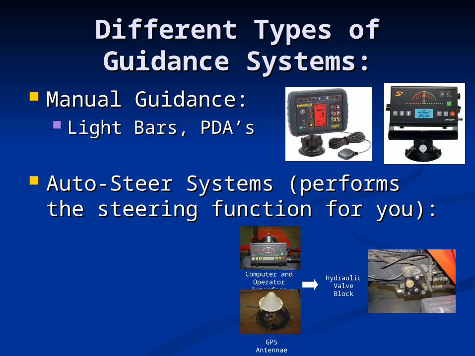
Different Types of Guidance Different Types of Guidance Systems:Systems:
Manual Guidance:Manual Guidance: Light Bars, PDA’sLight Bars, PDA’s
Auto-Steer Systems (performs the Auto-Steer Systems (performs the steering function for you):steering function for you):
GPS Antennae
Computer and Operator Interface
Hydraulic Valve Block
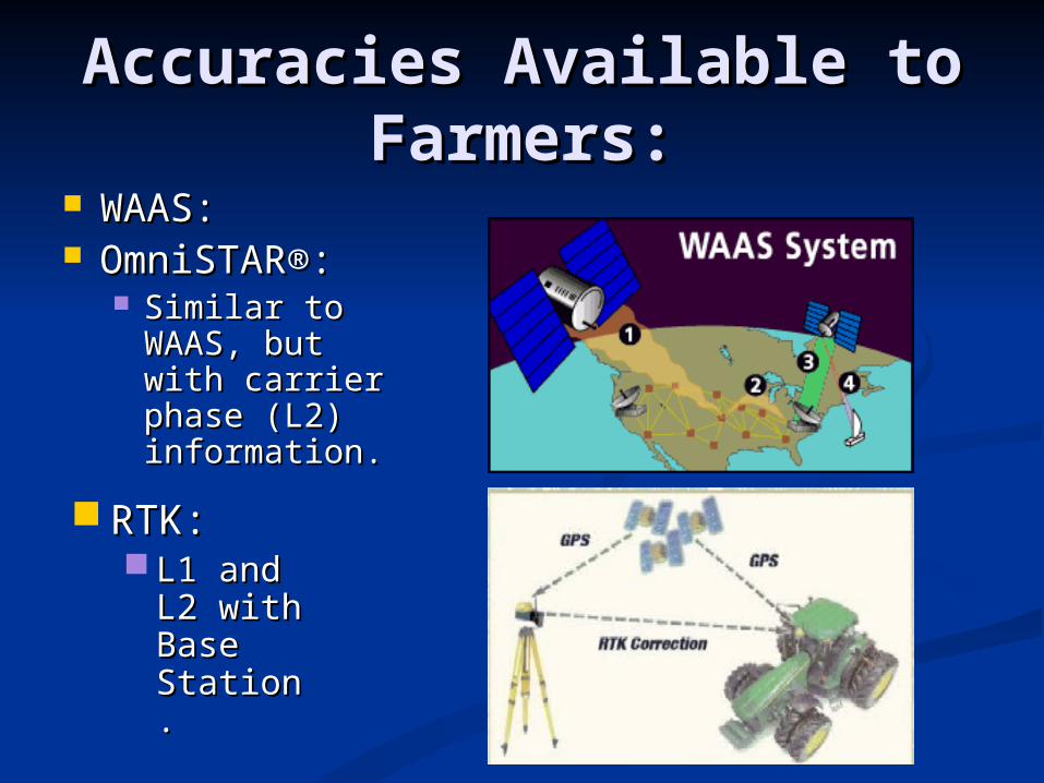
Accuracies Available to Accuracies Available to Farmers:Farmers:
WAAS:WAAS: OmniSTAR®:OmniSTAR®:
Similar to Similar to WAAS, but WAAS, but with carrier with carrier phase (L2) phase (L2) information.information.
RTK:RTK: L1 and L1 and
L2 with L2 with Base Base Station.Station.

Pass-to-Pass Accuracies of Pass-to-Pass Accuracies of Each System:Each System:
WAAS – 6 to 12 inches – 5 ft. deviations year-to-WAAS – 6 to 12 inches – 5 ft. deviations year-to-year.year.
OmniSTAR – 2 to 5 inchesOmniSTAR – 2 to 5 inches XP - +/- 8 inch year-to-year accuracyXP - +/- 8 inch year-to-year accuracy HP - +/- 4 inch year-to-year accuracyHP - +/- 4 inch year-to-year accuracy
RTK – 1 inch or less and year-to-yearRTK – 1 inch or less and year-to-year
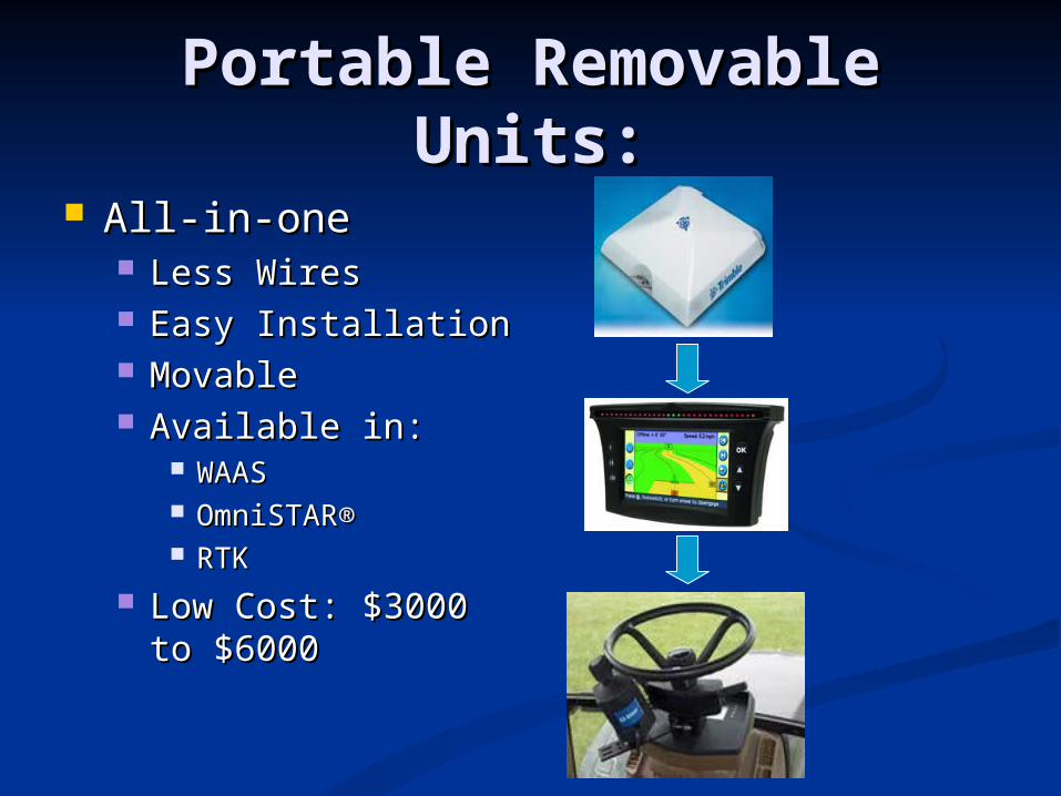
Portable Removable Portable Removable Units:Units:
All-in-oneAll-in-one Less WiresLess Wires Easy InstallationEasy Installation MovableMovable Available in:Available in:
WAASWAAS OmniSTAR®OmniSTAR® RTKRTK
Low Cost: $3000 to Low Cost: $3000 to $6000$6000
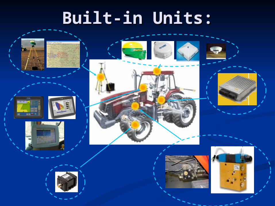
Built-in Units:Built-in Units:
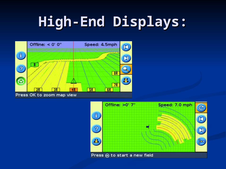
High-End Displays:High-End Displays:
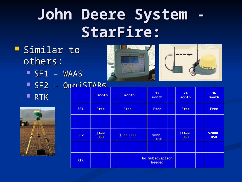
John Deere System - John Deere System - StarFire:StarFire:
Similar to others:Similar to others: SF1 – WAASSF1 – WAAS SF2 – OmniSTAR®SF2 – OmniSTAR® RTKRTK
No Subscription Needed RTK
$2000 USD $1400
USD $800 USD $600 USD $400
USDSF2
Free Free Free Free FreeSF1
36 month 24 month 12 month 6 month 3 month
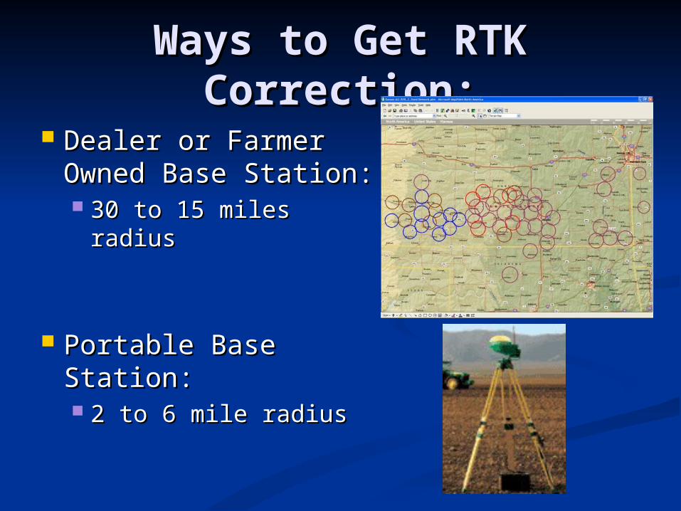
Ways to Get RTK Ways to Get RTK Correction:Correction:
Dealer or Farmer Dealer or Farmer Owned Base Owned Base Station:Station: 30 to 15 miles radius30 to 15 miles radius
Portable Base Portable Base Station:Station: 2 to 6 mile radius2 to 6 mile radius

Single Frequency (Non-Single Frequency (Non-RTK) Portable Base RTK) Portable Base
Station :Station : Outback Guidance BaselineOutback Guidance Baseline
L1 OnlyL1 Only
Guidance System in
Tractor
+
Radio Beacon
Accuracy: 1 inch (from manufacturer)Transmitter rated for 2.5 miles
2.5 miles
Advantages/Disadvantages:
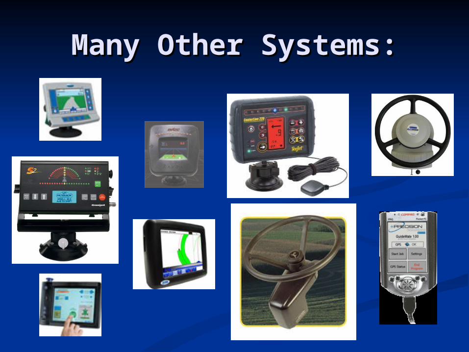
Many Other Systems:Many Other Systems:
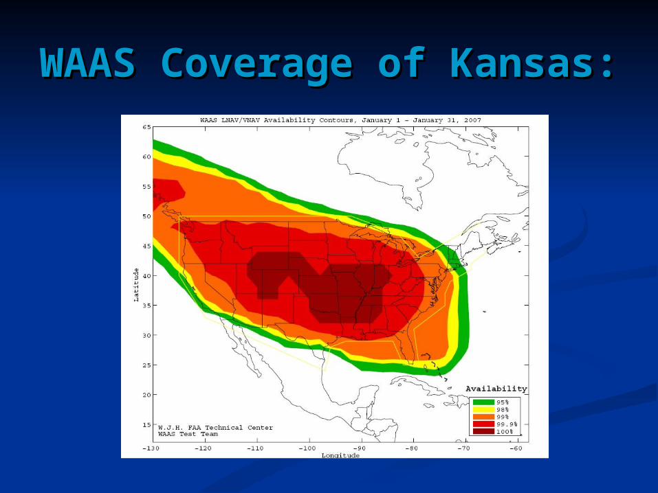
WAAS Coverage of WAAS Coverage of Kansas:Kansas:
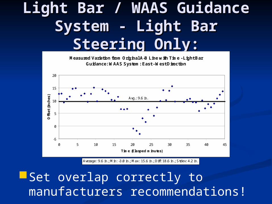
Light Bar / WAAS Guidance Light Bar / WAAS Guidance System - Light Bar Steering System - Light Bar Steering
Only:Only:Measured Variation from Original A-B Line with Time - Light Bar
Guidance: WAAS System: East - West Direction
-5
0
5
10
15
20
0 5 10 15 20 25 30 35 40 45
Time (Elasped minutes)
Off
set
(in
ches
)
Avg.: 9.6 in.
Average: 9.6 in.; Min: -3.0 in.; Max: 15.6 in.; Diff: 18.6 in.; Stdev: 4.2 in.
Set overlap correctly to manufacturers recommendations!
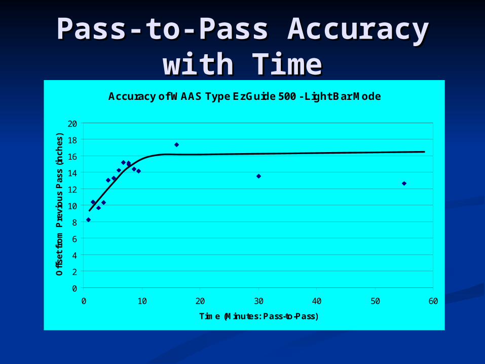
Pass-to-Pass Accuracy Pass-to-Pass Accuracy with Timewith Time
Accuracy of WAAS Type EzGuide 500 - Light Bar Mode
0
2
4
6
8
10
12
14
16
18
20
0 10 20 30 40 50 60
Time (Minutes: Pass-to-Pass)
Off
set
fro
m P
revi
ou
s P
ass
(in
ches
)
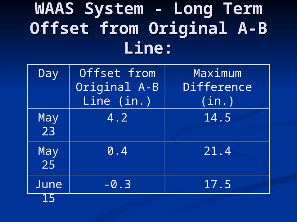
WAAS System - Long Term WAAS System - Long Term Offset from Original A-B Offset from Original A-B
Line:Line:
14.54.2May 23
21.40.4May 25
17.5-0.3June 15
Maximum Difference (in.)
Offset from Original A-B
Line (in.)
Day
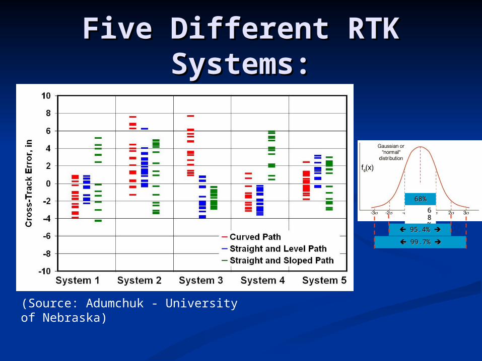
Five Different RTK Five Different RTK Systems:Systems:
(Source: Adumchuk - University of Nebraska)
68%68%68%68%
95.4%95.4%
99.7%99.7%
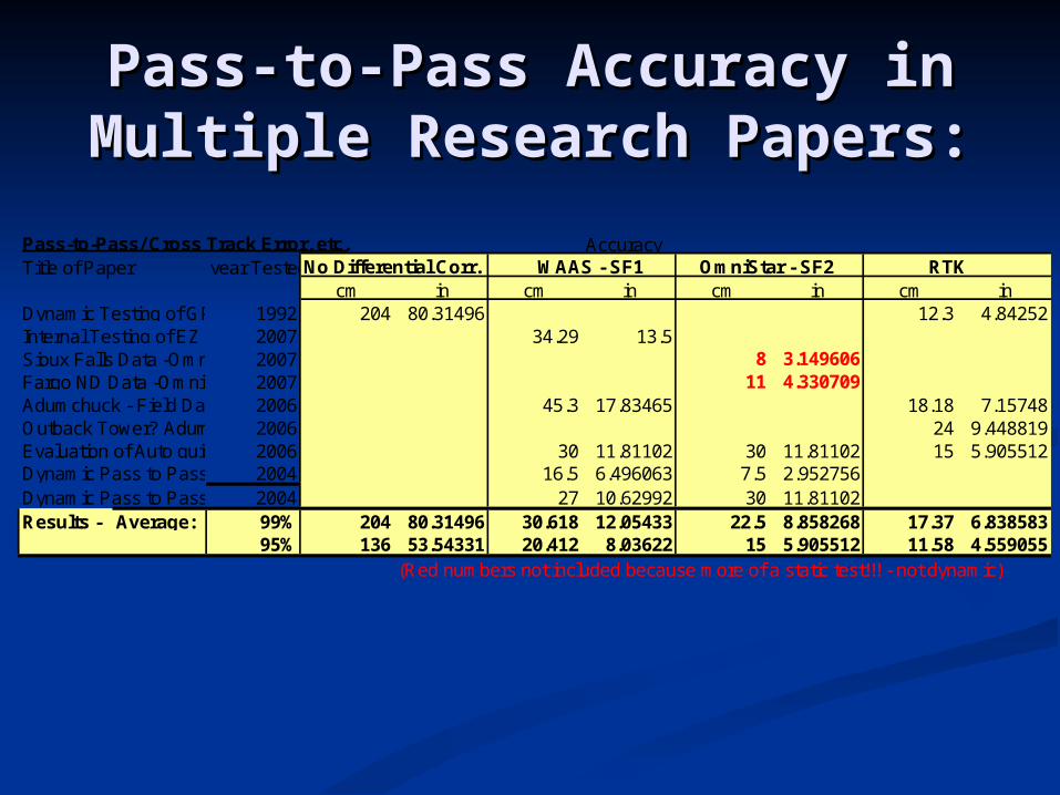
Pass-to-Pass Accuracy in Pass-to-Pass Accuracy in Multiple Research Papers:Multiple Research Papers:
Pass-to-Pass/ Cross Track Error, etc. AccuracyTitle of Paper year TestedNo Differential Corr. WAAS - SF1 OmniStar - SF2 RTK
cm in cm in cm in cm inDynamic Testing of GPS Receivers1992 204 80.31496 12.3 4.84252Internal Testing of EZ Guide 5002007 34.29 13.5Sioux Falls Data -Omni-Star HP2007 8 3.149606Fargo ND Data -Omni-Star XP2007 11 4.330709Adumchuck - Field Day Auto guidance - 5 RTK/1 WAAS/1 DGPS2006 45.3 17.83465 18.18 7.15748Outback Tower? Adumchuck - Field Day Auto guidance - DGPS2006 24 9.448819Evaluation of Auto guidance over varying time periods2006 30 11.81102 30 11.81102 15 5.905512Dynamic Pass to Pass Performance of DGPS receivers2004 16.5 6.496063 7.5 2.952756Dynamic Pass to Pass Performance of DGPS receivers 2004 27 10.62992 30 11.81102Results - Average: 99% 204 80.31496 30.618 12.05433 22.5 8.858268 17.37 6.838583
95% 136 53.54331 20.412 8.03622 15 5.905512 11.58 4.559055(Red numbers not included because more of a static test!!! - not dynamic)

Pass-to-Pass Accuracy at Pass-to-Pass Accuracy at Drawbar: Drawbar:
Pass-to-Pass Accuracy
0
2
4
6
8
10
12
14
16
WAAS OmniStar RTK
Type of Guidance System
Pas
s-to
-Pas
s A
ccu
racy
99% 95%
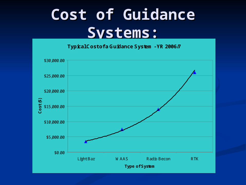
Cost of Guidance Cost of Guidance Systems:Systems:
Typical Cost of a Guidance System - YR 2006/7
$0.00
$5,000.00
$10,000.00
$15,000.00
$20,000.00
$25,000.00
$30,000.00
Light Bar WAAS Radio Becon RTK
Type of System
Co
st (
$)
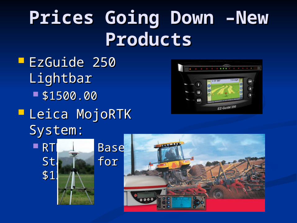
Prices Going Down –New Prices Going Down –New ProductsProducts
EzGuide 250 EzGuide 250 LightbarLightbar $1500.00$1500.00
Leica MojoRTK Leica MojoRTK System:System: RTK and Base RTK and Base
Station for $12,980Station for $12,980

Where GPS is Going:Where GPS is Going:
Accuracies have been Accuracies have been seen as quite good (by seen as quite good (by Farmers standards)Farmers standards) Boom ControlBoom Control
Turns off the boom Turns off the boom sections as they pass over sections as they pass over areas already sprayedareas already sprayed
Seed ControlSeed Control Turns off every 1 or 2 Turns off every 1 or 2
planter boxes when planter boxes when neededneeded

Example of Planter Auto Example of Planter Auto Shut-OffShut-Off
Uses of GPS Height Uses of GPS Height Modernization:Modernization:
Government:Government: Watershed Mapping and Flood Plain Watershed Mapping and Flood Plain
DeterminationDetermination BMP’s (best management practices)BMP’s (best management practices)
Atrazine Measurement (Herbicide for Killing Weeds)Atrazine Measurement (Herbicide for Killing Weeds) Sediment LoadsSediment Loads
Individual Farmer:Individual Farmer: Not as muchNot as much Relative heights usually good enough, but Relative heights usually good enough, but
bench mark may be used to help determine bench mark may be used to help determine sloped land and land type easiersloped land and land type easier
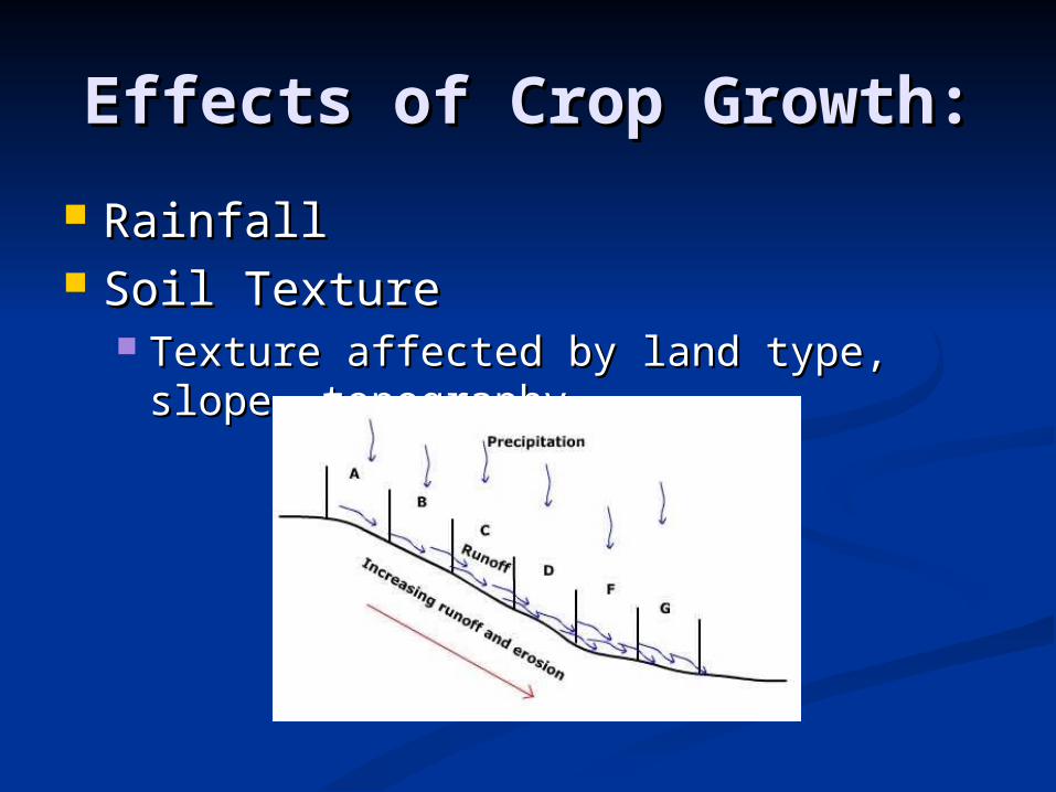
Effects of Crop Growth:Effects of Crop Growth:
RainfallRainfall Soil TextureSoil Texture
Texture affected by land type, slope, Texture affected by land type, slope, topographytopography
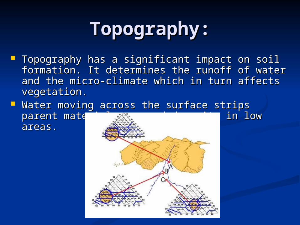
Topography:Topography: Topography has a significant impact on soil Topography has a significant impact on soil
formation. It determines the runoff of water and the formation. It determines the runoff of water and the micro-climate which in turn affects vegetation. micro-climate which in turn affects vegetation.
Water moving across the surface strips parent Water moving across the surface strips parent material away and deposits in low areas. material away and deposits in low areas.
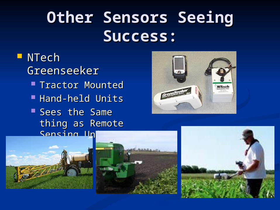
Other Sensors Seeing Other Sensors Seeing Success:Success:
NTech NTech GreenseekerGreenseeker Tractor MountedTractor Mounted Hand-held UnitsHand-held Units Sees the Same Sees the Same
thing as Remote thing as Remote Sensing UnitsSensing Units
Real-timeReal-time
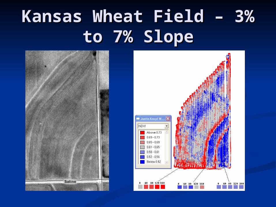
Kansas Wheat Field – 3% Kansas Wheat Field – 3% to 7% Slopeto 7% Slope

Nitrate Calibration Plots:Nitrate Calibration Plots:Test Plots of Nitrate
0.55
0.6
0.65
0.7
0.75
0.8
0 20 40 60 80 100 120 140 160 180
Nitrate Level (lbs per acre)
ND
VI
Le
ve
l -
Gre
en
se
ek
er
West Middle East Poly. (West) Poly. (Middle) Poly. (East)
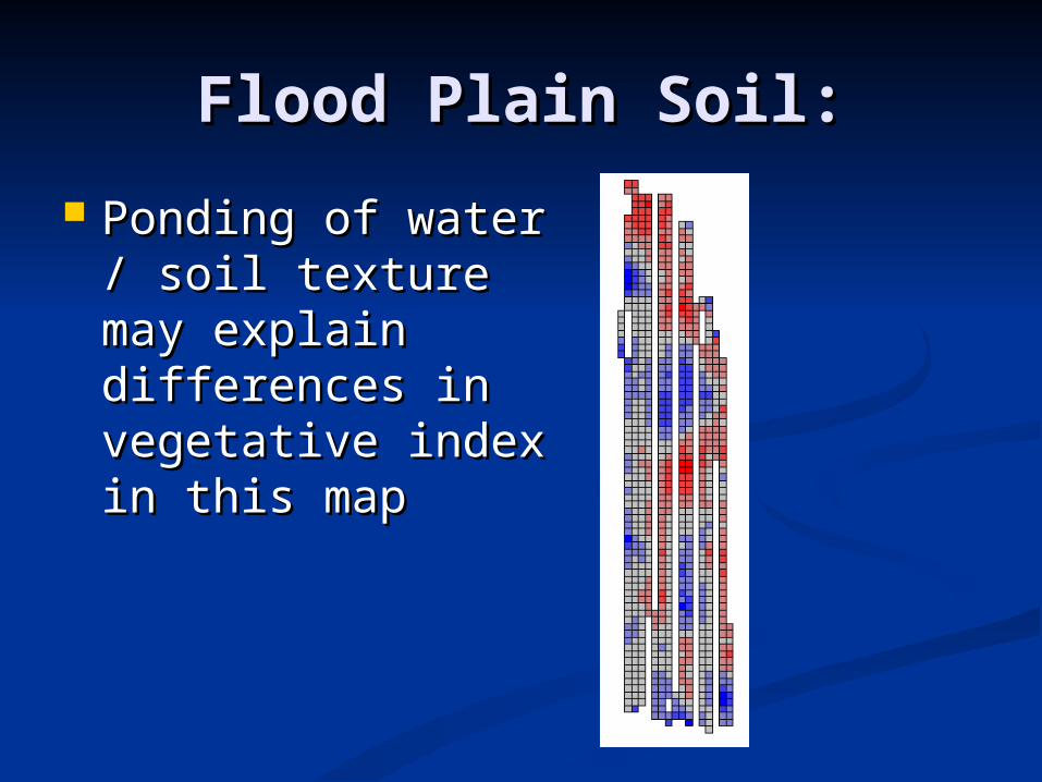
Flood Plain Soil:Flood Plain Soil:
Ponding of water / Ponding of water / soil texture may soil texture may explain differences explain differences in vegetative index in vegetative index in this mapin this map

The Future:The Future: No-till becoming more widely used.No-till becoming more widely used. Farmers doing much more spraying and at higher Farmers doing much more spraying and at higher
frequencies (more trips across the fields).frequencies (more trips across the fields). High cost of inputs (fertilizer and herbicide) causing High cost of inputs (fertilizer and herbicide) causing
farmers to re-think spraying strategies and move towards farmers to re-think spraying strategies and move towards variable rate applications.variable rate applications.
Land levelling could become more important as inputs Land levelling could become more important as inputs become higher / crops worth more.become higher / crops worth more.
Farmers will probably tend to use data that is easy to get Farmers will probably tend to use data that is easy to get first for developing prescription maps:first for developing prescription maps: Soil Texture Soil Texture TopographyTopography
Relative (RTK measurement)Relative (RTK measurement) Tilt sensorsTilt sensors Preloaded map, etc.Preloaded map, etc.
Greenseeker Greenseeker Etc.Etc.
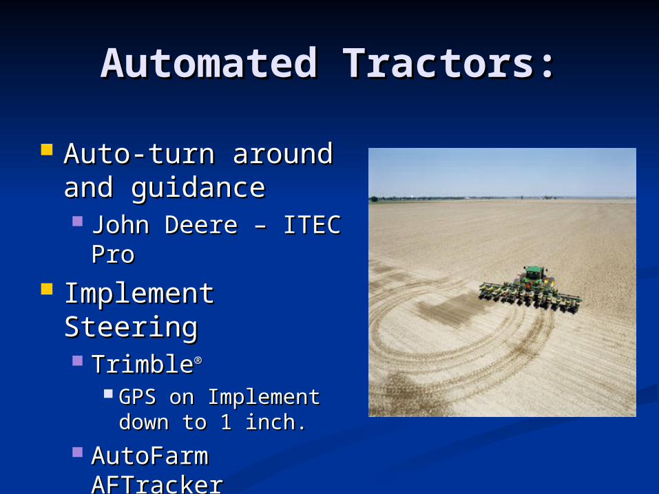
Automated Tractors:Automated Tractors:
Auto-turn around Auto-turn around and guidance and guidance John Deere – ITEC John Deere – ITEC
ProPro Implement Implement
SteeringSteering TrimbleTrimble®®
GPS on Implement GPS on Implement down to 1 inch.down to 1 inch.
AutoFarm AutoFarm AFTrackerAFTracker
The EndThe End(Questions?)(Questions?)
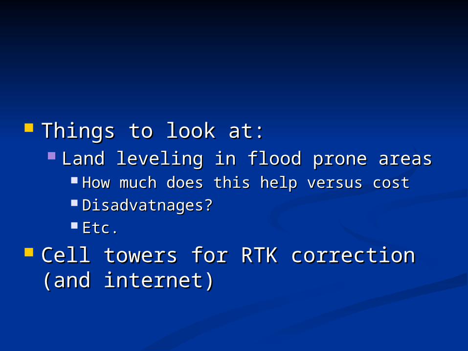
Things to look at:Things to look at: Land leveling in flood prone areasLand leveling in flood prone areas
How much does this help versus costHow much does this help versus cost Disadvatnages?Disadvatnages? Etc.Etc.
Cell towers for RTK correction (and Cell towers for RTK correction (and internet)internet)

To Replace Base Station:To Replace Base Station:
Need the Following:Need the Following: Must be close (for errors to be lowest)Must be close (for errors to be lowest) Fast repeat time Fast repeat time
Sprayers travelling at 15-20 MPH need a GPS with Sprayers travelling at 15-20 MPH need a GPS with an output rate or 5 to 20 Hz (real-time).an output rate or 5 to 20 Hz (real-time).
Different Options:Different Options: Cellular Cellular Internet, etc.Internet, etc. Some Type of Standardized Transmitted Some Type of Standardized Transmitted
SignalSignal Similar to Coast Guard BeaconSimilar to Coast Guard Beacon
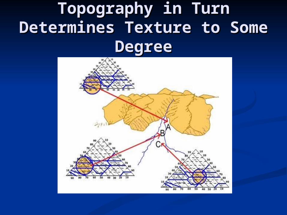
Topography in Turn Topography in Turn Determines Texture to Determines Texture to
Some DegreeSome Degree
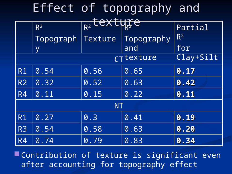
Effect of topography and textureEffect of topography and texture
0.340.340.830.790.74R40.200.200.630.580.54R30.190.190.410.30.27R1
NT0.110.110.220.150.11R40.420.420.630.520.32R20.170.170.650.560.54R1
CT
Partial R2
for Clay+Silt
R2
Topography and texture
R2
TextureR2
Topography
Contribution of texture is significant even after accounting for topography effect

Texture Triangle:Texture Triangle:
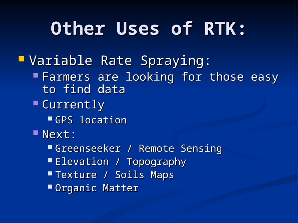
Other Uses of RTK:Other Uses of RTK:
Variable Rate Spraying:Variable Rate Spraying: Farmers are looking for those easy to Farmers are looking for those easy to
find datafind data CurrentlyCurrently
GPS locationGPS location Next:Next:
Greenseeker / Remote SensingGreenseeker / Remote Sensing Elevation / TopographyElevation / Topography Texture / Soils MapsTexture / Soils Maps Organic MatterOrganic Matter

Payback Period:Payback Period: Estimate 30” off without guidance, better than Estimate 30” off without guidance, better than
15” with WAAS alone.15” with WAAS alone. Typically, 2.5 yrs needed to pay off lower-end Typically, 2.5 yrs needed to pay off lower-end
system (depending upon type of system system (depending upon type of system purchased and number of uses per year).purchased and number of uses per year).
Ag Economics at Kansas State UniversityAg Economics at Kansas State University http://www.agmanager.info/farmmgt/machinery/default.
asp#Decision-Making%20Tools
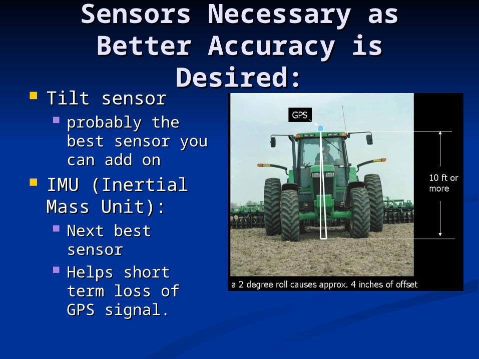
Sensors Necessary as Sensors Necessary as Better Accuracy is Desired:Better Accuracy is Desired:
Tilt sensor Tilt sensor probably the best probably the best
sensor you can sensor you can add on add on
IMU (Inertial IMU (Inertial Mass Unit):Mass Unit): Next best sensor Next best sensor Helps short term Helps short term
loss of GPS loss of GPS signal.signal.

Website:Website:
www.bae.ksu.edu/precag Email: [email protected]: [email protected] Call: 785-532-2929Call: 785-532-2929
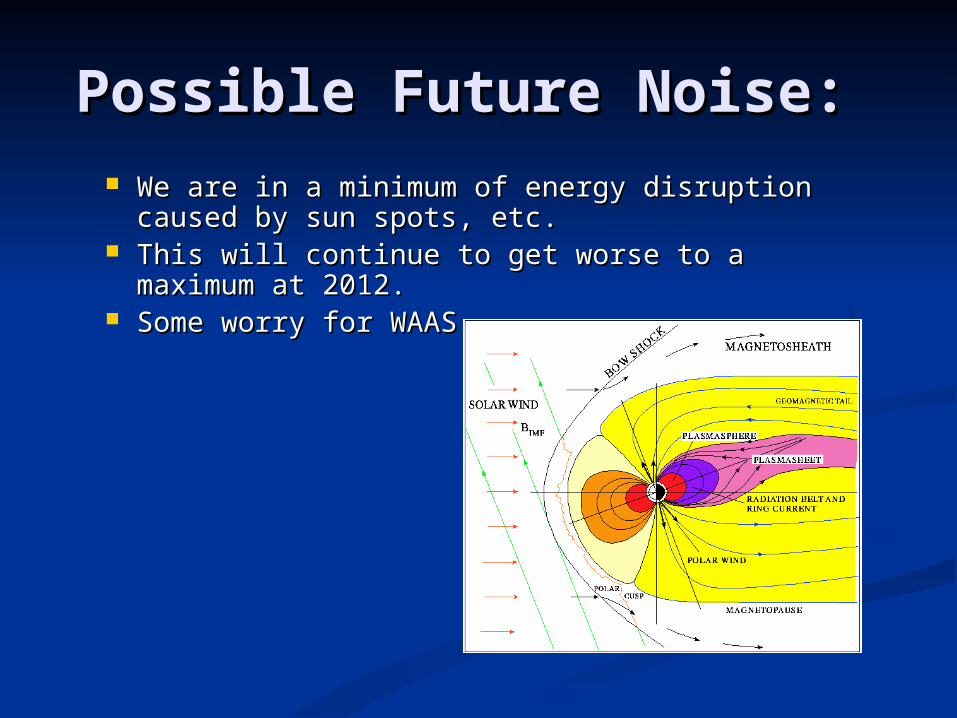
Possible Future Noise: Possible Future Noise: We are in a minimum of energy disruption caused We are in a minimum of energy disruption caused
by sun spots, etc.by sun spots, etc. This will continue to get worse to a maximum at This will continue to get worse to a maximum at
2012.2012. Some worry for WAASSome worry for WAAS

Air Clutch on Planter Air Clutch on Planter SystemSystem
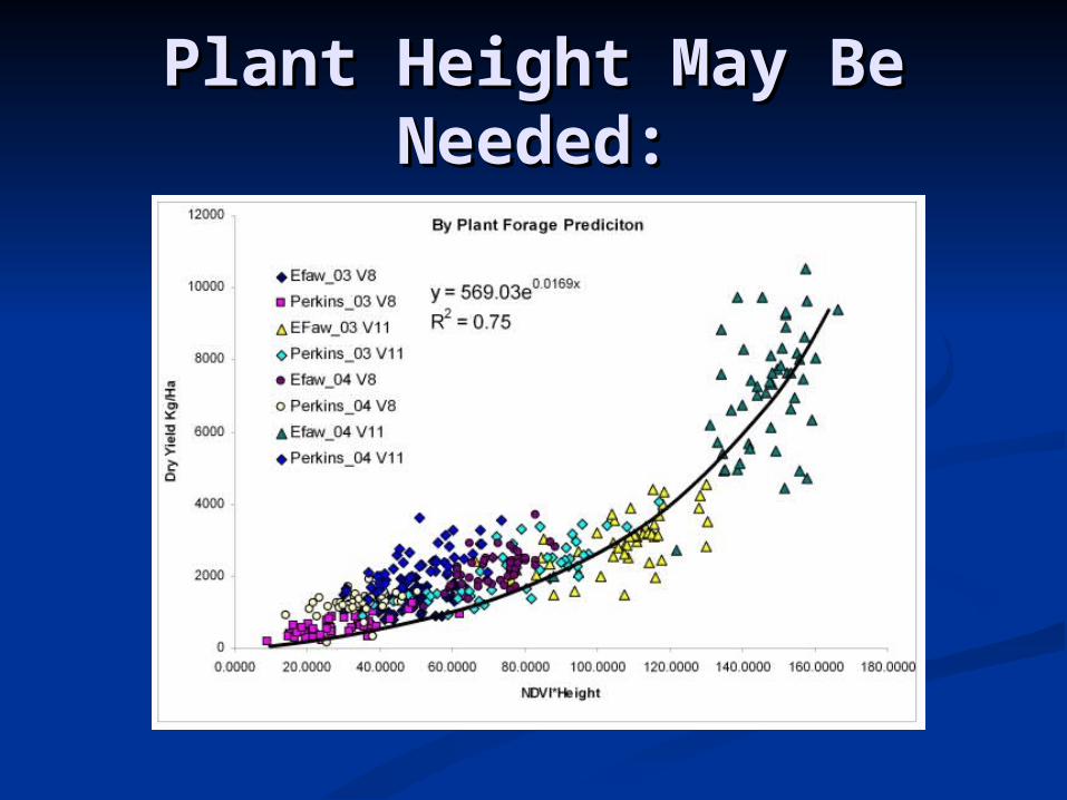
Plant Height May Be Plant Height May Be Needed:Needed:
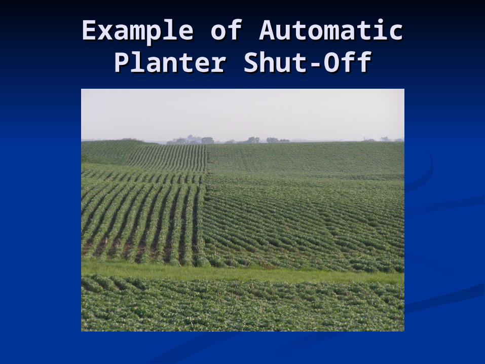
Example of Automatic Example of Automatic Planter Shut-OffPlanter Shut-Off
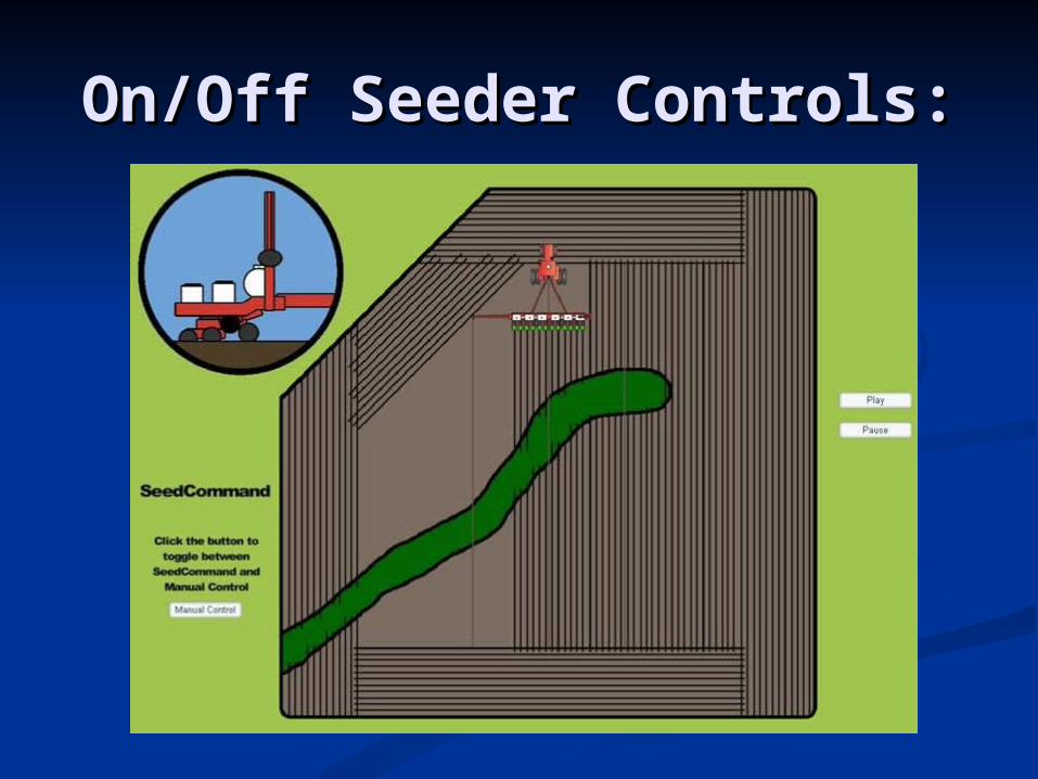
On/Off Seeder Controls:On/Off Seeder Controls:
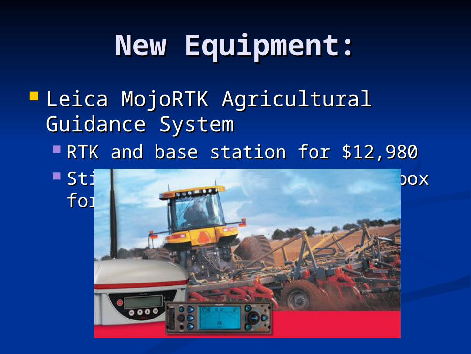
New Equipment:New Equipment:
Leica MojoRTK Agricultural Leica MojoRTK Agricultural Guidance SystemGuidance System RTK and base station for $12,980RTK and base station for $12,980 Still need hydraulic actuator box for Still need hydraulic actuator box for
auto-steerauto-steer
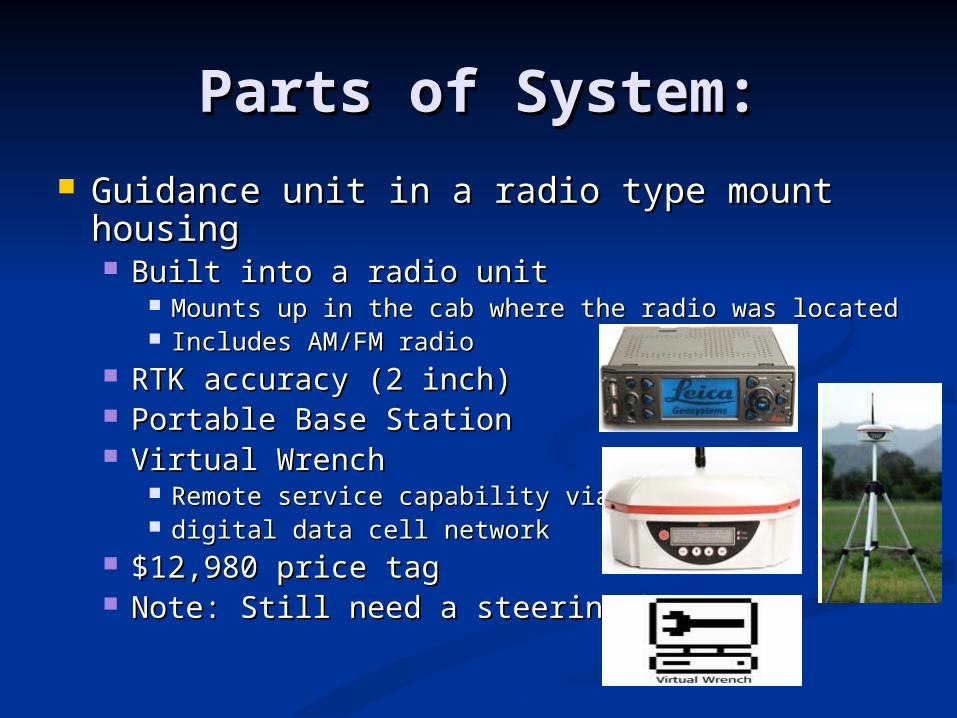
Parts of System:Parts of System: Guidance unit in a radio type mount Guidance unit in a radio type mount
housinghousing Built into a radio unit Built into a radio unit
Mounts up in the cab where the radio was locatedMounts up in the cab where the radio was located Includes AM/FM radioIncludes AM/FM radio
RTK accuracy (2 inch)RTK accuracy (2 inch) Portable Base StationPortable Base Station Virtual WrenchVirtual Wrench
Remote service capability via Remote service capability via digital data cell networkdigital data cell network
$12,980 price tag$12,980 price tag Note: Still need a steering kit!!!Note: Still need a steering kit!!!
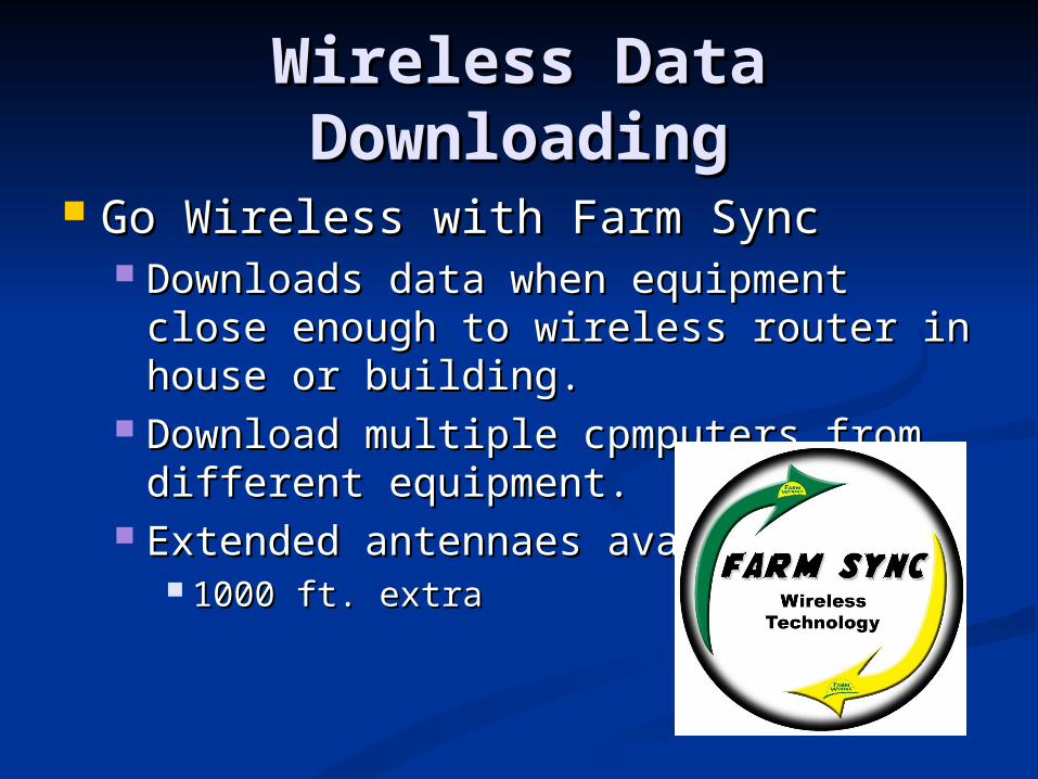
Wireless Data Wireless Data DownloadingDownloading
Go Wireless with Farm SyncGo Wireless with Farm Sync Downloads data when equipment close Downloads data when equipment close
enough to wireless router in house or enough to wireless router in house or building.building.
Download multiple cpmputers from Download multiple cpmputers from different equipment.different equipment.
Extended antennaes avaivble: Extended antennaes avaivble: 1000 ft. extra1000 ft. extra
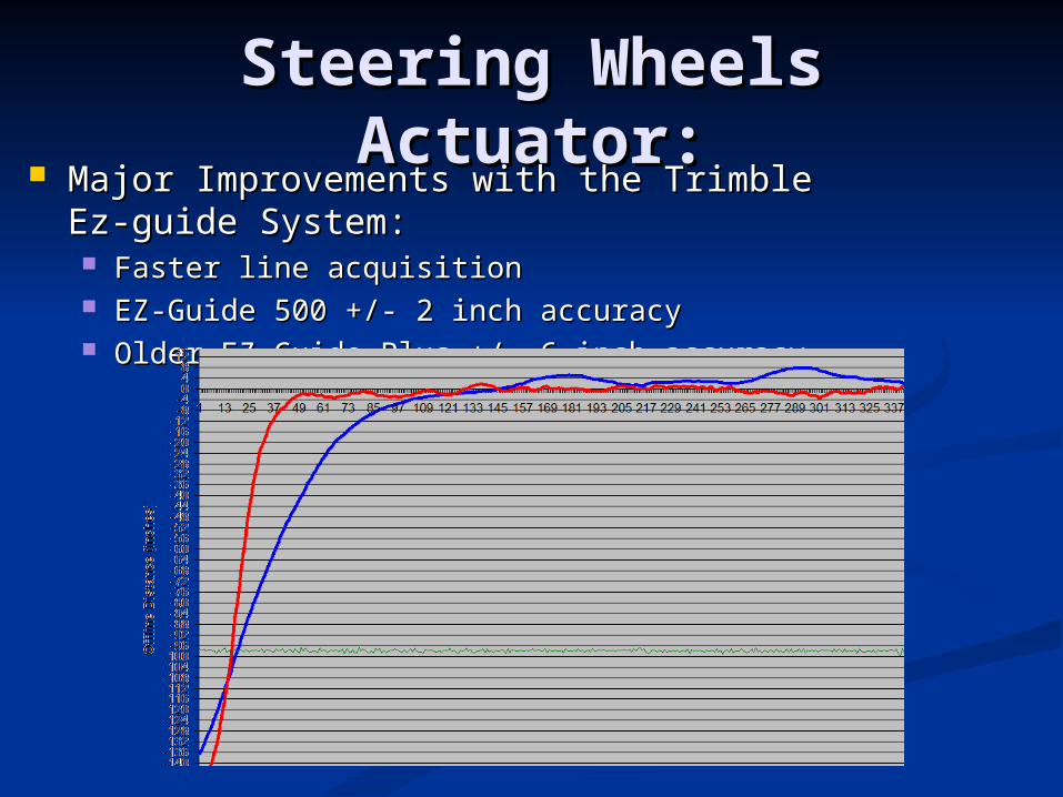
Steering Wheels Steering Wheels Actuator:Actuator:
Major Improvements with the Trimble Ez-Major Improvements with the Trimble Ez-guide System:guide System: Faster line acquisitionFaster line acquisition EZ-Guide 500 +/- 2 inch accuracyEZ-Guide 500 +/- 2 inch accuracy Older EZ-Guide Plus +/- 6 inch accuracyOlder EZ-Guide Plus +/- 6 inch accuracy
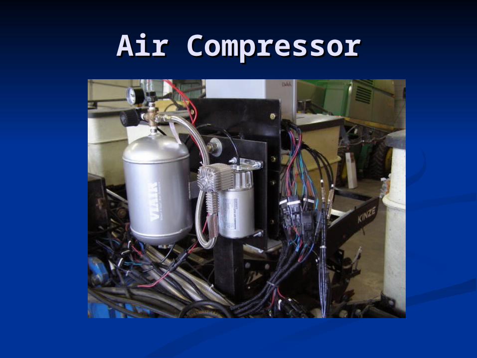
Air CompressorAir Compressor
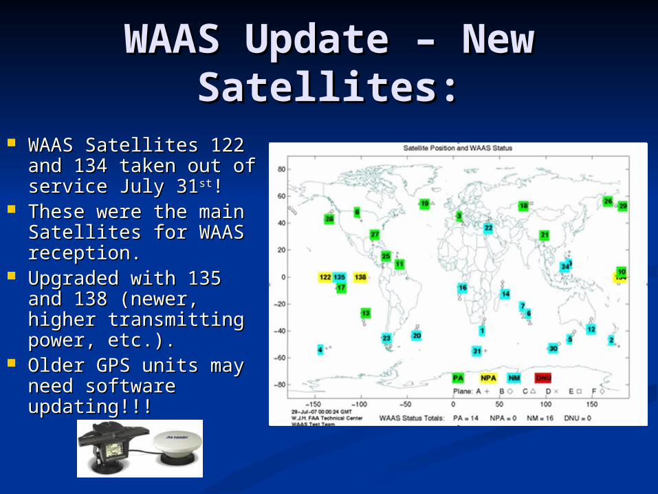
WAAS Update – New WAAS Update – New Satellites:Satellites:
WAAS Satellites 122 WAAS Satellites 122 and 134 taken out of and 134 taken out of service July 31service July 31stst!!
These were the main These were the main Satellites for WAAS Satellites for WAAS reception.reception.
Upgraded with 135 Upgraded with 135 and 138 (newer, and 138 (newer, higher transmitting higher transmitting power, etc.).power, etc.).
Older GPS units may Older GPS units may need software need software updating!!!updating!!!
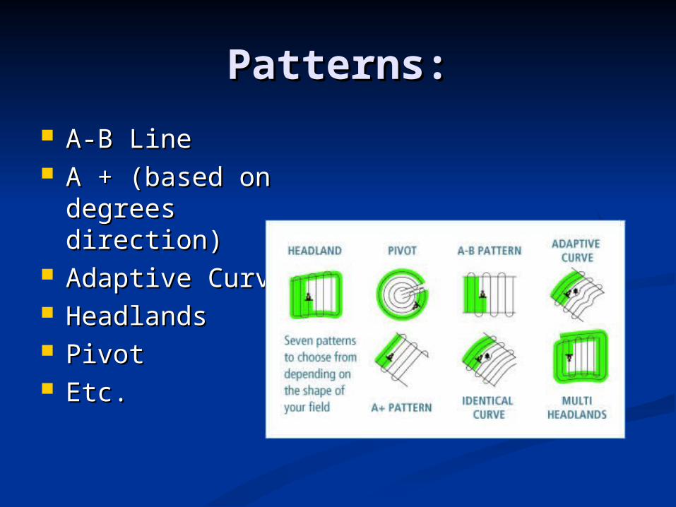
Patterns:Patterns:
A-B LineA-B Line A + (based on A + (based on
degrees direction)degrees direction) Adaptive CurveAdaptive Curve HeadlandsHeadlands PivotPivot Etc.Etc.
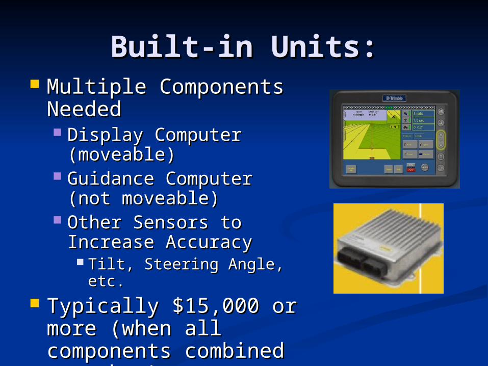
Built-in Units:Built-in Units: Multiple Components Multiple Components
NeededNeeded Display Computer Display Computer
(moveable)(moveable) Guidance Computer Guidance Computer
(not moveable)(not moveable) Other Sensors to Other Sensors to
Increase AccuracyIncrease Accuracy Tilt, Steering Angle, etc.Tilt, Steering Angle, etc.
Typically $15,000 or Typically $15,000 or more (when all more (when all components combined components combined together):together):
Where is GPS Going?Where is GPS Going?
WAAS most sold in the U.S.: WAAS most sold in the U.S.: Mainly because free and accuracies Mainly because free and accuracies
good enough for many farming good enough for many farming operationsoperations
OmnistarOmnistar Usually just an upgrade in price from Usually just an upgrade in price from
WAAS with an antennae and WAAS with an antennae and sibscription.sibscription.
RTK least soldRTK least sold Mainly larger farm with more moneyMainly larger farm with more money Farmers needing strip tillage, etc.Farmers needing strip tillage, etc.