Embed Size (px)
Citation preview
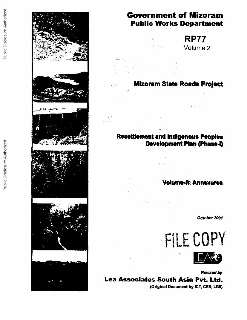
Government of MizoramPublic Works Department
RP77Volume 2
,- :- , - -- f:.
Mizoram State Roads Project
-47;~~~~~~7
Resestlement and Indigenous PeoplesDevelopment Plan (Phasea4)
34
u Ann.ur.s
October 2001
(Original Document by [CT CES, LBII)
Pub
lic D
iscl
osur
e A
utho
rized
Pub
lic D
iscl
osur
e A
utho
rized
Pub
lic D
iscl
osur
e A
utho
rized
Pub
lic D
iscl
osur
e A
utho
rized
TABLE OF CONTENTS
ANNEXURE-2.1SCHEDULE FOR CENSUS SURVEY
ANNEXURE-2.2SCHEDULE FOR SOCIO-ECONOMIC SURVEY
ANNEXURE-2.3WORLD BANK FUNDED SOCIAL & ENVIRONMENT IMPACT ASSESSMENT
ANNEXURE-3.1MIZORAM STATE HIGHWAY RESETTLEMENT AND REHABILITATION POLICY
ANNEXURE-3.2APPROVAL OF MIZORAM STATE HIGHWAY RESETTLEMENT ANDREHABILITATION POLICY
ANNEXURE-7DETAILS OF VARIOUS CATEGORIES OF IMPACTED PROPERTIES ALONGPRIORITY ROAD PlA
ANNEXURE-8.1PUBLIC INFORMATION & CONSULTATIONS AIZWAL-LUNGLEI (VIA HMUIFANG) -100 KM
ANNEXURE-8.2PUBLIC INFORMATION & CONSULTATIONS AND GENERAL EXIBHITS-PHOTOGRAPHS
ANNEXURE-8.3COVERAGE OF PUBLIC CONSULTATIONS IN THE LOCAL MEDIA
ANNEXURE-9.1LAND SETTLEMENT AND THE ACTS OF MIZORAM REGULATIONS AND RULESGOVERNING REVENUE ADMINISTRATION
ANNEXURE-9.2DETAILED STATEMENT OF LANDS OF ORGANISATION/ASSOCIATIONS ETC.,REQUIRED FOR IMPROVEMENT & UPGRADATION OF AIZAWL-THENZAWL-LUNGLEI ROAD (VIA HMUIFANG)
ANNEXURE-9.3DETAILED STATEMENT OF LANDS AVAILABLE WITHIN RESPECTIVE VILLAGECOUNCIL JURISDICTIONS & FREE LANDS REQUIRED FOR IMPROVEMENT &UPGRADATION OF AIZAWL-THENZAWL-LUNGLEI ROAD
ANNEXURE-9.4DETAILED STATEMENT OF GOVERNMENT DEPARTMENT LANDS REQUIREDFOR IMPROVEMENT & UPGRADATION OF AIZAWL-THENZAWL-LUNGLEI ROAD(VIA HMUIFANG)
ANNEXURE-10.1INCOME GENERATING SCHEMES, PROGRAMMES FOR POTENTIAL FORDEVELOPMENT- SECTOR WISE
ANNEXURE-10.1 (A)POULTRY AND PIGGERY AS INCOME GENERATING SOURCE
ANNEXURE-10.1 (B)DAIRY DEVELOPMENT THROUGH VILLAGE COOPERATIVES AS INCOMEGENERATING SOURCE
ANNEXURE-10.2ELIGIBLITY SUMMARY FOR INCOME RESTORATION
ANNEXURE-10.3NGO'S TERMS OF REFERENCE
ANNEXURE-13.1LOGICAL FRAMEWORK OF INDICATORS
ANNEXURE-13.2FORMATS FOR REPORTING - RECORD FOR INDIVIDUAL/HOUSEHOLDENTITLEMENTS
ANNEXURE-13.3FORMATS FOR REPORTING - MONITORING FORM FOR COMMUNITYENTITLEMENTS
ANNEXURE-13.4FORMATS FOR REPORTING - MONTHLY AND CUMULATIVE CORRIDORENTITLEMENT REPORT - INDIVIDUALS, HOUSEHOLDS AND COMMUNITY
ANNEXURE-13.5FORMATS FOR REPORTING - GRC MONTHLY AND CUMULATIVE REPORT
ANNEXURE-13.6FORMATS FOR REPORTING - DISTRICT LEVEL COMMITEE REPORT FORINDIVIDUAL PAP
ANNEXURE-13.7FORMATS FOR REPORTING - MONTHLY SYNTHESIS OF RAP IMPLEMENTATION(PHYSICAL)
ANNEXURE-13.5FORMATS FOR REPORTING - MONTHLY SYNTHESIS OF RAP IMPLEMENTATION(FINANCIAL)

ANNEXURE 2.1 &
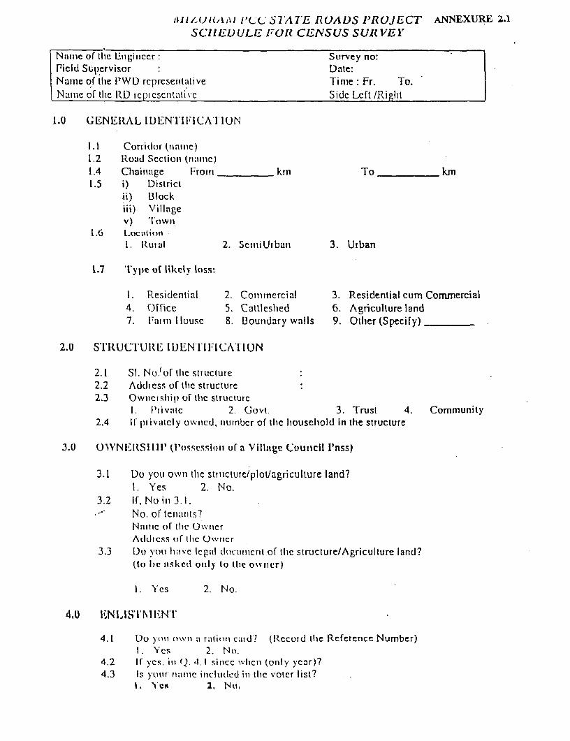
iIA(JI,'IA1 i'L' bSIATE I?E UADS IRUJECT ANNEXURE 2.1SCH'UEVULE F1OR CENSUS SURVEI'
Nam:e or tic lZnginccr: Survey no:Field Supcervisor : Date:Naime of the iPWD rcpreseritative Time: Fr. To.Namle of the RD icl)icscntatic Side Left /Right
1.U G1EN1EHItAL I DENrI 1I IF CA ul 0 N
1.1 Cur tidor (nwime)1.2 Ruatd Sectiuio (n;amue)
1.4 Chainage From ktn To km1.5 i) District
ii) Blockiii) Villagev) 'I'rown
1.6 L t.fiction. Rulal 2. SciniUibant 3. Urban
1.7 t ype of likely loss:
1. Residential 2. Commnercial 3. Residential cum Comrnercial4. Office 5. Catileshed 6. Agriculture land7. Faim l lousc 8. Bounidary walls 9. Oilier (Specify)
2.0 STItUCTURl IDENTI ll ICATI ION
2.1 Si. No.'of ilic structure2.2 Addiress of tihc structure2.3 Ownership of tlec structurc
I. lrivalc 2. (Govt. 3. TIrust 4. Community2.4 Ip1 ivatcly owned. numilbcr of tihc hiouseihold in the structure
3.0 UWVNEIRSI III' (I'ossCssioti uf a Village CouIIcil P'nss)
3.1 Du you own ilte strirctureiploulagriculture land?1. Yes 2. Nao.
3.2 If,No in 3.1,No. of tellnts?N.i1lC of tile OwtncrAddiess of the Onvticr
3.3 Do vtoU have lCg;al (locuiicInt or tlrc structure/Agriculture land?(to Ihe uishedi only to (lie owiner)
1. Yes 2. N o.
4.0 UEN1 lS'lr NII N V
4.1 Do yotu own a ration ca idt? (Record the Reference Number)1. Yes 2. N o.
4.2 If yes. it, o. t.I since whicti tonly year)?4.3 Is your nmirit inctiuled in thic voter list?
1. C 2., tr,,
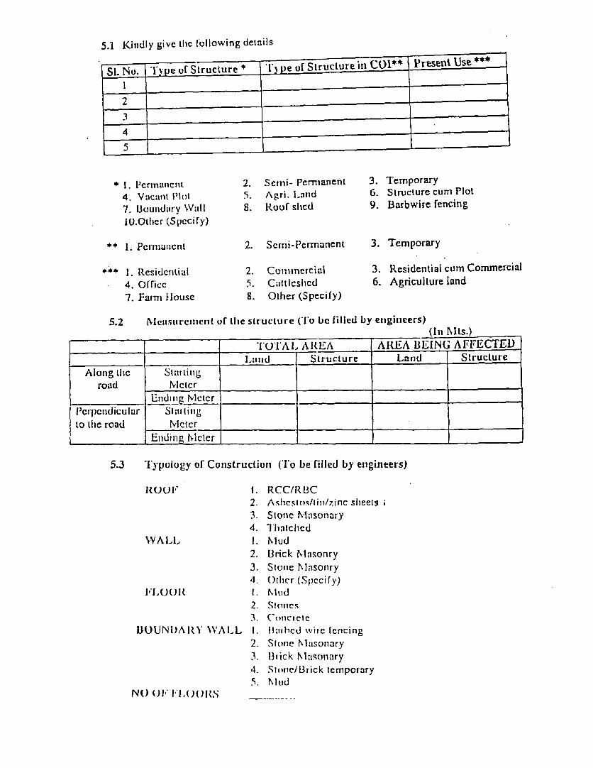
5.1 Kitidly givc tilc l'ollowing details
No. 1 )e o( Structure *e f tructure in C-1** resei Use
3
* 1. I'crinatictt 2. Sctni- Permanent 3. Temporary4. Vaclant lont 5. Agri. Land 6. Structure cum Plot7. Bounidary Wall 8. Roof slied 9. Barbwire fencing1O.Olter (Spccify)
*. 1. Pcrntiauicnt 2. Scmi-Pcrmanent 3. Temporary
*4.4.1* LResidcintial 2. Comimnercial 3. Residential cum Commercial4. O[ficc 5. CIttlcshlcd 6. Agriculture land7. Farmn Hlouse 8. Other (Specify)
5.2 NofsurCliut of lihc str-ucture (To be filled by etiginieers)(ill J\Ls.)
_________ ________ ~TOTAL1 ARItE A ARtE A BEING AFFECTE DI-rInd Structure Laniid Structure
Along thc Stattin'groad lvlctcr
-niLln Ncictr__ _,__ _ _ _ _ _rd t g M t r _ _ _ _ _ _ _ 1 _ __ _ __ __ ___ _ _ _ _
I'crpciidiculur Slatii rgto tlie road MIcter .
E_ldinlg Mictrer
5.3 'I'ypology of Constructioni (To be filled by engineers)
lROOF 1. RCC/RBC2. Asbicsmos/tisi/zinc sheets .3. Slone Mnsonary4. hliatched
WALL 1. NMud2. Brick Mlasonry3. Sconle Mlasonry4. ()ricr (Specify)
FL'00R 1. NhrId2. Stones3. Colcctele
BOUNI)AIR'Y WALL 1. Haihlcd xvire fenicing2. Stone lMasonary3. thick Mlasonary4. Stone/Brick temporary5. hIlMd
NO) ()I FL'.OORS
5.4 Diagram of the structure (lo be filled by engineers)
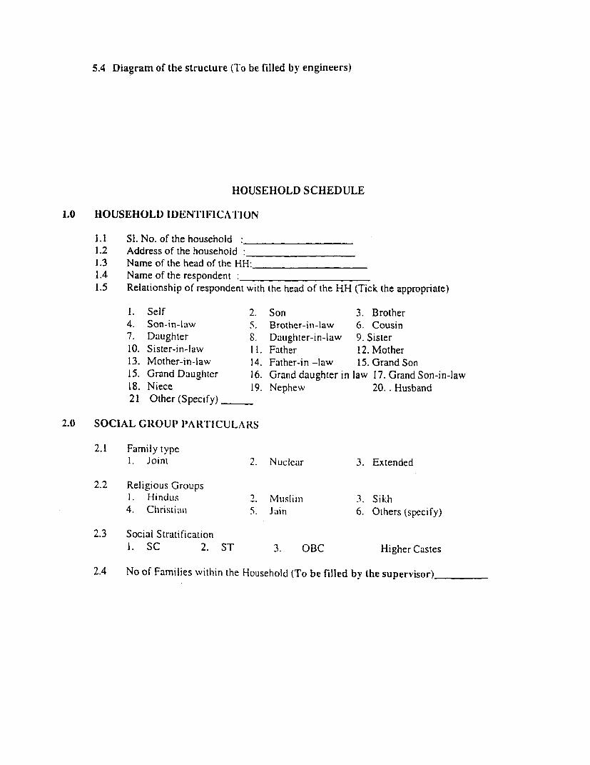
HOUSEHOLD SCHEDULE
1.0 HOUSEHOLD I DENTIF ICATI ON
1.1 SI. No. of the household :-1.2 Address of the household :-1.3 Name of the head of the HH:__1.4 Name of the respondent:1.5 Relationship of respondent with the head of the RH (Tick the appropriate)
1. Self 2. Son 3. Brother4. Son-in-law 5. Brother-in-law 6 Cousin7. Daughter 8. Daughter-in-law 9. Sister10. Sister-in-law It. Father 12. Mother13. Mother-in-law 14. Father-in -law 15. Grand Son15. Grand Daughter 16. Grand daughter in law 17. Grand Son-in-law18. Niece 19. Nephew 20.. Husband21 Other (Specify)
2.0 SOCIAL GIROUI' IART'I'ICULARS
2.1 Family type1. Joint 2. Nucic.ir 3. Extended
2.2 Religious Groups1. UindLIs 2. Musliiii 3. Sikh4. Christian 5. Jain 6. Others (specify)
2.3 Social Stratification1. SC 2. ST 3. OBC Higher Castes
2.4 No of Families within the Household (To be filled by the supervisor)
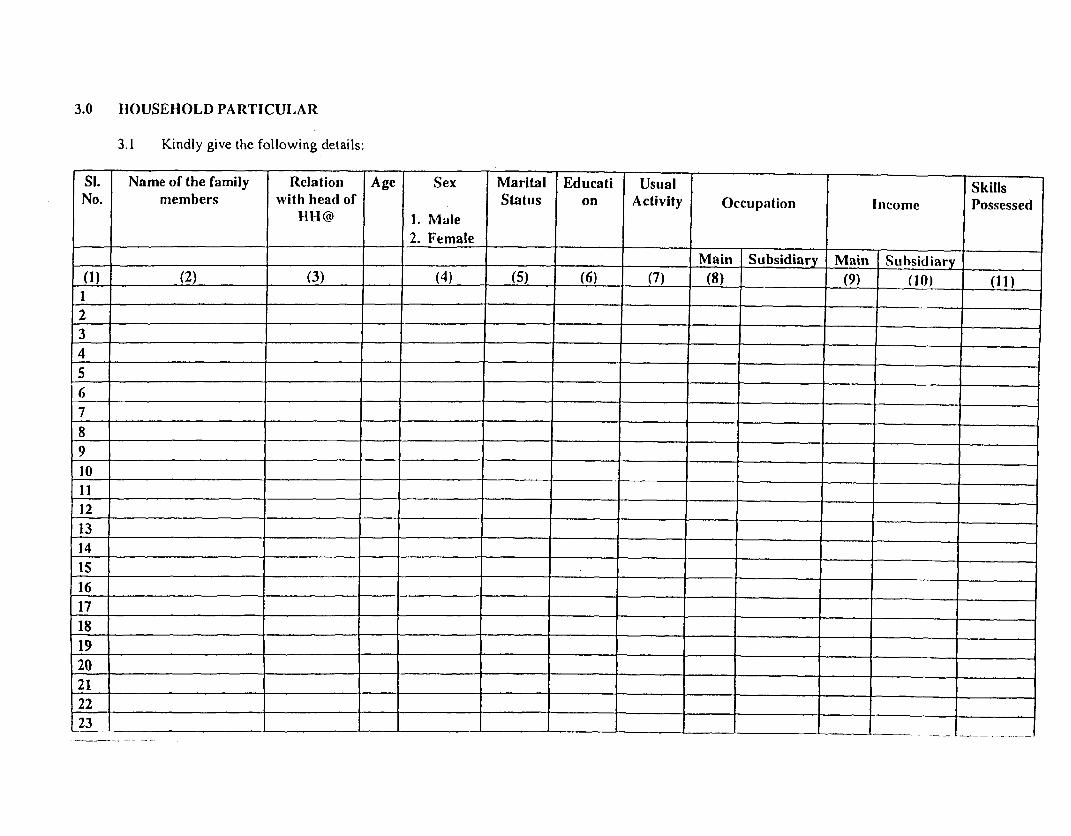
3.0 HOUSEHOLD PARTICULAR
3.1 Kindly give the following details:
SI. Name of the family Relation Age Sex Marital Educati Usual Skills
No. members with head of Status on Activity Occupation Income Possessed
IHl@ 1. Male
____ ____ ___ ____ ___ ___ ___ ____ ___2. F em ale _ _ _ _ _ _ _ _ _
= __________________ =___________ ______ Main Subsidiary Main Subsidiarv
(1 ) (2) (3) (4) (5) (6) (7) (8) _(9) (1 0) (11)
I .____________________ _____ ______-__
2 ___ _ _ _ _ _ _ _ _ _ __ _ _ _ _ __ _ _ __ ____ ___
4 _ _
12 =_ _ _ _ __ _ _ _ ___ _ _ _ ._ _ _ _ ___ _
8 _
10 .--=...-' ._
14 ._____ ___ _____ .____
3s _ ___ ______ ____
16 =__________ _-_____ =__ __________ ____
175______ ._____ ___ _
17 =__ -____ =___________
12 I I I_I_I _ I_A =_I___I
23 _ I l I I_I____ L l_I
21 4____ ____ ____ _____
22 ___________ ________ _____ ____ ____ __________ ___
23 6 ________________________________ _____________ _____
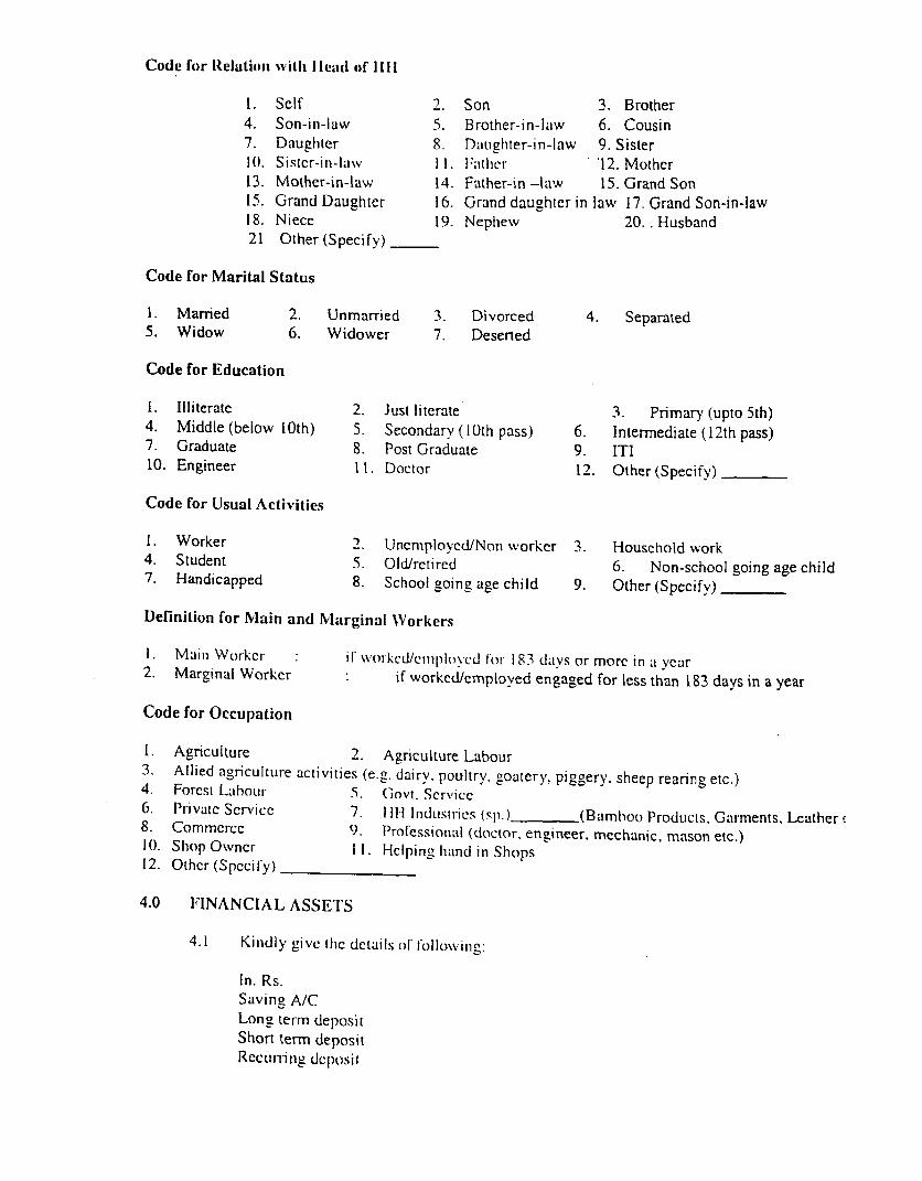
Code for ltelatioin vii I lead of 1111
1. Self 2. Son 3. Brother4. Son-in-law 5. Brother-in-iaw 6. Cousin7. Daughiter 8. Daughter-in-law 9. Sister10. Sistcr-in-lawxv I I. Father '12. Mother13. Mother-in-law 14. Father-in -law 15. Grand Son15. Grand Daughter 16. Grand daughter in law 17. Grand Son-in-law18. Niece 19. Nephew 20. . Husband21 Other (Specify)
Code for Marital Status
1. Married 2. Unmarried 3. Divorced 4. Separated5. Widow 6. Widower 7. Deserted
Code for Education
1. Illiterate 2. Just literate 3. Primary (upto 5th)4. Middle (below 10th) 5. Secondary (10th pass) 6. Intermediate (12th pass)7. Graduate 8. Post Graduate 9. ITI10. Engineer ll. Doctor 12. Other (Specify)
Code for Usual Activities
I. Worker 2. Unemploved/Non worker 3. Houschold work4. Student 5. Old/retired 6. Non-school going age child7. Handicapped 8. School going age child 9. Other (Specify)
Definition for Nlain and Marginal Workers
1. Main Worikcr 1 wl\,oiked/cmployed lob 183 days or morc in a year2. Marginal Worker if worked/employed engaged for less than 183 days in a year
Code for Occupation
1. Agriculture 2. Agriculture Labour3. Allied agriculture activities (e.g. dairv. poultry. goatery, piggery. sheep rearing etc.)4. Forcst LabouL- 5. (iovt. Service6. Privatc Service 7. 1111 Indiusiics (sp.)) (Bamhoo Products. Garments, Leather e
8. Commcrcc 9. Professional (doctor. engineer, mechanic, mason etc.)10. Shop Owncr 11. Hclpin2 hand in Shops12. Other (S pccily)
4.0 FINANCIAL ASSE'I'S
4.1 Kindly givc thc details of folloNving:
In. Rs.Saving A/CLong ter-m (lepositShort term depositRecurring deposii
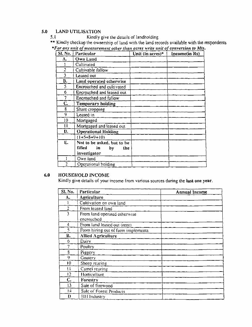
5.0 LAND UTILISATION5.1 Kindly give the details of landholding** Kindly checkup the ownership of land with the land records available with the respondents*For anzyuit o measurement other titant acres write utnit of conversion to Mts.
Si. No. Particular Unit (in acres)* Income(in Rs)A. Owni LanidI Cultivatcd2 Cultivable fallow3 Leased outB. Land operated otherwise I5 Encroached and cultivated6 Encroached and leased out7 Encroached and fallowC. Temporary holding8 Sharc cropping9 Leased in _10 Mortgaged . .
I Mortgaged and lcased out _
1). Operational lHolding(1+5+8+9+10)
E. Not to be asked. hut to hef-illed in by theinvestigator _
I Own land2 Operational holding_
6.0 HOUSEHOLD INCONIEKindly give details of your income from various sources during the last one year.
Si. No. Particular Annual IncomeA. AgricultureI Cultivation on own land2 From leased land3 From land operated otherwise
cncroaichcd4 From land lcased out (rent)5 From hiring out of farm implementsBI. Allie(d Agriculture6 Dai ry7 Poultry8 Piggery9 Goatcrv10 Sheep rcarinaI I Camel rearing _
12 1 loilictiltul-cC. Forestrv13 Sale of firewood _
14 Satlc ol Folrest ProductsI) li111 In d uL Stry V_ _ _ _ _ __ _ _ _ _ -_ _ _ _ _ __ _ _ _ _ _ _ _ _ _ _ _ _ _ _ _ _ _ _ _ _
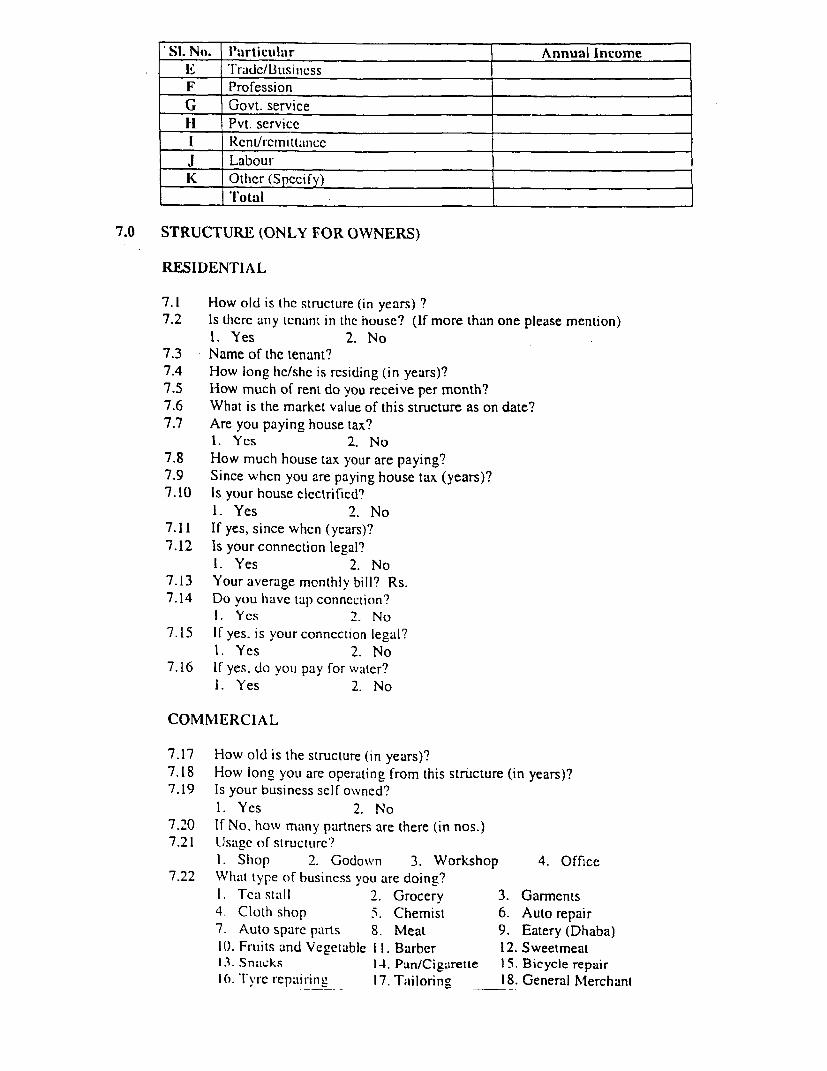
'Si. No. P'articulalr Annual Inco>meE 'I'tra;dc/BltsiniessF Profession.G Govt. servicelH Pvt. serviceI Rcnl/rcli ttaniccJ LabourK Other (Specify)
I '1'otal .
7.0 STRUCTURE (ONLY FOR OWNERS)
RESIDENTIAL
7.1 How old is the structure (in years) ?7.2 Is thcrc any tenant in thc house? (If more than one please mention)
1. Yes 2. No7.3 Name of the tenant?7.4 How long hc/she is rcsiding (in years)?7.5 How much of rent do you receive per month?7.6 What is the market value of this structure as on date?7.7 Are you paying house tax?
1. Yes 2. No7.8 How much house tax your are paying?7.9 Since when you are paying house tax (years)?7.10 Is your house clectrifiecd?
1. Yes 2. No7.11 If yes, since when (years)?7.12 Is your connection legal?
1. Yes 2. No7.13 Your average monthly bill? Rs.7.14 Do you have tap conncction?
1. Yes 2. No7.15 If yes. is your connection legal?
1. Yes 2. No7.16 If yes. do you pay for water?
1. Yes 2. No
COMMERCIAL
7.17 How old is the structure (in years)?7.18 How long you are operating from this structure (in years)?7.19 Is your business self owned?
1. Yes 2. No7.20 If No. howv many partners are there (in nos.)7.21 Usage of structure?
1. Shop 2. Godown 3. Workshop 4. Office7.22 What type of business you are doing?
I. Tea stall 2. Grocery 3. Garments4. Cloth shop 5. Chemist 6. Auto repair7. Auto sparc parts 8. Meat 9. Eatery (Dhaba)10. Fruils and Vegetable I1. Barber 12. Sweetmeat13. Snacks 14. Pan/Cigarette 15. Bicycle repair10. Tyrc repairing 17. Tailorin- 18. General Mlerchant
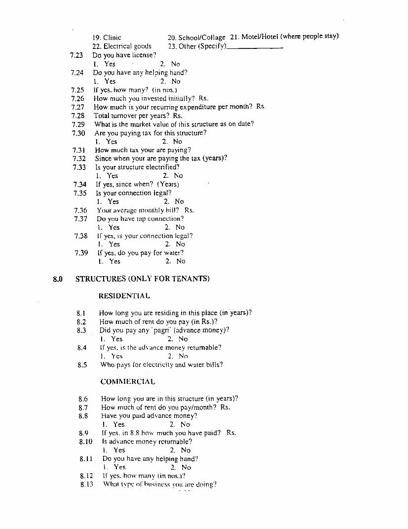
19. Clinic 20. School/Collage 21. Motel/Hotel (where people stay)22. Electrical goods 23. Other (Specify)
7.23 Do you have license?1. Yes 2. No
7.24 Do you have any helping hand?1. Yes 2. No
7.25 If ycs, how many? (in nos.)7.26 How much you invested initially'? Rs.7.27 How much is your recurring expenditure per month? Rs.7.28 Total turnover per years? Rs.7.29 What is the market value of this structure as on date?7.30 Are you paying tax for this structure?
1. Yes 2. No7.31 How much tax your are paying?7.32 Since when your are paying the tax (years)?7.33 Is your structure electrified?
1. Yes 2. No7.34 If yes, since when? (Years)7.35 Is your connection legal?
1. Yes 2. No7.36 Your avcragc monithly hill? Rs.7.37 Do you havc tlap conncction'?
1. Yes 2. No7.38 If ycs, is your conncctionl legal?
1. Yes 2. No7.39 If yes, do you pay for water?
1. Yes 2. No
8.0 STRUCTURES (ONLY FOR TENANTS)
RESIDENTI IAL
8.1 How long you are residing in this place (in years)?8.2 How much of rent do you pay (in Rs.)?8.3 Did you pay any 'pagrn (advance money)?
1. Yes 2. No8.4 If yes, is the advance money returnable?
1. Yes 2. No8.5 Who pays lor clectricity and water bills?
COvINIERCIAL
8.6 How long you are in this structure (in years)?8.7 How much of rent do you pay/month? Rs.8.8 Have you paid advance money?
1. Yes 2. No8.9 IC yes. in 8.8 how much you have paid? Rs.8.10 Is advance money returnable?
1. Yes 2. No8.11 Do you have any helping hand?
1. Yes 2. No8.12 11 yes. how matny (in nos.)?8.13 What t\pc of hittin"ss you are doing?
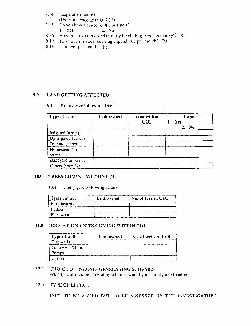
8.14 Usage of structure?(Usc samc code as in Q. 7.21)
8.15 Do you have liccnsc for the business?1. Yes 2. No
8.16 How much you invested initially (excluding advance money)? Rs.8.17 How much is your recumng expenditure per month? Rs.8.18 Tumover per month? Rs.
9.0 LAND GETTING AFFECTED
9.1 Kindly give following details:
Type of Land Unit owned Area within Legall ~~~ ~~COI 1. Yes1 __________ ~~~2. No.
Irrigated (acres) |Unirrigated (acics)Orchard (acres)Homestead (insq.mt.)Backyard in sq.mt.Others (specify)__
10.0 TREES COMIING WITHIN COI
10.1 Kindly give loliowing dctails
-Trees (In no.) Unit owned No. of tree in COIFruit bearineFoddcrFuci wood
11.0 IRRIGATION UNITS COMING WITHIN COI
Tylpe of well Unit owned No. of wells in COIDug wCels
Tube wells/HandPumpsLI Points
12.0 C11ICE OF INCOMlE (ENE 1RATIN(G SCHEIMESWhil typc of incomc gencrating schcmes would your family like to adopt?
13.0 'I'YI'E OF EFFECT
(NOT 'l() BE ASKEID BUT TO BE ASSEISSED) BY THE INVESTI-GATOR)
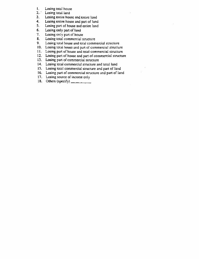
1. Losing total house2..' Losing total land3. Losing entire house and entire land4. Losing entire house and part of land5. Losing part of house and entire land6. Losing only part of land7. Losing only part of house8. Losing total commercial structure9. Losing total house and total commercial structure10. Losing total house and part of commercial structure11. Losing part of house and total commercial structure12. Losing part of house and part of commercial structure13. Losing part of commercial structure14. Losing total commercial structure and total land15. Losing total commercial structure and part of land16. Losing part of commcrcial structure and part of land17. Losing sourcc of income only18. Others (specify)

ANNEXURE 2.2 A
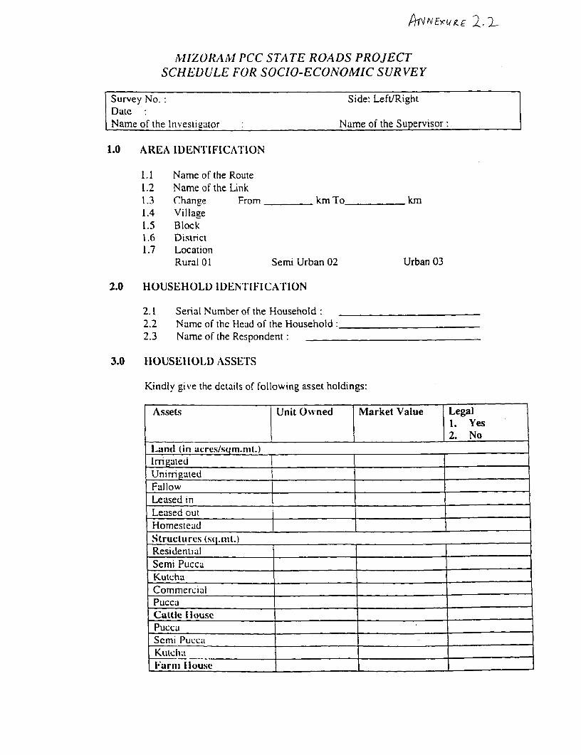
AIIZORAM PCC STATE ROADS PROJECTSCHEDULE FOR SOCIO-ECONOMIC SURVEY
Survey No.: Side, Left/RightDatc:Name of the Investigator : Name of the Supervisor:
1.0 AREA IDENTIFICATION
1.1 Name of the Route1.2 Name of the Link1.3 Change From km To tkm1.4 Village1.5 Block1.6 District1.7 Location
Rural 01 Semi Urban 02 Urban 03
2.0 HOUSEHOLD IDENTIFICATriON
2.1 Serial Number of the Household:2.2 Namc of the Head of the Household:2.3 Name of the Respondent:
3.0 HOUSEHOLD ASSET I'S
Kindly give the details of following asset holdings:
Assets Unit Owned Market Value Legal1. Yes2. No
Land (in acres/sqm.nit.)
IrTigatedUnirrimated
Fallow __Leased inLeased outHomesteadStrucltures (s( .nit.)ResidentialSemi PuccaKutchaCommcrciul
PuccaCattle [louse .
PuccaScmi PuccaKuitcha _
Zarn louse
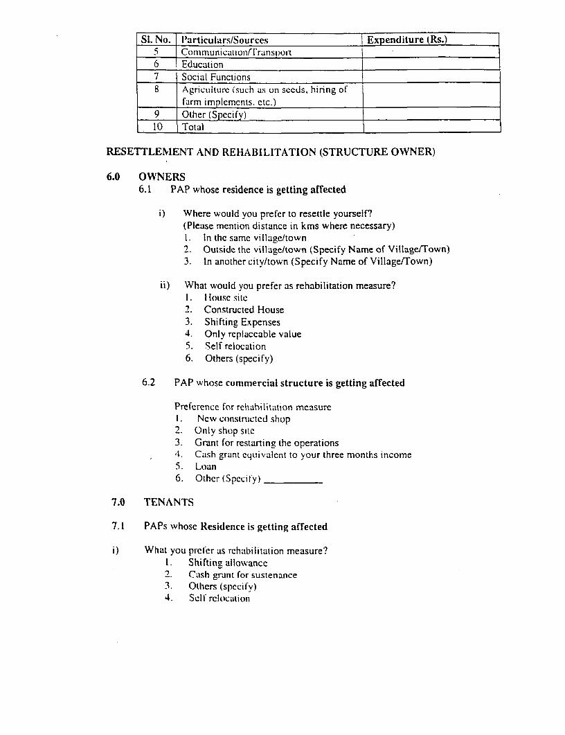
Si. No. Ilarticulars/Sources Expenditure (Rs.)5 Communicatonfrl'ransport
6 Education7 Sociai Functions8 AgricultLirc (such as on sceds, hiring of
farm implements. etc.)9 Other (Specify)10 Total
RESETTLEMENT AND REHABILITATION (STRUCTURE OWNER)
6.0 OWNERS6.1 PAP whose residence is getting affected
i) Where would you prefer to resettle yourself?(Please mention distance in kms where necessary)I. In thc samc village/town2. Outsidc the village/town (Specify Name of Village/Town)3. In another city/town (Specify Name of VillagefTown)
ii) What would you prefer as rehabilitation measure?I -IOtISC sitc
2. Constructed House3. Shifting Expenses4. Only replaceable value5. Self relocation6. Others (specify)
6.2 PAP whose commercial structure is getting affected
Preference for rehabilitation measureI. Ncv constnicted shop2. Only shop sitc3. Grant for restarting the operations4. Cash grant cequivalent to your three months income5. Loan6. Other (Specify)
7.0 TENANTS
7.1 PAPs whose Residenice is getting affected
i) What you priecr as rehabilitation measure?1. Shifting allowance2. Cash grant for sustenance3. Others (spccify)4. Sell' rclocatiotn
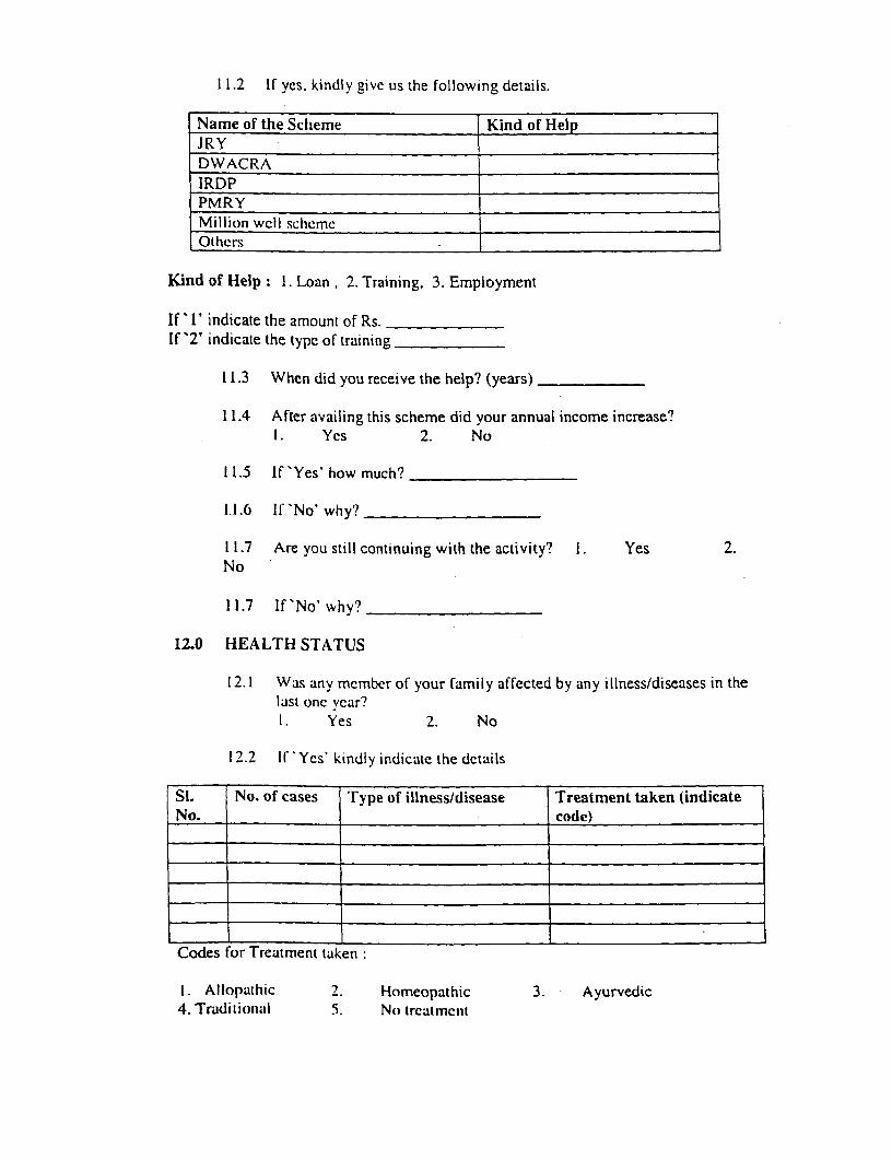
11.2 If yes, kindly give us the following details.
Name of the Scheme Kind of HelpJRYDWACRAIRDPPMRYMillion wcll schemcOtlhers
Kind of Help: 1. Loan, 2. Training, 3. Employment
If' I' indicate the amount of Rs.If '2' indicate the type of training
11.3 When did you receive the help? (years)
11.4 After availing this scheme did your annual income increase?I. Yes 2. No
11.5 If 'Yes' how much?
1.1.6 lI No' why?
11.7 Are you still continuing with the activity? I. Yes 2.No
11.7 If'No' why?
12.0 HEALTH STATUS
12.1 Was any member of your family affected by any illness/diseases in thelast one year?1. Yes 2. No
12.2 I 'Ycs kindly indicate the dctails
Si. No. of cases Type of illness/disease Treatment taken (indicateNo. _ _ code)
Codes for Treatment taken
1. Allopathic 2. Homeopathic 3. Ayurvedic4. Traditional 5. No trcatmcit

ANNEXURE 2.3 m
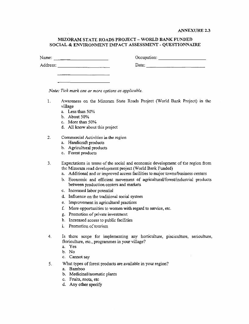
ANNEXURE 2.3
MIZORAM STATE ROADS PROJECT - WORLD BANK FUNDEDSOCIAL & ENVIRONMENT IMPACT ASSESSMENT - QUESTIONNAIRE
Name: Occupation:
Address: Date:
Note: Tick mark one or more options as applicable.
Awareness on the Mizoram State Roads Project (World Bank Project) in thevillagea. Less than 50%b. About 50%c. More than 50%d. All know about this project
2. Corrmercial Activities in the regiona. Handicraft productsb. Agricultural productsc. Forest products
3 . Expectations in terms of the social and economic development of the region fromthe Mizoram road development project (World Bank Funded)a. Additional and or improved access facilities to major towns/business centersb. Economic and efficient movement of agricultural/forest/industrial products
between production centers and marketsc. Increased labor potentiald. Influence on the traditional social systeme. Improvement in agricultural practicesf. More opportunities to women with regard to service, etc.g. Promotion of private investmenth. Increased access to public facilitiesi. Promotion of tourism
4. Is there scope for implementing any horticulture, pisciculture, sericulture,floriculture, etc., programmes in your village?a. Yesb. Noc. Cannot say
5. What types of forest products are available in your region?a. Bamboob. Medicinal/aromatic plantsc. Fruits, roots, etcd. Any other specify
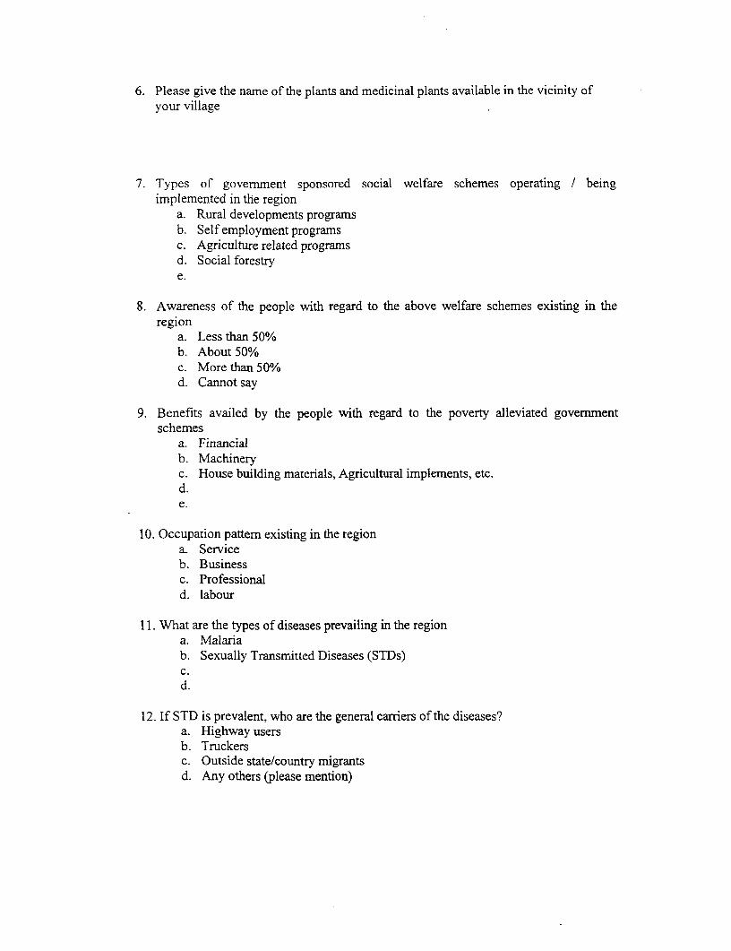
6. Please give the name of the plants and medicinal plants available in the vicinity ofyour village
7. Types of government sponsored social welfare schemes operating / beingimplemented in the region
a. Rural developments programsb. Self employment programsc. Agriculture related programsd. Social forestrye.
8. Awareness of the people with regard to the above welfare schemes existing in theregion
a. Less than 50%b. About 50%c. More than 50%d. Cannot say
9. Benefits availed by the people with regard to the poverty alleviated governmentschemes
a. Financialb. Machineryc. House building materials, Agricultural implements, etc.d.e.
10. Occupation pattern existing in the regiona. Serviceb. Businessc. Professionald. labour
11. What are the types of diseases prevailing in the regiona. Malariab. Sexually Transmitted Diseases (STDs)c.d.
12. If STD is prevalent, who are the general carriers of the diseases?a. Highway usersb. Truckersc. Outside state/country migrantsd. Any others (please mention)
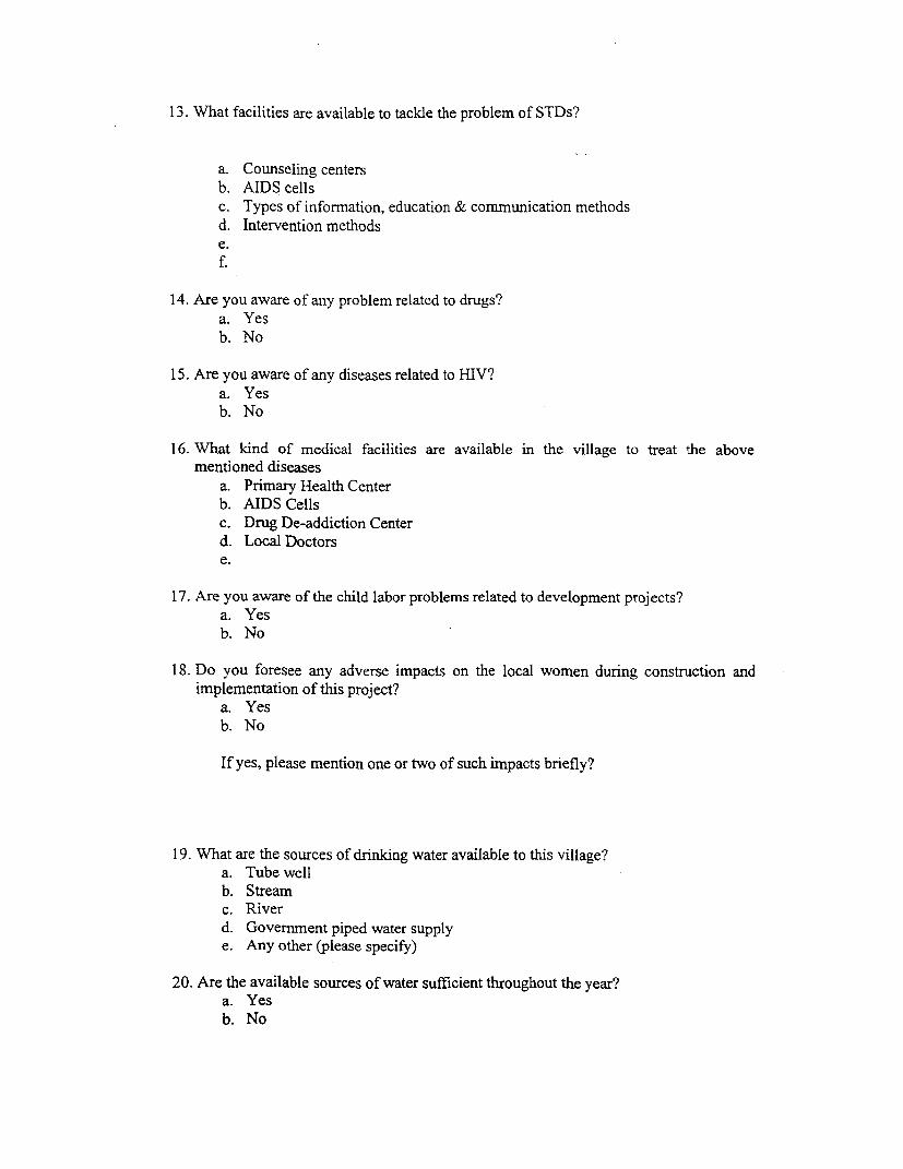
13. What facilities are available to tackle the problem of STDs?
a. Counseling centersb. AIDS cellsc. Types of information, education & comrnunication methodsd. Intervention methodse.f.
14. Are you aware of any problem related to drugs?a. Yesb. No
15. Are you aware of any diseases related to HIV?a. Yesb. No
16. What kind of medical facilities are available in the village to treat the abovementioned diseases
a. Primary Health Centerb. AIDS Cellsc. Drug De-addiction Centerd. Local Doctorse.
17. Are you aware of the child labor problems related to development projects?a. Yesb. No
18. Do you foresee any adverse impacts on the local women during construction andimplementation of this project?
a. Yesb. No
If yes, please mention one or two of such irnpacts briefly?
19. What are the sources of drinking water available to this village?a. Tube wellb. Streamc. Riverd. Government piped water supplye. Any other (please specify)
20. Are the available sources of water sufficient throughout the year?a. Yesb. No
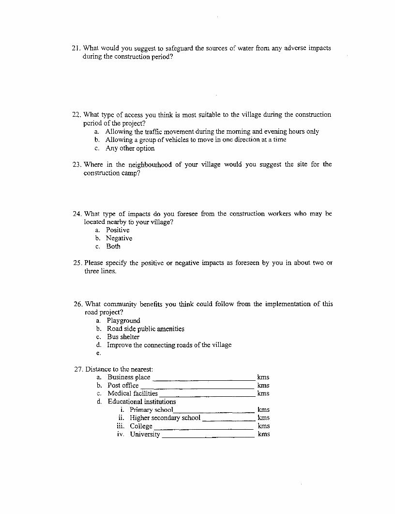
21. What would you suggest to safeguard the sources of water from any adverse impactsduring the construction period?
22. What type of access you think is most suitable to the village during the constructionperiod of the project?
a. Allowing the traffic movement during the morning and evening hours onlyb. Allowing a group of vehicles to move in one direction at a timec. Any other option
23. Where in the neighbourhood of your village would you suggest the site for theconstruction camp?
24. What type of impacts do you foresee from the construction workers who may belocated nearby to your village?
a. Positiveb. Negativec. Both
25. Please specify the positive or negative impacts as foreseen by you in about two orthree lines.
26. What commnunity benefits you think could follow from the implementation of thisroad project?
a. Playgroundb. Road side public amenitiesc. Bus shelterd. Improve the connecting roads of the villagee.
27. Distance to the nearest:a. Business place kmsb. Post office kmsc. Medical facilities kmsd. Educational institutions
i. Primary school kmsii. Higher secondary school kms
iii. College kmsiv. University kms
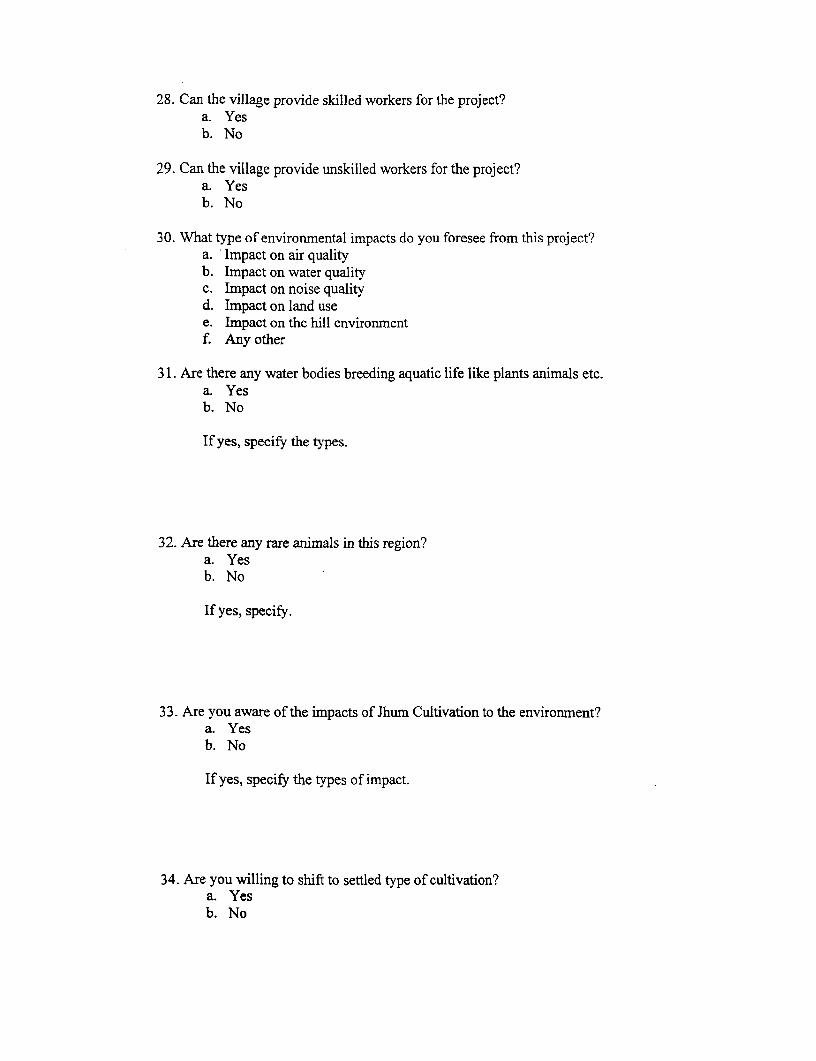
28. Can the village provide skilled workers for the project?a. Yesb. No
29. Can the village provide unskilled workers for the project?a. Yesb. No
30. What type of environmental impacts do you foresee from this project?a. Impact on air qualityb. Impact on water qualityc. Impact on noise qualityd. Impact on land usee. Impact on the hill environmentf. Any other
31. Are there any water bodies breeding aquatic life like plants animals etc.a. Yesb. No
If yes, specify the types.
32. Are there any rare animals in this region?a. Yesb. No
If yes, specify.
33. Are you aware of the impacts of Jhum Cultivation to the environment?a. Yesb. No
If yes, specify the types of impact.
34. Are you willing to shift to settled type of cultivation?a. Yesb. No
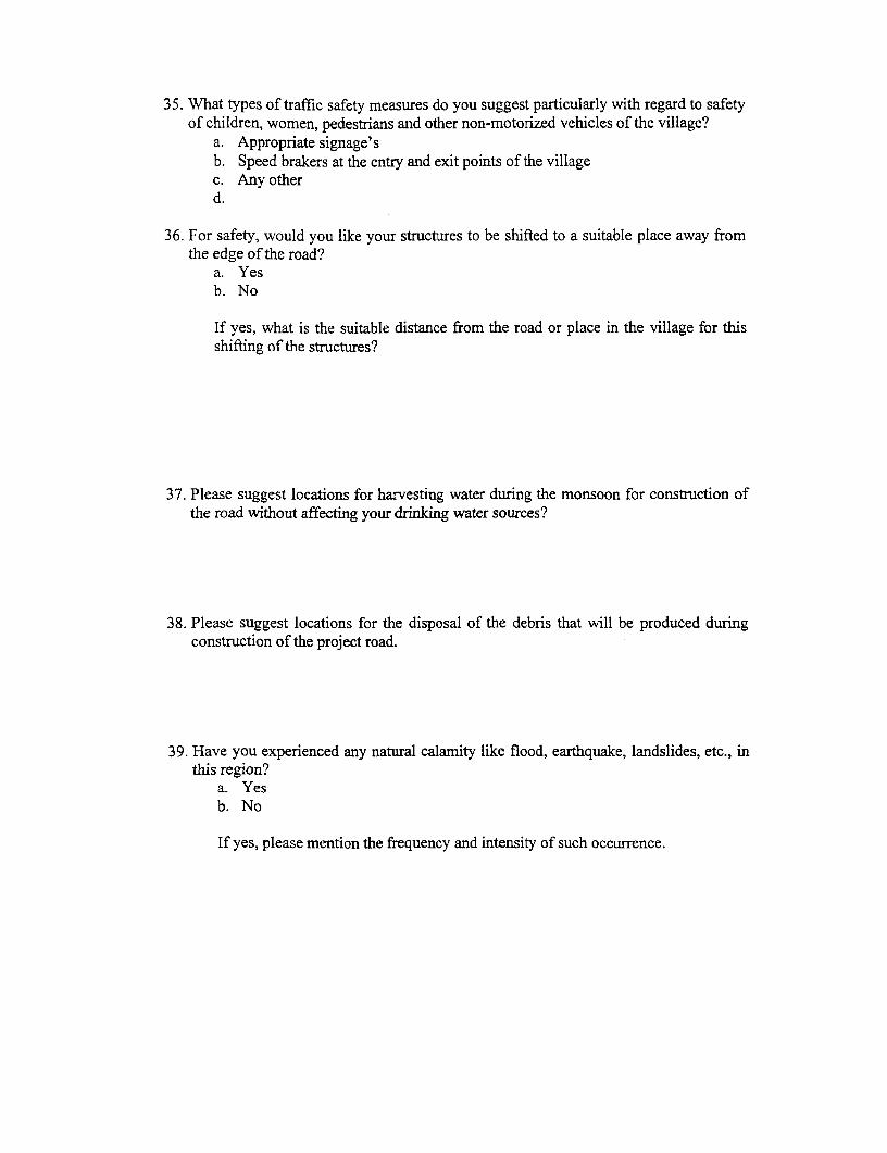
35. What types of traffic safety measures do you suggest particularly with regard to safetyof children, women, pedestrians and other non-motorized vehicles of the village?
a. Appropriate signage'sb. Speed brakers at the entry and exit points of the villagec. Any otherd.
36. For safety, would you like your structures to be shifted to a suitable place away fromthe edge of the road?
a. Yesb. No
If yes, what is the suitable distance from the road or place in the village for thisshifting of the structures?
37. Please suggest locations for harvesting water during the monsoon for construction ofthe road without affecting your drinking water sources?
38. Please suggest locations for the disposal of the debris that will be produced duringconstruction of the project road.
39. Have you experienced any natural calamity like flood, earthquake, landslides, etc., inthis region?
a. Yesb. No
If yes, please mention the frequency and intensity of such occurrence.

ANNEXURE 3.1
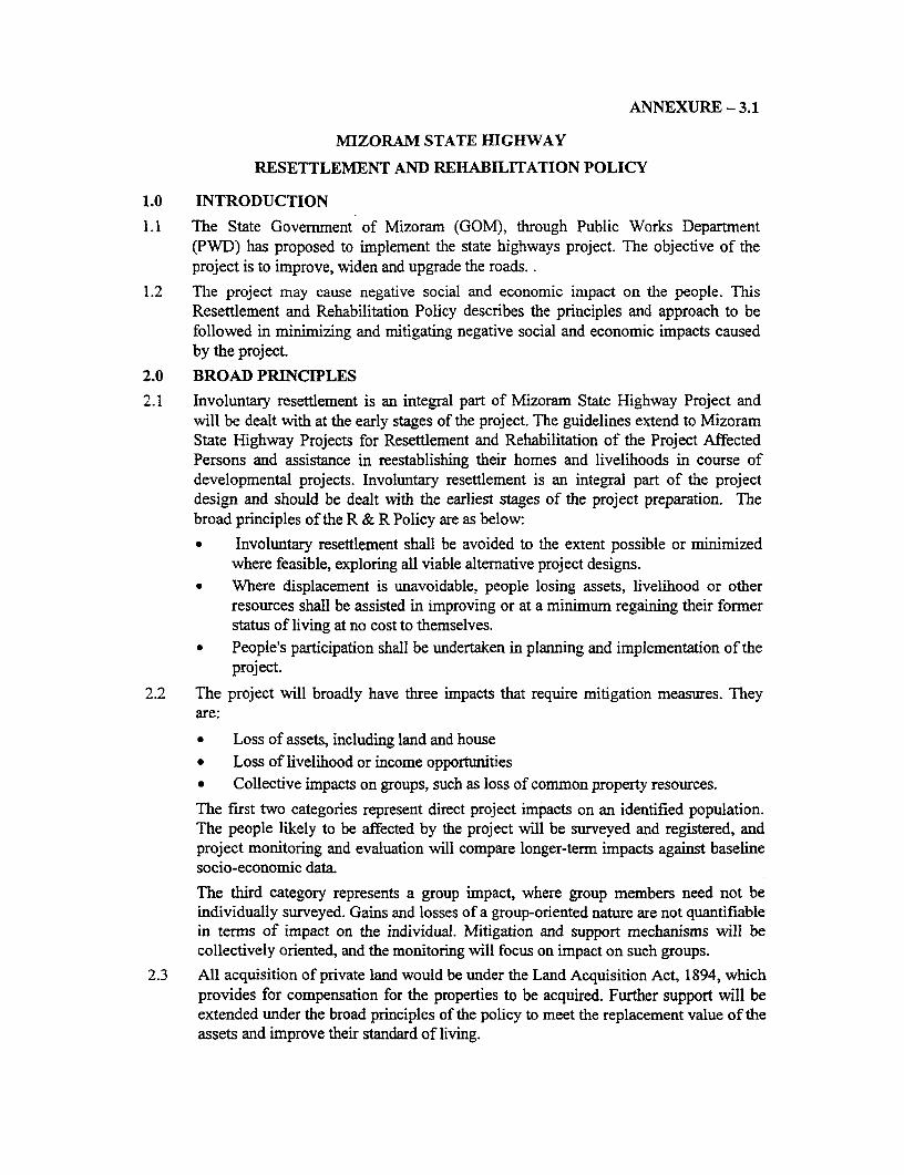
ANNEXURE - 3.1
MIZORAM STATE HIGHWAY
RESETTLEMENT AND REHABILITATION POLICY
1.0 INTRODUCTION
1.1 The State Government of Mizoram (GOM), through Public Works Department(PWD) has proposed to implement the state highways project. The objective of theproject is to improve, widen and upgrade the roads. .
1.2 The project may cause negative social and economic impact on the people. ThisResettlement and Rehabilitation Policy describes the principles and approach to befollowed in minimizing and mitigating negative social and economic impacts causedby the project.
2.0 BROAD PRINCIPLES
2.1 Involuntary resettlement is an integral part of Mizoram State Highway Project andwill be dealt with at the early stages of the project. The guidelines extend to MizoramState Highway Projects for Resettlement and Rehabilitation of the Project AffectedPersons and assistance in reestablishing their homes and livelihoods in course ofdevelopmental projects. Involuntary resettlement is an integral part of the projectdesign and should be dealt with the earliest stages of the project preparation. Thebroad principles of the R & R Policy are as below:
* Involuntary resettlement shall be avoided to the extent possible or minimizedwhere feasible, exploring all viable alternative project designs.
* Where displacement is unavoidable, people losing assets, livelihood or otherresources shall be assisted in improving or at a minimum regaining their formerstatus of living at no cost to themselves.
* People's participation shall be undertaken in planning and implementation of theproject.
2.2 The project will broadly have three impacts that require mitigation measures. Theyare:
* Loss of assets, including land and house* Loss of livelihood or income opportunities* Collective impacts on groups, such as loss of common property resources.
The first two categories represent direct project impacts on an identified population.The people likely to be affected by the project will be surveyed and registered, andproject monitoring and evaluation will compare longer-term impacts against baselinesocio-economic data.
The third category represents a group impact, where group members need not beindividually surveyed. Gains and losses of a group-oriented nature are not quantifiablein terms of impact on the individual. Mitigation and support mechanisms will becollectively oriented, and the monitoring will focus on impact on such groups.
2.3 All acquisition of private land would be under the Land Acquisition Act, 1894, whichprovides for compensation for the properties to be acquired. Further support will beextended under the broad principles of the policy to meet the replacement value of theassets and improve their standard of living.
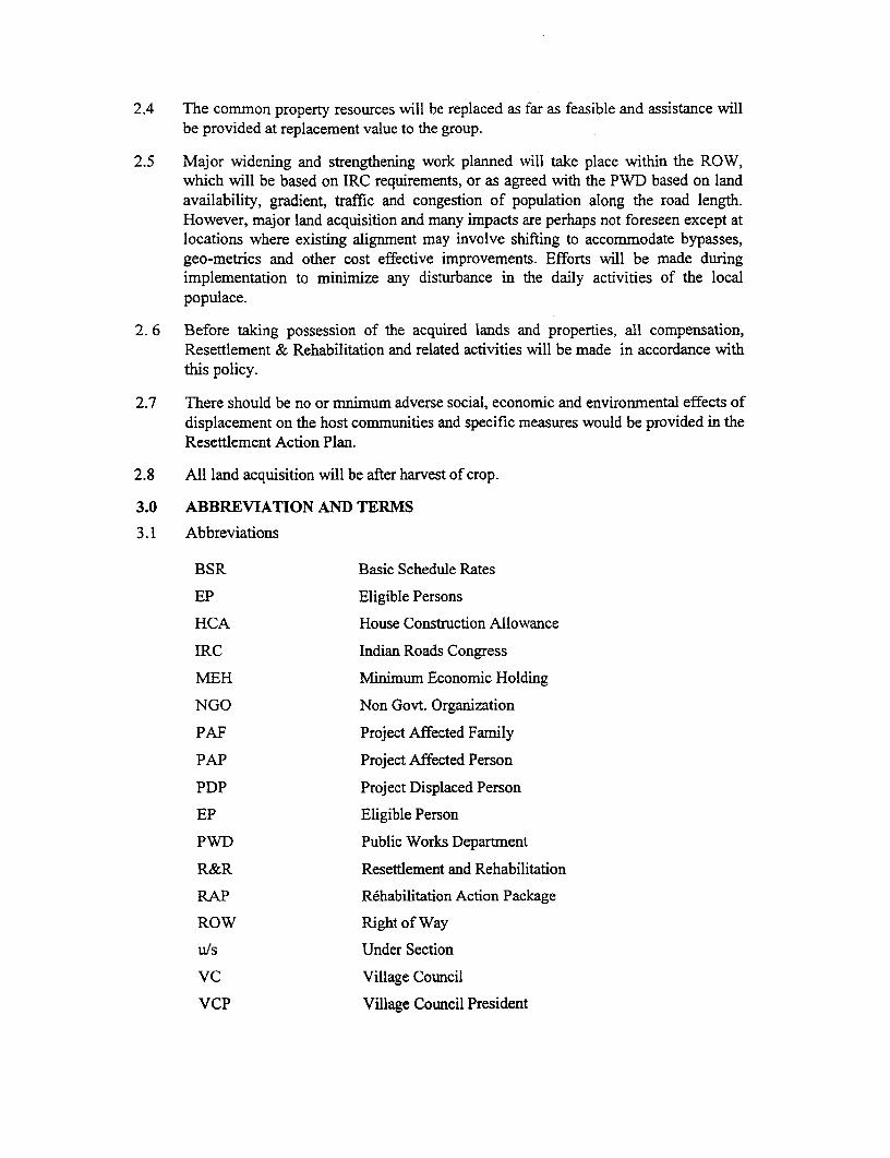
2.4 The common property resources will be replaced as far as feasible and assistance willbe provided at replacement value to the group.
2.5 Major widening and strengthening work planned will take place within the ROW,which will be based on IRC requirements, or as agreed with the PWD based on landavailability, gradient, traffic and congestion of population along the road length.However, major land acquisition and many impacts are perhaps not foreseen except atlocations where existing alignment may involve shifting to accommodate bypasses,geo-metrics and other cost effective improvements. Efforts will be made duringimplementation to minimize any disturbance in the daily activities of the localpopulace.
2. 6 Before taking possession of the acquired lands and properties, all compensation,Resettlement & Rehabilitation and related activities will be made in accordance withthis policy.
2.7 There should be no or mnimum adverse social, economic and environmental effects ofdisplacement on the host communities and specific measures would be provided in theResettlement Action Plan.
2.8 All land acquisition will be after harvest of crop.
3.0 ABBREVIATION AND TERMS
3.1 Abbreviations
BSR Basic Schedule Rates
EP Eligible Persons
HCA House Construction Allowance
IRC Indian Roads Congress
MEH Minimum Economic Holding
NGO Non Govt. Organization
PAF Project Affected Family
PAP Project Affected Person
PDP Project Displaced Person
EP Eligible Person
PWD Public Works Department
R&R Resettlement and Rehabilitation
RAP Rdhabilitation Action Package
ROW Right of Way
u/s Under Section
VC Village Council
VCP Village Council President
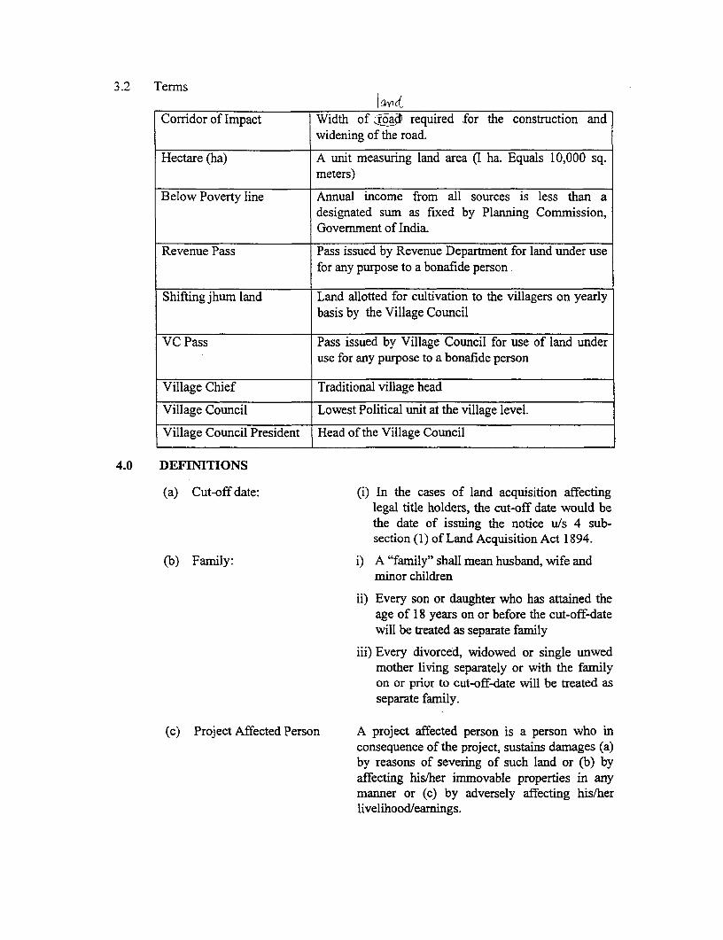
3.2 Terms1wd-
Corridor of Impact Width of :r6a required -for the construction andwidening of the road.
Hectare (ha) A unit measuring land area (I ha. Equals 10,000 sq.meters)
Below Poverty line Annual income from all sources is less than adesignated sum as fixed by Planning Commnission,Government of India.
Revenue Pass Pass issued by Revenue Department for land under usefor any purpose to a bonafide person
Shifting jhum land Land allotted for cultivation to the villagers on yearlybasis by the Village Council
VC Pass Pass issued by Village Council for use of land underuse for any purpose to a bonafide person
Village Chief Traditional village head
Village Council Lowest Political unit at the village level.
Village Council President Head of the Village Council
4.0 DEFINITIONS
(a) Cut-off date: (i) In the cases of land acquisition affectinglegal title holders, the cut-off date would bethe date of issuing the notice u/s 4 sub-section (1) of Land Acquisition Act 1894.
(b) Family: i) A "family" shall mean husband, wife andminor children
ii) Every son or daughter who has attained theage of 18 years on or before the cut-off-datewill be treated as separate family
iii) Every divorced, widowed or single unwedmother living separately or with the familyon or prior to cut-off-date will be treated asseparate family.
(c) Project Affected Person A project affected person is a person who inconsequence of the project, sustains damages (a)by reasons of severing of such land or (b) byaffecting his/her immovable properties in anymanner or (c) by adversely affecting his/herlivelihood/earnings.
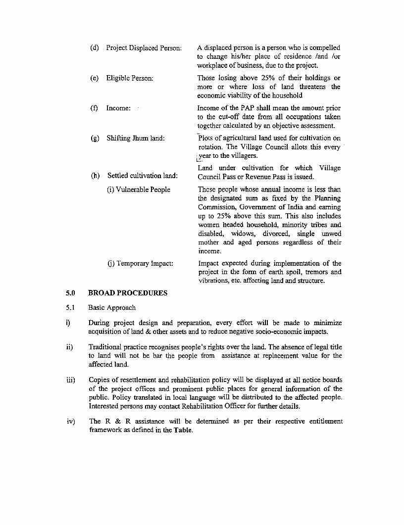
(d) Project Displaced Person: A displaced person is a person who is compelledto change his/her place of residence /and /orworkplace of business, due to the project.
(e) Eligible Person: Those losing above 25% of their holdings ormore or where loss of land threatens theeconomic viability of the household
(f) Income: Income of the PAP shall mean the amount priorto the cut-off date from all occupations takentogether calculated by an objective assessment.
(g) Shifting Jhum land: Plots of agricultural land used for cultivation onrotation. The Village Council allots this everyear to the villagers.
Land under cultivation for which Village(h) Settled cultivation land: Council Pass or Revenue Pass is issued.
(i) Vulnerable People Those people whose annual income is less thanthe designated sum as fixed by the PlanningCommission, Government of India and earningup to 25% above this sum. This also includeswomen headed household, minority tribes anddisabled, widows, divorced, single unwedmother and aged persons regardless of theirincome.
(j) Temporary Impact: Impact expected during implementation of theproject in the form of earth spoil, tremors andvibrations, etc. affecting land and structure.
5.0 BROAD PROCEDURES
5.1 Basic Approach
i) During project design and preparation, every effort will be made to minimizeacquisition of land & other assets and to reduce negative socio-economic impacts.
ii) Traditional practice recognises people's rights over the land. The absence of legal titleto land will not be bar the people from assistance at replacement value for theaffected land.
iii) Copies of resettlement and rehabilitation policy will be displayed at all notice boardsof the project offices and prominent public places for general inforrnation of thepublic. Policy translated in local language will be distributed to the affected people.Interested persons may contact Rehabilitation Officer for further details.
iv) The R & R assistance will be determined as per their respective entitlementframework as defined in the Table.
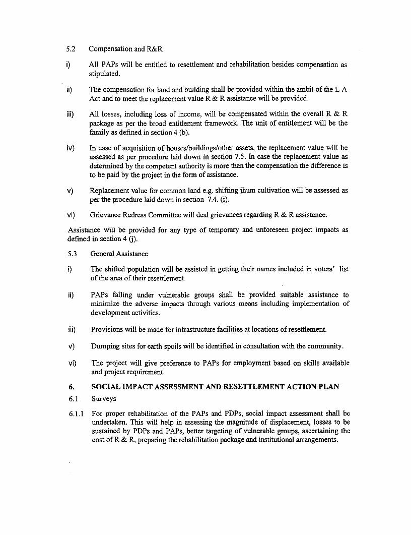
5.2 Compensation and R&R
i) All PAPs will be entitled to resettlement and rehabilitation besides compensation asstipulated.
ii) The compensation for land and building shall be provided within the ambit of the L AAct and to meet the replacement value R & R assistance will be provided.
iii) All losses, including loss of income, will be compensated within the overall R & Rpackage as per the broad entitlement framework. The unit of entitlement will be thefamily as defined in section 4 (b).
iv) In case of acquisition of houses/buildings/other assets, the replacement value will beassessed as per procedure laid down in section 7.5. In case the replacement value asdetermined by the competent authority is more than the compensation the difference isto be paid by the project in the form of assistance.
v) Replacement value for common land e.g. shifting jhum cultivation will be assessed asper the procedure laid down in section 7.4. (i).
vi) Grievance Redress Committee will deal grievances regarding R & R assistance.
Assistance will be provided for any type of temporary and unforeseen project impacts asdefned in section 4 (j).
5.3 General Assistance
i) The shifted population will be assisted in getting their names included in voters' listof the area of their resettlement.
ii) PAPs falling under vulnerable groups shall be provided suitable assistance tominimize the adverse impacts through various means including implementation ofdevelopment activities.
iii) Provisions will be made for infrastructure facilities at locations of resettlement.
v) Dumping sites for earth spoils will be identified in consultation with the community.
vi) The project will give preference to PAPs for employment based on skills availableand project requirement.
6. SOCIAL IMPACT ASSESSMENT AND RESETTLEMENT ACTION PLAN
6.1 Surveys
6.1.1 For proper rehabilitation of the PAPs and PDPs, social impact assessment shall beundertaken. This will help in assessing the magnitude of displacement, losses to besustained by PDPs and PAPs, better targeting of vulnerable groups, ascertaining thecost of R & R, preparing the rehabilitation package and institutional arrangements.
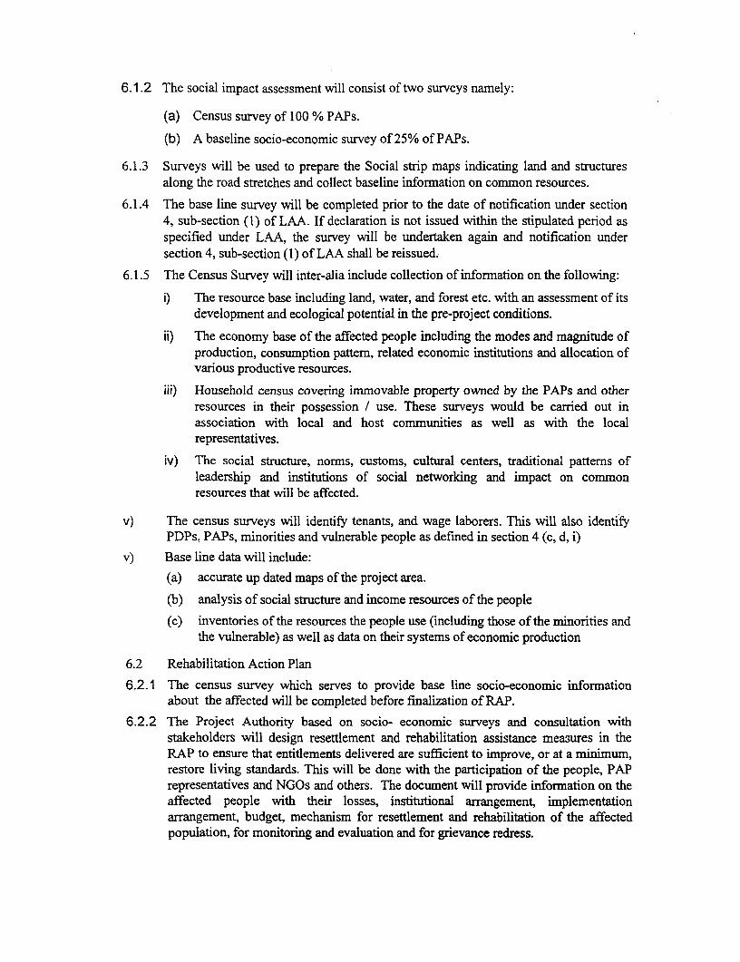
6.1.2 The social impact assessment will consist of two surveys namely:
(a) Census survey of 100 % PAPs.
(b) A baseline socio-economic survey of 25% of PAPs.
6.1.3 Surveys will be used to prepare the Social strip maps indicating land and structuresalong the road stretches and collect baseline information on common resources.
6.1.4 The base line survey will be completed prior to the date of notification under section4, sub-section (1) of LAA. If declaration is not issued within the stipulated period asspecified under LAA, the survey will be undertaken again and notification undersection 4, sub-section (1) of LAA shall be reissued.
6.1.5 The Census Survey will inter-alia include collection of information on the following:
i) The resource base including land, water, and forest etc. with an assessment of itsdevelopment and ecological potential in the pre-project conditions.
ii) The economy base of the affected people including the modes and magnitude ofproduction, consumption pattern, related economic institutions and allocation ofvarious productive resources.
iii) Household census covering immovable property owned by the PAPs and otherresources in their possession / use. These surveys would be carried out inassociation with local and host communities as well as with the localrepresentatives.
iv) The social structure, norms, customs, cultural centers, traditional patterns ofleadership and institutions of social networking and impact on commonresources that will be affected.
v) The census surveys will identify tenants, and wage laborers. This will also identifyPDPs, PAPs, minorities and vulnerable people as defined in section 4 (c, d, i)
v) Base line data will include:(a) accurate up dated maps of the project area.
(b) analysis of social structure and income resources of the people
(c) inventories of the resources the people use (including those of the minorities andthe vulnerable) as well as data on their systems of economic production
6.2 Rehabilitation Action Plan
6.2.1 The census survey which serves to provide base line socio-economic informationabout the affected will be completed before finalization of RAP.
6.2.2 The Project Authority based on socio- economic surveys and consultation withstakeholders will design resettlement and rehabilitation assistance measures in theRAP to ensure that entitlements delivered are sufficient to improve, or at a minimum,restore living standards. This will be done with the participation of the people, PAPrepresentatives and NGOs and others. The document will provide information on theaffected people with their losses, institutional arrangement, implementationarrangement, budget, mechanism for resettlement and rehabilitation of the affectedpopulation, for monitoring and evaluation and for grievance redress.
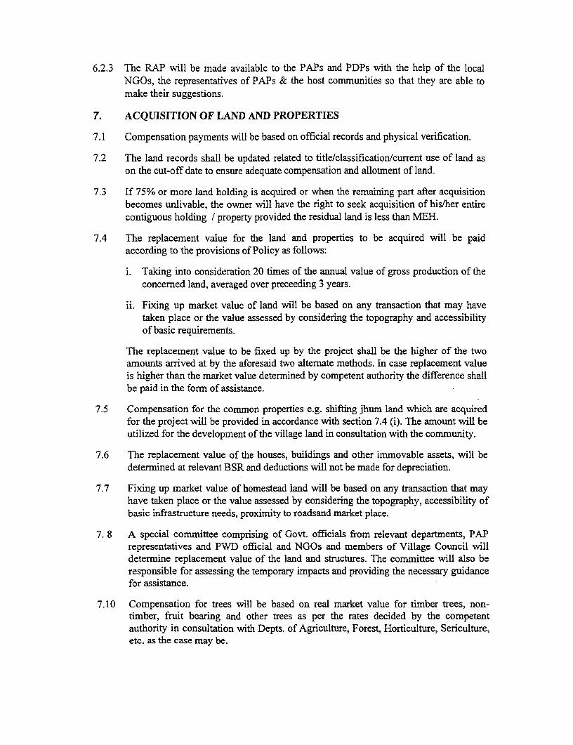
6.2.3 The RAP will be made available to the PAPs and PDPs with the help of the localNGOs, the representatives of PAPs & the host communities so that they are able tomake their suggestions.
7. ACQUISITION OF LAND AND PROPERTIES
7.1 Compensation payments will be based on official records and physical verification.
7.2 The land records shall be updated related to title/classification/current use of land ason the cut-off date to ensure adequate compensation and allotment of land.
7.3 If 75% or more land holding is acquired or when the remaining part after acquisitionbecomes unlivable, the owner will have the right to seek acquisition of his/her entirecontiguous holding / property provided the residual land is less than MEH.
7.4 The replacement value for the land and properties to be acquired will be paidaccording to the provisions of Policy as follows:
i. Taking into consideration 20 times of the annual value of gross production of theconcerned land, averaged over preceeding 3 years.
ii. Fixing up market value of land will be based on any transaction that may havetaken place or the value assessed by considering the topography and accessibilityof basic requirements.
The replacement value to be fixed up by the project shall be the higher of the twoamounts arrived at by the aforesaid two alternate methods. In case replacement valueis higher than the market value determined by competent authority the difference shallbe paid in the form of assistance.
7.5 Compensation for the common properties e.g. shifting jhum land which are acquiredfor the project will be provided in accordance with section 7.4 (i). The amount will beutilized for the development of the village land in consultation with the community.
7.6 The replacement value of the houses, buildings and other immovable assets, will bedetermined at relevant BSR and deductions will not be made for depreciation.
7.7 Fixing up market value of homestead land will be based on any transaction that mayhave taken place or the value assessed by considering the topography, accessibility ofbasic infrastructure needs, proximity to roadsand market place.
7. 8 A special committee comprising of Govt. officials from relevant departments, PAPrepresentatives and PWD official and NGOs and members of Village Council willdetermine replacement value of the land and structures. The committee will also beresponsible for assessing the temporary impacts and providing the necessary guidancefor assistance.
7.10 Compensation for trees will be based on real market value for timber trees, non-timber, fruit bearing and other trees as per the rates decided by the competentauthority in consultation with Depts. of Agriculture, Forest, Horticulture, Sericulture,etc. as the case may be.
7.11 Compensation shall be paid and efforts will be made to complete the R & R of PAPs/PDPs before taking possession of the land/properties. The PDPs and PAPs shall handover the land and other properties acquired to the Govt. free from all encumbrancessuch as mortgage, debt, etc. However, in case of outstanding government loans onsuch acquired lands and properties that remains unadjusted as per the informationfurnished by the PAPs or by the loaner agency, then such amounts shall be deductedout of the compensation.
7.12 Disposal of acquired properties:
i. Acquired land and property will vest in the Project Authority payingcompensation for such land s/properties.
ii. Even after payment of compensation, PDPs will be allowed to salvage thematerials from their houses, shops etc. acquired by the project and no chargeswill be levied upon them from the Govt. A notice to that effect will be issued totake away the materials so as to salvage within 48 hours of their demolition. Ifnot taken then the same shall be disposed by the Project Authority withoutgiving any further notice.
iii. The affected persons receiving compensation for trees shall be allowed to takeaway timber of their acquired trees for their domestic use. Tree standing onGovt. land shall be disposed off by open auction by the PWD.
8. RESETTLEMENT AND REHABILITATION
8.1 Agricultural land compensation will be provided and allotted in the joint name ofhusband and wife.
8.2 New resettlement sites or site for shopping complexes shall be developed if so optedby 15 or more number of families of PDPs or displaced shop owners, as the case maybe, at one place preferably in near by areas. However, where PDPs do not opt for suchsite and prefer cash, then adequate assistance towards the cost of infrastructuredevelopment will be given to the PDPs.
8.3 Compensation will be provided for development of infrastructure facilities for theresettlement areas. These will include civic amenities, schools, electricity, drinkingwater, community hall, urinals, garbage bins, shops, etc.
8.4 Plots for house/shops at the new resettlement sites will be provided to the PDPs onpayment basis and free of cost for the vulnerable person. The allotment of plot forhouse/shop will be in the joint name of husband and wife. Cost. of registration wouldbe borne by the project authority.
8.5 (i) Transitional allowance, shifting allowance, rent, economic rehabilitation will beprovided as part of Rehabilitation assistance.
(ii) Training for skill upgradation will be provided as a part of Rehabilitationassistance.
8.6 The relocation sites, as far as possible, will be close to the original habitation andsupport will be provided during the physical movement of the household belongingsand personnel.
8.7 People losing access to public land and other properties due to widening andupgradation of the road will be assisted as per the procedures in the entitlementframework.
8.8 Personal and individual attention will be paid towards assisting affected familiesduring their resettlement. The focus will be on minimizing the transition periodinvolved in resettlement.
8.9 Identity cards will be issued to all PAPs in order to establish their bonafide claim.
9. POST - PROJECT EVALUATION
9.1 While, Project Authorities, would continue to monitor R & R work, annualparticipatory evaluation will be undertaken by the VC.
9.2 Annual, Mid term and final evaluations will be done by extemal agencies.
10. ORGANIZATIONAL STRUCTURE
The project will have an R & R Cell with one Social Officer looking after R & R andone PWD official for land acquisition. They will work closely with the NGOsappointed at district level This Cell will be under the Project Director of the PIU. Theresponsibilities of the Cell will include implementation of the RAP and monitoringand evaluation.
11. COST AND BUDGETING
Tle cost of all compensation and R & R works will be integral part of the overallproject cost, which will be borne by the Project.
12. GRIEVANCE REDRESS
Grievance Redress Cell will be formed at the Block levels with representation fromPAPs, Village Council, PWD, Block Administration, District Administration, NGOsand any other opinion leader who will look into the grievances of the local people.
13. The assistance specified in the entitlement matrix will be adjusted to reflect the annualinflation rate.
14. Scope for making amendments in the R & R Policy
PWD Mizoram, from time to time will make amendments in the R & R Policy as and whenrequired.
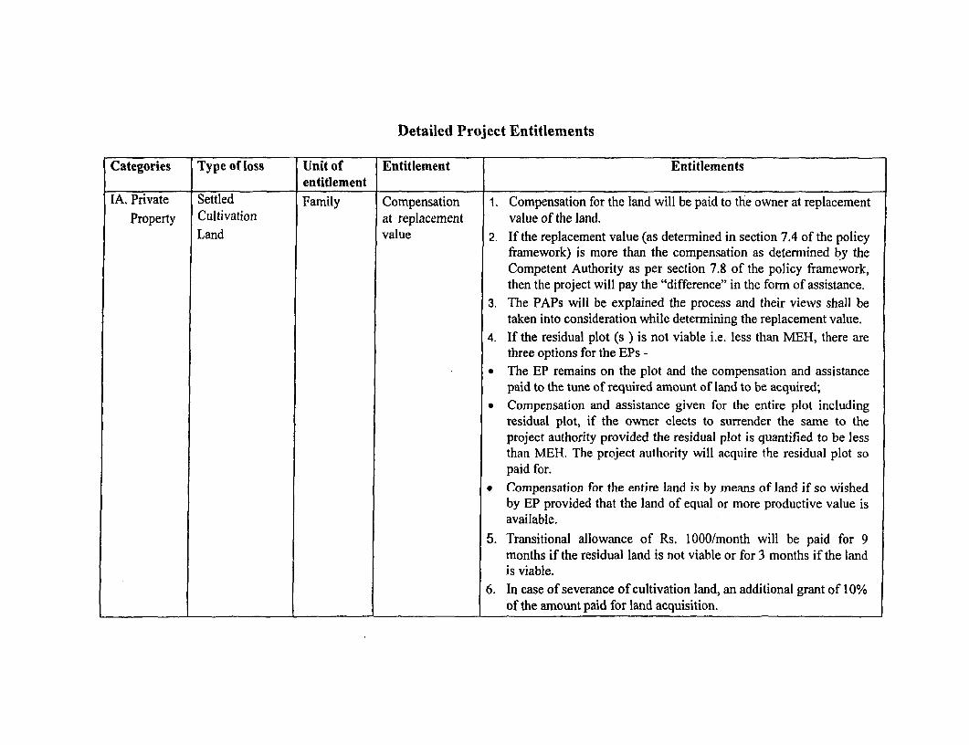
Detailed Project Entitlements
Categories Type of loss Unit of Entitlement Entitlementsentitlement
IA. Private Settled Family Compensation 1. Compensation for the land will be paid to the owner at replacementProperty Cultivation at replacement value of the land.
Land value 2. If the replacement value (as determnined in section 7.4 of the policyframework) is more than the compensation as determined by theCompetent Authority as per section 7.8 of the policy framework,then the project will pay the "difference" in the form of assistance.
3. The PAPs will be explained the process and their views shall betaken into consideration while determining the replacement value.
4. If the residual plot (s ) is not viable i.e. less than MEH, there arethree options for the EPs -
* The EP remains on the plot and the compensation and assistancepaid to the tune of required amount of land to be acquired;
* Compensation and assistance given for the entire plot includingresidual plot, if the owner elects to surrender the same to theproject authority provided the residual plot is quantified to be lessthan MEH. The project authority will acquire the residual plot sopaid for.
* Compensation for the entire land is by means of land if so wishedby EP provided that the land of equal or more productive value isavailable.
5. Transitional allowance of Rs. 1000/month will be paid for 9months if the residual land is not viable or for 3 months if the landis viable.
6. In case of severance of cultivation land, an additional grant of 10%of the amount paid for land acquisition.
Categories Type of loss Unit of Entitlement Entitlementsentitlement
I B. Private Non- Family Compensation I . If the asset (part or full) is a residential structure, then theProperty agricultural at "replacement replacement value will be calculated as equivalent to the cost of
land and value" provision of residential structure of area equivalent to that lost,assets subject to relevant quality standards of BSR as maintained by local
authority.
2. If the replacement value (as determined in section 7.6 of the policyframework) as determined by the Competent Authority as persection 7.9 of the policy framework, is more than thecompensation then the project will pay the "difference" in the formof assistance.
3. Homestead land will be accessed as per section 7.7
4. Transitional grant of Rs. 1 000/month to a maximum of 9 monthsfor those whose commercial structure is affected.
5. A rental assistance of Rs.500/- per month for 6 months will bepaid till alternate shelter is built.
6. PAP will be responsible for moving to the new house within 6months of payment of compensation or within 6 months ofreceiving the new plot.
7. A lump sum shifting allowance of Rs. 1 000/- will be paid.
8. Right to salvage materials from the demolished structure.
9. Compensation for lost of residential / commercial plot atresettlement site if so opted by 15 or more PDPs on payment andfree of cost for vulnerable groups will be provided. The size of theplots will be equal to the area lost or minimum of 35 sq., mts. forhouse and 1 5-sq. mts. for shop.

Categories Type of loss Unit of Entitlement Entitlementsentitlement
10. When the remaining structure is viable the PAP / PDP will havethe following options:
* May elect to retain ownership of residual portion and receivecompensation for only the portion acquired for the project
* May elect to receive compensation for the residual plot alongwith the acquired plots giving EP usufruct right thereon,which may be transferred to PWD with the notice of sixmonths.
11. Assistance will be provided to access housing scheme andtargeted support will be extended to vulnerable groups to assist inre-establishing homes.
12. PAP will be responsible to build the new house within 6 monthsof identification of the plot. And shift to the new house soonafter.
2. Common Shifting jhum VC Compensation at Replacement value for the common property transferred/acquired asproperty Land/fallow replacement per section 7.4. (i) and the amount will be utilized through
land value' participatory planning by the villagers within 6 months.
3. Tenants Residential & Individual Grant 1. The amount of deposit or advance paid by the tenant to the landlordCommercial or the remaining amount at the time of expropriation (this will bestructures deducted from the payment to the landlord)
2. A rental assistance of Rs 500/- per month for 6 months.
3. A lump sum shifting allowance of Rs 1000/-
Categories Type of loss Unit of Entitlement Entitlementsentitlement
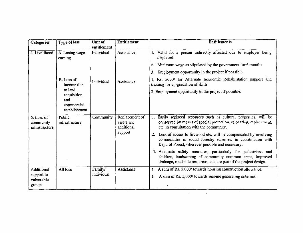
4. Livelihood A. Losing wage Individual Assistance 1. Valid for a person indirectly affected due to employer beingearning displaced.
2. Minimum wage as stipulated by the government for 6 months
3. Employment opportunity in the project if possible.
B. Loss of Individual Assistance 1. Rs. 5000/ for Alternate Economic Rehabilitation support andincome due training for up-gradation of skillsto land 2. Employment opportunity in the project if possible.acquisitionandconimercialestablishment
5. Loss of Public Community Replacement of 1. Easily replaced resources such as cultural properties, will becommunity infrastructure assets and conserved by means of special protection, relocation, replacement,infrastructure additional etc. in consultation with the community.
support 2. Loss of access to firewood etc. will be compensated by involving
communities in social forestry schemes, in coordination withDept. of Forest, wherever possible and necessary.
3. Adequate safety measures, particularly for pedestrians andchildren, landscaping of community common areas, improveddrainage, road side rest areas, etc. are part of the project design.
Additional All loss Family/ Assistance 1. A sum of Rs. 5,000/ towards housing construction allowance.support to individual 2. A sum of Rs. 5,000/ towards income generating schemes.vulnerablegroups
Categories Type of loss Unit of Entitlement Entitlementsentitlement
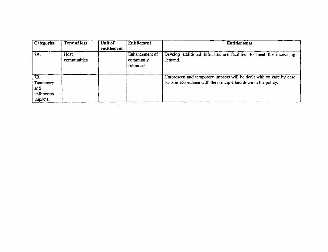
7A. Host Enhancement of Develop additional infrastructure facilities to meet the increasingcomnmunities community demand.
resources.
7B. Unforeseen and temporary impacts will be dealt with on case by caseTemporary basis in accordance with the principle laid down in the policy.andunforeseenimpacts. I _I

ANNEXURE 3.2
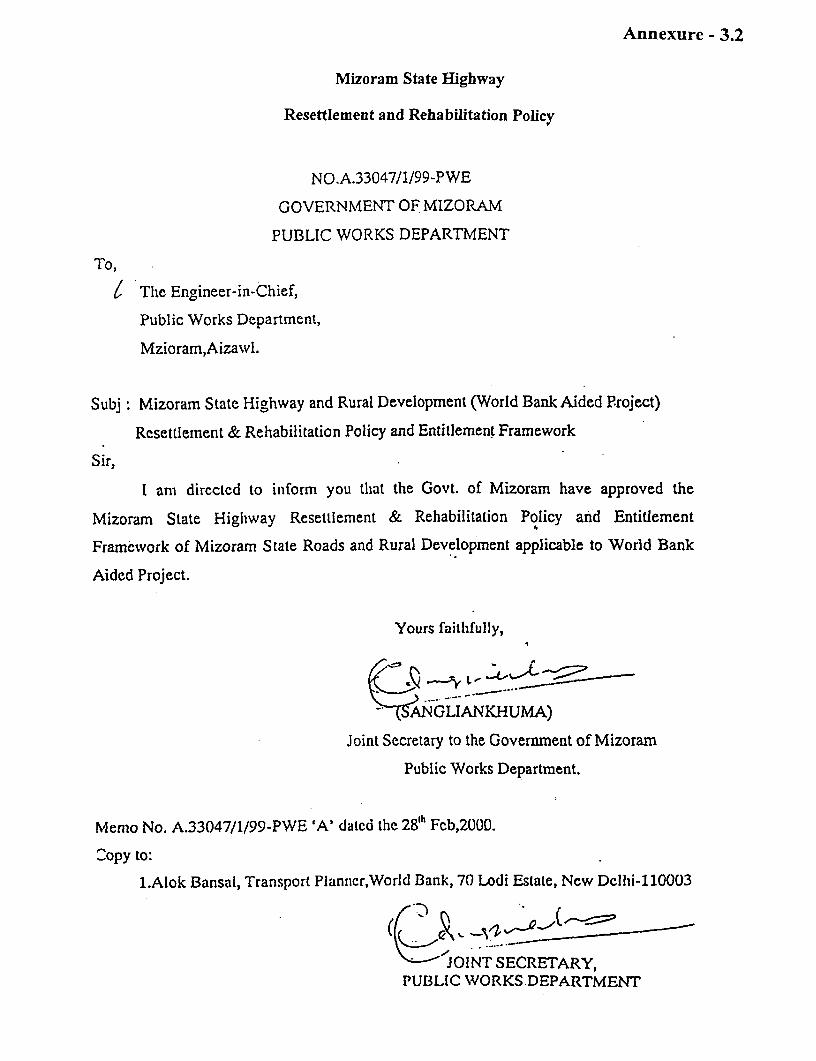
Annexure - 3.2
Mizoram State Highway
Resettlement and Rehabilitation Policy
NO.A.33047/1/99-PWE
GOVERNMENT OF MIZORAM
PUBLIC WORKS DEPARTMENT
To,
I The Engineer-in-Chief,
Public Works Department,
Mzioram,Aizawl.
Subj: Mizoram State Highway and Rural Development (World Bank Aided P.roject)
Resettlement & Rehabilitation Policy and Entitlement Framework
Sir,
I am directcd to inform you thiat the Govt. of Mizoram have approved the
Mizoram State Highway Resettlement & Rehabilitation Policy and Entitlement
Framework of Mizoram State Roads and Rural Development applicable to World Bank
Aided Project.
Yours faithfully,
e_n- -e
GLIANKHUMA)
Joint Secretary to the Government of Mizoram
Public Works Department.
Menio No. A.33047/1/99-PWE 'A' datcd the 28th Fcb,2000.
_opy to:
1.Alok Bansal, Transport Planncr,World Bank, 70 Lodi Estate, New Dcllhi-110003
K Yq _____ ___
JOINT SECRETARY,PUBLIC WORKS DEPARTMENT

ANNEXURE 7
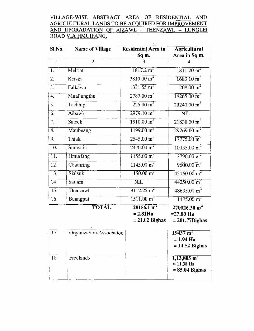
VILLAGE-WISE ABSTRACT AREA OF RESIDENTIAL ANDAGRICULTURAL LANDS TO BE ACQUIRED FOR IMPROVEMENTAND UPGRADATION OF AIZAWL - THENZAWL - LUNGLEIROAD VIA HMUIFANG.
SI.No. ! Name of Village Residential Area in Agricultural______ ___________________ Sq m. Area in Sq m.
1 1 2 3 4
1. Melriat 1817.2 mz 1811.20 m'
| 2. Kelsih 3819.00 m' 1683.10 m"
3. Falkawn 1331.55 mz 208.00 m
4. Muallungthu 2787.00 m2 14265.00 m
5. Tachhip 225.00 m' 20240.00 m'
6. Aibawk 2979.10 m NIL
7 E Sateek 1910.00 mL 21830.00 m'
I.8 Maubuang i1199.00 m 29269.00 m'
9. i Thiak j 2545.00 m ~ 17775.00 m'
10. Sumsuih 2470.00 m 10035.00 mz
11. Hmuifang 1155.00 mZ 3790.00 mz
12. Chamring 1145.00 mz 9600.00 m
13. Sialsuk 150.00 mL 45160.00 m
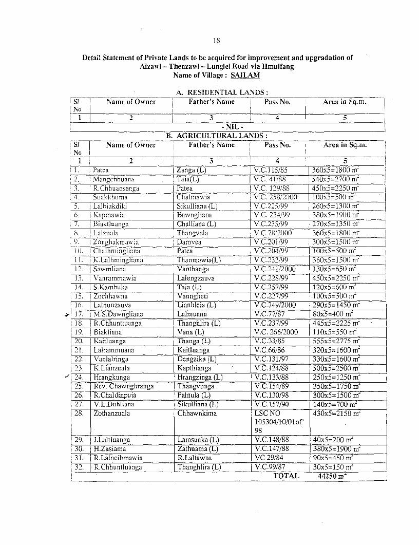
14. Sailam NIL 44250.00 m'
15. Thenzawl 3112.25 mL 48635.00 m'
16. 'Buangpui 151 1.00m 1475.00 m
TOTAL 28156.1 m: 270026.30 ms= 2.81Ha =27.00 Ha= 21.02 Bighas = 201.77Bighas
17. Organization/Association J 19437 m2=1.94 Ha- 14.52 Bighas
18. Freelands 1,13,805 mzL 11.38 Ha= 85.04 Bighas
1
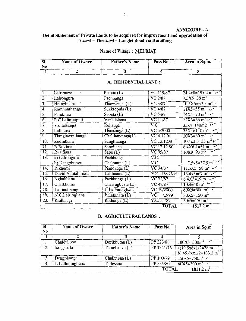
ANNEXURE - ADetail Statement of Private Lands to be acquired for improvement and upgradation of
Aizawl - Thenzawl - Lunglei Road via Hmuifang
Name of Village: MELRIAT
Si -- Name of Owner Father's Name Pass No. Area in Sq.m.INo _i__
1 2 3 4 5
A. RESIDENTIAL LAND:
1. Lalrimawii Patlaia (L) VC 115/87 24.4x8=195.2 m2. Lalrongura - Pachhunga VC 2/87 7.5X5=38 m~|3. 1Hrangbuana Thawvenga (L) VC 3/87 10.5X5=52.5 m
j 14. Ramnunthanga Suakropuia (L) VC 4/87 11X5=55 mL z5. Famkima Sabuta (L) VC 5/87 14X5=70 m 6. P.C.Lalhriatpuii Vanlalsiama | VC 11/87 22X3=66 mL- | 7. !Vanlalsanga Rohanga V.C 35x4=140m2 -
8. Lalhluna Thansanga (L) VC 5/2000 35X4=140 m2 9.__ Tlanglawmthanga Challianvunga(L) VC 4.12.90 20X3=60 m j
10. Zodinthara Sangtluanga VC 12.12.90 10.4x3.3=35 m~ L I11. R.Rokima Sangliana VC 12.12.90 8.4X6.4=54 m '
12. Ruatliana Sapa (L) VC 95/87 10X9=90 m 13. a) Lairongura Pachhunga V .C.
b) Dengphunga Chalhnuna (L) IV.C. _ 7.5x5=37.5 m214. Rikhumi Piandanga (L) VC 34/87 11.5X5=58 m- -
15. David Vanlalhruaia Laithuama (L) Shop P.No. 54/54 13.4x5=67 m -
16. Nghakliana Pachhunga (L) VC 32/87 6.4X3=19 m-17. Chalkhuma Chawngbuaia (L) VC47/87 10.4=40 m~ 18. Lalliantluangi J. Lalhmingliana VC 19/2000 60X5=300 mz9. N .C.Lalringliana P.Lalkhara (L) VC /1999 30X5=150 m~
20. |_Rinthangi Rothanga (L) V.C. 55/87 30x5=150 m2TOTAL 1817.2 m"
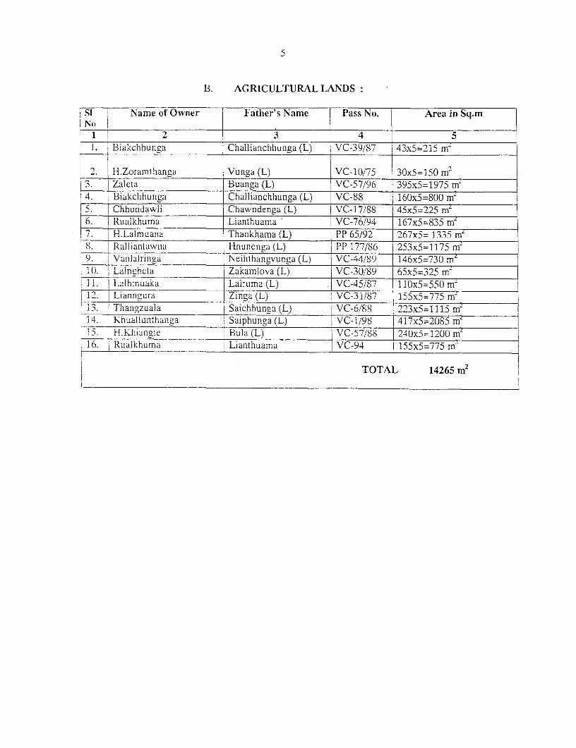
B. AGRICULTURAL LANDS:
Si Name of Owner Father's Name Pass No. I Area in Sq.m
__ l _2 3 4 51. ! Chaldailova Dorikhuma (L) PP 223/86 100X5=500mz2 Sangzuala Tlanghauva (L) PP 1341/76 a)19.5x8x1/2=78 2,
Singzuala b) 45.8xxl/2=183.2 m3. Dengphunga Chalhnuna (L) PP 100/79 150x5=750m 4. J. Lalhmingliana Taitesena PP 535/80 60X5=300 m
TOTA]L 1811.2 m'
2
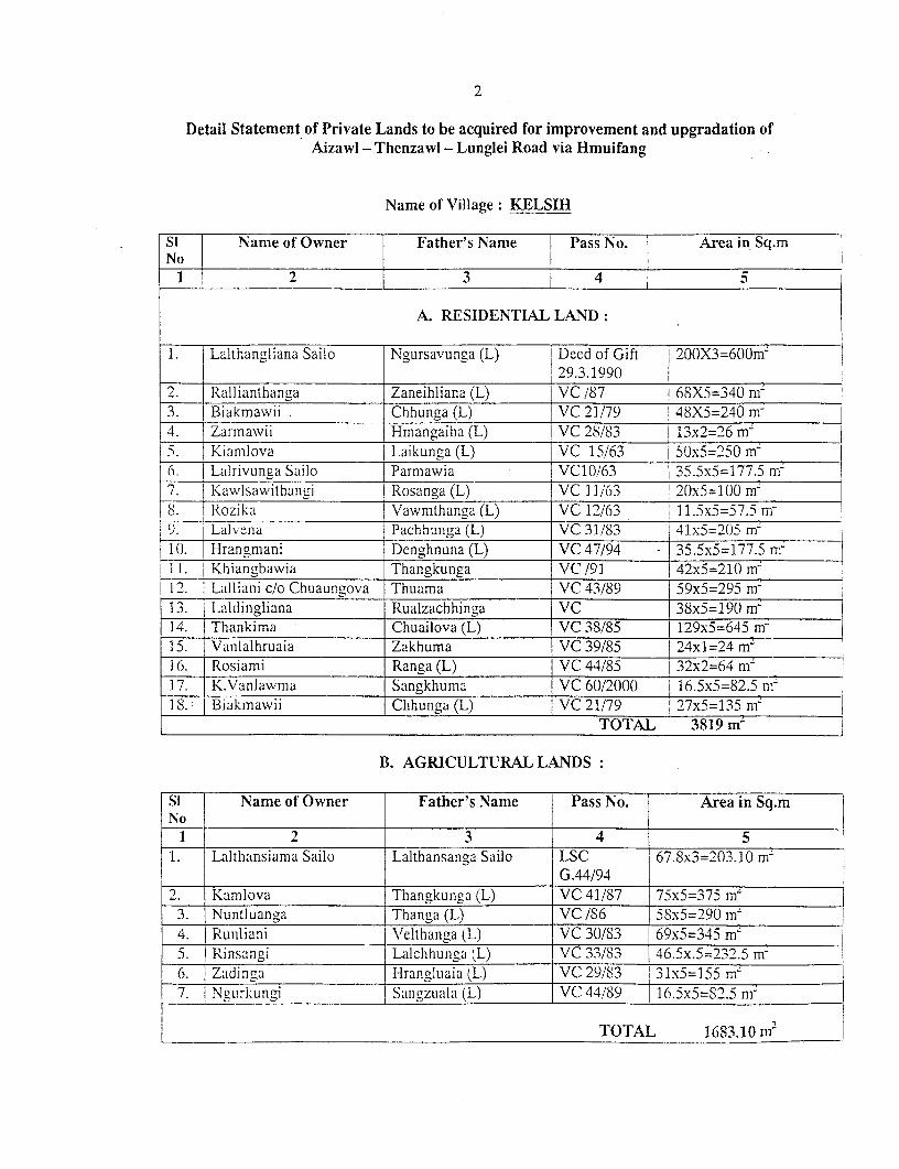
Detail Statement of Private Lands to be acquired for improvement and upgradation ofAizawl - Thenzawl - Lunglei Road via Hmuifang
Name of Village: KELSIH
Si Name of Owner Father's Name Pass No. Area in Sq.m
No 1 2 3 4 5
A. RESIDENTLAL LAND:
1. Lalthangliana Sailo Ngursavunga (L) Deed of Gift 200X3=600m-29.3.1990
2.___ Rallianthanga Zaneihliana (L) VC /87 68X5=340 mr3.__ Biakmawii Chhunga (L) VC 21/79 14SX5=240 m-4. Zarmawii Hmangaiha (L) VC 28/83 | 13x2=26 m-5. Kianflova Laikunga (L) VC 15/63 5Sx5=25() mn6__. |_Lalrivunga Sailo | Parmawia VC10/63 135.5x5=177.5 mn7. Kawlsawithangi I Rosanga (L) VC 11/63 2(x5=100 nfS. Rozika Vawmthanga(L) VC 12/63 11.5x5=57.5 mr'. Lalvena Pachhunga (L) VC 31/83 41x5=205 m-10. Hrangmani Denghnuna (L) VC 47/94 - } 35.5x5=177.5 m-
_1._ Khiangbawia Thangkunga VC /91 T 42x5=210 m-!12. Lalliani c/o Chuaun-ova Thuama VC 43/89 { 59xS=295 nm
13. Laldingliana Rualzachhinga VC 38x5=190 in14. Thankima Chuailova (L) VC 38/85 1 129x5=645 m-15. Vanlalhruaia Zakhuma VC 39/85 24x1=24 m`1 6. Rosiami Ranga (L) VC 44/85 32x2=64 mZ| 17. K.Vanlawmna Sangkhuma VC 60/200() 16.5x5=82.5 ni1S. Biakmawil Chhung (L) VC 21/79 27x5=135 mi
TOTAL 3819m1
B. AGRICULTURAL LANDS:
Si Name of Owner Father's Name Pass No. Area in Sq.mNo
1 2 3 4 51. Lalthansiamna Sailo Lalthansanaa Sailo LSC 67.8x3=203.10 m-
GG.44/94 _
2. J Kamlova Thangkunga (L) VC 41/87 75x5=375 m'3. Nuntluanga Thanga (L) VC /S6 5Sx5=290 m7 I4. Runliani \'elthaiiga (L) VC 30/S3 69x5=345 nrn5. | Rinsangi Lalchhunga (L) VC 33/83 46.5x.5=-232.5 mn6. Zadinga Hrangluaia (L) VC 29/83 31x5=155 mn7. Ngurkunlgi Sangzuala (L) VC 44/89 16.5x5=S2.5 nm
TOTAL 16S3.10 m2
3
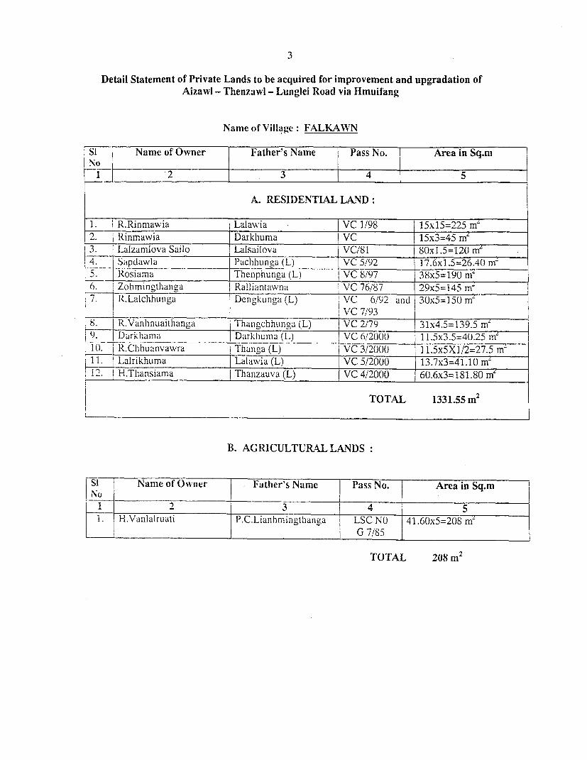
Detail Statement of Private Lands to be acquired for improvement and upgradation ofAizawi - Thenzawl - Lunglei Road via Hmuifang
Name of Village: FALKAWN
Si Name of Owner Father's Name Pass No. Area in Sq.m
2 3 4 5
A. RESIDENTIAL LAND:
1. R.Rinmawia Lalawia - j VC 1/98 15x15=225 mrn2. Rinmawia Darkhuma VC 15x3=45 ffZ3. I-alzamlova Sailo Lalsailova VC/81 8Ox1.5=120 me4. Sapdawla I _Pachhunya (L) VC 5/92 17.6xl.5=26.40 m~5. Rosiarna Thenphhunga (L) 1 VC 8/97 38x5=190 n't6. Zohmingthanga Ralliantkwnat VC 76/87 29x5=145 m~j 7. j R.Lalchhunga DLcngkunga (L) l VC 6/92 and 3()x5=15() m~
VC 7/931 8. j R;Vanhlnuaitlhangal j Thangchhunga (L) T VC 2/79 31x4.5=139.5 m1) I Darklia__i_ Darkhunia (L) $ VC 6/20001() 1.5x3.5=40.25 in10. 1R.C hhuaniva ra rTihangn,a(L) VC3/2((0 11.5x5XI/2=27.511. Lalrikhuma i Lalawia (L) [VC 5/2000 13.7x3=41.10 m'12. H.Thansiama Thanzauva (L) VC 4/2000 60.6x3=181.80 m'
TOTAL 1331.55 m2
B. AGRICULTURAL LkNDS:
Sl Name of Owner Father's Name Pass No. 1 Area in Sq.mNo I__ _ _ _
__ 1 ------- 2 3 4 5H.Vanlalruati P.C.Lianhmingthanga LSC NO 41.60x5=208m
G 1'AL 7/85 m
TOTAL 208m112
4
Detail Statement of Private Lands to be acquired for improvement and upgradation ofAizawl - Thenzawl - Lunglei Road via Hmuifang
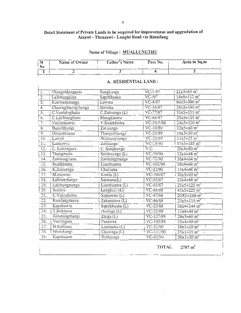
Name of Village: MUALLUNGTHU
Si Name of Owner Father's Name Pass No. Area in Sq.mNo
2 3 4 5
A. RE SIDENTIAL LAND:
I1. Thangchhingpuia [Sangkunga| VC-1/87 21x3=63 m'2. Lalhmangaiha Sapchhuaka VC-/97 14x8=112 m'
__3._| Kawlramthanga Lawma VC-4/87 60x5=300 mei 4. !Chawnghmingthanga Darzika VC-16/87 28x5=140 m-5. C.Vanlalnghaka I C.Zabuanga (L) VC-77/87 iZx5=15 6._I C.Lalthlengliana | Mangkhuma 1 VC-66/87 25x5-125 m'7. Vanlalmawia V.Rualkhuma VC-29/5/88 24x5=120 m8. Buaichhungi Zatluanga VC-10/89 12x5=60 m9. 1 Hmachhuana Thanachhunga VC-21/89 10x5=50mZ10. 1L-aveti Ncithangvunga VC-28/89 11x5=55 m"11. Lalmawia Zatluanga VC-19/90 37x5=185 m'12. C. Lalrongura C. Sangkunga V.C. 20x4=80 m'13. Thangzuala Saichhunga (L) VC-59/90 12x4=48 m'14. Zahmingliana Zahiningthanga VC-72/90 16x4=64 m-
[15. Rualkhuma Lianthuama VC-102/94 16x4=64 mz16. K.Zabuanga Challiana VC-22/90 15x4=60 mL17. Malsawmi Kawla (L) VC-100/87 30x3=90 m2
118. Lalbiakthanga Saimana(L) VC-55/87 22x4=88 m'19. Lalchungnunga Lianthuama (L) VC-65/87 25x5=125 mz20(. 1Rohlira Lcnigkaia (L) VC-88/88 45x5=225 m-21. C.Vanlalrema Saptawna (L) VC-47/88 2(X5=100 mz22. Ramfangzauva Zakamlova (L) VC-66/88 23x5=115 m'23. | Kapchawla Sapchhuaka (L) VC-23/88 36x4=144 m'24. T.Rohnuna Hminga (L) VC-25/89 I1x4=44 m'25. IRohmingthangi Zinga (L) VC-127/89 20x3=60 m'26. Vanringaia Pazawna VC-103/89 15x4=60 mz27. |- H.Rinliana Lianzama (L) OxVC-32/9)V lOx1=1OmL28 | Hlunthangi Chawnnga (L) VC-111/90 15x1=15 mI
29. Kapthuarni Rothianga VC-82/90 30x1=30 m'
TOTAL 2787m2TOTAL 2787 M2
5
B. AG(RICULTURAL LANDS
Si Name of Owner i Father's Name Pass No. Area in Sq.mI N o .__ _ _ _ _ _ _ _ _ _ _ _ _ _ _ _ _ _ _ _ _ _
1 ! 2 _ _ _ __23 4 51. 1 Bliakchhunga Challianchhunga (L) VC-39/87 43x5=215 mn
2. H.Zoramthanga Vunga (L) VC-10/75 30x5=150 m`_3. TZaleta Buanga (L) VC-57/96 395x5=1975 mn-
I4. * Biakchhunga Challianchhunga (L) VC-88 160x5=800 m-5. Chhundawli Chawndenga (L) VC-17/88 45x5=225 m-6. F Rualkhuma Lianthuama VC-76/94 167x5=835 m-7. H.Lalmuana Thankhama (L) PP 65/92 267x5= 1335 m'I. R Ralliantawlna lHnuncinga (L) 1I'l 177/S6 1 253x5=1 175 m-9. Vanlalrinig-a r Neihthangvunga (L) VC-44/S9 146x5=730 mfL10. Laingheta Zakamlova (L) VC-30/89 65x5=325 m-]1. Lllhmuaka Lalruma (L) VC-45/87 {110x5=5s0 m
L12 Lianngura Zinga (L) VC-31/87 155x5=775 m'13. Thangzuala iSaichhunga (L) VC-6/88 223x5=1115 nY14. Khuallunthanga Saiphunga (L) VC-1/98 4]7x5=2085 m'15. H.Khiangce Bula (L) VC-57/SS 24Ux5= 12() mn16. Rualkhuma Lianthuamia VC-94 155x5=775 mf
TOTAL 14265 ni2
6
Detail Statement of Private Lands to be acquired for improvement and upgradation ofAizawl - Thenzawl - Lunglei Road via Hmuifang
Name of Village: TACHHIP
|Si Name of Owner Father's Name PIass No. Area in Sq.mNo
_ __________ _ __2 __3 4 5A. RI:SIDENTlIAL LAND:
1. M.S.Dawngliana Zosanga VC 1997 10x5=50 m2. ! J.Zahlira Roselthanga VC 1993 10x5=50 m2
3. Lalruatkima Lalzuala VC 1986 25x5=125 m-TOTAL 225 m'
B. AGRICULTURAL LANDS:
I SI Name of Ownier Father's Name I Pass No. Area in Sq.mNo l _ _ _
I 2 3 4 l1. C.Rotluanga I Chhinga VC 4/82 30X5=150 m- 2. + Zaihnuiia Kawla I VC 5/58 165X5=825 mrI3t. ' Hualziki I Chalchhingvuiiga | PP 63/77 78X5=39() mZ4. Lalthanzualia j Vana (L) LSC G-5/9() 142X5=71(0 m'j5. K.Zakamlova Vunga TVC 7/76 125X5=625 mZ|. Ji.oranithaiiga PIengluaja PPII 1229it5 144X5=720 m'87 V.RBiakhfluanga Pengluaia -do- 56X5=280 ei
_____ ___I Rokhuma Neihkunga PP 8/88 27(X5=1350 m-9. lo Ronalla Thanghrima I Lal lek 48X5=24(1 m-.110. i Hranthankhuma I Thanchhingpuia Lal Pek 48X5=240( mZ11. Danglova Thanghrima I VC 4/85 80X5=400 m12.1 Neihkimia | Kawniga (L) VC 8/90 105X5=525 mZ13. ' Lalchhaihian| Chawngthuarna | VC 5/85 144X5=720 m' 14. j Romana f Thanghrima VC 3/85 175X5=875 mi'15. IChalliannaura f Zakunga | VC 6/85 175X5=875 m'
I 16. j R.L.Romawia Biakthuama (L) VC 7/85 182X5=91() ei17. LaIsanlazuala Rualkhuma VC 9/85 105X5=525 meIS. I J.Zahlira Roselthana| VC /1972 52X5=260 mZ l19. RohLMuama RoKhuunia (L) 1 VC 8 /1994 3T)X5=] (Yn I
! 2(2. K.Lalzuala I Raltawna j Lal Plek 66X5=330 mI21. 1 C.Rutalhleia I Rokhama 1 VC 1958 64X5=320 inm
2 . kL.Lalziiala Raltalnin Lai l'ek 15X5_775 m, lMumc a ncta --- VC19-55 167X5=83?5 m-
____ __H.Vala _ Neihivunga La! Pek 117X5=585 m25. Ru llkuinUa Rokclia Pi, 73/97 70X(5=350 m~
*( 6 Li Lhulnchiuctili _ _-_ VC 5/98 [ 70X5==350 mi 297. 1othuama Rokhu0nun VC 41/94 { 44X5=22() mn~
7
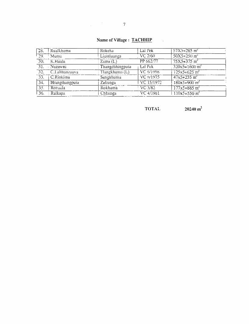
Name of Village: TACHHIP
28. Rualkliuma |Rokelia Lai Pek 57X5=285 m'l23. Mumna Liantlua__p VC 2/60 SOXS=25() m30. K..Huala -Zama (L) PP 662/77 75X5=375 m-31. Nuzawni Thangchhingpuia Lai Pek 32_0x5=1600 rnm
2. C.Lalthanzauva Tlan,khunia (L) VC 6/1)998 ) 125x5=625 my33. C.Rinkirna Sangkhurna VC 6/1975 47x5=235 m-34. Hrangthangpuia Zakunga VC 15/1972 180x5=900 m235. Rozuala Rokhuma VC 3/82 f 177x5=885 mLy36. >Ralkapa | Chhunga VC 4/1981 110x5=550 ml
TOTAL 20240 m2
8
Detail Statement of Private Lands to be acquired for improvement and upgradation ofAizawl - Thenzawl - Lunglei Road via Hmuifang
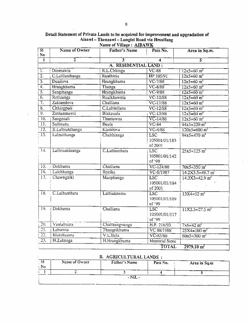
Name of Village: AIBAWKSi Name of Owner Father's Name Pass No. Area in Sq.m.No
1 2 . 4 54A. RESIDENTIAL LAND:
1. Dinmawia R.L.Chhinga VC-88 12x5=60 mz2. C.Laltlanthanga Rualhleia HP 105/91 12x5=60 rn3. Duailova Hrangakhuma VC-7/88 12x5=60 m4. Hrangkhuma Thanga VC-8/88 12x5=60 m5. Sangthanga Hrangkhuma VC-9/88 12x5=60 m'6. Rotluanga Rualkhawm;a VC-10/88 12x5=60 m'7. Zakiamlova Challiana VC-11/88 12x5=60( m'8. Chhinigpuii C.Lalrinliana VC-12/88 12x5=60 m'9. Zothanmawii Biakzuala VC-13/88 12x5=60 m'10. Sangzuali Thantawna VC-14/88 12x5=60 mz=| 1i Saihnuna ] Buaia VC-84 44x5=220 m12__. B_1-_albiak_thanga _Kiamlova VC-4/88 I120x5=60mI13. 1 Lalzuithanga I Chalthianga LSC 94x5=470 mr|
105001/01/183_ _ _ _ _ _ _ _ _ _ _ _ _ _ _ _ _ _ _ _ _ _ _ _ _ _ _ _ _ _ _ _ _ _ _ _ _ _ _ _ _ _ _ _ _ o f 20 01
14. Lalhruaidluanga I C.Lalhunthara LSC 25x5=125 rnm105001/01/142
! ___ I __________________ of'9 915. D Dokhuma iChalliana VC-124/88 70x5=350 m'1|. Lalchhunga Rozika VC-8/1987 14.2X3.5=49.7 mZ17. $ Chawngziki Manphuiiga LSC 14.3X3=42.9 m'
105001/01/184of 2001
I18. C.Lalhunthara Lalbiaknema LSC 13X4=52 mL105001/01/109of'99
19. Dokhuma Challiana LSC 11X2.5=27.5 mr105001/01/117of"3"9_ _ ___ __,__.__ _____ __f_9_
2U. I Vanlalruata Chalthangvunma H.P. 216/93 7x6=42 mL2 1. Lalsawta Thangrikhuma VC 88/1i988 25X4=100 m~9 2. i BiakihUalna V.L.Bela VC-85/88 6Ux5=300 m'23. j H.Zakunga H.Hrangkhuma Memorial Stone
i _____________________ TOTAL 2979.10 m'
B. AGRICULTURAL LANDS:Si Namc of Owner I Father's Name Pass No. Area in Sq.m
1o 22 f o 1 3 1 -4- -5 -
-NlL -
9
Detail Statement of I'rivate Lands to be acquired for improvement and upgradation ofAizawl - Thenzawl - Lunglei Road via Hmuifang
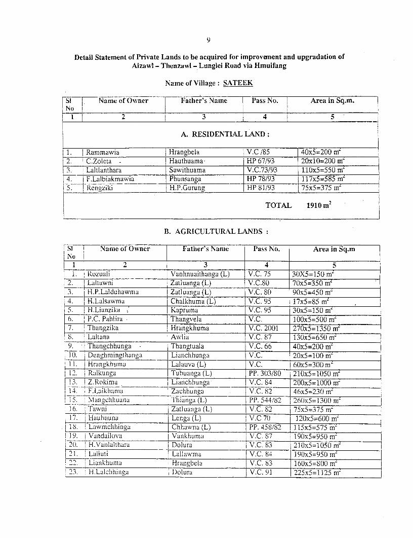
Name of Village: SATEEK
fiT r Name of Owner F Father's Name Pass No. Area in Sq.m.
l ~ ~ ~ ~~2 j3 - 4 1-5
A. RESIDENTL4L LAND:
1. Rammawia Hrangbela V.C /85 40x5=200 m'2. jC.Zoleta Hauthuama- HP 67/93 20x10=200 m'3.i Laltlanthara Sawithuama V.C.73/93 110x5=550 m'4. F.Lalbiakmawia Phunsanga HP 78/93 117x5=585 me
53.<! Rcigziki H.P.Gurunm HP 81/93 75x5=375 m4
TOTAL 1910 m2
B. AGRICULTURA&L LANDS:
SI i Nan2e of'Owner F Fatber's Name I lass No. Area in Sq.m
1 2 3 4 5l. Rozuali Vanhlnuaithanga (L) V.C. 75 3(X5=150 m
Z. Ldltawni Zatluanga (L) lY.C.S - 7(x5=350 m~H.P.Lalduhawnma Zatluaniga (L) V.C. 80 90x5=450( mn
4. H.Lalsawnia Chalkhuma (L) V.C. 95 17x5=85 m-S.j H.Lianzika K Kapruina V.C. 95 30x5=150( m'6. I.C. Pahlira Thangve]a V.C. 100x5=500 m'
1 7. z Thangzika Hrangkhuma V.C. 2001 270x5=1350 mnr~ I 8 Lanall.l Awlia V.C. 87 130x5=650 mri 9. I Thangchhunga Thangtuala V.C. 66 40x5=200 m
1(1 i D nghmingthanlga | Lianchhunga V.C. 20xS=l)0m'11. Hrangklihumia Lalauva (L) V.C. 60x5=30() ml12. Ralkunga Tubuanga (L) PP. 303/80 210x5=1050 m'1!3 :Z.][okinia Liainchhunga V.C. 84 200xS=1000 mr~
14. ,F.-Laikhalm.iia Zaclhlhunl1a - V.C. 82 46x5=23() m-I i .,IInIcIIILualaa I Thianzga (L) Pl. 544/82 26)0)x5= 130() m-
16. rawiii Zatluanga (L) V.C. 82 75x5=375 m'I 7. Hauhnuna Lenga (L) j .C 70 12)0x5=600 m`I S. Law mchhingai Chhawia (L) PP. 458/82 115x5=575 m'
I19. Vandailova Vankhuma \V.C. 87 190x5=950 m'nI 20. H.Vanlalthara j Dolura jV.C. 83 210x5=1050 mni21. Lailuti aIMVllawMa I V.C. 84 ]90(x5=J5-n950 nl
2 -Lankhunma Hrangbfla b V.C. 83 160x5=800 m'I'. H.La1cl h;in ga | Dolura V.C. 91 225x5=1125 mn
1024. Zosanga Padenga V.C. 60x5=300 m'25. Sangvuana Kaphranga V.C. 120x5=600 mz26. Hmarzika Bawiha PP. 184/82 260x5=1300 m'27. Thangzika Hrangkhuma V.C. 66 300x5=1500 mz28. Biakmawia Vandara (L) PP. 215/89 210x5=1050 m-29. K.Liankunga Bawka (L) PP. 563/77 a) 160x2=320 m'
PP. 562/77 b) 430x4=1720 m2
30. Rev. Darchungnunga Bawia PP. 9/2001 50x15=750 m'
TOTAL 21830 m2
11
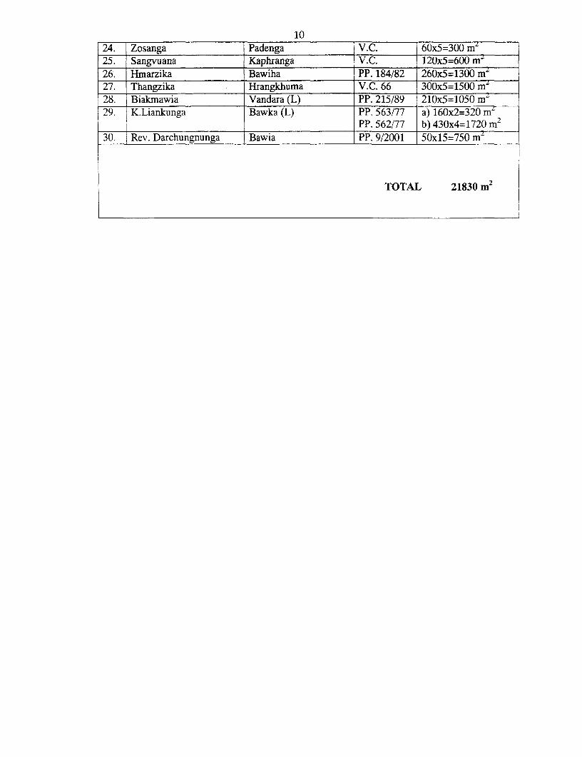
Detail Statement of Private Lands to be acquired for improvement and upgradation ofAizawl - Thenzawl - Lunglei Road via Hmuifang
Name of Village: MAUBUANG
Si Name of Owner Father's Name I Pass No. Area in Sq.m.
1 ~ ~~2 3 4 5
A. RESIDENTIAL LAND:
1. V.Thlangliana Engliana V.C 92/87 15x5=75 m-2. |JHrangthankima Mantawna | VC
Vanlalhruaia Pamuma V.C 84/87 28X8=224 m4. Tawnluia Pamuma V.C 83/87 25x8=200 ma
15. H.Thanzawna Thantluanga V.C 81/87 40x8=320 m-6. H.L.Rinliana Thantluanga V.C 70/87 35x8=280 m-
7. I H. Thanfala Thantluanga V.C. 96/97 20x5=100m2
TOTAL 1199 m
B. AGRICULTURAL LANDS:
Si Name of Owner 1 Father's Name Pass No. Area in Sq.miN o _ _ _ _ _ _ _
1 l 2 3 4 5a) 70x15=1050 m-
1. Michael Engthawla Holdara PP 5/85 b) 720x10=7200m2. J.Rosiama Paul Sena PP 7/87 105x8=840 m-3. l Thangthuama Selluaia V.C. 280x8=2240 m-4. H.L.Thantuan-a Thangzika V.C. 6/88 335x8=2680 mL5. H.L.Rinliana Thantluanga | V.C.5/88 130x8=1040 m`6. Saikhuma Laldanga V.C.8/88 70x8=560 m7. Ralthangzuala Vandara V.C.2/88 160x8=1280 m-8. T hantluangi Chalthianga (L) i V.C.4/88 97x8=776 m-9. Vanlalruata Liankunga V.C.9/88 66x8=528 m-10. i H.Thanzawna Thantluanga V.C.3/88 140x8= 1120 m`11. Lianchhingpuia Pathiauva PP 277/79 30x5=150 m- 12. 1 T.Vunci V.C. 15x5=75 m- !___I C/o Rodawla _ I1 13. Lalrindika Saphlira V.C. 99 520x8=4160 m-14. Hrangdawla Langrawnga V.C. 85 20x8=160 m-15. Thangkhuma Lalhleia V.C. 1/88 20x8=160 m16. Rolura Darrikhuma PP 6/87 600x8=4800 m-17. Rotluanga Zakapa V.C. 10/88 30x15=450 m
TOTAL 29269 m
12
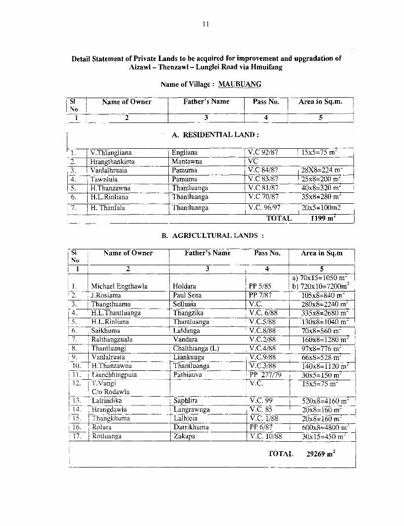
Detail Statement of Private Lands to be acquired for improvement and upgradation ofAizawl - Thenzawl - Lunglei Road via Hmuifang
Name of Village: THIAK
Si Name of Owner Father's Name Pass No. Area in Sq.m.No
1 2 3 4 5
___ A. RESIDENTIAL LAND:I Lalhmangaiha Patea V.C. 41/88 65x10=650 m'2. Hmingthanga Lalhmangaiha V.C. 41/88 15x15=225 m'
13. Kaphranga Suakchhingpuia V.C. 20X15=300 m'4. Lalnghaka Sawikunga V.C. 86/87 27x5=135 miD. Rothianga Buangkhuma V.C. 84/87 30x5=150 m`6. Remruata Bawiha V.C. 94/87 23x15=345 m7. Thansanga - Laihmangaiha V.C. 13x15=195 rn`8. Malsawma Suaka (L) V.C. 67/87 19x5=95 m2
9..~~~~~~~~~~~~~ 9. Hunliana , Biaktluanga V.C. 45x10=450 m2
TOTAL 2545 m'
B. AGRICULTURAL LANDS:SI Name of Owner Father's Name Pass No. Area in Sq.mN. to _ _ _ _ _ _ _ _ _ I _ _ _ _ _
1 2 3. . 4 I. Thangthuama Patea (L) V.C. 36/87 70x5=350 m2
:2. Liansanga Lianzika(L) V.C.34/85 320x5=1600 m2
3. Thanliana Rochhingvunga (L) V.C.98/87 50x5=250 m'14. Dokhuma Raltawna (L) V.C.123/87 133x5=665 m',5. Thanliana Rochhingvunga (L) V.C.131/85 135x5=675 m'16. Zaithankhuma Chawnghminga (L) V.C.96/86 30x15=450 m'7. Biaktluanga Thanvenga (L) V.C.111/87 a) 13xl5=195 m2
b) 100x5=500 in2
S. Kamlova Manphunga (L) V.C.181/87 110x5=550 rn9. Zoliana Lianhnuna (L) V.C.108/87 17x15=255 m'
| 10. Vanlalchhunga Ralliantawna (L) V.C.61/87 120x5=600 m11. Luangmuani Lalthanga (L) V.C.25/87 75x5=375 m'12. Darchhingi Seikunga (L) V.C.31/87 42x5=210 m2
13. Lianzuala Darkhuma (L) V.C.59/87 31x5=155 me14. Rosiama Saptawka V.C.197/87 140x5=700 m'15. K.Lalvuana Kawla V.C.13/87 330x5=1650 m16. Chawngthuama Liannawla (L) V.C.36/87 220x5=1100 m'n
117. Laldingliana Kama (L) V.C.171/87 134x5=670 m'18. Nunzira Darkhuma V.C.170/87 150x5=750 m'19. Vanlalnghina Lianchhingpuia V.C.27/87 205x5=1025 m'20. B.T.Sanga D.Thianga (L) PP 73/92 & a) 340x5=1700 Pi
PP 34/93 b) 670x5=3350 m2TOTAL 17775 ni
13
Detail Statement of Private Lands to be acquired for improvement and upgradation ofAizawl - Thenzawl - Lunglei Road via Hmuifang
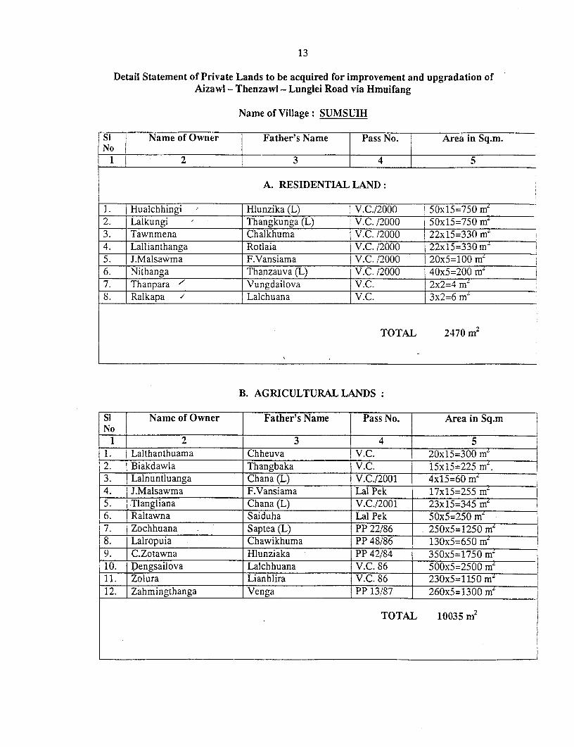
Name of Village: SUMSUIH
Si I Name of Owner Father's Name ] Pass No. Area in Sq.m.
1_ 2 3 i 4 5
A. RESIDENTIAL LAND:
1. Hualchhingi Hlunzika (L) V.C./2000 50x15=750 m'2. Lalkungi Thangkunga (L) V.C. /2000 50x15=750 m'3. Tawnmena Chalkhuma V.C. /2000 22x15=330 m'4. Lallianthanga Rotlaia V.C. /2000 22xl5=330 m-'5. J.Malsawma F.Vansiama V.C. /2000 20x5=100 m'6. Nithanga Thanzauva (L) V.C. /2000 40x5=200 m 7. Thanpara ' Vungdailova V.C. 2x2=4 mZ 8. Ralkapa / Lalchuana V.C. 3x2=6 m
TOTAL 2470 m2
B. AGRICULTURAL LANDS:
Si Name of Owner Father's Name Pass No. Area in Sq.mNo
1 2 3 4 51. Laithanthuama Chheuva V.C. 20x15=300 m'2. Biakdawla Thangbaka V.C. 15x15=225 m'.3. Lalnuntluanga Chana (L) V.C./2001 4x15=60 m'4. J.Malsawma F.Vansiama Lal Pek 17x15=255 me5. Tlangliana Chana (L) V.C./2001 23x15=345 me6. Raltawna Saiduha Lal Pek 50x5=250 mL7. Zochhuana Saptea (L) PP 22/86 250x5=1250 m'8. Lalropuia Chawikhuma PP 48/86 130x5=650 me9. C.Zotawna Hlunziaka PP 42/84 350x5=1750 m'10. Dengsailova Lalchhuana V.C. 86 500x5=2500 m'11. Zolura Lianhlira V.C. 86 230x5=1150 mZ12. Zahmingthanga Venga PP 13/87 260x5=1300 m'
TOTAL 10035 m2
14
Detail Statement of Private Lands to be acquired for improvement and upgradation ofAizawl - Thenzawl - Lunglei Road via Hmuifang
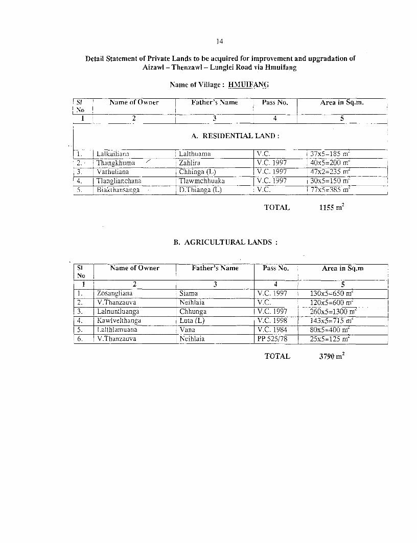
Name of Village: HMUIFANG
Si Name of Owner Father's Name Pass No. Area in Sq.m.
_ _ _ _ _ _ _ _ __2_ _ 3 _ _| 4 |5I~ 2I
A. RESIDENTIAL LAND:
1. Lalkailiana Lalthuama V.C. 37x5=185 m- 2.- Thangkhuma I Zahlira V.C. 1997 40x5=20() m 23. Varhuliana Chhinga (L) V.C. 1997 47x2=235 mZ I
4. Tlanglianchana Tlawmchhuaka V.C. 1997 3Ox5=150 m75___ Biakthansancya D.Thianga (L) V.C. 77x5=385 mff
TOTAL 1155 m 2
B. AGRICULTURAL LANDS:
S i Name of Owner [ Father's Name Pass No. Area in Sq.m
1 2 3 4 51. Zosangliana Siama V.C. 1997 j 130x5=650 m'2. V.Thanzauva Neihlaia \.C. 120x5=600 mn3. Lalnuntluanga Chhunga V.C. 1997 260x5=1300 m"4. Kawlvelthanga Luta (L) V.C. 1998 143x5=715 m'5. Lalthlamuana Vana V.C. 1984 80x5=400 m'6. V.Thanzauva Neihlaia PP 525/78 25x5=125 m'
TOTAL 3790 m2
15
Detail Statement of Private Lands to be acquired for improvement and upgradation ofAizawl - Tlienzawl - Lunglei Road via Hmuifang
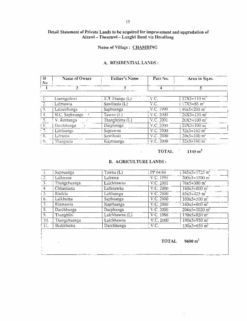
Name of Village: CH.AMRING
A. RESIDENTIAL LANDS:
Si Name of Owner Father's Name Pass No. Area in Sq.m.Nso II_ _I t 2 _ _ _ 13 4 5
1. Lianngailovi I K.T.Thanga (L) V.C. 92X5=11() m- 2. L Lalmawia Sawiluaia (L) T V.C. 1 17X5=85 m-
___ Lalzuithanga Sapbuanga V.C. 1999 40x5=200 m 4. H.C. Sapbuanga ( Tawna (L) V.C. 2000 26X5=130 m~5. V. Rothanga / Thanghrima (L) 1 V.C. 2001 2(X5=100 nm )6. Durchhunga D Darphuinga V.C. 2(000 20X5=100 m7. Laltluanga Saptawna V.C. 2000 32x5=160 m~!SX i Lalruata Sawiluaia V.C. 2000 20x5 1I00 mni', lThangseia T Kaptluanga V.C. 2000 32x5=160 m
TOTAL - 1145 m2
B. AGRICULTURE LANDS:
1. | Sapbuanga Tawna (L) |PP 64/84 | 345x5=1725 in
i2. 1 Lalhnuna Lalrema | V.C. 1995 30()x5=1500 m-i3. Thangchuanga i Laichhawna iV.C. 2001 76x5=380 m24 I C hhanliana Lalhnawka IV.C. 2000 160x5=800 nm5. 1TRinfela Laltluanga V.C. 2000 S5x5=425 mn!6. Lalkhuma Sapbuanga V.C. 2000 100x5=500 mL7. Rinmawia Kaptluanga V.C. 2000 160xS=S00 mL
S. Darchhunga Darphunga V.C. 2000 204x5=1020 mn9. Thanghliri Lalchhawna (L) V.C. 1996 170x5=850 mnTI1. Thangchuanga Lalchhawna V.C. 2000 190x5=950 mLI 1. Biakkhuma Darchhunga V.C. 1 130x5=650 m`
TOTAL 9600m2TOTAL 9600 M2
16
Detail Statement of Private Lands to be acquired for improvement and upgradation ofAizawl - Thenzawl - Lunglei Road via Hmuifang
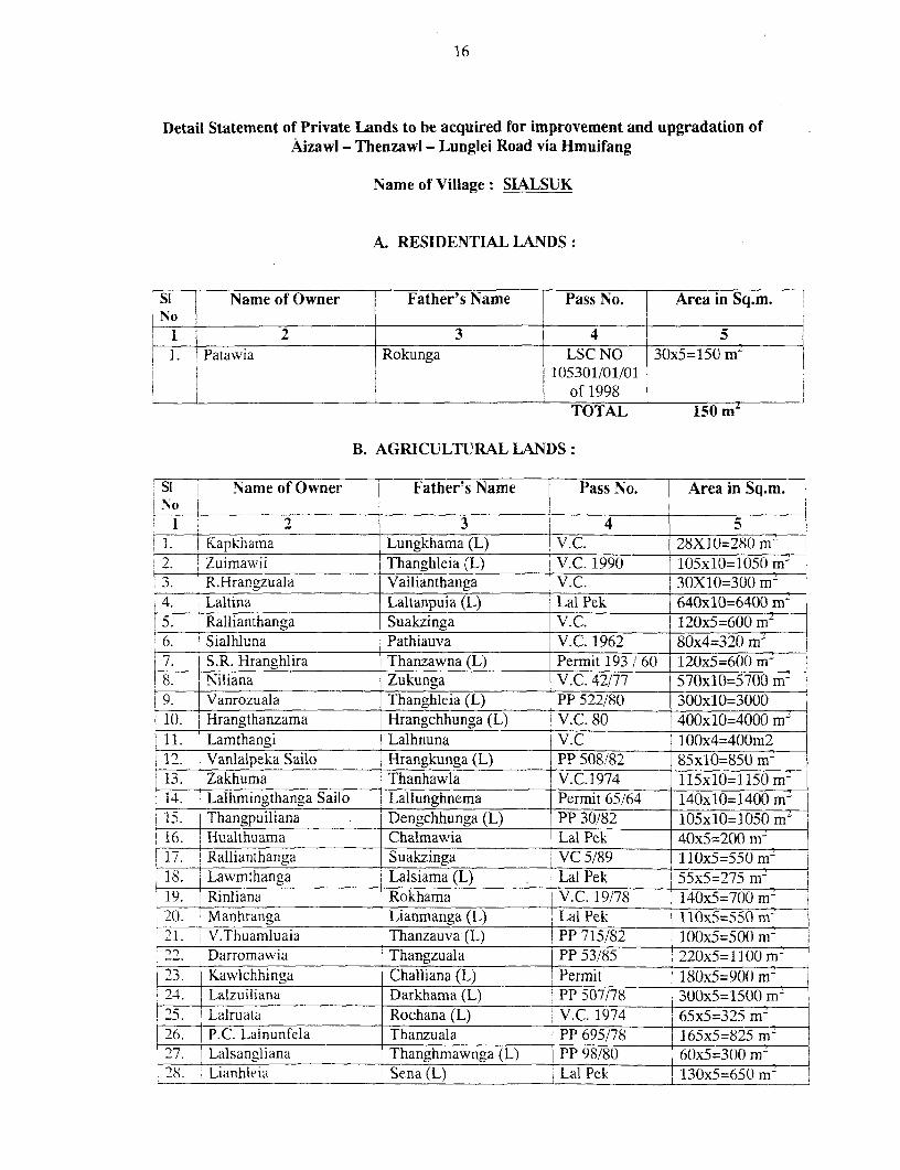
Name of Village: SIALSUK
A. RESIDENTIAL LANDS:
Sli Name of Owner Father's Name Pass No. Area in Sq.m.INo |,
I _ 2 3 51. 1 Patawia Rokunga LSC NO 30x5=150 m-
1105301/01/01of_1998 _
TOTAL 150 m
B. AGRICULTURAL LANDS:
Si - Name of Owner Father's Name Pass No. Area in Sq.m.
;o 1 j2 3 4 5
4 1. I Kapkhama Lungkhama (L) V.C. 28X10=280 m- 2. ^ Zuimawii Thanghleia (L) V.C. 1990 105x10=1050 m I3. R.Hrangzuala Vailianthanga V.C. 30X10=300 m-4. Laltina Laltanpuia (L) Lal Pek 640x10=6400 m45. Rallianthanga Suakzinga V.C. 120x5=600 m-6. Sialhluna Pathiauva V.C. 1962 80x4=320 m7. S.R. Hranghlira Thanzawna (L) Permit 193 /60 120x5=600 mn18. Niliana Zukunga V.C. 42/77 570xlO:=5700 m ,9. Vanrozuala Thanghleia (L) PP 522/80 300x10=300010. Hrangthanzama Hrangchhunga (L) i V.C. 80 400x10=4000 mi-
_11. Lamthangi Lalhnuna V.C 100x4=400m2i 1. Vanlalpeka Sailo Hrangkunga (L) PP 508/82 85x10=850 m i13. 1 Zakhuma Thanhawla V.C.1974 115x10=1150 mn
I 14. Lalhmingthanga Sailo Lallunghnema Permit 65/64 140x10=1400 mz15 Thangpuiliana Dengchhunga (L) PP 30/82 105x10=1050 m`16. ! Hualthuama Chalmawia Lal Pek 40x5=200 m'17. I Rallianthanga Suakzinga VC 5/89 110x5=550 m18 Lawmthanga Lalsiama (L) Lal Pek 55x5=2 75 m2
19. Rinliana Rokhama V.C. 19/78 140x5=700 mr&20. Manhranga | Lianmanga (L) Lal Pek 110x5=550 m-21. V.Thuamluaia | Thanzauva (L) ! PP 715/82 100x5=500 min
Darromawia Thangzuala PP 53/85 220x5=1100 m-2 '3. \ Kawlchhinga Challiana (L) 5 Permit 180x5=900 ml24. Lalzuiliana Darkhama (L) PP 507/78 300x5=1S00 m- I
~s1 35 |Lalruala Rochana (L) V.C. 1974 65x5=325 m-26. P.C. Lalnunfela Thanzuala PP 695/78 1165x5=825 mz27. \ Lalsangfiana Thanghmawnga (L) PP 98/80 16(x5=300() m
Lianhleia Sena (L) Lal Pek M130x5=65( m2
1729. Zanghawri Thanduha (L) Lal Pek 70x5=350 m2
30. Chaingaiha Kapruma (L) V.C. 30x5=150 Mi2
31. Biaktluangi Hauchungnunga (L) V.C. 70x5=350 ml32. Zabiaka Hranghleia V.C. 100x5=500 mi33. Lalbiaka Thanzinga (L) Lal Pek 35x5=175 m2
34. Remsiama Thanzauva (L) Permit 288/61 90x5=450 mz35. Kapruma Kailiana Lal Pek 2Ox5=100 m-36. Lalthlamuana Ngaizuala (L) V.C. 100x5=500 m2
37. Lalkhama Khuma (L) V.C. 23x5=115 min38. Manliani Thangthuama Lal Pek 27x5=135 m2
39. Rothangi Thangzuala (L) V.C. 100x5=500 mi2
40. Zorammawia Aisanga V.C. 80x5=400 m-41. Zathangliana Thuama (L) V.C. 78 430x5=2150 mrn42. Lalzuala Manhranga V.C. 88 130x5=650 m~43. Sangvunga Darchhawna V.C. 80x5=400 mn44. Sawmliana Chalmawia V.C. 100x5=500 m2
45. Biakthanga Darthuama V.C. 200x5=1000 mz46. Remsiama Thanzauva (L) V.C. 1999 380x2=760 mZ47. j Ralkapthanga Thansuaka (L) V.C. 88 100x5=50(m M
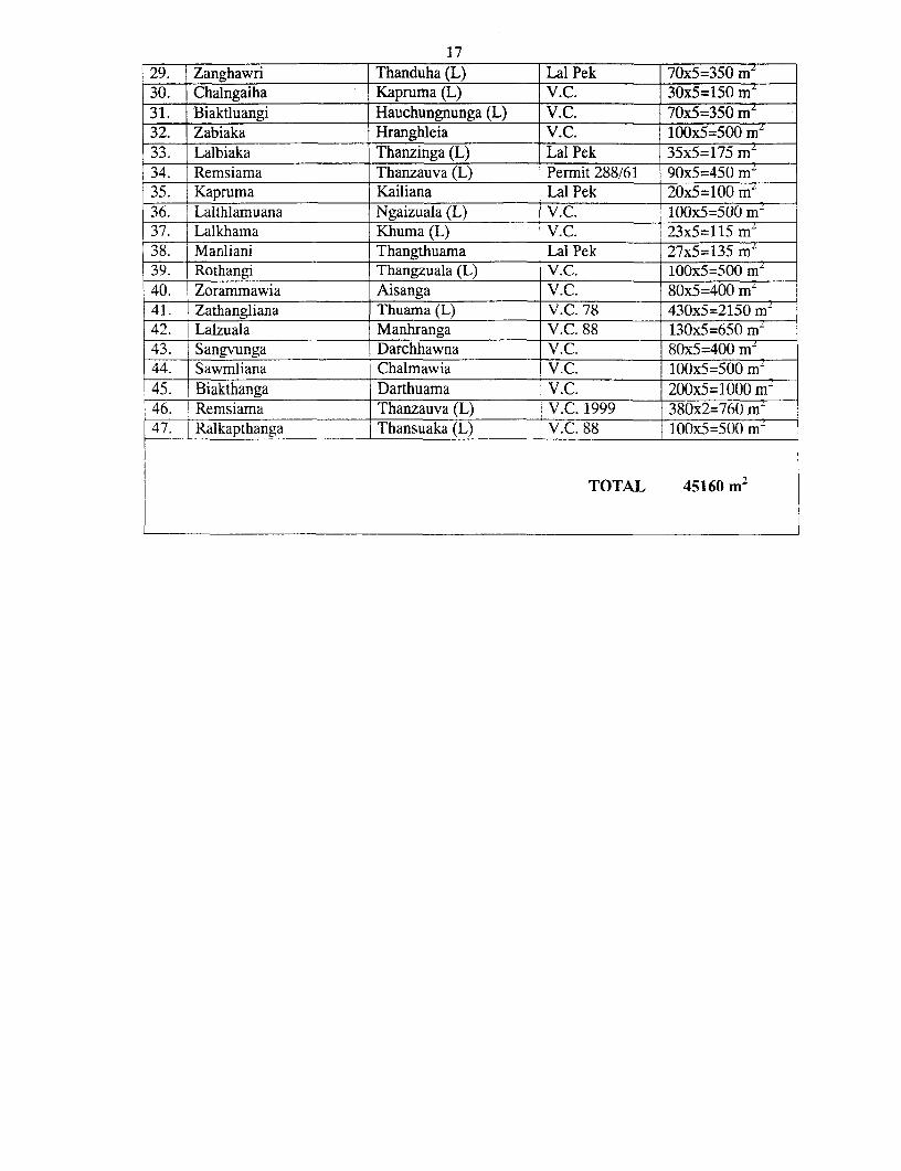
TOTAL 45160 m 2
Is
Detail Statement of l'rivate Lands to be acquired for improvement and upgradation ofAizawl - Thenzawl - Lunglei Road via Hmuifang
Name of Village: SAILAM
A. RESIDENTLAL LANDS:SI Naine of Owner Father's Name Pass No. Area in Sq.m.N o_ _ _ _ _ _ _ _ _ _ _
1i 2 ] 3 4 5I _ _ _ _ _ _ _ _ _ _ _ _ _ _ _ -N IL -
B. AGRICULTURAL LAND)S:Si Name of Owne ather's Name Pass No. Area in Sq.m.No_
-- I 2 3 4 51. ' Patea T Zanga (L) V.C.1 15/85 36Ox5=1800 m-2. Mangchhuana Taia(L) V.C. 41/88 540x5=2700 nm3. l R.Chhuansanga Patea V.C. 129/88 450x5=2250 mnj4. Suaukkhuma Chalmiawia j V.C. 258/2J000 100x5=500 m- 5. Lalbiakdiki Sikulliana (L) 1 V.C.225/99 260x5=1300 mn-f(6. K apinawia | Bawngliana V.C. 234/99 |380x5=1900 m'7. Biakfluanga | Challiana (L) V.C.235/99 270x5=1350 mni5. 1 alzuala Thangvela l V.C.78/2000() 36Ox5=18() m9' Zonfzhakriawia Damvea V.C.201/99 300x5=150()( m-(. Chaihniinaliana l Patea V.C.204/99 100x5=500in-
I kI K.Lalhminaliana Thanmawia(L) V.C.232/99 360x5=150() mn
12. Sawmliaia Vanthanga V.C.241/2000 130x5=65() in"13. 1 Vanrammawia Lalengzauva V.C.228/99 45(x5=2250 m-n-14. lS.Kambuka Taia (L) V.C.257/99 120x5=600 mnI15. Zocllhawina Vanngheti V.C.227/99 )100x5=S00( mn16. l Lalnunzauva Lianhleia (L) V.C.249/2000 290x5=1450 in
.7. 7 M.S.Dawngliana Lalmuana V.C.77/87 80x5=400 m~IS_. __R.Chhun_tluan_a Thanghlira (L) V.C.237/99 445x5=2295 m-19 1Biakliana Vana (L) V.C. 266/2000 1 10x5=550 m-
) 20. Kaitluanga Thanga (L) V.C.33/S5 555x5=2775 ni2 1. Lalrammuana Kaitluanga V.C.66/86 320x5=1600 m:22. Vanlalringa Dengzika (L) V.C.131/97 330x5=1600 m-23. K.Lianzuala Kapthianga V.C.124/88 500x5=2500 m`
-' 24. Hrangkunga Hrangzinga (L) V.C.133/88 250x5=1250 mn25. Rev. Chawnghranga Thangvunga V.C.154/89 350x5=1750 m'26. R.Chaldinpuia Palnula (L) V.C.130/98 300xS=1500 mi
1 27. V.L.Duhliana Sikulliana (L) V.C.157/90 140x5=700 m`+28 Zbthanzuala Chhawnkima LSC NO 430x5=2150 m'
105304/10/01of'98
29. J.Laltluanga Lamsuaka (L) V.C.148/88 40x5=200 rnf30-. H.Zasiama Zathuama (L) V.C.147/88 380x5= 1900 mr31. R.Lalneihmawia R.Laltawna VC 29/84 90x5=450 m-i32. R.Chhuntluanga Thanghlira (L) V.C.99/87 30xS=15() r
+ - TOTAL 44250 mi-I
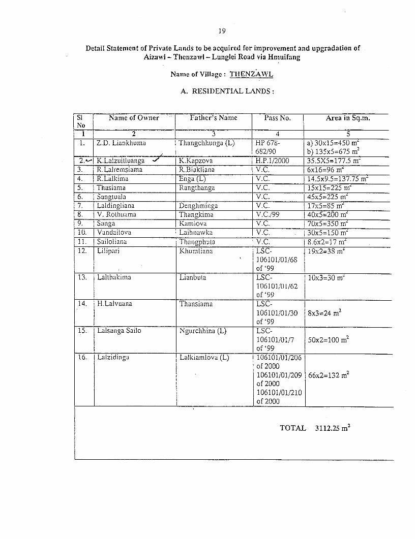
19
Detail Statement of Private Lands to be acquired for improvement and upgradation ofAizawl - Tlienlzawl - Lunglci Road via Hmuifang
Name of Village: TIIENZAWL
A. RESII)ENTLA-L LANDS:
Si Name of Owner Fatlher's Name Plass No. Area in Sq.m.No I
1 2 3 4 T 5 _1. ] Z.D. Liankhiujina Thaingclhhiunga (L) HP 678- a) 30x15=450 m-
|_______________ ,______ 682/90 b) 135x5=675 m2
2."-I K.Lalzuitluanga -' K.Kapzova H.P.1/2000 1 35.5X5=177.5 nm3. ZR.Lalremsiama R.Biakliana V.C. {6x16=96 m4. R.Lalkima Enga (L) V.C. i 14.5x9.5=137.75 mr5. Thasiama Rangthanga V.C. | 15xl5=225 m'6. Sanigtuala V.C. I45x5=225 m'7. | Laldingliana Denghminga V.C. 17x5=85 me8. I V. Rothuama Thangkirna V.C./99 40x5=200 m'9. Sanga Kamlova V.C. 70x5=350 m'1U. Vandailova Laihnawkvka V.C. i30x5=150 m-i11. I Sailoliana Thwigphuta V.C. S.6x2=17 ml12. I Lilipari Khuiniliana LSC- . 19x2=3S mz
106101101/68___. of'99 __________________o 9
13. Laltha.lkima Lianbuta LSC- 10x3=30 ml106101/101/6-2
_ _ _ _ _ _ _ _ _ _ _ _ _ _ _ _ _ _ _ _ _ _ _ o f'9914. H.Lalvuana Thansiama LSC-
106101/01/30 8x3=24 m2
of'9915. Lalsanga Sailo Ngurclhhina (L) LSC-
106101/01/7 50x2=100 m2of'99
16. Lalzidinga Lalkiamlova (L) 10610liOl/206of2000106101/01/209 66x2=132 rn2
of2000106101/01/210of2000
TOTAL 3112.25 m'
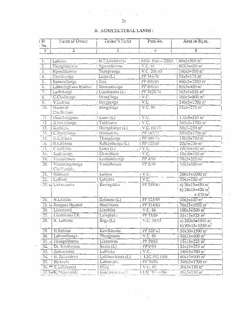
20
B'. AGRIY!CULTU I?ALT LANDS
SI Name of,0y Ownc 1 icrs IN7,Ie 1ass No. i Ai-ea in Sci.niL
________ F La] iiaaa H.TLalrim~~wia Misc. Pass -23/63~ 60x5=3(00 rwT____ F Thaii i r1 i v, ia N gourc-iih hawna~ \I NC. 9.5 90X5=45()
3tNg LI ]-C h a Thang11nga V/C. 2B,;93, I90x5=950 m-4. chcrthlmaa~a Liana (L) ])744'/76 35x5=1 75 rn5. Rom an"han"a Zajal 1T PP (06/&) 460.x5=2300 In
6. La] hinni a g] ana Hrahsci F Rom antha ac PP 806/86 T S Ox5=400 na'7. 1Lurhtha-mLi Lian111-Ihuama (Ll'; PP I 82Sj776 I 65x5=S25 mi-S. I ch;kumm ~ lHranci i I"i \/.C. 1I 6(Ix5S=0( Ini9. V/.Liiihnif IBcnapeCn ga\.C. 2 40.x5= 1200 II;,I U. N Nuzavwni1 Bellpemng N/C. 99 55x5=275 n-j
11. ua I II it anpu; ia (L) 1\..lOx5=550 ni
12. B. i O~fa~ fhhta\..340.x5=1700 ni-
13 ]'K aaa ... iang ( L) j NC. (SIiv3 S5ox5=250 mW:
I ~~~~~~~I Darthawnu F>1 37 350,x5=1 750 m.I5 K... anThangdon-zi IT 980<-S 150Ox5=750 n-i
a 0.. a iIa n zI~In (L) iPP I 2 5/S5 20x5 =I 00 n-
1C. LakmnLn:i(I) ___ .NC. (IUI(ni18. ~~-I,;2ta~ nolci Chwihlic in v.C. I Ox 10= I0(1
19. Va;.ta~~ arunia La-i Ihatu I a ~nci TPP 1/99 70.x5=3f0 nar2 \"an m i Il hnai I\,~ an!al hruaia 5 PP 59 x 753 5( m I
(/ V~!nhlli
21. 1 RJnzaw at 1.aLibntizi N/C. I200.x5= 1000 mll22. FLaflilni _____ _____ __ L lz a IN/C. _ _ _ 30x5=1 50 m- _ _ _
\__' va; IN' B3a\\ IT a ' 3 39/8i a) 30x 15=450 ngl
b) 28x15=420In'_ _ _ _ _ _ _ _ _ _ _ _ _ _ _ _ _ _ _ _ _ _ _ _ _ _ _ _ _ _ _ _ _ _ _ _ _ _ _ _ _ _ _ _ _ _ _ _ _ _ 87 0 'n i-
2-4. H-.Lillhi'Ira [ Zahanuna (L) PP 125/195 J20x5=100 Ill2)5. 4Roilgura Hralhscl I uilnn PP 1 214/S j 70x15= 1050 il-26. LE1iaMP aVII Li anihlira I /.C. 86 ).OOx5=500 rm2'27. Liaankhuma XIE. Lal nghal:ai I________ PP 73/'86 _____ 5x'15=-525 rrn
28. R. Lalkima 1En~~~~a(L) V'.C. 39;93 a) 200X5=1 000 ar_________________ ______________________________b) 90xl5=13'50 nl'
2 9. J, iL R ohl Ii ra Kavvlkhiuma PP 32R Fr 50x30=1500 m-3(1. jLzilramthanlga Than-zuala \'.C. 96 r40x15=6(JO mn31. Lj 1-irangsik1hunia } lintan PIVI iIP 59/185 r15x15=225 m-:32. Dr IK yiht~n Suaka (L) P"P 9/84 j2)5x15=375 m-
.. Zol j Ki \I III Laihiaka iC 1 40x5=700 ni-*34. B. 7~1!kilova I LaMikhvwlona (L) IISC NOC 1 /89 j6(1x 1 5= 9001 nm3 5. 1 3' ____________v___LaImuk -________ P'P 70!8 1 340x5= 17(10 nI'30. 't N.. Lilnpuia Mla . INlv c'.C9 9 i30x5= 1 5f1 III ____
I . a 'li~~.. . [ 1.~~.aichIaava A ~I L.S( " - c(:'S( i8X1 2J)l
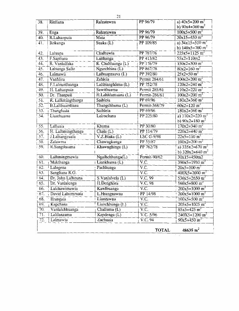
21
38. Rinliana Ralzatawna PP 96/79 a) 40x5=200 m-b) 90x4=360 m 2
39. Enga Ralzatawna PP 96/79 100x5=500 m'4-0. R.Laltanpuia Maia PP 96/79 3Ox15=450 m'41. Rokunga Suaka (L) PP 109/85 a) 34x15=510 m
42I - Chalbawia PP 787/76 b) 140x5=700 m242. Laluapa Chalbawia __PP 787/76 225x5=1125 mr
43. F.Sapliana Lalthanga I PP 413/82 55x2=llOm244. R. Vanlalfaka R. Chaltluanga (L) j PP 176/79 150x2=300 m-45. 1 Lalsanga Sailo Ngurchhina (L) j PP 867/78 80x2=160 m-46. Lalmawii Lalhuapzauva (L) PP 392/80 25x2=50 mr47. Vanhlira Zahleia Permit 284/61 100x2=200 mZ48. F.Lalnuntluanga Lalthianghlima (L) PP 752/78 120x2=240 mz49. H. Laltanpuia Sawithuama Permit 285/61 110x2=220 m-50. Dr. Thanpuii H.Lalthlamuana (L) Permit-286/61 100x2=200 mL51. R. Lalhmingthanga Saihleia PP 69/96 180x2=360 mz52. B.Lalthuamliana Thangchhuma (L) Permit-368/79 60x2=120 m~
I53. Thangluaia Saihleia PP 69/96 180x2=360 mZ54. Lianthuama Lairochana PP 225/80 a) 1 10x2=-220 m
I _ _ _________________ ________________ _ _ _ _ _ _ _ _ _ _ _ _ _ b) 90x2=180 m 2
55. Lalluaia Khuma PP 30/80 170x2=340 mr56. I-H. Lalhmingthanga Chala (L) PP 114/79 220x2=440 m57. J.Lalsangzuala V.Z.Biaka (L) 1 LSC G-9/98 22x5=110 mz58. Zalawma Chawngkunga PP 55/87 100x2=200 m-59. I R.Sangthuama Khawnghinga (L) PP 762/78 a) 335x2=670 m-60. j I b) 320x2=640 m2
I_60. Lalhmingmawia Ngaihchhunga(L) Permit-90/62 30xl5=450m261. 1 Makthanga Liankhuma (L) V.C. 390x5=1950 mrn62. Lalngena Pachhunga V.C. 20x5=100 m-63. Sangliana R.O. _ V.C. 400X5=2000 m
64. Dr. John Lalhnuna S.Vanlalvela (L) | V.C. 99 530x5=2650 mr 65. 1 Dr. Vanlalenga H.Denghlira 1 V.C. 98 160x5=800 m2
66. Lalchawimawia Kawlbuanga V.C. 200x5=1000 mz67. I David Lalremruata L.Hrangnawna PP 14/98 200x5=1000 m-'68. 1 Hrangaia Lianzawna V.C. 100x5=500 m L69. | Kapchana Lianchhunga (L) V.C. 205x5=1025 m- 70. ! Vanlalchhuanga Challuma (L) V.C. 85x5=425 m-717. Laltlanzama Kapdenga (L) V.C. 5/96 240X5=1200 m |72. Lalmawia Zachuaia V.C. 94 90x5=450 mrn
TOTAL 48635 m2
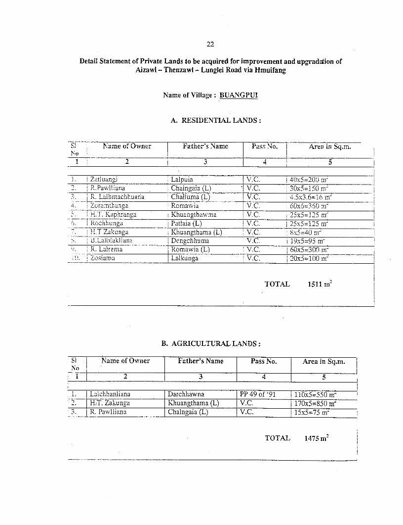
22
Detail Statement of Private Lands to be acquired for improvement and upgradation ofAizawl - Thenzawl - Lunglei Road via Hmuifang
Name of Village: BUANGPUI
A. RESIDENTIAL LANDS:
Sl , Name of Owner I Father's -Name 1 Pass No. Area in Sq.m.NO
1 1 2 L _ _ _ _ _ _ _ _ _ _2 3 __4 _
a ZaDluanni Lalpuia V.C. j4x5=2()( m-'. t R.Paw1liana [ Chalngaia (L) V.C. 3-0x5=150 mz
'__L____________ | Challuma (L) I V.C. I |x36 mzZ 7 ora:nLhan a Romawia I6V.C. IOx6=3)60 .m
.). H.T. Kaphranga Khuangthawrra T V.C. I x'-P5 m- 1Rochhunga TPatlaia (L) |V.C. I25x5=125 m-nH.T ZakXunga Khuanathama (L) I V.C. 8x5=40 m-
_________. _____ _ _ _ _ki _i_ana Dengchlurna I V.C. I x5=95 mrnR. Lalremna Romawia (L) V.C. j60x5=300 mnLOSiama Lalkunga V.C. 2 0x5= 100 rm
TOTAl& 1511 m2
B. AGRICULTURAL LANDS:
Si Name of Owner Father's Name Pass No. Area in Sq.m.
-1 2 3 1 4
l. | Lalchhanliana Darchhawna PP 49 of '91 110x5=550 mi_____ H:T. Za'sunga Khuangthama (L) V.C. 170x5=850 mI3. R. .Pawlliaina Chalngaia (L) V.C. 15x5=75 m'
TOTAL 1475 m2r
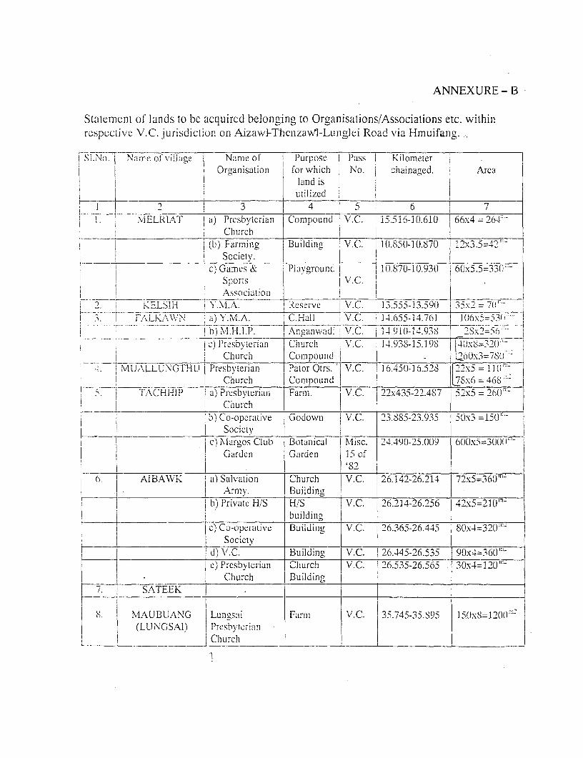
ANNEXURE- B
Statement of lands to be acquircd bclonging to Organisations/Associations etc. withinrospective V.C. jurisdiclion on Aizawl-Thcnzawl-Lunglci Road via Hmuifang.
,~~~~~~~~~~~~~
I Sl.No.i 'j Name of viliaoe Name of P'urpose Pass KilometerOrganisation for which No. j chainaged. Area
i I land is j
i__ _________________________ utilized __ !__
2 i 3 4 I7 1 6 7I L 7NiELRTsAT it) Presbyterian Compound V.C. 15.516-10.610 1 66x4 = 260
-_ _ _ _ _ _ _ _ _ Church' i_ I _
i(b) Farmingo Buildjing I V.C. 0.....t (.50-10).870) 12x3.5=4291'
- I , ~~~~~~Sociciy. l l.c) Gam,es & Plaviground I i 10.870-10.930 6(x5.5=33(
Sports V.(.
I Association !_ _ I _
tI N _ R I E C H Y.M.Al eseive IV. C. 13-555- 15 15x2 A 77.-i .. tYi-.LsA N l.l , >. M. A.. C.Hall n V.C. 4.655-14.76] 0 5= 5 !
j r in~~~~~~~) MI.H.lI'.P.lalxt,, !C ((-T4. 38 3x=,--_| .) Pr w sbvyerian ChIurch V C . 1.938-15. ]() xS= e9()W-
4. MLWXLLUNG1D ' Churcih Compound _ | - lOx3=7,80-
I '. lNIUALLUN'GTHU PreIsbyerianl Pator Qtrs. V.C. 116.45(0-16.528 |22x5 D=-IIO
TACHI-P P sbeChurcian Compound 7 x6=4L -6
:1. -- TAl-i CHlJIP I a) Presbyterian Farm. V.C. 22x43 5- 2 2_487 `52x5 = 20tJ'-!________________ _ |C hurch _ _ _ _ _
b ) Co-operative Godown V.C. j23.885-23.935 50x3 =150' -
Societ 249
c) Alartos Club Botanical Misc. 24.490-25.009 600x5=30(t-
arJden Giarden 1 5 of
(r. [ AIBAWI a) Salvation Church V.C. I 26.142-26.214 72x5=360"'1
Armn. Buildingb) Private H/S H/S V.C. 26.214-26.256 42x5=210'-
L _______________________ i_____________ _ |building Ic) Co-operatiVe Buildin, V.C. 26.365-26.445 80x4=3'()';'-
I | I ~~~~~~Soeiety _
I d) V. C. Buildin(y V.C. 2 26.145-26.535 90x4=360"'-
e) Presbyterian Clhurch V.C. 26.535-26.565 30x4=120'(-Church Buildin__
!7, SA0TEEK
8 S. i MAUBUANG Lun-sai Farm VI.C. 35.745-35.895 I5(JX8=12(l0'
(LlUNCGSAI) Presbyterian
Church
'I
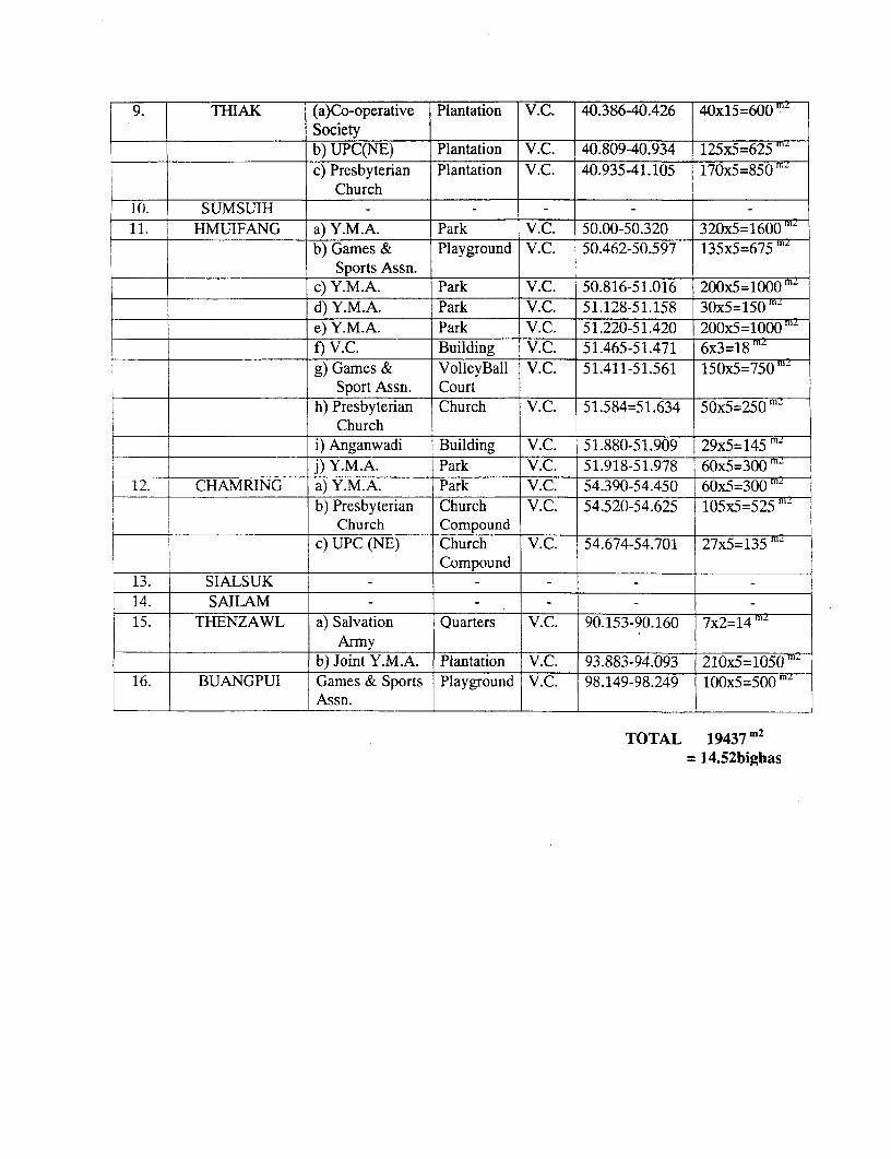
9. THIAK (a)Co-operative Plantation V.C. 40.386-40.426 40x15=600Societyb) UPC(NE) Plantation V.C. 40.809-40.934 125x5=625c) Presbyterian Plantation V.C. 40.935-41.105 170x5=850mrn
Church10. SUMSUIH1 1. HMUIFANG a) Y.M.A. Park V.C. 50.00-50.320 320x5=1600mz
b) Games & Playground V.C. 50.462-50.597 135x5=675 ZSports Assn.
c) Y.M.A. Park V.C. 50.816-51.016 200x5= 1000m
d) Y.M.A. Park V.C. 51.128-51.158 30x5=150 mze) Y.M.A. Park V.C. 51.220-51.420 200x5=1000lm
f) V.C. Building V.C. 51.465-51.471 6x3=18 mng) Games & VolleyBall V.C. 51.411-51.561 150x5=750 mz
Sport Assn. Courth) Presbyterian Church V.C. 51.584=51.634 50x5=250m
Churchi) Anganwadi Building V.C. 51.880-51.909 29x5=145 m'j) Y.M.A. Park V.C. 51.918-51.978 60x5=3000m '
12. CHAMRING a) Y.M.A. Park V.C. 54.390-54.450 60x5=300 mb) Presbyterian Church V.C. 54.520-54.625 105x5=525
Church Compoundc) UPC (NE) Church V.C. 54.674-54.701 27x5=135
Compound13. SIALSUK14. SAILAM-15. THENZAWL a) Salvation Quarters V.C. 90.153-90.160 7x2=l4rn
Armyb) Joint Y.M.A. Plantation V.C. 93.883-94.093 210x5= 1050mz
16. BUANGPUI Games & Sports Playground V.C. 98.149-98.249 100x5=500mAssn.
TOTAL 19437 m2
= 14.52bighas
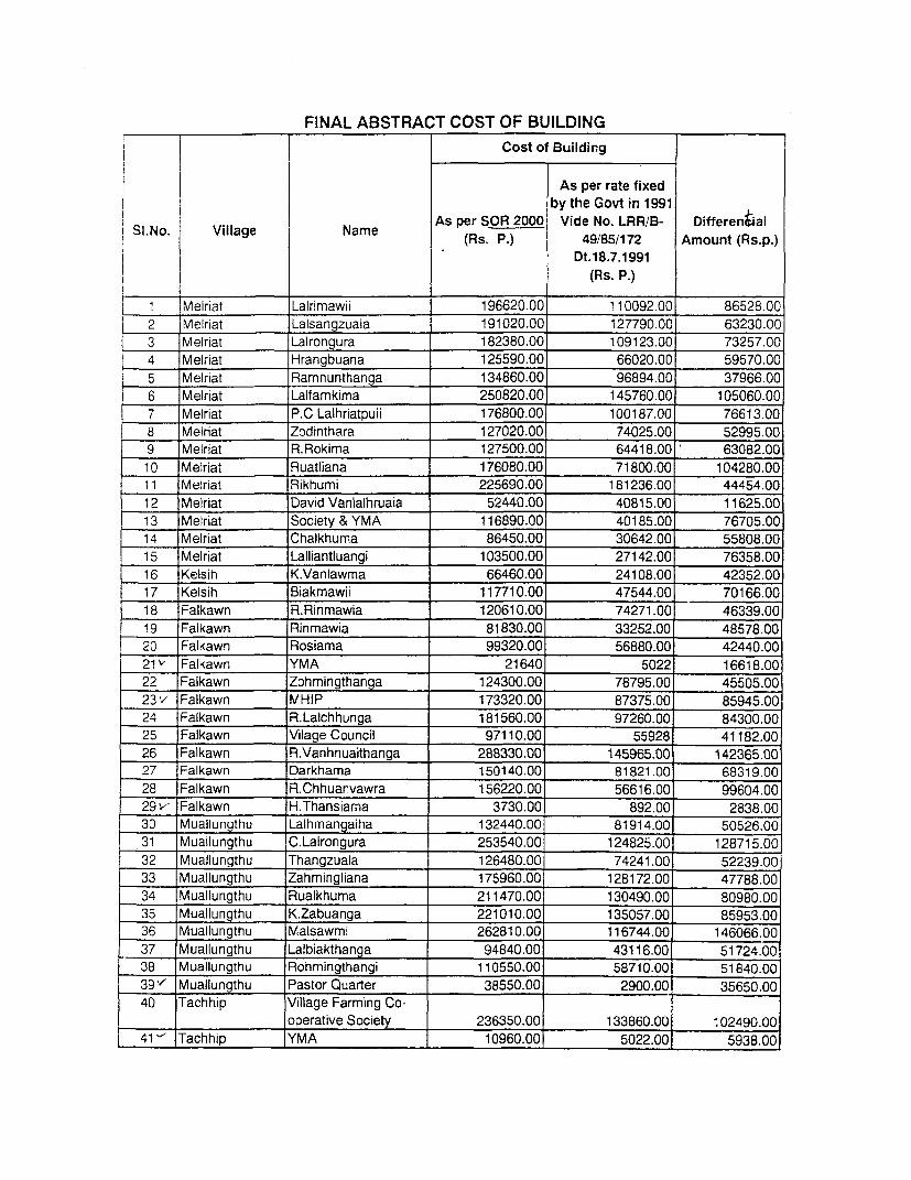
FINAL ABSTRACT COST OF BUILDINGCost of Building
As per rate fixedby the Govt in 1991
As per SOR 2000 Vide No. LRR/B- DifferenitalSI.No. Village Name (Rs. P.) 49/85/172 Amount (Rs.p.)
. Dt.18.7.1991
! | (Rs. P.)
1 Melriat Lalrimawii 196620.00 110092.00 86528.00
2 Melriat Lalsangzuala 191020.00 127790.00 63230.00
3 Melriat Lalrongura 182380.00 109123.00 73257.00
4 Melriat Hrangbuana 125590.00 66020.00 59570.00
5 Melriat Ramnunthanga 134860.00 96894.00 37966.00
6 Melriat Lalfamkima 250820.00 145760.00 105060.00
7 Melriat P.C Lalhriatpuii 176800.00 100187.00 76613.00
8 Melriat Zodinthara 127020.00 74025.00 52995.009 Melriat R.Rokima 127500.00 64418.00 63082.00
10 Meiriat Ruatliana 176080.00 71800.00 104280.0011 Melriat Rikhumi 225690.00 181236.00 44454.00
12 |Melriat David Vanlalhruaia 52440.00 40815.00 11625.00
13 Melriat Society & YMA 116890.00 40185.00 76705.00
14 Melriat Chalkhuma 86450.00 30642.00 55808.00
15 iMelriat Lalliantluangi 103500.00 27142.00 76358.00
16 Kelsih K.Vanlawma 66460.00 24108.00 42352.00
17 Kelsih Biakmawii 117710.00 47544.00 70166.00
18 Falkawn R.Rinmawia 120610.00 74271.00 46339.00
19 Falkawn Rinmawia 81830.00 33252.00 48578.00
20 Falkawn Rosiama 99320.00 56880.00 42440.00
21k' Falkawn YMA 21640 5022 16618.00
22 Falkawn Zohmingthanga 124300.00 78795.00 45505.00
23v Falkawn MHIP 173320.00 87375.00 85945.00
24 Falkawn R.Lalchhunga 181560.00 97260.00 84300.00
25 Falkawn Vilage Council 97110.00 55928 41182.00
26 Falkawn R.Vanhnuaithanga 288330.00 145965.00 142365.0027 Falkawn Darkhama 150140.00 81821.00 68319.00
28 Falkawn R.Chhuanvawra 156220.00 56616.00 99604.00
29- Falkawn H.Thansiama 3730.00 892.00 2838.00
30 Muallungthu Lalhmangaiha 132440.00 81914.00 50526.00
31 Muallungthu C.Lalrongura 253540.00 124825.00 128715.00
32 Muallungthu Thangzuala 126480.00 74241.00 52239.00
33 Muallungthu Zahmingliana 175960.00 128172.00 47788.00
34 Muallungthu Rualkhuma 211470.00 130490.00 80980.00
35 Muallungthu K.Zabuanga 221010.00 135057.00 85953.00
36 Muallungthu Malsawmi 262810.00 116744.00 146066.00
37 Muallungthu Lalbiakthanga 94840.00 43116.00 51724.00
38 Muallungthu Rohmingthangi 110550.00 58710.00 51840.00
39 " Muallungthu Pastor Quarter 38550.00 2900.00 35650.00
40 Tachhip Village Farming Co-_ ____________ operative Society 236350.00 133860.001 '02490.00
41 -' Tachhip YMA 10960.00 5022.001 5938.00
42 Aibawk Lalchhunga 117810.00 68163.00 49647.00
43 Aibawk Chawngziki 142220.00 71103.00 71117.00
44 Aibawk C.Lalhunthara 350290.00 164284.00 186C06.00
45 Aibawk Dokhuma 175690.00 85644.00 90046.00
i 46 " Aaawk YMA 22380.00 10432.00 11948.00
47 Aibawk PWD 148240.00 102348.00 45892.00
48 Aibawk Vanlalruata 41620.00 13392.00 28228.00
49 Aibawk Lalsawta 146080.00 42637.00 103443.00
______ Aibawk Village Council 34150.00 16074.00 18076.00
51 Sateek C.Zoleta 319600.00 144039.00 175561.00
52 - Sateek Thangchhunga 3740.00 3000.00 740.00
53 Sateek Village Council 5890.00 0.00 5890.00
j 54, Maubuang Michael Engthawla 124060.00 78516.00 45544.00
55 Maubuang Hrangthankima 69950.00 54987.00 14963.00
56 Maubuang Tawnluia 52400.00 24108.00 28292.00
57 Maubuang H.Thanzawna 132970.00 85695.00 47275.00
587 Maubuang Village Council 13250.00 8532.00 4718.00
59 ' Maubuang Rinsanga 12520.00 8016.00 4504.00
60'" Thiak Thansanga 10750.00 2800.00 7950.00
61 Thiak Hunliana 64120.00 28598.00 35522.00
62v Sumsuih Hualchhingi 4320.00 892.00 3428.00
63 Sumsuih Lalkungi 167800.00 87156.00 80644.00
64'- Sumsuih Thanpara 4320.00 892.00 3428.00
65' Sumsuih Ralkapa 6580.00 2900.00 3680.00
66 Hmuifang Presbyterian 377360.00 290649.00 86711.00
67 Hmuifang Thangkhuma 281240.00 158717.00 122523.00
68 Hmuifang F & C Deppt. 300580.00 214785.00 85795.00
69'/ Hmuifang Village Council 65360.00 30135.00 35225.00
70- Hmuifang Anganwadi 102970.00 60285.00 42685.00
71' Hmuifang B.T Sanga 11360.00 0.00 11360.00
72 Chamring Lalzuithanga 103290.00 47148.00 56142.00
73 { Chamring H.C.Sapbuanga 17890.00 12000.00 5890.00
74 Chamring V.Rothanga 158370.00 75240.00 83130.00
75 Chamring Darchhunga 99960.00 61050.00 38910.00
76v' Sialsuk NIL 0.00 0.00 0.00
77w- Sailam NIL 0.00 0.00 0.00
78 Thenzawl Lalthakima 96120.00 54216.00 41904.00
79" /Buangpui R.Pawlliana 25930.00 0.00 25930.00
80 Buangpui R.Lalhmachhuana 55660.00 20076.00 35584.00
| 81 Buangpui Zoramthanga 81620.00 38178.00 43442.00
TOTAL 9779360.00 5333596.00 4445764.00
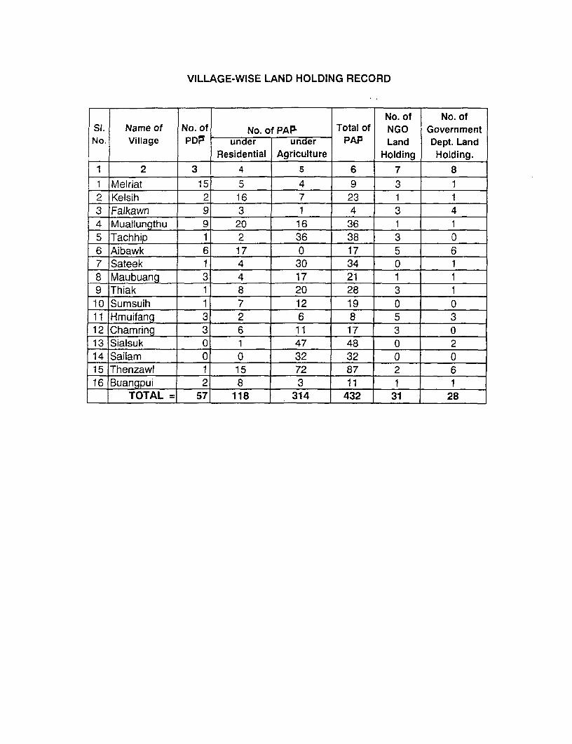
VILLAGE-WISE LAND HOLDING RECORD
No. of No. ofSt. Name of No. of No. of PAP Total of NGO GovernmentNo. Village PDF under under PAP Land Dept. Land
2 Residential Agriculture Holding Holding.1 2 3 4 5 6 7 8
1 Melriat 15 5 4 9 3 12 Kelsih 2 16 7 23 1 13 Falkawn 9 3 1 4 3 44 Muallungthu 9 20 16 36 1 15 Tachhip 1 2 36 38 3 06 Aibawk 6 17 0 17 5 67 Sateek 1 4 30 34 0 18 Maubuang 3 4 17 21 1 19 Thiak 1 8 20 28 3 110 Sumsuih 1 7 12 19 0 011 Hmuifang 3 2 6 8 5 312IChamring 3 6 11 17 3 013 Sialsuk 0 1 47 48 0 214 Sailam 0 0 32 32 0 015 Thenzawl 1 15 72 87 2 616 Buangpui 2 8 3 11 1 1
TOTAL = 57 118 314 432 31 28
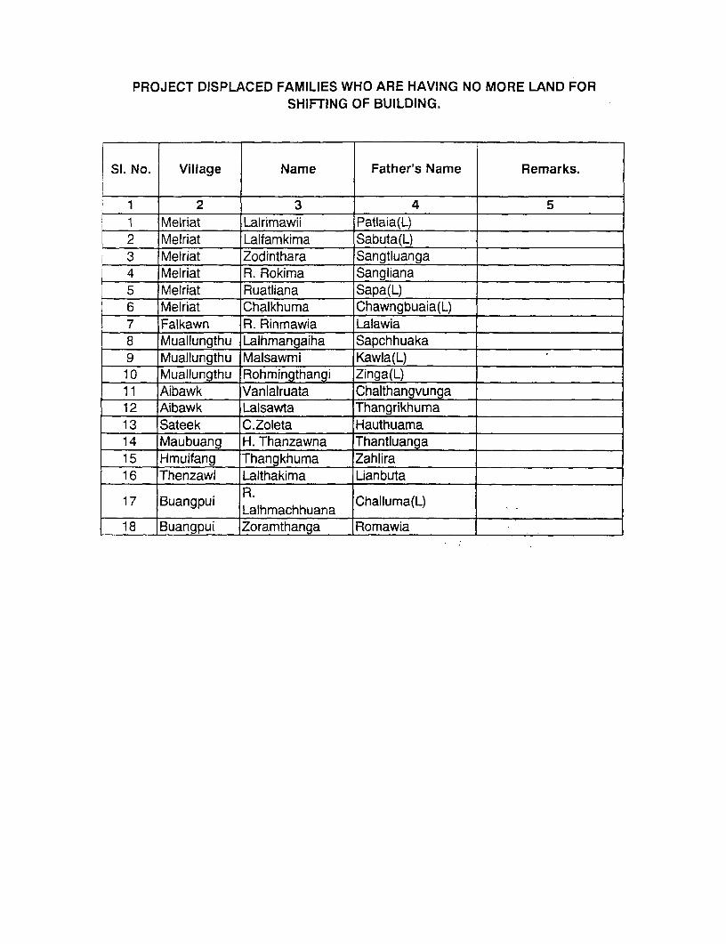
PROJECT DISPLACED FAMILIES WHO ARE HAVING NO MORE LAND FORSHIFTING OF BUILDING.
SI. No. Village Name Father's Name Remarks.
1 2 3 4 51 Melriat Lairimawii Patlaia(L)2 Melriat Lalfamkima Sabuta(L)0 3 fiMeriat Zodinthara Sangtluanga4 Melriat R. Rokima Sangliana5 Melriat Ruatliana Sapa(L)6 Melriat Chalkhuma Chawngbuaia(L)7 Falkawn R. Rinmawia Lalawia8 Muallungthu Lalhmangaiha Sapchhuaka9 Muallungthu Malsawmi Kawla(L)10 Muallungthu Rohmingthangi Zinga(L)11 Aibawk Vanlalruata Chalthangvunga12 Aibawk Lalsawta Thangrikhuma13 Sateek C.Zoleta Hauthuama14 Maubuang H.Thanzawna Thantluanga15 Hmuifang Thangkhuma Zahlira16 Thenzawl Lalthakima Lianbuta
17 Buangpui R. Challuma(L)_______________Lalhmachhuana ChluaL
18 Buangpui Zoramthanga Romawia
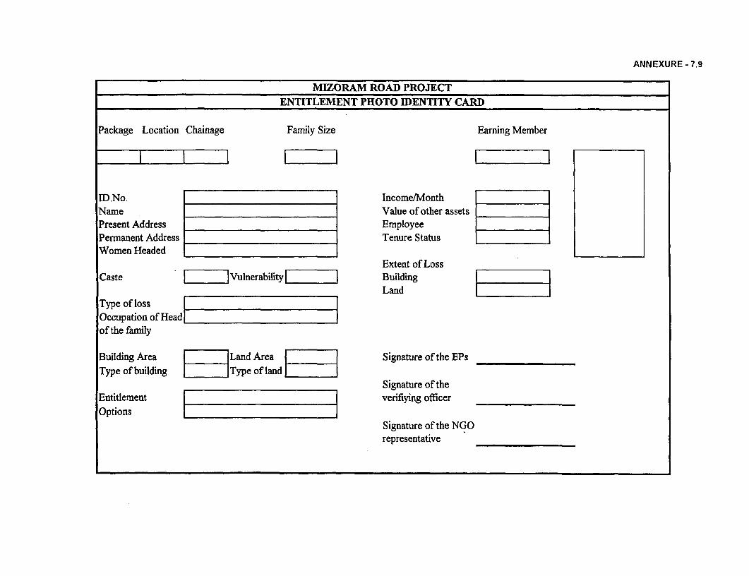
ANNEXURE - 7.9
MIZORAM ROAD PROJECT
ENTITLEMENT PHOTO IDENTITY CARD
Package Location Chainage Family Size Earning Member
ID.No. Income/Month
Name Value of other assets
Present Address Employee
Permanent Address Tenure StatusWomen Headed .
Extent of LossCaste . Vulnerability Building
_ _ _ _ _ _ _ _ _ _ _ _ _ _ _ _ _ _ _ _ _L and_ _ _ _ _ _
Type of loss l_l
Occupation of Head |_l
of the family
Building Area [ |Land Area |1 1 ]Signature of the EPsType of building Type of land [
Signature of theEntitlement | veriflying officerOptions l l
Signature of the NGOrepresentative

ANNEXURE 8.1
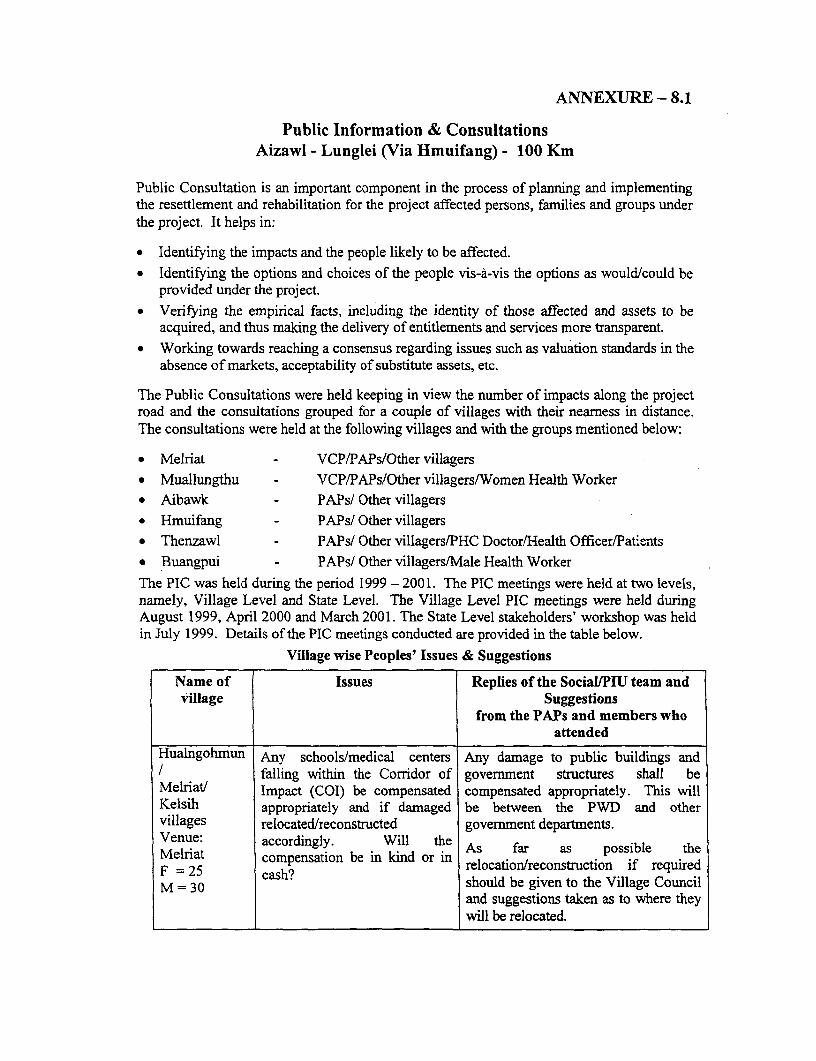
ANNEXURE- 8.1
Public Information & ConsultationsAizawl - Lunglei (Via Hmuifang) - 100 Km
Public Consultation is an important component in the process of planning and implementingthe resettlement and rehabilitation for the project affected persons, families and groups underthe project. It helps in:
* Identifying the impacts and the people likely to be affected.* Identifying the options and choices of the people vis-A-vis the options as would/could be
provided under the project.* Verifying the empirical facts, including the identity of those affected and assets to be
acquired, and thus making the delivery of entitlements and services more transparent.* Working towards reaching a consensus regarding issues such as valuation standards in the
absence of markets, acceptability of substitute assets, etc.
The Public Consultations were held keeping in view the number of impacts along the projectroad and the consultations grouped for a couple of villages with their nearness in distance.The consultations were held at the following villages and with the groups mentioned below:
* Melriat - VCP/PAPs/Other villagers* Muallungthu - VCP/PAPs/Other villagers/Women Health Worker* Aibawk - PAPs/ Other villagers* Hmuifang - PAPs/ Other villagers* Thenzawl - PAPs/ Other villagers/PHC Doctor/Health Officer/Patients* Buangpui - PAPs/ Other villagers/Male Health WorkerThe PIC was held during the period 1999 - 2001. The PIC meetings were held at two levels,namely, Village Level and State Level. The Village Level PIC meetings were held duringAugust 1999, April 2000 and March 2001. The State Level stakeholders' workshop was heldin July 1999. Details of the PIC meetings conducted are provided in the table below.
Village wise Peoples' Issues & Suggestions
Name of Issues Replies of the Social/PIU team andvillage Suggestions
from the PAPs and members whoattended
Hualngohmun Any schools/medical centers Any damage to public buildings and/ falling within the Corridor of govermment structures shall beMelriat/ Impact (COI) be compensated compensated appropriately. This willKelsih appropriately and if damaged be between the PWD and othervillages relocated/reconstructed government departments.Venue: accordingly. Will the As far as possible theMelriat acordesaiongly nkndo.nA fr a osl hFel 25 compensation be in kind or in relocation/reconstruction if requiredM= 25 .cash? should be given to the Village CouncilM=30
and suggestions taken as to where theywill be relocated.
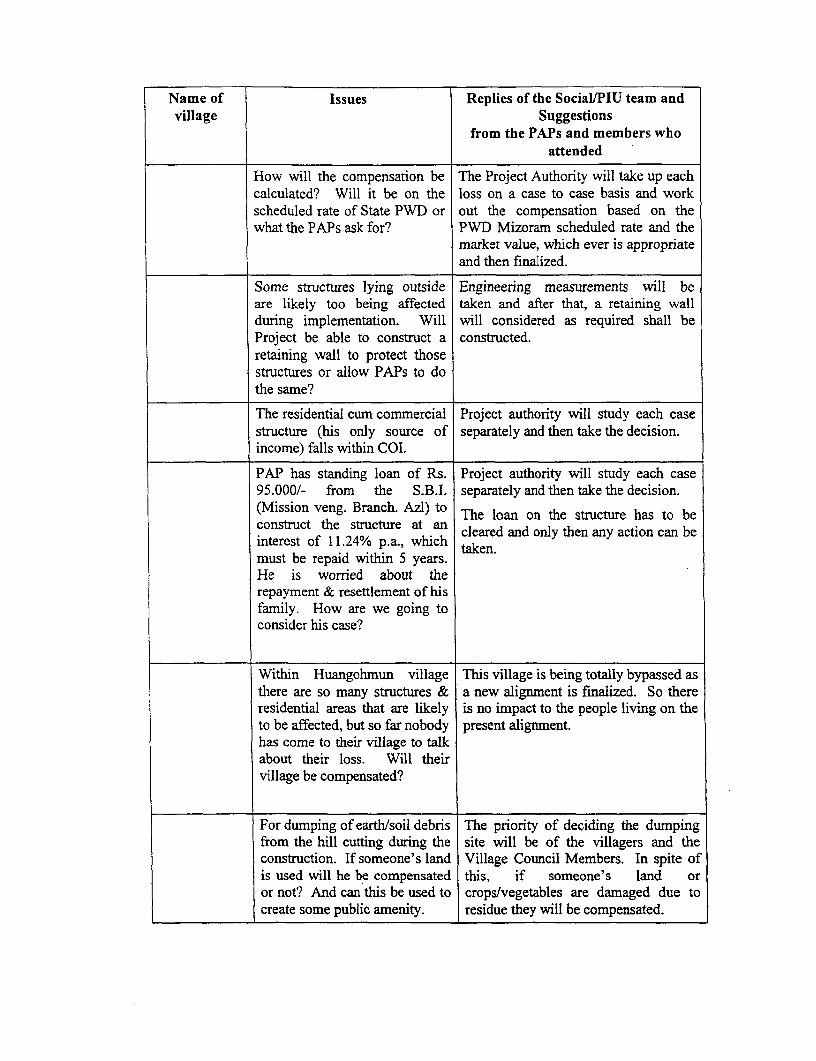
Name of Issues Replies of the Social/PIU team andvillage Suggestions
from the PAPs and members whoattended
How will the compensation be The Project Authority will take up eachcalculated? Will it be on the loss on a case to case basis and workscheduled rate of State PWD or out the compensation based on thewhat the PAPs ask for? PWD Mizoram scheduled rate and the
market value, which ever is appropriateand then finalized.
Some structures lying outside Engineering measurements will beare likely too being affected taken and after that, a retaining wallduring implementation. Will will considered as required shall beProject be able to construct a constructed.retaining wall to protect thosestructures or allow PAPs to dothe same?
The residential cum commercial Project authority will study each casestructure (his only source of separately and then take the decision.income) falls within COI.
PAP has standing loan of Rs. Project authority will study each case95.000/- from the S.B.I. separately and then take the decision.(Mission veng. Branch. Azl) to The loan on the structure has to beconstruct the structure at an cleared and only then any action can beinterest of 11.24% p.a., which taken.must be repaid within 5 years.He is worried about therepayment & resettlement of hisfamily. How are we going toconsider his case?
Within Huangohmun village This village is being totally bypassed asthere are so many structures & a new alignment is finalized. So thereresidential areas that are likely is no impact to the people living on theto be affected, but so far nobody present alignment.has come to their village to talkabout their loss. Will theirvillage be compensated?
For dumping of earth/soil debris The priority of deciding the dumpingfrom the hill cutting during the site will be of the villagers and theconstruction. If someone's land Village Council Members. In spite ofis used will he be compensated this, if someone's land oror not? And can this be used to crops/vegetables are damaged due tocreate some public amenity. residue they will be compensated.
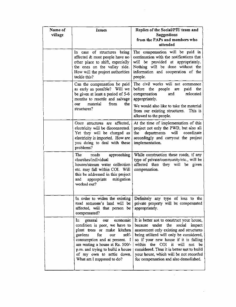
Name of Issues Replies of the Social/PIU team andvillage Suggestions
from the PAPs and members whoattended
In case of structures being The compensation will be paid inaffected & most people have no continuation with the notifications thatother place to shift, especially will be provided at appropriately.the ones on the valley side. Nothing will be done without theHow will the project authorities information and cooperation of thetackle this? people.
Can the compensation be paid The civil works will not commenceas early as possible? Will we before the people are paid thebe given at least a period of 5-6 compensation and relocatedmonths to resettle and salvage appropriately.our material from the We would also like to take the materialstructures? from our existing structures. This is
allowed to the people.
Once structures are affected, At the time of implementation of thiselectricity will be disconnected. project not only the PWD, but also allYet they will be charged as the departments will coordinateelectricity is imported. How are accordingly and carryout the projectyou doing to deal with these implementation.problems?
The roads approaching While construction these roads, if anychurches/individual type of private/community/etc., will behouses/stream water collection affected then they will be givenetc. may fall within COI. Will compensation.this be addressed in this projectand appropriate mitigationworked out?
In order to widen the existing Definitely any type of loss to theroad someone's land will be private property will be compensatedaffected, will that person be appropriately.compensated?
In general our economic It is better not to construct your house,condition is poor, we have to because under the social impactplant trees or make kitchen assessment only existing and structuresgardens for our self- being utilized will only be considered,consumption and at present. I so if your new house if it is fallingam renting a house at Rs. 500/- within the COI it will not bep.m. and trying to build a house considered. Thus it is better not to buildof my own to settle down. your house, which will be not recordedWhat am I supposed to do? for compensation and also demolished.
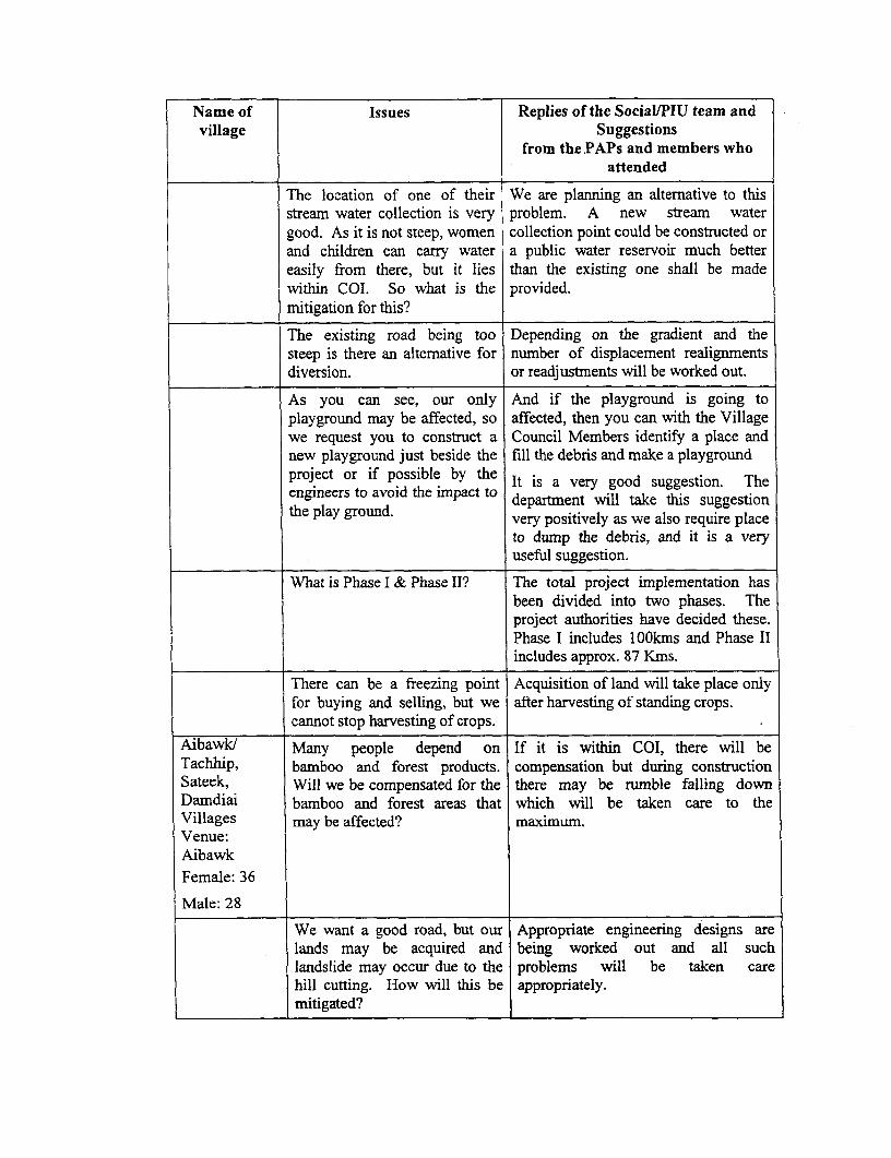
Name of Issues Replies of the Social/PIU team andvillage Suggestions
from the PAPs and members whoattended
The location of one of their We are planning an altemative to thisstream water collection is very problem. A new stream watergood. As it is not steep, women collection point could be constructed orand children can carry water a public water reservoir much bettereasily from there, but it lies than the existing one shall be madewithin COI. So what is the provided.mitigation for this?
The existing road being too Depending on the gradient and thesteep is there an altemative for number of displacement realignmentsdiversion. or readjustments will be worked out.
As you can see, our only And if the playground is going toplayground may be affected, so affected, then you can with the Villagewe request you to construct a Council Members identify a place andnew playground just beside the fill the debris and make a playgroundproject or if possible by the It is a very good suggestion. Theengineers to avoid the impact to department will take this suggestionthe play ground. very positively as we also require place
to dump the debris, and it is a veryuseful suggestion.
What is Phase I & Phase Il? The total project implementation hasbeen divided into two phases. Theproject authorities have decided these.Phase I includes lOOkms and Phase IIincludes approx. 87 Kms.
There can be a freezing point Acquisition of land will take place onlyfor buying and selling, but we after harvesting of standing crops.cannot stop harvesting of crops.
Aibawkl Many people depend on If it is within COI, there will beTachhip, bamboo and forest products. compensation but during constructionSateek, Will we be compensated for the there may be rumble falling downDamdiai bamboo and forest areas that which will be taken care to theVillages may be affected? maximum.Venue:AibawkFemale: 36
Male: 28
We want a good road, but our Appropriate engineering designs arelands may be acquired and being worked out and all suchlandslide may occur due to the problems will be taken carehill cutting. How will this be appropriately.mitigated?
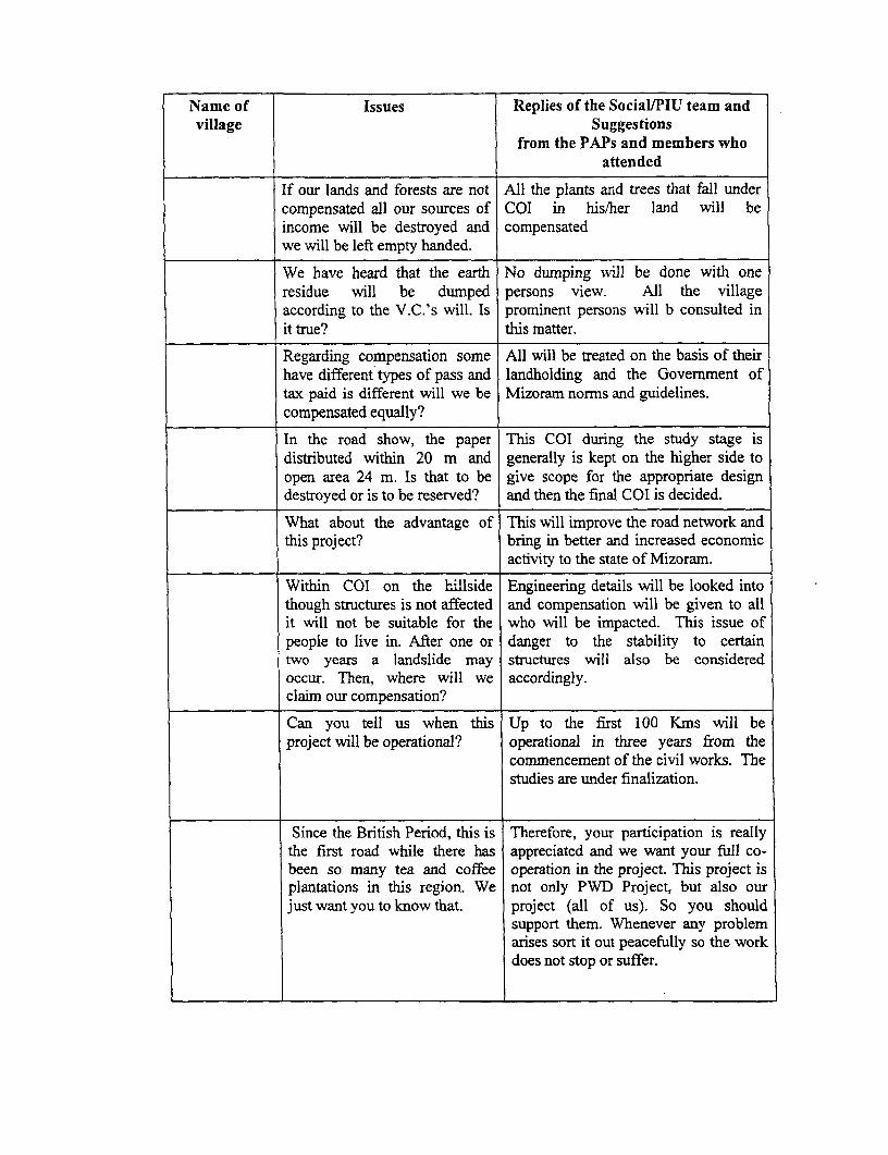
Name of Issues Replies of the Social/PIU team andvillage Suggestions
from the PAPs and members whoattended
If our lands and forests are not All the plants and trees that fall undercompensated all our sources of COI in his/her land will beincome will be destroyed and compensatedwe will be left empty handed.
We have heard that the earth No dumping will be done with oneresidue will be dumped persons view. All the villageaccording to the V.C.'s will. Is prominent persons will b consulted init true? this matter.
Regarding compensation some All will be treated on the basis of theirhave different types of pass and landholding and the Government oftax paid is different will we be Mizoram norms and guidelines.compensated equally?
In the road show, the paper This COI during the study stage isdistributed within 20 m and generally is kept on the higher side toopen area 24 m. Is that to be give scope for the appropriate designdestroyed or is to be reserved? and then the final COI is decided.
What about the advantage of This will improve the road network andthis project? bring in better and increased economic
activity to the state of Mizoram.
Within COI on the hillside Engineering details will be looked intothough structures is not affected and compensation will be given to allit will not be suitable for the who will be impacted. This issue ofpeople to live in. After one or danger to the stability to certaintwo years a landslide may structures will also be consideredoccur. Then, where will we accordingly.claim our compensation?
Can you tell us when this Up to the first 100 Kms will beproject will be operational? operational in three years from the
commencement of the civil works. Thestudies are under finalization.
Since the British Period, this is Therefore, your participation is reallythe first road while there has appreciated and we want your full co-been so many tea and coffee operation in the project. This project isplantations in this region. We not only PWD Project, but also ourjust want you to know that. project (all of us). So you should
support them. Whenever any problemarises sort it out peacefully so the workdoes not stop or suffer.
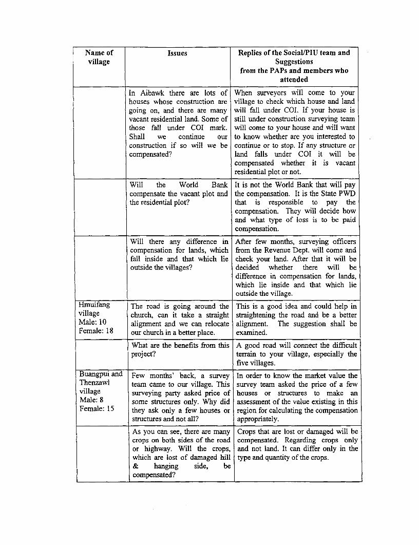
Name of Issues Replies of the SociallPIU team andvillage Suggestions
from the PAPs and members whoattended
In Aibawk there are lots of When surveyors will come to yourhouses whose construction are village to check which house and landgoing on, and there are many will fall under COI. If your house isvacant residential land. Some of still under construction surveying teamthose fall under COI mark. will come to your house and will wantShall we continue our to know whether are you interested toconstruction if so will we be continue or to stop. If any structure orcompensated? land falls under COI it will be
compensated whether it is vacantresidential plot or not.
Will the World Bank It is not the World Bank that will paycompensate the vacant plot and the compensation. It is the State PWDthe residential plot? that is responsible to pay the
compensation. They will decide howand what type of loss is to be paidcompensation.
Will there any difference in After few months, surveying officerscompensation for lands, which from the Revenue Dept. will come andfall inside and that which lie check your land. After that it will beoutside the villages? decided whether there will be
difference in compensation for lands,which lie inside and that which lieoutside the village.
Hmuifang The road is going around the This is a good idea and could help invillage church, can it take a straight straightening the road and be a betterMale: 10 alignment and we can relocate alignment. The suggestion shall beFemale: 18 our church in a better place. examined.
What are the benefits from this A good road will connect the difficultproject? terrain to your village, especially the
five villages.
Buangpui and Few months' back, a survey In order to know the market value theThenzawl team came to our village. This survey team asked the price of a fewvillage surveying party asked price of houses or structures to make anMale: 8 some structures only. Why did assessment of the value existing in thisFemale: 15 they ask only a few houses or region for calculating the compensation
structures and not all? appropriately.
As you can see, there are many Crops that are lost or damaged will becrops on both sides of the road compensated. Regarding crops onlyor highway. Will the crops, and not land. It can differ only in thewhich are lost of damaged hill type and quantity of the crops.& hanging side, becompensated?
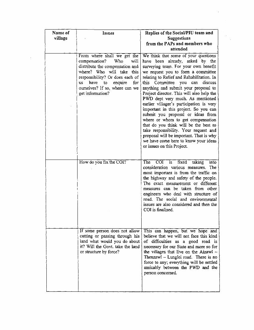
Name of Issues Replies of the Social/PlU team andvillage Suggestions
from the PAPs and members whoattended
From where shall we get the We think that some of your questionscompensation? Who will have been already, asked by thedistribute the compensation and surveying team. For your own benefitwhere? Who will take this we request you to form a committeeresponsibility? Or does each of relating to Relief and Rehabilitation. Inus have to enquire for this Committee you can discussourselves? If so, where can we anything and submit your proposal toget information? Project director. This will also help the
PWD dept very much. As mentionedearlier villager's participation is veryimportant in this project. So you cansubmit you proposal or ideas fromwhere or whom to get compensationthat do you think will be the best totake responsibility. Your request andproposal will be important. That is whywe have come here to know your ideasor issues on this Project.
How do you fix the COI? The COI is fixed taking intoconsideration various measures. Themost important is from the traffic onthe highway and safety of the people.The exact measurement or differentmeasures can be taken from otherengineers who deal with structure ofroad. The social and environmentalissues are also considered and then theCOI is finalised.
If some person does not allow This can happen, but we hope andcutting or passing through his believe that we will not face this kindland what would you do about of difficulties as a good road isit? Will the Govt. take the land necessary for our State and more so foror structure by force? the villages that live on the Aizawl -
Thenzawl - Lunglei road. There is noforce to any; everything will be settledarnicably between the PWD and theperson concerned.
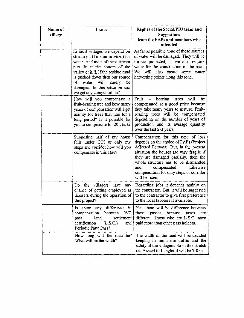
Name of Issues Replies of the Social/PIU team andvillage Suggestions
from the PAPs and members whoattended
In most villages we depend on As far as possible none of these sourcesstream pit (Tuikhur in Mizo) for of water will be damaged. They will bewater. And most of these stream further protected, as we also requirepits lie at the bottom of the water for the construction of the road.valley or hill. If the residue mud We will also create some wateris pushed down then our source harvesting points along this road.of water will surely bedamaged. In this situation canwe get any compensation?How will you compensate a Fruit - bearing trees will befruit-bearing tree and how many compensated at a good price becauseyears of compensation will I get they take many years to mature. Fruit-mainly for trees that line for a bearing trees will be compensatedlong period? Is it possible for depending on the number of years ofyou to compensate for 20 years? production and its average quantity
over the last 2-3 years.
Supposing half of my house Compensation for this type of lossfalls under COI or only my depends on the choice of PAPs (Projectsteps and corridor how will you Affected Persons). But, in the presentcompensate in this case? situation the houses are very fragile if
they are damaged partially, then thewhole structure has to be dismantledand compensated. Likewisecompensation for only steps or corridorwill be fixed.
Do the villagers have any Regarding jobs it depends mainly onchance of getting employed as the contractor. But, it will be suggestedlaborers during the operation of to the contractor to give first preferencethis project? to the local laborers if available.
Is there any difference in Yes, there will be difference betweencompensation between V/C these passes because taxes arepass land settlement different. Those who are L.S.C. havecertification (L.S.C.) and paid more than other pass holders.Periodic Patta Pass?
How long will the road be? The width of the road will be decidedWhat will be the width? keeping in mind the traffic and the
safety of the villagers. So in this stretchi.e. Aizawl to Lunglei it will be 7-8 m

ANNEXURE 8.2
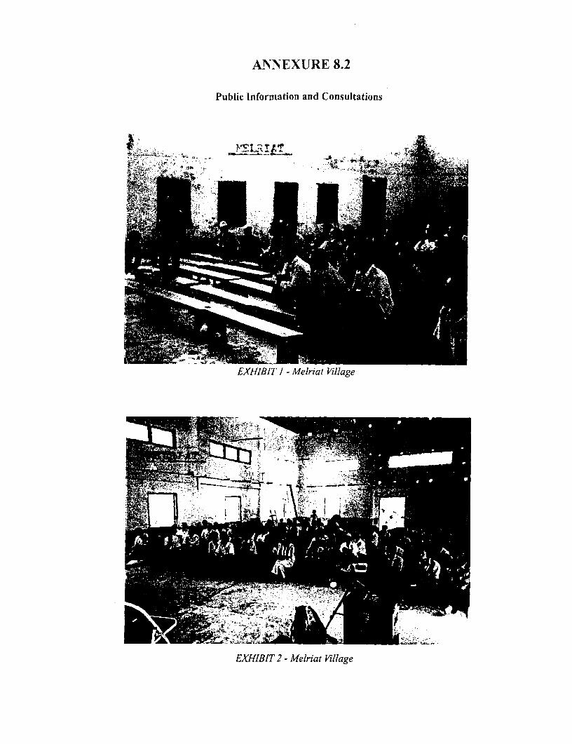
ANNEXURE 8.2
Public Information and Consultations
EXHIBIT 1 - Melriat Village
EXHIBIT 2 - Meiriat Village
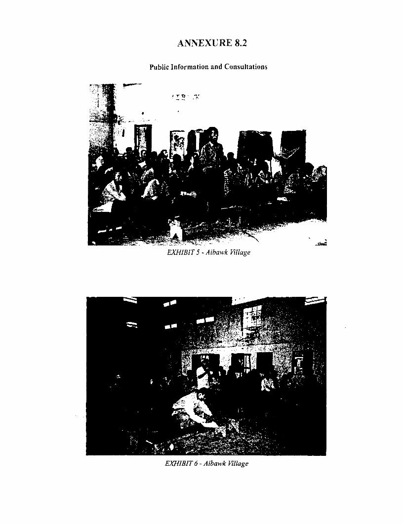
ANNEXURE 8.2
Public Information and Consultations
A 'r~~~~~~~~~~'
- -;Xs ; r r ^,,
AL.A
EXHIBITS - Aibawk Village
EXHIBIT 6- Aibawk Village
ANNEXURE 8.2
Public Information and Consultations
EXHIBIT 7 - Th'ak illage
EXHIBIT1 -Thenzawl Village
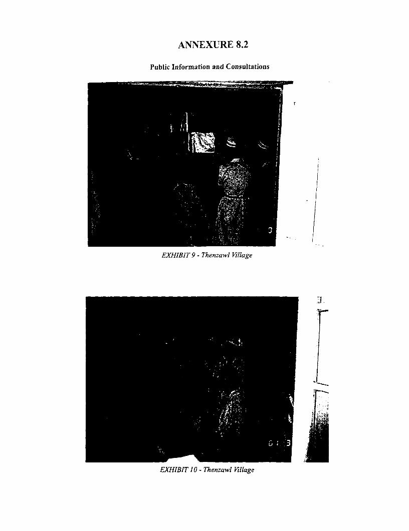
ANNEXURE 8.2
Public Information and Consultations
* ~ ~ ~ - - ____-__
i ,,.~~~~~~~~~~~~~~~~~~~~~~~~~~~~~~~~~.
',',: ' -"m
fr~~~~~~~~~- I} /
EXHBI 9 Thnal ilg
. _~~ ~~~~~~ - jl
EXHIBIT 10 - Thenzawl Vlillage
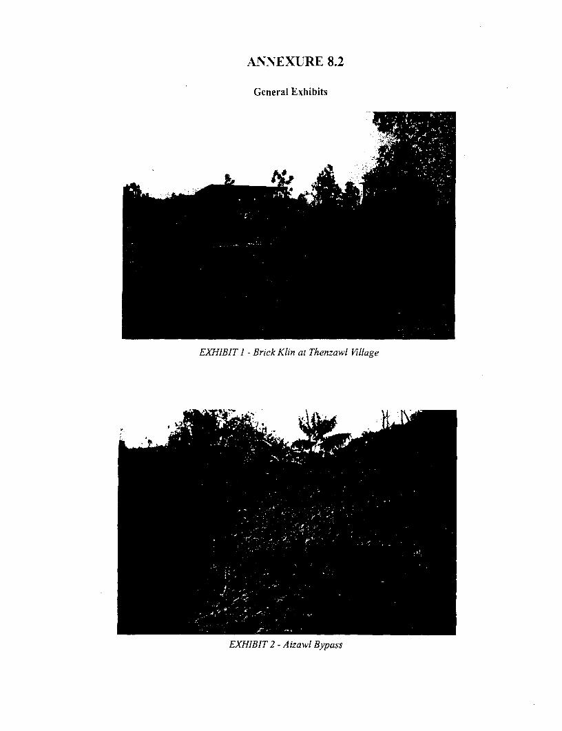
ANNEXURE 8.2
General Exhibits
E-XHIBIT I - Brick Klin at Thenzawl Village
E T
EXHIBIT 2 - A izawl Bypass
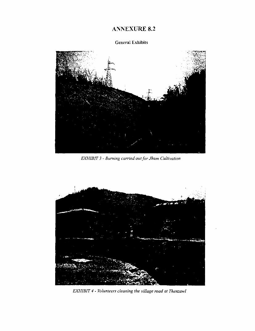
ANNEXURE 8.2
General Exhibits
. '- ~~~~~~~'S 2~<
''~EHII 3BrnigcridotfrJu utvto
EXHIBIT.A '. - Vouter claingt% vIllg roa at Tew
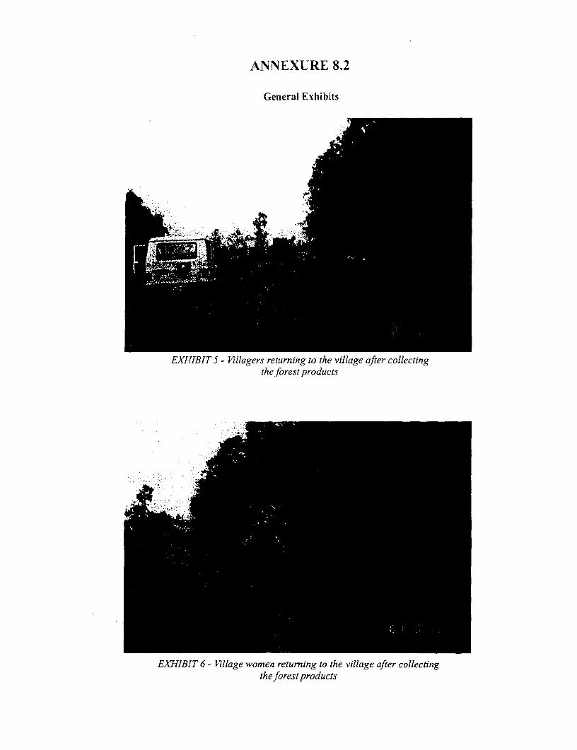
ANNEXURE 8.2
General Exhibits
EXHIBIT 5 - Villagers returning to the village after collectingthe forest products
EXHI-BIT 6 - Village women returning to the village after collectingthe forest products
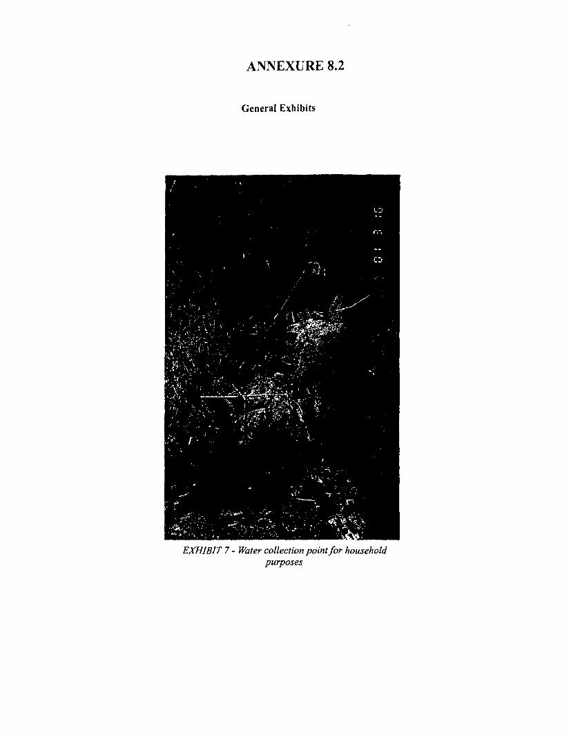
ANNEXURE 8.2
General Exhibits
, . 8~~~~~~~~~C
-zw'I
EXHIBIT7-Watrcolletionpointforhouseho.1%'~~~~~~~~~~~~~~~~~ .*
,,!'. g .'.', -
EXHIBI 7- Wate colcto point for househol- ' X _ 'purposes

ANNEXURE 8.3
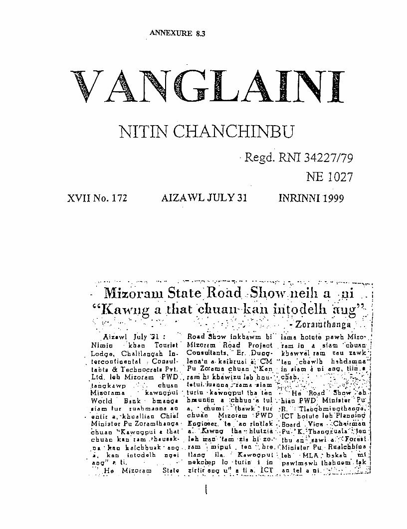
ANNEXURE 8.3
VANLANNITIN CHANCHINBU
Regd. RNI 34227/79
NE 1027
XVII No. 172 AIZAWL JULY 31 INRINNI 1999
iMizoram State'Road. ill a i'Kairig a that clhuaika'i in'todell aug"
- :-: :~ ; . . -Zorainthanga. 0
Aizawl July 31: Road Show iokbawm bi lame hotote pawh MIzo-.'Nimin kharn Tourist Mizorem Road Project ram in a siam "cbuanLodge, Chaltlangah In. Consultants, Er. Dung- kbewTel ram zeu zawkl;tQrcotifinentel Consul- leona'n a. kaihruai WI- CM `ten 'cbawlh hahdamna 4tabta & TechnocreEs Pvt.. Pu Zorame chuaa Ken in siam d ni ang, tiin.aLtd. lbh Mizoram PWD.', ream hi khawizu lob hlu- cheh aJtanckawp chuan Mutui.Iuanna ;rema SiamMizorama ktawnqpui turin -kawngput tba'teo'- He' Road' 3bow .'ab.Wotld Bnsok hmatoa htuniin a chbu "a tul haao PWD Minister' Pu .siam fur tuabhmanna aO a, -humi . tbawk 'ur R.-: Tlaiqbmingte ciar l
* entir a,-kbuallien Chi,f chuin Mizoram PWD ICT botule leh'PlanI3iogMiciator Pu Zoramthanga Engiieex. 'te. ao rintlak Board .Vice .IChiirine-chuan "Kawogpui a that a: '.Ktwug the-: blutzii -Pu' 'K. Thangue1a' echuan kIn ram .thaussk- lah 'ean (am -zia hi: zo-.. thu ean saw" a. Forestna, kaeu alcbbuak a-g a . ram mipui too bre. g.Minigstr Pu Rualchblua 1i, kan intodelh qoqi tlang ila. KawOgpui leh MLA : bskah maug" t ti. * nQkcbep lo turin i in pwlrmnwh thabncm tak I
He Mizoram Statc zirtir ang u" a ti a; ICT an tel a ni.'

ANNEXERE 9.1
ANNEXURE - 9.1
LAND SEITLEMENT SYSTEM AND THE ACTS OF MIZORAMREGULATIONS & RULES GOVERNING REVENUE ADMINISTRATION
The acts govening the land and revenue administration are typical to the state of Mizoram. Inorder to understand the revenue adrninistration it is important to understand certain provisionsof the following acts, rules, notifications namely:
* The Liushai Hill Districts (House Site) Act 1953.
* The Mizo District (Land & Revenue) Acts, 1956.
* The Mizo District (land & Revenue) Rules, 1967.
* The Mizo District (Agricultural Land) Act, 1963
* The Mizo District (Agricultural Land) Rules, 1971.
* The Mizo District (Transfer of Land) Acts, 1963.
Mizoram has been a district of the state of Assam till 1972. In pursuance of the SixthSchedule of Indian Constitution the erstwhile Lushai Hills District Council -or the MizoDistrict Council had passed certain acts, which specially applied, to the district. All theselegislation were proclaimed in the name of the Governor of Assam. Later on gainingstatehood in 1986 the state legislature has been responsible for enacting legislation andnotifications.
The Lushai Hill Districts (House Site) Act 1953 governs the administration of land regardinghouse site. No person can occupy a site without obtaining the consent, in the form of a pattafrom the village council or the administrative authority as the case may be. U/S 3 of theabove act a village council is the competent authority to allot site for residential and non-agricultural purpose with exception of shops and business establishment within itsjurisdiction. The Administrator of Mizoram (Appointed under Article 239 of the Constitutionof India) has the authority to allot sites for residential and other non-agricultural purpose forAizwal, Lunglei, Sairang, Kolasib, Champaiand Vankaphai, and also sites for shops andsmalltime business and hotels.
There are two types of ownership for land according to the Mizoram district (land & RevenueAct 1956 Within the Station Areas of Aizwal, Lunglei, Sairang, Kolasib, ChampaiandVankaphaibut dose no hold for all Government and Public Roads:
1. Settlement Holder: who has entered with an agreement with the administrator and hasheritable and transferable rights of use on or of subletting his land, i.e. he has been vestedwith the ownership of the land u/s 7 of The Mizo District (Land & Revenue) Acts 1956.
For acquisition of such land for public purpose reasonable compensation has to be paid tothe owner for the land.
2. Pass Holders: Persons who have temporary right of use or occupancy of the land and hasno right to the soil beyond the user rights. He doesn't even have the right to transfer theland by way of sale or gift or inheritance beyond the period of the pass or subletting.
All agricultural land in Mizoram is governed by the Mizoram District (Agricultural Land)Acts, 1963 and rules 1971.
In this case the are three category of titleholders:
1. Pass/ Permiit holders: (The permits were granted by the previous Mizoram DistrictCouncil under the Mizorarn District (Agricultural Land) Act 1956 which has since beenrepealed but accepted u/s 12(2) of The Mizoram District (Agricultural Land) Acts, 1963.This pass authorizes a person to use a piece of land but doesn't give them right of anowner.
2. Periodic Patta Holders: A person who has not acquired Patta holder's rights u/s 7 of theMizoram District (Agricultural Land) Acts, 1963. (The patta holder has heritable andtransferable right of use on or of subletting in his land subject to conditions in the Act).The land under Periodic Patta can be acquired for public purposes without compensationbefore the expiry of the period of allotment.
3. Patta Holder: These are titleholders who have heritable and transferable rights over theland. The types of land can be acquired for public purposes after payment of suitablecompensation for the land-acquired u/s 4 of the Mizoramn District (Agricultural Land)Acts, 1963.
Allotment of Land
For allotrnent of land an individual has to make an application to the Executive Member inCharge or the officer appointed or authorized stating the periodicity of allotmnent (Temporaryallotment/ Permanent Allotment). Applications from the villages should be submitted throughthe Village Council President along with his recommendations.
For temporary allotment of agricultural land the Executive Member shall verify the land in aprescribed schedule. For Pernanent allotment of agricultural land he shall cause the land tobe verified, surveyed measured and demarcated. He shall also prepare a sketch map of thepiece of land showing its current land use. A boundary description of the land shall also beprepared and submitted. The survey shall also whether the land is free and available for pattaand also free from all encumbrances.
In case of Temporary Allotment on completion of the verification and making of firtherinvestigation as may be necessary the Executive Member or the designated Officer shall grantor reject an Application. However in case of allotment of land under permanent allotment theland shall be allotted or rejected after receiving the report of the verification and the surveysand other investigations as may be necessary.
Conversion of Pass or Permit to Periodic Patta or Patta
The Executive Committee shall from time to time issue notices for the conversion of pass orpermit previously granted by authority to Periodic Patta or Patta for a whole district or acircle. On issuance of such notices the pass or Permit holder shall submit an application inwriting to the Executive Member or the designated Officer along with the pass or permitstating clearly whether the application is for conversion to a Periodic Patta or a Patta.Appfications from the village should be sent through the Village Council Presidents alongwith his recommendations.
On receipt of such applications the Executive Member or the designated officer shall verifyand survey the land and award the patta on payment of the specified fees.
Transfer of Land
To transfer the land partly or wholly the periodic patta holder shall have to apply for the sameu/s7 of the Mizoram District (Transfer of Land) Acts, 1963 .to the Secretary of the departmentalong with the prescribed fees. If nothing is found against such transfer of land as per theterms and conditions of the patta such transfer shall be effected in the Register of LandRecords and Patta documents on payment of the prescribed fees.
Notification for Reserve Land
According to a notification of the Government of Mizoram dated 21St June 1982 thegovernment has declared 5 meters in horizontal measurement on both sides from the edge ofall motorable roads other than National Highway, footpaths as reserve land. These landsshould not be included for area recommended for allotment for sites for house, shop andstalls. For allotment of land adjoining any departmental land a " No Objection " certificatehas to be obtained from the all such departments concerned.
Rules for Appeal against an Order
Appeals against any action under the Mizoram, District (Land & Revenue) Act 1956 andMizoram District (Agricultural Land) Acts 1963 shall be made to the Chief ExecutiveMember within 60 days from the date of the order. The Chief Executive Member shalldispose off the matter after giving a hearing to al the parties and witnesses concerned. Thishowever shall not debar any person from bringing a suit against such decision in a competentcourt of law. A village council court shall not be considered as a competent court for thepurpose.
However incase of the Lushai Hills (House Site) Act 1953 the order of the Administrator ofthe Village Council shall be considered as a decree of a competent civil court.

ANNEXURE 9.2
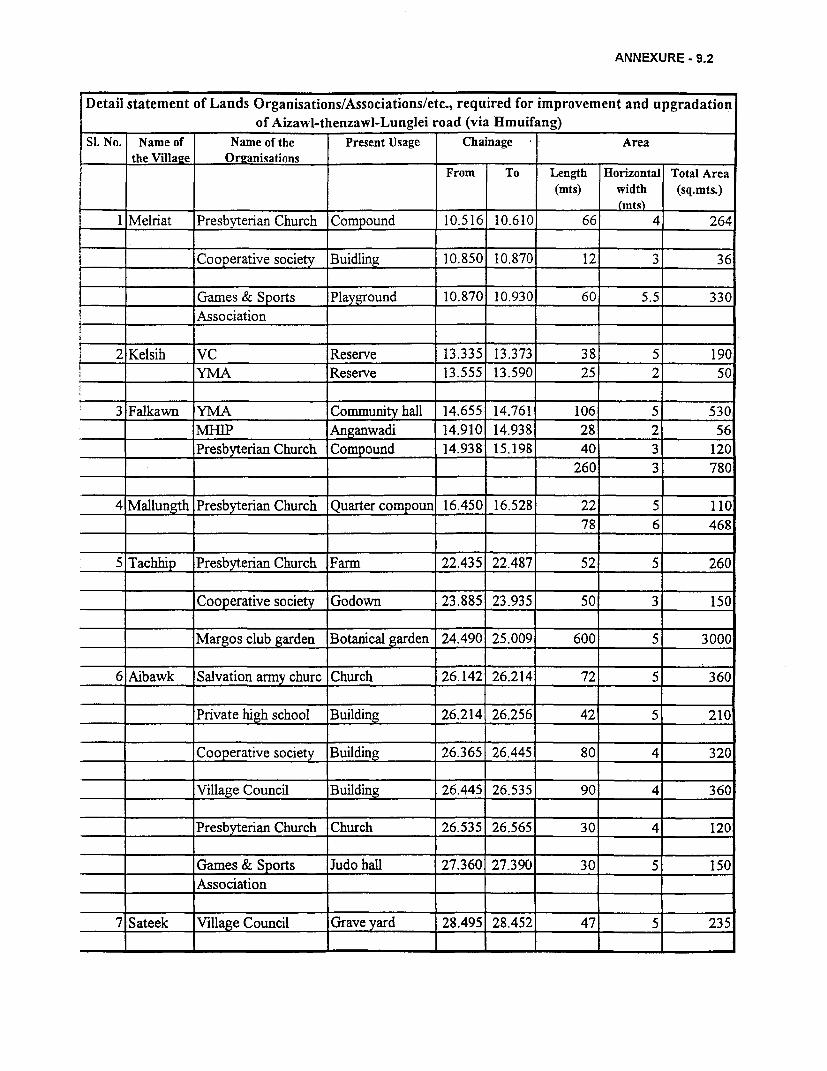
ANNEXURE - 9.2
Detail statement of Lands Organisations/Associations/etc., required for improvement and upgradationof Aizawl-thenzawl-Lunglei road (via iHmuifang)
SI. No. Name of Name of the Present Usage Chainage Areathe Villaze Orzanisations
From To Length Horizontal Total Area(mts) width (sq.mts.)
_ _ _ _ _ _ _ _ _ _ _ _ _ _ _ _ _ _ (m ts)1 Melriat Presbyterian Church Compound 10.516 10.610 66 4 264
Cooperative society Buidling 10.850 10.870 12 3 36
Games & Sports Playground 10.870 10.930 60 5.5 330
Association
2 Kelsih VC Reserve 13.335 13.373 38 5 190
________ YMA Reserve 13.555 13.590 25 2 50
3 Falkawn YMA Community hall 14.655 14.761 106 5 530
______ MIHIP 0Anganwadi 14.910 14.938 28 2 56
Presbyterian Church Compound 14.938 15.198 40 3 120260 3 780
4 Mallungth Presbyterian Church Quarter compoun 16.450 16.528 22 5 110
-_______ I_____________ T ____ 78 6 468
5 Tachhip Presbyterian Church Farm 22.435 22.487 52 5 260
Cooperative society Godown 23.885 23.935 50 3 150
Margos club garden Botanical garden 24.490 25.009 600 5 3000
6 Aibawk Salvation army churc Church 26.142 26.214 72 5 360
Private high school Building 26.214 26.256 42 5 210
C_o_o_pCooperative society Building 26.365 26.445 80 4 320
Village Council Building 26.445 26.535 90 4 360
Presbyterian Church Church 26.535 26.565 30 4 120
Games & Sports Judo hall 27.360 27.390 30 5 150
Association
7 Sateek Village Council Grave yard 28.495 28.452 47 5 235
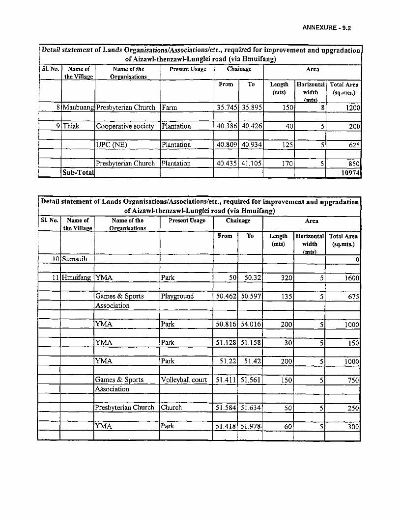
ANNEXURE - 9.2
Detail statement of Lands OrganisationslAssociationsletc., required for improvement and upgradationof Aizawl-thenzawl-Lunglei road (via Hmuifang)
SI. No. Name of Name of the Present Usage Chainage Areathe Villaze Or2anisations
From To Length Horizontal Total Area_ ____________________________________________________ _______________________ (m ts) w id th (s q .m ts .)
8 Maubuang Presbyterian Church Farm 35.745 35.895 150 8 1200
9 Thiak Cooperative society Plantation 40.386 40.426 40 5 200
UPC (NE) Plantation 40.809 40.934 125 5 625
. ___-___ Presbyterian Church Plantation 40.435 41.105 170 5 850Sub-Total, 10974
Detail statement of Lands Organisations/Associationsletc,, required for improvement and upgradationof Aizawl-thenzawl-Lunglei road (via Hmuifang)
SL No. Name of Name of the Present Usage Chainage Areathe Villazee . Ormanisations
From To Length Horizontal Total Area(mts) width (sq.mts.)
10 Sumsuih _ __ 0
11 Hmuifang YMA Park 50 50.32 320 5 1600
Games & Sports Playground 50.462 50.597 135 5 675Association
YMA Park 50.816 54.016 200 5 1000
YMA Park 51.128 51.158 30 5 150
YMA Park 51.22 51.42 200 5 1000
Games & Sports Volleyball court 51.411 51.561 150 5 750Association
Presbyterian Church Church 51.584 51.634 50 5 250
YMA Park 51.418 51.978 60 5 300- -T- -
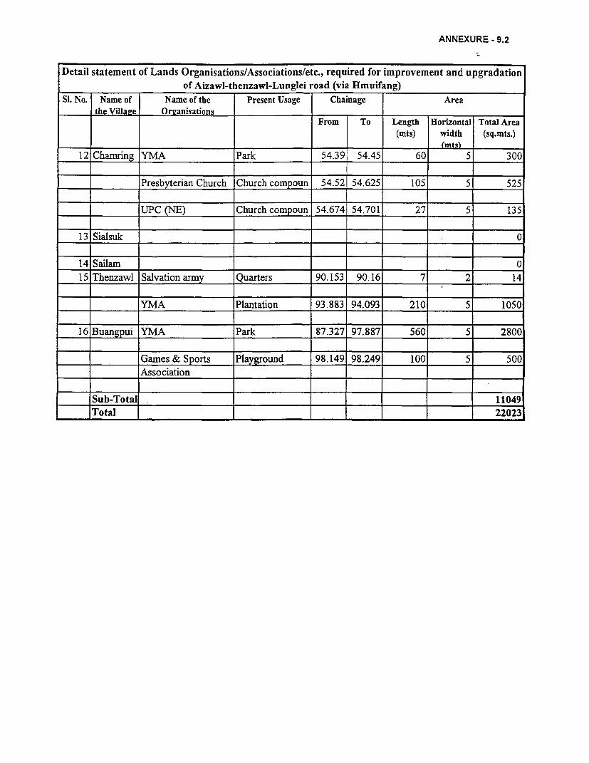
ANNEXURE - 9.2
Detail statement of Lands Organisations/Associations/etc., required for improvement and upgradationof Aizawl-thenzawl-Lunglei road (via Hmuifang)
SL No. Name of Name of the Present Usage Chainage Areathe VillaLe Or2anisations
From To Length Horizontal Total Area(mts) width (sq.mts.)
12 Chamring YMA Park 54.39 54.45 60 5 300
Presbyterian Church Church compoun 54.52 54.625 105 5 525
UPC (NE) Church compoun 54.674 54.701 27 5 135
13 Sialsuk 0
14 Sailam 0
15 Thenzawl Salvation army Quarters 90.153 90.16 7 2 14
_____ ______ YMA Plantation 93.883 94.093 210 5 1050
16 Buangpui YMA Park 87.327 97.887 560 5 2800
____ 1Games & Sports Playground 98.149 98.249 100 5 500
!___I_ Association
_ Sub-Total _ 11049
Total _ l l 22023

ANNEXURE 9.3 A
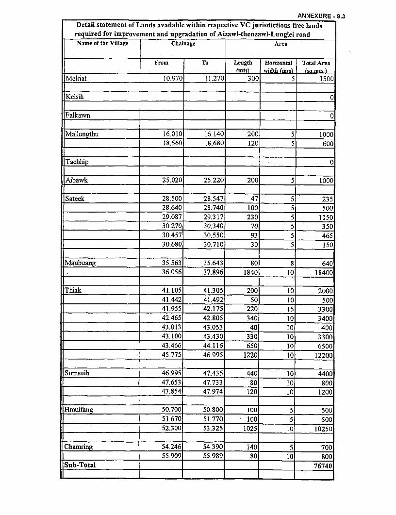
ANNEXURE - 9.3
Detail statement of Lands available within respective VC jurisdictions free landsrequired for improvement and upgradation of Aizawl-thenzawl-Lunglei roadName of the Village Chainage Area
From To Length Horizontal Total Area. ___________________________ _______________ (mts) width (mts) (sq.mts.)Melriat 10.970 11.270 300 5 1500
Kelsih 0
.Falkawn 0
Mallungthu 16.010 16.140 200 5 100018.560 18.680 120 5 600
Tachhip . 0
Aibawk 25.020 25.220 200 5 1000
Sateek 28.500 28.547 47 5 23528.640 28.740 100 5 500
___________________ 29.087 29.317 230 5 1150
30.270 30.340 70 5 350_____ __ 30.457 30.550 93 5 465
_____ __ 30.680 30.710 30 5 150
Maubuang 35.563 35.643 80 8 640l__________________ 36.056 37.896 1840 10 18400
Thiak 41.105 41.305 200 10 200041.442 41.492 50 10 500
41.955 42.175 220 15 3300
42.465 42.805 340 10 3400
43.013 43.053 40 10 40043.100 43.430 330 10 330043.466 44.116 650 10 6500
45.775 46.995 1220 10 12200
Sumsuih 46.995 47.435 440 10 440047.653 47.733 80 10 800
47.854 47.974 120 10 1200
Hmuifang 50.700 50.800 100 5 500______ _ 51.670 51.770 100 5 500
52.300 53.325 1025 10 10250
Chamrin 54.246 54.390 140 5 70055.909 55.989 80 10 800
Sub-Total 76740
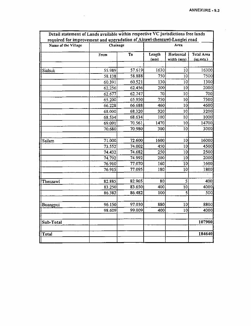
ANNEXURE - 9.3
Detail statement of Lands available within respective VC jurisdictions free landsrequired for improve ent and upgradation of Aizawl-thenzawl-Lunglei roadName of the Village Chainage Area
From To Length Horizontal Total Area(mts) width (mts) (sQ.mts.)
Sialsuk 55.989 57.619 1630 10 16300_____________________ 58.138 58.888 750 10 7500
60.391 60.521 130 10 130062.256 62.456 200 10 200062.677 62.747 70 10 700
65.200 65.950 750 10 750066.228 66.688 460 10 460068.000 68.320 320 10 320068.534 68.634 100 10 100069.091 70.561 1470 10. 14700
=___________________ 70.680 70.980 300 10 3000
Sailam 71.000 72.600 1600 10 16000
73.552 74.002 450 10 4500-__________________ 74.432 74.682 250 10 2500._________________ 1 74.792 74.992 200 10 2000
______ _ 76.910 77.070 160 10 1600_______-l__________ 76.915 77.095 180 10 1800
Thenzawl 82.885 82.965 80 5 400
-__________________ 83.250 83.650 400 10 4000__________________ _ 186.382 86.482 100 5 500
Buangpui 96.150 97.030 880 10 8800.___________________ 98.609 99.009 400 10 4000
Sub-Total 107900
Total 184640

ANNEXURE 9.4
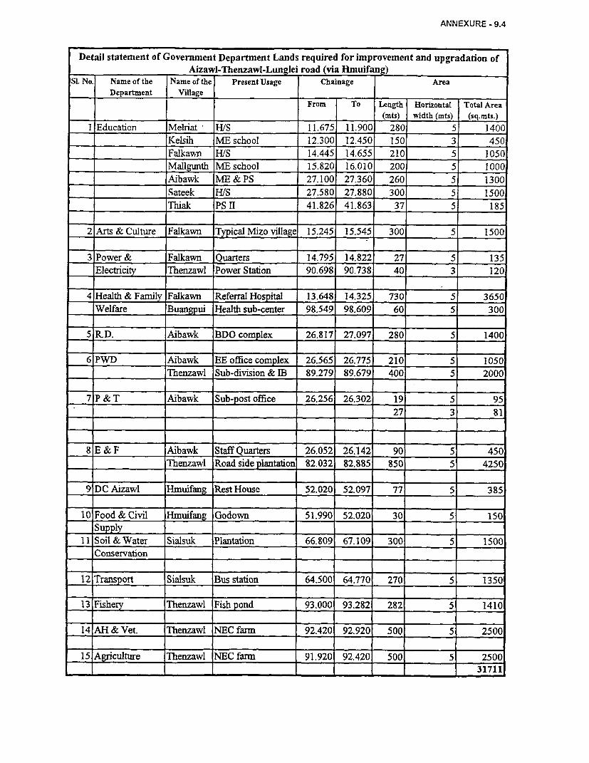
ANNEXURE - 9.4
Detail statement of Government Department Lands required for improvement and upgradation of___ ______ Aizawl-Thenzawl-Lunglei road (via Hmuifang)
SI. No. Name of the Name of the Present Usage Chainage AreaDepartment Village
From To Length Horizontal Total Area(mts) width (mts) (sq.mts.)
I Education Melriat H/S 11.675 11.900 280 5 1400Kelsih ME school 12.300 12.450 150 3 450Falkawn HWS 14.445 14.655 210 5 1050
Mallgunth ME school 15.820 16.010 200 5 1000
Aibawk ME & PS 27.100 27.360 260 5 1300
_ ____________ Sateek H/S 27.580 27.880 300 5 1500
Thiak PS II 41.826 41.863 37 5 185
2 Arts & Culture Falkawn Typical Mizo village 15.245 15.545 300 5 1500
3 Power & Falkawn Quarters 14.795 14.822 27 5 135Electricity Thenzawl Power Station 90.698 90.738 40 3 120
4 Health & Family Falkawn Referral Hospital 13.648 14.325 730 5 3650Welfare Buangpui Health sub-center 98.549 98.609 60 5 300
5 R-D. Aibawk BDO complex 26.817 27.097 280 5 1400
.~~~~~~~~~~~~~~~~~~~~ _6 PWD Aibawk EE office complex 26.565 26.775 210 5 1050
Thenzawl Sub-division & EB 89.279 89.679 400 5 2000
7 P & T Aibawk Sub-post office 26.256 26.302 19 5 95= ____________ _______________ ______ 27 3 81
8 E & F Aibawk Staff Quarters 26.052 26.142 90 5 450= ____________ Thenzawl Road side plantation 82.032 82.885 850 5 4250
9DC Aizawl Hmuifang Rest House 52.020 52.097 77 5 385
10 Food& Civil Hmuifang Godown 51.990 52.020 30 5 150Supply
11 Soil & Water Sialsuk Plantation 66.809 67.109 300 5 1500Conservaton _
12I Transport Sialsuk Bus station 64.500 64.770 270 5 1350
13 Fishery Thenzawl Fish pond 93.000 93.282 282 5 1410
14 AH & Vet. Thenzawl NEC farm 92.420 92.920 500 5 2500
15 Agriculture Thenzawl NEC farm 91.920 92.420 500 5 2500. _ _ _ __ 31711

ANNEXURE 10.1
ANNEXURE- 10.1
INCOME GENERATING SCHEMES, PROGRAMS WITH POTENTIAL FORDEVELOPMENT - SECTOR WISE
Agriculture, Land Development, Horticulture, Poultry, Dairy Development and Piggery
The state has a deficit production of rice, which is the staple food of, the region. Self-sufficiency is required to be achieved and this is one of the main objectives under the 9t plan.Further, the establishment of a sugar factory at Saitual has provided scope for sugarcanecultivation.
The scheme for assistance to small and marginal farmers in respect to minor irrigation, landdevelopment and supply of mini kits of improved HYV seeds and fertilizers. There is also a100% subsidy under this scheme.
There is also potential for cultivation of spices like ginger, turmeric, chillies, pepper, garlic,etc. The soil and climate are very conducive for this cultivation in Mizoram.
The potential for commercial floriculture and mushroom cultivation can be tapped. There isalso financial support available for this development. There are training centers/laboratoriesstep-up for the enhancement for skills in mushroom cultivation at Aizawl and Lunglei.
The establishment of a horticulture research center at Kolasib has been an encouraging steptowards horticulture development on a large scale. Emphasis is proposed to be made onproduction of seeds and planting materials of improved varieties in departmental farms. Thiswill help in distributing better seeds for horticulture development in the villages.
Soil and water conservation schemes - Mizoram being a totally hilly terrain, has very limitedavailability of flat land located in sporadic areas. These areas are confined to riverbanks,foothill valleys, and plateaus. Mizoram receives a high rainfall during a short durationbetween June and September. Due to this the soil and water conservation has become all themore important to ensure scientific land use and socio-economic security of the state. Morethan 90% of 2.5 m of annual average rainfall gets lost as surface run-off. This not onlyresults in loss of major water unused productively, but also heavy soil erosion causing hugeloss to life, property and agricultural crops.
To improve upon this loss, the land development and reclamation activity involving variousschemes is being undertaken on a large-scale. Rainwater harvesting is also a major successlately in Mizoram, which helps the people to successfully, arrest rainwater and use it for theirdaily chores. The various schemes under the land development and reclamation are describedbelow in brief.
- Run-off retarding scheme to have a stable agriculture/landuse on hill slopes, lands,terraces of various width are constructed using half cut half fill method. The othermethods adopted are in accordance with the slope are contour bunds, on lower slopes andcontour ditches on higher slopes. This is a scientific method adopted over and above anyother method in hill terrain agriculture/landuse.
- Micro-watershed management project- this scheme includes works of land developmentand protection. In this regard about 5 pilot projects have been proposed in Aizawl,Kolasib and Lunglei town regions.
Under the animal husbandry and veterinary sector, the veterinary services and animal healthhas been proposed to be strengthened with additional veterinary hospitals and laboratoriesbeing established.
It is also proposed to improve the cattle development schemes with improved maintenance toexisting cattle breeding farms, liquid nitrogen plant to achieve a high target in milkproduction. This scheme can be taken up on a large scale, as the success of milk productionunder operation flood has been a major economic earning activity in other parts of thecountry. This can be achieved through establishment of dairy cooperatives. Dairydevelopment is being given importance by the central government and has been identified ason of the thrust area in the 9th five-year plan. The government has identified strengthening ofthe dairy development wing and existing infrastructure for town milk supply. Provision isalso made under the scheme for assisting the dairy farmers through distribution of dairy cowson a 50% subsidy. The success of the dairy development through the milk cooperatives hasbeen commendable and proved that it has been a very effective source of income to thefamily. This has been illustrated through a case study presented in annexure 8.2.
Further, poultry development can also been a major income-generating source as theconsumption of poultry for meat has a high potential in the region due to the eating habits ofthe people of Mizoram. Improvements have been already proposed under this scheme underthe 9h plan for existing farms, namely, Regional Broiler Chick Farms, Tanhril Poultry Farm,Lunglei, and Serchipp Poultry Farm. If this sector is developed, there is lot of scope foradditional or exclusive income generating source to the PAPs in this project. An illustrationof the poultry sector and effective marketing linkages is provided in annexure 8.3.
Piggery also has high potential for adding to the various sources of income to the people ofthe region. Piggery development has been proposed and a scheme already exists for thispurpose. There are also subsidies and grant-in-aid through special livestock breedingavailable for assisting pig farmers in the state of Mizoram.
There is also potential for development of fisheries. The potential area for fishpond culture isestimated at 5000 ha, out of which 1650 ha has been partially developed and an additional of1250 ha has been proposed to be developed during the 9th plan period.
Industry
This is a very remotely developed sector in Mizoram. There is limited scope for industrialdevelopment due to the hilly terrain. The cost of production and transportation is high in thisregion due to the terrain. The various industrial developments on a small scale and thevarious schemes have been given below.
The Government of Mizoram established Mizoram Handloom and Handicraft DevelopmentCorporation in 1988. The various schemes under this corporation are varied. Some of themare listed below:
- Human resource development- Generation of employment opportunities- Group insurance scheme- Intensive handloom village development- Common facility centers- Research design and development
- Decentralized training program- Fair, exhibitions, grant-in-aid, subsidy, publicity- Tribal handloom development program- Promotional grant to ZOHANCO- Health package scheme- Work shed cum Housing- Thrift fund schemes
Mizoram Khadi and Village Industries Board. Development of growth centers wereidentified and established at Luangmual, Aizawl, Pukkui and Lunglei. There is definedindustrial estates set up at Zuangtui, Kolasib and Chawngte.
Zoram Electronic Development Corporation: Test and repair center, central purchase andmarketing of electronic goods and supply to government offices. Component bank forelectronic industries and computer training institutes are also set up and there is a proposalfor improvement to this corporation.
Zoram Industrial Development Corporation:
- Provides loan assistance to industrial units under refinance schemes of IDBI and SIDBI.
- Incentives, subsidies to SSIs since 1989. This is a promotional scheme to encourageinvestment in industrial sector.
- Development of medicinal herbs and plants and citronella grass cultivation andprocessing for oil extraction.
Entrepreneurial Development and Training: Promotional activity targeting to educate andlearn industrial workers and train for betters HRD.
Promotion of Village Cottage and Tiny Industries: Grant-in-aid for the poor section ruralartisans for enhancement of their activities and to encourage continuance of the activities.
Rural Development
Social Education: Community halls and indoor stadiums are constructed depending on thenumber of households in the villages. The 9h plan has proposed for construction of 120 newhalls in addition to the ones under construction.
Rural Housing: The main object of these schemes is to provide CCI sheets free of cost to theroofless rural families who are below poverty line.
New Land Use Policy: This is a family oriented scheme targeted for the complete eradicationof unproductive and wasteful tradition jhum cultivation and giving viable alternative schemesto encourage families to adopt settled cultivation.
National Program in Improved Chullas: This is a centrally sponsored scheme, which aims ataccomplishing - Energy/fuel wood/forest conservation and Employment generation.

ANNEXURE 10.1(A) A
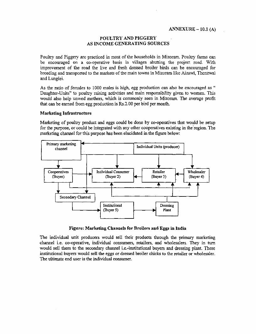
ANNEXURE - 10.1 (A)
POULTRY AND PIGGERYAS INCOME GENERATING SOURCES
Poultry and Piggery are practiced in most of the households in Mizoram. Poultry farms canbe encouraged on a co-operative basis in villages abutting the project road. Withimprovement of the road the live and fresh dressed broiler birds can be encouraged forbreeding and transported to the markets of the main towns in Mizoram like Aizawl, Thenzwaland Lunglei.
As the ratio of females to 1000 males is high, egg production can also be encouraged asDaughter-Units" to poultry raising activities and main responsibility given to women. Thiswould also help unwed mothers, which is commonly seen in Mizoram. The average profitthat can be earned from egg production is Rs.2.00 per bird per month.
Marketing Infrastructure
Marketing of poultry product and eggs could be done by co-operatives that would be setupfor the purpose, or could be integrated with any other cooperatives existing in the'region. Themarketing channel for this purpose has been elucidated in the figure below:
Primary marketing Individual channel L it(rucer)
_ ~~~~~~~~~ l
Cooperatives Individual Consumer er ~~Wholesaler(Buyer) (Buyer 2) (Buyer 3) (Buyer 4)
| econdr hx 711l
| { _ s ~~~Institutio nal |Dressing|
Figure: Marketing Channels for Broilers and Eggs in India
The individual unit producers would sell their products through the primary marketingchannel i.e. co-operative, individual consumers, retailers, and wholesalers. They in turnwould sell them to the secondary channel i.e.-institutional buyers and dressing plant. Theseinstitutional buyers would sell the eggs or dressed broiler chicks to the retailer or wholesaler.The ultimate end user is the individual consumer.

ANNEXURE 10.1l B)
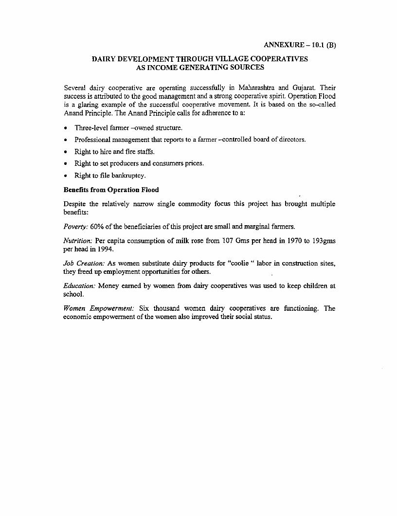
ANNEXURE - 10.1 (B)
DAIRY DEVELOPMENT THROUGH VILLAGE COOPERATIVESAS INCOME GENERATING SOURCES
Several dairy cooperative are operating successfully in Maharashtra and Gujarat. Theirsuccess is attributed to the good management and a strong cooperative spirit. Operation Floodis a glaring example of the successful cooperative movement. It is based on the so-calledAnand Principle. The Anand Principle calls for adherence to a:
* Three-level farmer -owned structure.
* Professional management that reports to a farmer -controlled board of directors.
* Right to hire and fire staffs.
* Right to set producers and consumers prices.
* Right to file bankruptcy.
Benefits from Operation Flood
Despite the relatively narrow single commodity focus this project has brought multiplebenefits:
Poverty: 60% of the beneficiaries of this project are small and marginal farmers.
Nutrition: Per capita consumption of milk rose from 107 Gms per head in 1970 to 193gmsper head in 1994.
Job Creation: As women substitute dairy products for "coolie " labor in construction sites,they freed up employment opportunities for others.
Education: Money earned by women from dairy cooperatives was used to keep children atschool.
Women Empowerment: Six thousand women dairy cooperatives are functioning. Theeconomic empowerment of the women also improved their social status.

ANNEXURE 10.2 I
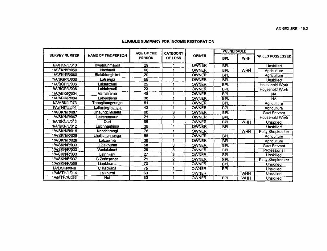
ANNEXURE - 10.2
ELIGIBLE SUMMARY FOR INCOME RESTORATION
AGE OF THE CATEGORY VULNERABLESURVEY NUMBER NAME OF THE PERSON PERON OF LOSS OWNER BPL WHH SKILLS POSSESSED
1/NFKN/UOIO Bwatnunmawia 29 1 OWNER BPL Unskilled1\A\FKN\R\060 Nachuaii 60 1 OWNER BPL WHH Agriculture1\A\FKN\R\060 Blakthianghlimi 29 1 OWNER BPL Agriculture1/A/BGP/U006 Lalsanga 55 1 OWNER BPL Unskiiled11A/BGP/U006 Laldukznali 25 1 OWNER BPL Household Work'I/AIBGP/U006 Lalduhzuali 23 1 OWNER BPL Household Work1/A/ABKJR/004 Vanlalrema 45 1 OWNER BPL NA1/AIABK/R/004 Lalbairliana 30 1 OWNER BPL NA1/A/ABK/L073 Thanglhungnunga 51 1 OWNER BPL Agriculture1\A\THK\L\001 Lalhmingthanga 43 1 OWNER BPL Agriculture1/AISKN/R/007 Chaungchhuana 60 3 OWNER BPL Govt Servant1/A/SKN/R/007 Lalranumauri 21 3 OWNER BPL Household Work1/A/SKN/UO12 Dari 66 1 OWNER BPL WHH Unskilled1/A/SKN/lJ012 Lalchhanhima 38 1 OWNER BPL . UnskilledI/AISKN/R/016 Kapchhmngi 76 i OWNER WHH Petty Shopkeeker1/A/SKN/R/028 Lhallianchhunga 68 1 OWNER BPL Agriculture1IAISKN/R/028 Lalzawma 36 1 OWNER BPL Agriculture1/WASKN/R/033 C.Zakhuma 58 3 OWNER BPL Govt Servant1/A/SKNIR1033 Vanlalahuni 29 3 OWNER BPL Professional1IAISKNIR/033 Lalrinliani 27 3 OWNER BPL Unskilled1/A/SKN/R/037 C.Zorinsanga 21 2 OWNER BPL Petty Shopkeeker11A/SKNlRi039 Liankhuma 70 1 OWNER BPL UnskilledIA/USKN/048 C Kapliana 75 1 OWNER BPL ' Unskilled1/AIMTH/L014 Lalkhumi 60 1 OWNER WHH UnskilledIAIMTH/R/026 Nui 80 1 OWNER BPL WHH Unskilled

ANNEXURE 10.3
Annexure 10.3 NGOs Terms of Reference
MIZORAM STATE ROADS PROJECTNGO Consultancy Services for Assistance in Implementation of
Resettlement & Indigenous People's Development Plan (R&IPDP) - Phase I Roads
TERMS OF REFERENCE
1 PROJECT BACKGROUND
The Government of Mizoram is seeking a World Bank loan (WB Loan no. 4114 IN) available with theGovernment of India, for upgradation and maintenance of the state road network. The project envisagesmajor augmentation of capacity and structural quality of the road network in the state of Mizoram. Theproject preparation activities including the project planning and design is being carried out by the PWD,Govemment of Mizoram (PWD), through project co-ordinating consultants (PCC).
A Strategic Options Study (SOS), covering 3,534 km of the state road network, was conducted duringOctober 1998-January 1999 For the roads so identified, Feasibility Studies, including engineering analy-sis and design, social and environmental screening and economic evaluation were carried out (com-pleted in January 2000). Based on the findings of these studies and discussions between the PWD andthe World Bank. corridors have been identified as candidates for (a) improvement/upgradation and (b)major maintenance works. The corridors that have been identified for improvement in two phases of theproject are listed in Table 1.1. Improvements to these roads consist mainly of, strengthening, widening,and minor realignments.
Table 1.1: Work ProgrammeProject Phase Corridor Length (km)
Improvement/ Upgradation CorridorsPhase I Aizawl - Thenzawl- Buangpui (P1 -A) 98.7
Phase I Buangpui-Lunglei (P1-B) 71.0Aizawl Bypass 16.0
Total 185.7
There are 18 villages falling along the project road Aizawl and Buangpui via Hmuifang measuring 98.7kms under Phase - I. The available formation in most cases is less than the 7.1m required for accom-modating the intermediate lane cross-section suggested, which calls in for an acquisition of private landand properties. Apart from the acquisition of private land and properties, the project will also involve theacquisition of land belonging to several community organisations and governmental departments. Ac-quisition of land may cause social disruption and economic loss for project affected persons (PAPs) andtheir families. It is therefore important that disturbances and losses of PAPs due to project are minimisedthrough proper planning.
It is against this background that PWD has carried out a social assessment of Project Affected Persons(PAPs) on the project road under Phase-1 and prepared a Resettlement & Indigenous People's Devel-opment Plan (R&IPDP). The titleholders of various types of properties were identified in the social as-sessment and a detailed Action Plan was prepared for the resettlement and rehabilitation. The R&R pol-
ToR for NGO Consultancy Services - 1 - Government of MizoramPublic Works Department
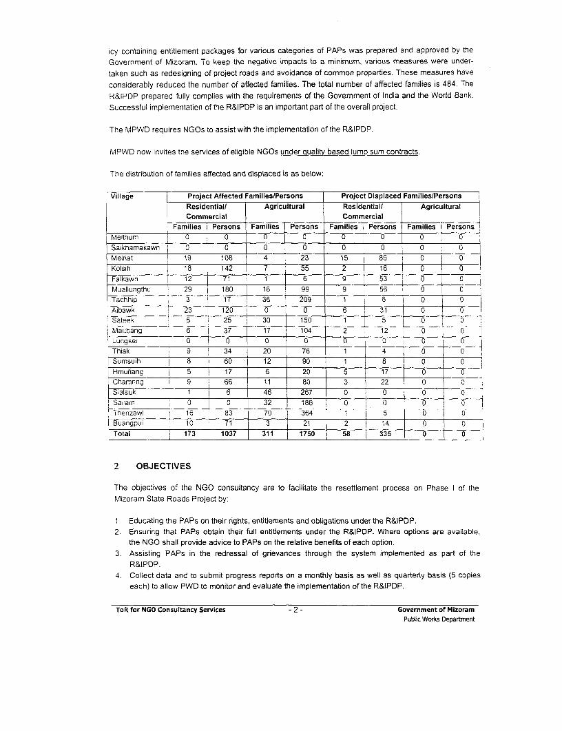
icy containing entitlement packages for various categories of PAPs was prepared and approved by theGovernment of Mizoram. To keep the negative impacts to a minimum, various measures were under-taken such as redesigning of project roads and avoidance of common properties. These measures have
considerably reduced the number of affected families. The total number of affected families is 484. TheR&IPDP prepared fully complies with the requirements of the Government of India and the World Bank.Successful implementation of the R&IPDP is an important part of the overall project.
The MPWD requires NGOs to assist with the implementation of the R&IPDP.
MPWD now invites the services of eligible NGOs under quality based lump sum contracts.
The distribution of families affected and displaced is as below:
Village Project Affected Families/Persons Project Displaced Families/Persons
Commercial CommercialFamilies Persons Families Persons Families Persons Families Persons
Melthum 0 0 0 0 0 0 0 0
Saikhamakawn 0 0 0 0 0 0 0 0Meiriat 19 108 4 23 15 86 0 0Kelsih j 18 142 7 55 2 16 0 0Falkawn 1 12 71 1 6 9 53 0 0Muallungthu | 29 180 16 99 9 56 0 0Tachhip 3 17 36 209 1 6 0 0Aibawk 23 1 120 0 0 6 31 0 0Sateek 5 25 30 150 1 5 0 0Maubang 6 r 37 | 17 104 2 12 0 0
Lungse 0 0 0 0 0 0 0 0 l
Thiak 9 | 34 20 76 1 4 0 0
Sumsuih 8 | 60 12 90 1 8 0 0 iHmuifang 5 17 6 20 5 17 0 0
Chamring 9 1 66 11 80 3 22 0 0
Sialsuk 1 6 46 267 0 00 0
Sailam 0 0 32 186 0 0 0 lThenzawl 16 83 70 364 1 j 5 0Buangpui 10 71 3 21 2 I 14 0
Total - 173 1037 311 1750 58 335 0 0
2 OBJECTIVES
The objectives of the NGO consultancy are to facilitate the resettlement process on Phase I of theMizoram State Roads Project by:
1 Educating the PAPs on their rights, entitlements and obligations under the R&IPDP.2. Ensuring that PAPs obtain their full entitlements under the R&IPDP. Where options are available,
the NGO shall provide advice to PAPs on the relative benefits of each option.3. Assisting PAPs in the redressal of grievances through the system implemented as part of the
R&IPDP.4. Collect data and to submit progress reports on a monthly basis as well as quarterly basis (5 copies
each) to allow PWD to monitor and evaluate the implementation of the R&IPDP.
ToR for NGO Consultancy Services - 2 - Government of MizoramPublic Works Department
5. To provide support and information to PAPs for income restoration.6. To assist the PAPs for relocation and rehabilitation.
3 TASKS OF THE NGO
The NGO will work as a link between the project represented by the Special Land Acquisition Officer(SLAO), the R&R Manager, and the affected community. The NGO will be responsible for assisting thePAPs during the resettlement and rehabilitation process and shall ensure that all of the provisions of theR&R Policy and the R&IPDP with regard to the well being of the PAPs are implemented.
The NGO shall play a role of secondary stakeholder in implementation of the R&IPDP and in mitigatingthe adverse effects of the Project. The NGO shall remain responsible for the development of a compre-hensive livelihood system to facilitate the PAPs to take advantages of the options available (as per theR&IPDP).
Specifically, the selected NGO will:
1. Develop rapport between the PAPs and the project authorities particularly the SLAO. This will beachieved through regular meeting with both the SLAO and the PAPs. Meetings with the SLAOwill be held at least fortnightly and meetings with PAPs will be held at least monthly. All meetingsand decisions taken are to be documented.
2. Assist the SLAO to undertake a public information campaign at the commencement of the projectto inform the affected communities of:
(i) the need for land acquisition involved in Phase-I roads
(ii) the need for displacement
(iii) the likely consequences of the project on the communities economic livelihood
(iv) identifying PAPs and verifying on the basis of the census survey carried out and facilitatingthe distribution of the, identity cards
(v) the R&R policy and entitlement packages
3. Assist PAPs in getting the compensation for their land and properties acquired for the project4. Ensure in coordination with the Village Council in the transfer of alternate land to PAPs.5. For the calculation of market value/replacement value, village committees have been set up. The
NGO shall represent the entitled persons (EPs) in the committee to ensure that a fair assess-ment takes place.
6. Ensure benefits due to the PAPs under R&R policy and R&IPDP are provided to the PAPs. Fromthe policy and the R&IPDP, the NGO will verify the entitlements of each PAP (being made by theSLAO). If there is a discrepancy, between the two, the NGO will be responsible for assisting thePAP in coming to some agreement with the SLAO and, if necessary, pursuing the matter throughthe grievance redressal mechanism.
7. Help project authorities in making arrangements for the smooth relocation of the PAPs and theirbusiness. This will involve close consultation with the PAPs.
8. Ensure proper utilization by the PAPs of various grants available under the R&R package. TheNGO will be responsible for advising the PAPs on how best use any cash that may be providedunder the R&IPDP. Emphasis should be placed on using such funds in sustainable way.
ToR for NGO Consultancy Services - 3 - Government of MizoramPublic Works Department
9. Assist PAPs in getting benefits from various government development programs particularly forhouse construction. There are a number of government housing and training programs for liveli-hood programs that can be used by PAPs. The NGOs will investigate the availability of places inthese programs and shall inform the PAPs of the opportunities that exist and their relative merits.The NGO will co-ordinate the training programs for sustainable livelihood and assist in develop-ing the required skills for livelihood rehabilitation. The NGO shall co-ordinate with the VillageCouncils, government departments and other organisations as YMA, MHIP etc., working in thearea to ensure that all the options available to the PAP are known and can be communicated tothem.
10. Develop micro level plans for resettlement and rehabilitation (R&R) in consultation with the PAPsand the SLAO. A plan shall be prepared and agreed for each PAP and will include such thing as:
(a) list of options open to and the choices made by the PAP. The NGOs will assist them inmaking their choices
(b) a list of benefits due to the PAP(c) arrangements for shifting(d) proposed utilization of any grant moneys due to the PAP(e) involvement of PAP in existing government development programs(e update information available of PAPs and collect information of PAPs coming in the project
due to any changes. PWD will be monitoring the implementation of the R&IPDP and willrequire data from the NGO to monitor input, output and impact indicators.
(g) any other responsibility as may be assigned by the SLAO for the welfare of the affectedcommunity.
11. To ensure that all common property resources and utilities likely to be impacted due to the pro-ject are replaced prior to the commencement of the construction on that particular sub-section ofthe road.
12. To ensure that the social impacts as the disruption of access and pedestrian safety during con-struction and adequately addressed.
13. To identify and provide for special management measures on a case-to-case basis for additionalstructures to be impacted/displaced. These would include propertes on the hillside, which mightget impacted due to the proposed cutting.
14. Create awareness among road users, the community in the roadside settlements and especiallyin and around the construction camps regarding HIV/AIDS/STDs.
15. Create awareness among the local population in the built up areas regarding the CommunityRoad Safety during construction through local consultations/campaigns/ workshops.
16. Also monitor the ban on use of child labour by the contractors of any civil works and related ac-tivities and will create awareness regarding the ill effects of child labour.
4. RESPONSIBILITIES OF IMPLEMENTATION
Responsibilities of Implementation of the R&IPDP will include:
Identification and Verification
The NGO shall undertake a survey of the project affected area and shall update the information on theEligible PAPs and project-affected families (PAFs). The NGO shall verify the information already avail-able on the individual losses of the PAPs collected by the PWD. The NGO shall establish rapport withPAPs, consult and provide information about the respective entitlements as proposed under theR&IPDP, and distribute Identity Cards to the eligible PAPs. An identity card should include a photograph
ToR for NGO Consultancy Services - 4 - Government of MizoramPublic Works Department

of the PAP, the extent of loss suffered due to the project, and the choice of the PAP with regard to themode of compensation and assistance (if applies, as per the R&IPDP).
The NGO shall prepare a list of the project-displaced persons/families (PDPs/PDFs) for relocation,enlisting the losses and the entitlements as per the R&IPDP, after verification. It shall also prepare a listof the project-affected persons/families (PAPs/PAFs) enlisting the losses and the entitlements as per theR&IPDP, after verification.
During the verification of the eligible PAPs/PAFs, the NGO shall ensure that each of the PAPs are con-tacted and consulted either in groups or individually. The NGO shall specially ensure consultation withthe women from the PAP families especially women headed households.
Participatory methods should be applied in assessing the needs of the PAPs. The methods of contactmay include (i) village level meetings; (ii) gender participation through group interactions; (iii) individualmeetings and interactions.
Post Design Consultation
NGO contracted shall also be responsible for post design consultation with the community for disclosureof designs for specific measures at individual level.
Counselling the Entitled Persons
The counselling shall include the following activities by the NGO: -
* The NGO shall explain to the PAPs the need for land acquisition, the provisions of the policy and theentitlements under the R&IPDP.
* Distribution of the R&R Policy and the translated version of the policy (in Mizo,) for each and everyPAP to make them understand the entitlements in correct perspectives.
* The NGO shall disseminate information to the PAPs on the possible consequences of the project onthe communities' livelihood systems and the options available.
* The NGO shall initiate micro-level plans for income restoration, in consultation with the PAPs.Women's perceptions are important to be incorporated in the development of these plans.
In all of these, the NGO shall consider women as a special focus group, and deal with them with careand sympathy.
Renresenting the EPs in Village Committees for Market Value Assessment
Village Committees have been established to evaluate the actual market value of the structures for eachof the 18 viliages along the project route. The NGO shall represent the entitled persons (EPs) in thesecommittees to ensure that a fair assessment takes place. The project will assist the eligible PAPs/PAFsin getting the difference between the assessed market price and the compensation award as assistance.
Disbursing the Assistances
The NGO shall document the entitlement of each of the PAPs/PAFs on the basis of the R&IPDP andcompare it with the SLAO's data and Village committees market value assessment. In case of dis-
ToR for NGO Consultancy Services - 5 - Government of MizoramPublic Works Department
crepancies, the NGO shall resolve it in consultation with the SLAO on the basis of the Policy guide-lines or take up the matter to the Grievance Redressal Committee.
* The NGO shall assist the project authorities in ensuring a smooth transition (during the part or fullrelocation of the PAPsIPAFs), helping the PAPS to take salvaged materials and shift with proper no-tices. In close consultation with the PAPs, the NGO shall inform the SLAO about the shifting datesagreed with the PAPs in writing and the arrangements desired by the PAPs with respect to their enti-tlements.
* The NGO shall assist the PAPs in opening bank accounts, explaining the implications, the rules andthe obligations of a joint account', and how s/he can access the resources s/he is entitled to.
* The NGO shall ensure proper utilisation of the R&R budget available for each of the packages. TheNGOs shall ensure that the PAPs have found economic investment options and are able to restoreagainst the loss of land and other productive assets. The NGO shall identify means and advise theSLAO to disburse the entitlements to the eligible persons/families in a manner that is transparent,and shall report to the MPWD on the level of transparency achieved in the project.
Assisting the EPs and the SLAO Negotiate for the New Land for Resettlement
* Obtain the PAP's choice in terms of (i) shifting plan and arrangements; (ii) grant utilisation plan; (iii)community asset building plan and (iv) institutional arrangements in maintaining the assets.
* Ensuring the replacement of the land lost in terms of quality and quantity.* Assist Village Council Officials in negotiating and transfer of alternate land to the PAPs.
Accompanyina and representing the EPs at the Grievance Committee Meetings
The NGO shall nominate a suitable person (from the staff of the NGO) to be a member of the GRC.The NGO shall make the PAP aware of the grievance redressal committees(GRC).The NGO shall train the PAPs on the procedure to file a grievance application and to confirm that astatement of claim from the concerned PAP accompanies each grievance application. The NGOshall help the PAPs in filling up the grievance application and also in clearing their doubts about theprocedure as well as the context of the GRC award.The NGO shall record the grievance and bring the same to the notice of the GRC within 7 (seven)days of receipt of the grievance from the PAPs. It shall also submit a draft resolution with respect tothe particular grievance of the PAP, suggesting multiple solutions, if possible, and deliberate on thesame in the GRC meeting through the NGO representative in the GRC.To accompany the PAPs to the GRC meeting on the decided date, help the PAP to express his/hergrievance in a formal manner if requested by the GRC and again inform the PAPs of the decisionstaken by the GRC within 3 days of receiving a decision from the GRC. (The timeframe for the GRCto take a decision is 15 days).
Assisting the eligible PAPs to take advantage of the existing Government Housing and EmploymentSchemes
With regard to the above, the NGO shall
It is proposed in the RAP that the R&R assistance from the project will be paid in the joint name of the spouses, as applicable,except in the cases of the woman-headed households and the woman wage earners.
ToR for NGO Consultancy Services - 6 - Government of MizoramPublic Works Department
* Coordinate (and impart wherever required) the training and capacity building of the PAPs, for up-grading their skills for income restoration. This will include the training to be given by the NGO towomen Self-help-group members in accounting, record maintenance, skill acquisition in the chosenenterprise, and marketing, etc.
* Help the PAPs in realising and optimising the indigenous technology knowledge (ITK) through useof local resources.
* Define, evolve and explore alternative methods of livelihood using the local skill and resources.* Contact financial institutions of the area in accessing the credit required by the individual as well as
groups of PAPs and the women's groups from the PAFs. The NGO shall maintain a detailed recordof such facilitation, and plan for each PAF to repay the loan.
* Establish linkages with the Village Councils for ensuring that the PAPs are benefited from theschemes available and those they are entitled to. The NGO shall maintain a detailed record of suchfacilitation.
Inter-Agency Linkages for Income Restoration and other R&R Services
The NGO shall be responsible for establishing linkages with
* Financial institutions for facilitating the PAPs to access credit;* Government departments, district administration and Village Councils, etc. to ensure that the PAPs
are included in the development schemes, as applicable;* Training institutes for imparting skill and management training for enterprise creation and develop-
ment.
Monitoring and Evaluation
The R&IPDP includes a provision for mid-term and post-project monitoring and evaluation by externalconsultants. The NGOs involved in the implementation of the R&IPDP will be required to supply all in-formation, documents to the external monitoring and evaluation consultants. To this end, the NGOs shallkeep proper documentation of their work and the R&R process involved in the project, and shall be re-sponsible for the upkeep and updating of such documents periodically and regularly. The documentationshall include photographs of the pre-intervention and the post-intervention scenario of all the properties,structures and assets affected by the project.
Recommending for the Improvement of R&R Services
- Recommend and suggest techniques and methods for improvement of services extended by theconcerned government departments and other agencies and committees in disbursement/extensionof R&R services in the project.
* Document implementation of the R&R process and services, including difficulties faced and corre-sponding solutions.Discuss with the MPWD on contingency management and other improvement of R&R services,
within the project road.
Documenting of Tasks Carried Out by the NGO and Evaluation of the Achievements of R&IPDP
The NGO selected for the assignment shall be responsible to
* Submit an inception report within three weeks; on signing up of the contract, including a work planfor the whole contract period, staffing and personnel deployment plan, and a withdrawal plan at the
ToR for NGO Consultancy Services - 7 - Government of MizoramPublic Works Department

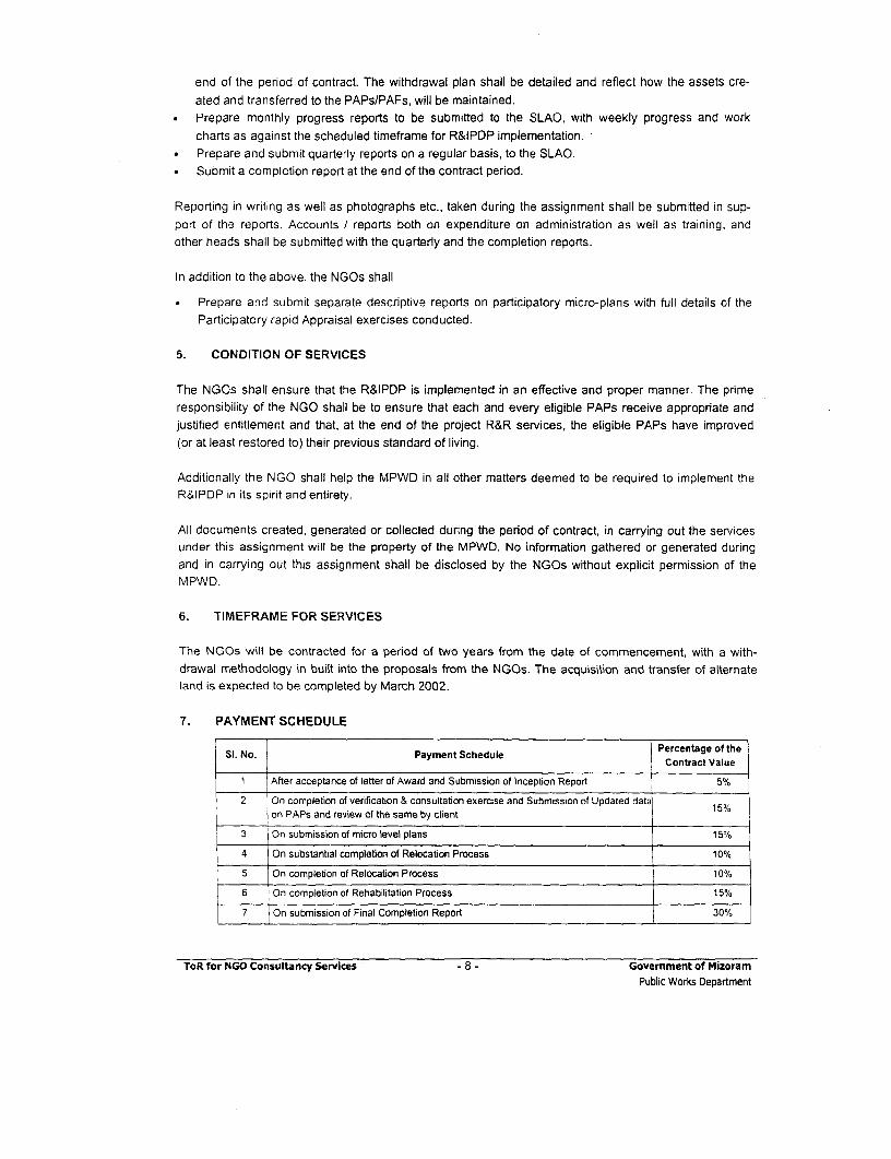
end of the period of contract. The withdrawal plan shall be detailed and reflect how the assets cre-ated and transferred to the PAPs/PAFs, will be maintained.
* Prepare monthly progress reports to be submitted to the SLAO, with weekly progress and workcharts as against the scheduled timeframe for R&IPDP implementation.
* Prepare and submit quarterly reports on a regular basis, to the SLAO.* Submit a completion report at the end of the contract period.
Reporting in writing as well as photographs etc., taken during the assignment shall be submitted in sup-port of the reports. Accounts / reports both on expenditure on administration as well as training, andother heads shall be submitted with the quarterly and the completion reports.
In addition to the above. the NGOs shall
Prepare and submit separate descriptive reports on participatory micro-plans with full details of theParticipatory rapid Appraisal exercises conducted.
5. CONDITION OF SERVICES
The NGOs shall ensure that the R&IPDP is implemented in an effective and proper manner. The primeresponsibility of the NGO shall be to ensure that each and every eligible PAPs receive appropriate andjustified entitlement and that, at the end of the project R&R services, the eligible PAPs have improved(or at least restored to) their previous standard of living.
Additionally the NGO shall help the MPWD in all other matters deemed to be required to implement theR&IPDP in its spirit and entirety.
All documents created, generated or collected during the period of contract, in carrying out the servicesunder this assignment will be the property of the MPWD. No information gathered or generated duringand in carrying out this assignment shall be disclosed by the NGOs without explicit permission of theMPWD.
6. TIMEFRAME FOR SERVICES
The NGOs will be contracted for a period of two years from the date of commencement, with a with-drawal methodology in built into the proposals from the NGOs. The acquisition and transfer of alternateland is expected to be completed by March 2002.
7. PAYMENT SCHEDULE
Si. No. Payment Schedule Percontract Value
1 After acceptance of letter of Award and Submission of Inception Report 5%
2 On completion of verification & consultation exercise and Submission of Updated dataon PAPs and review of the same by client 150/0
3 On submission of micro level pians 15%
4 On substantial completion of Relocation Process 10%
5 On completion of Relocation Process 10%
6 On completion of Rehabilitation Process 15%
7 On submission of Final Completion Report 30%
ToR for NGO Consultancy Services - 8 - Govemment of MizoramPublic Works Department
8. TEAM FOR THE ASSIGNMENT
The NGOs are free to recommend a team commensurate with the requirements of the project, subject tothe following conditions:
* That the proposal should accompany a personnel deployment schedule, clearly indicating whetherthe deployment is home-office based or in the field.
* That the NGOs must propose at least one woman as part of the key personnel. The person-monthdeployment of the woman key personnel shall constitute at least 33% of the person-month deploy-ment of all key professionals in the assignment. The proposed woman key person shall be availableto work at site (project route) for at least 50% of the duration of the contract.
* That the NGOs will depute a 'technical/professional' team to work at the site, which will consist atleast 33% of women members. Junior support personnel and administrative staff will not be consid-ered as 'technical/professional' members.
9. DATA TO BE PROVIDED BY THE CLIENT
Client will provide to the Consultants (NGO) the copies of census data, R&IPDP, Land Acquisition Planetc. collected/prepared.
10. COMPOSITION OF REVIEW COMMITTEE TO MONITOR NGOS WORKS
A reviewing committee consisting of the following officers of the MPWD shall review the progress of thework and the reports to be submitted by the NGO: -
1. Project Director Chairman2. SLAO Member3. R&R Manager, PWD Member
ToR for NGO Consultancy Services - 9 - Government of MizoramPublic Works Department

ANNEXURE 13.1 D
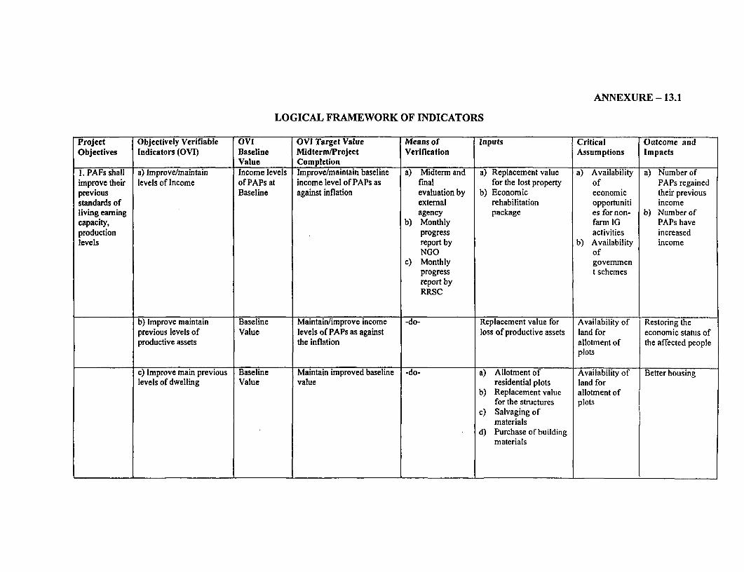
ANNEXURE-13.1
LOGICAL FRAMEWORK OF INDICATORS
Project Objectively Verifiable OVI OVI Target Value Means of Inputs Critical Outcome andObjectives Indicators (OVI) Baseline Midterm/Project Verification Assumptions Impacts
Value Completion1. PAFs shall a) Improve/maintain Income levels Improve/maintain baseline a) Midterm and a) Replacement value a) Availability a) Number ofimprove their levels of Income of PAPs at income level of PAPs as final for the lost property of PAPs regainedprevious Baseline against inflation evaluation by b) Economic economic their previousstandards of external rehabilitation opportuniti incomeliving earning agency package es for non- b) Number ofcapacity, b) Monthly farm IG PAPs haveproduction progress activities increasedlevels report by b) Availability income
NGO ofc) Monthly govemmen
progress t schemesreport byRRSC
b) Improve maintain Baseline Maintain/improve income -do- Replacement value for Availability of Restoring theprevious levels of Value levels of PAPs as against loss of productive assets land for economic status ofproductive assets the inflation allotment of the affected people
plots
c) Improve main previous Baseline Maintain improved baseline -do- a) Allotment of Availability of Better housinglevels of dwelling Value value residential plots land for
b) Replacement value allotment offor the structures plots
c) Salvaging ofmaterials
d) Purchase of buildingmaterials
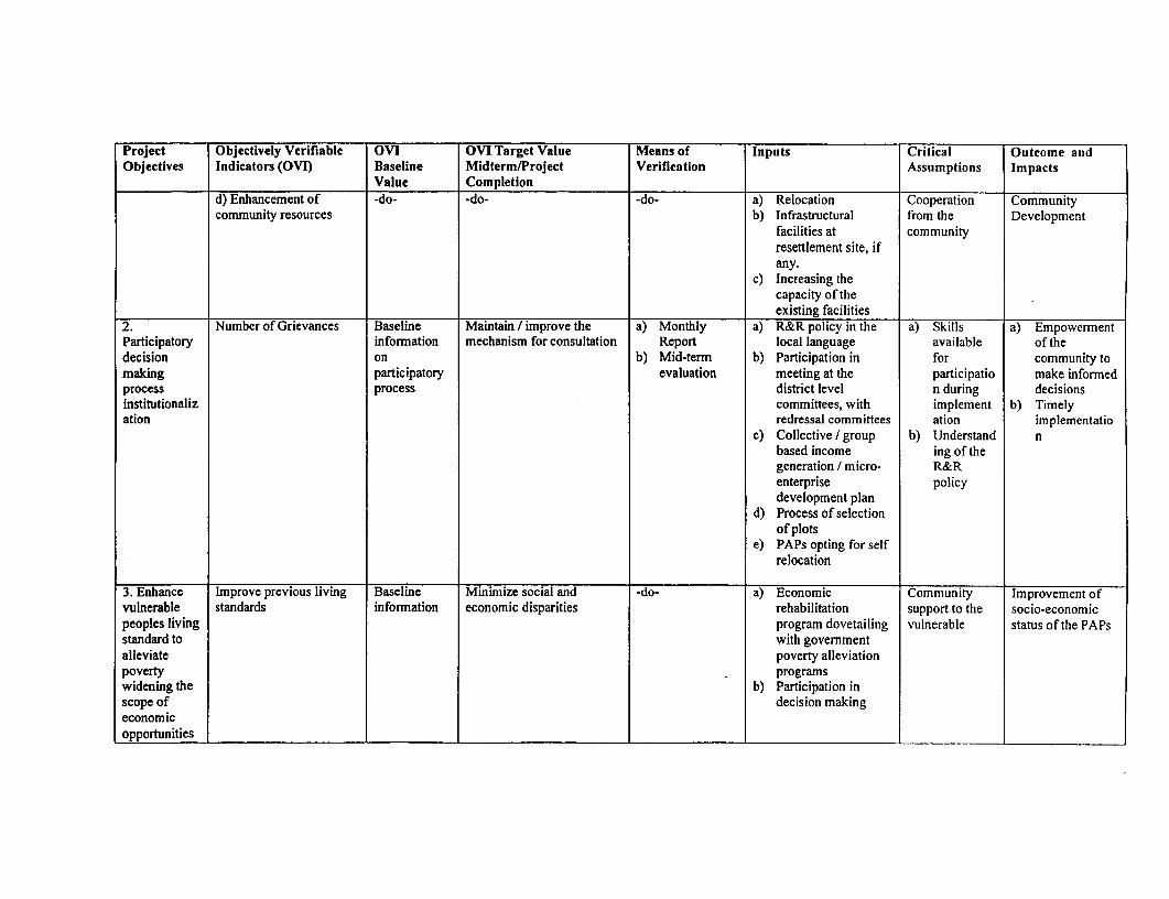
Project Objectively Verifiable OVI OVI Target Value Means of Inputs Critical Outcome andObjectives Indicators (OVI) Baseline Midterm/Project Verification Assumptions Impacts
Value Completiond) Enhancement of -do- -do- -do- a) Relocation Cooperation Communitycommunity resources b) Infrastructural from the Development
facilities at communityresettlement site, ifany.
c) Increasing thecapacity of theexisting facilities
2. Number of Grievances Baseline Maintain / improve the a) Monthly a) R&R policy in the a) Skills a) EmpowermentParticipatory information mechanism for consultation Report local language available of thedecision on b) Mid-term b) Participation in for community tomaking participatory evaluation meeting at the participatio make informedprocess process district level n during decisionsinstitutionaliz committees, with implement b) Timelyation redressal committees ation implementatio
c) Collective / group b) Understand nbased income ing of thegeneration / micro- R&Renterprise policydevelopment plan
d) Process of selectionof plots
e) PAPs opting for selfrelocation
3. Enhance Improve previous living Baseline Minimize social and -do- a) Economic Community Improvement ofvulnerable standards information economic disparities rehabilitation support to the socio-economicpeoples living program dovetailing vulnerable status of the PAPsstandard to with governmentalleviate poverty alleviationpoverty programswidening the b) Participation inscope of decision makingeconomicopportunities
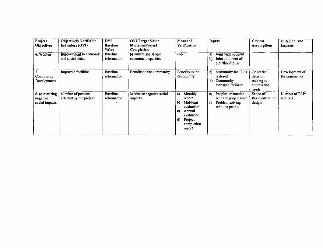
Project Objectively Verifiable OVI OVI Target Value Means of Inputs Critical Outcome andObjectives Indicators (OVI) Baseline Midterm/Project Verification Assumptions Impacts
Value Completion4. Women Improvement in economic Baseline Minimize social and -do- a) Joint bank account
and social status information economic disparities b) Joint allotment ofplot/shop/house
5. Improved facilities Baseline Benefits to the comrnunity Benefits to the a) community facilities Collective Development ofCommunity information community restored decision the communityDevelopment b) Community making to
managed facilities address theneeds
6. Minimizing Number of persons Baseline Minimize negative social a) Monthly e) Peoples interaction Scope of Number of PAPsnegative affected by the project information impacts report with the project team flexibility in the reducedsocial impacts b) Mid-term f) Problem solving design
evaluation with the peoplec) Annual
evaluationd) Project
completionreport

ANNEXURE 13.2
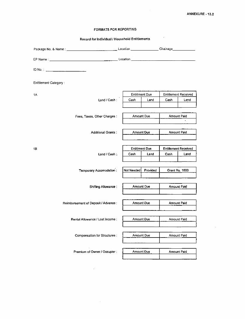
ANNEXURE -13.2
FORMATS FOR REPORTING
Record for Individual / Household Entitlements
Package No. & Name: Location Chainage-
EP Name: Location
ID No.: __
Entitlement Category:
1A Entitlment Due Entitlement Received
Land / Cash: Cash j Land Cash | Land
Fees, Taxes, Other Charges: | Amount Due | Amount Paid
Additional Grants: | Amount Due | Amount Paid
1 B Entitlment Due Entitlement Received
Land / Cash Cash | Landc Cash | Land
Temporary Accomodation: I Not Needed l Provided I Grant Rs. 1800
Shifting Allowance: I Amount Due I Amount Paid
Reimbursement of Deposit/ Advance: | Amount Due I Amount Paid
Rental Allowance I Lost Income: | Amount Due l Amount Paid
Compensation for Structures: Amount Due Amount Paid
Premium of Owner / Occupier: | Amount Due | Amount Paid
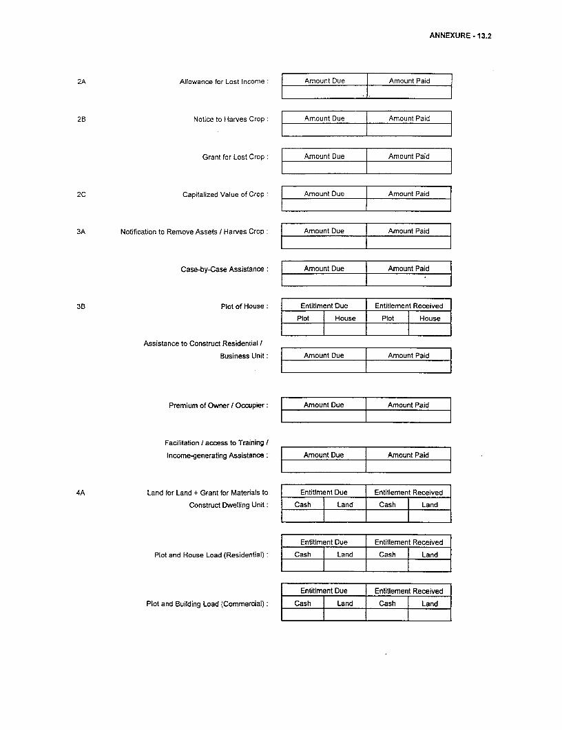
ANNEXURE - 13.2
2A Allowance for Lost Income: Amount Due Amount Paid
2B Notice to Harves Crop: Amount Due Amount Paid
Grant for Lost Crop: | Amount Due Amount Paid
2C Capitalized Value of Crop: | Amount Due | Amount Paid
3A Notification to Remove Assets / Harves Crop: | Amount Due l Amount Paid
Case-by-Case Assistance: f Amount Due Amount Paid
3B Plot of House: Entitiment Due Entitlement Received
Plot House Plo ouse
Assistance to Construct Residential /Business Unit: Amount Due Amount Paid
Premium of Owner / Occupier: Amount Due j Amount Paid
Facilitation I access to Training /
Income-generating Assistance: f Amount Due j Amount Paid
4A Land for Land + Grant for Matenals to Entitiment Due Entitlement Received
Construct Dwelling Unit: Cash Land Cash Land
Entitlment Due Entitlement Received
Plot and House Load (Residential) Cash { Land | Cash [Land
Entitlment Due Entitlement Received
Plotand Building Load (Commercial): Cash j Land | Cash [Land
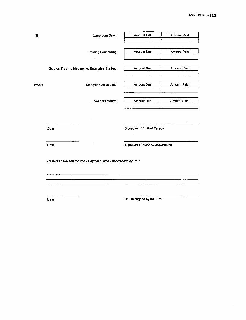
ANNEXURE - 13.2
4B Lump-sum Grant: j Amount Due | Amount Paid l
Training Counselling: | Amount Due | Amount Paid
Surplus Training Maoney for Enterprise Start-up: | Amount Due Amount Paid l
5A/5B Disruption Assistance: Amount Due [ Amount Paid I
Vendors Market: | Amount Due | Amount Paid |
Date Signature of Entitled Person
Date Signature of NGO Representative
Remarks: Reason for Non - Payment / Non - Acceptance by PAP
Date Countersigned by the RRSC

ANNEXURE 13.3 g
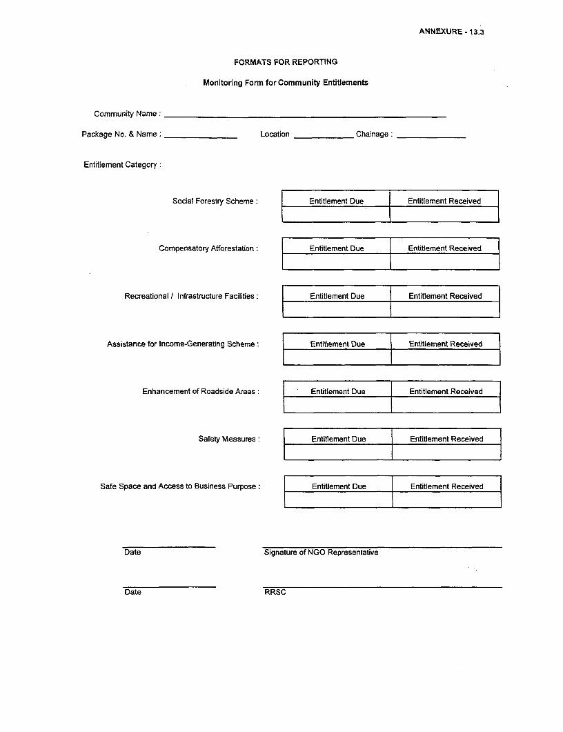
ANNEXURE - 13.3
FORMATS FOR REPORTING
Monitoring Form for Community Entitlements
Community Name:
Package No. & Name: Location Chainage:
Entitlement Category:
Social Forestry Scheme: Entitlement Due Entitlement Received
Compensatory Afforestation: Entitlement Due Entitlement Received
Recreational / Infrastructure Facilities: Entitlement Due } Entitlement Received
Assistance for Income-Generating Scheme: Entitlement Due j Entitlement Received
Enhancement of Roadside Areas: | Entitlement Due { Entitlement Received
Safety Measures: Entitlement Due Entitlement Received
Safe Space and Access to Business Purpose: Entitlement Due Entitlement Received
Date Signature of NGO Representative
Date RRSC

ANNEXURE 13.4
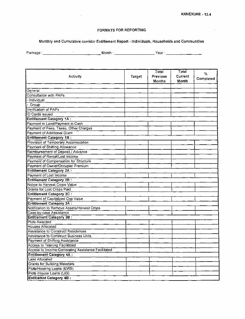
ANNEXURE - 13.4
FORMATS FOR REPORTING
Monthly and Cumulative corridor Entitlement Report - Individuals, Households and Communities
Package: Month: Year:
Total Total %Activity Target Previous Current Completed
Months Month
GeneralConsultation with PAPs- Individual- GroupVerification of PAPsID Cards issuedEntitlement Category 1A:Payment in Land/Payment in CashPayment of Fees, Taxes, Other ChargesPayment of Additional GrantEntitlement Category I B:Provision of Temporary Accomodation T_r _ r__Payment of Shifting AllowanceReimbursement of Deposit I AdvancePayment of Rental/Lost IncomePayment of Compensation for Structure Payment of Owner/Occupier Premium |Entitlement Category 2APayment of Lost IncomeEntitlement Category 2B:Notice to Harvest Crops Value I IGrants for Lost Crops PaidEntitlement Category 2C:Payment of Capitalized Cop ValueEntitlement Category 3A:Notification to Remove Assets/Harvest CropsCase-by-case AssistanceEntitlement Category 3B:Plots AwardedHouses AllocatedAssistance to Construct ResidencesAssistance to Construct Business UnitsPayment of Shifting AssistanceAccess to Training FacilitatedAccess to Income-Generating Assistance Facilitated _ _
Entitlement Category 4A:Land Allocated I IGrants for Building Materials l l
Plots/Housing Loans (EWS) l l
Plots /House Loans (LIG) l_l
Entitlemnt Category 4B:
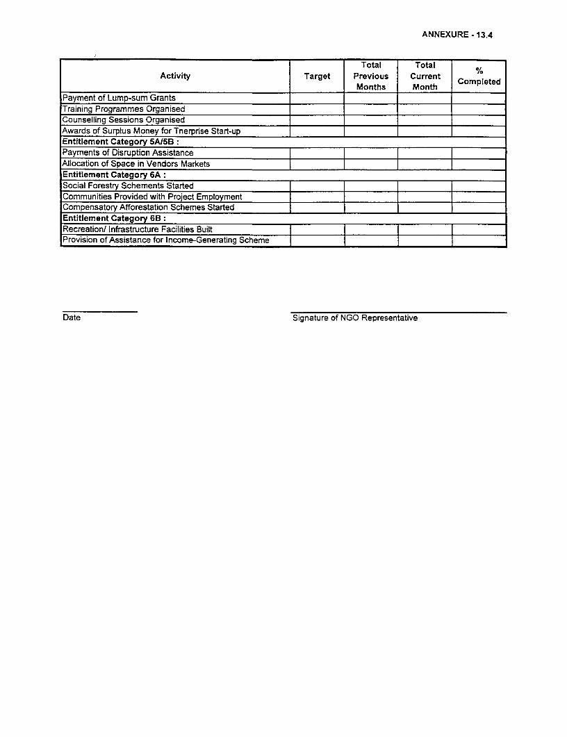
ANNEXURE - 13.4
Total Total c
Activity Target Previous Current Completed_________ Months Month Coped
Payment of Lump-sum GrantsTraining Programmes OrganisedCounselling Sessions OrganisedAwards of Surplus Money for Tnerprse Start-upEntitlement Category 5At5B:Payments of Disruption Assistance__________________Allocation of Space in Vendors MarketsEntitlement Category 6A:Social Forestry Schements StartedCommunities Provided with Project EmploymentCompensatory Afforestation Schemes StartedEntitlement Category 6B:Recreation/ Infrastructure Facilities Built l
Provision of Assistance for Income-Generating Scheme
Date Signature of NGO Representative

ANNEXURE 13.5 A
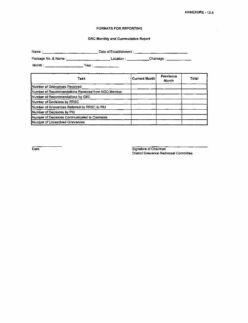
ANNEXURE - 13.5
FORMATS FOR REPORTING
GRC Monthly and Cummulative Report
Name: Date of Establishment:
Package No. & Name: Location: Chainage:
Month: Year:
Task Current Month Previsous Total
Number of Grievances ReceivedNumber of Recommendations Received from NGO MemberNumber of Recommendations by GRC
Number of Decisions by RRSC _
Number of Grievances Referred by RRSC to PIU
Number of Decisions by PIU
Number of Decisions Communicated to Claimants
Number of Unresolved Grievances
Date Signature of ChairmanDistrict Grievance Redressal Committee

ANNEXURE 13.6 A
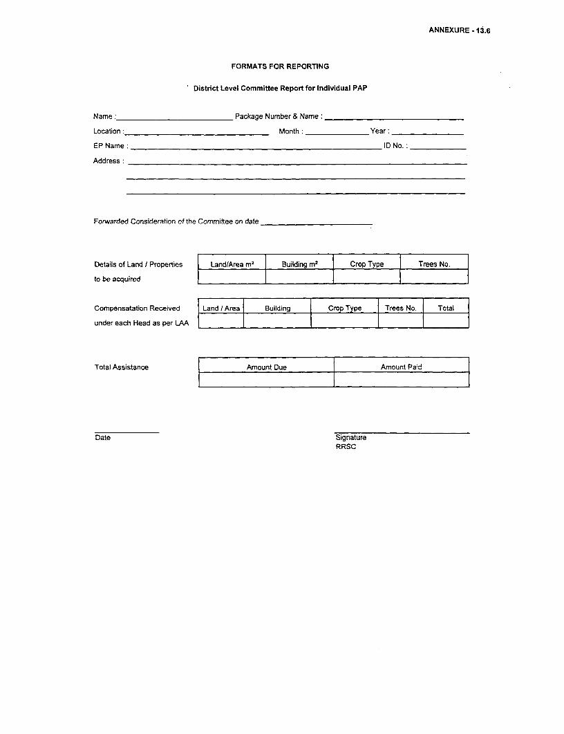
ANNEXURE - 13.6
FORMATS FOR REPORTING
District Level Committee Report for Individual PAP
Name: Package Number & Name:
Location Month: Year:
EP Name: ID No.:
Address:
Forwarded Consideration of the Committee on date
Details of Land / Properties Land/Area ml | Building m2l Crop Type I Trees No.
to be acquired I
Compensatation Received Land X Area Building Crp Type Trees No. Total
under each Head as per LAA
Total Assistance Amount Due Amount Paid
Date SignatureRRSC

ANNEXURE 13.7
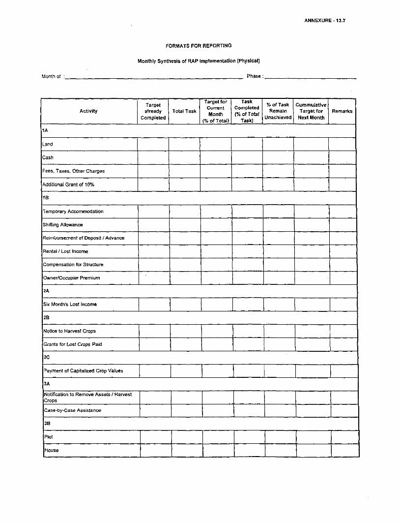
ANNEXURE -13.7
FORMATS FOR REPORTING
Monthly Synthesis of RAP Implementation (Physical)
Month of: Phase:
Targe ~~~Target for Task % of Task Cummulative
Activity already Total Task Current Copleted Remain Target for Remarks
Completed M |% of Total) Task) Unachieved Next Month
Cash
Fees, Taxes, Other Charges
Additional Grant of 10%
1B
Temporary Accommodation
Shifting Allowance
Reimbursement of Deposit / Advance
Rental I Lost Income
Compensation for Structure
Owner/Occupier Premium
2A
Six Month's Lost incomne
2B
Notice to Harvest Crops
Grants for Lost Crops Paid
2C
Payment of Capitalized Crop Values
3A
Notification to Remove Assets I HarvestCrops _ _ _ _ _ __ _ _ _ _ _ _ _ _ _
_ _ _ _ _ _ _ _ ~~~~ ~~~ ._ _ _ _ I_ _
Case-by-Case Assistance
3B
Plot _
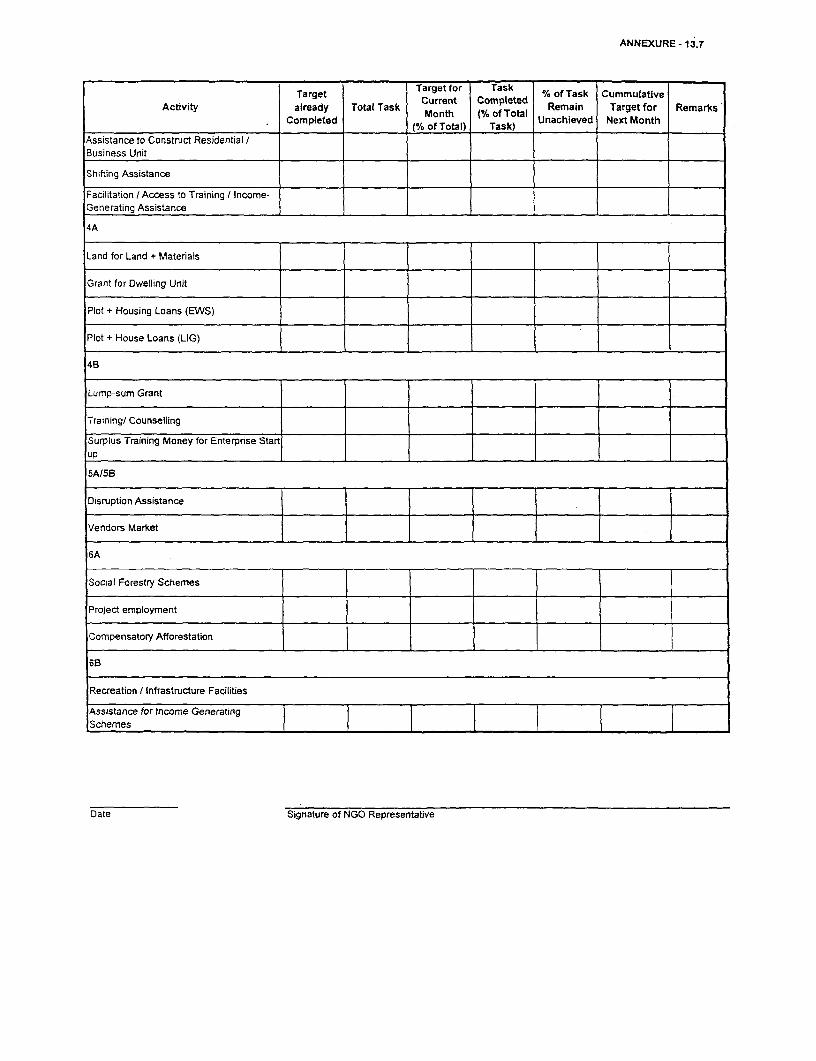
ANNEXURE- 13.7
Target Target for Task %ofTask CummulativeActivity already Total Task Current Corpleted Remain Target for Remarks'
A Completed a Month (% of Total Unachieved Next MonthCompleted ~~(% of Total) Task)
Assistance to Construct Residential IBusiness Unit
Shifting Assistance
Facilitation / Access to Training / Income-Generating Assistance
4A
Land for Land + Materials
Grant for Dwelling Unit
Plot + Housing Loans (EWS)
Plot + House Loans (LIG)
4B
Lump-sum Grant
Training/ Counselling
Surplus Training Money for Enterpnse Start
5A15B
Disruption Assistance
Vendors Market
6A
Social Forestry Schemes
Project employment
Compensatory Afforestation
6B
Recreation / Infrastructure Facilities
Assistance for Income GeneratingSchemes
Date Signature of NGO Representative

xz4
l
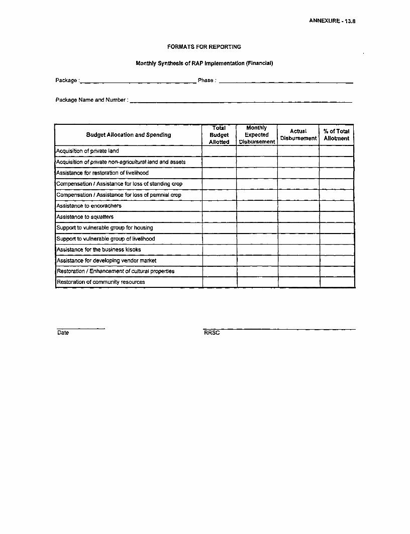
ANNEXURE - 13.8
FORMATS FOR REPORTING
Monthly Synthesis of RAP Implementation (Financial)
Package: Phase:
Package Name and Number:
Total Monthly Actual % of TotalBudget Allocation and Spending Budget Expected Disbursement Allotment
Allotted Disbursement
Acquisition of private land
Acquisition of private non-agricultural land and assets
Assistance for restoraton of livelihood
Compensabon I Assistance for loss of standing crop
Compensation / Assistance for loss of pemnial crop
Assistance to encorachers
Assistance to squatters
Support to vulnerable group for housing
Support to vulnerable group of livelihood
Assistance for the business kisoks
Assistance for developing vendor market
Restoration / Enhancement of cultural properties
Restoration of community resources
Date RRSC

![TAXATION DEPARTMENT MIZORAM - zotax.nic.in Schedules wef 1.1.2012.pdfTAXATION DEPARTMENT MIZORAM MIZORAM VALUE ADDED TAX VAT SCHEDULES ... Bakery products including biscuits [unbranded]](https://img.pdfslide.us/doc/110x75/5ab78cf57f8b9aa6018b93d5/taxation-department-mizoram-zotaxnicin-schedules-wef-112012pdftaxation-department.jpg)