Embed Size (px)
Citation preview
xpgoodway.com
Installation..................................................................... 2Licence............................................................................ 2Interface......................................................................... 2Flight-Plan...................................................................... 3Auto.Flight-Plan............................................................6Performances................................................................ 7Map...................................................................................8Search............................................................................12Airport............................................................................12Sid.&.Star.......................................................................13
Virtual.networks..........................................................13Settings..........................................................................14GoodWay.&.X-Plane....................................................15References....................................................................15Useful.Links...................................................................15Tutorial...........................................................................16Thanks,.Avertissements............................................17Commands................................................................... 18Icons.&.Shorcuts..........................................................19MapBox........................................................................ 20
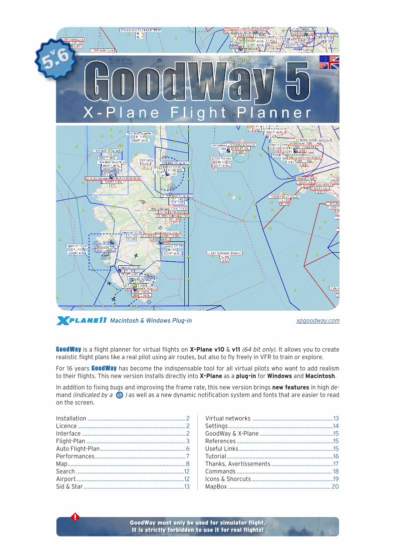
Macintosh & Windows Plug-in
GoodWay must only be used for simulator flight.It is strictly forbidden to use it for real flights!
GoodWay.is.a.flight.planner.for.virtual.flights.on.X-Plane v10.&.v11.(64 bit only)..It.allows.you.to.create.realistic.flight.plans.like.a.real.pilot.using.air.routes,.but.also.to.fly.freely.in.VFR.to.train.or.explore.
For.16.years.GoodWay.has.become.the.indispensable.tool.for.all.virtual.pilots.who.want.to.add.realism.to.their.flights..This.new.version.installs.directly.into.X-Plane.as.a.plug-in.for.Windows.and.Macintosh.
In.addition.to.fixing.bugs.and.improving.the.frame.rate,.this.new.version.brings.new features.in.high.de-mand.(indicated by a ).as.well.as.a.new.dynamic.notification.system.and.fonts.that.are.easier.to.read.on.the.screen.

GoodWay v5.6 Doc TEST 2018 12 17 - 17:54
Installation - 2GoodWay X-Plane Flight Planner
I n s t a l l a t i o n
Un-zip.the.GoodWay.zip.file.and.put.the.folder.as.it.is.into.the.folder:.X-Plane > Resources > Plugins.
The.plug-in.updates.are.automatic,.without.any.intervention.on. your. part.. You. are. informed. of. the. installation. of. a. new.version.
L i c e n c e
When.you.use.GoodWay.for.the.first.time.it.will.ask.you.to.en-ter.your.license..Otherwise,.you.can.activate.the.demo.mode.
Your.license.is.composed.of.the.2.elements.you.received.when.you.registered.(your Email and your Serial).
You. must. enter. this. information.exactly as it is written. in.the.registration.email.you.received..The license depends on your computer..You.may.only.use.a.license.for.a.single.instal-lation.and.only.on.the.computer.for.which.you.purchased.this.license.
The.computer.using.GoodWay.must.be.able.to.access.the.In-ternet..To.validate.your.registration,.GoodWay.connects.to.its.web.server..Your.license.will.then.be.attached.to.this.computer.and.can.no.longer.be.used.on.another.computer.
Once.your.license.is.accepted,.you.will.no.longer.be.asked.for.it.
Demonstration. mode. has. some. limitations.. Outside. these. li-mits,.GoodWay.works.like.the.normal.version:
.• GoodWay.can.be.used.for.15 minutes.
.• Waypoint’s.names.are.not.displayed.
.• It.is.not.possible.to.save.or.load.a.flight.plan.or.export.it.as.HTML.
.• The.flight.plan.cannot be sent.to.FMS,.FMC,.GPS.and.
GNS.I n t e r f a c e
I n t e r f a c e
Menu & Shortcuts
GoodWay‘s.menu.is.in.the.X-Plane Plugins.menu..It.provide.access.to.every.GoodWay.functions..
GoodWay’s.5.main. functions.are.easily.accessible. thanks. to.keyboard.shortcuts.that.are.by.default:
Flight Plan Map
Light intensity Settings(day/night, cycle of 4intensity levels) Flight profile
These. shortcuts. are. easily. modifiable. in. the. X-Plane. menu:.Plugins > Admin Plugin > HotKey Admin.
Joystick & Keyboard
You. can. set. Joystick. buttons. to. control. GoodWay.. Search.GoodWay.in.the.X-Plane.Joystick.Button.Functions.list.to.se-lect.the.functions:
.• Show./.Hide.the.Flight Plan
.• Show./.Hide.the.Map
.• Change.night mode
On.the.map:
.• Center on plane
.• Show./.Hide.the.Flight path
.• Show./.Hide.the.Flight Plan
.• Zoom in /.Zoom out
More.simply,.you.can.also.assign.keyboard keys.for.the.same.functions.
GoodWay v5.6 Doc TEST 2018 12 17 - 17:54
Interface - 3GoodWay X-Plane Flight Planner
Windows
GoodWay.windows.can.now.be.internal.(standard plug-in ope-ration).or.external. (independent window that you can move out of the X-Plane application and even on a second screen).
A.higher.version.of.X-Plane.v11.10.must.be.used.to.take.ad-vantage.of.this.new.feature..In.this.case,.a.small.button.is.dis-played. at. the. top. right. of. the. GoodWay. windows. and. allows.you.to.switch.from.internal.window.to.external.window.mode.and.vice versa.
The.window.then.has.a.new.title.bar.specific.to.the.operating.system.you.are.using.
Two windows have a special function: Flight Plan and Map. These two windows automatically return to the same operating mode as before.
When a standard GoodWay window is moved off the screen and disappears, simply use the menu or equiva-lent keyboard shortcut to hide it and display it again or restart X-Plane...
When a window is independent and you activate the X-Plane window, it can happen that the GoodWay inde-pendent window is hidden by the X-Plane window (this is the same with the X-Plane external FMS, GNS, etc. windows). To make it visible, use the menu or keyboard shortcuts.
When a GoodWay window uses the keyboard (red bar visible in the input field), type Escape (ESC) to return the keyboard to X-Plane.
Window’s. management. has. been. reviewed. so. that. they. can.be.resized.from.any.angle.or.side.using.the.small.arrows.that.appear.next.to.the.cursor.
F l i g h t P l a n
The.Flight Plan.tool.displays.the.flight.plan.as.a.list,.like.the.one.that.pilots.take.with.them.on.board.the.aircraft.
Details.of.the.functions.from.left.to.right:
Create.a.new.Flight.Plan.
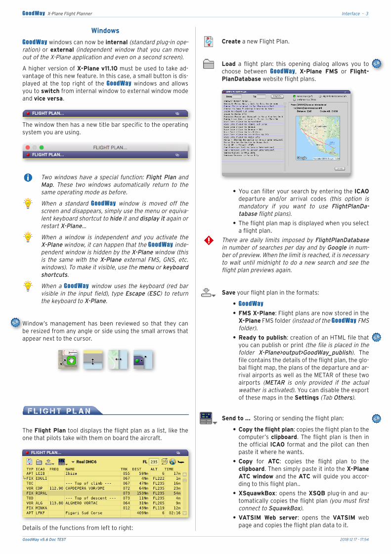
Load. a. flight. plan:. this. opening. dialog. allows. you. to.choose. between. GoodWay,. X-Plane FMS. or. Flight-PlanDatabase.website.flight.plans.
.• You.can.filter.your.search.by.entering.the.ICAO.departure. and/or. arrival. codes. (this option is mandatory if you want to use FlightPlanDa-tabase flight plans).
.• The.flight.plan.map.is.displayed.when.you.select.a.flight.plan.
There are daily limits imposed by FlightPlanDatabase in number of searches per day and by Google in num-ber of preview. When the limit is reached, it is necessary to wait until midnight to do a new search and see the flight plan previews again.
Save.your.flight.plan.in.the.formats:
.• GoodWay
.• FMS.X-Plane:.Flight.plans.are.now.stored.in.the.X-Plane.FMS.folder.(instead of the GoodWay FMS folder).
.• Ready to publish:.creation.of.an.HTML.file.that.you.can.publish.or.print.(the file is placed in the folder X-Plane>output>GoodWay_publish).. The.file.contains.the.details.of.the.flight.plan,.the.glo-bal.flight.map,.the.plans.of.the.departure.and.ar-rival.airports.as.well.as.the.METAR.of.these.two.airports. (METAR is only provided if the actual weather is activated)..You.can.disable.the.export.of.these.maps.in.the.Settings.(Tab Others).
Send to .....Storing.or.sending.the.flight.plan:
.• Copy the flight plan:.copies.the.flight.plan.to.the.computer’s.clipboard..The. flight.plan. is. then. in.the.official. ICAO. format.and. the.pilot.can. then.paste.it.where.he.wants.
.• Copy. for. ATC:. copies. the. flight. plan. to. the.clipboard..Then.simply.paste.it.into.the.X-Plane ATC window.and.the.ATC.will.guide.you.accor-ding.to.this.flight.plan..
.• XSquawkBox:.opens. the.XSQB.plug-in.and.au-tomatically.copies.the.flight.plan.(you must first connect to SquawkBox).
.• VATSIM Web server:. opens. the. VATSIM. web.page.and.copies.the.flight.plan.data.to.it.
GoodWay v5.6 Doc TEST 2018 12 17 - 17:54
Flight Plan - 4GoodWay X-Plane Flight Planner
.• JARDesign fichier X-Life ATC:.sends.the.flight.plan.to.the.X-Life.plug-in.of.JARDesign..This.op-tion.is.only.active.if.this.plug-in.is.present.
JARDesign’s X-Life uses its own database, which may be different from X-Plane’s database. It is therefore advisable to use the Navigraf database for X-Life and X-Plane data (to be placed in the Custom Data folder).
.• 124th ATC:.no.special.procedure.
.• FMC.(X-Plane v11, requires manual entry of de-parture and arrival airports).
.• FMS,.GNS 430.and.530.(X-Plane v11),.FMS.and.GPS.(X-Plane v10).
.• ZIBO 737-800.Aircraft:. It. takes.8.seconds.for.the. FMC. to. initialize. correctly. (an alert is dis-played during this time).
.• FlightFactor A320 Ultimate:. A. very. specific.procedure.must.be.performed.on.the.FMC.to.re-trieve.GoodWay ’s.flight.plan:
1.. .Click.on.the.DATA.button,
2.. .Click.on.the.A/C STATUS.line,
3.. .Click.on.line.L3.(with a small blue arrow to the left).. This. reloads. the. CO Routes. da-tabase. (nothing is displayed but it is nor-mal),
4.. .Click.the.INIT.button,
5.. .Type.GOODWAY.and.click.on.the.L1.button.(CO.RTE),
6.. The.flight.plan.is.loaded,.all.you.have.to.do.is.initialize.the.performance.and.SID/STAR.informations.
If the FMC displays an error, your X-Plane data may not match the aircraft data. In this case, synchronize them with the latest NAV-DATA files. Details of the error encountered by the FMC can be found in the X-Plane/log.txt file (see Flight Factor for more informa-tion).
.• FlightFactor B757 & B767:. To. download. into.the.flight.plan,.simply.enter.as.the.coroute.name.the.ICAOs.of.departure.and.arrival.airports.with.no.space.(e. g. LFMNLFPO).
.• X-FMC:.no.special.procedure.
.• Instruments.of.compatible.aircraft.from.partner.manufacturers:.JARDesign.or.Aerobask,.etc...
The current version of X-Plane (v11) does not allow GoodWay to fully control the FMC. Once the flight plan is sent to the FMC, you simply need to manually add the departure and arrival airports to the FMC Init page.
Continuous evolutions of X-Plane v11 (betas) can cause malfunctions of some of these functions (FMS/GPS/FMC/GNS) which will be adapted as and when they oc-cur.
Manual altitudes (by default) or.performances.of.the.selected.aircraft.
Manual.choice.of.a.specific.cruising.altitude.(this alti-tude must be compatible with the performance of the selected aircraft).
SID & STAR / Approaches:.Allows.you.to.obtain.ins-trument. arrival. and. departure. procedures. (see the chapter on SIDs & STARs, below)..
Open.the.Map window.(shortcut: CTRL + Z).
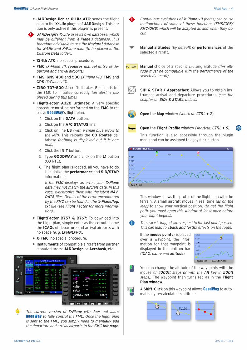
Open.the.Flight Profile.window.(shortcut: CTRL + S).
This. function. is. also. accessible. through. the. plugin.menu.and.can.be.assigned.to.a.joystick.button.
This.window.shows.the.profile.of.the.flight.plan.with.the.terrain..A.small.aircraft.moves. in.real.time.(as on the Map). to.show.your.vertical.position.. (to get the flight path, you must open this window at least once before your flight begins).
The trace is logged with respect to the last point passed. This can lead to «back and forth» effects on the route.
If.the.mouse pointer.is.placed.over. a. waypoint,. the. infor-mation. for. that. waypoint. is.displayed. in. the. bottom. bar.(ICAO, name and altitude)..
You.can.change.the.altitude.of.the.waypoints.with.the.mouse. (in 1000ft steps or with the Alt key in 500ft steps).. The. waypoint. then. turns. red. as. in. the. Flight Plan window.
A.Shift-Click.on.this.waypoint.allows.GoodWay.to.auto-matically.re-calculate.its.altitude.
GoodWay v5.6 Doc TEST 2018 12 17 - 17:54
Flight Plan - 5GoodWay X-Plane Flight Planner
When.you.select.a.Performance.for.your.aircraft,.the.TOC.(Top Of Climb - C).and.TOD.(Top Of Descent - D).are.displayed.on.the.profile.and.on.the.map.
2.new.lines.are.then.added.to.your.flight.plan.as.addi-tional waypoints. (you can disable this option in Set-tings)..
TOCs & TODs appear only if you do not display SID and STAR. This information is calculated in relation to the average performance and loads of the aircraft, but this gives a good estimate of when you will arrive in level flight and when you should initiate the descent. If the length of the flight plan does not allow you to climb to cruise altitude or you have not selected any perfor-mance, markers C and D are not displayed.
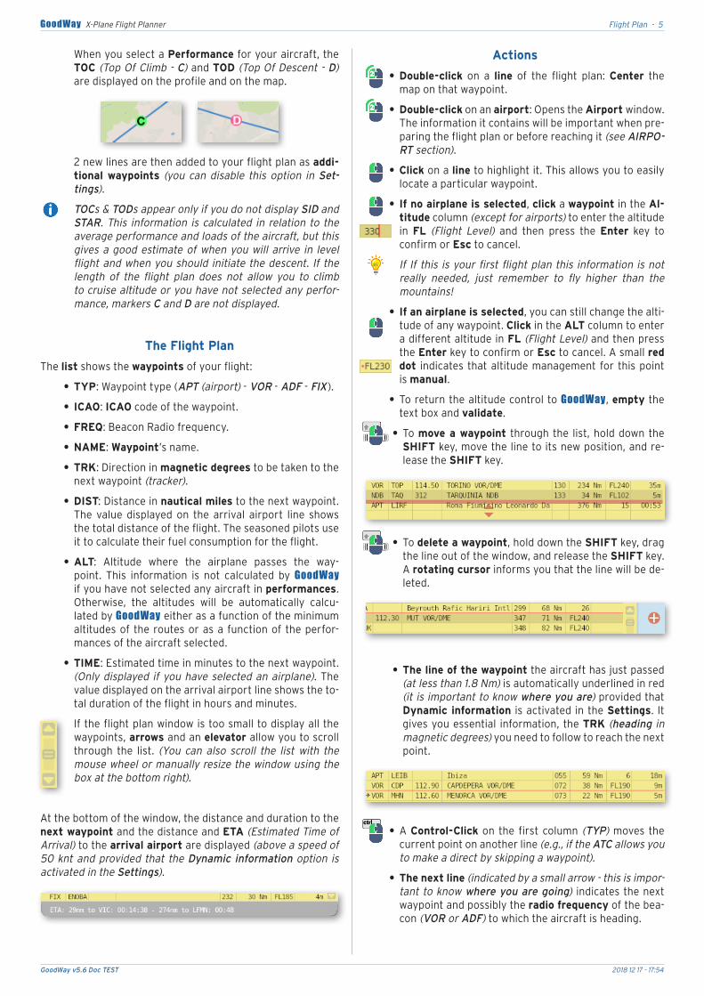
The Flight Plan
The.list.shows.the.waypoints.of.your.flight:
.• TYP:.Waypoint.type.(APT.(airport).-.VOR.-.ADF.-.FIX).
.• ICAO:.ICAO.code.of.the.waypoint.
.• FREQ:.Beacon.Radio.frequency..
.• NAME:.Waypoint’s.name.
.• TRK:.Direction.in.magnetic degrees.to.be.taken.to.the.next.waypoint.(tracker).
.• DIST:.Distance.in.nautical miles.to.the.next.waypoint..The. value. displayed. on. the. arrival. airport. line. shows.the.total.distance.of.the.flight..The.seasoned.pilots.use.it.to.calculate.their.fuel.consumption.for.the.flight.
.• ALT:. Altitude. where. the. airplane. passes. the. way-point.. This. information. is. not. calculated. by. GoodWay.if.you.have.not.selected.any.aircraft.in.performances..Otherwise,. the. altitudes. will. be. automatically. calcu-lated.by.GoodWay.either.as.a.function.of.the.minimum.altitudes.of. the.routes.or.as.a. function.of.the.perfor-mances.of.the.aircraft.selected.
.• TIME:.Estimated.time.in.minutes.to.the.next.waypoint..(Only displayed if you have selected an airplane)..The.value.displayed.on.the.arrival.airport.line.shows.the.to-tal.duration.of.the.flight.in.hours.and.minutes.
If.the.flight.plan.window.is.too.small.to.display.all.the.waypoints,.arrows.and.an.elevator.allow.you.to.scroll.through. the. list.. (You can also scroll the list with the mouse wheel or manually resize the window using the box at the bottom right).
At.the.bottom.of.the.window,.the.distance.and.duration.to.the.next waypoint.and.the.distance.and.ETA.(Estimated Time of Arrival).to.the.arrival airport.are.displayed.(above a speed of 50 knt and provided that the Dynamic information option is activated in the Settings).
Actions
.• Double-click. on. a. line. of. the. flight. plan:. Center. the.map.on.that.waypoint.
.• Double-click.on.an.airport:.Opens.the.Airport window..The.information.it.contains.will.be.important.when.pre-paring.the.flight.plan.or.before.reaching.it.(see AIRPO-RT section).
.• Click.on.a.line.to.highlight.it..This.allows.you.to.easily.locate.a.particular.waypoint.
.• If no airplane is selected,.click.a.waypoint.in.the.Al-titude.column.(except for airports).to.enter.the.altitude.in. FL. (Flight Level). and. then. press. the. Enter. key. to.confirm.or.Esc.to.cancel..
If If this is your first flight plan this information is not really needed, just remember to fly higher than the mountains!
.• If an airplane is selected,.you.can.still.change.the.alti-tude.of.any.waypoint..Click.in.the.ALT.column.to.enter.a.different.altitude.in.FL.(Flight Level).and.then.press.the.Enter.key.to.confirm.or.Esc.to.cancel..A.small.red dot. indicates.that.altitude.management.for.this.point.is.manual.
.• To.return.the.altitude.control.to.GoodWay,.empty.the.text.box.and.validate.
.• To.move a waypoint. through.the. list,.hold.down.the.SHIFT.key,.move.the.line.to.its.new.position,.and.re-lease.the.SHIFT.key.
.• .To.delete a waypoint,.hold.down.the.SHIFT.key,.drag.the.line.out.of.the.window,.and.release.the.SHIFT.key..A.rotating cursor.informs.you.that.the.line.will.be.de-leted.
.• The line of the waypoint.the.aircraft.has.just.passed.(at less than 1.8 Nm).is.automatically.underlined.in.red.(it is important to know where you are).provided.that.Dynamic information. is.activated.in.the.Settings.. It.gives.you.essential. information,.the.TRK.(heading in magnetic degrees).you.need.to.follow.to.reach.the.next.point.
.• A.Control-Click.on. the. first.column. (TYP).moves. the.current.point.on.another.line.(e.g., if the ATC allows you to make a direct by skipping a waypoint).
.• The next line.(indicated by a small arrow - this is impor-tant to know where you are going). indicates.the.next.waypoint.and.possibly.the.radio frequency.of.the.bea-con.(VOR or ADF).to.which.the.aircraft.is.heading.
GoodWay v5.6 Doc TEST 2018 12 17 - 17:54
Auto Flight Plan - 6GoodWay X-Plane Flight Planner
.• Set Instruments:. This. menu. is. accessed. by. an. Alt-Click.on.one.of.the.lines.of.the.flight.plan.
Depending.on.the.type.of.the.waypoint,.you.can.directly.adjust.your.flight.instruments:.autopilot.(heading, al-titude, VVI, OBS),.and.radios.(NAV / VOR, ADF / NDB).
This function may not work if your (non-standard) air-craft does not directly use X-Plane’s informations and protocols.
If your departure and arrival points are far away, the easiest way is to choose them first and then insert the crossing points. This allows you to see the shortest path, so you can follow it better by zooming in on the map.
If you duplicate an existing flight plan (many flight plans are available on the internet), it will be easier to use the addition of crossing points.
If you want to make simple instrument navigation, choose VORs and ADFs instead because the position of the FIXs is more complex (they require triangulation and/or chrono from the VOR and ADF instruments).
A u t o F l i g h t P l a n
This.is.one.of.the.most.powerful.tool.of.GoodWay.and.thanks.to.it.you.will.be.able.to.achieve.most.realistic.flight.plans.by.indicating.only.some.informations.
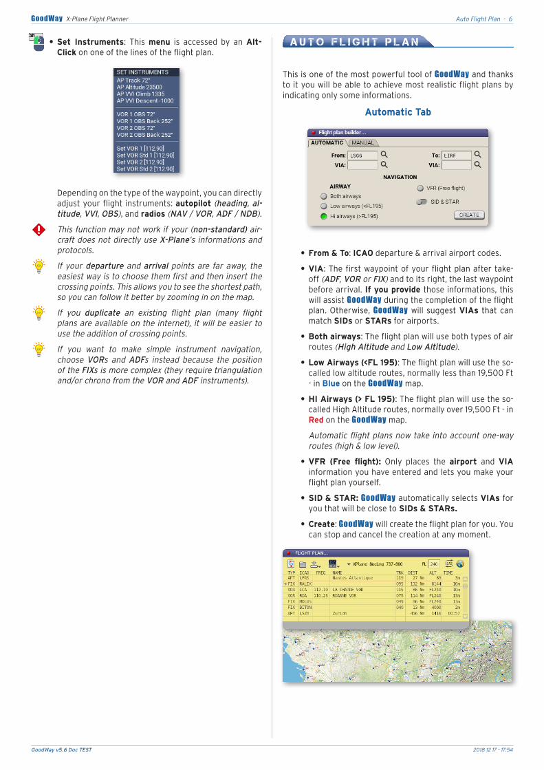
Automatic Tab
.• From & To:.ICAO.departure.&.arrival.airport.codes.
.• VIA:.The.first.waypoint.of.your.flight.plan.after.take-off.(ADF, VOR or FIX).and.to.its.right,.the.last.waypoint.before.arrival..If you provide those.informations,.this.will.assist.GoodWay.during.the.completion.of.the.flight.plan..Otherwise,. GoodWay.will. suggest.VIAs. that.can.match.SIDs.or.STARs.for.airports.
.• Both airways:.The.flight.plan.will.use.both.types.of.air.routes.(High Altitude and Low Altitude).
.• Low Airways.(<FL 195):.The.flight.plan.will.use.the.so-called.low.altitude.routes,.normally.less.than.19,500.Ft.-.in.Blue.on.the.GoodWay.map.
.• HI Airways.(> FL 195):.The.flight.plan.will.use.the.so-called.High.Altitude.routes,.normally.over.19,500.Ft.-.in.Red.on.the.GoodWay.map.
Automatic flight plans now take into account one-way routes (high & low level).
.• VFR (Free flight):. Only. places. the. airport. and. VIA.information.you.have.entered.and.lets.you.make.your.flight.plan.yourself.
.• SID & STAR: GoodWay automatically.selects VIAs for.you.that.will.be.close.to SIDs & STARs.
.• Create:.GoodWay.will.create.the.flight.plan.for.you..You.can.stop.and.cancel.the.creation.at.any.moment.
GoodWay v5.6 Doc TEST 2018 12 17 - 17:54
Performances - 7GoodWay X-Plane Flight Planner
GoodWay uses data from your earth_nav.dat, ear-th_awy.dat and earth_fix.dat files, instead of standard data if they are present in the X-Plane Custom Data folder. If you add a user_fix.dat file in this same folder, GoodWay adds its content to the list of standard FIXs. The file must respect the format imposed by X-Plane. You also have the possibility to create personal FIXs (see the procedure in the Map chapter).
Automatic flight plans now take into account one-way routes (High & Low Level). Altitudes will be automatical-ly calculated by GoodWay either according to the mini-mum altitudes of the routes or according to the capabi-lities of the aircraft selected in Performance.
You can refine your search for the best route by ma-nually entering the departure and arrival VIAs. Specia-lists will like to enter SID exit points and STAR inputs in this field.
During the flight plan creation, GoodWay will pause X-Plane for a few seconds to load the X-Plane data. If the distance between the departure and arrival airports is very short, it will be difficult to find a really optimized route..
The search buttons.next.to.the.input.fields.allow.you.to. open. the. search. tool.. The. button. disappears. to.show.you.which.input.field.corresponds.to.the.current.search.
Once.you.have.found.the.information.you.are.looking.for,.double-click.on.it.to.have.it.automatically.added.to.your.flight.plan.
This tool provides the “horizontal“ flight plan (viewed from above). GoodWay automatically sets the minimum altitudes for your waypoints but the vertical flight plan is assumed by the Performance tool that uses the air-craft’s capabilities to fix the vertical position at each waypoint.
Manual Tab
Type.the.flight.plan.in.the.official.ICAO.format.in.the.input.box.or.paste.(Cmd V or Ctrl V).a.flight.plan.stored.in.the.clipboard..GoodWay.will.create.the.flight.plan.for.you..A.cursor.offers.to.automatically.correct.the.flight.plan.if.it.is.not.in.ICAO.format.
In this version of GoodWay, the aircraft’s fuel consump-tion information has been deliberately omitted in order not to complicate your flight experience. Then, after all, in a simulator you don’t pay for fuel!
P e r f o r m a n c e s
The.choice.of.your.aircraft’s.performance. is.very. important.since.it.influences.the.calculation.of.the.speeds.and.altitudes.of.the.different.phases.of.your.flight.and.therefore.its.duration.and.profile.
There.are.2.ways.to.get.performance.for.your.aircraft:
.• The.data.of.the.real.aircraft.that.GoodWay.will.recover.on.a.specific.site,
.• Data.created.by.you.or.another.user.
Compatible aircraft continue to operate as before. The Global Performances are no longer located on your hard disk but are now on a server accessible by GoodWay.
In. the. Flight Plan. window,. select. the. performance. of. the.currently.used.aircraft..This.requires.that. the.creator.of. the.aircraft.has.correctly.entered.the.aircraft’s. ICAO.code.when.it. was. created.. You. may. have. several. proposals. in. the. list,.choose.the.one.you.want..
These. are. average. performances. of. the. aircraft,. so.they.are.sensitive.to.weight,.wind.and.relative.speed..If.the.Performances.are.the.ones.you.have.created.your-self.(see.below).they.are.preceded.by.an.*.
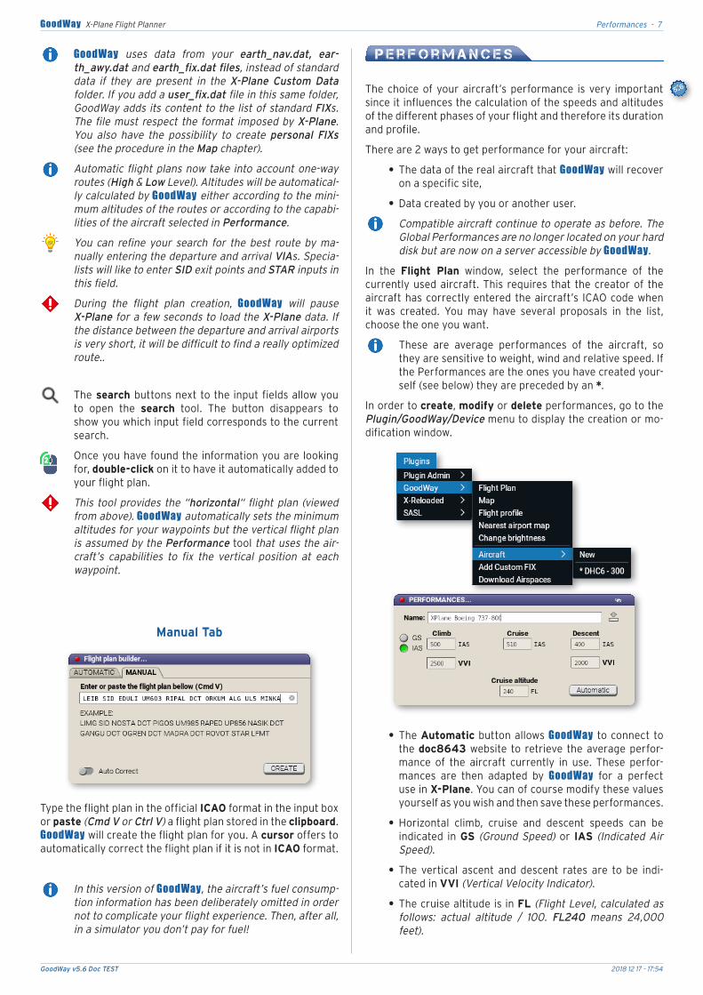
In.order.to.create,.modify.or.delete.performances,.go.to.the.Plugin/GoodWay/Device.menu.to.display.the.creation.or.mo-dification.window.
.• The.Automatic.button.allows.GoodWay. to.connect.to.the.doc8643.website. to. retrieve. the.average.perfor-mance. of. the. aircraft. currently. in. use.. These. perfor-mances. are. then. adapted. by. GoodWay. for. a. perfect.use.in.X-Plane..You.can.of.course.modify.these.values.yourself.as.you.wish.and.then.save.these.performances.
.• Horizontal. climb,. cruise. and. descent. speeds. can. be.indicated. in.GS. (Ground Speed). or. IAS. (Indicated Air Speed).
.• The. vertical. ascent. and. descent. rates. are. to. be. indi-cated.in.VVI.(Vertical Velocity Indicator).
.• The.cruise.altitude.is.in.FL.(Flight Level, calculated as follows: actual altitude / 100. FL240 means 24,000 feet).
GoodWay v5.6 Doc TEST 2018 12 17 - 17:54
Map - 8GoodWay X-Plane Flight Planner
After.having.created.or.changed.this.information,.you.can.save.it.
You.may.also.delete.the.performance.of.the.displayed.aircraft.
The performances modified by a user are stored on the GoodWay server. All users can access it, but only their creator can modify and delete them. Each pilot has only one customized performance per aircraft.
M a p
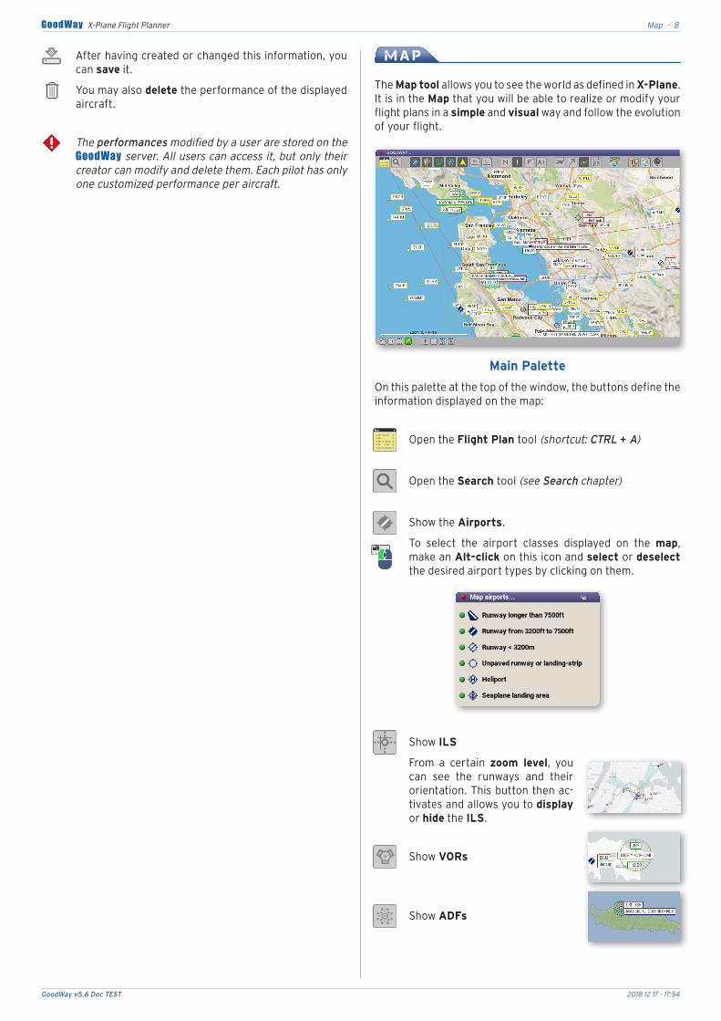
The.Map tool.allows.you.to.see.the.world.as.defined.in.X-Plane..It.is.in.the.Map.that.you.will.be.able.to.realize.or.modify.your.flight.plans.in.a.simple.and.visual.way.and.follow.the.evolution.of.your.flight.
Main Palette
On.this.palette.at.the.top.of.the.window,.the.buttons.define.the.information.displayed.on.the.map:.
Open.the.Flight Plan tool (shortcut: CTRL + A)
Open.the.Search tool (see Search chapter)
Show.the.Airports.
To. select. the. airport. classes. displayed. on. the. map,.make.an.Alt-click.on.this.icon.and.select.or.deselect.the.desired.airport.types.by.clicking.on.them.
Show.ILS
From. a. certain. zoom level,. you.can. see. the. runways. and. their.orientation..This.button.then.ac-tivates.and.allows.you.to.display.or.hide.the.ILS.
Show.VORs
Show.ADFs
GoodWay v5.6 Doc TEST 2018 12 17 - 17:54
Map - 9GoodWay X-Plane Flight Planner
Display. the. FIXs. (see Settings).and. personal. FIXs. you. have.created. (see the section Other Functions at the end of this chap-ter).
Display.airways.of.your.choice:
.• High Level.( > 19.500 ft)
.• Low Level.( < 19.500 ft)
One-way.airways.are.marked.with.a.triangle.indicating.the.direction.of.travel.(with XP >= v11).
To preserve the frame-rate, it is not possible to display both types of roads at the same time.
Display.Names,.ICAO.codes.and.beacon.Frequencies.
Show.altitudes (Flight plan, SID & STAR).
Display. your. aircraft. information. in.real. time. (see Settings):. HDG. (Hea-ding),.GS.(Ground Speed),.MSL.(Mean Sea Level, altitude above sea level)..Above 70 Knt,. the.ETA. in.a.straight.line.on.arrival.is.displayed.
Display.the.actual Flight Route.(see Settings).
Display.the.Flight.Plan.Path.
Display.selected.SIDs & STARs.
Choose.the.map.type..A.menu.and.submenus.allow.you.to.select.the.map.model.that.will.be.displayed.among.all.the.available.ones..
You.can.thus.adapt.the.map.according.to.your.tastes.and.needs.at.any.given. time. (exploration,.creation.of.a.flight.plan,.real-time.flight.monitoring,.etc.)..Test.the.different.maps.to.find.the.ones.that.suit.you.best.
The display of MAPBOX DESIGN maps requires regis-tration on their site and the (free) acquisition of an ac-cess key. The registration procedure is explained in the appendix at the end of this documentation.
.• Enable Contrast. improves. the. contrast. of. displayed.data.and.icons.(useful with some maps).
.• Enable HDEF.allows.you.to.display.(or not).more.infor-mation.on.the.map..An.alert.warns.you.that.this.option.may. cause. the. frame-rate. to. slow. down. significantly.and.make.the.map.less.readable.
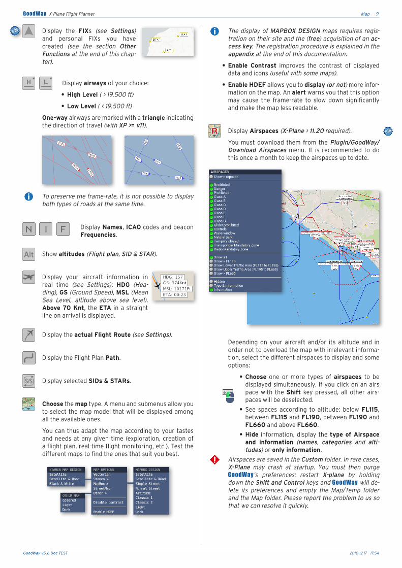
Display.Airspaces.(X-Plane > 11.20 required).
You. must. download. them. from. the.Plugin/GoodWay/Download Airspaces. menu.. It. is. recommended. to. do.this.once.a.month.to.keep.the.airspaces.up.to.date.
Depending. on. your. aircraft. and/or. its. altitude. and. in.order.not.to.overload.the.map.with.irrelevant.informa-tion,.select.the.different.airspaces.to.display.and.some.options:
.• Choose. one. or. more. types. of. airspaces. to. be.displayed.simultaneously.. If.you.click.on.an.airspace. with. the. Shift. key. pressed,. all. other. airs-paces.will.be.deselected.
.• See. spaces. according. to. altitude:. below. FL115,.between.FL115.and.FL190,.between.FL190.and.FL660.and.above.FL660.
.• Hide. information,.display.the.type of Airspace and information. (names, categories and alti-tudes).or.only information.
Airspaces are saved in the Custom folder. In rare cases, X-Plane may crash at startup. You must then purge GoodWay’s preferences: restart X-plane by holding down the Shift and Control keys and GoodWay will de-lete its preferences and empty the Map/Temp folder and the Map folder. Please report the problem to us so that we can resolve it quickly.
GoodWay v5.6 Doc TEST 2018 12 17 - 17:54
Map - 10GoodWay X-Plane Flight Planner
Display.weather.data.
A.secondary palette.appears.below.the.main.one.and.allows.you. to.select. the.type.of.data. to.be.displayed.(see appendix for a description of the different sym-bols).
This.new.version.of.GoodWay.allows.you.to.display.the.weather.for.3.altitude.levels.
Sky. Ground.Winds
Winds.at.FL120. Winds.at.FL340
Temperature. Pressure
.• Right-clicking. on. one. of. the. weather. icons. on.the.map.displays.the.METAR.report.at.this.posi-tion.(on versions of X-Plane < to 11.10, simply click on the icon).
The weather data comes exclusively from X-Plane’s weather function to ensure that the information between the plug-in and your simulator is perfectly ho-mogeneous.
Display.the.VATSIM.or.IVAO.virtual.controllers.(choose from the Settings also see the Virtual Networks section below).
A.secondary palette.appears.below.the.main.one.and.allows.you.to.select.the.type.of.data.to.be.displayed:
VATSIM.or.IVAO data.
Controlled.aircrafts. Flight.plans
Controlled.aeras. ATIS
Clearances. Ground.controls
Control.towers. Approaches
Names. Frequencies
.• A.right-click.on.one.of.the.aircraft.on.the.map.displays. its.data:.call sign,.aircraft type,.pilot,.flight plan,.speed.and.altitude..You.can.display.its.route.and.copy.its.flight.plan.and.then.paste.it.into.a.new.flight.plan.(on versions of X-Plane < to 11.10, simply click on the icon).
Tools Palette
At.the.bottom.of.the.window,.the first 4 buttons.on.the.left.are.the.map tools..Only one tool can be selected at a time.
Hand:. it. allows. you. to. move. the. displayed. portion. of.the.map.
.• Click and hold the. mouse. button. to. move. the.map.
.• When.using.another.tool,.you.can.still.move.the.map.by.holding.down.the.Control key.
.• Control + Double-click.zooms.on.the.map.
.• Control-Shit + Double-click.de-zooms.the.map.
Ruler:.it.allows.you.to.measure.the.distance.and.angle.(relative to true and non-magnetic north). between. 2.points.of.the.map..GoodWay.displays.the.distance.and.heading. between. these. 2. points.. Above 70Knt,. the.ETA.is.displayed.
.• Click on.the.map.and.move.the.mouse.in.the.de-sired.direction.
Zoom on zone:.reframes.the.map.on.a.particular.zone.
.• Click.on.the.map.and.move the mouse.to.form.a.rectangle..When.you.release.the.mouse.button,.the.map.is.automatically.zoomed.in.on.this.aera.
.• If. you. hold. down. the. Alt. key,. you. can. use. the.Area Zoom tool. even. if. you. are. using. another.tool.
Edit:.this.is.the.core.tool.of.GoodWay..It.allows.you.to.make.and.modify.your.flight.plans.in.a.simple.and.intui-tive.way.with.a.few.clicks..The.List.in.the.Flight Plan tool. updates. automatically. based. on. your. actions. on.the.map.
.• Add.a.waypoint.at.the.end.of.the.flight.plan:.click the.desired.waypoint.with.the.Shift.key.
.• Insérer.a.waypoint.between.two.others:.simply.click.on.the.line.linking.these.two.points,.move.it.and.release.the.mouse.button.over.the.point.to.be.added..(You can also Shift-click the previous waypoint and then move it to the waypoint you want to insert).
.• Move.a.waypoint:.click and.move. it.on.another.waypoint. (Airport, VOR, ADF, FIX) then. release.the.button.
GoodWay v5.6 Doc TEST 2018 12 17 - 17:54
Map - 11GoodWay X-Plane Flight Planner
.• Delete.a.waypoint:.click and.move it.on.the.map.where. there. is. no. information. (Airport, VOR, ADF, FIX).
The.following.4 buttons.are.used.for.framing.the.map:
Zoom.and.de-zoom.the.map.(Or use the mouse wheel).
At. the. bottom. of. the. map. and. in. the. left. corner,. the.zoom level.and.a.distance scale.are.displayed.
Zoom.and.reframe.the.map.on.the.flight plan.
Centers..the.map.on.the.plane’s.position..To.zoom.in.on.the.aircraft.as.well,.hold.the.Alt.key.at.the.same.time.
Double-click.the.same.button.to.keep.the.map.cente-red.on.the.aircraft’s.position.at.all. times.while. it. is. in.motion..The.icon.will.turn.red.
To. exit. this. mode,. click. the. button. again,. move the map.with.the.hand.tool.or.select.Flight Plan Zoom.
Additional functions on the Map
.• A. Control-click. (or right-click with X-Plane >= 11.10).on.an.airport.displays.a.menu.that.al-lows. you. to. open. the. airport tool. (see below),.the. SIDs. & STARs tool. (see below). or. display.the. METAR. report. (METeorological Aerodrome Report). for. that. airport.. The. METAR. indicates.ground.visibility.
.• A. Control-click. (or right-click with X-Plane >= 11.10). on. a. marker. displays. a. menu. that. allows.you. to. display. the. informations. of. this. marker.(Name, ICAO, Coordinates, Altitude and magne-tic deviation).or.to.add.a.personal FIX.
The.creation.of.personal FIX.can.be.done.in.two.ways,.by.using.the.Plugin/GoodWay/Add Custom FIX.menu.and.entering.its.coordinates,.or.by.using.the.Map.:
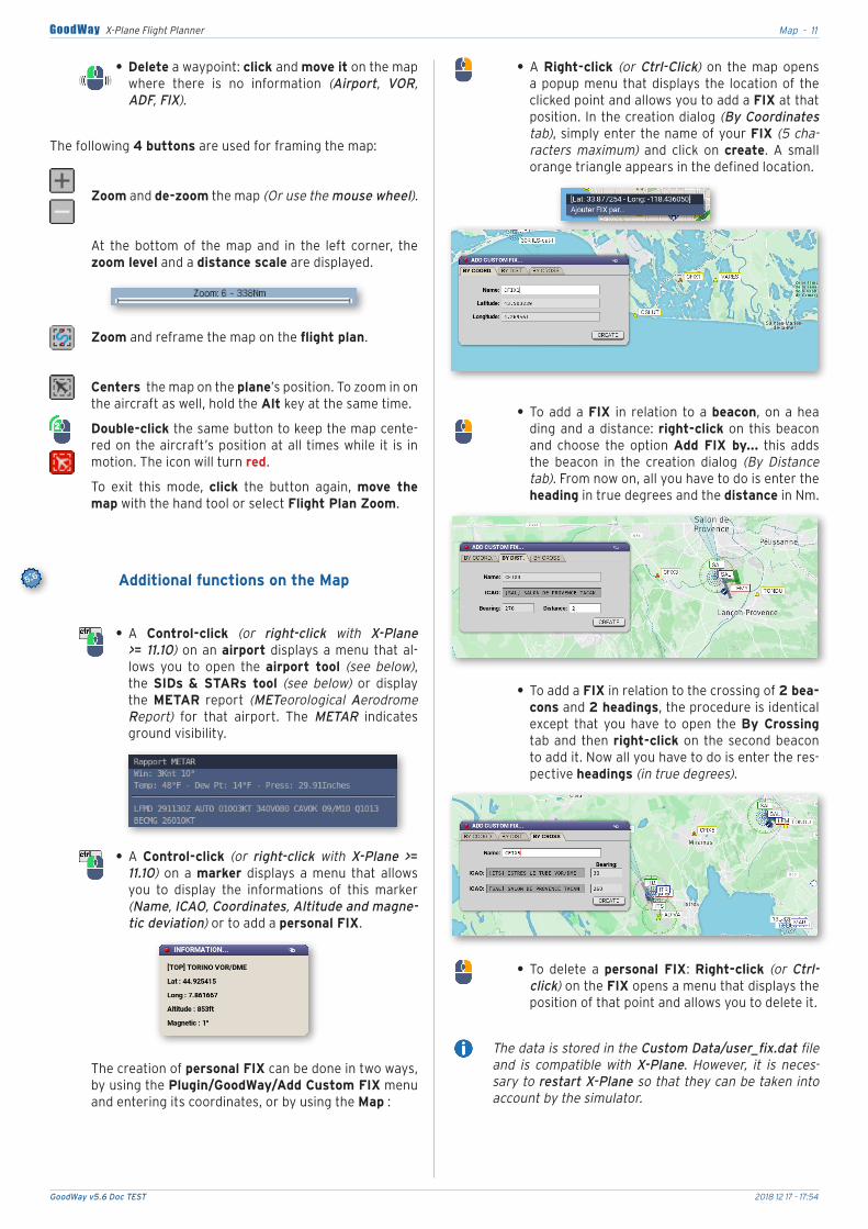
.• A. Right-click. (or Ctrl-Click). on. the. map. opens.a.popup.menu. that.displays. the. location.of. the.clicked.point.and.allows.you.to.add.a.FIX.at.that.position..In.the.creation.dialog.(By Coordinates tab),.simply.enter.the.name.of.your.FIX.(5 cha-racters maximum). and. click. on. create.. A. small.orange.triangle.appears.in.the.defined.location.
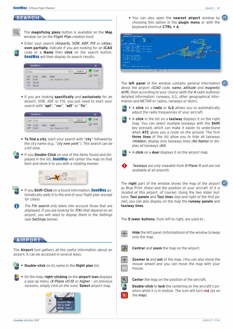
.• To.add.a.FIX. in. relation. to.a.beacon,. on.a.heading.and.a.distance:.right-click.on. this.beacon.and. choose. the. option. Add FIX by.... this. adds.the. beacon. in. the. creation. dialog. (By Distance tab)..From.now.on,.all.you.have.to.do.is.enter.the.heading.in.true.degrees.and.the.distance.in.Nm.
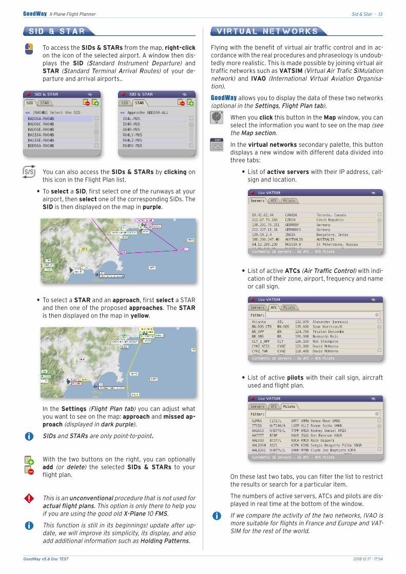
.• To.add.a.FIX.in.relation.to.the.crossing.of.2 bea-cons.and.2 headings,.the.procedure.is.identical.except. that. you. have. to. open. the.By Crossing.tab.and. then.right-click.on. the.second.beacon.to.add.it..Now.all.you.have.to.do.is.enter.the.res-pective.headings.(in true degrees).
.• To. delete. a. personal FIX:. Right-click. (or Ctrl-click).on.the.FIX.opens.a.menu.that.displays.the.position.of.that.point.and.allows.you.to.delete.it.
The data is stored in the Custom Data/user_fix.dat file and is compatible with X-Plane. However, it is neces-sary to restart X-Plane so that they can be taken into account by the simulator.
GoodWay v5.6 Doc TEST 2018 12 17 - 17:54
Search - 12GoodWay X-Plane Flight Planner
S e a r c h
The.magnifying glass.button. is.available.on. the.Map.window.(or on the Flight Plan creation tool).
.• Enter.your.search.(Airports, VOR, ADF, FIX or cities),.even partially,.indicate.if.you.are.looking.for.an.ICAO.code. or. a. Name. then. click. on. the. search. button..GoodWay.will.then.display.its.search.results.
.• If.you.are. looking.specifically.and.exclusively. for.an.airport,.VOR,.ADF.or.FIX,.you. just.need.to.start.your.search.with.“apt“,.“vor“,.“adf“.or.“fix“.
.• To find a city,.start.your.search.with.“cty“.followed.by.the.city.name.(e.g.: “cty new york“)..This search can be a bit slow.
.• If.you.Double-Click.on.one.of.the.items.found.and.dis-played.in.the.list,.GoodWay.will.center.the.map.on.that.item.and.show.it.to.you.with.a.rotating.marker.
.• If.you.Shift-Click.on.a.found.information,.GoodWay.au-tomatically.adds.it.to.the.end.of.your.flight.plan.(except for cities).
The FIX search only takes into account those that are displayed. If you are looking for FIXs that depend on an airport, you will need to display them in the Settings (see Settings below).
A i r p o r t
The.Airport.tool.gathers.all.the.useful. information.about.an.airport..It.can.be.accessed.in.several.ways:
.• Double-click.on.its.name.in.the.flight plan list.
.• On.the.map,.right-clicking.on.the.airport icon.displays.a.pop-up.menu.(X-Plane v11.10 or higher - on previous versions, simply click on the icon)..Select.airport.map..
.• You. can. also. open. the. nearest airport. window. by.choosing. this. option. in. the. plugin menu. or. with. the.keyboard.shortcut.CTRL + A.
The. left panel. of. the. window. contains. general. information.about. the. airport. (ICAO code, name, altitude and magnetic drift),.then.according.to.your.choice.(with the 4 radio buttons):.detailed. information:.runways,. ILS,.other.geographical. infor-mation.and.METAR.or.radios,.taxiways.or.doors.
.• A.click.on.a.radio.or. ILS.allows.you.to.automatically.adjust.the.radio.frequencies.of.your.aircraft.
.• A.click.in.the.list.on.a.taxiway.displays.it.on.the.right.map.. You. can. select. multiple. taxiways. with. the. Shift.key. pressed,. which. can. make. it. easier. to. understand.when.ATC.gives.you.a.route.on.the.ground..The.first.three lines. of. the. list. allow. you. to. hide. all. taxiways.(Hidden),.display.only.taxiways.lines.(No Name).or.dis-play.all.taxiways.(All).
.• A.click.on.a.door.displays.it.on.the.airport.map.
Taxiways are only viewable from X-Plane 11 and are not available at all airports.
The. right part. of. the. window. shows. the. map. of. the. airport.as.Blue.Print. (lines).and. the.position.of.your.aircraft. (if it is located at this airport, of course).. Using. the. two. slider. but-tons:.Taxi panels.and.Taxi lines.(top and right of the first pa-nel),.you.can.also.display.on.the.map.the.runway panels.and.taxiway lines.
The.5 lower buttons,.from.left.to.right,.are.used.to.:
Hide.the.left.panel.(informations).of.the.window.to.keep.only.the.map.
Centrer.and.zoom.the.map.on.the.airport.
Zoomer.in.and.out.of.the.map..(You can also move the mouse wheel). and. you. can. move. the. map. with. your.mouse.
Center.the.map.on.the.position.of.the.aircraft.
Double-click.to.lock.the.centering.on.the.aircraft’s.po-sition.while.it.is.in.motion..The.icon.will.turn.red (as on the map).
GoodWay v5.6 Doc TEST 2018 12 17 - 17:54
Sid & Star - 13GoodWay X-Plane Flight Planner
S i d & S t a r
To.access.the.SIDs & STARs.from.the.map,.right-click.on.the.icon.of.the.selected.airport..A.window.then.dis-plays. the. SID. (Standard Instrument Departure). and.STAR. (Standard Terminal Arrival Routes). of. your. de-parture.and.arrival.airports..
You.can.also.access.the.SIDs & STARs.by.clicking.on.this.icon.in.the.Flight.Plan.list.
.• To.select.a.SID,.first.select.one.of.the.runways.at.your.airport,.then.select.one.of.the.corresponding.SIDs..The.SID.is.then.displayed.on.the.map.in.purple.
.• To.select.a.STAR.and.an.approach,.first.select.a.STAR.and.then.one.of.the.proposed.approaches..The.STAR.is.then.displayed.on.the.map.in.yellow.
L
In.the.Settings.(Flight Plan tab).you.can.adjust.what.you.want.to.see.on.the.map:.approach.and.missed ap-proach.(displayed in dark purple).
SIDs and STARs are only point-to-point.
With.the.two.buttons.on.the.right,.you.can.optionally.add. (or delete). the. selected. SIDs & STARs. to. your.flight.plan.
This is an unconventional procedure that is not used for actual flight plans. This option is only there to help you if you are using the good old X-Plane 10 FMS.
This function is still in its beginnings! update after up-date, we will improve its simplicity, its display, and also add additional information such as Holding Patterns.
V i r t u a l N e t w o r k s
Flying.with.the.benefit.of.virtual.air.traffic.control.and.in.ac-cordance.with.the.real.procedures.and.phraseology.is.undoub-tedly.more.realistic..This.is.made.possible.by.joining.virtual.air.traffic.networks.such.as.VATSIM.(Virtual Air Trafic SIMulation network). and. IVAO. (International Virtual Aviation Organisa-tion).
GoodWay.allows.you.to.display.the.data.of.these.two.networks.(optional in the Settings, Flight Plan tab).
When.you.click.this.button.in.the.Map.window,.you.can.select.the.information.you.want.to.see.on.the.map.(see the Map section.
In.the.virtual networks.secondary.palette,.this.button.displays.a.new.window.with.different.data.divided.into.three.tabs:
.• List.of.active servers.with.their.IP.address,.call-sign.and.location.
.• List.of.active.ATCs.(Air Traffic Control).with.indi-cation.of.their.zone,.airport,.frequency.and.name.or.call.sign.
.• List.of.active.pilots.with.their.call.sign,.aircraft.used.and.flight.plan.
On.these.last.two.tabs,.you.can.filter.the.list.to.restrict.the.results.or.search.for.a.particular.item.
The.numbers.of.active.servers,.ATCs.and.pilots.are.dis-played.in.real.time.at.the.bottom.of.the.window.
If we compare the activity of the two networks, IVAO is more suitable for flights in France and Europe and VAT-SIM for the rest of the world.
GoodWay v5.6 Doc TEST 2018 12 17 - 17:54
Settings - 14GoodWay X-Plane Flight Planner
S e t t i n g s
4 tabs.allow.you.to.customize.the.way.GoodWay.works.
Flight Plan tab
.• Dynamic information: Enables or disables the.display.of.flight.plan.tracking.and.ETAs.on.the.list.
.• Add TOC and TOD:.Adds.to.the.flight.plan,. the.flight.profile.and.the.map.the.corresponding.waypoints.:.top.of.the.climb.and.beginning.of.the.descent.
.• Virtual Routes:.allows.the.use.of.a.file.of.virtual.routes.NAT. or. PACOT. (variable routes Trans-Atlantic and Trans-Pacific in particular). to. simplify. the. realisation.of.long-distance.flight.plans..These routes are not dis-played on the map and therefore cannot be used in a manual flight plan. Even if these routes are virtual, they use the NAV and FIX of X-Plane, which makes them 100% compatible with X-Plane.
.• STAR:. display. or. hide. approaches. (and final ap-proaches).and.use.or.not.use.missed approaches.
In some cases, missed approaches may also be added to the route. This is because the DME, Back and VOR approaches are only used for aligning, and that the file does not contain the runway... It’s up to you to delete unnecessary information from your flight plan.
Map Tab
A.pop-up menu.allows.you.to.choose.the.map.that.will.be.dis-played.(same function as the Map button on the main palette).
If. you.use.a.MapBox.map. that. requires. registration. (free of charge),. enter. the. serial. number. you. received. in. the. input.field..Then.check.the.correct.connection.using.the.Test.button.(detailed registration procedure in the appendix).
.• Your aircraft:.display.or.hide.your.aircraft.on.the.map..This.is.very.useful.if.you.don’t.necessarily.want.to.know.where.you.are.but.you.want.to.be.able.to.consult.the.map.during.your.flight.
.• Airport FIXs:.X-Plane.adds.a.lot.of.FIXs.around.airpo-rts.to.make.the.approach.easier..This.multitude.of. in-formation.makes.the.legibility.of.the.map.more.difficult.and.you.may.prefer.not.to.have.this.information.
.• Flight Plot:.GoodWay.will.record.the.plot.of.your.flight.and.you.can.see. it.on. the.map. in. real. time..Warning: This only works if you have opened a GoodWay window at one time or another. If no window is opened, the plug-in does not load and does not use any resources.
.• Auto framerate protection:.limit.the.amount.of.infor-mation.displayed.on.the.card. if.your. framerate.drops.below.20fps..This.is.an.intelligent.protection,.GoodWay.disables.one.by.one.the.options.of.the.card.to.bring.up.the.framerate.
Memory Cache Tab
In.order.to.speed.up.the.map.display,.this.one.is.downloaded.in. the. background. as. squares. saved. in. the. folder. X-Plane > Output > GoodWay_Map.
.• Enable cache management:. Controls. the. number.of. downloaded. map. portions. based. on. the. maximum.cache.size.you.specified.(in megabytes).below..The.next.time.X-Plane.is.launched,.GoodWay.will.delete.the.sur-plus.data.
.• Cache only the current map:.GoodWay.keeps.portions.of.the.map.currently.in.use.as.a.priority..
.• Delete cache folder content:.All.maps.portions.stored.in.the.cache.folder.will.be.deleted.and.re-downloaded.as.you.use.it.
Others Tab
.• Font size.of.the.map.
.• Virtual network:.choose.none,.VATSIM.or.IVAO.
.• Units:. Temperature. display. in. degrees. centigrade. or.fahrenheit.and.pressures.in.Hpa.(hectopascal).or.inHg.(inches).
.• Hide.GoodWay.when.using.an.external.view.of.the.air-craft.in.X-Plane.(except the Settings window).
.• Display.air.traffic.on.the.Map.and.airport maps..This.function.does.not.work.with.plugins.like.World Traffic.that.do.not.share.this.information.with.other.plugins.
.• Export.the.flight map.and.airport plans.to.the.«ready to publish».HTML.file.
GoodWay v5.6 Doc TEST 2018 12 17 - 17:54
GoodWay & X-Plane - 15GoodWay X-Plane Flight Planner
G o o d W a y & X - P l a n e
Although.GoodWay.is.installed.as.a.plug-in.in.X-Plane,.it.does.not.use.memory or processor resources. if. you.do.not.use.it!. It. has. been. optimized. to. the. maximum. so. as. not. to. slow.X-Plane.when.you.use.it..Some.options.in.its.Settings.allow.you.to.control.the.impact.on.the.simulator.
The.more.elements.you.see.on.the.Map,.the.more.power.you.need..The.Flight Plan,.Search.and.Airport windows.use.vir-tually.no.resources.
Some.operations.such.as. loading.navigation.data.can.pause.X-Plane.for.a.few.seconds..Just.wait.for.the.operation.to.fi-nish....
Flight. plans. made. with. GoodWay. are. made. with. and. for.X-Plane..They.can.be.used.to.define.your.flight.with.the.Air Traffic Control,. be. entered. in. the.FMS. /.FMC. and. also. the.X-Plane.GPS.
Every radio frequencies and precise positions of.each.flight.information.are.those.of.X-Plane..You.are.therefore.assured.that.your.flight.plans.will.work.perfectly.in.the.X-Plane.world.
A. new. API. has. been. developed. for. plug-in. developers. who.want.to.exchange.data.with.GoodWay.(consult us).
GoodWay. v5. updates. will. be. free. in. all. 5.x.x. versions.. It. is.compatible.with.X-Plane.v10.&.v11.(64 bits only),.but.frequent.X-Plane. updates. may. cause. some. plug-in. incompatibilities..We.are.always.working.intensively.to.provide.you.with.updates.that.will.correct.these.problems.
Check.regularly.the.GoodWay.web.site.or.the.Facebook page.for.more.information.on.these.updates.
R e f e r e n c e s
The.author.discovered.X-Plane.in.version.3..The.realism.of.the.simulator. quickly. convinced. him. that. he. was. flying. with. the.best. consumer. simulator. available.. This. impression. was. ful-ly.confirmed.during.a.pilot’s.baptism.where.everything.went.exactly.as. in.X-Plane..He. then.had. the. terrible.desire. to. fly.and.to.understand.how.to.find.his.way.in.the.air..He.discovered.navigation.and.began.building.GoodWay.in.2002.
He.then.took.pilot.training.courses.to.better.understand.the.real.world.of.aviation.and.be.able.to.transfer.it.to.the.simulator.to.improve.the.X-Plane.flight.experience.
Over.the.years,.many.passionate.enthusiasts,.real.commercial.pilots. and. instructors. have. come. to. enrich. his. thinking. and.help. him.. Progress. that. is. now. essential. for.X-Plane. comes.for.most.of.these.highly.motivated.people.(Cockpit 3D, Push-Back, Pilot 3D in the cockpit, aircraft outside view, etc...)..All.this.comes.from.a.community.of.diverse.people.who. love.to.build.scenes,.airports,.fly,.and.experiment.so.that.our.pleasure.is.always.more.real!
U s e f u l L i n k s
GoodWay tutorials, information and updates
xpgoodway.com
GoodWay v5.2 trailer on YouTube
https://youtu.be/ZnkcM2HocJQ
Milan’s Tutorials on YouTube (in french)
Version 5.2 overview
https://youtu.be/wnVIHOjOA7M
Manage Direct To with GoodWay 5.2
https://youtu.be/tgRkbbVWQO4
If.you.want.to.know.more.about.real.flight,.instrument.flying,.and.have.much.more.fun.than.with.a.GPS,.here.are.some.other.sites.to.consult.
Flying with NDB / ADF (simplest)
lavionnaire.fr/RadioNavADF.php
airinstruction.com/cours/index.php
The xplane.fr site with hundreds of tipson X-Plane and its tools (in French)
xplanefr.com
Be.aware.that.what.you.learn.there.will.help.you.to.push.the.door.of.an.aeroclub.one.day,.because.flying.with.X-Plane.will.cost.you.a.lot.less!
Virtual air traffic control networks
VATSIM: vatsim.net & VATSIM France: vatfrance.org
IVAO: ivao.aero & IVAO France: ivao.fr/fr
GoodWay v5.6 Doc TEST 2018 12 17 - 17:54
Tutorial - 16GoodWay X-Plane Flight Planner
T u t o r i a l
This.little.tutorial.will.not.teach.you.how.to.fly.but.it.will.teach.you.how.to.use.GoodWay.to.achieve.your first flight plan.
VFR Flight with waypoints
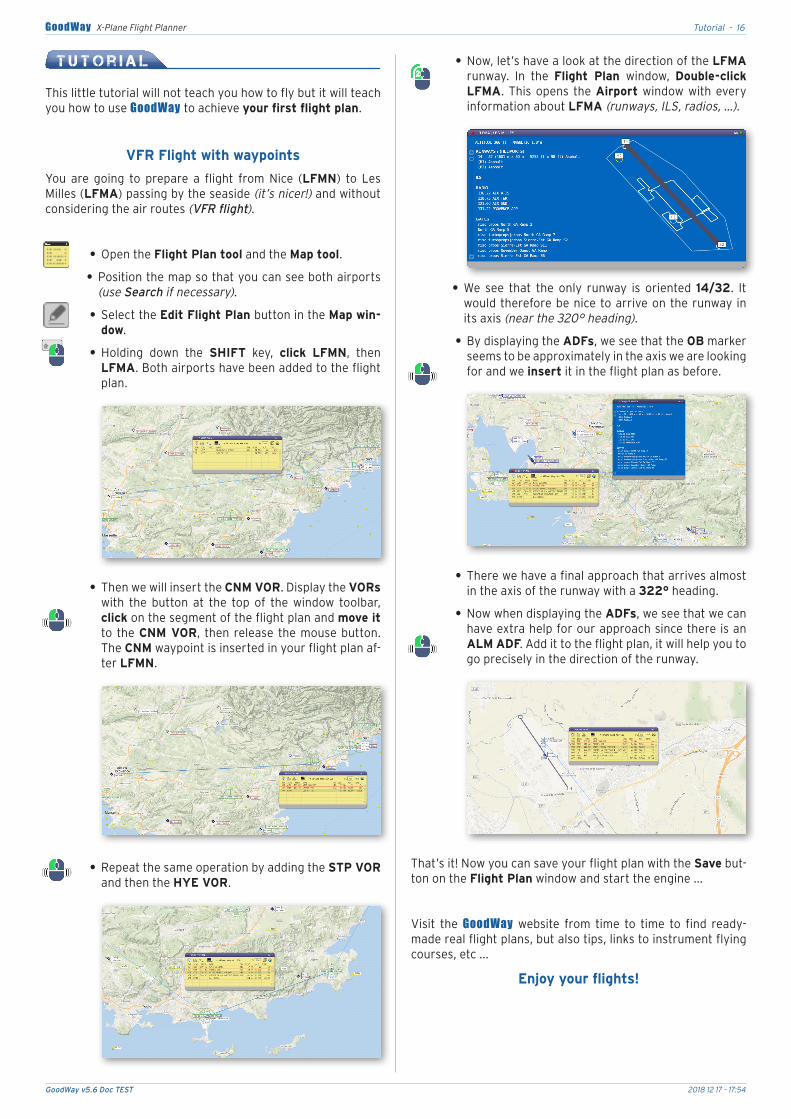
You. are. going. to. prepare. a. flight. from. Nice. (LFMN). to. Les.Milles.(LFMA).passing.by.the.seaside.(it’s nicer!).and.without.considering.the.air.routes.(VFR flight).
.• Open.the.Flight Plan tool.and.the.Map tool.
.• Position.the.map.so.that.you.can.see.both.airports.(use Search if necessary).
.• Select.the.Edit Flight Plan button.in.the.Map win-dow.
.• Holding. down. the. SHIFT. key,. click. LFMN,. then.LFMA..Both.airports.have.been.added.to.the.flight.plan.
.• Then.we.will.insert.the.CNM VOR..Display.the.VORs.with. the. button. at. the. top. of. the. window. toolbar,.click.on.the.segment.of.the.flight.plan.and.move it.to. the.CNM VOR,. then. release. the.mouse.button..The.CNM.waypoint.is.inserted.in.your.flight.plan.af-ter.LFMN.
.• Repeat.the.same.operation.by.adding.the.STP VOR.and.then.the.HYE VOR.
.• Now,.let’s.have.a.look.at.the.direction.of.the.LFMA.runway.. In. the. Flight Plan window,. Double-click LFMA..This.opens. the.Airport.window.with.every.information.about.LFMA (runways, ILS, radios, ...).
.• We. see. that. the. only. runway. is. oriented. 14/32.. It.would.therefore.be.nice.to.arrive.on.the.runway. in.its.axis.(near the 320° heading).
.• By.displaying.the.ADFs,.we.see.that.the.OB.marker.seems.to.be.approximately.in.the.axis.we.are.looking.for.and.we.insert.it.in.the.flight.plan.as.before.
.• There.we.have.a.final.approach.that.arrives.almost.in.the.axis.of.the.runway.with.a.322°.heading.
.• Now.when.displaying.the.ADFs,.we.see.that.we.can.have.extra.help.for.our.approach.since.there.is.an.ALM.ADF..Add.it.to.the.flight.plan,.it.will.help.you.to.go.precisely.in.the.direction.of.the.runway.
That’s.it!.Now.you.can.save.your.flight.plan.with.the.Save.but-ton.on.the.Flight Plan.window.and.start.the.engine....
Visit. the. GoodWay. website. from. time. to. time. to. find. ready-made.real.flight.plans,.but.also.tips,.links.to.instrument.flying.courses,.etc....
Enjoy your flights!
GoodWay v5.6 Doc TEST 2018 12 17 - 17:54
Thanks - 17GoodWay X-Plane Flight Planner
GoodWay must be used exclusivelyin the context of simulator flight.
It is strictly forbidden to use itfor real flights!
T h a n k s
This.chapter.is.far.too.short.considering.the.number.of.people.who. have. contributed. in. GoodWay ’s. development. for. more.than.15.years. is.great..Those.who.are.not.mentioned.should.not.hold.it.against.us,.they.will.always.be.the.craftsmen.of.the.pleasure.that.we.all.have.to.fly.with.X-Plane.
Here. is.the. list.of.people.that.the.authors.want.to.thank.for.their.help.and.support.during.all.these.years:
JP.and.his.team,Always.ready.to.help.and.bring.their.excellent.ideas.
Tony, Mario, Jean Paul, Pimpom, E.T., Gérard,Pierre, Ron, Rollen, Alexis, XP.Fr, XP.Org,
and of courseAustin, Sergio, Ben, Phillip, Sandy et Randy
for their incredible work on X-Plane.
This.list.could.not.be.complete.if.we.do.not.also.thank.our.wives or companions. who. support. our. absences. during. our. flying.hours.and.our.endless.stories.about.our.virtual.landings....
Developer, DocumentationStéphane MAUREL
Design (Plug-in & Documentation)Jean-Marie EDQUIST
Technical advisorsMilan, Bruno
Italian documentationTony & Alessandro
spanish documentationXavier Martin
The GoodWay software package(Software, design, features, documentation)Is subject to international copyright laws.
Copyright 2001-2018
The use of GoodWay is subjectto EULA license acceptance.
W A R N I N G S
.• Goodway.uses.data.from.several.websites,.these data are the property of these websites.and.are.not.gua-ranteed.over.time.
The.service.of.these.sites.may.indeed.be.suspended.or.definitively.stopped. independently.of.our.will..We.will.of.course.do.our.utmost.to.be.able.to.maintain.these.services.or.functions.but.without.any.guarantee.of.suc-cess.
Some. sites. used. by. Goodway. may. have. connection limits by IP address.. They. are. therefore. not. always.usable.at.will.and.may.have.a.daily.or.monthly.limit.
.• Goodway.does.not.work.in.VR.mode.(Virtual reality).
.• Changes.in.the.size.of.the.X-Plane.interface.(130-150%).disturb.Goodway.and.should.not.be.used.
.• Before contacting technical. support,. please. consult.the. FAQ. (http://www.xpgoodway.com/faq.html). where.you. will. find. answers. to. the. most. frequently. asked.questions.
.• To contact technical. support,. send. an. email.([email protected]). indicating. in. the. subject.line. your. serial. number. (in the form xxxx-xxxx-xxxx-xxxx-xxxx-xxxx). and. the. problem. encountered.. Also.attach.the.X-Plane/log.txt.file.
GoodWay v5.6 Doc TEST 2018 12 17 - 17:54
Commands - 18GoodWay X-Plane Flight Planner
C o m m a n d s
ActionsFlight Plan
windowMap
windowSearchwindow
Airportwindow
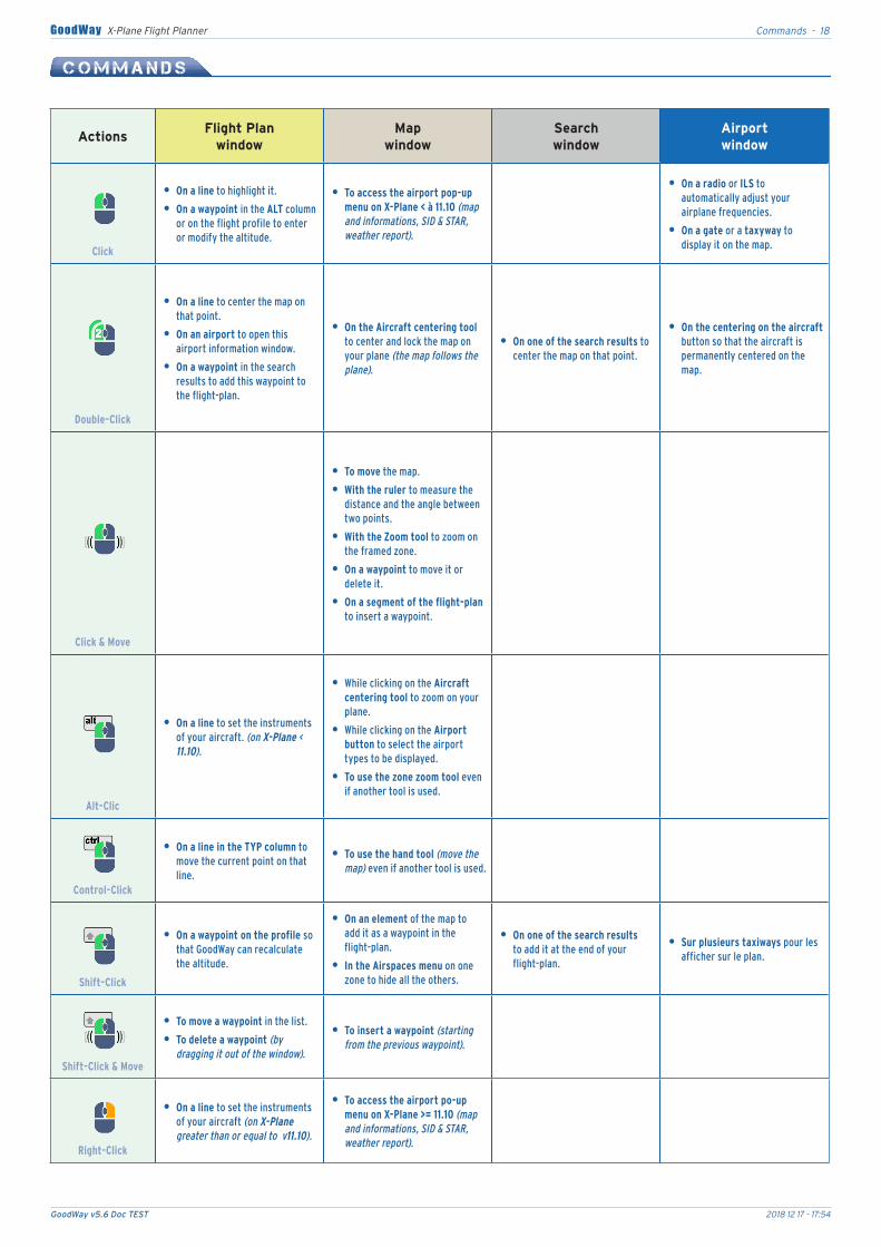
Click
•• On•a•line to highlight it.
•• On•a•waypoint in the ALT column or on the flight profile to enter or modify the altitude.
•• To•access•the•airport•pop-up•menu•on•X-Plane•<•à•11.10 (map and informations, SID & STAR, weather report).
•• On•a•radio or ILS to automatically adjust your airplane frequencies.
•• On•a•gate•or a taxyway to display it on the map.
Double-Click
•• On•a•line to center the map on that point.
•• On•an•airport to open this airport information window.
•• On•a•waypoint in the search results to add this waypoint to the flight-plan.
•• On•the•Aircraft•centering•tool to center and lock the map on your plane (the map follows the plane).
•• On•one•of•the•search•results to center the map on that point.
•• On•the•centering•on•the•aircraft•button so that the aircraft is permanently centered on the map.
Click•&•Move
•• To•move the map.
•• With•the•ruler•to measure the distance and the angle between two points.
•• With•the•Zoom•tool to zoom on the framed zone.
•• On•a•waypoint to move it or delete it.
•• On•a•segment•of•the•flight-plan•to insert a waypoint.
Alt-Clic
•• On•a•line to set the instruments of your aircraft. (on X-Plane < 11.10).
• While clicking on the•Aircraft•centering•tool•to zoom on your plane.
• While clicking on the•Airport•button to select the airport types to be displayed.
•• To•use•the•zone•zoom•tool even if another tool is used.
Control-Click
•• On•a•line•in•the•TYP•column to move the current point on that line.
•• To•use•the•hand•tool (move the map) even if another tool is used.
Shift-Click
•• On•a•waypoint•on•the•profile•so that GoodWay can recalculate the altitude.
•• On•an•element of the map to add it as a waypoint in the flight-plan.
•• In•the•Airspaces•menu on one zone to hide all the others.
•• On•one•of•the•search•results to add it at the end of your flight-plan.
•• Sur•plusieurs•taxiways•pour les afficher sur le plan.
Shift-Click•&•Move
•• To•move•a•waypoint in the list.
•• To•delete•a•waypoint (by dragging it out of the window).
•• To•insert•a•waypoint (starting from the previous waypoint).
Right-Click
•• On•a•line to set the instruments of your aircraft (on X-Plane greater than or equal to v11.10).
•• To•access•the•airport•po-up•menu•on•X-Plane•>=•11.10 (map and informations, SID & STAR, weather report).
GoodWay v5.6 Doc TEST 2018 12 17 - 17:54
Icons & Shortcuts - 19GoodWay X-Plane Flight Planner
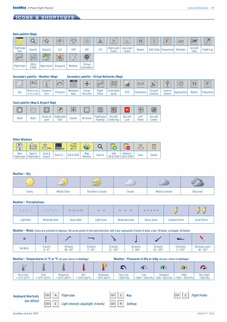
I c o n s & S h o r t c u t s
Flight-plan Map Flight Profile
Light intensity (day/night, 4 levels) Settings
Keyboard•Shortcuts(par défaut)
Weather•-•Sky
Main•palette•(Map)
Weather•-•Precipitations
Tools•palette•(Map•&•Airport•Map)
Other•Windows
Secondary•palette•-•Weather•(Map) Secondary•palette•-•Virtual•Networks•(Map)
Weather•-•Winds•(icons are oriented in degrees, the arrow points in the wind direction, half a bar represents 5 knots of wind, a bar: 10 knots, a triangle: 50 knots)
Weather•-•Temperatures•in•°C•or•°F•(at your choice in Settings) Weather•-•Pressures•in•hPa•or•inHg•(at your choice in Settings)
Flight-plan tool Search Airports ILS VOR ADF FIX High Level
routesLow Level
routes Names ICAO Code Frequencies Altitudes AircraftInfos Flight Log
Flight-plan SID & STARS Map choice Airspaces Weather Virtual
Controllers
Sky Wind (Ground, FL120, FL340)
Tempera-ture Pressure Networks
dataActive
AircraftsFlight-Plans
Controlled aeras ATIS Clearances Ground
ControlsControl Towers Approaches Names Frequencies
Hand Ruler Zoom on zone
Flight-plan Edit Zoome De-Zoom Flight-plan
FramingAircraft
CenteringAircraft
LockLeft
PanelAircraft Center
NewFlight-plan
Open aFlight-plan
Save & Export Send To ... SID & STAR Map
Window Search AddSID & STAR
RemoveSID & STAR Save Delete
Sunny Mostly Clear Variable or Cloudy Cloudy Mostly Covered Obscured
Light Rain Moderate Rain Heavy Rain Light Snow Moderate Snow Heavy Snow Isolated Storm Great Storm
No Wind 5 knotsN - 0°
10 knotsNE - 45°
15 knotsE - 90°
25 knotsSE - 135°
50 knotsS - 180°
70 knotsSO - 225°
125 knotsE - 270°
150 knots and +NE - 315°
Very Cold<= 0°C (32°F)
Cold<= 10°C (50°F)
Tempered<= 20°C (68°F)
Hot<= 30°C (86°F)
Heatwave> 30°C (86°F)
Very Low< 1000 hPa
Low> 1000 < 1010 hPa
Standard>1010 <1020 hPa
High> 1020 < 1030 hPa
Very High> 1030 hPa
GoodWay v5.6 Doc TEST 2018 12 17 - 17:54
MapBox - 20GoodWay X-Plane Flight Planner
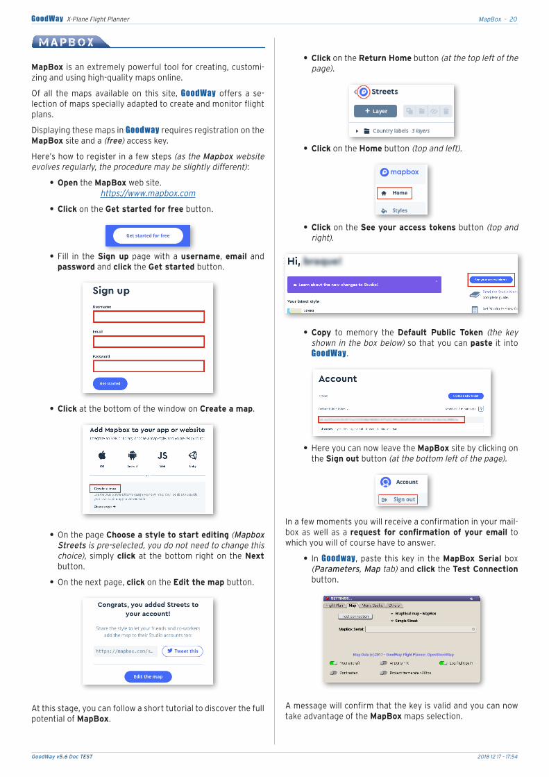
M a p B o x
MapBox. is.an.extremely.powerful.tool.for.creating,.customi-zing.and.using.high-quality.maps.online.
Of. all. the. maps. available. on. this. site,. GoodWay. offers. a. se-lection.of.maps.specially.adapted.to.create.and.monitor.flight.plans.
Displaying.these.maps.in.Goodway.requires.registration.on.the.MapBox.site.and.a.(free).access.key..
Here’s.how.to.register.in.a.few.steps.(as the Mapbox website evolves regularly, the procedure may be slightly different):
.• Open.the.MapBox.web.site.https://www.mapbox.com
.• Click.on.the.Get started for free button.
.• Fill. in. the. Sign up. page. with. a. username,. email. and.password.and.click.the.Get started button.
.• Click.at.the.bottom.of.the.window.on.Create a map.
.• On.the.page.Choose a style to start editing.(Mapbox Streets is pre-selected, you do not need to change this choice),. simply.click.at. the.bottom.right.on. the.Next.button.
.• On.the.next.page,.click.on.the.Edit the map button.
At.this.stage,.you.can.follow.a.short.tutorial.to.discover.the.full.potential.of.MapBox.
.• Click.on.the.Return Home.button.(at the top left of the page).
.• Click.on.the.Home.button.(top and left).
.• Click.on.the.See your access tokens.button.(top and right).
.• Copy. to. memory. the. Default Public Token. (the key shown in the box below) so.that.you.can.paste. it. into.GoodWay.
.• Here.you.can.now.leave.the.MapBox.site.by.clicking.on.the.Sign out.button.(at the bottom left of the page).
In.a.few.moments.you.will.receive.a.confirmation.in.your.mail-box.as.well.as.a.request for confirmation of your email. to.which.you.will.of.course.have.to.answer.
.• In. Goodway,.paste. this.key. in. the.MapBox Serial.box.(Parameters, Map tab).and.click.the.Test Connection.button.
A.message.will.confirm.that.the.key.is.valid.and.you.can.now.take.advantage.of.the.MapBox.maps.selection.