Embed Size (px)
Citation preview
TCP/ RLA/3101 ----------------------------------------------------------------------------------------------------------------
Assistance to Improve Local Agricultural Emergency Preparedness in Caribbean Countries Highly Prone to Hurricane Related Disasters
Good Practices for Hazard Risk Management in Agriculture
Summary Report Jamaica
April 2008
Submitted by:
The Food and Agriculture Organization of the United Nations
Good Practices for Hazard Risk Management in Agriculture - Summary Report Jamaica
ii
---------------------------------------------------------------------------------------------------------
Assistance to Improve Local Agricultural Emergency Preparedness in Caribbean Countries Highly Prone to Hurricane Related Disasters
Good Practices for Hazard Risk Management in Agriculture
Summary Report Jamaica
Prepared by:
Balfour Spence, Ph.D. Department of Geography and Geology
The University of West Indies, Mona Jamaica W.I.
in collaboration with the
Rural Agricultural Development Authority (RADA), Jamaica
_____________________________________________________________ Technical guidance: Disaster Risk Management Group, FAO, Rome
TCP/RLA/3101

Good Practices for Hazard Risk Management in Agriculture - Summary Report Jamaica
iii
The designations employed and the presentation of material in this publication do not imply the expression of any opinion whatsoever on the part of FAO concerning the legal status of any country, territory, city or area or of its authorities, or concerning the delimitation of its frontiers or boundaries. Opinions expressed in this publication are those of the authors and do not imply any opinion whatsoever on the part of FAO.
Good Practices for Hazard Risk Management in Agriculture - Summary Report Jamaica
i
EXECUTIVE SUMMARY
The vulnerability of the Caribbean region to hydro- meteorological hazards such as hurricanes, floods, drought, high magnitude rainfall and related hazards such landslides is underscored. The recurrent impacts of these events have wreaked havoc on environment, economy and society throughout the region. Although the contribution of agriculture to Caribbean regional GDP has steadily declined over the last two decades, this sector has remained a major employer of labour and as such a main player in the livelihood profile of the region. The extreme vulnerability of the agricultural sector to a variety of hazards/disaster has been a perpetual focus of hazard/disaster management and interventions in the Caribbean. Over the past decade, the FAO has regular responded to the relief/rehabilitation/reconstruction needs of the sector in the aftermath of hurricane-related disasters. While such response and rehabilitation interventions are important, the extent of devastation caused to the agricultural sector by the 2004-2005 hurricane seasons stresses the need to move from a reactive to a proactive mode in order to facilitate more long term and sustainable benefits form interventions. It is in recognition of the immense negative impact of the 2004 hurricane season on the agricultural landscape of the Caribbean region and in response to the urgent call for assistant from regional policy makers, that the Food and Agricultural Organization funded the regional project Assistance to improve local agricultural emergency preparedness in Caribbean countries highly prone to hydro-meteorological hazards/disasters. Jamaica, Haiti, Cuba and Grenada were among the worst affected countries by hurricane-related disasters during 2004-2005, hence the urgent need to emphasize preparedness as a mitigation strategy for the impacts of these events. While the aforementioned countries all have Disaster and Risk Management (DRM) frameworks that address preparedness and mitigation issues to different extent and involve a wide cross-section of stakeholders, there are weaknesses in linking long-term development planning within the agricultural sector with the realities and projections of recurrent natural hazards/disasters and improving preparedness and mitigation measures. Until relatively recently, DRM has followed the traditional path of emphasis at the national and regional levels with scant regard for community level needs. Over the last 5 years the Caribbean region has been experiencing a paradigm shift in this regard, with increased recognition of the importance and advantages of community-based disaster management planning. It is this approach to DRM, which was applied in the regional FAO project. The project was organized in two phases. The first evaluated the DRM framework as well as identified and documented good practices employed by Jamaican small farmers in mitigating the impacts of hydro-meteorological hazards in three pilot sites as well as in the broader agro-ecological environment. The second phase involved the implementation of good practices – in case of Jamaica the Hedgerow/alley cropping technique in a selected community. The implementation process was undertaken in collaboration with the Rural Agricultural Development Authority and involved the provision of technical training as well as material inputs to participating farmers while at the same time ensuring that the project outputs are sustainable. Over 90 farmers, school children and agricultural extension officers were trained in the implementation of the technique while over 60 farmers benefited form the provision of inputs. Sustainability of project outputs was integral to the implementation process and in that regard various measures were implemented to ensure expansion of the technique beyond the pilot site as well as ensure sustainability. A number of important lessons were learned from the good practice implementation process, the most significant of which related to the role of NGO’s in the implementation of community level projects. Lessons learned and recommendations arising from the project are discussed later in this report.

Good Practices for Hazard Risk Management in Agriculture - Summary Report Jamaica
ii
CONTENTS
EXECUTIVE SUMMARY.................................................................................................................... i
CONTENTS........................................................................................................................................... ii
LIST OF TABLES ............................................................................................................................... iv
LIST OF FIGURES ............................................................................................................................. iv
1 INTRODUCTION.............................................................................................................................. 1
1.1 Project Goal and Objectives and Outputs ............................................................................................. 2
1.2 Implementation Strategy .......................................................................................................................... 3
1.3 National Context of Project Implementation - Jamaica ...................................................................... 3
1.3.1 Geographical Location ................................................................................................................... 3
1.3.2 Importance and Structure of Agricultural Economy .................................................................. 4
1.3.3 Recent Hydro-meteorological hazard-related damage to Agriculture .................................... 5
1.3.4 Post Ivan Agriculture Sector Needs .............................................................................................. 7
2 METHODOLOGICAL APPROACH .............................................................................................. 7
2.1 Establishment of Jamaica National Team and Implementation Arrangements ............................... 8
2.2 Composition of National Team ............................................................................................................... 8
2.3 Data Collection ......................................................................................................................................... 8
3 NATIONAL AND LOCAL DRM INSTITUTIONAL FRAMEWORKS AND RESPONSES TO RECENT HYDRO-METEOROLOGICAL HAZARDS ............................................................ 9
3.1 National Disaster Plan ............................................................................................................................. 9
3.1.1 Aim of the National Disaster Plan ................................................................................................ 9
3.1.2 Organizational Structure ................................................................................................................ 9
3.2 National Hazard Mitigation Policy ...................................................................................................... 11
3.3 Linkage between DRM framework and Agricultural Sector Institutions and Services ................. 12
3.4 Strength, Weaknesses and Challenges of the DRM Framework in Relation to the Agricultural
Sector...........................................................................................................................................13
3.4.1 Relevance Pilot Sites Analysis to DRM Framework ...................................................................... 13
4 PILOT SITES ................................................................................................................................... 14
4.1 Criteria for Selection of Pilot Sites....................................................................................................... 14
4.2 Lower Rio Grande Valley ...................................................................................................................... 14
4.2.1 Site Description.............................................................................................................................. 15
4.2.2 Socio-economic Profile................................................................................................................. 16
4.2.3 Hazard/Disaster Vulnerability Context ...................................................................................... 17
4.2.4 Risk Perceptions and Disaster Risk Management .................................................................... 21

Good Practices for Hazard Risk Management in Agriculture - Summary Report Jamaica
iii
4.2.5 Disaster prevention and mitigation............................................................................................. 21
4.2.6 Preparedness and post disaster management............................................................................ 23
4.2.7 Replicability of DRM Issues........................................................................................................ 24
4.3 Southfield.................................................................................................................................................. 24
4.3.1 Site Description.............................................................................................................................. 24
4.3.2 Socio-economic Profile................................................................................................................. 25
4.3.3 Hazard/Disaster Vulnerability Context ...................................................................................... 25
4.3.4 Risk Perceptions and Disaster Risk Management .................................................................... 26
4.4 Tethford .................................................................................................................................................... 26
4.4.1 Site Description.............................................................................................................................. 26
4.4.2 Socio-economic Profile................................................................................................................. 27
4.4.3 Hazard/Disaster Vulnerability Context ...................................................................................... 28
4.4.4 Risk Perceptions and Disaster Risk Management .................................................................... 28
5 GOOD PRACTICES IDENTIFIED DURING FIELD SURVEY ............................................... 29
6 NATIONAL LEARNING EXCHANGE WORKSHOP................................................................ 37
7 PROMOTION AND REPLICATION OF DRM GOOD PRACTICES IN PILOT COMMUNITY .................................................................................................................................... 43
7.1 Project implementation approach in Jamaica .................................................................................... 43
7.2 Expansion of the Hedgerow/Alley Cropping Technique in Southern Trelawny............................. 44
7.3 Description of project interventions ..................................................................................................... 45
7.4 Project implementation process ............................................................................................................ 47
8 LESSONS LEARNED AND RECOMMENDATIONS................................................................ 51
9 REFERENCES ................................................................................................................................. 53
APPENDIX 1 ....................................................................................................................................... 54

Good Practices for Hazard Risk Management in Agriculture - Summary Report Jamaica
iv
LIST OF TABLES
Table 1: Selected Demographic and Economic Variables and Hurricane impacts in CARICOM States,
1973-2003. Damages indicated in US dollars ............................................................................ 1
Table 2: Jamaica: Damage and Losses to Agricultural Sector from Hurricane Ivan (J$ Million) ............ 5
Table 3: Farm Size Distribution in Windsor Extension Area ................................................................. 16
Table 4: Age Distribution of in Lower Rio Grande................................................................................ 16
Table 5: Poverty Incidence in Portland, 1992, 1998 and 2002 ............................................................... 17
Table 6: Mean Monthly Rainfall (mm) for Selected Locations in the Rio Grande Valley 1951-1989... 18
Table 7: Change in Selected Land-Uses in the Rio Grande Valley, 1986- 1998.................................... 19
Table 8: Sub-sector Breakdown of Flood an Landslide Disaster Losses to Agriculture in the Rio Grande
Valley, 1998 ............................................................................................................................. 20
Table 9: Percentage Distribution of Flood Experiences of Residents in the Lower Rio Grande ............ 20
Table 10: Percentage Distribution of Flood Loss/Damage ....................................................................... 20
Table 11: Hazard Impact Reduction Utility of Non-Cultivated Plants ..................................................... 22
Table 12: Percentage Reliance on Official Flood Warnings..................................................................... 23
Table 13: Stage of Obedience to Flood Warnings .................................................................................... 24
Table 14: Reasons for not Obeying Evacuation Orders............................................................................ 24
Table 15: Farm Size Distribution in the Southfield Extension ................................................................. 25
Table 16: Poverty Incidence in St Elizabeth, 1992, 1998 and 2002 ......................................................... 25
Table 17: Poverty Incidence in St Catherine, 1992, 1998 and 2002......................................................... 27
Table 18: Farm Size Distribution in the Southfield Extension ................................................................. 27
Table 19: Input Procurement and Distribution ......................................................................................... 48
Table 20: Beneficiaries from Hedgerow/Alley Training .......................................................................... 50
LIST OF FIGURES
Figure 1: Location Map of Jamaica ................................................................................................................ 4
Figure 2: Distribution of Major Communities Affected by Hurricane Ivan ................................................... 6
Figure 3: Organizational Summary of National Disaster Management Actors in Jamaica........................... 10
Figure 4: Location of the Lower Rio Grande Valley, Jamaica ..................................................................... 15
Figure 5: Active and Passive Use of Biodiversity to Mitigate Hazard Impact on a Flood and Landslide
Susceptible House Plot.................................................................................................................. 23
Good Practices for Hazard Risk Management in Agriculture - Summary Report Jamaica
1 INTRODUCTION
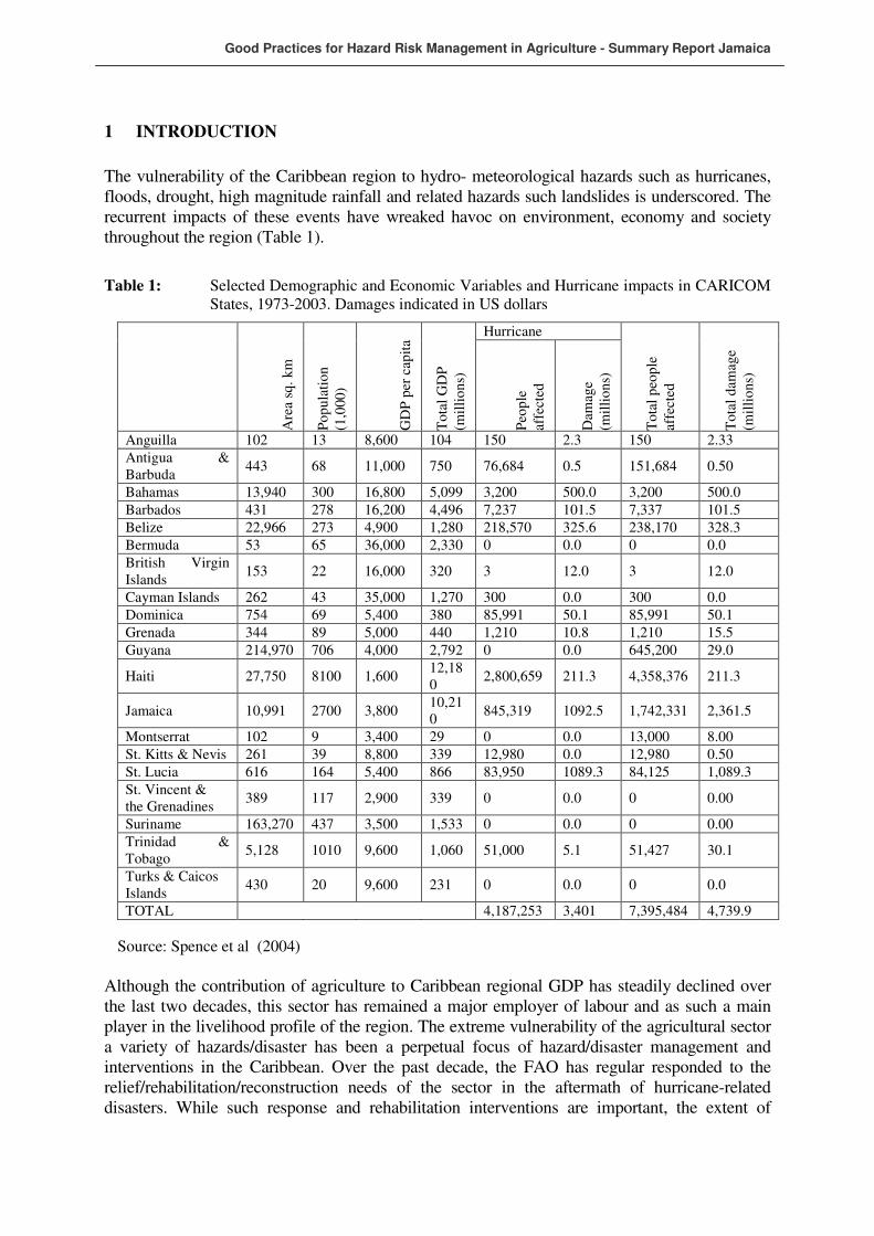
The vulnerability of the Caribbean region to hydro- meteorological hazards such as hurricanes, floods, drought, high magnitude rainfall and related hazards such landslides is underscored. The recurrent impacts of these events have wreaked havoc on environment, economy and society throughout the region (Table 1).
Table 1: Selected Demographic and Economic Variables and Hurricane impacts in CARICOM States, 1973-2003. Damages indicated in US dollars
Hurricane
Are
a sq
. k
m
Po
pu
lati
on
(1
,000
)
GD
P p
er c
apit
a
To
tal
GD
P
(mil
lio
ns)
Peo
ple
af
fect
ed
Dam
age
(mil
lio
ns)
To
tal
peo
ple
affe
cted
To
tal
dam
age
(mil
lio
ns)
Anguilla 102 13 8,600 104 150 2.3 150 2.33
Antigua & Barbuda
443 68 11,000 750 76,684 0.5 151,684 0.50
Bahamas 13,940 300 16,800 5,099 3,200 500.0 3,200 500.0
Barbados 431 278 16,200 4,496 7,237 101.5 7,337 101.5
Belize 22,966 273 4,900 1,280 218,570 325.6 238,170 328.3
Bermuda 53 65 36,000 2,330 0 0.0 0 0.0
British Virgin Islands
153 22 16,000 320 3 12.0 3 12.0
Cayman Islands 262 43 35,000 1,270 300 0.0 300 0.0
Dominica 754 69 5,400 380 85,991 50.1 85,991 50.1
Grenada 344 89 5,000 440 1,210 10.8 1,210 15.5
Guyana 214,970 706 4,000 2,792 0 0.0 645,200 29.0
Haiti 27,750 8100 1,600 12,180
2,800,659 211.3 4,358,376 211.3
Jamaica 10,991 2700 3,800 10,210
845,319 1092.5 1,742,331 2,361.5
Montserrat 102 9 3,400 29 0 0.0 13,000 8.00
St. Kitts & Nevis 261 39 8,800 339 12,980 0.0 12,980 0.50
St. Lucia 616 164 5,400 866 83,950 1089.3 84,125 1,089.3
St. Vincent & the Grenadines
389 117 2,900 339 0 0.0 0 0.00
Suriname 163,270 437 3,500 1,533 0 0.0 0 0.00
Trinidad & Tobago
5,128 1010 9,600 1,060 51,000 5.1 51,427 30.1
Turks & Caicos Islands
430 20 9,600 231 0 0.0 0 0.0
TOTAL 4,187,253 3,401 7,395,484 4,739.9
Source: Spence et al (2004)
Although the contribution of agriculture to Caribbean regional GDP has steadily declined over the last two decades, this sector has remained a major employer of labour and as such a main player in the livelihood profile of the region. The extreme vulnerability of the agricultural sector a variety of hazards/disaster has been a perpetual focus of hazard/disaster management and interventions in the Caribbean. Over the past decade, the FAO has regular responded to the relief/rehabilitation/reconstruction needs of the sector in the aftermath of hurricane-related disasters. While such response and rehabilitation interventions are important, the extent of
Good Practices for Hazard Risk Management in Agriculture - Summary Report Jamaica
2
devastation caused to the agricultural sector by the 2004-2005 hurricane seasons stresses the need to move from a reactive to a proactive mode in order to facilitate more long term and sustainable benefits form interventions. Jamaica, Haiti, Cuba and Grenada were among the worst affected countries by hurricane-related disasters during 2004-2005, hence the urgent need to emphasize preparedness as a mitigation strategy for the impacts of these events. While the aforementioned countries all have Disaster and Risk Management (DRM) frameworks that address preparedness and mitigation issues to different extent and involve a wide cross-section of stakeholders, there are weaknesses in linking long-term development planning within the agricultural sector with the realities and projections of recurrent natural hazards/disasters and improving preparedness and mitigation measures. Until relatively recently, DRM has followed the traditional path of emphasis at the national and regional levels with scant regard for community level needs. Over the last 5 years the Caribbean region has been experiencing a paradigm shift in this regard, with increased recognition of the importance and advantages of community-based disaster management planning. It is this approach to DRM which was advocated in the FAO project being implemented.
1.1 Project Goal and Objectives and Outputs
The goal of the project was to contribute to community based disaster management planning and community level risk management within the agricultural sector through:
i) Improvements in institutional frameworks and technical options for hurricane-related disaster preparedness.
ii) Emergency response and post-emergency agricultural assistance.
iii) Assessment of national and community level DRM institutional frameworks and actions and responses taken in relation to agriculture during recent hazard/disaster impacts.
iv) Identification, demonstration and potential for replication of community adapted “good practices, technologies and strategies” response, preparedness and mitigation in the agricultural sector.
v) Contributions to the improvement of disaster preparedness and contingency action plans focussing on aspects of agriculture, and; development of policy recommendations to improve post-emergency input delivery interventions and agricultural rehabilitation programs.
The project had three target-audience specific expected outputs (EO):
i) EO1: Local communities/small scale farmers: identification, demonstration of and replication of locally adapted god practices for response preparedness and assessment of demand responsive training related to innovative preparedness activities.
ii) EO2: Local Government Departments: inputs to local action plans for timely, efficient and demand responsive emergency operations to minimize adverse effects of hurricane-related disasters on the agricultural sector and integration of agricultural issues into local contingency planning.
iii) EO3: Government and relevant ministries (rural and agricultural ministries) and international community: recommendations and best practice examples to enhance national and local preparedness in national and international post emergency agricultural rehabilitation programs.

Good Practices for Hazard Risk Management in Agriculture - Summary Report Jamaica
3
1.2 Implementation Strategy
The project adopted an iterative, participatory implementation process to identify and compare lessons learned and good practice examples of disaster preparedness for emergency response and preparedness in the agricultural (including livestock) sector with special emphasis on the local institution and farm levels. Thereafter, this information was valuated in order to promote replication in selected pilot sites of techniques which would add value to existing systems. Key recommendations for improving agricultural disaster preparedness aspects of the national/local DRM systems in place, and for the impacts of preparedness activities (or the lack of them) on immediate emergency relief and rehabilitation operations, were analyzed and shared at regional level. Close collaboration with government DRM programmes and other agriculture and livelihood development work was established at the onset of the project in each country to avoid possible duplications and establish a platform for mutual learning and action. Operational linkages were also established with FAO Emergency Coordinators and other FAO development projects in the region. Preliminary findings were discussed during national data consolidation workshops, followed thereafter by a regional technical workshop between National Project Coordinators and selected key representatives of the participating countries. The objective of the workshops was to compare good practice examples of risk preparedness and immediate emergency response in agriculture and identify the most successful for broader replication. During its second half, the project focused on fine-tuning and adapting good practice examples on a pilot basis in selected sites of the participating countries. The project promoted partnerships at local government level, supported the replication of good practices and established farmer’s review groups to monitor and evaluate the impact of the adapted/introduced mechanisms and good practice techniques. The project developed a strategy to carry on beyond project termination the pilot testing. In October 2007 representatives from local government and civil societies from Cuba, Grenada, Haiti and Jamaica and other CARICOM countries were invited to share lessons learned, good practices and recommendations at a regional synthesis workshop. Representatives from the international community currently working on hurricane disaster relief and preparedness in the region were also invited. Workshop findings and recommendations have been documented in a separate report.
1.3 National Context of Project Implementation - Jamaica
The national context of the project implementation relates to the geographical location of Jamaica in relation to hydro-meteorological hazards such as hurricanes, floods and drought, the dualistic structure of the agricultural economy which results in extreme vulnerability of most farmers and the social and economic impact of recent hydro-meteorological hazards that undermine attempts towards sustainable development.
1.3.1 Geographical Location
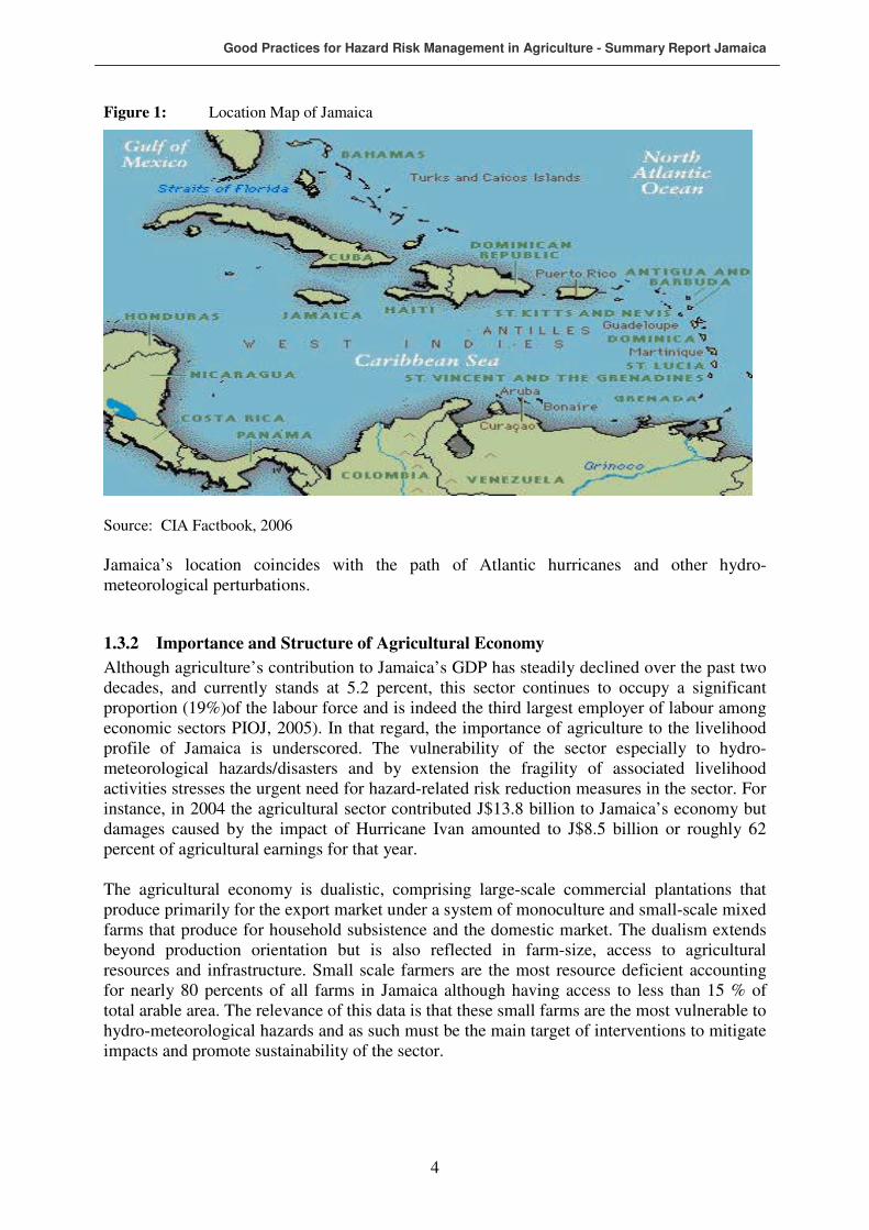
Jamaica is located in the Greater Antilles, approximately 145 kilometres south of Cuba and 161 kilometres west of Haiti. It is the third largest island in the Caribbean chain, with a total area of 10,938 km2. The island is 236 kilometres long and 82 kilometres at its widest extremity (see Figure 1).
Good Practices for Hazard Risk Management in Agriculture - Summary Report Jamaica
4
Figure 1: Location Map of Jamaica
Source: CIA Factbook, 2006
Jamaica’s location coincides with the path of Atlantic hurricanes and other hydro-meteorological perturbations.
1.3.2 Importance and Structure of Agricultural Economy
Although agriculture’s contribution to Jamaica’s GDP has steadily declined over the past two decades, and currently stands at 5.2 percent, this sector continues to occupy a significant proportion (19%)of the labour force and is indeed the third largest employer of labour among economic sectors PIOJ, 2005). In that regard, the importance of agriculture to the livelihood profile of Jamaica is underscored. The vulnerability of the sector especially to hydro-meteorological hazards/disasters and by extension the fragility of associated livelihood activities stresses the urgent need for hazard-related risk reduction measures in the sector. For instance, in 2004 the agricultural sector contributed J$13.8 billion to Jamaica’s economy but damages caused by the impact of Hurricane Ivan amounted to J$8.5 billion or roughly 62 percent of agricultural earnings for that year. The agricultural economy is dualistic, comprising large-scale commercial plantations that produce primarily for the export market under a system of monoculture and small-scale mixed farms that produce for household subsistence and the domestic market. The dualism extends beyond production orientation but is also reflected in farm-size, access to agricultural resources and infrastructure. Small scale farmers are the most resource deficient accounting for nearly 80 percents of all farms in Jamaica although having access to less than 15 % of total arable area. The relevance of this data is that these small farms are the most vulnerable to hydro-meteorological hazards and as such must be the main target of interventions to mitigate impacts and promote sustainability of the sector.

Good Practices for Hazard Risk Management in Agriculture - Summary Report Jamaica
5
1.3.3 Recent Hydro-meteorological hazard-related damage to Agriculture
Over the past few years Jamaica’s agricultural sector has suffered billions of dollars in damage and loss earnings resulting from the impact of hydro-meteorological hazards. In the 30-year period 1973-2003 the sector suffered losses to the tune of $2,361.5 million (PIOJ, 2004). At the launch of this project in April 2006, the Minister of Agriculture announced that the agricultural sector suffered more than $6 billion in damage from Hurricane Ivan in 2004 and a further $196 million in 2005 from Hurricanes Dennis and Emily. This of course is in addition to losses suffered from droughts and related bush fires. ECLAC (2004) assessment in the aftermath of Hurricane Ivan indicated that agriculture production and infrastructure/assets were extensively destroyed by wind and flooding during the hurricane (Table 2).
Table 2: Jamaica: Damage and Losses to Agricultural Sector from Hurricane Ivan (J$ Million)
Total loss to the sector was estimated at $ 8,550.0 million, approximately $ 3 407.0 were the cost of direct damages. In the domestic agriculture sub-sector, the Ministry of Agriculture
Good Practices for Hazard Risk Management in Agriculture - Summary Report Jamaica
6
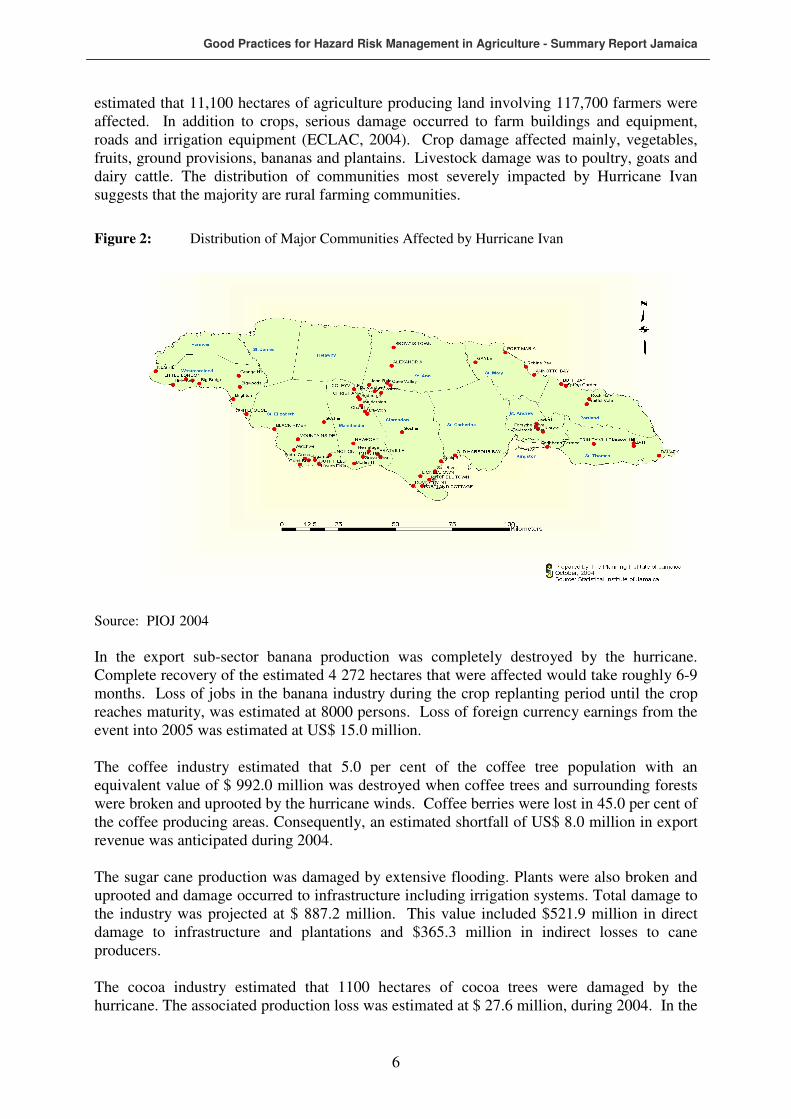
estimated that 11,100 hectares of agriculture producing land involving 117,700 farmers were affected. In addition to crops, serious damage occurred to farm buildings and equipment, roads and irrigation equipment (ECLAC, 2004). Crop damage affected mainly, vegetables, fruits, ground provisions, bananas and plantains. Livestock damage was to poultry, goats and dairy cattle. The distribution of communities most severely impacted by Hurricane Ivan suggests that the majority are rural farming communities.
Figure 2: Distribution of Major Communities Affected by Hurricane Ivan
Source: PIOJ 2004
In the export sub-sector banana production was completely destroyed by the hurricane. Complete recovery of the estimated 4 272 hectares that were affected would take roughly 6-9 months. Loss of jobs in the banana industry during the crop replanting period until the crop reaches maturity, was estimated at 8000 persons. Loss of foreign currency earnings from the event into 2005 was estimated at US$ 15.0 million. The coffee industry estimated that 5.0 per cent of the coffee tree population with an equivalent value of $ 992.0 million was destroyed when coffee trees and surrounding forests were broken and uprooted by the hurricane winds. Coffee berries were lost in 45.0 per cent of the coffee producing areas. Consequently, an estimated shortfall of US$ 8.0 million in export revenue was anticipated during 2004. The sugar cane production was damaged by extensive flooding. Plants were also broken and uprooted and damage occurred to infrastructure including irrigation systems. Total damage to the industry was projected at $ 887.2 million. This value included $521.9 million in direct damage to infrastructure and plantations and $365.3 million in indirect losses to cane producers. The cocoa industry estimated that 1100 hectares of cocoa trees were damaged by the hurricane. The associated production loss was estimated at $ 27.6 million, during 2004. In the

Good Practices for Hazard Risk Management in Agriculture - Summary Report Jamaica
7
case of Pimento losses were estimated at $351.0 million. Direct damage was estimated at $ 209.0 million while loss to future production was projected at $142.0 million. For citrus production losses were estimated at $ 325.0 million, and represented loss of fruits in varying stages of maturity.
1.3.4 Post Ivan Agriculture Sector Needs
The needs of the agricultural sector in the aftermath of Hurricane Ivan have been identified by the ECLAC assessment as those required in the short-term rehabilitation and long term reconstruction phases. In the short-term the identified needs of the sector focussed on normalizing the livelihood of affected farmers while continuing reactivation of economic activities in affected areas. In that regard some of the identified needs are not specific to agriculture but target all affected areas. Needs that are specific to the agricultural sector include:
• Provisional repair of farm access roads.
• Supply of seeds and basic inputs to small and medium-scale farmers along with soft loans and other financial support.
• Repair of farm infrastructure.
In the more long-term reconstruction phase the objective is to fully re-establish livelihood activities in the sector and as such focuses on projects that will:
• Increase resilience and reduce vulnerability in the agricultural sector.
• Overcome direct and indirect losses resulting from the impact of the hurricane.
• Increasing mitigation against the reoccurrence of the event.
The project being implemented by the FAO addresses these long-term reconstruction needs of the agricultural sector.
2 METHODOLOGICAL APPROACH
The methodological approach in the initial phase of the project implementation in Jamaica followed a number of steps:
i) Sensitization of national stakeholders and establishment of a project implementation team.
ii) Development of criteria for and selection of pilot sites.
iii) Field visits and data collection at pilot sites.
iv) Analysis of the existing Disaster Risk Management framework to ascertain the interface between the agricultural sector and the DRM framework.
v) Analysis of potential contribution of the project to strengthening the DRM framework in the agricultural sector.
vi) Presentation of findings at National and Regional workshops.
Good Practices for Hazard Risk Management in Agriculture - Summary Report Jamaica
8
2.1 Establishment of Jamaica National Team and Implementation Arrangements
The preparatory phase of the project in Jamaica began with sensitization meetings between the Regional Coordinator, the National Consultant, the Permanent Secretary (PS) at the Ministry of Agriculture and Lands, the Executive Director of the Rural Agricultural Development Agency (RADA), the Deputy Executive Director of RADA, and the Director of Projects at RADA. These meetings served to apprise relevant central government stakeholders of the project goals and implementation strategy. Since RADA’s portfolio spans central as well as local government activities, this organization was designated by the PS in the Ministry of Agriculture and Lands to spearhead the project on behalf of the Government of Jamaica. The Director of Projects was designated by RADA as the National Coordinator and along with the executive of RADA, the Regional Coordinator, and the National Consultant, developed criteria for selection of Pilot Sites. Once pilot sites were agreed upon by RADA, the national team was expanded to include stakeholders in the locale of the pilot sites.
2.2 Composition of National Team
The Jamaica national team is comprised of:
i) Regional Coordinator for the Project.
ii) National Consultant.
iii) National Coordinator.
iv) Three (3) RADA Parish Managers (1 from each pilot site).
v) Three (3) RADA Extension Area Officers (1 each from the Extension Area in which the pilot sites fall).
Following the National Workshop a number of stakeholders from pilot sites have been incorporated into the implementation team.
2.3 Data Collection
Data collection was conducted through a combination of desktop research and field interaction at pilot sites. Secondary data related to hydro-meteorological hazard impacts as well as the DRM framework were obtained through desktop research using material from the Planning Institute of Jamaica (PIOJ), the Office of Disaster Preparedness and Emergency Management (ODPEM) and the Ministry of Agriculture. Primary data collection related to the pilot sites was undertaken through focus group meetings and farm visits at the three pilot sites. These interactions were organized through the National Co-ordinator for this project within RADA and the relevant RADA Parish Managers and Extension Area Officers. Participants in these meetings were primarily agricultural stakeholders. The National Workshop also provided a forum for information sharing. Analysis of the existing Disaster Risk Management framework was undertaken in order to ascertain the interface between the agricultural sector and the DRM framework as well as to establish the potential contributions of the project to overall DRM framework and that of the agricultural sector in particular.
Good Practices for Hazard Risk Management in Agriculture - Summary Report Jamaica
9
3 NATIONAL AND LOCAL DRM INSTITUTIONAL FRAMEWORKS AND RESPONSES TO RECENT HYDRO-METEOROLOGICAL HAZARDS
The Office of Disaster Preparedness and Emergency Management (ODPEM), which fall under the Ministry of Local Government and Environment is the national focal point responsible for disaster management and the implementation of disaster policy in Jamaica. The ODPEM works in conjunction with the National Disaster Committee (NDC). There are also various working committees, including those on public education, health, finance and disaster relief. At the local level, there is a disaster management system, which relies heavily on the local planning authorities. Parish Disaster Committees (PDCs), supported by a Parish Disaster Co-ordinator, are located within each of the Parish Councils. These PDCs are further grouped into regions, with a Regional Co-ordinator assigned for the Northern, Southern, Eastern and the Western Regions of the island. The role of the regional coordinators is to act as Parish Liaison Officers for the ODPEM. The Meteorological Services Division, also under the MLE, has the national responsibility to issue warnings and watches for hydro-meteorological hazards, including droughts, during the preparedness stage of a disaster. The mandate of the ODPEM is structured within the context of a National Disaster Plan, hazard- specific sub-plans and more recently, a National Hazard Mitigation Policy.
3.1 National Disaster Plan
3.1.1 Aim of the National Disaster Plan
The overall aim of the National Disaster Plan is to detail arrangements to cope with the effects of natural and/or man-made disasters occurring in Jamaica. It seeks to assign responsibilities and to provide coordination of emergency activities connected with major disasters, in general and specific ways. It also encourages a process of learning to adequately cope with the recovery from a disaster, from both local and other experiences. The plan therefore addresses the short and long term objectives of the National Emergency Organization (NEO), and will be subject to continuous scrutiny, review and upgrading as deemed necessary, based on operating and other experiences. As such, it will be continuously strengthened and expanded in its scope, content, membership composition, administrative and policy guidelines, rescue, relief and recovery procedures, and in regional and international relationships with similar organizations (Ministry of Environment, 2005).
3.1.2 Organizational Structure
The organizational structure of DRM in Jamaica comprises:
a) The National Disaster Committee (NDC).
b) The National Disaster Executive (NDE) and its committees.
• Health. • Emergency Operations, Transport and Communications. • Public Information and Education. • Administration and Finance. • Welfare and Shelter/Relief Clearance. • Damage Assessment, Recovery and Rehabilitation.

Good Practices for Hazard Risk Management in Agriculture - Summary Report Jamaica
10
c) The Office of Disaster Preparedness and Emergency Management (ODPEM).
d) National Emergency Operations Centre (NEOC).
e) Regional Disaster Coordinators.
f) Regional Emergency Operations Centres (REOC’s).
g) Parish Disaster Committees (PDC’s).
h) Parish Disaster Executives (PDE’s).
i) Parish Emergency Operations Centres (PEOC’s).
j) Zonal Committees.
k) Government Organizations, Agencies and Individuals (GO's).
l) Non-Governmental Organizations and Agencies (NGO's).
m) Private Voluntary Organizations (PVO's).
n) Volunteers.
o) Regional and International Agencies.
Figure 3: Organizational Summary of National Disaster Management Actors in Jamaica
Public Information
Emergency operations
National Disaster Council
National Disaster
Executive
Parish Disaster
Committees
Regional Coordinators
Health Committee
Parish Disaster Executive
Welfare, Shelter & Clearance
NGOs Office of Disaster Preparedness &
Emergency Management
Admin. &
Finance
Damage Assessment
PVOs

Good Practices for Hazard Risk Management in Agriculture - Summary Report Jamaica
3.2 National Hazard Mitigation Policy
The national policy on hazard mitigation provides a framework for integrating hazard mitigation into all policies, programmes and plans at national and community levels. It sets out the broad goals and guiding principles for hazard risk reduction, and thus informs the development of national hazard mitigation plans. Jamaica’s vulnerability to multiple natural and human-induced hazards and their repeated impact on the social and economic fabric of the society are challenges to the attainment of sustainable development. These challenges are further compounded by social issues such as poverty, the location of human settlements in high-risk areas, environmental degradation and instances of poorly constructed infrastructure and housing. In a globally changing economic environment, Jamaica’s ability to mobilize external disaster assistance will be diminished as international aid organizations and development partners impose more stringent criteria for assistance owing to increasing cost associated with disaster impacts globally. It is within this context that hazard mitigation is being promoted as a priority in Jamaica’s policy agenda. There is increasing recognition that hazard mitigation, through the implementation of risk-reduction measures can play a significant role in sustainable development. In that regard, it is timely that Jamaica has now articulating a Policy that reflects national desire to factor hazard mitigation into the overall development framework. The vision of the policy is to have a society in which hazard mitigation has evolved to become a part of everyday life. This vision is predicated on the recognition that a community-based approach must be the focus of any intervention. This Policy therefore promotes the active participation and partnership of communities, governmental and non-governmental organizations, the private sector and development partners, in the conceptualization, design and implementation of hazard mitigation measures. It also provides the basic guidelines for realization of the benefits of hazard mitigation to the achievement of sustainable development. The main purpose of the policy is the provision of a framework for the integration of hazard mitigation into all policies, programs and plans at all levels of society. As such the policy promotes the institutionalization of hazard-risk reduction measures that leads ultimately to the process of hazard-impact mitigation. Since hazard mitigation is not an end within itself, the policy is grounded in the belief that the mainstreaming of hazard-mitigation measures must be an integral part of the sustainable development process, and as such, its primary goal is to facilitate the attainment of Jamaica’s sustainable development objectives through minimization of physical, economic and social dislocations caused by hazards and disasters. The scope of the policy involves the application of structural and non-structural mitigation measures by the society in general and communities in particular, to lessen the adverse effects of natural and human-induced hazards. Specifically, these measures incorporate disaster prevention, preparedness, emergency response and rehabilitation and reconstruction. Within the context of its institutional and legislative framework, the implementation of the Policy will be spearheaded by ODPEM, but with the recognition that there are currently a number of institutional mandates whose frameworks support the objectives of hazard mitigation. The primary goals are therefore acceleration of sustainable development and minimization of physical, economic and social dislocations through the implementation of hazard mitigation strategies. In that regard the main objective is to provide of an integrated

Good Practices for Hazard Risk Management in Agriculture - Summary Report Jamaica
12
legislative, regulatory and institutional framework that will support hazard mitigation at all levels of society. Achievement of this objective is hinged on the promotion of collaboration among all stakeholders towards the achievement of reduced hazard impacts. The policy is grounded in the key guiding principles of accountability among institutional and community stakeholders, equity of access to resources, partnership inclusiveness and participation of all stakeholders. Strategies for achieving the goals of the Policy will focus on the engagement of communities, the building of relevant institutions and capabilities to reduce vulnerability, expansion of hazard/disaster information base, the harnessing of local knowledge and experiences and the engagement of the scientific community. The effectiveness of strategies will depend on the development of mechanisms for financing hazard mitigation. This policy document is intended to provide a broad framework for hazard mitigation. The design of strategies that are specific to different hazards to which Jamaica is vulnerable will for part of a separate document detailing the policy implementation plan. Priority areas for action include the integration of hazard mitigation into national policy and legislative/regulatory frameworks, sensitization, public education and outreach at all levels of society, initiation of long-term programmes of hazard-risk mapping and community-based disaster management planning. The primary challenge to the implementation of this policy is how to effectively create a culture of hazard mitigation at all levels of society. The immediate next step towards meeting the objectives of the policy is the development of a strategic implementation plan focusing on specific measures to be undertaken in the implementation of the Policy.
3.3 Linkage between DRM framework and Agricultural Sector Institutions and Services
In the absence of a specific disaster management plan for the agricultural sector, the linkage between the national disaster management framework and agricultural sector institutions and services is implicit and as such, hydro-meteorological hazard/disaster response in the agricultural sector has been largely reactive rather than proactive. It is in that context the launching of the FAOs hydro-meteorological preparedness project involving assistance to improve local agricultural emergency preparedness in Caribbean countries highly prone to hydro-meteorological disasters is timely and represent a paradigm shift in disaster management for the agricultural sector in Jamaica and the wider Caribbean. Indeed, at the signing ceremony for the launch of the project in April 2006, both the Minister of Agriculture and the FAO Country Representative in Jamaica concurred that the project represents a benchmark strategy for redirecting disaster-related assistance from recovery to assisting regional countries in implementing mitigating strategies to minimize the effects of natural disasters on agriculture. It is in that context that the Representative argues that “in the
past we have been responding to disasters, now we are building the capacity to prepare for
disasters so we do not lose as much or we would bounce back much faster,”. The development of a disaster management plan specific to the agricultural sector is currently on the work programme of the ODPEM.
Good Practices for Hazard Risk Management in Agriculture - Summary Report Jamaica
13
The agricultural sector disaster plan will build on the existing disaster functions of the Ministry of Agriculture and Lands. Currently, the emergency functions of the Ministry include:
• Response readiness.
• Damage assessment/Data gathering.
• Transportation.
• Public cleansing and disposal of dead animals.
• Rehabilitation.
• Assess agricultural damage and needs in association with the NEOC and damage survey team.
• In association with the NEOC, assist with the coordination of all counter measures needed to control or eradicate the outbreak of any exotic animal or plant disease.
• Organize relief measures, in association with the NEOC, for any situation which has a significant effect on animal welfare.
• Pre-emergency responsibilities include:
The command and direction of all counter measures needed to control or eradicate an outbreak of an exotic animal or plant disease, and the responsibility for organizing relief measures for any other emergency situation which has a significant effect on animal welfare.
3.4 Strength, Weaknesses and Challenges of the DRM Framework in Relation to the Agricultural Sector
In spite of the apparent comprehensiveness of the national DRM framework and its organizational pro-activeness in terms of mobilization of resources to reduce direct impact of hydro-meteorological hazards on the human population and some economic sectors, its effectiveness in relation to the agricultural sector is still largely reactive. That is, the undertaking of damage and needs assessment following impact, but with little consideration for mitigation and prevention within the sector. The few mitigation interventions that exist represent either the initiatives of farmers at the community level, based on their experiences and local knowledge and therefore fall outside the DRM framework, or piecemeal interventions by nationally and internationally sponsored projects. This project provides an opportunity for the mainstreaming of local disaster risk management initiatives through their identification and highlight of their applicability, implementation procedure and benefits. The challenge of this mainstreaming process will be in the reorientation of the mindset of disaster managers and agricultural planners to embrace an emerging paradigm that involves community level planning with a bottom up approach to risk reduction. The National Hazard Mitigation Policy strongly emphasizes a community approach to DRM and it is anticipated that due consideration of this approach will be embraced in the proposed disaster risk reduction plan for the agricultural sector. In essence therefore this project can represent an initial step in the framing of a community –level DRM framework that can inform a more comprehensive national framework for loss reduction in the agricultural sector thus enhancing the relevance of the existing framework.
3.4.1 Relevance Pilot Sites Analysis to DRM Framework
One of the criteria for the selection of pilot sites discussed in the next section of this report is evidence of good practices for the mitigation of hydro-meteorological hazards. The local initiatives for DRM as well as through interventions identified at the site are not integrated into the national DRM framework, primarily because the framework does not specifically address the agricultural sector. It is in that context that the analysis at the sites, especially the

Good Practices for Hazard Risk Management in Agriculture - Summary Report Jamaica
14
matrices of good practices developed in this report can provide the basis building capacity for loss reduction in the agricultural sector.
4 PILOT SITES
Description of the pilot sites focuses for the most part on the agro-physical and agro-social profiles as means of gauging the potential impact of the project intervention in those environments. The level of detail is not consistent for all sites, reflecting for the most part the availability of relevant data. For instance, in the Rio Grande Valley where a number of micro-level studies have been conducted the availability of relevant micro-data is much greater than for Tethford where baseline studies are largely non-existent.
4.1 Criteria for Selection of Pilot Sites
Criteria for the selection of pilot communities were established through consultation and discussions with RADA executives. RADA has overall responsibility for agricultural development in Jamaica and as such is appropriately poised to determine the suitability of communities for participation in the pilot phase of the project. The Agency recommended the following criteria for selection of pilot sites:
i) Diversity in crop emphasis of the pilot communities so as to represent as wide a cross section as possible of the agro-ecological zones and small-scale farming systems in Jamaica.
ii) Recurrent impacts and high levels of damaged sustained from hydro-meteorological hazards/disasters.
iii) Evidence of indigenous practices for mitigation of impacts from hydrological hazards/disasters.
On the basis of these criteria the following communities were selected as pilots for the project:
i) Lower Rio Grande Valley comprising the communities of Fellowship, Berridale, Toms Hope, Coopers Hill and Golden Vale in the parish of Portland. For the most part this site represents a high rainfall agro-ecological zone with steep slopes and is therefore representative of the interior farming systems of eastern Jamaica.
ii) Tetford in the parish of St Catherine, representing a flatland ecological zone characterized by moderate to low rainfall regime and is therefore typical of coastal plains of southern Jamaica.
iii) Southfield in the parish of St Elizabeth, a lowland agro-ecological zone characterized by rolling terrain and extreme moisture deficit. This site is therefore representative of many of the lowland coastal areas of southern Jamaica.
4.2 Lower Rio Grande Valley
The Rio Grande Valley is extremely susceptible to hydro-meteorological and related hazard and has experienced repeated devastation from hurricanes, floods and landslides. It has also been the focus of various interventions from national as well as international agencies to combat the impact of hazards. Crop emphasis of the region is somewhat mixed with export bananas featuring prominently and farmers have devised various strategies to combat the impact of hazards to which they are vulnerable.

Good Practices for Hazard Risk Management in Agriculture - Summary Report Jamaica
15
4.2.1 Site Description
The Lower Rio Grande Valley is located within the easterly parish of Portland and covers an area of 10.36 square kilometres. Total population is approximately 1023 people distributed among the five communities of: Fellowship, Toms Hope, Berridale, Goldenvale and Coopers Hill (Figure 4). Population density is 99 persons per square kilometre which in the context of rural Jamaica is fairly low. However, owing to the predominantly steep terrain, physiographic density is relatively high with fairly intensive cultivation of land (Thomas-Hope and Spence 2003).
Figure 4: Location of the Lower Rio Grande Valley, Jamaica
The Rio Grande watershed consist of steep, hilly terrain, with 75 percent of the area having elevations exceeding 1500 meters above sea level and more than 50 percent of the area having slopes in excess of 20 degrees. Geologically, the pilot site is comprised primarily of Cretaceous sedimentary rocks with subordinate volcanic and volcaniclastic deposits. These deposits are sporadically interrupted by white and yellow limestone outcrops. Permeability of the rocks is low, which, along their high swelling potential, makes them susceptible to landslides. Low permeability also contributes to high runoff potential, which increases the possibility of flooding (Mines and Geology Division, 2000). Soil types at the research site are dominated by clay and stony loams. These soils are moderate to well-drained. The site experiences a long wet season and receives an annual mean rainfall ranging from 3810 mm to over 5080 mm. Humidity is variable with elevation and ranges from 60 to 85 percent (NRCD, 1987). Frequent high-intensity rainfalls in conjunction with geology, topography and anthropogenic activities are major contributors to the vulnerability of the area to flood and landslide hazards. The physical characteristics of the site forms part of its natural resource base. Soil and rainfall characteristics support a range of agricultural activities including export banana production, coffee and mixed cropping. A high rainfall regime has resulted in one of the largest and most consistent river systems in Jamaica – the Rio Grande. The natural beauty and normally gentle

Good Practices for Hazard Risk Management in Agriculture - Summary Report Jamaica
16
flow of this river system has contributed to its eco-tourism potential and its utility as a major rafting site. Extensive deposit of sand during high magnitude flow has contributed to sand mining activities. Extensive forested areas support lumbering as well as montane ecotourism activities.
4.2.2 Socio-economic Profile
The pilot site is situated in the Windsor Extension Area which contains approximately 1583 farmers cultivating about 2,924 ha of land, giving a mean farm size of about 1.9 ha (table 3).
Table 3: Farm Size Distribution in Windsor Extension Area
Farm-size Category (ha.) Number of Farmers Area (ha.) % All Farms < 0.5 419 109.17 3.7 0.5 – 0.99 293 214.32 6.2 1.0 – 1.99 654 1,114.73 38.0 2.0 – 4.99 133 508.25 17.4 > 5.0 84 977 33.4 Total 1,583 2924.02 100.0
Source: Compiled from Rural Agricultural Development Agency database
Overall, forestry is the main land use throughout the Rio Grande Valley, covering an area of 19,657 ha. Cultivated crops for both export and domestic market cover an area of 2,072 ha. A further 944 ha are covered by pasture and 638 ha in settlements (Ferguson, 1998). The dominant agricultural activities include house gardens and orchards, consisting primarily of banana mono-culture and agro-forestry. The settlements are concentrated on the low land areas in proximity to the main river (Rio Grande) and its tributaries which increase their vulnerability to riverine flooding. Farms on the other hand are located on steep slopes that are susceptible to landslides and erosion (Thomas-Hope, Spence and Semple 1999). Most of the respondents at the pilot site are between 40 and 65 years (Table 4), with a mean age of 46 years. This, along with the fact that 10 percent of the residents are over 65 years indicates an aging trend at the site.
Table 4: Age Distribution of in Lower Rio Grande
Age Category Frequency % of Sample <40 31 34 40-65 50 56 >65 09 10 Total 90 100
At 3.5 persons, the average household size for the pilot site is similar to the national average. The age dependency of 88 dependents per 100 working age individuals is however greater than the national mean and is one of the highest for the country as a whole. Undoubtedly, the high age dependency has contributed to the area’s ranking among the highest incidence of poverty in Jamaica. Indeed, nearly one-third of the population of the parish in which the site is situated is classified as below the poverty level even though the prevailing conditions are an improvement on that of 1992 when over a half of the population was below the poverty line.

Good Practices for Hazard Risk Management in Agriculture - Summary Report Jamaica
17
Table 5: Poverty Incidence in Portland, 1992, 1998 and 2002
Year Poverty Incidence 1992 50.3 1998 18.3 2002 32.3
Source: Planning Institute of Jamaica/Statistical Institute of Jamaica, 2002
The overall picture that emerges is of a community that by the nature of its physical attributes (geology, topography, climate etc.) is vulnerable to flooding. This natural vulnerability is enhanced by the socio-economic vulnerability of the population characterised by low income levels and a significant proportion of the elderly. Farming is the primary livelihood activity at the pilot site employing most residents on a full or par-time basis. The small farms which are characteristic of the site are involved in the production of export bananas although high level of rejection in recent years is reorienting production towards the domestic market. Farmers typically cultivate fragmented plots, each dominated by a different type of crop, owing to variations in soil characteristics over short distances. Researchers involved in a United Nations University (UNU) biodiversity project – People, land Management and Environmental Change (PLEC) at the site have identified three main types of agricultural activities at the site:
i) Agro-forest. ii) Orchards. iii) House-gardens.
Typically, farmers own at least one of the fragments they cultivate but a variety of other tenure arrangements are in vogue. These include:
• Family land - a situation where the land is jointly owned by family members in the absence of a legal framework of inheritance.
• Lease/rental arrangements.
• Informal occupation of land (squatting) - illegal occupation of private or public lands.
• Caretaking. These tenure arrangements have different levels of land security and related capacity to access official assistance such as loans. In addition to farming, some residents are employed in the eco-tourism industry as raft captains of privately owned but Tourism Product Development Company (TPDCo) regulated bamboo rafts that transport visitors from the community of Berridale to the mouth of the Rio Grande. The parish of Portland has been a traditional recruitment site for the overseas hospitality market and some residents find seasonal employment in the overseas hospitality industry, including cruise ships.
4.2.3 Hazard/Disaster Vulnerability Context
In the context of disaster management, hazard vulnerability refers to the degree of loss to a given element or set of elements at risk resulting from the occurrence of a hazard of a given magnitude. In that regard the Rio Grande Valley is highly vulnerable to flood and landslide hazards. Both hazards are initiated by similar factors, namely high magnitude rainfall in conjunction with topographic and geological factors (Table 4). As such the onset of these

Good Practices for Hazard Risk Management in Agriculture - Summary Report Jamaica
18
hazards in the Rio Grande valley tends to be simultaneous and the impacts are felt in similar locations with similar level of frequency. The susceptibility of the area to these hazards is a function of characteristics of the physical environment as well as the nature of human use systems in relation to this physical environment. Relevant physical characteristics include a high rainfall regime (Table 6), prevalence of steep slopes and a geology dominated by Cretaceous Sedimentary rocks interspersed by White and Yellow Limestone and moderately drained Alluvium (Ferguson, 1998).
Table 6: Mean Monthly Rainfall (mm) for Selected Locations in the Rio Grande Valley 1951- 1989
Location Jan Feb Mar Apr May Jun Jul Aug Sep Oct Nov Dec Year
Millbank 617 381 356 498 486 534 466 497 468 622 810 800 6497
Pt. Antonio 235 143 112 173 347 362 294 277 320 413 414 301 3319
Fellowship 339 236 188 258 421 429 391 325 323 397 500 565 4424
Swift River 357 289 280 311 392 164 204 180 190 347 577 570 3923
Source: STATIN, 1990
In addition to these physical characteristics, human use systems involving rapid removal of vegetation and inappropriate land use on steep slopes have contributed to the magnitude and frequency of flood and landslide hazards. Flooding at the pilot site is normally riverine. Riverine flooding occurs where abnormally high stream flow results in the overflow of the natural or artificial banks of a stream (Water Resource Authority, 1996). Riverine flooding in the Rio Grande Valley is most frequently caused by high magnitude rainfall in conjunction with ground saturation and resultant low infiltration rates. Ground saturation and the rate of soil moisture infiltration are influenced not only by rainfall intensity and duration but also by the specific geology and topography of the Rio Grande watershed. . Much of the flooding is predictable in the sense that its occurrence is seasonal and is largely confined to the period from May to November. Landslide is a recurrent hazard and is related primarily to slope instability and subsequent failure. Geology of the Rio Grande Valley is a major factor in slope failure with most failures occurring on volcanic and shale rock slopes (ODPEM, 1998). Many such slope failures occur in association with geological faults and fractures with weaken rocks and make them susceptible to slope movement. Approximately 63 percent of the pilot site is categorized as having high to very high landslide risk. Except for a small part of the Toms Hope community which is classified as a low risk landslide area owing to relatively flat topography, the remainder of the site is categorized as having moderate landslide risk (Ministry of Mining and Energy, 2000). Low risk landslide areas have high susceptibility to riverine flooding. These areas also coincide with the prime export banana-growing sites at the Demonstration Site. With regard to geology, White Limestone, Yellow Limestone, Richmond Formation and Cretaceous Sedimentary Formation underlie much of the site. The Cretaceous Sedimentary Formation contains subordinate volcanic and volcaniclastic deposits with extremely low permeability. Low permeability results in high runoff potential and increases the susceptibility to flooding and landslides. The swelling capacity of this formation and associated clayey soils weakens slope stability and increases landslide potential. Like the Cretaceous

Good Practices for Hazard Risk Management in Agriculture - Summary Report Jamaica
19
Sedimentary Formation, the Richmond Formation is characterized by low permeability high runoff, low bearing capacity and swelling of associated clays, which facilitates flooding and landslide potential. White and Yellow Limestone are common geological formations in the Rio Grande Valley. Whereas the White Limestone tends to be well cemented, hard and competent, the Yellow Limestones are weakly cemented with low permeability and poor slope stability. Owing to the presence of clays the associated soils are subject to swelling, contributing to high landslide susceptibility. Karstic drainage patterns are well developed in the White Limestone group with characteristic sinkholes and depressions that feed underground drainage systems. The presence of depressions contributes to the hazard susceptibility of the site as accumulation of water in these depressions result in high flood risk. Agriculture is the primary economic activity in the Rio Grande Valley and although an estimated 80.4 percent of the watershed was forested in 1998 agriculture pressure especially for monoculture banana is increasing at an alarming rate (Table 7). The area utilized for all land-use activities except forest increased between 1986 and 1998, with overall increase amounting to about 8 percent (1866.9 ha.). This increase in land area utilized for human livelihood has come at the expense of the forested area which declined by about 847 hectares over the 12-year period. This pattern of land-use change has implications for flood and landslide susceptibility in the Rio Grande Valley because the removal of forest from steep slopes and disturbance of these slopes for cultivation increases rainfall run-off and reduces slope stability. Agricultural practices especially those related to monoculture banana serve to aggravate hazard impacts because the practice of removing undergrowth from banana fields allows more rapid water run-off. Besides agriculture, other human use systems contribute to hazard susceptibility in the Rio Grande Valley. The increasing population of the area has resulted in expansion of the built environment, especially for road and housing developments and the occupation of more vulnerable locations.
Table 7: Change in Selected Land-Uses in the Rio Grande Valley, 1986- 1998
Land-use Area (ha.) 1998
%Total Area 1998
Area (ha) 1986
%Total Area 1986
Area (ha.) 1986-1988
Built-up 637.8 2.6 n.a
Banana 569.0 2.3 338.0 1.5 231(68%)
Coconut mix 534.9 2.2 236.8 1.1 298.1(125%)
Food trees 396.5 1.6 n.a
Mixed Agriculture 563.9 2.3 486.6 2.2 77.1(16%)
Pasture 940.0 3.5 745.9 3.3 194.1(26%)
Grass 820.8 3.3 n.a
Forest 19656.0 81.0 20502.8 90.7 -846.8(-4%)
Water 285.7 1.2 281.6 1.2 4.1(1.5%)
Total 24408.6 100.0 22541.7 100.0 1866.9(8%)
Source: Compiled from ODPEM, 1998
In outlining factors influencing slope failure in the Rio Grande Valley during the 1998 flood and landslide disaster, Harris (1998) identifies the following:
Exposed road surfaces on hillside slopes. Excavated cuts on hillside slopes for housing construction. Sides of narrow gullies and rivers.

Good Practices for Hazard Risk Management in Agriculture - Summary Report Jamaica
20
Consistent and reliable temporal data on flood and landslide events in the Rio Grande Valley is non-existent. However, following the event of 1998 the ODPEM undertook a fairly comprehensive economic assessment of impact on the agricultural system sof the region. During this event losses to the agricultural sector amounted to J$201.6 (ODPEM 1998). Table 8 shows the sub-sector breakdown of these losses. Flooding alone accounted for 60 percent of this loss or a total of J$121 million.
Table 8: Sub-sector Breakdown of Flood an Landslide Disaster Losses to Agriculture in the Rio Grande Valley, 1998
Sub-sector Value of Losses (J$ million) % of Total Loss Crops (including coffee and banana)
179.6 89
Farm buildings 2.0 1
Soil Conservation 6.0 3
Fishing 6.0 3
Livestock 2.0 1
Land settlement/farm roads 6.0 3
Total 201.6 100.0
Source: Compiled from ODPEM 1998
The high presence of unconsolidated rock materials, such as conglomerates, in the area, and poor land-use practices result in a high incidence of landslides which cause damage to livelihood activities and infrastructure. Because the parish of Portland has the highest mean annual rainfall in Jamaica, drought conditions are relatively rare but cause economic dislocation when they occur.
Table 9: Percentage Distribution of Flood Experiences of Residents in the Lower Rio Grande
Number of Flood Experiences Lower Rio Grande > 10 87.0
10-20 8.0 >20 8.0
Mean 6.43 Maximum 99
Socio-economic vulnerability relates to livelihood activities such as farming and ecotourism as well as settlement choices. The dominance of the agricultural landscape by bananas and the susceptibility of this crop to wind damage are main factors in socio-economic vulnerability. Reliance on the Rio Grande to support ecotourism activities and the susceptibility of this river system to flooding is also a factor in socio-economic vulnerability. In addition, the steepness of the terrain has forced the development of settlements in relatively high density on the few flatland areas of the Rio Grande floodplain. This factor explains the high incidence of losses of household contents due to flooding.
Table 10: Percentage Distribution of Flood Loss/Damage
Type of Loss/Damage Lower Rio Grande Household contents 60.0 Business 42.0 Farm 56.0 Vehicle 7.0 Death/injury to family/friend 19.0 Other 3.0

Good Practices for Hazard Risk Management in Agriculture - Summary Report Jamaica
21
Anecdotes of total economic loss resulting from hydro-meteorological events are therefore prevalent in the pilot community in spite of the resilience of farmers and their employment of a variety of loss-reduction measures (Table 10).
4.2.4 Risk Perceptions and Disaster Risk Management
The lower Rio Grande has been the target of a number of disaster risk reduction interventions and in general these are viewed positively by residents but with some scepticism in relation to sustainability of these interventions. The area has been the focus of various external interventions aimed at production sustainability, the most recent being by the United States Agency for International Development (USAID) Ridge to Reef Watershed Project (R2RW). The R2RW was a US$8 million initiative between the Government of Jamaica’s National Environment and Planning Agency (NEPA) and the United States Agency for International Development (USAID) addressing the degradation of watersheds in Jamaica by improving and sustaining the management of natural resources in targeted watershed areas that are both environmentally and economically significant. Other recent interventions from external organization include the:
• Eastern Jamaica Agricultural Support Project (EJASP) - jointly funded by the European Union (EU) with a grant of 6.9 million Euros and the Jamaican Government with a contribution of 1.1 million Euros. The objective of the project was to reduce poverty by increasing the income of targeted farmers, generating employment and reducing rural-urban drift (EJASP…).
• Agricultural Support Services Project (ASSP) - an IDP loan-funded US$31.5 million project to enhance the competitiveness of Jamaican agriculture in domestic and global markets and to increase the incomes of agricultural producers.
4.2.5 Disaster prevention and mitigation
Hazard impact-reduction measures utilized by farmer in the Lower Rio Grande focuses primarily on flood-impact and soil-loss reduction strategies. Farmers use a variety of cultivated and non-cultivated species to mitigate the impact of floods and landslide. Species utilized include banana, coconut, fruit trees, grass, growsick, lumber, sugar cane, wild cane and pineapples. Bamboo and lumber were the most commonly used species. Interestingly, farmers’ knowledge and awareness of the utility of certain species in hazard mitigation did not always correspond with their actual use of these species. In most cases, knowledge of the utility of species exceeded actual use. This is primarily because farmers’ use of specific plants in hazard mitigation is largely dependent on the income-generating capacity of that plant as well as other characteristics of the plant that might make it otherwise unattractive to farmers. For instance, in spite of widespread knowledge of the usefulness of bamboo and grass in binding soil and thereby reducing soil; erosion their utilization was not as widespread as would be expected, because they lack economic value to the farmer. Moreover, farmers were also aware that in the case of bamboo, the matted roots stifle the growth of cultivated crops. Non-use of plants in flood and landslide mitigation is therefore not and indication of lack of knowledge of their utility in that regard. As such the frequency of use of biodiversity in hazard mitigation is lower than the level of knowledge that exist on the effectiveness of these plants in that regard. The water tolerant crops were utilised in flood mitigation in a number of ways. In locations where farms are susceptible to sheet flooding water tolerant crops such as dasheen are planted to reduce water velocity and thereby prevent damage to more valuable crops. The most common use of water tolerant crops was to plant them in waterlogged

Good Practices for Hazard Risk Management in Agriculture - Summary Report Jamaica
22
locations, thereby maximizing utility and income from scarce land resource. Dasheen was most commonly use in this manner. Water-tolerant plants were also planted along the edges of drains and other waterways as a bank-stabilization mechanism that would prevent excessive bank erosion and the spreading of floodwater. However, in at least one case it was argued that planting of water-tolerant crops along the banks of drainage ways defeated the purpose of these drains as the plants, if not properly managed, will ‘choke’ waterways and aggravate flooding. It was further argued that although these water-tolerant crops have hazard mitigation value, unless markets could be secured for these crops investments in their planting cannot be justified. Not all plants utilized in mitigating the impact of flood and landslide hazard are actively cultivated, i.e. planted and maintained for economic purposes. Within the context of this analysis such plants are categorically referred to as ‘non-cultivated’ but the terminology does not imply wild. In fact, non-cultivated plants are not grown primarily for their market value but for home consumption and other uses such as their medicinal value. While in some cases such plants may generate income and contribute to food security within the farm household, they are passively encouraged rather than actively cultivated. Non-cultivated plants more commonly include bamboo, coconuts, fruit trees, grass, growstick, hibiscus, lumber trees, pineapple, sugar cane and wild cane. Non-cultivated plants were utilized in a number of ways (Table 11). As a water velocity reduction strategy, non-cultivated plants not only enhance slope stability and thereby reduce landslide susceptibility, but the reduced rate of runoff also mitigate the impact of inundation in the ‘bottom lands’. Without non-cultivated plants and in the absence of mechanically engineered mitigation structures, farm drains and riverbanks are susceptible to soil erosion and slumping, both of which normally result in crop loss which aggravate the impact of these hazards. Farmers utilize larger trees particularly those with high moisture absorption capacity in the regulation of soil moisture.
Table 11: Hazard Impact Reduction Utility of Non-Cultivated Plants
Type of hazard impact reduction Number of farms % PLEC Farmers Reduction of water velocity 11 21.2
Stabilization of farms drains 8 15.4
Stabilization of river slope 13 25.0
Soil moisture regulation 5 9.6
Soil nutrient regeneration 2 3.8
Non-use of non-cultivated plants 13 25.0
Total 52 100.0
Trees used in this manner include various types of lumber trees and in a few cases, eucalyptus. Lumber trees were the preferred variety because of their commercial value. Planting of these species in waterlogged section of farms serves to reduce soil-moisture levels and thereby reduce the probability of flooding during periods of sustained rainfall. Interestingly, farmers who did not utilize species with high moisture absorption capacity explained that these species can result in excessive moisture depletion during periods of low rainfall. Farmers perceive species such as growstick as being good for ‘building’ soils. There is a scientific basis for this perception as growstick is a leguminous plant and its nitrogen fixation capacity leads to the regeneration of cultivated soils.
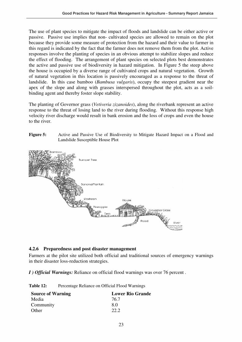
Good Practices for Hazard Risk Management in Agriculture - Summary Report Jamaica
23
The use of plant species to mitigate the impact of floods and landslide can be either active or passive. Passive use implies that non- cultivated species are allowed to remain on the plot because they provide some measure of protection from the hazard and their value to farmer in this regard is indicated by the fact that the farmer does not remove them from the plot. Active responses involve the planting of species in an obvious attempt to stabilize slopes and reduce the effect of flooding. The arrangement of plant species on selected plots best demonstrates the active and passive use of biodiversity in hazard mitigation. In Figure 5 the steep above the house is occupied by a diverse range of cultivated crops and natural vegetation. Growth of natural vegetation in this location is passively encouraged as a response to the threat of landslide. In this case bamboo (Bambusa vulgaris), occupy the steepest gradient near the apex of the slope and along with grasses interspersed throughout the plot, acts as a soil-binding agent and thereby foster slope stability. The planting of Governor grass (Vetiveria zizanoides), along the riverbank represent an active response to the threat of losing land to the river during flooding. Without this response high velocity river discharge would result in bank erosion and the loss of crops and even the house to the river.
Figure 5: Active and Passive Use of Biodiversity to Mitigate Hazard Impact on a Flood and Landslide Susceptible House Plot
4.2.6 Preparedness and post disaster management
Farmers at the pilot site utilized both official and traditional sources of emergency warnings in their disaster loss-reduction strategies. I ) Official Warnings: Reliance on official flood warnings was over 76 percent .
Table 12: Percentage Reliance on Official Flood Warnings
Source of Warning Lower Rio Grande Media 76.7 Community 8.0 Other 22.2

Good Practices for Hazard Risk Management in Agriculture - Summary Report Jamaica
24
Official warnings are normally conveyed by the media or disseminated through various community channels and are issued by meteorological services in conjunction with disaster management organizations. Discussions with farmers indicate heavy reliance on official media (radio, television) as sources of official flood warning (Table 12). In general, media sources of warnings were considered reasonably reliable. In spite of being alerted by warnings, evacuation obedience to these warnings is not always immediate (Table 13).
Table 13: Stage of Obedience to Flood Warnings
Stage Lower Rio Grande Immediately 38.8 When flood water begin to rise 35.3 During flooding 10.6
For those who respond immediately to evacuation recommendations, the overwhelming explanation is that based on past experiences they regard flooding as real threat to life and property. Those who did not respond immediately the primary explanation was that they did not have sufficient confidence in the official warning. A range of explanations for not obeying evacuation orders at all were offered (Table 14 ).
Table 14: Reasons for not Obeying Evacuation Orders
Reasons Lower Rio Grande Prefer comfort of home 5.3 Confidence in personal mitigation 5.3 Not vulnerable 36.8 No confidence in official warnings 47.4 Security concern 5.3
4.2.7 Replicability of DRM Issues
The agro-physical and agro-social environments of the Rio Grande site is typical of other interior locations of eastern Jamaica, particularly the parish of St. Thomas and parts of St Mary. In that regard, good practices identified in Portland have the potential for replication in the aforementioned parishes.
4.3 Southfield
Southfield is a dry farming environment that was devastated by Hurricane Ivan and other tropical weather phenomena, including drought. Crop emphasis is on condiments, non-leafy vegetables and watermelons.
4.3.1 Site Description
Southfield is located in the south-western parish of St Elizabeth. Farming density is high owing to a gently undulating landscape. Generally low rainfall in conjunction with well-drained soil underlain by white limestone, are main contributors to soil-moisture deficit of the area. The main natural resource is fertile agricultural lands and a land management system focused on dry farming using grass mulch.
Good Practices for Hazard Risk Management in Agriculture - Summary Report Jamaica
25
4.3.2 Socio-economic Profile
The Southfield Extension consist of 1,391 farmers farming a total of 1,357.13 hectares, thus averaging just over a hectare per farmer. Modal farm size is however less than 1 hectare (Table 15.).
Table 15: Farm Size Distribution in the Southfield Extension
Farm-size Category (ha.)
Number of Farmers Area (ha.) % All Farms
< 0.5 541 133.57 39.0 0.5 – 0.99 382 278.51 26.0 1.0 – 1.99 405 644.77 29.0 2.0 – 4.99 44 167.79 4.0 > 5.0 19 132.49 2.0 Total 1,391 1,57.13 100.0
Mean household size in this pilot site is currently 3.6 persons, a significant decline since 1992 when the average household size was 4.1 persons. The population distribution indicates an age dependency ratio of 75.7 dependents per 100 working-age population. At 20.0 percent, poverty level at this site is not different from the national estimate of 19.7 percent (PIOJ/STATIN, 2002) but represent a significant decline since 1992 (Table 16)
Table 16: Poverty Incidence in St Elizabeth, 1992, 1998 and 2002
Year Poverty Incidence 1992 47.2 1998 18.8 2002 20.8
Source: Planning Institute of Jamaica/Statistical Institute of Jamaica, 2002
Agriculture is the main livelihood activity for over 95% of the households in the Southfield community but secondary activities included employment at the Aluminum Partners plant at Nain in the parish of St Elizabeth. As is case of other rural communities in Jamaica, farmers in this area are primarily men but some of the more outstanding farmers were found in female-headed households. The heavy reliance on farming to fulfill livelihood objectives and the vulnerability of this sector to hydro-meteorological hazard are serious challenges to sustainable livelihood in the community. For instance, during a focus group consultation farmers indicated loss earnings ranging from US$15,500 to over US$47,000 during a drought in 2005. Over 87 % of farmers in the community have secure tenure of their land. Security of tenure is reflected in either personal ownership of land or family land. Mean farm-size is approximately 2 hectares.
4.3.3 Hazard/Disaster Vulnerability Context
Communities in the Southfield Extension area are vulnerable and have been repeatedly impacted by a number of hydro-meteorological hazards including:
• Storms (wind).
• Flooding from high magnitude rainfall.
• Drought/bush fires.
Good Practices for Hazard Risk Management in Agriculture - Summary Report Jamaica
26
Storm and flooding impacts for the most part coincide with the Caribbean hurricane season and droughts have become more frequent. While there was a general perception that very little could be done to mitigate the impact of hurricanes winds, farmers were confident that the effects of floods and droughts could me mitigated. More recently, extensive loss of crops has been incurred from bushfires resulting from prolonged drought and careless use of fire. Vulnerability to bushfires is aggravated by the virtual lack of firefighting capability in proximity to the community. The vulnerability of the Southfield extension area does not only stem from its physical location in relation to hydro-meteorological hazards but also as a result of the susceptibility of their primary livelihood activities, agriculture to these hazards and the inadequacy of the disaster response mechanism in effectively mitigating impact. Over 90 percent of the residents in this extension are relying solely on agriculture as a livelihood strategy. In that regard any disruption of this activity by the impacts of hazards can spell disaster for this community. This level of vulnerability was evident in the devastation caused to the area by the impact of hurricanes Charley and Ivan in quick succession and by bush fires the following year. Cost of damage to crops and farm infrastructure from the impact of Hurricanes Ivan and Charley in the communities of the Southfield Extension Area range from J$800,000 –J$1,200,000 per farm household in addition to losses suffered to household items etc.
4.3.4 Risk Perceptions and Disaster Risk Management
All farmers in this extension area have been impacted by multiple hazard and this level of experience has undoubtedly influence their perceptions of these hazards as well the disaster management strategies they employ to mitigate impact. The response to drought is almost universal throughout the area although the level of response is a function of resource availability. Drought mitigation takes the form of guinea grass mulching throughout but farmers with greater resource capability have enhances this measure through the addition of drip irrigation. In that regard farmers monitor drought forecast. Perceptions of and response to hurricanes and floods a similarly positive. Farmers rely on official sources of for flood and hurricane information and respond positively to warnings. Few farmers have employed systems of surface drainage to prevent flooding and drip irrigation equipments are secured when hurricanes threaten. Although farm insurance is virtually absent from this agricultural landscape the disaster risk management measures employed by farmers are intended to mitigate if not prevent disasters from hazard impacts.
4.4 Tethford
4.4.1 Site Description
Tethford is located on the southern alluvial plains of parish of St Catherine. Farming density is high owing to the flat topography and availability of irrigation water. As is typical of most of the southern plains of Jamaica, mean rainfall is low and variable averaging about 1050mm per year. Soils are generally derived from old and recent alluvia. The old alluvia is imperfectly to moderately well drained, deep and fine-textured (RPPD,1990). In sections of the old alluvium soils crack widely and become extremely hard when dry. Soils on the recent alluvium are well to excessively drained, deep and fine to coarse textured. In the north western portions of the site where limestone hills protrude onto the plain, well-drained, deep fine-textured soil has developed on limestone colluvium. Within Jamaica’s agricultural administrative context Tethford falls in the Old Harbour Extension Area of the Rural Agricultural Development Agency.

Good Practices for Hazard Risk Management in Agriculture - Summary Report Jamaica
27
The main natural resource is fertile agricultural lands and a land management system focused on irrigated farming. Until a recent low-technology intervention by the USAID, irrigation of farms utilized a sprinkler system. The USAID intervention has brought a more efficient and cost-effective low-technology drip irrigation system.
4.4.2 Socio-economic Profile
Specific demographic data for the community of Tethford is unavailable and therefore data for the parish of St Catherine in which community lies is used as a proxy. The area has a mean household size of 3.6 with almost one-third of the population under 14 years and 7 percent over 65 years old, giving an age dependency ratio of 65 persons per 100 working age population, one of the lowest in Jamaica (PIOJ/STATIN, 2002). Since 1992 the area saw significant reduction in the incidence of poverty Table 17). Indeed, St. Catherine currently has the lowest incidence of poverty in Jamaica.
Table 17: Poverty Incidence in St Catherine, 1992, 1998 and 2002
Year Poverty Incidence 1992 28.2 1998 8.2 2002 6.2
Source: Planning Institute of Jamaica/Statistical Institute of Jamaica, 2002
Tethford falls within the Old Harbour Extension area which consists of 558 farmers, cultivating a total of 1,129 hectares, thus averaging just over 2 hectares per farmer (Table18). As is typical of rural communities in St Catherine, agriculture is the mainstay of Tethford with virtually no other option for employment within the community. Farming in the community is centred on fast-maturing cash crops such as vegetables, legumes and root crops. This combination of crops is replicated in similar agro-ecological zones across Jamaica and as such, good practices for mitigating the impact of hydro-meteorological hazards in Tethford have a favourable chance for widespread replication in Jamaica.
Table 18: Farm Size Distribution in the Southfield Extension
Farm-size Category (ha.)
Number of Farmers Area (ha.) % All Farms
< 0.5 165 34.78 3.0 0.5 – 0.99 106 80.64 7.0 1.0 – 1.99 212 345.00 31.0 2.0 – 4.99 49 182.67 16.0 > 5.0 26 485.54 43.0 Total 558 1128.93 100.0
Source: Compiled from Rural Agricultural Development Agency database
While farming is the main livelihood activity for over 90% of the households in the Tethford, alternative employment for a small proportion of the population is provided in urban centres such as Spanish Town and on large sugar estates such as Bernard Lodge. Land tenure is relatively secure with nearly 70 percent of the farmers owning at least one of the plots they cultivate. Security of tenure is reflected in either personal ownership of land or family land.

Good Practices for Hazard Risk Management in Agriculture - Summary Report Jamaica
28
4.4.3 Hazard/Disaster Vulnerability Context
Communities in the Old Harbour Extension Area including Tethford are vulnerable and have been repeatedly impacted by a number of hydro-meteorological hazards including:
• Storms (wind)
• Flooding from high magnitude rainfall
• Droughts
Storm and flooding impacts for the most part coincide with the Caribbean hurricane season and although droughts are frequent their impact has been significantly mitigated owing to access of farms to irrigation water. While there was a general perception that very little could be done to mitigate the impact of hurricanes winds, farmers were confident that the effects of floods could me mitigated through cooperative planning among farmers to develop a comprehensive network of drains that would ensure movement of excess water from farms. Currently, each farm has an internal network of drains that are capable of handling low magnitude rainfall events. However, in the absence of an inter-farm network that would allow free passage of water to main drainage systems, high magnitude rainfall results in serious flooding of farms. The vulnerability of Tethford does not only stem from its physical location in relation to hydro-meteorological hazards but also as a result of the susceptibility of the primary livelihood activities, agriculture, to these hazards and the inadequacy of the disaster response mechanism in effectively mitigating impact. Given the importance of agriculture to the economic base of the community, any disruption of this activity by the impacts of hazards can spell disaster. This level of vulnerability was evident in the devastation caused to the area by the impact of hurricanes Gilbert and Ivan.
4.4.4 Risk Perceptions and Disaster Risk Management
All farmers in this community have been impacted by multiple hazards and this experience has undoubtedly influenced their perceptions of the disaster management strategies they employ to mitigate impacts. The response to droughts and floods is almost universal throughout the area. Farmers traditionally used a sprinkler irrigation system connected to the National Irrigation Commission distribution network to mitigate the impact of moisture deficit in the low rainfall months. Following devastations caused by Hurricane Ivan in 2004, a USAID project has introduced low technology drip irrigation to the community as a means of improving the cost effectiveness of the irrigation system. This system has reduced risk from drought while improving savings on water cost. In addition, it contributes to improved labour efficiency on farms by allowing farmers to continue cultivation activities while irrigating. This was not possible with the sprinkler irrigation system as the labourer would be “soaked”. A disturbing tendency observed in the field is for some farmers to continue use of the sprinkler irrigation in conjunction with the drip, in essence increasing their water-use cost. Farmers explained that they “prefer to see the soil soaked”. Evidently cultural traditions related to sprinkler irrigation has not yet been removed from the psyche of farmers. The use of drains to mitigate flooding is universal. Farmers do not consider monitoring of drought forecast important to their operation owing to reliance on irrigation. Perceptions of and response to hurricanes and floods are positive as farmers normally try to secure irrigation equipment once hurricane or flood warnings are issued. Farmers rely on official (National Meteorological Services) sources of for flood and hurricane information. Although hazard insurance is virtually absent from this agricultural landscape farmers employ low technology structural and non structural measures to mitigate hazard impact and reduce the vulnerability of their livelihoods. Low technology structural mitigation measures include the intra-farm drainage network and irrigation systems aforementioned. Non-structural measures include the securing of equipment and the monitoring of forecast.

Good Practices for Hazard Risk Management in Agriculture - Summary Report Jamaica
29
5 GOOD PRACTICES IDENTIFIED DURING FIELD SURVEY
Jamaican small farmers traditionally use a variety of good practices for mitigating the impact of hydro-meteorological hazards. This section highlights some of the practices that were identified during the field survey component of this project.
DRM Good Practice in Agriculture 1- Jamaica
Attributes Description Name Guinea Grass Mulching Historical aspect Long established in southern St Elizabeth Hazard applicability Drought/moisture deficit Environmental suitability Flat or sloping land in moisture-deficit agro-ecological
zones Farming scale applicability Small scale (< 10 ha.) Input needs Reliable source of abundant Guinea Grass (approx. 60 yds3
per ha.) Cost estimate for implementation J$5000/ ha. (US$80/ ha.) for farmers who have insufficient
space to grow guinea grass Method of implementation Clearing of land to be cultivated, secure sufficient grass to
cover area, harvest grass before seeding (flowering), apply fertilizer and other soil treatment to prepared land, prepare holes for sowing or transplanting of seedlings, arrange grass blades lengthwise in one direction over the area, then repeat the process from opposite direction, plant seeds
Institutional requirements Technical pest control support from extension services Maintenance requirements Repeat of implementation steps once per year Benefits Moisture conservation, weed control, reduce wind erosion,
reduce run-off, reduce soil temperature, improve soil structure, source of organic manure, retention of volatile fertilizer material, provide cushion for vine crops, reduce abrasion to trailing fruits and vegetables, facilitate organic farming practices.
DRM Good Practice in Agriculture 2- Jamaica Name Minimum Tillage Historical aspect Long established on dry southern coastal plains and steep
uplands of Jamaica. Hazard applicability Drought/rainfall-related soil erosion Environmental suitability Drier coastal agro-ecological zones, with stable soil
structure, moderately wet upland AEZ with stable soil structure.
Farming scale applicability Small scale farming (> 5 ha) Input needs Labour, simple digging tools Cost estimate for implementation Labour intensive especially for weed control - J$3000/day
(US$50/day) Method of implementation Varies with location & cropping system, reduced
cultivation depth by drilling holes for planting of seeds/seedlings on prepared land. Can involve shallow-cut tillers in some locations.
Institutional requirements Expansion of RADA training capacity, farmer training, education on benefits of technique
Maintenance requirements Weed control Benefits Reduced fossil fuel use, reduced soil erosion, increase in
soil biodiversity, reduced pesticide and nitrogen leaching, soil moisture conservation

Good Practices for Hazard Risk Management in Agriculture - Summary Report Jamaica
30
DRM Good Practice in Agriculture 3- Jamaica Name Drip irrigation Historical aspect Recent introduction to Jamaican small farming (since 2000
and especially since Hurricane Ivan in 2004. Intervention from USAID
Hazard applicability Drought Environmental suitability All annual/seasonal moisture deficit AEZ with flat to
gentle slopes Farming scale applicability All farming scales (small farms to plantations) Input needs Large quantity of drip irrigation hose, reliable source of
irrigation water, low-technology pumps, subsided cost of inputs (irrigation hose & water storage facility for areas not serviced by National Irrigation Commission), fuel for pumps.
Cost estimate for implementation Cost of irrigation hose (expensive), cost of pumps, cost of water storage facility
Method of implementation Suitable for tilled or minimum tilled land, Lining out of land in straight lines, Laying of irrigation hose along lined out area, connection of hose to pumping system
Institutional requirements Expansion of RADA training capacity, farmer training, education on benefits of technique, maintenance education.
Maintenance requirements Regular flushing of irrigation pipes to prevent build up of sediments and calcium in areas where water contains dissolved limestone
Benefits Year round production, improved yields, better crop quality, more efficient use of water resource, lower irrigation cost (compared with sprinkler system)
DRM Good Practice in Agriculture 4- Jamaica Name Fire-breaks Historical aspect Long established in areas of large scale monoculture of
sugar cane and to lesser extent in the guinea grass mulch areas of St Elizabeth.
Hazard applicability Drought-induced bushfires Environmental suitability All annual/seasonal moisture deficit AEZ where bush fires
are a threat Farming scale applicability All farming scales (small farms to plantations) Input needs Equipment and labour if bare soil firebreaks as used by
sugar plantations, fire-resistant seedlings for planted firebreaks used on small farms, community-level fire reduction planning
Cost estimate for implementation Cost involve development and distribution of seedling, equipment for establishing bare soil firebreaks, cost of community planning and training
Method of implementation Establishment of fire-resistant vegetation barrier on perimeter of farm, minimal undergrowth, bare soil area around perimeter and between sections of large sugar cane farms
Institutional requirements Expansion of RADA training capacity, community level fire hazard reduction planning
Maintenance requirements Pruning of vegetation barrier, removal of undergrowth

Good Practices for Hazard Risk Management in Agriculture - Summary Report Jamaica
31
Benefits Reduced crop-loss from bush fires, added protection against wind damage in storms, reduced soil moisture loss through shading and wind reduction.
DRM Good Practice in Agriculture 5- Jamaica Name Rainwater Harvesting & Storage Historical aspect Long established in most rural communities in Jamaica
owing to seasonal variability in rainfall. Mainly for domestic use but used for agriculture especially in the growing of high value crops such as vegetable, fruits and condiments
Hazard applicability Drought Environmental suitability All annual/seasonal moisture deficit AEZ but especially
those involved in the farming of high valued seasonal crop (cash crops)
Farming scale applicability Medium to small-scale farming (10 ha and less) Input needs Larger household water tanks, community water
catchments Cost estimate for implementation Cost of building water storage/catchments. Cost currently a
deterrent for communities and households so require subsidies.
Method of implementation Building of catchments/storage facility. If water is depleted supply can be obtained from public/private system
Institutional requirements Expansion of RADA capacity/program for providing irrigation water to farmers, collaboration with Min of Water
Maintenance requirements Regular cleaning of storage facility Benefits Year round production, increased yields, improved crop
quality
DRM Good Practice in Agriculture 6- Jamaica Name Aquifer Recharge Historical aspect Long established in areas of large scale commercial
monoculture and mixed cropping. Mainly in sugar cane areas
Hazard applicability Drought & Flood impact reduction Environmental suitability All annual/seasonal moisture deficit AEZ but especially
those involved large scale monoculture on the southern coastal plains
Farming scale applicability Large scale (> 50 ha.) Input needs Drilling equipment for boreholes or identification of
appropriate sinkholes Cost estimate for implementation Cost of drilling and channelling of water to recharge hole Method of implementation Construction of recharge well/boring or channelling of
water down sinkholes Institutional requirements Collaboration among RADA, NIC and WRA Maintenance requirements Prevention of siltation Benefits Drought mitigation, flood mitigation,, mitigation of saline
intrusion, water quality maintenance, sustain water supply, prevention of well collapse

Good Practices for Hazard Risk Management in Agriculture - Summary Report Jamaica
32
DRM Good Practice in Agriculture 7- Jamaica
Name Timing of Crop Establishment Historical aspect Normally practiced in areas of rain-fed dependent
agriculture throughout Jamaica. Planting coincides with rainy season.
Hazard applicability Drought Environmental suitability All annual/seasonal moisture deficit AEZ but especially
those involved in the production of annuals. Farming scale applicability Small scale farming (5 ha. and less) Input needs Annual planting calendar. Many farmers currently use
MacDonald Almanac. Reliable source of hydro-meteorological data.
Cost estimate for implementation Cost of literature and related training Method of implementation Appropriate interpretation and use of hydro-meteorological
data Institutional requirements Collaboration between RADA and the Meteorological
Service in the provision of reliable hydro-meteorological to agriculture
Maintenance requirements N/A Benefits Drought mitigation, reduced loss from droughts and
bushfires, maximization of soil moisture resource
DRM Good Practice in Agriculture 8- Jamaica Name Seasonal Breeding (Livestock) Historical aspect Very rarely practiced in Jamaica but recommended by some
livestock rearing literature. Practice on some large dairy/beef operations such as Serge Island and WINDALCO
Hazard applicability Drought impact reduction Environmental suitability All flatland to gently-sloping AEZ with seasonal moisture
deficit Farming scale applicability Large scale (> 50 ha.) Input needs Reliable source of hydro-meteorological data. Cost estimate for implementation Cost of improve hydro-meteorological information Method of implementation Appropriate interpretation and use of hydro-meteorological
data Institutional requirements Collaboration between RADA and the Meteorological
Service in the provision of reliable hydro-meteorological to agriculture
Maintenance requirements N/A Benefits Drought mitigation, reduced loss from droughts,
maximization of soil moisture resource, synchronization between nutritional requirements and feed availability
DRM Good Practice in Agriculture 9- Jamaica Name Planting of drought-tolerant crops Historical aspect Widely practiced in seasonal and annual rainfall deficit
areas of Jamaica, particularly along the southern coast Hazard applicability Drought impact reduction Environmental suitability Upland and lowland AEZ with rainfall deficit Farming scale applicability Small and large scale Input needs Drought tolerant planting material, eg cassava (manioc) Cost estimate for implementation Cost of planting material Method of implementation Appropriate interpretation and use of hydro-meteorological
data
Good Practices for Hazard Risk Management in Agriculture - Summary Report Jamaica
33
Institutional requirements Collaboration between RADA and the Meteorological Service in the provision of reliable hydro-meteorological to agriculture, awareness campaign by RADA on crop options for dought
Maintenance requirements N/A Benefits Drought impact reduction, crop loss reduction,
maximization of soil moisture use
DRM Good Practice in Agriculture 10- Jamaica Name Raised Beds/Network Drains Historical aspect Widely practiced in lowland areas susceptible to flooding Hazard applicability Floods Environmental suitability Flatland AEZ with poor drainage and moderate to high
annual rainfall Farming scale applicability Small and large scale under varied cropping systems Input needs Integrated inter-farm drainage network, drain-digging
equipment or manual labour Cost estimate for implementation Labour cost, cost of employing drain-digging equipment Method of implementation Appropriate interpretation and use of hydro-meteorological
data Institutional requirements Development of collaborative farming groups Maintenance requirements Seasonal removal of debris from drains, stabilization of the
sides of drains by planting grass etc, maintenance of the integrity of beds
Benefits Reduction in the depth and of area extent of floods, reduce crop loss from flooding, regulation of soil moisture
DRM Good Practice in Agriculture 11- Jamaica Name Contour Planting of Matt & King Grass Historical aspect Widely practiced in steep upland areas with high rainfall,
especially in eastern Jamaica Hazard applicability Landslides Environmental suitability Extremely steep AEZ with high rainfall and slope angles
45-50 degrees Farming scale applicability Small-scale hillside farming involved in mixed-cropping Input needs Provision of Matt & King Grass seedlings, extension
training Cost estimate for implementation Cost of providing seedlings, transport, field training Method of implementation Contour planting of Matt or King Grass at specific interval
on steep slope. Interval based on slope angle Institutional requirements Expanded capacity for training at RADA Maintenance requirements Seasonal cutting back of grass and replenishment of thinned
areas in barrier Benefits Slope stabilization, soil loss reduction, sustainable crop
production on steep slopes, increased water infiltration, sustainable water supply
DRM Good Practice in Agriculture 12- Jamaica Name Contour Planting of Pineapples Historical aspect Widely practiced in steep upland areas with high rainfall,
especially in eastern Jamaica Hazard applicability Landslides Environmental suitability Extremely steep AEZ with high rainfall and slope angles
45-50 degrees

Good Practices for Hazard Risk Management in Agriculture - Summary Report Jamaica
34
Farming scale applicability Small-scale hillside farming involved in mixed-cropping Input needs Provision of pineapple seedlings, extension training Cost estimate for implementation Cost of providing seedlings, transport, field training Method of implementation Contour planting of pineapples at specific interval on steep
slope. Interval based on slope angle Institutional requirements Expanded capacity for training at RADA Maintenance requirements Replenishment of thinned areas in barrier especially after
reaping of pineapples Benefits Slope stabilization, soil loss reduction, sustainable crop
production on steep slopes, increased water infiltration, sustainable water supply
DRM Good Practice in Agriculture 13 – Jamaica Name Check Dams Historical aspect Occasionally used on steep slopes as a part of government
or project related soil conservation programs Hazard applicability Landslides/Floods Environmental suitability Extremely steep AEZ with high rainfall and slope angles
45-50 degrees Farming scale applicability Small-scale hillside farming involved in mixed-cropping Input needs Material for dam construction. Recycled material such as
tires sometimes used for dam construction, extension training
Cost estimate for implementation Cost of acquiring construction material Method of implementation Construction of a series of small dams on small, steep
stream channels to reduce overall water velocity Institutional requirements Expanded capacity for training at RADA Maintenance requirements Repair of weakened section of dam, maintenance of
vegetation cover on stream bank especially in proximity to the dam
Benefits Slope stabilization, soil loss reduction, sustainable crop production on steep slopes, increased water infiltration, sustainable water supply, flood control in lower part of stream
DRM Good Practice in Agriculture 14 – Jamaica Name Hedgerow Alley Cropping Historical aspect Not wide used. Largely confined to yam growing areas of
northern Manchester and southern Trelawny. Introduced as intervention for soil loss reduction on moderately steep slopes
Hazard applicability Landslides Environmental suitability Moderate to steep AEZ with seasonally high rainfall and
loose soil structure Farming scale applicability Small-scale hillside farming involved in mixed-cropping or
monoculture cultivation of tubers Input needs Nursery for production of seedlings, subsidized provision of
seedlings, extensive training on implementation and maintenance
Cost estimate for implementation Cost of providing seedlings, transport, field training Method of implementation Establishment of hedgerow at regular interval along contour
and planting of alley between hedges Institutional requirements Expanded capacity for training at RADA, extension training Maintenance requirements Seasonal cutting back of hedgerow and replenishment of
thinned areas in hedge
Good Practices for Hazard Risk Management in Agriculture - Summary Report Jamaica
35
Benefits Slope stabilization, soil loss reduction, sustainable crop production on steep slopes, increased water infiltration, sustainable water supply, reduced demand for yam-sticks as sections of hedge can be allowed to ‘grow out’ and harvested as yam-sticks, reduced chemical fertilizer demand if leguminous plants used for hedgerow
DRM Good Practice in Agriculture 15- Jamaica Name Incorporation of Tree Management into Land Management
(Cut Back) Historical aspect Being recently promoted by RADA under the Food Tree
Project as a means of hurricane loss reduction, food tree resuscitation and improved efficiency in production
Hazard applicability Landslides, Flooding, Strong winds Environmental suitability All AEZ in Jamaica Farming scale applicability All scales of farming that involve tree fruit tree crops
production Input needs Equipment for cut-back of trees (chainsaw etc), long
ladders or other means of elevation, technical training, seedlings to support other components of the Food Tree Project
Cost estimate for implementation Cost of providing equipment and training Method of implementation Decision of appropriate level of cut-back based on
technological knowledge (cutting should occur above growth nodules), use of chainsaw or other appropriate equipment to make ‘clean’ cut
Institutional requirements Expanded capacity for training at RADA, extension training, establishment of nurseries for seedlings
Maintenance requirements Seasonal cutting back of hedgerow and replenishment of thinned areas in hedge
Benefits Slope stabilization, soil loss reduction, sustainable crop production on steep slopes, increased infiltration of, reduce loss from hurricane winds, more efficient harvesting of food trees (can harvest from the ground if sufficiently cut back).
DRM Good Practice in Agriculture 16- Jamaica Name Raised Floors (for poultry production) Historical aspect Practiced in isolated locations for poultry production but is
being promoted by RADA and JLA based on successes elsewhere
Hazard applicability Flooding Environmental suitability Lowland AEZ that is vulnerable to flooding and where
poultry rearing is practiced Farming scale applicability All scales of poultry production Input needs Appropriate flooring material that will allow adequate
ventilation that will dry up moisture and minimize ammonia gas from faeces and deep litter system, support for flooring
Cost estimate for implementation Cost of providing seedlings, transport, field training Method of implementation Raise flooring to an appropriate level depending on the
level of threat from flooding, allow for approx. one square foot of floor space per bird, set back building as much as possible from the source of flooding, face building away from the sun
Institutional requirements Training in site selection and protection of poultry from flooding
Maintenance requirements Regular removal of waste Benefits Poultry loss reduction from flooding, better ventilation of
poultry house, more efficient harvesting of waste.

Good Practices for Hazard Risk Management in Agriculture - Summary Report Jamaica
36
DRM Good Practice in Agriculture 17- Jamaica Name Planting of low-profile crops in areas susceptible to wind
damage Historical aspect Practiced in isolated locations such as the Rio Grande
Valley of Portland Hazard applicability Strong winds/hurricanes Environmental suitability All AEZ in Jamaica Farming scale applicability More suitable for smaller farms but can be employed on
larger farms (e.g. sugar cane) Input needs Identification of appropriate crops and provision to farmers Cost estimate for implementation Cost of providing crop to farmers Method of implementation Identification and preparation of appropriate site Institutional requirements Promotion of measure by RADA or local farmers’
organizations such as the Jamaica Agricultural Society Maintenance requirements N/A Benefits Reduced damage to crops by wind, maximization of use of
land area.
DRM Good Practice in Agriculture 18 – Jamaica Name Triangular Bracing Mechanism for Bananas Historical aspect Practiced on a single farm in the Rio Grande Valley.
Bracing using bamboo is relatively common on small farms involved in banana production throughout Jamaica but the triangular bracing innovation has been developed and is being use by one farmer in Portland.
Hazard applicability Strong winds/hurricane Environmental suitability Sloping lands that are susceptible to strong winds and
where banana is extensively grown Farming scale applicability Small farms (< 10 ha) Input needs Provision of bamboo brace, metal cables, metal or rubber
rings with sufficient circumference to encompass banana stem
Cost estimate for implementation Cost of bamboo if not grown locally, cost of metal cables and ring
Method of implementation For banana cultivated on slope, place a metal or rubber ring around banana stem immediately below the fruiting area. Place bamboo brace on the up-slope side of banana tree with the ‘kotch’ firmly braced below the ring while the other end is firmly planted in the soil at an angle of about 45 degrees to the horizontal. Metal cables are attached to the ring on either side of the bamboo brace at an angle of about 25 degrees to the brace. Ends of the cable are firmly pegged in the soil on the up-slope side of the tree. The triangular configuration provides resistance to wind from all directions.
Institutional requirements Provision within RADA for dissemination of the technique Maintenance requirements Regular check of the system to ensure effectiveness and to
prevent bruising of banana stem Benefits Reduce damage/loss to banana from wind impact
Good Practices for Hazard Risk Management in Agriculture - Summary Report Jamaica
37
DRM Good Practice in Agriculture 19- Jamaica Name Removal of foliage from immature bananas Historical aspect Practiced by two farmers in the Rio Grande Valley Hazard applicability Strong winds/hurricane Environmental suitability All AEZ where banana is grown Farming scale applicability Suitable for small farms owing to high manual labour
demand Input needs Manual labour and cutting implement for removal of
foliage Cost estimate for implementation Cost of labour, cost of fertilizer required immediately after
impact Method of implementation When hurricane impact is imminent (i.e. 5-6 hours before
impact), foliage is manually trimmed from immature banana plants. This requires significant labour input over a short period of time. When the threat is passed the trees will recover their foliage and continue maturation without any impact on production. Absence of foliage during wind impact reduces resistance and allows the stems to remain upright.
Institutional requirements Provision of capacity within RADA for the dissemination of the innovation
Maintenance requirements Fertilization of trimmed plants immediately after impact Benefits Reduce banana loss from hurricane impact, sustained
banana production.
6 NATIONAL LEARNING EXCHANGE WORKSHOP
A national learning exchange workshop was held on December 6, 2006 at the Hotel Four Seasons in Kingston with the objectives to:
• Discuss and Identify of key linkages and gaps between existing disaster risk management (DRM) systems and agricultural systems and policies in Jamaica.
• Review the roles of main disaster management stakeholders in relation to the agricultural sector and formulate recommendations for improved disaster preparedness and response especially at the community level.
• Review agricultural good practices for the mitigation of impacts from hydro-meteorological hazards and to select best practices for sharing at the Regional Workshop.
Approximately 22 persons inclusive of the Project National Coordinator and the Regional Consultant attended the workshop. Representation included:
• Four farmers (representing the pilot sites).
• Eleven technocrats representing the Rural Agricultural Development Agency at the national, regional and parish levels.
• One representative from the Office of Disaster Preparedness and Emergency Management.
• One representative from the Jamaica Dairy Development Board.

Good Practices for Hazard Risk Management in Agriculture - Summary Report Jamaica
38
• Two representatives from the Department of Geography & Geology at the University of the West Indies (including a graduate student conducting research on hazard impacts on the agricultural sector).
• One person representing UNEP and the UWI Institute for Sustainable Development. The workshop was organized as a mix of plenary sessions and group work. Group work was guided by distinct working instructions.
Box 1: Working Groups Guidelines
1. Categorization of hydro-meteorological for best practice review/discussion: (a) Hurricane (strong wind) (b) Flood/Landslide (c) Drought Because hurricane impact is characterized by wind as well as flood damage, and to distinguish hurricane impacts from flooding caused by other high magnitude rainfall events, the good practice review in relation to hurricanes focuses on the wind impact component. Flooding and landslides were treated as a single hazard group owing to the dynamic relationship between the two, especially in upland environments. 2. Three groups are focusing on a specific hydro-meteorological hazard. Each group reviewed/discussed good practices within the context of the following farming systems:
- Mixed cropping - Monoculture (banana etc) - Agroforestry - Livestock
The following categories were provided to guide the discussion and classify good practices
- Description of good practice - Type of farming system for which it is appropriate - Location where used - Extensiveness of use - Cost of improvement - Suggestions for improvement of the technique - Benefits of technique - Drawbacks of technique
In light of information from the ODPEM representative that development of an agricultural sector-specific disaster risk reduction plan is currently on the work programme of the UWI, the discussion of the relevance of the DRM framework was considered to be more appropriate to the consultation and review process related to the development of the plan. The emphasis of the working group was therefore on identification and discussion of good practices. Good practices identified by the working groups are summarized in the matrices on the following pages. At the end of the group work the plenary reviewed the practices identified and decided on/ selected the “best” of these, for presentation at the Regional Workshop. Good practices identified by the working groups are summarized in the matrices below.
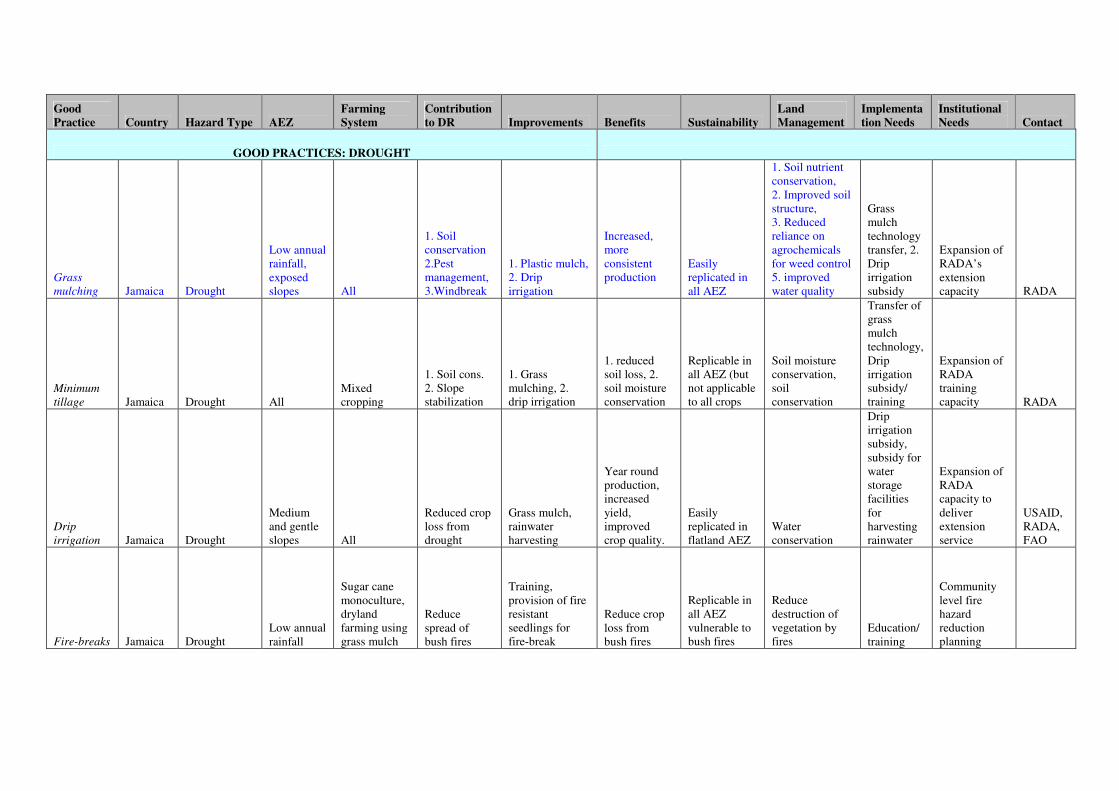
Good Practice Country Hazard Type AEZ
Farming System
Contribution to DR Improvements Benefits Sustainability
Land Management
Implementation Needs
Institutional Needs Contact
GOOD PRACTICES: DROUGHT
Grass
mulching Jamaica Drought
Low annual rainfall, exposed slopes All
1. Soil conservation 2.Pest management, 3.Windbreak
1. Plastic mulch, 2. Drip irrigation
Increased, more consistent production
Easily replicated in all AEZ
1. Soil nutrient conservation, 2. Improved soil structure, 3. Reduced reliance on agrochemicals for weed control 5. improved water quality
Grass mulch technology transfer, 2. Drip irrigation subsidy
Expansion of RADA’s extension capacity RADA
Minimum
tillage Jamaica Drought All Mixed cropping
1. Soil cons. 2. Slope stabilization
1. Grass mulching, 2. drip irrigation
1. reduced soil loss, 2. soil moisture conservation
Replicable in all AEZ (but not applicable to all crops
Soil moisture conservation, soil conservation
Transfer of grass mulch technology, Drip irrigation subsidy/ training
Expansion of RADA training capacity RADA
Drip
irrigation Jamaica Drought
Medium and gentle slopes All
Reduced crop loss from drought
Grass mulch, rainwater harvesting
Year round production, increased yield, improved crop quality.
Easily replicated in flatland AEZ
Water conservation
Drip irrigation subsidy, subsidy for water storage facilities for harvesting rainwater
Expansion of RADA capacity to deliver extension service
USAID, RADA, FAO
Fire-breaks Jamaica Drought Low annual rainfall
Sugar cane monoculture, dryland farming using grass mulch
Reduce spread of bush fires
Training, provision of fire resistant seedlings for fire-break
Reduce crop loss from bush fires
Replicable in all AEZ vulnerable to bush fires
Reduce destruction of vegetation by fires
Education/ training
Community level fire hazard reduction planning

Good Practices for Hazard Risk Management in Agriculture - Summary Report Jamaica
40
Rainwater
harvesting
and storage Jamaica Drought
Rainfall deficit areas
Small-scale mixed farming
Drought impact reduction
larger capacity household water tanks, community water catchments
Year round production, increased yield, improved crop quality.
Replicable in most AEZ no information
Subsidy for building water storage/ catchments facilities
no information
RADA, Min of Water
Aquifer
recharge Jamaica Drought
Flatlands with annual rainfall deficit
Large scale monoculture, mixed cropping
Drought mitigation, flood mitigation, mitigate saline intrusion no information
Sustained water supply, prevention of well collapse
Replicable in most flatland environments with medium to near-surface aquifer
Maintain water quality, prevents saline accumulation in soils, prevents degradation of soil quality.
no information
no information
RADA, NIC, WRA
Timing of
crop
establish-
ment Jamaica Drought
Areas of rain-fed dependent agriculture.
mixed cropping especially of annuals
Drought impact reduction
Integration of other good practices such as grass mulching and drip irrigation.
Reduced crop loss from drought and bush-fires
Replicable in all rain fed environments especially for annuals
Maximization of soil moisture resource
Technological transfer of grass mulching, drip irrigation
Expanded extension service
RADA,JAS
Seasonal
breeding
(livestock) Jamaica Drought
Flatlands to medium slopes
Beef/dairy production
Drought impact reduction no information
Synchroniza-tion between nutritional requirements of livestock and feed availability
Replicable in large scale livestock rearing AEZ no information
no information
no information
RADA, JLA, WINDALCO, Serge Island Dairy
Planting of
drought
tolerant
crops
Jamaica
Drought
All seasonal and rain-deficit areas
Mixed cropping
Drought impact reduction
no information
Crop loss reduction from drought
Replicable in all moisture deficit AEZ
Maximization of soil moisture resource
no information
Extension/ training
RADA
GOOD PRACTICES: FLOOD / LANDSLIDE
Raised beds Jamaica Flood
Flatlands with poor drainage
Mixed cropping
Reduced flood depth and extent
Integrated/collaborative inter-farm drainage network
Reduced crop loss from flooding
Replicable in flatland AEZ vulnerable to flooding
Regulate soil moisture
Cost subsidy for trench-digging equipment or manual labor
Development of collaborative farming groups RADA

Good Practices for Hazard Risk Management in Agriculture - Summary Report Jamaica
41
Contour
planting of
Matt and
King grass Jamaica Landslide
Extremely steep AEZ with slopes 45-50 degrees
Mixed cropping
Slope stabilization and soil-loss reduction
Zero/minimum tillage
Sustainable crop production on steep slopes
Replicable in most steep AEZ
Reduce soil loss, slope stabilization, increased rainwater infiltration, sustainable water supply
Extension training, provision of Matt/King grass
Expanded capacity for training in RADA RADA
Contour
planting of
pineapples Jamaica Landslide
Extremely steep AEZ with slopes 45-50 degrees
Mixed cropping
Slope stabilization and soil-loss reduction
Zero/minimum tillage
Sustainable crop production on steep slopes
Replicability in most steep AEZ
Reduce soil loss, slope stabilization, increased rainwater infiltration, sustainable water supply
Extension training, provision of pineapple seedlings
Expanded capacity for training in RADA RADA
Check dams Jamaica Landslide/ flooding
Extremely steep AEZ with slopes 45-50 degrees
Mixed cropping
Slope stabilization and soil-loss reduction
Zero/minimum tillage
Sustainable crop production on steep slopes
Replicability in most steep AEZ
Reduce soil loss, slope stabilization, increased rainwater infiltration, sustainable water supply
Extension training
Expanded capacity for training in RADA RADA
Hedgerow
Alley
Cropping Jamaica Landslide
Moderate to steep AEZ
Mixed cropping, small scale monoculture of tubers
Slope stabilization and soil-loss reduction
Zero/minimum tillage
Sustainable crop production on steep slopes
Replicability in most steep AEZ
Reduce soil loss, slope stabilization, increased rainwater infiltration, sustainable water supply
Extension training
Expanded capacity for training in RADA RADA
Incorporation
of tree
management
into land
management Jamaica
Landslide/ flooding strong winds All
Mixed cropping
Slope stabilization and soil-loss reduction
Zero/minimum tillage
Sustainable crop production on steep slopes
Replicable in most AEZ
Reduce soil loss, slope stabilization, increased rainwater infiltration, sustainable water supply
Establishment of nurseries for seedlings
Expanded capacity for training in RADA RADA
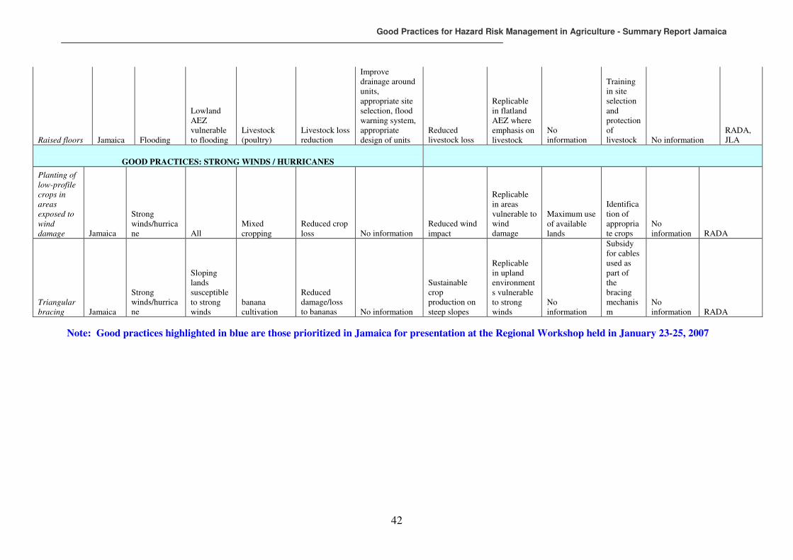
Good Practices for Hazard Risk Management in Agriculture - Summary Report Jamaica
42
Raised floors Jamaica Flooding
Lowland AEZ vulnerable to flooding
Livestock (poultry)
Livestock loss reduction
Improve drainage around units, appropriate site selection, flood warning system, appropriate design of units
Reduced livestock loss
Replicable in flatland AEZ where emphasis on livestock
No information
Training in site selection and protection of livestock No information
RADA, JLA
GOOD PRACTICES: STRONG WINDS / HURRICANES
Planting of
low-profile
crops in
areas
exposed to
wind
damage Jamaica
Strong winds/hurricane All
Mixed cropping
Reduced crop loss No information
Reduced wind impact
Replicable in areas vulnerable to wind damage
Maximum use of available lands
Identification of appropriate crops
No information RADA
Triangular
bracing Jamaica
Strong winds/hurricane
Sloping lands susceptible to strong winds
banana cultivation
Reduced damage/loss to bananas No information
Sustainable crop production on steep slopes
Replicable in upland environments vulnerable to strong winds
No information
Subsidy for cables used as part of the bracing mechanism
No information RADA
Note: Good practices highlighted in blue are those prioritized in Jamaica for presentation at the Regional Workshop held in January 23-25, 2007

Good Practices for Hazard Risk Management in Agriculture - Summary Report Jamaica
43
The good practices selected for the presentation at the Regional level workshop held in January 2007 in Kingston included: A. For drought management
o Grass mulching B. For hurricane, land slide and flood management
o Incorporation of Tree Management into Land Management: o Agro-forestry
o Pruning/top mgmt. o Alley Cropping o Strip Cropping
o Trenching Consensus of participants was that the workshop objectives were achieved. Both farmers and technocrats considered the proposed intervention to be timely and committed to active participation and partnership in the project. From a personal perspective it is felt that more could have been achieved through discussion of the relevance of the DRM Framework to the agricultural sector. This could enhance the agricultural sector-specific disaster reduction plan now on the work programme of the ODPEM. The outcomes of the regional workshop are not reported here since they are available in a separate workshop report.
7 PROMOTION AND REPLICATION OF DRM GOOD PRACTICES IN PILOT COMMUNITY
7.1 Project implementation approach in Jamaica
During the initial phase of the project a number of good practices with the potential for further replication was identified, one of them being the hedgerow/alley cropping technique. This technique was applied in a yam-growing area of southern Trelawny as a strategy for soil-loss reduction from slippage and erosion associated with intense rainfall. The two most promising options emerging for the promotion of broader replication of good practises during the second year of the project were:
i) Improvement of guinea grass mulching (dry farming technique) in southern St Elizabeth through addition of low technology drip irrigation at a water-deficit pilot site, and;
ii) Expansion of Alley Cropping at the non-pilot site vulnerable to landslides and soil movement in southern Trelawny
The assessment of the southern St Elizabeth site suggested that farmers at this pilot site had the resources to make any desired improvements to their farming techniques on their own costs, and as such the relatively small project intervention would not lead to high maximization of impact. The project therefore decided to promote replication of the hedgerow/alley cropping technique in Southern Trelawny site.
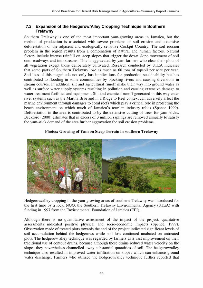
Good Practices for Hazard Risk Management in Agriculture - Summary Report Jamaica
44
7.2 Expansion of the Hedgerow/Alley Cropping Technique in Southern Trelawny
Southern Trelawny is one of the most important yam-growing areas in Jamaica, but the method of production is associated with severe problems of soil erosion and extensive deforestation of the adjacent and ecologically sensitive Cockpit Country. The soil erosion problem in the region results from a combination of natural and human factors. Natural factors include intense rainfall on steep slopes that trigger the down-slope movement of soil onto roadways and into streams. This is aggravated by yam-farmers who clear their plots of all vegetation except those deliberately cultivated. Research conducted by STEA indicates that some parts of Southern Trelawny lose as much as 60 tons of topsoil per acre per year. Soil loss of this magnitude not only has implications for production sustainability but has contributed to flooding in some communities by blocking rivers and causing diversions in stream courses. In addition, silt and agricultural runoff make their way into ground water as well as surface water supply systems resulting in pollution and causing extensive damage to water treatment facilities and equipment. Silt and chemical runoff generated in this way enter river systems such as the Martha Brae and in a Ridge to Reef context can adversely affect the marine environment through damages to coral reefs which play a critical role in protecting the beach environment on which much of Jamaica’s tourism industry relies (Spence 1999). Deforestation in the area is contributed to by the extensive cutting of trees for yam-sticks. Beckford (2000) estimates that in excess of 3 million saplings are removed annually to satisfy the yam-stick demand of the area further aggravation the soil erosion problems.
Photos: Growing of Yam on Steep Terrain in southern Trelawny
Hedgerow/alley cropping in the yam-growing areas of southern Trelawny was introduced for the first time by a local NGO, the Southern Trelawny Environmental Agency (STEA) with funding in 1997 from the Environmental Foundation of Jamaica (EFJ). Although there is no quantitative assessment of the impact of the project, qualitative assessments indicated positive physical and socio-economic impacts (Spence, 1999). Observation made of treated plots towards the end of the project indicated significant levels of soil accumulation behind the hedgerows while soil loss continued unabated on untreated plots. The hedgerow alley technique was regarded by farmers as a vast improvement on their traditional use of contour drains, because although these drains reduced water velocity on the slopes they nevertheless channelled away substantial quantities of soil. The hedgerow/alley technique also resulted in improved water infiltration on slopes which can enhance ground water discharge. Farmers who utilized the hedgerow/alley technique further reported that
Good Practices for Hazard Risk Management in Agriculture - Summary Report Jamaica
45
when daily labour cost and frequency of maintain hedgerows were taken into account, the overall cost of establishing and maintaining the new technique was substantially less than that associated with contour trenches as a soil conservation measure. In that regard the production cost of yam farmers who adopted the technique was reduced. At the community level, reduced inconveniences related to road blockage owing to erosion from farms and the related cost of clearing roads was yet another positive of the hedgerow/alley technique. In addition, reduced turbidity of streams has implications for reduction in the water treatment cost of communities. At the time of final evaluation of the project 393 farmers had been exposed to detailed information regarding the use of the technique. This served to improve the level of environmental awareness among farmers in southern Trelawny and as such the technique holds great promise for promotion of the sustainable use of land resources by farmers.
7.3 Description of project interventions
At the end of the South Trelawny Soil Conservation Project a large number of non-target farmers in southern Trelawny expressed interest and desires to adopt the hedgerow/alley technique but were unable to benefit due to unavailability of resources to STEA to continue expansion of the intervention when that project ended. A stakeholder meeting held in May 2007 between the FAO Resident Representative in Jamaica, the National Consultant for the FAO project, The Director of STEA and community representatives from southern Trelawny indicated that the desire of farmers to continue adaptation of the hedgerow/alley technique is very much alive. In that regard it was proposed that the funds available for fine-tuning and promoting good practice(s) identified in the first phase of the FAO project, should be allocated to the revival of the hedgerow/alley technique of vegetative soil conservation in southern Trelawny for the following reasons:
• The evaluation of the technique indicated that it not only has the potential to reduce soil-loss associated with intense rainfall, but that in addition a wide range of environmental benefits can be derived.
• Farmers in southern Trelawny are extremely receptive of the innovation but currently lack the resources for its implementation. Only a small proportion of the farmers in the area have benefited from the previous initiative and thus the scope of impact of the proposed FAO intervention was large.
• Given the range of environmental and social benefits that can be derived from the intervention, the prospect for collaboration with other development partners was considered extremely good.
A phased project implementation approach was selected focusing on the revival and expansion of the hedgerow/alley good practice in southern Trelawny as well as on the exposure of farmers to other good practices identified at the pilot sites. Specifically, the exposure of farmers to the grass mulching technique and subsequent adaptation was chosen since it could enhance the effect of the hedgerow alley system in reducing soil loss by reducing splash erosion and overland flow of rain-water. Initially, it was proposed that the southern Trelawny Environmental Agency would spearhead the implementation with close collaboration with the Rural Agricultural Development Authority (RADA). This phased approach would involve possible collaboration with the Global Environmental Facility (GEF) and USAID. Given the experience of STEA with the implementation of Alley Cropping and the grass-root networks that are the forte of NGOs, it was initially considered appropriate that the implementation of the FAO intervention would be undertaken through this agency. After

Good Practices for Hazard Risk Management in Agriculture - Summary Report Jamaica
46
preliminary engagements with STEA however the decision was taken collectively by the National Consultant, the National Counterpart and the FAO Resident Representative to disengage this organization owing to significant incongruence between the operational procedures of STEA and the objectives of the FAO as it relates to the project. The emphasis of the FAO was on the reduction of hydro-meteorological hazard vulnerability, and subsequent loss reduction in the agricultural sector, implicit in which is the maximization of benefits from the intervention to the farmers. The operational procedures of the NGO would have resulted in only about 20 percent of the benefits of the intervention going directly to farmers. There were important lessons learnt on institutional arrangements from this experience and these are highlighted later in this report. Finally, it was decided that RADA would spearhead the intervention because although its grass-root networks might not be as well-established as those of the NGO, the decentralized structure of this government agency allows close interactions at the community level. In addition, RADA has the most comprehensive and extensive extension service in Jamaica. The technical implementation procedure used under the FAO TCP to promote further replication of the Hedgerow/Alley system was applied according to the following details. This method of vegetative soil conservation involves the planting of fast growing leguminous trees at close spacing along the contours of slopes. A variety of species can be used but building on the positive experience from the STEA project the use of Calliandra calothyrus was promoted in southern Trelawny. The main benefits of this species are that:
• Deep, almost vertical rooting system grows below the depth of root crops such as yams and therefore does not interfere with the tubers but provides support for the upper soil horizons;
• Use of Calliandra results in efficient and productive use of farm space because the vertical rooting system allows planting of tubers in close proximity to the Calliandra
plant;
• Calliandra trees grow well on a wide variety of soil types and their rooting systems stabilizes banks and ridges;
• The leaves of the Calliandra plant can be used as animal fodder;
• The plant enhances soil fertility through nitrogen fixation and;
• The stem of the Calliandra is sturdy and can be harvested as yam sticks. Calliandra seedlings were planted in rows approximately 3m apart on steep slopes and 5m apart on gentler slopes in the project area. At the seedling stage, temporary stakes were used to protect the young plants. Farm trash is piled on the up-slopes side of the stakes to form barriers that act as temporary erosion control until the plants are mature enough to perform that function. The rows of trees so configured is called the hedgerow and the space between rows, alley. The alleys are natural terraces and are used to plant crops. As the Calliandra
plants grow, they are pruned and the litter so created is used to further build the trash barrier. The hedges can be modified to produce yam-sticks by allowing trees at 2m intervals to ‘grow out’. When these trees mature they can be harvested as yam-sticks. On the steepest and more badly eroded slopes, hedges were established at 2 meters apart and seedlings planted at 1 meter spacing while on gentler slopes hedges were established between 6- 7 metres apart. Once established, Hegderows are maintained at a height of 0.75 metres through constant pruning (cutting back). Biomass generated from pruning is piled on the upslope side of the Hedgerow to further stem the down-slope movement of soil. Given that Calliandra is a

Good Practices for Hazard Risk Management in Agriculture - Summary Report Jamaica
47
leguminous plant the addition of this biomass to the soil enhances nitrogen fixation and thereby improves soil nutrient. Soil accumulated on the upslope side of the Hedgerow is manually spread across the plot. In some instances, farmer can allow sections of the Hedgerow to grow beyond 0.75 metres and the outgrown saplings utilized as support for yam vines. This is an important advantage of the technique as there has been significant environmental damage caused by the removal of young saplings from forests to be used as support for yam vines. Most of the saplings in proximity to farms have been removed in the past, and in recent years farmers have resorted to purchasing this input, incurring higher production cost.
7.4 Project implementation process
The detailed implementation process for the field activities involved the following steps:
� Selection of communities within southern Trelawny for the implementation of the Hedgerow/Alley technique; Selection of communities to benefit from the good practice intervention was jointly undertaken by the Zonal Manager for the RADA Western Zone, the RADA Parish Manager for the parish of Trelawny and the Extension Officers responsible for Southern Trelawny. Four communities were selected, namely Allsides, Stettin, Lowe River and Wait-a-Bit. The primary criteria for selection included steepness of slopes on which farms were located, evident soil loss and land slippage problems and the willingness of farmers to adopt the Hedgerow/Alley technique. Crops, and in particular yams are grown on step slopes throughout the selected communities.
� Development of training materials and schedule and implementation of training process for farmers jointly with RADA extension and planning personnel. During training, farmers were advised in the implementation of the Hedgerow/Alley technique at 9 training field days held throughout the selected communities over a period of 6 months. Training days were conducted by the RADA Land Husbandry officer for the Western Zone and assisted by Extension Officers, the Director of Projects at RADA, other RADA personnel and the National Consultant.
The training days consisted of an in-class session in which participants were apprised of the objective of the project by the National Consultant and RADA Director of Projects. This session also exposed farmers to the theoretical component of the project focusing on the benefits of the Hedgerow/Alley technique and the technique for proper implementation. These sessions were conducted in community facilities such as community centres and church halls.
Photos: In-Class Training Session
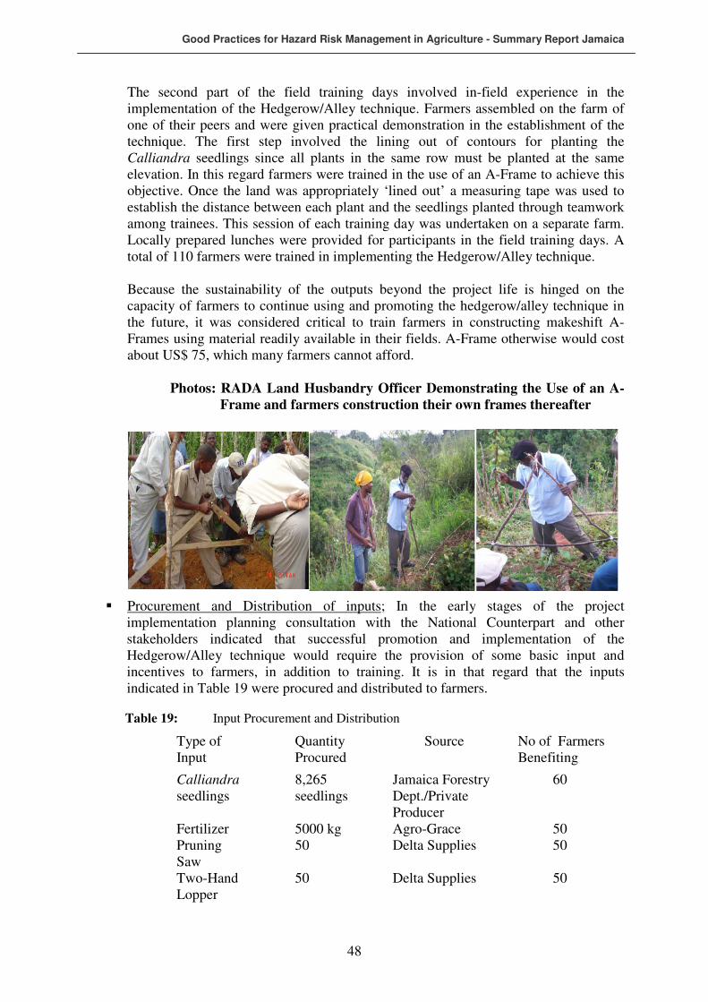
Good Practices for Hazard Risk Management in Agriculture - Summary Report Jamaica
48
The second part of the field training days involved in-field experience in the implementation of the Hedgerow/Alley technique. Farmers assembled on the farm of one of their peers and were given practical demonstration in the establishment of the technique. The first step involved the lining out of contours for planting the Calliandra seedlings since all plants in the same row must be planted at the same elevation. In this regard farmers were trained in the use of an A-Frame to achieve this objective. Once the land was appropriately ‘lined out’ a measuring tape was used to establish the distance between each plant and the seedlings planted through teamwork among trainees. This session of each training day was undertaken on a separate farm. Locally prepared lunches were provided for participants in the field training days. A total of 110 farmers were trained in implementing the Hedgerow/Alley technique. Because the sustainability of the outputs beyond the project life is hinged on the capacity of farmers to continue using and promoting the hedgerow/alley technique in the future, it was considered critical to train farmers in constructing makeshift A-Frames using material readily available in their fields. A-Frame otherwise would cost about US$ 75, which many farmers cannot afford.
Photos: RADA Land Husbandry Officer Demonstrating the Use of an A- Frame and farmers construction their own frames thereafter
� Procurement and Distribution of inputs; In the early stages of the project implementation planning consultation with the National Counterpart and other stakeholders indicated that successful promotion and implementation of the Hedgerow/Alley technique would require the provision of some basic input and incentives to farmers, in addition to training. It is in that regard that the inputs indicated in Table 19 were procured and distributed to farmers.
Table 19: Input Procurement and Distribution
Type of Input
Quantity Procured
Source No of Farmers Benefiting
Calliandra seedlings
8,265 seedlings
Jamaica Forestry Dept./Private Producer
60
Fertilizer 5000 kg Agro-Grace 50 Pruning Saw
50 Delta Supplies 50
Two-Hand Lopper
50 Delta Supplies 50

Good Practices for Hazard Risk Management in Agriculture - Summary Report Jamaica
49
The bulk of the Calliandra seedlings used to establish the Hedgerow were secured under contract from the Department of Forestry in Jamaica and were distributed to participating farmers through the local RADA office located at Lowe River in southern Trelawny. 265 seedlings were secured from a private producer in southern Trelawny. Allocation of seedlings per farmer was determined by the size of plot to be treated as well as by the degree of mass wasting being experienced on the plot. In general farmers with larger areas to be treated received more seedlings than those with smaller areas. Where the degree of mass wasting on a plot was high, more seedlings were allocated to ensure stabilization of the slopes. Successful establishment of the Hedgerows required application of chemical fertilizer approximately six weeks after the seedlings are planted. To this end, 5000 kg of fertilizer was distributed to 50 farmers. To ensure that the fertilizer was utilized for the establishment of the Hedgerow, allocations were made only when the seedlings had reached the stage where fertilizing was required. Maintenance of the hedgerows through constant pruning is critical to the successful adoption and implementation of the technique by farmers. While some level of pruning could be achieved using a machete, the most common toll among tool among Jamaican small farmers, better results are obtained when appropriate pruning tools are used. In that regard, the project provided participating farmers with small hand-held pruning tools.
� Development of a sustainability plan for the project; one of the most common
criticism of small farming intervention projects in developing countries is the lack of sustainability of project outputs. The end of the project period usually heralds the start of a period of disinterest and degradation of project gains.
It was in that regard that the project implementation team embarked on the design of measures that would foster the sustainability of outputs. It was agreed that such measures should include:
i) Embedding of the hedgerow/alley technique into the farming culture of the project site through the training of school children and other future farmers.
ii) Building capacity among farmers for continued implementation of the technique beyond the project life in a cost effective and efficient way.
iii) Building capacity for the promotion and dissemination of project output beyond the project site.
Further, follow up actions to the FAO project activities have been prepared. It is envisage and was discussed with the GEF Representative in Jamaica to complement the project with additional interventions from the GEF for the further expansion of the initiatives, while maintaining the overall project management responsibility with the FAO. GEF’s interest for follow up is especially related to the wide range of environmental benefits to be derived from the project implementation. An additional initiative to strengthen sustainability of project interventions lies in the advanced plans of establishing with support from STEA and RADA a seed propagation facility in southern Trelawny that would have the capacity to service a wider area with Calliandra seedlings. This facility would fall under the direct management of STEA and would allow the NGO to derive financial benefits from the sale of seedlings.
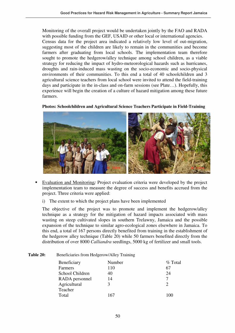
Good Practices for Hazard Risk Management in Agriculture - Summary Report Jamaica
50
Monitoring of the overall project would be undertaken jointly by the FAO and RADA with possible funding from the GEF, USAID or other local or international agencies. Census data for the project area indicated a relatively low level of out-migration, suggesting most of the children are likely to remain in the communities and become farmers after graduating from local schools. The implementation team therefore sought to promote the hedgerow/alley technique among school children, as a viable strategy for reducing the impact of hydro-meteorological hazards such as hurricanes, droughts and rain-induced mass wasting on the socio-economic and socio-physical environments of their communities. To this end a total of 40 schoolchildren and 3 agricultural science teachers from local school were invited to attend the field-training days and participate in the in-class and on-farm sessions (see Plate…). Hopefully, this experience will begin the creation of a culture of hazard mitigation among these future farmers.
Photos: Schoolchildren and Agricultural Science Teachers Participate in Field-Training
� Evaluation and Monitoring; Project evaluation criteria were developed by the project implementation team to measure the degree of success and benefits accrued from the project. Three criteria were applied:
i) The extent to which the project plans have been implemented
The objective of the project was to promote and implement the hedgerow/alley technique as a strategy for the mitigation of hazard impacts associated with mass wasting on steep cultivated slopes in southern Trelawny, Jamaica and the possible expansion of the technique to similar agro-ecological zones elsewhere in Jamaica. To this end, a total of 167 persons directly benefited from training in the establishment of the hedgerow alley technique (Table 20) while 50 farmers benefited directly from the distribution of over 8000 Calliandra seedlings, 5000 kg of fertilizer and small tools.
Table 20: Beneficiaries from Hedgerow/Alley Training
Beneficiary Number % Total Farmers 110 67 School Children 40 24 RADA personnel 14 7 Agricultural Teacher
3 2
Total 167 100
Good Practices for Hazard Risk Management in Agriculture - Summary Report Jamaica
51
ii) The degree of acceptance of the technique by farmers
In general farmers recognized the benefits of the technique and embraced its implementation. Indeed, it was the enthusiasm of farmers about the good practice that attracted its expansion in southern Trelawny under this FAO project. Project resources could not be extended to all the farmers who expressed interest in participating in the project but the sustainability component provides an opportunity for such farmers to benefit from the ‘buy in’ by RADA.
iii) The level of maintenance of young hedgerows by farmers
A monitoring and evaluation visit to the project site revealed that over 90 percent of farmers who established hedgerows in the early stage of implementation had maintained the seedlings as instructed. A single farmer had lost all his seedlings during a bushfire that swept across his farm. RADA is currently planning to intervene and assist the farmer in the re-establishment of his hedgerows.
8 LESSONS LEARNED AND RECOMMENDATIONS
A number of lessons emerged form the project implementation process. These relate to three issues mainly: (i) the relationship between the DRM framework for Jamaica and the agricultural sector; (ii) The institutional frameworks for the implementation of community-level disaster risk reduction projects for the agricultural sector and (iii) the organization of field training activities.
� Relationship between the DRM framework and agricultural sector: While the general DRM framework for Jamaica is relatively well developed in theory, no sectoral sub-component, except for tourism, is existent. In that regard emergency response within the agricultural sector is largely ad hoc. However, the Office of Disaster Preparedness and Emergency Management is currently advocating the development of an agricultural sector disaster plan. This approach is recommendable as it would allow disaster management issues within the agricultural sector to be addressed at more localized levels.
� Institutional Framework for project implementation: There is a general tendency within the context of community-level project interventions related to environmental sustainability and disaster risk reduction, to emphasize the involvement of local and relevant NGOs. The rationale is that the grass root approach of NGOs provides them with more comprehensive insights of community dynamics and thus would ensure greater ‘buy in’ to such interventions. It is in this context that a local NGO was initially engaged in discussions for implementation the hedgerow/alley technique in southern Trelawny. The selected NGO was intimately familiar with the social and cultural nuances of the implementation site and as such, and thus was considered the ideal partner for implementation of Phase 2 of the project. However, the project found that the operational modus operandi of the NGO would have resulted in larger proportions of the intervention resources being utilized to cover administrative expenses of the NGO, and a smaller proportion would have been devoted to providing tangible assistance to farmers. This situation conflicted with the FAO’s intervention objective of maximizing direct benefits to farmers. Disengagement from the NGO was therefore necessary and the Rural Agricultural Development Authority was engaged.
Good Practices for Hazard Risk Management in Agriculture - Summary Report Jamaica
52
While the grass root network of the RADA through its extension services may not be as developed as that of the NGO, its administrative costs do not rely on project money, allowing almost total allocation of intervention resources directly to farmers. The lesson here is that more mileage from a project intervention can be obtained through engagement of a government institution that has a reasonably well established community level network as compared to an NGO that has greater grass root familiarity. In addition it was considered that RADA could continue the work after project termination on its on resources, while an NGO would certainly stop interventions immediately with the ceasing of external funding resources. From that perspective it could further be argued that that exploration of the institutional framework of government agencies for the implementation of community-level projects should be emphasized if maximum benefits of interventions are to be reaped by target groups.
� Organization of Field Training: Scheduling of training must take into account the
daily timetable of farmers. Invariably training session started later than scheduled as farmers traditionally work on their plots during the early hours of the morning and are therefore not available for the early start of training. Consultation with community leaders and/or extension officers provides information that can inform the scheduling of training activities.
� FAO procurement procedure for community level projects: While the FAO
procedure for procurement of goods and services ensures transparency and accountability in the implementation of projects, the procedure appears to be not suitable for procurement in deep rural environments where supply of goods and services are for the most part informal. Insistence on procurement guidelines therefore resulted in delays in the implementation of the hedgerow/alley project. It is therefore recommended that modifications of guidelines be made appropriate for environments where informal transactions are the norm. This would of course be in line with the FAO considerations of cultural accommodation in project implementation.
� Use of farmers’ plot for field training: Negotiation for the use of a farmer’s plot for
field demonstration should take into account the cultural sensitivity of farmers to having large numbers of people traversing their cultivated fields. Cognizance of this sensitivity must be balanced with effectively achieving the objectives of training.
Good Practices for Hazard Risk Management in Agriculture - Summary Report Jamaica
53
REFERENCES
ECLAC, Planning Institute of Jamaica (PIOJ) and UNDP (2004), Macro-Socio-Economic and
Environmental Assessment of Damage done by Hurricane Ivan September 10 -12 2004,
Planning Institute of Jamaica, Kingston.
Ferguson H. (1998) “The effective allocation of watershed resources using GIS technology: The case of the Rio Grande Watershed, Jamaica”. University of Technology, Jamaica. Food and Agricultural Organization (FAO) 2006 TCP RLA 3101: Assistance to Improve Local agricultural Preparedness in Caribbean Countries Highly Prone to Hydro-meteorological Hazards, Project Document. Jamaica Ministry of Land and Environment (2005) National Hazard Mitigation Policy, Jamaica. Mines and Geology Division (2000) Landslide Susceptibility Map of the Rio Grande Valley, Portland. NRCD (1987) Jamaica Country Environmental Profile. Kingston Jamaica.
Office of Disaster Preparedness and Emergency Management (1998) National Disaster Plan. Planning Institute of Jamaica (PIOJ) (2004), Economic Update and Outlook Vol. 9 No. 2,
Planning Institute of Jamaica, Kingston. Planning Institute of Jamaica (PIOJ) (2005), Economic Update and Outlook Vol. 9 No. 3,
Planning Institute of Jamaica, Kingston. Planning Institute of Jamaica (PIOJ) (2004), Economic and Social Survey of Jamaica 2003,
Planning Institute of Jamaica, Kingston.
Spence, B. et al (2004) Relationship Among Disaster Development and Poverty. Report submitted to the Caribbean Disaster Emergency Response Agency (CDERA)/Japan International Cooperation Agency (JICA), 2003 Spence B. et al (2005) Experiences and Behaviour of Jamaican Residents in Relation to Hurricane Ivan. Report submitted to the Japan International Corporation Agency, 2005. Thomas-Hope E., B. Spence and H. Semple (1999) Biodiversity within the Small Farming Systems of the Rio Grande Watershed, Jamaica. Seminario Internacional Sobre
Agridiversidad Campesina. Toluca, Mexico. Thomas-Hope E. and B. Spence (2002) Promoting Agro-biodiversity under Difficulties: The Jamaica PLEC Experience. PLEC News and Views, #19, March 2002. Thomas-Hope E. and B. Spence (2003) PLEC : Jamaica in Agrodiversity: Learning from Farmers Across the World, Brookfield et al (eds). United Nations University Press. US Central Intelligence Agency (2006) CIA Factbook, 2006. CIA, 2006.

Good Practices for Hazard Risk Management in Agriculture - Summary Report Jamaica
54
APPENDIX 1
Description of Good Practices prioritized at Regional Workshop
Guinea Grass Mulching
Relevance to Hazard Type: Drought
Location in Jamaica: Southern Plains What is Guinea Grass Mulching Guinea grass mulching is the utilization of cut dried grass applied in a matted form over prepared land surface prior to the establishment of a crop, as a strategy to reduce moisture loss from plants and soil. Mulching Procedure Step 1: Harvest Guinea Grass before flowering (seeding) because when seeding begins, guinea grass stem becomes more liquefied thus more difficult to break down as mulch. There is also a higher proportion of stems to leaves after seeding and it is the leaves that account for the bulk of the matting that forms mulch. Timing for harvesting guinea grass is therefore critical. Step 2: Secure sufficient amount of grass to adequately cover the area prepared for production. To provide a mat that will not break down before the cropping season is over, it is recommended to use 46 cubic meters of dried grass per hectare of prepared land.. Step 3: Apply fertilizers and any other soil treatment especially if fertilizer will be broadcast and incorporated into the soil. Step 4: Prepare holes for sowing seeds or for transplant Step 5: The dried grass to be used should be piled in the vicinity of the land to be treated for ease of preparing the mat. Dried grass removed from the heap and the leaves arranged length-wise in a single direction over the area prepared, completely covering the soils. The process is repeated in the opposite direction forming a matt. Step 6: Mulching operation now complete and crop production activities can now proceed normally. Benefits of Grass Mulching i) Allows crop production during dry periods in areas where this would not be possible
without irrigation. The process reduces evapotranspiration and traps soil moisture within the mulch environment and makes it available for an extended period for the

Good Practices for Hazard Risk Management in Agriculture - Summary Report Jamaica
55
establishment of crops. In the early stages of seed germination condensation on the mulch provides moisture for germinating seeds. Mulch also keeps the root environment cool, allowing for better crop establishment and nutrient uptake.
ii) Mulching suppresses weed growth, reduces competition for soil nutrients and reduces cost of weed control.
iv) Mulching reduces soil loss from wind erosion when soil structure is disturbed during harrowing or other traditional forms of land preparation.
v) Mulching protects the soil from splash and rill erosion by reducing the impact of rainfall on the surface and prevents the development of rills.
vi) The presence of mulch on the surface helps to deflect direct sunlight from the root zone of crops thus resulting in lower temperature in the root zone and more efficient utilization of soil nutrients.
vii) Mulching facilitates improvement in soil structure by:
• Preventing deterioration of soil surface.
• Incorporation of organic matter into the soil structure. This helps in binding soil particles together, thus improving structure and moisture-holding capacity.
viii) Many inorganic fertilizers, especially those with high nitrogen content and some organic manures (such as poultry manure), volatises if left exposed to high temperature. Exposure to high temperature is reduced by the application of mulch thus allowing greater availability of nutrients to plants.
ix) Mulching improves the marketability of vine crops such as melons and pumpkins ensuring a more even colouration between the parts that rest on the ground and the rest of the crop. Mulching also prevents scarring of crops by providing a cushion for vine crops.
Good Practices for Hazard Risk Management in Agriculture - Summary Report Jamaica
56
Incorporation of Tree Management into Land Management
Relevance to Hazard Types: Floods, Landslides and Strong Winds
Location in Jamaica: All Agro-ecological Zones
Tree Management in Land Management Incorporation of tree management into land management includes according to the prioritization done by the Regional Workshop four related measures:
• Alley Cropping
• Agroforestry
• Tree pruning/top management.
• Strip cropping
1. Alley Cropping
The use of hedgerows has been advocated by conservationists in various parts of the world because they have been found to be effective in minimizing soil erosion by reducing surface runoff velocities and prolonging infiltration rates. Also the hedgerows are a good source of organic matter, nitrogen, phosphorous, potassium, and other micro-nutrients.
Benefits of Alley Cropping Benefits of Alley Cropping include:
• Minimization of soil erosion.
• Reduction of rainfall run-off velocity.
• Prolonged infiltration rate.
• Provision of organic matter to improve soil structure.
• Nitrogen fixation where leguminous plants are used.
• Source of phosphorous, potassium and other micro-nutrients.
Alley Cropping Procedure Alley cropping (hedgerow/alley system of vegetative conservation) is an agroforestry system in which fast-growing nitrogen fixing trees are planted in rows, and food or cash crops planted in the space (alley) between the rows. On gentle slopes the hedgerows are established about 2-6 metres apart. On steeper slopes the hedgerows should be about 2 metres apart along the contour of the land. Within the rows the distance between the trees varies, but may be as close as 5-10 centimetres on steep slopes.

Good Practices for Hazard Risk Management in Agriculture - Summary Report Jamaica
57
Photo of Alley cropping
At the seedling stage, temporary stakes are placed into the ground close to the young hedges and farm trash is placed on the up-slope side of the stakes to form barriers that act to control soil erosion. The stakes hold the barriers until the plants are mature enough to hold the barriers by themselves. As the hedges grow, they are periodically pruned to prevent the shading of crops in the alleys and the pruning debris are used to further build up the trash barrier, or as mulch on the farmed area between the hedgerows. In southern Trelawny, hedgerows are also being managed to produce yam sticks by leaving individual trees to grow at intervals of 2 meters. When the trees mature, the stems are cut and used as yam sticks. A variety of leguminous species can be used for nitrogen fixation. These include Leucaena
leucocophala, Tephrosia candida, Desmodium rensonii, Flemingia macrophylla, Alnus
nepalensis, and Calliandra calothyrsus. The hedgerow alley system of vegetative soil conservation is currently being promoted in Southern Trelawny, in Jamaica, a part of the Cockpit Country buffer zone and one of the foremost regions in Jamaica for commercial yam production. Promotional work is being done by the Southern Trelawny Environmental Agency (STEA), an NGO working in the area. STEA has reported a high level of acceptance of this technology because of its ease in implementation, effectiveness in controlling soil erosion, and low financial cost in relation to farmers' income. In addition, the Calliandra calothyrsus, the hedgerow plant that is being promoted in southern Trelawny, does not occupy much farm space and its vertical root system penetrates deep into the soil and does not interfere with the root systems of cultivated crops. This allows farmers to plant food crops in close proximity to the Calliandra plants. Given the high level of interest expressed in this technology by small farmers in the buffer zone areas of south and Southwestern Trelawny, similar levels of acceptance are likely in yam growing communities elsewhere in Jamaica. A key factor in ensuring similar level of success elsewhere lies in the promotion and management of the technology. Organizations such as STEA with expertise in the planning and implementation of this strategy would be a good source of technical support and training to participating farmers. Advantages of Alley Cropping include:

Good Practices for Hazard Risk Management in Agriculture - Summary Report Jamaica
58
• Enhancement/diversification in farm production.
• Improvement in surface run-off and soil erosion.
• Improved utilization of soil nutrients.
• Reduced wind erosion/damage.
• Modification of micro-climate to improve crop production.
• Improved wildlife habitat.
2. Agro-forestry What is Agro-forestry Agro-forestry is a farming system that integrates crops and/or livestock with trees and shrubs. Integrating trees and shrubs with the other enterprises on a farm can create additional sources of income, spread farm labor throughout the year, and increase the productivity of the other enterprises, while protecting soil, water, and wildlife. Agro-forestry systems include alley cropping, silvo-pasture, windbreaks, riparian buffer strips, and forest farming for non-timber forest products. While they clearly offer economic and ecological advantages, these systems also involve complex interactions, which complicate their management. Benefits of Agro-forestry The resulting biological interactions provide multiple benefits, including diversified income sources, increased biological production, better water quality, and improved habitat for both humans and wildlife agro-forestry involves combining a tree planting with another enterprise - such as grazing animals or producing mushrooms - or managing a woodlot for a diversity of special forest products. For example, an agro-forestry system might produce fire wood, biomass feed stocks, pine straw mulch, fodder for grazing animals, and other traditional forestry products. At the same time, the trees are sheltering livestock from wind or sun, providing wildlife habitat, controlling soil erosion, and - in the case of most leguminous species - fixing nitrogen to improve soil fertility. Specific benefits of agro-forestry include:
• Better control runoff and thus soil erosion, thereby reducing losses of water, soil material, organic matter and nutrients.
• Maintaining soil organic matter and biological activity at levels satisfactory for soil fertility. This depends on an adequate proportion of trees in the system - normally at least 20% crown cover of trees to maintain organic matter over systems as a whole.
• Maintaining more favourable soil physical properties than agriculture, through organic matter maintenance and the effects of tree roots.
• Leading to more closed nutrient cycling than agriculture and hence to more efficient use of nutrients. This is true to an impressive degree for forest garden/farming systems.
• On trees expert can check the development of soil toxicities, or reduce existing toxicities - both soil acidification and salinization can be checked, and trees can be employed in the reclamation of polluted soils.
• Agro-forestry systems utilise solar energy more efficiently than mono-cultural systems - different height plants, leaf shapes and alignments all contribute.
• They can lead to reduced insect pests and associated diseases.

Good Practices for Hazard Risk Management in Agriculture - Summary Report Jamaica
59
• They can create a healthy environment - interactions from agro-forestry practices can enhance the soil, water, air, animal and human resources of the farm. Agro-forestry practices may use only 5% of the farming land area yet account for over 50% of the biodiversity, improving wildlife habitat and harbouring birds and beneficial insects which feed on crop pests. Tree biodiversity adds variety to the landscape and improves aesthetics.
• They can moderate microclimates. Shelter given by trees improves yields of nearby crops and livestock. Shade in summer can be beneficial for livestock, reducing stress.
• Agro-forestry can augment soil water availability to land-use systems. In dry regions, though, competition between trees and crops is a major problem.
• Nitrogen-fixing trees & shrubs can substantially increase nitrogen inputs to agro-forestry systems.
• Trees can probably increase nutrient inputs to agro-forestry systems by retrieval from lower soil horizons and weathering rock. ('Mining' minerals and trace elements).
• The decomposition of tree litter and pruning can substantially contribute to maintenance of soil fertility. The addition of high-quality tree pruning (i.e. high in Nitrogen but which decay rapidly) leads to large increases in crop yields.
• The release of nutrients from the decomposition of tree residues can be synchronised with the requirements for nutrient uptake of associated crops. While different trees and crops will all have different requirements, and there will always be some imbalance, the addition of high-quality pruning to the soil at the time of crop planting usually leads to a good degree of synchrony between nutrient release and demand.
• In the maintenance of soil fertility under agro-forestry, the role of roots is at least as important as that of above-ground biomass.
• Agro-forestry can provide a more diverse farm economy and stimulate the whole rural economy, leading to more stable farms and communities. Economic risks are reduced when systems produce multiple products.
3. Tree pruning/Top Management Pruning/top management is a strategy used to mitigate the impact of strong winds and to facilitate more efficient harvesting of crops. The procedure involves removal of excess and especially dried biomass from trees (pruning) and the cutting back of taller trees to heights that will facilitate more efficient harvesting as well as reducing the potential for uprooting during strong winds. 4. Strip Cropping Strip cropping is the growing of row crops, forages, small grains, or fallow in a systematic arrangement of equal width strips across a field. This practice applies on cropland or other land where crops are grown. A strip-cropping system consists of two or more strips. All tillage and planting operations follows the strip line established. Vegetation in a strip-cropping arrangement consists of crops and/or forages grown in a planned rotation. No two adjacent strips shall be in an erosion susceptible condition at the same time during the year. However, two adjacent strips may be in erosion-resistant cover at the same time. Erosion-resistant strips shall be crops or crop residues that provide the needed protective cover during

Good Practices for Hazard Risk Management in Agriculture - Summary Report Jamaica
60
those periods when erosion is expected to occur. Acceptable protective cover includes a growing crop, including grasses, legumes, or grass-legume mixtures, standing stubble, residue with enough surface cover to provide protection, or surface roughness sufficient to provide protection. A vegetative cover shall be selected that is tolerant of the anticipated depth of sediment deposition. When the erosion-resistant strip is in permanent vegetation, the species established shall either be tolerant to herbicides used on the cropped strips or protected from damage by herbicides used on the cropped strips. The required width of strips shall be determined using currently approved erosion prediction technologies to achieve the planned erosion reduction. Strip boundaries shall run parallel to each other and as close to the contour as practical. Benefits of strip cropping include:
• Reduce soil erosion from water and transport of sediment and other water-borne contaminants.
• Reduce soil erosion from wind.
• Protect growing crops from damage by windborne soil particles.


![JAMAICA - Food and Agriculture Organizationextwprlegs1.fao.org/docs/pdf/jam165343.pdf · JAMAICA No. 1 -2016 I assent, [L.S.] f?ryd. Governor-General. AN ACT to Repeal the Jamaica](https://img.pdfslide.us/doc/110x75/5f59904ed4257a7c0d649234/jamaica-food-and-agriculture-org-jamaica-no-1-2016-i-assent-ls-fryd-governor-general.jpg)