Embed Size (px)
Citation preview
BHP Iron Ore (Goldsworthy) Limited.
GOLDSWORTHY EXTENSION PROJECT PHASE XX
DoE Information Centre
008495
r- -- - 4 BHP Iron Ore 622.341(941.3)
BHP
73-,
PISE II
Table of Contents
1.0 Suinnary-
2.0 Introduction
2.1 Objective
2.2 Location
2.3 Ownership
2.4 History
2.5 Existing Facilities
3.0 Pro-ject Description
3.1 Introduction
3.2 Mining
3.3 Ore Processing
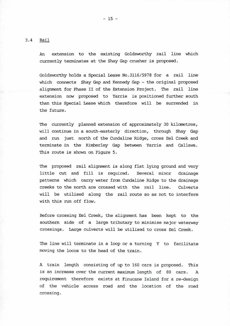
3.4 Rail
3.5 Overburden and Residue Management
3.6 Workforce
3.7 Support Facilities
3.8 Work Schedule
3.9 Exploration Potential
4.0 Existing Envirormnt
4.1 Regional Setting
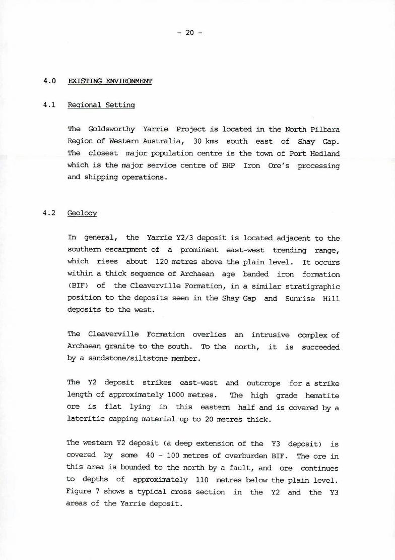
4.2 Geology
43 Climatology
4.4 Hydrology
4.5 Vegetation and Flora
4.6 Fauna
5.0 Aboriginal Heritage
6.0 Social Iniacts
6.1 Land Use
6.2 Heritage
6.3 Social Environment
7.0 Environmental Impact and Hanagit
7.1 Construction Phase
7.2 Operation Phase
1.0 SUNMARY
This proposal is to develop a mining operation at Yarrie.
The ore reserve in the proposed mining area is approximately
30 million tonnes of high grade iron ore and extraction of
this product is planned at 5 million tonnes per year.
The project will involve a 30 kilometre extension to the
existing Shay Gap railway line, relocation of the Shay Gap
crusher and train loading facilities to Yarrie, erection of a
contractors camp site and provision for power and water. The
total cost of this developtent is around $40 million.
Thw vrkforce will peak during the develoçent phase at
approximately 200. During the production phase, it is
anticipated that the workforce will stabilise at around 100
people on site.
-2 -
2.0 INTRODtXTION
2.1 Oblective
The aim of this project is to move the principal Goldsworthy
mining operations to the Yarrie area. This proposal is
suhnitted by B}1P Iron Ore (Goldsworthy) Limited ("The
Company") pursuant to Clause 8 of the Iron Ore (Goldsworthy -
Nimingarra) Agreement Act.
Plans to move to Yarrie were outlined in November 1985 in the
"Goldsworthy Extension Project", copies of which were
sutxnitted to the State Government of Western Australia through
the then Department of Resource Development. The project was
divided into two distinct phases; Phase I - Mining of
Nimingarra, Sunrise Hill and Shay Gap areas, and Phase II -
Kennedy Gap and Yarrie.
A Notice of Intent was sutnitted for Phase I in December 1986
which indicated this phase would continue through to the year
1999.
Since the acquisition by BHP Minerals and its Japanese
partners in 1990 of the Hanson interest in the Mount
Goldsworthy Mining Associates joint venture, an intensive
drilling program has been undertaken on the Nimingarra/Sunrise
Hill/Shay Gap areas and also the Yarrie area. From the
results of this program, an extensive study was made of the
ore reserves with the result that mining at Yarrie has been
moved forward to coniznence full production in 1994.
Drilling is continuing in the Kennedy Gap area and any
proposal for that development will be the subject of a
separate subnission pursuant in the Iron Ore (Goldsworthy)
Agreement Act.
PORT HEDLAN1 "
2 r
I'
tIA
POINT SAMSON S HAY GAP DAMP
KHAM BArN
BOEdOURNE 4'
BARROW ISLAND WESTo YARRIE - NO1H PROJECT
AREA U
I 7- 4,
MARBLE BAR
r; 1 z
\ S - o p
• PANNAWONICA \. 74
Deepdak' P'OtWtI -.
0 c, •
NULLAGINE
-- - ------------ WI TTE-NOQ
Pa,1 • SEALED ROAD _____ UNSEALED ROAD
R ange UNDER CONSTRUCTION
RAILROAD
TOM PRtCE
KARIJINI VANDI
NATIONAL PARK
PARABURDOO 011hIhaI,fl,a
/ YARRIE IRON ORE PROJECT NEWMA
LOCATION MAP K,hulllL'll,!b
FIGURE 1
I / Pardoo•
r' m De Grey -.
I I e ORD-RIDLEY
MLM5 SA I PORT HEDLAND __ SA
AREA
I/ pow 1 '" 45/881
I / 45/1077/ GOLDSWORTHY N E45/ 1075
Boodafrie f ML249 5,4 .1st ii Pippingarra
reey E45/
Wallareenye /1
Sk
I / - U Eg/nb3J,
4- LaJ/aRoakh• 'V TE
\ / (
-r ScQ io
Die
BAR ..
NUU-dgar
/
13
'014
15 19
41L.249 SA \20
T
Cal/awe Gap-Vm r08118
U
4f249 S4 1
ILI o 10 20 30 40 50km L I I I I I
iP ho Ow
NORTHERN PILBARA TENEMENTS
Area A _____ M.L. 235 SA
Area B I I M.L 249 SA (21 Sections)
}
BHP IRON ORE (GO Area D M.L. 251 SA/M.L. 263 SA (8 SectIons) LDSWORTHY) LTD.
ExpIoraton Licence areas
—I-- I— Existing railroad —II II Proposed railroad
Town Homestead
BHPO2
Figure 2
-3 -
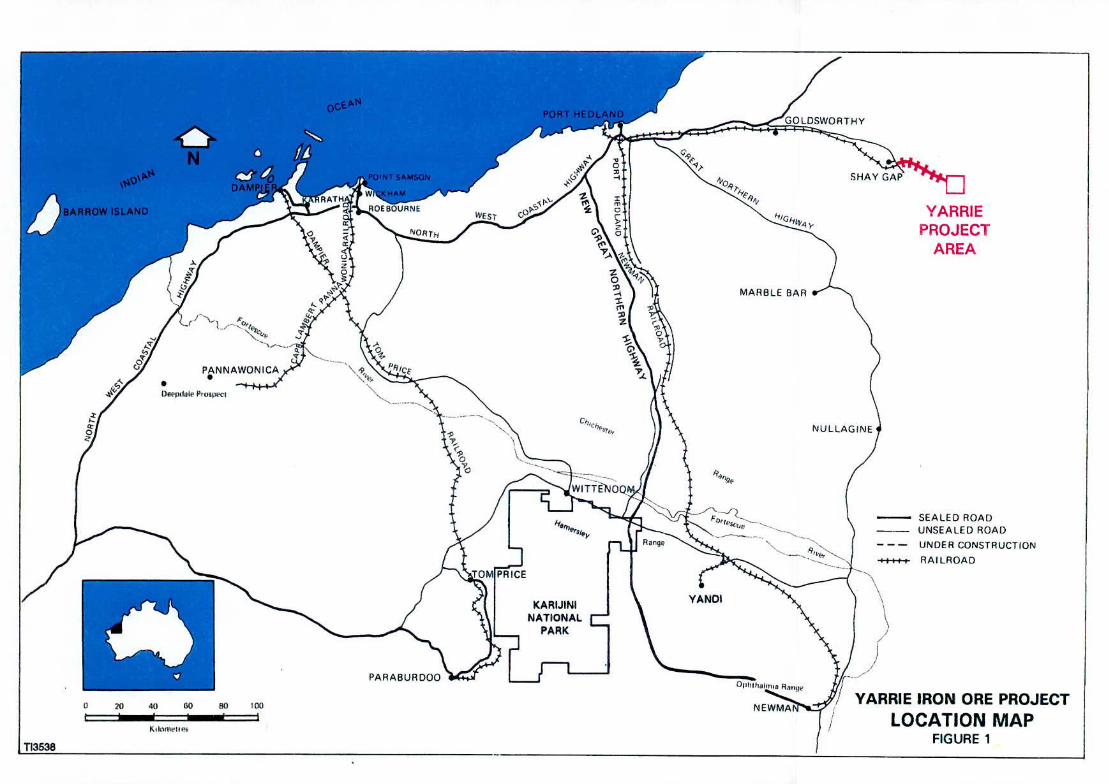
2.2 Location
The current mining operation of Mount Goldsworthy Mining
Associates is located in the Pilbara region of the north-west
division of Western Australia - see Figure 1.
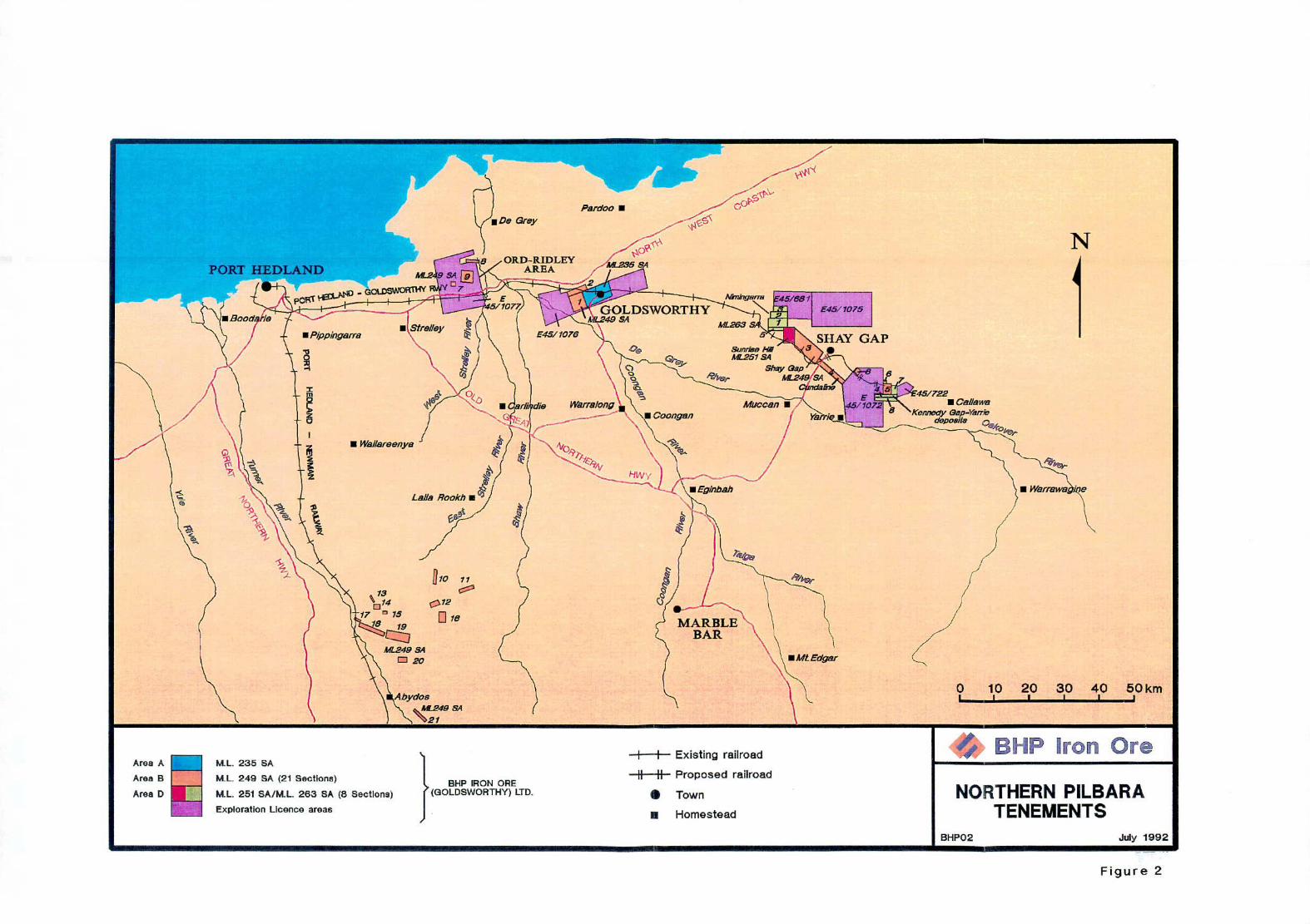
Tenements that the company holds in this region are as follows:
1. Goldsworthy area
Goldsworthy ML235SA
Goldsworthy Mt249SA Sect 1 and 2
C) E 45/1076
2. Shay Gap area
Shay Gap NL249SA Sect 3
Cundaline M[249SA Sect 4
C) Sunrise Hill ML251SA
Nimingarra ML2635A Sect 1,2,3 and 5
E 45/681
E 45/1075
3. Yarrie area
Kennedy Gap ?1L249SA Sect 5
Cattle Gorge NL249SA Sect 6
C) Yarrie NL263SA Sect 4,6,7 and 8
E 45/722
E 45/1072
These tenements are shown on Figure 2 together with nearby
tenements in the Ord - Ridley and 1bydos areas.
-4 -
2.3 Ownership
The Mount Goldsworthy Mining Associates Joint Venturers are
the owners of the Goldsworthy operations. These joint
venturers are:
BHP Australia Coal Limited 30%
BHP Iron Pty Limited 55%
Mitsui Iron Ore Corporation 7%
C I Minerals Australia Pty Ltd 8%
The manager for the project is BHP Iron Ore (Goldsworthy) Ltd
of 200 St George's Terrace, Perth, Western Australia.
2.4 History
Goldsworthy Mining Limited (name changed to BHP Iron Ore
(Goldsworthy) Ltd in 1991) was the first iron ore mining
company to commence operations in the Pilbara.
Goldsworthy
Formal Government approval for construction, and subsequent
mininq operations at Mount Goldsworthv. s achieved ,ith fH - -
passing of the Iron Ore (Mt Goldsworthy) Agreement Act in
December 1964, which superseded previous acts passed in 1962
and 1963.
Initial contracts with Japanese Steel Mills, finalised in
Februaiy 1965, provided for the export of 16.8 million tonnes
of high grade lump ore, over a seven year period. The next 15
months of construction at Mt Goldsworthy and Finucane Island
marked the commencement of the 'iron ore boom' and sparked off
a new era in the develognent of the Pilbara area.
-5 -
In the twenty-six years since the first iron ore shixient was
made from the Goldsworthy Project in June 1966, approximately
150 million tonnes of ore have been mined and shipped to
customers in Japan, South-East Asia, Europe and Australia.
Mining was initially based on the Goldsworthy orebodies, but
with the increasing market demand, capacity was expanded and
operations were extended in 1972-1973 to include the Shay Gap!
Sunrise Hill deposits.
The original deposits at Goldsworthy were mined out in December
1982, and all mining operations have since been concentrated at
Shay Gap and Sunrise Hill. However, since the economically
rnineable high grade ore reserves accessible to the Shay Gap
crusher were limited, the Company changed the basis of its
operations and adopted a new production concept, which commenced
in January 1989. This concept allowed the operations to continue
in the Shay Gap/Sunrise Hill area while continuing to utilise
its existing assets in that area, as well as the existing
railway to Finucane Island and the port facilities located there.
This change in operations was the subject of the Goldsworthy
Extension Project - Phase I. The concept involved an expansion
in the mining areas to include the Nimingarra area. In addition
a beneficiation plant was constructed at the port facilities at
Finucane Island to upgrade low grade ore to a high grade
saleable product.
2.5 Existing Facilities
2.5.1 Mining
The ore reserves at Nimingarra, Sunrise Hill and Shay
Gap are .Archaean in origin and occur mainly as narrow
steeply dipping lodes, striking along an east-west
trending ridge and also as shallower crust type ore
deposits adjacent to these lodes. A relatively large
number of small deposits have been developed and have
been mined using conventional open cut methods. See
Figure 3.
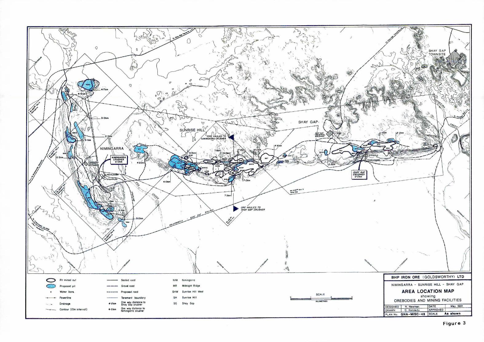
Pit mined Out Sealed road NIM Nimingorra
Proposed pit Gravet road MR Mdnight Ridge
Water bore. Proposed rood SHW Sunrise Hill West SCALE
Powertine Tenement boundary SH Sunrise Hill 0
Droinoge 40kn, ewoydistonce to SC Shy Gap
Contour (tOm interval) 40km One way distance to Nimingorro crusher
Figure 3
-6 -
Primary blast holes, 310cm in diameter and up to 15m
deep, are drilled in the ore and the waste, in
predetermined patterns for blasting. The blasted
material is then excavated by front end loaders and
loaded into a fleet of 24 x 120 tonne haulpak trucks,
which transport the ore to either the Nimingarra or
Shay Gap crusher, and the waste to nearby dumps. The
ore is primary crushed and stockpiled, ready for
trainloading.
2.5.2 Railing
The 180 km standard gauge heavy duty railway line,
which links the Nimingarra train loader and the Shay
Gap train loader to the Port operations at Finucane
Island, traverses relatively flat country (see Figure
2). There are twelve bridge crossings, the longest of
which is 427 metres over the De Grey River.
Trains, consisting of rakes of 75 to 80 ore cars, each
carrying 75 tonnes of ore, are hauled by a single 3750
HP locomotive. All railway operations and maintenance,
including track maintenance, were controlled from the
town of Goldsworthy. These operations have been
transferred to Port Hedland with the completed
changeover finalized in July 1992.
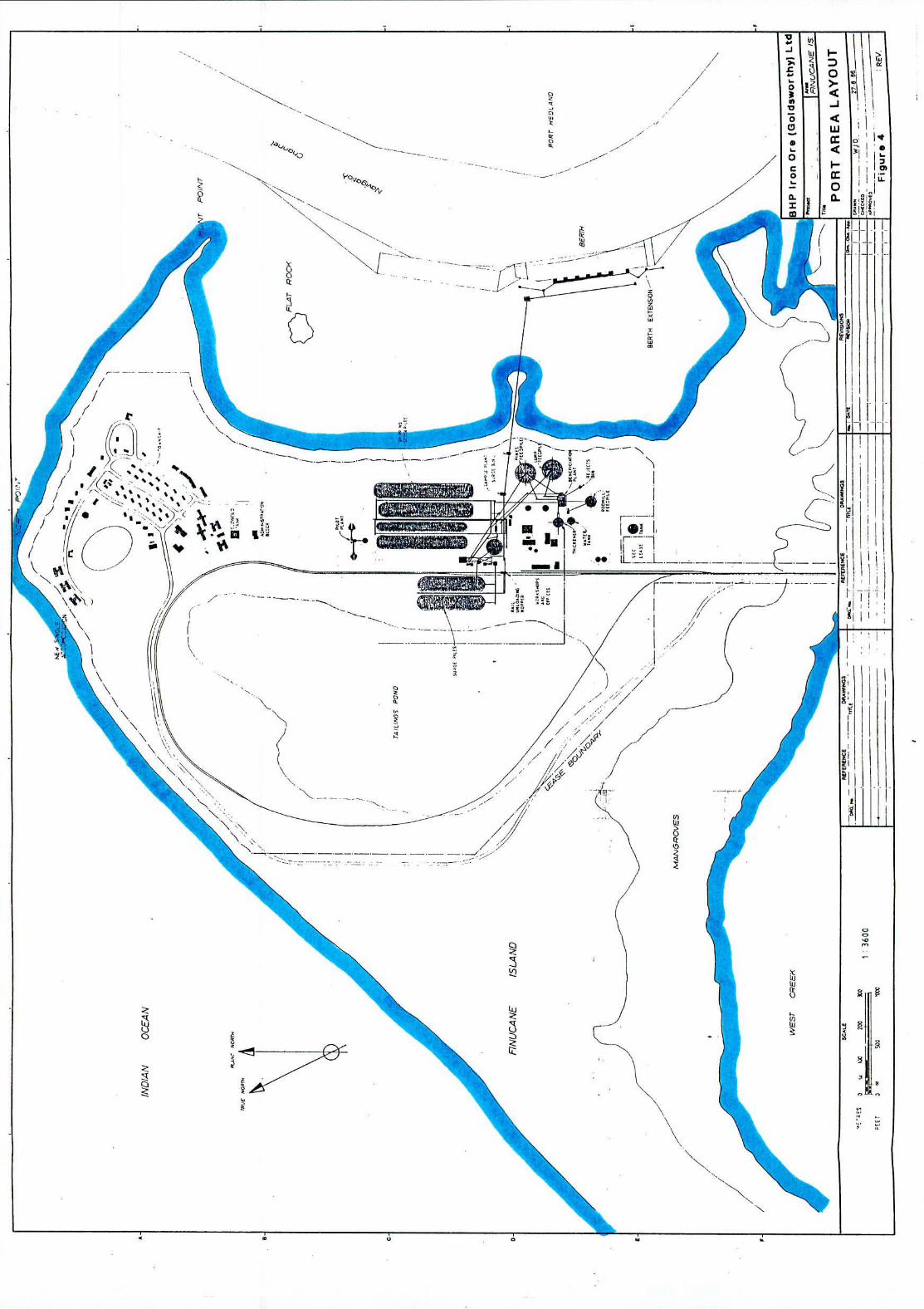
2.5.3 Port Ore Handling Facilities
Upon delivery to the Port, the ore is discharged and
stacked in a surge pile, from which it is selectively
withdrawn as required for secondary and tertiary
crushing and screening. The high grade crushed ore is
screened into two products for shipnent, nominally -30
+6nm lump and nominally -6rrun fines, which are stacked
and blended on the shipping product stockpiles. The
law grade crushed ore is directed to separate
stockpiles ahead of the beneficiation plant (see
Figure 4 - Port Area Layout).
/ / LU
JL1Ji
q
$
/i •( %% 4\
/ S 'N.. " •. t •1
.?'.
(7 9.
-i--i
11
3
-7 -
The beneficiation plant consists of two jigs, one each
to treat the lump and fines fractions. The concentrates
from the jigs are dewatered, conveyed and blended with
direct high grade ore. The middlings from the lump jig
are quaternaxy crushed and returned to the fines feed
stockpile. The middlings from the fines ore jig pass to
a rod mill before treatment in a spiral circuit. Slimes
which are separated by cycloning are pumped to a Wet
High Intensity Magnetic Separator. Plant water is
conserved by using a thickener from which tailings are
pumped to a pond.
When shiploading, the ore products are reclaimed from
the stockpile and conveyed to the berth, at a rrximum
rate of 4500 TPH, averaging about 3000 TPH, after
allowing for hatch changes, draft surveys, etc. The ore
is sampled, as it is loaded, and the samples are reduced
and combined for final analysis.
The Goldsworthy berth, as it presently stands, is capable
of accommodating and loading ships up to approximately
180 000 tonnes. Marine activities and the sailing
drafts are governed by the large tidal movements, which
can be as much as 7.3 metres. Vessel movements within
the harbour are controlled by the Port Hedland Port
Authority.
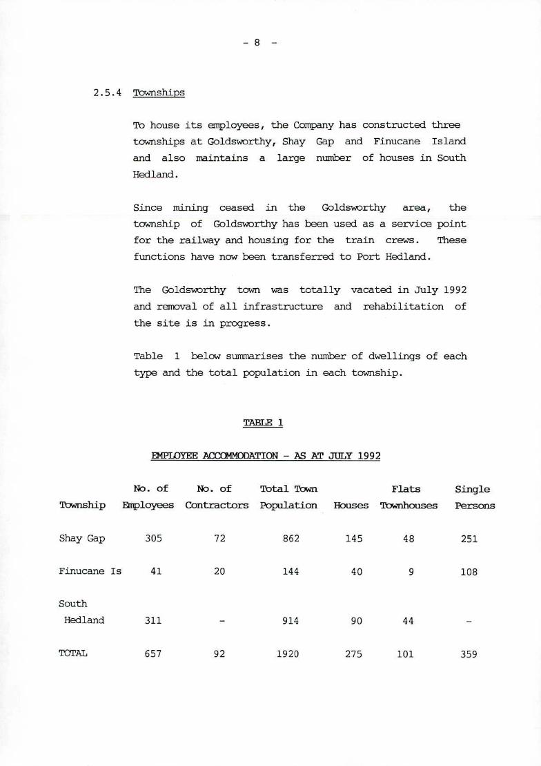
2.5.4 Townships
To house its employees, the Company has constructed three
townships at Goldsworthy, Shay Gap and Finucane Island
and also maintains a large number of houses in South
Hedland.
Since mining ceased in the Goldsworthy area, the
township of Goldsworthy has been used as a service point
for the railway and housing for the train crews. These
functions have now been transferred to Port Hedland.
The Goldsworthy town was totally vacated in July 1992
and removal of all infrastructure and rehabilitation of
the site is in progress.
Table 1 below surrnnarises the number of dwellings of each
type and the total population in each township.
E4PLOYEE ACCC'14ODATI0N - AS AT JULY 1992
No. of No. of Total Town Flats Single
TYb.?nship Eloyees Contractors Population Houses 'Inhouses Persons
Shay Gap 305 72 862 145 48 251
Finucane Is 41 20 144 40 9 108
South
Hedland 311 - 914 90 44 -
TOTAL 657 92 1920 275 101 359
-9 -
2.5.5 Conmunications
Each centre is linked by up to date telephone and other
communication services.
2.5.6 Power Supply
Initially the Company provided all its own power
requirements, which were generated at two small power
stations, one at Goldsworthy and one at Finucane Island.
The station at Finucane Island was closed in the mid '80s
and power for the Port operations and the Finucane Island
corrmunity is now drawn from the State Energy Commission
system at South Hedland, through a Company provided
power line.
Power for the Goldsworthy and Shay Gap townships and
Shay Gap mine area was generated at the Company' s 13.8 MW
power station at Goldsworthy and transmitted by an
overhead transmission line to Shay Gap. With the
introduction of the Goldsworthy Extension Project -
Phase I, a State Energy Co1Tunission power line was
erected which linked Port Hedland and Goldsworthy. The
Goldsworthy power station was decommissioned and all
power used by the company is now purchased from SECWA.
2.5.7 Water Supply
The water supply for the Shay Gap and Goldsworthy
townships is obtained from nearby bore fields, and the
Company maintains the required water treatment
facilities and sewerage treatment plants.
The bore field and sewerage treatment plants at
Goldsworthy will be decommissioned, removed and
rehabilitated with the removal of the townsite.
MOM
2.5.8 Roads/Airstrips
Roads have had to be constructed and maintained by the
Coirpany, linking the towns to the main road system.
This includes the road from the Hedland light industrial
area to Finucarie Island, and from the main road turn off
to Goldsworthy and Shay Gap.
Airstrips have also been constructed, at Goldsworthy and
Shay Gap. A request has been made by the local pastoral
holders to leave the Goldsworthy airstrip in place when
the Goldsworthy township and associated facilities are
removed and rehabilitated.
3.1 Introduction
This proposal describes Phase II of the GoldsvQorthy Extension
Project. This phase as outlined in 1986 was due to commence in
the year 1999. Exploration drilling programs have been an
ongoing activity in the operations with an intense program
taking place in 1991/92 throughout the Nimingarra/Shay Gap area
as well as the Yarrie area. The remaining reserves at
Nimingarra/Shay Gap which resulted from this program have shown
that the life expectancy of the area is much shorter than
originally thought.
Conversely, the mining reserve shown to exist at Yarrie is an
increase on original estimates. Although there is a
requirement to remove a large volume of overburden, the
improved grade of the iron ore combined with other technical
advantages dictate that an immediate move to Yarrie is
necessary for the ongoing viability of the total Goldsworthy
operations.
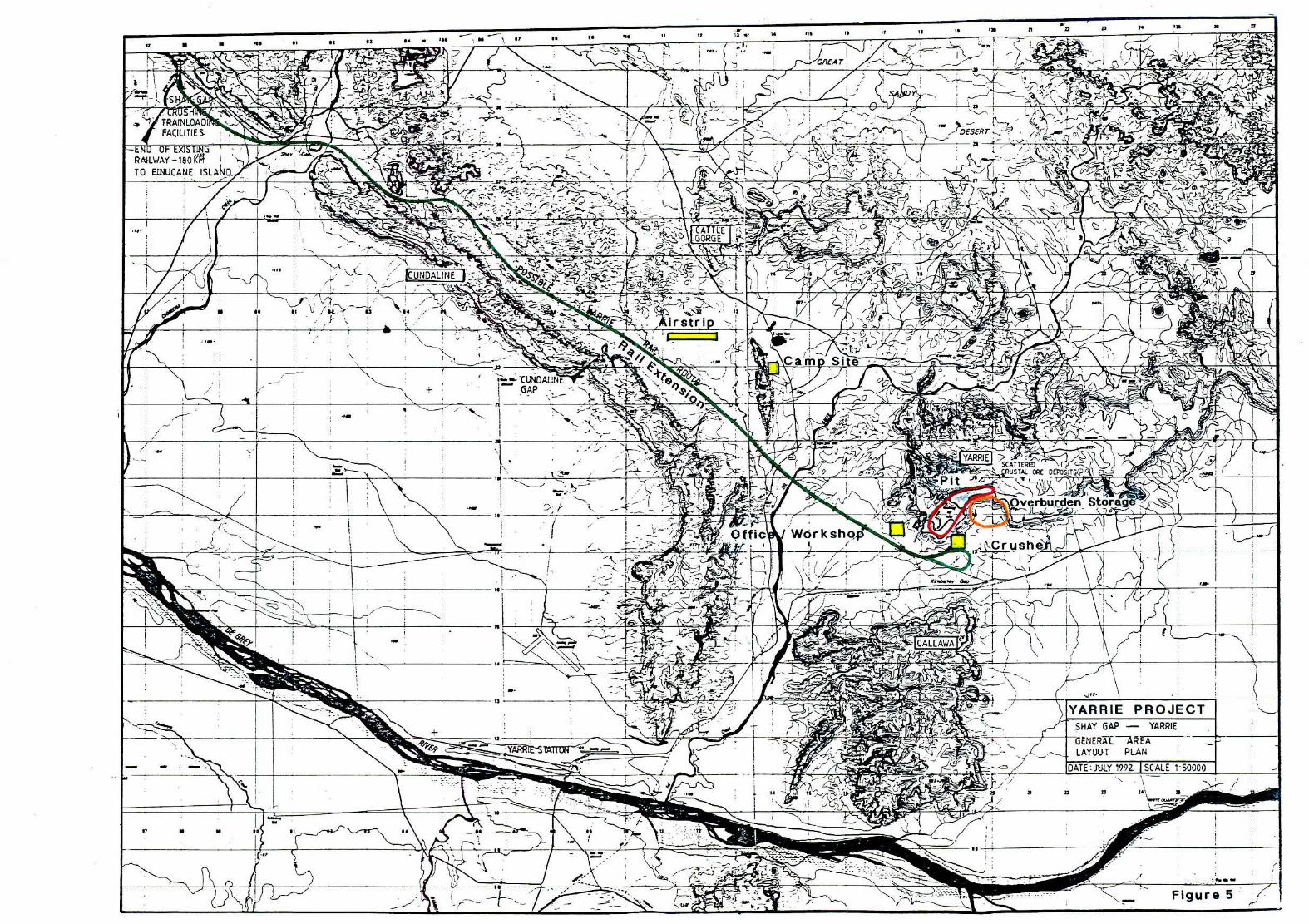
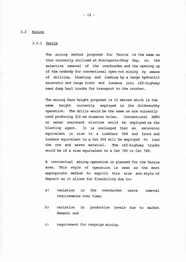
The Yarrie area is located approximately 32 km south-east of
the Shay Gap crusher location (see Figure 5).
Plate 1 shows a general view taken from the top of the Yarrie
mesa looking south-west.
The required extraction of high grade direct product ore is
proposed at about 5 million tonnes per year, depending on sales
contracts.
- — 0 II I. 40 44 12 .. 4 . . 24 ' 20 Ia a
02 •4 84 t — -
I
GREAT
$
~ wt ,
1 TRALOAD( FACRJTIE 1 —- -. -
- DES
RAI
ERT-
LNG LWAY180'
-
;>
44;&Q~ GORGE ~ -
:\- ..... .....
- - •-'-'. t
\/ 1___
UNDALR
i ts I
,• c. 43
Airstrip - ,-J/ / _\_•_•
o? ;7c-,
-• . - Cam
'. - )5 \ I - ' S - '• - —. S -CLiOALJN s -• ' --T',
+GAP
AP
;.'L- ' . i-- -• '- -' '-- •>r-?--'i1 1
CATT
_.- RUST4LEOEPOSITS'
/ — - - - OverburdenStorad
( - -Offic Workshqp - / r.?. ' -' -
•'-'- 'Crushe I I
• / ,• I
__________ N - - - •• - - ._,---- • •
•:•. -- - C : - -. . -- S 1
-
13
-YARRIE PROJECT HAY GAP - YARRIE
____ _______ - • — -12--
•- / ,, - L. • GNER[AEA S -.
ç - -* - S • -. LAYQUT PLAN
DATE JULY 19Z ISCALE 150000 -
L •- .. - . . . .•
tj.' -' - ---- 2? 11 22 23 a
N N - 8 84 84 -: • - -
'5,
1 I - •- -
- - . •• . '• - S ( - S / • - -
_$, _.__4__
- S
- -- - • - - S - 88 • •
--
p
/ -5- _-.-------'-,
- •- -5-- -5----- -•--•.---------- -5-----
-5
I ___
\ -• 'c,- .- ,:'' .••.__- - - •-, -' (
___--
- - - Figure5 7
-.5--- ' S-f- ( -- - .-- "\ u#- • - 'C / S
- 12 -
3.2 Mining
3.2.1 Yarrie
The mining method proposed for Yarrie is the same as
that currently utilised at Nimingarra/Shay Gap, ie. the
selective removal of the overburden and the opening up
of the orebody for conventional open-cut mining by means
of drilling, blasting and loading by a large hydraulic
excavator and large front end loaders into off-highway
rear dump haul trucks for transport to the crusher.
The mining face height proposed is 12 metres which is the
same height currently employed in the Goldsworthy
operation. The drills would be the same as are currently
used producing 310 nn diameter holes. Conventional ANFO
or water resistant slurries would be employed as the
blasting agent. It is envisaged that an excavator
equivalent in size to a Liebherr 994 and front end
loaders equivalent to a Cat 994 will be employed to load
the ore and waste material. The off-highway trucks
would be of a size equivalent to a Cat 785 or Cat 789.
A contractual mining operation is planned for the Yarrie
area. This style of operation is seen as the most
appropriate method to exploit this size and style of
deposit as it allows for flexibility due to:
variation in the overburden waste removal
requirements over time;
variation in production levels due to market
demand; and
requirement for campaign mining.
q3v
311S 3NIVI ]IHLIVA
CA - !d e! J J IBA obeioS uapjnqjOAO
- - -• -''-.
:--. ••.yr............ .•-I Jb,1 ., •
-41- - • - •• •. -'-v. . - - .I • - :.I1I..'• JL .jS_
-,. •'+- •• -.. - . - •
1Ls i4 • / - I
. 1fW •. -' 7 •I
iqsnj AJW!Jd
lemleilleo
- 13 -
A develonent phase of approximately 9 months duration
is required to remove around 8 million tonnes of
overburden to uncover the high grade iron ore. Mining
of the high grade is scheduled to commence in Ppril 1994.
The extraction rate of saleable ore is proposed at about
5 million tonnes per year. A reserve of approximately
30 Mt has been identified with a strip ratio of around
2:1 (overburden :ore). Exploration drilling has
intersected deeper ore in the Y2 area and further
economic analysis needs to be made to assess the
viability of this ore.
Pit dewatering will not be required until the latter
years of the project when mining has reached
approximately 110 Tn RL.
A preliminary pit plan which illustrates a total
extraction pit is shown on Figure 6 which is included at
the back of this report. Confirmation of this design is
subject to an economic analysis of the deeper ore in the
Y2 area.
3.2.2 Nimingarra/Surirjse Hill
Following the develoiiient of mining operations at
Yarrie, Goldsworthy will still have contracts with
customers for ore types which are not available from the
Yarrie area. These contracts vary in amounts up to
1,500,000 tonnes per year.
It is proposed that this ore will be sourced from the
current Nimingarra/Sunrise Hill area. Mining will take
place in campaigns by deploying part of the contractors
mining fleet at Yarrie to Nimingarra. Sufficient
product stockpiles will be created next to the rail spur
to last for several months to meet contracts.
At the above extraction rate, this area will be mined
out in 1997.
- 14 -
3.3 Ore Processing
3.3.1 Nine
It is proposed to relocate the existing Shay Gap crusher
to Yarrie. The crusher will be positioned on the side
of the escarient at Yarrie in the general location as
indicated in Figure 6 taking advantage of the height to
reduce the haulage distance.
Ore will be direct tipped to the crusher from haul trucks
or loader fed from adjacent run-of-mine stockpiles.
Primary crushing will take place to produce a nominal
-150rruxi size product. The crushed ore will be conveyed
to a trainloading facility, again relocated from Shay
Gap, for loading the current fleet of rail cars. The
possibility of crushing to a -100mm size product will be
considered.
The existing Nimingarra crusher will be utilised for
crushing ore from mining campaigns in Niiningarra/Sunrise
Hill area. This ore, once mined and crushed will be
placed onto the existing Nimingarra stockpiles. Train
loading will take place using the existing conveyor and
ore bin facilities.
3.3.2 Port
All existing plant and equixnent used for train unloading
and stockpiling, crushing and screening and product
stockpiling and shiploading will continue to be used.
The beneficiation plant, as described in Section 1.5.3,
will continue to receive low grade ore from the mine
site for upgrading and then blending with the
run-of-mine product.
- 15 -
3.4 Rail
An extension to the existing Goldswor-thy rail line which
currently terminates at the Shay Gap crusher is proposed.
Goldsworthy holds a Special Lease No.3116/5978 for a rail line
which connects Shay Gap and Kennedy Gap - the original proposed
alignment for Phase II of the Extension Project. The rail line
extension now proposed to Yarrie is positioned further south
than this Special Lease which therefore will be surrended in
the future.
The currently planned extension of approximately 30 kilometres,
will continue in a south-easterly direction, through Shay Gap
and run just north of the Cundaline Ridge, cross Eel Creek and
terminate in the Kimberley Gap between Yarrie and Callawa.
This route is shown on Figure 5.
The proposed rail alignment is along flat lying ground and very
little cut and fill is required. Several minor drainage
patterns which carry water from Cunda line Ridge to the drainage
creeks to the north are crossed with the rail line. Culverts
will be utilised along the rail route so as not to interfere
with this run off flow.
Before crossing Eel Creek, the alignment has been kept to the
southern side of a large tributaxy to minimise major waterway
crossings. Large culverts will be utilised to cross Eel Creek.
The line will terminate in a loop or a turning Y to facilitate
moving the locos to the head of the train.
A train length consisting of up to 160 cars is proposed. This
is an increase over the current maximum length of 80 cars. A
requirement therefore exists at Finucane Island for a re-design
of the vehicle access road and the location of the road
crossing.
- 16 -
This becomes necessary with increased train lengths because the
train will restrict access along the current road aligrinient as
ore cars at the end of the train are unloaded. It is therefore
proposed to move the road crossing further away from the Island
to allow free movement of vehicles.
3.5 Overburden and Residue Management
3.5.1 Overburden
The total quantity f or removal of overburden material is
estimated at 60 million tonnes. If it should prove
economic to mine the deeper ore in the Y2 area of
Yarrie, this overburden tonnage will increase as a deep
cover occurs in this area.
Overburden dumping will take place in contour layers in
the embankment on the southern side of the mesa (Plate
1). This location will enable the dump to be blended
with the natural topography. The proposed dump design
is shown on Figure 6.
Contouring of the dump will be formed as mining
progresses deeper in the pit. In this way, an overall
angle of around 200 can be maintained.
At the completion of mining, the dump will be shaped to
blend with the existing land form and rehabilitated to
BHP standards.
Where possible, mined out areas, which will occur on the
eastern half of the deposit, will be back-filled with
overburden material.
3.5.2 Residue Management
The newly constructed extension to the beneficiation
plant residue pond at Finucane Island to receive residue
material from the thickener is of adequate size to
continue to receive this material for the duration of
the project. No additional facilities are required in this area.
17 -
3.6
Work force
A contractor mining operation is proposed for mining the Yarrie
orebody. This same workforce will be utilised for campaign
mining at Nimingarra/Sunrise Hill.
At the peak, during the develonent phase, it is estimated a
workforce of 200 will be employed. This will stabilise at 100
people on site during production.
It is envisaged that the contractor will operate his workforce
on a periodic work/recreation shift system.
3.7 Support Facilities
3.7.1 Mine Area
Upon moving to Yarrie, all support facilities will be
established at the Yarrie mine site. These facilities
will consist of:
Camp Site
Air Strip
Mine Offices
Workshop
Mine Plant and Light Vehicle Parking areas
Fuelling facilities
Power facilities
Water supply facilities
Explosive stores.
A contractors camp site will be erected close to the
Yarrie mine site but of sufficient distance so as not to
be disturbed by the mining activity. See Figure 5. The
camp site will consist of full acconirnodation and messing
facilities together with recreation facilities for the
entire mine site workforce - canpany and contractor.
An airstrip will be constructed for light aircraft close
to the camp site.
The mine facilities, offices, workshops etc will be
located at plain level in the area indicated on Figure 5.
This area is placed sufficiently far from the pit to
avoid blast damage.
Fuel facilities will be placed in an area designed in
accordance with current regulations as will the
explosives storage compound located and constructed in a
remote area away from other infrastructure.
Power for the camp site, mine offices, workshop,
crushing and train loading facilities will be sourced
from the SECciA line that currently terminates at the
Shay Gap township. This line will be extended to Yarrie.
The water supply will be obtained from the nearby Eel
Creek aquifer. Several bores will be located along the
Creek which will pump water to nearby storage tanks.
This water will be used for drinking and domestic
purposes at the camp and mine site as well as dust
suppression in the mine area.
3.7.2 Port Area
All existing port area support facilities will remain
unchanged.
3.8. Work Schedule
A work schedule has been devised to have Yarrie commence in the
shortest practical time period. This places the timing for the
commencement of the production phase at December 1993.
In order to meet this date, the commencement of site work on
the railway, which is on the critical path, is scheduled at
1 April 1993.
- 19 -
3.9 Exploration Potential
In addition to the ore defined in the Yarrie deposit, the area
contains further reserves in the form of shallow 'crustal'
deposits and the cemented conglomerate deposit of Kennedy Gap.
Further definition of these areas will be obtained during the
mining phase at Yarrie.
These additional deposits are of lower quality than Yarrie and
as such, do not form part of this proposal. Should a market be
found for these products, a further proposal will be suhnitted.
- 20 -
4.1 Regional Setting
The Goldsworthy Yarrie Project is located in the North Pilbara
Region of Western .Pustralia, 30 kms south east of Shay Gap.
The closest major population centre is the town of Port Hedland
which is the major service centre of BHP Iron Ore's processing
and shipping operations.
4.2 Geology
In general, the Yarrie Y2/3 deposit is located adjacent to the
southern escarinent of a prominent east-west trending range,
which rises about 120 metres above the plain level. It occurs
within a thick sequence of Archaean age banded iron formation
(BIF) of the Cleaverville Formation, in a similar stratigraphic
position to the deposits seen in the Shay Gap and Sunrise Hill
deposits to the west.
The Cleaverville Formation overlies an intrusive complex of
Archaean granite to the south. To the north, it is succeeded
by a sandstone/siltstone member.
The Y2 deposit strikes east-west and outcrops for a strike
length of approximately 1000 metres. The high grade hematite
ore is flat lying in this eastern half and is covered by a
lateritic capping material up to 20 metres thick.
The western Y2 deposit (a deep extension of the Y3 deposit) is
covered by some 40 - 100 metres of overburden BIF. The ore in
this area is bounded to the north by a fault, and ore continues
to depths of approximately 110 metres below the plain level.
Figure 7 shows a typical cross section in the Y2 and the Y3
areas of the Yarrie deposit.
SE NW
S N
_ + 57m + -
- ± + + +. +=—r- I2 =-= / 0 50 lOOm
± + ++
Y 3 + + + + +
87m 7m
+ + + + -
44550E section +
Stratrraphy Ore types / BHP iror Or (G dsworthy) Ltd. Mafic Intrusive Laterite ' 50% Fe -
ciatone / quartzite Hh grade - 80% Fe Drillhole
t~Y;a"_'r YARRIE 2 / 3 typacaly 68% Fe I 1 .+ Granfle
Depth (m) Typical Cross-Sections
2 BHP06 July 1992
Figure 7
- 21 -
4.3 Climatology
The background climate of the north west of Western Australia
is tropical. During the summer months, in particular,
temperatures are frequently high, particularly inland, and
humidity is high in coastal regions. Rainfall throughout the
region shows a strong summer maximum with very dry conditions
during the late winter and spring. Winds are predominantly
from the south east, with sea breezes along the coast,
particularly during the warmer months.
There are four specific weather phenomena which are of greatest
importance to this region. The summer monsoon brings most of
the annual rainfall to the region. Its influence decreases
southward. Much of this rain comes from tropical cyclones,
which are also associated with damaging winds, flooding and
storm surges. During the winter months develoiient or
intensification of anticyclones over southern Western Australia
and South Australia may produce strong easterly winds over
parts of the north west. Also during winter, major cloud bands
may develop which extend from off the northwest coast across
the continent and bring significant rain to the northwest and
interior of the country.
In summer, inland temperatures can be extreme. Near the coast,
the climate is modified somewhat, although humidity in coastal
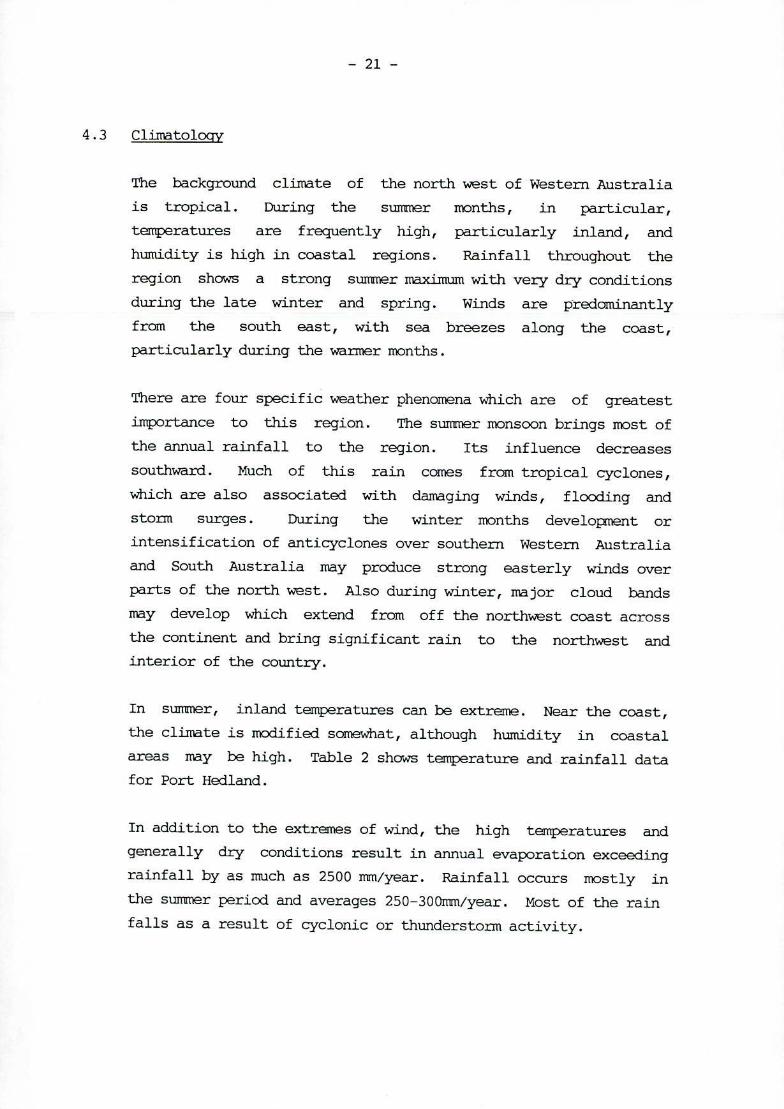
areas may be high. Table 2 shows temperature and rainfall data
for Port Hed land.
In addition to the extremes of wind, the high temperatures and
generally dry conditions result in annual evaporation exceeding
rainfall by as much as 2500 mm/year. Rainfall occurs mostly in
the summer period and averages 250-300mm/year. Most of the rain
falls as a result of cyclonic or thunderstorm activity.
- 22 -
CLIMMOIOGY - PORT HEDLAND
Tnperatuire ( C) Rainfall (xmi) Mean Mean Avg.No. of LOW High Min Max Min Max Rain days
January 25.4 36.3 18.1 47.5 0 454 5 February 25.3 36.3 16.3 47.1 0 360 7 March 24.4 36.8 15.8 44.5 0 251 4 April 21.1 35.2 12.2 42.4 0 352 2 May 17.0 30.3 7.0 38.8 0 170 3 June 13.7 27.1 4.7 34.4 0 125 3 July 11.9 26.6 3.2 33.8 0 81 2 August 12.9 28.6 3.7 36.8 0 35 1 September 15.3 32.4 8.4 40.9 0 9 1 October 18.0 34.7 11.1 43.7 0 8 1 November 21.2 36.5 12.4 47.4 0 67 1 December 23.8 36.7 16.6 47.9 9 219 2
4.4.1 Surface Water Hydroloqy
There is no major creek or river directly impacted by
this proposal. Streamf low in the area is highly
ephemeral and for most of the year the creeks are dry,
except for occasional pools in gullies formed on the
ridge. Large streamf lows are associated with
rain-bearing depressions or high intensity winter
rainfall. Along some of the ridges of the area there
are permanent pools which have been used by the
Aboriginals.
- 23 -
4.4.2 Hydrology of the Orebody
The majority of Yarrie Y2/3 deposit being located on the
top of the ridge with a surface elevation of RL270 m is
well above the watertable which is located at RL110 in.
The watertable is below the plain level at Kixrerley Gap
(RL124 m. The Yarrie Pit will require dewatering in
the latter stages of mining if the ore in the deep Y2
area is extracted. If this is to occur, at the
cessation of mining, the pit will fill with water, and, a
waterbcx:ly some 13 hectres in area and 70m deep will be
fonned once the water level reaches the present level.
It is estimated that it would take 40 million tonnes of
overburden to backfill the pit to just above the
existing watertable and if this was a requirement, would
make the Yarrie project uneconomic.
- 24 -
4.5 Veqetation and Flora
4.5.1 Suxwnary
The description of the vegetation and flora of the
Yarrie Area is based on a field survey carried out 12-13
August 1992. Nuch of the area has been subject to
cattle grazing but the vegetation associations appear
generally resilient. The area is floristically and
structurally similar to those found over large area of
the north - eastern Pilbara, to the west of the Great
Sandy Desert. The predominant formations are Tree
Steppe on the ranges, Shrub Steppe on plains and broad
valley systems, with Riveraine Sclerophyll Woodland
lining the well defined, major drainage systems.
4.5. 2 (Ijectives and Methods
The vegetation was examined on foot and by vehicles at a
number of locations along the rail route and in the
mining area. Several large sections of the rail route
had been burnt within the last 12-18 months. In these
areas identification of seedling regeneration was
necessary to confirm vegetation communities.
The mining area is well roaded and was examined in some
detail. Several valley systems were examined as well as
the upper plateaux and the huinock grasslands to the
south.
Voucher specimens were collected for later confirmation
of all those species which could not be positively
recognised in the field.
- 25 -
4.5.3 Results
4.5.3.1 Flora
A total of 80 plant species was recorded, representing
46 genera and 29 families. These are listed in Table 3.
Plant families best represented by numbers of species
are the Mirnosaceae, with some 13 species of Acacia
recorded; the Fabaceae, Amaranthaceae and Nyrtaceae are
also well represented.
The Poaceae and ephemerals were under represented at the
time of the survey, most of the grasses flower in summer
and a good range of Asteraceae and other ephemerals
would be expected to be present later in the season.
4.5.3.2 Vegetation
The Railway Extension Route
Hummock grasslands of the soft spinifex Tricdia
pun gens are the most frequent components of the Shrub
Steppe along the railway extension route. Some of the
more frequent shrub / small tree species present include
Acacia a.ncistrocarp, A. inaequilatera, A. holosericea
and A. tumida, with scattered specimens of Hakea
rnacrocarpa, H. suberea and Grevillea wickha.mii. Local
patches of low wattles including Acacia translucens, A.
hilliana and A. adoxa occur amongst the spinifex.
Infrequent specimens of Eucalyptus tenminalis and E.
aff .papuana are the tallest species of the Shrub
Steppe. Steeper side slopes carry some Eucalyptus
leucophloia with Triodia wiseana replacing
T.pungens as the main spinifex species.
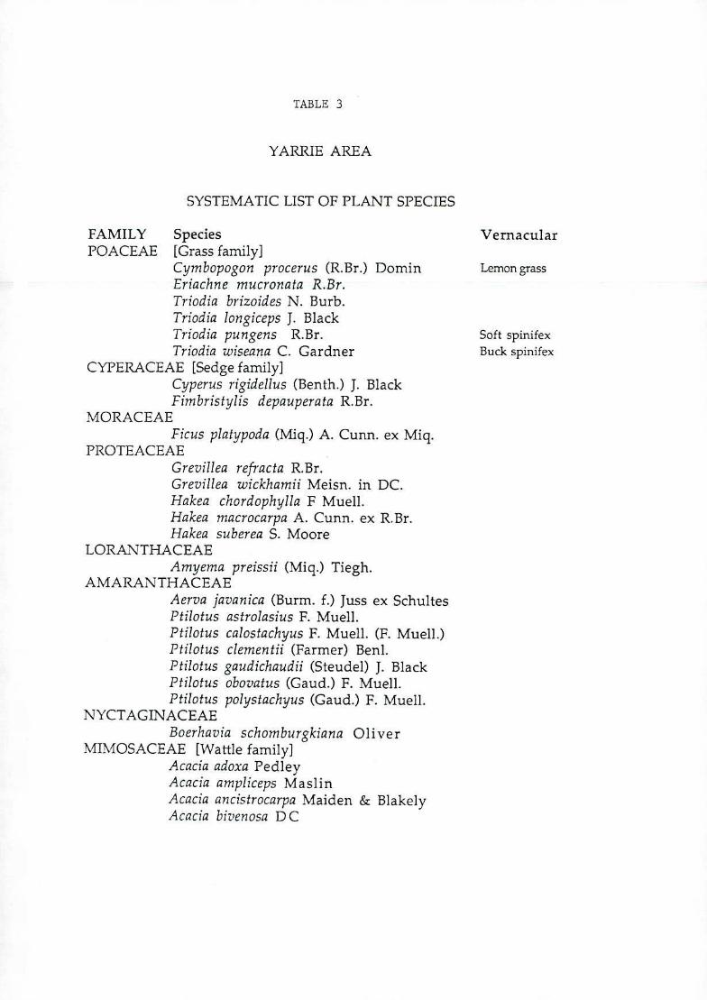
TABLE 3
YARRIE AREA
SYSTEMATIC LIST OF PLANT SPECIES
FAMILY Species POACEAE [Grass family]
Cymbopogon procerus (R.Br.) Domin Eriachne mucronata R.Br. Triodia brizoides N. Burb. Triodia ion giceps J. Black Triodia pungens R.Br. Triodia wiseana C. Gardner
CYPERACEAE [Sedge family] Cyperus rigidellus (Benth.) J. Black Fimbristylis depauperata R.Br.
MORACEAE Ficus piatypoda (Miq.) A. Cunn. ex Miq.
PROTEACEAE Grevillea refracta R.Br. Grevillea wickhamii Meisn. in DC. Hakea chordophylla F Muell. Hakea niacrocarpa A. Cunn. ex R.Br. Hakea suberea S. Moore
LORANTHACEAE Amyema preissii (Miq.) Tiegh.
AMARANTHACEAF Aerva javanica (Burm. f.) Juss ex Schultes Ptilotus astroiasjus F. Muell. Ptilotus calostachyus F. Muell. (F. Muell.) Ptilotus ciemen tii (Farmer) Beni. Ptilotus gaudichaudii (Steudel) J. Black Ptilotus obovatus (Gaud.) F. Muell. Ptilotus polystachyus (Gaud.) F. Muell.
NYCTAGINACEAE Boerhavia schomburgkiana Oliver
MIMOSACEAE [Wattle family] Acacia adoxa Pedley Acacia ampliceps Maslin Acacia ancistrocarpa Maiden & Blakely Acacia bivenosa DC
Vernacular
Lemon grass
Soft spinifex Buck spinifex
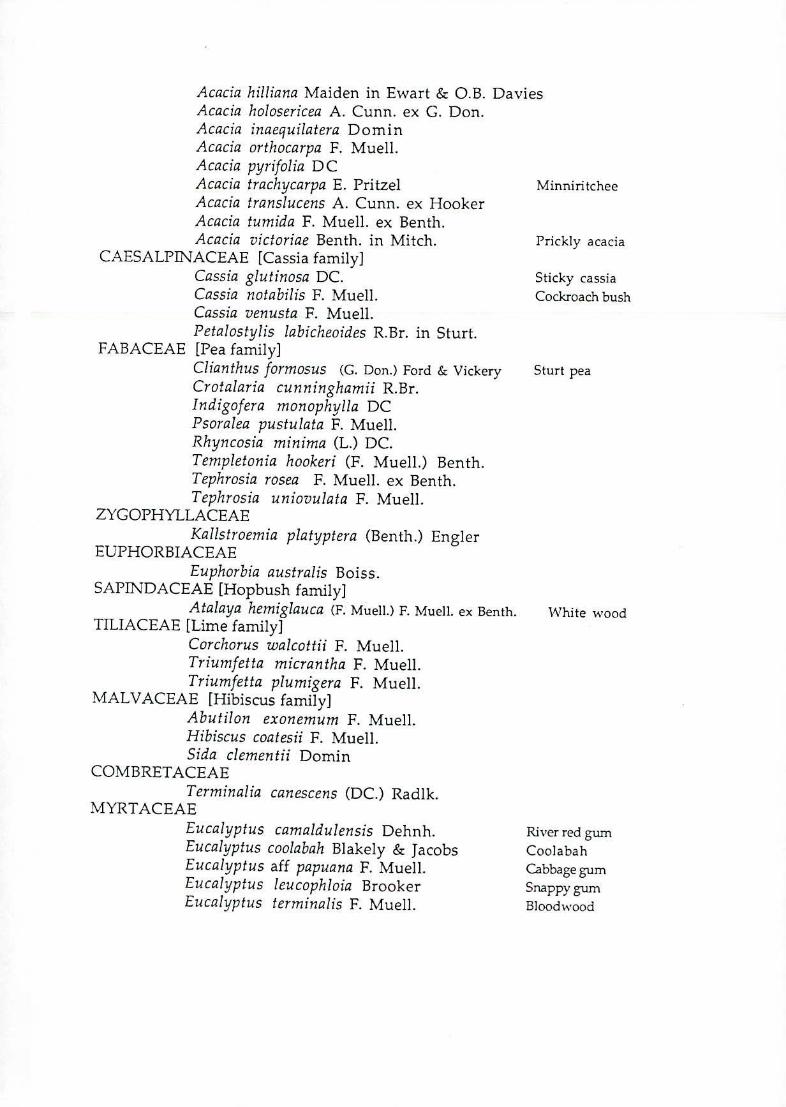
Acacia hilliana Maiden in Ewart & O.B. Davies Acacia holosericea A. Cunn. ex C. Don. Acacia inaequilatera Domin Acacia orthocarpa F. Muell. Acacia pyrifolia DC Acacia trachycarpa E. Pritzel Mirmiritchee Acacia translucens A. Cunn. ex Hooker Acacia tumida F. Muell. ex Benth. Acacia victoriae Benth. in Mitch. Prickly acacia
CAESALPINACEAE [Cassia family] Cassia glutinosa DC. Sticky cassia Cassia notabilis F. Muell. Cockroach bush Cassia venusta F. Muell. Petalostylis labicheoides R.Br. in Sturt.
FABACEAE [Pea family] Clian thus formosus (G. Don.) Ford & Vickery Sturt pea Crotalaria cunninghamii R.Br. Indigofera monophylla DC Psoralea pustulata F. Muell. Rhyncosia minima (L.) DC. Templetonia hookeri (F. Muell.) Benth. Tephrosia rosea F. Muell. ex Benth. Tephrosia uniovulata F. Muell.
ZYGOPHYLLACEAB Kallstroemia pla typtera (Benth.) Engler
EUPHORBIACEAF Euphorbia australis Boiss.
SAP]INDACEAE [Hopbush family] Atalaya hemiglauca (F. Muell.) F. Muell. ex Benth. White wood
TILIACEAE [Lime family] Corchorus walcottii F. Muell. Triumfetta micrantha F. Muell. Triumfetta plumigera F. Muell.
MALVACEAE [Hibiscus family] Abutilon exonemum F. Muell. Hibiscus coatesji F. Muell. Sida clementii Domin
COM BRETACEAE Terminalia can escens (DC.) Radik.
MYRTACEAE Eucalyptus camaldulensis Dehnh. Riverredgum Eucalyptus coolabah Blakely & Jacobs Coolabah Eucalyptus aff papuana F. Muell. Cabbage gum Eucalyptus leucophloia Brooker Snappy gum Eucalyptus terminalis F. Muell. Bloodwood
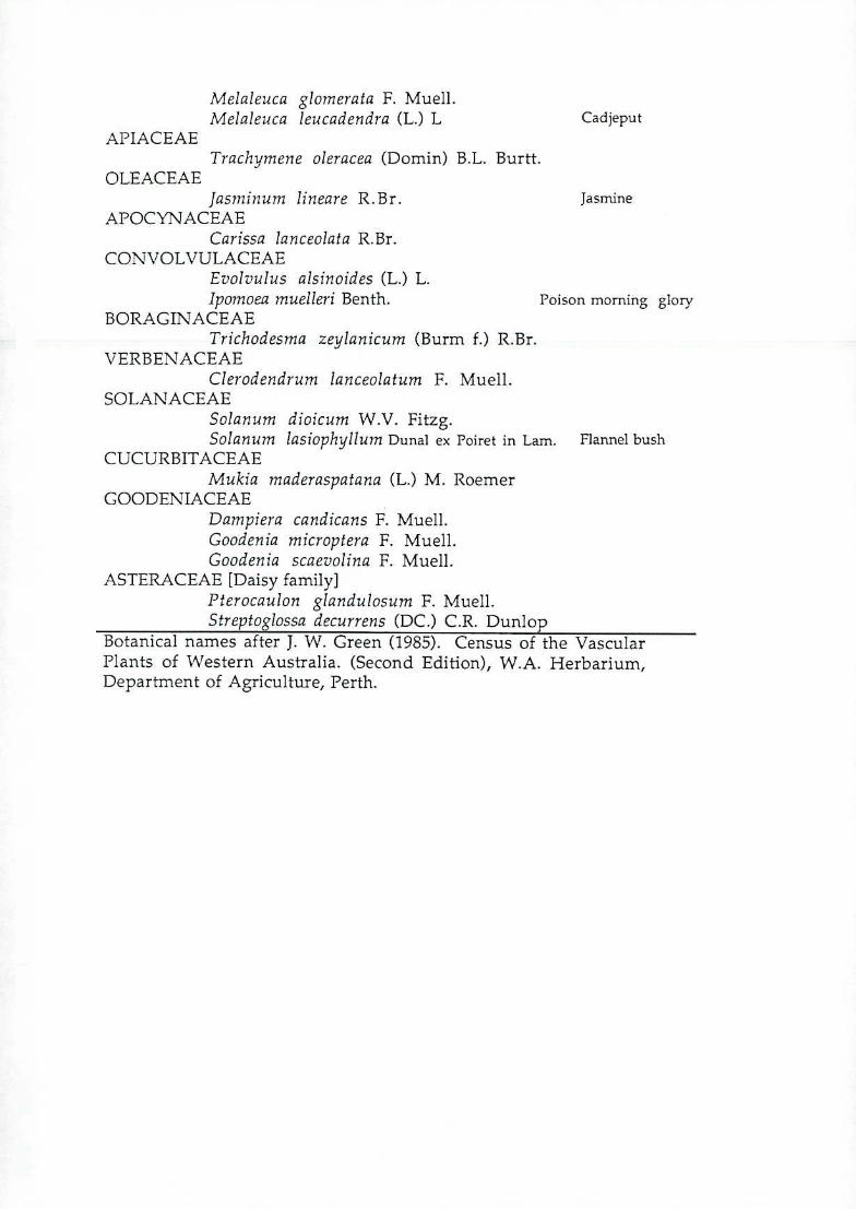
Melaleuca glornerata F. Muell. Melaleuca leucadendra (L.) L Cadjeput
APIACEAE Trachymene oleracea (Domin) B.L. Burtt.
OLEACEAE Jasminum lineare R.Br. Jasmine
APOCYNACEAE Carissa lanceolata R.Br.
CON VOL VULACEAE Evolvulus alsinoides (L.) L. Ipomoea muelleri Benth. Poison morning glory
BORAGINACEAE Trichodesma zeylanicum (Burm f.) R.Br.
VERBENACEAE Clerodendrum lanceolatum F. Muell.
SOLANACEAE Solanum dioicum W.V. Fitzg. Solanum lasiophyllurn Dunal ex Poiret in Lam. Flannel bush
CUCURBITACEAE Mukia maderaspatana (L.) M. Roemer
GOODENIACEAE Danipiera candicans F. Muell. Goodenia microptera F. Muell. Goodenia scaevolina F. Muell.
ASTERACEAE [Daisy family] Pterocaulon glandulosum F. Muell. Streptoglossa decurrens (DC.) C.R. Dunlop
Botanical names after J. W. Green (1985). Census of the Vascular Plants of Western Australia. (Second Edition), W.A. Herbarium, Department of Agriculture, Perth.
- 26 -
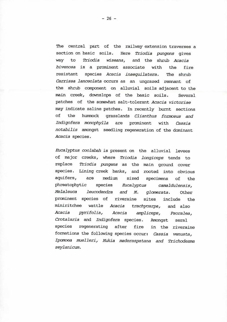
The central part of the railway extension traverses a
section on basic soils. Here Triodia pungens gives
way to qricdia wiseana, and the shrub Acacia
bivenosa is a prominent associate with the fire
resistant species Acacia inaequilatera. The shrub
Carrissa lanceolata occurs as an ungrazed remnant of
the shrub component on alluvial soils adjacent to the
main creek, downslope of the basic soils. Several
patches of the somewhat salt-tolerant Acacia vi Ct oriae
may indicate saline patches. In recently burnt sections
of the hummock grasslands Clian thus fonmsus and
Indigofera monophylla are prominent with Cassia
nota.bilis amongst seedling regeneration of the dominant
Acacia species.
Eucalyptus coolabah is present on the alluvial levees of major creeks, where Tricdia longiceps tends to
replace Tn cxii a pun gens as the main ground cover
species. Lining creek banks, and rooted into obvious
aquifers, are medium sized specimens of the
phreatophytic species Eucalyptus camaldulensis, Helaleuca leuccdencfra and H. glomera ta. Other
prominent species of riveraine sites include the
'niniritchee wattle Acacia trachycaip, and also
Acacia pyrifolia, Acacia anipliceps, Psoralea,
Crotalaria and Incilgofera species. Amongst seral
species regenerating after fire in the riveraine
foimations the following species occur: Cassia venusta, Ipmoea muelleri, Muki a madera spa tana and Trichcdesrna
zeylanicum.
- 27 -
Several moist soaks occur throughout the plains. Most
of these are now far from pristine as a result of
intensive use by cattle and the feral donkey and
horses. Formerly these would have carried dense grass
cover of Eriachne species, presently only the longer
lived trees are present. In the first section of the
railway route such soaks carry patches of Melaleuca or
Acacia anipliceps. Elsewhere, away from the route,
patches of tall Acacia tumida or A. holosericea
occur. The largest areas are lined with a peripheral
ring of unthrifty Eucalyptus coolabah trees.
The Mining Area
The most typical woody perennial species of the plateaux
of the mining area is the bloodwood Eucalyptus
terminalis. This produces abundant sprout growth in
areas burnt recently. Tn cc/ia pun gens is common on
moisture gaining sites, replaced by Tnicdia brizoides /
T. basedowli on elevated water shedding stony
habitats. Other prominent woody perennials include
Hakea suberea, Acacia inaequi la tera, Gre villea
wickharnii and Cassia glutinosa. Smaller forbs
include Euphorbia aust.ralis and Evolvulus
alsinoides. Several species of Ptilotus occur along
roadsides and scattered throughout the plateaux.
Templetonia hookeri and Acacia orthcarpa are thin,
delicate, shrubs of more open areas where also the low
forb Boerha via occurs amongst the Triodia basedowii
hummocks.
Shallow gullies and moisture gaining faults running
across the plateaux are clothed in dense stands of
Acacia tuinida, sometimes with Tephrosia and Solanum
species as understory. On steep slopes Eucalyptus
leucophloia occurs with Ti ccii a wiseana and Kallstroe.mia platyptera. Lining steep - sided
valleys, and in crevices and ledges, clumps of Eriachne
nucrona ta, Cnlxogon procerus and Cyrus species
break the monotony of the spinifex species.
Larger valleys have several eucalypts present including
those mentioned above as well as Eucalyptus aff
p3puana. 1ërminalia canescens and Atalaya hemiglauca
are other trees present. Carrissa lanceolata is a
shrub of this habitat and Ficus platypxfa is seen
rooted on bare rock all up the sides of steep valleys
and on ledges.
Typical, relatively short-lived, seral species following
fire on the plateaux of the mining area include: the
shrubby species of Sida, Corchorvs and Triumphetta,
the forbs Indigofera im'nophylla, Cassia notabilis and
Sol an urn species and the herbaceous 2rachyrnene
oleracea.
Hunick Grasslands to the South
Iintediately south of the mining area Tricdia pun ge,ns
dominates the vegetation. Scattered trees of
Eucalyptus teiminalis and less frequently
E.leucophloia, are the tallest plants present. A
series of narrow channels carry water, in season, from
the highlands and these are exclusively dominated by
Aca ci a turnida to a 3m height. These drainage lines
also have a range of grass species and similar shrubs to
those associated with A tumida in the breaks across
the plateaux ie. Solanum, Tëphi-osia and Crotalaria,
Clerodendron species.
None of the species identified from either the railway
extension route or the mining area are of any specific
importance in the context of conservation value.
- 29 -
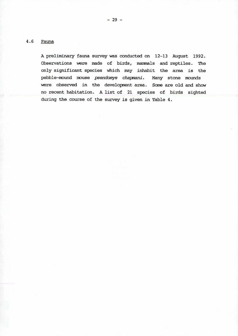
4.6 Fauna
A preliminary fauna survey was conducted on 12-13 August 1992.
Observations were made of birds, mammals and reptiles. The
only significant species which may inhabit the area is the
pebble-mound mouse psendorrqs chapnni. Many stone mounds
were observed in the developent area. Some are old and show
no recent habitation. A list of 21 species of birds sighted
during the course of the survey is given in Table 4.
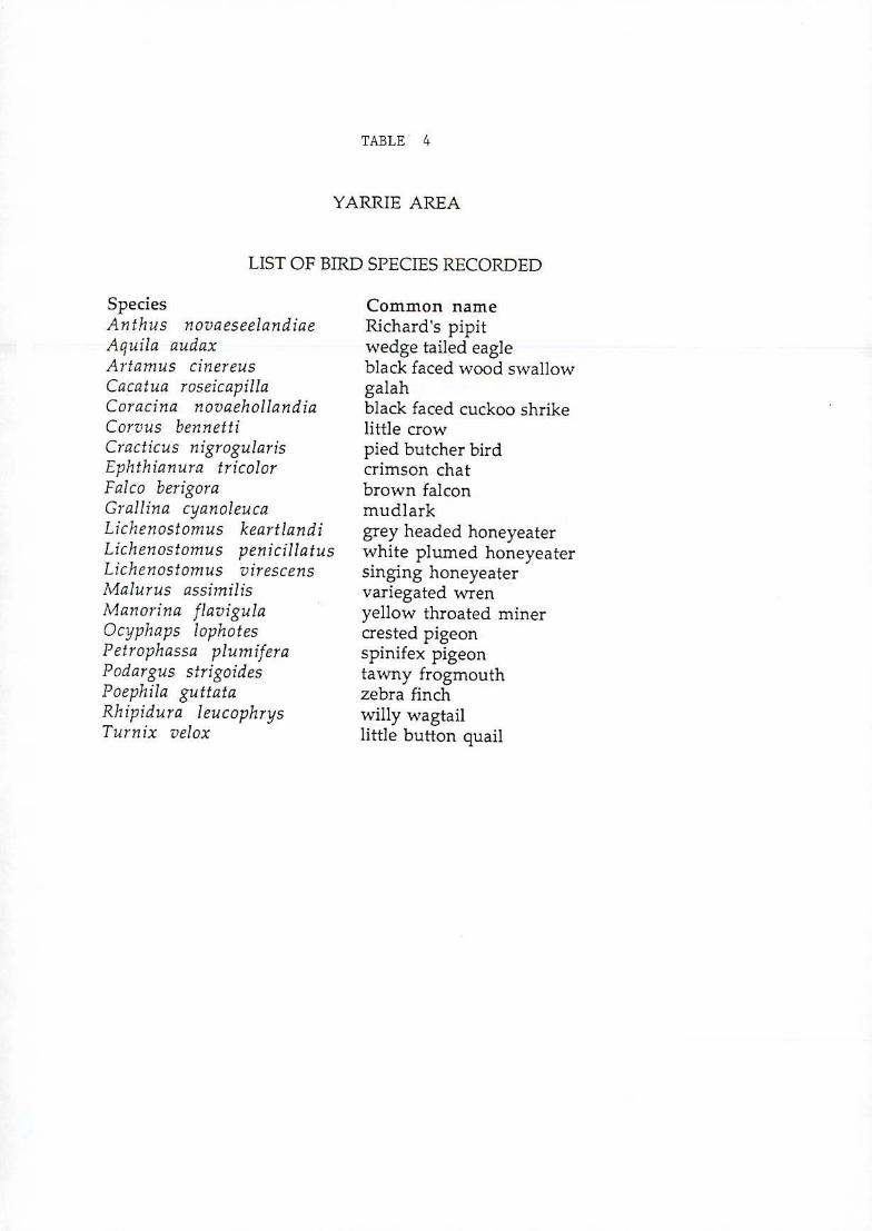
TABLE 4
YARRIE AREA
LIST OF BIRD SPECIES RECORDED
Species Anthus novaeseelandiae Aquila audax Artamus cinereus Cacatua roseicapilla Coracina novaehollandia Corvus bennetti Cracticus nigrogularis Ephthianura tricolor Falco berigora Grallina cyanoleuca Lichenostornus keartlandi Lichenostomus penicillatus Lichenostonius virescens Malurus assimilis Manorina flavigula Ocyphaps lophotes Petrophassa plum ifera Podargus strigoides Poephila guttata Rhipidura leucophrys Turn ix velox
Common name Richard's pipit wedge tailed eagle black faced wood swallow galah black faced cuckoo shrike little crow pied butcher bird crimson chat brown falcon mudlark grey headed honeyeater white plumed honeyeater singing honeyeater variegated wren yellow throated miner crested pigeon spinifex pigeon tawny frogmouth zebra finch willy wagtail little button quail
MIM
;iwJe4
Archaeological and ethnographic surveys were conducted in the
Yarrie Mining area in 1991. Because of the importance of the
general Yarrie-Shay Gap area, an agreement was entered into by
the company, which the Aboriginal people see as protecting
their religious interests in the area. Additionally, during
the past year, the Aboriginal people have been kept informed of
the project developaent and more detailed archaeological work
will be carried out in all areas of potential disturbance.
There have been four archaeological and two ethnographic sites
identified on Yarrie. Only one known archaeological Site will
be disturbed in the mining area and a final report on sites
along the railroute camp and airstrip is still pending.
- 31 -
6.0 SOCIAL IMPACTS
6.1 Lend Use
apart from mining, the only other land use has been for cattle
grazing from sparsely located stations. Mining will continue
at much the same level of activity as in the past and is
confined to a relatively small area.
The rail extension will traverse pastoral land, but because of
the flat nature of the surrounds, there is very little cut and
fill required. In the restricted areas where cut and fill is
to take place, there is only a very minor change in elevation
to that of the surrounding landform.
It is therefore considered that the mining activity together
with the rail extension will have negligible impact on the
pattern of land use.
Consultations will be held with the pastoral lease holder of
Nuccan 3114-713 and Yarrie 3114-1179 (same person) regarding
the location of the proposed rail alignment.
5.2 Heritage
The region is remote and arid, and only contains areas of low
scenic beauty with no features of special interest.
5.3 Social Environment
In keeping with BHP's objective of becoming a more efficient
miner who can compete at the very competitive international
level, a sigTlificant change to the operation of the workforce
needs to occur.

- 32 -
A change from a ccxnpany workforce to a contractual mining operation is seen as the most appropriate method of mining the Yarrie / Nimingarra orebodies. Flexibility is the most important parameter to vary ore and/or waste movement as appropriate to meet market demand and the variation of the individual orebodies.
Without such flexibility, the Goldsworthy operation could not compete internationally and would cease to exist.
appropriate consultation will be held with unions and employees to ensure this change in work force is accomplished smoothly.
- 33 -
7.1 Construction Phase
7.1.1 Landform
Changes to the topography of the project area will
result from earthworks required to prepare the principle
developnent sites including camps, rail spur, access
roads, airport, minesite buildings. To minimise the
impacts of this stage of develoent, only the minimum
area required for the construction will be disturbed and
once construction is completed, all areas no longer
required for the operation of the facility, will be
contoured, slopes stabilised, topsoil replaced and
vegetated.
7.1.2 Borrow Pits
Borrow pits will be required for construction materials
at the xninesite, airport and along the rail spur.
Borrow pits for all construction materials will be
selected and operated to minimise erosion and land
disturbance and the Newman Guidelines for borrow pit
deve1onent and rehabilitation will be applied.
- 34 -
7.1.3 Flora and Fauna
The Railway Extension Route
The main impacts on plant and associated animal
communities will be associated with bridge crossings.
As moisture in this and environment is scarce the main
drainage channels of the area are focii of both plant
and animal diversity. Consequently care will need to be
exercised at all stages of construction in relation to
the extent of damage imposed on the riveraine systems.
The building of the railway will require the destruction
of plant communities along the length of the rail
extension. However the area of vegetation cleared will
be small in comparison to the floristic units present in
the general area, and all the species affected are well
represented in the surrounding areas.
7.1.4 Archaeoloqical Sites
Any archaeological sites requiring disturbance will be
assessed and approval to use the land under Section
18(2) of the Aboriginal Heritage Act will be obthined.
7.2 Operational Phase
7.2.1 Landform
Nining ore from the Yarrie orebody will result in the
foimation of a large mined out pit. Overburden from the
mining operation will be deposited in a dump located in
a crescent shaped gully to the south of the mine (see
Plate 1). A portion of the overburden will be
backfilled into the eastern area of the pit. All dumps
will be stabilised by resloping and rehabilitation using
BI-IP Iron Ore Standard techniques similar to those used
at Newman and presently at Goldsworthy.
- 35 -
No significant impacts are expected to the hydrology of the area during mining, however, when the mining
activity is completed, a srrll body of water will remain in the base of the pit.
While mining below the water table and dewatering is taking place, the discharged water will be used as much as possible for mining activities. It is estimated a
discharge rate of 50 1/sec will be recjuired. Any excess water will be released to the environment along a
natural water course and allowed to seek its way to Eel Creek. It is likely that the water will only reach the creek during high rainfall periods.
7.2.3 Flora and Fauna
The Railway Extension Route
The principal impact from the operation of the railway will be impediment to overland rrvement of large
mammals. Of these, three groups can be distinguished: native animals (mainly euro, Macropus robustus) domestic cattle (Bos taurus) and feral animals (mainly donkey, Egvus asinus and brumby Equus cah11us). Some tactical pastoral fencing may be required to manage
cattle. Loss of habitat for smaller animals, including
reptiles, will also occur. Impediment to overland flow may affect the health and density of plant coimiunities on the down slope of the rail access corridor. Adequate culverting will minimise such impacts.
)T.;>
...•• ."• S
• €-..• 'i:.. . - .-.-: t; •'
72
- Ct J D"'.7 i.•'• '
a c: :r r. i:•. ,"
:
-: 4: -.- '.ki .r.'. ",-•
c . ;
• -::-. o:;. -v'
-• . .. _. '...\ 'i(J no.r-' - - -- :-:G: -3• '.
:. : - t" f(' •'i'' •- e'
;..., L1.•:
- - J .J_ S -, •. -
-- • ;ix
.•.•r2 •.?-:7 -'- :;-•
Tl . • -
. •'.,-: : p7 - J, -
5;
••.• •.•,;5t
: -
.,J'J
'.:---' c : :;:' LY •.
. ::. ..-. •:; rti -. . .,- r- •
; •-.:; -.n .•; •--.-)---7.p r 1t1
- 36 -
The Mining Area and Grasslands to the South
The principal impact from the mining of the plateaux
will be loss of habitat. of the fauna, the main species
affected will be the euro (Macropus robustus). This
is a common and abundant species, other hilly areas in
the vicinity of the develoient, which will not be
mined, contain similar habitat and sustain similar
population densities. The grassy plain below the mine,
which will be the repository of overburden material,
will become a new hill. In this sense one habitat
sequence will be exchanged for another and many plant
and the associated faunal species will eventually return.
Gullies and caves in the mining area provide niches for
amphibia, snakes and bat species. None of these are
likely to suffer any important loss of genetic diversity
due to the temporary local extinction due to mining.
Moundsassociated with the Pebble-mound mouse
(Pseudoniys chap-nani) occur in TricAila basedowli / T.
brizoides spin.ifex hummock grasslands on the plateaux
adjacent to the mining area. It is not known whether
the mouse has current populations in these areas, many
of the mounds are apparently of some antiquity.
Disturbance of areas not subject to mining where these
nests are located will be kept to a minimum. It is
recommended that a survey of the distribution of mounds,
with estimation of their relative activity potential /
ages be undertaken. This research would provide mine
management with a realistic set of management options to
conserve the species should it prove to be present.
However it must be noted that although this species is
at present poorly known, mounds are widespread
throughout much of the Pilbara region.
- 37 -
Destruction of plant communities will be systematic and
thorough throughout the area to be mined. Considerable
disturbance to plant communities will also occur due to
the associated infrastructure works. The vegetation
cleared and destroyed is not unique and is repeated on
similar hill systems in the general area. The area
destroyed will be small in ccarison to the floristic
units present in the region, and all the plant species
affected are well represented in the surrounding areas.
7.2.4 Dust and Noise
The camp facility will be located several kilornetres to
the north west of the mining site and as such, will
generally be unaffected by the operational activities.
At the mining site during construction and operational
phases of the develoinent, normal means of dust control
willbe applied to the various dust sources. However,
recent studies have indicated that water is still the
best dust suppressant available for most applications
except roads, where there has been recent success with
sealants such as waste oil and other surface agents.
7.2.5 Hazardous Materials
The developnent and operation of the proposed project
will necessitate the use of a wide range of products
which may be termed "Hazardous Materials". These
substances include such products as fuels, lubricants,
detergents and paints. The handling, use, and disposal
of these products will comply with all local and State
regulations.
7.2.6 Other wastes
The mine will generate several types of less toxic waste including; scrap metal, tyres, wood, paper and domestic solid and liquid waste. These wastes will be disposed of in approved land fills and in the case of liquid wastes, will be treated by approved processes.
7.2.7 Rehabilitation
Following the closure of the Yarrie mine, all building and other structures will be rnoved. Roads, camps, railroads and all other land disturbabce will be rehabilitated to a condition similar to that prior to mining.
7.2.8 Environmental Naiiagernent Plan
A detailed environmental Management Plant including monitoring and control systems to address potential environmental impacts will be included with the fonrl environmental report.
DEPARTMENT OF ENVIRONMENTAL PROTECT:c WESTRAL 'A SQUARE
141 ST. GEOR(iE1ERRACE PERTH
PRS:RJH;kd:yRXEp2

LIBRARY DEPARTMENT OF ENVRONMENTIL PROTEC Tic
WESTRALIA SQUARE 141 ST. GEORGE TEt*ACE, PERTH