Embed Size (px)
Citation preview
44 Kings Park Road West Perth WA 6005 PO Box 778, Claremont WA 6910
Telephone: (61-8) 6263 4423 Facsimile: (61-8) 9284 5426 www.catalystmetals.com.au ABN 54 118 912 495
ASX ANNOUNCEMENT 18 OCTOBER 2018
GOLD MINERALISATION IN RAB DRILLING AT GOLDEN CAMEL PROJECT; INITIAL RESULTS FROM DRUMMARTIN PROJECT
• Scout RAB drilling survey reports best intersection of 6 metres averaging 4.2g/t gold at the
Golden Camel Project • Widespread scattered arsenic and silver anomalism confirm Golden Camel potential • Widely-spaced air core drill holes completed across each of four targets at Drummartin Project • Favourable bedrock lithologies and trace geochemical results confirm prospectivity for gold-
bearing corridors associated with major fault structures at Drummartin ____________________________________________________________________________________
During May and June 2018, Catalyst Metals Limited (Catalyst or the Company) (ASX: CYL) carried out the first reconnaissance programmes on the Golden Camel Project and the Drummartin Project both located east of the Whitelaw Gold Belt. Limited previous exploration has been carried out on these areas and the RAB and Air Core drilling programmes are primarily designed to test basement depth and confirm bedrock geology. Despite being a very early stage of exploration, RAB drilling intersected a shallow zone of gold mineralisation at the Golden Camel Project (6.0 metres @ 4.2g/t Au from 12 metres depth in RGB040) located in an area over three kilometres along strike from known mineralisation. GOLDEN CAMEL PROJECT FARM-IN AGREEMENT In July 2018 the Company entered into an agreement with a private company, Golden Camel Mining Pty Ltd, to earn a 50.1% interest in Exploration Licences EL5449 and EL5490. The expenditure of $55,000 in the first quarter of the 2019 financial year satisfies Catalyst’s obligation under Phase 1 of this agreement and has generated results providing sufficient encouragement to justify the Company embarking on Phase 2 of the Agreement. Phase 2 entitles the Company by the expenditure of $650,000 over the next four years, to earn a 50.1% interest in the two exploration licences. The tenements cover a large area of over 25km north-south x 3km wide, totalling 85 square kilometres, located approximately 15 km east of the Fosterville gold mine (Figure 1). Included in the Golden Camel tenement package are Mining Leases MIN5548 and MIN5570 covering the Golden Camel gold mine. In 2017, Golden Camel Mining successfully mined and processed approximately 6,000 tonnes of ore between surface and 10 metres depth from the Golden Camel mine. Historical drill results demonstrate the continuation of gold mineralisation to greater depth. Phase 2 of Catalyst’s earn-in agreement includes the option to purchase a 50.1% interest in the Mining Leases for $1 million after expenditure of $350,000 and the completion of 1,200 metres of diamond/RC precollar at the Golden Camel and Tolleen mine sites. At the Toolleen mine site, where historic mining activities have been rehabilitated, previous drill results indicate the continuation of gold mineralisation to greater depth. A number of other prospects are identified from the results of past exploration and modest historic mining activities (Figure 2)
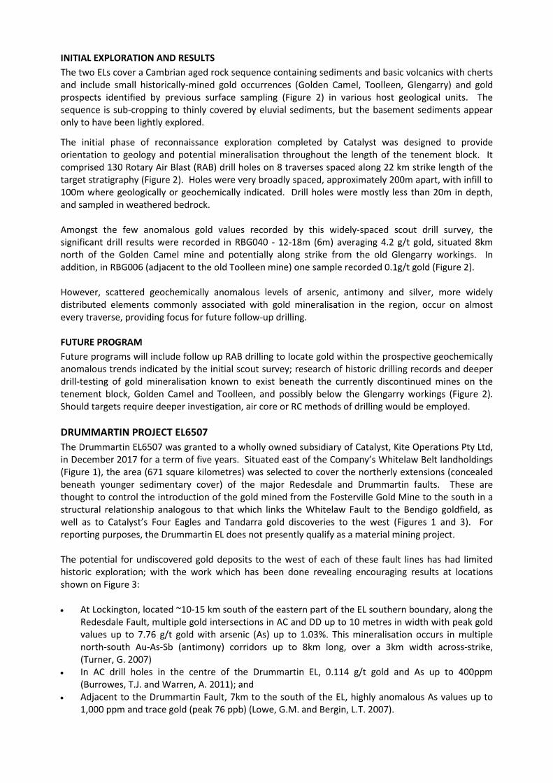
INITIAL EXPLORATION AND RESULTS The two ELs cover a Cambrian aged rock sequence containing sediments and basic volcanics with cherts and include small historically-mined gold occurrences (Golden Camel, Toolleen, Glengarry) and gold prospects identified by previous surface sampling (Figure 2) in various host geological units. The sequence is sub-cropping to thinly covered by eluvial sediments, but the basement sediments appear only to have been lightly explored.
The initial phase of reconnaissance exploration completed by Catalyst was designed to provide orientation to geology and potential mineralisation throughout the length of the tenement block. It comprised 130 Rotary Air Blast (RAB) drill holes on 8 traverses spaced along 22 km strike length of the target stratigraphy (Figure 2). Holes were very broadly spaced, approximately 200m apart, with infill to 100m where geologically or geochemically indicated. Drill holes were mostly less than 20m in depth, and sampled in weathered bedrock. Amongst the few anomalous gold values recorded by this widely-spaced scout drill survey, the significant drill results were recorded in RBG040 - 12-18m (6m) averaging 4.2 g/t gold, situated 8km north of the Golden Camel mine and potentially along strike from the old Glengarry workings. In addition, in RBG006 (adjacent to the old Toolleen mine) one sample recorded 0.1g/t gold (Figure 2). However, scattered geochemically anomalous levels of arsenic, antimony and silver, more widely distributed elements commonly associated with gold mineralisation in the region, occur on almost every traverse, providing focus for future follow-up drilling. FUTURE PROGRAM Future programs will include follow up RAB drilling to locate gold within the prospective geochemically anomalous trends indicated by the initial scout survey; research of historic drilling records and deeper drill-testing of gold mineralisation known to exist beneath the currently discontinued mines on the tenement block, Golden Camel and Toolleen, and possibly below the Glengarry workings (Figure 2). Should targets require deeper investigation, air core or RC methods of drilling would be employed. DRUMMARTIN PROJECT EL6507 The Drummartin EL6507 was granted to a wholly owned subsidiary of Catalyst, Kite Operations Pty Ltd, in December 2017 for a term of five years. Situated east of the Company’s Whitelaw Belt landholdings (Figure 1), the area (671 square kilometres) was selected to cover the northerly extensions (concealed beneath younger sedimentary cover) of the major Redesdale and Drummartin faults. These are thought to control the introduction of the gold mined from the Fosterville Gold Mine to the south in a structural relationship analogous to that which links the Whitelaw Fault to the Bendigo goldfield, as well as to Catalyst’s Four Eagles and Tandarra gold discoveries to the west (Figures 1 and 3). For reporting purposes, the Drummartin EL does not presently qualify as a material mining project. The potential for undiscovered gold deposits to the west of each of these fault lines has had limited historic exploration; with the work which has been done revealing encouraging results at locations shown on Figure 3: • At Lockington, located ~10-15 km south of the eastern part of the EL southern boundary, along the
Redesdale Fault, multiple gold intersections in AC and DD up to 10 metres in width with peak gold values up to 7.76 g/t gold with arsenic (As) up to 1.03%. This mineralisation occurs in multiple north-south Au-As-Sb (antimony) corridors up to 8km long, over a 3km width across-strike, (Turner, G. 2007)
• In AC drill holes in the centre of the Drummartin EL, 0.114 g/t gold and As up to 400ppm (Burrowes, T.J. and Warren, A. 2011); and
• Adjacent to the Drummartin Fault, 7km to the south of the EL, highly anomalous As values up to 1,000 ppm and trace gold (peak 76 ppb) (Lowe, G.M. and Bergin, L.T. 2007).

References cited above: Turner, G. 2007. Els 4552, 4553, 4554 and 4555. Annual Report on work completed to 31st December 2006 and lodged as Annual Technical Report to Government on work completed on the ELs Burrowes, T.J. and Warren, A. (Oscar Mining Pty Ltd). 2011. EL 5203 Terrick East. Annual Technical Report of Exploration Activities for the period 1st January to 31st December 2010 Lowe, G.M. and Bergin, L.T. (Leviathon Resources Ltd). 2007. ELs 4845, 4846 and 4884 Milloo, Pinegrove and Lockington West. Annual Technical Report of Exploration Activities for the period 1st January to 31st December 2006.
INITIAL RECONNAISSANCE AND RESULTS Exploration targets were generated in the western half of the Drummartin Project based on Whitelaw Belt models after review and reinterpretation of gravity data sets and open-file reports of earlier exploration activities. Four of five targets were evaluated by single traverses of air core (AC) drill holes, totalling 27 AC holes typically to around 150 metres in depth and in total 2,870 metres of drilling. The wide spacing of these holes (300m apart) was fundamentally designed to provide initial insights into the depth of cover and bedrock geology; and in doing so to provide some incidental geochemical indications of prospective mineralised corridors. The separation of these holes is much wider than the footprints of the mineralisation that have been encountered in the Whitelaw corridor to the west (Figure 1), so it is not expected that this initial density of drilling is sufficient to discount the presence of significant gold mineralisation within these traverses. Most of the holes drilled reached deeply-weathered bedrock at depths between 50 and 100m, confirming the feasibility of exploring this area. The following characteristics were observed:
• The weathered bedrock is consistent with that encountered throughout the region. The weathered sandstone and siltstone rock types included scattered intervals with abundant vein quartz (gravity targets 1, 2 and 4) (Figure 3) and pyrite (gravity target 2) further enhancing general prospectivity for proximal gold mineralisation, and
• Occasional weakly anomalous values of Au and As were reported, highlighted by 45 and 36 ppm As in gravity target 4.
FUTURE PROGRAM The initial reconnaissance focussed on the western half of the Drummartin EL. Results will be further examined before targets for follow-up drilling are identified. In the eastern half of the Drummartin Project, where existing gravity data is insufficient for confident target generation, and cover may be a little deeper than in the west, additional gravity surveys will be considered before scout drilling is attempted. This part of the EL lies to the north along strike of the Lockington gold mineralisation discussed above, and focuses on targets adjacent to the Redesdale Fault, thought to be genetically linked to the Fosterville gold deposit a little further (50km) to the south (Figure 1). For further information contact:
Steve Boston Bruce Kay Chairman Technical Director Telephone: +61 409 574 515 +61 400 613 180

Competent Person’s statement The information in this report that relates to exploration results is based on information compiled by Mr Bruce Kay, a Competent Person, who is a Fellow of the Australasian Institute of Mining and Metallurgy. Mr Kay is a non-executive director of the Company and has sufficient experience that is relevant to the style of mineralisation and type of deposit under consideration and to the activity being undertaken to qualify as a Competent Person as defined in the 2012 Edition of the Australasian Code for Reporting of Exploration Results, Mineral Resources and Ore Reserves (the JORC Code). In compiling this report Mr Kay has examined the reports referenced herein and confirms his confidence in the data they contain, and that this report accurately reflects those data. Mr Kay consents to the inclusion in the report of the matters based on his information in the form and context in which it appears.

Figure 1: Golden Camel and Drummartin Tenement Location
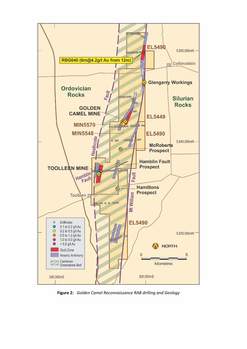
Figure 2: Golden Camel Reconnaissance RAB drilling and Geology

Figure 3: Drummartin First-pass targets and Reconnaissance Air Core Drilling

APPENDIX 1: GOLDEN CAMEL RAB DRILLING
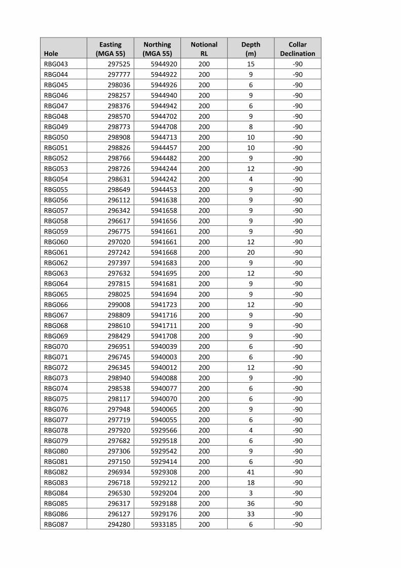
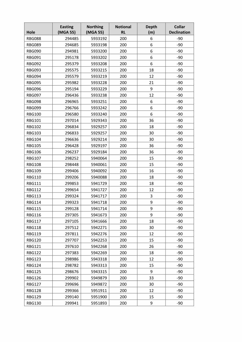
Table 1a RAB drill hole collars
Hole Easting
(MGA 55) Northing (MGA 55)
Notional RL
Depth (m)
Collar Declination
RBG001 294128 5936731 200 9 -90 RBG002 294323 5936734 200 6 -90 RBG003 294525 5936737 200 6 -90 RBG004 294725 5936743 200 6 -90 RBG005 294945 5936745 200 6 -90 RBG006 295120 5936751 200 15 -90 RBG007 295323 5936760 200 18 -90 RBG008 295526 5936754 200 24 -90 RBG009 295724 5936762 200 6 -90 RBG010 295925 5936771 200 21 -90 RBG011 296120 5936777 200 18 -90 RBG012 296325 5936777 200 9 -90 RBG013 296529 5936779 200 4 -90 RBG014 296725 5936790 200 13 -90 RBG015 296840 5936856 200 15 -90 RBG016 297125 5936710 200 13 -90 RBG017 297326 5936784 200 9 -90 RBG018 297515 5936807 200 15 -90 RBG019 297732 5936816 200 12 -90 RBG020 297925 5936814 200 24 -90 RBG021 298047 5951872 200 12 -90 RBG022 298172 5951877 200 18 -90 RBG023 298464 5951885 200 12 -90 RBG024 298633 5951889 200 9 -90 RBG025 298833 5951892 200 9 -90 RBG026 299034 5951896 200 12 -90 RBG027 299283 5951900 200 7 -90 RBG028 299438 5951814 200 9 -90 RBG029 299646 5951646 200 15 -90 RBG030 299840 5951540 200 15 -90 RBG031 298025 5949840 200 9 -90 RBG032 298228 5949841 200 12 -90 RBG033 298431 5949847 200 9 -90 RBG034 298625 5949850 200 9 -90 RBG035 298829 5949855 200 9 -90 RBG036 299030 5949858 200 4 -90 RBG037 299207 5949865 200 6 -90 RBG038 299477 5949871 200 9 -90 RBG039 299620 5949870 200 6 -90 RBG040 299825 5949871 200 36 -90 RBG041 297130 5944909 200 9 -90 RBG042 297325 5944921 200 9 -90
Hole Easting
(MGA 55) Northing (MGA 55)
Notional RL
Depth (m)
Collar Declination
RBG043 297525 5944920 200 15 -90 RBG044 297777 5944922 200 9 -90 RBG045 298036 5944926 200 6 -90 RBG046 298257 5944940 200 9 -90 RBG047 298376 5944942 200 6 -90 RBG048 298570 5944702 200 9 -90 RBG049 298773 5944708 200 8 -90 RBG050 298908 5944713 200 10 -90 RBG051 298826 5944457 200 10 -90 RBG052 298766 5944482 200 9 -90 RBG053 298726 5944244 200 12 -90 RBG054 298631 5944242 200 4 -90 RBG055 298649 5944453 200 9 -90 RBG056 296112 5941638 200 9 -90 RBG057 296342 5941658 200 9 -90 RBG058 296617 5941656 200 9 -90 RBG059 296775 5941661 200 9 -90 RBG060 297020 5941661 200 12 -90 RBG061 297242 5941668 200 20 -90 RBG062 297397 5941683 200 9 -90 RBG063 297632 5941695 200 12 -90 RBG064 297815 5941681 200 9 -90 RBG065 298025 5941694 200 9 -90 RBG066 299008 5941723 200 12 -90 RBG067 298809 5941716 200 9 -90 RBG068 298610 5941711 200 9 -90 RBG069 298429 5941708 200 9 -90 RBG070 296951 5940039 200 6 -90 RBG071 296745 5940003 200 6 -90 RBG072 296345 5940012 200 12 -90 RBG073 298940 5940088 200 9 -90 RBG074 298538 5940077 200 6 -90 RBG075 298117 5940070 200 6 -90 RBG076 297948 5940065 200 9 -90 RBG077 297719 5940055 200 6 -90 RBG078 297920 5929566 200 4 -90 RBG079 297682 5929518 200 6 -90 RBG080 297306 5929542 200 9 -90 RBG081 297150 5929414 200 6 -90 RBG082 296934 5929308 200 41 -90 RBG083 296718 5929212 200 18 -90 RBG084 296530 5929204 200 3 -90 RBG085 296317 5929188 200 36 -90 RBG086 296127 5929176 200 33 -90 RBG087 294280 5933185 200 6 -90
Hole Easting
(MGA 55) Northing (MGA 55)
Notional RL
Depth (m)
Collar Declination
RBG088 294485 5933192 200 6 -90 RBG089 294685 5933198 200 6 -90 RBG090 294981 5933200 200 6 -90 RBG091 295178 5933202 200 6 -90 RBG092 295379 5933208 200 6 -90 RBG093 295575 5933215 200 18 -90 RBG094 295579 5933219 200 12 -90 RBG095 295982 5933228 200 21 -90 RBG096 295194 5933229 200 9 -90 RBG097 296436 5933238 200 12 -90 RBG098 296965 5933251 200 6 -90 RBG099 296766 5933242 200 6 -90 RBG100 296580 5933240 200 6 -90 RBG101 297014 5929343 200 36 -90 RBG102 296834 5929257 200 18 -90 RBG103 296833 5929257 200 30 -90 RBG104 296636 5929214 200 30 -90 RBG105 296428 5929197 200 36 -90 RBG106 296237 5929184 200 36 -90 RBG107 298252 5940064 200 15 -90 RBG108 298448 5940061 200 15 -90 RBG109 299406 5940092 200 16 -90 RBG110 299206 5940088 200 18 -90 RBG111 299853 5941729 200 18 -90 RBG112 299654 5941727 200 12 -90 RBG113 299324 5941717 200 3 -90 RBG114 299323 5941718 200 9 -90 RBG115 299128 5941714 200 9 -90 RBG116 297305 5941673 200 9 -90 RBG117 297105 5941666 200 18 -90 RBG118 297512 5942271 200 30 -90 RBG119 297811 5942276 200 12 -90 RBG120 297707 5942253 200 15 -90 RBG121 297610 5942268 200 26 -90 RBG122 297383 5942269 200 18 -90 RBG123 298986 5943318 200 12 -90 RBG124 298782 5943313 200 15 -90 RBG125 298676 5943315 200 9 -90 RBG126 299902 5949879 200 33 -90 RBG127 299696 5949872 200 30 -90 RBG128 299366 5951911 200 12 -90 RBG129 299140 5951900 200 15 -90 RBG130 299941 5951893 200 9 -90
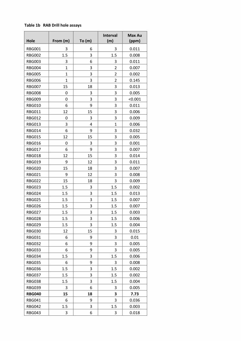
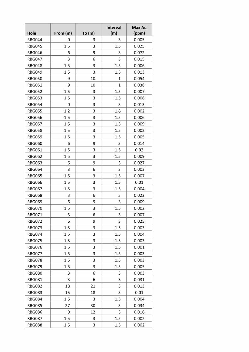
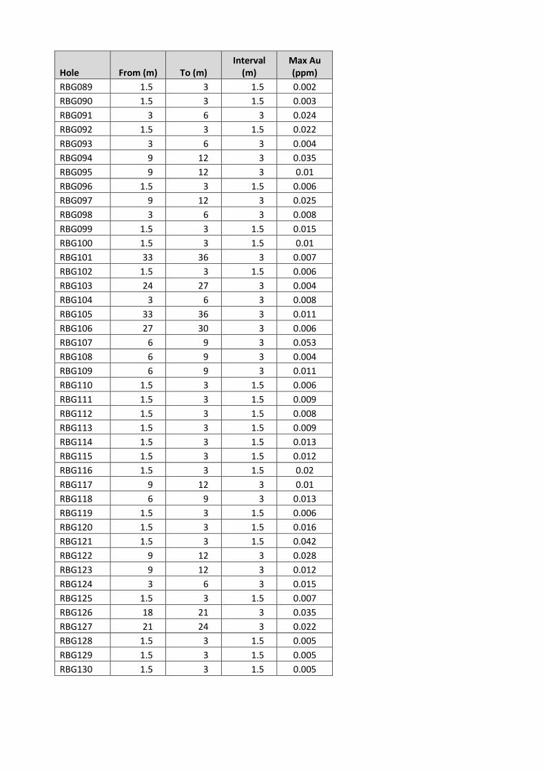
Table 1b RAB Drill hole assays
Hole From (m) To (m) Interval
(m) Max Au (ppm)
RBG001 3 6 3 0.011 RBG002 1.5 3 1.5 0.008 RBG003 3 6 3 0.011 RBG004 1 3 2 0.007 RBG005 1 3 2 0.002 RBG006 1 3 2 0.145 RBG007 15 18 3 0.013 RBG008 0 3 3 0.005 RBG009 0 3 3 <0.001 RBG010 6 9 3 0.011 RBG011 12 15 3 0.006 RBG012 0 3 3 0.009 RBG013 3 4 1 0.006 RBG014 6 9 3 0.032 RBG015 12 15 3 0.005 RBG016 0 3 3 0.001 RBG017 6 9 3 0.007 RBG018 12 15 3 0.014 RBG019 9 12 3 0.011 RBG020 15 18 3 0.007 RBG021 9 12 3 0.008 RBG022 15 18 3 0.009 RBG023 1.5 3 1.5 0.002 RBG024 1.5 3 1.5 0.013 RBG025 1.5 3 1.5 0.007 RBG026 1.5 3 1.5 0.007 RBG027 1.5 3 1.5 0.003 RBG028 1.5 3 1.5 0.006 RBG029 1.5 3 1.5 0.004 RBG030 12 15 3 0.015 RBG031 6 9 3 0.01 RBG032 6 9 3 0.005 RBG033 6 9 3 0.005 RBG034 1.5 3 1.5 0.006 RBG035 6 9 3 0.008 RBG036 1.5 3 1.5 0.002 RBG037 1.5 3 1.5 0.002 RBG038 1.5 3 1.5 0.004 RBG039 3 6 3 0.005 RBG040 15 18 3 7.73 RBG041 6 9 3 0.036 RBG042 1.5 3 1.5 0.003 RBG043 3 6 3 0.018
Hole From (m) To (m) Interval
(m) Max Au (ppm)
RBG044 0 3 3 0.005 RBG045 1.5 3 1.5 0.025 RBG046 6 9 3 0.072 RBG047 3 6 3 0.015 RBG048 1.5 3 1.5 0.006 RBG049 1.5 3 1.5 0.013 RBG050 9 10 1 0.054 RBG051 9 10 1 0.038 RBG052 1.5 3 1.5 0.007 RBG053 1.5 3 1.5 0.008 RBG054 0 3 3 0.013 RBG055 1.2 3 1.8 0.002 RBG056 1.5 3 1.5 0.006 RBG057 1.5 3 1.5 0.009 RBG058 1.5 3 1.5 0.002 RBG059 1.5 3 1.5 0.005 RBG060 6 9 3 0.014 RBG061 1.5 3 1.5 0.02 RBG062 1.5 3 1.5 0.009 RBG063 6 9 3 0.027 RBG064 3 6 3 0.003 RBG065 1.5 3 1.5 0.007 RBG066 1.5 3 1.5 0.01 RBG067 1.5 3 1.5 0.004 RBG068 3 6 3 0.022 RBG069 6 9 3 0.009 RBG070 1.5 3 1.5 0.002 RBG071 3 6 3 0.007 RBG072 6 9 3 0.025 RBG073 1.5 3 1.5 0.003 RBG074 1.5 3 1.5 0.004 RBG075 1.5 3 1.5 0.003 RBG076 1.5 3 1.5 0.001 RBG077 1.5 3 1.5 0.003 RBG078 1.5 3 1.5 0.003 RBG079 1.5 3 1.5 0.005 RBG080 3 6 3 0.003 RBG081 3 6 3 0.031 RBG082 18 21 3 0.013 RBG083 15 18 3 0.01 RBG084 1.5 3 1.5 0.004 RBG085 27 30 3 0.034 RBG086 9 12 3 0.016 RBG087 1.5 3 1.5 0.002 RBG088 1.5 3 1.5 0.002
Hole From (m) To (m) Interval
(m) Max Au (ppm)
RBG089 1.5 3 1.5 0.002 RBG090 1.5 3 1.5 0.003 RBG091 3 6 3 0.024 RBG092 1.5 3 1.5 0.022 RBG093 3 6 3 0.004 RBG094 9 12 3 0.035 RBG095 9 12 3 0.01 RBG096 1.5 3 1.5 0.006 RBG097 9 12 3 0.025 RBG098 3 6 3 0.008 RBG099 1.5 3 1.5 0.015 RBG100 1.5 3 1.5 0.01 RBG101 33 36 3 0.007 RBG102 1.5 3 1.5 0.006 RBG103 24 27 3 0.004 RBG104 3 6 3 0.008 RBG105 33 36 3 0.011 RBG106 27 30 3 0.006 RBG107 6 9 3 0.053 RBG108 6 9 3 0.004 RBG109 6 9 3 0.011 RBG110 1.5 3 1.5 0.006 RBG111 1.5 3 1.5 0.009 RBG112 1.5 3 1.5 0.008 RBG113 1.5 3 1.5 0.009 RBG114 1.5 3 1.5 0.013 RBG115 1.5 3 1.5 0.012 RBG116 1.5 3 1.5 0.02 RBG117 9 12 3 0.01 RBG118 6 9 3 0.013 RBG119 1.5 3 1.5 0.006 RBG120 1.5 3 1.5 0.016 RBG121 1.5 3 1.5 0.042 RBG122 9 12 3 0.028 RBG123 9 12 3 0.012 RBG124 3 6 3 0.015 RBG125 1.5 3 1.5 0.007 RBG126 18 21 3 0.035 RBG127 21 24 3 0.022 RBG128 1.5 3 1.5 0.005 RBG129 1.5 3 1.5 0.005 RBG130 1.5 3 1.5 0.005
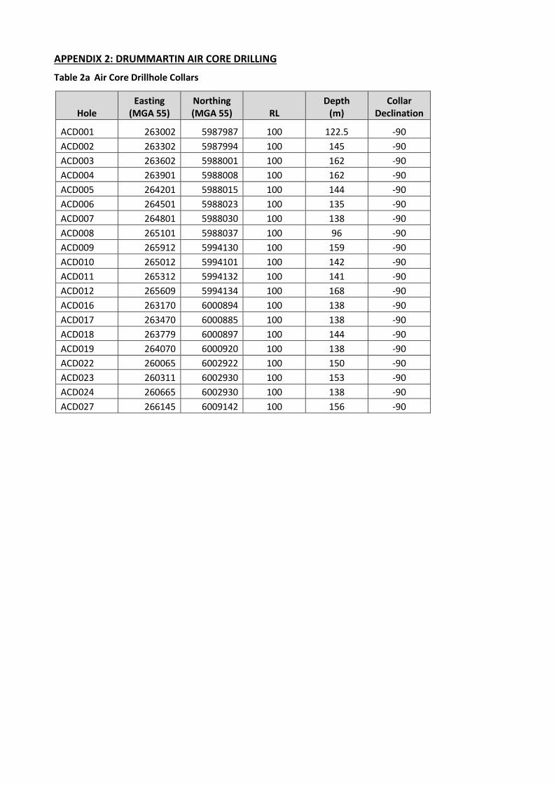
APPENDIX 2: DRUMMARTIN AIR CORE DRILLING
Table 2a Air Core Drillhole Collars
Hole Easting
(MGA 55) Northing (MGA 55) RL
Depth (m)
Collar Declination
ACD001 263002 5987987 100 122.5 -90 ACD002 263302 5987994 100 145 -90 ACD003 263602 5988001 100 162 -90 ACD004 263901 5988008 100 162 -90 ACD005 264201 5988015 100 144 -90 ACD006 264501 5988023 100 135 -90 ACD007 264801 5988030 100 138 -90 ACD008 265101 5988037 100 96 -90 ACD009 265912 5994130 100 159 -90 ACD010 265012 5994101 100 142 -90 ACD011 265312 5994132 100 141 -90 ACD012 265609 5994134 100 168 -90 ACD016 263170 6000894 100 138 -90 ACD017 263470 6000885 100 138 -90 ACD018 263779 6000897 100 144 -90 ACD019 264070 6000920 100 138 -90 ACD022 260065 6002922 100 150 -90 ACD023 260311 6002930 100 153 -90 ACD024 260665 6002930 100 138 -90 ACD027 266145 6009142 100 156 -90
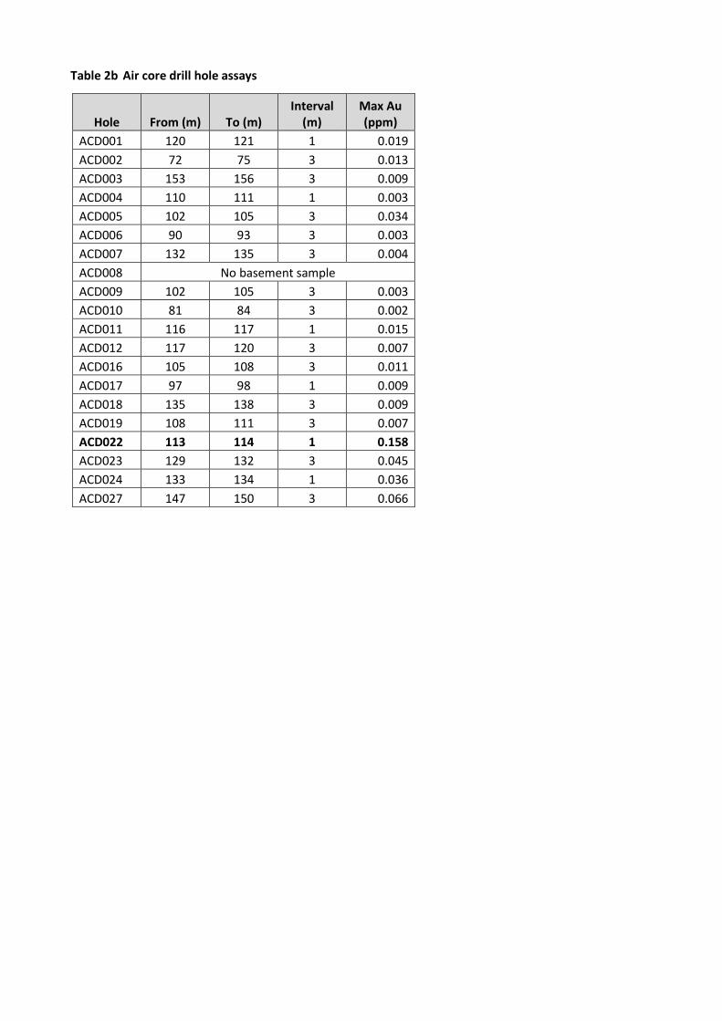
Table 2b Air core drill hole assays
Hole From (m) To (m) Interval
(m) Max Au (ppm)
ACD001 120 121 1 0.019 ACD002 72 75 3 0.013 ACD003 153 156 3 0.009 ACD004 110 111 1 0.003 ACD005 102 105 3 0.034 ACD006 90 93 3 0.003 ACD007 132 135 3 0.004 ACD008 No basement sample ACD009 102 105 3 0.003 ACD010 81 84 3 0.002 ACD011 116 117 1 0.015 ACD012 117 120 3 0.007 ACD016 105 108 3 0.011 ACD017 97 98 1 0.009 ACD018 135 138 3 0.009 ACD019 108 111 3 0.007 ACD022 113 114 1 0.158 ACD023 129 132 3 0.045 ACD024 133 134 1 0.036 ACD027 147 150 3 0.066
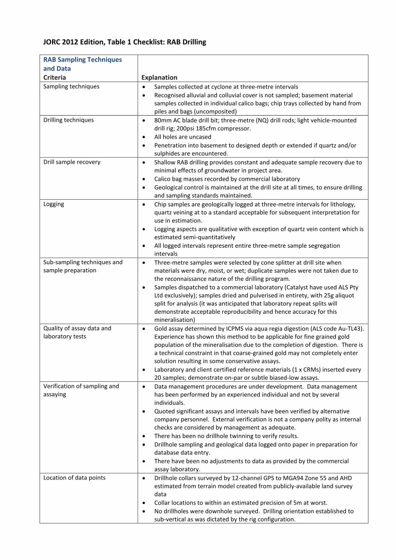
JORC 2012 Edition, Table 1 Checklist: RAB Drilling
RAB Sampling Techniques and Data Criteria Explanation Sampling techniques • Samples collected at cyclone at three-metre intervals
• Recognised alluvial and colluvial cover is not sampled; basement material samples collected in individual calico bags; chip trays collected by hand from piles and bags (uncomposited)
Drilling techniques • 80mm AC blade drill bit; three-metre (NQ) drill rods; light vehicle-mounted drill rig; 200psi 185cfm compressor.
• All holes are uncased • Penetration into basement to designed depth or extended if quartz and/or
sulphides are encountered. Drill sample recovery • Shallow RAB drilling provides constant and adequate sample recovery due to
minimal effects of groundwater in project area. • Calico bag masses recorded by commercial laboratory • Geological control is maintained at the drill site at all times, to ensure drilling
and sampling standards maintained. Logging • Chip samples are geologically logged at three-metre intervals for lithology,
quartz veining at to a standard acceptable for subsequent interpretation for use in estimation.
• Logging aspects are qualitative with exception of quartz vein content which is estimated semi-quantitatively
• All logged intervals represent entire three-metre sample segregation intervals
Sub-sampling techniques and sample preparation
• Three-metre samples were selected by cone splitter at drill site when materials were dry, moist, or wet; duplicate samples were not taken due to the reconnaissance nature of the drilling program.
• Samples dispatched to a commercial laboratory (Catalyst have used ALS Pty Ltd exclusively); samples dried and pulverised in entirety, with 25g aliquot split for analysis (it was anticipated that laboratory repeat splits will demonstrate acceptable reproducibility and hence accuracy for this mineralisation)
Quality of assay data and laboratory tests
• Gold assay determined by ICPMS via aqua regia digestion (ALS code Au-TL43). Experience has shown this method to be applicable for fine grained gold population of the mineralisation due to the completion of digestion. There is a technical constraint in that coarse-grained gold may not completely enter solution resulting in some conservative assays.
• Laboratory and client certified reference materials (1 x CRMs) inserted every 20 samples; demonstrate on-par or subtle biased-low assays.
Verification of sampling and assaying
• Data management procedures are under development. Data management has been performed by an experienced individual and not by several individuals.
• Quoted significant assays and intervals have been verified by alternative company personnel. External verification is not a company polity as internal checks are considered by management as adequate.
• There has been no drillhole twinning to verify results. • Drillhole sampling and geological data logged onto paper in preparation for
database data entry. • There have been no adjustments to data as provided by the commercial
assay laboratory. Location of data points • Drillhole collars surveyed by 12-channel GPS to MGA94 Zone 55 and AHD
estimated from terrain model created from publicly-available land survey data
• Collar locations to within an estimated precision of 5m at worst. • No drillholes were downhole surveyed. Drilling orientation established to
sub-vertical as was dictated by the rig configuration.
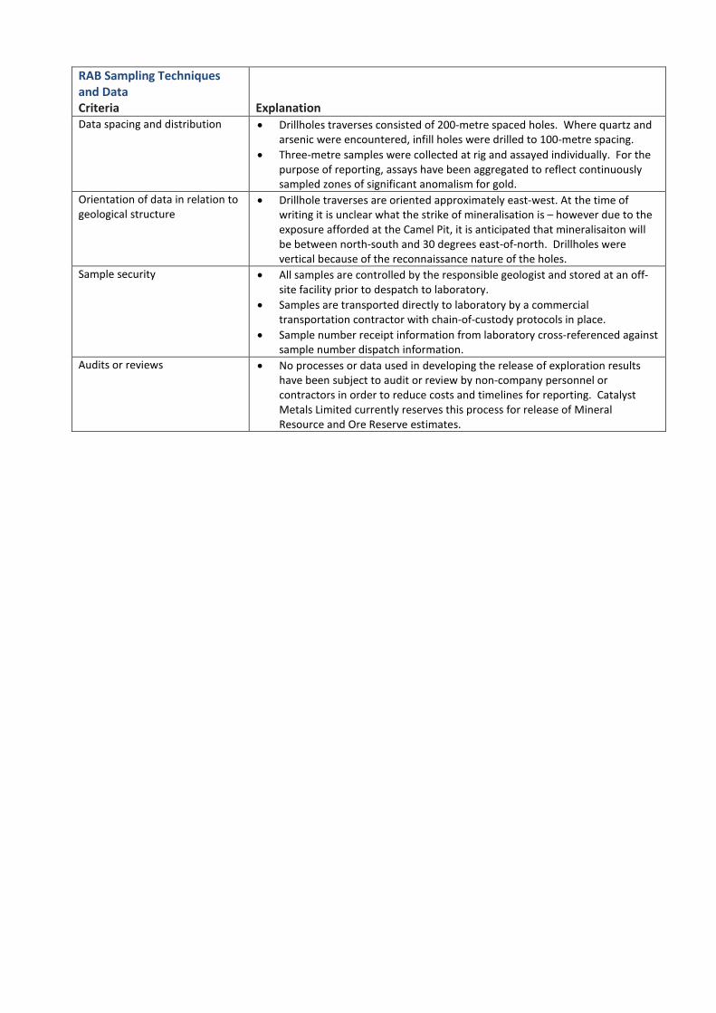
RAB Sampling Techniques and Data Criteria Explanation Data spacing and distribution • Drillholes traverses consisted of 200-metre spaced holes. Where quartz and
arsenic were encountered, infill holes were drilled to 100-metre spacing. • Three-metre samples were collected at rig and assayed individually. For the
purpose of reporting, assays have been aggregated to reflect continuously sampled zones of significant anomalism for gold.
Orientation of data in relation to geological structure
• Drillhole traverses are oriented approximately east-west. At the time of writing it is unclear what the strike of mineralisation is – however due to the exposure afforded at the Camel Pit, it is anticipated that mineralisaiton will be between north-south and 30 degrees east-of-north. Drillholes were vertical because of the reconnaissance nature of the holes.
Sample security • All samples are controlled by the responsible geologist and stored at an off-site facility prior to despatch to laboratory.
• Samples are transported directly to laboratory by a commercial transportation contractor with chain-of-custody protocols in place.
• Sample number receipt information from laboratory cross-referenced against sample number dispatch information.
Audits or reviews • No processes or data used in developing the release of exploration results have been subject to audit or review by non-company personnel or contractors in order to reduce costs and timelines for reporting. Catalyst Metals Limited currently reserves this process for release of Mineral Resource and Ore Reserve estimates.
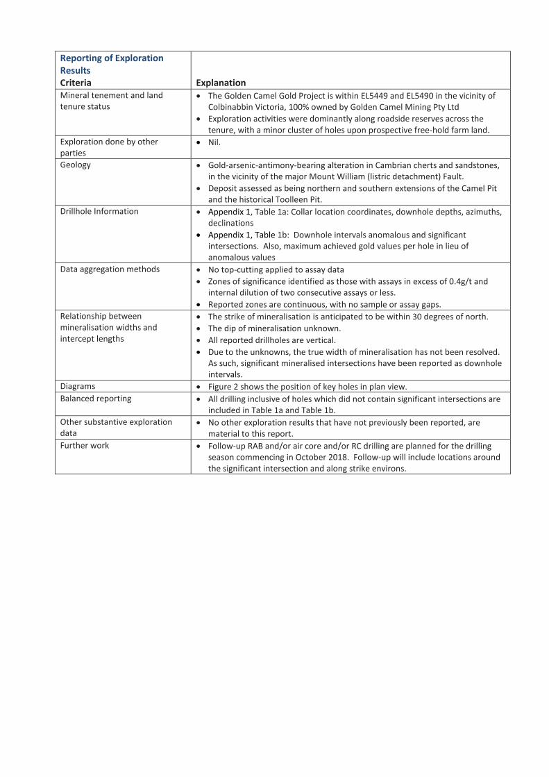
Reporting of Exploration Results Criteria Explanation Mineral tenement and land tenure status
• The Golden Camel Gold Project is within EL5449 and EL5490 in the vicinity of Colbinabbin Victoria, 100% owned by Golden Camel Mining Pty Ltd
• Exploration activities were dominantly along roadside reserves across the tenure, with a minor cluster of holes upon prospective free-hold farm land.
Exploration done by other parties
• Nil.
Geology • Gold-arsenic-antimony-bearing alteration in Cambrian cherts and sandstones, in the vicinity of the major Mount William (listric detachment) Fault.
• Deposit assessed as being northern and southern extensions of the Camel Pit and the historical Toolleen Pit.
Drillhole Information • Appendix 1, Table 1a: Collar location coordinates, downhole depths, azimuths, declinations
• Appendix 1, Table 1b: Downhole intervals anomalous and significant intersections. Also, maximum achieved gold values per hole in lieu of anomalous values
Data aggregation methods • No top-cutting applied to assay data • Zones of significance identified as those with assays in excess of 0.4g/t and
internal dilution of two consecutive assays or less. • Reported zones are continuous, with no sample or assay gaps.
Relationship between mineralisation widths and intercept lengths
• The strike of mineralisation is anticipated to be within 30 degrees of north. • The dip of mineralisation unknown. • All reported drillholes are vertical. • Due to the unknowns, the true width of mineralisation has not been resolved.
As such, significant mineralised intersections have been reported as downhole intervals.
Diagrams • Figure 2 shows the position of key holes in plan view. Balanced reporting • All drilling inclusive of holes which did not contain significant intersections are
included in Table 1a and Table 1b. Other substantive exploration data
• No other exploration results that have not previously been reported, are material to this report.
Further work • Follow-up RAB and/or air core and/or RC drilling are planned for the drilling season commencing in October 2018. Follow-up will include locations around the significant intersection and along strike environs.
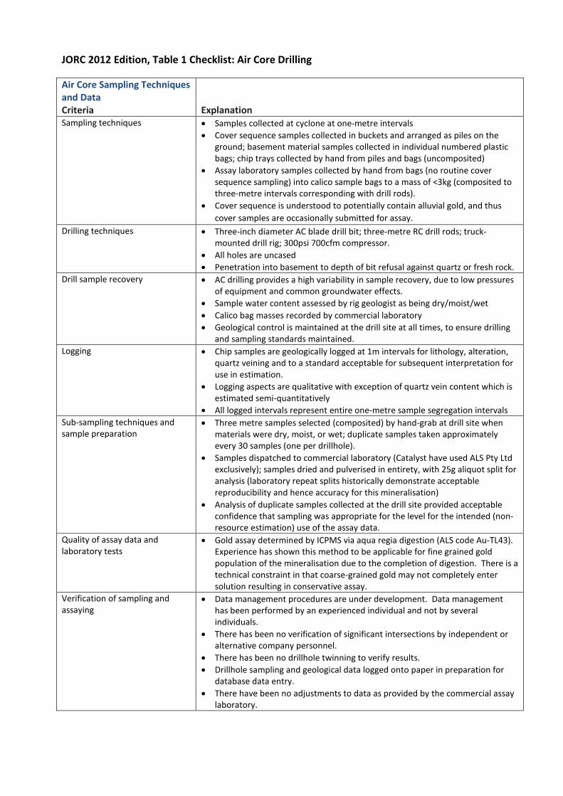
JORC 2012 Edition, Table 1 Checklist: Air Core Drilling
Air Core Sampling Techniques and Data Criteria Explanation Sampling techniques • Samples collected at cyclone at one-metre intervals
• Cover sequence samples collected in buckets and arranged as piles on the ground; basement material samples collected in individual numbered plastic bags; chip trays collected by hand from piles and bags (uncomposited)
• Assay laboratory samples collected by hand from bags (no routine cover sequence sampling) into calico sample bags to a mass of <3kg (composited to three-metre intervals corresponding with drill rods).
• Cover sequence is understood to potentially contain alluvial gold, and thus cover samples are occasionally submitted for assay.
Drilling techniques • Three-inch diameter AC blade drill bit; three-metre RC drill rods; truck-mounted drill rig; 300psi 700cfm compressor.
• All holes are uncased • Penetration into basement to depth of bit refusal against quartz or fresh rock.
Drill sample recovery • AC drilling provides a high variability in sample recovery, due to low pressures of equipment and common groundwater effects.
• Sample water content assessed by rig geologist as being dry/moist/wet • Calico bag masses recorded by commercial laboratory • Geological control is maintained at the drill site at all times, to ensure drilling
and sampling standards maintained. Logging • Chip samples are geologically logged at 1m intervals for lithology, alteration,
quartz veining and to a standard acceptable for subsequent interpretation for use in estimation.
• Logging aspects are qualitative with exception of quartz vein content which is estimated semi-quantitatively
• All logged intervals represent entire one-metre sample segregation intervals Sub-sampling techniques and sample preparation
• Three metre samples selected (composited) by hand-grab at drill site when materials were dry, moist, or wet; duplicate samples taken approximately every 30 samples (one per drillhole).
• Samples dispatched to commercial laboratory (Catalyst have used ALS Pty Ltd exclusively); samples dried and pulverised in entirety, with 25g aliquot split for analysis (laboratory repeat splits historically demonstrate acceptable reproducibility and hence accuracy for this mineralisation)
• Analysis of duplicate samples collected at the drill site provided acceptable confidence that sampling was appropriate for the level for the intended (non-resource estimation) use of the assay data.
Quality of assay data and laboratory tests
• Gold assay determined by ICPMS via aqua regia digestion (ALS code Au-TL43). Experience has shown this method to be applicable for fine grained gold population of the mineralisation due to the completion of digestion. There is a technical constraint in that coarse-grained gold may not completely enter solution resulting in conservative assay.
Verification of sampling and assaying
• Data management procedures are under development. Data management has been performed by an experienced individual and not by several individuals.
• There has been no verification of significant intersections by independent or alternative company personnel.
• There has been no drillhole twinning to verify results. • Drillhole sampling and geological data logged onto paper in preparation for
database data entry. • There have been no adjustments to data as provided by the commercial assay
laboratory.
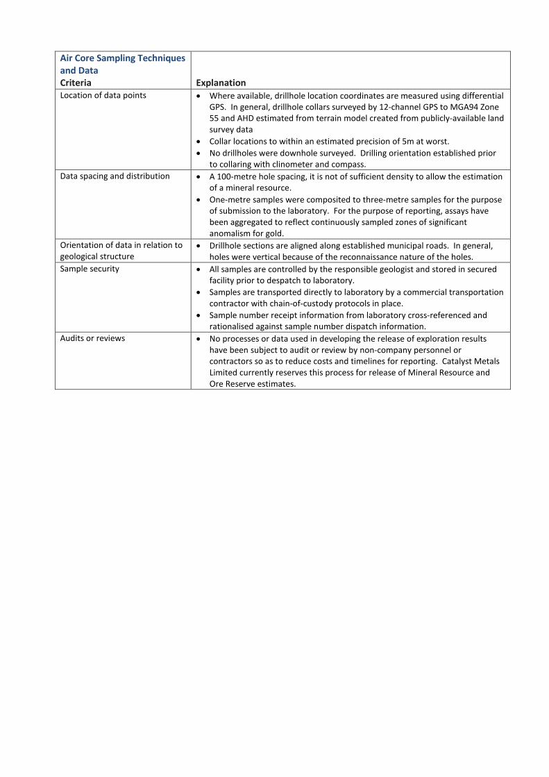
Air Core Sampling Techniques and Data Criteria Explanation Location of data points • Where available, drillhole location coordinates are measured using differential
GPS. In general, drillhole collars surveyed by 12-channel GPS to MGA94 Zone 55 and AHD estimated from terrain model created from publicly-available land survey data
• Collar locations to within an estimated precision of 5m at worst. • No drillholes were downhole surveyed. Drilling orientation established prior
to collaring with clinometer and compass. Data spacing and distribution • A 100-metre hole spacing, it is not of sufficient density to allow the estimation
of a mineral resource. • One-metre samples were composited to three-metre samples for the purpose
of submission to the laboratory. For the purpose of reporting, assays have been aggregated to reflect continuously sampled zones of significant anomalism for gold.
Orientation of data in relation to geological structure
• Drillhole sections are aligned along established municipal roads. In general, holes were vertical because of the reconnaissance nature of the holes.
Sample security • All samples are controlled by the responsible geologist and stored in secured facility prior to despatch to laboratory.
• Samples are transported directly to laboratory by a commercial transportation contractor with chain-of-custody protocols in place.
• Sample number receipt information from laboratory cross-referenced and rationalised against sample number dispatch information.
Audits or reviews • No processes or data used in developing the release of exploration results have been subject to audit or review by non-company personnel or contractors so as to reduce costs and timelines for reporting. Catalyst Metals Limited currently reserves this process for release of Mineral Resource and Ore Reserve estimates.

Reporting of Exploration Results Criteria Explanation Mineral tenement and land tenure status
• The Drummartin Gold Project is within EL6507 in the vicinity of Gunbower Victoria, 100% owned by Kite Operations Pty Ltd
• Exploration activities were confined to road-side easements. Exploration done by other parties
• None in the area drilled
Geology • Gold-arsenic bearing narrow veins in Ordovician sandstone in the vicinity of a regional-scale anticline.
• Deposit assessed as being northern extension of the Fosterville deposit in the vicinity of the Drummartin and Redesdale listric faults, with potential for post-mineralisation influence/redistribution by proximal granitic intrusion.
• Potential for some supergene gold enrichment in paleo-weathering profile. Drillhole Information • Appendix 1, Table 2a: Collar location coordinates, downhole depths, azimuths,
declinations • Appendix 1, Table 2b: Downhole intervals of mineralisation, gold grade of
intervals Data aggregation methods • AC drillhole samples were composited to three metres by default, however
the presence of quartz and/or sulphide triggers the change to one-metre sample intervals.
• No top-cutting applied to assay data • Zones of significance identified as those with assays in excess of 0.4g/t and
internal dilution of two consecutive assays or less. • Reported zones are continuous, with no sample or assay gaps. • Maximum gold values are tabulated for holes where no significant
intersections were returned. Relationship between mineralisation widths and intercept lengths
• The strike of mineralisation is expected to be notionally north-south, where roadside traverses were notionally east-west.
• The dip of mineralisation is expected to be sub-vertical and sub-parallel with bedding as was the case in the Bendigo Goldfield.
• AC drillholes are vertical. • Due to the complexity of slate belt gold mineralisation, the true width of
mineralisation has not been resolved. As such, significant mineralised intersections have been reported as downhole intervals.
Diagrams • Figure 3 shows the regional locations of investigation – each of which containing a singular roadside traverse of air core drillholes
Balanced reporting • All drilling inclusive of holes which did not contain significant intersections are included in Tables 2a and 2b.
Other substantive exploration data
• No other exploration results that have not previously been reported, are material to this report.
Further work • Follow up air core drilling is planned in the vicinity of intersected quartz.