Embed Size (px)
Citation preview
revista
p. 147-174
T - T - TEletronic Magazine:
Time - Technical - Territory, V.3, N.1 (2012), 147:174
ISSN: 2177-4366
GOEGRAPHICAL REPRESENTATION OF SPATIAL PLANNING: A
SURVEY OF SIX STRATEGIC
ENVIRONMENTAL ASSESSMENTS (SEA) OF
TRANSPORTATION PLANS IN LATIN AMERICA.
Rafael Sanzio Araújo dos Anjos Alessandro Aveni
Como citar este artigo:AVENI, A., Rafael Sanzio Araújo dos Anjos. GOEGRAPHICAL REPRESENTATION OF SPATIAL PLANNING: A SURVEY OF SIX STRATEGIC ENVIRONMENTAL ASSESSMENTS (SEA) OF TRANSPORTATION PLANS IN LATIN AMERICA. Eletronic Magazine: Time - Technical - Territory, v.3, n.1 (2012), p. 147:170 ISSN: 2177-4366.
available in: http://inseer.ibict.br/ciga/index.php/ciga/article/viewFile/99/70
Este obra está licenciado com uma Licença Crea tive Commons Atribuição-NãoComercial 4.0 Internacional.
148 Goegraphical Representation Of Spatial Planning
GOEGRAPHICAL REPRESENTATION OF SPATIAL PLANNING:
A SURVEY OF SIX STRATEGIC ENVIRONMENTAL
ASSESSMENTS (SEA) OF TRANSPORTATION PLANS IN LATIN
AMERICA.
Alessandro Aveni
Email:[email protected]
Mestre em Geografia
Universidade de Brasília UNB – Brasília
Rafael Sanzio Araújo dos Anjos
Geógrafo, Doutor em Informações Espaciais (POLIUSP-BR/IRD-FR),
Pós-Doutoramento em Cartografia Étnica (MRAC-BE).
Professor Associado do Depto. de Geografia da UnB.
E-mail:[email protected]
ABSTRACT: This study examines the representation of space in the Territory Planning (PDT) in the activity of transport with a focus space in Latin America and Brazil, as is assessed by six Strategic Environmental Assessment (SEA) reports. Among these six, two refer to Brazil, two in Bolivia, one in Chile and Peru. The objective of this work is to evaluate the representations of geographic space (GS) in Strategic Environmental Assessments Plans Planning of Transport Activity. This is justified because the concept of territorial planning is changing in his speech, in its meaning, which introduces new challenges. The analysis technique is developed as a qualitative and mixed evaluation scheme based on Fischer, Healey and basic concepts of cartography studies. The result shows a general weakness of the representation of geographic space and cartographic technique of planning. That affects the information published and, at the end, the planning process. In addition to the techniques of planning, correct implementation of sustainability assessment processes with the use of Strategic Environmental Assessment and cartographic representations, it is imperative to reflect methodological advance before the plans that involve a strategic assessment of the space, its representation and its use.
Keywords: Geographic Area. Strategic Environmental Assessment. Planning of the Territory.
Eletronic Magazine: Time - Technical - Territory, V.3, N.1 (2012), 147:174 ISSN: 2177-4366
149 www.ciga.unb.br Aveni, A.
RESUMO: O presente estudo analisa a representação do espaço no Planejamento do Território
(PdT) na atividade de transportes com enfoque espacial na América Latina e no Brasil,
consoante é avaliado por meio de seis relatórios de Avaliação Ambiental Estratégica (AAE).
Destes seis relatórios, dois referem-se ao Brasil, dois à Bolívia, um ao Chile e um ao Peru. O
objetivo desta pesquisa é avaliar as representações do espaço geográfico (EG) nas Avaliações
Ambientais Estratégicas de Planos do Território da Atividade de Transportes. Esta análise se
justifica em razão de que o conceito de planejamento territorial está sofrendo mutações seja
no seu discurso, seja no seu significado, o que introduz novos desafios. A técnica de análise
desenvolveu-se com avaliação qualitativa com base em esquemas de estudos dos autores
Fischer e Healey e de conceitos básicos de cartografia. O resultado da pesquisa mostra em
geral uma fraqueza no discurso de planejamento a respeito da representação do espaço
geográfico e na técnica cartográfica que afeta a informação publicada e no final o processo de
planejamento. Além das técnicas de planejamento, da correta execução dos processos de
avaliação de sustentabilidade com o uso da Avaliação Ambiental Estratégica e de
representações cartográficas, torna-se imperioso fazer uma reflexão metodológica prévia
antes dos planos que envolvem uma avaliação estratégica do espaço, da sua representação e
do seu uso.
Palavras-chave: Espaço Geográfico. Avaliação Ambiental Estratégica. Planejamento do
Território.
RÉSUMÉ: Cette étude analyse la représentation de l'espace dans l'Aménagement du
Territoire (AT) dans l'activité de transport avec une attention spatiale en Amérique
latine et au Brésil, évaluée au moyen de six rapports d'Èvaluation Environnementale
Stratégique (EES). Parmi ces six rapports, deux reportent au Brésil, deux a Bolivie, l'un
au Chili et une au Pérou. L'objectif de cette recherche est d'évaluer les représentations
de l'espace géographique (EG) dans les évaluations environnementales stratégiques des
plans de planification des transports. Cette analyse est justifiée par le fait que le concept
de l´Aménagement territoriale est-il en mutation dans son discours, e dans son sens, ce
qui introduit de nouveaux défis. La technique d'analyse a eté mis au point avec
l'évaluation qualitative basée sur des études des auteurs l'Fischer et Healey et sur des
concepts de base de la cartographie. Le résultat de la recherche affiche une faiblesse
dans le discours global de planification de la représentation de l'espace géographique et
Eletronic Magazine: Time - Technical - Territory, V.3, N.1 (2012), 147:174 ISSN: 2177-4366
150 Goegraphical Representation Of Spatial Planning
technique cartographique qui affecte les informations publiées et, o final, la procédure
d´ ámenagement elle même. Au-delá des techniques de ámenagement, de mise en œuvre
correcte des procédures d'évaluation de durabilité avec l'utilisation de l'évaluation
environnementale stratégique et des représentations cartographiques, il est impératif de
tenir compte en avance da méthodologie avant de la production des plans qui impliquent
une évaluation stratégique de l'espace, sa représentation et son utilisation.
Mots-clés: Espace géographique. Évaluation environnementale stratégique. l'Aménagement du Territoire.
Introduction
The space is past and present actions together, already frozen in objects (SANTOS,
1996). We define and plan future actions cause and effect in the territory, given that
they do not yet have real effects, but has an effect, put into budgets and reports, the
categorizations and representations of society. The planning process of the territory
(PDT) is a social practice that sets new representations in Geographic Space (GS)
among the actions thus considered "frozen in objects."
The spaces are those which have send a set of conditions to decide on elsewhere. The
PDT is among the causes of this dynamic in public and private types. Planning the
public domain, which is what matters in this work, means Policies, Plans, Programs and
Projects defined in law, originated and practiced for the state and public institutions
which impose their actions in space. The Strategic Environmental Assessment (SEA) of
Policies, Plans and Programmes (PPP), translates into a report, evaluates the strategies
and actions contained in the PPP to reach the territory noting in particular the
environmental impacts.
The objective of this article is to evaluate the representation of geographic space in
SEA´s Transport Plans, a set of PDT. This is justified because the present work, an
analysis of representations of space in reports of SEA and transport planning, is a
research activity underdeveloped by geography. The analysis of Geographical Space
Reports of SEA Policy, Plans and Public Programs, can also be used to clarify the
methodological discussion on Planning and Space Planning. The basic data of the
Eletronic Magazine: Time - Technical - Territory, V.3, N.1 (2012), 147:174 ISSN: 2177-4366
151 www.ciga.unb.br Aveni, A.
research are reports of SEA of Transport Plans between 1995 and 2010 in Latin
America.
The work is structured in three sections as follows: the first describes the Territorial
Planning (PDT) and Strategic Environmental Assessment (SEA) and covers the
geographical concepts of space, nature, environment and transport functions in space. It
also points out the importance of cartography in the representation of space. A second
section discusses the analysis performed for the geographical area of Latin America and
particularly Brazil. It will be shown the representation of space in the SEA and create a
characterization of the phenomenon, and comment the results focusing on the Brazilian
case. A last section is devoted to conclusions.
1. Planning and Strategic Environmental Assessment Some References
1.1 Planning
The territory representation and management are a powerful means through the
organization of space, enabling the existence and reproduction of society as a whole.
The management of the territory, on the other hand, has "a history that translates into
social workers and distinct spatial practices, historically variable" (CORRÊA, 1992, p.
115).
Recently in Brazil, the Ministry of Planning, Budget and Management (MP), aware of
the interactions between process development and space, has targeted efforts to
introduce this concept in the Multi-annual Plan (PPA) Federal Government's main tool
for action planning government.
To further advance the implementation of territorial planning in Brazil, in 2006 the
Ministry, through the Department of Planning and Strategic Investments - SPI has
developed a comprehensive study about the development process of the Brazilian
territory, in order to support the development of the PPA 2008 -2011. This study, called
"Study Approach to Subsidize the Territorial Dimension of the PPA 2008-2011
National Development Planning and Long-Term Government", or, synthetically, "Study
of Territorial Planning," aims not only to analyze the overlap between development and
deep territory, but also generate, from that analysis, a coordinated set of investments
that could cause a change in the current configuration of the national territory.
Eletronic Magazine: Time - Technical - Territory, V.3, N.1 (2012), 147:174 ISSN: 2177-4366
152 Goegraphical Representation Of Spatial Planning
Characterized by a high spatial concentration of population and economic terms in the
coastal region and central southern country From this point of view, it can be stated that
the "Study of Physical Planning has the assumption that the investments of the
Government, particularly the Federal Government, are determinants of a new economic
geography of Brazil.
In fact there are different levels of disagreement about planning purposes due to the
degree of concentration of power exists. Disagreements generate conflicts over land use
in the tuning fork and are ways of looking at the existing power in places.
Power is an objectification of the political forces conflict in a territory. This is formed
from space, is the result of an action conducted by an actor who performs a program
(syntagmatic actor) at any level. He appropriating a space, realizes or performs an
abstract representation. One can say in agreement with Raffestin (1993) that the actor
"produce territory" or “produce space”. The PDT is this, a way to govern the territory, a
syntagmatic action of an actors, a form of power production, which develops and
implements a set of concepts, processes and tools. In this, people are the most critical
part.
In a post-industrial society is there any difference between the place of decision and the
place of action. This feature leads to the problem that the flow of decisions, which
reflect the decision-making powers, are in fact extra-territorial in the sense that no
longer exists, these post-industrial societies, a defined hierarchy between places and
government of the territory (DE MASI, 2003). Therefore, the complexity of strategic
choices in PDT depends not just about getting a role of central government, but on
various levels of effective control of the territory (or supra-local and local) and how the
actors and agents compete for land use interpret the actions planned by the central
government. At last it depends also on the spatial representations of geographical
elements relationship. A state monopoly on information and therefore its influence in
decision-making is completely compromised, so is the concept of territory, ie. the
domain of the state territory to be compromised. Therefore, planning decisions and
environmental impacts are necessarily aware of places, local authorities and their
agents.
Eletronic Magazine: Time - Technical - Territory, V.3, N.1 (2012), 147:174 ISSN: 2177-4366
153 www.ciga.unb.br Aveni, A.
The nature and the environment representations, in turn, pass through the interaction
between the units of the natural landscape and the polygons of human intervention. The
environmental problem in PDT enters the environment in the concept of sustainability.
The PDT must be committed to this goal, which is an interpretation of future space
post-industrial society.
Sustainability and planning are complementary in the sense that sustainability is a
strategy of spatial planning. Sustainability, however, need planning strengthening, so it
is important for planners to define the dynamics and effects of common resources
concerning a participatory process and network, and define what is local zoning control
(JEPSON, 2001) .
However is necessary to put on the planning agenda the following issues: spatial
differences between the background and the actuators of the plans, a different use of
space by men, new social relations and new spaces of relationship; space emergency
regional and local emergency cultural and political pressures in the planning, the
emergence of local knowledge in territorial politics.
These issues focus on rethinking the relationship between territory planning and
financial planning, rethinking the hierarchy of planning levels of the territory by placing
the region as another actor to rethink the role of society in the planning process, not
only with the participation.
The present paper, based on considerations of this section, intends to consider the
planning of the territory as a dialogue and information. In other words communication
and information play a dominant role in planning. P. Healey (1997, p.233) argues that to
understand the dilemma of planning in modern society, it should be committed to the
democratic process to promote social justice and a sustainable environment. The
administrative and technical mechanisms intended and designed to achieve these goals
are based on a strict rationalism and dominant. The criticism also reflects the arguments
for and against the plan that are in the literature of urban planning in England.
Healey follows the dialectical position of Habermans (1986) who argues that two
spheres that coexist in society: the first is the system, ie, a "reproduction aterial"
governed by instrumental rationality (adaptation of means to ends), incorporated into
the hierarchical relationships (political power) and exchange (economics), the second is
Eletronic Magazine: Time - Technical - Territory, V.3, N.1 (2012), 147:174 ISSN: 2177-4366
154 Goegraphical Representation Of Spatial Planning
the life-world, ie is the sphere of 'symbolic play' of language networks of meanings that
make up particular world view, they are referring to the facts goals, social norms or the
subjective contents. In this interpretation, Habermans (1986) also conceives of
communicative rationality and communicative action, ie, free communication, and
critical, as an alternative to instrumental reason and the overcoming of Enlightenment
reason that masks domination. However is Giddens (1984) who deepens and who is
dealing with the interaction continuance in frame construction and the world of life
(HEALEY, 1997).
So Healey (1997) treats the problem of planning as a point of view of the
"communication" paradigm using the Giddens and Habermans social theories. The
author conceives using a dynamic meta language and critiques the theoretical possibility
of planning in line with the current requirements of the post-industrial society. Planning
becomes dialectic, a communicative action and government and she marries it with a
possibility of network communication, wherein there are several different actors and
social movements that relate to the same and in different places of the territory and
outside it.
Therefore the proposal planning practice must set limits and rules that allow it to be
recursive but also reflective and inter subjective, that is: dialog (Healey, 1997). This
ultimately, is the hypothesis of Mannheim (1984 p.115) that social knowledge is no
longer a search between rational and irrational, but a set of empirical ontology and value
judgments.
1.2 Strategic Environmental Assessment
The transport plans´ environmental impact assessment can be implemented with the use
of Strategic Environmental Assessments reports, the basic documents of this research.
The simplest way to define SEA is "evaluating the environmental impacts of a policy,
plan or program (PPP)." The present SEA scholar definitions are divided between those
associated with the concept of environmental impact assessment of projects (and
THERIVEL and PARTITÁDARIO, 1996) and those that supported the concept of
Eletronic Magazine: Time - Technical - Territory, V.3, N.1 (2012), 147:174 ISSN: 2177-4366
155 www.ciga.unb.br Aveni, A.
environmental management and sustainable development (Sadler and VERHEEM,
1996, THERIVEL, 2004).
According to the Brazilian Ministry of Environment, the Strategic Environmental
Assessment (SEA) is an instrument of environmental policy that aims to assist in
advance, decision makers in the process of identifying and assessing the impacts and
effects, maximizing the positive and minimizing the negative, given that a strategic
decision - regarding the implementation of a policy, plan or program - could trigger in
the environment and sustainable use of natural resources, whatever the planning
instance.
The benefits to be expected as a result of application of SEA are mainly:
• comprehensive overview of the environmental implications of the implementation of
policies, plans and government programs (PPP), whether the relevant activity
development or applied to a region's security and environmental issues are adequately
addressed in these different levels of government of the territory;
• facilitating the linking of environmentally structured actions in the territory;
• policy and integrated planning and environmentally sustainable;
• assessment of the likely impacts of actions and projects necessary for the
implementation of policies and plans and programs that are being evaluated, and
• provide a better context for the assessment of cumulative environmental impacts
potentially generated by those projects with a process of consultation and public
participation.
Egler (2001), the most important Brazilian author of the subject, however, stressed that
the discussion of SEA is still unclear about the methodological aspects. One group of
problems, as mentioned, is certainly the path dependence, ie. the direction that was
printed in the legislation regarding the territory government and planning process that is
difficult to be modified in the short term.
It can be summarized in the words of Egler (2008) that the characteristics of SEA, the
look of sustainability as a process that goes into a strategy based on the vision of the
future SEA (ie. MMA in Brazil) as the integration and greed inclusion of
environmental aspects in PDT (called Objective-led). The other is to solve problems
(
Eletronic Magazine: Time - Technical - Territory, V.3, N.1 (2012), 147:174 ISSN: 2177-4366
156 Goegraphical Representation Of Spatial Planning
R. Therivel and others in Europe) as a process more flexible in the direction of
sustainability. The SEA is part of sustainability reports that are part of an EP (called
Baseline-led).
Another problem detected in Brazil, is the vision or a strategy planning in the PDT. The
Ministry of Planning, Budget and Management (MP), aware of the interactions between
EG and development process, has directed its efforts to introduce this concept in the
Multi-Annual Plan (PPA) of the Federal Government. , However, is far from defining a
position of sustainable comprehensive planning. Egler (2008) again reiterates that the
greatest difficulty able to delay the implementation of SEA in Brazil lies in the political
context that involves the planning activity.
Make advance the goals of a public policy, plan or program (PPP) is not a usual
procedure of those who are responsible for preparing these documents. Usually the PPP
are maintained in a limited scope in order to avoid adverse reactions or due to the
sensitive nature of some of them (economic plans are good examples of a sensitive
area).
1.3 Geographical space
Here we use a definition of space that belongs more to a neo-Marxist critical theory. But
there are different concepts of space a sense of geographical space is neutral and neck
depends on the social culture that uses it. Santos (1997) points out that space is an
instance of the society. In its definition instance, it contains and is contained in other
instances. Thus, the essence of space is social (and political). We parallel the one hand
the set of objects distributed over a geographic area, its geography or space and how
these objects are given to our eyes visible in its continuity (the landscape), on the other
side, which gives life to these objects (active principle), ie, all social processes
representative of a society at a given time (SANTOS, 1997).
Eletronic Magazine: Time - Technical - Territory, V.3, N.1 (2012), 147:174 ISSN: 2177-4366
157 www.ciga.unb.br Aveni, A.
Eletronic Magazine: Time - Technical - Territory, V.3, N.1 (2012), 147:174 ISSN: 2177-4366
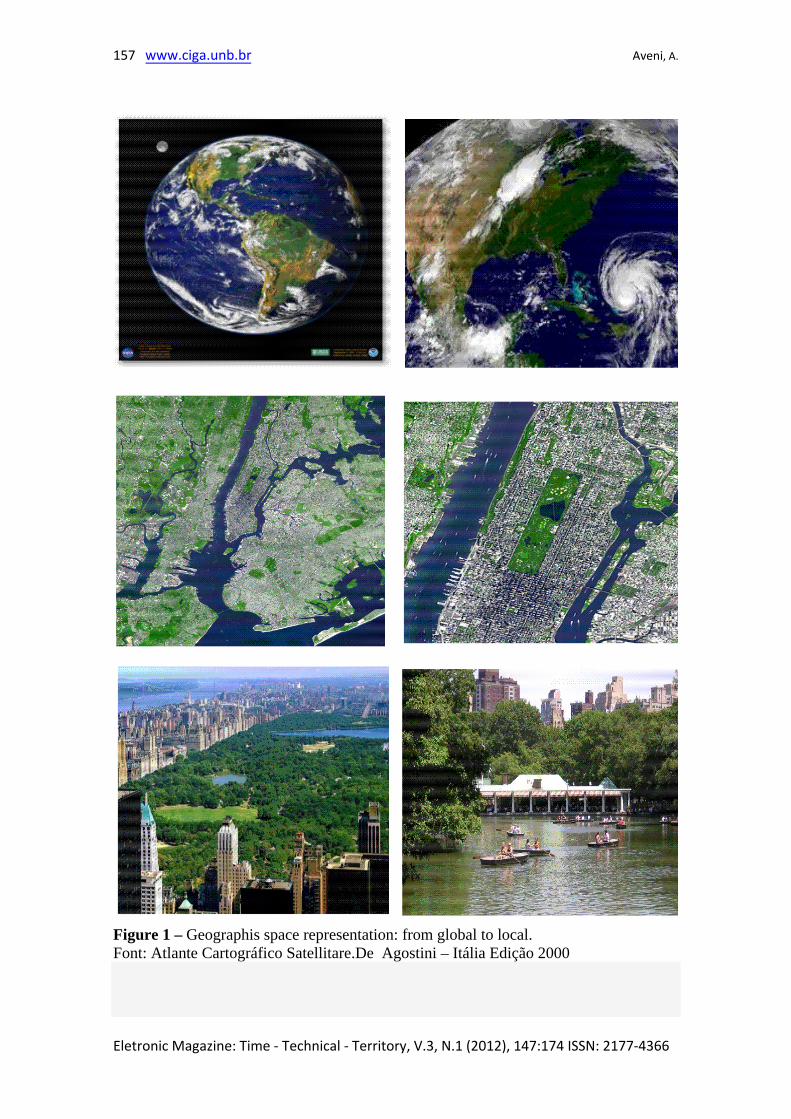
Figure 1 – Geographis space representation: from global to local. Font: Atlante Cartográfico Satellitare.De Agostini – Itália Edição 2000
158 Goegraphical Representation Of Spatial Planning
These processes are resolved as that are carried out through forms. These are initially
geographical and then take a territorial expression. The fractions containing
geographical forms of the social, that are not just forms, but forms, content, because
they change as the social movement that gives them their fractions of the social whole.
The action is inherent in the conditioning function and it is in the shape that contains it.
So the whole process establishes a meaning only when embodied. However, Santos
(1997) explains that is a space that contains the category, or is a category of analytical
entirety.
The space is socially produced and a structure created is a subject-object of an
interpretation of space, so it is not necessary to divide the space of society because it is
necessary rules for shipbuilding and separate. Then, in the present paper we share the
sayings of Surtegaray (2001) on the concept of GS as "one and multiple". Space is the
broader concept, a whole whose meaning is one of the most abstract among the
Geography. The geographical space express different levels of abstraction and,
consequently, different operational possibilities. (SUERTEGARAY 2001)
1.4 Nature and Environment
Nowadays we need to integrate the concept of GS in the planning of the territory with
emerging concepts such as sustainability. Sustainability is a concept connected to
Nature and the Environment. The use of Environment in place of GS involves looking
at a more linked to concepts of value of natural and anthropogenic systems. Regarding
the GS, nature takes meanings of "natural resources, energy and economic value."
According to L. C. Cidade (2001) our view of nature derives from paradigms set the
course of centuries. For the author, the modern system, the reason, the analytical
method and subject-object separation have been considered pillars of countless
scientific achievements. Facing the current challenges, particularly in the description of
nature and society, the society-nature theme was always present in the discourse of
geography.
The very Nature meaning can be understood as building and construction of social
processes, since the current pattern, it cannot be understood so pure (ecosystem),
Eletronic Magazine: Time - Technical - Territory, V.3, N.1 (2012), 147:174 ISSN: 2177-4366
159 www.ciga.unb.br Aveni, A.
separated from its subject, the man. It was the German scientist Ernst Haeckel in 1869,
who first used the word Nature to order the study of relationships between living beings
and the environment habitat. Using Nature means focuses on contemporary ecological
knowledge area. This provides the criteria of the scientific study of the distribution and
abundance of living organisms and the interactions that determine them.
Therefore, in the current work Space is Nature and Nature is Space, however, the
concept of nature that emphasizes the aspect of the ecosystem as a source of services
essential to the survival of man and his empirical human perception. Thus, in defining
the Nature we configure and highlight critical aspects or fundamental to life on Earth
and thus the physical rather than psychological and social. It should be noted with the
concept of the nature of "value for living" space in particular focused on the value of
energy and balance.
Therefore the SEA and the PDT is used instead of Nature, the concept of the
Environment. Environment is another social representation of space and nature. The
term began to be used politically in 1972 when it was held in Stockholm in Sweden, the
First World Conference on the Environment. This was the first milestone of meetings
involving representatives of various States to the debate on environmental issues and
nature conservation. During the 80 years was resumed discussion of the environment
against the economic development. Through these international discussions, the concept
of the Environment regarding the nature and GS took a much more apparent
characteristic of "socio-political value".
This affected the laws of various nations, for example, in the Federal Constitution of
Brazil in 1988 is set to:
Everyone is entitled to an ecologically balanced environment, and the common use and
essential to a healthy quality of life, imposing on the government and the community
the duty to defend and preserve it for present and future generations.
What reflects a principle of the United Nations, where:
Man has the fundamental right to liberty, equality, and to enjoy adequate living
conditions, in an environment of quality that permits a life of dignity and well-being and
is the carrier's solemn obligation to protect and improve the environment
environment
Eletronic Magazine: Time - Technical - Territory, V.3, N.1 (2012), 147:174 ISSN: 2177-4366
160 Goegraphical Representation Of Spatial Planning
for present and future generations. (UNITED NATIONS 1972)
The Environment, considered in the present paper, has social, economic and political
process in PDT and Transport Plans. A resource or a territory (parts of Nature) has no
value unless it is inserted in the terms of use and, in particular in this work, in term of
transport activity. Environment is part of nature that assumes value as a natural resource
(not yet exploited), but is also part of nature manufactured (modified work) to man.
1.5 Transport flows and fixed assets.
In case of transport activity should also be pointed out the difference between concepts
of transport flows in space and fixed assets. Clozier (1963) says that geography, that
deals with transportation, focuses on roles and relationships of communication
proposing the science of Geography as spatial interaction and communication.
Already in the 80 Rafferstin, developed in geography the difference between movement
and communication, and Santos and Silveira (2001) speak of "geography of movement"
or mobility once she has the central problems the movement of goods, services and
capital (geography international trade, geographic markets and businesses, geographic
flows of capital); forms and transport networks (road, rail, waterways, seas and oceans,
air), humans and their spatial mobility (taxonomy of mobility, migration, "spillovers"
technology, tourism); information and networks (media, information flows, networks,
nodes).
Transport is, however, a space-territory relationship with important features and unique
to the space. The functions of transport become important to explain their plans and
environmental assessments. The structure of space necessarily refers to physical and
social base, given that, for example, the distance is regarded as the movement functional
distance (ie, the function of the relationships between different points in space that can
be achieved for people). The spatial interaction between these forms leads to set the
distances depending on the relationship between physical and virtual objects.
Thus, the interest is even an isometric analysis (ratio of distance from the same
function) which is different from the physical distance, ie. km. The speed (and time) is
part of the equation that defines the communication and "broad sense", integration,
Eletronic Magazine: Time - Technical - Territory, V.3, N.1 (2012), 147:174 ISSN: 2177-4366
161 www.ciga.unb.br Aveni, A.
understood as a function of mobility. There is thus the actual speed, or useful
commercial, and the average.
Transport activities attribute to space features some social functions. The functions are
the objectives to the satisfaction of a user's needs and movement of goods, services and
capital. The mobility, is relevant in the way of looking at the movement and the
concepts of migration and urban mobility and extra-urban, or semi-nomadic life inside
(we must not lose the concept of international migration), tourist mobility.
1.6 Cartography
For IBGE (IBGE, 1998), etymologically speaking the word cartography - description of
space - was introduced in 1839, the second Viscount of Santarem, Francisco Manoel de
Barros e Souza de Mesquita de Macedo Leitão (1791-1856).
The concept of Cartography, now accepted without major challenges, was established in
1966 by the International Cartographic Association (ICA), and later ratified by
UNESCO, the same year: "The cartography is presented as a set of studies and scientific
operations, technical and artistic, based on the results of direct observation or
examination of documents, turn to the preparation of maps, charts and other forms of
expression or representation of objects, elements, phenomena and physical and
socioeconomic environments, as well as its utilization. "
The IBGE explains that the cartographic representation can exist as a globe, map, chart,
plan or image. For any representation you must set its scale. Scale is defined as the ratio
between the size of a drawing line and their counterparts. The preparation of a letter
requires first of all, the establishment of a method, whereby each point on the surface of
the earth corresponds to a point on the map, and vice versa. We can also say that
according to IBGE (IBGE, 1998) that all representations of curved surfaces in a plan
involving "extensions" or "contractions" that result in distortions or "tears." The
construction of a projection system will be chosen so that the card will have properties
which meet the objectives required for its use.
The nature of representation in the reports of the Strategic Environmental Assessment
of the current study is to represent geographic scales of 1:1,000,000 and smaller
Eletronic Magazine: Time - Technical - Territory, V.3, N.1 (2012), 147:174 ISSN: 2177-4366
162 Goegraphical Representation Of Spatial Planning
(1:2,500,000, 1:5,000,000 1:30.000.000 up). In this type of card details planimetric and
altimetric are generalized, which offer accuracy in accordance with the scale of
publication.
There is also a use of thematic maps. These are the letters, maps or plans at any scale,
intended for a specific topic, the research necessary to socioeconomic, natural resources
and environmental studies.
Being a map or chart representation, a single sheet of paper from the surface in reduced
dimensions, you must associate the elements of symbols and conventions. The symbols
that include cartographic conventions, meeting the requirements of technical drawing
and photographic reproduction, represent in a more expressive, the different terrain and
topographic objects in general.
Through graphical and thematic maps it can be represented an activity of transport and
spatial relationship between objects as a territory, region and environment. So the way
to represent the space exists in SEA mostly with thematic maps. The purpose of this
representation is to provide, with the aid of symbols and / or qualitative quantitative
arranged on a basis of reference drawn from maps and topographical maps, information
about a particular topic or phenomenon that is present or acts in the territory mapped.
One of the first authors to present the map as a standard model in cartography, was
Borad (1967, apud SIMIELLI, 1986) that defined the map as a model of reality, made
from a scientific method of investigation. According to Taylor (1994), the reflection of
the more modern theory of modeling is the introduction of the technology of geographic
information systems - GIS, as a result, on the one hand, the intensive use of
mathematical and statistical methods in working with many variables and, on the other
of all technological and computing, especially graphics programs.
Bertin (1967) was the first author who systematized the graphic language as a system of
graphic symbols with meaning and significant with respect to graphic semiology. He
considered as meaning the relationship between the data to be represented, noting that
these relations can be similarity / diversity of order or proportionality. Then the
relations must be transcribed on the map with visual variables that represent the exact
Eletronic Magazine: Time - Technical - Territory, V.3, N.1 (2012), 147:174 ISSN: 2177-4366

163 www.ciga.unb.br Aveni, A.
Eletronic Magazine: Time - Technical - Territory, V.3, N.1 (2012), 147:174 ISSN: 2177-4366
relationship between the data to be represented. The significant variables are the
following visual: size, value, texture, color, orientation and shape.
2. Techniques of data processing and study results
The technique used in the work to show representations of space in the SEA try to find
empirical relationships of cause and effect, for lack of consolidated methodologies for
analyzing the specific problem of the research. The technical analysis is here divided
into three steps: Audit of procedures for SEA Analysis "Rhetoric" (or discourse) inside
the SEA, the SEA Cartographic Analysis.
Audit. Below Tables 1 and 2 show the description of the proposal evaluation audit
Fischer formal review. The basic scheme of assessment is in accordance with Annex I
of the book cited by the same author (FISCHER 2007, p.155). The review process
(Table 1) is based on a qualitative analysis (the degree of quality) based on assessments
of a (hit) and G (not reached) for each step of analysis.
The questions to assess the SEA are divided into six steps and each step there are
questions to be answered to assess the degree of achievement of objectives. The
questions for this qualitative assessment are shown in Table 2. The evaluation process
takes place answering the questions in sequence. The answers to the questions have
resulted in the level of quality, ie, what value was reached in which the goal of the
question, the value is always a (hit) and the maximum value of G (not reached) the least.
Results, averaged for each question infers the final qualitative evaluation.
Table 1 – Strategic Environmental Assesment (SEA) audinting: values. A Fully achieved
B Achieved with minor omissions
C Achieved with omissions and inadequacies
D Not achieved with omissions and inadequacies
E Not Satisfactory with relevant omissions and faults
F Very unsatisfactory important parts missing and weakly developed
G Not attempted completely
164 Goegraphical Representation Of Spatial Planning
Eletronic Magazine: Time - Technical - Territory, V.3, N.1 (2012), 147:174 ISSN: 2177-4366
n / a not applicable
? unclear
Source: Fischer (2007:155).
Table 2 - Strategic Environmental Assesment (SEA) auditing: process.
1. DESCRIPTION OF THE PROGRAM AND DATABASEhighlights the objectivesemphasizes the interaction with other PPPPexplains how SEA was carried outdescribes how it is integrated into the decision process to the PPPdescribes the problems of other integrated assesmentmake the information relevant to the situation ex anteposes significant problemsplaces information about the goals of protecting the environment
2. IDENTIFICATION AND EVALUATION OF THE CRITICAL ISSUESAND OPTIONSconsiders the objectives and geographical scope of the PPPlists the problems considereddescribes how the goals were identifieddescribes key information *describes the issues that must be defined with assessmentsexplains evaluation methods which were used for information
3. DETERMINATION OF IMPACTSidentifies a system PPPIdentifies the value and vulnerability of the areaidentifies the landscapeidentifies the effects of the environmentidentifies the side effectstrans identifies border effects (Area)identifies risks to human healthidentifies the geographic area and population affected
4. PROCESS OF PUBLIC DISCUSSIONdescribes the level of governancedescribes how the summary of the assessment was made available for thosewho e'afetadoconfirms the results of the incorporated thread shape
5. REPORTINGsections and includes a reportposes difficulties and uncertainties encountered in the processis defined as a choice of course as the process to minimizeimpacts on the choice itself (participatory process, and alternativecomparison purposes)
165 www.ciga.unb.br Aveni, A.
6. RECOMMENDATIONS AND DESCRIPTION OF THE CHOSENALTERNATIVE AND MONITORINGpresents the choices and motivationsputs the information on how to avoid impacts and what measures tomitigate impactsposes as monitor any effects not predictabledescribes how monitoringExplains how the monitoring will beexplains how the monitoring is done
Source: Fischer (2007:155). Adaptation: Alessandro Aveni
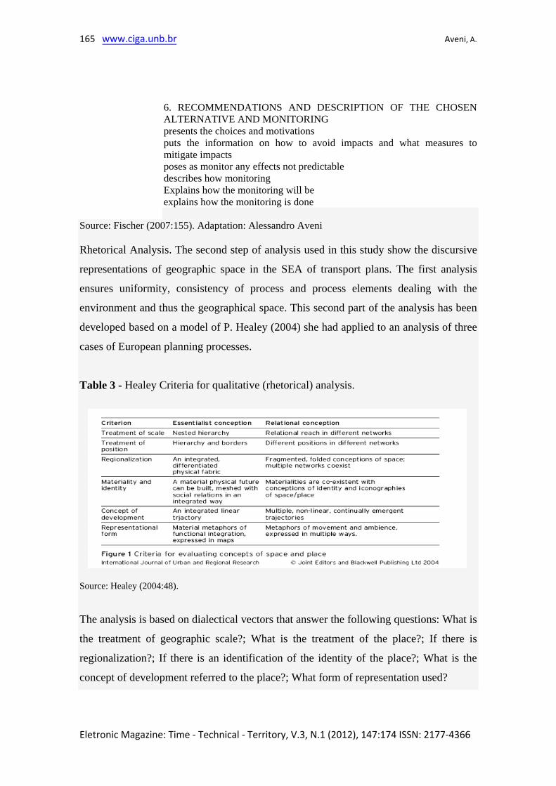
Rhetorical Analysis. The second step of analysis used in this study show the discursive
representations of geographic space in the SEA of transport plans. The first analysis
ensures uniformity, consistency of process and process elements dealing with the
environment and thus the geographical space. This second part of the analysis has been
developed based on a model of P. Healey (2004) she had applied to an analysis of three
cases of European planning processes.
Table 3 - Healey Criteria for qualitative (rhetorical) analysis.
Source: Healey (2004:48).
The analysis is based on dialectical vectors that answer the following questions: What is
the treatment of geographic scale?; What is the treatment of the place?; If there is
regionalization?; If there is an identification of the identity of the place?; What is the
concept of development referred to the place?; What form of representation used?
Eletronic Magazine: Time - Technical - Territory, V.3, N.1 (2012), 147:174 ISSN: 2177-4366
166 Goegraphical Representation Of Spatial Planning
Table 3 is a schematic explanation of criteria for analysis due to the above questions. It
explains for example, treatment of scale seeks to explain whether there is a full
explanation of the document system and explanation of spatial hierarchy: spatial
networks in which relations. The treatment of the place (location) seeks to explain in the
document is a representation of borders and different nodes of a network space.
The planning documents, as a way to represent and build a space form a vocabulary and
practice building a new "political space" (HEALEY 2004, p.51). So a search for
relationships between SEA and GS through this vocabulary may be relevant for
understanding the phenomena.
The analytical work was developed using the same logic of the Healey (2004) review of
three cases in Europe and successively is addicted with transport related concepts. A
hierarchy of natural objects is therefore evident in SEA at the same time it is evident in
the plans. An analysis with the scheme suggested for Healey is consistent with a look of
the planning process of dialogue with the problems due to changes in the process of
PDT. It is the direct link with additional reports as the SEA, to be part of a single
change plan in the territory.
Cartographic Analysis. The cartographic representation is still in need over the more
graphic representations of space. According to the procedure used to evaluate the
mapping to graphical representations, one must consider the perspective and plan. You
should also consider the guidance in relation to terrestrial coordinates scales and
projections. The scale is relevant beyond the type (large, medium and small) a
qualifying geographic location, regional, national, continental and global. The map
representation is done particularly for reference and should put : the author, in particular
the sources and forms of implementation. The forms are the main point, the linear and
zonal. These forms may be characterized by variables such as size (which translates
relations proportions in geometric figures), value (range of shades that ranks), grain
(which suggests the order in space), color (visual selection of the objects represented ),
orientation (distinguishes objects) and form (the symbols that represent objects and
social space).
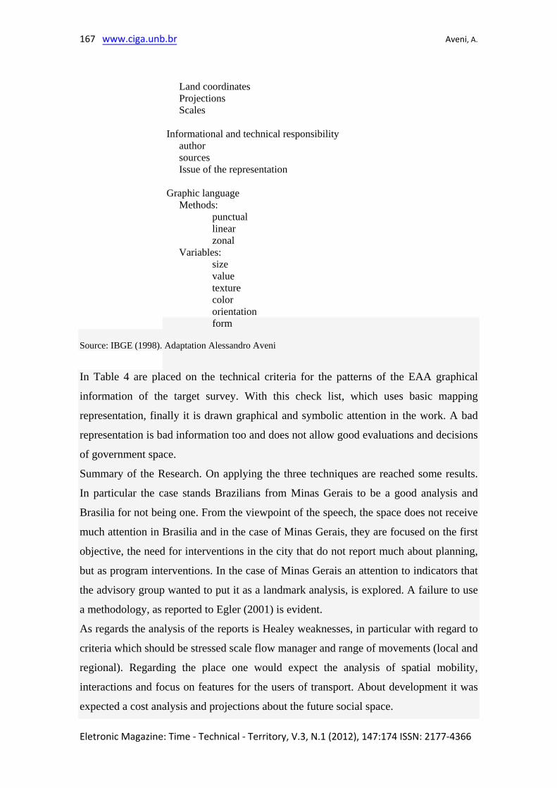
Table 4 - Criteria for analysis of imaging from space.
Cartographic base
Eletronic Magazine: Time - Technical - Territory, V.3, N.1 (2012), 147:174 ISSN: 2177-4366
167 www.ciga.unb.br Aveni, A.
Land coordinates Projections Scales
Informational and technical responsibility author sources Issue of the representation
Graphic language Methods:
punctual linear zonal
Variables: size value texture color orientation form
Source: IBGE (1998). Adaptation Alessandro Aveni
In Table 4 are placed on the technical criteria for the patterns of the EAA graphical
information of the target survey. With this check list, which uses basic mapping
representation, finally it is drawn graphical and symbolic attention in the work. A bad
representation is bad information too and does not allow good evaluations and decisions
of government space.
Summary of the Research. On applying the three techniques are reached some results.
In particular the case stands Brazilians from Minas Gerais to be a good analysis and
Brasilia for not being one. From the viewpoint of the speech, the space does not receive
much attention in Brasilia and in the case of Minas Gerais, they are focused on the first
objective, the need for interventions in the city that do not report much about planning,
but as program interventions. In the case of Minas Gerais an attention to indicators that
the advisory group wanted to put it as a landmark analysis, is explored. A failure to use
a methodology, as reported to Egler (2001) is evident.
As regards the analysis of the reports is Healey weaknesses, in particular with regard to
criteria which should be stressed scale flow manager and range of movements (local and
regional). Regarding the place one would expect the analysis of spatial mobility,
interactions and focus on features for the users of transport. About development it was
expected a cost analysis and projections about the future social space.
Eletronic Magazine: Time - Technical - Territory, V.3, N.1 (2012), 147:174 ISSN: 2177-4366
168 Goegraphical Representation Of Spatial Planning
However the SEA is an analysis that uses GS. In those reports, there are definitions of
scale, distance, space and structure interaction, however, so fragmentary. In particular,
in Minas Gerais, a regional analysis is sufficiently developed and the regionalization,
however, with loss of information about the identity of the place of the interventions.
There is no developed criteria defining and linking regional development plans in
relation to municipalities and zoning about decisions on transport. Nevertheless, there
are forms of representation and a thematic use of GIS and other mapping techniques,
but this does not lead to a complete representation of traffic flows.
Types of transport mobility are analyzed for Minas Gerais cargo and tourism. There is
an integrated analysis of the functions assigned to the space, ie goals of satisfying a
user's needs and movement of goods, services and capital, forms of transport and
communication, spatial mobility of goods, information and people, information and
communication space.
In the Minas Gerais SEA, dominates a very positive factor in the risk analysis of
impacts of freight transport, however, completely lacking an analysis of different
possibilities to change the matrix of transport not only in relation to the modal, but also
within the matrix road What is the purpose of analysis. This is strange being that the
report aims to make a strategic analysis.
In both reports also there is lack of alternatives analysis and public discussion. The
spatial mobility is analyzed in statistical terms but without deep social. The analysis of
data likely source of the DNIT is not detailed and well referenced. At the end is a place
that does not follow the rules of use of statistical techniques.
In relation to spatial representations, Minas Gerais has an outstanding level cartographic
representation, but lack Brasilia, because there is much concern in the report with
quantitative data and tables. In relation to consultants, Brasilia, which sought outside
ones it comes off as worse. In relation to monitoring in view of integration in the
planning process, the legal case of Brasilia stopped analyzes. In the case of Minas
Gerais there was no monitoring until the researcher knew the review and a continuation
of SEA and its integration in the transport plans of Minas Gerais.
Eletronic Magazine: Time - Technical - Territory, V.3, N.1 (2012), 147:174 ISSN: 2177-4366
169 www.ciga.unb.br Aveni, A.
Eletronic Magazine: Time - Technical - Territory, V.3, N.1 (2012), 147:174 ISSN: 2177-4366
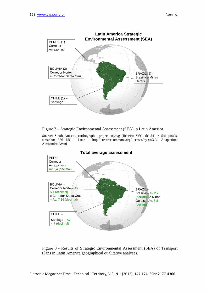
CHILE (1) –Santiago
PERU – (1) Corredor Amazonas
BOLIVIA (2) –Corredor Nortee Corredor Santa Cruz
BRAZIL (2) –Brasília e Minas Gerais
Latin America StrategicEnvironmental Assessment (SEA)
Figure 2 – Strategic Environmental Assessment (SEA) in Latin America. Source: South_America_(orthographic_projection).svg (ficheiro SVG, de 541 × 541 pixels, tamanho: 386 kB) - Luan - http://creativecommons.org/licenses/by-sa/3.0/. Adaptation: Alessandro Aveni
CHILE –
Santiago – Av. 4,7 (decimal)
PERU –Corredor Amazonas -Av.5,4 (decimal)
BOLIVIA –Corredor Norte – Av. 5,4 (decimal)e Corredor Santa Cruz – Av. 7,16 (decimal)
BRAZIL –Brasília – Av.2,7 (decimal) e Minas Gerais – Av. 5,8 (decimal)
Total average assessment
Figure 3 - Results of Strategic Environmental Assessment (SEA) of Transport Plans in Latin America geographical qualitative analyses.
170 Goegraphical Representation Of Spatial Planning
Source: South_America_ (orthographic_projection). Svg (SVG file, nominally 541 × 541 pixels, file size: 386 kB) - Luan - http://creativecommons.org/licenses/by-sa/3.0/. Adaptation: Alessandro Aveni
3. Conclusions and recommendations
One possibility for transport plans SEAs to be integrated into PDT is to address the GS,
put it in the speech, using graphical representations as a self-explanatory it is producing
space. These SEA reports demonstrate an approach that leads to understand the actions
and objects in the territory (climate, water, soil, etc..). But it is done in a separate way
which does not allow an integrated view. Such an approach needs, for example, to
integrate the common analysis in physical geography that analyzes geosystems,
ecosystems and emergy (ie. cost of energy in joule). Such analysis is not addressed in
any report.
Thus the desired "integrated spatial" plans and reports by the SEA analysis, is confused
with the "integration into a single document from multiple geographic elements of the
assessment." To clarify this difference that is not only verbal: in the same document are
placed the elements of nature, the social and economic factors and actions and impacts.
But this is not "integrate" the elements for a decision space, but put them in the same
document. This is set against a matrix of type (causal) two-dimensional and not the
multiplicity of dimensions. Lack focus on the concepts that characterize the spatial
geographic territory.
In this paper, the term integration, means a complete (ie multiple and polycentric in the
same moment in time) assessment of all the elements of GS, which may aid a better
understanding and representation for a decision-maker. Therefore, the best
representation is not matrix (or two-dimensional), but, one connected to the network
and mapping using, for example, the technique SIG and dynamic graphical
representation. The links thus should not be represented only as a double cause and
effect and no spatial depth, but are multiple and polycentric.
A complete Geographic Space analysis can add value to SEA and the planning of the
territory, ie, provide better information for decisions. A failure in representing space is
clearly the issue of governance of public space and a power issue.
Eletronic Magazine: Time - Technical - Territory, V.3, N.1 (2012), 147:174 ISSN: 2177-4366
171 www.ciga.unb.br Aveni, A.
The survey of Latin America SEA confirm two issues: a different interpretation of the
space is perceived in the plans and evaluations of SEA and the difficulty of integrating
SEA in PDT, since it realizes the need for an interpretation of the spatial planning of the
territory.
Research has shown the problems of using the space category in the reports of SEA for
transport plans, particularly in Latin America and Brazil. There is a failure to use
comprehensive, integrated and holistic concept of GS in the reports, even though
present fragments of geographical concepts and representations on maps. This result
opens the possibility of research on the subject.
It also appears, in the analysis, in relation to the movement and transport that the use of
PDT in GS transport is more connected to society and their representations of the fixed
assets than the physical characteristics and flows. Thus, the role of transport in space is
not well represented because is linked more to structures and less to economic flows.
Functions such as leisure (with the exception of tourism), type of travel in relation to
age and culture are not addressed in the reports and plans.
To confirm this assessment highlights that the representations of flows are not
represented in the SEA and plans or maps, but in tables. This is somewhat surprising,
and in relation to transport infrastructure would have been expected a greater use of
maps, especially information flows and movement. But considering that these
documents have a strong political sense, it is not surprising that the technicians who
prepare the SEA are subject to political appointments and tend to distort strategies and
analysis techniques with a strong representation of economic and engineering (tables
and graphs and matrices).
In many cases, was relevant in the search to a lack of part of the planning process:
monitoring. This is particularly the case in Latin America where monitoring is also
dependent on donors. By monitoring not only mean a confrontation between prediction
and outcome. A good monitoring includes ongoing review of the process of PDT in the
logic of Strategic Management of PDT.
At last it must be said that the difficulty is probably on dealing with the geographical
space and its representation as a component of decision-making process and
recognize
Eletronic Magazine: Time - Technical - Territory, V.3, N.1 (2012), 147:174 ISSN: 2177-4366
172 Goegraphical Representation Of Spatial Planning
the usefulness of this in PDT mostly in terms of information and communication. In
other words, besides the techniques guidelines, or that can be "transferred" teams with
specialists, it is important to work before to plan to define the concepts, categories and
symbolic representations to be used (strategies and alternatives) rather than the
techniques and the procedures that define SEA of PDT.
The training in use and treatment of the concept of geographical space for those who are
working in this area seems to be the pivot change and best improve techniques for the
PDT including a rhetorical analysis (discourse) and planning history. Based on this final
analysis it is deemed essential to auditing the SEA. An audit with the Fischer audit
technique This allows to treat all reports in the same way and know the weaknesses of
the process before making comparisons.
Technical analysis of alternatives is essential to a better spatial representation and use of
techniques that include the definition of space (physical, social, economic etc.). Some
model also can be used for quantitative analysis of alternatives. With these suggestions
he is also the indispensable necessity of a better use of imaging techniques. At present,
the use of GIS is important to note that there is no excuse in not complete graphical
representations. The use of techniques that yield dynamic representations is also
required.
For PDT in particular transport planning, the relationship with the environment can be
used to discuss alternatives strategic outside the physical environment - society
relationship that only highlights aspects of pollution and fossil fuels reduction. For
example, function in relation to tourism is often used, but there are not represented
neither discursively nor graphically.
REFERENCES
BERTIN, J. Sémiologie Graphique: les diagrammes, les réseaux, les cartes.
Paris:Mounton e Gauthier-Villars, 1967.
BOARD, C. Os mapas como modelos: modelos físicos e de informação in em
Geografia. Coord. Richard J. Chorley e Peter Hagett. São Paulo: EDUSP, 1975.
Eletronic Magazine: Time - Technical - Territory, V.3, N.1 (2012), 147:174 ISSN: 2177-4366
173 www.ciga.unb.br Aveni, A.
DE MASI, D. (org.) A sociedade pós-industrial. 4a ed. São Paulo Senac, 2003.
DALAL CLAYTON B., e SADLER B., Strategic Environmental Assessment: A Sourcebook
and Reference Guide to International Experience, Earthscan, Paperback edition, London,
2005.
EGLER, P.G. Perspectivas de uso no Brasil do processo de Avaliação Ambiental Estratégica
Eduação e Meio Ambiente, 2001. Disponível em: <http://
www.mct.gov.br/CEE/revista/rev11.htm Acesso em 30/07/2011.
EGLER, P.C.G., Improving the Environmental Impact Assessment Process in Brazil. PhD
Thesis the School of Environmental Sciences University of East Anglia, England, 1998.
FISCHER, T.B. Theory and Practise of Strategic Evironmental Assesment, Heartscan,
London,2007.
GIDDENS, A. The Constitution of Society: Outline of the Theory of Structuration
Cambridge: Polity Press, 1994.
HARVEY, D. A condição pós-moderna. Uma pesquisa sobre as origens da mudança
cultural. São Paulo: Loyola, 1994.
HAGGET P.; CHORLEY R..J. Models in Geography, The trinity Press, Wocheter e London,
1997.
HEALEY, P. “Rational method” as a mode of policy formation and implementation in land-use
policy. Environment and Planning B; Planning and design, 10, pp 19-39,1983.
HEALEY, P. Planning through Debate: The Communicative Turn in Planning Theory. The
Town Planning ReviewVol. 63, No. 2 (Apr., 1992), pp. 143-162, 1992.
HEALEY, P.; KHAKEE A et alli (Eds.) Making strategic special plans: innovations in Europe.
London, University College London, 1997.
HEALEY, P. The Treatment of Space and Place in the New Strategic Spatial Planning in
Europe International Journal of Urban and Regional Research Volume 28.1 March 2004 45-67,
2004.
HEALEY, P. Collaborative planning in perspective in Planning Theory SAGE Publications
(London, Thousand Oaks, CA and New Delhi) Vol 2(2): 101–123, 2003.
MANNHEIM, K. Sociology of Knowledge Tavistock Publication Limited, 1984.
Eletronic Magazine: Time - Technical - Territory, V.3, N.1 (2012), 147:174 ISSN: 2177-4366
174 Goegraphical Representation Of Spatial Planning
MINISTÉRIO DO PLANEJAMENTO E ORÇAMENTO INSTITUTO BRASILEIRO DE
GEOGRAFIA E ESTATÍSTICA – IBGE DIRETORIA DE GEOCIÊNCIAS – DGC. Noções
básicas de Cartografia, Rio de Janeiro, 128p., 1998.
MINISTÉRIO DE TRANSPORTES MT, PNLT – Plano Nacional de Logística e
Transportes volume 5 – transporte e meio ambiente Tomo 1 – Relatório de Tratamento
Ambiental no Setor Transporte abril/2007.
MINISTÉRIO DO MEIO AMBIENTE, MMA. Avaliação ambiental estratégica, Brasília:
MMA/SQA, 92p., 2002.
SADLER, B.;VERHEEM, R., Strategic Environmental Assessment: Status,
Challenges and Future Directions. Ministry of Housing, Spatial Planning and the
Environment. Netherlands. p. 188,1996. SANTOS, M. A natureza do espaço: técnica e tempo, razão e emoção. São Paulo : Hucitec,
1996.
SANTOS, M. e SILVEIRA, M. L. O Brasil. Território e sociedade no inicio do século XXI,
Editora Record Ltda, 13a ed. Rio de Janeiro, 2010.
SUERTEGARAY, D. M. A. Espaço Geográfico Uno E Múltiplo Revista electrónica de
geografía y ciencias sociales Universidad de Barcelona Nº 93, 15 de julio de 2001.
TAYLOR, D.R. Fraser. Uma Base Conceitual para a Cartografia: Novas Direções para a
Era da Informação. Caderno de Textos - Série Palestras, LEMADI–DG/USP, São Paulo,
v. 1, n.1, p.11-24, ago. 1994.
THERIVEL, R.; Partidário, M. R. The Pratice of Strategic Environmental
Assessment. Earthscan Publications Ltd, London, 1996. TOURAINE, A. La Société post-industrielle. Paris, Danoel, 1996.
JEPSON, E. J. Jr. Sustainability and Planning: Diverse Concepts and Close Associations
Journal of Planning Literature n.15 p.499, 2001.
Eletronic Magazine: Time - Technical - Territory, V.3, N.1 (2012), 147:174 ISSN: 2177-4366