Embed Size (px)
Citation preview

GNSS POST-PROCESSING SOFTWARE
Product Overview // June 2014
2
www.effigis.com
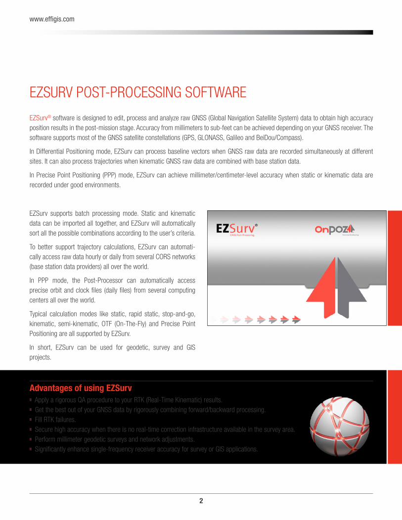
EZSURV POST-PROCESSING SOFTWARE
EZSurv® software is designed to edit, process and analyze raw GNSS (Global Navigation Satellite System) data to obtain high accuracy position results in the post-mission stage. Accuracy from millimeters to sub-feet can be achieved depending on your GNSS receiver. The software supports most of the GNSS satellite constellations (GPS, GLONASS, Galileo and BeiDou/Compass).
In Differential Positioning mode, EZSurv can process baseline vectors when GNSS raw data are recorded simultaneously at different sites. It can also process trajectories when kinematic GNSS raw data are combined with base station data.
In Precise Point Positioning (PPP) mode, EZSurv can achieve millimeter/centimeter-level accuracy when static or kinematic data are recorded under good environments.
EZSurv supports batch processing mode. Static and kinematic data can be imported all together, and EZSurv will automatically sort all the possible combinations according to the user’s criteria.
To better support trajectory calculations, EZSurv can automati-cally access raw data hourly or daily from several CORS networks (base station data providers) all over the world.
In PPP mode, the Post-Processor can automatically access precise orbit and clock files (daily files) from several computing centers all over the world.
Typical calculation modes like static, rapid static, stop-and-go, kinematic, semi-kinematic, OTF (On-The-Fly) and Precise Point Positioning are all supported by EZSurv.
In short, EZSurv can be used for geodetic, survey and GIS projects.
Advantages of using EZSurv Apply a rigorous QA procedure to your RTK (Real-Time Kinematic) results. Get the best out of your GNSS data by rigorously combining forward/backward processing. Fill RTK failures. Secure high accuracy when there is no real-time correction infrastructure available in the survey area. Perform millimeter geodetic surveys and network adjustments. Significantly enhance single-frequency receiver accuracy for survey or GIS applications.
3
www.effigis.com
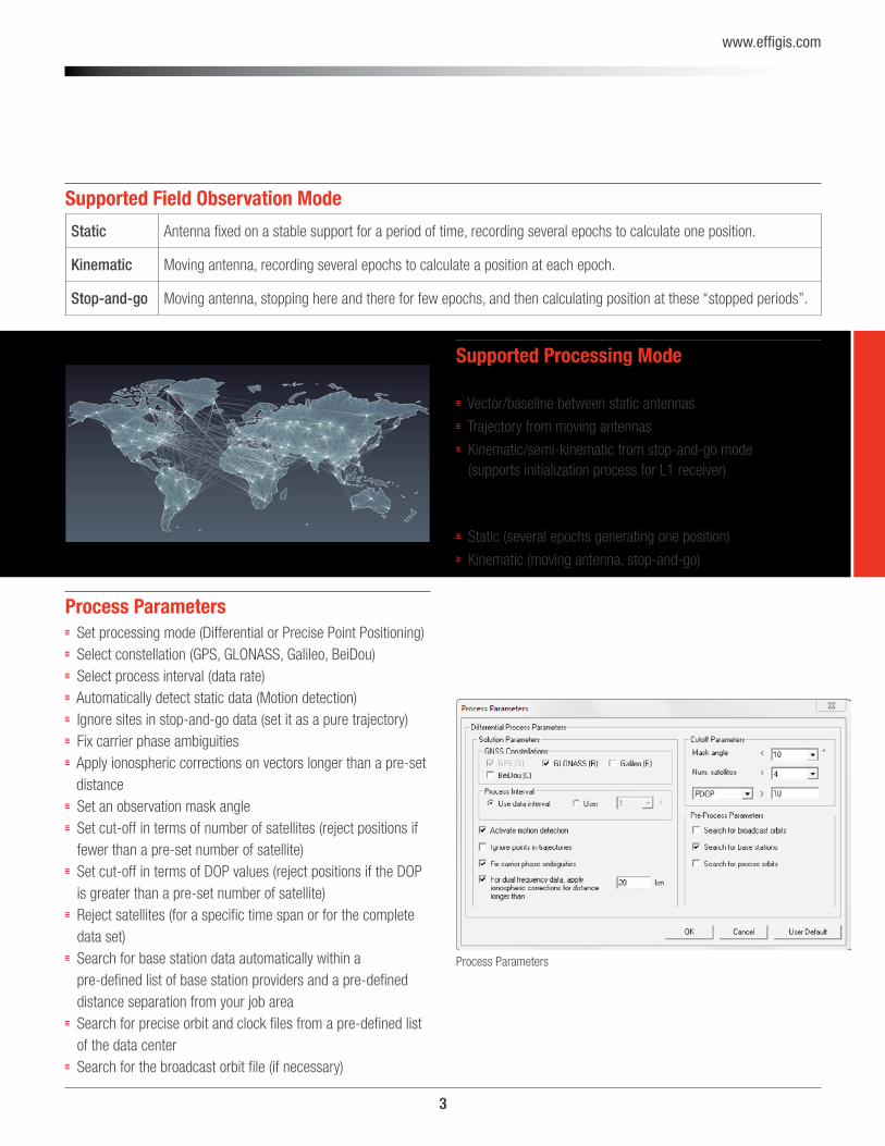
Process Parameters
Process Parameters Set processing mode (Differential or Precise Point Positioning) Select constellation (GPS, GLONASS, Galileo, BeiDou) Select process interval (data rate) Automatically detect static data (Motion detection) Ignore sites in stop-and-go data (set it as a pure trajectory) Fix carrier phase ambiguities Apply ionospheric corrections on vectors longer than a pre-set distance
Set an observation mask angle Set cut-off in terms of number of satellites (reject positions if fewer than a pre-set number of satellite)
Set cut-off in terms of DOP values (reject positions if the DOP is greater than a pre-set number of satellite)
Reject satellites (for a specific time span or for the complete data set)
Search for base station data automatically within a pre-defined list of base station providers and a pre-defined distance separation from your job area
Search for precise orbit and clock files from a pre-defined list of the data center
Search for the broadcast orbit file (if necessary)
Supported Field Observation Mode
Static Antenna fixed on a stable support for a period of time, recording several epochs to calculate one position.
Kinematic Moving antenna, recording several epochs to calculate a position at each epoch.
Stop-and-go Moving antenna, stopping here and there for few epochs, and then calculating position at these ‘‘stopped periods’’.
Supported Processing Mode Differential (using base station data as a reference site):
Vector/baseline between static antennas
Trajectory from moving antennas
Kinematic/semi-kinematic from stop-and-go mode (supports initialization process for L1 receiver)
Precise Point Positioning (using precise orbits and clocks as a reference):
Static (several epochs generating one position)
Kinematic (moving antenna, stop-and-go)
4
www.effigis.com
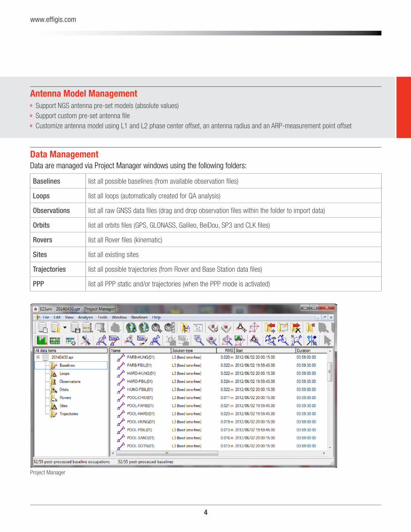
Data ManagementData are managed via Project Manager windows using the following folders:
Baselines list all possible baselines (from available observation files)
Loops list all loops (automatically created for QA analysis)
Observations list all raw GNSS data files (drag and drop observation files within the folder to import data)
Orbits list all orbits files (GPS, GLONASS, Galileo, BeiDou, SP3 and CLK files)
Rovers list all Rover files (kinematic)
Sites list all existing sites
Trajectories list all possible trajectories (from Rover and Base Station data files)
PPP list all PPP static and/or trajectories (when the PPP mode is activated)
Project Manager
Antenna Model Management Support NGS antenna pre-set models (absolute values) Support custom pre-set antenna file Customize antenna model using L1 and L2 phase center offset, an antenna radius and an ARP-measurement point offset
5
www.effigis.com
Data Compatibility
Carlson SurvCE (land surveying application) MicroSurvey FieldGenius (land surveying application) ESRI ArcPad with OnPOZ GNSS Driver for ArcPad (GIS application)
OnPOZ EZTag CE™ (GIS application) OnPOZ EZField™ (land surveying application) OnPOZ GNSS Control Panel IKE GPS data acquisition software (GIS application) BAP GeoAssist Software (land surveying application) BAP Precision Geo Mobile Solution (GMS) Software (GIS application)
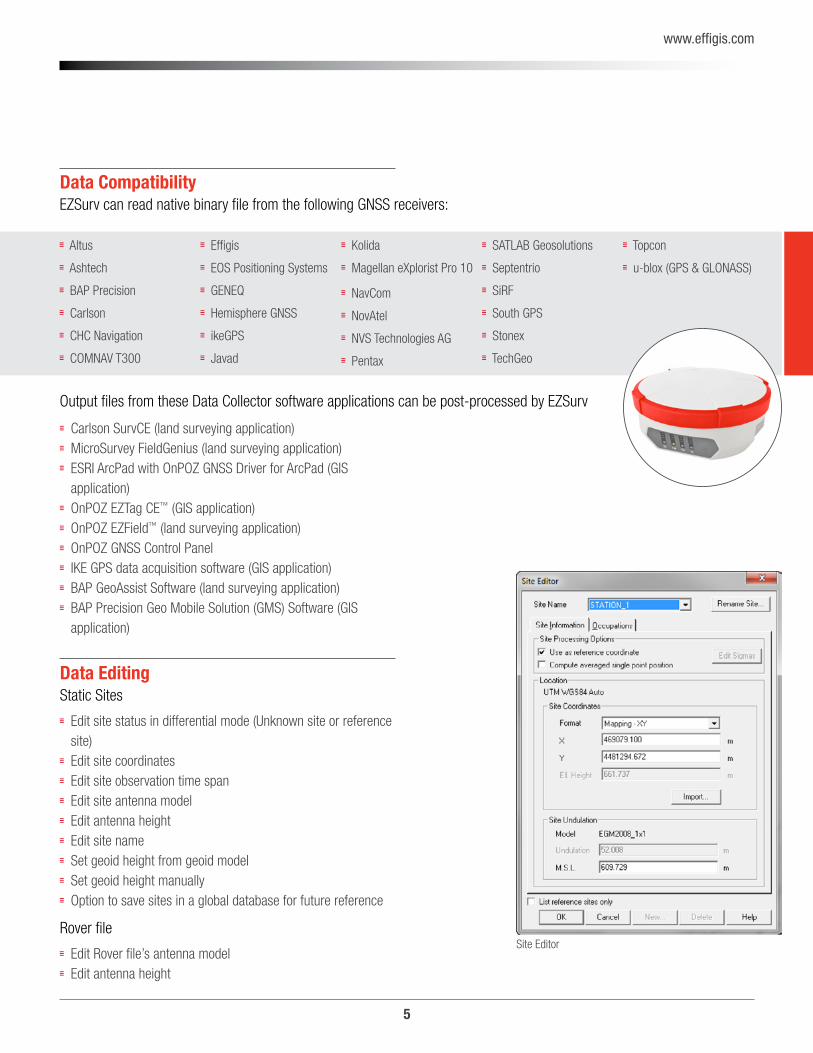
Data EditingStatic Sites
Edit site status in differential mode (Unknown site or reference site)
Edit site coordinates Edit site observation time span Edit site antenna model Edit antenna height Edit site name Set geoid height from geoid model Set geoid height manually Option to save sites in a global database for future reference
Rover file
Edit Rover file’s antenna model Edit antenna height
Site Editor
EZSurv can read native binary file from the following GNSS receivers:
Altus
Ashtech
BAP Precision
Carlson
CHC Navigation
COMNAV T300
Effigis
EOS Positioning Systems
GENEQ
Hemisphere GNSS
ikeGPS
Javad
Kolida
Magellan eXplorist Pro 10
NavCom
NovAtel
NVS Technologies AG
Pentax
SATLAB Geosolutions
Septentrio
SiRF
South GPS
Stonex
TechGeo
Topcon
u-blox (GPS & GLONASS)
Output files from these Data Collector software applications can be post-processed by EZSurv
6
www.effigis.com
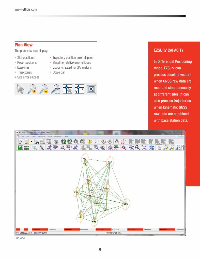
Plan ViewThe plan view can display:
Site positions Rover positions Baselines Trajectories Site error ellipses
Plan View
Trajectory position error ellipses Baseline relative error ellipses Loops (created for QA analysis) Scale bar
In Differential Positioning
mode, EZSurv can
process baseline vectors
when GNSS raw data are
recorded simultaneously
at different sites. It can
also process trajectories
when kinematic GNSS
raw data are combined
with base station data.
EZSURV CAPACITY
7
www.effigis.com
Datum Editor Support most popular modern datum with their 15-parameter transformation (with respect to WGS84).
81 pre-defined datum with their parameter transformations with respect to WGS84.
Editor to customize your own datum along with their 15 para-meter transformation.
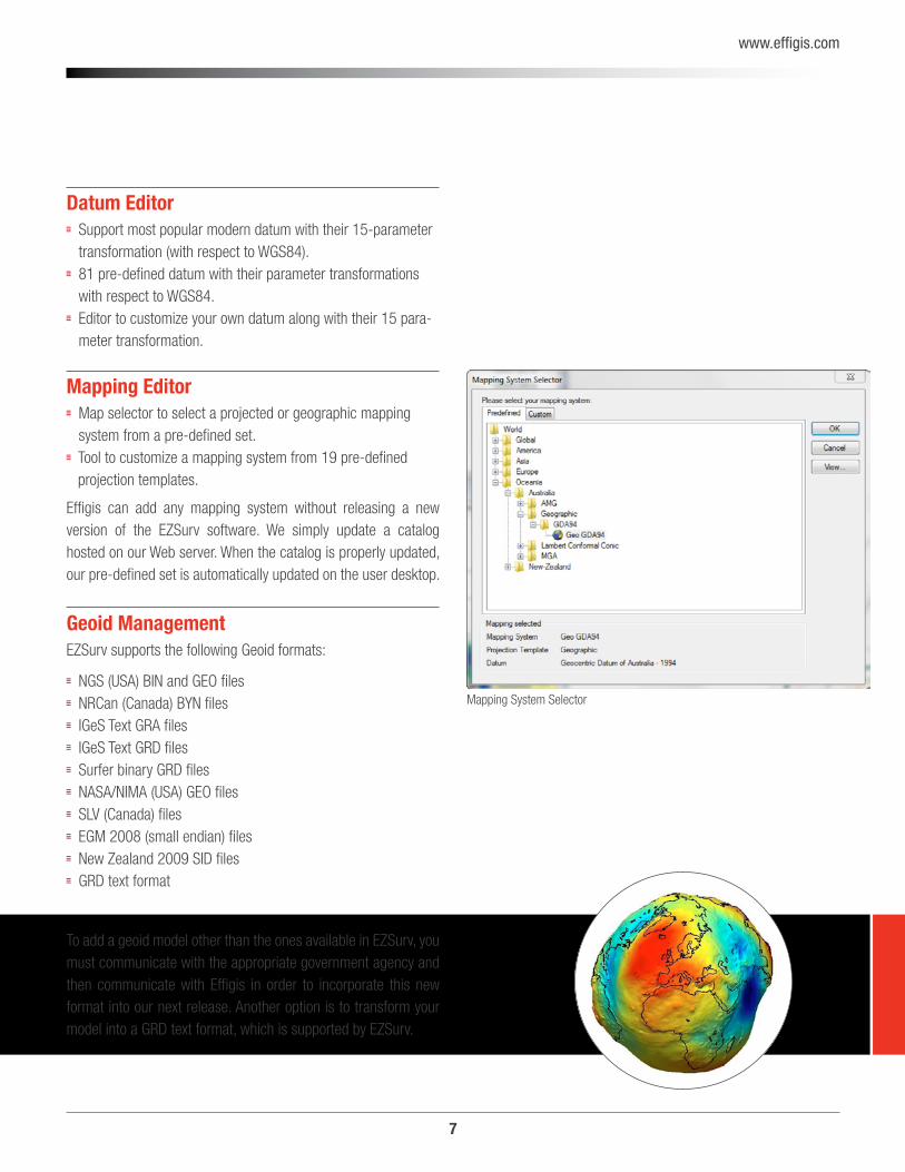
Mapping Editor Map selector to select a projected or geographic mapping system from a pre-defined set.
Tool to customize a mapping system from 19 pre-defined projection templates.
Effigis can add any mapping system without releasing a new version of the EZSurv software. We simply update a catalog hosted on our Web server. When the catalog is properly updated, our pre-defined set is automatically updated on the user desktop.
Geoid ManagementEZSurv supports the following Geoid formats:
NGS (USA) BIN and GEO files NRCan (Canada) BYN files IGeS Text GRA files IGeS Text GRD files Surfer binary GRD files NASA/NIMA (USA) GEO files SLV (Canada) files EGM 2008 (small endian) files New Zealand 2009 SID files GRD text format
Mapping System Selector
To add a geoid model other than the ones available in EZSurv, you must communicate with the appropriate government agency and then communicate with Effigis in order to incorporate this new format into our next release. Another option is to transform your model into a GRD text format, which is supported by EZSurv.
8
www.effigis.com
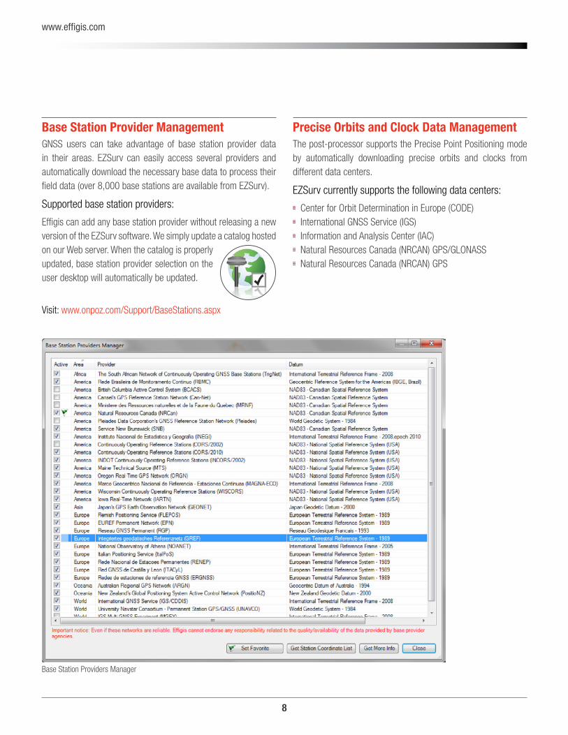
Base Station Provider ManagementGNSS users can take advantage of base station provider data in their areas. EZSurv can easily access several providers and automatically download the necessary base data to process their field data (over 8,000 base stations are available from EZSurv).
Supported base station providers:
Effigis can add any base station provider without releasing a new version of the EZSurv software. We simply update a catalog hosted on our Web server. When the catalog is properly updated, base station provider selection on the user desktop will automatically be updated.
Precise Orbits and Clock Data ManagementThe post-processor supports the Precise Point Positioning mode by automatically downloading precise orbits and clocks from different data centers.
EZSurv currently supports the following data centers:
Center for Orbit Determination in Europe (CODE) International GNSS Service (IGS) Information and Analysis Center (IAC) Natural Resources Canada (NRCAN) GPS/GLONASS Natural Resources Canada (NRCAN) GPS
Base Station Providers Manager
Visit: www.onpoz.com/Support/BaseStations.aspx
9
www.effigis.com
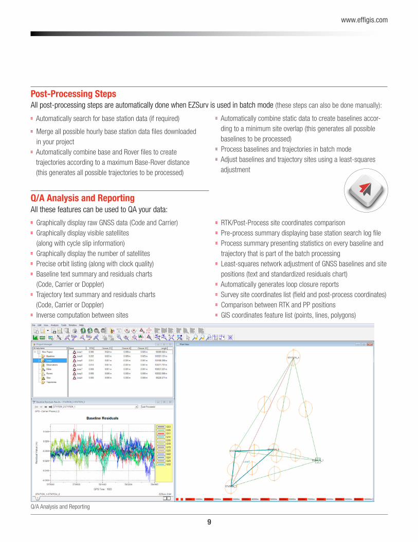
Q/A Analysis and ReportingAll these features can be used to QA your data:
Graphically display raw GNSS data (Code and Carrier) Graphically display visible satellites (along with cycle slip information)
Graphically display the number of satellites Precise orbit listing (along with clock quality) Baseline text summary and residuals charts (Code, Carrier or Doppler)
Trajectory text summary and residuals charts (Code, Carrier or Doppler)
Inverse computation between sites
Post-Processing Steps
Automatically search for base station data (if required)
Merge all possible hourly base station data files downloaded in your project
Automatically combine base and Rover files to create trajectories according to a maximum Base-Rover distance (this generates all possible trajectories to be processed)
RTK/Post-Process site coordinates comparison Pre-process summary displaying base station search log file Process summary presenting statistics on every baseline and trajectory that is part of the batch processing
Least-squares network adjustment of GNSS baselines and site positions (text and standardized residuals chart)
Automatically generates loop closure reports Survey site coordinates list (field and post-process coordinates) Comparison between RTK and PP positions GIS coordinates feature list (points, lines, polygons)
Q/A Analysis and Reporting
Automatically combine static data to create baselines accor-ding to a minimum site overlap (this generates all possible baselines to be processed)
Process baselines and trajectories in batch mode Adjust baselines and trajectory sites using a least-squares adjustment
All post-processing steps are automatically done when EZSurv is used in batch mode (these steps can also be done manually):
10
www.effigis.com
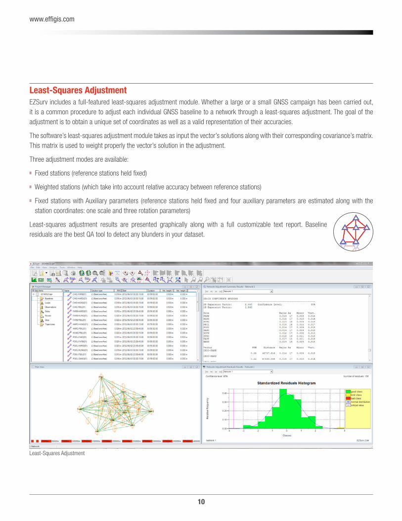
Least-Squares AdjustmentEZSurv includes a full-featured least-squares adjustment module. Whether a large or a small GNSS campaign has been carried out, it is a common procedure to adjust each individual GNSS baseline to a network through a least-squares adjustment. The goal of the adjustment is to obtain a unique set of coordinates as well as a valid representation of their accuracies.
The software’s least-squares adjustment module takes as input the vector’s solutions along with their corresponding covariance’s matrix. This matrix is used to weight properly the vector’s solution in the adjustment.
Three adjustment modes are available:
Fixed stations (reference stations held fixed)
Weighted stations (which take into account relative accuracy between reference stations)
Fixed stations with Auxiliary parameters (reference stations held fixed and four auxiliary parameters are estimated along with the station coordinates: one scale and three rotation parameters)
Least-squares adjustment results are presented graphically along with a full customizable text report. Baseline residuals are the best QA tool to detect any blunders in your dataset.
Least-Squares Adjustment
11
www.effigis.com
Available Versions (Processing Capabilities)
Lite GNSS for GIS users looking for reliable sub-foot accuracy using GNSS receivers
L1 GNSS to achieve accurate surveying (centimeter) using single frequency GNSS receivers
L1/L2 GNSS to achieve accurate surveying (centimeter) using GNSS dual frequency receivers
Export sites in CSV format (custom format) Export sites in DXF format Export GIS features in Google Earth Export GIS features in ESRI Shapefile Export GIS features in DXF Export GIS features in CSV
Possible Export Formats
Export baselines in GEOLAB format Export baselines in SURVNET format Export baselines in CSV files (custom format) Export trajectories in fix text format Export trajectories in CSV file (custom format) Export loop closure in CSV
12
www.effigis.com
Software Licensing Using Receiver S/N EZSurv can be licensed using the receiver S/N, there is no need for a dongle security key.
It requires an Internet connection when you launch the software for the first time.
This licensing mode allows you to install the software on as many PCs as you want to process the data from licensed receivers.
Licensing rules when using receiver S/N:
Allows software installations on multiple PCs. Allows multiple users, even simultaneously (processing licensed receiver data).
It does not require any dongle key or formal license activation.
The licensed receiver’s S/N must simply be encoded in the raw GNSS data file.
An Internet connection is required only when the software is launched for the first time, so that the receiver’s S/N can be validated.
RINEX files can only be processed in differential mode (not PPP).
Only static RINEX files used as a base station can be included in the processing.
Kinematic RINEX files cannot be processed. In order to be included in the processing, static RINEX files must be simultaneous with a licensed receiver (properly registered).
Software Licensing Using PC ID EZSurv can also be licensed using a PC ID with, no need for a dongle security key. We offer a RINEX and an Open License.
It requires a software key code (you receive it when you buy it). It requires an Internet connection when you launch the software in order to validate your key code.
This allows you to install the software on one PC to process data from multiple receivers.
The license can easily be moved from one PC to another.
Licensing ModesThere are two different licensing modes to accommodate different business models:
1. Using the receiver Serial Model (to accommodate manufacturers who want to include software with their equipment).
2. PC-Base License using a software Key Code (2 levels):
A RINEX Level (processing only RINEX files), and An OPEN License (processing all supported binary formats).
13
www.effigis.com
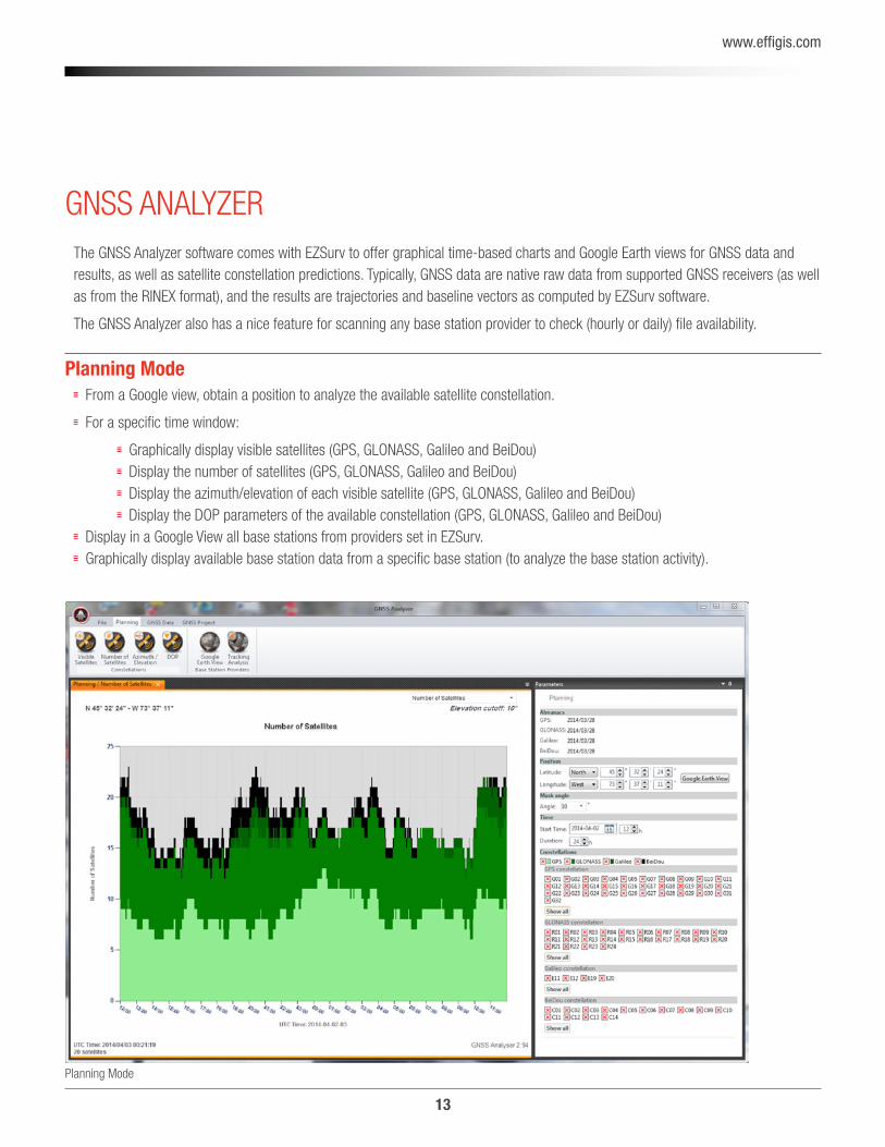
Planning Mode
GNSS ANALYZERThe GNSS Analyzer software comes with EZSurv to offer graphical time-based charts and Google Earth views for GNSS data and results, as well as satellite constellation predictions. Typically, GNSS data are native raw data from supported GNSS receivers (as well as from the RINEX format), and the results are trajectories and baseline vectors as computed by EZSurv software.
The GNSS Analyzer also has a nice feature for scanning any base station provider to check (hourly or daily) file availability.
Planning Mode From a Google view, obtain a position to analyze the available satellite constellation.
For a specific time window:
Graphically display visible satellites (GPS, GLONASS, Galileo and BeiDou) Display the number of satellites (GPS, GLONASS, Galileo and BeiDou) Display the azimuth/elevation of each visible satellite (GPS, GLONASS, Galileo and BeiDou) Display the DOP parameters of the available constellation (GPS, GLONASS, Galileo and BeiDou) Display in a Google View all base stations from providers set in EZSurv. Graphically display available base station data from a specific base station (to analyze the base station activity).
14
www.effigis.com
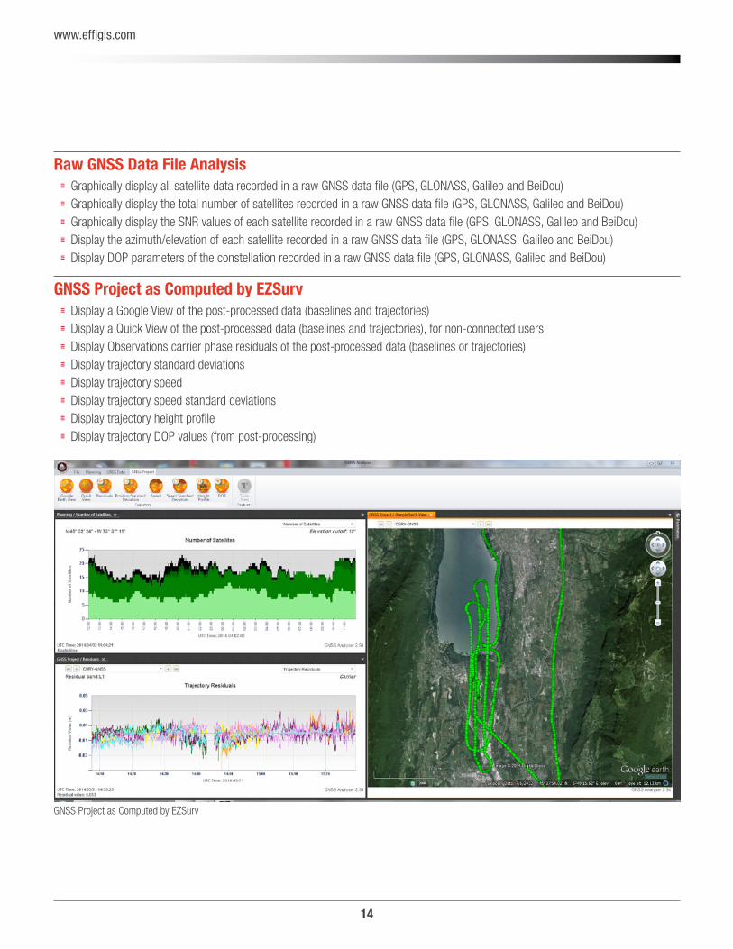
Raw GNSS Data File Analysis Graphically display all satellite data recorded in a raw GNSS data file (GPS, GLONASS, Galileo and BeiDou) Graphically display the total number of satellites recorded in a raw GNSS data file (GPS, GLONASS, Galileo and BeiDou) Graphically display the SNR values of each satellite recorded in a raw GNSS data file (GPS, GLONASS, Galileo and BeiDou) Display the azimuth/elevation of each satellite recorded in a raw GNSS data file (GPS, GLONASS, Galileo and BeiDou) Display DOP parameters of the constellation recorded in a raw GNSS data file (GPS, GLONASS, Galileo and BeiDou)
GNSS Project as Computed by EZSurv Display a Google View of the post-processed data (baselines and trajectories) Display a Quick View of the post-processed data (baselines and trajectories), for non-connected users Display Observations carrier phase residuals of the post-processed data (baselines or trajectories) Display trajectory standard deviations Display trajectory speed Display trajectory speed standard deviations Display trajectory height profile Display trajectory DOP values (from post-processing)
GNSS Project as Computed by EZSurv
15
www.effigis.com
OEM SOLUTION
White Label GNSS Post-Processing SoftwareWant to extend your software product range quickly? Add our white label GNSS post-processing software to your own product offering to access new revenue streams.
Integrating new software into your product range allows you to achieve product differentiation and gain a significant competitive edge in order to access new revenue streams.
Combining our unique and user-friendly post-processing software with your GIS and RTK product ranges will instantly add value to your product offering and make you highly proactive in your market approach. And since we are committed to non-stop product innovation, we will help you stay one step ahead of your competitors, while keeping your engineering risk to a minimum and your development costs well under control.
For this approach to be successful, you need a reliable partner with proven technology. A partner who understands your objectives and wants to help you succeed. A partner who is flexible from start to finish, from initial contract to product delivery.
With 20 years of experience in GNSS signal processing, a forward-thinking R&D team and unparalleled customer service, Effigis is the partner you’re looking for.
Why Partner with Us for Survey Applications?You offer the most powerful RTK technology to your customers. However, they need a back-up option for cases when the RTK infrastructures fail, or when those infrastructures simply do not exist. Moreover, as professional surveyors, they want to be able to QA-control their results. Providing your customers with a cutting-edge post-mission RTK tool, along with your equipment, is a major differentiating factor that guarantees the ‘‘start-to-finish’’ solution promised to your customers.
WHY EZSURV? Easy to use with minimum training time.
Compatible with most of the receivers in the market place.
Compatible with all the GNSS constellations.
Supports all possible processing modes.
Flexible licensing mode.
Outstanding technical support.
On the market for more than 20-years.

16
www.effigis.com
Why partner with Us for GIS Applications?As the GIS user market grows, users demand more accuracy, less effort and affordable prices. Post-processing specifically fulfills that need.
Providing your customers with a complete solution that includes post-processing allows them to significantly improve their GIS data. In turn, it allows you to deliver a ‘‘start-to-finish’’ solution at a competitive price.
A Trusted PartnerWe are renowned for fostering long-term relationships with our customers and partners. We’ve adopted the ‘‘Red Carpet Culture’’ not only is our engineering team members technically gifted, they will systematically go the extra mile to help our customers and partners achieve their goals. We’re proud of our track record as a trusted technology provider to some of the world’s leading brands.
Best of BreedWe have been involved in GNSS signal processing since 1991. Over the years, we have developed enviable expertise in GNSS signal processing for precise positioning. We have established compatibility with most of the receiver brands on the market, with many base station providers around the word, and with the most commonly used data collection software in the industry.
17
www.effigis.com
System RequirementsComputers (laptop or desktop) running Microsoft Windows XP, Windows Vista, Windows 7, Windows 8 or Windows 8.1.
Support PlanThe GNSS Office Support Plan is designed to help-you make the most of your EZSurv Software. The plan is free of charge for the first year. Afterward, you will be contacted to renew it for a minimum charge.
Your GNSS Office Plan entitles you to the following benefits for the products covered by the plan:
Online access to the OnPOZ Technical Support Area for the latest downloads and information. Phone and e-mail access to OnPOZ technical support representatives. Licenses for the latest software updates.
Visit our OnPOZ Technical Support Area
http://www.onpoz.com/Support/KBData/KbMainPage.aspx to answer some of your questions.

Contact Information
4101 Molson Street, Suite 400,
Montreal, QC, Canada H1Y 3L1
+ 1-514-495-0018
+ 1-888-495-6577
www.effigis.com
EZTag CE™ and EZField™ are recognized trademarks of Effigis. EZSurv® is a registered trademark of Effigis.All other trademarks are registered or recognized by their respective owners. Windows and the Windows logo are trademarks or registered trademarks of Microsoft Corporation in the United States and/or other countries. © 2015 Effigis. All rights reserved | 005-000024-102, Rev. D