Embed Size (px)
Citation preview

Glaciers of North America—
GLACIERS OF MÉXICO
By
SIDNEY E. WHITE
Glac i e r s in México are r e s t r i c t ed to i t s three h ighes t mountains , a l l s t ra tovo l canoes . Of the two that have been ac t ive in h i s tor i c t ime, Volcán Pico de Orizaba (Volcán Ci t la l t épe t l ) has nine named g lac i e r s , and Popocatépe t l has three named g lac i e r s . The one dormant s t ra tovo l cano, Iz tacc íhuat l , has 12 named g lac i e r s . The to ta l area o f the 24 g lac i e r s i s 11.44 square k i lometer s . The g lac i e r s on a l l three vo l canoes have been r e c eding dur ing the 20th c entury . Since 1993, in t e rmit t ent exp los ive and e f fus ive vo l canic ac t iv i ty a t the summit o f Popocatépe t l has covered i t s g lac i e r s wi th t ephra and caused some me l t ing
SATELLITE IMAGE ATLAS OF GLACIERS OF THE WORLD
Edited by RICHARD S. WILLIAMS, Jr., and JANE G. FERRIGNO
U.S. GEOLOGICAL SURVEY PROFESSIONAL PAPER 1386–J–3

CONTENTS III
Abstract
---------------------------------------------------------------------------- J383
Introduction
----------------------------------------------------------------------- 383
Volcán Pico de Orizaba (Volcán Citlaltépetl)
----------------------------- 384
F
IGURE
1. Topographic map showing the glaciers on Citlaltépetl
--------- 385
2. Sketch map showing the principal overland routes to Citlaltépetl, Iztaccíhuatl, and Popocatépetl
------------------ 386
3. Oblique aerial photograph of Citlaltépetl from the northwest in February 1942
--------------------------------------------- 387
4. Enlargement of part of a Landsat 1 MSS false-color composite image of Citlaltépetl and environs
--------------------------- 388
T
ABLE
1. Nine named glaciers of Citlaltépetl
---------------------------- 384
Volcán Iztaccíhuatl
-------------------------------------------------------------- 389
F
IGURE
5. Topographic map showing the glaciers on Iztaccíhuatl
-------- 389
6. Oblique aerial photograph of Iztaccíhuatl from the west in February 1942
------------------------------------------------ 390
7. Enlargement of a Landsat 1 MSS false-color composite image of Iztaccíhuatl and Popocatépetl and environs
-------- 394
T
ABLE
2. Twelve named glaciers of Iztaccíhuatl
------------------------- 388
Volcán Popocatépetl
------------------------------------------------------------ 395
F
IGURE
8. Topgraphic map showing the glaciers on Popocatépetl
-------- 395
9. Photograph of Popocatépetl from the north at Tlamacas, in March 1978
--------------------------------------------------- 397
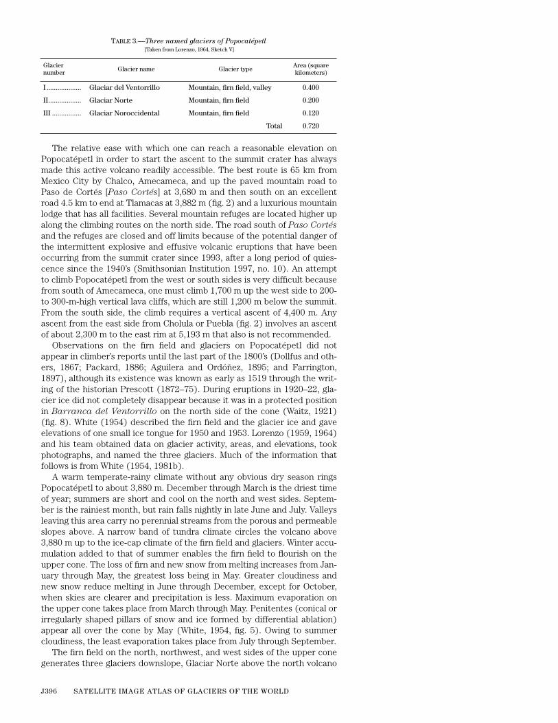
T
ABLE
3. Three named glaciers of Popocatépetl
------------------------- 396
Landsat Images of the Glaciers of Citlaltépetl, Iztaccíhuatl, and Popocatépetl
-------------------------------------------------------------------- 401
F
IGURE
10. Enlargement of a Landsat 3 RBV image of the glaciers and firn on the summit areas of the Iztaccíhuatl and Popocatépetl volcanoes
-------------------------------------- 402
11. Index map to the optimum Landsat 1, 2, and 3 images of the glaciers of México
------------------------------------------- 403
T
ABLE
4. Optimum Landsat 1, 2, and 3 images
of the glaciers of México
401
References Cited
----------------------------------------------------------------- 404
CONTENTS
Page

GLACIERS OF MÉXICO J383
SATELLITE IMAGE ATLAS OF GLACIERS OF THE WORLD
GLACIERS OF NORTH AMERICA—
GLACIERS OF MÉXICO
By
SIDNEY E. WHITE
1
Abstract
Glaciers in México are limited to its three highest mountains, all of which are volcanoes:Volcán Pico de Orizaba (Volcán Citlaltépetl), Volcán Iztaccíhuatl, and the active (since 1993)Volcán Popocatépetl, which have 9, 12, and 3 named glaciers, respectively. The total area ofthe 24 glaciers is 11.44 square kilometers. All of México’s glaciers are small, with areas rarelyexceeding a few tenths of a square kilometer, except for the ice cap and firn field of Gran Gla-ciar Norte on Citlaltépetl, which has an area of 9.08 square kilometers and from which sevenoutlet glaciers emanate. The small areal dimensions of México’s glaciers severely restrict theusefulness of Landsat multispectral scanner images for delineating individual glaciers or formonitoring variations in terminus position. The nearly threefold improvement in spatial reso-lution of the Landsat 3 return beam vidicon images compared to multispectral scannerimages (30-meter versus a 79-meter pixel), permits a more accurate delineation of the moun-tain glaciers of México.
Introduction
Under the present climatic conditions, three volcanoes in south-centralMéxico, all having highest elevations in excess of 5,000 m, support numer-ous small glaciers. (1) Volcán Pico de Orizaba (Volcán Citlaltépetl)
2
, a5,610-m-high (Simkin and Siebert, 1994; previous value was 5,675 m) stra-tovolcano in the State of Veracruz, supports nine named glaciers. Seven vol-canic eruptions have been recorded there in historic time, the last in 1687(Simkin and others, 1981). (2) Volcán Iztaccíhuatl, a 5,230-m-high (Simkinand Siebert, 1994; previous value was 5,286 m), dormant Holocene strato-volcano in the State of Puebla, has three summits and 12 named glaciers.(3) Volcán Popocatépetl, a 5,465-m-high (Simkin and Siebert, 1994; previ-ous value was 5,452 m) stratovolcano in the State of Puebla, has threenamed glaciers. Since 1345, Popocatépetl has been the site of at least 25,and perhaps as many as 30, eruptions, the last at this writing in January2001 (Simkin and Siebert, 1994; Smithsonian Institution, 1994, 1995, 1996,1997, 1998, 1999, 2000; Roberto Quaas, written commun., 1997). Theauthor also observed one gas-column eruption on 7 April 1953.
The equilibrium line altitude (ELA) of glaciers on Iztaccíhuatl andPopocatépetl is 4,880 m and 4,925 m, respectively; the ELA of glaciers onCitlaltépetl is not known. No other highland areas in México are sufficientlyhigh to be above the present-day snowline. During the Illinoian age of the
Tomicoxco
1
Department of Geological Sciences, Ohio State University, 275 Mendenhall Laboratory, 125 SouthOval Mall, Columbus, Ohio 43210–1398.
2
Most of the geographic place-names used in this section are from the Gazetteer of Mexico (U.S.Board on Geographic Names, 1992). An exception is Citlaltépetl, where the Nahuatl place-name is usedinstead of the Spanish one (Volcán Pico de Orizaba). Throughout the text, references to Citlaltépetl, Iztac-cíhuatl, and Popocatépetl are, after the first mention, without Volcán in the title. A few names not listed inthe gazetteer are shown in italics.
Manuscript approved for publication 7 March 2002.
Pleistocene Epoch, however, the ELA was as low as 3,510 m on Iztaccíhuatlduring the Tonicoxco (Tomicoxco) advance and was somewhat higher

J384 SATELLITE IMAGE ATLAS OF GLACIERS OF THE WORLD
during other advances. Cerro Ajusco, a 3,937 m-high volcanic mountainsouth of Mexico City in the Federal District (D.F., Distrito Federal), sup-ported glaciers during times of lower ELA during the late Wisconsinan ageand during the late Holocene Epoch (early neoglaciation and middleneoglaciation) (White, 1981a, 1984). The following discussion of the gla-ciers on Citlaltépetl, Iztaccíhuatl, and Popocatépetl emphasizes historicand modern observations.
Volcán Pico de Orizaba (Volcán Citlaltépetl)
At 5,610 m (Simkin and Siebert, 1994; previous value was 5,675 m,which is used as the reference elevation in the text for glacier eleva-tions), Citlaltepétl is the highest mountain in México and the third high-est on the North American Continent. It contains the largest ice cap andfirn field in México (Gran Glaciar Norte) and has nine named glaciers(fig. 1 and table 1), including the ice cap, its seven outlet glaciers, and amountain (niche) glacier. Its name is derived from the Nahuatl words Cit-lalli (star) and tépetl (mountain). However, its officially recognized nameis Spanish, Pico de Orizaba. Situated at lat 19º02' N. and long 97º17' W., itis 210 km east of Mexico City and 120 km west of Veracruz and the Gulf ofMexico. Topographic maps of Citlaltépetl are sold by the Comisión Car-tográfica Militar, Secretaría de la Defensa Nacional, México, D.F. Provi-sional maps by Estudios y Proyectos, Asociación Civil (A.C.), México,D.F., also may be purchased. Vertical aerial photos taken in 1955 by theComisión del Papaloapan are in the Instituto de Geografía, Universidadde México, México, D.F. Oblique aerial photographs taken in 1942 areavailable from Compañía Mexicana Aerofoto, Sociedad Anónima (S.A.),México, D.F.
Because of its inaccessibility due to the 210-km distance from MexicoCity and the 42-km journey from
Tlalchíchuca
or the 46-km trip from
San
Andres Chalchícomula
by alternate third-class roads to trailheads fromthe northwest (fig. 2), Citlaltépetl
rarely has been studied from any view-point. However, being the highest and the most esthetic mountain in Méx-ico—a white shining star in the east—it caught the attention of Europeansearly in the development of the country and was climbed several times fromthe mid-1800’s to the early 1900’s (Galeotti, 1850; Plowes and others, 1877;Angermann, 1904; Waitz, 1910). Glaciers and snowfields were mentioned inthe description of these climbs because they were along the logical routesof ascent; unfortunately, scientific details are scarce in these works.
T
ABLE
1
.—Nine named glaciers of Citlaltépetl
[Taken from Lorenzo, 1964, sketch III. Leaders (--), not known]
Glacier number Glacier name Glacier typeArea
(square kilometers)
Gran Glaciar Norte Ice cap, firn field 9.08
I....................... Lengua del Chichimeco Outlet --
II ..................... Glaciar de Jamapa Outlet --
III .................... Glaciar del Toro Outlet --
IV .................... Glaciar de la Barba Outlet --
V ..................... Glaciar Noroccidental Outlet --
VI .................... Glaciar Occidental Outlet --
VII................... Glaciar Suroccidental Outlet --
VIII ................. Glaciar Oriental Mountain (niche) .42
Total 9.50

GLACIERS OF MÉXICO J385
4600
0 3 KILOMETERS
III
III
IV
V
VI
VII
VIII
4400
Gran Glaciar Norte
Citlaltépetl glaciers:
I Lengua del Chichimeco
II JamapaIII ToroIV BarbaV NoroccidentalVI OccidentalVII SuroccidentalVIII Oriental
CITLALTÉPETL
4200
4400
480
0
50 00
5200
5400
5600
4200
4000
3800
97°15'97°20'W
19°05'N
19°
Blásquez (1957) may have been the first to study Citlaltépetl’s glaciers froma glaciological viewpoint. He studied from a hydrogeological perspectivethe meltwater that is used locally. The most exacting study of Citlaltépetl’sglaciers was by a team of mountaineering geophysicists led by José LuisLorenzo in 1958, working under the auspices of the Comité Nacional deMéxico for the International Geophysical Year (1957–58) through the Insti-tuto de Geofísica. Despite hardships of elevation and unforeseen storms,the team measured glacier-surface slopes, accumulation areas, and eleva-tions of glacier termini. In addition, they carried out topographic mappingof the nine glaciers and took scores of excellent photographs (Lorenzo,1959, 1964). The retreat of the northernmost outlet glacier, Glaciar deJamapa, is recorded by Palacios and Vázquez Selem (1996). No other scien-tific work on Citlaltépetl glaciers is known, except for an occasional men-tion in mountaineering journals.
Figure 1.
—Glaciers (shown in green) onCitlaltépetl. The numbers refer to thenamed outlet and mountain glaciers listedin table 1. Contour interval, 100 m. Origi-nal map by Estudios y Proyectos, A.C.,México, D.F. (Modified from Lorenzo, 1964,sketch III.)

J386 SATELLITE IMAGE ATLAS OF GLACIERS OF THE WORLD
Figure 2.
—Principal overland routes to Cit-laltépetl, Iztaccíhuatl, and Popocatépetl.Paved roads are shown in broadest lines;trails, in dashed lines. (Modified fromLorenzo, 1959, sketch II.)
A temperate, humid climate with periodic rainy seasons, although drierin winter, surrounds Citlaltépetl
up to about 4,300 m. Above this, tundraand ice-cap climates prevail to the summit. Heavy snowfall probably occursboth in winter and summer, as it does on the other high volcanoes. Snowfalling on the south and southeast sides melts quickly because of solar radi-ation but persists on the northwest and north sides. Aided by the insolationangle and wind redeposition, the persistent snow cover develops into ahuge accumulation area and firn field, which serves as a source for the out-let glaciers.
The entire north side of the upper Citlaltépetl cone is covered by theGran Glaciar Norte of Lorenzo (1959), which fills an elongate highlandbasin with near-radial flow and is the source area for seven outlet glaciers(figs. 1 and 3). The main glacier extends 3.5 km north of the crater rim, hasa surface area of about 9.08 km
2
, and descends from 5,650 m to a littlebelow 5,000 m (Lorenzo, 1964, fig. 12). It has a slightly irregular andstepped profile that is caused in part by the configuration of the bedrock.Most crevasses show an ice thickness of approximately 50 m.
Below the 5,000-m elevation on the north side of the volcano, the outletglaciers Lengua del Chichimeco and Glaciar de Jamapa extend north andnorthwest another 1.5 km and 2 km, respectively. The terminal lobe of Len-gua del Chichimeco at 4,740 m, having a gradient of only 140 m km
–1
, is alow, broad ice fan that has a convex-upward profile (Lorenzo, 1964, fig. 10),a front typical of almost all Mexican glaciers. The most distinct glacier isGlaciar de Jamapa, which leaves Gran Glaciar Norte (figs. 1 and 3) at about4,975 m and, after 2 km with a gradient of 145 m km
–1
, divides into twosmall tongues that end at 4,650 m and 4,640 m. Both tongues terminate inbroad convex-upward ice fans thinning along their edges (Lorenzo, 1964,figs. 14 and 15). The retreat of these tongues prior to 1994 produced mucherosion downstream and buried their edges by ablation rock debris (Pala-cios and Vázquez Selem, 1996).
The west side of Gran Glaciar Norte generates five outlet glaciers(fig. 1). From north to south, the first two, Glaciar del Toro and Glaciar de
Gulf ofMexico
Pacific Ocean
Mexico City
Texcoco
Calpulalpan
Hueyotlipan Apizaco
Huamantla
El Carmen
CupiaxtlaTexmelucan
Huejotzingo
Puebla
Tepeaca Acatzingo San Andres Chalchícomula
CITLALTÉPETL
Villa HidalgoTlalchíchucaSan Salvador
El Seco
POPOCATÉPETL
Orizaba
Tlalmanalco
Chalco
Amecameca
San RafaelTrancas
SIE
RR
A N
EVA
DA
Tehuacán
El Salto La Joya
CholulaTlamacas
IZTACCÍHUATL
Cuau
tla
Paso de Cortés
Vera
cruz
vi
a Ja
lapa
Veracruz
via Córdoba
UNITED STATES
MEXICO
Mexico City
99°W 98°30' 98° 97°30' 97°
19°N
18°30'
0 50 KILOMETERS

GLACIERS OF MÉXICO J387
la Barba (fig. 3), are hanging cliff or icefall glaciers, reaching the tops ofgiant lava steps (Lorenzo, 1964, fig. 18) at 4,930 m and 5,090 m, respec-tively. They then descend 200 to 300 m farther down into the heads ofstream valleys as huge ice blocks but are not regenerated there. One kilo-meter farther south, Glaciar Noroccidental (fig. 3), a small outlet glacier300 m long (Lorenzo, 1964, figs. 21 and 22), drains away from the side ofGran Glaciar Norte at about 5,100 m and draws down the ice surface a fewtens of meters over a distance of 500 m, descending to 4,920 m with a gradi-ent of 255 m km
–1
. One kilometer still farther south, Glaciar Occidental(fig. 3) breaks away from Gran Glaciar Norte west of the summit crater atabout 5,175 m as a steep, 1-km-long glacier (Lorenzo, 1964, figs. 22 and 23)having a gradient of 270 m km
–1
that ends at 4,930 m. From the southwestcorner of the mountain, another outlet glacier, Glaciar Suroccidental, 1.6km long, flows from Gran Glaciar Norte at 5,250 m (Lorenzo, 1964, figs. 22and 23) with a gradient of 200 m km
–1
, which also ends at 4,930 m in a longsmooth surface.
East of the summit cone, a separate steep niche glacier, Glaciar Oriental,1.2 km long and having a gradient of 440 m km
–1
(fig. 1), flows down themountainside from about 5,600 m to 5,070 m; it contains many crevassesand seracs (Lorenzo, 1964, figs. 24 and 25) and is the most difficult glacierto climb.
Lorenzo (1964) calculated that Glacier Oriental had a surface area ofabout 420,000 m
2
in 1958, which makes the total area of glaciers and firnfield on Citlaltépetl about 9.5 km
2
. No earlier historical record of glaciertongue activity (advance or recession) is known for Citlaltépetl’s glaciers.
Figure 4 is a Landsat 1 multispectral scanner (MSS) false-color com-posite image of Citlaltépetl and environs on 25 May 1973. Although theGran Glaciar Norte ice cap is covered with snow, it is possible to see theseven outlet glaciers on the irregular west margin of the ice cap, espe-cially Glaciar de Jamapa and Glaciar Occidental. The 79-m picture ele-ment (pixel) of the MSS image makes it difficult to delineate the terminiof the seven outlet glaciers from the ice cap. Glacier Oriental, the nicheglacier on the east, is not discernible in figure 4.
Figure 3.
—Citlaltépetl from the northwest.Gran Glaciar Norte is the high, white conein the center. Glaciar de Jamapa, one ofthe seven outlet glaciers from Gran Gla-ciar Norte, is on the left skyline. The outletglaciers Glaciar del Toro and Glaciar de laBarba are visible in the center; the outletglaciers Glaciar Noroccidental and GlaciarOccidental are in the upper right. Obliqueaerial photograph taken in February 1942,courtesy of Compañía Mexicana Aerofoto.

J388 SATELLITE IMAGE ATLAS OF GLACIERS OF THE WORLD
Figure 4.
—Enlargement of part of aLandsat 1 MSS false-color compositeimage (1306–16231; 25 May 1973;Path 26, Row 47) of Citlaltépetl andenvirons. Landsat image from theEROS Data Center, Sioux Falls, S.Dak.
97°30'W
19°N
97°
0 10 KILOMETERS
CITLALTÉPETL
T
ABLE
2.
—Twelve named glaciers of Iztaccíhuatl
[Taken from Lorenzo, 1964, sketch VII]
Glacier number
Glacier name Glacier typeArea (square kilometers)
I............ Glaciar de la Cabeza Mountain, ice cap 0.014
II .......... Glaciar del Cuello Mountain, valley 0.050
III ......... Glaciar de Ayolotepito Mountain, cirque, valley 0.213
IV ......... Glacier Norte Mountain, niche, hanging, interrupted 0.046
V........... Glaciar del Cráter Mountain, crater, interrupted, cascading
0.180
VI ......... Glaciar Oestenoroeste Mountain, ice cap, hanging 0.050
VII ........ Glaciar Nororiental Mountain, firn field,valley 0.025
VIII....... Glaciar Centro Oriental Mountain, firn field, valley 0.245
IX ......... Glaciar de Ayoloco Mountain, cirque, valley 0.247
X .......... Glaciar Sudoriental Mountain, firn field 0.078
XI ......... Glaciar Atzintli Mountain, ice apron 0.058
XII........ Glaciar de San Agustín Mountain, niche 0.011
Total 1.217

GLACIERS OF MÉXICO J389
Volcán Iztaccíhuatl
At 5,230 m (Simkin and Siebert, 1994; previous value was 5,286 m, whichis still authoritative and is used as the reference elevation in the text for gla-cier elevations), Iztaccíhuatl is the third highest peak in México and the sev-enth highest on the continent. It has 2 firn fields and 12 named glaciers (fig. 5and table 2). Its name is derived from the Nahuatl words Iztac (white) andcíhuatl (woman). When viewed from the west (fig. 6), the long profile fromnorth to south conjures up the head, neck, chest, stomach, knees, and feet ofa recumbent sleeping woman covered with a white shroud. Its name, oftenmisspelled, is incorrectly translated in places. The highest of three summits,
El Pecho
, is situated at lat 19º10'30" N. and long 98º38'30" W. The 12 namedglaciers are scattered along a north-south distance of approximately 3 km.Iztaccíhuatl can be seen from Mexico City, lying only 64 km to the southeast
Figure 5.
—Glaciers on Iztaccíhuatl. Thenumbers refer to the named glaciers listedin table 2. Contour interval, 100 m. (Modi-fied from Lorenzo, 1964, sketch VII.)
4700
4700
4600
4500
IZTACCÍHUATL
4900
4800
50005100
5200
Stomach area5000
5000
4900
4900
4800
4800
4700
4700
4600
4500
La Cabeza
5100
50 0 0
Iztaccíhuatl glaciers:
I
II
III IV
V
VI
IX
X
XI
XII
VII
VIII
I CabezaII CuelloIII AyolotepitoIV NorteV CráterVI OestenoroesteVII NororientalVIII Centro OrientalIX AyolocoX SudorientalXI AtzintliXII San Augustín
El Pecho46
00
4500
4400
98°39'W 98°38'
0 1 KILOMETER
19°11'N
19°10'

J390 SATELLITE IMAGE ATLAS OF GLACIERS OF THE WORLD
Figure 6.
—Iztaccíhuatl from the west. Atthe far left of the photograph, partly underclouds, is the separate, irregularly erodedVolcán Teyotl. Next is the higher, snow-covered, cliff-encircled peak, La Cabeza,with Glaciar de la Cabeza sloping to theleft. The highest ice-covered peak is ElPecho (5,286 m), with the firn field in the“neck” between it and La Cabeza, sourceof Glaciar de Ayolotepito. The ice-coveredpeak of El Pecho is Glaciar Oestenoroeste.South of El Pecho (right) is the “stomacharea” firn field, source of Glaciar deAyoloco. Glaciar Atzintli is to the right ofthe “stomach area,” but in the photograph,a recent snowfall joins all into one snow-field. La Joya (fig. 2) is at the right side ofthe photograph. Oblique aerial photo-graph taken in February 1942, courtesy ofCompañía Mexicana Aerofoto.
near the southern end of the
Sierra Nevada
(fig. 2). Only one topographicmap is needed, Iztaccíhuatl 14Q–h(107), which is sold by the Secretaría de laDefensa Nacional. Vertical aerial photos that have excellent quality and flight-line precision and were taken in 1945 by the Compañía Mexicana Aerofotoare easily purchased; these photographs were used by the company for thepreparation of the maps by photogrammetric techniques. Oblique aerial pho-tographs taken in 1942 and more recently are also available from CompañíaMexicana Aerofoto.
The proximity of Iztaccíhuatl to Mexico City and the relative ease inreaching the mountain from both the east and the west enticed many scien-tists and mountaineers to climb it and to observe the glaciers. Although notrecommended, from the east side one may leave the old Mexico City—Pue-bla Highway at Texmelucan or at Huejotzingo (fig. 2) and drive 5 to 10 kmonto the broad east slopes of the range. The field party should be accompa-nied by Spanish-speaking persons in order to explain its presence in thearea. From Mexico City, however, a paved highway via Chalco and Tlalma-nalco past the paper factory at San Rafael (fig. 2), a distance of about50 km, allows access onto the northwestern and western slopes of themountain by means of mountain roads and four-wheel-drive vehicles. FromSan Rafael, it is 7 km up to
Trancas
and 6 km more to the end of the road at
El Salto
at 3,750 m. From
El Salto
, the glaciers at 4,770 m and a mountainrefuge are only 3 km distant. The route used most by climbers from MexicoCity is about 65 km by Chalco and Amecameca up a paved mountain road toPaso de Cortés at 3,680 m, and then north on a poor road 3.5 km to its endat the south end of the mountain at
La Joya
, which is 4,000 m high (fig. 2).From here, the peaks above the glaciers and mountain refuges are reachedin 3.5 km by a climber’s route above 4,500 m along the crest of high peaks.
The oldest reference to glaciers on Iztaccíhuatl was made by José Antoniode Alzate y Ramírez sometime between 1781 and 1789 (Alzate y Ramírez,1831; cited in Lorenzo, 1964). Not until 1890 did other reports on the glacierice appear (Whitehouse, 1890; Heilprin, 1890, who briefly mentioned glacierson Iztaccíhuatl, including a crevassed one he named the “Porfirio Diaz Gla-cier,” probably Glaciar de Ayoloco). Several scientists discussed cirques onthe west side, the glaciers in them, and meteorological factors responsible(Ordóñez, 1894; Farrington, 1897; Böse and Ordóñez, 1901; Brecker, 1908;Melgarejo, 1910; Freudenberg, 1911). The hydroelectric possibilities of gla-cier meltwater were studied by Paredes (1922), and glaciers and their

GLACIERS OF MÉXICO J391
climatic situation, by Jaeger (1925, 1926) and Prister (1927). Robles Ramos(1944) conducted hydrologic and meteorologic studies in 1942 on the westside and related glacier melting to streamflow. De Terra (1947), De Terra andothers (1949), White (1962, 1981a), and Vázquez-Selem and Phillips (1998),discussed the glaciers in relation to former glaciations.
According to Vázquez-Selem and Phillips (1998), the glacial deposits onIztaccíhuatl volcano provide the “most complete record of [past] glaciation ofcentral México.” Their glacial chronology is based on dating moraines withthe
36
Cl cosmogenic isotope and tephra from Popocatépetl. The Nexcoa-lango moraines at 3,100 m described by White (1962) are dated at between151 and 126 Ka [marine isotope stage (MIS) 6]; the Hueyatlaco Moraines ofWhite (1962), associated with the last global glacier maximum (LGGM), aredated at 20 to 14 Ka. A major deglaciation of Iztaccíhuatl started at14–13 Ka; Little Ice Age (LIA) moraines are located at 4,300 to 4,700 m.
The elevations of 3 glacier termini in 1953 and 1955 appeared in White(1956), and the elevations of all 12 glaciers in 1959–60, in Lorenzo (1964).The best account by far of Iztaccíhuatl glaciers is that by Lorenzo and hiscolleagues.
A temperate-rainy climate with no conspicuous dry season encircles thelower slopes of the
Sierra Nevada
and the upper flanks of Iztaccíhuatl toabout 4,000 m. Although rain falls every month, summer is the wettest andwinter is the driest time of year. Snow falls as low as 4,000 m from Novem-ber through January. Above 4,000 m are tundra and ice-cap climates. Snowaccumulates on all slopes above 4,500 m not only in winter but also fromJune through middle-August. The volume of precipitation apparentlydecreases markedly above 4,000 m, but no record of rainfall and snowfall isknown for the upper mountain slopes. The 5.8-km-long north-south axis ofIztaccíhuatl plus the location, orientation, and elevation of the highestpeaks affect local wind directions during snowfall and provide protectionfrom insolation. On the basis of all these factors, accumulation areas of firndevelop above 5,000 m and serve as the source area for 8 of the 12 glaciers.Vázquez Selem (1989), however, in his study of periglacial features, discov-ered ice cores covered with detritus in the rock glaciers at about 4,400 m onthe north side of the peak of Volcán Teyotl (fig. 6), a lower, much-erodedvolcano north of Iztaccíhuatl. Small firn fields and ice glaciers existed thereduring the most recent neoglaciation, but they are now melted.
Most Iztaccíhuatl glaciers originate above the 5,000-m elevation in sim-ple basins and become short, cascading mountain glaciers. Two on the westside, Glaciar de Ayolotepito and Glaciar de Ayoloco (fig. 6), are thickest incirquelike valley heads. They are neoglacial remnants and have huge earlyneoglacial moraines and four small inner moraines in front of the ice(White, 1956), probably all built within the last 3,000 years. Three glaciersstart from a high transection firn field that has flow both to the east andwest (Glacier del Cuello, Glaciar de Ayolotepito, and Glaciar Norte), andtwo start from
El Pecho
(Glaciar del Cráter and Glaciar Oestenoroeste).Glaciar del Cráter on
El Pecho
occupies a now-dormant crater, although itwas active as recently as post-early neoglaciation, possibly between 3,000and 2,500 years ago. Because the early neoglacial moraines are coveredwith volcanic scoria from the now-dormant crater, scoria that has been ver-ified petrographically, this suggests that the volcano should be consideredto be dormant rather than extinct. The descriptions and measurements ofIztaccíhuatl glaciers that follow are from Lorenzo (1964), plus informationadded from White (1956) and White’s unpublished fieldwork.
Glaciar de la Cabeza is a thin lens of ice of 14,400 m
2
on the northwestsummit of
La Cabeza
and extends only 200 m northwest from about 5,145m to slightly lower than 5,000 m (figs. 5 and 6; Lorenzo, 1964, fig. 48). Itstops above cliffs, but during neoglaciation, it regenerated at the cliff bot-tom and built moraines north of
La Cabeza
.
J392 SATELLITE IMAGE ATLAS OF GLACIERS OF THE WORLD
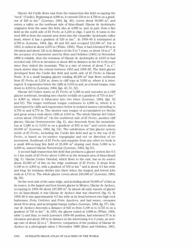
Glacier del Cuello flows east from the transection firn field occupying the“neck” (Cuello). Beginning at 4,990 m, it extends 550 m to 4,760 m on a gradi-ent of 420 m km
–1
(Lorenzo, 1964, fig. 49), covers about 50,000 m
2
, andenters a valley on the northeast side of Iztaccíhuatl. Glaciar de Ayolotepitooriginates from the same firn field, also at 4,990 m, and, in part, from a firnfield on the north side of
El Pecho
at 5,250 m (figs. 5 and 6). It turns to thewest 900 m from the summit area down into the cirquelike Ayolotepito valleyhead, where it has a gradient of 520 m km
–1
. In 1959–60 it terminated at4,760 m (Lorenzo, 1964, figs. 40 and 50) and occupied 212,500 m
2
, but in1953, it ended at about 4,670 m (White, 1956). Thus, it had retreated 90 m inelevation and about 125 m in distance in the 6 to 7 years, or about 19 m a
–1
. Ifthe accuracy of a barometer used by Böse and Ordóñez (1901) in November1898 is reliable, then the terminus of Glaciar de Ayolotepito at 4,610 m hadreceded only 150 m in elevation or about 460 m distance in the 61 to 62 yearssince they visited the mountain. This is a rate of retreat of about 7 m a
–1
,much slower than the retreat between 1953 and 1959–60. The third glacierdeveloped from the Cuello firn field and north side of
El Pecho
is GlaciarNorte. It is a small hanging glacier totaling 46,200 m
2
that flows northeastfrom
El Pecho
at 5,250 m, down to cliff tops at 5,050 m, where it is inter-rupted. It regenerates below the cliffs at 5,010 m and, as a broad tongue, runsdown to 4,910 m (Lorenzo, 1964, figs. 43, 51, 52).
Glaciar del Cráter starts on
El Pecho
at 5,286 m and cascades as a cliffglacier northeast, breaking into chaotic icefalls on a gradient of 755 m km
–1
to 4,965 m, where it bifurcates into two lobes (Lorenzo, 1964, figs. 52and 53). The longer northeast tongue continues to 4,890 m, where it isinterrupted by cliffs and regenerates below in isolated masses extending to4,750 m and 4,770 m. The shorter east tongue of accumulated ice blocksand great seracs ends above cliffs at 4,910 m. The whole Glaciar del Crátercovers about 179,500 m
2
. On the northwest side of
El Pecho
, another cliffglacier, Glaciar Oestenoroeste (fig. 6), also descends from the mountain-top at 5,286 m to 5,010 m on a gradient of 835 m km
–1
and covers about50,000 m
2
(Lorenzo, 1964, fig. 54). The subdivision of this glacier systemnorth of
El Pecho
, including the Cuello firn field and up to the top of
El
Pecho
, is based on ice-surface topography and not on direction of icemovement. Southeast of
El Pecho
and separate from any other ice body isa small 400-m-long firn field of 25,000 m
2
sloping east from 5,060 m to4,830 m, named Glaciar Nororiental (Lorenzo, 1964, fig 55).
A second high-transection firn field that produces a glacier system lies 0.5to 1 km south of
El Pecho
above 5,000 m in the stomach area of Iztaccíhuatl(fig. 5). Glaciar Centro Oriental, which flows to the east, has as its sourceabout 45,000 m
2
of firn on the ridge southeast of
El Pecho
. It drops from5,190 m to 4,850 m, with a gradient of 550 m km
–1
and is about 0.5 km wideand long. Its terminus divides into three lobes; the longest and lowest lobeends at 4,715 m. The whole glacier covers about 245,000 m
2
(Lorenzo, 1964,fig. 56).
On the west side of the same ridge, and including about 50,000 m
2
of firn asits source, is the largest and best known glacier in México, Glaciar de Ayoloco,occupying in 1959–60 about 247,000 m
2
. In almost all early reports of glacierice on Iztaccíhuatl, it was Glaciar de Ayoloco that was observed (fig. 6). In1959–60 it was approximately 0.5 km wide at its head between two high rockbuttresses,
Peña Ordóñez
and
Peña Aguilera
, and had seracs, crevassesabout 50 m deep, and an irregular bumpy surface (Lorenzo, 1964, fig. 57). Gla-ciar de Ayoloco descends a distance of 625 m from 5,190 m to 4,725 m on agradient of 745 m km
–1
. In 1955, the glacier ended at 4,668 m (White, 1956,table 1) and thus, to reach Lorenzo’s 1959–60 position, had retreated 57 m inelevation and about 100 m in distance in the intervening 4 to 5 years, an aver-age rate of about 22 m a
–1
. However, comparison of the position of Glaciar deAyoloco in a photograph taken 1 November 1898 (Böse and Ordóñez, 1901,

GLACIERS OF MÉXICO J393
fig. 2) with photographs taken at the same site by Lorenzo shows the terminusat White’s 4,465-m (third) inner stadial moraine. This gives a retreat of about260 m in elevation, about 810 m in distance, and an average rate of retreatabout 13 m a
–1
in the 61 to 62 years. A photograph in Melgarejo (1910, no. 8),presumably taken in the summer of 1910, shows the terminus of Glaciar deAyoloco about at White’s 4,540-m (fourth) inner stadial moraine (White, 1956,table 1). Vertical aerial photographs taken in November 1945 reveal a thin icetongue at about 4,560 m, perhaps no longer active due to its tenuity in a pro-tected position below a high rock ridge on the Ayoloco valley-head bottom,about 260 m downvalley from its 1955 position. On the other hand, Böse andOrdóñez (1901) obtained a November 1898 barometric elevation for Glaciarde Ayoloco of 4,545 m. If this elevation is accurate, then in 61 to 62 years, theglacier receded 180 m in elevation and about 475 m in distance compared toLorenzo’s position, or at an average rate of about 8 m a
–1
. This is a muchslower rate than that between 1955 and 1959–60, although it is quite consis-tent with the average rate of retreat of the Glaciar de Ayolotepito during thesame period. From all these historic fluctuations, however disparate, it is evi-dent that Glaciar de Ayoloco has been continuously retreating since the1890’s.
A third glacier also of this stomach-area system is Glaciar Sudorientalwhich has an area of about 77,500 m
2
. It is moving toward the southeast, isonly about 270 m long, and descends from about 5,110 m to 4,990 m(Lorenzo, 1964, fig. 58) on a gradient of 445 m km
–1
.Based on photographic documentation, Glaciar de Ayoloco and the next
glacier 200 m to the south, prior to 1918, had been all one glacier, but in 1953,White realized that a name was needed for this small, separate, thin ice mass.Following the suggestion of José Luis Lorenzo, it was named Atzintli Glacier(White, 1956, p. 294). Glaciar Atzintli, now isolated south of the stomach area(figs. 5 and 6), was only 460 m long in 1959–60, starting at 5,085 m and end-ing at 4,855 m. It had an area of 57,500 m
2
(Lorenzo, 1964, figs. 40, 41, 59)and a gradient of 500 m km
–1
. In 1953, its terminus had been at 4,785 m(White, 1956, table 1), which indicates a recession of 70 m in elevation over a140 m distance, or about 21 m a
–1
in the 6 to 7 years, similar to the retreatrate of 22 m a
–1
for Glaciar de Ayoloco during the same period. As docu-mented in a photograph that had Glaciar de Ayoloco in the foreground (Mel-garejo, 1910, no. 1), glacier ice surrounding
Peña Aguilera
had not yetseparated into two glaciers by the summer of 1910. In views from the samephotographic site, glacier ice still surrounded
Peña Aguilera
by the summerof 1918 (Paredes, 1922, figs. 11, 17, and 18). Other long-distance photo-graphs also show one large glacier on the west side of the stomach area in1910 (Melgarejo, 1910, no. 5; after Hugo Brehme of Mexico City). A photo-graph taken in April 1946, before the ablation season began, shows the possi-ble initiation of separation into two glaciers (De Terra and others, 1949, plate20). Historic records of the elevations of Glaciar Atzintli are not known.
Glaciar de San Agustín, which has an area of about 11,250 m
2
, is a rem-nant of a once much larger niche glacier on the southeast side of the stom-ach area. It begins about 80 m east of the 5,070 m ridgecrest at 5,030 m andends about 100 m to the southeast at 4,980 m (Lorenzo, 1964, fig. 41). Thetotal area covered by all 12 glaciers on Iztaccíhuatl in 1959–60 was1,215,850 m
2
, about one-eighth that of the glaciers on Citlaltépetl.Figure 7 is an enlargement of a Landsat 1 MSS false-color composite image
of Iztaccíhuatl and vicinity on 7 February 1973. Although not all of the 12named glaciers on Iztaccíhuatl can be delineated because of the spatial resolu-tion limitations of the MSS image and because of snow cover, the three largestglaciers, Glaciar de Ayolotepito, Glaciar Centro Oriental, and Glaciar deAyoloco can be distinguished (table 2 and fig. 5).

J394 SATELLITE IMAGE ATLAS OF GLACIERS OF THE WORLD
0 5 KILOMETERS
98°38'W
19°N
IZTACCÍHUATL
POPOCATÉPETL
Figure 7.
—Enlargement of a Landsat 1 MSS false-color composite image (1199–16285; 7February 1973; Path 27, Row 47) of Iztaccíhuatl and Popocatépetl and environs. Landsatimage from the EROS Data Center, Sioux Falls, S. Dak.

GLACIERS OF MÉXICO J395
5300
5200
5100
5000
4900
4800
4700
4600
4500
P O P O C AT É P E T L
Crater
5100
5000
4900
4800
4700
4600
4500
III
III
Peak
Barranca del Ventorrillo
Popocatépetl glaciers:I. VentorilloII. NorteIII. Noroccidental 0 .5 1 2 KILOMETERS
EXPLANATION
19°01'
19°02'N
98°38'W 98°37'
Volcán Popocatépetl
At 5,465 m (Simkin and Siebert, 1994; previous value was 5,452 m, which isused as the reference elevation in the text for glacier elevations), Popocaté-petl is the second highest peak in México and the fifth highest on the conti-nent. It is one of the Earth’s highest active volcanoes and 20 million people livewithin a radius of 80 km from its summit (Williams, 1999). Since 1993, inter-mittent explosive and occasional effusive volcanic activity has occurred fromthe summit of Popocatépetl (Smithsonian Institution, 1994, 1995, 1996 1997,1998, 1999, 2000). It has one firn field that has three small glaciers flowing tothe north (figs. 8 and 9 and table 3). The name is derived from the Nahuatlwords, Popoca (smoking) and tépetl (mountain). The west crater rim is thehighest point and is situated at lat 19º01'15" N. and long 98º37'35" W. Only72 km southeast of Mexico City and fully visible, Popocatépetl forms thesouthern end of the
Sierra Nevada
at the southern geologic boundary of theNorth American Continent. Two Secretaría de la Defensa Nacional topo-graphic maps are needed to provide complete coverage: Popocatépetl14Q–h(123) and Xalinatzintla 14Q–h(124). Vertical aerial photographs takenin 1945 by Compañía Mexicana Aerofoto are available, as are oblique aerialphotographs taken in 1942 and more recently by the same company.
Figure 8.
—Glaciers on Popocatépetl. Thenumbers refer to the named glaciers listedin table 3. Contour interval, 100 m. (Modi-fied from Lorenzo, 1964, sketch V.)
J396 SATELLITE IMAGE ATLAS OF GLACIERS OF THE WORLD
The relative ease with which one can reach a reasonable elevation onPopocatépetl in order to start the ascent to the summit crater has alwaysmade this active volcano readily accessible. The best route is 65 km fromMexico City by Chalco, Amecameca, and up the paved mountain road toPaso de Cortés [
Paso Cortés
] at 3,680 m and then south on an excellentroad 4.5 km to end at Tlamacas at 3,882 m (fig. 2) and a luxurious mountainlodge that has all facilities. Several mountain refuges are located higher upalong the climbing routes on the north side. The road south of
Paso Cortés
and the refuges are closed and off limits because of the potential danger ofthe intermittent explosive and effusive volcanic eruptions that have beenoccurring from the summit crater since 1993, after a long period of quies-cence since the 1940’s (Smithsonian Institution 1997, no. 10). An attemptto climb Popocatépetl from the west or south sides is very difficult becausefrom south of Amecameca, one must climb 1,700 m up the west side to 200-to 300-m-high vertical lava cliffs, which are still 1,200 m below the summit.From the south side, the climb requires a vertical ascent of 4,400 m. Anyascent from the east side from Cholula or Puebla (fig. 2) involves an ascentof about 2,300 m to the east rim at 5,193 m that also is not recommended.
Observations on the firn field and glaciers on Popocatépetl did notappear in climber’s reports until the last part of the 1800’s (Dollfus and oth-ers, 1867; Packard, 1886; Aguilera and Ordóñez, 1895; and Farrington,1897), although its existence was known as early as 1519 through the writ-ing of the historian Prescott (1872–75). During eruptions in 1920–22, gla-cier ice did not completely disappear because it was in a protected positionin
Barranca del Ventorrillo
on the north side of the cone (Waitz, 1921)(fig. 8). White (1954) described the firn field and the glacier ice and gaveelevations of one small ice tongue for 1950 and 1953. Lorenzo (1959, 1964)and his team obtained data on glacier activity, areas, and elevations, tookphotographs, and named the three glaciers. Much of the information thatfollows is from White (1954, 1981b).
A warm temperate-rainy climate without any obvious dry season ringsPopocatépetl to about 3,880 m. December through March is the driest timeof year; summers are short and cool on the north and west sides. Septem-ber is the rainiest month, but rain falls nightly in late June and July. Valleysleaving this area carry no perennial streams from the porous and permeableslopes above. A narrow band of tundra climate circles the volcano above3,880 m up to the ice-cap climate of the firn field and glaciers. Winter accu-mulation added to that of summer enables the firn field to flourish on theupper cone. The loss of firn and new snow from melting increases from Jan-uary through May, the greatest loss being in May. Greater cloudiness andnew snow reduce melting in June through December, except for October,when skies are clearer and precipitation is less. Maximum evaporation onthe upper cone takes place from March through May. Penitentes (conical orirregularly shaped pillars of snow and ice formed by differential ablation)appear all over the cone by May (White, 1954, fig. 5). Owing to summercloudiness, the least evaporation takes place from July through September.
The firn field on the north, northwest, and west sides of the upper conegenerates three glaciers downslope, Glaciar Norte above the north volcano
T
ABLE
3.
—Three named glaciers of Popocatépetl
[Taken from Lorenzo, 1964, Sketch V]
Glacier number
Glacier name Glacier typeArea (square kilometers)
I ................... Glaciar del Ventorrillo Mountain, firn field, valley 0.400
II.................. Glaciar Norte Mountain, firn field 0.200
III ................ Glaciar Noroccidental Mountain, firn field 0.120
Total 0.720

GLACIERS OF MÉXICO J397
Figure 9.—Popocatépetl from the north atTlamacas (fig. 2). A permanent firn fieldexists above the arcuate crevasses andicefall. Glaciar Norte is on the cone underrecent snowfall above the leftmost tree.The reactivated Glaciar del Ventorrillo isvisible below the crevasses as a double-lobed glacier hanging down from the coneinto Barranca del Ventorrillo. GlaciarNoroccidental is on the cone at the rightedge of the firn field above a sloping, cas-tellated rock crag. Photograph taken 23March 1978 by M.L. White.
flanks, Glaciar del Ventorrillo in Barranca del Ventorrillo, and GlaciarNoroccidental above the west side cliffs (fig. 8). In 1950, the lower limit ofGlaciar Norte (not recognized then as a glacier) was estimated as about4,800 m. Lorenzo in 1958 recorded it on the convex north cone from about5,250 m down to 4,840 m (Lorenzo, 1964, figs. 26 and 27), but he noted thatit was only the remnant of a glacier. From Lorenzo’s map (fig. 8), GlaciarNorte, as he then subdivided the firn field, is about 600 m long, has a gradi-ent of 600 m km–1, and covers about 200,000 m2 of the cone.
The fluctuation of Glaciar del Ventorrillo is more significant in determin-ing the history of the Popocatépetl firn field and glaciers. The 1945 aerialphotographs show no expansion of the Ventorrillo firn edge as glaciers, butby 1949, two conspicuous but small ice tongues extended into the head ofBarranca del Ventorrillo (White, 1954, fig. 2). In 1950, the lower icetongue was measured as 4,573 m; in 1953, it had melted back 4 m in eleva-tion (White, 1954, fig. 4), and in 1958, Lorenzo (1964) found it at about4,690 m. This is a recession of 117 m in elevation over a distance of about270 m, an average rate of retreat of about 34 m a–1 in the 8-year interval.After 1958, the small ice tongue disappeared. In 1958, the glacier beganbelow the north crater rim at about 5,200 m, was about 800 m long on a gra-dient of 640 m km–1, and occupied about 400,000 m2 of the cone (Lorenzo,1964, figs. 26, 29, 30). This steep gradient pulls the ice apart to form hugecrevasses (fig. 9). Ice on the cone above Glaciar del Ventorrillo above5,030 m was about 40 m thick in 1951 and about 30 m thick in 1958.
Glaciar Noroccidental is the western counterpart of the other two glacierextensions of the firn field, becoming distinguished as a glacier at about5,300 m. It ends above the lava cliffs at 5,015 m, is 440 m long on a gradientof 430 m km–1, and occupies 120,000 m2 of the cone (Lorenzo, 1964, figs. 29and 31). In 1958, the Popocatépetl firn field and glaciers totaled only720,000 m2, about half that of Iztaccíhuatl glaciers. At the time of Lorenzo’smeasurements, all of Mexico’s firn fields and glaciers covered about 11.4 km2.
The firn field on Popocatépetl undoubtedly did not survive the “Hypsith-ermal Interval.” Yet historic Toltec and Aztec sketches of the mountainsdepict much ice and snow on both Iztaccíhuatl and Popocatépetl. Cortes’captains had great difficulty crossing the perpetual snows of the Popocaté-petl cone in 1519. Packard (1886) stated that in 1885 a stream flowing inthe largest valley on the north side of the mountain was “fed by the snows

J398 SATELLITE IMAGE ATLAS OF GLACIERS OF THE WORLD
of the peak.” No stream flows there today, even with the huge firn fieldabove, except on sunny days when it is melting. When Anderson (1917)climbed Popocatépetl in 1906, he found a glacier in Barranca del Ventor-
rillo down to nearly 4,335 m, as estimated from his photograph (Anderson,1917, plate XXV). Because of the clarity of detail, photographs taken in1910 by Hugo Brehme of Mexico City disclose the glacier in Barranca del
Ventorrillo to be at a position estimated at 4,390 m. Melgarejo’s photo-graph (1910, no. 2), taken from Brehme’s photographic site, shows the gla-cier at this same elevation. Weitzberg (1923, photograph 8) pictures theglacier just before the 1920–21 eruptions at about 4,435 m. In addition, Bre-hme’s other 1910 photographs reveal thick ice or firn on the west flanks ofPopocatépetl below the lava cliffs beneath Glaciar Noroccidental at approx-imately 4,700 m, as well as at about 4,650 m on the flanks due west of thehighest summit, places where no ice or firn exists at the time of this writing.
The 100-m recession in elevation of Glaciar del Ventorrillo from 1906 to1920 agrees with field evidence of fresh striations and glacial polish on bed-rock knobs down to 4,440 m and with weathered, disintegrated, striatedbedrock below 4,335 m down to 4,236 m (White, 1954). Although quitespeculative and without accurate dating control, the position where Ander-son found the glacier in 1906 may match the retreat from the late-neogla-cial Arapaho Peak advance (Benedict, 1973) of the southern and middleRocky Mountains in the United States. Evidence of a still older advance,certainly prior to 1519 and possibly matching the middle-neoglacial Audu-bon advance of the Rocky Mountains, exists where Barranca del Ventor-
rillo emerges from the steeper part of the cone (fig. 9). Here, and 100 to200 m beyond on the gentler north flanks to 4,150 m, are striated and pol-ished but weathered surfaces on lava flows, an end moraine almost crossingthe valley floor of Barranca del Ventorrillo, an inner lateral moraine onthe east side of the valley, and striated blocks in the tephra of a dissectedalluvial fan 10 to 100 m north of the end moraine (White, 1954).
When Waitz (1921) climbed Popocatépetl in early 1921 during an erup-tion, he saw the glacier still well preserved in Barranca del Ventorrillo. Heattributed this preservation to the glacier’s sheltered position and the thick-ness of volcanic deposits on this side of the cone. Waitz estimated that theglacier then reached to about 4,800 m. How much of the recession from the4,435 m position in 1920, estimated from Weitzberg’s (1923) pictures, isdue to the 1920–21 volcanic activity is not known, but growth again since1921 down to 4,573 m in 1950 attests to a healthy positive mass balance forthose 30 years. The rapid recession of 117 m in elevation from 1950 to 1958suggests a sudden change to a negative mass balance.
The activity of the firn field on the cone above Glaciar del Ventorrillo isrevealed by a 37-year study of the appearance and disappearance of cre-vasses. No crevasses were visible on the oblique aerial photographs of thefirn field in 1942. Vertical aerial photographs taken in November 1945 showonly one crevasse about 225 m long. By July 1949, four crevasses about 300to 400 m long had appeared and were accompanied by several smaller ones.By August 1950, all but two of the larger crevasses had disappearedbecause of snow infilling. By May 1953, no new crevasses had appeared,and all the old ones were nearly filled by snow. By April 1955, the small icetongues of Glaciar del Ventorrillo had retreated high onto the cone, the oldbut unopened crevasses of 1950 still showed, and a new set of short, enechelon crevasses had opened between Glaciar Noroccidental and the westedge of upper Glaciar del Ventorrillo. By August 1956, one new crevasseabove the healed 1950 crevasses and four new ones had opened up at thehead of Glaciar del Ventorrillo, and the 1955 en echelon set was being filledby snow. The firn edge above the position where the small ice tongue hadbeen since 1949 was so thin that many rocks showed through in 1956. Theset of en echelon crevasses between Glaciar del Ventorrillo and Glaciar
GLACIERS OF MÉXICO J399
Noroccidental appears in Lorenzo’s figure 31 that he prepared in 1958(Lorenzo, 1964). By November 1968, three partially snow-filled crevasseson the north crater rim and one several hundred meters lower down hadformed above the head of Glaciar del Ventorrillo. As a result of this crevassestudy, no doubt exists as to the activity of the firn field and the importanceof that gradient of 640 m km–1 on the northwest side of the cone.
The most significant change that took place in the 10 years between1958 and 1968 was the growth of a thick bulge of ice down into Barranca
del Ventorrillo in the same location as the small ice tongue of 1949–58.From the 1968 photos, its lower limit is estimated at about 4,700 m and itsthickness at about 30 to 40 m. By March 1978, this large bulge of icebecame a broad, lobed glacier (fig. 9), probably 70 to 100 m thick, extend-ing from the former position of Glaciar Norte to a double-lobed glacier inBarranca del Ventorrillo at an estimated elevation of 4,600 m. Stratifica-tion, possibly annual, of the lobes of ice reveals at least 10 layers. In the 10years following 1968, strong drawdown by this double-lobed glacier pro-duced four or five deep, wide crevasses just above its head and a chaoticicefall of seracs on the cone. In August 1979, the sides of this double-lobedglacier appeared as 50-m-high vertical cliffs, except where the lowest lobeat 4,600 m projected as a steep ramp into Barranca del Ventorrillo. A fewtens of meters below the crater rim, a new, long crevasse also cut across thecone. In 1984, French volcanologists recorded the continuing existence ofthis same double-lobed glacier and its vertical cliffs (Christian Boudal, let-ter dated 24 September 1984).
Glaciar del Ventorrillo has continued to retreat because of heating, sulfurdioxide gas flux, spasmodic fumarolic activity of the volcano, and tephrafalls from the main crater. The area of glaciers on the north flanks alreadyhad diminished by 24 percent from 1958 to 1982 (Delgado and Brugman,1995; Palacios, 1996; Smithsonian Institution, 1994, 1995, 1996, 1997).Estimations of the elevation of the glacier front made by Hugo Delgado arein Palacios (1996, table 1): in 1989 at 4,680 m, in 1992 at 4,694 m, and in1993 at 4,702 m. Palacios (1996), on the basis of his field measurements,found the glacier front in February 1994 at 4,713 m and in November 1995at 4,735 m, as is clearly shown on his map. Delgado and Brugman (1995)measured it in April 1995 at 4,879 m. Their rate of recession between 1982and 1995 was 7.6 m a–1. Palacios and Marcos (1998) noted that Popocaté-petl’s glaciers had undergone significant retreat during the 1980’s and early1990’s, a process that accelerated between 1994 and 1995.
In 1993, Popocatépetl awakened from a long period of quiescence. Since1345, it has had 30 observed eruptions. In the 20th century, it has beenactive in 1920–1922, 1923–1924, 1933, 1942–1943, and 1947 (SmithsonianInstitution, 1997, no. 10).
On March 5 1996, tephra dropped over the north flank and covered thesnow and glaciers there; this occurred also on 30 April and again on 28–29October 1996 (Smithsonian Institution, 1996, no. 4, 10; 1997, no. 3).
In 1997, on 20 March and 24 and 29 April, tephra was blown to 4 km abovethe summit and fell on the glaciers on the north slopes; one of the most violenteruptions in the past three years threw tephra all over the volcano as well asfar to the east on 11 May (Smithsonian Institution, 1997, no. 4). The amount ofglacier recession and ice melted by hot tephra after such events is unknown.On June 1997, the largest tephra emission of the 1994-97 eruption occurred;several large tephra emissions had also taken place earlier during May andJune.
Between June 1997 and June 1999, Popocatépetl experienced anincrease in seismic activity and intermittent periods of explosive and occa-sional effusive volcanic activity from it steep-walled, 250 m-deep summitcrater (Smithsonian Institution, 1998, nos. 1, 2, 5, 6, 8, 10, 12; 1999, nos. 1,3, 4, 6). The Centro Nacional de Prevención de Desastres (CENAPRED),

J400 SATELLITE IMAGE ATLAS OF GLACIERS OF THE WORLD
Universidad Nacional Autonoma de México (UNAM), sends periodicreports to the Smithsonian Institution that are published in the monthlybulletin of the Global Volcanism Network. Up-to-date information fromCENAPRED about Popocatépetl volcanic activity can be obtained fromtheir Web site [http://www.cenapred.unam.mx/] under the heading: Bolet-ines and Boletin del Volcán Popocatépetl. The largest explosive event dur-ing this period occurred on 20 June 1997, when a 13-km-high column oftephra arose from the summit crater. This eruption had no observableeffect on Popocatépetl’s glaciers (Smithsonian Institution, 1997, no. 10).However, a closer inspection in January 1998 (Sheridan and others, 2001)revealed that “…the glaciers showed noticeable ablation and lacked mar-ginal ice cliffs that had been observed in 1995.” Sheridan and others (2001)also referenced floods that originated from the terminus of Glaciar Vento-rillo on 1 July 1997, that must have resulted from melting of glacier ice. Inlate February and early March 1999, the glaciers were observed to be par-tially blanketed with tephra; impacts from the December 1998 activity werevisible, and runoff from melting ice and snow was evident (SmithsonianInstitution, 1999, no. 3). On 15 May 1999, the increase in activity wasaccompanied by runoff of meltwater (Smithsonian Institution, 1999, no. 5).Low-level activity continued during July into the first part of October 1999,including occasional low-magnitude microseismic and/or tectonic eventsand tephra plumes and falls on 1, 5, and 29 September, and a 4-km hightephra column on 3 October 1999 (Smithsonian Institution, 1999, no. 9).On 25 February 2000, a small block-lava dome was observed to be growingin the center of the summit crater (Smithsonian Institution, 2000, no. 1). Insummer 2000, two small mudflows were noted on 23 and 24 June 2000, andtephra plumes and falls took place on 3, 4, and 14 July 2000, and on 4 and10 August 2000. The 4 August 2000 explosive event was the largest, pro-ducing a 5-km high tephra column and tephra falls on several nearby towns(Smithsonian, 2000, no. 7). Additional explosive events were reported inOctober 2000 (Smithsonian, 2000, no. 10). In December 2000 and January2001, additional tephra columns were reported; on 29 January 2001, flowsof pyroclastics caused some melting of glacier ice (Smithsonian, 2000, no.12). The long-term impact by the volcanic activity on the mass-balance ofPopocatépetl’s glaciers must await the cessation of its currently activephase. Research by Sheridan and others (2001) stated that the glacier iceon Popocatépetl covered an area of 0.559 km2 in April 1995; radio-echo-sounding surveys showed a volume of 2.8 x 10⁷ m3 of glacier ice. They pos-tulated that about one-third of the volume (~1 x 10⁷ m3) was available formelting, primarily by ablation from pyroclastic flows. Lorenzo (1964) calcu-lated an area of 0.720 km2 (Table 3), so the loss of area is 0.161 km2 orabout 22 percent.
Figure 7 is an enlargement of a Landsat 1 MSS false-color compositeimage of Popocatépetl and vicinity on 7 February 1973. The three namedglaciers can be delineated on the northwest slope of the volcano, althoughthey are just barely within the spatial resolution of the MSS image. Snowcan also be seen in the 0.8-km-wide summit crater.
GLACIERS OF MÉXICO J401
Landsat Images of the Glaciers of Citlaltépetl,
Iztaccíhuatl, and Popocatépetl
Landsat MSS images are only marginally useful in delineating the terminiof some of the larger individual glaciers at the summit areas of the Mexicanvolcanoes. The small area of these glaciers and the spatial resolution limita-tion (79-m pixels) of the MSS image are the limiting factors. A search of theLandsat image archive turned up two usable Landsat 3 return beam vidicon(RBV) images of the glaciers of Iztaccíhuatl and Popocatépetl; no Landsat 3RBV images of Citlaltépetl were acquired. Unfortunately, however, thenational Landsat 3 RBV archive has been destroyed. The only images thatremain are in local archives, such as the Satellite Glaciology Project at theU.S. Geological Survey. Figure 10 is an enlargement of the December 1980Landsat 3 RBV image of Iztaccíhuatl and Popocatépetl. When comparedwith figure 7, a Landsat 1 MSS false-color composite image of the samearea, it is evident that the nearly threefold increase in spatial resolution ofthe Landsat 3 RBV image (30-m versus 79-m pixels) permits a more reliabledelineation of the firn areas and termini of the 12 glaciers on Iztaccíhuatland 3 glaciers on Popocatépetl. Table 4 provides a list of the optimum Land-sat 1, 2, and 3 images of the glaciers of México; figure 11 is an index mapshowing the location and coverage of the optimum Landsat imagery.
TABLE 4.—Optimum Landsat 1, 2, and 3 images of the glaciers of México
[see fig. 11 for explanation of symbols used in “code” column]
Path-Row
Nominal scene center
(lat-long)
Landsatidentification
numberDate
Solar elevation
angle(degrees)
CodeCloud Cover
(percent)Remarks
26–47 18o45'N.96o53'W.
1180–16225 19 Jan 73 38 0 Citlaltépetl
26–47 18o45'N.96o53'W.
1306–16231 25 May 73 61 0 Citlaltépetl, image used for figure 4
26–47 18o45'N.96o53'W.
21508–16003 10 Mar 79 44 0 Citlaltépetl
27–47 18o45'N.98o19'W.
1199–16285 07 Feb 73 41 0 Iztaccíhuatl and Popocatépetl, image used for figure 7
27–47 18o45'N.98o19'W.
1235–16291 15 Mar 73 51 10 Iztaccíhuatl and Popocatépetl
27–47 18o45'N.98o19'W.
31028–16054-A 27 Dec 80 34 0 Iztaccíhuatl and Popocatépetl, image used for figure 10; Landsat 3 RBV image archived by the USGS Satellite Glaciology Project

J402 SATELLITE IMAGE ATLAS OF GLACIERS OF THE WORLD
0 5 KILOMETERS
98°38'W
19°05'N
Figure 10.—Enlargement of aLandsat 3 RBV image (31028–16054, subscene A; 27 December1980; Path 27, Row 47) of the gla-ciers and firn on the summitareas of the Iztaccíhuatl (north)and Popocatépetl (south) volca-noes. Reproduced by permissionof the Earth Observation SatelliteCompany (EOSAT).

GLACIERS OF MÉXICO J403
15°N
Excellent image (0 to ≤5 percent cloud cover)
EXPLANATION OF SYMBOLS
Evaluation of image usability for glaciologic, geologic, and cartographic applications. Symbols defined as follows:
Nominal scene center for a Landsat image outside the area of glaciers
Usable Landsat 3 RBV scenes. A, B, C and D refer to usable RBV subscenes
A
A
C
B
D
0 400 KILOMETERS
U N I T E D S TAT E S
M É X I C O
Mexico City
El Paso
SIE
RR
AM
AD
RE
OC
CI D
EN
TA
L
SIE
RR
AM
AD
RE
OR
IEN
TA
L
Acapulco
Guadalajara
Pacific Ocean
Gulf of Mexico
35°N30°N
30°N
25°N
20°N
15°N
90°W95°W100°W105°W110°W
25°N
20°N
115°W 110°W 105°W 100°W 95°W 90°W
Good image (>5 to ≤10 percent cloud cover)
ROW 040
ROW 045
ROW 050
PATH
030
PATH
035
PATH
040
PATH
025
PATH
020
BE
LIZ
E
GUATEMALA
HONDURAS
Figure 11.—Optimum Landsat 1, 2, and 3images of the glaciers of México.

J404 SATELLITE IMAGE ATLAS OF GLACIERS OF THE WORLD
Aguilera, J.G., and Ordóñez, Ezequiel, 1895, Expedición cientí-fica al Popocatépetl [Scientific expedition to Popocatépetl]:México, Comisión Geológica Mexicana, 48 p.
Alzate y Ramírez, J.A., 1831, Observaciones físicas ejecutadaspor D. José Antonio Alzate en la Sierra Nevada [Physicalobservations carried out by Don José Antonio Alzate in theSierra Nevada], in Gacetas de literatura de México [Gazettesof Mexican literature]: Puebla, México, Reimpresas en la ofi-cina del hospital de S. Pedro, á cargo del ciudadano M. BuenAbad, v. 1, p. 99–107.
Anderson, Tempest, 1917, Volcanic studies in many lands: Lon-don, John Murray, 2d series, 88 p.
Angermann, Ernesto, 1904, Observaciones geológicas en unaascensión al Citlaltépetl (Pico de Orizaba) [Geological obser-vations on an ascent of Citlaltépetl (Pico de Orizaba)]:Sociedad Científica “Antonio Alzate,” Memorias y revista,v. 21, p. 365–369.
Benedict, J.B., 1973, Chronology of cirque glaciation, ColoradoFront Range: Quaternary Research, v. 3, no. 4, p. 584–599.
Blásquez, Luis, 1957, Hidrogeología de la cuenca superior de losríos Jamapa, Atoyac y una parte del Blanco [Hydrogeology ofthe upper basin of the Río Jamapa, Río Atoyac, and a part ofthe Río Blanco], in Estudios hidrogeológicos: México Univer-sidad Nacional, Instituto de Geología Anales, v. 12, p. 57–95.
Böse, Emil, and Ordóñez, Ezequiel, 1901, Der Ixtaccíhuatl (5280m): Eine Berg und Gletscherfahrt in den Tropen [Iztaccíhuatl(5,280 m): A mountain and glacier expedition in the tropics]:Zeitschrift des Deutschen und Österreichischen Alpenvere-ins, v. 32, p. 138–158.
Brecker, C.S., 1908, Una ascensión al Iztaccíhuatl, por C. Gil-christ [An ascent of Iztaccíhuatl, by C. Gilchrist]: SociedadMexicana de Geografía y Estadística Boletín, 5a, Epoca 3,p. 222–229.
Delgado, H., and Brugman, M., 1995, Monitorio de los glaciaresdel Volcán Popocatépetl [Monitoring of the glaciers of thePopocatépetl Volcano], in Volcán Popocatépetl. Estudiosrealizados durante la crisis de 1994–1995: México, D.F.,Comite Científico Asesor Centro Nacional de Prevención deDesastres - Universidad Nacional Autonama de México(CENAPRED - UNAM), p. 221-241.
De Terra, Helmut, 1947, Teoría de una cronología geológica parael Valle de Mexico [Theory of a geologic chronology for theValley of Mexico]: Revista Mexicana Estudios Antropológi-cos, Sociedad Mexicana Antropología, v. 9, p. 11–26.
De Terra, Helmut, Romero, Javier, and Stewart, T.D., 1949,Tepexpan man [Mexico]: Viking Fund Publications in Anthro-pology, no. 11, 160 p.
Dollfus, Aguste de, Montserrat, E., and Pavie, P., 1867, Récitd’une ascension au Popocatepetl (23 Avril 1865) [Account ofan ascent of Popocatépetl on 23 April 1865]: Paris, France, Lacommission scientifique de Mexique, Archives de la Commis-sion Scientifique du Mexique, v. 2, p. 187–208.
Farrington, O.C., 1897, Observations on Popocatepetl and Ixtac-cihuatl: Chicago, Field Columbian Museum, Publication 18,Geological series, v. 1, no. 2, p. 69–120.
Freudenberg, Wilhelm, 1911, The ascent of Iztaccihuatl from thesouth: Sociedad Científica “Antonio Alzate,” Memorias yrevista, v. 31, p. 73–75.
Galeotti, Enrique, 1850, Observaciones hechas en el volcán Picode Orizaba en 1838 [Observations made on the Pico de Oriz-aba volcano in 1838]: Instituto Nacional de Geografía yEstadística de la Republica Mexicana Boletín, v. 1, no. 8,p. 199–202.
Heilprin, Angelo, 1890, Barometric observations among the highvolcanoes of Mexico, with a consideration of the culminatingpoint of the North American Continent: Academy of NaturalSciences of Philadelphia, Proceedings, v. 42, p. 251–265.
Jaeger, Fritz, 1925, Untersuchungen über das diluviale Klima inMexiko [Investigations about the diluvial climate in Mexico]:Gesellschaft für Erdkunde zu Berlin, Zeitschrift, no. 9–10,p. 366–373.
———1926, Reisen und Forschungen in Mexiko im Sommer1925 [Travels and research in Mexico during the summer of1925]: Gesellschaft für Erdkunde zu Berlin, Zeitschrift,no. 7–8, p. 297–310.
Lorenzo, J.L., 1959, Los glaciares de México [The glaciers ofMéxico]: Universidad Nacional Autónoma de México, Insti-tuto de Geofísica, Monografías 1, 114 p.
———1964, Los glaciares de México (segunda edición) [The gla-ciers of México (2d ed.)]: Universidad Nacional Autónoma deMéxico, Instituto de Geofísica, Monografías 1, 124 p.
Melgarejo, A., 1910, The greatest volcanoes of Mexico: NationalGeographic Magazine, v. 21, no. 9, p. 741–760.
Ordóñez, Ezequiel, 1894, Observaciones relativas á los volcanesde México [Observations relative to the volcanoes of Méx-ico]: Sociedad Científica “Antonio Alzate,” Memorias yrevista, v. 8, p. 183–196.
Packard, A.S., 1886, Ascent of the volcano of Popocatepetl:American Naturalist, v. 20, p. 109–123.
Palacios, David, 1996, Recent geomorphic evolution of a glacio-volcanic active stratovolcano: Popocatépetl (México): Geo-morphology, v. 16, no. 4, p. 319–335.
Palacios, David, and Vázquez Selem, Lorenzo, 1996, Geomorphiceffects of the retreat of Jamapa Glacier, Pico de Orizaba Vol-cano (México): Geografiska Annaler, v. 78A, no. 1, p. 19–34.
Palacios, David, and de Marcos, J., 1998, Glacial retreat and itsgeomorphological effects on Mexico’s active volcanoes1994–1995: Journal of Glaciology, v. 44, no. 146, p. 63–67.
Paredes, Trinidad, 1922, La circulación de las aguas en la faldaoccidental del Ixtaccihuatl [The circulation of water on thewestern slope of Iztaccíhautl]: Sociedad Científica “AntonioAlzate,” Memorias y revista, v. 40, p. 1–40.
Plowes, Mateo, Rodríquez, Enrique, and Vigil, Pedro, 1877,Comisión del Citlaltepetl—Memoria de los trabajos ejecuta-dos por los Ingenieros [Commission of Citlaltépetl—Memoirof the works carried out by the engineers]: Ministerio deFomento de la República Mexicana Anales, v. 3, p. 79–113.
Prescott, W.H., 1872–75, History of the conquest of Mexico, inKirk, J.F., ed., Complete works: Philadelphia, J.B. Lippincott,v. 4–6.
References Cited

GLACIERS OF MÉXICO J405
Prister, Augusto, 1927, Notas preliminares sobre vestigios gla-ciales en el Estado de Hidalgo y en el Valle de México [Pre-liminary notes about relict glaciers in the State of Hidalgoand in the Valley of México]: Sociedad Científica “AntonioAlzate,” Memorias y revista, v. 48, p. 1–13.
Robles Ramos, Ramiro, 1944, Algunas ideas sobre la glaciologíay morfología del Iztaccihuatl [Some ideas about the glaciol-ogy and morphology of Iztaccíhuatl]: Revista Geográfica delInstituto Panamericano de Geografía e Historia, v. 4, p. 65–75.
Sheridan, M.F., Hubbard, Bernard, Bursik, M.I, Abrams, Michael,Siebe, Claus, Macías, J.L., and Delgado, Hugo, 2001, Gaugingshort-term volcanic hazards of Popocatépetl: EOS, v. 82,no.16, p. 185 and p 188–189.
Simkin, Tom, and Siebert, Lee, 1994, Volcanoes of the world (2ded.): Tucson, Ariz., Geoscience Press, Inc., in associationwith the Smithsonian Institution, 349 p.
Simkin, Tom, Siebert, Lee, McClelland, Lindsay, Bridge, David,Newhall, Christopher, and Latter, J.H., 1981, Volcanoes of theworld, a regional directory, gazetteer, and chronology of vol-canism during the last 10,000 years: Stroudsburg, Pa., Hutch-inson Ross Publishing Company, 232 p.
Smithsonian Institution, 1994, Popocatépetl (México): GlobalVolcanism Network Bulletin (Smithsonian Institution), v. 19,nos. 11, 12.
———1995, Popocatépetl (México): Global Volcanism NetworkBulletin (Smithsonian Institution), v. 20, nos. 1, 2, 3.
———1996, Popocatépetl (México): Global Volcanism NetworkBulletin (Smithsonian Institution), v. 21, nos. 1, 4, 10, 12.
———1997, Popocatépetl (México): Global Volcanism NetworkBulletin (Smithsonian Institution), v. 22, nos. 3, 4, 7, 10, 11, 12.
———1998, Popocatépetl (México): Global Volcanism NetworkBulletin (Smithsonian Institution), v. 23, nos. 1, 2, 5, 6, 8, 10,11, 12.
———1999, Popocatépetl (México): Global Volcanism NetworkBulletin (Smithsonian Institution), v. 24, nos. 1, 3, 4, 6, 9.
———2000, Popocatépetl (México): Global Volcanism NetworkBulletin (Smithsonian Institution), v. 25, nos. 1, 7, 10, 12.
U.S. Board on Geographic Names, 1992, Gazetteer of Mexico:Washington, D.C., Defense Mapping Agency, 3 v., 1,684 p.
Vázquez-Selem, Lorenzo, 1989, Geomorfología glacial y periglacialdel Volcán Teyotl [Glacial and periglacial geomorphology ofthe Volcano Teyotl]: Universidad Nacional Autónoma de Méx-ico, Colegio de Geografía, Unpublished Master’s thesis, 155 p.
Vázquez-Selem, L., and Phillips, F.M., 1998, Glacial chronology ofIztaccíhuatl volcano, central Mexico, based on cosmogenic36Cl exposure ages and tephrochronology [abs.]: in Programand Abstracts of the 15th Biennial Meeting, American Quater-nary Association, AMQUA 1998, Northern Hemisphere-Southern Hemisphere Interconnections (5–7 September1998; Puerto Vallarta, México), p. 174.
Waitz, Paul, 1910, Observaciones geológicas acerca del Pico deOrizaba [Geological observations about the Pico de Orizaba]:Sociedad Geológica Mexicana Boletín, v. 7, p. 67–76.
———1921, Popocatepetl again in activity: American Journal ofScience, 5th series, v. 1, no. 1, p. 81–85.
Weitzberg, Fritz, 1923, El ventisquero del Popocatépetl [The gla-cier of Popocatépetl]: Sociedad Científica “Antonio Alzate,”Memorias y revista, v. 41, p. 65–90.
White, S.E., 1954, The firn field on the volcano Popocatépetl,Mexico: Journal of Glaciology, v. 2, no. 16, p. 389–392.
———1956, Probable substages of glaciation on Iztaccíhuatl,Mexico: Journal of Geology, v. 64, no. 3, p. 289–295.
———1962, Late Pleistocene glacial sequence for the west sideof Iztaccíhuatl, México: Geological Society of America Bulle-tin, v. 73, no. 8, p. 935–958.
———1981a, Equilibrium line altitudes of late Pleistocene andRecent glaciers in central Mexico: Geografiska Annaler,v. 63A, no. 3–4, p. 241–249.
———1981b, Neoglacial to recent glacier fluctuations on thevolcano Popocatépetl, México: Journal of Glaciology, v. 27,no. 96, p. 359–363.
———1984, Pleistocene glaciation of volcano Ajusco, centralMexico, and comparison with the Standard Mexican GlacialSequence: Quaternary Research, v. 21, no. 1, p. 21–35.
Whitehouse, H.R., 1890, Ascent of ‘Iztaccihuatl’: Alpine Journal,v. 15, no. 110, p. 268–271.
Williams, A.R., 1999, Popocatépetl. Mexico’s smoking mountain:National Geographic, v. 195, no. 1, p. 116–137.