Embed Size (px)
DESCRIPTION
Â
Citation preview
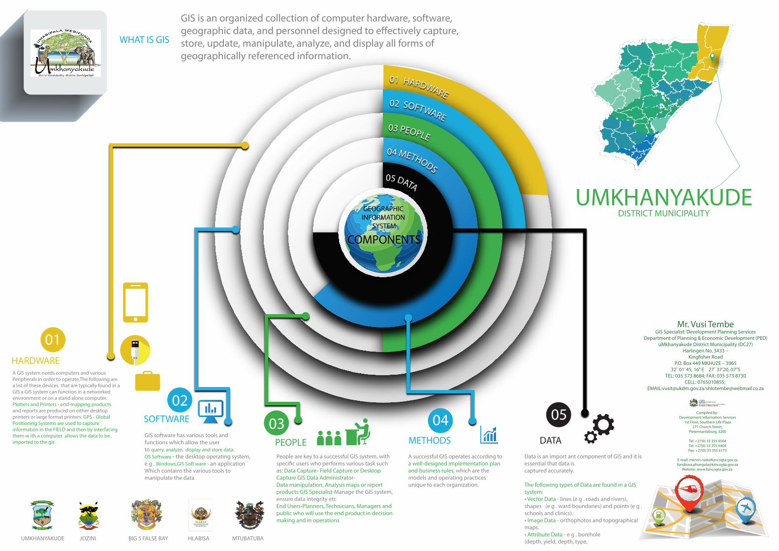
05 DATA
04 METHODS
03 PEOPLE
02 SOFTWARE
01 HARDWARE
GIS software has various tools and functions which allow the userto query, analyze, display and store data.OS Software - the desktop operating system, e g . Windows.GIS Soft ware - an application Which contains the various tools to manipulate the data
People are key to a successful GIS system, with speci�c users who performs various task such as: Data Capture- Field Capture or Desktop Capture GIS Data Administrator- Data manipulation, Analysis maps or report products GIS Specialist-Manage the GIS system, ensure data integrity etcEnd Users-Planners, Technicians, Managers and public who will use the end product in decision making and in operations
A successful GIS operates according to a well-designed implementation plan and business rules, which are the models and operating practices unique to each organization.
Data is an import ant component of GIS and it is essential that data iscaptured accurately. The following types of Data are found in a GIS system:• Vector Data - lines (e g . roads and rivers), shapes (e g . ward boundaries) and points (e g . schools and clinics).• Image Data - orthophotos and topographical maps.• Attribute Data - e g . borehole (depth, yield, depth, type,
METHODS DATA
SOFTWARE
HARDWARE
PEOPLE
A GIS system needs computers and various Peripherals in order to operate,The following are a list of these devices that are typically found in a GIS a GIS system can function in a networkedenvironment or on a stand alone computer. Plotters and Printers - end-mapping products and reports are produced on either desktop printers or large format printers. GPS - Global Positioning Systems are used to capture information in the FIELD and then by interfacing them w ith a computer allows the data to be imported to the gis
UMKHANYAKUDEDISTRICT MUNICIPALITY
Compiled by: Development Information Services
1st Floor, Southern Life Plaza271 Church Street,
Pietermaritzburg, 3200
Tel: +27(0) 33 355 6504Tel: +27(0) 33 355 6404Fax: +27(0) 33 355 6173
E-mail: [email protected]@kzncogta.gov.za
Website: www.kzncogta.gov.za
WHAT IS GIS
UMKHANYAKUDE JOZINI BIG 5 FALSE BAY HLABISA MTUBATUBA
Mr. Vusi TembeGIS Specialist: Development Planning Services
Department of Planning & Economic Development (PED)uMkhanyakude District Municipality (DC27)
Harlingen No. 3433 –King�sher Road
P.O. Box 449 MKHUZE – 396532˚ 01’ 45, 16” E 27˚ 37’20, 07”S
TEL: 035 573 8684; FAX: 035 573 8730CELL: 0765010855;
EMAIL:[email protected]/[email protected]
GIS is an organized collection of computer hardware, software, geographic data, and personnel designed to e�ectively capture, store, update, manipulate, analyze, and display all forms of geographically referenced information.
0203 04 05
01
COMPONENTS
GEOGRAPHIC INFORMATION
SYSTEM