Embed Size (px)
Citation preview
Gippsland LakesRamsar site
Ecological Character Description
March 2010Chapters1-2
Other chapters can be downloaded from:www.environment.gov.au/water/publications/environmental/wetlands/21-ecd.html
INTRODUCTION
1 INTRODUCTION
1.1 BackgroundThe Gippsland Lakes Ramsar site is one of 64 wetland areas in Australia that is listed as a Wetland of International Importance under the Convention on Wetlands of International Importance especially as Waterfowl Habitat or, as it is more commonly referred to, the Ramsar Convention (the Convention). Gippsland Lakes was listed as a Ramsar site under the Convention in 1982 in recognition of its outstanding coastal wetland values and features.
The Convention sets out the need for contracting parties to conserve and promote wise use of wetland resources. In this context, an assessment of ecological character of each listed wetland is a key concept under the Ramsar Convention.
Under Resolution IX.1 Annex A: 2005, the ecological character of a wetland is defined as:
The combination of the ecosystem components, processes and benefits/services that characterise the wetland at a given point in time.
The definition indicates that ecological character has a temporal component, generally using the date of listing under the Convention as the point for measuring ecological change over time. As such, the description of ecological character should identify a wetland’s key attributes and provide an assessment point for the monitoring and evaluation of the site as well as guide policy and management, acknowledging the inherent dynamic nature of wetland systems over time. This report therefore aims to describe the ecological character at the date of listing (1982).
This report provides the ECD for the Gippsland Lakes Ramsar site. In parallel with the preparation of the ECD, the Ramsar Information Sheet (RIS) for the site is being updated for submission to the Australian Government and Ramsar Secretariat.
The report has been prepared in accordance with the requirements of the National Framework and Guidance for Describing the Ecological Character of Australia’s Ramsar Wetlands (DEWHA 2008) (hereafter referred to as the National ECD Framework). Further information about the requirements of the Framework is discussed in Section 1.2.
1
INTRODUCTION
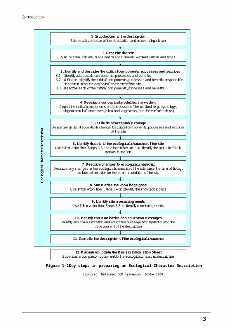
1.2 Scope and PurposeFigure 1-1 shows the key steps of the ECD preparation process from the National ECD Framework which forms the basis for ECD reporting.
The key purposes of undertaking an ECD (from DEWHA 2008) are as follows:
1. To assist in implementing Australia’s obligations under the Ramsar Convention, as stated in Schedule 6 (Managing wetlands of international importance) of the Environment Protection and Biodiversity Conservation Regulations 2000 (Commonwealth):
a) To describe and maintain the ecological character of declared Ramsar wetlands in Australia
b) To formulate and implement planning that promotes:
i) conservation of the wetland
ii) wise and sustainable use of the wetland for the benefit of humanity in a way that is compatible with maintenance of the natural properties of the ecosystem.
2. To assist in fulfilling Australia’s obligation under the Ramsar Convention, to arrange to be informed at the earliest possible time if the ecological character of any wetland in its territory and included in the Ramsar List has changed, is changing or is likely to change as the result of technological developments, pollution or other human interference.
3. To supplement the description of the ecological character contained in the Ramsar Information Sheet submitted under the Ramsar Convention for each listed wetland and, collectively, to form an official record of the ecological character of the site.
4. To assist the administration of the Commonwealth Environment Protection and Biodiversity Conservation Act 1999 (EPBC Act), particularly:
a) to determine whether an action has, will have or is likely to have a significant impact on a declared Ramsar wetland in contravention of sections 16 and 17B of the EPBC Act, or
b) to assess the impacts that actions referred to the Minister under Part 7 of the EPBC Act have had, will have or are likely to have on a declared Ramsar wetland.
5. To assist any person considering taking an action that may impact on a declared Ramsar wetland whether to refer the action to the Minister under Part 7 of the EPBC Act for assessment and approval.
6. To inform members of the public who are interested generally in declared Ramsar wetlands to understand and value the wetlands.
2
INTRODUCTION
Figure 1-1 Key steps in preparing an Ecological Character Description
(Source: National ECD Framework, DEWHA 2008)
1. Introduction to the descriptionSite details, purpose of the description and relevant legislation
5. Set limits of acceptable changeDetermine limits of acceptable change for critical components, processes and services
of the site
4. Develop a conceptual model for the wetlandDepict the critical components and processes of the wetland (e.g. hydrology,
biogeochemical processes, biota and vegetation, and their relationships)
3. Identify and describe the critical components, processes and services3.1 Identify all possible components, processes and benefits3.2 Of these, identify the critical components, processes and benefits responsible for determining the ecological character of the site3.3 Describe each of the critical components, processes and benefits
2. Describe the siteSite location, climate, maps and images, tenure, wetland criteria and types
6. Identify threats to the ecological character of the siteuse information from Steps 3-5 and other information to identify the actual or likely
threats to the site
8. Summarise the knowledge gapsUse information from Steps 3-7 to identify the knowledge gaps
7. Describe changes to ecological characterDescribe any changes to the ecological character of the site since the time of listing;
include information on the current condition of the site
9. Identify site monitoring needsUse information from Steps 3-8 to identify monitoring needs
10. Identify communication and education messagesIdentify any communication and education message highlighted during the
development of the description
11. Compile the description of the ecological character
12. Prepare or update the Ramsar Information SheetSubmit as a companion document to the ecological character description
Ecol
ogic
al C
hara
cter
Des
crip
tion
3
INTRODUCTION
1.3 Relevant Treaties, Legislation and RegulationsThis section provides an overview of the treaties, legislation and regulations at various levels of government relevant to the Gippsland Lakes Ramsar site.
1.3.1 Australian Government Legislation or Policy Instruments
International - Ramsar Convention
The Convention on Wetlands of International Importance (Ramsar, Iran 1971) or as it is more commonly known, the Ramsar Convention, is an intergovernmental treaty dedicated to the conservation and sustainable use of wetlands (EA 2001). Australia was one of the first 18 countries to become a signatory to the Convention in 1971 and the Convention entered into force in Australia in 1975. The Ramsar Convention Secretariat maintains a List of Wetlands of International Importance that includes 64 existing Australian sites.
Australia’s obligations to protect and maintain the ecological character of its Ramsar sites is recognised in Commonwealth Legislation through the EPBC Act, as noted in Section 1.2 above.
Ramsar wetlands and the EPBC Act
Under the EPBC Act (refer s16) an action that has, will have, or is likely to have, a significant impact on the ecological character of a Ramsar wetland (one of the eight matters of National Environmental Significance), must be referred to the Australian Government Minister for Environment and undergo an environmental assessment and approval process. EPBC Act Policy Statements provide specific guidance to help assess the significance of an action. An action is likely to have a significant impact on the ecological character of a Ramsar wetland if there is a real chance or possibility that it will result in:
areas of the wetland being destroyed or substantially modified
a substantial and measurable change in the hydrological regime of the wetland for example, a substantial change to the volume, timing, duration and frequency of ground and surface water flows to and within the wetland
the habitat or lifecycle of native species dependent upon the wetland being seriously affected
a substantial and measurable change in the physico-chemical status of the wetland for example, a substantial change in the level of salinity, pollutants, or nutrients in the wetland, or water temperature which may adversely impact on biodiversity, ecological integrity, social amenity or human health
an invasive species that is harmful to the ecological character of the wetland being established in the wetland.
4
INTRODUCTION
The EPBC Act also dictates standards for managing Ramsar wetlands (refer s335) through the Australian Ramsar management principles that are listed within Schedule 6 of the EPBC Regulations 2000.
International conventions on migratory species
Australia is a signatory to four international conventions on migratory species. The conventions are:
The Convention on Migratory Species (CMS) also known as the Bonn Convention.
The Japan-Australia Migratory Birds Agreement (JAMBA).
The China-Australia Migratory Birds Agreement (CAMBA).
The Republic of Korea-Australia Migratory Birds Agreement (ROKAMBA).
Convention on Migratory Species (CMS)
The CMS was adopted in 1979 and aims to conserve terrestrial, marine and avian migratory species throughout their range. It is an intergovernmental treaty, under the United Nations Environment Program, concerned with the conservation of wildlife and habitats on a global scale.
Japan-Australia Migratory Birds Agreement (JAMBA), China-Australia Migratory Birds Agreement (CAMBA) and Republic of Korea-Australia Migratory Birds Agreement (ROKAMBA)
JAMBA and CAMBA are bilateral agreements between the governments of Japan and Australia and China and Australia, which seek to protect migratory birds listed in the two agreements. The two agreements list terrestrial, water and shorebird species that migrate between Australia and the respective countries. In both cases the majority of listed species are shorebirds. Both agreements require the parties to protect migratory birds from take or trade except under limited circumstances, protect and conserve habitats, exchange information, and build cooperative relationships. The JAMBA agreement also includes specific provisions for cooperation on conservation of threatened birds.
In April 2002, Australia and the Republic of Korea also signed a bilateral migratory bird agreement similar to the JAMBA and CAMBA. The ROKAMBA agreement obliges its Parties to protect bird species which regularly migrate between Australia and the Republic of Korea, and their environment. The Annex to the ROKAMBA contains the list of species or subspecies of birds for which there is reliable evidence of migration between the two countries.
EPBC Act and protection of species listed under international conventions
The particular species that are the subject of the agreements or conventions are listed as migratory species under the EPBC Act, and thus are considered to be a matter of National Environmental Significance. Therefore, any action or potential action that may affect these species or species listed as rare or threatened must be referred to the Australian Government Minister for the Environment for assessment. The Minister will decide whether the action will, or is likely to, have a significant impact on the listed species and whether the action will require approval under the EPBC Act. If approval under the EPBC Act is required, then an environmental assessment of the action must be carried out.
5
INTRODUCTION
The Minister decides whether to approve the action, and what conditions (if any) to impose, after considering the environmental assessment.
1.3.2 Victorian Government Legislation or Policy Instruments
Catchment and Land Protection Act 1994
Under the Act, Victoria is divided into ten catchment regions, and a Catchment Management Authority (CMA) is established for each region. CMAs form a major part of the framework for achieving sustainable management of Victoria's land and water resources including vegetation management.
Coastal Management Act 1995
The Act was enacted to establish the Victorian Coastal Council in order to provide for the establishment of Regional Coastal Boards, co-ordinate strategic planning and management for the Victorian coast. It also provides for the preparation and implementation of management plans for coastal Crown land and a co-ordinated approach to approvals for the use and development of coastal Crown land.
The Act aims to plan for and manage the use of Victoria's coastal resources on a sustainable basis for recreation, conservation, tourism, commerce and similar uses in appropriate areas while protecting and maintaining areas of environmental significance on the coast including its ecological, geomorphological, geological, cultural and landscape features. The Act also aims to facilitate the development of a range of initiatives that improve recreation and tourism, to maintain and improve coastal water quality, to improve public awareness and understanding of the coast and to involve the public in coastal planning and management.
Crown Land (Reserves) Act 1978
This Act provides for reservation of Crown Land Reserves for a variety of public purposes, the appointment of committees of management to manage reserves and for leasing and licensing of reserves for purposes approved by the Minister administering the Act.
Environmental Protection Act 1970
This Act establishes the Environment Protection Authority and makes provision for the Authority's powers, duties and functions. These relate to improving the air, land and water environments by managing waters, control of noise and control of pollution. The Act provides for a ‘works approval’ process for actions that may lead to water, noise and air pollution, in addition to the usual planning permit requirements or where the planning scheme may not apply.
State Environment Protection Policies (SEPPs) are subordinate legislation made under the provisions of the Act to provide more detailed requirements and guidance for the application of the Act to Victoria. The SEPPs aim to safeguard the following environmental values and human activities (beneficial uses) that need protection in the State of Victoria from the effect of waste:
6
INTRODUCTION
human health and well-being
ecosystem protection
visibility
useful life and aesthetic appearance of buildings, structures, property and materials
aesthetic enjoyment and local amenity.
The State Environment Protection Policy (Waters of Victoria) 2003, Schedule F3 (Gippsland Lakes and Catchment) No S 13, Gazetted 26/2/1988 sets out environmental quality objectives for surface waters in the State. However due to a lack of data the SEPP does not include specific environmental quality objectives for wetlands at present.
Fisheries Act 1995
The Act provides a legislative framework for the regulation, management and conservation of Victorian fisheries including aquatic habitats. The Fisheries Act seeks to protect and conserve fisheries resources, habitats and ecosystems, including the maintenance of aquatic ecological processes and genetic diversity and at the same time promote the sustainable use of those resources.
Flora and Fauna Guarantee Act 1988
The Act provides a legislative and administrative framework for the conservation of biodiversity in Victoria. The Act provides for the listing of threatened taxa, communities and potentially threatening processes. It requires the preparation of action statements for listed species, communities and potentially threatening processes and sets out the process for implementing interim conservation orders to protect critical habitats. The Act also seeks to provide programs for community education in the conservation of flora and fauna and to encourage co-operative management of flora and fauna.
National Parks Act 1975
The Act provides for the establishment and management of national, State and other parks in Victoria to preserve and protect natural values and provide for their public use and enjoyment. Based on information from the National Park Act Annual Report 2009, there are 133 managed areas covering a total of over 3.32 million hectares.
Planning and Environment Act 1987
The Planning and Environment Act 1987 is the basis for the direction and control of land in Victoria. Under the Act planning schemes are required which set out policies and provisions for the use, development and protection of land for local government areas. Each municipality in Victoria is covered by a planning scheme. Planning schemes provide local councils with the means of controlling land use and development to protect wetlands and waterways. These are legal documents prepared by the local council or the Minister for Planning, and approved by the Minister.
The State Planning Policy Framework states that: “Planning and responsible authorities must ensure that any changes in land use or development would not adversely affect the habitat values of
7
INTRODUCTION
wetlands and wetland wildlife habitats designated under the Convention on Wetlands of International Importance”.
Local Planning Policy Frameworks in the Gippsland Region for the Shire of Wellington and East Gippsland Shire also make specific references to wetlands in their area and the need to protect such areas. As a result many of the larger, higher value wetlands, such as those of international and national significance, are already protected by environmental significance overlays (ESOs) and zonal controls.
Water Act 1989
The Water Act 1989 establishes rights and obligations in relation to water resources and provides mechanisms for the allocation of water resources (the ‘bulk entitlement’ process). This includes the consideration of environmental water needs of rivers and wetlands as well as for human uses such as urban water supply and irrigation.
Waterway management and general river health management is the responsibility of Catchment Management Authorities and Melbourne Water (Part 10 of the Act).
The Act also provides for the establishment of an Environmental Water Reserve (EWR). The EWR can be held in storage and released to a river, it can be run-of-river flow and it can be groundwater. The EWR is defined in section 4A of the Water Act and comprises water set aside for the environment through:
environmental entitlements
bulk entitlements held by the Minister for Environment
conditions on bulk entitlements and water licences
provisions in Water Supply Protection Area management plans
any other provision of the Water Act 1989 or regulations, including for example permissible consumptive volumes.
Wildlife Act 1975
The purposes of this Act are to protect and conserve wildlife, prevent wildlife taxa from becoming extinct, promote the sustainable use of and access to wildlife, and to manage activities concerning or related to wildlife. The Act regulates the protection, management and use of wildlife.
8
INTRODUCTION
2 GENERAL DESCRIPTION OF THE SITE
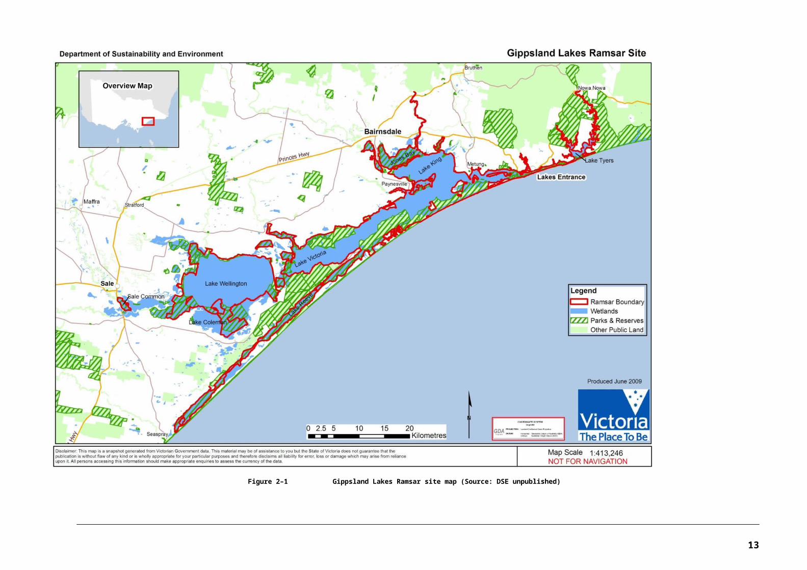
2.1 Location and Brief DescriptionThe Gippsland Lakes Ramsar site is located east of the Latrobe Valley and south of the Eastern Highlands in the State of Victoria, approximately 300 kilometres east of the capital city of Melbourne. It consists of a group of coastal lagoons separated from the sea by a barrier system of sand dunes and fringed on the seaward side by the Ninety Mile Beach. Summary details for the Ramsar site are provided in Table 2-1.
The Gippsland Lakes system is linked to the sea by an artificial entrance, opened in 1889, where the town of Lakes Entrance is now situated. The main lagoons/lakes are fed by a number of river systems. The largest of the rivers are the Latrobe, Macalister, Thomson, Avon (flowing into Lake Wellington), Mitchell, Nicholson and Tambo (flowing into Lake King).
As shown in Error: Reference source not found (provided by DSE), the Ramsar site boundary (and wetlands within) can be described as follows:
In general, the site is a system of lakes and swamplands extending from Sale eastward to their outlet to the sea at Lakes Entrance.
The main lagoons/lakes of the site are Lake Wellington (area 148.19 square kilometres), Lake Victoria (area 78.14 square kilometres) and Lake King (area 96.84 square kilometres). Lake Wellington is connected to Lake Victoria by McLennan Strait. Other wetlands associated with the Strait area include Morley Swamp and Victoria Lagoon.
Lake Tyers is the other major lagoon within the site boundary but is not part of the larger Lake King-Victoria-Wellington lakes system. It is situated to the east of Lakes Entrance with its own intermittent connection to Bass Strait.
The elongated saltmarsh-dominated Lake Reeve is also contained within the Ramsar site, extending from Loch Sport southwest to Seaspray. The site boundary at this location includes the lake and associated wetlands only and does not include terrestrial areas, dunal areas and the ocean beaches of the Gippsland Lakes Coastal Park.
Other wetlands of the site include Jones Bay and Macleod Morass which lie immediately south of Bairnsdale at the head of Lake King and on either side of the Mitchell River. The Nicholson River (flowing into Jones Bay) is also included within the site, with the site boundary extending upstream to about the location of the town of Sarsfield (but downstream from the Nicholson River Dam).
In addition to the lakes and lagoons, the site boundaries also include wetlands that occur on the margins of the lakes, hereafter referred to as fringing wetlands.
The major fringing wetlands of Lake Wellington that are within the Ramsar site boundary include the eastern sections of Lake Coleman (including Tucker Swamp), Dowd Morass, the Heart Morass and Clydebank Morass.
9
INTRODUCTION
Large areas of Lake Coleman (western portion) are outside of the boundaries of the Ramsar site. The lake is mainly Commonwealth land that is managed and used by the Department of Defence for training purposes.
Sale Common is the westernmost feature of the Ramsar site, situated along the Latrobe River near the town of Sale. Sale Common is a predominantly freshwater wetland.
The Ramsar site does not include dryland (for example, non-wetland) areas.
Table 2-1 Details of the Gippsland Lakes Ramsar site
Ramsar Site Name Gippsland Lakes Ramsar Site
Location in Coordinates Latitude: 37° 49’ to 38° 12’S
Longitude: 147° 04’ to 148° 08’E
General Location The lakes and wetlands that make up the Gippsland Lakes Ramsar site extend eastwards from Sale Common to Lake Tyers.
The site is located east of the Latrobe Valley and south of the Eastern Highlands, approximately 300 kilometres from Melbourne.
Area 60 015 hectares
Date of Listing 15 December 1982
Dates Used for Description 1982 (time of listing); 2010 (time of preparation of the ECD)
Original Description Date This is the first ECD undertaken for the site. As part of this project, the Ramsar Information Sheet has also been updated.
Compiler’s Name BMT WBM Pty Ltd with expert input from Austecology Pty Ltd and Dodo Environmental under contract with the Department of Sustainability, Environment, Water, Population and Communities.
Ramsar Information Sheet Last updated 1999. Updated as part of current ECD by BMT WBM (2010).
Australian Ramsar Wetlands webpage:http://www.environment.gov.au/water/topics/wetlands/database/pubs/21-ris.pdf
Ramsar Site No.: 269 (Australian Ramsar Site No.: 21)
Management Plan Gippsland Lakes Ramsar Site Strategic Management Plan published in July 2003 by the Department of Sustainability and Environment (DSE 2003)
Management Authority Managed by Parks Victoria – approximately 58 108 hectares (97 per cent)
Department of Sustainability and Environment – approximately 1600 hectares (2.5 per cent)
Private Freehold – approximately 192 hectares (0.3 per cent)
Local Government – approximately 115 hectares (0.2 per cent)
10
Figure 2–1 Gippsland Lakes Ramsar site map (Source: DSE unpublished)
11
2.2 Land Use and TenureThe land use and tenure within and adjacent to the site are described in this section. Relevant treaties, legislation and management plans relevant to the site are listed in Section 1 of this ECD.
2.2.1 Land Use Within and Adjacent to the Site
The land and waters of the Gippsland Lakes Ramsar site have a variety of tenures and are managed in accordance with the Gippsland Lakes Ramsar Site Strategic Management Plan (DSE 2003).
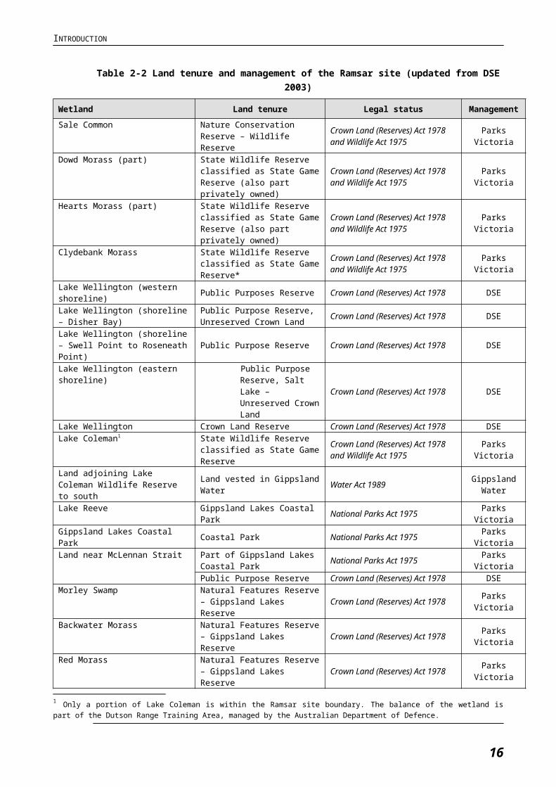
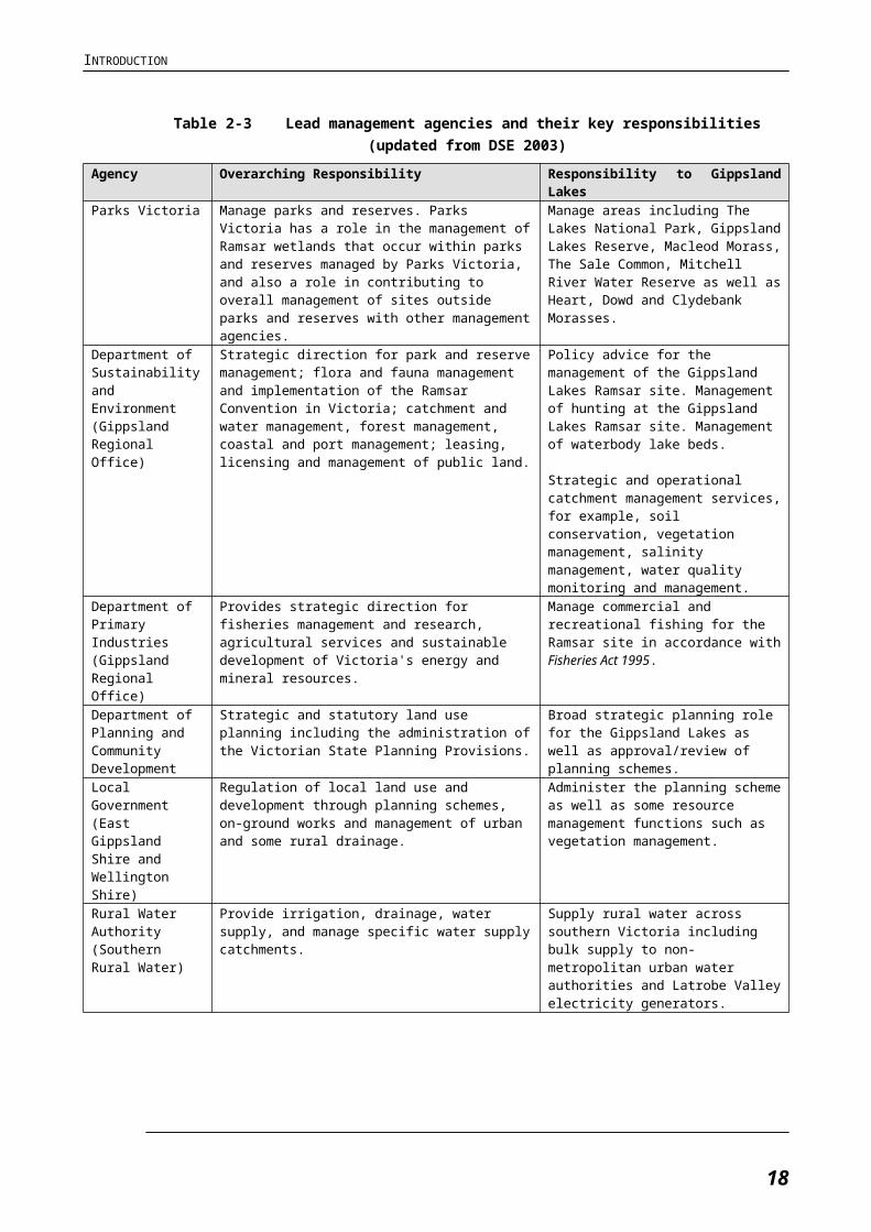
A range of agencies are responsible for ensuring that management of the site complies with the broad range of legislative requirements. The successful management of the Gippsland Lakes Ramsar site therefore relies on effective cooperation and partnership between the various management agencies. Table 2-2 and Table 2-3 summarise the land tenure and management arrangements including the roles and responsibilities of lead management agencies.
As outlined in the tables, the majority of the site (approximately 38 000 hectares) is reserved under the Crown Land (Reserves) Act 1978 as Nature Conservation Reserve, Natural Features Reserve, and Public Purpose Reserve. Approximately one third of the Gippsland Lakes Ramsar site is located within the Lakes National Park (2390 hectares) and Gippsland Lakes Coastal Park (17 610 hectares) (Parks Victoria 1998). Both Parks are proclaimed under the National Parks Act 1975. Located south of the Ramsar site is the Ninety Mile Beach Marine National Park, proclaimed in November 2002. A small area (0.3 per cent) of the site near Paynesville (on Lake Victoria) is held as private, freehold land.
Nature Conservation Reserves and other land managed primarily for conservation surround 45 per cent of the Ramsar site, and include parks and reserves (20 per cent) and coastal and waterway areas (25 per cent). Non-conservation land that surrounds the site includes grazing (45 per cent), residential (five per cent) and industrial (five per cent). In general, urban development is increasing in areas bordering the site, while agriculture is decreasing.
The site is located in two local government shires. The East Gippsland Shire covers the eastern area of the Gippsland Lakes Ramsar site from where McLennan Strait enters Lake Victoria and the eastern edge of the Lakes National Park (Sperm Whale Head) and covering all of Lake Victoria, Lake King, Lake Bunga and Lake Tyers. The Wellington Shire covers the western area of the Gippsland Lakes Ramsar site including Lake Wellington, Lake Reeve, McLennan Strait and the land south of Lake Victoria covering the Ninety Mile Beach, Loch Sport and the Lakes National Park (Sperm Whale Head).
East Gippsland and Wellington Shires implement the state planning provisions which control development and land use changes within the area.
12
INTRODUCTION
Table 2-2 Land tenure and management of the Ramsar site (updated from DSE 2003)
Wetland Land tenure Legal status ManagementSale Common Nature Conservation Reserve –
Wildlife ReserveCrown Land (Reserves) Act 1978 and Wildlife Act 1975 Parks Victoria
Dowd Morass (part) State Wildlife Reserve classified as State Game Reserve (also part privately owned)
Crown Land (Reserves) Act 1978 and Wildlife Act 1975 Parks Victoria
Hearts Morass (part) State Wildlife Reserve classified as State Game Reserve (also part privately owned)
Crown Land (Reserves) Act 1978 and Wildlife Act 1975 Parks Victoria
Clydebank Morass State Wildlife Reserve classified as State Game Reserve*
Crown Land (Reserves) Act 1978 and Wildlife Act 1975 Parks Victoria
Lake Wellington (western shoreline) Public Purposes Reserve Crown Land (Reserves) Act 1978 DSELake Wellington (shoreline – Disher Bay)
Public Purpose Reserve, Unreserved Crown Land Crown Land (Reserves) Act 1978 DSE
Lake Wellington (shoreline – Swell Point to Roseneath Point) Public Purpose Reserve Crown Land (Reserves) Act 1978 DSE
Lake Wellington (eastern shoreline) Public Purpose Reserve, Salt Lake – Unreserved Crown Land
Crown Land (Reserves) Act 1978 DSE
Lake Wellington Crown Land Reserve Crown Land (Reserves) Act 1978 DSELake Coleman1 State Wildlife Reserve classified
as State Game ReserveCrown Land (Reserves) Act 1978 and Wildlife Act 1975 Parks Victoria
Land adjoining Lake Coleman Wildlife Reserve to south Land vested in Gippsland Water Water Act 1989 Gippsland
WaterLake Reeve Gippsland Lakes Coastal Park National Parks Act 1975 Parks VictoriaGippsland Lakes Coastal Park Coastal Park National Parks Act 1975 Parks VictoriaLand near McLennan Strait Part of Gippsland Lakes Coastal
Park National Parks Act 1975 Parks Victoria
Public Purpose Reserve Crown Land (Reserves) Act 1978 DSEMorley Swamp Natural Features Reserve –
Gippsland Lakes Reserve Crown Land (Reserves) Act 1978 Parks Victoria
Backwater Morass Natural Features Reserve – Gippsland Lakes Reserve Crown Land (Reserves) Act 1978 Parks Victoria
Red Morass Natural Features Reserve – Gippsland Lakes Reserve Crown Land (Reserves) Act 1978 Parks Victoria
Victoria Lagoon Natural Features Reserve – Wildlife Reserve classified as State Game Reserve
Crown Land (Reserves) Act 1978 Parks Victoria
Lake Victoria Crown Land Reserve Crown Land (Reserves) Act 1978 DSEThe Lakes National Park The Lakes National Park National Parks Act 1975 Parks VictoriaBlond Bay Natural Features Reserve –
Wildlife Reserve classified as State Game Reserve
Crown Land (Reserves) Act 1978 and Wildlife Act 1975 Parks Victoria
Lake King Public Purposes Reserve Crown Land (Reserves) Act 1978 DSEMacleod Morass Natural Features Reserve –
Wildlife Reserve classified as State Game Reserve
Crown Land (Reserves) Act 1978 and Wildlife Act 1975 Parks Victoria
Jones Bay Natural Features Reserve – Wildlife Reserve classified as State Game Reserve and Natural Features Reserve – Gippsland Lakes Reserve
Crown Land (Reserves) Act 1978 and Wildlife Act 1975 Parks Victoria
Mitchell River Water Reserve Land Act 1958 Parks VictoriaSwan Reach Natural Features Reserve –
Gippsland Lakes ReserveCrown Land (Reserves) Act 1978 and Wildlife Act 1975 Parks Victoria
Lake Tyers Forest Park Crown Land (Reserves) Act 1978 DSE, ShireLand to the south of Lake King Gippsland Lakes Coastal Park National Parks Act 1975 Parks VictoriaNorth Arm (near Lakes Entrance) Public Purpose Reserve Crown Land (Reserves) Act 1978 DSE
1 Only a portion of Lake Coleman is within the Ramsar site boundary. The balance of the wetland is part of the Dutson Range Training Area, managed by the Australian Department of Defence.
13
INTRODUCTION
Wetland Land tenure Legal status ManagementLakes Entrance to Lake Tyers including Lake Bunga
Lakes Entrance – Lake Tyers Coastal Reserve Crown Land (Reserves) Act 1978 Parks Victoria,
EGSC
14
INTRODUCTION
Table 2-3 Lead management agencies and their key responsibilities (updated from DSE 2003)
Agency Overarching Responsibility Responsibility to Gippsland LakesParks Victoria Manage parks and reserves. Parks Victoria has a role
in the management of Ramsar wetlands that occur within parks and reserves managed by Parks Victoria, and also a role in contributing to overall management of sites outside parks and reserves with other management agencies.
Manage areas including The Lakes National Park, Gippsland Lakes Reserve, Macleod Morass, The Sale Common, Mitchell River Water Reserve as well as Heart, Dowd and Clydebank Morasses.
Department of Sustainability and Environment (Gippsland Regional Office)
Strategic direction for park and reserve management; flora and fauna management and implementation of the Ramsar Convention in Victoria; catchment and water management, forest management, coastal and port management; leasing, licensing and management of public land.
Policy advice for the management of the Gippsland Lakes Ramsar site. Management of hunting at the Gippsland Lakes Ramsar site. Management of waterbody lake beds.
Strategic and operational catchment management services, for example, soil conservation, vegetation management, salinity management, water quality monitoring and management.
Department of Primary Industries (Gippsland Regional Office)
Provides strategic direction for fisheries management and research, agricultural services and sustainable development of Victoria's energy and mineral resources.
Manage commercial and recreational fishing for the Ramsar site in accordance with Fisheries Act 1995.
Department of Planning and Community Development
Strategic and statutory land use planning including the administration of the Victorian State Planning Provisions.
Broad strategic planning role for the Gippsland Lakes as well as approval/review of planning schemes.
Local Government (East Gippsland Shire and Wellington Shire)
Regulation of local land use and development through planning schemes, on-ground works and management of urban and some rural drainage.
Administer the planning scheme as well as some resource management functions such as vegetation management.
Rural Water Authority (Southern Rural Water)
Provide irrigation, drainage, water supply, and manage specific water supply catchments.
Supply rural water across southern Victoria including bulk supply to non-metropolitan urban water authorities and Latrobe Valley electricity generators.
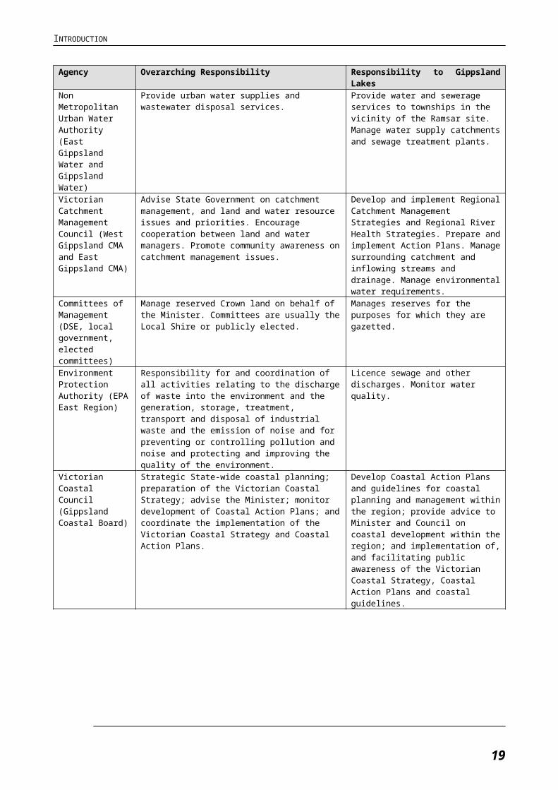
Non Metropolitan Urban Water Authority (East Gippsland Water and Gippsland Water)
Provide urban water supplies and wastewater disposal services.
Provide water and sewerage services to townships in the vicinity of the Ramsar site. Manage water supply catchments and sewage treatment plants.
Victorian Catchment Management Council (West Gippsland CMA and East Gippsland CMA)
Advise State Government on catchment management, and land and water resource issues and priorities. Encourage cooperation between land and water managers. Promote community awareness on catchment management issues.
Develop and implement Regional Catchment Management Strategies and Regional River Health Strategies. Prepare and implement Action Plans. Manage surrounding catchment and inflowing streams and drainage. Manage environmental water requirements.
Committees of Management (DSE, local government, elected committees)
Manage reserved Crown land on behalf of the Minister. Committees are usually the Local Shire or publicly elected.
Manages reserves for the purposes for which they are gazetted.
Environment Protection Authority (EPA East Region)
Responsibility for and coordination of all activities relating to the discharge of waste into the environment and the generation, storage, treatment, transport and disposal of industrial waste and the emission of noise and for preventing or controlling pollution and noise and protecting and improving the quality of the environment.
Licence sewage and other discharges. Monitor water quality.
15
INTRODUCTION
Agency Overarching Responsibility Responsibility to Gippsland LakesVictorian Coastal Council (Gippsland Coastal Board)
Strategic State-wide coastal planning; preparation of the Victorian Coastal Strategy; advise the Minister; monitor development of Coastal Action Plans; and coordinate the implementation of the Victorian Coastal Strategy and Coastal Action Plans.
Develop Coastal Action Plans and guidelines for coastal planning and management within the region; provide advice to Minister and Council on coastal development within the region; and implementation of, and facilitating public awareness of the Victorian Coastal Strategy, Coastal Action Plans and coastal guidelines.
Department of Defence
While the Dutson Range Training Area is not contained within the boundaries of the Ramsar site, the Department of Defence plays a significant role in the management of Lake Coleman in cooperation with Parks Victoria.
Selected areas of Dutson Range have been identified as conservation zones to maintain and enhance significant environmental values (HLA 2007). A range of environmental management plans are implemented (fire, weed control, water management) to maintain wetland values.
Gippsland Ports Establish, manage, dredge and maintain channels in port waters; provide and maintain navigation in connection with navigation of port waters; direct and control movement of vessels within port waters.
Operation of commercial port of Lakes Entrance. Maintenance of navigational aids and channels. Management of public facilities.
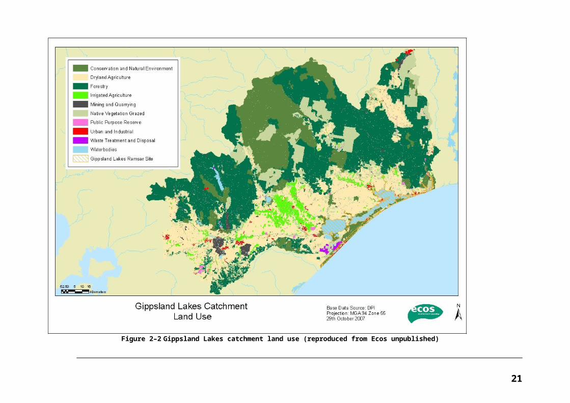
2.2.2 Catchment Land Use
The catchment of the Gippsland Lakes covers an area of over two million hectares and supports many land uses as shown in Error: Reference source not found (based on DCE 1991). It includes several large towns and cities (Sale, Bairnsdale, Warragul, Traralgon, Morwell and Moe), Victoria’s major electricity generating facilities, the Latrobe Valley industrial area, extensive dryland and irrigated farmland and a significant proportion of Victoria’s hardwood and softwood timber resources (DCE 1991).
The water resources of the river systems that drain into the Gippsland Lakes have been extensively developed to support agricultural activities, urban water supply, industrial use and as cooling water for thermal electricity generation (DCE 1991). A significant portion of the lower reaches of the Latrobe, Macalister and Mitchell Rivers are surrounded by irrigation areas, primarily comprising dairy farming and horticulture.
The Latrobe River receives a number of licensed discharges of waste, the major contributions being treated sewage from Warragul, Moe and Morwell, and industrial wastewater from the power generating companies (DCE 1991). The lower reaches of the rivers in the western part of the catchment are experiencing elevated groundwater tables and associated saline discharge, as well as nutrient and sediment discharges from irrigation drainage.
The Tambo, Avon and Nicholson Rivers also drain into the lakes system. Within the Tambo catchment there are former mining areas around Cassillis that have eroded in the past created large slugs of sand within the lower reaches of the river near Bruthen and Tambo Upper and erodible agricultural areas, particularly in granitic areas. Both the Avon and Nicholson Rivers drain from vegetated upper catchments into areas that are dominated by cleared agricultural land along their lower reaches.
16
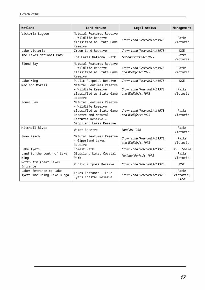
Figure 2–2 Gippsland Lakes catchment land use (reproduced from Ecos unpublished)
17
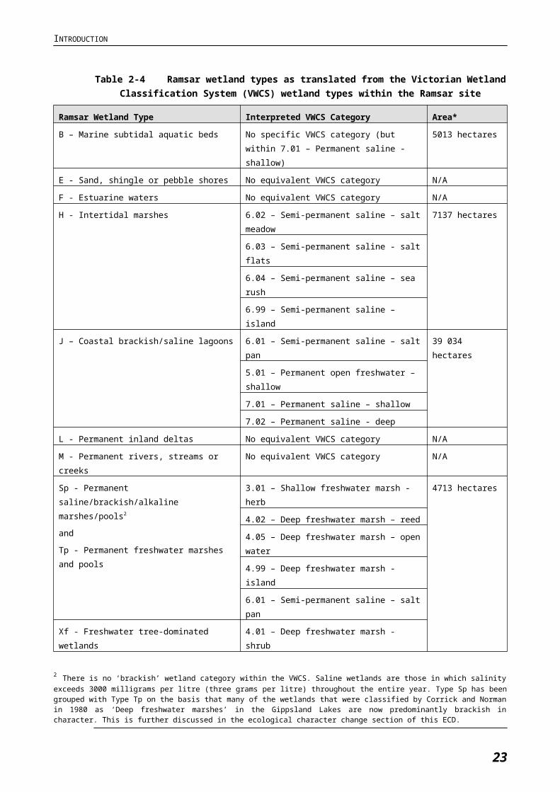
2.3 Description of Wetland TypesThe Gippsland Lakes Ramsar site contains an extensive system of estuarine, fresh and brackish coastal wetlands, with a diversity of wetland types present including lagoons, marshes and tree-swamps. For this report, the Ramsar Classification System for Wetland Types (approved by Recommendation 4.7 and amended by Resolutions VI.5 and VII.11 of the Conference of the Contracting Parties) is used. Wetland categorisation under the Ramsar typology provides up to 12 marine/coastal wetland types, 20 inland wetland types and 10 human-made wetland types.
To date, no mapping according to Ramsar wetland types of Gippsland Lakes has been undertaken. Therefore, in order to refine the presence of Ramsar wetland types within the site, information was collated and reviewed from the following sources: the 1999 RIS (Casanelia 1999), the Victorian Wetland Classification System (VWCS) (based on Corrick and Norman 1980) and Ecological Vegetation Class (EVC) mapping by DSE.
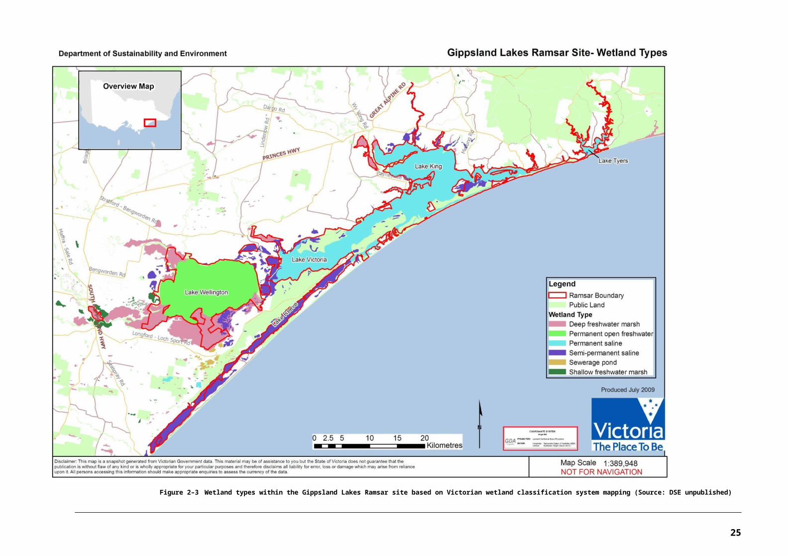
Although direct overlaps between the different wetland types as classified by the three systems are limited, the most likely equivalent wetland types were determined and are presented in Table 2-4. Using the VWCS mapping, a map of wetland types within the Ramsar site was generated (refer Error:Reference source not found) and areas of each wetland type were calculated (refer Table 2-4 using equivalent Ramsar wetland types).
Based on the review, the following Ramsar wetland types are seen as being represented within the site at the current time:
five marine/coastal wetland types (B, E, F, H, J)
five inland wetland types (L, M, Sp, Tp and Xf)
one man-made wetland type (Type 8).
All of the wetland types listed above are considered to have been supported by the site at the time of listing in 1982 based on the information presented in the original listing document (Victorian Ministry for Conservation 1980).
18
INTRODUCTION
Table 2-4 Ramsar wetland types as translated from the Victorian Wetland Classification System (VWCS) wetland types within the Ramsar site
Ramsar Wetland Type Interpreted VWCS Category Area*
B – Marine subtidal aquatic beds No specific VWCS category (but within 7.01 –
Permanent saline - shallow)
5013 hectares
E - Sand, shingle or pebble shores No equivalent VWCS category N/A
F - Estuarine waters No equivalent VWCS category N/A
H - Intertidal marshes 6.02 – Semi-permanent saline – salt meadow 7137 hectares
6.03 – Semi-permanent saline - salt flats
6.04 – Semi-permanent saline – sea rush
6.99 – Semi-permanent saline – island
J – Coastal brackish/saline lagoons 6.01 – Semi-permanent saline – salt pan 39 034 hectares
5.01 – Permanent open freshwater – shallow
7.01 – Permanent saline – shallow
7.02 – Permanent saline - deep
L - Permanent inland deltas No equivalent VWCS category N/A
M - Permanent rivers, streams or creeks No equivalent VWCS category N/A
Sp - Permanent saline/brackish/alkaline
marshes/pools2
and
Tp - Permanent freshwater marshes and pools
3.01 – Shallow freshwater marsh - herb 4713 hectares
4.02 – Deep freshwater marsh – reed
4.05 – Deep freshwater marsh – open water
4.99 – Deep freshwater marsh - island
6.01 – Semi-permanent saline – salt pan
Xf - Freshwater tree-dominated wetlands 4.01 – Deep freshwater marsh - shrub
*Based on mapping of corresponding VWCS categories; except for Type B which is based on EVC mapping.
2 There is no ‘brackish’ wetland category within the VWCS. Saline wetlands are those in which salinity exceeds 3000 milligrams per litre (three grams per litre) throughout the entire year. Type Sp has been grouped with Type Tp on the basis that many of the wetlands that were classified by Corrick and Norman in 1980 as ‘Deep freshwater marshes’ in the Gippsland Lakes are now predominantly brackish in character. This is further discussed in the ecological character change section of this ECD.
19
Figure 2–3 Wetland types within the Gippsland Lakes Ramsar site based on Victorian wetland classification system mapping (Source: DSE unpublished)
20
2.3.1 Coastal Wetlands
Type B: Marine subtidal aquatic beds
This wetland type is represented by seagrass beds that cover a total area of 5013 hectares within the site (based on EVC mapping). Seagrass beds are widely distributed within the site, particularly within the eastern parts including Lake Tyers, Lake Victoria and Lake King (Roob and Ball 1997, Hindell 2008). Species of seagrass that are present include Zostera muelleri, Heterozostera tasmanica, Ruppia spiralis and Lepilaena cylindrocarpa (Roob and Ball 1997). Seagrass beds are an ecologically significant habitat, providing breeding grounds, nursery areas, food and shelter for a variety of aquatic fauna, and also provide a food source for black swans and other herbivorous waterbirds.
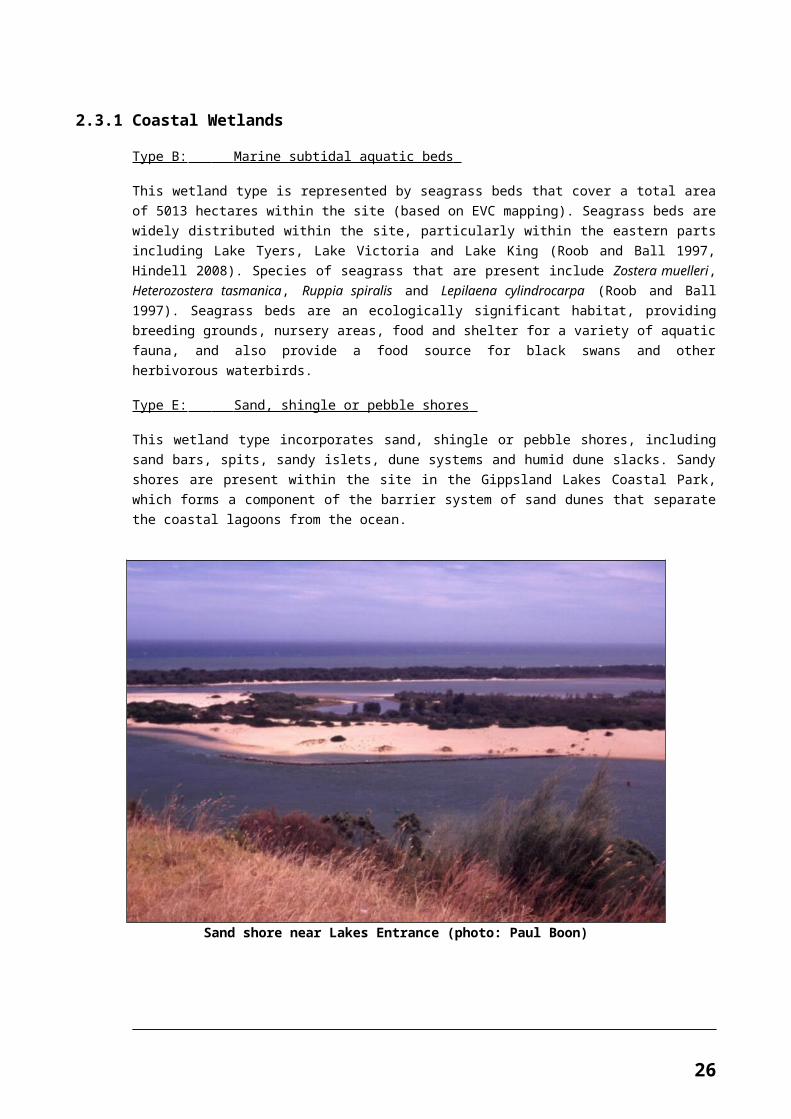
Type E: Sand, shingle or pebble shores
This wetland type incorporates sand, shingle or pebble shores, including sand bars, spits, sandy islets, dune systems and humid dune slacks. Sandy shores are present within the site in the Gippsland Lakes Coastal Park, which forms a component of the barrier system of sand dunes that separate the coastal lagoons from the ocean.
Sand shore near Lakes Entrance (photo: Paul Boon)
21
INTRODUCTION
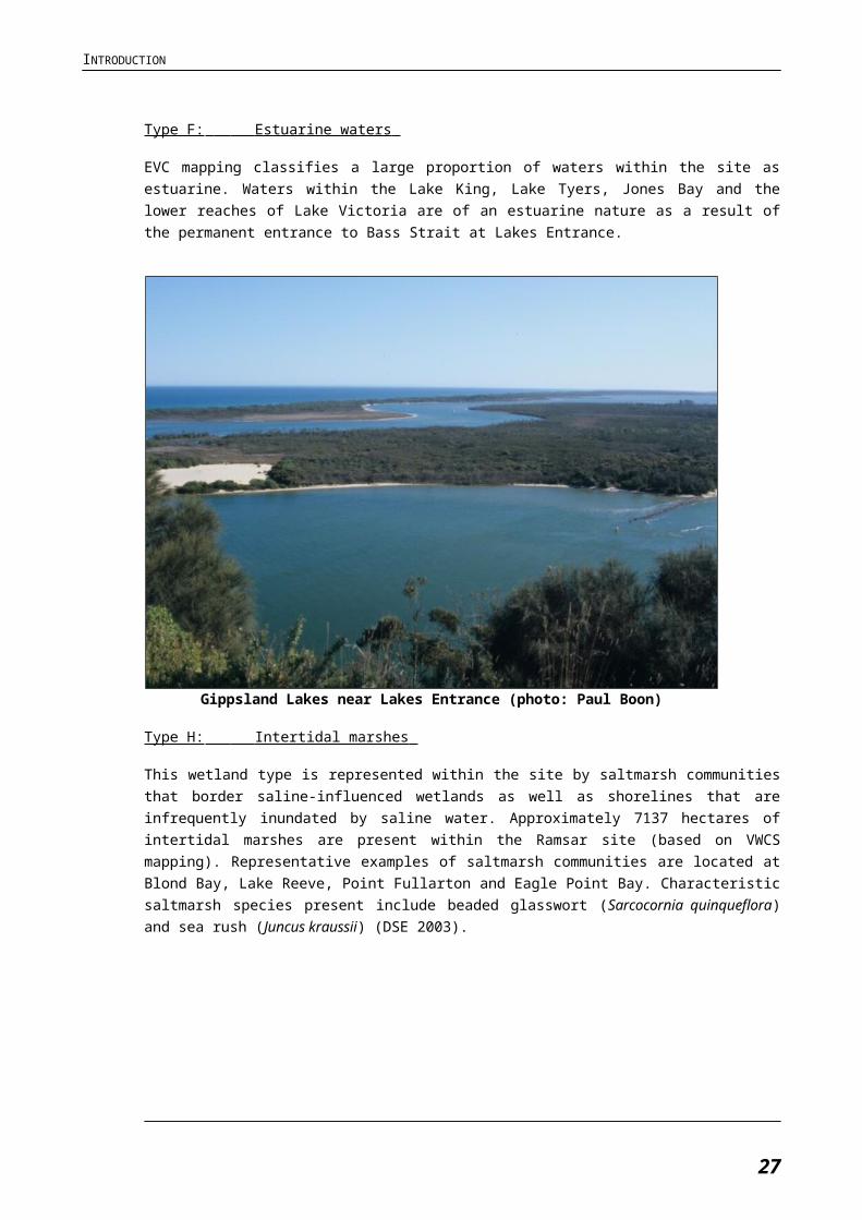
Type F: Estuarine waters
EVC mapping classifies a large proportion of waters within the site as estuarine. Waters within the Lake King, Lake Tyers, Jones Bay and the lower reaches of Lake Victoria are of an estuarine nature as a result of the permanent entrance to Bass Strait at Lakes Entrance.
Gippsland Lakes near Lakes Entrance (photo: Paul Boon)
Type H: Intertidal marshes
This wetland type is represented within the site by saltmarsh communities that border saline-influenced wetlands as well as shorelines that are infrequently inundated by saline water. Approximately 7137 hectares of intertidal marshes are present within the Ramsar site (based on VWCS mapping). Representative examples of saltmarsh communities are located at Blond Bay, Lake Reeve, Point Fullarton and Eagle Point Bay. Characteristic saltmarsh species present include beaded glasswort (Sarcocornia quinqueflora) and sea rush (Juncus kraussii) (DSE 2003).
22
INTRODUCTION
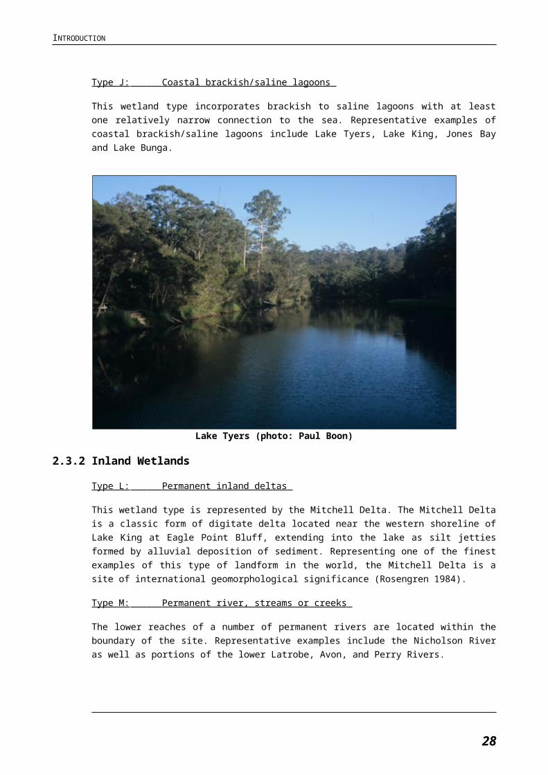
Type J: Coastal brackish/saline lagoons
This wetland type incorporates brackish to saline lagoons with at least one relatively narrow connection to the sea. Representative examples of coastal brackish/saline lagoons include Lake Tyers, Lake King, Jones Bay and Lake Bunga.
Lake Tyers (photo: Paul Boon)
2.3.2 Inland Wetlands
Type L: Permanent inland deltas
This wetland type is represented by the Mitchell Delta. The Mitchell Delta is a classic form of digitate delta located near the western shoreline of Lake King at Eagle Point Bluff, extending into the lake as silt jetties formed by alluvial deposition of sediment. Representing one of the finest examples of this type of landform in the world, the Mitchell Delta is a site of international geomorphological significance (Rosengren 1984).
Type M: Permanent river, streams or creeks
The lower reaches of a number of permanent rivers are located within the boundary of the site. Representative examples include the Nicholson River as well as portions of the lower Latrobe, Avon, and Perry Rivers.
23
INTRODUCTION
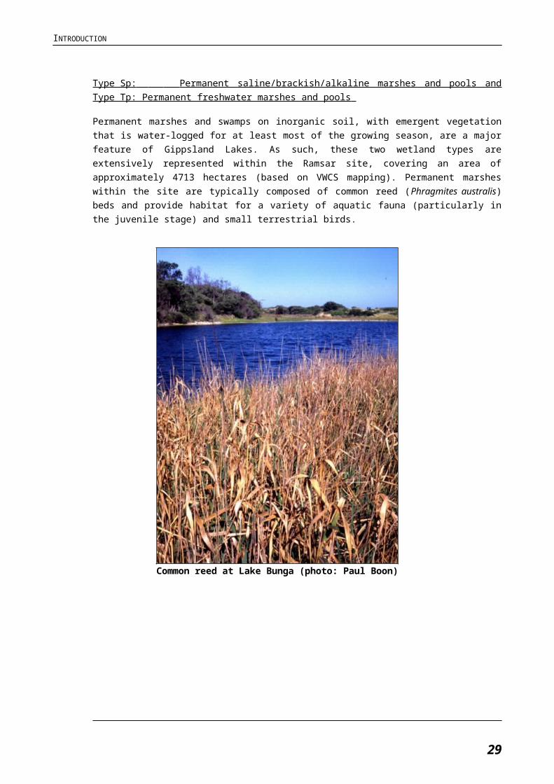
Type Sp: Permanent saline/brackish/alkaline marshes and pools and Type Tp: Permanent freshwater marshes and pools
Permanent marshes and swamps on inorganic soil, with emergent vegetation that is water-logged for at least most of the growing season, are a major feature of Gippsland Lakes. As such, these two wetland types are extensively represented within the Ramsar site, covering an area of approximately 4713 hectares (based on VWCS mapping). Permanent marshes within the site are typically composed of common reed (Phragmites australis) beds and provide habitat for a variety of aquatic fauna (particularly in the juvenile stage) and small terrestrial birds.
Common reed at Lake Bunga (photo: Paul Boon)
24
INTRODUCTION
Type Xf: Freshwater tree-dominated wetlands
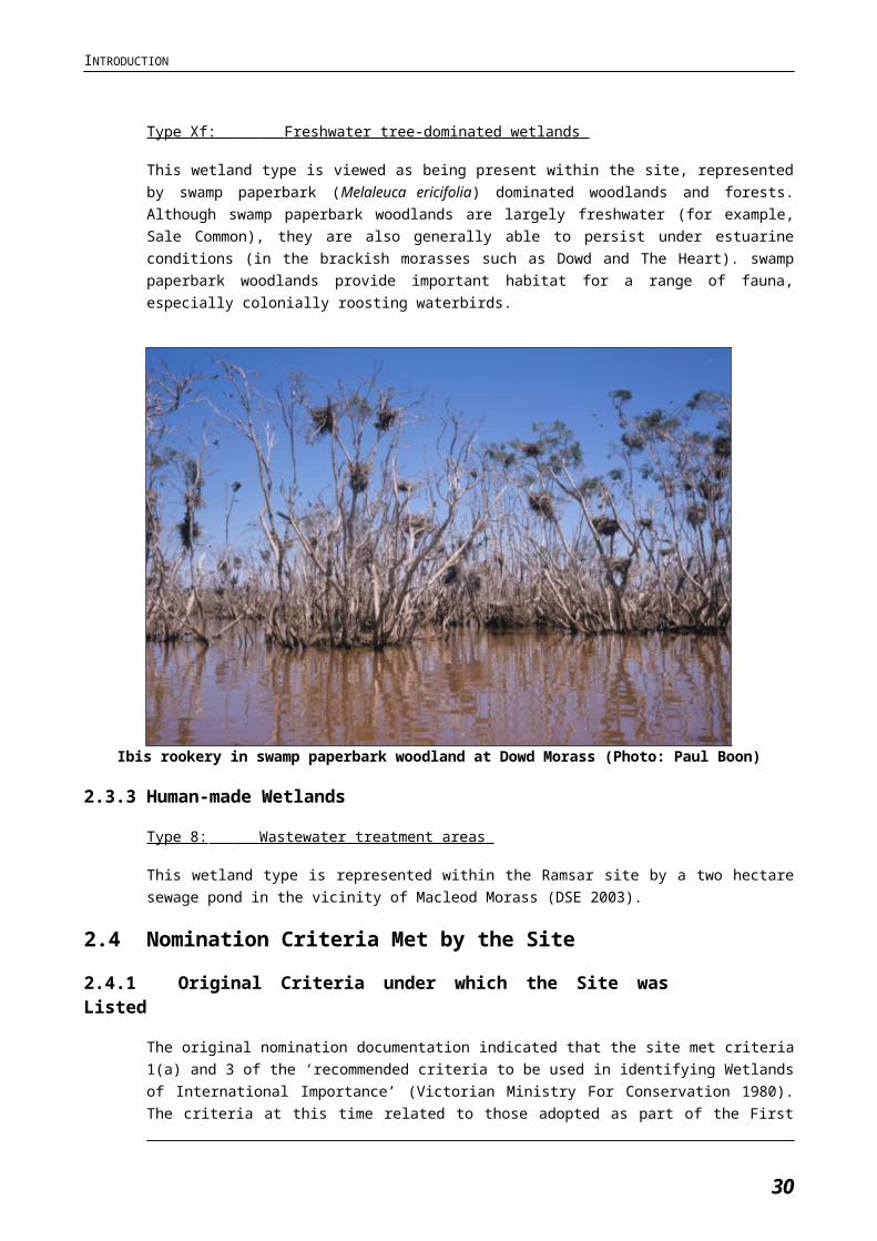
This wetland type is viewed as being present within the site, represented by swamp paperbark (Melaleuca ericifolia) dominated woodlands and forests. Although swamp paperbark woodlands are largely freshwater (for example, Sale Common), they are also generally able to persist under estuarine conditions (in the brackish morasses such as Dowd and The Heart). swamp paperbark woodlands provide important habitat for a range of fauna, especially colonially roosting waterbirds.
Ibis rookery in swamp paperbark woodland at Dowd Morass (Photo: Paul Boon)
2.3.3 Human-made Wetlands
Type 8: Wastewater treatment areas
This wetland type is represented within the Ramsar site by a two hectare sewage pond in the vicinity of Macleod Morass (DSE 2003).
2.4 Nomination Criteria Met by the Site2.4.1 Original Criteria under which the Site was Listed
The original nomination documentation indicated that the site met criteria 1(a) and 3 of the ‘recommended criteria to be used in identifying Wetlands of International Importance’ (Victorian Ministry For Conservation 1980). The criteria at this time related to those adopted as part of the First Meeting of the Conference of Contracting Parties for the Ramsar Convention assembled in Cagliari, Sardinia (CoP 1 Criteria).
The relevant ‘Cagliari’ criteria met by the site were as follows:
25
INTRODUCTION
1. A wetland should be considered internationally important if it:
o (a) regularly supports either 10 000 ducks, geese and swans; or 10 000 coots; or 20 000 waders. This criterion is broadly analogous of the present day criterion 5 (see Section 2.4.2).
3. A wetland should be considered internationally important if it is a particularly good example of a specific type of wetland characteristic of its region. This criterion is broadly analogous of the present day criterion 1 (see Section 2.4.2).
The documentation supporting the original listing (Victorian Ministry for Conservation 1980) outlines the following justification for these criteria:
The Gippsland Lakes and their associated swamps and morasses regularly support an estimated 40 to 50 thousand ducks, swans, coots, and other waterfowl. Tucker Swamp, on the edge of Lake Wellington, supports one of only two breeding colonies of Pied Cormorants in Victoria. The Gippsland Lakes support an estimated four per cent of Victoria’s wader population. The permanence of the main lakes and the relatively regular flooding of the adjacent wetlands mean that this wetland is an important drought refuge for many waterfowl.
The most recent RIS (Casanelia 1999) for the site indicated that the site meets the following criteria (based on the Ramsar Convention Criteria adopted at the 1996 Conference of Parties – CoP 6 criteria):
1(a) it is a particularly good representative example of a natural or near-natural wetland, characteristic of the appropriate biogeographical region.
3(a) it regularly supports 20 000 waterfowl.
3(b) it regularly supports substantial numbers of individuals from particular groups of waterfowl, indicative of wetland values, productivity or diversity.
3(c) where data on populations are available, it regularly supports one per cent of the individuals in a population of one species or subspecies of waterfowl.
Based on the National ECD Framework, Appendix 5, these pre-1999 criteria translate to the following current Nomination Criteria (2005):
Criterion 1: A wetland should be considered internationally important if it contains a representative, rare, or unique example of a natural or near-natural wetland type found within the appropriate biogeographic region.
Criterion 3: A wetland should be considered internationally important if it supports populations of plant and/or animal species important for maintaining the biological diversity of a particular biogeographic region.
Criterion 5: A wetland should be considered internationally important if it regularly supports 20 000 or more waterbirds.
26
INTRODUCTION
Criterion 6: A wetland should be considered internationally important if it regularly supports one per cent of the individuals in a population of one species or subspecies of waterbird.
As part of the current study, there is a requirement to re-assess the applicability of all criteria to the site which is presented below.
2.4.2 Assessment Based on Current Information and Ramsar Criteria
The site is considered to meet Ramsar Nomination Criteria 1, 2, 4, 5, 6 and 8 based upon the information reviewed when preparing this ECD (refer Table 2-5). Justification statements for each criterion are provided below. In the context of the criteria, the relevant biogeographic region used is the Australian Drainage Division and River Basins.3 For Gippsland Lakes, this is the ‘Southeast Coast’ Region which extends from the NSW border to the Millicent River in Western Victoria.
3 Guidelines under the Ramsar Convention (contained in the Ramsar Handbook v.3) favour the use of international or national biogeographic regions in the context of interpretation of Ramsar
Nomination Criteria and other aspects of the Convention. The Australian Drainage Divisions and Interim Marine and Coastal Regionalisation for Australia (IMCRA - version 4 - June 2006) have
been adopted as the most relevant national bioregionalisation schemes for this ECD.
27
GENERAL DESCRIPTION OF THE SITE
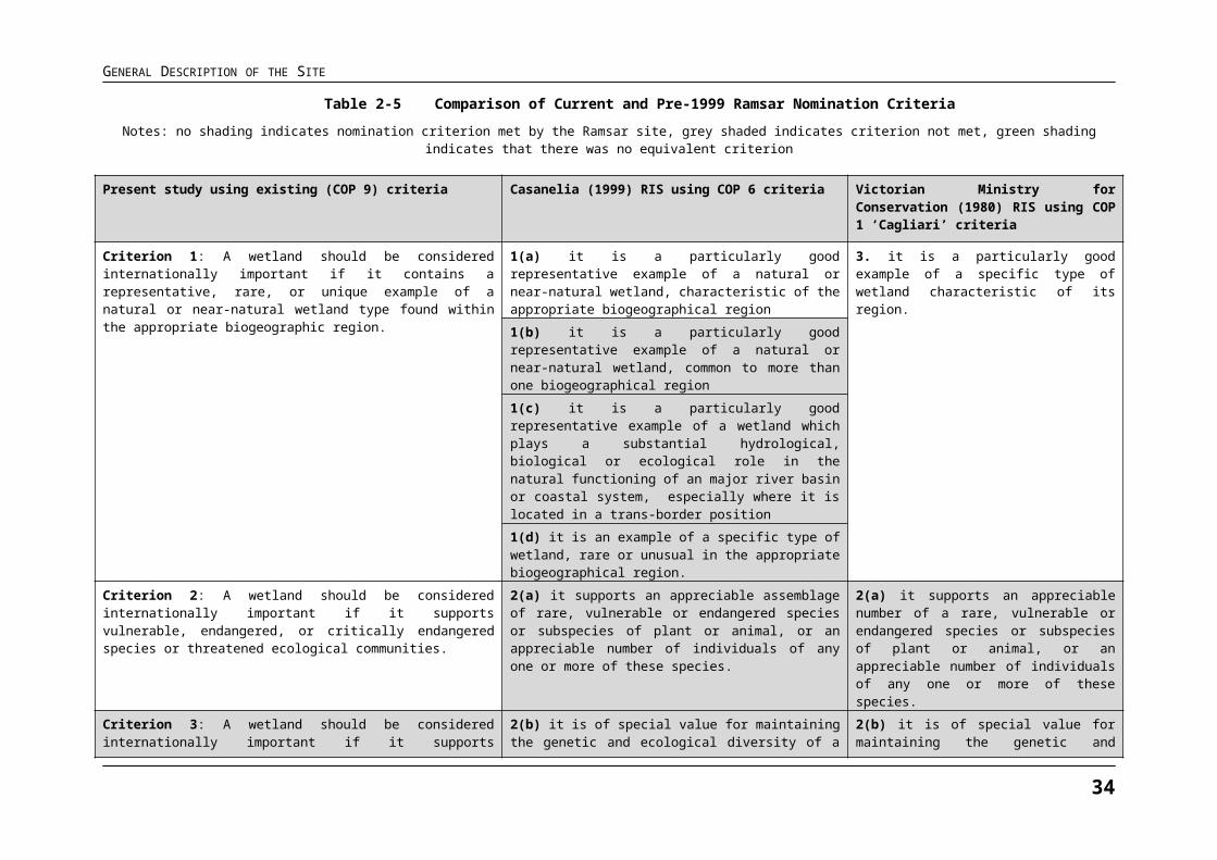
Table 2-5 Comparison of Current and Pre-1999 Ramsar Nomination Criteria Notes: no shading indicates nomination criterion met by the Ramsar site, grey shaded indicates criterion not met, green shading indicates that there was no equivalent criterion
Present study using existing (COP 9) criteria Casanelia (1999) RIS using COP 6 criteria Victorian Ministry for Conservation (1980) RIS using COP 1 ‘Cagliari’ criteria
Criterion 1: A wetland should be considered internationally important if it contains a representative, rare, or unique example of a natural or near-natural wetland type found within the appropriate biogeographic region.
1(a) it is a particularly good representative example of a natural or near-natural wetland, characteristic of the appropriate biogeographical region
3. it is a particularly good example of a specific type of wetland characteristic of its region.
1(b) it is a particularly good representative example of a natural or near-natural wetland, common to more than one biogeographical region1(c) it is a particularly good representative example of a wetland which plays a substantial hydrological, biological or ecological role in the natural functioning of an major river basin or coastal system, especially where it is located in a trans-border position1(d) it is an example of a specific type of wetland, rare or unusual in the appropriate biogeographical region.
Criterion 2: A wetland should be considered internationally important if it supports vulnerable, endangered, or critically endangered species or threatened ecological communities.
2(a) it supports an appreciable assemblage of rare, vulnerable or endangered species or subspecies of plant or animal, or an appreciable number of individuals of any one or more of these species.
2(a) it supports an appreciable number of a rare, vulnerable or endangered species or subspecies of plant or animal, or an appreciable number of individuals of any one or more of these species.
Criterion 3: A wetland should be considered internationally important if it supports populations of plant and/or animal species important for maintaining the biological diversity of a particular biogeographic region
2(b) it is of special value for maintaining the genetic and ecological diversity of a region because of the quality and peculiarities of its flora and fauna
2(b) it is of special value for maintaining the genetic and ecological diversity of a region because of the quality and peculiarities of its flora and fauna.
2(d) it is of special value for one or more endemic plant or animal species or communities
2(d) it is of special value for one or more endemic plant or animal species or communities
Criterion 4: A wetland should be considered internationally important if it supports plant and/or animal species at a critical stage in their life cycles, or provides refuge during adverse conditions.
2(c) it is of special value as the habitat of plants or animals at a critical stage of their biological cycle.
2(c) it is of special value as the habitat of plants or animals at a critical stage of their biological cycles.
Criterion 5: A wetland should be considered internationally important if it regularly supports 20 000 or more waterbirds.
3(a) it regularly supports 20 000 waterfowl. 1(a) it regularly supports either 10 000 ducks, geese and swans; or 10 000 coots; or 20 000 waders.
Criterion 6: A wetland should be considered internationally important if it regularly supports one per cent of the individuals in a population of one species or subspecies of waterbird.
3(c) where data on populations are available, it regularly supports one per cent of the individuals in a population of one species or subspecies of waterfowl.
1(b) it regularly supports one per cent of the individuals in a population of one species or subspecies of waterfowl.
28
GENERAL DESCRIPTION OF THE SITE
Present study using existing (COP 9) criteria Casanelia (1999) RIS using COP 6 criteria Victorian Ministry for Conservation (1980) RIS using COP 1 ‘Cagliari’ criteria
3(b) it regularly supports substantial numbers of individuals from particular groups of waterfowl, indicative of wetland values, productivity or diversity.
1(c) it regularly supports one per cent of the breeding pairs in a population of one species or subspecies of waterfowl.
Criterion 7: A wetland should be considered internationally important if it supports a significant proportion of indigenous fish subspecies, species or families, life-history stages, species interactions and/or populations that are representative of wetland benefits and/or values and thereby contributes to global biological diversity.
4(a) it supports a significant proportion of indigenous fish subspecies, species or families, life-history stages, species interactions and/or populations that are representative of wetland benefits and/or values and thereby contributes to global biological diversity.
No equivalent criterion
Criterion 8: A wetland should be considered internationally important if it is an important source of food for fishes, spawning ground, nursery and/or migration path on which fish stocks, either within the wetland or elsewhere, depend.
4(b) it is an important source of food for fishes, spawning ground, nursery and/or migration path on which fish stocks, either within the wetland or elsewhere, depend.
No equivalent criterion
Criterion 9: A wetland should be considered internationally important if it regularly supports 1 per cent of the individuals in a population of one species or subspecies of wetland-dependent non-avian animal species.
No equivalent criterion No equivalent criterion
29
Criterion 1 - Met ( )
The Gippsland Lakes Ramsar site forms one of the largest coastal lagoon systems in the Drainage Division and contains a distinctive landscape of wetlands and flat coastal plains. The site supports a broad range of wetland types in close proximity to each other, including periodically inundated palustrine marshes, permanently inundated palustrine marshes, shallow lacustrine (lake) features, deep lacustrine features, lagoons with narrow inlets, and broad embayments. The site also includes the lower reaches of several river systems, including a large reach of the Nicholson River which feeds into Jones Bay.
None of the individual wetland types within the site are considered rare or unusual on a bioregional scale. However this criterion is seen to be met given that the site contains excellent examples of particular wetland types within the bioregion, most notably the following:
The Mitchell River Delta is a particularly outstanding example of a permanent inland delta (Ramsar wetland Type L). The Mitchell Delta is a classic form of digitate delta that is considered to representing one of the finest examples of this type of landform in the world (Rosengren 1984) (see Section 2.3.2).
The site supports two waterbodies that remain in a near-natural state that are considered excellent representative examples of that wetland type in the drainage division (Southeast Coast). These waterbodies are Lake Tyers (an intermittently opening and closing lagoon or ICOL with a predominantly undeveloped catchment) and Lake Reeve (a coastal barrier lagoon and saltmarsh complex adjacent to Ninety Mile Beach).4 Further information about these two areas is contained in the critical components section of this ECD.
The site does not appear to meet the criterion from a ‘hydrological importance’ perspective. While the hydrology of the site is undoubtedly an important driver of wetland ecosystem processes at a site-scale (see Critical Process 1), it is not seen to meet as particularly important characteristic of the wetland at broader spatial scales. It is also noted that the fringing wetlands around the edges of the lakes remove a significant amount of nutrients from river water before it enters the lake system (DSE 2003), however the water quality of the system cannot be considered to be of an excellent standard and therefore this part of the criterion is not considered to apply.
Criterion 2 - Met ( )
The site supports several nationally threatened wetland fauna species at various stages of their life-cycle (DSE 2003, Ecos unpublished, Birds Australia 2009, DSE 2009). This includes:
Resident frog populations – Two nationally threatened species utilise the site: green and golden bell frogs (Litoria aurea) and growling grass frogs (Litoria raniformis). Both species have been recorded regularly (though not systematically over time) within the site, with known and potentially suitable habitat occurring within the site (Tyler 1997, Gillespie 1996, Cleman and Gillespie 2004).
4 Lake Tyers and Lake Reeve were selected following discussions with the Steering Committee as the wetland areas within Gippsland Lakes that best reflect the nomination criteria in terms of
representativeness.
GENERAL DESCRIPTION OF THE SITE
The cryptic wetland birds Australian painted snipe (Rostratula australis) and Australasian bittern (Botaurus poiciloptilus) have been recorded on an irregular basis or rarely, though potentially suitable habitat for these species occurs within the site (Blakers et al. 1984, Garnett and Crowley 2000, Rogers et al. 2005, DSE 2010). There is insufficient information to determine patterns in usage within the site. The Australian painted snipe is listed as vulnerable under the EPBC Act, while the Australasian bittern is not EPBC listed, but is listed as endangered on the 2010 IUCN Red List of Threatened Species (IUCN 2010).
Habitat for the juvenile life-history stage of the Australian grayling (Prototroctes maraena) - This species is listed as vulnerable under the EPBC Act and Australian Society of Fish Biologists (ASFB 2001), and near threatened on the 2010 IUCN Red List (IUCN 2010). While this species spends most of its life in freshwaters, larvae are passively swept into estuarine and marine waters before maturing and are thought to migrate (during spring) back into freshwaters at approximately 6 months of age (McDowall 1996). As this species has been recorded in the freshwater streams that feed directly into the Ramsar site (that is, Tambo, Thomson, Latrobe, Avon and Mitchell Rivers – see Backhouse et al. 2008), it is almost certain that this species relies on the lagoons of the site to complete the estuarine part of its life-cycle.
Threatened flora habitat - Three nationally vulnerable and endangered wetland-associated flora species have been recorded as within the site: dwarf kerrawang (Rulingia prostrata) (Carter and Walsh 2008), swamp everlasting (Xerochrysum palustre) (Bayer 2001, DSE 2008) and metallic sun-orchid (Thelymitra epipactoides) (BDFNC 2005, Parks Victoria 2003).
Criterion 3 – Not Met ( )
The key elements to be considered underpinning this criterion are outlined in Section 70 of the Ramsar Handbook for Wise Use of Wetlands 14 (Ramsar Convention Secretariat 2007), namely:
1. are “hotspots” of biological diversity and are evidently species-rich even though the number of species present may not be accurately known
2. are centres of endemism or otherwise contain significant numbers of endemic species
3. contain the range of biological diversity (including habitat types) occurring in a region
4. contain a significant proportion of species adapted to special environmental conditions (such as temporary wetlands in semi-arid or arid areas)
5. support particular elements of biological diversity that are rare or particularly characteristic of the biogeographic region.
There is no evidence to suggest that the site represents a ‘hot-spot’ of biological diversity on a bioregional scale, and the site is not located in a centre of local endemism. While the site does support high biodiversity values at a local scale and a broad range of wetland types (see discussion for Criterion 1 above), there is presently insufficient information to determine whether the site supports the range of species or habitats occurring in the bioregion. The site does not support a large proportion of species adapted to special environmental conditions. Based on the above, the site does not support this criterion.
31
GENERAL DESCRIPTION OF THE SITE
Criterion 4 - Met ( )
The site supports habitat and conditions that are important for critical life cycle stages of a variety of wetland-dependent fauna species. These stages are important because if they should be interrupted or prevented from occurring, the long-term conservation of those species may be threatened.
Section 70 of the Ramsar Handbook for Wise Use of Wetlands 14 (Ramsar Convention Secretariat 2007) recognises two key elements.
1. Critical habitat for mobile or migratory species which contain high proportions of populations gathered in a relatively small area at a particular life history stage.
As outlined in the Gippsland Lakes Ramsar site nomination document (Victorian Ministry of Conservation 1980), “the permanence of the main lakes and the relatively regular flooding of the adjacent wetlands mean that this wetland is an important drought refuge for many waterfowl”. These waterbirds are comprised of seasonal migratory species and ‘resident’ waterbirds, both of which are considered ‘mobile’. As discussed in Section Error: Reference source not found, the site in general contains high abundances of waterbirds (Parks Victoria 2003), with particularly large aggregations occurring in deep freshwater marshes (for example, Dowd Morass, the Heart Morass, Sale Common), as well as salt marsh and shallow permanent saline wetlands (for example, Lake Reeve). The site supports moulting habitat for waterbird species, which is considered by the Ramsar Convention Secretariat (2007) as a critical function underpinning this criterion.
2. Refugia habitat for non migratory wetland dependent species.
The site supports refugia habitat for a range of non-migratory wetland-dependent species. In particular, the freshwater marshes (Sale Common, Macleod Morass) are seen as particularly important refugia for aquatic species (see section Error: Reference source not found), including permanent refugia (and breeding sites) for two nationally threatened species; that is, growling grass frog (Litoria raniformis) (DSE 2010) and the green and golden bell frog (Litoria aurea) (Parks Victoria 2003).
Criterion 5 - Met ( )
The site has previously been attributed with regularly supporting approximately 40 000 to 50 000 waterbirds (refer ANCA 1995, NPS 1995, DSE 2003). Whilst systematic data collection has not been undertaken across the site, data analysis undertaken in 2008 (refer Ecos unpublished) found that the site continues to regularly support more than 20 000 waterbirds.
Section Error: Reference source not found provides a detailed account of patterns in abundance of various waterbird species.
Criterion 6 - Met ( )
Waterbird species which are considered to have occurred within the site in such abundance so as to meet the one per cent population threshold are: red-necked stint (Calidris ruficollis), black swan (Cygnus atratus), sharp-tailed sandpiper (Calidris acuminate), chestnut teal (Anas castanea), musk duck (Biziura lobata), fairy tern (Sterna nereis) and little tern (Sterna albifrons) (Parks Victoria 2003, Bamford et al. 2008).
32
GENERAL DESCRIPTION OF THE SITE
However, there is a lack of recent or comprehensive waterbird count data for the site and as a result, the justifications for these species in terms of meeting the one per cent criterion draws upon a range of published and unpublished data sources.
Section Error: Reference source not found provides a detailed account of patterns in abundance of various waterbird species.
Criterion 7 - Not Met ( )
The Ramsar Handbook emphasises that the term diversity under this criterion can encompasses number of life-history stages, species interactions and complexity of fish-environmental interactions. The fish assemblages of the site are comprised of species with different life-history characteristics, including potadromous (entirely freshwater) species, to catadromous (requiring marine and freshwaters to complete life-cycle) and fully marine species.
In this context, six fish groups were identified in Ecos (unpublished) to utilise the site:
estuarine residents, for example black bream, river garfish and estuary perch
estuarine dependent (freshwater), for example, Australian bass, Australian grayling, Cox’s gudgeon, empire gudgeon, freshwater herring, spotted galaxias, striped gudgeon
estuarine dependent (marine), for example silver fish, smallmouth hardyhead
estuarine opportunists (freshwater), for example, longfin and shortfin eels
estuarine opportunists (marine), for example, whiting, mullet, pipefish, seahorse
marine stragglers, for example, a large group of oceanic fishes that use the site periodically.
Overall, Gippsland Lakes contains an appreciable number of fish species, with approximately 179 fish species represented (Ecos unpublished). However, there are insufficient data to determine the proportion of fish (or shellfish) species that the site supports relative to the total fish diversity in bioregion.
Ramsar Secretariat (2007) also considers endemism as an important element of biodiversity. No fish species that are endemic to the IMCRA Twofold Shelf meso-scale bioregion are known to occur at the site. While species that are endemic to the broader region exist at the site, the site is not known to be particularly important in maintaining populations of these species, and therefore the site does not meet this criterion from an endemicity perspective.
In reference to the above key elements, it is assessed that there is insufficient data to determine the applicability of the criterion.
Criterion 8 - Met ( )
Gippsland Lakes provides important habitats, feeding areas, dispersal and migratory pathways, and spawning sites for numerous fish species of direct and indirect fisheries significance. These fish have important fisheries resource values both within and external to the site.
33
GENERAL DESCRIPTION OF THE SITE
Section 70 of the Ramsar Handbook for Wise Use of Wetlands 14 (Ramsar Convention Secretariat 2007) recognises two key elements under criterion 8:
1. Identification of shallow coastal wetland habitats that are important spawning, nursery and feeding grounds.
2. Identification of riverine, swamp and lake fish habitat that are important spawning and migratory pathways.
With respect to the first element, it is noted that the site supports numerous species of direct fisheries importance include European carp, yellow eye mullet, black bream, tailor, river garfish, estuary perch, Australian anchovy, dusky flathead, luderick, Australian salmon, silver trevally, leatherjackets and sea mullet. With the exception of carp, all these species are either estuarine residents or depend on estuaries in some way during their life cycle. Many of the fish and crustacean species listed above spend their juvenile stages in shallow nearshore waters of the site, particularly around seagrass and intertidal habitats. These species also spawn in inshore waters, particularly near the surf zone and in sandy channels within the boundaries of the Ramsar site (see section Error: Reference source notfound).
The site supports important breeding habitat for numerous species, of which black bream is considered particularly outstanding. This species spawns in mid-lower estuaries and adjacent waters of main lakes (that is, areas with salinities between 17 and 21 grams per litre) during October to December (Tilleard 2009). A detailed account of the specific habitat values of the site for coastal fish species is provided in Section Error: Reference source not found.
In terms of the second element, the brackish marshes, lakes and rivers are known to support important spawning, nursery and migratory pathways for numerous species (see Criterion 7). Of particular note is the role of the riverine/lake continuum in providing a nursery habitat and movement corridor for larval Australian grayling. The values of the site for this threatened species are discussed under Nomination Criterion 2.
Criterion 9 – Not Met ( )
Criterion 9 relates to non-avian wetland taxa including, inter alia, mammals, reptiles, amphibians, fish and aquatic macro-invertebrates. Some of the key non-avian wetland species within Gippsland Lakes that are appropriate to consider in the context of Criterion 9 include:
Australian grayling
dwarf galaxias
spiny crayfish5;
green and golden bell frog
5 Several spiny crayfish which are endemic to the bioregion were also considered, namely Gippsland crayfish Euastacus kershawi, South Gippsland spiny crayfish Euastacus neodiversus and Orbost spiny crayfish Euastacus diversus. There are no records of these species in the site. The habitat conditions in which E. neodiversus and E. diversus have been recorded are not supported in the site, that is, undisturbed freshwater streams, high altitude rainforest (E. diversus) or coastal heath/schelorophyll forest (E. neodiversus). Euastacus kershawi occurs in broader range of habitats than the other two species, including tree lined creeks surrounded by cleared pasture (sea level to 250 metres elevation).
34
GENERAL DESCRIPTION OF THE SITE
growling grass frog.
In interpreting the application of Criterion 9 to these species, Ramsar Handbook 14 indicates that reliable population size limits from published sources must be included in the justification for the application of the Criterion.
Investigation of survey data for these species as part of the current study has shown such data is largely incomplete and forms an information gap. On this basis, there is not definitive data from which to determine the applicability of the criterion.
35