Embed Size (px)
Citation preview
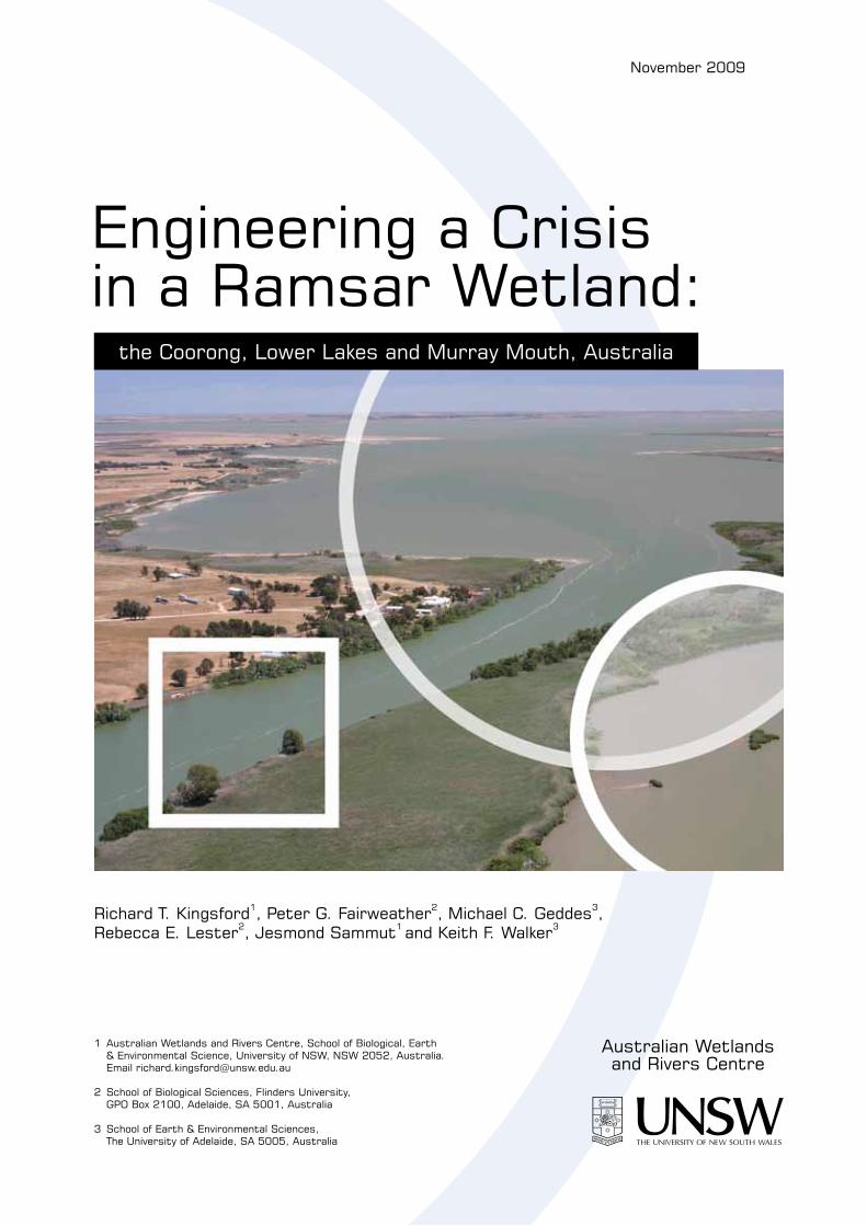
Engineering a Crisis in a Ramsar Wetland:
the Coorong, Lower Lakes and Murray Mouth, Australia
Richard T. Kingsford1, Peter G. Fairweather2, Michael C. Geddes3, Rebecca E. Lester2, Jesmond Sammut1 and Keith F. Walker3
1 Australian Wetlands and Rivers Centre, School of Biological, Earth & Environmental Science, University of NSW, NSW 2052, Australia. Email [email protected]
2 School of Biological Sciences, Flinders University, GPO Box 2100, Adelaide, SA 5001, Australia
3 School of Earth & Environmental Sciences, The University of Adelaide, SA 5005, Australia
Australian Wetlands and Rivers Centre
November 2009
Coorong, Lower Lakes and Murray Mouth: A Ramsar Wetland in Crisis 2
Table of Contents
Executive Summary ...................................................................................................................3
Recommendations......................................................................................................................4
Introduction................................................................................................................................6
The Ramsar wetland ..................................................................................................................8
Origins of the crisis..................................................................................................................13
Water resource governance ..................................................................................................13
Upstream water resource development ................................................................................15
Implications for the Ramsar wetland ...................................................................................17
Prospects ..................................................................................................................................32
Conservation obligations .........................................................................................................43
Role of science.........................................................................................................................45
Conclusions..............................................................................................................................47
Acknowledgements..................................................................................................................49
References................................................................................................................................49
Coorong, Lower Lakes and Murray Mouth: A Ramsar Wetland in Crisis 3
Executive Summary
The Coorong, Lower Lakes and Murray Mouth (CLLMM) in South Australia, at the end of
the Murray-Darling river system, were declared a Ramsar Wetland of International
Importance in 1985. Historically, the wetland has relied on inflows from the River Murray.
These began to decline after irrigated agriculture was established along the river in the late
19th Century, and seawater incursions to the CLLMM increased until construction of tidal
barrages near the mouth was completed in 1939-40. Flows continued to decline with the
building of dams upstream and increased diversions throughout the Murray-Darling Basin.
Despite the imposition of a ‘cap’ on diversions in 1995, flows were further reduced by a
decade-long drought. At least another decade of average or greater rainfall is now needed to
restore the Basin’s reservoirs to full capacity. At the Murray Mouth, long-term median annual
flows declined by 71%, with a 89-96% reduction in the driest 20% of years. Water levels in
Lake Alexandrina and Lake Albert have fallen below sea level and the salinity of the
Coorong has increased while the Murray Mouth requires continual dredging. Building weirs
and other regulatory structures, pumping water to flood the exposed areas and limestoning,
mulching and planting are addressing a threat from newly-exposed Acid Sulfate Soils (ASS)
around the lake margins. There is a plan to pump hypersaline water from the Coorong to the
ocean, to offset increasing hypersalinity in the South Lagoon caused by a lack of freshwater
inflows. A last-resort option is to abandon the wetland as a freshwater environment and open
the barrages to allow seawater into the lakes. Projected rises in sea level, associated with
global warming, suggest that the sea could invade the region in 25-50 years; if this is correct
then, there are limited prospects for long-term management of the Lakes as a freshwater
system. The ecological character of the CLLMM is changing rapidly. For example, bird
numbers have declined sharply, species of freshwater fish are threatened and diadromous
species are denied passage between the river and ocean. Calcareous masses formed by the
tubeworm Ficopotamus enigmaticus, an invasive brackish-water polychaete, have
proliferated in Lake Alexandrina and killed many freshwater turtles. There are socioeconomic
impacts on regional agriculture, boating, fishing and tourism. Governments are planning to
spend up to $2 billion on engineering interventions, planting, other mitigation programs,
community initiatives and securing water for Adelaide, as well as schemes to recover water
for the environment, but progress is slow. The short-term future of the CLLMM is in the
hands of the South Australian Government, and its long-term future will depend on how
Coorong, Lower Lakes and Murray Mouth: A Ramsar Wetland in Crisis 4
much water state and Commonwealth governments can recover for the environment via a
Basin Plan developed by the Murray-Darling Basin Authority (MDBA) in compliance with
the federal Water Act 2007. A target of an annual median flow of 3,800 GL at the barrages
represents a flow that would restore low flows (below the median) when the system is most
vulnerable to about one third of natural volume, considerably below historical levels, but
probably allowing establishment of an estuarine-freshwater ecosystem in the Lower Lakes.
This would represent an increase of about 700 GL (6%) in median annual flows at the
barrages to be managed through flow rules. The unsustainable state of the CLLMM fails to
meet a key objective of the National Water Initiative, signed by most governments in 2004 to
return overallocated systems to environmentally-sustainable levels of extraction. We endorse
some government initiatives, but have reservations about the long-term consequences of
engineering works and contend that fragmentation of the regional environment to expedite
management is not consistent with ecological science or wise natural resource management in
the long term. We also acknowledge that the quantities of water required to secure the
CLLMM are considerable, particularly given the competing demands from human consumers
and other parts of the environment. There is a perception that there is insufficient water in the
system and that the CLLMM will be deprived of flows as global climate change progresses
and eventually be inundated by rising sea levels. These risks exist but with careful
management of water resources and a level of sophistication not yet approached in the
management history of the Murray-Darling Basin, the CLLMM can be saved, albeit an
immense challenge for communities, their governments and agencies.
Coorong, Lower Lakes and Murray Mouth: A Ramsar Wetland in Crisis 5
Recommendations
1. As part of the Basin Plan, the Murray-Darling Basin Authority (MDBA) should establish
as a target, a median annual flow at the barrages of at least 3,800 GL. Such a flow would
restore low flows (below the median) when the system is most vulnerable to about one
third of natural volume. This would represent an increase of about 700 GL (6%) in
median annual flows at the barrages. This is considerably below historical levels, but
probably is a minimum requirement for an estuarine-freshwater ecosystem in the Lower
Lakes and, with management of the barrages, should restore conditions favourable for
waterbird populations in the Coorong. Flow could also be managed to ensure fish passage
and reinstate a range of floods.
2. In the short term, vigorous efforts are needed to recover fresh water for the Coorong
Lower Lakes and Murray Mouth and riparian wetlands along the Murray below Lock 1
(Blanchetown). Claims that too little water is available demonstrate the low priority given
to critical environmental needs. By implication, environmental needs on the scale of the
CLLMM can be met only if there is a major flood or sustained rainfall to fill upstream
reservoirs.
3. Water levels in Lake Alexandrina and Lake Albert should be restored to +0.3 (approx. sea
level) to +0.8 m AHD, and allowed to vary rather than being kept stable.
4. The Australian Government could commission an independent public review of scientific
knowledge of the Coorong Lower Lakes and Murray Mouth and the science that
underpins present and planned interventions (e.g. weirs). This should include a critical
appraisal of the threat represented by acid sulfate soils (ASS) and methods for mitigation,
as a basis for immediate action and later for adaptive management processes.
5. The proposal to build a ‘temporary’ weir across the Murray at Pomanda Island, at the
junction of the River Murray and Lake Alexandrina should be abandoned. This is planned
to secure a potable water supply for Adelaide and rural towns in the event of continued
drought, or highly saline water in Lake Alexandrina, but its incidental ecological effects
would be overwhelmingly negative. Part of the supply will be met by the recent decision
to construct a desalination plant at Port Stanvac, Adelaide. Also, an increase in flows
would potentially avoid any need for a weir.
6. The proposal to open the barrages and admit seawater to the Lower Lakes also should be
abandoned, as it would irrevocably change the freshwater character of the lakes. If the
proposal were implemented, a weir at Pomanda Island would be inevitable.
Coorong, Lower Lakes and Murray Mouth: A Ramsar Wetland in Crisis 6
7. Immediate steps are needed to protect environmental values in the main body of Lake
Alexandrina, which is continuing to regress and become more saline. Its decline will be
accelerated by weir construction and pumping.
8. Lake Albert should be restored and maintained as a freshwater environment, and one
option is to dig a channel between the lake and the Coorong therefore should be
abandoned.
9. There should be adaptive governance, planning and management, requiring a ‘vision’,
objectives and targets that are achievable, measurable and open to review. This should
engage all stakeholders. Development of a long-term plan has commenced, under the
aegis of the South Australian Department for Environment and Heritage, with funding
from the Australian Government.
10. For long-term management of the Coorong, Lower Lakes and Murray Mouth,
consideration should be given to forming a joint steering committee of the South
Australian Department for Environment and Heritage, the Murray-Darling Basin
Authority and the federal Department of Environment, Water, Heritage and the Arts.
11. Better hydrological data are needed for the Coorong Lower Lakes and Murray Mouth.
This should include modelling inflows under scenarios that include a more equitable
balance than prevails between the needs of the environment and human consumers.
Modelling should include options from The Living Murray initiative, the buy-back
program, water-use efficiency measures, sustainable diversion limits and Basin Plan
arrangements, using historical flows and climate change scenarios.
12. The Australian Government should reconsider the Ramsar listing of the Coorong Lower
Lakes and Murray Mouth with a view to a more realistic basis for sustainable
management, should all the values for which the wetland was nominated no longer apply.
Introduction
In 1971, Australia and other countries committed to conserve the ecological character of
significant wetlands (Ramsar Convention for Wetlands of International Importance 1971).
Despite this, many wetlands around the world are adversely affected by water resource
development (Lemly et al. 2000; Kingsford et al. 2006), including many of the 16 Ramsar-
listed sites in the Murray-Darling Basin (1,059,000 km2) (e.g. Sharley and Huggan 1996;
Kingsford 2000a; Kingsford and Thomas 1995, 2004; Arthington and Pusey 2003). About
10,000 GL are diverted each year across the Murray-Darling Basin and over 1,000 GL are
Coorong, Lower Lakes and Murray Mouth: A Ramsar Wetland in Crisis 7
lost from irrigation channel and pipe networks (CSIRO 2008b); over 95% of the diversions
are for irrigation (CSIRO 2008b). Before development, about 52% of the surface water of the
Basin reached the sea (~11,600 GL, Table 1) while the remaining 48% sustained wetlands
and floodplains and contributed to groundwater recharge (CSIRO 2008b). Adelaide (1.1
million people) depends on River Murray water for 40-60% (100GL y-1) of its annual water;
this increases to more than 90% when local rainfall is low.
The Coorong, Lower Lakes and Murray Mouth (CLLMM) is a 140,500 ha complex of
shallow lakes, streams, lagoons and wetlands in South Australia, at the terminus of the
Murray-Darling Basin (Fig. 1). The complex was recognised as a Ramsar site in 1985 for its
physical and biological diversity and spectacular populations of migratory shorebirds
(Phillips and Muller 2006). Escalating demands for water and mis-management by successive
state and federal governments have depleted inflows of fresh water. As a result, there is an
ecological crisis in the CLLMM, foreshadowed by closure of the Murray Mouth in 1981 and
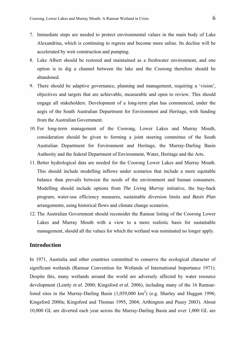
continued dredging ($5.2 million y-1) since 2002 (Plate 1). Since 2006, salinities in the North
and South lagoons of the Coorong have increased and falling water levels have exposed Acid
Sulfate Soils (ASS) around the margins of Lake Alexandrina, Lake Albert and tributary
streams (Fig. 1). The abundances of many species, including shorebirds and other waterbirds,
have declined sharply over the past two decades (e.g. Paton et al. 2009). In 2008, the South
Australian and Australian Governments formally acknowledged that the ecological character
of the CLLMM Ramsar site has changed (Article 3.2 of the Ramsar Convention).
Plate 1. Dredge maintaining the Murray Mouth (5.2 million y-1) which is critical for the health of the Coorong,
under low or no flow conditions (R.T. Kingsford, Nov 2007).
Coorong, Lower Lakes and Murray Mouth: A Ramsar Wetland in Crisis 8
In this paper, we examine the origins and effects of the crisis. We outline the ecological and
biophysical state of the CLLMM (see Brookes et al. 2009, in review), but focus primarily on
a critical examination of historical, current and future management. We consider whether
management responses are sufficient to maintain one of our more diverse and significant
wetlands, in keeping with Australia’s national and international obligations.
The Ramsar wetland
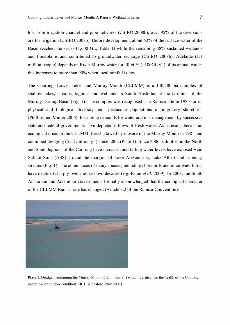
The River Murray is joined by the Darling River at Wentworth (Plate 1), New South Wales,
830 river-km from its entrance to the Southern Ocean near Goolwa, South Australia (Fig. 1).
Over the long-term, the Lower Murray receives about 90% of its annual flow from the
Murray and its tributaries in New South Wales and Victoria (Goss 2003; Walker 2006), and
the remainder is from the Darling (Breckwoldt et al. 2004). The Lower Murray fills the
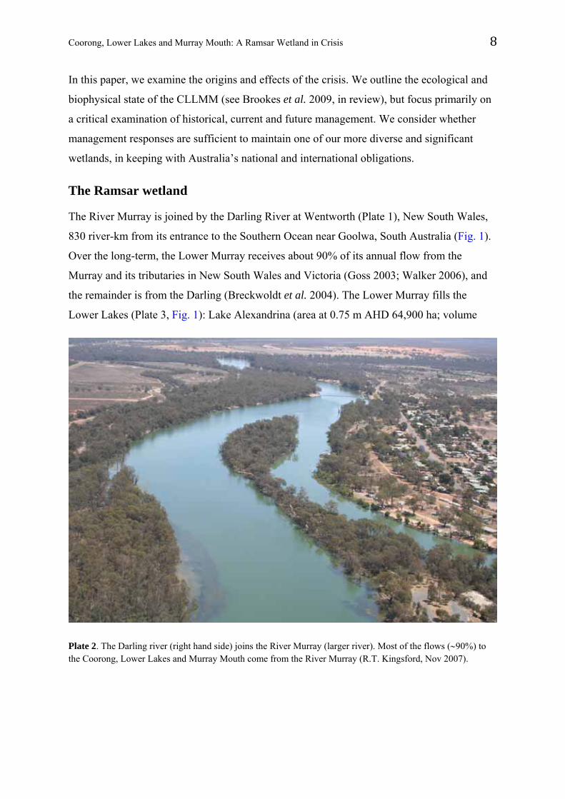
Lower Lakes (Plate 3, Fig. 1): Lake Alexandrina (area at 0.75 m AHD 64,900 ha; volume
Plate 2. The Darling river (right hand side) joins the River Murray (larger river). Most of the flows (90%) to the Coorong, Lower Lakes and Murray Mouth come from the River Murray (R.T. Kingsford, Nov 2007).
Coorong, Lower Lakes and Murray Mouth: A Ramsar Wetland in Crisis 9
Plate 3. The River Murray (left hand side) entering Lake Alexandrina (R.T. Kingsford, Nov 2009).
1,610 GL; mean depth 2.8 m) and Lake Albert (1,710 ha; 270 GL; 1.7 m). Lake Alexandrina
also receives small annual inflows from the Finniss River and Currency Creek (70 GL) and
smaller streams draining the Eastern Mount Lofty Ranges (CSIRO 2008a; Fig. 1). The data
for tributaries are imprecise because there are losses to floodplains and wetlands downstream
of the last gauges in these catchments. Flows pass through Lake Alexandrina and exit to the
Southern Ocean through the Goolwa Channel and channels between low islands to the
Coorong and Murray Mouth (Plate 4, Fig. 1).
Prior to barrage construction, Lake Alexandrina generally was fresh water (Barnett 1993; Sim
and Muller 2004; Fluin et al. 2007). This is shown by the fossilised remains of diatoms,
including salt-sensitive species, deposited in the lake sediments over the last 7,000 years
(Barnett 1993; Fluin et al. 2007). Sediment cores show that the estuarine environment was
limited to the Goolwa Channel (Fig. 1). This area was, and is, known to aboriginal
Ngarrindjeri people as ‘the meeting of the waters’. There is some evidence of minor marine
incursions into the main body of Lake Alexandrina, but less than 5% of total diatom taxa
come from estuarine or marine environments (Fluin et al. 2007). This is less frequent than
indicated by modelling of marine incursions (17% of years before development: MDBC
2008). Lake Albert also was mainly fresh water (Fluin, J. pers. comm.).
Coorong, Lower Lakes and Murray Mouth: A Ramsar Wetland in Crisis 10
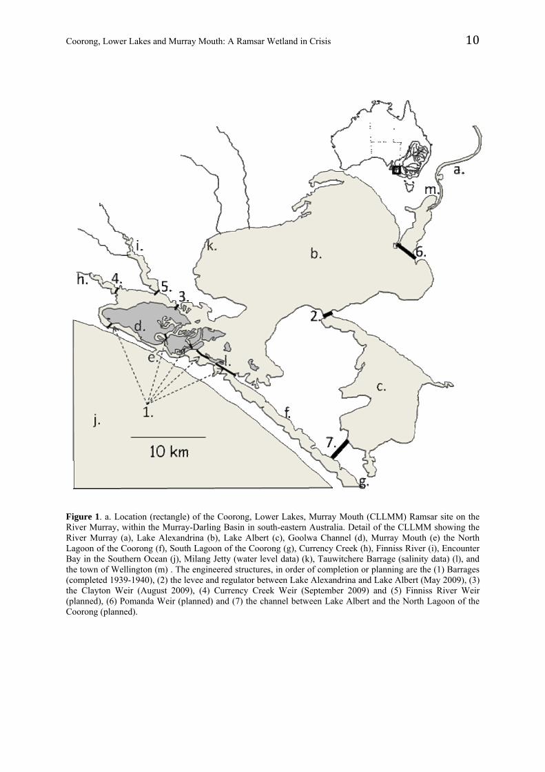
Figure 1. a. Location (rectangle) of the Coorong, Lower Lakes, Murray Mouth (CLLMM) Ramsar site on the River Murray, within the Murray-Darling Basin in south-eastern Australia. Detail of the CLLMM showing the River Murray (a), Lake Alexandrina (b), Lake Albert (c), Goolwa Channel (d), Murray Mouth (e) the North Lagoon of the Coorong (f), South Lagoon of the Coorong (g), Currency Creek (h), Finniss River (i), Encounter Bay in the Southern Ocean (j), Milang Jetty (water level data) (k), Tauwitchere Barrage (salinity data) (l), and the town of Wellington (m) . The engineered structures, in order of completion or planning are the (1) Barrages (completed 1939-1940), (2) the levee and regulator between Lake Alexandrina and Lake Albert (May 2009), (3) the Clayton Weir (August 2009), (4) Currency Creek Weir (September 2009) and (5) Finniss River Weir (planned), (6) Pomanda Weir (planned) and (7) the channel between Lake Albert and the North Lagoon of the Coorong (planned).
Coorong, Lower Lakes and Murray Mouth: A Ramsar Wetland in Crisis 11
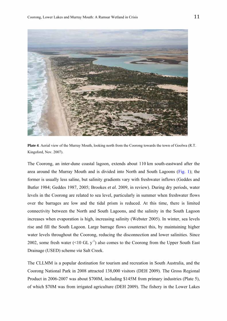
Plate 4. Aerial view of the Murray Mouth, looking north from the Coorong towards the town of Goolwa (R.T.
Kingsford, Nov. 2007).
The Coorong, an inter-dune coastal lagoon, extends about 110 km south-eastward after the
area around the Murray Mouth and is divided into North and South Lagoons (Fig. 1); the
former is usually less saline, but salinity gradients vary with freshwater inflows (Geddes and
Butler 1984; Geddes 1987, 2005; Brookes et al. 2009, in review). During dry periods, water
levels in the Coorong are related to sea level, particularly in summer when freshwater flows
over the barrages are low and the tidal prism is reduced. At this time, there is limited
connectivity between the North and South Lagoons, and the salinity in the South Lagoon
increases when evaporation is high, increasing salinity (Webster 2005). In winter, sea levels
rise and fill the South Lagoon. Large barrage flows counteract this, by maintaining higher
water levels throughout the Coorong, reducing the disconnection and lower salinities. Since
2002, some fresh water (<10 GL y-1) also comes to the Coorong from the Upper South East
Drainage (USED) scheme via Salt Creek.
The CLLMM is a popular destination for tourism and recreation in South Australia, and the
Coorong National Park in 2008 attracted 138,000 visitors (DEH 2009). The Gross Regional
Product in 2006-2007 was about $700M, including $145M from primary industries (Plate 5),
of which $70M was from irrigated agriculture (DEH 2009). The fishery in the Lower Lakes
Coorong, Lower Lakes and Murray Mouth: A Ramsar Wetland in Crisis 12
and the Coorong involves 37 fishers and produces at least $5.5 million per annum (Plate 6,
Hera-Singh 2002, EconSearch 2006). The recreational boating industry in 2003 had an
estimated value of $14.2 million, employing 140 people (Helicon 2004). Changes in the
CLLMM have had major social and economic effects in the region, including reductions in
dairy farms and livestock numbers (Plate 5), and downturns in wine production and the
irrigation industry generally. Communities are concentrated in the towns of Goolwa, Clayton,
Miland and Meningie (Plate 7). For the Ngarrindjeri, traditional inhabitants of the country,
there is a deep sense of loss because the region is central to their culture (Ngarrindjeri Tendi
2006).
Plate 5. Cattle around the margins of Lake Alexandrina rely on the freshwater lake for drinking water (R.T. Kingsford, Nov. 2009).
Plate 6. Fishing is one of the important economic drivers of the Coorong, Lower Lakes and Murray Mouth
region (R.T. Kingsford Nov. 2009).
Coorong, Lower Lakes and Murray Mouth: A Ramsar Wetland in Crisis 13
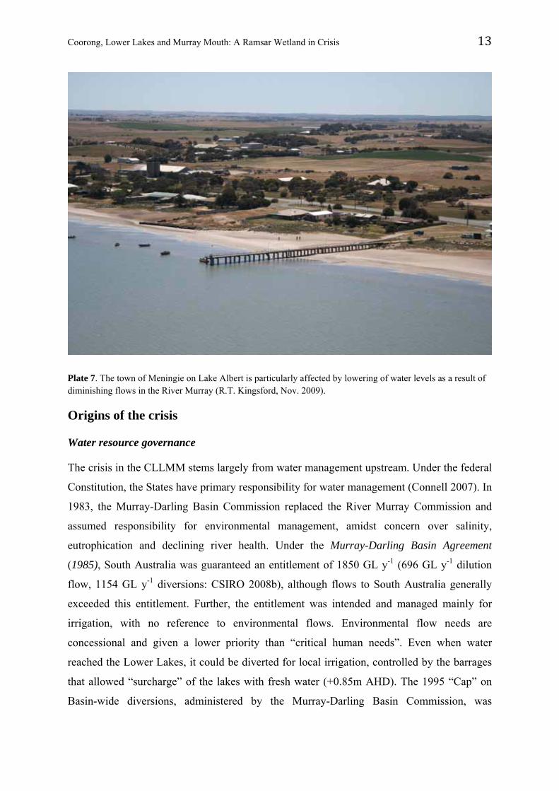
Plate 7. The town of Meningie on Lake Albert is particularly affected by lowering of water levels as a result of diminishing flows in the River Murray (R.T. Kingsford, Nov. 2009).
Origins of the crisis
Water resource governance
The crisis in the CLLMM stems largely from water management upstream. Under the federal
Constitution, the States have primary responsibility for water management (Connell 2007). In
1983, the Murray-Darling Basin Commission replaced the River Murray Commission and
assumed responsibility for environmental management, amidst concern over salinity,
eutrophication and declining river health. Under the Murray-Darling Basin Agreement
(1985), South Australia was guaranteed an entitlement of 1850 GL y-1 (696 GL y-1 dilution
flow, 1154 GL y-1 diversions: CSIRO 2008b), although flows to South Australia generally
exceeded this entitlement. Further, the entitlement was intended and managed mainly for
irrigation, with no reference to environmental flows. Environmental flow needs are
concessional and given a lower priority than “critical human needs”. Even when water
reached the Lower Lakes, it could be diverted for local irrigation, controlled by the barrages
that allowed “surcharge” of the lakes with fresh water (+0.85m AHD). The 1995 “Cap” on
Basin-wide diversions, administered by the Murray-Darling Basin Commission, was
Coorong, Lower Lakes and Murray Mouth: A Ramsar Wetland in Crisis 14
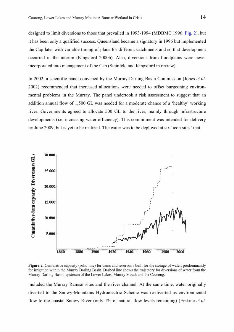
designed to limit diversions to those that prevailed in 1993-1994 (MDBMC 1996: Fig. 2), but
it has been only a qualified success. Queensland became a signatory in 1996 but implemented
the Cap later with variable timing of plans for different catchments and so that development
occurred in the interim (Kingsford 2000b). Also, diversions from floodplains were never
incorporated into management of the Cap (Steinfeld and Kingsford in review).
In 2002, a scientific panel convened by the Murray-Darling Basin Commission (Jones et al.
2002) recommended that increased allocations were needed to offset burgeoning environ-
mental problems in the Murray. The panel undertook a risk assessment to suggest that an
addition annual flow of 1,500 GL was needed for a moderate chance of a ‘healthy’ working
river. Governments agreed to allocate 500 GL to the river, mainly through infrastructure
developments (i.e. increasing water efficiency). This commitment was intended for delivery
by June 2009, but is yet to be realized. The water was to be deployed at six ‘icon sites’ that
Figure 2. Cumulative capacity (solid line) for dams and reservoirs built for the storage of water, predominantly for irrigation within the Murray Darling Basin. Dashed line shows the trajectory for diversions of water from the Murray-Darling Basin, upstream of the Lower Lakes, Murray Mouth and the Coorong.
included the Murray Ramsar sites and the river channel. At the same time, water originally
diverted to the Snowy-Mountains Hydroelectric Scheme was re-diverted as environmental
flow to the coastal Snowy River (only 1% of natural flow levels remaining) (Erskine et al.
Coorong, Lower Lakes and Murray Mouth: A Ramsar Wetland in Crisis 15
1999). Governments agreed to restore 21% of mean annual flow in the Snowy River, with an
interim target of 15% by 2009, but this commitment also is still to be realised.
Drought ushered in the new millennium, and still persists (2009) with an intensity rivaling the
worst historical droughts, but the effects have been deepened by the entrenched requirements
of irrigation and other consumers. In 2008, the Australian Government announced a $12.9
billion plan, Water for the Future (Wong 2008), to complement reforms introduced by the
Council of Australian Governments (COAG) in 1994 and the National Water Initiative
(NWI) in 2004. The Water Act 2007 became effective in March 2008, establishing the
Murray-Darling Basin Authority (MDBA) in place of the Murray-Darling Basin
Commission. There was $5.8 billion dedicated to improved water-use efficiency and $3.1
billion to ‘buy back’ irrigation entitlements for use by the Commonwealth Environmental
Water Holder in the federal Department of Environment, Water, Heritage and the Arts. Under
the Act, the MDBA is responsible for monitoring water resources, reviewing state water-
resource plans, engaging with the community and producing a Basin Plan that, by 2011, will
set environmentally-sustainable limits on diversions, ensuring sufficient water for ‘critical
human needs’.
Upstream water resource development
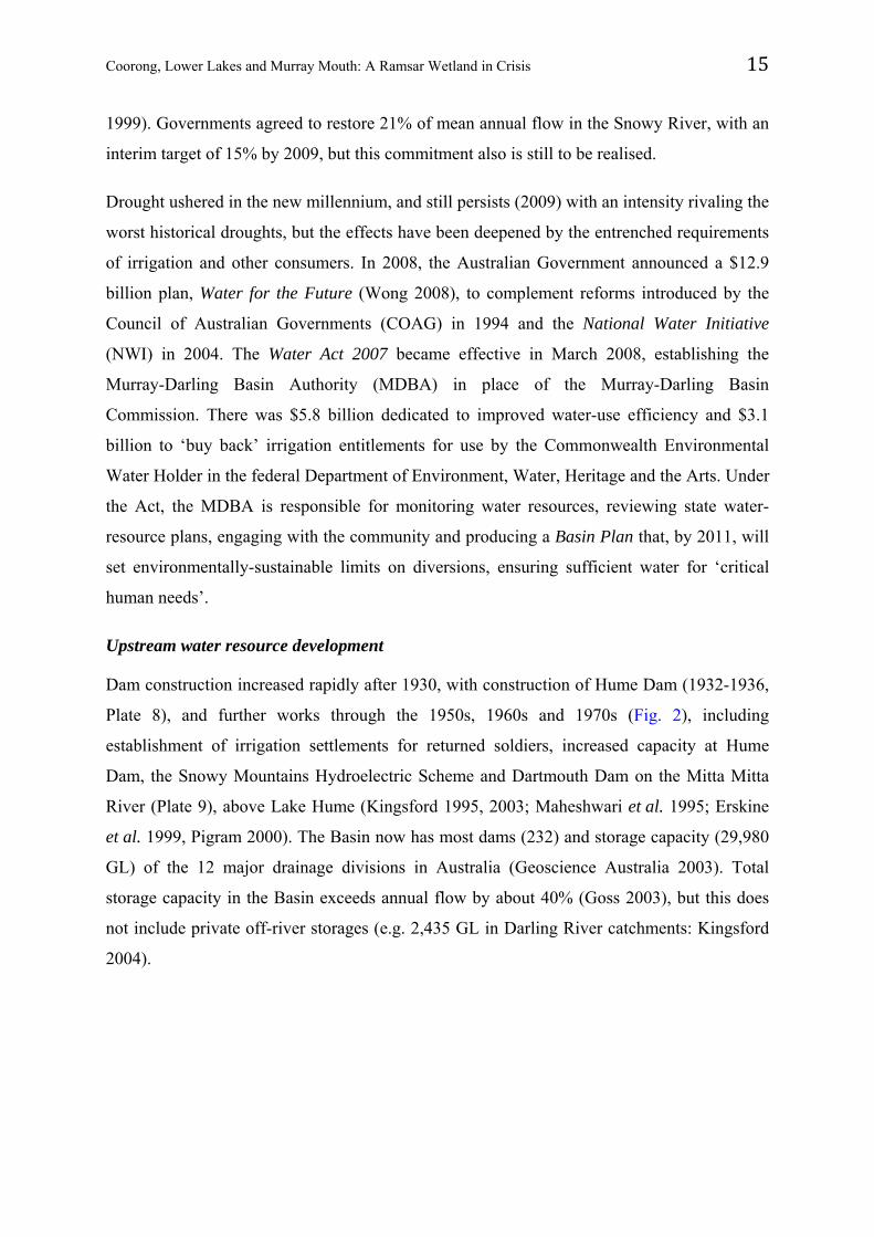
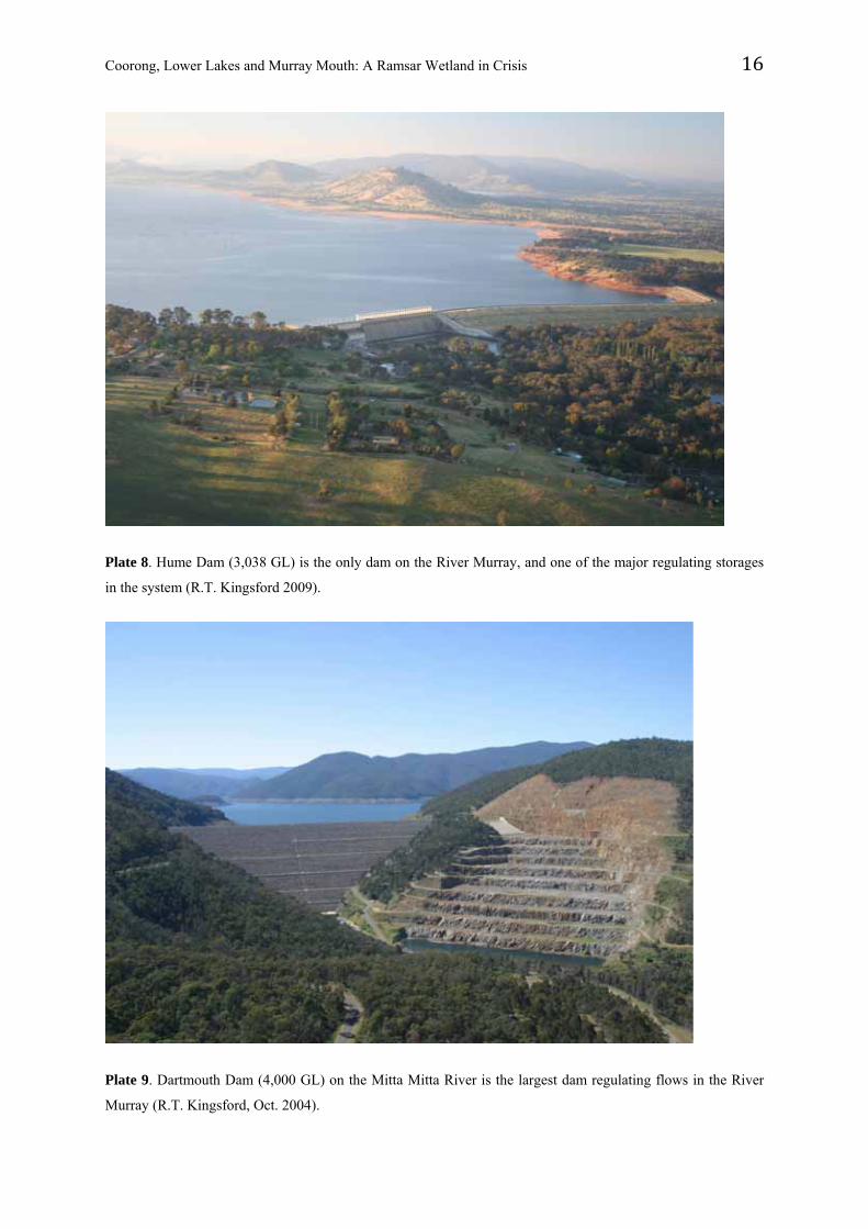
Dam construction increased rapidly after 1930, with construction of Hume Dam (1932-1936,
Plate 8), and further works through the 1950s, 1960s and 1970s (Fig. 2), including
establishment of irrigation settlements for returned soldiers, increased capacity at Hume
Dam, the Snowy Mountains Hydroelectric Scheme and Dartmouth Dam on the Mitta Mitta
River (Plate 9), above Lake Hume (Kingsford 1995, 2003; Maheshwari et al. 1995; Erskine
et al. 1999, Pigram 2000). The Basin now has most dams (232) and storage capacity (29,980
GL) of the 12 major drainage divisions in Australia (Geoscience Australia 2003). Total
storage capacity in the Basin exceeds annual flow by about 40% (Goss 2003), but this does
not include private off-river storages (e.g. 2,435 GL in Darling River catchments: Kingsford
2004).
Coorong, Lower Lakes and Murray Mouth: A Ramsar Wetland in Crisis 16
Plate 8. Hume Dam (3,038 GL) is the only dam on the River Murray, and one of the major regulating storages
in the system (R.T. Kingsford 2009).
Plate 9. Dartmouth Dam (4,000 GL) on the Mitta Mitta River is the largest dam regulating flows in the River
Murray (R.T. Kingsford, Oct. 2004).
Coorong, Lower Lakes and Murray Mouth: A Ramsar Wetland in Crisis 17
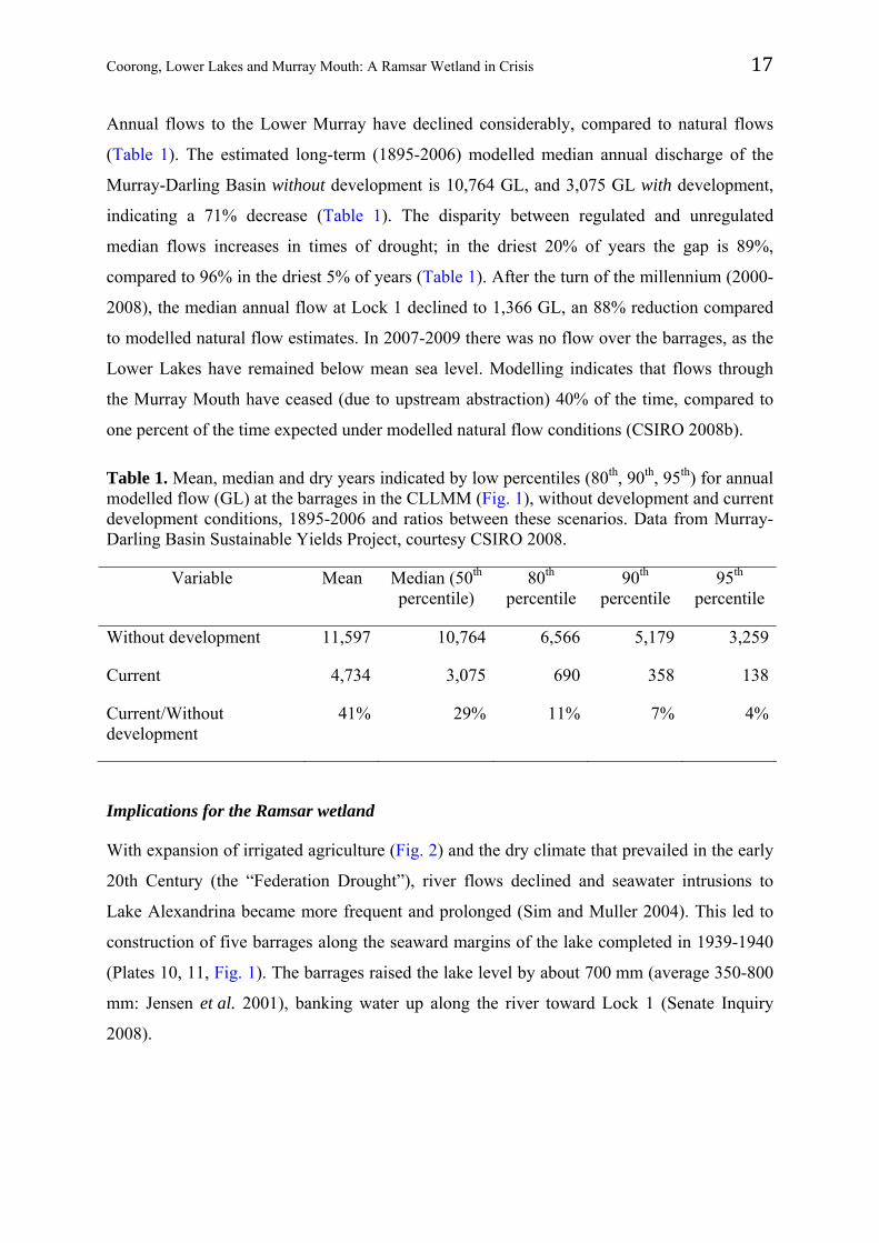
Annual flows to the Lower Murray have declined considerably, compared to natural flows
(Table 1). The estimated long-term (1895-2006) modelled median annual discharge of the
Murray-Darling Basin without development is 10,764 GL, and 3,075 GL with development,
indicating a 71% decrease (Table 1). The disparity between regulated and unregulated
median flows increases in times of drought; in the driest 20% of years the gap is 89%,
compared to 96% in the driest 5% of years (Table 1). After the turn of the millennium (2000-
2008), the median annual flow at Lock 1 declined to 1,366 GL, an 88% reduction compared
to modelled natural flow estimates. In 2007-2009 there was no flow over the barrages, as the
Lower Lakes have remained below mean sea level. Modelling indicates that flows through
the Murray Mouth have ceased (due to upstream abstraction) 40% of the time, compared to
one percent of the time expected under modelled natural flow conditions (CSIRO 2008b).
Table 1. Mean, median and dry years indicated by low percentiles (80th, 90th, 95th) for annual modelled flow (GL) at the barrages in the CLLMM (Fig. 1), without development and current development conditions, 1895-2006 and ratios between these scenarios. Data from Murray-Darling Basin Sustainable Yields Project, courtesy CSIRO 2008.
Variable Mean Median (50th percentile)
80th percentile
90th percentile
95th percentile
Without development 11,597 10,764 6,566 5,179 3,259
Current 4,734 3,075 690 358 138
Current/Without development
41% 29% 11% 7% 4%
Implications for the Ramsar wetland
With expansion of irrigated agriculture (Fig. 2) and the dry climate that prevailed in the early
20th Century (the “Federation Drought”), river flows declined and seawater intrusions to
Lake Alexandrina became more frequent and prolonged (Sim and Muller 2004). This led to
construction of five barrages along the seaward margins of the lake completed in 1939-1940
(Plates 10, 11, Fig. 1). The barrages raised the lake level by about 700 mm (average 350-800
mm: Jensen et al. 2001), banking water up along the river toward Lock 1 (Senate Inquiry
2008).
Coorong, Lower Lakes and Murray Mouth: A Ramsar Wetland in Crisis 18
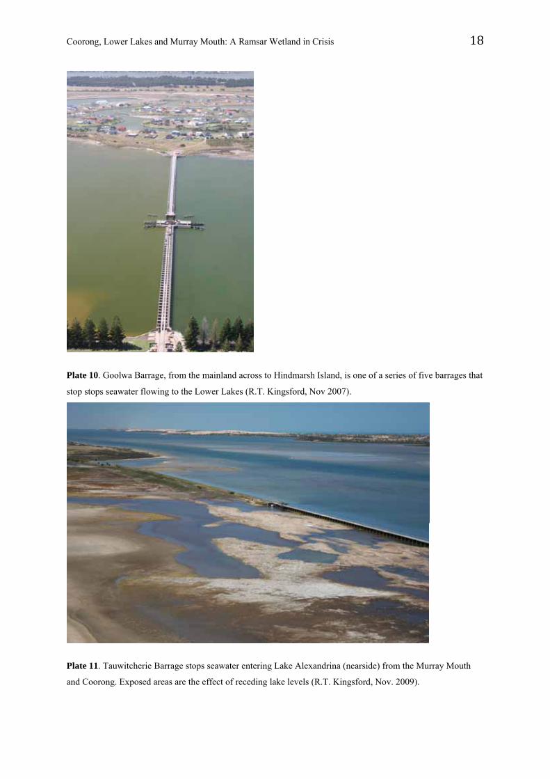
Plate 10. Goolwa Barrage, from the mainland across to Hindmarsh Island, is one of a series of five barrages that
stop stops seawater flowing to the Lower Lakes (R.T. Kingsford, Nov 2007).
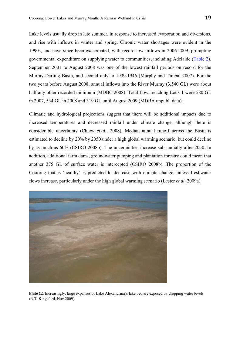
Plate 11. Tauwitcherie Barrage stops seawater entering Lake Alexandrina (nearside) from the Murray Mouth
and Coorong. Exposed areas are the effect of receding lake levels (R.T. Kingsford, Nov. 2009).
Coorong, Lower Lakes and Murray Mouth: A Ramsar Wetland in Crisis 19
Lake levels usually drop in late summer, in response to increased evaporation and diversions,
and rise with inflows in winter and spring. Chronic water shortages were evident in the
1990s, and have since been exacerbated, with record low inflows in 2006-2009, prompting
governmental expenditure on supplying water to communities, including Adelaide (Table 2).
September 2001 to August 2008 was one of the lowest rainfall periods on record for the
Murray-Darling Basin, and second only to 1939-1946 (Murphy and Timbal 2007). For the
two years before August 2008, annual inflows into the River Murray (3,540 GL) were about
half any other recorded minimum (MDBC 2008). Total flows reaching Lock 1 were 580 GL
in 2007, 534 GL in 2008 and 319 GL until August 2009 (MDBA unpubl. data).
Climatic and hydrological projections suggest that there will be additional impacts due to
increased temperatures and decreased rainfall under climate change, although there is
considerable uncertainty (Chiew et al., 2008). Median annual runoff across the Basin is
estimated to decline by 20% by 2050 under a high global warming scenario, but could decline
by as much as 60% (CSIRO 2008b). The uncertainties increase substantially after 2050. In
addition, additional farm dams, groundwater pumping and plantation forestry could mean that
another 375 GL of surface water is intercepted (CSIRO 2008b). The proportion of the
Coorong that is ‘healthy’ is predicted to decrease with climate change, unless freshwater
flows increase, particularly under the high global warming scenario (Lester et al. 2009a).
Plate 12. Increasingly, large expanses of Lake Alexandrina’s lake bed are exposed by dropping water levels (R.T. Kingsford, Nov 2009).
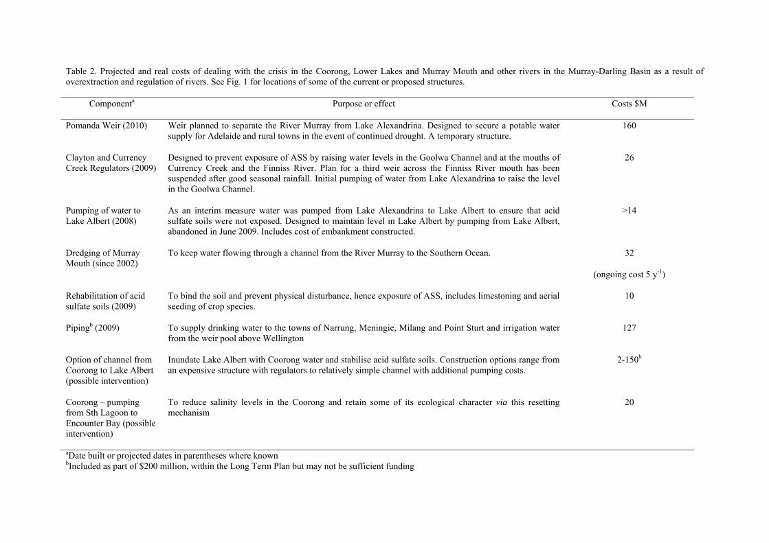
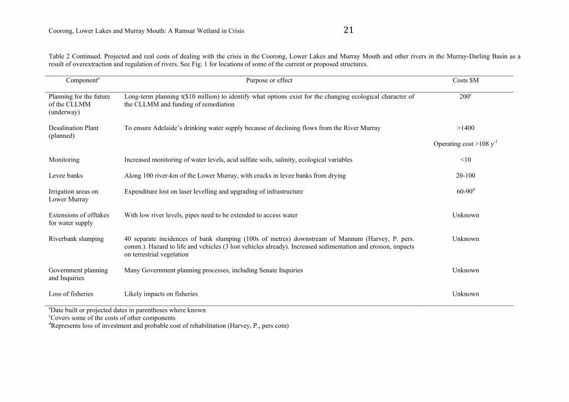
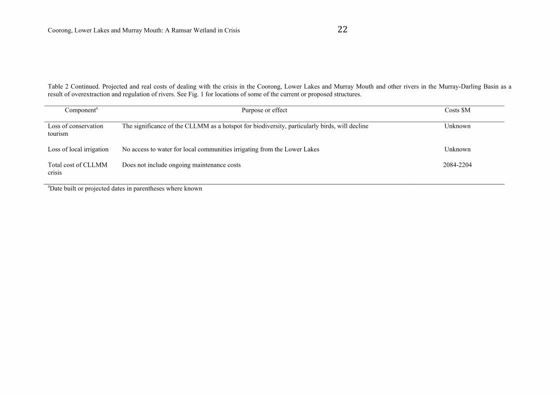
Table 2. Projected and real costs of dealing with the crisis in the Coorong, Lower Lakes and Murray Mouth and other rivers in the Murray-Darling Basin as a result of overextraction and regulation of rivers. See Fig. 1 for locations of some of the current or proposed structures.
Componenta Purpose or effect Costs $M
Pomanda Weir (2010) Weir planned to separate the River Murray from Lake Alexandrina. Designed to secure a potable water supply for Adelaide and rural towns in the event of continued drought. A temporary structure.
160
Clayton and Currency Creek Regulators (2009)
Designed to prevent exposure of ASS by raising water levels in the Goolwa Channel and at the mouths of Currency Creek and the Finniss River. Plan for a third weir across the Finniss River mouth has been suspended after good seasonal rainfall. Initial pumping of water from Lake Alexandrina to raise the level in the Goolwa Channel.
26
Pumping of water to Lake Albert (2008)
As an interim measure water was pumped from Lake Alexandrina to Lake Albert to ensure that acid sulfate soils were not exposed. Designed to maintain level in Lake Albert by pumping from Lake Albert, abandoned in June 2009. Includes cost of embankment constructed.
>14
Dredging of Murray Mouth (since 2002)
To keep water flowing through a channel from the River Murray to the Southern Ocean. 32
(ongoing cost 5 y-1)
Rehabilitation of acid sulfate soils (2009)
To bind the soil and prevent physical disturbance, hence exposure of ASS, includes limestoning and aerial seeding of crop species.
10
Pipingb (2009) To supply drinking water to the towns of Narrung, Meningie, Milang and Point Sturt and irrigation water from the weir pool above Wellington
127
Option of channel from Coorong to Lake Albert (possible intervention)
Inundate Lake Albert with Coorong water and stabilise acid sulfate soils. Construction options range from an expensive structure with regulators to relatively simple channel with additional pumping costs.
2-150b
Coorong – pumping from Sth Lagoon to Encounter Bay (possible intervention)
To reduce salinity levels in the Coorong and retain some of its ecological character via this resetting mechanism
20
aDate built or projected dates in parentheses where known bIncluded as part of $200 million, within the Long Term Plan but may not be sufficient funding
Coorong, Lower Lakes and Murray Mouth: A Ramsar Wetland in Crisis 21
Table 2 Continued. Projected and real costs of dealing with the crisis in the Coorong, Lower Lakes and Murray Mouth and other rivers in the Murray-Darling Basin as a result of overextraction and regulation of rivers. See Fig. 1 for locations of some of the current or proposed structures.
Componenta Purpose or effect Costs $M
Planning for the future of the CLLMM (underway)
Long-term planning t($10 million) to identify what options exist for the changing ecological character of the CLLMM and funding of remediation
200c
Desalination Plant (planned)
To ensure Adelaide’s drinking water supply because of declining flows from the River Murray >1400
Operating cost >108 y-1
Monitoring Increased monitoring of water levels, acid sulfate soils, salinity, ecological variables <10
Levee banks Along 100 river-km of the Lower Murray, with cracks in levee banks from drying 20-100
Irrigation areas on Lower Murray
Expenditure lost on laser levelling and upgrading of infrastructure 60-90d
Extensions of offtakes for water supply
With low river levels, pipes need to be extended to access water Unknown
Riverbank slumping 40 separate incidences of bank slumping (100s of metres) downstream of Mannum (Harvey, P. pers. comm.). Hazard to life and vehicles (3 lost vehicles already). Increased sedimentation and erosion, impacts on terrestrial vegetation
Unknown
Government planning and Inquiries
Many Government planning processes, including Senate Inquiries Unknown
Loss of fisheries Likely impacts on fisheries Unknown
aDate built or projected dates in parentheses where known cCovers some of the costs of other components
dRepresents loss of investment and probable cost of rehabilitation (Harvey, P., pers com)
Coorong, Lower Lakes and Murray Mouth: A Ramsar Wetland in Crisis 22
Table 2 Continued. Projected and real costs of dealing with the crisis in the Coorong, Lower Lakes and Murray Mouth and other rivers in the Murray-Darling Basin as a result of overextraction and regulation of rivers. See Fig. 1 for locations of some of the current or proposed structures.
Componenta Purpose or effect Costs $M
Loss of conservation tourism
The significance of the CLLMM as a hotspot for biodiversity, particularly birds, will decline Unknown
Loss of local irrigation No access to water for local communities irrigating from the Lower Lakes Unknown
Total cost of CLLMM crisis
Does not include ongoing maintenance costs 2084-2204
aDate built or projected dates in parentheses where known
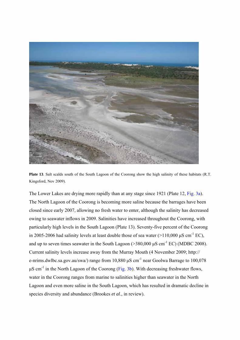
Plate 13. Salt scalds south of the South Lagoon of the Coorong show the high salinity of these habitats (R.T.
Kingsford, Nov 2009).
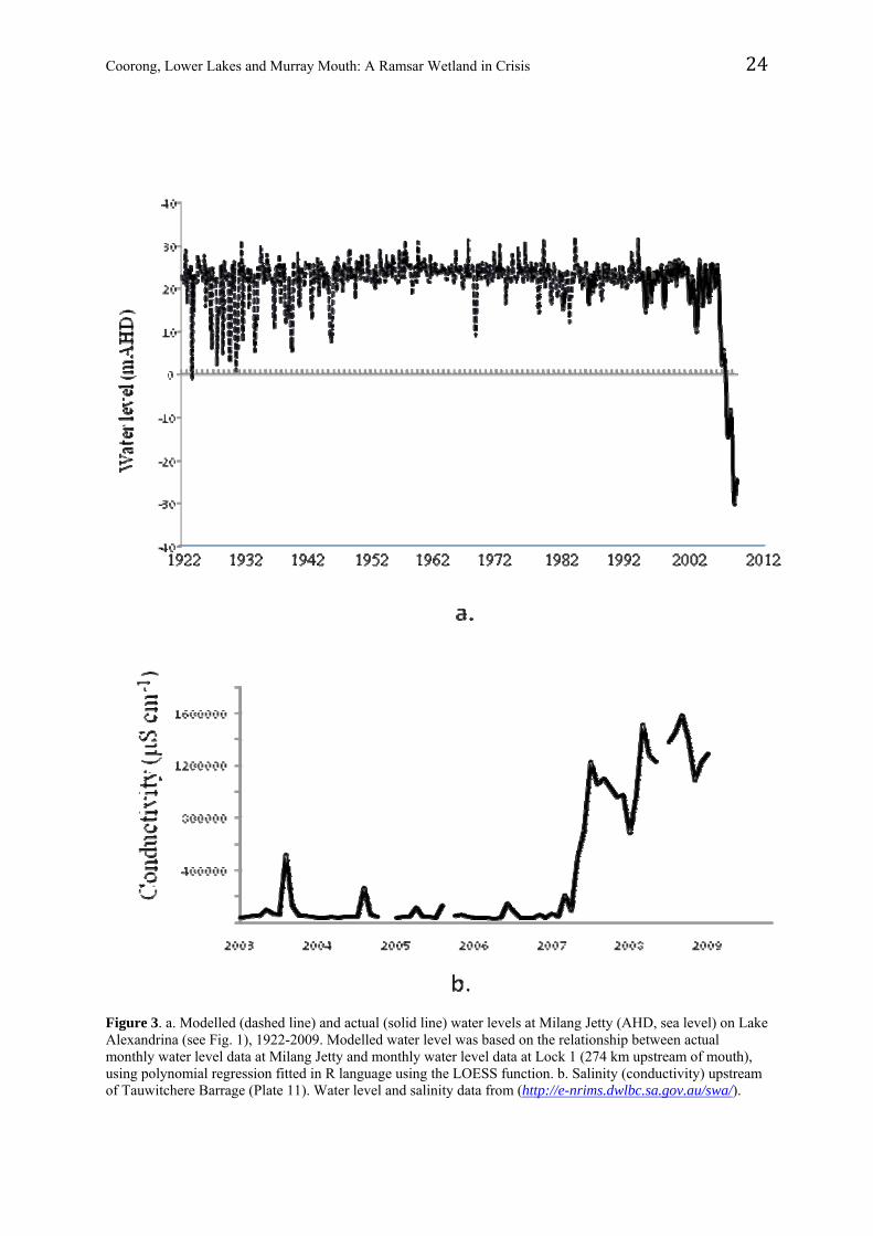
The Lower Lakes are drying more rapidly than at any stage since 1921 (Plate 12, Fig. 3a).
The North Lagoon of the Coorong is becoming more saline because the barrages have been
closed since early 2007, allowing no fresh water to enter, although the salinity has decreased
owing to seawater inflows in 2009. Salinities have increased throughout the Coorong, with
particularly high levels in the South Lagoon (Plate 13). Seventy-five percent of the Coorong
in 2005-2006 had salinity levels at least double those of sea water (>110,000 μS cm-1 EC),
and up to seven times seawater in the South Lagoon (>380,000 μS cm-1 EC) (MDBC 2008).
Current salinity levels increase away from the Murray Mouth (4 November 2009; http://
e-nrims.dwlbc.sa.gov.au/swa/) range from 10,880 μS cm-1 near Goolwa Barrage to 100,078
μS cm-1 in the North Lagoon of the Coorong (Fig. 3b). With decreasing freshwater flows,
water in the Coorong ranges from marine to salinities higher than seawater in the North
Lagoon and even more saline in the South Lagoon, which has resulted in dramatic decline in
species diversity and abundance (Brookes et al., in review).
Coorong, Lower Lakes and Murray Mouth: A Ramsar Wetland in Crisis 24
Figure 3. a. Modelled (dashed line) and actual (solid line) water levels at Milang Jetty (AHD, sea level) on Lake Alexandrina (see Fig. 1), 1922-2009. Modelled water level was based on the relationship between actual monthly water level data at Milang Jetty and monthly water level data at Lock 1 (274 km upstream of mouth), using polynomial regression fitted in R language using the LOESS function. b. Salinity (conductivity) upstream of Tauwitchere Barrage (Plate 11). Water level and salinity data from (http://e-nrims.dwlbc.sa.gov.au/swa/).
Coorong, Lower Lakes and Murray Mouth: A Ramsar Wetland in Crisis 25
The biota of the Lakes is changing to salt-tolerant species, particularly estuarine and marine
species. The CLLMM formerly supported diverse communities of plants, waterbirds, fish and
other animals, including endangered species (Phillips and Muller 2006). There were 117
aquatic and floodplain species recorded during surveys in 2008/ 2009 of the Lower Lakes 33
species less than during similar surveys in 2004/2005 (Marsland and Nicol 2009).while
macrophyte abundance in the Coorong has declined precipitously (Rogers and Paton 2009a,b;
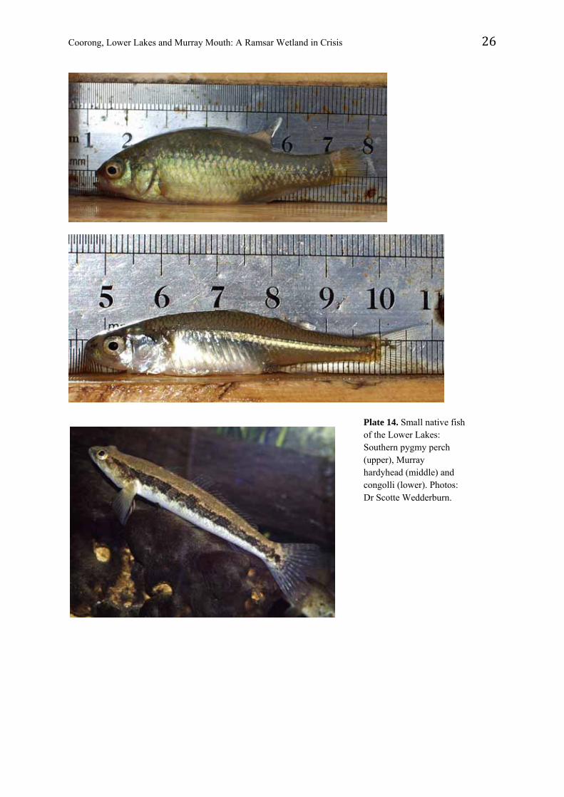
Brookes et al. 2009, in review). The native fish community (18 species: Wedderburn and
Hammer 2003) is changing as freshwater species decline (Wedderburn and Barnes 2009). In
2002, three species (Murray hardyhead Craterocephalus fluviatilis, Yarra pygmy perch
Nannoperca obscura, southern pygmy perch N. australis) lived in areas where there were
aquatic plants (Plate 14, Hammer et al. 2002). The Yarra pygmy perch is now considered
extinct in the wild in the Murray-Darling Basin, the other two species occur only in small
remnant pockets and the Murray hardyhead faces imminent extinction (Wedderburn and
Barnes 2009). Diadromous fish, including common galaxias Galaxias maculatus and congolli
Pseudaphritis urvillii (Plate 14), can no longer migrate between marine and freshwater
environments; few galaxias and no congolli were captured in surveys in March 2009
(Wedderburn and Barnes 2009). There is a successful captive maintenance program for a
number of rare small-bodied species which are surviving well in captivity.
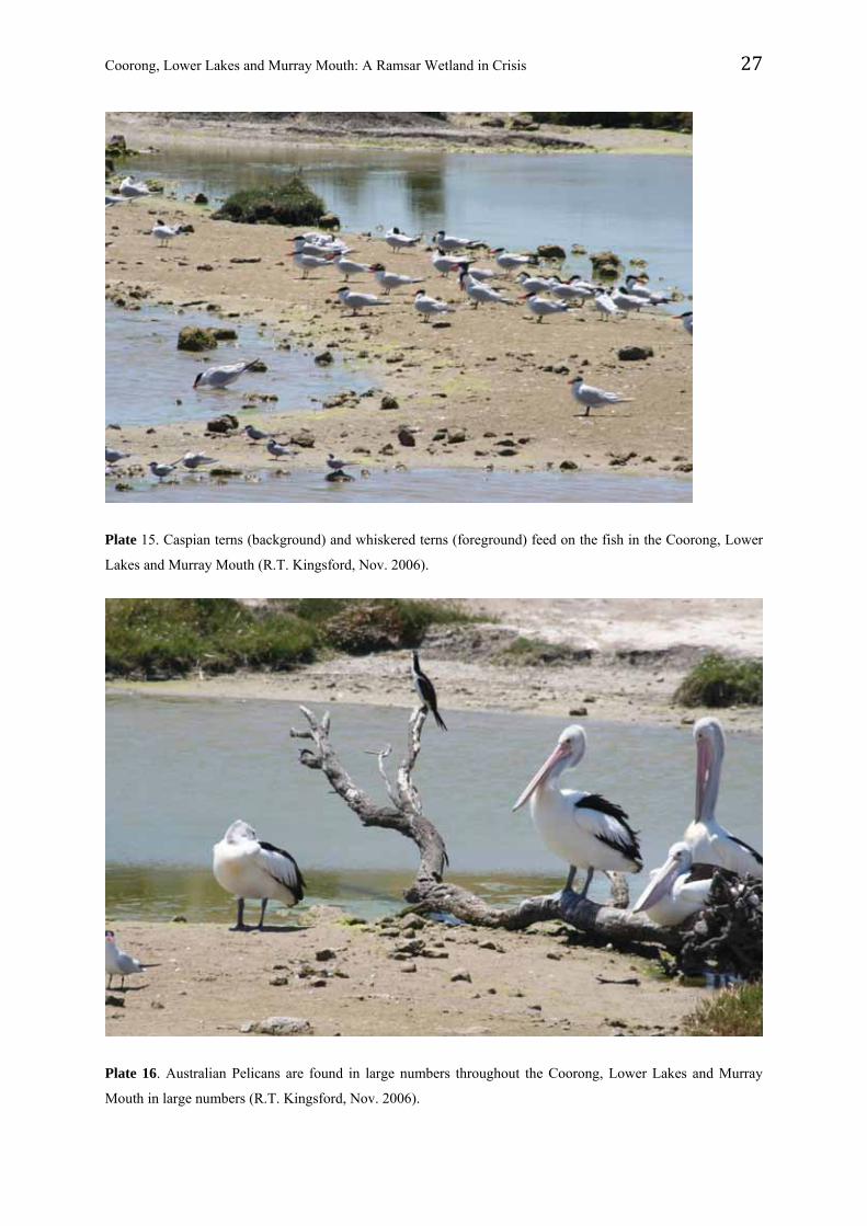
In the Coorong, migratory shorebirds and herbivorous and piscivorous waterbirds have
declined as salinities have risen (Paton et al. 2009; Rogers and Paton 2009a,b). Estimates of
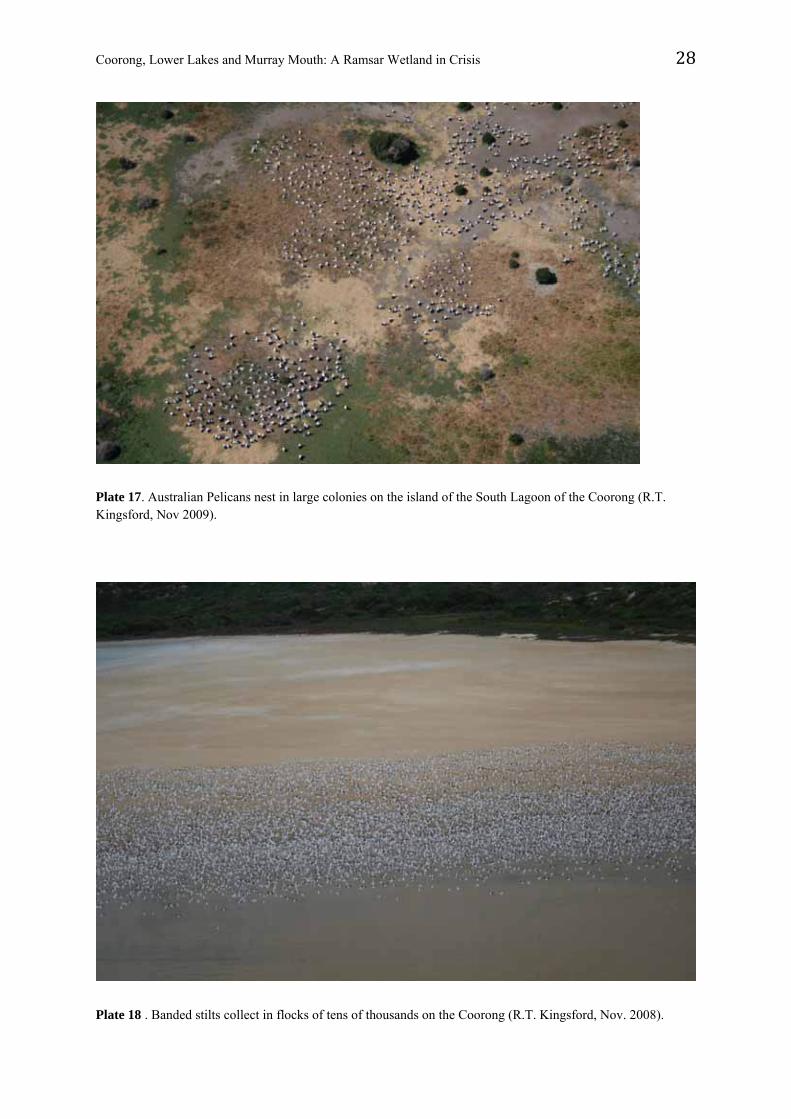
waterbirds for the CLLMM in November of 2007 were 250,000 (Plates 15-18), including 42
species identified during aerial surveys (Kingsford and Porter 2008), but in a similar survey
in 2008 the numbers had declined by 48% (Kingsford and Porter 2009). As well, there were
more estuarine species of waterbirds (shorebirds, terns) in the Lower Lakes in 2008 than
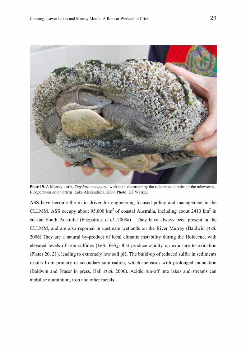
2007. The marine tubeworm Ficopotamus enigmaticus (Serpulidae) is invading previously-
freshwater habitats, forming dense masses of calcareous tubes on hard surfaces (including
animals with shells), killing freshwater mussels, turtles (Plate 19) and other organisms.
Coorong, Lower Lakes and Murray Mouth: A Ramsar Wetland in Crisis 26
Plate 14. Small native fish of the Lower Lakes: Southern pygmy perch (upper), Murray hardyhead (middle) and congolli (lower). Photos: Dr Scotte Wedderburn.
Coorong, Lower Lakes and Murray Mouth: A Ramsar Wetland in Crisis 27
Plate 15. Caspian terns (background) and whiskered terns (foreground) feed on the fish in the Coorong, Lower
Lakes and Murray Mouth (R.T. Kingsford, Nov. 2006).
Plate 16. Australian Pelicans are found in large numbers throughout the Coorong, Lower Lakes and Murray
Mouth in large numbers (R.T. Kingsford, Nov. 2006).
Coorong, Lower Lakes and Murray Mouth: A Ramsar Wetland in Crisis 28
Plate 17. Australian Pelicans nest in large colonies on the island of the South Lagoon of the Coorong (R.T. Kingsford, Nov 2009).
Plate 18 . Banded stilts collect in flocks of tens of thousands on the Coorong (R.T. Kingsford, Nov. 2008).
Coorong, Lower Lakes and Murray Mouth: A Ramsar Wetland in Crisis 29
Plate 19. A Murray turtle, Emydura macquarii, with shell encrusted by the calcareous tubules of the tubeworm, Ficopotamus enigmaticus. Lake Alexandrina, 2009. Photo: KF Walker.
ASS have become the main driver for engineering-focused policy and management in the
CLLMM. ASS occupy about 95,000 km2 of coastal Australia, including about 2410 km2 in
coastal South Australia (Fitzpatrick et al. 2008a). They have always been present in the
CLLMM, and are also reported in upstream wetlands on the River Murray (Baldwin et al.
2006).They are a natural by-product of local climatic instability during the Holocene, with
elevated levels of iron sulfides (FeS; FeS2) that produce acidity on exposure to oxidation
(Plates 20, 21), leading to extremely low soil pH. The build-up of reduced sulfur in sediments
results from primary or secondary salinisation, which increases with prolonged inundation
(Baldwin and Fraser in press, Hall et al. 2006). Acidic run-off into lakes and streams can
mobilise aluminium, iron and other metals.
Coorong, Lower Lakes and Murray Mouth: A Ramsar Wetland in Crisis 30
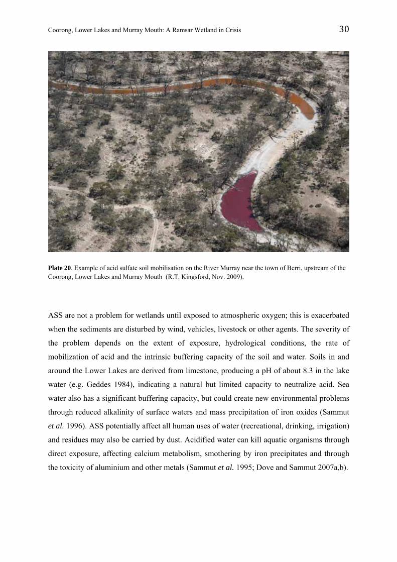
Plate 20. Example of acid sulfate soil mobilisation on the River Murray near the town of Berri, upstream of the Coorong, Lower Lakes and Murray Mouth (R.T. Kingsford, Nov. 2009).
ASS are not a problem for wetlands until exposed to atmospheric oxygen; this is exacerbated
when the sediments are disturbed by wind, vehicles, livestock or other agents. The severity of
the problem depends on the extent of exposure, hydrological conditions, the rate of
mobilization of acid and the intrinsic buffering capacity of the soil and water. Soils in and
around the Lower Lakes are derived from limestone, producing a pH of about 8.3 in the lake
water (e.g. Geddes 1984), indicating a natural but limited capacity to neutralize acid. Sea
water also has a significant buffering capacity, but could create new environmental problems
through reduced alkalinity of surface waters and mass precipitation of iron oxides (Sammut
et al. 1996). ASS potentially affect all human uses of water (recreational, drinking, irrigation)
and residues may also be carried by dust. Acidified water can kill aquatic organisms through
direct exposure, affecting calcium metabolism, smothering by iron precipitates and through
the toxicity of aluminium and other metals (Sammut et al. 1995; Dove and Sammut 2007a,b).
Coorong, Lower Lakes and Murray Mouth: A Ramsar Wetland in Crisis 31
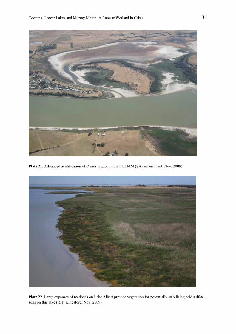
Plate 21. Advanced acidification of Dunns lagoon in the CLLMM (SA Government, Nov. 2009).
Plate 22. Large expanses of reedbeds on Lake Albert provide vegetation for potentially stabilising acid sulfate soils on this lake (R.T. Kingsford, Nov. 2009).
Coorong, Lower Lakes and Murray Mouth: A Ramsar Wetland in Crisis 32
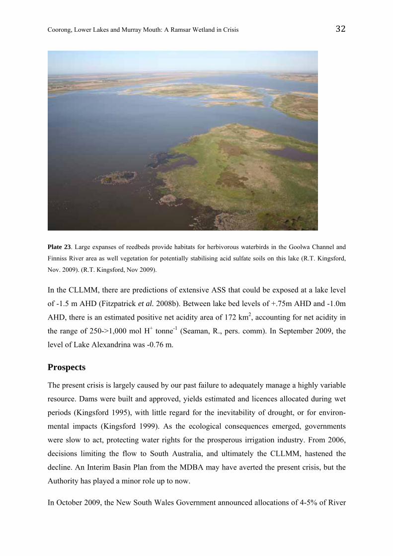
Plate 23. Large expanses of reedbeds provide habitats for herbivorous waterbirds in the Goolwa Channel and
Finniss River area as well vegetation for potentially stabilising acid sulfate soils on this lake (R.T. Kingsford,
Nov. 2009). (R.T. Kingsford, Nov 2009).
In the CLLMM, there are predictions of extensive ASS that could be exposed at a lake level
of -1.5 m AHD (Fitzpatrick et al. 2008b). Between lake bed levels of +.75m AHD and -1.0m
AHD, there is an estimated positive net acidity area of 172 km2, accounting for net acidity in
the range of 250->1,000 mol H+ tonne-1 (Seaman, R., pers. comm). In September 2009, the
level of Lake Alexandrina was -0.76 m.
Prospects
The present crisis is largely caused by our past failure to adequately manage a highly variable
resource. Dams were built and approved, yields estimated and licences allocated during wet
periods (Kingsford 1995), with little regard for the inevitability of drought, or for environ-
mental impacts (Kingsford 1999). As the ecological consequences emerged, governments
were slow to act, protecting water rights for the prosperous irrigation industry. From 2006,
decisions limiting the flow to South Australia, and ultimately the CLLMM, hastened the
decline. An Interim Basin Plan from the MDBA may have averted the present crisis, but the
Authority has played a minor role up to now.
In October 2009, the New South Wales Government announced allocations of 4-5% of River
Coorong, Lower Lakes and Murray Mouth: A Ramsar Wetland in Crisis 33
Murray water entitlements on the basis that the main storages had sufficient water (Hume
Dam 36%, Dartmouth Dam 28%, Menindee Lakes 12%, Lake Victoria 46%) following
seasonal rainfall (DECCW 2009). There is no clear rationale for this decision in light of the
problem in the CLLMM. It appears that a freshwater future is possible for the Lakes, despite
projected changes in the regional climate (CSIRO 2008a). Water allocation policies have
played a key role in the crisis, and they define the future of the CLLMM to an even greater
extent than climate change (e.g. Lester et al. 2009a). Increasing freshwater flows to the
CLLMM is the only solution to maintaining part, if not all, of the system’s ecological
character. Even small environmental allocations could be effective if timed well (Lester et al.
2009a). At the end of August 2008, there were 4,378-5,840 GL (24% of capacity) in
upstream storages, with 1,499 GL allocated (Senate Inquiry 2008). It is not clear how much
of the remaining water was either inaccessible (e.g. Talbingo Reservoir has no low-level
offtake), or would not reach the CLLMM due to system losses. More rainfall in the
catchments during 2009 should mean additional water for the CLLMM but this is subject to
policy decisions, governed by water sharing plans.
In the long term, there are four options to increase flows to the CLLMM: (1) buy back
irrigation entitlements, (2) increase the efficiency of using water extracted upstream and
locally and return the savings to the river, (3) compulsory acquisition of irrigation water (by
state governments) and (4) reduction in extraction levels. The Australian Government has
committed $3.1 billion to buy back irrigation entitlements for Murray-Darling Basin
wetlands. The cost of Murray water now averages $2,156 ML-1 (DEWHA 2009). At this cost,
$3.1 billion could return 1,438 GL (100% expenditure), 719 GL (50%) or 359 GL (25%); this
is similar to the estimate of 1,500 GL (Productivity Commission 2009). Currently, about 242
GL (average long-term volume available water) has been purchased from Murray catchments
(DEWHA 2009). Most water (395 GL) has been purchased for stressed wetlands elsewhere in
the Basin, notably the Macquarie Marshes, the Murrumbidgee, Lachlan and Gwydir wetlands
and Menindee Lakes. There are other key wetlands along the Murray requiring water,
including four other Ramsar sites: Barmah-Millewa, Hattah-Kulkyne, Koondrook-Perricoota
and Chowilla floodplain. It is not clear how much Murray water will be purchased and how
much of this would reach the CLLMM, given that there are significant transmission losses. In
effect, allocations to wetlands remote from the point of origin require additional
‘conveyancing’ water factored into the allocation.
Coorong, Lower Lakes and Murray Mouth: A Ramsar Wetland in Crisis 34
Regulation has reduced the long-term median annual flow at the barrages by 71% (Table 1),
but low flows are down by considerably more, leading to disproportionate impacts during
drought. These include falling lake levels, increasing salinities and the risks associated with
ASS. Appropriate flow targets for low-flow periods need to be fully modelled but preliminary
modelling suggests that flow should not fall below one-third of the natural flow in any year.
This rule would increase the median flow at the barrages by about 700 GL y-1 to nearly 3,800
GL y-1, but would offer flow protection during drought. This translates to about a 6% increase
in flows above current levels, shifting end of system flows to about 35% of natural. This
could be managed through a series of rules that target ecosystem responses (e.g. fish passage,
flooding).
There is uncertainty about the water dividend for the river from the Australian Government’s
expenditure of $5.8 billion on increased water-use efficiency, and it remains to be seen how
much water can be used for the CLLMM. Compulsory acquisition by State governments has
not seriously been considered, in deference to the social and economic impacts. There will be
an opportunity to review water sharing policies with the setting of ‘sustainable diversion
limits’ in the MDBA Basin Plan, but this is not expected to take effect until mid-2011, and
compliant State water resource plans will not take effect until 2014-2019. Defining
sustainable diversion limits will be extremely difficult, but the present state of the CLLMM is
clear testament that present levels of diversions are not sustainable. There is a perception that
there is insufficient water in the system and that the CLLMM will be deprived of flows as
global climate change progresses and eventually be inundated by rising sea levels. These
risks exist but with careful management of water resources and a level of sophistication not
yet approached in the management history of the Murray-Darling Basin, the CLLMM can be
saved, albeit an immense challenge for communities, their governments and agencies.
There may be sufficient small flows to slow the drying of the CLLMM over the summer but
if not, alteration of ecosystem states is highly likely (Lester and Fairweather 2009b).
Governments have primarily responded with rapidly-implemented engineering solutions at
considerable cost (Tables 2 and 3). Drivers of policy include avoidance of irreversible
damage to the CLLMM, particularly through acidification, ensuring that actions do not affect
water quality for major water-supply offtakes in the Murray and avoidance of treatments that
compromise long-term options (Senate Inquiry 2008). Modelled acidification thresholds and
triggers drive this process (Brookes et al. 2009, in review). The development of ASS is partly
Coorong, Lower Lakes and Murray Mouth: A Ramsar Wetland in Crisis 35
a symptom of river regulation (Hall et al. 2006): the barrage operating policy of maintaining
lake levels at a relatively constant 0.75 m AHD has not permitted wetting and drying phases.
ASS were originally detected around the margins of Lake Alexandrina, during a national
survey, with initial sampling concentrated around the mouths of the Finniss River and
Currency Creek (Fitzpatrick et al. 2009). Based on this preliminary survey, the South
Australian Government deemed the data sufficient to warrant engineering interventions, with
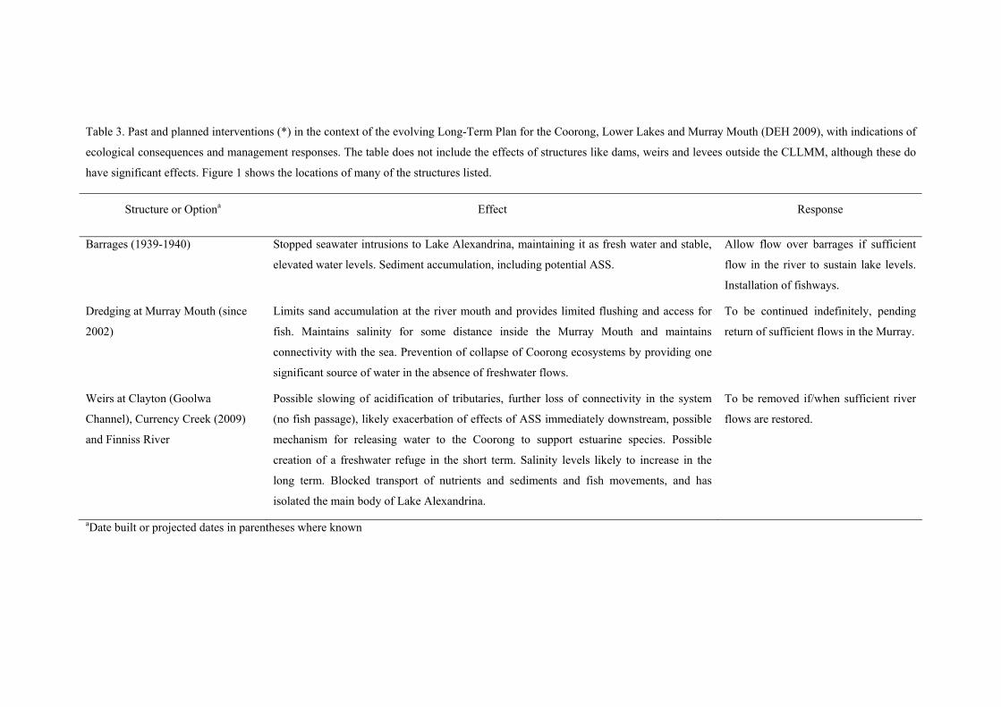
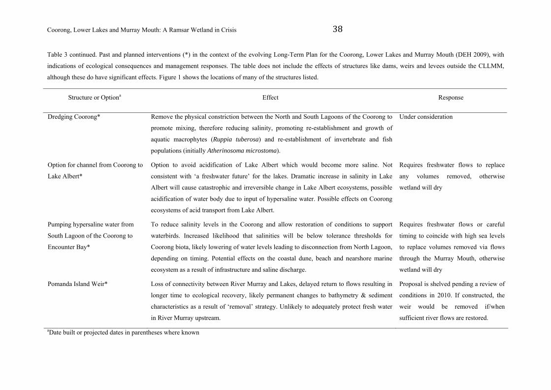
Table 3. Past and planned interventions (*) in the context of the evolving Long-Term Plan for the Coorong, Lower Lakes and Murray Mouth (DEH 2009), with indications of
ecological consequences and management responses. The table does not include the effects of structures like dams, weirs and levees outside the CLLMM, although these do
have significant effects. Figure 1 shows the locations of many of the structures listed.
Structure or Optiona Effect Response
Barrages (1939-1940) Stopped seawater intrusions to Lake Alexandrina, maintaining it as fresh water and stable,
elevated water levels. Sediment accumulation, including potential ASS.
Allow flow over barrages if sufficient
flow in the river to sustain lake levels.
Installation of fishways.
Dredging at Murray Mouth (since
2002)
Limits sand accumulation at the river mouth and provides limited flushing and access for
fish. Maintains salinity for some distance inside the Murray Mouth and maintains
connectivity with the sea. Prevention of collapse of Coorong ecosystems by providing one
significant source of water in the absence of freshwater flows.
To be continued indefinitely, pending
return of sufficient flows in the Murray.
Weirs at Clayton (Goolwa
Channel), Currency Creek (2009)
and Finniss River
Possible slowing of acidification of tributaries, further loss of connectivity in the system
(no fish passage), likely exacerbation of effects of ASS immediately downstream, possible
mechanism for releasing water to the Coorong to support estuarine species. Possible
creation of a freshwater refuge in the short term. Salinity levels likely to increase in the
long term. Blocked transport of nutrients and sediments and fish movements, and has
isolated the main body of Lake Alexandrina.
To be removed if/when sufficient river
flows are restored.
aDate built or projected dates in parentheses where known
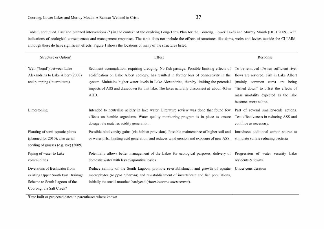
Coorong, Lower Lakes and Murray Mouth: A Ramsar Wetland in Crisis 37
Table 3 continued. Past and planned interventions (*) in the context of the evolving Long-Term Plan for the Coorong, Lower Lakes and Murray Mouth (DEH 2009), with
indications of ecological consequences and management responses. The table does not include the effects of structures like dams, weirs and levees outside the CLLMM,
although these do have significant effects. Figure 1 shows the locations of many of the structures listed.
Structure or Optiona Effect Response
Weir (‘bund’) between Lake
Alexandrina to Lake Albert (2008)
and pumping (intermittent)
Sediment accumulation, requiring dredging. No fish passage. Possible limiting effects of
acidification on Lake Albert ecology, has resulted in further loss of connectivity in the
system. Maintains higher water levels in Lake Alexandrina, thereby limiting the potential
impacts of ASS and drawdown for that lake. The lakes naturally disconnect at about -0.3m
AHD.
To be removed if/when sufficient river
flows are restored. Fish in Lake Albert
(mainly common carp) are being
“fished down” to offset the effects of
mass mortality expected as the lake
becomes more saline.
Limestoning Intended to neutralise acidity in lake water. Literature review was done that found few
effects on benthic organisms. Water quality monitoring program is in place to ensure
dosage rate matches acidity generation.
Part of several smaller-scale actions.
Test effectiveness in reducing ASS and
continue as necessary.
Planting of semi-aquatic plants
(planned for 2010), also aerial
seeding of grasses (e.g. rye) (2009)
Possible biodiversity gains (via habitat provision). Possible maintenance of higher soil and
or water pHs, limiting acid generation, and reduces wind erosion and exposure of new ASS.
Introduces additional carbon source to
stimulate sulfate reducing bacteria
Piping of water to Lake
communities
Potentially allows better management of the Lakes for ecological purposes, delivery of
domestic water with less evaporative losses
Progression of water security Lake
residents & towns
Diversions of freshwater from
existing Upper South East Drainage
Scheme to South Lagoon of the
Coorong, via Salt Creek*
Reduce salinity of the South Lagoon, promote re-establishment and growth of aquatic
macrophytes (Ruppia tuberosa) and re-establishment of invertebrate and fish populations,
initially the small-mouthed hardyead (Atherinosoma microstoma).
Under consideration
aDate built or projected dates in parentheses where known
Coorong, Lower Lakes and Murray Mouth: A Ramsar Wetland in Crisis 38
Table 3 continued. Past and planned interventions (*) in the context of the evolving Long-Term Plan for the Coorong, Lower Lakes and Murray Mouth (DEH 2009), with
indications of ecological consequences and management responses. The table does not include the effects of structures like dams, weirs and levees outside the CLLMM,
although these do have significant effects. Figure 1 shows the locations of many of the structures listed.
Structure or Optiona Effect Response
Dredging Coorong* Remove the physical constriction between the North and South Lagoons of the Coorong to
promote mixing, therefore reducing salinity, promoting re-establishment and growth of
aquatic macrophytes (Ruppia tuberosa) and re-establishment of invertebrate and fish
populations (initially Atherinosoma microstoma).
Under consideration
Option for channel from Coorong to
Lake Albert*
Option to avoid acidification of Lake Albert which would become more saline. Not
consistent with ‘a freshwater future’ for the lakes. Dramatic increase in salinity in Lake
Albert will cause catastrophic and irreversible change in Lake Albert ecosystems, possible
acidification of water body due to input of hypersaline water. Possible effects on Coorong
ecosystems of acid transport from Lake Albert.
Requires freshwater flows to replace
any volumes removed, otherwise
wetland will dry
Pumping hypersaline water from
South Lagoon of the Coorong to
Encounter Bay*
To reduce salinity levels in the Coorong and allow restoration of conditions to support
waterbirds. Increased likelihood that salinities will be below tolerance thresholds for
Coorong biota, likely lowering of water levels leading to disconnection from North Lagoon,
depending on timing. Potential effects on the coastal dune, beach and nearshore marine
ecosystem as a result of infrastructure and saline discharge.
Requires freshwater flows or careful
timing to coincide with high sea levels
to replace volumes removed via flows
through the Murray Mouth, otherwise
wetland will dry
Pomanda Island Weir* Loss of connectivity between River Murray and Lakes, delayed return to flows resulting in
longer time to ecological recovery, likely permanent changes to bathymetry & sediment
characteristics as a result of ‘removal’ strategy. Unlikely to adequately protect fresh water
in River Murray upstream.
Proposal is shelved pending a review of
conditions in 2010. If constructed, the
weir would be removed if/when
sufficient river flows are restored.
aDate built or projected dates in parentheses where known
Coorong, Lower Lakes and Murray Mouth: A Ramsar Wetland in Crisis 39
Table 3 continued. Past and planned interventions (*) in the context of the evolving Long-Term Plan for the Coorong, Lower Lakes and Murray Mouth (DEH 2009), with
indications of ecological consequences and management responses. The table does not include the effects of structures like dams, weirs and levees outside the CLLMM,
although these do have significant effects. Figure 1 shows the locations of many of the structures listed.
Structure or Optiona Effect Response
Training structures at river mouth* Groin to divert sand and prevent blockage at the mouth. Does not allow for movement of
the Murray Mouth as has happened in the past. Also likely to require pumping of sand
seasonally to prevent accumulation.
Under consideration, but unlikely.
Fishways Installation of fishways in the barrages to allow for the movement of native fish species into
and out of Lake Alexandrina
Now in place, but of limited value in
prevailing circumstances, given the low
water levels..
aDate built or projected dates in parentheses where known
regulators (levees) to establish high water levels in addition to applying local management to
ASS hotspots with limestoning and aerial seeding to assist in bioremediation (Table 3).
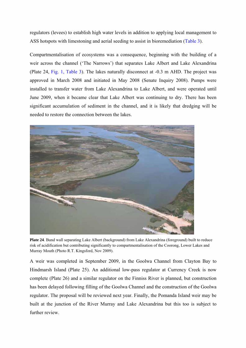
Compartmentalisation of ecosystems was a consequence, beginning with the building of a
weir across the channel (‘The Narrows’) that separates Lake Albert and Lake Alexandrina
(Plate 24, Fig. 1, Table 3). The lakes naturally disconnect at -0.3 m AHD. The project was
approved in March 2008 and initiated in May 2008 (Senate Inquiry 2008). Pumps were
installed to transfer water from Lake Alexandrina to Lake Albert, and were operated until
June 2009, when it became clear that Lake Albert was continuing to dry. There has been
significant accumulation of sediment in the channel, and it is likely that dredging will be
needed to restore the connection between the lakes.
Plate 24. Bund wall separating Lake Albert (background) from Lake Alexandrina (foreground) built to reduce risk of acidification but contributing significantly to compartmentalisation of the Coorong, Lower Lakes and Murray Mouth (Photo R.T. Kingsford, Nov 2009).
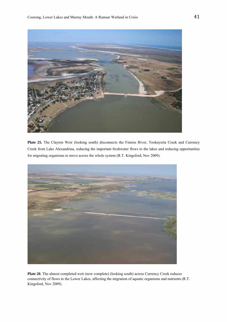
A weir was completed in September 2009, in the Goolwa Channel from Clayton Bay to
Hindmarsh Island (Plate 25). An additional low-pass regulator at Currency Creek is now
complete (Plate 26) and a similar regulator on the Finniss River is planned, but construction
has been delayed following filling of the Goolwa Channel and the construction of the Goolwa
regulator. The proposal will be reviewed next year. Finally, the Pomanda Island weir may be
built at the junction of the River Murray and Lake Alexandrina but this too is subject to
further review.
Coorong, Lower Lakes and Murray Mouth: A Ramsar Wetland in Crisis 41
Plate 25. The Clayton Weir (looking south) disconnects the Finniss River, Tookayerta Creek and Currency
Creek from Lake Alexandrina, reducing the important freshwater flows to the lakes and reducing opportunities
for migrating organisms to move across the whole system (R.T. Kingsford, Nov 2009).
Plate 26. The almost completed weir (now complete) (looking south) across Currency Creek reduces connectivity of flows to the Lower Lakes, affecting the migration of aquatic organisms and nutrients (R.T. Kingsford, Nov 2009).
Coorong, Lower Lakes and Murray Mouth: A Ramsar Wetland in Crisis 42
Another option widely discussed is to open the barrages (Fig. 1) allowing marine water from
the Coorong to enter the Lakes, changing the present freshwater ecosystem, primarily
designed to avoid acidification of the entire lake system. This would initially change the
Lakes initially into an estuarine ecosystem, quickly followed by fully marine and then even
more saline conditions. The short-term consequence of opened barrages would be mortality
of freshwater biota, followed by invasions of estuarine or marine species and species tolerant
of even higher salinities. A further proposed remedy is to build a channel from the Coorong
to Lake Albert and submerge ASS (Fig. 1, Table 3).
The long-term ecological effects of these latter short-term engineering actions would be
profound and probably not reversible. Either would fundamentally change the ecology of the
lakes, with the likelihood of salinity remaining at high levels because of insufficient mixing
and flushing of water through the lakes and the formation of potential ASS conditions
(Fitzpatrick 2008b). Another possibility is to let the system dry. This runs the risk of further
acidic oxidation of pyrite in ASS and the subsequent mobilization of the oxidation products
during wet periods, unless combinations of options raise the pH and stop acid movement.
About 200 ha of Loveday Bay dried out and acidified.
In the absence of barrage flows, dredging of the Murray Mouth since 2002 has provided an
essential source of water to offset evaporative losses. Other proposed engineering works also
could have ameliorated the effect of drought, but none modelled so far (400 scenarios) has
matched the effects of freshwater flows (Lester et al. 2009a, b, c, d). Engineering and micro-
management options may prevent system collapse in the short term, but none is an alternative
to freshwater flows over the barrages. This emphasises the necessity of securing additional
water for the Coorong.
Much effort is now focused on the development of a long-term plan for the CLLMM by the
SA Department for Environment and Heritage, in response to $200 million offered by the
Australian Government (Table 2). The plan, now well-advanced (DEH 2009), has identified
the major problems and highlights the threat of acidification and the need for increased flows
from the Murray. It includes a vision for the CLLMM:
Our goal is to secure a future for the Coorong, Lower Lakes and Murray Mouth as
a healthy, productive and resilient wetland of international importance (DEH 2009).
Coorong, Lower Lakes and Murray Mouth: A Ramsar Wetland in Crisis 43
The plan acknowledges an ‘irrevocable’ responsibility to conserve the ecological character of
the CLLMM, with regard for its environmental significance and its cultural, social,
recreational and economic value. It is committed to involving all interested parties, in and out
of government, including Ngarrindjeri people. It indicates that the responses will address
short-, medium- and long-term needs for at least 25 years, leading eventually to a transition to
a ‘marine’ environment, based on projected sea-level rises associated with global warming.
The ‘freshwater future’ for the CLLMM therefore applies within limits determined by sea
level, although the plan concedes that a different ecological character could result from the
impacts of the current crisis. Within this time frame, the plan aims to implement best-practice
adaptive management to ensure that short-term remedies do not limit future options, to secure
sufficient fresh water to re-establish ecological functions and improve water quality, to
restore more natural water level regimes, bioremediate ASS and restore and maintain
connectivity between habitats.
Strategies for adaptive management that are currently documented are well conceived but
could be improved. Strategic Adaptive Management Planning (Biggs and Rogers 2003) is a
process of articulating a desired condition for managed area, through a ‘vision’ statement and
identification of key attributes, and elaborated through a hierarchy of objectives that reflect
these values, beginning broadly and leading to management outcomes and indicators that are
measurable and reportable. All the key issues are identified in the plan. This process could be
developed explicitly for each of the major objectives for the area (e.g. connectivity,
management of ASS, biodiversity conservation).
The long-term plan is primarily the responsibility of the South Australian Department for
Environment and Heritage (SA DEH) (DEH 2009). To encourage integration across agencies,
and facilitate future development of the plan, it would be useful to establish a joint steering
committee of SA DEH, MDBA and the federal Department of Environment, Water, Heritage
and the Arts.
Conservation obligations
The Lower Lakes now support a diverse range of estuarine species, which were sparse during
the previous five years (Brookes et al. in review), and freshwater habitats in the CLLMM are
diminishing with the drying and increasing salinity of the lakes, reduced connectivity and
increasing salinity of the Coorong. The refilled Goolwa Channel from rainfall and pumped
lake water has decreasing salinities while the salinities of the lakes increase. The South
Coorong, Lower Lakes and Murray Mouth: A Ramsar Wetland in Crisis 44
Australian Government is obliged by legislation to protect the biodiversity values of the
Coorong National Park while the Australian Government has obligations under the Ramsar
Convention to protect and promote wise use of the wetlands and report any likely changes to
the ecological character. There is still only an admission by the Australian Government of
‘likely change’ in character, despite abundant evidence of cascading ecological changes.
Further, the Australian Government may volunteer to list a site on the Montreux Record, a
list of international Ramsar sites where “an adverse change in ecological character has
occurred, is occurring, or is likely to occur and which are therefore in need of priority
conservation action” (Ramsar 2007). On 4 August 2009, the Australian Government decided
not to take any such action. No Ramsar site in Australia has ever been listed on the
international public record, despite evidence that some qualify. Any listing would probably
serve little practical value as resources and efforts are currently focused on the problem; there
is some value at a global scale to admit that water scarcity issues are particularly difficult
even for a well developed country like Australia. The Australian Government is also
responsible for protecting habitats and individual migratory bird species through various
international bilateral agreements (e.g. CAMBA, the Chinese Australian Migratory Bird
Agreement) and these, with Ramsar responsibility, are matters of national significance under
the Environment Protection and Biodiversity Conservation (EPBC) Act 1999. It is clear that
migratory bird abundance has declined considerably within the CLLMM (Paton et al. 2009;
Rogers et al. 2009). It is problematic that many of the current engineering structures, treating
the symptoms of the problem, are required to be tested by stringent environmental assessment
and yet diversions of flows from upstream, the main cause of the crisis, are not assessed.
Conservation obligations are thus currently subordinate to industry requirements for water
upstream. The imminent collapse and unsustainable state of the CLLMM reflect the lack of
collective focus by the Governments of the Murray-Darling Basin on the conservation of this
unique ecosystem. It is also fails to meet a key objective of the National Water Initiative,
signed by most governments in 2004 (Western Australia signed later), to “complete the return
of all currently overallocated or overused systems to environmentally-sustainable levels of
extraction” (IGA 2004). Without addressing the underlying cause of lack of water, the
likelihood of Australia meeting its obligations for this Ramsar site are remote.
Coorong, Lower Lakes and Murray Mouth: A Ramsar Wetland in Crisis 45
Role of science
Twenty five years ago there were signs that the impacts of regulation and abstraction on the
Murray and its floodplain communities were significant (e.g. Walker 1985). Considerable
work since has contributed to understanding the increasing ecological effects of diverting
water and regulating the Murray with dams and weirs (Kingsford 2000a; Walker 1992, 2006).
An expert panel on the River Murray in 2002 recommended that the return of an additional
1500 GL would provide a ‘moderate’ chance of restoring the health of the River Murray
(Jones et al. 2002), but the Australian Government and the State governments committed to
returning only 500 GL, mostly through engineering efficiency options. Of that 500 GL, only
133 GL of water entitlement had actually been recovered under the Living Murray Initiative
by 2008 (Senate Inquiry 2008). Although the extent of the present drought could not have
been predicted, there were no contingency plans. Also, because the CLLMM never had an
environmental flow allocation, it had to rely on flow reaching it from upstream, which could
then also be diverted from the Lower Lakes.
Current scientific effort has documented tipping points of the freshwater and estuarine
ecosystem into a marine to hypersaline condition (Lester and Fairweather 2009a,b; Brookes
et al. 2009, in review). Until relatively recently, the scientific investment for whole-system
management and understanding of basic ecology was relatively poor and piecemeal. Much of
the immediate engineering response to avert acidification was based on limited sampling for
ASS, with little discussion of model uncertainty for extrapolations to vulnerable areas.
Sampling for acidification was preliminary rather than comprehensive (Fitzpatrick et al.
2008b, 2009), although subsequently considerably extended, but these data were used to
support assertions that the entire CLLMM would become catastrophically acidic. This
continues to be the main focus for current management. The MDBA commissioned a peer
review of the ASS science that was not made public, for unexplained reasons. Issues of
sampling intensity, as well as uncertainty of both modelling and the capacity for ecosystems
to recover from episodic acidification have not been adequately addressed. Despite this, the
policy options appear to assume the worst-case scenario, and to assume that natural recovery
is not possible. The Senate Inquiry concluded that “The general consensus of experts was that
sea water is the less damaging option” (Senate Inquiry 2008). Plans and operations for the
mitigation of acidification impacts have considered less-intrusive measures such as
Coorong, Lower Lakes and Murray Mouth: A Ramsar Wetland in Crisis 46
limestoning and planting of terrestrial species to stabilise soil, with an increasing emphasis on
large scale restoration. There was little modelling of potential buffering potential of lake
water, or the potential for harmful secondary impacts induced by the proposed management
scenarios. Acidification is not entirely a human-induced process; it also occurs episodically
and sometimes seasonally (Hart et al. 1980) under natural conditions and triggers fish kills
(Bishop 1980, Brown et al. 1983) that do not necessarily lead to long-term ecosystem damage
under natural conditions. The capacity of the modified environment of the CLLMM to
recover from acidification events of varying scales and frequencies, and the effects of current
or proposed engineering works need to be assessed for future options as well as initiating
emergency actions. The current urgency should not be a substitute for increasing our
understanding of how these complex systems operate because only that will ensure
preparation for new threats. As with all aspects of the ecology of the CLLMM, research must
test various predictions from the many conceptual and mathematical models used as our
options depend upon the veracity of modelling. Our future ability to plan and respond should
be enhanced if we emerge from this crisis with wisdom. This will be contingent on
availability of fresh water and management of the system. Hydrochemical modelling alone is
not sufficient to inform decision-making processes or to predict the environmental outcomes
of the proposed management strategies. Ecological monitoring and modelling are also
required. Similarly, there was limited analysis initially of the effects of naturally re-
generating vegetation communities on lake edges might have in reducing acid generation
through reduction of water loss and wind erosion. More work on sulfate reduction processes
and consequences of acidification is needed.
The potential ecosystem responses to acidification have not been adequately predicted or
evaluated for the CLLMM. Such an evaluation needs to consider obstruction to fish passage
during acidification events, and the joint effects of natural and artificial obstructions on
recruitment of the aquatic biota, as well as the potential for acidic water to pool. The current
focus on hydrochemical modelling ignores fish avoidance behaviour of acid and aluminium
in natural, unregulated systems (Giattina and Garton 1983, Norrgren et al. 1991, Sammut
et al. 1995), acute versus chronic effects of acidification, interactions between the impacts
and other factors, or processes that might determine the environmental outcomes of the
proposed management scenarios. Re-engineering the system to manage ASS may restrict fish
escape and reduce prospects of natural recovery because of impeded fish passage. The
magnitude of fish kills (and mortality of other biota) is largely dependent on the extent and
Coorong, Lower Lakes and Murray Mouth: A Ramsar Wetland in Crisis 47
duration of acidification events (Sammut et al. 1995, 1996), the presence of and access to
refugia, and the chemical species of aluminium and iron (Callinan et al. 2005; Sammut et al.
1995, 1996).
The remediation or mitigation of acidification and its impacts requires consideration of
complex modelling undertaken for the CLLMM, a focus on managing risk and collection of
field data, given the options for management. Models should account for the acidity
generated by pyrite and metal hydrolysis, the storage and transport of acid, the chemical loads
and chemical species of metals, the assimilative capacity of the receiving waters and the
effects of current and proposed changes to the landscape and water flows, to effectively
predict environmental impacts or the efficacy of management. Such models are complex and
depend upon a larger suite of environmental data than are currently available from
preliminary studies. Additionally, management strategies could be underpinned by clearer
environmental goals with consideration of an ecosystem’s capacity to recover from acute
versus chronic effects of acidification, something that would have helped before the current
crisis. Acute events, such as fish kills, are not sufficient indicators of the overall impact of
soil acidification and a reduction in their frequency is not a reliable measure of success for
any management. Fish kills often trigger community concern yet more chronic impacts go
unnoticed, and negative impacts from management could similarly be overlooked. The best
management practices for the CLLMM will be difficult to identify if interactions between
hydrological, chemical and ecological processes are not evaluated overtly. A more rigorous
process of scientific inquiry could generate less-costly management strategies with better
environmental outcomes (for ASS but also other emerging threats within the region), and
avoid triggering new environmental problems.
Conclusions
There are considerable costs in treating the symptoms of the current crisis, possibly up to
$2.2 billion (Table 2). The value of water for the CLLMM needs to be informed by the
considerable externalities currently realised as real engineering costs and costs to community
(Table 2). Governments will embark on a long-term Basin Plan (Table 2) but this is unlikely
to deal with the underlying cause of the crisis. The simplistic assumption that the last resort
of opening the barrages and allowing sea water into the Lakes would create a functional
estuary is highly unlikely, without significant guaranteed freshwater flows from the River
Murray. A functional estuary requires the mixing of saline and fresh water. There is
Coorong, Lower Lakes and Murray Mouth: A Ramsar Wetland in Crisis 48
opportunity to introduce more variability in inundation patterns through a structured
management program that allows flow of seawater and freshwater through the barrages. None
of this could be done without a guaranteed environmental flow for the CLLMM that meets its
primary ecological needs. Such a flow will necessarily be variable but overall volumes must
be sufficient to ensure that hypersaline conditions leading to ecosystem collapse does not
occur. This may require the volume of the lakes to be reduced. Without sufficient freshwater
flows, CLLMM would increase in salinity and even Lake Alexandrina would become more
saline than seawater within two to three years. Management would ultimately be of a drying,
acidic and hypersaline system, if significant riverine flows were not available. Lake Albert is
a terminal system that would likely follow a similar trajectory to the South Lagoon of the
Coorong and become more saline than seawater, with only the largest floods able to flush its
salinity.
Restoring connectivity in the form of freshwater flows to the CLLMM must be a priority if
the communities of Australia and South Australia are to meet their conservation obligations.
There needs to be action to save the Coorong, Lower Lakes and Murray Mouth, clearly
articulated through a vision, goals and specific objectives, informed and evaluated by
available science and monitoring data. All these processes are well underway although they
could be more clearly linked in a hierarchy of objectives in the long-term plan. A hierarchy of
objectives will necessarily allow some transparency in management and achievement of
adaptive management planning processes (Biggs and Rogers 2003). Given that the States of
the Murray Darling Basin are also in large part responsible, the problem should not reside
with just these two governments but all governments of the Murray-Darling Basin need to
make these considerations part of their decision-making on annual allocations.
If connectivity is not largely restored, many of the biodiversity values will be lost. A
thorough cost-benefit analysis is needed to consider the effects of this course of action on the
ecology of the CLLMM and its dependent communities up to a time horizon of 50-100 years.
The changes are affecting the Ngarrindjeri, local industries of irrigation, dryland agriculture,
commercial fishing (including cockle harvesting), tourism, small-business trading and some
urban development. The current status of the CLLMM as a wetland of national and
international importance is likely to decline even further without bold decisions about its
future, and its dependency on fresh water.
Coorong, Lower Lakes and Murray Mouth: A Ramsar Wetland in Crisis 49
Acknowledgements
Much of our current understanding of the ecosystem and its pressures has come from research
over many years by The University of Adelaide, the CLLAMMecology Research Cluster,
CSIRO Flagship Water for a Healthy Country, SA Department for Environment and Heritage
and Murray Futures. We thank Dr Shiquan Ren for assistance in modelling water levels in
Lake Alexandrina.
References
Arthington, A.H. and Pusey, B. J. (2003). Flow restoration and protection in Australian rivers. River Research
and Applications 19, 377-395.
Baldwin, D. S., Rees, G., Mitchell, A., Watson, G., Williams, J. (2006). The short-term effects of salinization on
anaerobic nutrient cycling and microbial community structure in sediment from a freshwater wetland.
Wetlands 26, 455-464.
Baldwin, D. S. and Fraser, M. (In press). Rehabilitation options for inland waterways impacted by sulfidic
sediments - a synthesis. Environmental Management.
Barnett, E. (1993). A Holocene paleoenvironmental history of Lake Alexandrina, South Australia. Journal of
Paleolimnology 12, 259–268.
Biggs, H.C. & Rogers, K.H. (2003). An adaptive system to link science, monitoring, and management in
practice. In: du Toit, J.T., Rogers, K.H. & Biggs H.C. (eds) The Kruger Experience: Ecology and
management of savanna heterogeneity. Island Press, Washington, pp.59-80.
Bishop, K.A. (1980). Fish kills in relation to physical and chemical changes in Magela Creek (East Alligator
River System, Northern Territory) at the beginning of the tropical wet season. Australian Zoology 20, 485-
500.
Breckwoldt, R., Boden, R., Andrew, J. (eds) (2004). The Darling. Murray Darling Basin Commission, Canberra.
Brookes, J.D., Rogers, D.J., Aldridge, K.T., Deegan, B., Hipsey, M.R., Paton, D.C., Ganf, G.G., Rolston, A.,
Webster, I. and, Noell, C. (in review). Managing the Lower Lakes and Coorong. Marine and Freshwater
Research.
Brookes, J.D, Lamontagne, S., Aldridge, K.T., Benger, S., Bissett, A., Bucater, L., Cheshire, A.C., Cook,
P.L.M., Deegan, B.M., Dittmann, S., Fairweather, P.G., Fernandes, M.B., Ford, P.W., Geddes, M.C.,
Gillanders, B.M., Grigg, N.J., Haese, R.R., Krull, E., Langley, R.A., Lester, R.E., Loo, M., Munro,
A.R., Noell, C.J., Nayar, S., Paton, D.C., Revill, A.T., Rogers, D.J., Rolston, A., Sharma, S.K., Short,
D.A., Tanner, J.E., Webster, I.T., Wellman, N.R., and Ye, Q. (2009). An Ecosystem Assessment
Coorong, Lower Lakes and Murray Mouth: A Ramsar Wetland in Crisis 50
Framework to Guide Management of the Coorong. Final report of the CLLAMMecology Research
Cluster. CSIRO: Water for a Healthy Country National Research Flagship, Canberra.
Brown, T.E., Morley, A.W., Sanderson, N.T. and Tait, R.D. (1983). Report of a large fish kill resulting from natural
acid water conditions in Australia.. Journal of Fish Biology 22, 335-350.
Callinan, R.B, Sammut, J and Fraser, G.C. (2005). Dermatitis, branchitis and mortality in empire gudgeon
Hypseleotris compressa exposed naturally to runoff from acid sulfate soils. Diseases of Aquatic Organisms
67, 247-253.
Chiew F.H.S., Teng J., Vaze J., Post D.A., Perraud J.M., Kirono D.G.C. and Viney N.R. (2009) Estimating
climate change impact on runoff across south-east Australia: methods, results and implications of
modelling method. Water Resources Research 45, W10414, doiL10.1029/2008WR007338.
Connell, D. (2007). Water politics in the Murray-Darling Basin. Federation Press, Sydney.
CSIRO (2008a). Water Availability in the Eastern Mount Lofty Ranges. A report to the Australian Government
from the CSIRO Murray-Darling Sustainable Yields Project. 104pp.
CSIRO (2008b). Water availability in the Murray. A report to the Australian Government from the CSIRO
Murray-Darling Basin Sustainable Yields Project. CSIRO, Australia. 217pp.
DECCW (2009). Critical water planning for the Murray Valley. Issue 28, 15 October 2009, Office of Water,
NSW Department of Environment, Climate Change and Water (http://www.water.nsw.gov.au/Water-
Management/Water-availability/Critical-water-planning/Critical-water-planning/default.aspx, accessed
23/10/09).
DEH (Department for Environment and Heritage) (2009). Murray Futures. Lower Lakes and Coorong
Recovery. The Coorong, Lower Lakes and Murray Mouth: Managing for a health future. Government of
South Australia, Department of Environment and Heritage, Adelaide.
Department of Environment, Water, Heritage and the Arts (2009) Progress of 2008-09: Restoring the Balance
in the Murray-Darling Basin Water Purchasing http://www.environment.gov.au/water/policy-
programs/entitlement-purchasing/2008-09.html (12/10/09).
Dove, M.C. and Sammut, J. (2007). Impacts of estuarine acidification on survival and growth of Sydney rock
oysters, Saccostrea glomerata (Gould 1850). Journal of Shellfish Research 26, 519-527.
Dove, M.C and Sammut, J. (2007). Histologic and feeding response of Sydney rock oysters, Saccostrea
glomerata, to acid sulfate soil outflows. Journal of Shellfish Research 26, 1-10.
EconSearch. (2006). Economic indicators for the Lakes and Coorong Fishery 2004/2005. Report prepared for
PIRSA by EconSearch P/L, Adelaide.
Coorong, Lower Lakes and Murray Mouth: A Ramsar Wetland in Crisis 51
Erskine, W.D., Terrazzolo, N., Warner, R.F. (1999). River rehabilitation from the hydrogeomorphic impacts of a
large hydro-electric power project: Snowy River, Australia. Regulated Rivers: Research and management
15, 3-24.
Fitzpatrick R.W., Powell B., and Marvanek S. (2008a). Atlas of Australian acid sulfate soils. In: Inland Acid
Sulfate Soil Systems across Australia (Eds R. Fitzpatrick and P. Shand). pp 63-77. CRC LEME Open File
Report No. 249. (Thematic Volume) CRC LEME, Perth, Australia.
Fitzpatrick, R.W., Shand, P., Marvanek, S., Merry, R.H, Thomas, M., Raven, M.D., Simpson S.L. and
McClure, S. (2008b). Acid Sulfate Soils in Subaqueous, Waterlogged and Drained Soil Environments in
Lake Albert, Lake Alexandrina and River Murray below Blanchetown (Lock 1): Properties, distribution,
genesis, risks and management. A report prepared for the South Australian Department for Environment
and Heritage. pp. 168. CSIRO: Land and Water Science Report 46/08.
Fitzpatrick, R.W., Grealish, G. Shand, P. Marvanek, S., Thomas, B. Creeper, N., Merry R. and Raven M.
(2009). Preliminary Assessment of Acid Sulfate Soil Materials in Currency Creek, Finniss River,
Tookayerta Creek and Black Swamp Region, South Australia. A report prepared for the South Australian
Department for Environment and Heritage. pp. 24. CSIRO: Land and Water Science Report 01/09.
Fluin, J., Gell, P., Haynes, D., Tibby, J., and Hancock, G. (2007). Palaeolimnological evidence for the
independent evolution of neighbouring terminal lakes, the Murray Darling Basin, Hydrobiologia 591, 117–
134.
Geddes M.C. (1984). The limnology of Lake Alexandrina, River Murray, South Australia, and the effect of
nutrients and light on the phytoplankton. Australian Journal of Marine and Freshwater Research 35, 399-
415
Geddes, M.C. (1987). Changes in salinity and in the distribution of macrophytes, macrobenthos and fish in the
Coorong Lagoons, South Australia, following a period of River Murray flow. Transactions of the Royal
Society of South Australia 111, 173-181.
Geddes, M.C. and Butler, A.J. (1984) Physiochemical and biological studies on the Coorong Lagoons, South
Australia, and the effect of salinity on the distribution of the macrobenthos. Transactions of the Royal
Society of South Australia 108, 51-62.
Geoscience Australia (2003). Dams and water storages 1990. GIS dataset.
https://www.ga.gov.au/products/servlet/controller;jsessionid=60F39E08CAEC0FC6DF285AF455327A1C
?event=GEOCAT_DETAILS&catno=42358 (accessed 23/10/09).
Giattina, J.D. and Garton, R.R. (1983). A review of preference avoidance responses of fish to aquatic contaminants.
Research Review 87, 43-90.
Coorong, Lower Lakes and Murray Mouth: A Ramsar Wetland in Crisis 52
Goss, K.F. (2003) Environmental flows, river salinity and biodiversity conservation: managing trade-offs in the
Murray–Darling basin. Australian Journal of Botany 51, 619-625.
Hall, K., Baldwin, D.S., Rees, G., Richardson A. (2006). Distribution of inland wetlands with sulfidic sediments
in the Murray-Darling Basin, Australia. Science of the Total Environment 370, 235-244.
Hammer, M., Wedderburn, S., and Westergaard, S. (2002). Freshwater fishes. Pages 54-61 in R. Brandle, editor.
A Biological Survey of the Murray Mouth Reserves, South Australia. Department for Environment and
Heritage, Adelaide.
Hart, B.T., Ottoway, E.M. and Noller, B.N. (1987). Magela Creek system, northern Australia. I. 1982-83 wet season
water quality. Australian Journal of Marine and Freshwater Research 38, 261-288.
Helicon (2004). Recreational Boating Industry Development Project: Lower Murray and Lakes. Final Report
prepared for the Fleurieu Regional Development Commission Inc.
Hera-Singh, G. (2002). Fishing Industry. In The Murray Mouth: Exploring the implications of closure or
restricted flow, a report prepared for the Murray-Darling Basin Commission, Department of Water, Land
and Biodiversity Conservation, Adelaide, pp. 21-24.
IGA (Intergovernment Agreement) 2004. Intergovernmental agreement on a National Water Initiative between
the Commonwealth of Australia and the Governments of New South Wales, Victoria, Queensland, South
Australia, the Australian Capital Territory and the Northern Territory
(http://www.nwc.gov.au/resources/documents/Intergovernmental-Agreement-on-a-national-water-
initiative.pdf, accessed 15/11/09)
Jensen, A., Good, M., Harvey, P., Tucker, P. and Long, M. (eds) (2001) River Murray Barrages: Environmental
flows. An evaluation of environmental flow needs in the Lower Lakes and Coorong. A report for the
Murray-Darling Basin Commission, pp. 118. Wetlands Management Program, Department for Water
Resources.
Jones, G., Hillman, T., Kingsford, R.T., McMahon, T., Walker, K., Arthington, A., Whittington, J., and
Cartwright, S. (2002). Independent Report of the Expert Reference Panel on Environmental Flows and
Water Quality. Requirements for the River Murray System. Prepared for the Environmental Flows and
Water Quality Objectives for the River Murray Project Board, Murray-Darling Basin Commission,
Canberra.
Kingsford, R.T. (1995). Ecological effects of river management in New South Wales. In Conserving
Biodiversity: Threats and Solutions (eds.) R.A. Bradstock, T.D. Auld, D.A. Keith, R.T. Kingsford, D.
Lunney, and D.P. Sivertsen, pp. 144-161. Surrey Beatty & Sons, Sydney.
Kingsford, R.T. (1999) Managing the water of the Border Rivers in Australia: Irrigation, government and the
wetland environment. Wetlands Ecology and Management 7: 25-35.
Coorong, Lower Lakes and Murray Mouth: A Ramsar Wetland in Crisis 53
Kingsford, R.T. (2000a). Review: Ecological impacts of dams, water diversions and river management on
floodplain wetlands in Australia. Austral Ecology 25. 109-127.
Kingsford, R.T. (2000b). Protecting or pumping rivers in arid regions of the world? Hydrobiologia 427, 1-11.
Kingsford, R.T. (2003). Social, institutional and economic drivers for water resource development – a case
study of the Murrumbidgee River, Australia. Aquatic Ecosystem Health and Management 6, 69-79.
Kingsford, R.T. (2004). Wetlands and waterbirds of the Darling River. In The Darling (eds.) R. Breckwoldt,
Boden, R & Andrew, J., pp 234-259. Murray-Darling Basin Commission, Canberra.
Kingsford, R.T. and Thomas, R.F. (1995). The Macquarie Marshes and its waterbirds in arid Australia: A 50-
year history of decline. Environmental Management 19: 867-878.
Kingsford, R.T. and Thomas, R.F. (2004). Destruction of wetlands and waterbird populations by dams and
irrigation on the Murrumbidgee River in arid Australia. Environmental Management 34, 383-396.
Kingsford R.T. and J.L. Porter (2008). Survey of Waterbird Communities of the Living Murray Icon Sites -
November 2007. School of Biological, Earth and Environmental Sciences, University of New South
Wales. Report to Murray-Darling Basin Authority.
Kingsford, R.T. and J.L. Porter (2009). Survey of waterbird communities of the Living Murray icon sites -
November 2008. School of Biological, Earth and Environmental Sciences, University of New South
Wales. Report to Murray-Darling Basin Authority.
Kingsford, R.T., Lemly, A.D. & J.R. Thompson (2006). Impacts of dams, river management and diversions on
desert rivers. In Ecology of Desert Rivers, ed. R.T. Kingsford, pp. 203-247 . Cambridge University Press,
Cambridge.
Lemly, A. D., Kingsford R. T., and Thompson, J. R. (2000). Irrigated agriculture and wildlife conservation:
conflict on a global scale. Environmental Management 25, 485-512.
Lester, R.E. and Fairweather, P.G. (2009a). Ecosystem States of the Coorong: An Ecosystem Response Model.
Method development and sensitivity analyses, CSIRO: Water for a Healthy Country National Research
Flagship, pp. 126.
Lester, R.E. and Fairweather, P.G. (2009b). Modelling future conditions in the degraded semi-arid estuary of
Australia’s largest river using ecosystem states. Estuarine Coastal & Shelf Science 85, 1-11
Lester, R.E., Webster, I.T., Fairweather, P.G. and Langley, R.A. (2009a). Predicting the Future Ecological
Condition of the Coorong, The effect of management actions & climate change scenarios. CSIRO: Water
for a Healthy Country National Research Flagship, pp. 104.
Coorong, Lower Lakes and Murray Mouth: A Ramsar Wetland in Crisis 54
Lester, R.E., Webster, I.T., Fairweather, P.G., and Langley, R.A. (2009b). Predicting the Ecosystem Response
of the Coorong to the South Lagoon Salinity Reduction Scheme, A report prepared for the South
Australian Murray-Darling Basin Natural Resource Management Board, Flinders Research Centre for
Coastal & Catchment Environments, pp. 82. Flinders University, Adelaide, May 2009.
Lester, R.E., Webster, I.T., Fairweather, P.G, and Langley, R.A. (2009c). Understanding and Quantifying the
Ecological Benefit of Dredging the Murray Mouth, A report prepared for the South Australian Murray-
Darling Basin Natural Resource Management Board, June 2009 (draft), pp. 92. Flinders Research Centre
for Coastal and Catchment Environments, Flinders University.
Lester, R.E., Webster, I.T., Fairweather, P.G, and Langley, R.A. (2009d). Predicting the Ecosystem Response of
the Coorong to the Coorong South Lagoon Flow Restoration Scheme. A report prepared for the
Department of Water, Land and Biodiversity Conservation, July 2009, Flinders Research Centre for
Coastal and Catchment Environments, Flinders University, pp. 144
Maheshwari, B. L., Walker, K. F. and McMahon, T. A. (1995). Effect of regulation on the flow regime of the
River Murray, Australia. Regulated Rivers: Research and Management. 10, 15-38.
Marsland, K.B. and Nicol, J.M. (2009). Lower Lakes vegetation condition monitoring-2008/09. South
Australian Research and Development Institute (Aquatic Sciences), Adelaide, 45pp. SARDI Publication in
press
MDBC (Murray-Darling Basin Commission) (2008). Lower Lakes, Coorong and Murray Mouth Icon Site
Environmental Management Plan 2006-07. Murray-Darling Basin Commission, Canberra.
MDBMC (Murray-Darling Basin Ministerial Council) (1996) Setting the Cap. Report of the Independent Audit
Group. Murray-Darling Basin Ministerial Council, Canberra.
Murphy B.F. and Timbal B. (2007). A review of recent climate variability and climate change in southeastern
Australia. International Journal of Climatology, 28, 859-879 doi:10.1002/joc.1627.
Ngarrindjeri Tendi (2006). Ngarrindjeri Nation Yarluwar-Ruwe Plan: Kungun Ngarrindjeri Yannan (Listen to
Ngarrindjeri people talking). Ngarrindjeri Heritage Committee, Ngarrindjeri Native Title Management
Committee, 56 pp.
Norrgren, L., Wicklund Glynn, A. and Malmborg, O. (1991). Accumulation and effects of aluminium in the
minnow (Phoxinus phoxinus L.) at different pH levels. Journal of Fish Biology 39, 833-847.
Paton, D. C., Rogers, D. J., Hill, B. M., Bailey, C. P. and Ziembicki, M. (2009). Temporal changes to spatially-
stratified waterbird communities of the Coorong, South Australia: implications for the management of
heterogeneous wetlands. Animal Conservation 12, 408-417
Coorong, Lower Lakes and Murray Mouth: A Ramsar Wetland in Crisis 55
Phillips, W., and Muller, K. (2006). Ecological character of the Coorong, Lakes Alexandrina and Albert
Wetland of International Importance. Department for Environment and Heritage, Adelaide
Pigram, J.J. (2000). Options for rehabilitation of Australia's Snowy River: an economic perspective. Regulated
rivers: research & management 16, 363-373.
Productivity Commission (2009). Market mechanisms for recovering water in the Murray-Darling Basin.
Productivity Commission Issues Paper, August 2009, Canberra.
Ramsar Convention on Wetlands of International Importance (1971). especially as Waterfowl Habitat. (Iran), 2
February 1971. UN Treaty Series No. 14583. As amended by the Paris Protocol, 3 December 1982, and
Regina Amendments, 28 May 1987.
Ramsar (2007). Addressing change in the ecological character of Ramsar sites and other wetlands. Ramsar
handbooks for the wise use of wetlands, 3rd edition, vol. 15. Ramsar Convention Secretariat, Gland,
Switzerland.
Rogers, D.J., and Paton D.C. (2009a). Spatiotemporal variation in the waterbird communities of the Coorong.
CSIRO: Water for a Healthy Country National Research Flagship, Canberra, 57pp.
Rogers, D.J. and Paton, D.C. (2009b). Changes in the distribution and abundance of Ruppia tuberosa in the
Coorong. CSIRO: Water for a Healthy Country National Research Flagship, Canberra.
Sammut, J., Melville, M.D., Callinan, R.B. and Fraser, G. (1995). Estuarine acidification: impacts on aquatic biota
of draining acid sulfate soils. Australian Geographical Studies 33, 89-100.
Sammut, J., White, I. and Melville, M.D. (1996). Acidification of an estuarine tributary in eastern Australia due to
drainage of acid sulfate soils. Marine and Freshwater Research 47, 669-684.
Senate Inquiry (2008). Water management in the Coorong and Lower Lakes (including consideration of the
Emergency Water (Murray-Darling Basin Rescue) Bill 2008). Standing Committee on Rural and Regional
Affairs. Senate Printing Unit, Department of the Senate, Parliament House, Canberra.
Sharley, T. and Huggan, C. (1995). Chowilla Resource Management Plan. Final Report. Murray-Darling Basin
Commission, Canberra.
Sim, T., and Muller, K. (2004). A Fresh History of the Lakes: Wellington to the Murray Mouth, 1800s to 1935.
River Murray Catchment Water Management Board, Strathalbyn, South Australia.
Steinfeld, C.M.M. and Kingsford, R.T. (in review). Disconnecting the floodplain — earthworks and their
ecological effect on a dryland floodplain in the Murray-Darling Basin, Australia. Journal of Applied Ecology
Walker, K. F. (1985) A review of the ecological effects of river regulation in Australia. Hydrobiologia 125, 111-
129.
Coorong, Lower Lakes and Murray Mouth: A Ramsar Wetland in Crisis 56
Walker K.F. (1992). A semi-arid lowland river: the River Murray, Australia. In P.A. Calow, G.E. Petts (eds),
The Rivers Handbook, v1. Blackwell Scientific, Oxford, pp. 472-492.
Walker, K.F. (2006). Serial weirs, cumulative effects: the Lower River Murray, Australia. In R. Kingsford (ed.)
The Ecology of Desert Rivers. Cambridge University Press, Cambridge, p. 248-279.
Webster, I.T. (2005). Hydrodynamics of the Coorong and Murray mouth. Water for a Healthy Country
National Research Flagship, CSIRO, Canberra.
Wedderburn, S. and Barnes, T. (2009). Condition Monitoring of Threatened Fish Species at Lake Alexandrina
and Lake Albert (2008-2009). The University of Adelaide, Adelaide.
Wedderburn, S., and Hammer, M. (2003) The Lower Lakes Fish Inventory: Distribution and Conservation of
Freshwater Fishes of the Ramsar Convention Wetland at the Terminus of the Murray Darling Basin, South
Australia. Native Fish Australia (SA) Inc., Adelaide.
Wong, P. (2008) Minister for Climate Change and Water. Speech to the 4th Annual Australian Water Summit.
Sydney Convention and Exhibition Centre. 29-30 April 2008. ‘Water for the Future’
(http://www.environment.gov.au/minister/wong/2008/pubs/sp20080429.pdf , accessed 23/10/09).