Embed Size (px)
Citation preview
Proceedings of Relating Systems Thinking and Design RSD9 Symposium, NID Ahmedabad, 2020
1
Gigamapping as a toolkit for city analysis
A design-led research Yijun Chen;Marie Davidová;Federico Wulff
Welsh School of Architecture, Cardiff University
Abstract
This article introduces Gigamapping as a toolkit to help architects undertake analysis and design. Due to globalization, many architectural design companies have expanded into the international market. Gigamapping is a beneficial tool for analysis and design, since it can help designers to display the relationships that affect designs in-context, thereby helping architects to analyse problems and settings. At the same time, it can be used for the integration of all parts of a project through the coherent connection of conceptual ideas and responses to the context. Additionally, it constitutes a powerful tool for supporting teamwork. MA AD is the design research Masters of the Welsh School of Architecture (WSA) of Cardiff University, and Analysis of Precedents is one of the core modules of it. The authors will use training from the Analysis of Precedent module and design-led research in MA AD to illustrate the role of Gigamapping for analysis and design. Key words: Gigamapping, System thinking, Contextual Analysis, Design-led research, Interculture node
1. Introduction 1.1 The potential of Gigamapping
Many world-famous architects work on numerous architectural design projects and multiple commissions in different countries at the same time (McCann, 2010). Many projects lack a deep connection with each of the intervention sites’ contexts by world-wide practices driven by globalization. Not all projects are suitable for the cities where they are located. In certain ways, these projects have accelerated many issues of urban space. Architects should make a deeper effort for understanding the areas where their projects are located instead of implementing their innovative, but also generic ideas regardless of the specificities of each context. Gigamapping involves establishing a comprehensive list of different types of systemic relations, using a color code for each relationship category (Sevaldson & Ryan, 2014). Gigamapping can employ different vital factors according to an urban area's specific characteristics and can use lines to show the organic links between each essential element. A complete Gigamap can show an architect's thinking and the connection between the project and the city, thereby helping the design team to work more comprehensively. Architectural practices’ design teams can develop and analyze a project's dimensions through Gigamapping, including urban culture, materials, lighting, ventilation, and line of sight. The factors in a series of construction projects can be considered in a holistic and orderly manner. Overlapping simple forms and symbols with architectural projects does not help the organic development of urban space. An architect should have sufficient knowledge of the city and the site, including geography, culture, customs, climate, economy, demographics, local materials, etc. When the design project is carried out, the project should avoid imposing a design on an unsuitable urban area.

Proceedings of Relating Systems Thinking and Design RSD9 Symposium, NID Ahmedabad, 2020
2
Gigamapping could also be used when exploring different strategies and approaches to integrating the different traits of performance-oriented architecture and can help to maintain an overview of both directly and indirectly affected conditions (Hensel, 2010). Gigamapping could not only be used as a tool for urban analysis, but it can also show the relationship between the city and the architecture scales, together with its ‘citizens’ social fabric, within the design research process. 1.2 Introduction of Practice I and Practice II
As noted by Sevaldson, "Gigamapping is super extensive mapping across multiple layers and scales, investigating relations between seemingly separated categories and so implementing boundary critique to the conception and framing of systems” (Sevaldson, 2015). The primary purpose of this practice is to explore the use of Gigamapping for the analysis of a new city. It could help a variety of projects to find the connections between different factors within an urban space. In the future, Gigamapping could help architects to consider a full range of elements when working on projects in a new city. It can be used to organically combine an architect's ideas with the city's culture, instead of merely superimposing these ideas. Within this process, Gigamapping is intended as the architects’ medium for analysing the city and its architecture together with its citizen’s social fabric. Gigamap could not only be used as tools for city analysis, but can also show the relationship between the city level and the architecture level. As part of this paper, the authors consider the Gigamapping training in gained by MA AD students in the Analysis of Precedent module. Based on the group's cooperation, a three-hour survey was undertaken looking at the National Museum of Wales, St. Fagans. Each team member was responsible for a separate element of the Gigamapping process. Gigamapping is a useful tool for contextual analysis in architectural research, education and practice. Another element of this paper is the consideration of how Gigamapping can be used for the whole design research process. The authors utilize design-led research on Albergheria, Palermo and the use of Gigamapping to integrate the research steps with the design proposals and content.
2. Practice I: Gigamapping training in Analysis of Precedent module 2.1 Background of practice I
This practice is from Analysis of Precedent module, which focusses on how architecture can learn from that which precedes it and on how we analyse precedent in order to learn something that can be applied to future design thinking.(Davidova, 2019)The study group surveyed and studied in St. Fagans for a week, and collected an important amount of data and information on this area, considering many different aspects. This exercise focused on using Gigamapping in the search for connections within the vernacular architecture to diagram their relations. We collected the data as a team, where each member held responsibility for certain aspects. 2.2 Group work in Gigamapping training
The learning group surveyed and studied St. Fagans for a week and collected many data and information in this area. The learning group first established the elements and classified them. The associated features were then superimposed with the same color. The group learned from the experience to illustrate Gigamapping's role in urban analysis. We each selected a particular area or building in this ancient village and used Gigamapping to analyze its correlation correlation to each design element. For instance, the study group studied the cockpit (Cockfighting field) to explore the different aspects of thinking, including its interior, exterior, material, skylight, and temperature. At the same time, the study

Proceedings of Relating Systems Thinking and Design RSD9 Symposium, NID Ahmedabad, 2020
3
group also finished the sky-dome experiment at Cardiff University. This exercise was used to give members of the study group a basic understanding of the concept of Gigamapping.
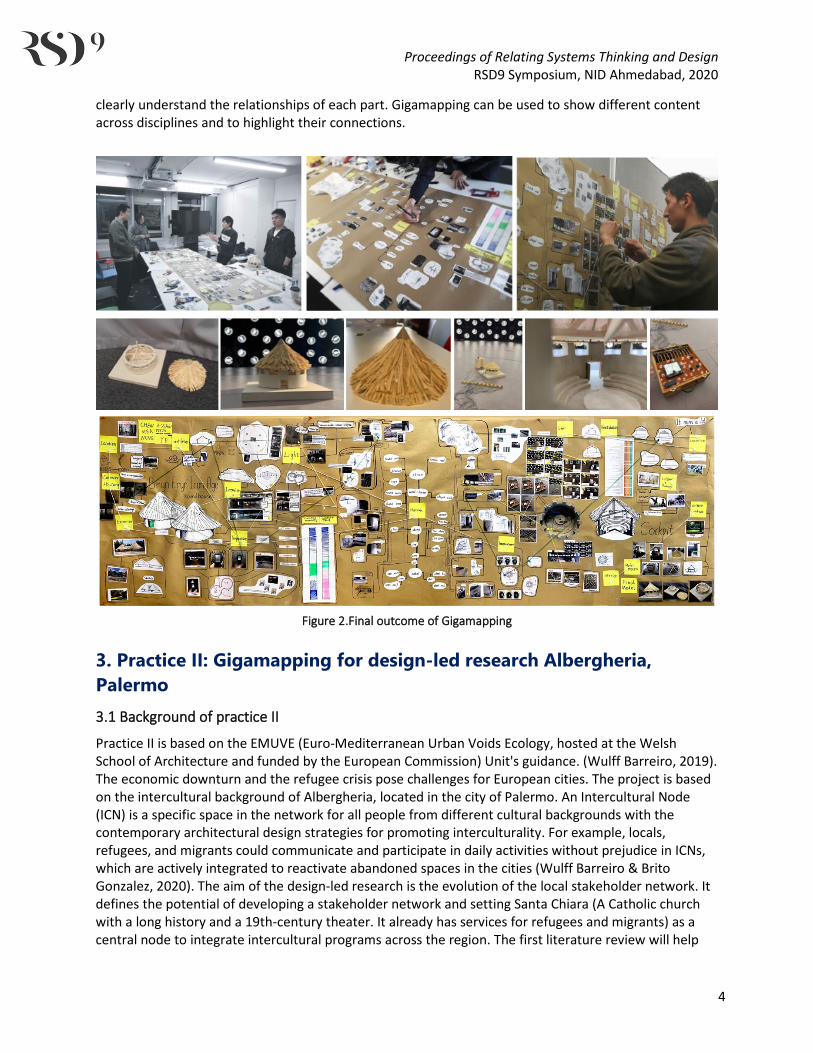
Figure 1. Group work in St. Fagans
As the mindmap (see Figure 1 ) shows, the first step of Gigamapping is that each group member prepares and discusses the part they are responsible for. The purpose of this phase is to gain a complete understanding of the relationships between different parts. Secondly, the group places the core issue in the middle of the Gigamapping, which spreads like a branch to the position of each group member. This core is an overview of all the elements, through which readers can easily understand the structure of the entire Gigamapping and what needs to be expressed. Thirdly, the group uses lines to connect different parts and elements. When Gigamapping is complete, the connection between each part can be clearly seen, helping to analyze the strategy for the next step. For model making, we selected clay for several experiments, and made a model of the cockpit at the appropriate ratio for the sky-dome experiment. In the process of making the model, we learned about the unique structure of traditional Welsh houses. This is very important for enabling us to understand the architectural style of this area. The sky-dome experiment is necessary to reduce the carbon emissions of buildings. It fully simulates the lighting and thermal insulation performance of buildings under the sun's height and azimuth of the Welsh climate. The summary of the final Gigamapping is used to organize the knowledge gained during the Analysis of Precedent module. This process helps us to understand the course more clearly and to apply the knowledge gained from it to the core elements of the Master’s degree, providing benefits to architectural teaching. As shown in Group work in St. Fagans (see Figure 1), designers can directly and
Proceedings of Relating Systems Thinking and Design RSD9 Symposium, NID Ahmedabad, 2020
4
clearly understand the relationships of each part. Gigamapping can be used to show different content across disciplines and to highlight their connections.
Figure 2.Final outcome of Gigamapping
3. Practice II: Gigamapping for design-led research Albergheria, Palermo 3.1 Background of practice II
Practice II is based on the EMUVE (Euro-Mediterranean Urban Voids Ecology, hosted at the Welsh School of Architecture and funded by the European Commission) Unit's guidance. (Wulff Barreiro, 2019). The economic downturn and the refugee crisis pose challenges for European cities. The project is based on the intercultural background of Albergheria, located in the city of Palermo. An Intercultural Node (ICN) is a specific space in the network for all people from different cultural backgrounds with the contemporary architectural design strategies for promoting interculturality. For example, locals, refugees, and migrants could communicate and participate in daily activities without prejudice in ICNs, which are actively integrated to reactivate abandoned spaces in the cities (Wulff Barreiro & Brito Gonzalez, 2020). The aim of the design-led research is the evolution of the local stakeholder network. It defines the potential of developing a stakeholder network and setting Santa Chiara (A Catholic church with a long history and a 19th-century theater. It already has services for refugees and migrants) as a central node to integrate intercultural programs across the region. The first literature review will help

Proceedings of Relating Systems Thinking and Design RSD9 Symposium, NID Ahmedabad, 2020
5
this project to explore the method of establishing associated programs in a stakeholder network to integrate the services of Albergheria as a whole in the intercultural process so as to guide people from different backgrounds to participate actively. The second literature review focuses on designing suitable and high-quality spaces for the associated programs. (WSA Masters in Architectural Design, 2020) In the 20th century, during the Allied invasion of of 1942 during the WWII, the city suffered devastating damage, particularly around the port and surrounding areas. After WWll, Sicily with Palermo as its Capital city became an autonomous region, but the state had to share effective control of the city with the rising power of the Mafia criminal organisation. Well-publicized murders, as well as uncontrolled urban expansion, led to serious traffic problems, widespread poverty, and a historic center still partly in ruins due to the Mafia’s economic interests in urban speculation. More recently, the city has loosened the grip of Mafia and is developing into a business and cultural hub. There is also increasing tourism from visitors interested in its rich legacy, faded grandeur, and labyrinthine streets (Lo Piccolo, 1996). Under the leadership of Mayor Leoluca Orlando, Palermo has been committed to fighting the Mafia and supporting refugees and immigrants (Palermo & Izmir, 2020). Many immigrants have lived in Palermo for numerous years and have their own community cultures (Horowitz, 2020). Palermo has special potential in the Intercultural process, including integrating both the existing people of different cultural backgrounds, and newly-arrived of immigrants. The most critical part is how to use an intervention to integrate people from different cultural backgrounds. 3.2 Gigamap A: Contextual analysis
Figure 3.Gigamap A: Contextual analysis
Gigamap A (see Figure 3) is used to help contextual analysis. The contextual analysis includes study schedules, statistical research, interviews, physical models, and courses (lectures, courses and tutorials). After the analysis, a contextual diagnosis can be obtained, which is the basic component of the general proposal. Through a literature review, any research gaps are found to support the spatial context analysis. The research questions and research aim can then be put forward before the second literature review. The design project can be discussed and expanded upon in the next design process by finishing the toolkit. As such, contextual analysis is essential for the design. By linking to contextual analysis related interdisciplinary content, Gigamapping could thus be used to display the essential clue in context more intuitively.

Proceedings of Relating Systems Thinking and Design RSD9 Symposium, NID Ahmedabad, 2020
6
3.2.1 Gigamapping in urban analysis of Albergheria
As shown in the left part of Gigamap A (see Figure 3) , Albergheria is a complex area. It is a multi-ethnic region with a long history facing the issue of degraded urban space. Gigamapping could help to connect the elements of the area context effectively. On the one hand, people who live here do not have very high economic income. Residents mainly sell primary products on the service sector, including clothing, daily necessities, and agricultural products. Small stores are abundant and scattered, making them difficult to manage. Therefore, putting them in the Gigamapping is a useful approach to observe and study them directly. In this way, people’s business activities are panoramic for the analysis in this section. On the other hand, Albergheria also has a high heritage value. There is a large quantity of tangible heritage and some intangible cultural heritage in the area. The authors use Gigamapping to connect different types of areas including residential areas, degraded areas, Public space and heritage sites. After classifying the tangible heritage and intangible cultural heritage, we can see the locations of the high-value spaces on the Gigamapping. This means that, through Gigamapping, small businesses and high value areas can be managed and discussed methodically. Gigamap A 1 (see Figure 3) . The distribution of residential areas and its imbalance. The better-quality houses are distributed outside the site. Due to the gap between the rich and the poor in the population, there are many informal occupations in the middle area. Gigamap A 2 (see Figure 3). The presence of many degraded areas within the site has reduced its accessibility. From the perspective of environmental behavior, the existence of these areas will encourage people to move deeper into the area. Gigamap A 3 (see Figure 3) Public space is an important node on the site, enhancing accessibility for residents. The setting of public space in the urban environment could stimulate the potential of the site. Gigamap A 4 (see Figure 3). The distribution of heritage sites on the north side is more diverse, and the Norman Palace is the most popular tourist attraction. Heritage sites in Albergheria has not been fully utilized, which could be used to enrich people's lives, contributing to the potential development of this area. When the degraded facilities are restored, people from different backgrounds are also willing to hold events in Albergheria. The tourists could communicate frequently with residents and provide job opportunities for migrants and refugees.
3.2.2 Gigamap A: Interview in Albergheria
All the methods of data collection in Gigamap A (see Figure 3) are from the groupwork training and practice, as mentioned above in practice I. This part will explain how and why migrants and refugees were chosen as the objects for analysis. In this section, by observing and communicating with refugees in the study trip, their requirements can be managed and classified. Gigamap A (see Figure 3)shows all the requirements of refugees and migrants. It can be found that the needs of refugees are broadly similar, which can be concluded easily from the Gigamapping. In general, their needs are physiological, safety, belongingness, love and esteem, following Maslow's theory (Maslow, 1943). Accordingly, Gigamapping provides the directions for how to design the space for the refugees and migrants. It is necessary to build associated space for refugees, helping them to communicate with others. This can bring them together, and since it will mean that there are fewer of them in other parts of the community, it may make local people feel safer.
Proceedings of Relating Systems Thinking and Design RSD9 Symposium, NID Ahmedabad, 2020
7
3.2.3 Gigamap A: Diagnosis of stakeholder network in Albergheria
As the right section of Gigamap A (see Figure 3) shows, the stakeholder network plays a very important role in the Intercultural process of the entire region. It is based on an existing network of stakeholders. By investigating the influence and characteristics of different stakeholders, the scope and influence of each stakeholder's service can be measured. From the summary in Gigamap A (see Figure 3), we can see the loopholes and evolution direction in the next generation’s stakeholder network. Santa Chiara has a high level of potential as the main central node. It not only provides basic refugee assistance but also follows the specific design of intercultural training. It will connect surrounding stakeholders and create more intercultural communication chances. In this Gigamapping, the authors found that Albergheria has the potential to improve the stakeholder network. In the previous Contextual analysis, Gigamapping played a function of sorting out complex interdisciplinary content. It intuitively helped the authors to make a diagnosis. Due to the limited number of interviewed refugees and the short study trip time, the understanding of refugee requirements may not be comprehensive. This may cause some errors when using Gigamapping to explore a new city, which has certain impacts on the results of the project. 3.3 Gigamap B: Site selection
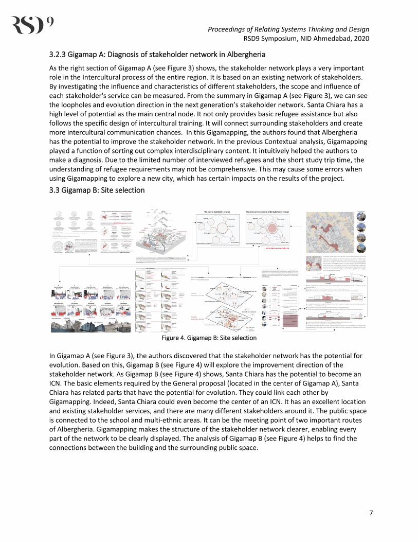
Figure 4. Gigamap B: Site selection
In Gigamap A (see Figure 3), the authors discovered that the stakeholder network has the potential for evolution. Based on this, Gigamap B (see Figure 4) will explore the improvement direction of the stakeholder network. As Gigamap B (see Figure 4) shows, Santa Chiara has the potential to become an ICN. The basic elements required by the General proposal (located in the center of Gigamap A), Santa Chiara has related parts that have the potential for evolution. They could link each other by Gigamapping. Indeed, Santa Chiara could even become the center of an ICN. It has an excellent location and existing stakeholder services, and there are many different stakeholders around it. The public space is connected to the school and multi-ethnic areas. It can be the meeting point of two important routes of Albergheria. Gigamapping makes the structure of the stakeholder network clearer, enabling every part of the network to be clearly displayed. The analysis of Gigamap B (see Figure 4) helps to find the connections between the building and the surrounding public space.

Proceedings of Relating Systems Thinking and Design RSD9 Symposium, NID Ahmedabad, 2020
8
3.3.1 Gigamapping in site selection for a design project
In the left section of Gigamap B (see Figure 4), the purpose is to show people from different cultural backgrounds the proposals, enabling a change from passive participation to active participation, and finally active participation in regional affairs and a sense of belonging. The heat map of human traffic around Santa Chiara has potential to develop. It can be seen that in the original heat map, Via Formaggi (south of Santa Chiara) and Via Giuseppe (north of Santa Chiara) are not very busy streets. Santa Chiara has the advantage that it is located in a multi-ethnic residential area and has three stakeholders distributed around it. At the same time, the two roads are the daily commuting routes for middle school students. Two playgrounds and a semi-public area can be connected to the surrounding public space. The right side of Gigamap B (see Figure 4) shows that public space has great potential to become a space for stakeholders' daily activities and work. Through the series of connections between important public spaces, the daily activities of different groups of people can be integrated together. According to Gigamap B (see Figure 4), the cooperation between stakeholders can rely on associated programs to connect. For example, existing public spaces can be used by stakeholders who share common types of services. Gigamapping can make the implications of research clear through step-by-step analysis. Each branch of the extension can be analyzed and researched, making the research more comprehensive and critical.
3.4 Gigamap C: Design proposal, second literature review and case study
Figure 5. Gigamap C: Design proposal, second literature review and case study
3.4.1 Gigamap C literature review and research gap
Gigamapping helps to structure research more effectively. The Gigamapping process begins with a literature review, which indicates the direction of the research gap. It can be found that the research gap relates to the associated programs of the stakeholder network, which is the second step of the analysis process in Gigamapping. The role of knowledge mapping Gigamap C 1 (see Figure 5)in the left section of Gigamap C (see Figure 5) is to allow existing knowledge to be displayed within a framework. Knowledge mapping uses four keywords to locate the four quadrants on the map. Each quadrant is divided into five influencing factors. After the literature review, the original general proposal Gigamap C 1 to 2 (see Figure 5) was connected by Gigamap. The Gigamap helps to modify the original proposal while also seeking out the research gap. By superimposing different academic materials, the Gigamap can show which areas have been covered clearly. Within section (1) of the Gigamap C (see Figure 5), the red part is the uncovered position Gigamap C 1 (see Figure 5), which can be defined as the position of the research gap.
Proceedings of Relating Systems Thinking and Design RSD9 Symposium, NID Ahmedabad, 2020
9
3.4.2 Gigamap C in spatial diagnosis, research aims, and second literature review
After the first literature review, a spatial contextual diagnosis Gigamap C 1 to 2 (see Figure 5) of Santa Chiara and the stakeholder network was undertaken based on the academic materials collected and studied. The next step within the Gigamapping process is to finish the research proposal. Then, according to the proposal, the second literature review can be addressed. This demonstrates the cooperation of each node in the stakeholder network through the associated programs. So the research question comes into being. What kind of space could host associated programs with adequate spatial qualities that integrate the stakeholder network interactions to promote people's participation in the ICN (Interculture node)? As the center of the stakeholder network, Santa Chiara should not only hold an associated program but should also develop its own potential, including heritage value, support services, and intercultural activities. In accordance with the above research questions and research aims, the second literature review can be undertaken Gigamap C 3 to 4 (see Figure 5). The critical point is to realize the three aspects of research aims. It will be expanded from three directions, based on the main element: “Spatial qualities for associated programs”. The second literature review enables us to look more deeply at Gigamap B (see Figure 4). It is worth considering other scholars’ findings including “Happiness-enhancing strategies in space” (Tkach & Lyubomirsky, 2006). “Design of interior spaces can enable activities contributing to people's subjective wellbeing” (Petermans, 2019). “An Intercultural Urban Library. Program and space”(Janes, 2010). “Space activities and programs as a tool to reinvigorate the identity” (Venet et al., 2012). “Architecture and participation”(Blundell-Jones, 2009). “Three levels of exposing” (Wulff Barreiro & Brito Gonzalez, 2020) In fully exposed spaces, people's behavior is completely displayed in public. People's interest in participation and interaction within such spaces can be stimulated. Fully exposed spaces are helpful to promote the occurrence of intercultural activities. Open-air restaurants, performances, and sports games can all be regarded as fully exposed. The second literature review makes the connection between Gigamapping branches and the research aim more comprehensive. This section in Gigamap C 4 to 5 (see Figure 5) applies the three levels of exposure and Territorial Hierarchy to Santa Chiara to provide a basis for the arrangement of the associated space. The purposes of this is to move from an intermediate scale to an architectural scale. In the process of visiting others, people leave their private spaces, go through public spaces, and then return to private spaces (N John Habraken, 1987). This process responds to how Santa Chiara, as the center of the stakeholder network, can arrange its associated space to support associated programs.
3.4.3 Gigamap C case study
The final step is to find the appropriate case to study through Gigamapping. The associated program in Gigamap C 4 to 5 (see Figure 5) is critical to the stakeholder network. It can be adjusted based on the characteristics of different stakeholders, helping the various parts of the stakeholder network be closely connected. Gigamap C (see Figure 5) focuses on analyzing the relationships between an associated program and a stakeholder network. How do different stakeholders plan events together? How can people organize intercultural activities organically through stakeholder network? When Santa Chiara becomes the center of the stakeholder network, it will undertake many associated programs. Gigamap C (see Figure 5) shows those questions clearly one-by-one, which helps to find the appropriate cases. The focus of the chosen case is space translation. The case study is the essential part of Gigamapping since it

Proceedings of Relating Systems Thinking and Design RSD9 Symposium, NID Ahmedabad, 2020
10
can connect the various elements of the process. For example, the case study is based on the second literature review, and reflects the theories within it. In addition, the case study is an effective approach to explain the research in detail. This means that the analysis of cases can answer the research questions and research aims, connecting with other branches in the Gigamap. 3.5 Final design project
After completing the analysis of Gigamap A (see Figure 3) to Gigamap C, the authors made several decisions based on the outcomes of the Gigamapping A to C (see Figure 3 and Figure 5). For example, design projects connect public spaces in series through associated programs at an intermediate scale. Stakeholders' projects could be carried out not only indoors but also in public space. Plaza Santa Chiara could expand Santa Chiara's existing services. It also launches an associated program in public space with other Stakeholders. Furthermore, it can use the daily commuting routes of students and the sports field to carry out cross-cultural activities. Approach for urban strategy: The design aim is to select the appropriate method based on the first and second literature review. Three levels of exposure(Wulff Barreiro & Brito Gonzalez, 2020) and Territorial Hierarchy (N J Habraken & Teicher, 1998) are selected as the core methods for connecting public spaces and encouraging people to participate in support networks of stakeholders. In the intermediate scale, the authors use three levels of exposed to establish a spatial sequence in Santa Chiara. It Introduce associated programs with different characteristics from public spaces to indoor spaces. As for architecture scale, different Territorial Hierarchy are suitable for different associated programs. This part uses it to determine the associated space of different partitions. After establishing the associated space, the architecture scale and the intermediate scale can be connected. The associated programs can be integrated within the two scales.
Figure 6.Design project based on the analysis in Gigamaps A-C

Proceedings of Relating Systems Thinking and Design RSD9 Symposium, NID Ahmedabad, 2020
11
Figure 7. Design research project based on the analythical outcomes of Gigamaps A-C
3.5 Gigamap D for testing final design decisions
The function of Gigamap D (see Figure 8) is to show the relationships among designs after completing the design project. The Gigamap makes the structure of the whole project clear and methodical, which develops the various directions and aspects of the center within the Gigamapping process. The authors can continue to update Gigamap D (see Figure 8) in the later stages of the project to test its development. Testing can make the design project more in line with the needs of contextual analysis.
Figure 8. Gigamap D: for testing final design decision
Proceedings of Relating Systems Thinking and Design RSD9 Symposium, NID Ahmedabad, 2020
12
Conclusion After completing the Analysis of Precedent module, the authors began to use Gigamapping as a tool for analysis and design. The authors try to make Gigamapping work at different stages of the design-led research, including analysis, dismantling, determining the direction of the design, etc. Gigamap A (see Figure 3) is used for the contextual analysis and discovering the needs and potential of the site. Gigamap B (see Figure 4) continues in-depth based on Gigamap A (see Figure 3). It explores the key elements of satisfying the context requirements and puts forward a general proposal. In order to give the design project a clearer direction, Gigamap C (see Figure 5) processes a large amount of data, including the second literature review and the case study. It serves as a database and toolbox for the authors to make design decisions. After completing the design project, the authors use Gigamap D (see Figure 8) to display the entire project. Feedback about the design can also be displayed in Gigamap D (see Figure 8) . This gives the authors the option to modify his design dynamically. The Gigamapping process was used to develop the ideas and steps to make the project comprehensive and varied, making it an important tool within this research. Gigamapping provides diverse benefits to the whole research project. This paper attempts to demonstrate the potential of Gigamapping in design-led research. Gigamaps A-D show the content of each stage of the design process independently, but with the potential to be integrated. Therefore, Gigamapping can be used to undertake diverse interdisciplinary tasks in analysis and design to help architects make judgments. The authors’ practice is used to allow architects to analyze the context of an urban area more systemically to develop design projects and reduce the problems which can be caused by generic architecture driven under globalization that is not sufficiently sensitive to the contexts where they’re operating.
Acknowledgement Thanks to the master's training at Welsh school of architecture for giving me access to Gigamapping and design-led research. This paper's content is derived from the exercise of MAAD (Master of Art, Architectural design). This paper would not have been possible without the consistent and valuable comments that I received from my supervisor Dr. Marie Davidova and Dr. Federico Wulff, whose insightful guidance and enthusiastic encouragement in shaping this paper gain my deepest gratitude. References
Blundell-Jones, P. (2009). Architecture and participation. London [U.A.] Taylor & Francis. Davidova, M. (2019). Masters in Architectural Design Analysis of Precedent. Habraken, N J, & Teicher, J. (1998). Structure of the ordinary : form and control in the built environment.
Mit Press PP - Cambridge Ma. Habraken, N John. (1987). The Control of Complexity. 4(2). Hensel, M. U. (2010). Performance-oriented Architecture: Towards a Biological Paradigm for
Architectural Design and the Built Environment. FORMakademisk, 3(1). https://doi.org/10.7577/formakademisk.138
Horowitz, J. (2020). Palermo Is Again a Migrant City, Shaped Now by Bangladeshis and Nigerians. The New York Times. https://www.nytimes.com/2019/05/22/world/europe/italy-palermo-immigrants-salvino.html
Janes, A. (2010). Voices of Toronto - An Intercultural Urban Library. Handle.Net. https://doi.org/http://hdl.handle.net/10012/5071
Proceedings of Relating Systems Thinking and Design RSD9 Symposium, NID Ahmedabad, 2020
13
Lo Piccolo, F. (1996). Urban Renewal in the Historic Centre of Palermo. Planning Practice & Research, 11(2). https://doi.org/10.1080/02697459650036369
McCann, E. (2010). The Global Architect: Firms, Fame, and Urban Form.Donald McNeill. Urban Geography, 31(7). https://doi.org/10.2747/0272-3638.31.7.1004
Palermo, & Izmir. (2020). Cities of solidarity: Leoluca Orlando and Tunç Soyer talk to Lorenzo Marsili. Soundings, 74(74). https://doi.org/10.3898/soun.74.06.2020
Petermans, A. (2019). Subjective wellbeing and interior architecture: why and how the design of interior spaces can enable activities contributing to people’s subjective wellbeing. J. of Design Research, 17(1). https://doi.org/10.1504/jdr.2019.102232
Sevaldson, B. (2015). Gigamaps: Their role as bridging artefacts and a new Sense Sharing Mode. 1–3. http://openresearch.ocadu.ca/id/eprint/2049/1/Sevaldson_Gigamaps_2015.pdf
Sevaldson, B., & Ryan, A. J. (2014). Relating Systems Thinking and Design I. Practical Advances in Systemic Design. FormAkademisk - Forskningstidsskrift for Design Og Designdidaktikk, 7(3). https://doi.org/10.7577/formakademisk.1233
Tkach, C., & Lyubomirsky, S. (2006). How Do People Pursue Happiness?: Relating Personality, Happiness-Increasing Strategies, and Well-Being. Journal of Happiness Studies, 7(2). https://doi.org/10.1007/s10902-005-4754-1
Venet, C., Baranes, B., Balhausen, T., & Landfester, U. (2012). European identity through space : space activities and programmes as a tool to reinvigorate the European identity. Springerwiennewyork PP - Vienna ; New York.
WSA Masters in Architectural Design. (2020). DT Dissertation Thesis Brief. Wulff Barreiro, F. (2019). MAAD Emuve Unit Palermo Icn 2019-2020 Final Brief. 2019, 1–14. Wulff Barreiro, F., & Brito Gonzalez, O. (2020). The production of intercultural urban landscapes, a multi-
scalar approach: the case of Ballarò, Palermo. URBAN DESIGN International, 25(3). https://doi.org/10.1057/s41289-020-00126-6