Embed Size (px)
Citation preview
Geothermal exploration in the Fell Sandstone Formation(Mississippian) beneath the city centre of Newcastle upon Tyne,UK: the Newcastle Science Central Deep Geothermal Borehole
Paul L. Younger1,2, David A. C. Manning1,3, David Millward4, Jonathan P. Busby5,Charles R. C. Jones6 & Jonathan G. Gluyas7*1 Newcastle Institute for Research on Sustainability (NIReS), Devonshire Building, Newcastle University, Newcastle uponTyne NE1 7RU, UK
2 Present address: School of Engineering, University of Glasgow, Glasgow G12 8QQ, UK3 School of Civil Engineering and Geosciences, Drummond Building, Newcastle University, Newcastle upon Tyne NE1 7RU, UK4 British Geological Survey, The Lyell Centre, Research Avenue South, Edinburgh EH14 4AP, UK5 British Geological Survey, Environmental Science Centre, Nicker Hill, Keyworth, Nottingham NG12 5GG, UK6 Mott MacDonald, 22 Station Road, Cambridge CB1 2JD, UK7 Department of Earth Sciences, University of Durham, South Road, Durham DH1 3LE, UK*Correspondence: [email protected]
Abstract: The postulate that geothermal energy might be recoverable from strata laterally equivalent to the Fell SandstoneFormation (Carboniferous: Mississippian) beneath Newcastle upon Tyne has been examined by the drilling and testing of the1821 m deep Newcastle Science Central Deep Geothermal Borehole. This proved 376.5 m of Fell Sandstone Formation below1400 m, much of which resembled braided river deposits found at outcrop, although some lower portions were reddened andyielded grains of aeolian affinity. Downhole logging after attainment of thermal equilibrium proved a temperature of 73°C at1740 m, and allowed estimation of heat flow at about 88 mW m−2. This relatively high value probably reflects deep convectivetransfer of heat over a distance of >8 km from the North Pennine Batholith, along the Ninety Fathom Fault. The Fell Sandstonetraversed by the borehole proved to be of low hydraulic conductivity (c. 7 × 10⁻⁵ m d−1). The water that entered the well washighly saline, with a Na–(Ca)–Cl signature similar to other warm waters encountered in the region. It remains for futuredirectional drilling to establish whether sufficient natural fracture permeability can be encountered, or wells stimulated, tosupport commercial heat production.
Received 21 June 2016; revised 22 September 2016; accepted 27 September 2016
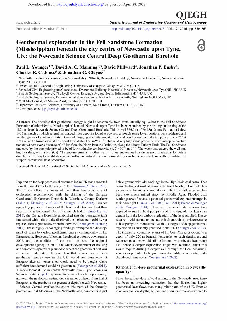
Exploration for deep geothermal resources in the UK was concertedfrom the mid-1970s to the early 1980s (Downing & Gray 1986).There then followed a hiatus of more than two decades, untilexploration recommenced with the drilling of the EastgateGeothermal Exploration Borehole in Weardale, County Durham(Table 1; Manning et al. 2007; Younger et al. 2012). Besidesupgrading previous estimates of the heat production and heat flowrates in the radiothermal North Pennine Batholith (Kimbell et al.2010), the Eastgate Borehole established that the permeable faultintersected within the granite displayed the highest permeability yetreported from a granite anywhere in theworld (Younger &Manning2010). These highly encouraging findings prompted the develop-ment of plans to exploit geothermal energy commercially at theEastgate site. However, following the global economic downturn in2008, and the abolition of the main sponsor, the regionaldevelopment agency, in 2010, the wider development of housingand commercial premises planned to accept the geothermal heat wassuspended indefinitely. It was clear that a new era of deepgeothermal energy use in the UK would not commence atEastgate after all; other sites would need to be sought wheresufficient heat demand could be guaranteed (Younger et al. 2012).A redevelopment site in central Newcastle upon Tyne, known asScience Central (Fig. 1), appeared to provide the ideal opportunity,although the geological setting there is rather different from that atEastgate, as the granite is not present at depth beneath Newcastle.
Science Central overlies the entire thickness of the formerlyproductive Coal Measures in the Newcastle area, commencing just
below ground with old workings in the High Main coal seam. Thatseam, the highest worked seam in the Great Northern Coalfield, hasa consistent thickness of around 2 m in the Newcastle area, and hasbeen extensively mined since the Middle Ages. Flooded coalworkings are, of course, a potential geothermal exploration target intheir own right (Banks et al. 2009; Faull 2011; Preene & Younger2014; Younger 2014). However, the electricity consumptionrequired to run the heat pumps (needed to upgrade the heat) candetract from the low carbon credentials of the heat supplied. Hencereservoirs with natural temperatures high enough to obviate recourseto heat pumps are more attractive; this is the goal of deep geothermalexploration as currently practised in the UK (Younger et al. 2012).The (formerly) economic seams of the Coal Measures extend to adepth of only 220 m beneath Newcastle. At such depths, groundwater temperatures would still be far too low to obviate heat-pumpuse; hence a deeper exploration target was required, albeit thiswould require drilling a deeper well through the Coal Measures,which can provide challenging ground conditions associated withabandoned mine voids (Younger et al. 2002).
Rationale for deep geothermal exploration in Newcastleupon Tyne
Since the earliest days of coal mining in the Newcastle area, therehas been an increasing realization that the district has highergeothermal heat flows than many other parts of the UK. Even atrelatively shallow depths, generations of miners were accustomed to
© 2016 The Author(s). This is an Open Access article distributed under the terms of the Creative Commons Attribution License (http://creativecommons.org/licenses/by/3.0/). Published by The Geological Society of London. Publishing disclaimer: www.geolsoc.org.uk/pub_ethics
Research article Quarterly Journal of Engineering Geology and Hydrogeology
Published online November 17, 2016 https://doi.org/10.1144/qjegh2016-053 | Vol. 49 | 2016 | pp. 350–363
by guest on April 28, 2018http://qjegh.lyellcollection.org/Downloaded from
work scantily clad. At a more scientific level, saline waters withgeochemical signatures indicative of equilibration at temperaturesup to 160°C were found throughout the collieries of the region(Younger et al. 2015). Of particular note are the barium-rich Na–Clbrines (Dunn 1877; Clowes 1889; Edmunds 1975), which werefound in various collieries that intersected some of the major west–east faults that define the block-and-basin structure of the
Carboniferous in northern England (see Turner et al. 1995); chiefamongst these is the Ninety Fathom Fault (De Paola et al. 2005).Particularly prolific inflows of barium-rich Na–Cl brines wereassociated with the Ninety Fathom Fault and one of its footwallsplays (the Rising Sun Fault) in the former North Tyneside collieriesof Eccles (UK National Grid Reference [NZ 304 718]) and RisingSun [NZ 298 683], located 10 and 7.5 km NE of Science Central
Table 1. Summary details for boreholes mentioned in the text
Borehole name BGS registration number British NationalGrid Reference
Date drilled Total depth (m)Fell Sandstone (m)
Easting Northing Top Base
Newcastle Science Central Deep Geothermal NZ 26 SW 3569 424 010 564 330 2011 1821.0 1418.5 1795.0Eastgate Geothermal Exploration NY 93 NW 97 393 870 538 210 2004 995.0 Not presentEastgate 2B NY 93 NW 98 394 526 538 126 2010 420.4 Not presentHarton Dome 1 NZ 36 NE 80 439 660 565 620 1960 1769.0 1467.3 TD1
Longhorsley 1 NZ 19 SW 6 414 442 592 553 1986 1828.0 261.95 1700.78Rookhope NY 94 SW 1 393 756 542 789 1960 – 61 807.7 Not presentRowlands Gill NZ 15 NE 276 416 634 558 141 1986 242.9 Not reachedSeal Sands 1 NZ 52 SW 308 453 796 523 805 1974 – 75 4169.7 Not presentWhitley Bay 12 NZ 37 SW 56 434 900 574 800 1967 2015.0 Not reached
1Base of Fell Sandstone not reached; TD, total depth.2Inclined borehole.
Fig. 1. Map of NE England showing the principal geological features and selected deep boreholes. Contours, in kilometres below Ordnance Datum, indicatethe upper surface of the North Pennine Batholith (after Kimbell et al. 2010). The larger inset map shows the location of the Science Central Borehole site incentral Newcastle upon Tyne in relation to numbered public highways. Contains Ordnance Survey data © Crown copyright and database right 2016.Geological data are from the British Geological Survey DiGMapGB © NERC 2015.
351Deep geothermal borehole, Newcastle upon Tyne
by guest on April 28, 2018http://qjegh.lyellcollection.org/Downloaded from
respectively. The recorded flow rates of these brines were significantand remained steady over many years; for example, the Rising Sunpit registered 1.4 million litres per day and Eccles 0.82 million litresper day. These brines were reported as being unusually warm to thetouch, and their chemistry indicated equilibration temperatures inthe range 150 – 200°C (Younger et al. 2015). At Eccles Colliery,they were so abundant and persistent that they were processed on anindustrial scale for their barium content for 43 years until the mineclosed in 1978 (Banks et al. 1996; Gray & Judd 2003). There arefew permanent exposures of the Ninety-Fathom Fault Zone, but atthe nearest of these to Newcastle (15 km ENE at Cullercoats Bay[NZ 365 712]) the Permian Yellow Sands, which elsewhere in theregion are uncemented, are thoroughly cemented by barite (BaSO4),the same mineral that was precipitated from the brines found in thenearby Rising Sun and Eccles collieries. Clearly, circulation of suchbrines in the Ninety-Fathom Fault Zone was previously even morewidespread. The clear implication is that high-temperature brinesmight still be circulating within lower reaches of the fault system atgreater depths. Where these faults cut competent horizons, fracturepermeability might be present.
But is there a suitable thickness of competent rock at suitable depths(1.5 – 2 km) to ensure commercially viable temperatures (>70°C)beneath Newcastle upon Tyne? At those depths Mississippian strataare the only possibility. Candidate lithologies would be limestone orsandstone. Some of the thicker limestone units in this region, such asthe Melmerby Scar Limestone of the North Pennines, could well hostpermeable fractures, as they do at outcrop; however, they are unlikelyto have significant intergranular permeability (Younger 1995).Sandstone might host fracture permeability and also at least someintergranular permeability. The most promising sandstone unit in theregional succession is the Fell Sandstone Formation, which is wellexposed in natural crags in mid- to north Northumberland (Fig. 1),where it typically comprises well-sorted, medium- to coarse-grainedsandstone, locally coarsening to pebble and granule-grade beds(Robson 1956; Hodgson 1978; Lawrence et al. 2011). BetweenRothbury andBerwick-upon-Tweed, the Fell Sandstone has long beenexploited as a public-supply freshwater aquifer, taking advantage ofseveral large springs and numerous boreholes (Hodgson & Gardiner1971; Bell 1978; Turner et al. 1993; Younger 1995, 1998). Allprevious boreholes in the Fell Sandstone had been consistent with thefacies model erected from outcrop observations (Hodgson 1978;Turner et al. 1993): that of a low-sinuosity braided river, withcoarsening of the modal grain size in proximity to palaeo fault-scarps(Turner et al. 1993). Whether such favourable aquifer propertieswould persist as far south as Newcastle, given the distances overwhich facies changes occur in the Mississippian of northernmostEngland and southern Scotland, or, even if they did, that sufficientporosity would be preserved at burial depths approaching 2 km, wereopen questions that could not be resolved before drilling.
A more fundamental question concerned whether the FellSandstone Formation would be present beneath Newcastle. Thepossibility that it may not had been mooted previously byCraddock-Hartopp & Holliday (1984), in the context of evaluatingpotential geothermal prospects. The Harton Dome 1 Borehole(Table 1) penetrated a sandstone unit more than 301 m thick atapproximately the right stratigraphic position, although Ridd et al.(1970) declined to assign it to the Fell Sandstone ‘Group’ (later‘demoted’ to formation status). However, no sandstonewas found inthe much deeper (4169 m) Seal Sands 1 Borehole (Table 1; Johnsonet al. 2011) some 58 km SSE fromNewcastle. Therefore, at the startof this project it was not clear that the Fell Sandstone would befound beneath Newcastle upon Tyne.
From the limited deep borehole data available, it was estimatedthat, if the Fell Sandstone were present beneath Newcastle, it oughtto be fully penetrated by a borehole drilled to 2000 m. This was thenthe maximum drilled depth envisaged for the Newcastle Science
Central Deep Geothermal Borehole (hereafter: Science CentralBorehole). However, as the ultimate choice of site was dictated byland availablity and proximity to a putative future heat demandcentre (proposed new buildings), it was always clear that theborehole was not ideally located in respect to the Ninety FathomFault or any of its known footwall splay faults (see Chadwick et al.1995). It was therefore resolved that, should available funds permit,one or more daughter boreholes would be drilled directionally fromthe vertical mother hole in the hope of intersecting fault zoneswithin the Fell Sandstone.
Drilling and well completion
Drilling of the Science Central Borehole (Table 1) started in 2011,with drilling and casing activities taking place in three distinctphases with separate rigs and crews.
In Phase 1 (16 February–15 March 2011) the hole was drilled byDrilcorp Ltd (Drilcorp) using a Beretta T151S rig through thepotentially difficult Coal Measures in which old workings wereanticipated. A 20 m length of conductor pipe was installed to sealout the shallowest mine workings in the High Main coal seam.Surface casing was then installed to 245.5 m and pressure tested to10 bar. This depth is some 10.5 m below the floor of the deepestcoal seam worked in the Newcastle area (the Brockwell Seam).
During this phase of drilling minor losses of flush occurred, butmost coal seams proved to be intact and it appears, fortuitously, thatthe location chosen for the borehole was on a ‘shaft pillar’: a radialarea of unworked strata surrounding the North Elswick Collieryshaft. However, at a depth of 160 m, a complete loss of flush wasexperienced through a number of large open fissures cutting asandstone, which at that point lies about 7 m above the Beaumont(= Harvey) coal seam. Overcoming this loss of flush was not easy anddrilling eventually proceeded with lost circulation and no cuttingsrecovery. It is inferred that the major fissures had propagated from acollapsed mine roadway, probably about 8 m from the borehole.
The shallowest groundwater at about 20 m below ground level(BGL) proved to be perched. Continual saturation was not reacheduntil a depth of about 80 m, which corresponds to the level of theRiver Tyne about a kilometre away. When the loss of flush occurredat 160 m BGL, the impact on water levels in the borehole wasdramatic: where the standing water level in the borehole had beenaround 6 m BGL, it suddenly dropped to 60.5 m BGL. Cascadingwater could be clearly heard at the top of the casing. CCTVinspection showed particles being transported downwards into openfractures at around 80 m below sea level; this level appears to reflectthe influence of continuing pumping of an old colliery shaft by theCoal Authority at Kibblesworth, some 8 km to the south.
Phase 2 of the drilling (1 June–11 July 2011) was undertaken byGeometric COFOR, working as subcontractor to Drilcorp, using ahydraulic hoist rig (HH102). The drill stack was capped with ablow-out preventer rated to 20.7 MPa (3000 psi), which exceededby a margin of 4.8 MPa (700 psi) the ‘worst-case scenario’ in theunlikely event the borehole encountered over-pressured natural gasat 2000 m depth. Casing was installed to 954 m, grouted andpressure-tested to 20.7 MPa (3000 psi). Subsequently, drillingcontinued using tri-cone rock-rollers in harder strata (such as thedolerite of the Whin Sill intrusion), and polycrystalline diamondcompact (PDC) bits with downhole motors in the softersedimentary strata. Only occasional minor losses of flush wereobserved and were swiftly rectified by addition of further drillingmud. Drilling was completed on 11 July 2011. Lack of budgetprevented drilling of daughter boreholes to intersect faults in thehope of accessing permeability associated with them (see Ellis et al.2014), installation of further casing or screening below 954 m andalso delayed geophysical logging until 26 October 2011. Good logsof fluid temperature, conductivity and natural gamma were then
352 P. L. Younger et al.
by guest on April 28, 2018http://qjegh.lyellcollection.org/Downloaded from
obtained to a depth of 970 m (i.e. 16 m beyond the toe of thecasing). At that depth, the sondes were unable to proceed beyond anobstruction. Subsequently, funds were obtained to deploy aworkover rig in July 2012. The borehole was cleaned to 1790 m(which is the base of the Fell Sandstone) using a 122 mm (4¾ inch)drill bit and 72 mm (2⅞ inch) tubing. Although this tubing stringbecame stuck fast at 1782 m, a stabilized bottom-hole temperatureof 73.3°C at 1772 m was recorded inside the tubing on 15 August2012.
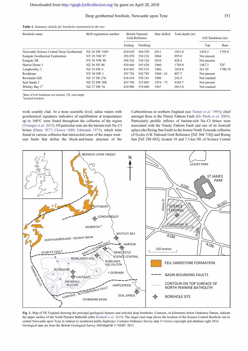
A third phase of activity was carried out in 2014 (10 March–2April), when Newcastle Science City commissioned BDF Ltd,project managed by Mott MacDonald, to reinstate the borehole sothat a pump test on the Fell Sandstone could be carried out. BDFmobilized an IDECO 5625 rig and undertook a three-step operationto clear the borehole, install a perforated liner through the FellSandstone and carry out a permeability test. The rig was able torotate the 72 mm tubing but unable to circulate through it or move it
vertically. On 14 March the tubing was cut and 1690 m wereretrieved, leaving a 92 m bottom-hole assembly in situ.Considerable quantities of backfill were then cleared from theborehole and on 21 March 2014 two geophysical sonde runs(gamma-caliper and gamma short and long resistivity) were madefrom 1394 m BGL to 1680 m BGL in the open-hole section below a52 mm drill string. ‘Techniseal’ tubing was then hung off inside theexisting 178 mm (7 inch) casing with a perforated section for theFell Sandstone interval, from 1418.5 m BGL to the shoe at1650.88 m BGL. Perforations comprised a series of six drilled holes(12.5 mm diameter) per foot on a spiral pattern of three holes at120° × 152 mm (6 inch) pitch. Three ‘swell’ packers were installedon the 115 mm (4½ inch) casing to isolate the casing annulus bysealing against the formation at locations chosen from the gamma-caliper log.
Figure 2 is based on the Phase 3 as-built drawing and includes thecasing and drilling details from the earlier phases.
Fig. 2. Science Central well constructiondiagram.
353Deep geothermal borehole, Newcastle upon Tyne
by guest on April 28, 2018http://qjegh.lyellcollection.org/Downloaded from
The perforated section was then cleaned and developed bywashing with clean water to displace mud, circulation withhypochlorite solution to break down the polymer, airlifting, andrepeated forward and reverse circulation with 72 mm (2⅞ inch)eductor at various settings within the slotted section. A short airliftyield test with the eductor at 200 m (the submergence limited by theair compressor) then gave an estimated yield of less than 0.1 l s−1.Because recovery was very slow, further attempts were made tostimulate flow from the formation by successively lowering theairline by 200 m and airlifting until, ultimately, a pumped waterlevel of 805 m BGL was achieved. From 00:40 on 23 March, finalrecovery was measured in two stages; first, using the air pressuregauge to calculate submergence; second, using a pressuretransducer once water levels had recovered to 200 m BGL.
Once the well had recovered (June 2014), water samples weretaken at 500, 1000 and 1500 m using a 2 l motorized water sampler(European Geophysical Services Ltd; EGS). Water samples wereanalysed using the following techniques: cations by inductivelycoupled plasma optical emission spectroscopy (ICP-OES) using aVarian Vista MPX axial ICP-OES system with CCD detectoraccording to Standard Methods for the Examination of Water andWaste Water Section 3120B (American Public Health Association;American Water Works Association; Water Pollution ControlFederation 1981); anions by ion chromatography, using a DionexDX 320 ion chromatograph system for Gradient Anion Analysisaccording to Standard Methods for the Examination of Water andWaste Water Section 4110B; ammoniacal N using a GerhardtVapodest distillation unit to conduct the primary distillation step inaccordance with Standard Methods for the Examination of Waterand Waste Water Section 4500-NH₃ B, followed by titration inaccordance with Standard Methods for the Examination of Waterand Waste Water Section 4500-NH₃ C; pH and conductivity using aMyron L Company Ultrameter II – pH calibrated with pH 4, 7 and10 buffers and conductivity with 1413 µS cm−1 standard inaccordance with manufacturer’s operation manual. Conductivitywas also checked using a 12 880 µS cm−1 standard; alkalinity usinga Hach Digital Titrator Model AL-DT kit set up according tomanufacturer’s operation manual. Two water samples collectedduring drilling were analysed radiochemically by Tracerco Ltd,Teesside (www.tracerco.com).
Geological and geophysical logging
Interpretation of the geology encountered in the borehole is basedon the cuttings log, augmented and corrected for depth using theoriginal natural gamma log. During drilling cuttings samples weretaken every 1 m from 4 to 161 m BGL and every 5 m from 251 m tothe terminated depth and examined for lithology and reservoirquality; no samples were recovered from the interval 161 – 251 m ascirculation in the borehole was lost. The cuttings are stored in theMaterials Collections at the National Geological Repository at theBGS in Keyworth, Nottinghamshire. BGS registration details aregiven in Table 1.
Wireline geophysical logs were acquired by EGS.From the customary wireline geophysical log suite available to
facilitate geological interpretation, only the natural gamma log wasacquired in the first two drilling phases. Problems with side-wallinstability meant that, with the exception of the uppermost 239 mthrough which data were acquired in open hole, the logs had to beacquired through 170 mm diameter steel casing to 943 m andthrough 60 mm i.d. pipe to the final logging depth of 1782 m. Thelogs are not corrected for borehole diameter as there was no calliperlog. On 3 April 2014 bottom-hole temperature was measured at68°C (1649 m). Then gamma-caliper and gamma short and longnormal resistivity logs were run for the open-hole interval 1394–1680 m BGL. These logs corroborate the interpretation derived
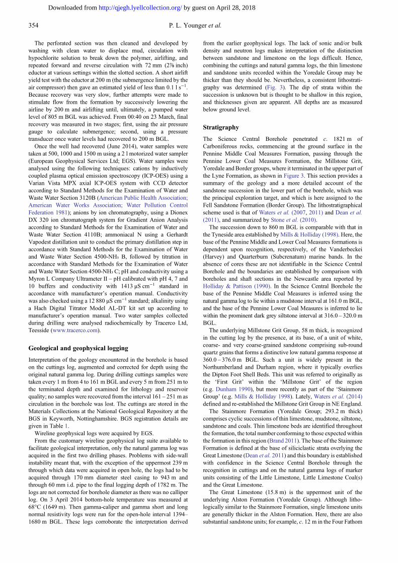
from the earlier geophysical logs. The lack of sonic and/or bulkdensity and neutron logs makes interpretation of the distinctionbetween sandstone and limestone on the logs difficult. Hence,combining the cuttings and natural gamma logs, the thin limestoneand sandstone units recorded within the Yoredale Group may bethicker than they should be. Nevertheless, a consistent lithostrati-graphy was determined (Fig. 3). The dip of strata within thesuccession is unknown but is thought to be shallow in this region,and thicknesses given are apparent. All depths are as measuredbelow ground level.
Stratigraphy
The Science Central Borehole penetrated c. 1821 m ofCarboniferous rocks, commencing at the ground surface in thePennine Middle Coal Measures Formation, passing through thePennine Lower Coal Measures Formation, the Millstone Grit,Yoredale and Border groups, where it terminated in the upper part ofthe Lyne Formation, as shown in Figure 3. This section provides asummary of the geology and a more detailed account of thesandstone succession in the lower part of the borehole, which wasthe principal exploration target, and which is here assigned to theFell Sandstone Formation (Border Group). The lithostratigraphicalscheme used is that of Waters et al. (2007, 2011) and Dean et al.(2011), and summarized by Stone et al. (2010).
The succession down to 860 m BGL is comparable with that inthe Tyneside area established by Mills & Holliday (1998). Here, thebase of the Pennine Middle and Lower Coal Measures formations isdependent upon recognition, respectively, of the Vanderbeckei(Harvey) and Quarterburn (Subcrenatum) marine bands. In theabsence of cores these are not identifiable in the Science CentralBorehole and the boundaries are established by comparison withboreholes and shaft sections in the Newcastle area reported byHolliday & Pattison (1990). In the Science Central Borehole thebase of the Pennine Middle Coal Measures is inferred using thenatural gamma log to lie within a mudstone interval at 161.0 m BGL,and the base of the Pennine Lower Coal Measures is inferred to liewithin the prominent dark grey siltstone interval at 316.0 – 320.0 mBGL.
The underlying Millstone Grit Group, 58 m thick, is recognizedin the cutting log by the presence, at its base, of a unit of white,coarse- and very coarse-grained sandstone comprising sub-roundquartz grains that forms a distinctive low natural gamma response at360.0 – 376.0 m BGL. Such a unit is widely present in theNorthumberland and Durham region, where it typically overliesthe Dipton Foot Shell Beds. This unit was referred to originally asthe ‘First Grit’ within the ‘Millstone Grit’ of the region(e.g. Dunham 1990), but more recently as part of the ‘StainmoreGroup’ (e.g. Mills & Holliday 1998). Lately, Waters et al. (2014)defined and re-established the Millstone Grit Group in NE England.
The Stainmore Formation (Yoredale Group; 293.2 m thick)comprises cyclic successions of thin limestone, mudstone, siltstone,sandstone and coals. Thin limestone beds are identified throughoutthe formation, the total number conforming to those expected withinthe formation in this region (Brand 2011). The base of the StainmoreFormation is defined at the base of siliciclastic strata overlying theGreat Limestone (Dean et al. 2011) and this boundary is establishedwith confidence in the Science Central Borehole through therecognition in cuttings and on the natural gamma logs of markerunits consisting of the Little Limestone, Little Limestone Coal(s)and the Great Limestone.
The Great Limestone (15.8 m) is the uppermost unit of theunderlying Alston Formation (Yoredale Group). Although litho-logically similar to the Stainmore Formation, single limestone unitsare generally thicker in the Alston Formation. Here, there are alsosubstantial sandstone units; for example, c. 12 m in the Four Fathom
354 P. L. Younger et al.
by guest on April 28, 2018http://qjegh.lyellcollection.org/Downloaded from
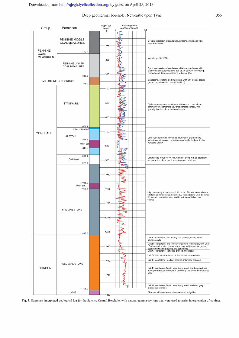
Fig. 3. Summary interpreted geological log for the Science Central Borehole, with natural gamma-ray logs that were used to assist interpretation of cuttings.
355Deep geothermal borehole, Newcastle upon Tyne
by guest on April 28, 2018http://qjegh.lyellcollection.org/Downloaded from
cycle and 6 m in the Three Yard cycle. Between the limestone andsandstone units, intervals of decreasing upward natural gamma logvalues indicate upwards coarsening from mudstone to sandstone, acharacteristic of this formation. Thus, the Alston Formation too hasa characteristic natural gamma log profile. However, only a few ofthe Yoredale cycles are present and at 133.8 m the thickness of theAlston Formation proved in the Science Central Borehole is verymuch thinner than that seen, for example, in the boreholes (Table 1;Fig. 1) at Rookhope (264.2 m; Johnson & Nudds 1996),Longhorsley 1 (311 m; Lawrence et al. 2011) and Harton Dome 1(467 m; Ridd et al. 1970).
The explanation for the unusually thin Alston Formation lies inthe interpretation of the cuttings from a 68 m interval from 860.0 to928.0 m BGL. Throughout this zone quartz-dolerite contributes10 – 30% of the cuttings samples. The typically sub-angular shapeof the cuttings, and the presence of a gap between the start of thiszone and the dolerite seen higher up at 765.5 – 813.5 m BGL, doesnot suggest that these are cavings from that unit of dolerite. Inaddition to the dolerite cuttings, there are changing proportions oflimestone, sandstone, mudstone and coal (e.g. at 905 m), suggestingthat a stratigraphy is present. This is supported by the character ofthe natural gamma log, which is similar to that for the AlstonFormation above the zone: the constant values for the dolerite wouldnot alter the shape of the curve radically. It is concluded that thezone is a fault, juxtaposing dolerite against Alston Formation. Thiswould explain the very slow drilling rate throughout this section andthe worn bit recovered when the drill string was pulled from thebottom of it.
The natural gamma log from the Tyne Limestone Formationentered below the fault zone shows a higher frequency responsethan that from the Alston Formation and the cuttings containevidence of many thin limestone and sandstone units alternatingwith siltstone and mudstone, which is typically micaceous. A fewcoarsening- and fining-upwards parasequences are noted, althoughthe intervals are generally thinner than in the Alston Formation.Below 1294 m sandstone forms a significant proportion of theformation with units up to 20 m thick. The sandstone is white, fineand very fine grained, and carbonate cemented. The base of theformation at 1418.5 m BGL is marked by the absence of limestonebeds and a major change in the character of the natural gamma log.The thickness of the formation is 452 m, less than proved in theLonghorsley 1 Borehole (530 m; Lawrence et al. 2011), owing inpart to its faulted upper contact.
Of particular interest in the Science Central borehole is thesuccession of sandstone units, 376.5 m thick, encountered between1418.5 and 1795 m BGL and interpreted as the Fell SandstoneFormation. This is described in more detail below. The lowest 25 mseen in the borehole consist of red, grey and purple micaceoussiltstone with subordinate dolostone, sandstone and evaporite-rock(possibly anhydrite). Although only a fewmetres were encountered,the lithologies present are similar to the Lyne Formation describedfrom north Cumbria and the Scottish Borders (Day 1970; Ward1997; Dean et al. 2011).
Quartz-dolerite, interpreted as corresponding to the regionallyimportant Great Whin Sill (Randall 1995; Stone et al. 2010), occursat twomain intervals in the Science Central Borehole: 765.5 – 813.5and 1058.0 – 1096.5 m BGL, giving a combined thickness of86.5 m. It is not known whether the further 68 m of quartz-doleriteencountered in the apparent fault zone is a third leaf, a faulted repeatof one of the other leaves, or a dyke. The two main units are perhapsthe most readily identified on the natural gamma log and serve as thefirst-order calibration of the cuttings log. The upper of these twointervals occurs within the Alston Formation between the FourFathom and Five Yard limestones. The lower interval occurs withinthe Tyne Limestone Formation. The occurrence here is comparablewith that in the Harton Dome 1 Borehole, which proved a combined
thickness of 99.4 m, the thickest known for this unit. However, atHarton all three leaves occur within the Alston Formation.
Fell Sandstone Formation
The Fell Sandstone Formation in the Science Central boreholecomprises white, pink and red, very fine- to coarse-grained sandstonewith a proportion of dark grey micaceous siltstone that varies fromalmost none in the lower part to substantial in the upper part. Thinlimestone beds are recorded at 1440 and 1750 m BGL. On the basisof the natural gamma log response, the formation is divided intoseven units (A–G, Fig. 3). The log response for units D–G displayssubstantially higher values than for sandstones throughout the rest ofthe borehole succession, reflecting the argillaceous and commonlyhighly micaceous nature of the formation. Unit F has the highestgamma values for any sandstone in the borehole succession. Thegamma-caliper and gamma short and long normal resistivity logsacquired in 2014 for the open-hole interval 1394–1680 m BGLprovide supporting evidence to the subdivisions identified within theFell Sandstone. EGS reported values of 1.35 and 1.45 ohm m for twosamples of the polymer mud in the borehole at the time of logging.The short and long normal resistivity values are around 30 and35 ohm m respectively over much of the section but where there aredepth intervals with higher values (typically in the range 100 –150 ohm m; the peak values of 190 and 250 ohm m occur at 1405 mBGL), the long normal value is always the higher.
Most of the sandstone is very fine and fine grained, and weaklycalcareous. The exceptions are Unit B, which is coarse grained, andUnit E, which is medium grained. The former is also feldspathic andthere are abundant round to sub-round, frosted quartz grains(aeolian) in the upper part of the unit, along with dark red to brownjasper-like grains. The sandstone throughout is quartzitic, althougha small proportion of very pale green lithic clasts and dark heavyminerals is evident from visual inspection in all but Unit A, which isalso white (all the other sandstones are pale pink to red).
The proportion of interbedded siltstone varies between the units.Unit F appears to contain the least siltstone and Unit B the most.Units D and F comprise two packages dominantly of sandstoneseparated by siltstone, whereas Unit B coarsens upwards overallfrom siltstone at the base to sandstone.
With the exception of the occurrence of aeolian grains and theabsence of some beds of coal, this sandstone succession resemblesthe description of the unassigned sandstone formation at the base ofthe succession in the Harton Dome 1 Borehole (Fig. 1; Table 1).Similarities include the grain size, the argillaceous and micaceouscharacter, and the nature of the cement, with the upper part reported tobe calcareous whereas the lower part is siliceous (Ridd et al. 1970).
The formation is here equated with the Fell Sandstone Formation,contrary to the conclusion of Ridd et al. (1970) for the Harton Dome1 Borehole. However, there are differences from the Fell Sandstoneat outcrop in north Northumberland. There, the Fell Sandstone istypically medium to coarse grained, coarsening locally to pebblyand granule-grade beds (Robson 1956; Lawrence et al. 2011); therocks are generally silica-cemented (Turner et al. 1993). Aeoliangrains have not, to our knowledge, been reported previously. Thegrain size of the Science Central Borehole sandstones is more akinto that seen from the Fell Sandstone at outcrop NE of Bewcastle,where the formation is fine to medium grained and moreargillaceous, although the rocks there are more lithic rich (Day1970). The grain-size change is compatible with the more distallocation of this new record.
Geothermics
Heat flow is a primary parameter in the assessment of geothermalenergy resources and allows more reliable extrapolations of
356 P. L. Younger et al.
by guest on April 28, 2018http://qjegh.lyellcollection.org/Downloaded from
temperatures to depth than geothermal gradients. Heat flow isconsidered to be either measured, whereby equilibrium tempera-tures are combined with measured thermal conductivities from thegeological strata over which the equilibrium temperatures weremeasured (a thermal conductivity log), or estimated, where thethermal conductivities have to be assumed (Rollin 1995). Estimatedheat flows are much less reliable than measured, but owing to thelack of onshore boreholes with thermal conductivity logs three-quarters of the UK onshore heat flow dataset is estimated (Busby2010).
As outlined above, the Science Central borehole was temperaturelogged on a number of occasions. For geothermic appraisalpurposes, the most useful logging event was that carried out on15 August 2012, more than a year after borehole terminated depthwas reached, and a month after the cessation of renewed circulationwhen the borehole was cleared using the workover rig. An estimateof the residual effect on the temperatures in the borehole owing toflushing has been made with the Horner method (Lachenbruch &Brewer 1959). This shows that at 500 m depth the residual effect is+0.03°C and at 1759 m depth it is −0.03°C. Hence the temperaturelog recorded in August 2012 can be considered to representequilibrium temperatures. This is supported by the temperature of73°C recorded at 1730 m BGL by Schlumberger on 13 March 2014(20 months after flushing ceased).
The sample returns from the drilling were too fine and too mixedfor thermal conductivity measurements. Hence only an estimatedheat flow can be determined. However, the Longhorsley 1 Borehole,30 km to the NNW (Fig. 1; Table 1), drilled in 1986 by CandeccaResources plc has a thermal conductivity log frommeasurements onchip samples that were corrected for porosities derived from thegeophysical logs (Gebski et al. 1987). The sequence penetrated isvery similar to that at Science Central except that it commences
below the Millstone Grit (Lawrence et al. 2011). An attempt totranspose this log to Science Central has been made using some keyhorizons as guides. These are principally the Great Limestone, theFour Fathom Limestone, the Whin Sill (Upper and Lower Leaf), theFive Yard Limestone and the Fell Sandstone. The estimated thermalconductivity log for Science Central is shown in Figure 4 for thedepth range 500 – 1755 m.
Figure 4 also shows the temperature log and, derived from it, thetemperature gradient log calculated over 5 m intervals. Thetemperature gradient log displays significant and rapid variationdown the borehole that is consistent with a rapidly varying sequenceof siltstone, sandstone and limestone. Below 1400 m the gradientlog shows less variation owing to the thick sandstone sequence inthe upper section of the Fell Sandstone, and the lower gradients tothe bottom of the hole are compatible with a sandstone-dominatedsequence.
There are a number of techniques for calculating heat flow. Theheat flow Qd at a depth d is given by
Qd ¼ lddT
dz
� �d
where (δT/δz)d is the temperature gradient over the interval ofthermal conductivity λd. However, a technique that combines all theobservations from the borehole is the step-integrated heat flowequation of Bullard (1939). The relationship between the thermalresistance (a measurement of resistance to heat flow in a material) Rand the temperature T is linear for conductive, steady-state verticalheat flow with no internal heat production; that is,
Tz ¼ To þ QXi
Dzili
� �
Fig. 4. Plots of temperature (diagonalblack line), temperature gradient (greyline in left-hand plot) and estimatedthermal conductivity (grey line in right-hand plot) for depths below 500 m in theScience Central borehole. Thestratigraphic log, summarized from thefull version in Figure 3, is shown on theright.
357Deep geothermal borehole, Newcastle upon Tyne
by guest on April 28, 2018http://qjegh.lyellcollection.org/Downloaded from
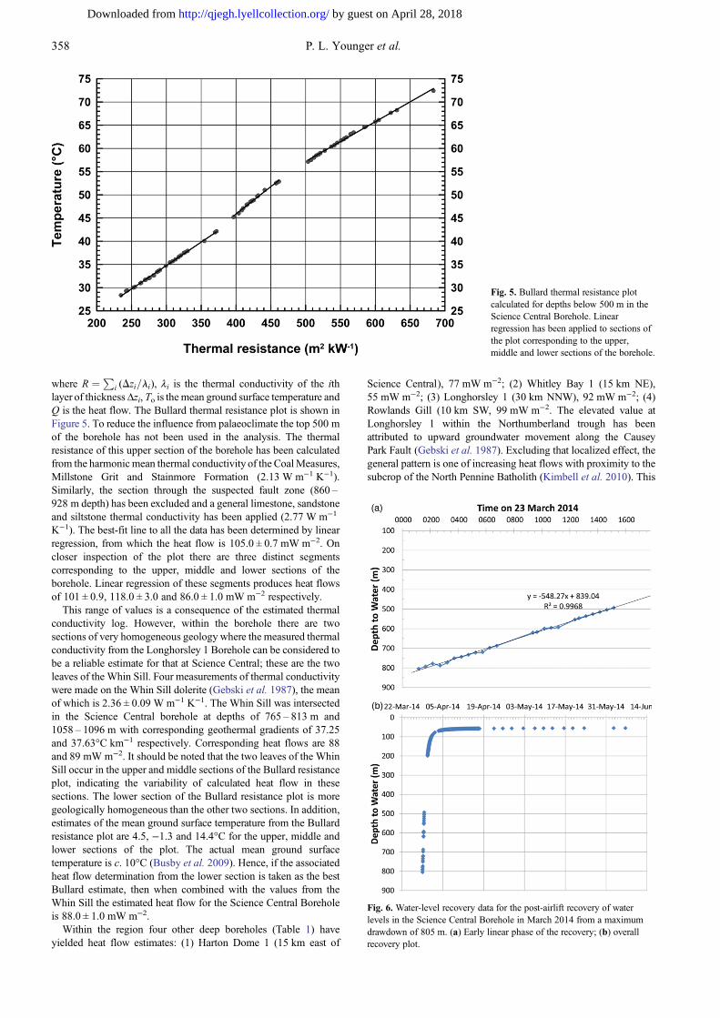
where R ¼ Pi (Dzi=li), λi is the thermal conductivity of the ith
layer of thickness Δzi, To is the mean ground surface temperature andQ is the heat flow. The Bullard thermal resistance plot is shown inFigure 5. To reduce the influence from palaeoclimate the top 500 mof the borehole has not been used in the analysis. The thermalresistance of this upper section of the borehole has been calculatedfrom the harmonic mean thermal conductivity of the CoalMeasures,Millstone Grit and Stainmore Formation (2.13 W m−1 K−1).Similarly, the section through the suspected fault zone (860 –928 m depth) has been excluded and a general limestone, sandstoneand siltstone thermal conductivity has been applied (2.77 W m−1
K−1). The best-fit line to all the data has been determined by linearregression, from which the heat flow is 105.0 ± 0.7 mW m−2. Oncloser inspection of the plot there are three distinct segmentscorresponding to the upper, middle and lower sections of theborehole. Linear regression of these segments produces heat flowsof 101 ± 0.9, 118.0 ± 3.0 and 86.0 ± 1.0 mW m−2 respectively.
This range of values is a consequence of the estimated thermalconductivity log. However, within the borehole there are twosections of very homogeneous geology where the measured thermalconductivity from the Longhorsley 1 Borehole can be considered tobe a reliable estimate for that at Science Central; these are the twoleaves of the Whin Sill. Four measurements of thermal conductivitywere made on the Whin Sill dolerite (Gebski et al. 1987), the meanof which is 2.36 ± 0.09 W m−1 K−1. The Whin Sill was intersectedin the Science Central borehole at depths of 765 – 813 m and1058 – 1096 m with corresponding geothermal gradients of 37.25and 37.63°C km−1 respectively. Corresponding heat flows are 88and 89 mW m−2. It should be noted that the two leaves of the WhinSill occur in the upper and middle sections of the Bullard resistanceplot, indicating the variability of calculated heat flow in thesesections. The lower section of the Bullard resistance plot is moregeologically homogeneous than the other two sections. In addition,estimates of the mean ground surface temperature from the Bullardresistance plot are 4.5, −1.3 and 14.4°C for the upper, middle andlower sections of the plot. The actual mean ground surfacetemperature is c. 10°C (Busby et al. 2009). Hence, if the associatedheat flow determination from the lower section is taken as the bestBullard estimate, then when combined with the values from theWhin Sill the estimated heat flow for the Science Central Boreholeis 88.0 ± 1.0 mW m−2.
Within the region four other deep boreholes (Table 1) haveyielded heat flow estimates: (1) Harton Dome 1 (15 km east of
Science Central), 77 mW m−2; (2) Whitley Bay 1 (15 km NE),55 mW m−2; (3) Longhorsley 1 (30 km NNW), 92 mW m−2; (4)Rowlands Gill (10 km SW, 99 mW m−2. The elevated value atLonghorsley 1 within the Northumberland trough has beenattributed to upward groundwater movement along the CauseyPark Fault (Gebski et al. 1987). Excluding that localized effect, thegeneral pattern is one of increasing heat flows with proximity to thesubcrop of the North Pennine Batholith (Kimbell et al. 2010). This
Fig. 5. Bullard thermal resistance plotcalculated for depths below 500 m in theScience Central Borehole. Linearregression has been applied to sections ofthe plot corresponding to the upper,middle and lower sections of the borehole.
Fig. 6. Water-level recovery data for the post-airlift recovery of waterlevels in the Science Central Borehole in March 2014 from a maximumdrawdown of 805 m. (a) Early linear phase of the recovery; (b) overallrecovery plot.
358 P. L. Younger et al.
by guest on April 28, 2018http://qjegh.lyellcollection.org/Downloaded from
granite, which has no surface outcrop, has been known to beradiothermal since it was first accessed by the Rookhope Borehole(Table 1) in 1960 – 61 (Dunham et al. 1965), and has recently beena target of geothermal exploration in its own right through thedrilling and testing of two boreholes at Eastgate, County Durham(Table 1; Manning et al. 2007; Younger & Manning 2010). Thenortheasterly outpost of the Batholith, the Rowlands Gill Pluton(Kimbell et al. 2010), is also its closest subcrop to centralNewcastle, lying some 8 km to the WSW of the Science CentralBorehole. Given this separation, any influence of that radiothermalgranite on heat flow in central Newcastle must be indirect.Inspection of the regional geological framework (Kimbell et al.2010) leads to the suggestion that convection of deep groundwatermay be occurring along the major west–east-striking faults of theStublick–Ninety Fathom Fault system (Fig. 1). These faults appearto intersect the Rowlands Gill Pluton, and the principal fault (theNinety Fathom Fault) crops out c. 2 km north of Science Central.This does not necessarily mean that hot water from the convectivezone is entering the Fell Sandstone, but it does at least imply thatthermal conduction above zones of hot groundwater flow couldexplain the observed positive heat anomaly in central Newcastle.
Hydraulic conductivity testing and permeability
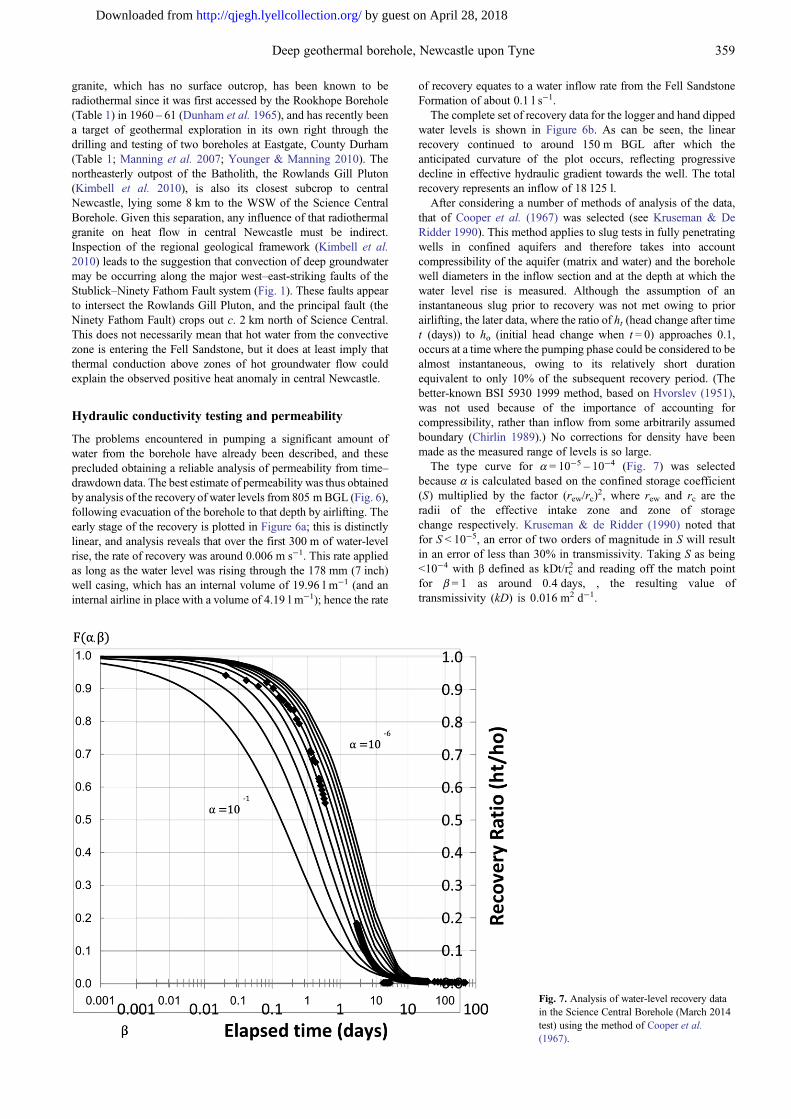
The problems encountered in pumping a significant amount ofwater from the borehole have already been described, and theseprecluded obtaining a reliable analysis of permeability from time–drawdown data. The best estimate of permeability was thus obtainedby analysis of the recovery of water levels from 805 mBGL (Fig. 6),following evacuation of the borehole to that depth by airlifting. Theearly stage of the recovery is plotted in Figure 6a; this is distinctlylinear, and analysis reveals that over the first 300 m of water-levelrise, the rate of recovery was around 0.006 m s−1. This rate appliedas long as the water level was rising through the 178 mm (7 inch)well casing, which has an internal volume of 19.96 l m−1 (and aninternal airline in place with a volume of 4.19 l m−1); hence the rate
of recovery equates to a water inflow rate from the Fell SandstoneFormation of about 0.1 l s−1.
The complete set of recovery data for the logger and hand dippedwater levels is shown in Figure 6b. As can be seen, the linearrecovery continued to around 150 m BGL after which theanticipated curvature of the plot occurs, reflecting progressivedecline in effective hydraulic gradient towards the well. The totalrecovery represents an inflow of 18 125 l.
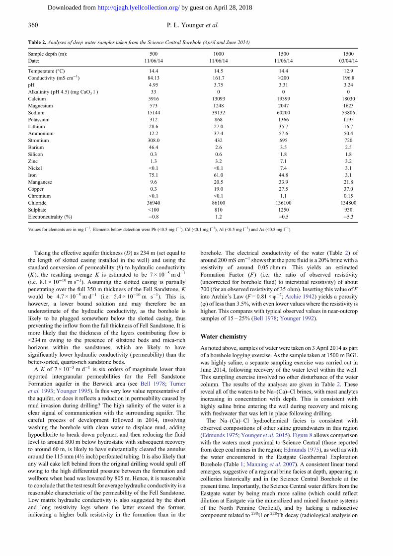
After considering a number of methods of analysis of the data,that of Cooper et al. (1967) was selected (see Kruseman & DeRidder 1990). This method applies to slug tests in fully penetratingwells in confined aquifers and therefore takes into accountcompressibility of the aquifer (matrix and water) and the boreholewell diameters in the inflow section and at the depth at which thewater level rise is measured. Although the assumption of aninstantaneous slug prior to recovery was not met owing to priorairlifting, the later data, where the ratio of ht (head change after timet (days)) to ho (initial head change when t = 0) approaches 0.1,occurs at a time where the pumping phase could be considered to bealmost instantaneous, owing to its relatively short durationequivalent to only 10% of the subsequent recovery period. (Thebetter-known BSI 5930 1999 method, based on Hvorslev (1951),was not used because of the importance of accounting forcompressibility, rather than inflow from some arbitrarily assumedboundary (Chirlin 1989).) No corrections for density have beenmade as the measured range of levels is so large.
The type curve for α = 10−5 – 10−4 (Fig. 7) was selectedbecause α is calculated based on the confined storage coefficient(S) multiplied by the factor (rew/rc)
2, where rew and rc are theradii of the effective intake zone and zone of storagechange respectively. Kruseman & de Ridder (1990) noted thatfor S < 10−5, an error of two orders of magnitude in S will resultin an error of less than 30% in transmissivity. Taking S as being<10−4 with β defined as kDt/rc
2 and reading off the match pointfor β = 1 as around 0.4 days, , the resulting value oftransmissivity (kD) is 0.016 m2 d−1.
Fig. 7. Analysis of water-level recovery datain the Science Central Borehole (March 2014test) using the method of Cooper et al.(1967).
359Deep geothermal borehole, Newcastle upon Tyne
by guest on April 28, 2018http://qjegh.lyellcollection.org/Downloaded from
Taking the effective aquifer thickness (D) as 234 m (set equal tothe length of slotted casing installed in the well) and using thestandard conversion of permeability (k) to hydraulic conductivity(K ), the resulting average K is estimated to be 7 × 10⁻⁵ m d−1
(i.e. 8.1 × 10⁻¹⁰ m s−1). Assuming the slotted casing is partiallypenetrating over the full 350 m thickness of the Fell Sandstone, Kwould be 4.7 × 10⁻⁵ m d−1 (i.e. 5.4 × 10⁻¹⁰ m s−1). This is,however, a lower bound solution and may therefore be anunderestimate of the hydraulic conductivity, as the borehole islikely to be plugged somewhere below the slotted casing, thuspreventing the inflow from the full thickness of Fell Sandstone. It ismore likely that the thickness of the layers contributing flow is<234 m owing to the presence of siltstone beds and mica-richhorizons within the sandstones, which are likely to havesignificantly lower hydraulic conductivity (permeability) than thebetter-sorted, quartz-rich sandstone beds.
A K of 7 × 10⁻⁵ m d−1 is six orders of magnitude lower thanreported intergranular permeabilities for the Fell SandstoneFormation aquifer in the Berwick area (see Bell 1978; Turneret al. 1993; Younger 1995). Is this very low value representative ofthe aquifer, or does it reflects a reduction in permeability caused bymud invasion during drilling? The high salinity of the water is aclear signal of communication with the surrounding aquifer. Thecareful process of development followed in 2014, involvingwashing the borehole with clean water to displace mud, addinghypochlorite to break down polymer, and then reducing the fluidlevel to around 800 m below hydrostatic with subsequent recoveryto around 60 m, is likely to have substantially cleared the annulusaround the 115 mm (4½ inch) perforated tubing. It is also likely thatany wall cake left behind from the original drilling would spall offowing to the high differential pressure between the formation andwellbore when head was lowered by 805 m. Hence, it is reasonableto conclude that the test result for average hydraulic conductivity is areasonable characteristic of the permeability of the Fell Sandstone.Low matrix hydraulic conductivity is also suggested by the shortand long resistivity logs where the latter exceed the former,indicating a higher bulk resistivity in the formation than in the
borehole. The electrical conductivity of the water (Table 2) ofaround 200 mS cm−1 shows that the pore fluid is a 20% brine with aresistivity of around 0.05 ohm m. This yields an estimatedFormation Factor (F) (i.e. the ratio of observed resistivity(uncorrected for borehole fluid) to interstitial resistivity) of about700 (for an observed resistivity of 35 ohm). Inserting this value of Finto Archie’s Law (F = 0.81 × w−2; Archie 1942) yields a porosity(w) of less than 3.5%, with even lower values where the resistivity ishigher. This compares with typical observed values in near-outcropsamples of 15 – 25% (Bell 1978; Younger 1992).
Water chemistry
As noted above, samples of water were taken on 3 April 2014 as partof a borehole logging exercise. As the sample taken at 1500 m BGLwas highly saline, a separate sampling exercise was carried out inJune 2014, following recovery of the water level within the well.This sampling exercise involved no other disturbance of the watercolumn. The results of the analyses are given in Table 2. Thesereveal all of the waters to be Na–(Ca)–Cl brines, with most analytesincreasing in concentration with depth. This is consistent withhighly saline brine entering the well during recovery and mixingwith freshwater that was left in place following drilling.
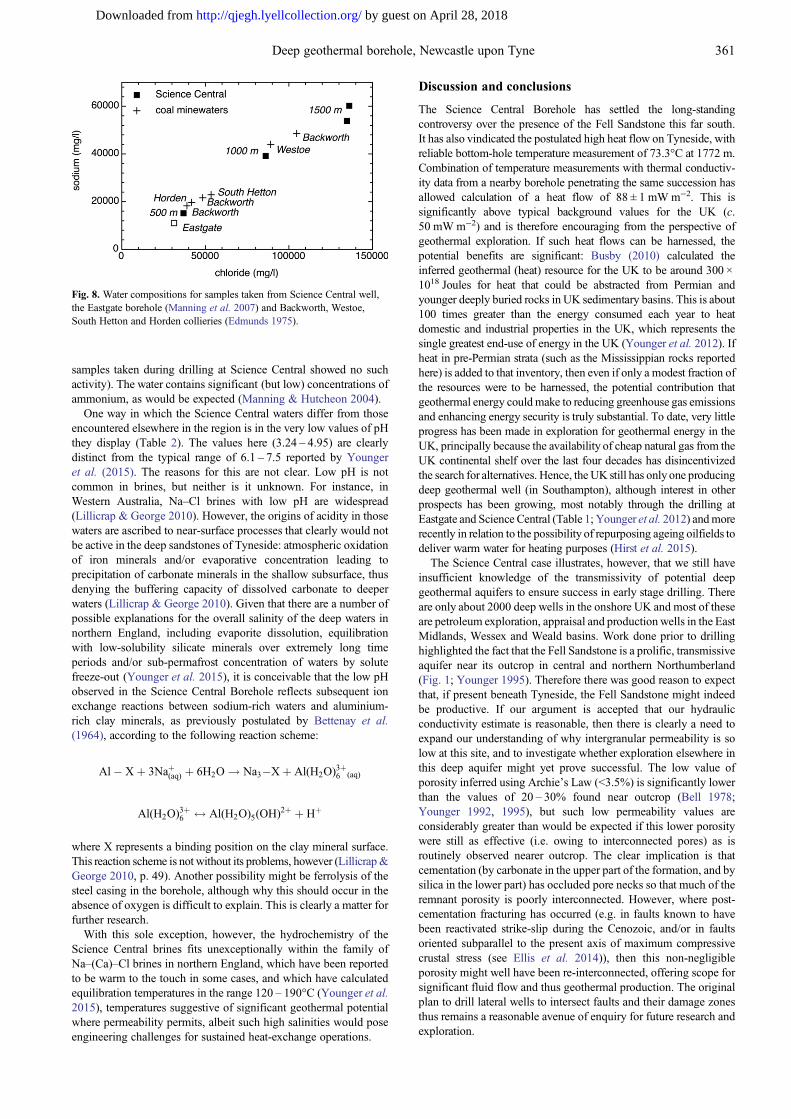
The Na–(Ca)–Cl hydrochemical facies is consistent withobserved compositions of other saline groundwaters in this region(Edmunds 1975; Younger et al. 2015). Figure 8 allows comparisonwith the waters most proximal to Science Central (those reportedfrom deep coal mines in the region; Edmunds 1975), as well as withthe water encountered in the Eastgate Geothermal ExplorationBorehole (Table 1; Manning et al. 2007). A consistent linear trendemerges, suggestive of a regional brine facies at depth, appearing incollieries historically and in the Science Central Borehole at thepresent time. Importantly, the Science Central water differs from theEastgate water by being much more saline (which could reflectdilution at Eastgate via the mineralized and mined fracture systemsof the North Pennine Orefield), and by lacking a radioactivecomponent related to 238U or 228Th decay (radiological analysis on
Table 2. Analyses of deep water samples taken from the Science Central Borehole (April and June 2014)
Sample depth (m): 500 1000 1500 1500Date: 11/06/14 11/06/14 11/06/14 03/04/14
Temperature (°C) 14.4 14.5 14.4 12.9Conductivity (mS cm−1) 84.13 161.7 >200 196.8pH 4.95 3.75 3.31 3.24Alkalinity (pH 4.5) (mg CaO3 l ) 33 0 0 0Calcium 5916 13093 19399 18030Magnesium 573 1248 2047 1623Sodium 15144 39132 60200 53806Potassium 312 868 1366 1195Lithium 28.6 27.0 35.7 16.7Ammonium 12.2 37.4 57.6 50.4Strontium 308.0 432 695 720Barium 46.4 2.6 3.5 2.5Silicon 0.3 0.6 1.8 1.8Zinc 1.3 3.2 7.1 3.2Nickel <0.1 <0.1 7.4 3.1Iron 75.1 61.0 44.8 3.1Manganese 9.6 20.5 33.9 21.8Copper 0.3 19.0 27.5 37.0Chromium <0.1 <0.1 1.1 0.15Chloride 36940 86100 136100 134800Sulphate <100 810 1250 930Electroneutrality (%) −0.8 1.2 −0.5 −5.3
Values for elements are in mg l−1. Elements below detection were Pb (<0.5 mg l−1), Cd (<0.1 mg l−1), Al (<0.5 mg l−1) and As (<0.5 mg l−1).
360 P. L. Younger et al.
by guest on April 28, 2018http://qjegh.lyellcollection.org/Downloaded from
samples taken during drilling at Science Central showed no suchactivity). The water contains significant (but low) concentrations ofammonium, as would be expected (Manning & Hutcheon 2004).
One way in which the Science Central waters differ from thoseencountered elsewhere in the region is in the very low values of pHthey display (Table 2). The values here (3.24 – 4.95) are clearlydistinct from the typical range of 6.1 – 7.5 reported by Youngeret al. (2015). The reasons for this are not clear. Low pH is notcommon in brines, but neither is it unknown. For instance, inWestern Australia, Na–Cl brines with low pH are widespread(Lillicrap & George 2010). However, the origins of acidity in thosewaters are ascribed to near-surface processes that clearly would notbe active in the deep sandstones of Tyneside: atmospheric oxidationof iron minerals and/or evaporative concentration leading toprecipitation of carbonate minerals in the shallow subsurface, thusdenying the buffering capacity of dissolved carbonate to deeperwaters (Lillicrap & George 2010). Given that there are a number ofpossible explanations for the overall salinity of the deep waters innorthern England, including evaporite dissolution, equilibrationwith low-solubility silicate minerals over extremely long timeperiods and/or sub-permafrost concentration of waters by solutefreeze-out (Younger et al. 2015), it is conceivable that the low pHobserved in the Science Central Borehole reflects subsequent ionexchange reactions between sodium-rich waters and aluminium-rich clay minerals, as previously postulated by Bettenay et al.(1964), according to the following reaction scheme:
Al� Xþ 3Naþ(aq) þ 6H2O ! Na3�Xþ Al(H2O)3þ6 (aq)
Al(H2O)3þ6 $ Al(H2O)5(OH)
2þ þ Hþ
where X represents a binding position on the clay mineral surface.This reaction scheme is not without its problems, however (Lillicrap&George 2010, p. 49). Another possibility might be ferrolysis of thesteel casing in the borehole, although why this should occur in theabsence of oxygen is difficult to explain. This is clearly a matter forfurther research.
With this sole exception, however, the hydrochemistry of theScience Central brines fits unexceptionally within the family ofNa–(Ca)–Cl brines in northern England, which have been reportedto be warm to the touch in some cases, and which have calculatedequilibration temperatures in the range 120 – 190°C (Younger et al.2015), temperatures suggestive of significant geothermal potentialwhere permeability permits, albeit such high salinities would poseengineering challenges for sustained heat-exchange operations.
Discussion and conclusions
The Science Central Borehole has settled the long-standingcontroversy over the presence of the Fell Sandstone this far south.It has also vindicated the postulated high heat flow on Tyneside, withreliable bottom-hole temperature measurement of 73.3°C at 1772 m.Combination of temperature measurements with thermal conductiv-ity data from a nearby borehole penetrating the same succession hasallowed calculation of a heat flow of 88 ± 1 mWm−2. This issignificantly above typical background values for the UK (c.50 mW m−2) and is therefore encouraging from the perspective ofgeothermal exploration. If such heat flows can be harnessed, thepotential benefits are significant: Busby (2010) calculated theinferred geothermal (heat) resource for the UK to be around 300 ×1018 Joules for heat that could be abstracted from Permian andyounger deeply buried rocks in UK sedimentary basins. This is about100 times greater than the energy consumed each year to heatdomestic and industrial properties in the UK, which represents thesingle greatest end-use of energy in the UK (Younger et al. 2012). Ifheat in pre-Permian strata (such as the Mississippian rocks reportedhere) is added to that inventory, then even if only a modest fraction ofthe resources were to be harnessed, the potential contribution thatgeothermal energy couldmake to reducing greenhouse gas emissionsand enhancing energy security is truly substantial. To date, very littleprogress has been made in exploration for geothermal energy in theUK, principally because the availability of cheap natural gas from theUK continental shelf over the last four decades has disincentivizedthe search for alternatives. Hence, the UK still has only one producingdeep geothermal well (in Southampton), although interest in otherprospects has been growing, most notably through the drilling atEastgate and Science Central (Table 1; Younger et al. 2012) andmorerecently in relation to the possibility of repurposing ageing oilfields todeliver warm water for heating purposes (Hirst et al. 2015).
The Science Central case illustrates, however, that we still haveinsufficient knowledge of the transmissivity of potential deepgeothermal aquifers to ensure success in early stage drilling. Thereare only about 2000 deep wells in the onshore UK and most of theseare petroleum exploration, appraisal and production wells in the EastMidlands, Wessex and Weald basins. Work done prior to drillinghighlighted the fact that the Fell Sandstone is a prolific, transmissiveaquifer near its outcrop in central and northern Northumberland(Fig. 1; Younger 1995). Therefore there was good reason to expectthat, if present beneath Tyneside, the Fell Sandstone might indeedbe productive. If our argument is accepted that our hydraulicconductivity estimate is reasonable, then there is clearly a need toexpand our understanding of why intergranular permeability is solow at this site, and to investigate whether exploration elsewhere inthis deep aquifer might yet prove successful. The low value ofporosity inferred using Archie’s Law (<3.5%) is significantly lowerthan the values of 20 – 30% found near outcrop (Bell 1978;Younger 1992, 1995), but such low permeability values areconsiderably greater than would be expected if this lower porositywere still as effective (i.e. owing to interconnected pores) as isroutinely observed nearer outcrop. The clear implication is thatcementation (by carbonate in the upper part of the formation, and bysilica in the lower part) has occluded pore necks so that much of theremnant porosity is poorly interconnected. However, where post-cementation fracturing has occurred (e.g. in faults known to havebeen reactivated strike-slip during the Cenozoic, and/or in faultsoriented subparallel to the present axis of maximum compressivecrustal stress (see Ellis et al. 2014)), then this non-negligibleporosity might well have been re-interconnected, offering scope forsignificant fluid flow and thus geothermal production. The originalplan to drill lateral wells to intersect faults and their damage zonesthus remains a reasonable avenue of enquiry for future research andexploration.
Fig. 8. Water compositions for samples taken from Science Central well,the Eastgate borehole (Manning et al. 2007) and Backworth, Westoe,South Hetton and Horden collieries (Edmunds 1975).
361Deep geothermal borehole, Newcastle upon Tyne
by guest on April 28, 2018http://qjegh.lyellcollection.org/Downloaded from
Acknowledgements and FundingThe work reported here was funded by the Deep Geothermal Challenge Fund(DGCF) of the UK Government’s Department of Energy and Climate Change,matched by funding and in-kind contributions from Newcastle Science City (apartnership of Newcastle University, the City of Newcastle upon Tyne and (priorto its abolition in 2010) the regional development agency, One North East).Further funding was provided by the British Geological Survey. We thankM. Feliks, who managed the DGCF at the time. K. Ward (Newcastle University),D. Gowans (Drilcorp), and T. Pickering, J. Dawson and K. Haughton (all ofGeometric COFOR) managed and executed the drilling. We are also grateful toour former students L. Armstrong, R. Bullock (both then at Durham University)and H. Tait (then at Newcastle University) for their work on logging the boreholecuttings, to D. Lawrence (formerly of BGS) for supervising the logging, and toA. Waring, P. Orme and J. Davies (Newcastle University) for field and laboratoryassistance with hydrogeology, geophysics and hydrogeochemistry. The work offormer Newcastle student O. Reid (née Fitzpatrick) in first collating data on thecolliery brines is also gratefully acknowledged. We also acknowledge thecontribution made by BDF and Mott MacDonald to the successful completion ofthe well in 2014, and the support from staff at Newcastle City Council,particularly C. Jessett. We thank K. Beesley and J. Whitford from EuropeanGeophysical Services (EGS) for their support with the geophysical logging andpresentations of results. D.M. and J.P.B. publish with the permission of theExecutive Director, British Geological Survey.
Scientific editing by Stephen Buss
ReferencesAmerican Public Health Association; American Water Works Association; Water
Pollution Control Federation 1981. Standard methods for the examination ofwater and wastewater: selected analytical methods approved and cited by theUnited States Environmental Protection Agency. American Public HealthAssociation, Washington, D.C.
Archie, G.E. 1942. Electrical resistivity log as an aid in determining somereservoir characteristics. Transactions of the American Institute of MiningEngineers, 146, 54–62.
Banks, D., Younger, P.L. & Dumpleton, S. 1996. The historical use of mine-drainage and pyrite-oxidation waters in central and eastern England, UnitedKingdom. Hydrogeology Journal, 4, 55–68.
Banks, D., Fraga Pumar, A. & Watson, I. 2009. The operational performance ofScottish minewater-based ground source heat pump systems. QuarterlyJournal of Engineering Geology and Hydrogeology, 42, 347–357, http://doi.org/10.1144/1470-9236/08-081
Bell, F.G. 1978. Petrographical factors relating to porosity and permeability in theFell Sandstone. Quarterly Journal of Engineering Geology, 11, 113–126,http://doi.org/10.1144/GSL.QJEG.1978.011.02.01
Bettenay, E., Blackmore, A.V. & Hingston, F.J. 1964. Aspects of the hydrologiccycle and related salinity in the Belka Valley, Western Australia. AustralianJournal of Soil Research, 2, 187–210.
Brand, P.J. 2011. The Serpukhovian and Bashkirian (Carboniferous, Namurianand basal Westphalian) faunas of northern England. Proceedings of theYorkshire Geological Society, 58, 143–165, http://doi.org/10.1144/pygs.58.3.283
Bullard, E.C. 1939. Heat flow in South Africa. Proceedings of the Royal Societyof London, Series A, 173, 428–450.
Busby, J.P. 2010. Geothermal prospects in the United Kingdom. In: Proceedings,World Geothermal Congress 2010, Bali, Indonesia, 25–29 April 2010. http://nora.nerc.ac.uk/15965/1/GeothermalProspectsUK.pdf
Busby, J.P., Lewis, M., Reeves, H. & Lawley, R. 2009. Initial geologicalconditions before installing ground source heat pump systems. QuarterlyJournal of Engineering Geology and Hydrogeology, 42, 295–306, http://doi.org/10.1144/1470-9236/08-092
Chadwick, R.A., Holliday, D.W., Holloway, S. & Hulbert, A.G. 1995. Thestructure and evolution of the Northumberland–Solway Basin and adjacentareas. British Geological Survey Subsurface Memoir. HMSO, London.
Chirlin, G.R. 1989. A critique of the Hvorslev method for slug test analysis: thefully penetrating well. Ground Water Monitoring and Remediation, 9,130–138.
Clowes, F. 1889. Deposits of barium sulfate from mine water. Proceedings of theRoyal Society, 46, 368–369.
Cooper, H.H., Bredehoeft, J.D. & Papadopulos, I.S. 1967. Response of a finitediameter well to instantaneous charge of water.Water Resources Research, 3,263–269.
Craddock-Hartopp, M.A. & Holliday, D.W. 1984. The Fell Sandstone Group ofNorthumberland: Investigation of the geothermal potential of the UK. BritishGeological Survey, Keyworth.
Day, J.B.W. 1970. Geology of the country around Bewcastle. Memoir of theGeological Survey of Great Britain, England and Wales. Sheet 12.
Dean, M.T., Browne, M.A.E., Waters, C.N. & Powell, J.H. 2011. Astratigraphical framework for the Carboniferous successions of northernGreat Britain (onshore). British Geological Survey Research Report,RR/10/07, Her Majesty’s Stationary Office, London.
De Paola, N., Holdsworth, R.E. & McCaffrey, K.J.W. 2005. The influence oflithology and pre-existing structures on reservoir-scale faulting patterns in
transtensional rift zone. Journal of the Geological Society, London, 161,471–480, http://doi.org/10.1144/0016-764904-043
Downing, R.A. & Gray, D.A. 1986. The geothermal resources of the UnitedKingdom. Journal of the Geological Society, London, 143, 499–507, http://doi.org/10.1144/gsjgs.143.3.0499
Dunham, K.C. 1990. Geology of the Northern Pennine Orefield; Volume 1 Tyneto Stainmore. Economic Memoir of the British Geological Survey, Englandand Wales, Sheets 19 and 25, and parts of 13, 24, 26, 31, 32, 2nd edn. HerMajesty’s Stationary Office, London.
Dunham, K.C., Dunham, A.C., Hodge, B.L. & Johnson, G.A.L. 1965. Granitebeneath Viséan sediments with mineralization at Rookhope, northernPennines. Quarterly Journal of the Geological Society of London, 121,383–417, http://doi.org/10.1144/gsjgs.121.1.0383
Dunn, J.T. 1877. On a water-box deposit. Chemical News, 35, 140.Edmunds, W.M. 1975. Geochemistry of brines in the coal measures of Northeast
England. Transactions of the Institution of Mining and Metallurgy, London(Section B: Applied Earth Science), 84, B39–B52.
Ellis, J., Mannino, I., Johnston, J., Felix, M.E.J., Younger, P.L. & Vaughan, A.P.M. 2014. Shiremoor Geothermal Heat Project: reducing uncertainty aroundfault geometry and permeability using Move™ for structural model buildingand stress analysis. European Geosciences Union General Assembly 2014,Vienna, 27 April–2 May 2014, EGU2014-15069. http://meetingorganizer.copernicus.org/EGU2014/EGU2014-15069.pdf
Faull, M.L. (ed.) 2011. Heat-pump technology using minewater. National CoalMiningMuseum for England Publications, 13. National CoalMiningMuseumfor England, Overton.
Gebski, J.S., Wheildon, J. & Thomas-Betts, A. 1987. Investigation of the UK heatflow field (1984–1987). Investigation of the geothermal potential of the UK.British Geological Survey, Keyworth.
Gray, G. & Judd, A.G. 2003. Barium sulphate production from mine waters inSouth East Northumberland. British Mining, 73, 72–88.
Hirst, C.M., Gluyas, J.G. & Mathias, S.A. 2015. The late field life of the EastMidlands Petroleum Province; a new geothermal prospect? Quarterly Journalof Engineering Geology and Hydrogeology, 48, 104–114, http://doi.org/10.1144/qjegh2014-072
Hodgson, A.V. 1978. Braided river bedforms and related sedimentary structuresin the Fell Sandstone Group (Lower Carboniferous) of north Northumberland.Proceedings of the Yorkshire Geological Society, 41, 509–532, http://doi.org/10.1144/pygs.41.4.509
Hodgson, A.V. & Gardiner, M.D. 1971. An investigation of the aquifer potentialof the Fell Sandstone of Northumberland. Quarterly Journal of EngineeringGeology, 4, 91–108, http://doi.org/10.1144/GSL.QJEG.1971.004.02.01
Holliday, D.W. & Pattison, J. 1990. Carboniferous geology of Corbridge andPrudhoe: geological notes and local details for sheets NZ06 and the easternparts of NY96NE and SE (Northumberland). British Geological SurveyTechnical Report, WA/90/013.
Hvorslev, M.J. 1951. Time lag and soil permeability in ground-waterobservations. US Army Corps of Engineers, Vicksburg, Mississippi,Waterways Experiment Station Bulletin, 36.
Johnson, G.A.L. & Nudds, J.R. 1996. Carboniferous biostratigraphy of theRookhope Borehole, Co. Durham. Transactions of the Royal Society ofEdinburgh: Earth Sciences, 86, 181–226.
Johnson, G.A.L. Somerville, I.D., Tucker, M.E. & Cozar, P. 2011. Carboniferousstratigraphy and context of the Seal Sands No. 1 Borehole, Teesmouth, NEEngland; the deepest onshore borehole in Great Britain. Proceedings of theYorkshire Geological Society, 58, 173–196, http://doi.org/10.1144/pygs.58.3.231
Kimbell, G.S., Young, B., Millward, D. & Crowley, Q.G. 2010. The NorthPennine batholith (Weardale Granite) of northern England: new data on its ageand form. Proceedings of the Yorkshire Geological Society, 58, 107–112,http://doi.org/10.1144/pygs.58.1.273
Kruseman, G.P. & De Ridder, N.A. 1990. Analysis and Evaluation of PumpingTest Data, 2nd edn. ILRI Publication, 47.
Lachenbruch, A.H. &Brewer, M.C. 1959. Dissipation of the temperature effect ofdrilling a well in Arctic Alaska. US Geological Survey Bulletin, 1083-C,73–109.
Lawrence, D.J.D., Dean, M.T., Entwisle, D.C., Kimbell, G.S. & Butcher, A.2011. Geology of the Rothbury district – a brief explanation of the geologicalmap. Sheet Explanation of the British Geological Survey. 1:50,000 sheet 9Rothbury (England & Wales).
Lillicrap, A. & George, R.J. 2010. The distribution and origins of acidgroundwaters in the South West Agricultural Area. Department of Agricultureand Food, Western Australia, Report 362. http://researchlibrary.agric.wa.gov.au/cgi/viewcontent.cgi?article=1343&context=rmtr
Manning, D.A.C. & Hutcheon, I.E. 2004. Distribution and mineralogicalcontrols on ammonium in deep groundwaters. Applied Geochemistry, 19,1495–1503.
Manning, D.A.C., Younger, P.L., Smith, F.W., Jones, J.M., Dufton, D.J. &Diskin, S. 2007. A deep geothermal exploration well at Eastgate, Weardale,UK: a novel exploration concept for low-enthalpy resources. Journal of theGeological Society, London, 164, 371–382, http://doi.org/10.1144/0016-76492006-015
Mills, D.A.C. & Holliday, D.W. 1998. Geology of the district around Newcastleupon Tyne, Gateshead and Consett. Memoir of the British Geological Survey,Sheet 20 (England and Wales), British Geological Survey, Keyworth.
362 P. L. Younger et al.
by guest on April 28, 2018http://qjegh.lyellcollection.org/Downloaded from

Preene, M. &Younger, P.L. 2014. Can you take the heat? –Geothermal energy inmining. Mining Technology, 123, 107–118, http://doi.org/10.1179/1743286314Y.0000000058.
Randall, B.A.O. 1995. The Great Whin Sill and its associated dyke suite. In:Johnson, G.A.L. (ed.) Robson’s Geology of North East England. (TheGeology of North East England, Second Edition). Transactions of the NaturalHistory Society of Northumbria, 56, 319–327.
Ridd, M.F., Walker, D.B. & Jones, J.M. 1970. A deep borehole at Harton on themargin of the Northumbrian trough. Proceedings of the Yorkshire GeologicalSociety, 38, 75–103 http://doi.org/10.1144/pygs.38.1.75
Robson, D.A. 1956. A sedimentary study of the Fell Sandstones of theCoquet Valley, Northumberland. Quarterly Journal of the GeologicalSociety of London, 112, 241–262, http://doi.org/10.1144/GSL.JGS.1956.112.01-04.12
Rollin, K.E. 1995. A simple heat-flow quality function and appraisal of heat-flowmeasurements and heat-flow estimates from the UK Geothermal Catalogue.Tectonophysics, 244, 185–196.
Stone, P., Millward, D., Young, B., Merritt, J.W., Clarke, S.M., McCormac, M. &Lawrence, D.J.D. 2010. British Regional Geology: Northern England, 5thedn. British Geological Survey, Keyworth, Nottingham.
Turner, B.R., Younger, P.L. & Fordham, C.E. 1993. Fell Sandstone Grouplithostratigraphy southwest of Berwick-upon-Tweed: implications for theregional development of the Fell Sandstone. Proceedings of the YorkshireGeological Society, 49, 269–281, http://doi.org/10.1144/pygs.49.4.269
Turner, B.R., Robson, D.A., Dearman, W.R., Jones, J.M.M., Magraw, D. &Smith, F.W. 1995. Structure. In: Johnson, G.A.L. (ed.) Robson’s Geologyof North East England. (The Geology of North East England, SecondEdition). Transactions of the Natural History Society of Northumbria, 56,331–343.
Ward, J. 1997. Early Dinantian evaporites of the Easton-1 well, Solway basin,onshore, Cumbria, England. In: Meadows, N.S., Trueblood, S.P., Hardman,M. &Cowan, G. (eds) PetroleumGeology of the Irish Sea and Adjacent Areas.Geological Society, London, Special Publications, 124, 277–296, http://doi.org/10.1144/GSL.SP.1997.124.01.17
Waters, C.N., Browne, M.A.E., Dean, M.T. & Powell, J.H. 2007.Lithostratigraphical framework for Carboniferous successions of GreatBritain (Onshore). British Geological Survey Research Report, RR/07/01.
Waters, C.N., Dean, M.T., Jones, N.S. & Somerville, I.D. 2011. NorthumberlandTrough and Solway Basin. In: Waters, C.N., Somerville, I.D. et al. (eds) ARevised Correlation of Carboniferous Rocks in the British Isles. GeologicalSociety, London, Special Reports, 26, 89–95.
Waters, C.N., Millward, D. & Thomas, C.W. 2014. The Millstone Grit Group(Pennsylvanian) of the Northumberland–Solway Basin and Alston Block ofnorthern England. Proceedings of the Yorkshire Geological Society, 60,29–51, http://doi.org/10.1144/pygs2014-341
Younger, P.L. 1992. The hydrogeological use of thin sections: inexpensiveestimates of groundwater flow and transport parameters. Quarterly Journal ofEngineering Geology, 25, 159–164, http://doi.org/10.1144/GSL.QJEG.1992.025.02.09
Younger, P.L. 1995. Hydrogeology. In: Johnson, G.A.L. (ed.) Robson’sGeology of North East England. (The Geology of North East England,Second Edition). Transactions of the Natural History Society ofNorthumbria, 56, 353–359.
Younger, P.L. 1998. Long term sustainability of groundwater abstraction in northNorthumberland. In: Wheater, H. & Kirby, C. (eds) Hydrology in a ChangingEnvironment (Proceedings of the International Symposium organised by theBritish Hydrological Society, 6–10 July 1998, Exeter, UK), Volume II. Wiley,Chichester, 213–227.
Younger, P.L. 2014. Hydrogeological challenges in a low-carbon economy (The22nd Ineson Lecture). Quarterly Journal of Engineering Geology andHydrogeology, 47, 7–27, http://doi.org/10.1144/qjegh2013-063
Younger, P.L. & Manning, D.A.C. 2010. Hyper-permeable granite: lessons fromtest-pumping in the Eastgate Geothermal Borehole, Weardale, UK. QuarterlyJournal of Engineering Geology and Hydrogeology, 43, 5–10, http://doi.org/10.1144/1470-9236/08-085
Younger, P.L., Banwart, S.A. & Hedin, R.S. 2002. Mine Water: Hydrology,Pollution, Remediation. Kluwer, Dordrecht.
Younger, P.L., Gluyas, J.G. & Stephens, W.E. 2012. Development of deepgeothermal resources in the UK. Proceedings of the Institution of CivilEngineers – Energy, 165, 19–32, http://doi.org/10.1680//ener.11.00009
Younger, P.L., Boyce, A.J. &Waring, A.J. 2015. Chloride waters of Great Britainrevisited: from subsea formation waters to onshore geothermal fluids.Proceedings of the Geologists’ Association, 126, 453–465, http://doi.org/10.1016/j.pgeola.2015.04.001
363Deep geothermal borehole, Newcastle upon Tyne
by guest on April 28, 2018http://qjegh.lyellcollection.org/Downloaded from