Embed Size (px)
Citation preview
Geotechnical Investigation of Proposed Residential Subdivision Lot 9001, 570-572 & 574 Murdoch Drive, South Hedland, WA
Doc Ref 213492Report01.1 Prepared for Cardno (WA) Pty Ltd January 2015
DOCUMENT CONTROL © Copyright 2015 Cardno Victoria Pty Ltd trading as Cardno Lane Piper (ABN 47 106 610 913) Level 4, 501 Swanston Street, Melbourne Vic 3000 Australia Tel: +61 3 9888 0100 Fax: +61 3 9808 3511 www.lanepiper.com.au www.cardno.com
This report is prepared solely for the use of Cardno (WA) Pty Ltd (the client) to whom this report is addressed and must not be reproduced in whole or part or included in any other document without our express permission in writing. No responsibility or liability to any third party is accepted for any damages arising out of the use of this report by any third party.
Report Title: Geotechnical Investigation of Proposed Residential Subdivision, Lot 9001, 570- 572 & 574 Murdoch Drive, South Hedland, WA
Doc. Ref: 213492Report01.2
Client: Cardno (WA) Pty Ltd
Signatures: Prepared By: Authorised By:
Simon Sheldrick BE(Civil) Senior Geotechnical Engineer
Davin Slade BE(Civil), MIEAust. Senior Associate
Revision Status: Rev No. Status Date Writer Reviewer
0 Draft 22 October 2014 SMS DBS
1 Final 23 October 2014 SMS DBS
2 Final 27 January 2015 SMS DBS
Documents Distribution (This Revision): Type Recipient Name Position & Company
Electronic Ashwin Subramaniam Senior Town Planner, Cardno (WA) Pty Ltd
Electronic File 213492 Cardno Lane Piper
213492Report01.2 Page i
Geotechnical Investigation of Proposed Residential Subdivision Lot 9001, 570-572 & 574 Murdoch Drive, South Hedland, WA
Cardno (WA) Pty Ltd
GEOTECHNICAL INVESTIGATION OF PROPOSED RESIDENTIAL SUBDIVISION
Lot 9001, 570-572 & 574 Murdoch Drive, South Hedland, WA
Table of Contents DOCUMENT CONTROL ........................................................................................................... I 1 INTRODUCTION ............................................................................................................... 5
1.1 Scope of Work .......................................................................................................... 5 2 LIMITATIONS OF THE REPORT ...................................................................................... 6 3 SITE DESCRIPTION ......................................................................................................... 6 4 SITE GEOLOGY................................................................................................................ 9 5 FIELDWORK ................................................................................................................... 10
5.1 Safe Work Procedures ............................................................................................ 10 5.2 Geotechnical Investigation ...................................................................................... 10 5.3 In-situ Percolation Testing ....................................................................................... 10
6 LABORATORY TESTING ................................................................................................ 11 7 RESULTS OF THE INVESTIGATION .............................................................................. 11
7.1 Sub-Surface Profile ................................................................................................. 11 7.2 Groundwater ........................................................................................................... 11 7.3 Laboratory Testing .................................................................................................. 11 7.4 In-situ Percolation Testing ....................................................................................... 12
8 CONCLUSIONS & RECOMMENDATIONS ..................................................................... 13 8.1 Dwellings ................................................................................................................ 13
8.1.1 General Site Classification......................................................................................... 13 8.1.2 Foundations ............................................................................................................... 13
8.2 Other Geotechnical Considerations ........................................................................ 14 8.2.1 In-situ Hydraulic Conductivity of the Sandy Soils ...................................................... 14 8.2.2 Construction Issues ................................................................................................... 14 8.2.3 Difficulty in Excavation ............................................................................................... 15 8.2.4 Battered Slopes ......................................................................................................... 15 8.2.5 Suitability of On-site Material as an Engineered Fill .................................................. 15 8.2.6 Underground Services ............................................................................................... 15
8.3 Further Geotechnical Investigation .......................................................................... 16 9 REFERENCES ................................................................................................................ 16
Text Tables Table 7-1: Typical Subsurface Profile ..................................................................................... 11 Table 7-2: Summary of Laboratory Results ............................................................................ 12 Table 7-3: Results of In-situ Constant Head Permeability Testing .......................................... 12
213492Report01.2 Page ii
Geotechnical Investigation of Proposed Residential Subdivision Lot 9001, 570-572 & 574 Murdoch Drive, South Hedland, WA
Cardno (WA) Pty Ltd
Text Figures Figure 3-1: South of the Site Looking Northwest (April 2014) ................................................... 6 Figure 3-2: Centre of the Site Looking Northeast (April 2014)................................................... 7 Figure 3-3: South of the Site Looking West (April 2014) ........................................................... 7 Figure 3-4: South of the Site Looking North (April 2014) ........................................................... 8 Figure 3-5: The Western Drainage Channel (April 2014) .......................................................... 8 Figure 3-6: Cemented Sand Mound (April 2014) ...................................................................... 9 Figure 4-1: Port Hedland - Bedout Island Geology Map Extract (1:250,000, 2006) ................... 9
Appendices ......................................................................................................... 1 Page Appendix A
Figures Figure 1: Site and Testpit Location Plan
..................................................................................................... 21 Pages Appendix BTestpit Records CTP01 to CTP20 Unified Classification System
....................................................................................................... 4 Pages Appendix CGeotechnical Laboratory Testing Results Particle Size Distributions Atterberg Limit Tests Emerson Class Number Determinations
......................................................................................................... 1 Page Appendix DLimitations of the Report
213492Report01.2 Page iii
Geotechnical Investigation of Proposed Residential Subdivision Lot 9001, 570-572 & 574 Murdoch Drive, South Hedland, WA
Cardno (WA) Pty Ltd
LIST OF ABBREVIATIONS AND UNITS
Technical Terms µm Micrometre
1H:2V Slope Ratio of 1 Horizontal to 2 Vertical
AHD Australian Height Datum
AADT Average Annual Daily Traffic
AC Asphaltic Cement
Base Course Upper Layer of the pavement
CBR California Bearing Ratio (%)
cm Centimetre
cm3/min Cubic centimetres per minute
CTCR Cement Treated Crushed Rock
DCP Dynamic Cone Penetrometer
DTL Daily Traffic Loading
EC Electrical Conductivity
ESA Equivalent Standard Axles
FoS Factor of Safety
GPS Global Positioning System
HV Heavy Vehicles (Usually a %)
kPa Kilopascal
Ksat Saturated hydraulic conductivity
LF Loading Factor
m Metre
m/day Metres per day
magl Metres Above Ground Level
mbgl Metres Below Ground Level
MGA Map Grid of Australia
MPa Megapascal
NATA National Association of Testing Authorities
PLI Point Load Index
PMB Polymer Modified Binder
Prime Application of a primer to a prepared base
Sub-Base Course Lower layer of the pavement
Subgrade Foundation material for the pavement
TDS Total Dissolved Solids (salinity of water)
UCS Unconfined Compressive Strength
213492Report01.2 Page iv
Geotechnical Investigation of Proposed Residential Subdivision Lot 9001, 570-572 & 574 Murdoch Drive, South Hedland, WA
Cardno (WA) Pty Ltd
GEOTECHNICAL INVESTIGATION OF PROPOSED RESIDENTIAL SUBDIVISION
Lot 9001, 570-572 & 574 Murdoch Drive, South Hedland, WA
1 INTRODUCTION Cardno Lane Piper was contacted in an email dated 9 December 2013 from Lorraine Elliott of Cardno (WA) Pty Ltd with regard to conducting a preliminary geotechnical investigation at the proposed residential development, located at Lot 9001, 570-572 & 574 Murdoch Drive in South Hedland, Western Australia. It is understood that a reticulated sewer system will be used on the site.
The limited geotechnical investigation has been undertaken to provide a general assessment of the site for use as a residential, recreational open space and school development.
The investigation was undertaken in accordance with our email proposal dated 9 December 2013, which was accepted via a Business Unit Agreement dated 13 February 2014 from Lorraine Elliott from Cardno (WA) Pty Ltd.
1.1 Scope of Work
The investigation will provide general recommendations only and included a desktop study and preliminary site investigation.
The desktop study included a review of the geology and hydrogeology of the area. The desktop assessment was used to gain an understanding of the likely ground stratigraphy as well as the potential impacts of groundwater on the development.
The preliminary site investigation included an intrusive investigation using testpits to determine the stratigraphy and in-situ percolation testing to estimate the infiltration rate of the soils.
The outcomes of the desktop study and preliminary site investigation include the following: 1. Sub-surface ground profile and geological setting 2. A discussion of the site features 3. The results of the geotechnical laboratory testing 4. The results of the percolation testing 5. The likely issues relating to the design and construction of dwellings 6. A general preliminary assessment of the likely site classification for lots on the
development 7. An assessment of the likely allowable bearing pressures for footings for residential type
structures 8. A discussion of the potential impact of groundwater on the residential development 9. Other geotechnical issues that may impact on the suitability of the site for the proposed
residential development 10. Recommendations for further geotechnical investigation that will be required at the
construction stage.
213492Report01.2 Page 5
Geotechnical Investigation of Proposed Residential Subdivision Lot 9001, 570-572 & 574 Murdoch Drive, South Hedland, WA
Cardno (WA) Pty Ltd
2 LIMITATIONS OF THE REPORT The report is limited to the investigation of the proposed residential development and specifically covers the issues discussed in the project scope identified in Section 1.1. The investigation will provide general recommendations only and will not provide site classifications for the individual lots.
It does not include the geotechnical investigation and/or design of any embankments, cuttings or bridges, pavements, wetlands and does not include recommendations with regards the backfilling of service trenches or design or installation of septic systems.
No environmental conclusions or recommendations are made in this report.
The limitations of the geotechnical reports are contained in Appendix D.
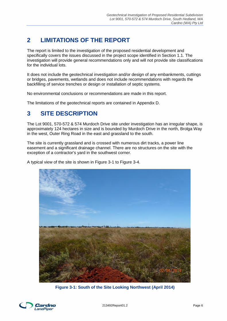
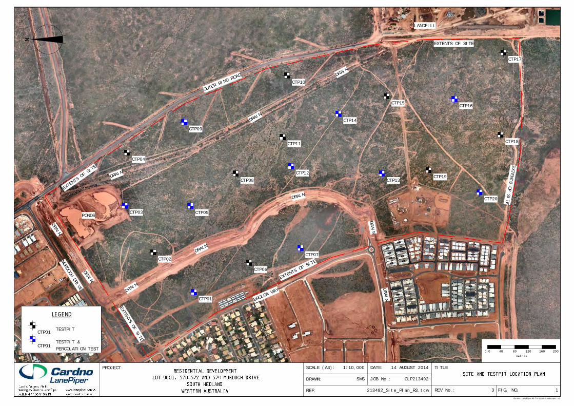
3 SITE DESCRIPTION The Lot 9001, 570-572 & 574 Murdoch Drive site under investigation has an irregular shape, is approximately 124 hectares in size and is bounded by Murdoch Drive in the north, Brolga Way in the west, Outer Ring Road in the east and grassland to the south.
The site is currently grassland and is crossed with numerous dirt tracks, a power line easement and a significant drainage channel. There are no structures on the site with the exception of a contractor’s yard in the southwest corner.
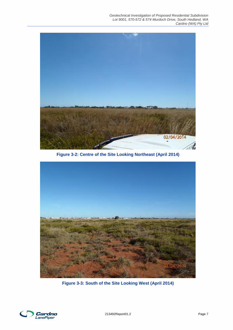
A typical view of the site is shown in Figure 3-1 to Figure 3-4.
Figure 3-1: South of the Site Looking Northwest (April 2014)
213492Report01.2 Page 6
Geotechnical Investigation of Proposed Residential Subdivision Lot 9001, 570-572 & 574 Murdoch Drive, South Hedland, WA
Cardno (WA) Pty Ltd
Figure 3-2: Centre of the Site Looking Northeast (April 2014)
Figure 3-3: South of the Site Looking West (April 2014)
213492Report01.2 Page 7
Geotechnical Investigation of Proposed Residential Subdivision Lot 9001, 570-572 & 574 Murdoch Drive, South Hedland, WA
Cardno (WA) Pty Ltd
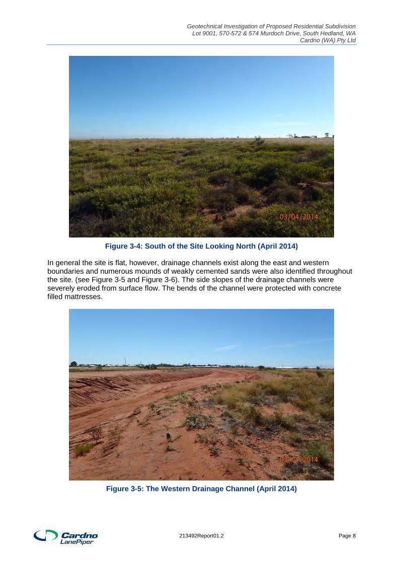
Figure 3-4: South of the Site Looking North (April 2014)
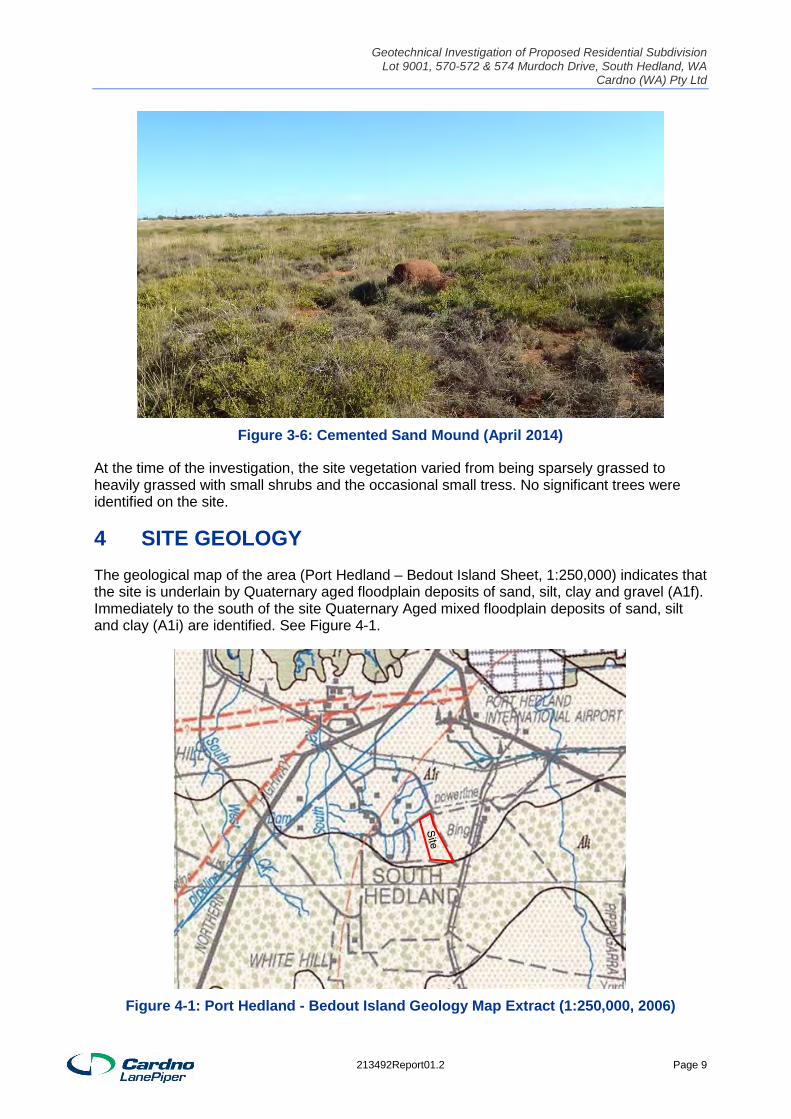
In general the site is flat, however, drainage channels exist along the east and western boundaries and numerous mounds of weakly cemented sands were also identified throughout the site. (see Figure 3-5 and Figure 3-6). The side slopes of the drainage channels were severely eroded from surface flow. The bends of the channel were protected with concrete filled mattresses.
Figure 3-5: The Western Drainage Channel (April 2014)
213492Report01.2 Page 8
Geotechnical Investigation of Proposed Residential Subdivision Lot 9001, 570-572 & 574 Murdoch Drive, South Hedland, WA
Cardno (WA) Pty Ltd
Figure 3-6: Cemented Sand Mound (April 2014)
At the time of the investigation, the site vegetation varied from being sparsely grassed to heavily grassed with small shrubs and the occasional small tress. No significant trees were identified on the site.
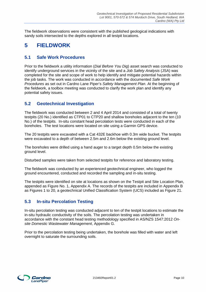
4 SITE GEOLOGY The geological map of the area (Port Hedland – Bedout Island Sheet, 1:250,000) indicates that the site is underlain by Quaternary aged floodplain deposits of sand, silt, clay and gravel (A1f). Immediately to the south of the site Quaternary Aged mixed floodplain deposits of sand, silt and clay (A1i) are identified. See Figure 4-1.
Figure 4-1: Port Hedland - Bedout Island Geology Map Extract (1:250,000, 2006)
213492Report01.2 Page 9
Geotechnical Investigation of Proposed Residential Subdivision Lot 9001, 570-572 & 574 Murdoch Drive, South Hedland, WA
Cardno (WA) Pty Ltd
The fieldwork observations were consistent with the published geological indications with sandy soils intersected to the depths explored in all testpit locations.
5 FIELDWORK
5.1 Safe Work Procedures
Prior to the fieldwork a utility information (Dial Before You Dig) asset search was conducted to identify underground services in the vicinity of the site and a Job Safety Analysis (JSA) was completed for the site and scope of work to help identify and mitigate potential hazards within the job tasks. The work was conducted in accordance with the documented Safe Work Procedures as set out in Cardno Lane Piper’s Safety Management Plan. At the beginning of the fieldwork, a toolbox meeting was conducted to clarify the work plan and identify any potential safety issues.
5.2 Geotechnical Investigation
The fieldwork was conducted between 2 and 4 April 2014 and consisted of a total of twenty testpits (20 No.) identified as CTP01 to CTP20 and shallow boreholes adjacent to the ten (10 No.) of the testpits. In-situ constant head percolation tests were conducted in each of the boreholes. The test locations were located on site using a Garmin GPS device.
The 20 testpits were excavated with a Cat 432E backhoe with 0.3m wide bucket. The testpits were excavated to a depth of between 2.5m and 2.6m below the existing ground level.
The boreholes were drilled using a hand auger to a target depth 0.5m below the existing ground level.
Disturbed samples were taken from selected testpits for reference and laboratory testing.
The fieldwork was conducted by an experienced geotechnical engineer, who logged the ground encountered, conducted and recorded the sampling and in-situ testing.
The testpits were identified on site at locations as shown on the Testpit and Site Location Plan, appended as Figure No. 1, Appendix A. The records of the testpits are included in Appendix B as Figures 1 to 20, a geotechnical Unified Classification System (UCS) included as Figure 21.
5.3 In-situ Percolation Testing
In-situ percolation testing was conducted adjacent to ten of the testpit locations to estimate the in-situ hydraulic conductivity of the soils. The percolation testing was undertaken in accordance with the constant head testing methodology specified in AS/NZS 1547:2012 On-site Domestic Wastewater Management, Appendix G.
Prior to the percolation testing being undertaken, the borehole was filled with water and left overnight to saturate the surrounding soils.
213492Report01.2 Page 10
Geotechnical Investigation of Proposed Residential Subdivision Lot 9001, 570-572 & 574 Murdoch Drive, South Hedland, WA
Cardno (WA) Pty Ltd
6 LABORATORY TESTING The testing was undertaken in Cardno Lane Piper’s NATA accredited soils laboratory and consisted of: Particle Size Distributions Atterberg Limit Tests Emerson Class Number Determinations
The test records are appended as Figures No. 1 – 4, Appendix C.
7 RESULTS OF THE INVESTIGATION
7.1 Sub-Surface Profile
The typical generalized subsurface profile encountered in the testpits is shown in Table 7-1. For further details, the reader is referred to the appended testpit records.
Table 7-1: Typical Subsurface Profile
Silty SAND (SM) fine to medium grained, red, brown, loose to very dense, very dry, weakly to strongly cemented, friable with fine to coarse
gravel and iron staining encountered to a depth of 2.5m and the maximum testpit depth explored of 2.6m
The variations to the encountered subsurface profiles are described below: Slightly moist from 2.4m in CTP02 and 1.2m in CTP08 Slightly moist and clayey from 2.4m in CTP05 Clayey from 2.4m in CTP12
7.2 Groundwater
Groundwater was not encountered in any of the testpits at the time of the investigation and the soils encountered were very dry to the depths explored. Shallow or perched groundwater cannot be precluded after sustained rainfall or in the wetter times of the year.
7.3 Laboratory Testing
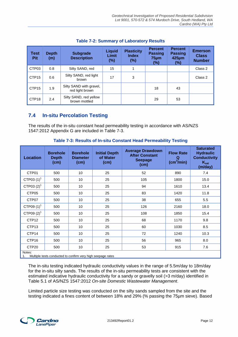
The results of the geotechnical laboratory tests are summarized in Table 7-2.
213492Report01.2 Page 11
Geotechnical Investigation of Proposed Residential Subdivision Lot 9001, 570-572 & 574 Murdoch Drive, South Hedland, WA
Cardno (WA) Pty Ltd
Table 7-2: Summary of Laboratory Results
Test Pit
Depth (m)
Subgrade Description
Liquid Limit (%)
Plasticity Index (%)
Percent Passing
75µm (%)
Percent Passing 425µm
(%)
Emerson Class
Number
CTP03 0.8 Silty SAND, red 15 1 Class 2
CTP15 0.6 Silty SAND, red light brown 17 3 Class 2
CTP15 1.9 Silty SAND with gravel, red light brown 18 43
CTP18 2.4 Silty SAND, red yellow brown mottled 29 53
7.4 In-situ Percolation Testing
The results of the in-situ constant head permeability testing in accordance with AS/NZS 1547:2012 Appendix G are included in Table 7-3.
Table 7-3: Results of In-situ Constant Head Permeability Testing
Location Borehole
Depth (cm)
Borehole Diameter
(cm)
Initial Depth of Water
(cm)
Average Drawdown After Constant
Seepage (cm)
Flow Rate Q
(cm3/min)
Saturated Hydraulic
Conductivity Ksat
(m/day) CTP01 500 10 25 52 890 7.4
CTP03 (1)1 500 10 25 105 1800 15.0
CTP03 (2)1 500 10 25 94 1610 13.4
CTP05 500 10 25 83 1420 11.8
CTP07 500 10 25 38 655 5.5
CTP09 (1)1 500 10 25 126 2160 18.0
CTP09 (2)1 500 10 25 108 1850 15.4
CTP12 500 10 25 68 1170 9.8
CTP13 500 10 25 60 1030 8.5
CTP14 500 10 25 72 1240 10.3
CTP16 500 10 25 56 965 8.0
CTP20 500 10 25 53 915 7.6 Notes: 1. Multiple tests conducted to confirm very high seepage rates
The in-situ testing indicated hydraulic conductivity values in the range of 5.5m/day to 18m/day for the in-situ silty sands. The results of the in-situ permeability tests are consistent with the estimated indicative hydraulic conductivity for a sandy or gravelly soil (>3 m/day) identified in Table 5.1 of AS/NZS 1547:2012 On-site Domestic Wastewater Management.
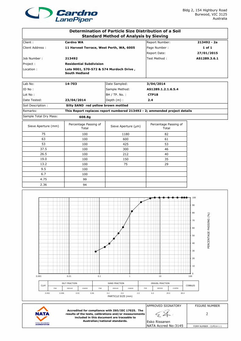
Limited particle size testing was conducted on the silty sands sampled from the site and the testing indicated a fines content of between 18% and 29% (% passing the 75µm sieve). Based
213492Report01.2 Page 12
Geotechnical Investigation of Proposed Residential Subdivision Lot 9001, 570-572 & 574 Murdoch Drive, South Hedland, WA
Cardno (WA) Pty Ltd
on the in-situ permeability testing results, this fines content appears to have little effect on reducing the in-situ hydraulic conductivity of the silty sand soils.
8 CONCLUSIONS & RECOMMENDATIONS From a geotechnical aspect, the site is suitable for residential development. The sandy soils encountered should not prove significantly problematic for the development of the site. However, the designer needs to consider the impact of the following in the design and construction of the development: The highly erosive characteristics of the sandy soils as evident in the existing drainage
channels on the site and the results of the Emerson dispersion testing The variable cementation of the sandy soils The potential loss of strength and difficulty trafficking of the sandy soils due to disturbance,
construction activity or change in moisture condition. The difficulty in compacting the unconfined sands and the need to moisture condition
during engineered filling Slope stability and erosion can be an issue for exposed embankments within the sands. The difficulty in maintaining vegetation and groundcover used in erosion control in the drier
and hotter times of the year.
As the groundwater was not encountered to the depths explored on the site, groundwater is not expected to have a significant impact on the development for most of the year. The presence of elevated groundwater in the wetter months cannot be precluded.
8.1 Dwellings
8.1.1 General Site Classification
Based on the soil strata encountered in the investigation, the site classifications for the lots will typically be ‘S’ (Slightly Reactive), provided there is no fill on the lots, in accordance with AS 2870 Residential Slabs and Footings.
If it is proposed to place engineered fill on the lots an increase in site reactivity can be expected depending on the depth and type of fill used. The slightly reactive sands can be used as engineered fill, but there is a potential for slightly increased surface movements of the fill and this needs to be considered by the designer in accordance with the guidelines in AS2870.
Individual site classifications will be required for the dwellings once the sub-division is developed.
8.1.2 Foundations
Residential Footings
The proposed residential structures can be founded on a stiffened raft footing.
All edge and internal beams for the stiffened rafts should penetrate through any fill (if encountered) with a minimum founding depth of at least 0.3m below the finished surface level assuming an articulated masonry veneer or similar construction in accordance with AS2870:2011. The edge and internal beams should be designed using a maximum allowable bearing pressure of 100kPa for beams founded in the silty sand.
213492Report01.2 Page 13
Geotechnical Investigation of Proposed Residential Subdivision Lot 9001, 570-572 & 574 Murdoch Drive, South Hedland, WA
Cardno (WA) Pty Ltd
No beams for the stiffened raft should be founded in fill material if encountered.
The slab panels may be placed on the stripped surface provided that it is proof rolled with a heavy flat drum roller. If the flat drum roller locates any soft spots, these should be excavated out and replaced with compacted sand in near horizontal layers. The internal slab panels can be designed for an allowable bearing pressure of not greater than 25kPa.
Construction of Shallow Foundations
Once the excavation for the shallow footings is completed, it is recommended that a thin layer of blinding concrete be poured over the base of the excavation prior to the placement of the reinforcement to minimise the impact of weathering on the underlying soils. Trenches shall be dewatered and cleaned prior to concrete placement so that no significant softened or loosened material remains.
The sandy soils encountered on the site can be prone to saturation and subsequent loss of strength during wet periods or loosening due to disturbance from construction activity. In these circumstances for excavations through these soils the builder may need to support the sides of the excavations with the use of plywood shuttering and timber struts.
Site Preparation
It is recommended that the exposed natural ground surface is proof-rolled with at least six passes of a vibrating smooth drum roller to locate any soft spots. If any soft spots are located it is recommended that the soft spots be excavated and replaced with compacted sand. The sand should be placed in near horizontal layers of not greater than 200mm loose thickness and compacted to at least 98% Standard dry density ratio, in accordance with AS 1289, Methods of testing soils for engineering purposes.
Post Construction
No allowance has been made in these recommendations for any undisclosed variations or other post construction factors that may influence the performance of the footings. The reader is referred to the CSIRO publication BTF18 Foundation Maintenance and Footing Performance: A Homeowners Guide for additional information. (Refer to CSIRO website for details).
8.2 Other Geotechnical Considerations
8.2.1 In-situ Hydraulic Conductivity of the Sandy Soils
The percolation testing on-site indicated that the silty sand soils are highly permeable with an in-situ hydraulic conductivity in excess of 5m/day. The high hydraulic conductivity of soils makes the site suitable for infiltration stormwater management systems such as suitably designed below ground stormwater soakage pits. Conversely, the high hydraulic conductivity of the silty sand soils makes the site unsuitable for septic tank and leaching field wastewater systems.
8.2.2 Construction Issues
The main construction issues on this site are expected to be associated with the underlying loose and weakly cemented silty sands. After heavy rains or during the wet season or as a
213492Report01.2 Page 14
Geotechnical Investigation of Proposed Residential Subdivision Lot 9001, 570-572 & 574 Murdoch Drive, South Hedland, WA
Cardno (WA) Pty Ltd
result of construction activity disturbance, the sands may be difficult to traffic by wheeled vehicles. Tracked vehicles such as excavators should be able to traffic the site all year round.
8.2.3 Difficulty in Excavation
The excavation of the silty sands should be able to be handled with hydraulic excavators. The sands were strongly cemented at variable depths across the site and may require loosening with a ripper attachment prior to excavation, particularly in confined areas.
Rock is not expected to be encountered in the expected excavation depths on the site.
8.2.4 Battered Slopes
It is recommended that any cut slopes in the sands be battered back to a slope of not greater than 1V:2H for the short term due to their potentially loose nature. If the slopes are to be permanently battered the slope should not exceed 1V:3H. These slopes should be protected from erosion with selected vegetation, shotcreting or permanent erosion control mats.
Minor slumps can fall from the sides of the excavation. These batter slopes are not appropriate in locations of critical underground services and are not applicable if the crest or slope is surcharged. Where the excavation is within a 1V:2H of critical underground services or the crest is surcharged; the excavation should be supported using an appropriate trench support system.
8.2.5 Suitability of On-site Material as an Engineered Fill
The on-site sands can be used as engineered fill but can be difficult to compact when unconfined. The sand fill will also need to be moisture conditioned during compaction and can be difficult to traffic with wheeled vehicles when loose or saturated. However, local contractors are likely to be aware of these issues and have established procedures for handling the issues.
Any imported structural fill should be primarily granular in nature. Suitable fills are non-descript crushed rock and clayey sands. All materials should have a maximum particle size of 50mm and not be gap graded. The plasticity index should not exceed 20%.
The structural fill should be placed in near horizontal layers not exceeding 200mm in thickness and be compacted to at least 95% Standard dry density ratio in accordance with Australian Standard 1289 5.1.1 - 1993. The upper 200mm thickness of the structural fill should be compacted to at least 98% Standard dry density ratio. The structural fill should be placed within ± 2% of the Standard Optimum Moisture Content.
8.2.6 Underground Services
Based on the findings of the investigation, open trenching or directional drilling (or other similar trenchless technology) is suitable for the installation of services on the site depending on the depth of the service.
Open Trenching
Shallow underground services will encounter loose sand overlying weakly or more cemented silty sands. While it is considered unlikely that a significant collapse of the side walls of the excavation will occur if the excavation is entirely within the weakly or more cemented sands,
213492Report01.2 Page 15
Geotechnical Investigation of Proposed Residential Subdivision Lot 9001, 570-572 & 574 Murdoch Drive, South Hedland, WA
Cardno (WA) Pty Ltd
minor collapses and slumping of the loose sands could occur that would not pose a significant risk to the machinery but would be a risk to any workers within the excavation. If workers are required to enter an excavation deeper than 1.5m then shoring using an appropriate trench support system will be required or the sides of the excavation should be flattened back to a maximum slope of 1V:2H.
Directional Drilling
Directional drilling (or other similar trenchless technology) is suitable for the installation of deeper services on the site. The use of casing during directional drilling (or other similar trenchless technology) will be required to prevent borehole collapse. It is anticipated that the loose to very dense variably cemented sands can be readily drilled and reamed by a directional drilling machine.
The presence of fine to coarse grained sands and gravels and the impact on the protective coating of pipes needs to be considered by the designer. These coarse grained soils may abrade and cause damage to the pipe protection as it is drawn through the borehole.
8.3 Further Geotechnical Investigation
It is recommended that detailed geotechnical investigation, including intrusive investigation and laboratory testing, is undertaken for all aspects of the proposed development including pavements, wetlands, individual residential lots and commercial spaces. The detailed testing would need to be undertaken in accordance with the local Council and Authority Guidelines and be targeted based on the proposed development.
9 REFERENCES AS 1289 Methods of Testing Soils for Engineering Purposes
AS 1726 - 1993 Geotechnical Site Investigations
AS 2870 - 2011 Residential Slabs and Footings
AS/NZS 1547 - 2012 On-site Domestic Wastewater Management
Geological Survey of Western Australia, Port Hedland – Bedout Island Geological Map 1:250,000 2006.
213492Report01.2 Page 16
Geotechnical Investigation of Proposed Residential Subdivision Lot 9001, 570-572 & 574 Murdoch Drive, South Hedland, WA
Cardno (WA) Pty Ltd
Appendix A1 Page
Figures
Figure 1: Site and Testpit Location Plan
213492Report01.2 Appendix A
PROJECT
1FIG. NO.3
SCALE (A3):
213492_Site_Plan_R3.tcwCardno LanePiperA3-Turbocad-Landscape.tct
DRAWN:
REF:
DATE:
JOB No.:
REV No.:
SMS
1:10,000 TITLE14 AUGUST 2014
CLP213492
N
CTP01
LEGEND
TESTPIT
CTP01TESTPIT &PERCOLATION TEST
CTP03 CTP05
CTP07
CTP20
CTP16
CTP14
CTP09
CTP01
CTP13
CTP02
CTP06
CTP12CTP08
CTP11
CTP10
CTP04
CTP15
CTP17
CTP18
CTP19
OUTER RI
NG ROAD
MURDOCH DRIVE
BROLGA W
AY
LANDFILL
PONDS
DRAIN
DRAIN
DRAIN
DRAIN
DRAIN
DRAIN
DRAIN
DRAIN
DRAIN
DRAIN
metres20016012080400.0
EXTENT
S OF S
ITE
EXTENT
S OF S
ITE
EXTENTS OF SITE
EXTENTS OF SITE
EXTENTS OF SITE
Geotechnical Investigation of Proposed Residential Subdivision Lot 9001, 570-572 & 574 Murdoch Drive, South Hedland, WA
Cardno (WA) Pty Ltd
Appendix B21 Pages
Testpit Records
CTP01 to CTP20 Unified Classification System
213492Report01.2 Appendix B
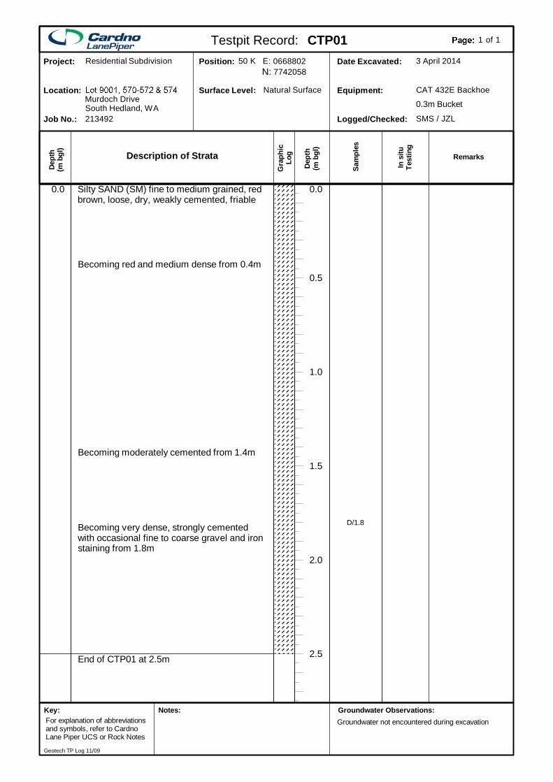
End of CTP01 at 2.5m
Silty SAND (SM) fine to medium grained, redbrown, loose, dry, weakly cemented, friable
2.5
2.0
1.5
1.0
0.5
0.0
Becoming red and medium dense from 0.4m
Becoming moderately cemented from 1.4m
Becoming very dense, strongly cementedwith occasional fine to coarse gravel and ironstaining from 1.8m
0.0
D/1.8
Description of Strata
Gra
phic
Log
Dep
th(m
bgl
)
Dept
h(m
bgl
)
In s
ituTe
stin
g
Sam
ples
SMS / JZLLogged/Checked:
CAT 432E BackhoeEquipment:
3 April 2014Date Excavated:77420580668802Position:
Natural SurfaceSurface Level:
213492Job No.:
Murdoch DriveLocation:
Residential SubdivisionProject:
South Hedland, WA 0.3m Bucket
Testpit Record: CTP01 of1 1
Remarks
50 K E:N:
Groundwater Observations:Groundwater not encountered during excavation
Key:For explanation of abbreviationsand symbols, refer to CardnoLane Piper UCS or Rock Notes
Notes:
Geotech TP Log 11/09
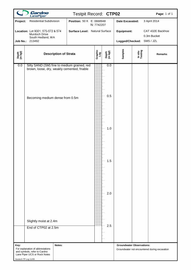
End of CTP02 at 2.5m
Silty SAND (SM) fine to medium grained, redbrown, loose, dry, weakly cemented, friable
2.5
2.0
1.5
1.0
0.5
0.0
Becoming medium dense from 0.5m
Slightly moist at 2.4m
0.0
Description of Strata
Gra
phic
Log
Dep
th(m
bgl
)
Dept
h(m
bgl
)
In s
ituTe
stin
g
Sam
ples
SMS / JZLLogged/Checked:
CAT 432E BackhoeEquipment:
3 April 2014Date Excavated:77422070668948Position:
Natural SurfaceSurface Level:
213492Job No.:
Murdoch DriveLocation:
Residential SubdivisionProject:
South Hedland, WA 0.3m Bucket
Testpit Record: CTP02 of1 1
Remarks
50 K E:N:
Groundwater Observations:Groundwater not encountered during excavation
Key:For explanation of abbreviationsand symbols, refer to CardnoLane Piper UCS or Rock Notes
Notes:
Geotech TP Log 11/09
End of CTP03 at 2.5m
Silty SAND (SM) fine to coarse grained, red,medium dense, very dry, friable withoccasional medium to coarse grained gravel
2.5
2.0
1.5
1.0
0.5
0.0
Becoming moderately cemented from 0.5m
Difficult excavation from 1.0m
Becoming dense and moderately cementedwith abundant fine to coarse grained gravelfrom 1.4mBecoming very dense, fine to coarse grainedsand and fine to coarse grained gravel from1.5m
0.0
D/0.8
Description of Strata
Gra
phic
Log
Dep
th(m
bgl
)
Dept
h(m
bgl
)
In s
ituTe
stin
g
Sam
ples
SMS / JZLLogged/Checked:
CAT 432E BackhoeEquipment:
3 April 2014Date Excavated:77423110669119Position:
Natural SurfaceSurface Level:
213492Job No.:
Murdoch DriveLocation:
Residential SubdivisionProject:
South Hedland, WA 0.3m Bucket
Testpit Record: CTP03 of1 1
Remarks
50 K E:N:
Groundwater Observations:Groundwater not encountered during excavation
Key:For explanation of abbreviationsand symbols, refer to CardnoLane Piper UCS or Rock Notes
Notes:
Geotech TP Log 11/09
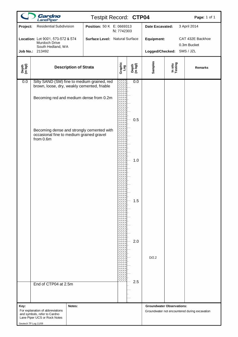
End of CTP04 at 2.5m
Silty SAND (SM) fine to medium grained, redbrown, loose, dry, weakly cemented, friable
2.5
2.0
1.5
1.0
0.5
0.0
Becoming red and medium dense from 0.2m
Becoming dense and strongly cemented withoccasional fine to medium grained gravelfrom 0.6m
0.0
D/2.2
Description of Strata
Gra
phic
Log
Dep
th(m
bgl
)
Dept
h(m
bgl
)
In s
ituTe
stin
g
Sam
ples
SMS / JZLLogged/Checked:
CAT 432E BackhoeEquipment:
3 April 2014Date Excavated:77423030669313Position:
Natural SurfaceSurface Level:
213492Job No.:
Murdoch DriveLocation:
Residential SubdivisionProject:
South Hedland, WA 0.3m Bucket
Testpit Record: CTP04 of1 1
Remarks
50 K E:N:
Groundwater Observations:Groundwater not encountered during excavation
Key:For explanation of abbreviationsand symbols, refer to CardnoLane Piper UCS or Rock Notes
Notes:
Geotech TP Log 11/09
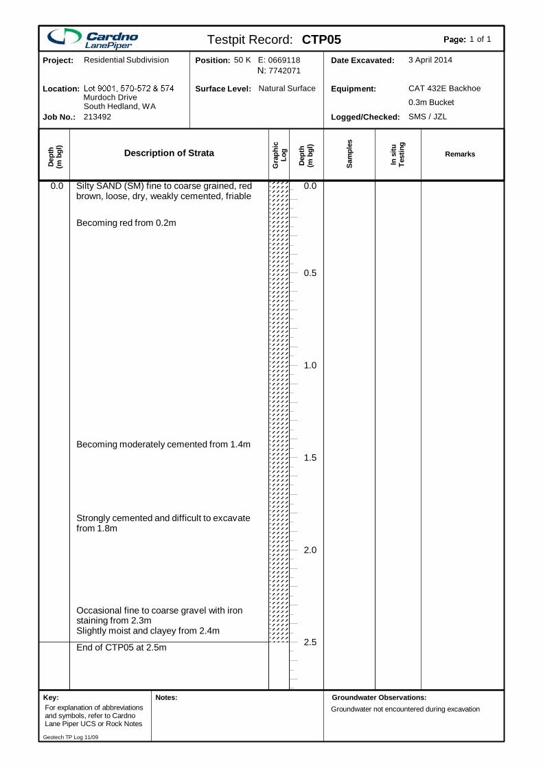
End of CTP05 at 2.5m
Silty SAND (SM) fine to coarse grained, redbrown, loose, dry, weakly cemented, friable
2.5
2.0
1.5
1.0
0.5
0.0
Becoming red from 0.2m
Becoming moderately cemented from 1.4m
Strongly cemented and difficult to excavatefrom 1.8m
Occasional fine to coarse gravel with ironstaining from 2.3mSlightly moist and clayey from 2.4m
0.0
Description of Strata
Gra
phic
Log
Dep
th(m
bgl
)
Dept
h(m
bgl
)
In s
ituTe
stin
g
Sam
ples
SMS / JZLLogged/Checked:
CAT 432E BackhoeEquipment:
3 April 2014Date Excavated:77420710669118Position:
Natural SurfaceSurface Level:
213492Job No.:
Murdoch DriveLocation:
Residential SubdivisionProject:
South Hedland, WA 0.3m Bucket
Testpit Record: CTP05 of1 1
Remarks
50 K E:N:
Groundwater Observations:Groundwater not encountered during excavation
Key:For explanation of abbreviationsand symbols, refer to CardnoLane Piper UCS or Rock Notes
Notes:
Geotech TP Log 11/09
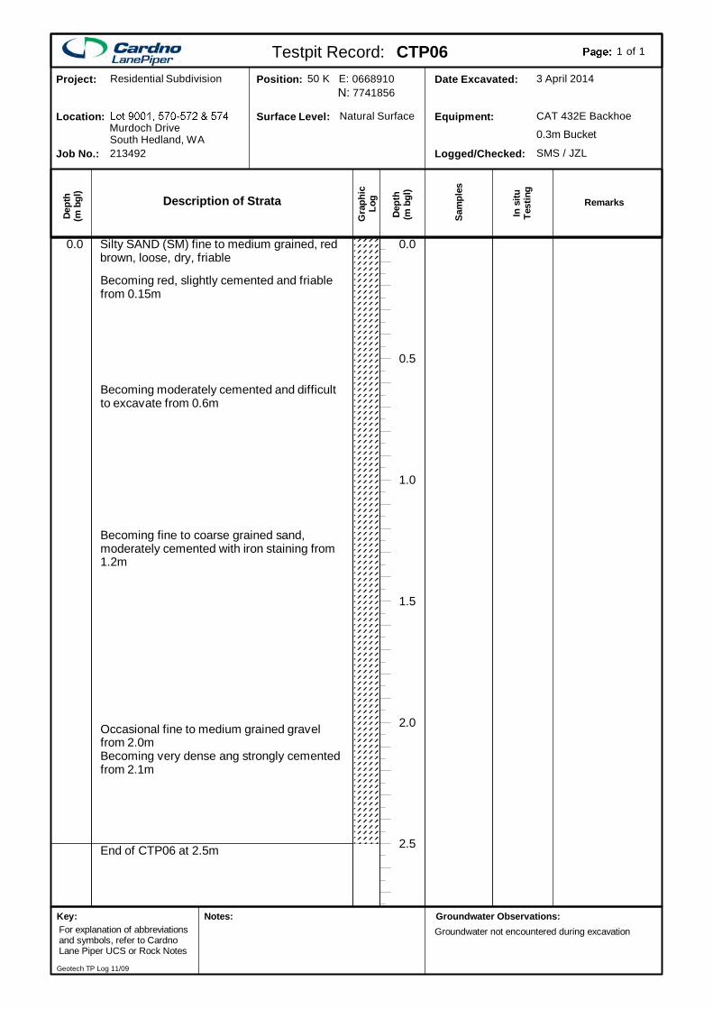
End of CTP06 at 2.5m
Silty SAND (SM) fine to medium grained, redbrown, loose, dry, friable
2.5
2.0
1.5
1.0
0.5
0.0
Becoming red, slightly cemented and friablefrom 0.15m
Becoming moderately cemented and difficultto excavate from 0.6m
Becoming fine to coarse grained sand,moderately cemented with iron staining from1.2m
Occasional fine to medium grained gravelfrom 2.0mBecoming very dense ang strongly cementedfrom 2.1m
0.0
Description of Strata
Gra
phic
Log
Dep
th(m
bgl
)
Dept
h(m
bgl
)
In s
ituTe
stin
g
Sam
ples
SMS / JZLLogged/Checked:
CAT 432E BackhoeEquipment:
3 April 2014Date Excavated:77418560668910Position:
Natural SurfaceSurface Level:
213492Job No.:
Murdoch DriveLocation:
Residential SubdivisionProject:
South Hedland, WA 0.3m Bucket
Testpit Record: CTP06 of1 1
Remarks
50 K E:N:
Groundwater Observations:Groundwater not encountered during excavation
Key:For explanation of abbreviationsand symbols, refer to CardnoLane Piper UCS or Rock Notes
Notes:
Geotech TP Log 11/09
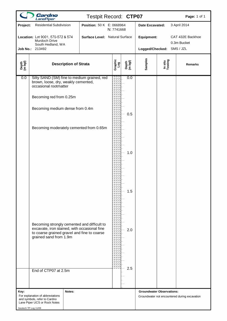
End of CTP07 at 2.5m
Silty SAND (SM) fine to medium grained, redbrown, loose, dry, weakly cemented,occasional rootmatter
2.5
2.0
1.5
1.0
0.5
0.0
Becoming red from 0.25m
Becoming medium dense from 0.4m
Becoming moderately cemented from 0.65m
Becoming strongly cemented and difficult toexcavate, iron stained, with occasional fineto coarse grained gravel and fine to coarsegrained sand from 1.9m
0.0
Description of Strata
Gra
phic
Log
Dep
th(m
bgl
)
Dept
h(m
bgl
)
In s
ituTe
stin
g
Sam
ples
SMS / JZLLogged/Checked:
CAT 432E BackhoeEquipment:
3 April 2014Date Excavated:77416680668964Position:
Natural SurfaceSurface Level:
213492Job No.:
Murdoch DriveLocation:
Residential SubdivisionProject:
South Hedland, WA 0.3m Bucket
Testpit Record: CTP07 of1 1
Remarks
50 K E:N:
Groundwater Observations:Groundwater not encountered during excavation
Key:For explanation of abbreviationsand symbols, refer to CardnoLane Piper UCS or Rock Notes
Notes:
Geotech TP Log 11/09
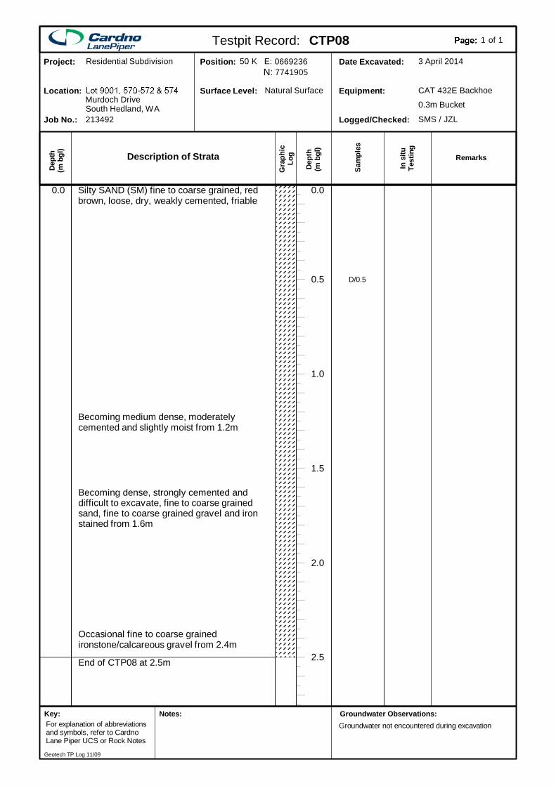
End of CTP08 at 2.5m
Silty SAND (SM) fine to coarse grained, redbrown, loose, dry, weakly cemented, friable
2.5
2.0
1.5
1.0
0.5
0.0
Becoming medium dense, moderatelycemented and slightly moist from 1.2m
Becoming dense, strongly cemented anddifficult to excavate, fine to coarse grainedsand, fine to coarse grained gravel and ironstained from 1.6m
Occasional fine to coarse grainedironstone/calcareous gravel from 2.4m
0.0
D/0.5
Description of Strata
Gra
phic
Log
Dep
th(m
bgl
)
Dept
h(m
bgl
)
In s
ituTe
stin
g
Sam
ples
SMS / JZLLogged/Checked:
CAT 432E BackhoeEquipment:
3 April 2014Date Excavated:77419050669236Position:
Natural SurfaceSurface Level:
213492Job No.:
Murdoch DriveLocation:
Residential SubdivisionProject:
South Hedland, WA 0.3m Bucket
Testpit Record: CTP08 of1 1
Remarks
50 K E:N:
Groundwater Observations:Groundwater not encountered during excavation
Key:For explanation of abbreviationsand symbols, refer to CardnoLane Piper UCS or Rock Notes
Notes:
Geotech TP Log 11/09
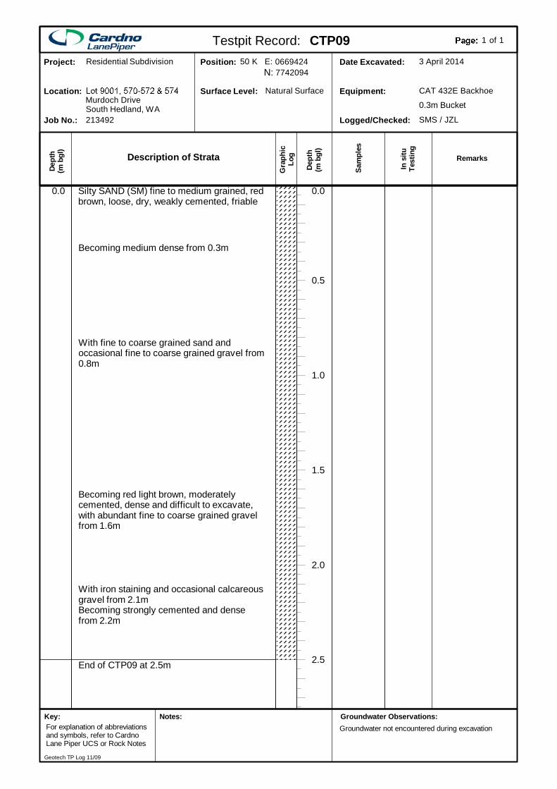
End of CTP09 at 2.5m
Silty SAND (SM) fine to medium grained, redbrown, loose, dry, weakly cemented, friable
2.5
2.0
1.5
1.0
0.5
0.0
Becoming medium dense from 0.3m
With fine to coarse grained sand andoccasional fine to coarse grained gravel from0.8m
Becoming red light brown, moderatelycemented, dense and difficult to excavate,with abundant fine to coarse grained gravelfrom 1.6m
With iron staining and occasional calcareousgravel from 2.1mBecoming strongly cemented and densefrom 2.2m
0.0
Description of Strata
Gra
phic
Log
Dep
th(m
bgl
)
Dept
h(m
bgl
)
In s
ituTe
stin
g
Sam
ples
SMS / JZLLogged/Checked:
CAT 432E BackhoeEquipment:
3 April 2014Date Excavated:77420940669424Position:
Natural SurfaceSurface Level:
213492Job No.:
Murdoch DriveLocation:
Residential SubdivisionProject:
South Hedland, WA 0.3m Bucket
Testpit Record: CTP09 of1 1
Remarks
50 K E:N:
Groundwater Observations:Groundwater not encountered during excavation
Key:For explanation of abbreviationsand symbols, refer to CardnoLane Piper UCS or Rock Notes
Notes:
Geotech TP Log 11/09
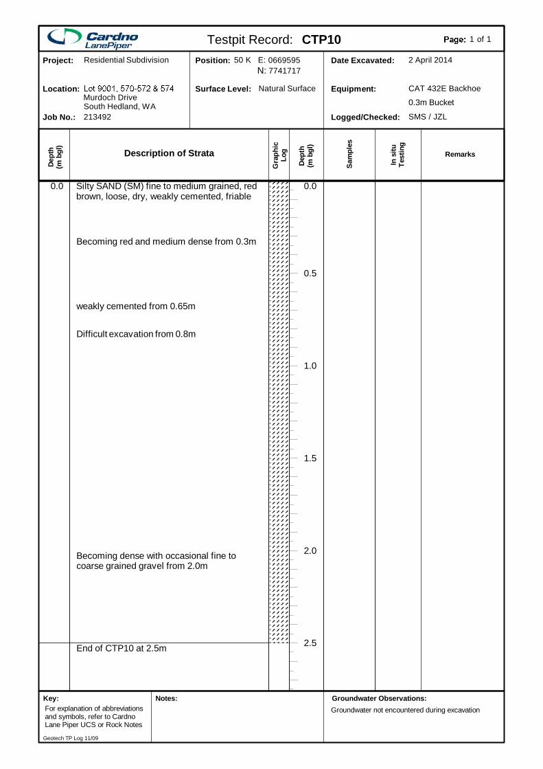
End of CTP10 at 2.5m
Silty SAND (SM) fine to medium grained, redbrown, loose, dry, weakly cemented, friable
2.5
2.0
1.5
1.0
0.5
0.0
Becoming red and medium dense from 0.3m
weakly cemented from 0.65m
Difficult excavation from 0.8m
Becoming dense with occasional fine tocoarse grained gravel from 2.0m
0.0
Description of Strata
Gra
phic
Log
Dep
th(m
bgl
)
Dept
h(m
bgl
)
In s
ituTe
stin
g
Sam
ples
SMS / JZLLogged/Checked:
CAT 432E BackhoeEquipment:
2 April 2014Date Excavated:77417170669595Position:
Natural SurfaceSurface Level:
213492Job No.:
Murdoch DriveLocation:
Residential SubdivisionProject:
South Hedland, WA 0.3m Bucket
Testpit Record: CTP10 of1 1
Remarks
50 K E:N:
Groundwater Observations:Groundwater not encountered during excavation
Key:For explanation of abbreviationsand symbols, refer to CardnoLane Piper UCS or Rock Notes
Notes:
Geotech TP Log 11/09
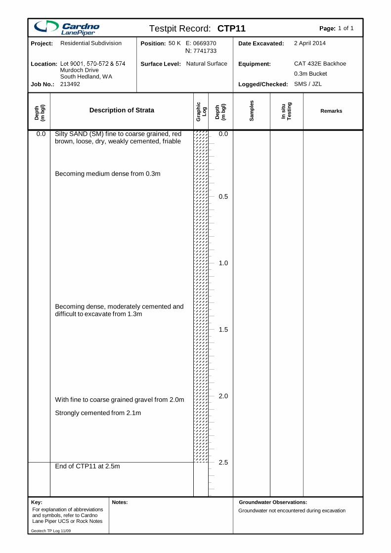
End of CTP11 at 2.5m
Silty SAND (SM) fine to coarse grained, redbrown, loose, dry, weakly cemented, friable
2.5
2.0
1.5
1.0
0.5
0.0
Becoming medium dense from 0.3m
Becoming dense, moderately cemented anddifficult to excavate from 1.3m
With fine to coarse grained gravel from 2.0m
Strongly cemented from 2.1m
0.0
Description of Strata
Gra
phic
Log
Dep
th(m
bgl
)
Dept
h(m
bgl
)
In s
ituTe
stin
g
Sam
ples
SMS / JZLLogged/Checked:
CAT 432E BackhoeEquipment:
2 April 2014Date Excavated:77417330669370Position:
Natural SurfaceSurface Level:
213492Job No.:
Murdoch DriveLocation:
Residential SubdivisionProject:
South Hedland, WA 0.3m Bucket
Testpit Record: CTP11 of1 1
Remarks
50 K E:N:
Groundwater Observations:Groundwater not encountered during excavation
Key:For explanation of abbreviationsand symbols, refer to CardnoLane Piper UCS or Rock Notes
Notes:
Geotech TP Log 11/09
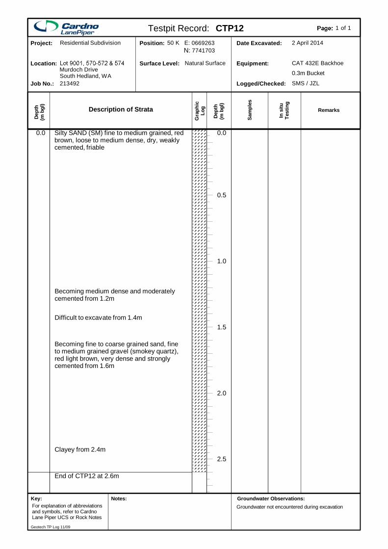
End of CTP12 at 2.6m
Silty SAND (SM) fine to medium grained, redbrown, loose to medium dense, dry, weaklycemented, friable
2.5
2.0
1.5
1.0
0.5
0.0
Becoming medium dense and moderatelycemented from 1.2m
Difficult to excavate from 1.4m
Becoming fine to coarse grained sand, fineto medium grained gravel (smokey quartz),red light brown, very dense and stronglycemented from 1.6m
Clayey from 2.4m
0.0
Description of Strata
Gra
phic
Log
Dep
th(m
bgl
)
Dept
h(m
bgl
)
In s
ituTe
stin
g
Sam
ples
SMS / JZLLogged/Checked:
CAT 432E BackhoeEquipment:
2 April 2014Date Excavated:77417030669263Position:
Natural SurfaceSurface Level:
213492Job No.:
Murdoch DriveLocation:
Residential SubdivisionProject:
South Hedland, WA 0.3m Bucket
Testpit Record: CTP12 of1 1
Remarks
50 K E:N:
Groundwater Observations:Groundwater not encountered during excavation
Key:For explanation of abbreviationsand symbols, refer to CardnoLane Piper UCS or Rock Notes
Notes:
Geotech TP Log 11/09
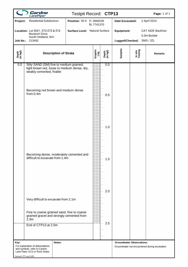
End of CTP13 at 2.5m
Silty SAND (SM) fine to medium grained,light brown red, loose to medium dense, dry,weakly cemented, friable
2.5
2.0
1.5
1.0
0.5
0.0
Becoming red brown and medium densefrom 0.4m
Becoming dense, moderately cemented anddifficult to excavate from 1.4m
Very difficult to excavate from 2.1m
Fine to coarse grained sand, fine to coarsegrained gravel and strongly cemented from2.3m
0.0
Description of Strata
Gra
phic
Log
Dep
th(m
bgl
)
Dept
h(m
bgl
)
In s
ituTe
stin
g
Sam
ples
SMS / JZLLogged/Checked:
CAT 432E BackhoeEquipment:
2 April 2014Date Excavated:77413700669236Position:
Natural SurfaceSurface Level:
213492Job No.:
Murdoch DriveLocation:
Residential SubdivisionProject:
South Hedland, WA 0.3m Bucket
Testpit Record: CTP13 of1 1
Remarks
50 K E:N:
Groundwater Observations:Groundwater not encountered during excavation
Key:For explanation of abbreviationsand symbols, refer to CardnoLane Piper UCS or Rock Notes
Notes:
Geotech TP Log 11/09
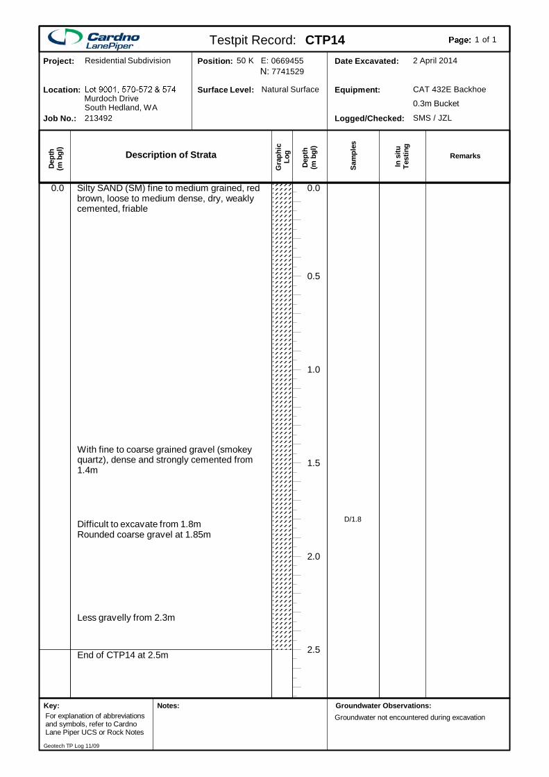
End of CTP14 at 2.5m
Silty SAND (SM) fine to medium grained, redbrown, loose to medium dense, dry, weaklycemented, friable
2.5
2.0
1.5
1.0
0.5
0.0
With fine to coarse grained gravel (smokeyquartz), dense and strongly cemented from1.4m
Difficult to excavate from 1.8mRounded coarse gravel at 1.85m
Less gravelly from 2.3m
0.0
D/1.8
Description of Strata
Gra
phic
Log
Dep
th(m
bgl
)
Dept
h(m
bgl
)
In s
ituTe
stin
g
Sam
ples
SMS / JZLLogged/Checked:
CAT 432E BackhoeEquipment:
2 April 2014Date Excavated:77415290669455Position:
Natural SurfaceSurface Level:
213492Job No.:
Murdoch DriveLocation:
Residential SubdivisionProject:
South Hedland, WA 0.3m Bucket
Testpit Record: CTP14 of1 1
Remarks
50 K E:N:
Groundwater Observations:Groundwater not encountered during excavation
Key:For explanation of abbreviationsand symbols, refer to CardnoLane Piper UCS or Rock Notes
Notes:
Geotech TP Log 11/09
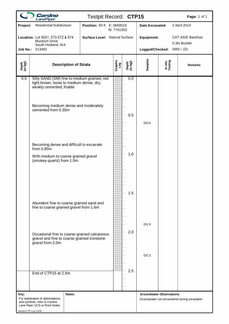
End of CTP15 at 2.5m
Silty SAND (SM) fine to medium grained, redlight brown, loose to medium dense, dry,weakly cemented, friable
2.5
2.0
1.5
1.0
0.5
0.0
Becoming medium dense and moderatelycemented from 0.35m
Becoming dense and difficult to excavatefrom 0.85m
With medium to coarse grained gravel(smokey quartz) from 1.0m
Abundent fine to coarse grained sand andfine to coarse grained gravel from 1.6m
Occasional fine to coarse grained calcareousgravel and fine to coarse grained ironstonegravel from 2.0m
0.0
D/0.6
D/1.9
D/2.3
Description of Strata
Gra
phic
Log
Dep
th(m
bgl
)
Dept
h(m
bgl
)
In s
ituTe
stin
g
Sam
ples
SMS / JZLLogged/Checked:
CAT 432E BackhoeEquipment:
2 April 2014Date Excavated:77413530669519Position:
Natural SurfaceSurface Level:
213492Job No.:
Murdoch DriveLocation:
Residential SubdivisionProject:
South Hedland, WA 0.3m Bucket
Testpit Record: CTP15 of1 1
Remarks
50 K E:N:
Groundwater Observations:Groundwater not encountered during excavation
Key:For explanation of abbreviationsand symbols, refer to CardnoLane Piper UCS or Rock Notes
Notes:
Geotech TP Log 11/09
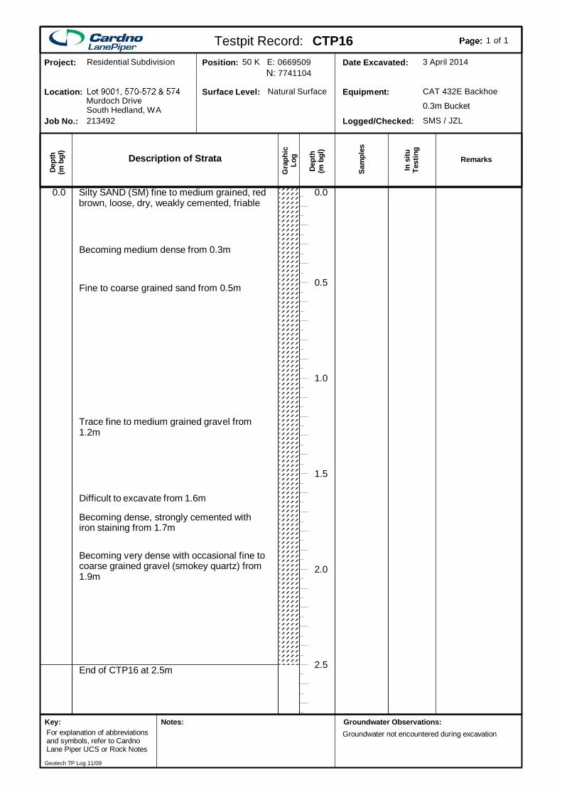
End of CTP16 at 2.5m
Silty SAND (SM) fine to medium grained, redbrown, loose, dry, weakly cemented, friable
2.5
2.0
1.5
1.0
0.5
0.0
Becoming medium dense from 0.3m
Fine to coarse grained sand from 0.5m
Trace fine to medium grained gravel from1.2m
Difficult to excavate from 1.6m
Becoming dense, strongly cemented withiron staining from 1.7m
Becoming very dense with occasional fine tocoarse grained gravel (smokey quartz) from1.9m
0.0
Description of Strata
Gra
phic
Log
Dep
th(m
bgl
)
Dept
h(m
bgl
)
In s
ituTe
stin
g
Sam
ples
SMS / JZLLogged/Checked:
CAT 432E BackhoeEquipment:
3 April 2014Date Excavated:77411040669509Position:
Natural SurfaceSurface Level:
213492Job No.:
Murdoch DriveLocation:
Residential SubdivisionProject:
South Hedland, WA 0.3m Bucket
Testpit Record: CTP16 of1 1
Remarks
50 K E:N:
Groundwater Observations:Groundwater not encountered during excavation
Key:For explanation of abbreviationsand symbols, refer to CardnoLane Piper UCS or Rock Notes
Notes:
Geotech TP Log 11/09
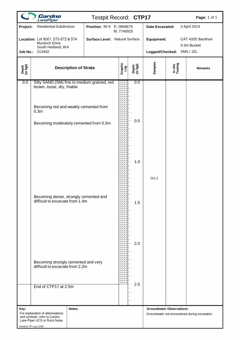
End of CTP17 at 2.5m
Silty SAND (SM) fine to medium grained, redbrown, loose, dry, friable
2.5
2.0
1.5
1.0
0.5
0.0
Becoming red and weakly cemented from0.3m
Becoming moderately cemented from 0.5m
Becoming dense, strongly cemented anddifficult to excavate from 1.4m
Becoming strongly cemented and verydifficult to excavate from 2.2m
0.0
D/1.2
Description of Strata
Gra
phic
Log
Dep
th(m
bgl
)
Dept
h(m
bgl
)
In s
ituTe
stin
g
Sam
ples
SMS / JZLLogged/Checked:
CAT 432E BackhoeEquipment:
3 April 2014Date Excavated:77409250669679Position:
Natural SurfaceSurface Level:
213492Job No.:
Murdoch DriveLocation:
Residential SubdivisionProject:
South Hedland, WA 0.3m Bucket
Testpit Record: CTP17 of1 1
Remarks
50 K E:N:
Groundwater Observations:Groundwater not encountered during excavation
Key:For explanation of abbreviationsand symbols, refer to CardnoLane Piper UCS or Rock Notes
Notes:
Geotech TP Log 11/09
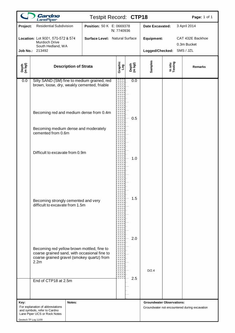
End of CTP18 at 2.5m
Silty SAND (SM) fine to medium grained, redbrown, loose, dry, weakly cemented, friable
2.5
2.0
1.5
1.0
0.5
0.0
Becoming red and medium dense from 0.4m
Becoming medium dense and moderatelycemented from 0.6m
Difficult to excavate from 0.9m
Becoming strongly cemented and verydifficult to excavate from 1.5m
Becoming red yellow brown mottled, fine tocoarse grained sand, with occasional fine tocoarse grained gravel (smokey quartz) from2.2m
0.0
D/2.4
Description of Strata
Gra
phic
Log
Dep
th(m
bgl
)
Dept
h(m
bgl
)
In s
ituTe
stin
g
Sam
ples
SMS / JZLLogged/Checked:
CAT 432E BackhoeEquipment:
3 April 2014Date Excavated:77409360669378Position:
Natural SurfaceSurface Level:
213492Job No.:
Murdoch DriveLocation:
Residential SubdivisionProject:
South Hedland, WA 0.3m Bucket
Testpit Record: CTP18 of1 1
Remarks
50 K E:N:
Groundwater Observations:Groundwater not encountered during excavation
Key:For explanation of abbreviationsand symbols, refer to CardnoLane Piper UCS or Rock Notes
Notes:
Geotech TP Log 11/09
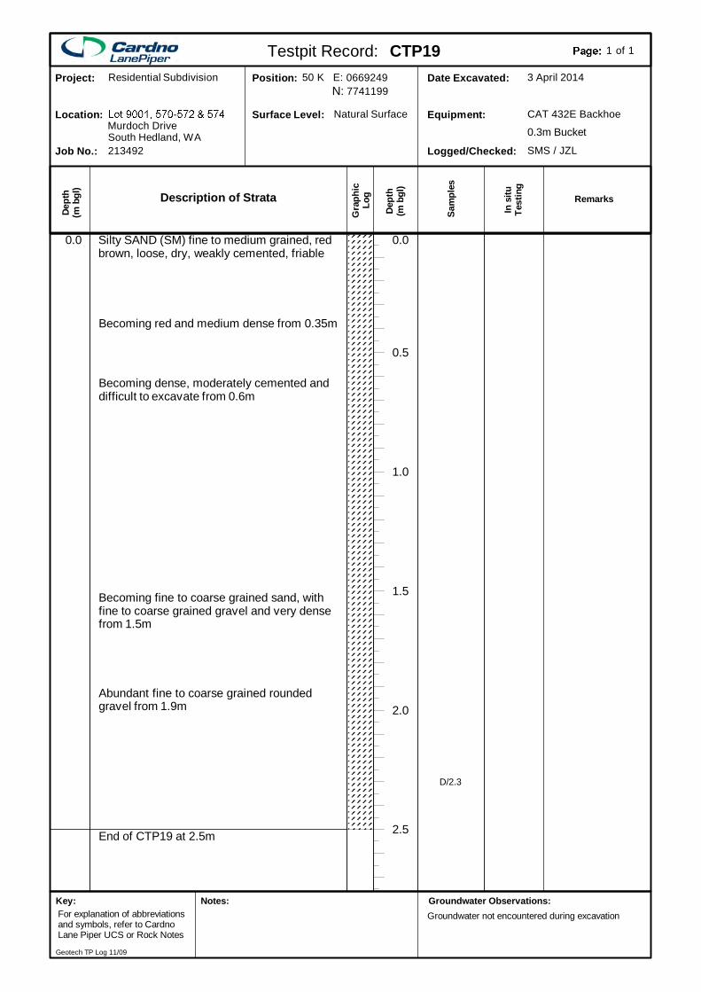
End of CTP19 at 2.5m
Silty SAND (SM) fine to medium grained, redbrown, loose, dry, weakly cemented, friable
2.5
2.0
1.5
1.0
0.5
0.0
Becoming red and medium dense from 0.35m
Becoming dense, moderately cemented anddifficult to excavate from 0.6m
Becoming fine to coarse grained sand, withfine to coarse grained gravel and very densefrom 1.5m
Abundant fine to coarse grained roundedgravel from 1.9m
0.0
D/2.3
Description of Strata
Gra
phic
Log
Dep
th(m
bgl
)
Dept
h(m
bgl
)
In s
ituTe
stin
g
Sam
ples
SMS / JZLLogged/Checked:
CAT 432E BackhoeEquipment:
3 April 2014Date Excavated:77411990669249Position:
Natural SurfaceSurface Level:
213492Job No.:
Murdoch DriveLocation:
Residential SubdivisionProject:
South Hedland, WA 0.3m Bucket
Testpit Record: CTP19 of1 1
Remarks
50 K E:N:
Groundwater Observations:Groundwater not encountered during excavation
Key:For explanation of abbreviationsand symbols, refer to CardnoLane Piper UCS or Rock Notes
Notes:
Geotech TP Log 11/09
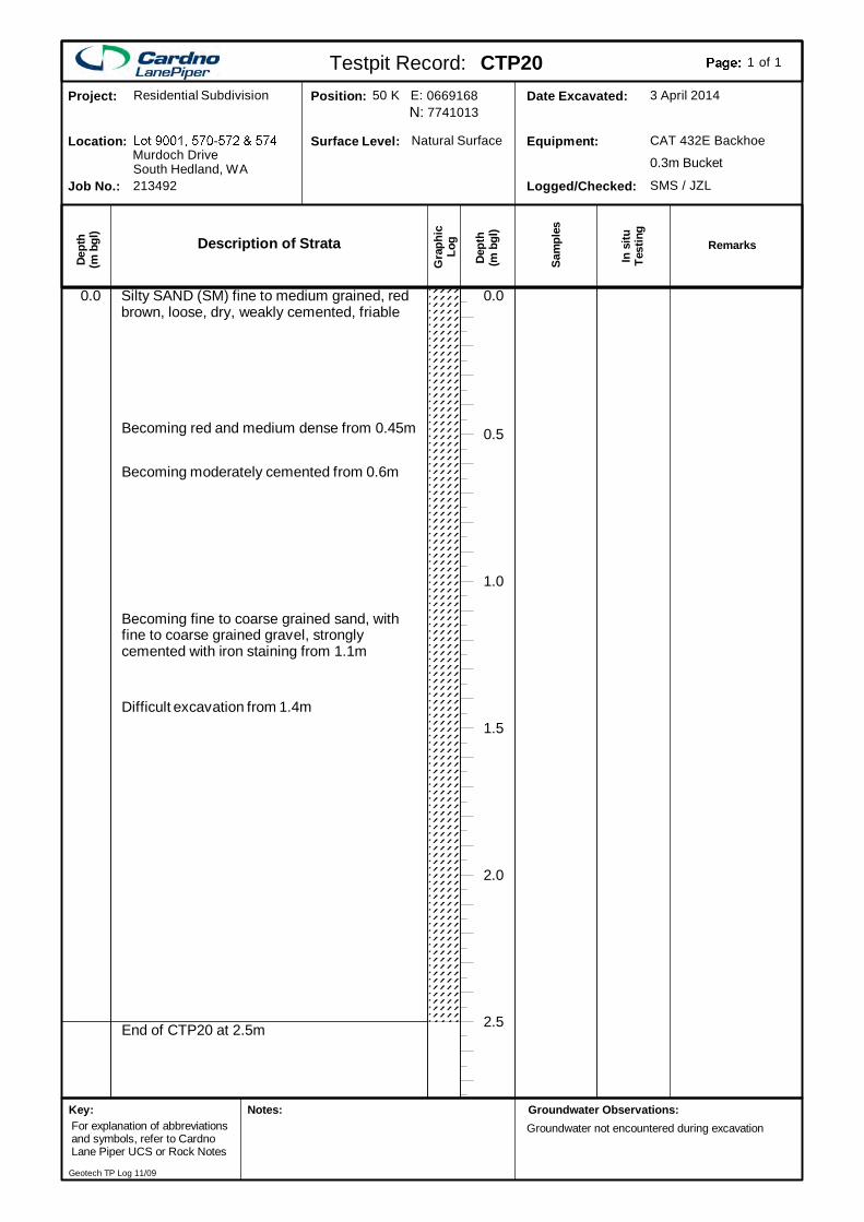
End of CTP20 at 2.5m
Silty SAND (SM) fine to medium grained, redbrown, loose, dry, weakly cemented, friable
2.5
2.0
1.5
1.0
0.5
0.0
Becoming red and medium dense from 0.45m
Becoming moderately cemented from 0.6m
Becoming fine to coarse grained sand, withfine to coarse grained gravel, stronglycemented with iron staining from 1.1m
Difficult excavation from 1.4m
0.0
Description of Strata
Gra
phic
Log
Dep
th(m
bgl
)
Dept
h(m
bgl
)
In s
ituTe
stin
g
Sam
ples
SMS / JZLLogged/Checked:
CAT 432E BackhoeEquipment:
3 April 2014Date Excavated:77410130669168Position:
Natural SurfaceSurface Level:
213492Job No.:
Murdoch DriveLocation:
Residential SubdivisionProject:
South Hedland, WA 0.3m Bucket
Testpit Record: CTP20 of1 1
Remarks
50 K E:N:
Groundwater Observations:Groundwater not encountered during excavation
Key:For explanation of abbreviationsand symbols, refer to CardnoLane Piper UCS or Rock Notes
Notes:
Geotech TP Log 11/09
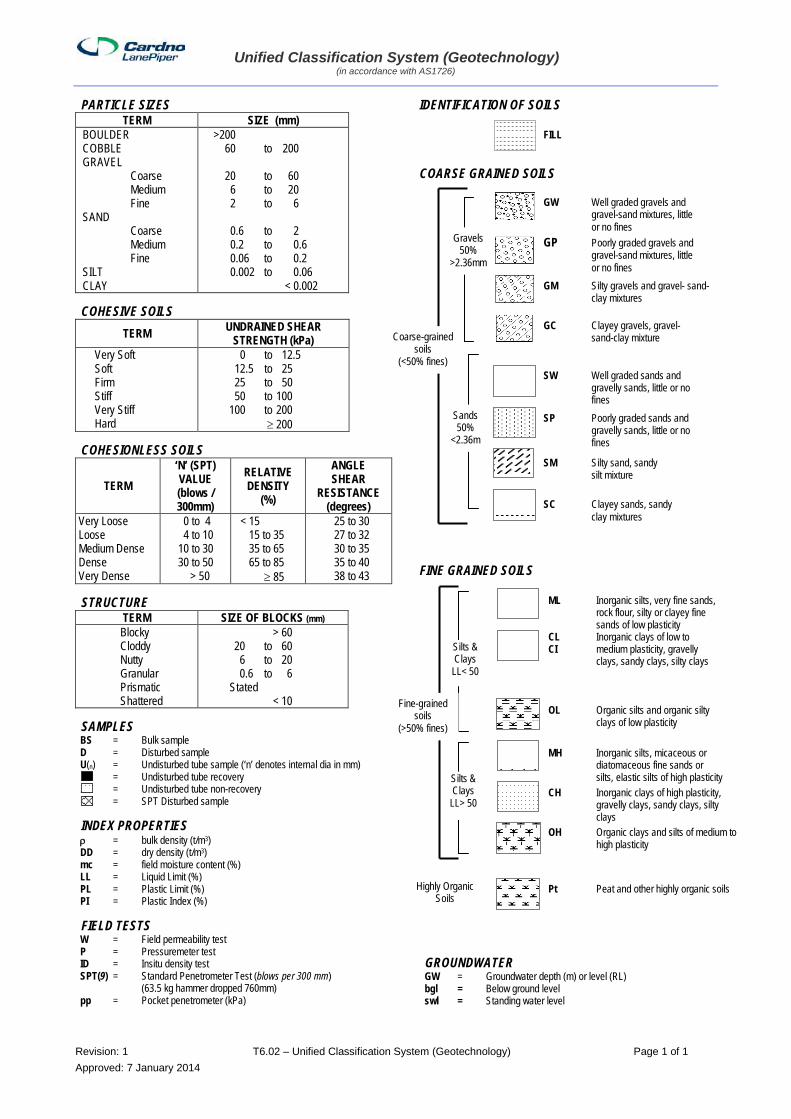
Unified Classification System (Geotechnology) (in accordance with AS1726)
Revision: 1 T6.02 – Unified Classification System (Geotechnology) Page 1 of 1 Approved: 7 January 2014
PARTICLE SIZES TERM SIZE (mm)
BOULDER COBBLE GRAVEL Coarse Medium Fine SAND Coarse Medium Fine SILT CLAY
>200 60 to 200 20 to 60 6 to 20 2 to 6 0.6 to 2 0.2 to 0.6 0.06 to 0.2 0.002 to 0.06 < 0.002
COHESIVE SOILS TERM UNDRAINED SHEAR
STRENGTH (kPa) Very Soft Soft Firm Stiff Very Stiff Hard
0 to 12.5 12.5 to 25 25 to 50 50 to 100 100 to 200 ≥ 200
COHESIONLESS SOILS
TERM ‘N’ (SPT) VALUE (blows / 300mm)
RELATIVE DENSITY
(%)
ANGLE SHEAR
RESISTANCE (degrees)
Very Loose Loose Medium Dense Dense Very Dense
0 to 4 4 to 10 10 to 30 30 to 50 > 50
< 15 15 to 35 35 to 65 65 to 85 ≥ 85
25 to 30 27 to 32 30 to 35 35 to 40 38 to 43
STRUCTURE TERM SIZE OF BLOCKS (mm)
Blocky Cloddy Nutty Granular Prismatic Shattered
> 60 20 to 60 6 to 20 0.6 to 6 Stated < 10
SAMPLES BS = Bulk sample D = Disturbed sample U(n) = Undisturbed tube sample (‘n’ denotes internal dia in mm) = Undisturbed tube recovery .. = Undisturbed tube non-recovery .. = SPT Disturbed sample
INDEX PROPERTIES ρ = bulk density (t/m3) DD = dry density (t/m3) mc = field moisture content (%) LL = Liquid Limit (%) PL = Plastic Limit (%) PI = Plastic Index (%)
FIELD TESTS W = Field permeability test P = Pressuremeter test ID = Insitu density test SPT(9) = Standard Penetrometer Test (blows per 300 mm) (63.5 kg hammer dropped 760mm) pp = Pocket penetrometer (kPa)
IDENTIFICATION OF SOILS
COARSE GRAINED SOILS
FINE GRAINED SOILS
GROUNDWATER GW = Groundwater depth (m) or level (RL) bgl = Below ground level swl = Standing water level
Sands 50%
<2.36m
Gravels 50%
>2.36mm
GW Well graded gravels and gravel-sand mixtures, little or no fines GP Poorly graded gravels and gravel-sand mixtures, little or no fines GM Silty gravels and gravel- sand-
clay mixtures
GC Clayey gravels, gravel- sand-clay mixture
SW Well graded sands and gravelly sands, little or no fines SP Poorly graded sands and gravelly sands, little or no fines
SM Silty sand, sandy silt mixture
SC Clayey sands, sandy clay mixtures
ML Inorganic silts, very fine sands, rock flour, silty or clayey fine sands of low plasticity CL Inorganic clays of low to CI medium plasticity, gravelly clays, sandy clays, silty clays OL Organic silts and organic silty clays of low plasticity MH Inorganic silts, micaceous or diatomaceous fine sands or silts, elastic silts of high plasticity
CH Inorganic clays of high plasticity, gravelly clays, sandy clays, silty clays
OH Organic clays and silts of medium to high plasticity Pt Peat and other highly organic soils Highly Organic
Soils
FILL
Coarse-grained soils
(<50% fines)
Silts & Clays
LL> 50
Silts & Clays
LL< 50
Fine-grained soils
(>50% fines)
Geotechnical Investigation of Proposed Residential Subdivision Lot 9001, 570-572 & 574 Murdoch Drive, South Hedland, WA
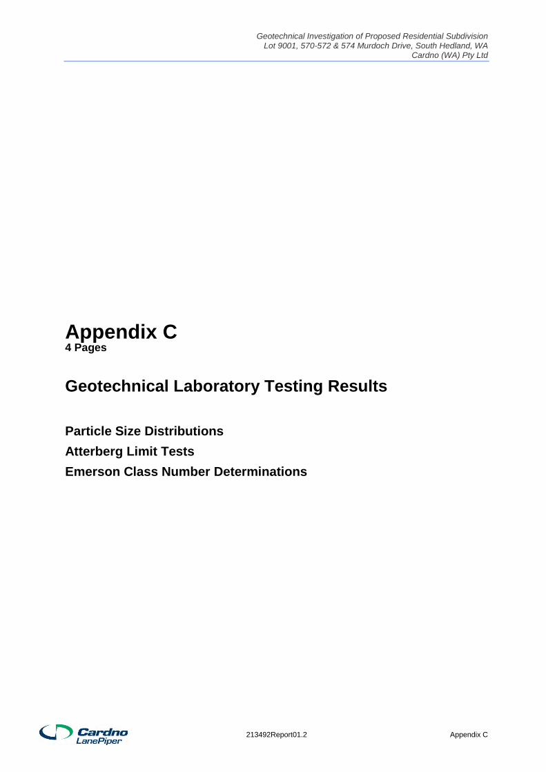
Cardno (WA) Pty Ltd
Appendix C4 Pages
Geotechnical Laboratory Testing Results
Particle Size Distributions Atterberg Limit Tests Emerson Class Number Determinations
213492Report01.2 Appendix C
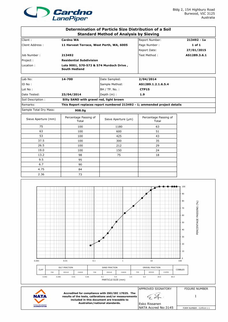
Client : Report Number: 213492 - 1a
Client Address : Page Number : 1 of 1
Report Date: 27/01/2015
Job Number : 213492 Test Method :
Project :
Location :
Lab No: 14-700 Date Sampled: 2/04/2014
ID No : Sample Method: AS1289.1.2.1.6.5.4
Lot No : BH / TP. No. : CTP15
Date Tested: 23/04/2014 Depth (m) : 1.9
Soil Description : Silty SAND with gravel red, light brown
Remarks: This Report replaces report numbered 213492 - 1; ammended project details
Sample Total Dry Mass: 908.0g
Percentage Passing of
TotalSieve Aperture (µm)
Percentage Passing of
Total
100 1180 63
100 600 51
100 425 43
100 300 35
100 212 29
100 150 24
53
75
Cardno WA
Residential Subdivision
Sieve Aperture (mm)
63
37.5
26.5
19.0
Bldg 2, 154 Highbury Road
Burwood, VIC 3125
Australia
Determination of Particle Size Distribution of a Soil
Standard Method of Analysis by Sieving
11 Harvest Terrace, West Perth, WA, 6005
AS1289.3.6.1
Lots 9001, 570-572 & 574 Murdoch Drive ,
South Hedland
100 150 24
98 75 18
95
90
84
73
APPROVED SIGNATORY FIGURE NUMBER
Accredited for compliance with ISO/IEC 17025. The
13.2
9.5
6.7
4.75
2.36
19.0
0
10
20
30
40
50
60
70
80
90
100
0.001 0.01 0.1 1 10 100
PERCENTAGE P
ASSIN
G (%
)
SILT FRACTION SAND FRACTION GRAVEL FRACTIONCLAY COBBLES
0.002 0.006 0.02 0.06 0.2 0.6 2.0 6.0 20.0 60.0
PARTICLE SIZE (mm)
FINE MEDIUM FINE MEDIUMCOARSE FINE MEDIUM COARSE COARSE
Esko Rissanen
NATA Accred No:3145 FORM NUMBER : CLP014-1-1
Accredited for compliance with ISO/IEC 17025. The
results of the tests, calibrations and/or measurements
included in this document are traceable to
Australian/national standards.
1
Client : Report Number: 213492 - 2a
Client Address : Page Number : 1 of 1
Report Date: 27/01/2015
Job Number : 213492 Test Method :
Project :
Location :
Lab No: 14-703 Date Sampled: 3/04/2014
ID No : Sample Method: AS1289.1.2.1.6.5.4
Lot No : BH / TP. No. : CTP18
Date Tested: 23/04/2014 Depth (m) : 2.4
Soil Description : Silty SAND red yellow brown mottled
Remarks: This Report replaces report numbered 213492 - 2; ammended project details
Sample Total Dry Mass: 608.8g
Percentage Passing of
TotalSieve Aperture (µm)
Percentage Passing of
Total
100 1180 82
100 600 61
100 425 53
100 300 46
100 212 40
100 150 35
53
75
Cardno WA
Residential Subdivision
Sieve Aperture (mm)
63
37.5
26.5
19.0
Bldg 2, 154 Highbury Road
Burwood, VIC 3125
Australia
Determination of Particle Size Distribution of a Soil
Standard Method of Analysis by Sieving
11 Harvest Terrace, West Perth, WA, 6005
AS1289.3.6.1
Lots 9001, 570-572 & 574 Murdoch Drive ,
South Hedland
100 150 35
100 75 29
100
100
99
94
APPROVED SIGNATORY FIGURE NUMBER
Accredited for compliance with ISO/IEC 17025. The
13.2
9.5
6.7
4.75
2.36
19.0
0
10
20
30
40
50
60
70
80
90
100
0.001 0.01 0.1 1 10 100
PERCENTAGE P
ASSIN
G (%
)
SILT FRACTION SAND FRACTION GRAVEL FRACTIONCLAY COBBLES
0.002 0.006 0.02 0.06 0.2 0.6 2.0 6.0 20.0 60.0
PARTICLE SIZE (mm)
FINE MEDIUM FINE MEDIUMCOARSE FINE MEDIUM COARSE COARSE
Esko Rissanen
NATA Accred No:3145 FORM NUMBER : CLP014-1-1
Accredited for compliance with ISO/IEC 17025. The
results of the tests, calibrations and/or measurements
included in this document are traceable to
Australian/national standards.
2
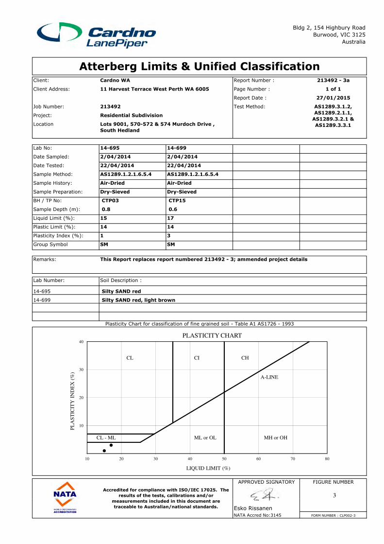
Client: Cardno WA Report Number : 213492 - 3a
Client Address: Page Number : 1 of 1
Report Date : 27/01/2015
Job Number: 213492 Test Method:
Project:
Location
Lab No: 14-695 14-699
Date Sampled: 2/04/2014 2/04/2014
Date Tested: 22/04/2014 22/04/2014
Sample Method: AS1289.1.2.1.6.5.4 AS1289.1.2.1.6.5.4
Sample History: Air-Dried Air-Dried
Sample Preparation: Dry-Sieved Dry-Sieved
BH / TP No: CTP03 CTP15
Sample Depth (m): 0.8 0.6
Liquid Limit (%): 15 17
Plastic Limit (%): 14 14
Plasticity Index (%): 1 3 #N/A #N/A
Group Symbol SM SM
Bldg 2, 154 Highbury Road
Burwood, VIC 3125
Australia
Atterberg Limits & Unified Classification
Residential Subdivision
11 Harvest Terrace West Perth WA 6005
Lots 9001, 570-572 & 574 Murdoch Drive ,
South Hedland
AS1289.3.1.2,
AS1289.2.1.1,
AS1289.3.2.1 &
AS1289.3.3.1
Remarks: This Report replaces report numbered 213492 - 3; ammended project details
Lab Number: Soil Description :
14-695 Silty SAND red
14-699 Silty SAND red, light brown
APPROVED SIGNATORY FIGURE NUMBER
Accredited for compliance with ISO/IEC 17025. The
results of the tests, calibrations and/or
measurements included in this document are
Plasticity Chart for classification of fine grained soil - Table A1 AS1726 - 1993
10
20
30
40
10 20 30 40 50 60 70 80
PL
AS
TIC
ITY
IN
DE
X (
%)
LIQUID LIMIT (%)
PLASTICITY CHART
CL CI CH
A-LINE
CL - ML ML or OL MH or OH
Esko Rissanen
NATA Accred No:3145 FORM NUMBER : CLP002-3
measurements included in this document are
traceable to Australian/national standards.
3
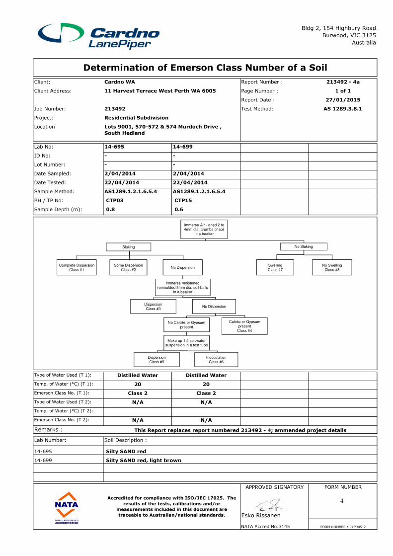
Client: Cardno WA Report Number : 213492 - 4a
Client Address: Page Number : 1 of 1
Report Date : 27/01/2015
Job Number: 213492 Test Method:
Project:
Location
Lab No: 14-695 14-699
ID No: - -
Lot Number: - -
Date Sampled: 2/04/2014 2/04/2014
Date Tested: 22/04/2014 22/04/2014
Sample Method: AS1289.1.2.1.6.5.4 AS1289.1.2.1.6.5.4
BH / TP No: CTP03 CTP15
Sample Depth (m): 0.8 0.6
Determination of Emerson Class Number of a Soil
Bldg 2, 154 Highbury Road
Burwood, VIC 3125
Australia
11 Harvest Terrace West Perth WA 6005
AS 1289.3.8.1
Residential Subdivision
Lots 9001, 570-572 & 574 Murdoch Drive ,
South Hedland
Immerse Air - dried 2 to 4mm dia. crumbs of soil
in a beaker
Slaking No Slaking
Type of Water Used (T 1): Distilled Water Distilled Water
Temp. of Water (°C) (T 1): 20 20
Emerson Class No. (T 1): Class 2 Class 2
Type of Water Used (T 2): N/A N/A
Temp. of Water (°C) (T 2):
Emerson Class No. (T 2): N/A N/A
Remarks :
Lab Number: Soil Description :
14-695 Silty SAND red
14-699 Silty SAND red, light brown
APPROVED SIGNATORY FORM NUMBER
Accredited for compliance with ISO/IEC 17025. The
results of the tests, calibrations and/or
measurements included in this document are
This Report replaces report numbered 213492 - 4; ammended project details
Complete DispersionClass #1
Some Dispersion Class #2
No DispersionSwellingClass #7
No SwellingClass #8
Immerse moistened remoulded 3mm dia. soil balls
in a beaker
DispersionClass #3
No Dispersion
No Calcite or Gypsum present
Calcite or Gypsum present
Class #4
Make up 1:5 soil/water suspension in a test tube
DispersionClass #5
FlocculationClass #6
Esko Rissanen
NATA Accred No:3145 FORM NUMBER : CLP005-2
measurements included in this document are
traceable to Australian/national standards.
4
Geotechnical Investigation of Proposed Residential Subdivision Lot 9001, 570-572 & 574 Murdoch Drive, South Hedland, WA
Cardno (WA) Pty Ltd
Appendix D1 Page
Limitations of the Report
213492Report01.2 Appendix D
LIMITATIONS OF GEOTECHNICAL REPORTS
Doc: Limitations of Geotechnical Reports Last Revised: 25-Feb-13
The purpose of this report is to provide a geotechnical assessment of the sites examined. The information provided herein will reduce the exposure to risks, but no geotechnical assessment can eliminate them. Nonetheless, even a rigorous assessment may fail to detect all of the geotechnical conditions on a site. Site variations may have occurred in areas not investigated or sampled.
This geotechnical report should not be used when the nature of the proposed site usage changes, when the size, layout, or location of the development is modified, when the site ownership changes nor should it be applied to a nearby area. No environmental assessment has been undertaken nor is implied.
This site geotechnical assessment identifies actual subsurface conditions where the samples were taken and at the time they were taken. Any soil tests completed, were carried out in Cardno Lane Piper’s NATA accredited soil laboratory. Geotechnical engineers then interpreted the laboratory results and field data and rendered an opinion about the overall subsurface conditions, including the soil type, extent of the soil layers, and their likely impact on the proposed development, with a discussion of the implications considered likely. The actual conditions may differ from the inferred conditions, as no person (no matter how qualified) or even the most detailed subsurface investigation can predict with confidence what may be hidden by soil or water or may have altered with time. Often the interface between different geotechnical areas may be more abrupt or gradual than anticipated. The actual conditions in an area may differ from those predicted.
Site assessments are limited by time, and natural processes such as erosion, or mankind altering the ground conditions, including the site levels or filled areas, may affect a site assessment. This geotechnical assessment is prepared in response to a client’s specific requirements. No person other than the client should apply the report without first conferring with Cardno Lane Piper.
Costly problems can occur if the report is misinterpreted. To avoid these problems, Cardno Lane Piper should be retained to work with the appropriate design professionals and to review the adequacy of their plans and specifications relative to the geotechnical matters.
This report should only be reproduced in its entirety. Reproduction of borehole or testpit logs alone without the entire report should not be permitted. Redrafting of the borehole or testpit logs for inclusion in drawings or other reports should not be allowed as errors in the drafting can occur. It is recommended that the report be made available in entirety to persons and organisations involved in the project such as contractors. Simply disclaiming responsibility for the accuracy of the subsurface or geotechnical information does not insulate the organisation from liability. The more information a contractor has available to him, the better able he is to avoid costly construction problems and costly adversarial situations.
Finally, geotechnical reports are based extensively on opinion and judgment and are less exact than other sciences. The report may contain a number of explanatory clauses or limitations on the results to inform the client about the restrictions of the report. These clauses are not meant to be exculpatory clauses to foist liability onto another person, but to identify where Cardno Lane Piper’s and the client’s responsibilities start and finish. Their use is to clarify where individual responsibilities lie and to allow the individual to take appropriate actions.