Embed Size (px)
Citation preview
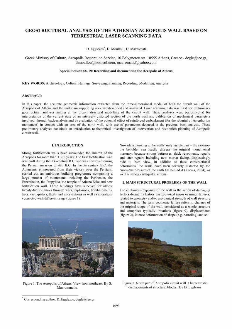
GEOSTRUCTURAL ANALYSIS OF THE ATHENIAN ACROPOLIS WALL BASED ON TERRESTRIAL LASER SCANNING DATA
D. Egglezos*, D. Moullou , D. Mavromati
Greek Ministry of Culture, Acropolis Restoration Service, 10 Polygnotou str. 10555 Athens, Greece - [email protected], [email protected], [email protected]
Special Session SS-19: Recording and documenting the Acropolis of Athens
KEY WORDS: Archaeology, Cultural Heritage, Surveying, Planning, Recording, Modelling, Analysis ABSTRACT: In this paper, the accurate geometric information extracted from the three-dimensional model of both the circuit wall of the Acropolis of Athens and the underlain supporting rock are described and analyzed. Laser scanning data was used for preliminary geostructural analyses aiming at the proper structural modelling of the circuit wall. These analyses were performed a) for interpretation of the current state of an intensely distorted section of the north wall and calibration of mechanical parameters involved, through back-analysis and b) evaluation of the potential effect of reinforced embankment (for the reburial of Arrephorion monument) in contact with an area of the north wall, with use of parameters deduced at the previous back-analysis. These preliminary analyses constitute an introduction to theoretical investigation of intervention and restoration planning of Acropolis circuit wall.
* Corresponding author. D. Egglezos, [email protected]
1. INTRODUCTION
Strong fortification walls have surrounded the summit of the Acropolis for more than 3.300 years. The first fortification wall was built during the 13th century B.C. and was destroyed during the Persian invasion of 480 B.C. In the 5th century B.C. the Athenians, empowered from their victory over the Persians, carried out an ambitious building programme comprising a large number of monuments including the Parthenon, the Erechtheion, the Propylaia, the temple of Athena Nike and new fortification wall. These buildings have survived for almost twenty-five centuries through wars, explosions, bombardments, fires, earthquakes, thefts and interventions as well as alterations connected with different usage (figure 1).
Figure 1. The Acropolis of Athens. View from northeast. By S.
Mavrommatis.
Nowadays, looking at the walls’ only visible part – the exterior- the beholder can hardly discern the original monumental masonry, because strong buttresses, thick revetments, repairs and later repairs including new mortar facing, displeasingly hide it from view. In addition to these constructional deformities, the walls have been severely distorted by the enormous pressure of the earth fill behind it (Korres, 2004), as well as strong earthquake actions.
2. MAIN STRUCTURAL PROBLEMS OF THE WALL
The continuous exposure of the wall in the action of damaging factors during its history has provoked major or minor failures, related to geometry and/or mechanical strength of wall structure and materials. The term geometric failure refers to changes of the original shape of the wall, considered as a whole structure and comprises typically: rotations (figure 9), displacements (figure 2), intense deformation of shape (e.g. barreling) and so
Figure 2. North part of Acropolis circuit wall. Characteristic displacements of structural blocks. By D. Egglezos
1093

on. On the other hand, the term mechanical failure applies mainly to material blocks and comprises block fractures (figure 3), joint dislocations (figure 4), superficial weathering, disorganization of major areas due to mortar loss, instability of underlain rockmass, and so on. The above described structural problems, irrespectively of their geometric or mechanical nature, constitute what is typically called, the “pathology” of the monument (Egglezos et al., 2008). This “pathology” is encountered systematically in large areas at the current state of the circuit wall.
Figure 3. Characteristic fractures in the SE corner of Acropolis circuit wall. By D. Egglezos
Figure 4. South part of Acropolis circuit wall. Characteristic dislocations of joints of structural blocks. By D. Egglezos
Taking into consideration the above mentioned problems, as well as the severe loading factors acting on the circuit wall (soil thrust, dead load from its own weight, thermal loading, foundation instabilities, and –the rather critical load- earthquake events), it is easily concluded that a systematic intervention has to be launched. The intervention has to assure a) minimization of additional deterioration, b) restoration of seriously damaged areas, c) drastic decrease of the effect of loading factors and d) safe conditions for a long period of time. This intervention, in brief, must comprise tasks as, geometric documentation of the existing state, realization of supporting studies relating to the walls (systematic geotechnical investigation of the area, drainage of the superficial plane of the rocky hill, proper laboratory program for determination of mechanical properties of structural blocks, seismic hazard evaluation study and so on), geostructural analyses for interpretation of current state and proper choice of geotechnical and structural model simulation for design of stability measures (both for the walls and the supporting underlain rock), extended instrumentation for continuous observation of both the current and future (post-intervention) state, continuous conservation of the repaired/restored monument. In this paper, the main emphasis from the above mentioned targets focuses on, how rigorous geometric documentation of the circuit wall applies directly to geostructural analyses for interpretation of current state of deformed sections and permits the calibration of structural model parameters.
3. GEOMETRIC DOCUMENTATION
Geometric recording based on reliable elevation information and 3D phototextured models are now, perhaps, the standard photogrammetric products for archaeological and architectural documentation (Mavromati et al., 2002, Georgopoulos et al., 2005). An orthophoto constitutes a powerful textured representation combining geometric accuracy with high visual quality and a wealth of detail, providing invaluable information about morphology and deformation. Hence, it is a non-generalized background and the vectorized interpretation to be overlaid is left to the specialists. A fully 3D photo-textured surface model provides photorealistic visualization, high geometric accuracy and facilitates geometric or morphological documentation and analysis (Moullou et al., 2007). The recording and the documentation of the Acropolis circuit walls is a vital part of the restoration planning. Due mainly to its size (~ 760m perimeter, maximum height 18m) and its inaccessibility (figure 5) the only fast and accurate method that could be applied is a proper combination of photogrammetry and 3D laser scanning. This is the reason why the Acropolis Restoration Service initiated, in 2007, a project, its objective being the recording, modelling, visualisation and GIS applications development for the Acropolis archaeological site. The project has a dual goal consisting of: firstly the production of the scientific infrastructure needed for current or future restoration planning, with the emphasis laid on the Acropolis circuit walls. The project will cater for the investigation of the various interventions the walls have sustained across time, for the location and study of the poros limestone and marble blocks reused in them and for the examination of their static sufficiency. And secondly the exposure of all information
The International Archives of the Photogrammetry, Remote Sensing and Spatial Information Sciences. Vol. XXXVII. Part B5. Beijing 2008
1094
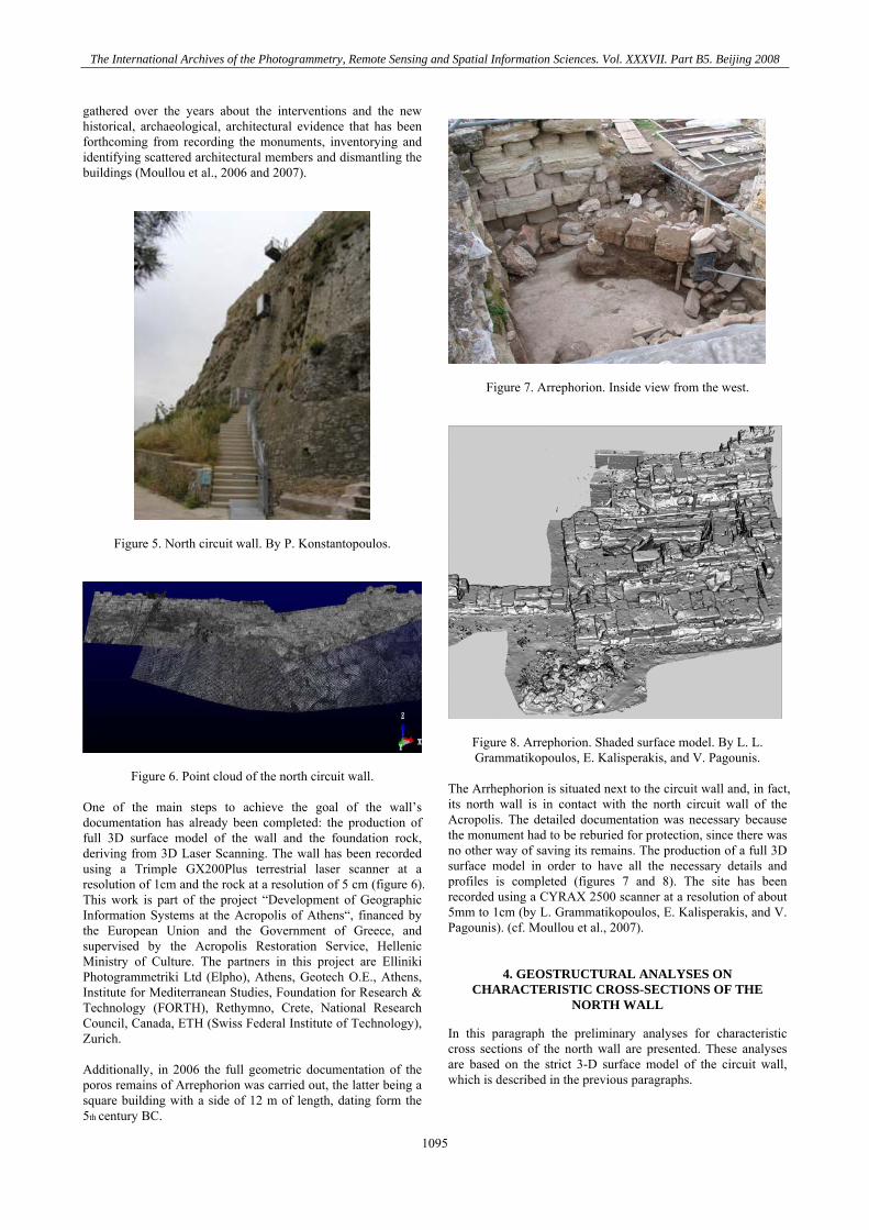
gathered over the years about the interventions and the new historical, archaeological, architectural evidence that has been forthcoming from recording the monuments, inventorying and identifying scattered architectural members and dismantling the buildings (Moullou et al., 2006 and 2007).
Figure 5. North circuit wall. By P. Konstantopoulos.
Figure 6. Point cloud of the north circuit wall. One of the main steps to achieve the goal of the wall’s documentation has already been completed: the production of full 3D surface model of the wall and the foundation rock, deriving from 3D Laser Scanning. The wall has been recorded using a Trimple GX200Plus terrestrial laser scanner at a resolution of 1cm and the rock at a resolution of 5 cm (figure 6). This work is part of the project “Development of Geographic Information Systems at the Acropolis of Athens“, financed by the European Union and the Government of Greece, and supervised by the Acropolis Restoration Service, Hellenic Ministry of Culture. The partners in this project are Elliniki Photogrammetriki Ltd (Elpho), Athens, Geotech O.E., Athens, Institute for Mediterranean Studies, Foundation for Research & Technology (FORTH), Rethymno, Crete, National Research Council, Canada, ETH (Swiss Federal Institute of Technology), Zurich. Additionally, in 2006 the full geometric documentation of the poros remains of Arrephorion was carried out, the latter being a square building with a side of 12 m of length, dating form the 5th century BC.
Figure 7. Arrephorion. Inside view from the west.
Figure 8. Arrephorion. Shaded surface model. By L. L. Grammatikopoulos, E. Kalisperakis, and V. Pagounis.
The Arrhephorion is situated next to the circuit wall and, in fact, its north wall is in contact with the north circuit wall of the Acropolis. The detailed documentation was necessary because the monument had to be reburied for protection, since there was no other way of saving its remains. The production of a full 3D surface model in order to have all the necessary details and profiles is completed (figures 7 and 8). The site has been recorded using a CYRAX 2500 scanner at a resolution of about 5mm to 1cm (by L. Grammatikopoulos, E. Kalisperakis, and V. Pagounis). (cf. Moullou et al., 2007).
4. GEOSTRUCTURAL ANALYSES ON
CHARACTERISTIC CROSS-SECTIONS OF THE NORTH WALL
In this paragraph the preliminary analyses for characteristic cross sections of the north wall are presented. These analyses are based on the strict 3-D surface model of the circuit wall, which is described in the previous paragraphs.
The International Archives of the Photogrammetry, Remote Sensing and Spatial Information Sciences. Vol. XXXVII. Part B5. Beijing 2008
1095
The International Archives of the Photogrammetry, Remote Sensing and Spatial Information Sciences. Vol. XXXVII. Part B5. Beijing 2008
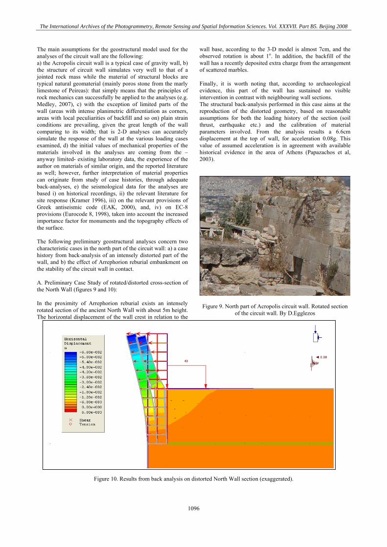
The main assumptions for the geostructural model used for the analyses of the circuit wall are the following: a) the Acropolis circuit wall is a typical case of gravity wall, b) the structure of circuit wall simulates very well to that of a jointed rock mass while the material of structural blocks are typical natural geomaterial (mainly poros stone from the marly limestone of Peireas): that simply means that the principles of rock mechanics can successfully be applied to the analyses (e.g. Medley, 2007), c) with the exception of limited parts of the wall (areas with intense planimetric differentiation as corners, areas with local peculiarities of backfill and so on) plain strain conditions are prevailing, given the great length of the wall comparing to its width; that is 2-D analyses can accurately simulate the response of the wall at the various loading cases examined, d) the initial values of mechanical properties of the materials involved in the analyses are coming from the –anyway limited- existing laboratory data, the experience of the author on materials of similar origin, and the reported literature as well; however, further interpretation of material properties can originate from study of case histories, through adequate back-analyses, e) the seismological data for the analyses are based i) on historical recordings, ii) the relevant literature for site response (Kramer 1996), iii) on the relevant provisions of Greek antiseismic code (EAK, 2000), and, iv) on EC-8 provisions (Eurocode 8, 1998), taken into account the increased importance factor for monuments and the topography effects of the surface. The following preliminary geostructural analyses concern two characteristic cases in the north part of the circuit wall: a) a case history from back-analysis of an intensely distorted part of the wall, and b) the effect of Arrephorion reburial embankment on the stability of the circuit wall in contact. A. Preliminary Case Study of rotated/distorted cross-section of the North Wall (figures 9 and 10): In the proximity of Arrephorion reburial exists an intensely rotated section of the ancient North Wall with about 5m height. The horizontal displacement of the wall crest in relation to the
wall base, according to the 3-D model is almost 7cm, and the observed rotation is about 1o. In addition, the backfill of the wall has a recently deposited extra charge from the arrangement of scattered marbles. Finally, it is worth noting that, according to archaeological evidence, this part of the wall has sustained no visible intervention in contrast with neighbouring wall sections. The structural back-analysis performed in this case aims at the reproduction of the distorted geometry, based on reasonable assumptions for both the loading history of the section (soil thrust, earthquake etc.) and the calibration of material parameters involved. From the analysis results a 6.6cm displacement at the top of wall, for acceleration 0.08g. This value of assumed acceleration is in agreement with available historical evidence in the area of Athens (Papazachos et al, 2003).
Figure 9. North part of Acropolis circuit wall. Rotated section
of the circuit wall. By D.Egglezos
Figure 10. Results from back analysis on distorted North Wall section (exaggerated).
1096
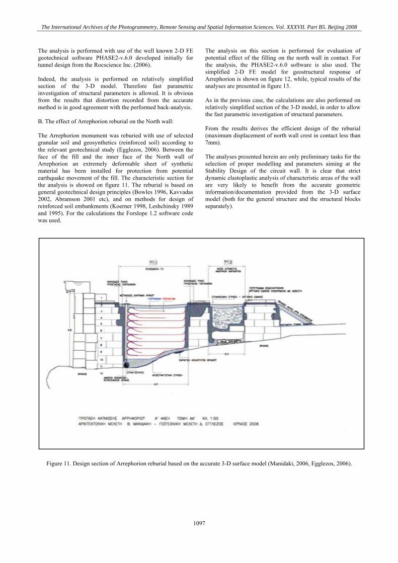
The analysis is performed with use of the well known 2-D FE geotechnical software PHASE2-v.6.0 developed initially for tunnel design from the Rocscience Inc. (2006). Indeed, the analysis is performed on relatively simplified section of the 3-D model. Therefore fast parametric investigation of structural parameters is allowed. It is obvious from the results that distortion recorded from the accurate method is in good agreement with the performed back-analysis. B. The effect of Arrephorion reburial on the North wall: The Arrephorion monument was reburied with use of selected granular soil and geosynthetics (reinforced soil) according to the relevant geotechnical study (Egglezos, 2006). Between the face of the fill and the inner face of the North wall of Arrephorion an extremely deformable sheet of synthetic material has been installed for protection from potential earthquake movement of the fill. The characteristic section for the analysis is showed on figure 11. The reburial is based on general geotechnical design principles (Bowles 1996, Kavvadas 2002, Abramson 2001 etc), and on methods for design of reinforced soil embankments (Koerner 1998, Leshchinsky 1989 and 1995). For the calculations the Forslope 1.2 software code was used.
The analysis on this section is performed for evaluation of potential effect of the filling on the north wall in contact. For the analysis, the PHASE2-v.6.0 software is also used. The simplified 2-D FE model for geostructural response of Arrephorion is shown on figure 12, while, typical results of the analyses are presented in figure 13. As in the previous case, the calculations are also performed on relatively simplified section of the 3-D model, in order to allow the fast parametric investigation of structural parameters. From the results derives the efficient design of the reburial (maximum displacement of north wall crest in contact less than 7mm). The analyses presented herein are only preliminary tasks for the selection of proper modelling and parameters aiming at the Stability Design of the circuit wall. It is clear that strict dynamic elastoplastic analysis of characteristic areas of the wall are very likely to benefit from the accurate geometric information/documentation provided from the 3-D surface model (both for the general structure and the structural blocks separately).
Figure 11. Design section of Arrephorion reburial based on the accurate 3-D surface model (Manidaki, 2006, Egglezos, 2006).
The International Archives of the Photogrammetry, Remote Sensing and Spatial Information Sciences. Vol. XXXVII. Part B5. Beijing 2008
1097
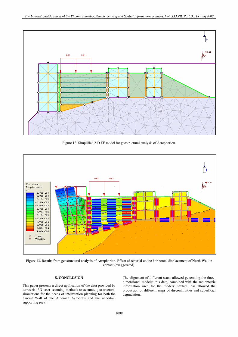
Figure 12. Simplified 2-D FE model for geostructural analysis of Arrephorion.
Figure 13. Results from geostructural analysis of Arrephorion. Effect of reburial on the horizontal displacement of North Wall in contact (exaggerated).
5. CONCLUSION
This paper presents a direct application of the data provided by terrestrial 3D laser scanning methods to accurate geostructural simulations for the needs of intervention planning for both the Circuit Wall of the Athenian Acropolis and the underlain supporting rock.
The alignment of different scans allowed generating the three-dimensional models: this data, combined with the radiometric information used for the models’ texture, has allowed the production of different maps of discontinuities and superficial degradation.
The International Archives of the Photogrammetry, Remote Sensing and Spatial Information Sciences. Vol. XXXVII. Part B5. Beijing 2008
1098
The accurate geometrical information obtained, was used as input for the PHASE 2-6.0 geotechnical software of Rockscience Inc. for preliminary geostructural FE analysis and allowed a) the reproduction of case history of an intensely distorted part of the North Wall through back analysis procedure and the calibration of mechanical parameters of materials involved as well and b) the evaluation of potential effect of reburial embankment on the North Wall in contact, with use of the calibrated parameters derived from the previous case. The results of the analyses are proven promising for a successful geostructural simulation of the circuit wall. Considering the serious wall’s “pathology”, the correct geostructural simulation, based on accurate geometric data is indispensable for the design analysis of the wall’s stability measures in the near future.
REFERENCES
Abramson, L.W., Lee, T.S., Sharma, S., Boyce, G.M. 2001. Slope stability and Stabilitzation Methods. John Wiley & Sons. Bowles E. Joseph, 1996. Foundation analysis and design, Mc Graw Hill – International editions, 5th edition.
ΕAK, 2000. Greek Antiseismic Code: Ministry of Public Works of Greece, ΦΕΚ 2184 Β’/20-12-1999. Egglezos, D., 2006. Geotechnical Study for the Reburial of Arrephorion monument. Acropolis Restoration Service ΥΠ.ΠΟ./Υ.Σ.Μ.Α. (in Greek) . Egglezos D., Moullou D. 2008. Acropolis Circuit Wall: Studies, research and interventions. The Acropolis Restoration News.
Eurocode 7, 1995. European standards for design of geotechnical projects. Eurocode 8, 1998. European standards for earthquake design. Georgopoulos, A., Makris, G.N., Dermentzopoulos, A., 2005. An alternative method for large scale orthophoto production. Proceedings XX CIPA International Symposium, Torino, Italy 26 September - 1 October, http://cipa.icomos.org/fileadmin/papers/Torino2005/300.pdf. Forslope 1.2, 2004. Software code for design of reinforced walls and embankments. Huesker Synthetics, Germany. Kavvadas, M., 2002. Elements of Soil Mechanics. N.T.U.A., Athens, Greece (in Greek).
Koerner, R.M., 1998. Designing with Geosynthetics. Prentice Hall, 4th edition. Korres, M., 2004. The Pedestals and the Akropolis South Wall. “Attalos, Athens and the Acropolis”. Cambridge University Press, pp. 242-337. Kramer, S.L., 1996. Geotechnical earthquake engineering. Prentice Hall, Inc., Upper Saddle River, NJ, USA. Leshchinsky, D. and Boedeker, R. H., 1989. Geosynthetic reinforced earth structures. Journal of Geotechnical Engineering, ASCE, 115(10), pp. 1459-1478. Leshchinsky, D., Ling, H. I., and Hanks, G., 1995. Unified Design Approach to Geosynthetic-Reinforced Slopes and Segmental Walls. Geosynthetics International, 2(5), pp. 845-881. Manidaki, V., 2006. Architectural Study for the Reburial of Arrephorion monument. Acropolis Restoration Service ΥΠ.ΠΟ./Υ.Σ.Μ.Α. (in Greek). Mavromati, D., Petsa, E., Karras, G., 2002. Theoretical and practical aspects of archaeological orthoimaging. International Archives of Photogrammetry & Remote Sensing, 34(5), pp. 413-418. Medley, E., Zekkos, D., 2007. Seismic performance of rock bolts structures with observations from the October 2006 Hawaii earthquake. 4ICEGE, Thessaloniki, Greece. Moullou, D., Ioannidou, M., 2006. The principle of publicity as applied to the Acropolis Restoration Works: How the application of information technology can be beneficial. II Giornata Gregoriana. Il Tempio della Concordia. Storia e Restauri, Agrigento, Italy, November 24-25 (in print). Moullou, D., Mavrommati, D., 2007. Topographic and Photogrammetric Recording of the Acropolis of Athens. Proceedings XXI CIPA International Symposium, Athens, Greece, October 1-6. Papazachos V., Papazachou K., 2003. Earthquakes in Greece. Ziti editions. (In Greek) Rockscience Inc., 2005. Phase2 6.0, A 2-D FE elastoplastic Code for geotechnical applications. Toronto, Ontario, Canada. All pictures published belong to the ESMA (Committee for the Preservation of the Acropolis Monuments) archives.
The International Archives of the Photogrammetry, Remote Sensing and Spatial Information Sciences. Vol. XXXVII. Part B5. Beijing 2008
1099

The International Archives of the Photogrammetry, Remote Sensing and Spatial Information Sciences. Vol. XXXVII. Part B5. Beijing 2008
1100


![]Athenian Letters](https://img.pdfslide.us/doc/110x75/55cf8e3a550346703b8fe525/athenian-letters.jpg)