Embed Size (px)
Citation preview

Geospatial Mapping and Navigation of the Web
Kevin S. McCurleyIBM Almaden Research Center
650 Harry RoadSan Jose, CA 95120
U.S.A.
ABSTRACTWeb pages may be organized, indexed, searched, and navi-gated along several di�erent feature dimensions. We investi-gate di�erent approaches to discovering geographic contextfor web pages, and describe a navigational tool for browsingweb resources by geographic proximity.
Keywords: Geospatial information retrieval, geographicinformation systems, browsers, navigation.
1. INTRODUCTIONSince the early days of the world wide web, many dif-
ferent e�orts have been made for organizing, navigating,and searching documents. Simple inverted keyword search-es (perhaps not so simple now that the web has grown solarge!) continue to provide one of the most useful techniquesfor users to �nd information on a given topic, but they alsoform a starting point for a number of higher-level semanticqueries that can be used in an information search. For ex-ample, a reader may only be interested in �nding documentsthat that are written in Japanese, or that were created ormodi�ed after a certain date. A reader may also only beinterested in pages that are written for a �fth-grade readingskill. Such information retrieval tasks are not well served bya simple keyword search, and systems organized to answersuch queries generally require higher-level semantic informa-tion about the content.Navigational tools may also rely on information that has
been extracted during a crawl and stored in a database. Onenovel feature for navigation is the \What's Related" serviceprovided by Alexa corporation [14], and incorporated intoboth Netscape Communicator and Microsoft Internet Ex-plorer. A further example was provided by the \backlinksbrowser" presented by the author at this conference twoyears ago [5], allowing a user to traverse hyperlinks in thereverse direction. One might also imagine various ways ofcreating a temporal browsing mechanism, o�ering the read-er the chance to view the change history of a resource refer-enced by a URL as time progresses.This paper addresses the problem of indexing and naviga-
tion of web resources by geospatial criteria. Information re-trieval based on geographic criteria is a fairly common task.Examples include travelers who wish to learn what oppor-tunities exist in a destination, students who are studying
Copyright is held by the author/owner.WWW10, May 1-5, 2001, Hong Kong.ACM 1-58113-348-0/01/0005.
another part of the world, intelligence analysts preparing areport on a given area, business planners investigating anarea for expansion, or government planners who wish to fo-cus on environmental or economic impact in a speci�c re-gion. For a good introduction to the �eld of informationretrieval using geographic criteria, see [15].In addition to geographic information retrieval and nav-
igation of Internet content, geography plays an importantrole in other aspects of the Internet. Advertising is muchmore e�ective for both consumers and advertisers when ito�ers products and services that are readily available in thearea of the consumer. Content that is tailored to a regionis potentially more useful to users from that region. Forexample, local customs and laws in uence the expectationsof users when they interact with the network. Note that auser or server need not have a static location, since mobileusage of the Internet is expected to grow rapidly in the fu-ture. We call such geographic contexts entity-based, sincethey represent a feature of the user or computing systemitself.A more interesting and subtle source of geographic context
is provided by the content itself (we refer to these as content-based contexts). For example, the web page of a companymay contain the address or phone number of the compa-ny headquarters, conveying a geographic context within thepage. A page reporting on a news event should be assigneda geographic context of the location where the event tookplace. Note that a content-based context for a web pagemay be inferred from the entity-based context of the serverthat hosts the page, since the URL itself may be regardedas part of the content.Geospatial contexts may be point locations, or arbitrarily
shaped regions. The regions need not be contiguous (e.g.,the country of Japan consists of many islands). They neednot even be planar; one interesting feature of our projectis that we will eventually be able to answer queries aboutall pages with geographic contexts for land locations be-low sea level. A web resource will very often have multiplegeographic contexts, and it is impossible to assign just one(e.g., a personal page of a person who lives in one place, butcomments about a site they visited on vacation).Many pages on the web have no strongly determined geo-
graphic context, so it would be misleading to expect suchfor every page on the net. Other pages have a very obviousgeographic context (e.g., those containing a postal addressfor a physical location). The signi�cance of a geographiccontext is diÆcult to determine, but multiple indicators ofproximate geographic context can be used to improve the
221
assurance of correlation to a geographic location. Moreover,some indicators give higher con�dence than others. Considerfor example the two cases of recognizing the phrase \Caspi-an Sea" within a web page vs. recognizing a phone numberthat is located on the shore of the Caspian Sea. The phonenumber may be included only as a way of reaching a personwho has further information about the actual topic of thepage, and their residence on the Caspian Sea may in fact beirrelevant. By contrast, unless the term \Caspian Sea" hasanother recognizable meaning, there is little reason to doubtthe geographic signi�cance of this reference. While it is al-ways possible that a geographic indicator is only incidental,it still provides a way to rank documents according to theirgeographic relevance. Those that contain a geographicallysigni�cant indicator are clearly more relevant to a geograph-ically constrained information retrieval task than those thatdo not.The �eld of Geographic Information Systems (GIS) deals
primarily with data sets of geographic signi�cance, such asdemographic data, weather data, or geologic data. In this�eld the process of recognizing geographic context is referredto as geoparsing, and the process of assigning geographiccoordinates is referred to as geocoding. In this paper wereport on e�orts to geoparse and geocode web pages, andsome of the opportunities that this o�ers for navigation,indexing, and organizing.It is natural to wonder what fraction of web pages contain
a recognizable geographic context. Based on experimentswith a fairly large partial web crawl, we found that approx-imately 4.5% of all web pages contain a recognizable US zipcode, 8.5% contain a recognizable phone number, and 9.5%contain at least one of these. The actual fractions may besomewhat higher - these are ones that are actually recog-nized by our conservative parser. This does not say that theuse of geographic context is limited to only 10% of the web,because there are other indicators that may be used, andthere also exist opportunities for inference of implicit geo-graphic context for every web resource from the entity-basedcontext of the server (see section 2).Our primary focus in this paper is on information retrieval
and navigation. In section 5 we describe the implementa-tion of a navigational tool that allows the user to browse webpages by their geographic proximity rather than their hyper-link proximity. Geospatial information for web pages hasmany other uses as well. For example, when combined withan inverted keyword index, we can perform queries such as\�nd me pages that talk about biking trails in a geographiccontext within 50 kilometers of my brother's home". Suchqueries may not easily be answered with a simple invertedkeyword index, for it is often not clear how to formulate akeyword search that will exclude pages from outside of agiven region.We are not the �rst to recognize and consider the use
of geospatial information in web sites. Buyukokkten etal [2] studied the use of several geographic keys for the pur-pose of assigning site-level geographic context. By analyzing\whois" records, they built a database that relates IP ad-dresses and hostnames to approximate physical locations.By combining this information with the hyperlink structureof the web, they were able to make inferences about geog-raphy of the web at the granularity of a site. For example,they were able to con�rm from their study that the NewYork Times has a more global reputation than the San Fran-
cisco Chronicle, based on the fact that is linked to from amore geographically diverse set of sites.Among commercial sites, Northern Light has very recent-
ly started o�ering a \GeoSearch" capability, where keywordsearches can be constrained by proximity to a speci�ed ad-dress or phone number within the USA and Canada. Theyapparently recognize addresses within web pages, and usean address database to locate web pages containing near-by addresses. Yahoo! o�ers a \Yellow Pages" service forbusinesses in the USA, with search and ontologies organizedalong geographic as well as business lines. Their site appearsto have been built from commercial databases of businesses,and makes no attempt to organize non-business web pages.In the future the author expects to see a ood of develop-ment in this direction, partly in order to address the needsof mobile IP users.
2. SOURCES OF GEOSPATIAL CONTEXTFOR HOSTS
Context for servers or sites may be derived from any in-formation that is correlated to that machine. One usefulsource (used in [2]) is the Whois database for domain reg-istrations. This database was originally developed by theNIC for the purposes of problem solving and accountabili-ty, and contains phone numbers, addresses, and email ad-dresses for administrative and technical points of contactfor each domain. After the commercialization of the Inter-net, the responsiblity for this database has been dispersed toseveral organizations and usage is now constrained by pro-prietary interests. Note that the IP2LL package [13] usesthis approach to assign latitude and longitude to hostnames.We constructed a similar package in C++ for determiningentity-based geographic context of servers.While the whois database is quite useful, it is also pos-
sible to often derive site-level information of this degree ofaccuracy by analyzing the predominant geographic contextof individual pages on that site. Commercial sites often con-tain \contact" or \employment" pages that are linked fromthe top level or from many places on the site. Additionalheuristics are provided by the use of hostname aliases andhosts that share the same IP address.An additional source of geographic information is related
to the way that traÆc is routed on the Internet. IP pack-ets are typically forwarded through a sequence of hops inrouters. The route is dynamic, but most sites are connectedto the backbone by only one or two individual connections.Because of the way communication services are sold, thesebackbone connection points are typically located a relative-ly short physical distance from the server itself. The trace-route utility provides a mechanism of discovering the lasthop before reaching the server, and a truncated example oftraceroute output is shown in �gure 1.From a database of physical locations of these connection
point routers, it is possible to determine the approximatelocation of any server connected to the Internet with highprobability. It is possible to determine the identity of thesebackbone access routers the traceroute protocol and utility.This is the method used by the Gtrace tool [17] to display anapproximate location of servers connected to the Internet.The data collected in this way is of very limited accuracyhowever.Parts of the Domain Name System (DNS) provide a very
222
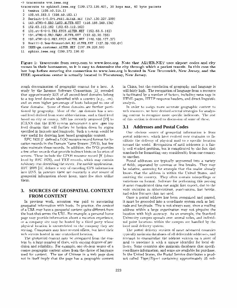
-> traceroute www.ieee.orgtraceroute to sphinx5.ieee.org (199.172.136.40), 30 hops max, 40 byte packets1 tenkuu (198.59.115.1)
2 198.59.183.1 (198.59.183.1)3 Serial5-1-0.GW1.PHX1.ALTER.NET (157.130.227.209)4 143.ATM3-0.XR2.LAX2.ALTER.NET (146.188.249.134)5 152.63.112.162 (152.63.112.162)6 131.at-5-0-0.TR2.NYC8.ALTER.NET (152.63.5.142)7 184.ATM6-0.XR2.EWR1.ALTER.NET (152.63.20.233)
8 192.ATM1-0-0.HR2.NYC2.ALTER.NET (146.188.177.37)9 Hssi11-0.New-Brunswick4.NJ.ALTER.NET (137.39.100.61)
10 IEEE-gw.customer.ALTER.NET (137.39.228.50)11 sphinx.ieee.org (199.172.136.8)
Figure 1: Traceroute from swcp.com to www.ieee.org. Note that ALTER.NET uses airport codes and citynames in their hostnames, so it is easy to determine the city through which a packet travels. In this case thelast hop before entering the connection to www.ieee.org is located in New Brunswick, New Jersey, and theIEEE operations center is actually located in Piscataway, New Jersey.
rough determination of geographic context for a host. Astudy by the Internet Software Consortium [12] revealedthat approximately 25% of all second-level domains belongto a top level domain identi�ed with a country (e.g., .cn),and an even higher percentage of hosts belonged to one ofthese domains. Some of these domains are further parti-tioned by geography. Most of the .us domain has a sec-ond level derived from state abbreviations, and a third levelbased on city or county. SRI has recently proposed [19] toICANN that the DNS system incorporate a new .geo toplevel domain that will further be broken down by regionspeci�ed in latitude and longitude. Such a system would bevery useful for deriving host-based geographic context.RFC 1876 [7] de�ned a LOC resource record format for lo-
cation records in the Domain Name System (DNS), but fewsites maintain these records. In addition, the DNS providesa few other records that provide indirect hints on location ofservers. These include the GPOS resource record [9] (obso-leted by RFC 1876), and TXT records, which may containarbitrary text describing the server. For mobile applications,RFC 2009 [11] de�nes a way of encoding GPS informationinto DNS. In practice these are currently a rare source ofgeospatial information about hosts, since few sites utilizethem.
3. SOURCES OF GEOSPATIAL CONTEXTFROM CONTENT
In previous work, attention was paid to associatinggeospatial information with hosts. In practice, the content
of a URL may have a geospatial context quite di�erent fromthe host that serves the URL. For example, a personal homepage may provide information about a vacation experience,or a company site may be hosted by a third party whosephysical location is uncorrelated to the company they areserving. Companies may have several oÆces, but have theirweb servers hosted in one centralized location.The geospatial context may be recognized from the con-
tent by a large number of clues, with varying degrees of pre-cision and reliability. For example, one obvious source of acoarse geographic context arises from the choice of languageused for content. The use of Chinese in a web page doesnot in itself imply that the page has a geographic context
in China, but the correlation of geography and language isstill fairly high. The recognition of language from a resourceis facilitated by a number of factors, including meta tags inHTML pages, HTTP response headers, and direct linguisticanalysis.In order to assign more accurate geographic context to
web resources, we have devised several strategies for analyz-ing content to recognize more speci�c indicators. The restof this section is devoted to discussion of some of these.
3.1 Addresses and Postal CodesOne obvious source of geospatial information is from
postal addresses, which have evolved over centuries to fa-cilitate the delivery of physical mail to a speci�c locationaround the world. Recognition of mail addresses is a fair-ly well studied problem, but is complicated by the fact thatstandards for formatting vary considerably from one countryto another.Postal addresses are typically segmented into a variety
of �elds, separated by commas or line breaks. They maybe relative, assuming for example that the reader alreadyknows that the address is within the United States, andomitting the country. They often contain misspellings orvariations on format. Software for performing this parsingis more complicated than one might �rst expect, due to thewide variation in abbreviations, punctuation, line breaks,and other features that are used.Once a postal address has been recognized and parsed,
it must be geocoded into a coordinate system such as lati-tude and longitude. This is not always easy, since a mailingaddress within a large organization may not pinpoint thelocation with high accuracy. As an example, the StanfordUniversity campus spreads over several miles, and individ-ual point locations within the campus are handled by thelocal mail delivery system.The postal delivery services of more advanced countries
typically maintain databases of all deliverable addresses, andattempt to canonicalize the address written on a piece ofmail to associate it with a unique identi�er for local de-livery. Some countries also maintain databases that specifycoordinate information, and some are available for purchase.In the United States, the Postal Service distributes a prod-uct called Tiger/Zip+4 containing approximately 35 mil-
223
lion records, and specifying a street address range for eachdeliverable 9-digit postal code. Combining this with theCensus department's TIGER (Topologically Integrated andGeographic Encoding and Reference System) dataset, it ispossible to recover a latitude and longitude for a point as-sociated with each unique deliverable address in the UnitedStates. These data sets are repackaged and sold by severalcommercial data vendors. Unfortunately, nine-digit ZIP+4codes are not used universally in the United States, and theolder �ve digit ZIP codes are much more common.Note that the previously mentioned data sets provide on-
ly point locations. The US Postal Service has developmentunderway on a database of polygonal boundaries called ZIPCode Tabulation Areas (ZCTAs). This will allow even bet-ter determination of the region associated with a postalcode.In the United Kingdom, the Ordnance Survey o�ers li-
censing on an Address Point database that references 25million point locations. In addition, they o�er a productcalled Code-Point that gives coordinates for the 1.6 milliondi�erent postal codes within England, Scotland, and Wales.Each postal code contains an average of �fteen adjoiningaddresses. The resolution of this data is 1 meter.No doubt such data sets are available for other countries
as well, but there is no single source of such data. One majordiÆculty in using these data sources is the fact that each onehas a non-standard format, and they must be reprocessedinto a consistent format in order to be combined into anoverall web mining system. Moreover, each database is dy-namic, and a mechanism must be built to ingest updates.Just ingesting updates is not enough, however, because theweb content may remain static, and make a reference towhatever was at the address at the time that the URL wascreated. If one takes these factors into account, then thetask of maintaining a reliable source of point location infor-mation from addresses can be daunting.In our prototype system, we used a small database of US
postal codes and associated latitude/longitude values for thecentroid of each region. US postal codes are either �ve di-git numeric strings or nine digit numeric strings. An aver-age �ve-digit zip code covers an area of about 120 squaremiles, but the median size is only about 40 square miles.The largest is about 27,000 square miles (zip code 99723 innorthern Alaska). Not all of the US is covered by zip codes,and their boundaries are not well de�ned. We used a exparser to recognize zip codes in pages, but in order to avoidtoo many false positives we required that the postal code beimmediately preceded by a reference to the associated state.In other words, we did not accept 95120 as a legitimate zipcode unless it was preceded by white space and one of themany representations for the state of California, including\Calif.", \Cal.", or \CA".
3.2 Telephone NumbersMost telephone numbers have traditionally been segment-
ed according to geography, in order to provide for eÆcientrouting of traÆc. There are numerous exceptions to thisrule, such as 800 numbers in the US, which need not haveany geographic signi�cance. International telephone num-bers typically begin with a country code, which allows a verycoarse assignment of geographic context. More informationabout the structure of the number assignments within a re-gion can provide more precise geographic context.
Recognizing telephone numbers within web pages is notcompletely foolproof, as they may be confused for variousother numbers such as serial numbers or part numbers.Moreover, there are several standard ways of encoding atelephone number, depending on whether it is regarded asa local call or an international call. International telephonenumbers are most often written according to the standardoutlined by CCITT [3, 4], and begin with a +, followedby a country code, followed by a city code (in the US thiscorresponds to what is called an \area code"). These coun-try codes and city codes are variable length, but since theyare used for routing of calls, they are pre�x-free and unam-biguous. Thus by identifying a number within a page, weare able to determine the country and city of the numberwithout diÆculty.Further complication for international calling arises from
the fact that in some countries you need to dial an interna-tional access code (called an International Direct Dial codeor IDD) in order to make an international call (e.g., in theU.S. it is 011). This is generally prepended to the interna-tional number, and some people will write this even thoughit is not part of the standard. We also encountered pagesthat contain phone dialing instructions from inside Centrexsystems, where you need to dial an outside access code (e.g.,a 9 or an 8) before dialing the full number.Most telephone traÆc is local rather than international,
and therefore many numbers are written according to localcustoms rather than an international standard. Unless ageographic context can be inferred from some other sourceto expand the number into its international form, the con-struction of the full international number will be impossibleto construct. In distinguishing a local vs. international num-ber, we have some hints to help us. In some countries youneed to dial a national direct dial code (NDD) in order tomake a call from one city to another city still in the samecountry. In this case the country code is omitted, and a lo-cal access number is sometimes prepended, so that the localform is not necessarily a suÆx of the international number.Thus an international number from the U.K. that would or-dinarily be written as +44 12 345 6789 might be written as(0)12 345 6789 when referenced inside the UK. If the callis originated to this number from inside the same city, thenyou would only need to dial 12 345 6789. In order to rep-resent both the international and intranational forms, somepeople have adopted a form like +44 (0)12 345 6789. Furthercomplication arises from the nonstandard use of parenthe-ses, spaces, slashes, and dashes within the number. All ofthese rules were incorporated into a ex parser.In addition to recognizing a country and city code for
a phone number, it is possible to infer even �ner detail insome cases. Telephone numbers in the US are segmentedby 3-digit \area code" (also called a Number Plan Area orNPA), and blocks of 10,000 numbers (called an exchange orNXX) within an NPA are then assigned to individual car-riers. This assignment falls under the control of the NorthAmerican Numbering Plan (NANP). Individual exchanges(NPA/NXX combinations) are generally con�ned to arather small geographic region, and are thus a good sourceof geographic context. We downloaded a database from theInternet [8] that provides latitude and longitude for over100,000 NPA/NXX telephone pre�xes in the USA. A moreauthoritative database is available under a license and sub-scription basis from the TraÆc Routing Administration [20].
224
Their database provides vertical and horizontal coordinates(V&H) in a unique coordinate system that is used forcalculating billing rates between di�erent exchanges (seehttp://www.trainfo.com/products services/tra/vhpage.html).With a little e�ort, conversion from V&H coordinates tolatitude and longitude is possible.Canada and the Carribean are included in the NANP,
but Dykstra's database did not include the Caribbean, sowe downloaded a separate list from areacode.com. For in-ternational numbers, we used the list of city and countrycodes from the Telecom archives [18]. This list is somewhatout of date, but gave us a list of approximately 24,000 citycodes and country codes. We then attempted to match thislist of cities against the NIMA database (see section [16])of geographic place names, which returned the latitude andlongitude of 16,500 of the cities. In this way we were ableto construct a rudimentary database to prove the conceptof phone number lookups, although clearly more thoroughcoverage would be possible with more e�ort and more au-thoritative data.Going down to the level of individual numbers, databas-
es exist that provide a physical address for most telephonenumbers. Such databases are generally proprietary and ex-pensive due to their commercial value and the level of main-tenance required to keep them up to date. By combiningsuch databases with others such as the Tiger data set, it ispossible to determine the geographic context from telephonenumbers with fairly high precision. For non-US telephonenumbers, such databases are probably also available, though�nding them for individual jurisdictions would be tedious.
3.3 Geographic Feature NamesOne rich source of geographic context is the recognition
of proper names of geographic entities. We identi�ed twovery useful databases for this purpose. The �rst of these isthe Geographic Names Information System (GNIS), avail-able from the United States Geologic Survey. This data setprovides a listing of approximately 2.5 million geographic en-tities along with their latitude and longitude. The listingscover entities in many categories, including lakes, school-s, churches, parks, buildings, valleys, airports, populatedplaces, mines, etc.The second data set that we found is the Geographic
Names System from the United States National Imagery andMapping Agency's (NIMA, formerly the Defense MappingAgency) database of international geographic feature names.This comprises a database of locations for approximately 3.5million features worldwide whose names are approved bythe U.S. Board on Geographic Names. The purpose of thisdatabase is to standardize the spelling of place names with-in US government publications, but as a result it provides avery up-to-date and accurate database of geographic placenames and locations. Each month, approximately 20,000 ofthe items are updated.Combining these two databases, we have a list of approxi-
mately six million worldwide geographic feature names alongwith their latitude and longitude. Recognizing such a largenumber of patterns within a web page requires a little atten-tion to algorithms and software, since it is unacceptable toperform a separate check for each pattern. For small phraselists, ex provides a mechanism for recognizing such patternsusing a �nite state machine. At this scale however, ex isinappropriate. Another approach is to use fgrep, which uses
the Aho-Corasick algorithm [1]. The Aho-Corasick algorith-m is perfectly suited to this application. If the combinedlength of the patterns is M , then once a precomputationof time M has been performed, the time to recognize thesepatterns is O(n), where n is the length of the document tobe searched.When the name \Chicago" occurs in a web page, we might
naturally assume that the web page has something to dowith the city in Illinois, and make the assignment of geo-graphic context. Such an assignment is clearly going tohave some errors associated with it, however, since the word\Chicago" has multiple meanings, including the name of acity in the US, a pop music group, and the internal projectname used for Microsoft Windows'95 during its develop-ment. Thus when we recognize the word \Chicago", it isnot always correct to assume a geographic context, and weshould probably use corroboration of another factor beforemaking this association. Even if it was a proper geographicassignment, it is interesting to note that the word \Chicago"appears in the name of over 243 entities outside the stateof Illinois, spread across 27 U.S. states. No doubt manyof these are obscure, but it illustrates the danger in usingcommon words as indicators of geographic context.
3.4 Context derived from hyperlinksMany pages will not themselves contain geographic con-
text, yet it can be implicit from the context in which thepage is ordinarily encountered. The other pages that arelinked to or from a page may themselves have an explic-it geospatial context associated with them. In this case wecan make an implicit association to the target page, using anaggregation of contexts from linked pages. Such an assign-ment has much lower reliability than an explicit reference,but can still be valuable for indexing and navigation. Giv-en that we are able to make an explicit determination ofgeospatial context for about 10% of all pages on the webusing simple geocodes in the content, and since the aver-age number of outlinks from a page is approximately ten,one might expect that there is a high probability that mostpages are linked from a page containing an explicitly recog-nizable geospatial context. Many pages will have multiplegeographic contexts inferred this way, and multiple contextsthat are in agreement provide increased con�dence in theinference.
3.5 Other sourcesIn addition to the methods described in the previous sec-
tions for assigning geographic context, there are a few thatwe did not attempt to exploit. For example, we could use awhitepages directory of people to identify names of people inwebpages, and assign their address as a geographic contextfor the page. The diÆculties in distinguishing people withthe same name makes this approach fairly error-prone. Theuse of business directory databases and yellow pages direc-tories to correlate businesses against their web presence alsoobviously o�ers some promise, although this is restricted tocommerce related information discovery.
3.6 Geocoding of HTML by AuthorsThe goal of this study has been to study automatic meth-
ods for geoparsing and geocoding of web pages, and theexploitation of geographic context with browsing and in-dexing. If one assumes that the author of a document has
225
the best sense of the geographic context of a document, itseems natural to ask that authors insert metadata into theirdocuments that conveys this context directly.In a recent Internet Draft [6],1 it was proposed that au-
thors use a simple META tag to encode positional informa-tion. The proposed tags allow speci�cation of a latitude,longitude, altitude, region (e.g., ISO country code), andplace name. The existence of such a tag o�ers some ad-vantage, since the author is likely to best understand thecorrect geospatial context for the content. Unfortunately,there are numerous problems with the proposal. For onething, authors seldom have the correct tools to determineprecise coordinates for their content. Furthermore, thereare no international standards or registries for common ter-minology on place names (e.g., indentifying Florence andFirenze as the same place). The proposal also fails to ad-dress several other needs, including mobile locations and theability to encode polygonal boundaries (e.g., for a river ora county). Moreover, all metadata initiatives su�er fromthe chicken and egg problem of wishing that the existingweb was retro�tted with metadata. We believe that ourwork demonstrates that it is already possible to constructfairly reliable geospatial metadata directly from the contentwithout the need for rewriting the web, although clearly itwould be better if the authors were to author documentsin a way that made their geographic context explicit andreadily parsable.Note that an experimental service for such geocoding is
available online at http://geotags.com. They also o�er arudimentary search engine with the ability to restrict searchby spatial boundaries, but they only index pages that con-tain the speci�ed META tag. The number of pages contain-ing these tags is very small at present.There exist several other e�orts to specify data format-
s for geospatial metadata. One is contained in the DublinCore [22] \Coverage" tag, which comprises an XML tag thatspeci�es either a temporal converage, a spatial location, orjurisdiction for the resource. The spatial location may thenbe speci�ed either as a place name, a point, a polygonal re-gion, or a globally unique geocode (such as a nine-digit zip-code in the US). The recommendation recognizes the needfor a controlled vocabulary for place names, and gives theexample of the Getty Thesaurus of Geographic Names [10].It also describes ways to encode polygonal regions in a coor-dinate system. Another attempt to de�ne geographic meta-data has been developed by the United States Federal Geo-graphic Data Committee. Their focus is almost entirely onencoding geographic data sets, and there is little attentionto formatting of metadata that would allow for easy parsingand resource discovery in web pages.Interoperability and exchange of data between GIS sys-
tems has always proved diÆcult, and there are few stan-dards to help in the area. The Open GIS Consortium pro-motes interoperability and standards for data format and ex-change. They have proposed a rather elaborate mechanismfor encoding of geographic information via the GeographicMarkup Language (GML). Their proposal uses XML to en-code geographic place names, and geometric information forgeographic features. Due to the highly technical nature ofthe format, the author believes that it is ill suited to a doc-ument collection as diverse as the web.
1Internet Drafts are considered works in progress, and arenot generally for reference. This draft expires in July, 2001.
4. DATABASE OPERATIONSOnce web pages are geoparsed and geocoded, we require
an organizational structure that will allow us to exploit thedata. As with any database, the design of the database isdictated by the kinds of queries that the database needs toanswer. The three types of queries that are desired are:
1. given a URL, �nd the geospatial contexts associatedwith that URL.
2. given a point location and an integer k, return a pri-oritized list of k URLs, ranked by the distance of theirgeographic context from the point.
3. given the speci�cation of a geographic region, return alist of URLs that have a geographic context that eitheroverlap or lie completely within the region.
The �rst query is very simple to perform - we simply requirea suitable database indexed by URL. The second query issomewhat more complicated, and requires the ability to �ndthe k nearest neighbors in the database. Algorithms for thisproblem typically require O(k+ log n) and space O(n log n)for data sets of size n. The third query requires a rangequery, for which fairly eÆcient algorithms are known, par-ticularly if the region is con�ned to rectangular regions withsides aligned along lines of latitude and longitude. In thiscase there are simply coded and eÆcient algorithms thattake time O(A+log2 n) time and O(n log n) space, where Ais the size of the output. Luckily for graphical display in aspatial browser this is the most natural query.In our prototype system we made several choices that
greatly simplify the design of the database. One of thesewas to con�ne ourselves to a relatively small list of loca-tions (approximately 150,000). By collapsing all geographiccontexts to this small number of actual locations, we areable to greatly reduce the complexity of the database. An-other choice we made was to use simple hashtable lookups,and build query logic on top of this. Thus we designed thedatabase using only two lists. The �rst list stores the lo-cation IDs associated with a given URL. The second liststores the URLs associated with a given location ID. Ontop of this we built software to support range queries and knearest neighbor searches.
5. SPATIAL WEB BROWSINGThe major motivation for this project was to explore the
opportunities for navigation of web resources by their spatialcontext. Hypertext has the unique property that informa-tion need not be processed linearly, but individual thoughtswithin a document may be followed by traversing a hyper-link. In some information discovery tasks, the thought thatneeds to be followed is spatial in nature. For example, whenmaking travel plans for a conference, many people look forunusual activities that are available in close proximity totheir destination. Traditional travel guides o�er the oppor-tunity to �nd such opportunities, but they are often manyclicks away via traditional hyperlink navigation. Moreover,travel portals are often out of date or incomplete due to theneed for human editing. We hypothesize that when a userwishes to see web resources that have similar geospatial con-text, the natural thing to do is to design an environment inwhich the user can browse by geographic proximity ratherthan by link traversal. We designed a system that maps
226
web resources to a map, and allowed the user to select doc-uments for browsing according to their geographic location.Web resources appear as icons overlayed on this map. Inthis way a user can use mouse selections to re�ne their nav-igation, selecting portions of the map to concentrate on, orby clicking on the icons of the map to display the pages thatdiscuss the location they are displayed at.In the design of graphic user interface tools, screen real
estate is very precious. We do not seek to replace the tradi-tional hypertext mechanism, but rather to augment it witha spatial element. We do not see spatial browsing as a pri-mary means of following ideas, but rather as a complementto standard hypertext browsing and keyword searches. Inorder to minimize the number of actions that a user mustperform in order to switch into spatial browsing mode, weconceived of the idea of a \what's nearby" button that func-tions much the same way that the \what's related" buttonfunctions in the Netscape and Microsoft Internet Explorerbrowsers that use the Alexa service [14]. By clicking on thisbutton, the user is presented with a view of web resourceswhose geographic context is in close proximity to the pagethat is currently being displayed. The process of geopars-ing and geocoding web pages and depositing them into adatabase makes this an easy task.There are several obvious choices for the design of a nav-
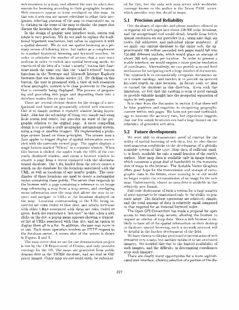
igational tool based on geospatially related web resources.One is to simply present a separate window listing hyper-links. This has the advantage of being very simple and usinglittle screen real estate, but provides no sense of the geo-graphic relation to the original page. A more compellingdesign is to provide a truly geographic navigational system,using a map or satellite imagery. We implemented a proto-type system based on these principles. The system uses aJava applet to trigger display of spatial information associ-ated with the currently viewed page. The applet displays asingle button marked \Where" in a separate window. Whenthis button is clicked, the applet reads the URL of the cur-rently displayed window, and opens a browser window torequest a page from a server equipped with the aforemen-tioned database. The URL loaded from the server causes asearch on the database for the locations associated with theURL, as well as locations of any nearby points. The coor-dinates of these locations are used to create a rectangularregion containing these points. The server then responds tothe browser with a page containing a reference to an imagemap referencing a map from a map server, and overlayingmenu information over the map that allows the user to in-spect and navigate to URLs at the locations displayed onthe map. Locations corresponding to the URL being in-spected are color coded as blue dots, and nearby locationswith other URLs associated with them are color coded asgreen. Each dot represents a \hot spot" so that when a userclicks on the dot, a popup menu appears showing a truncat-ed list of URLs associated with that site, and an option todisplay them all in a list. In addition, the user may zoom inor out. Each zoom operation involves an HTTP request tothe database server. A screen shot of the system is shownin Figures 2 and 3.The map server that we use for our demonstration project
is run by the US Department of Census, and only providescoverage for the US. The maps are generated from publicdomain data in the TIGER database, and are sent as GIFraster images. Other map servers could easily be substitut-
ed for this, but the only web map server with worldwidecoverage known to the author is the Xerox PARC server,which provides very low detail in maps.
5.1 Precision and ReliabilityOur databases of zipcodes and phone numbers allowed us
to segment all web pages into about 150,000 point locations,and the navigational tool would clearly bene�t from betterspatial resolution on our geocodes (e.g., using nine digit zipcodes, full addresses, and individual phone numbers). Ifwe apply our current database to the entire web, the ap-proximately 100 million geocoded web pages would fall into150,000 di�erent buckets, which would place an average ofabout 700 web pages per location. In order to present ausable interface, we would require a more precise resolutionof coordinates. Alternatively, we can provide a second levelmechanism for navigating such a large number of documents.One approach is to automatically categorize documents in-to a coarse ontology, and another is to provide an invertedkeyword search on that location. In future work we planto extend the database in this direction. Even with thislimitation, we feel that the existing system is good enoughto provide valuable insight into the geospatial separation oftopics in web pages.It is clear from the discussion in section 3 that there will
be false positives and negatives in recognizing geographiccontext within web pages. We have not pursued methodol-ogy to measure the accuracy rate, but experience suggeststhat our few simple heuristics can had a huge impact on thereliability of geocoded web data.
5.2 Future developmentsWe were able to demonstrate proof of concept for the
utility of spatial browsing of web data, but we also discov-ered numerous roadblocks to the development of a globallyavailable system of this type. Map data of suÆcient quali-ty is freely available for only a small fraction of the earth'ssurface. Most map data is available only in image format,which consumes a great deal of bandwidth in the transmis-sion of maps to the browser. The Scalable Vector Graphicso�ers great hope for the transmission and storage of carto-graphic data in the future, since zooming in or out wouldno longer require the retransmission of an image for the newmap. Unfortunately, almost no map data is available in thisrelatively new format.Full scale deployment of such a system for a large number
of users appears to be constrained only by the ability to gen-erate maps. The database operations are relatively simple,and the total amount of data is relatively small comparedto that required for an inverted keyword index.The Open GIS Consortium has made a proposal for open
access to web-based map servers, allowing the browser torequest an overlay of map data. Since a web browser is un-likely to have all of the spatial information on their desktopto facilitate spatial browsing, such a network protocol willbe helpful in the further development of the �eld.We have chosen to display positional representation of web
resources over a map, but another option is to use rasterizedimagery. We avoided this due to the limited availability ofsuch imagery, and the diÆculty in determining coordinatesatop such imagery.There are clearly many opportunites for a more sophisti-
cated user interface, allowing selection of a portion of the dis-
227
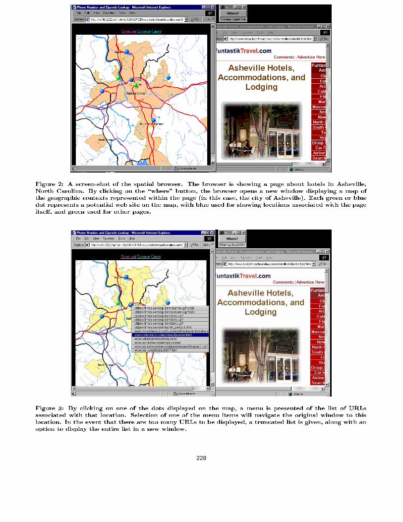
Figure 2: A screen-shot of the spatial browser. The browser is showing a page about hotels in Asheville,North Carolina. By clicking on the \where" button, the browser opens a new window displaying a map ofthe geographic contexts represented within the page (in this case, the city of Asheville). Each green or bluedot represents a potential web site on the map, with blue used for showing locations associated with the pageitself, and green used for other pages.
Figure 3: By clicking on one of the dots displayed on the map, a menu is presented of the list of URLsassociated with that location. Selection of one of the menu items will navigate the original window to thislocation. In the event that there are too many URLs to be displayed, a truncated list is given, along with anoption to display the entire list in a new window.
228
played map, control over the resolution, the use of imagery,overlays with other spatially correlated data, and better in-tegration into one of the existing browsers (eliminating theneed for the free- oating button).
6. CONCLUSIONSWe have demonstrated that discovery and exploitation
of geographic information in web pages is quite feasible,and exploitation of such information provides a useful newparadigm for the navigation and retrieval of web informa-tion. In spite of the many limitations for our prototype sys-tem, we have found it to be a useful adjunct to the existingmethods of navigation and indexing, and we expect that thefuture development of roaming web users connected throughwireless wide area networks will increase the demand for s-patial information about the web.
AcknowledgementThe author would like to thank Linda Hill of the Universityof California Santa Barbara for helpful discussions on geo-graphic name databases, and Sridhar Rajagopalan for helpwith ex.
7. REFERENCES[1] A. V. Aho and M. Corasick, \EÆcient String
Matching: An Aid to Bibliographic Search,"Communications of the ACM, 18, No. 6 (June 1975),333-340.
[2] Orkut Buyukokkten, Junghoo Cho, HectorGarcia-Molina, Luis Gravano, Narayanan Shivakumar,\Exploiting geographical location information of webpages." In Proceedings of Workshop on WebDatabases (WebDB'99) held in conjunction with ACMSIGMOD'99, June 1999.
[3] CCITT/ITU-T Recommendation E.123: TelephoneNetwork and ISDN Operation, Numbering, Routingand Mobile Service: Notation for National andInternational Telephone Numbers. 1993.
[4] CCITT/ITU-T Recommendation E.164/I.331 (05/97):The International Public TelecommunicationNumbering Plan. 1997.
[5] Soumen Chakrabarti, David A. Gibson, and Kevin S.McCurley, \Sur�ng the Web Backwards", Proceedingsof the 8th International World Wide Web Conference,Elsevier, (1999) pp. 601-615.
[6] Andrew Daviel, \Geographic registration of HTMLdocuments", Internet Draftdraft-daviel-html-geo-tag-04.txt, work in progress(December 2000, Expires July 2001). Available onlineat http://geotags.com/geo/draft-daviel-html-geo-tag-pre04.html.
[7] C. Davis, P. Vixie, T. Goodwin, I. Dickinson, AMeans for Expressing Location Information in theDomain Name System, RFC 1876, The InternetSociety, January, 1996. Available online athttp://www.ietf.org/rfc/rfc1876.txt.
[8] P. Dykstra, NPA/NXX database. Available online athttp://sd.wareonearth.com/�phil/npanxx/.
[9] C. Farrell, M. Schulze, S. Pleitner, and D. Baldoni,\DNS Encoding of Geographical Location", RFC1712, The Internet Society, November, 1994. Availableonline at http://www.ietf.org/rfc/rfc1712.txt
[10] Getty Thesaurus of Geographic Names, Available athttp://shiva.pub.getty.edu/tgn browser
[11] T. Imielinski and J. Navas, \GPS-Based Addressingand Routing", The Internet Society, November 1996.Available online
[12] Internet Domain Survey, Internet SoftwareConsortium. Available online athttp://www.isc.org/ds/.
[13] The IP2LL Perl package. Available online athttp://www-pablo.cs.uiuc.edu/Project/VR/ip2ll/faq.htm.
[14] B. Kahle and B. Gilliat. Alexa - navigate the Websmarter, faster, easier. Technical report, AlexaInternet, Presidio of San Francisco, CA., 1998. Seealso http://www.alexa.com/
[15] Ray R. Larson, \Geographic Information Retrievaland Spatial Browsing" In: GIS and Libraries:Patrons, Maps and Spatial Information, Linda Smithand Myke Gluck, Eds., University of Illinois, (1996),81-124. Available online athttp://sherlock.berkeley.edu/geo ir/PART1.html
[16] National Imagery and Mapping Agency GeoNetnames server, available online athttp://164.214.2.59/gns/html/.
[17] Ram Periakaruppan and Evi Nemeth, \GTrace - AGraphical Traceroute Tool," 13th SystemsAdministration Conference - LISA '99, November7-12, 1999, Seattle, Washington, USA.
[18] The Telecom archives. Available online athttp://hyperarchive.lcs.mit.edu/telecom-archives/archives/areacodes/.
[19] SRI Proposal for a .geo top level domain. Availableonline at http://www.dotgeo.org
[20] TraÆc Routing Administration, Available online athttp://www.trainfo.com/tra/catalog.htm.
[21] A. Vaha-Sipila, \URLs for Telephone Calls", RFC2806, The Internet Society, April 2000. Availableonline at http://www.ietf.org/rfc/rfc2806.txt.
[22] S. Weibel, J. Kunze, C. Lagoze, M. Wolf, \DublinCore Metadata for Resource Discovery". RFC 2413,The Internet Society, September 1998. Availableonline at http://www.ietf.org/rfc/rfc2413.txt.
229