Embed Size (px)
Citation preview

JOURNAL OF RESEARCH IN FORESTRY, WILDLIFE AND ENVIRONMENT, VOLUME 12, NO. 2 JUNE, 2020
Balogun and Iyekekpolor, 2020
GEOSPATIAL ASSESSMENT OF DEFORESTATION OF SOKPONBA AND EHOR FOREST
RESERVES IN EDO STATE, NIGERIA
*Balogun T. F. and Iyekekpolor, A. C.
Department of Geography and Regional Planning; University of Benin, Benin City, Edo State, Nigeria
* Corresponding Author email: [email protected]; +2348057378533
ABSTRACT
The study assessed the state of Sokponba and Ehor Forest Reserves in Edo State, with Landsat images of
1987, 2002 and 2018 using ENVI and ArcGIS software. One hundred copies of Questionnaire were also
administered to elicit information from respondents. The study revealed that within the period of 31 years
under study, Sokponba Forest Reserve has reduced from 28,913.63 hectares in 1987 to 1,578.15 hectares in
2018 while plantation and farmland increased from 15,357.96 ha in 1987 to 43,494.21 in 2018. Ehor Reserve
also reduced from 11,128.86 hectares in 1987 to 3,242.28 in 2018. In the same vein, plantation and farmland
increased from 1,424.97 hectares in 1987 to 9,323.28 hectares in 2018. The deliberate government policies of
allocating compartment to timber contractors for logging and granting permit to farm in the Forest Reserves
were identified as the major drivers responsible for the depletion of the Sokponba and Ehor Forest Reserves.
Considering the consequential effects arising from deforestation the study recommends reforestation and
taungya farming system for sustainable environment.
Keywords: Forest reserve; Depletion; Remote sensing; land use changes, communities, farming
INTRODUCTION
Forest Reserves are areas of forest designated by the
government for the protection of trees growing or
planted in order to preserve a particular type of
habitat and its flora and fauna which are often
considered rare or endangered (Usman and Adefalu,
2010; Farlex, 2014). Forest Reserves are thus areas
of forests which are reserved and managed for
conservation and to provide special opportunities
for study or research. According to Oyebo (2006),
Nigeria has a total of 1,160 constituted Forest
Reserves, covering a total land area of 10 752,702
hectares, representing about 10% of the total land
area. Forests, according to Food and Agriculture
Organization (2010), provide support for one billion
people that live in extreme poverty around the
world and provide remunerative employment to
more than one hundred million. They contain more
than 80% of terrestrial biodiversity and provide
essential environmental services such as soil
conservation, watershed management, protection
against floods and landslides, sources of industrial
woods (Aweto, 1990; Ojonigu et al., 2009),
effective sink for carbon dioxide and release of
oxygen (Oduntan et al, (2012).
Despite these benefits, forests are currently under
severe human interference which is distorting its
natural state and impacting negatively on the
biodiversity composition and the environment. The
continued indiscriminate cutting down of trees
without replacement for constructions, fuel wood,
agricultural purpose, grazing and hunting, has led to
the degradation of the forest ecosystem, extinction
of valuable trees, wildlife and loss of biodiversity.
Cullen et al, (2011) are of the view that at least 18
percent of global greenhouse gas (GHG) emissions,
a major cause of climate change worldwide is
attributable to deforestation.
Dewan et al (2012) observed that since the launch
of the first earth resource technology satellite
(Landsat) in 1972, remote sensing has established
its contribution in the monitoring of forest
This work is licensed under a Creative Commons Attribution 4.0 License
Journal of Research in Forestry, Wildlife & Environment Vol. 12(2) June, 2020
E-m a il: jr fw e2 0 1 9 @gm a il .com ; jfew r@y a h oo.com http://www.ajol.info/index.php/jrfwe
jfewr ©2020 - jfewr Publications ISBN: 2141 – 1778
Balogun and Iyekekpolor, 2020
286

JOURNAL OF RESEARCH IN FORESTRY, WILDLIFE AND ENVIRONMENT, VOLUME 12, NO. 2 JUNE, 2020
GEOSPATIAL ASSESSMENT OF DEFORESTATION OF SOKPONBA AND EHOR FOREST RESERVES IN EDO STATE, NIGERIA
resources. According to Foody, (2003) and Kumar
et al., (2010), the combination of the three Landsat
sensors, MSS, TM and ETM+ have provided the
longest time series of images suitable for
monitoring changes in the earth’s vegetation. Thus,
Landsat data have been relied on to perform
detailed assessments of changes in tropical forests
worldwide. This can be seen in the works of Naemi
and Tuomaala (2011) on forest degradation in
Marakwet district, Kenya; Yohanna et al (2012) on
monitoring of deforestation of south – west Nigeria;
Okeke (2013) on Land Cover Change Analysis in
the Afi-Mbe-Okwangwo Landscape Cross River
State where he used multi-temporal remotely sensed
images Landsat 5 TM, and 7 ETM+, from 1986 –
2010; Reddy et al, (2013) the quantification of
forest cover changes and fragmentation; Ati et al
(2010) assessment of change in Kagoro forest, in
Kaduna State, Nigeria. While Akingbogun et al
(2012) in their study, utilized 1972, 1984 and 2000
TM satellite remote sensing data to examine Eleyele
Forest Reserve Plantation Degradation in North
West Local Government of Ibadan in Oyo State of
Nigeria, Njungbwen and Mbakwe (2013) analyzed
deforestation of Uyo between 1969 – 2004, using
Aerial photographs and Quick bird satellite
imagery.
In like manner Mmon and Mbee (2014) in their
study of Gele Gele forest reserve in Edo State
observed that there is a steady growth of the
population of the communities around the reserve
which led to rapid decline and depletion of the rich
biodiversity and biological resources in the reserve
due to overdependence on the forest resources. On
the other hand Aliyu et al (2014) in their assessment
of the rate and the causes of environmental changes
(land use / cover) in Fufore area of Adamawa State,
through the application of Remote Sensing and GIS
techniques utilized Landsat MSS 1972, TM 1987,
ETM 1999 and 2007 Nigeria sat – 1 satellite
images. While Saranya et al (2014) utilized
geospatial techniques to quantify changes in forest
cover and to map patterns of deforestation in
Andhra Pradesh, India during 1930–2011, Adedeji
et al (2015) in their study assessed and predicted
changes in land use / land cover at Gambari forest
reserve, Nigeria using Remote Sensing and GIS
techniques. The study determined the magnitude,
rate and dynamics of change in the spatial extent of
the forest reserve between 1984 and 2014 using
multi – temporal datasets (Landsat TM 1984 and
2000 and OLI/TIRS 2014).
All these works utilized geospatial techniques and
results indicated decrease in forest reserves due to
anthropogenic activities. None of the studies
involved human dimension in the method of
assessment of the state of the forest. Since man was
responsible for deforestation and also at the
receiving end, this study combines both Remote
Sensing technique and questionnaire survey method
in the research design.
FAO, (2010) observed that in Africa, Nigeria is
among the five countries with the largest annual net
loss of forest for 2000 - 2010, with 3.7 percent. The
situation has not changed. Between the periods of
2005 to 2010, about 410,100 hectares of forest was
lost per year. Batta et al., (2013) confirmed that
Nigeria has one of the largest rates of deforestation
in the world; the country has lost 55.7% of its
primary forest. Olakunle et al., (2011) opined that
the main drivers of deforestation in the country are
agriculture, logging and mining. Considering the
alarming rate of forest depletion in Nigeria and the
consequential effect of global warming and
flooding, it becomes paramount to monitor our
forest reserve in Nigeria. This paper therefore
assesses the state of Sokponba and Ehor Forest
Reserves using satellite data and questionnaire
survey to determine the drivers responsible for
forest depletion in Nigeria.
Sokponba and Ehor Forest Reserves are tropical
rainforest, rich in economic valuable trees such as
Opepe, Afara, Mahogany, Albizia, Alstonia, Okwen
and several others which are made up of three
layers with a close canopy. These Forest Reserves
serve as source of income generation to the
government, communities and individuals, through
lumbering, logging and farming activities taking
place in the forest. The socio – economic activities
of the communities in the study areas is mainly
subsistence farming. Crops such as cassava, yams,
plantain are cultivated.
MATERIALS AND METHODS
Study Area
Sokponba Forest Reserve located in Orhionmwon
Local Government Area (LGA) (Figure 1) and Ehor
287

JOURNAL OF RESEARCH IN FORESTRY, WILDLIFE AND ENVIRONMENT, VOLUME 12, NO. 2 JUNE, 2020
Balogun and Iyekekpolor, 2020
Forest Reserve in Uhunmwonde LGA (Figure 2)
were selected out of 23 Forest Reserves in Edo
State for detailed study (Figure 3). Sokponba Forest
Reserve was constituted in 1912 while Ehor Forest
Reserve was constituted in 1950. Sokponba Reserve
covers an area of 49,210 hectares while Ehor covers
a total area of 29,566 hectares. The total area
coverage of the Forest Reserves under study is put
at 78,776 hectares. The Sokponba Forest Reserve is
located between latitude 6°12´10.49˝N and
5°58´15.29˝N and between longitude 5°49´46.42˝E
and 5°52´11.63˝E. while the Ehor BC16/1 Forest
Reserve spans between latitude 6°23´33.89˝N and
6°26´10.38˝N and longitude 5°57´55.42˝E and
6°6´6.59˝E. Sokponba Forest Reserve has 176
compartments, and Ehor 114 compartments. There
are several villages in and around the forest reserves
areas.
Figure 1:Ehor Forest Reserve
Figure 2: Sokponba Forest Reserve
Figure : Forest Reserves in Edo State
Source: Edo State Ministry of Environment, 2018
Experimental Design
Multi – temporal Landsat images of 1987, 2002 and
2018 of the study areas, with a resolution of 30 and
28.5 metres were used. What informs the choice of
these images was the need for earliest and latest
available images as at the time of the study that
were cloud free and also the need to have an
intermediate image with which to compare changes.
Repeated visits to the study area were carried so as
to have adequate knowledge of the prevalent and
dominant land cover and land use types. This
enabled accurate land use and land cover
classification. Snowball sampling technique was
employed in the administration of questionnaire to
the target population in and around the reserves.
This method involved asking an initial contact
within a population to identify other potential
288
JOURNAL OF RESEARCH IN FORESTRY, WILDLIFE AND ENVIRONMENT, VOLUME 12, NO. 2 JUNE, 2020
GEOSPATIAL ASSESSMENT OF DEFORESTATION OF SOKPONBA AND EHOR FOREST RESERVES IN EDO STATE, NIGERIA
participants until the required number of sample
size is reached. Basically, the population for this
study consisted of farmers, timber contractors and
forest guards. Since we do not know the potential
respondents we needed an initial contact person
within the population to identify other potential
participants hence snowball sampling method was
used. Six communities were purposefully selected
from each reserve because of their proximity to the
reserves. The communities chosen are Iguemokhua,
Oben, Ugo, Iguere, and Evuarhue and Sokponba for
Sokponba Forest Reserve and for Ehor Forest
Reserve, Ugiehudu, Eguaholor, Ohe, Uhi, Egbisi
and Uhie communities were selected. A total of 100
copies of questionnaire were administered for this
purpose across the selected communities to elicit
information from the respondents about their
activities within the forest.
Images Processing and Analysis
The study employed the use of Landsat 4, 1987 TM;
Landsat 7, 2002 ETM+ and Landsat 8, 2018 OLI /
TIRS images. The three images corresponded with
path 189, row 055 and 056 of the WRS-2. The
images were cloud-free and had good radiometric
quality as reported by the data provider. The entire
images were already georeferenced and with a
projected coordinate system of
WGS_84_UTM_Zone_32N.
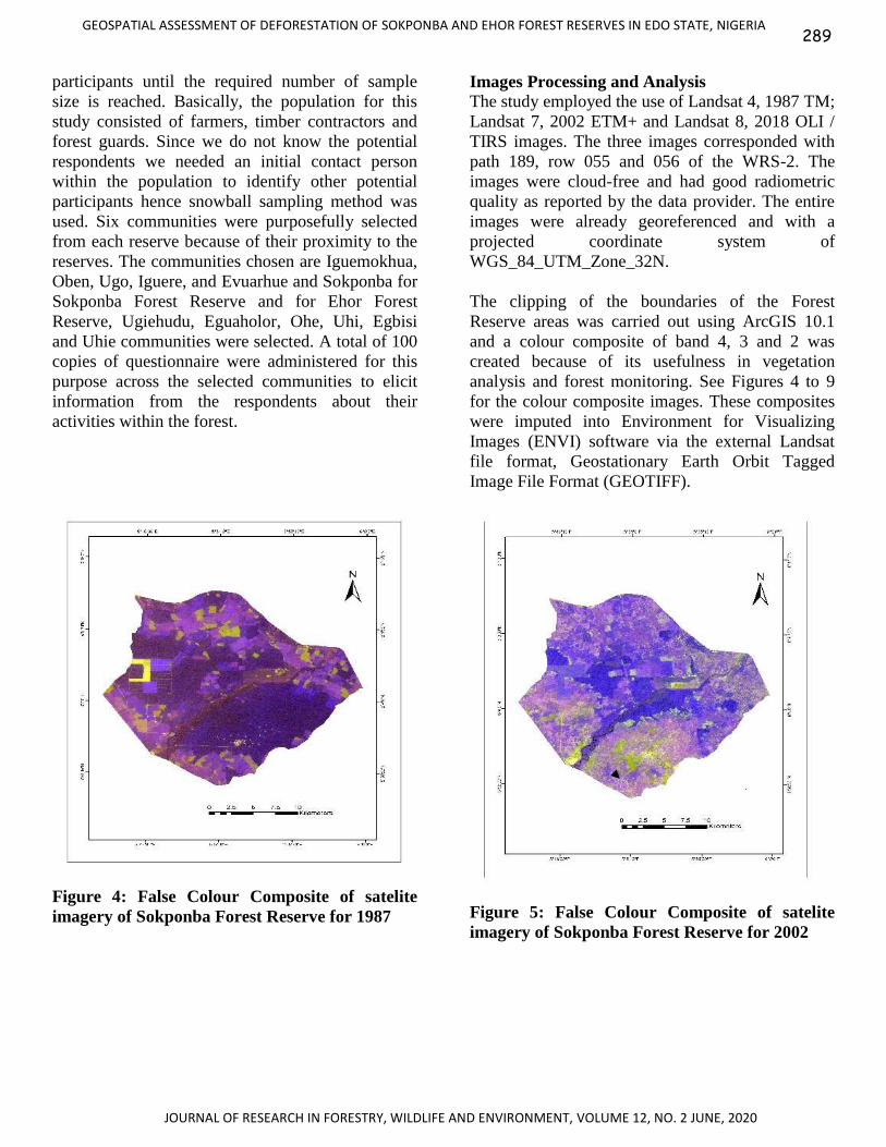
The clipping of the boundaries of the Forest
Reserve areas was carried out using ArcGIS 10.1
and a colour composite of band 4, 3 and 2 was
created because of its usefulness in vegetation
analysis and forest monitoring. See Figures 4 to 9
for the colour composite images. These composites
were imputed into Environment for Visualizing
Images (ENVI) software via the external Landsat
file format, Geostationary Earth Orbit Tagged
Image File Format (GEOTIFF).
Figure 4: False Colour Composite of satelite
imagery of Sokponba Forest Reserve for 1987
Figure 5: False Colour Composite of satelite
imagery of Sokponba Forest Reserve for 2002
289

JOURNAL OF RESEARCH IN FORESTRY, WILDLIFE AND ENVIRONMENT, VOLUME 12, NO. 2 JUNE, 2020
Balogun and Iyekekpolor, 2020
Figure 6: False Colour Composite of satelite
imagery of Sokponba Forest Reserve for 2018
Figure 7: False Colour Composite satellite
imagery of Ehor Forest Reserve for 1987.
Figure 8: False Colour Composite satellite
imagery of Ehor Forest Reserve for 2002.
Figure 9: False Colour Composite satellite
imagery of Ehor Forest Reserve for 2018.
Supervised classification method was employed by
assigning pixel to classes. The knowledge obtained
during reconnaissance visits to the study areas was
used in the creation of Training Sites. Maximum
likelihood classifier algorithm was used in
transforming the spectral signature of the training
sites into various land use and land cover types
present in the study area (Table 1). Several other
post classification algorithms such as majority
analysis clump and sieve classes were used to refine
the classification.
Table 1: Description of major land use land cover classification scheme
Classes Description
Matured Forest Forest with merchantable trees.
Light Forest Secondary forest, shrubs and / or herbaceous vegetation association
Agricultural land Arable land, permanent crops, pastures and heterogeneous agricultural areas
Water Rivers and streams.
Settlements These are villages within or around the reserves
290

JOURNAL OF RESEARCH IN FORESTRY, WILDLIFE AND ENVIRONMENT, VOLUME 12, NO. 2 JUNE, 2020
GEOSPATIAL ASSESSMENT OF DEFORESTATION OF SOKPONBA AND EHOR FOREST RESERVES IN EDO STATE, NIGERIA
Change Detection Analysis
Change detection statistic was used to compile a
detailed tabulation of changes between two
classification periods; 1987 – 2002, 2002 – 2018
and 1987 – 2018. While the statistics report
included a class – for – class image difference, the
analysis focused primarily on the changes which
have occurred in the initial state classification. The
analysis identified the classes into which pixels
changed in the final state. Several methods (such as
class statistics, overlay, and conversion of
classification to vector) were adopted to identify,
describe and quantify differences between images
of the same scene at different times. This was useful
in identifying the various classes which change
from one class to another. The change statistic
report table was divided into two, the initial state
classes in the column and the final state classes in
the row.
RESULTS
In Table 2, the genders composition of the
respondents to the questionnaire administered to the
residents of communities in and around Ehor and
Sokponba forest reserves shows that 57 % were
males, while females were 43 %. Among the
respondents, 24. 0% do not have formal education,
39.0 % had education up to the primary school level
while 21.0 % of them attended secondary school,
16. 0 % of the respondents have tertiary education.
It could be said that majority of the population is
literate and could understand the questions
administered to them. Majority (87.0 %) of the
respondents are farmers while timber contractor
accounts for 13.0 %. This shows that farming and
logging are the major activities going on in the
various forest reserves.
Table 2: Social Economic Variables of Respondents
Demographic characteristics Frequency Percentage (%)
Gender Male 57 57.0
Female 43 43.0
Education
No formal education 24 24.0
Primary education 39 39.0
Secondary education 21 21.0
Tertiary education 16 16.0
Occupation
Farming 87 87.0
Timber contractor 13 13.0
Farm Location
Forest Reserve 75 75.0
Free area 12 12.0
No response
Source of Farmland Government 41 41.0
Individual 9 9.0
Community 28 28.0
Nobody 2 2.0
No response 20 20.0
Estimated cost per hectares
>100,000 69 69.0
1000,000-200,000 1 1.0
No response 30 30.0
291

JOURNAL OF RESEARCH IN FORESTRY, WILDLIFE AND ENVIRONMENT, VOLUME 12, NO. 2 JUNE, 2020
Balogun and Iyekekpolor, 2020
Demographic characteristics Frequency Percentage (%)
Duration of farming operation
1-5yrs 28 28.0
6-10yrs 12 12.0
11-20yrs 5 5.0
20yrsabove 51 51.0
No response 4 4.0
Location of Logging
Allotted comp in reserve 6 6.0
In reserve but not allotted 3 3.0
Free Areas 2 2.0
Both reserve and free areas 2 2.0
No response
Cost of Compartment
87 87.0
200,001- 400,000 1 1.0
400,001 - 600,000 5 5.0
Above 600,000 3 3.0
No Response 91 91.0
Duration of Logging
1- 5yrs 3 3.0
6-10yrs 6 6.0
No Response 91 91.0
Causes of change in the reserves
Logging 40 40.0
Farming 29 29.0
Settlement Expansion 8 8.0
Bush fire 14 14.0
About 28.0% of the respondents have stayed for 1 -
5 years, those who have stayed for 6 – 10 years
were 12.0 %, also 5.0% of them have stayed for 11 -
20 years and 51.0 %, have stayed for 20 years and
above. More than half of the respondents have
stayed long enough to give informed response to the
questionnaire. About 75. 0 % of the farmers carry
out their farming operations in the reserve, 12. 0%
farm in free areas while 13. % of the respondent did
not indicate the location of their farm lands. Among
the farmers, 41.0 % indicated that they got their
farm land from the government, 28. 0% from the
communities, while 9.0 % of the respondents got
theirs from individuals and 2. 0 % of the people
decided to farm in the reserves without permission
from anybody. About, 20. 0% of the farmers did not
return answer to the question on source of their
farmland.
Farmers who make use of the reserve pay certain
amount of money for the use of the land annually.
About 69.0 % of the respondents affirm that they
pay below N100, 000 per hectare of land while 1.0
% says that they pay above N100, 000 per hectare
of land. About 30.0% of the respondent decline
answers to this question. Findings further reveals
that about 31. 0 % of the respondents have been
farming there for about 1-5 years, 33. 0 % for about
6 -10 years while 4.0 % and 6. 0 %, have spent 11 -
20 years and above 20 years respectively. This long
numbers of years that farming has been taken place
in the reserves account partly for the current state of
the reserves.
Result of the analysis of the questionnaire shows
that 3. 0 % of the timber contractors have been
operating in the reserves for about 1 – 5 years,
while 6. 0 % has worked there for 6 -10 years.
Information from timber contractors shows that 6. 0
% of loggers carry out their logging activities in the
state government allotted compartment while about
3.0 % illegally exploit the forest resources, 2.0 % of
the contractor operates in free areas and 2.0%
292

JOURNAL OF RESEARCH IN FORESTRY, WILDLIFE AND ENVIRONMENT, VOLUME 12, NO. 2 JUNE, 2020
GEOSPATIAL ASSESSMENT OF DEFORESTATION OF SOKPONBA AND EHOR FOREST RESERVES IN EDO STATE, NIGERIA
operates both in the reserves as well as free areas.
Majority (87%) of loggers decline response to the
question. Finding shows that timber contractors
who are allotted compartments in the reserves pay
various amount of money to the government. About
1.0 % of the contractor agreed that they pay
between N200,000 – 400,000 per compartment, 5.0
% pay between N400,001 – 600 -000 and 3.0 %,
pay above N600, 000. Though 91% of loggers did
not return answer to this question their response
may not be too far from others. Respondents are
aware that their activities are responsible for the
changes in the forest reserves as 40% agreed that
logging was responsible while 29% concur that
farming was responsible. Accuracy assessments of
the classified images were carried out and results
(Table 3) showed high level of accuracy (above
84%).
Table 3: Confusion Matrix and Kappa Coefficient table of classified images
Forest Reserves/Year Overall Accuracy Kappa Coefficient
Sokponba 1987 (762/839) 90.8224% 0.8720
Sokponba 2002 (683/753) 90.7039% 0.8705
Sokponba 2018 (178/211) 84.3602% 0.7642
Ehor BC16/1, 1987 (395/423) 93.3806% 0.9003
Ehor BC16/1, 2002 (477/530) 90.0000% 0.8499
Ehor BC16/1, 2018 (459/510) 90.0000% 0.8503
Overlay operation was carried out by superimposing
the shapefile of the various classes of land use /
Land cover of 1987, 2002 and 2018 of a particular
reserve on each other. The essence of this is to
enhance effective visualization and to determine the
extent to which the Sokponba and Ehor Forest
Reserves have changed within the period under
review. From the result obtained, it is obvious that
the two Forest Reserves were severely depleted of
its resources, as shown in Figures 10, 11 and 12 for
Sokponba Forest Reserve and Figures 13, 14 and 15
for Ehor Forest Reserve.
Figure 10: Classified satellite imagery of
Sokponba Forest Reserve for 1987.
Figure 11: Classified satellite imagery of
Sokponba Forest Reserve for 2002.
293

JOURNAL OF RESEARCH IN FORESTRY, WILDLIFE AND ENVIRONMENT, VOLUME 12, NO. 2 JUNE, 2020
Balogun and Iyekekpolor, 2020
Figure 12: Classified satellite imagery of
Sokponba Forest Reserve for 2018
Figure 13: Classified satellite imagery of Ehor
Forest Reserve for 1978
Figure 14: Classified satellite imagery of Ehor
Forest Reserve for 2002
Figure 15: Classified satellite imagery of Ehor
Forest Reserve for 2018
Land Use Changes in Sokponba Forest Reserve
1987 - 2018
The Sokponba Forest Reserve within the 31 years
period witnessed a drastic decreased and reduction
of the forest resources as only a tiny portion 4.3%
of the entire forest was left (Figure 16). Sokponba
Forest Reserve was divided into 175 compartments
made up of different merchantable species of trees
(Ihenyen et al., 2006). These compartments were
allocated to timber contractors for exploitation by
the state government for a fee, which was one of the
major reasons for the forest depletion (Table 2).
Also, illegal lumbering, contributed to deforestation
of the forest reserve, likewise farming activities
carried out by the people within and outside the
forest reserve area.
Figure 16: Overlay of classified imagery of
Sokponba Forest Reserve for 1987 and 2018.
294

JOURNAL OF RESEARCH IN FORESTRY, WILDLIFE AND ENVIRONMENT, VOLUME 12, NO. 2 JUNE, 2020
GEOSPATIAL ASSESSMENT OF DEFORESTATION OF SOKPONBA AND EHOR FOREST RESERVES IN EDO STATE, NIGERIA
Data from Table 4 indicates that within thirty-one
years, Sokponba Forest Reserve, which was
28,913.63 ha (57.9%) in 1987, decreased to
8,641.33 ha (17.3%) in 2002. It further decreased
drastically to 1,578.15 ha (3.2%) in 2018. While
buildings and bare surface and waterbody
decreased, plantation and farmland continued to
witness tremendous expansion, from 15,357.96 ha
(30.8%) in 1987 to 36402.66ha (72.9%) in 2002 and
further increased in size to 43,494.21 ha (87.0%) in
2018.
Table 4: Land use Changes in Sokponba Forest Reserve from 1987 – 2018
Land use 1987 Percentage
(%)
2002 Percentage
(%)
2018 Percentage
(%)
Matured forest 28,913.63 57.9% 8,641.33 17.3% 1,578.15 3.2%
Plantation and farmland 15,357.96 30.8% 36,402.66 72.9% 43,494.21 87.0%
Buildings and bare
surface
5,469.48 11.0% 4,747.50 9.5% 4,735.71 9.5%
Waterbody 195.84 0.39% 168.66 0.34% 162.54 0.33%
Total 49936.91 100% 49960.15 100% 49970.61 100%
Land Use Changes in Ehor Forest Reserve
Figure 17 indicates that Ehor Forest Reserve
between 1987 and 2018, a period of 31 years,
witnessed a lot of changes in the composition,
content and structure of the forest. The loss of the
forest can be attributed to the renting of the reserve
for farming activities and giving of permit to timber
contractors for exploitation by the State government
for a fee (Table 2).
Figure 17: Overlay of classified imagery of Ehor
Forest Reserve for 1987 and 2018.
The Table 5 illustrates the land use changes that
occurred in Ehor Forest Reserve area from 1987 –
2018. The matured forest as at 1987 was 11,128.86
ha. It reduced in size in 2002 to 10,590.39 ha which
may be considered very minimal. The Forest
Reserve between 2002 to 2018 witnessed a high rate
of depletion of its resource as a total of 7,348.11 ha
of forest land was converted. The reserve reduced to
3242.28 ha in 2018. Plantation and farm land
witness increased expansion from 1,424.97 ha
(11.4%) in 1987 to 1,970.64 (15.7%) ha in 2002,
and to 9,323.28 ha (74.2 %) in 2018.
Table 5: Land use Changes in Ehor Forest Reserve from 1987 – 2018
Land use 1987 Percentage
(%)
2002 Percentage
(%)
2018 Percentage
(%)
Matured Forest 11,128.86 88.6% 10,590.39 84.3% 3,242.28 25.8%
Plantation and farmland 1,424.97 11.4% 1,970.64 15.7% 9,323.28 74.2%
Total 12553.83 12561.03 100 12565.56 100
295
JOURNAL OF RESEARCH IN FORESTRY, WILDLIFE AND ENVIRONMENT, VOLUME 12, NO. 2 JUNE, 2020
Balogun and Iyekekpolor, 2020
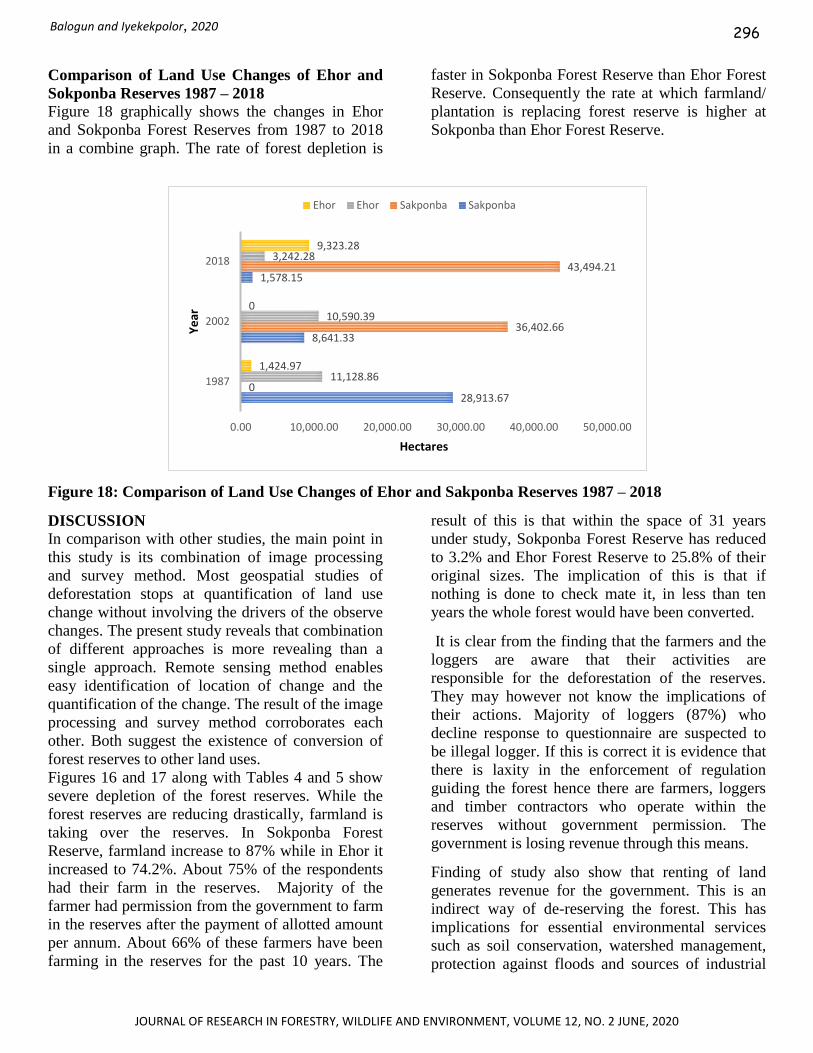
Comparison of Land Use Changes of Ehor and
Sokponba Reserves 1987 – 2018
Figure 18 graphically shows the changes in Ehor
and Sokponba Forest Reserves from 1987 to 2018
in a combine graph. The rate of forest depletion is
faster in Sokponba Forest Reserve than Ehor Forest
Reserve. Consequently the rate at which farmland/
plantation is replacing forest reserve is higher at
Sokponba than Ehor Forest Reserve.
Figure 18: Comparison of Land Use Changes of Ehor and Sakponba Reserves 1987 – 2018
DISCUSSION
In comparison with other studies, the main point in
this study is its combination of image processing
and survey method. Most geospatial studies of
deforestation stops at quantification of land use
change without involving the drivers of the observe
changes. The present study reveals that combination
of different approaches is more revealing than a
single approach. Remote sensing method enables
easy identification of location of change and the
quantification of the change. The result of the image
processing and survey method corroborates each
other. Both suggest the existence of conversion of
forest reserves to other land uses.
Figures 16 and 17 along with Tables 4 and 5 show
severe depletion of the forest reserves. While the
forest reserves are reducing drastically, farmland is
taking over the reserves. In Sokponba Forest
Reserve, farmland increase to 87% while in Ehor it
increased to 74.2%. About 75% of the respondents
had their farm in the reserves. Majority of the
farmer had permission from the government to farm
in the reserves after the payment of allotted amount
per annum. About 66% of these farmers have been
farming in the reserves for the past 10 years. The
result of this is that within the space of 31 years
under study, Sokponba Forest Reserve has reduced
to 3.2% and Ehor Forest Reserve to 25.8% of their
original sizes. The implication of this is that if
nothing is done to check mate it, in less than ten
years the whole forest would have been converted.
It is clear from the finding that the farmers and the
loggers are aware that their activities are
responsible for the deforestation of the reserves.
They may however not know the implications of
their actions. Majority of loggers (87%) who
decline response to questionnaire are suspected to
be illegal logger. If this is correct it is evidence that
there is laxity in the enforcement of regulation
guiding the forest hence there are farmers, loggers
and timber contractors who operate within the
reserves without government permission. The
government is losing revenue through this means.
Finding of study also show that renting of land
generates revenue for the government. This is an
indirect way of de-reserving the forest. This has
implications for essential environmental services
such as soil conservation, watershed management,
protection against floods and sources of industrial
28,913.67
8,641.33
1,578.15
0
36,402.66
43,494.21
11,128.86
10,590.39
3,242.28
1,424.97
0
9,323.28
0.00 10,000.00 20,000.00 30,000.00 40,000.00 50,000.00
1987
2002
2018
Hectares
Ye
ar
Ehor Ehor Sakponba Sakponba
296

JOURNAL OF RESEARCH IN FORESTRY, WILDLIFE AND ENVIRONMENT, VOLUME 12, NO. 2 JUNE, 2020
GEOSPATIAL ASSESSMENT OF DEFORESTATION OF SOKPONBA AND EHOR FOREST RESERVES IN EDO STATE, NIGERIA
woods which are provided by the reserves. It is also
known that forest acts as carbon sink. The depletion
of Sokponba and Ehor Forest Reserves will lead to
carbon trap and invariably contribute to global
warming.
CONCLUSION
In this study, the potential of geospatial data was
investigated for estimating the deforestation of
Sokponba and Ehor Forest reserves. It is observed
in the study that the reserves have been seriously
deforested which carry along with it negative
consequences. The importance of forest reserves in
revenue generation, conservation of medicinal plant
and wildlife, livelihood sustainability and
environmental moderation demands that its use be
regulated to avoid depletion. Hence, the need for
regular monitoring of the forest using the
combination of geospatial and survey methods.
REFERENCES
Adedeji, O. H., Tope – Ajayi, O. O. and Abegunde,
O. L. (2015). Assessing and Predicting
Changes in the Status of Gambari Forest
Reserve, Nigeria. Using Remote Sensing
and GIS Techniques. Journal of
Geographic Information System, 7: 301 –
318.
Aliyu, M. G and Abdullahi .L. T (2014) Assessment
of Environmental Changes in the Fufore
Area of Adamawa State, Nigeria. IOSR
Journal of Environmental Science,
Toxicology and Food Technology (IOSR -
JESTFT, 8(5): 01-06 Ati, O. F., Sheyin, T., Abbas, I., and Muhammad, S.
(2010), “Assessing Changes in Kagoro
Forest, Kaduna State Nigeria using Remote
Sensing and GIS”. Research Journal of
Applied Sciences, Engineering and
Technology, 2(2): 121-132.
Akingbogun, A.A., Kosoko, O.S.O.A. and
Aborisade, D.K. (2012) Remote Sensing and
GIS Application for Forest Reserve
Degradation Prediction and Monitoring.
First FIG Young Surveyors Conference
Knowing to Create the Future, Rome, 4-5 May 2012, 1-27
Aweto, A.O., (1990). Plantation forestry and forest
conservation in Nigeria. The
Environmentalist, 10:27-34.
Batta, H., Ashong, C. A. and Bashir, A. S (2013).
Press Coverage of Climate Change Issues in
Nigeria and Implications for Public
Participation Opportunities. Journal of
Sustainable Development, 6(2):56-69
Dewan, A. M., Yamaguchi, Y. and Rahman, M. Z.
(2012), Dynamics of land use/cover changes
and the analysis of landscape fragmentation
in Dhaka Metropolitan, Bangladesh.
GeoJournal, 77:315–330.
Farlex, A. (2014), Forest Reserve – Definition of
Forest Reserve
www.thefreedictionary.com/forest+reserve.
Accessed 10/06/2014
FAO. (2010). Global Forest Resources Assessment
2010: Main report‘, Food and Agriculture
Organization. FAO Forestry paper 163.
Foody, G.M. (2003) Remote Sensing of tropical
forest environments: towards the monitoring
of environmental resources for sustainable
development. International Journal of
Remote Sensing, 24(20):4035-4046
Ihenyen, J., Okoegwale, E. E. and Mensah J. K
(2006) Composition of tree Species in Ehor
Forest Reserve, Edo State, Nigeria. Nature
Science, 7(8): 8-18
Kumar, D., S. Borah and U. Shankar, (2010).
Temporal forest cover change monitoring in
chakrashila wildlife sanctuary, Assam, India
using Remote Sensing and GIS.
Communicated data.
Mmom, P. C. and Mbee, M. D. (2014), Population
Pressure and Forest Resource Depletion in
Gele Gele Forest Reserve of Edo State,
Nigeria International Journal of Physical
and Human Geography, 2(1): 10-21
Naemi, G. and Tuomaala, A. (2011). Detecting
Forest Degradation in Marakwet District,
Kenya, using Remote Sensing and GIS.
Geobiosphere Science Centre, Physical
Geography and Ecosystems Analysis, Lund
University Solvegatan 12, S – 22362 Lund
Sweden.
Njungbwen, E. and Mbakwe, R. (2O13) A GIS and
Remote Sensing Approach to Assessment of
Deforestation In Uyo, Akwa Ibom State
Nigeria. Ethiopian Journal of
297

JOURNAL OF RESEARCH IN FORESTRY, WILDLIFE AND ENVIRONMENT, VOLUME 12, NO. 2 JUNE, 2020
Balogun and Iyekekpolor, 2020
Environmental Studies and Management,
6(4):348-357
Oduntan, O. O., Soaga, J. A. O., Akinyemi, A. F.
and Ojo, S. O. (2013), “Human Activities,
Pressure and Its Threats on Forest Reserves
in Yewa Division of Ogun State”, Nigeria
E3 Journal of Environmental Research and
Management 4(5): 0260-0267.
Ojonigu F. A. Sheyin, T. Abbas, I and Mohammed,
S. O. (2009) Assessing Changes in Kagoro
Forest, Kaduna State Nigeria using Remote
Sensing and GIS. Research Journal of
Applied Sciences, Engineering and
Technology, 2(2): 121-132.
Okeke O. F (2013) Land Cover Change Analysis in
the Afi-Mbe-Okwangwo landscape Cross
River State, Nigeria. www.wcsnigeria.org.
Accessed on 20/06/2015.
Olakunle, O.F., Omotayo A. and Odewumi S. G
(2011). Pattern and Problems of
Deforestation in Southwestern Nigeria.
International Journal of Academic
Research, 3(3)641-655
Oyebo, M.A., (2006). History of Forest
Management in Nigeria from 19th Century
to Date. In: Salami, A.T. (Ed.), Imperatives
of Space Technology for Sustainable Forest
Management in Nigeria. Proceedings of an
International Stakeholders Workshop
Sponsored by National Space Research and
Development Agency, Abuja, pp: 1-14.
Reddy, C. S., Sreelekshmi, S., Jha, C. S. and
Dadhwal, V. K. (2013), National
Assessment of Forest Fragmentation in
India: landscape indices as measures of the
effects of fragmentation and forest cover
change. Ecological Engineering, 60: 453–
464.
Saranya, K. L, P. Hari Krishna, C. Sudhakar,
Reddy, C. S. Jha and V. K. Dadhwal (2014)
Assessment and monitoring of deforestation
from 1930 to 2011 in Andhra Pradesh, India
using remote Sensing and collateral data.
Current Science, 107(5)
Usman, B. A. and Adefolalu, L. L. (2010), “An
Appraisal of Nigerian National Policy on
Forestry, wildlife and Protected Areas”
Environmental Issues, 3(1):50
Yohanna P, Innocent, R. and Emmanuel, B. (2012)
The Application of Remote Sensing and
Geographic Information System (GIS) for
Monitoring Deforestation in South-West
Nigeria. Journal of Environmental Issues
and Agriculture in Developing Countries (4)1:6-11
298