Embed Size (px)
Citation preview

16/10/2017
1
Geospatial application in Kiribati
ICC-21ST RESAP(9TH TO 13TH OCTOBER, 2017)BANGKOK, THAILAND
Outline
Kiribati ProfileNatural disasters in KiribatiAchievements Challenges/IssuesWays forward

16/10/2017
2
Kiribati profile
Kiribati Profile
• Geographical Location: Center of the Pacific Ocean straddling across the equator
• 33 small island atolls • The islands are distributed into 3
groups: • Gilbert Group• Phoenix Group• Line group
• Population: 110,000 in 2010 National Census
• The total Land mass is only 811km2
16/10/2017
3
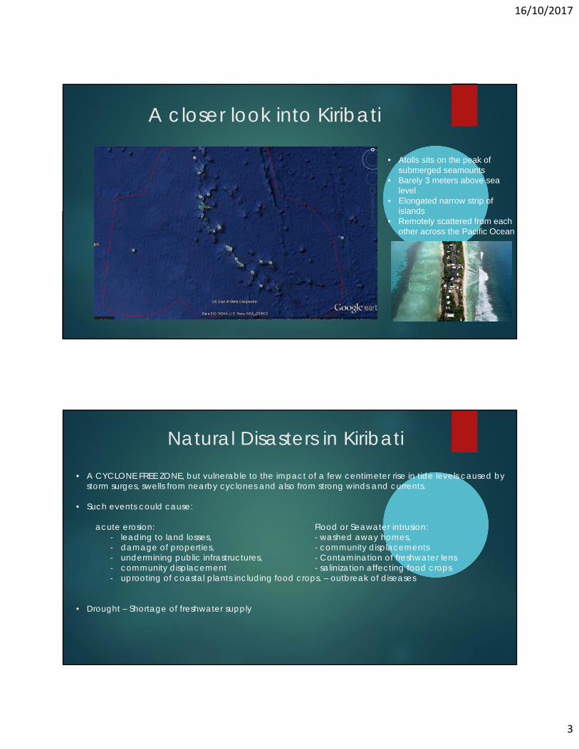
A closer look into Kiribati
• Atolls sits on the peak of submerged seamounts
• Barely 3 meters above sea level
• Elongated narrow strip of islands
• Remotely scattered from each other across the Pacific Ocean
Natural Disasters in Kiribati
• A CYCLONE FREE ZONE, but vulnerable to the impact of a few centimeter rise in tide levels caused by storm surges, swells from nearby cyclones and also from strong winds and currents.
• Such events could cause:
acute erosion: Flood or Seawater intrusion:- leading to land losses, - washed away homes,- damage of properties, - community displacements- undermining public infrastructures, - Contamination of freshwater lens- community displacement - salinization affecting food crops- uprooting of coastal plants including food crops. – outbreak of diseases
• Drought – Shortage of freshwater supply

16/10/2017
4
EROSION
Erosion mapsErosion maps were developed to inform decision making.
Procurement of satellite cost Kiribati about hundreds of thousands of dollars
Erosion maps were developed based on only two datasets that are currently available with Government the 1969 historical aerial photos and 2010 or 2011 Geoeye satellite image
Due to the expensive datasets, Kiribati is currently unable to continue such programme to give a more present picture of the shoreline

16/10/2017
5
FLOODING – 2.9 meter of sea level
Kiritimati island in the Line Group, was hit by an unusual tropical storm system named Pali that developed west of the atoll in early January. The concurrent spring tide, El Niño-induced above average sea level and storm-generated swell produced severe inundation, damaging coastal infrastructure and resulting in tragic loss of lives
FLOOD MODELING
• Flood modeling was impossible to be developed for low lying atolls of Kiribati
• Lack of digital elevation models for the islands • No high resolution satellite imageries that would be able to produce high
resolution digital elevation models that would be able to detect the impact of a few centimeter rise in tide level.
• For Kiribati, space technology and its applications are just unaffordable
• Cost Effective SOLUTION:
• SPC GSD and Kiribati conducted a trial exercise on Kiritimati island testing the capabilities of Unmanned Aerial Vehicle in developing digital elevation model, a model that would provide the basis of the extent of flood and its impacts.
• SPC GSD purchased an equipment to be used for 15 member countries• SPC GSD also serves member countries based on a country request• The equipment has been useful in post inundation assessments in the Pacific
as well

16/10/2017
6
UAV APPLICATION FOR FLOOD MODELLING
Risk impact tool
High Resolution Digital Surfaceand elevation mode
Flood modeling issues
outcome of the work does not provide a full coastal hazard assessment for the study area as it only looks at extreme water levels without considering wave action. Wave induced inundation is an important factor that would need to be thoroughly considered
Government of Kiribati is eager to work with SPC to raise funds in order to carry out the second phase of the project which could consist of:
- collecting bathymetry data- modelling the impact of wave and finalizing inundation
hazard maps- Finalizing PacSAFE- Training relevant stakeholder on the use of PacSafe

16/10/2017
7
Seismic activities in KiribatiFrom December 1981 to March 1983, an earthquake swarm commenced at a location 150 km southeast of Arorae island, the southeasternmost of the Gilbert Island. The swarm produced 217 earthquakesThe report stated that it is one of the most unusual intraplate events recorded
A 5.2 MAGNITUDE earthquake was detected again in the Kiribati region on the 13th of September 2017
A 4.6-magnitude earthquake was detected in the Line Group at 02:46:24 / 2:46 am (local time epicenter). Exact time and date of earthquake 01/08/16 / 2016-08-01 13:46:24 / August 1, 2016 @ 1:46 pm UTC/GMT. Exact location of event, longitude -169.447 West, latitude -4.4721 South, depth = 10 km.
On the 20th of April, 2016, Fiji detected seismic activity in Kiribati Waters with a magnitude of 5.2. Location: 0.63 S long: 168.13 E, Depth is 200km
Concerns about earthquakes and Tsunami impacts
Fortunately, the earthquakes were weak to produce tsunami
Lack of monitoring systems and currently depended on other Pacific Island Country’s equipments
Kiribati is now concerned about earthquakes and tsunami impacts because there is no higher grounds for evacuation on the island,
Lack of capacity in seismology and tsunamis risk assessments

16/10/2017
8
RESAP action plan 2018 - 2030 To provide mechanism for institutional strengthening on the application
of SPACE technology particularly to countries like Kiribati. To provide funding to support national and regional geospatial projects
to enhance the country’s preparedness, responses and resilience to disaster risks and climate change impacts
Data sharing mechanism and promote the use of open source softwares and databases
Recognize the special cases of small island states in Space technology Ensure all member states including the Pacific Countries have flood
simulations including early warning systems bridge the gaps of isolation and remoteness issues of islands in the
Pacific, Increase engagement and participation of member countries
including the Pacific island Countries - Leaving no one behind in 2030.