Embed Size (px)
Citation preview

GeoServer for Spatio-temporal
Data Handling
With Examples For MetOc
And Remote Sensing
Ing. Simone Giannecchini
Ing. Daniele Romagnoli Ing. Andrea Aime
GeoSolutions
GeoSolutions
Founded in Italy in late 2006
Expertise
• Image Processing, GeoSpatial Data Fusion
• Java, Java Enterprise, C++, Python
• JPEG2000, JPIP, Advanced 2D visualization
Supporting/Developing FOSS4G projects GeoServer, MapStore
GeoNetwork, GeoNode, Ckan
Clients
Public Agencies
Private Companies
http://www.geo-solutions.it
FOSS4G 2015, Seoul 14th-19th September 2015

Reference scenario
FOSS4G 2015, Seoul 14th-19th September 2015

ImageMosaic – the basics
FOSS4G 2015, Seoul 14th-19th September 2015

Terminology
Granule/Tile
The individual raster element composing the mosaic
(Granule) Index
The collection of metadata records describing the location, spatial coverage and other attributes of each single granule
Dimensions/Domains
The dimensions besides the spatial ones used to distinguish individual granules
FOSS4G 2015, Seoul 14th-19th September 2015

GraNules Assumptions
Granules must share the same Coordinate Reference System
Granules must share the same ColorModel and SampleModel not anymore in GeoServer 2.8.0, assuming you enable JAI-EXT
Granules can overlap as they please, can have different resolutions
Granules can be in different file formats (faster if the format is uniform)
FOSS4G 2015, Seoul 14th-19th September 2015

The mosaic index
Always present
Drives the collection of granules for mosaicking
Implemented by default using GeoTools Vector Sources
Currently supported/tested sources
PostGIS (JNDI)
Oracle (JNDI) it’s been a nightmare because of
naming!
H2
Shapefile
Can be customized to support custom granule indexes (e.g. legacy catalog)
FOSS4G 2015, Seoul 14th-19th September 2015
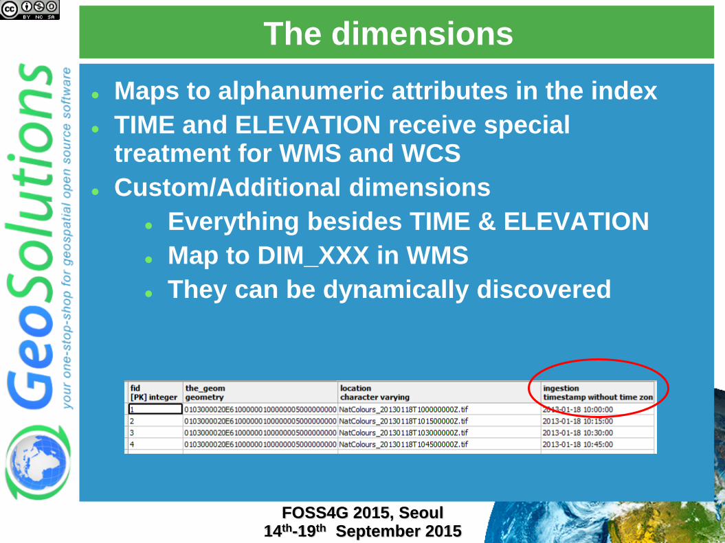
The dimensions
Maps to alphanumeric attributes in the index
TIME and ELEVATION receive special treatment for WMS and WCS
Custom/Additional dimensions
Everything besides TIME & ELEVATION
Map to DIM_XXX in WMS
They can be dynamically discovered
FOSS4G 2015, Seoul 14th-19th September 2015

Parsing dimensions from file names
FOSS4G 2015, Seoul 14th-19th September 2015
indexer.properties file
TimeAttribute=ingestion
ElevationAttribute=elevation
Schema=*the_geom:Polygon,location:String,ingestion:java.
util.Date,elevation:Double
PropertyCollectors=TimestampFileNameExtractorSPI[timereg
ex](ingestion),DoubleFileNameExtractorSPI[elevationregex
](elevation)
elevationregex.properties file
regex=(?<=_)(\\d{3})(?=_)
elevationregex.properties file
regex=[0-9]{8}T[0-9]{9}Z(\?!.\*[0-9]{8}T[0-9]{9}Z.\*)
NCOM_wattemp_020_20081031T0000000_12.tiff

Publishing dimensions
FOSS4G 2015, Seoul 14th-19th September 2015

NetCDF
FOSS4G 2015, Seoul 14th-19th September 2015

NetCDF format support
FOSS4G 2015, Seoul 14th-19th September 2015
NetCDF support Support COARDS/CF* conventions loosely
Expose NetCDF internal data as a set of 2D slices
Fast 2D (time, elevation) slice extraction

NetCDF index support files
FOSS4G 2015, Seoul 14th-19th September 2015
NetCDF Internal Index Speeds up 2D slice extraction
H2/PostgreSQL + binary file
Index location is configurable via –DNETCDF_DATA_DIR Data in a non-writable location
Granule Index in a DBMS
Individual NetCDF Indexes on a separate directory

One or more variables
FOSS4G 2015, Seoul 14th-19th September 2015
Polyphemus Sample Dataset 1 File Multiple Coverages!

NetCDF indexing configuration
FOSS4G 2015, Seoul 14th-19th September 2015

NetCDF indexing configuration
FOSS4G 2015, Seoul 14th-19th September 2015
NetCDF Indexer drive the indexing
Automatically created, can be hand edited to expose some coverages only or parametrize the indexing
<?xml version="1.0" encoding="UTF-8" standalone="yes"?>
<Indexer>
<schemas>
<schema name="default" >
<attributes>the_geom:Polygon,imageindex:Integer,time:java.util.Date, elevation:Double</attributes>
</schema>
</schemas>
<coverages>
<coverage>
<name>O3</name>
<schema ref="default"></schema>
</coverage>
…
</coverages>
</Indexer>

NetCDF GridMapping to EPSG codes
FOSS4G 2015, Seoul 14th-19th September 2015

Assumptions/Limitations
FOSS4G 2015, Seoul 14th-19th September 2015
Only WGS84 is supported in GeoServer 2.8.x also custom
CRS are supported (GridMapping to EPSG properties)
Only NetCDF following COARDS/CF convention are
supported
NetCDF WCS output is only available for multidimensional
data sources (ImageMosaic and NetCDF)

ImageMosaic – NetCDF integration
FOSS4G 2015, Seoul 14th-19th September 2015

NetCDF/Mosaic integration
FOSS4G 2015, Seoul 14th-19th September 2015
ImageMosaic NetCDF integration
Allow the ImageMosaic to handle multiple NetCDF files
Expose NetCDF internal structure (times, elevations)
Make ImageMosaic handle slices of the NetCDF file as granules
Mosaic
NetCDF 1 NetCDF 2 NetCDF … N
…
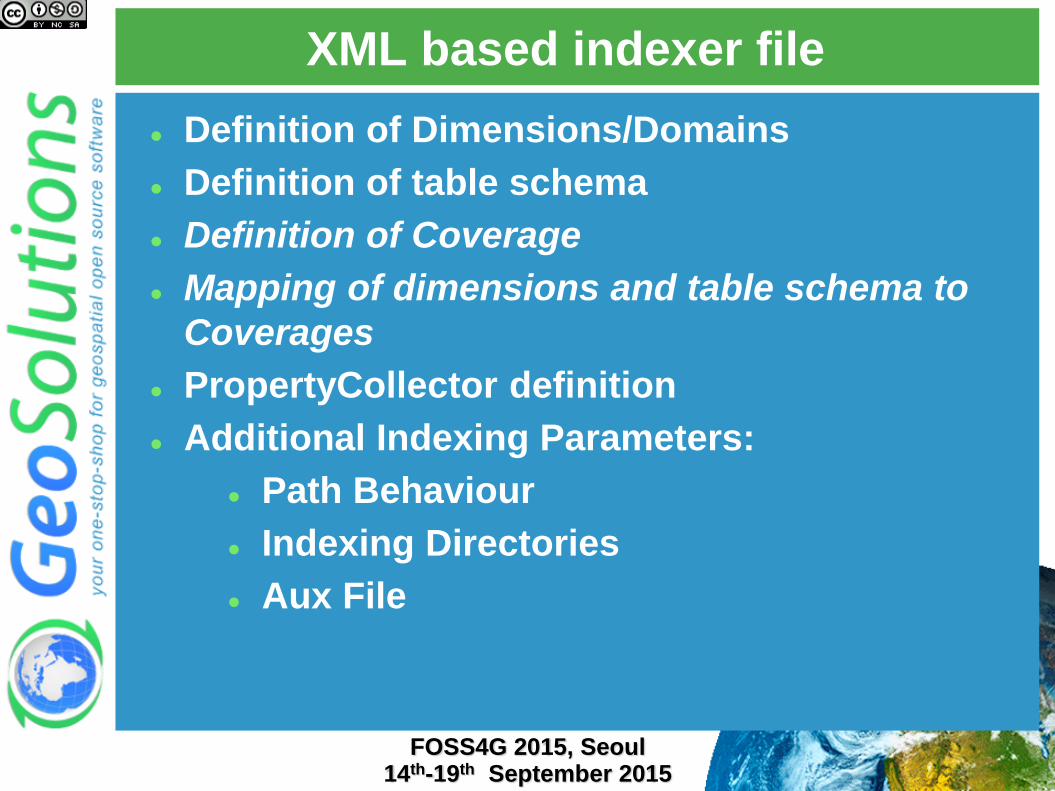
XML based indexer file
FOSS4G 2015, Seoul 14th-19th September 2015
Definition of Dimensions/Domains
Definition of table schema
Definition of Coverage
Mapping of dimensions and table schema to
Coverages
PropertyCollector definition
Additional Indexing Parameters:
Path Behaviour
Indexing Directories
Aux File

XML indexer: domains/dimensions
FOSS4G 2015, Seoul 14th-19th September 2015
<?xml version="1.0" encoding="UTF-8" standalone="yes" ?>
<Indexer>
<domains>
<domain name="time">
<attributes><attribute>time</attribute></attributes>
</domain>
<domain name="elevation">
<attributes><attribute>elevation</attribute></attributes>
</domain>
<domain name="fileDate">
<attributes><attribute ref="fileDateCollector">fileDate</attribute></attributes>
</domain>
<domain name="updated">
<attributes><attribute ref="updatedCollector">updated</attribute></attributes>
</domain>
</domains>

XML indexer : schemas and coverages
FOSS4G 2015, Seoul 14th-19th September 2015
<schemas>
<schema name="default" >
<attributes>the_geom:Polygon,location:String,imageindex:Integer,time:java.util.Date,
elevation:Double, fileDate:java.util.Date,updated:java.util.Date
</attributes>
</schema>
</schemas>
<coverages>
<coverage>
<name>V</name>
<schema ref="default"></schema>
<domains>
<domain ref="time" />
<domain ref="elevation" />
<domain ref="fileDate" />
<domain ref="updated" />
</domains>
</coverage>
</coverages>

XML indexer : collectors and params
FOSS4G 2015, Seoul 14th-19th September 2015
<collectors>
<collector name="fileDateCollector">
<value>[0-9]{8}</value>
<spi>TimestampFileNameExtractorSPI</spi>
<mapped>fileDate</mapped>
</collector>
<collector name="updatedCollector">
<value>MODIFY_TIME</value>
<spi>RuntimeExtractorSPI</spi>
<mapped>updated</mapped>
</collector>
</collectors>
<parameters>
<parameter name="AbsolutePath" value="true" />
<parameter name="AuxiliaryFile" value="polyphemus-test.xml" />
<parameter name="IndexingDirectories"
value="D:/Training_2.4_multidim_Win64/source_data/polyphemus" />
</parameters>

Multiple coverages per mosaic
FOSS4G 2015, Seoul 14th-19th September 2015

REST configuration of mosaic contents
FOSS4G 2015, Seoul 14th-19th September 2015
Granule Index CRUD Operations via REST
CREATE curl -u admin:Geos -XPUT -H "Content-
type:application/zip" --data-binary
@http://localhost:8080/geoserver/rest/workspaces/geosolu
tions/coveragestores/temperature/file.imagemosaic
READ index schema
curl -v -u admin:Geos -XGET
http://localhost:8080/geoserver/rest/workspaces/geosolut
ions/coveragestores/polyphemus/coverages/NO2/index.xml
READ WFS like with CQL filtering and paging
curl -v -u admin:Geos -XGET
"http://localhost:8080/geoserver/rest/workspaces/geosolu
tions/coveragestores/polyphemus/coverages/NO2/index/gran
ules.xml?limit=1&filter=time='2013-03-03T00:00:00Z

REST configuration of mosaic contents
FOSS4G 2015, Seoul 14th-19th September 2015
READ (Retrieve specific granule by ID)
curl -v -u admin:geoserver -XGET
"http://localhost:8080/geoserver/rest/workspaces/topp/cove
ragestores/polyphemus-
v1/coverages/NO2/index/granules/NO2.2689.xml"
UPDATE (harvest)
curl -v -u admin:Geos -XPOST -H "Content-type: text/plain"
-d "/polyphemus_20130303.nc"
"http://localhost:8080/geoserver/rest/workspaces/geosoluti
ons/coveragestores/polyphemus/external.imagemosaic"
DELETE WFS like with CQL filtering and paging or by ID
curl -v -u admin:geoserver -XDELETE
"http://localhost:8080/geoserver/rest/workspaces/topp/cov
eragestores/polyphemus-
v1/coverages/NO2/index/granules.xml?filter=location='poly
phemus_20130301.nc'"

GRIB/GRIB2 Format Support
FOSS4G 2015, Seoul 14th-19th September 2015
Based on same UCAR NetCDF Java libs used
by NetCDF Format
Same capabilities of NetCDF Format
Same indexing logic
Same ImageMosaic support

The services - visualize
FOSS4G 2015, Seoul 14th-19th September 2015

WMS
FOSS4G 2015, Seoul 14th-19th September 2015
TIME, ELEVATION & Custom dimensions
http://localhost:8080/geoserver/geosolutions/wms?...
&time=2013-03-1T00:00:00.000Z
&elevation=35.0
&DIM_FILEDATE=2013-03-01T00:00:00.000Z
&DIM_UPDATED=2013-04-08T08:18:41.597Z

Rendering transformations
FOSS4G 2015, Seoul 14th-19th September 2015
SLD Based transformations
On-the-fly contouring
On-the-fly poligonalization
Current arrows
Wind Barbs
Pluggable: add your own

Rendering transformations
FOSS4G 2015, Seoul 14th-19th September 2015
windbarbs
currents
contouring

WMS-EO
FOSS4G 2015, Seoul 14th-19th September 2015
Extending LayerGroup concept
Support same style on both raster and vector
data
Support custom dimensions
Alter map on the fly to support band combination
Wizard to configure EO layer groups
Product layer tree
Mix of vector and raster info
Raw data, flags (clouds, snow), browse

WMS-EO
FOSS4G 2015, Seoul 14th-19th September 2015
Helper UI to build the tree

WMS-EO
FOSS4G 2015, Seoul 14th-19th September 2015

The services - download
FOSS4G 2015, Seoul 14th-19th September 2015

WCS 2.0
FOSS4G 2015, Seoul 14th-19th September 2015
Basics Core service
KVP binding
XML binding
Common extensions CRS
Scaling
Interpolation
Range subsetting
GeoTiff
GML
NetCDF
Add the output format extensions GeoTIFF
GML Grid
NetCDF

WCS 2.0 processing chain
FOSS4G 2015, Seoul 14th-19th September 2015
Crop
RangeSubset
Scale & Interpolate
Reproject & Interpolate
Encode
Core
Extension
Extension
Extension
Extension

WCS 2.0 DescribeCoverage
FOSS4G 2015, Seoul 14th-19th September 2015
BBOX
TIME
ELEVATION
CUSTOM

Download ND NetCDF
FOSS4G 2015, Seoul 14th-19th September 2015
http://localhost:8080/geoserver/wcs?request=GetCoverage&service=WCS&
version=2.0.1&coverageId=geosolutions__NO2
&Format=application/x-netcdf
&subset=http://www.opengis.net/def/axis/OGC/0/Long(5,20)
&subset=http://www.opengis.net/def/axis/OGC/0/Lat(40,50)
&subset=http://www.opengis.net/def/axis/OGC/0/elevation(300,1250)
&subset=http://www.opengis.net/def/axis/OGC/0/time("2013-03-
01T10:00:00.000Z","2013-03-01T22:00:00.000Z")
• Can also handle custom
dimensions
• Described in DescribeCoverage
in a vendor metadata section

WCS EO
FOSS4G 2015, Seoul 14th-19th September 2015
Add support for WCS EO metadata in readers
Associate each file with EO metadata
Include such information in
DescribeCoverage/DescribeEODataset
EODataset: multidimensional mosaic or NetCDF file
Describe the inner structure (granules listing) in
DescribeEODataSet