Embed Size (px)
Citation preview
Spatio-temporal Data Handling With GeoServer
for MetOc And Remote Sensing
Ing. Daniele Romagnoli
Ing. Simone Giannecchini Ing. Andrea Aime
FOSS4G-EU 2015, Como 17th July 2015
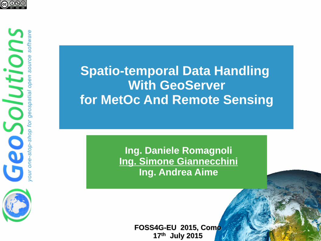
Outline
Who we are
GeoServer
Plugins of Interests
NetCDF
ImageMosaic
OGC Services
Real World Use-Cases
FOSS4G-EU 2015, Como 17th July 2015

GeoSolutions
Italian SME
Expertise
• Image Processing, GeoSpatial Data Fusion
• Java, Java Enterprise, C++, Python
• JPEG2000, JPIP, Advanced 2D visualization
Supporting/Developing FOSS4G projects
MapStore, GeoServer
GeoNetwork. GeoNode, CKAN
Clients
Public Agencies
Private Companies
http://www.geo-solutions.it
FOSS4G-EU 2015, Como 17th July 2015
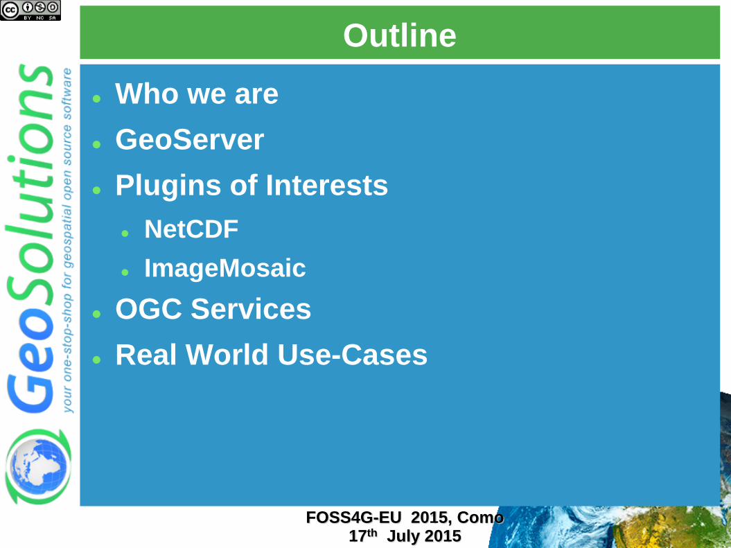
GeoServer
GeoSpatial enterprise gateway
Java Enterprise
Management and Dissemination of
raster and vector data
Standards compliant OGC WCS 1.0, 1.1.1 (RI), 2.0
OGC WFS 1.0, 1.1 (RI), 2.0
OGC WMS 1.1.1, 1.3
OGC WPS 1.0.0
Google Earth/Maps support KML, GeoSearch, etc..
FOSS4G-EU 2015, Como 17th July 2015
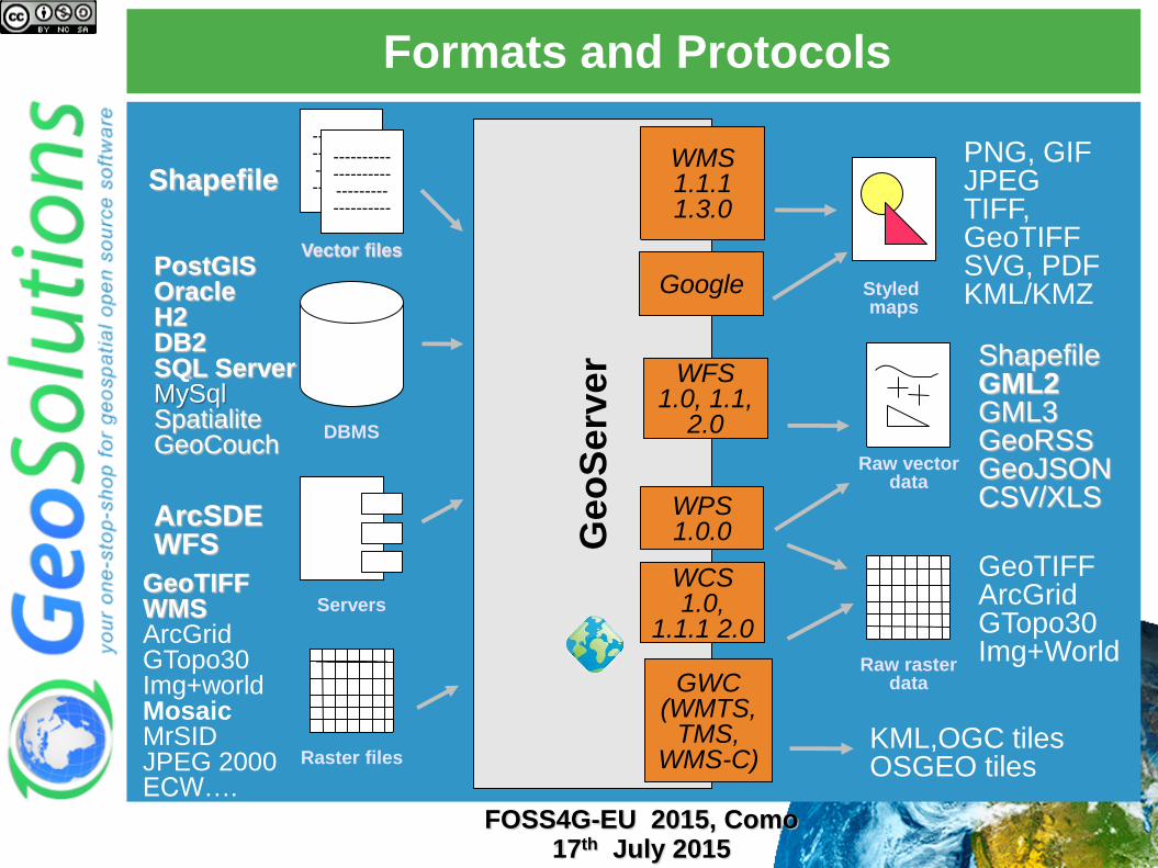
Formats and Protocols
Geo
Serv
er
WFS 1.0, 1.1,
2.0
WMS 1.1.1 1.3.0
PostGIS Oracle H2 DB2 SQL Server MySql Spatialite GeoCouch
Shapefile
---------- ---------- --------- ----------
---------- ---------- --------- ----------
---------- ---------- --------- ----------
ArcSDE WFS
PNG, GIF JPEG TIFF, GeoTIFF SVG, PDF KML/KMZ
Shapefile GML2 GML3 GeoRSS GeoJSON CSV/XLS
Raw vector data
Servers
Styled maps
DBMS
Vector files
WCS 1.0,
1.1.1 2.0
GeoTIFF WMS ArcGrid GTopo30 Img+world Mosaic MrSID JPEG 2000 ECW….
Raster files
Raw raster data
GeoTIFF ArcGrid GTopo30 Img+World
GWC (WMTS,
TMS, WMS-C)
KML,OGC tiles OSGEO tiles
WPS 1.0.0
FOSS4G-EU 2015, Como 17th July 2015
Reference Scenario/Domain
FOSS4G-EU 2015, Como 17th July 2015

ImageMosaic – Part 1
FOSS4G-EU 2015, Como 17th July 2015
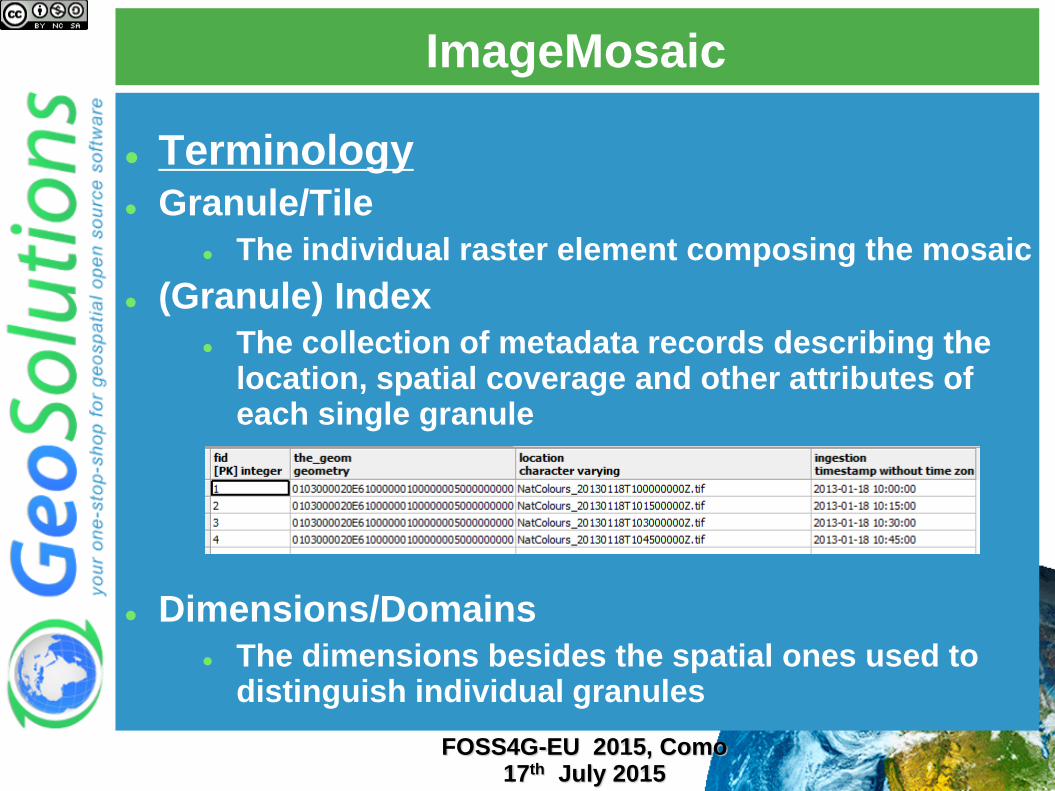
ImageMosaic
Terminology
Granule/Tile
The individual raster element composing the mosaic
(Granule) Index
The collection of metadata records describing the location, spatial coverage and other attributes of each single granule
Dimensions/Domains
The dimensions besides the spatial ones used to distinguish individual granules
FOSS4G-EU 2015, Como 17th July 2015
ImageMosaic
(Granule) Index
Always present
Drives the collection of granules for mosaicking
Implemented by default using GeoTools Vector Sources
Can be customized to support custom granule indexes (e.g. legacy catalog)
Currently supported/tested DBMS
PostGis (JNDI)
Oracle (JNDI) it’s been a nightmare!
H2
FOSS4G-EU 2015, Como 17th July 2015
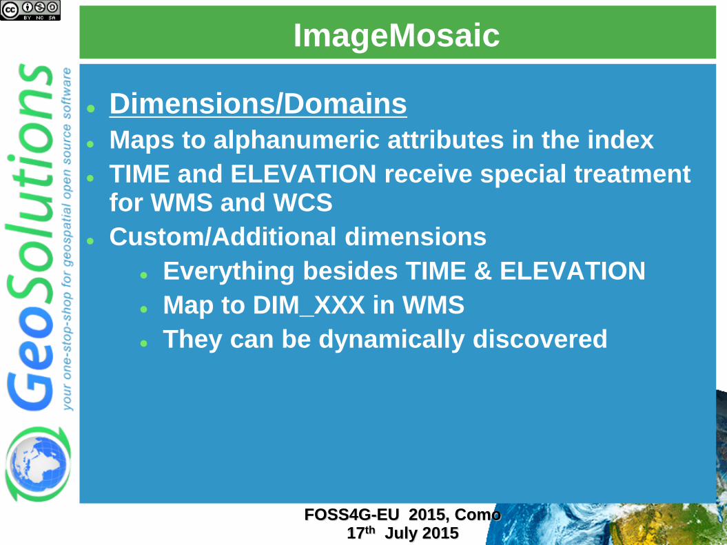
ImageMosaic
Dimensions/Domains
Maps to alphanumeric attributes in the index
TIME and ELEVATION receive special treatment for WMS and WCS
Custom/Additional dimensions
Everything besides TIME & ELEVATION
Map to DIM_XXX in WMS
They can be dynamically discovered
FOSS4G-EU 2015, Como 17th July 2015
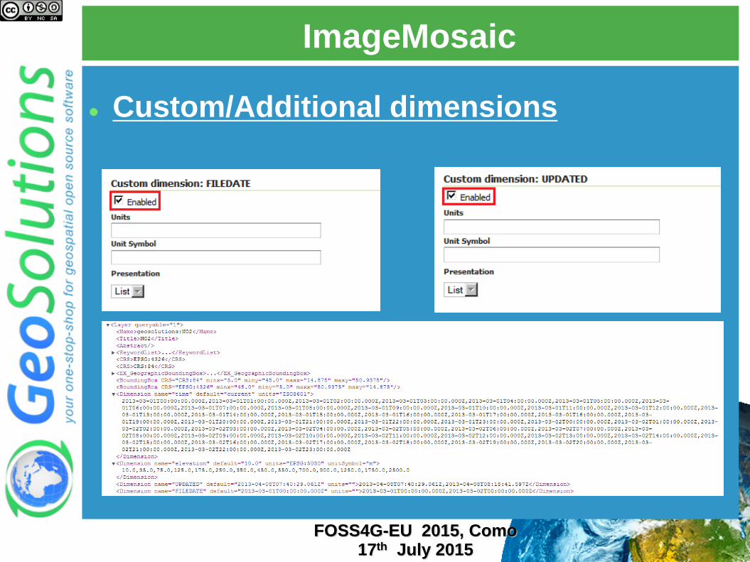
ImageMosaic
Custom/Additional dimensions
FOSS4G-EU 2015, Como 17th July 2015
ImageMosaic
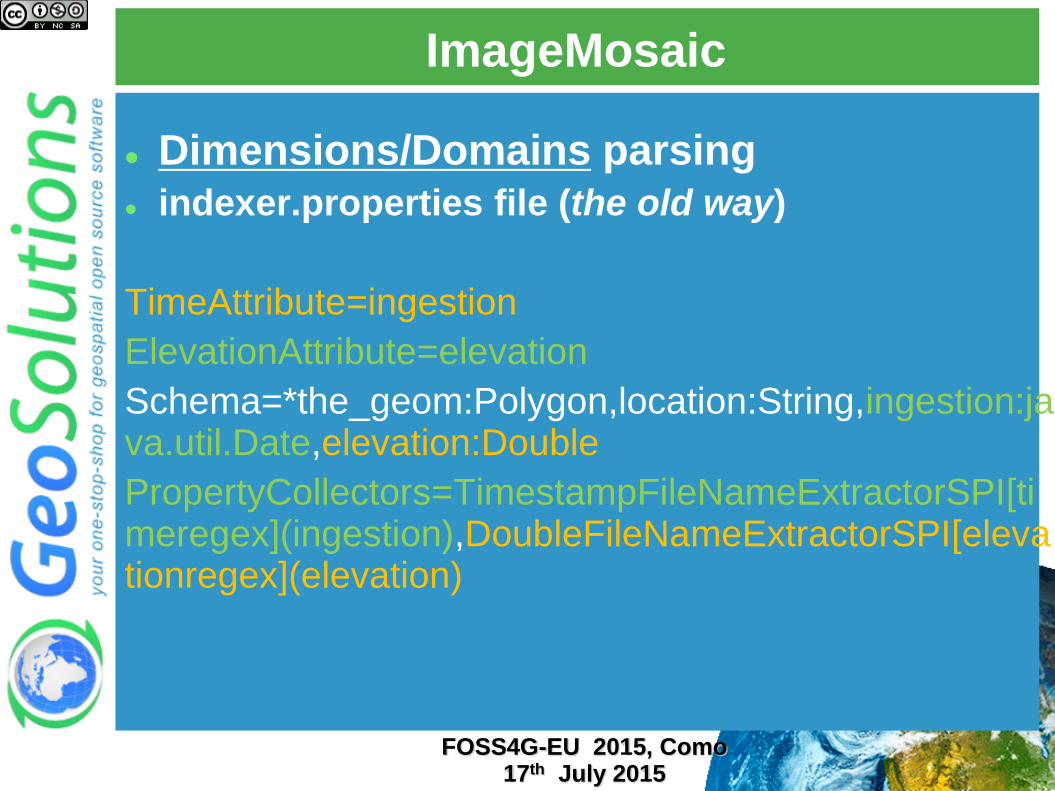
Dimensions/Domains parsing
indexer.properties file (the old way)
TimeAttribute=ingestion
ElevationAttribute=elevation
Schema=*the_geom:Polygon,location:String,ingestion:java.util.Date,elevation:Double
PropertyCollectors=TimestampFileNameExtractorSPI[timeregex](ingestion),DoubleFileNameExtractorSPI[elevationregex](elevation)
FOSS4G-EU 2015, Como 17th July 2015
ImageMosaic
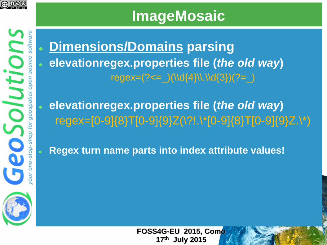
Dimensions/Domains parsing
elevationregex.properties file (the old way)
regex=(?<=_)(\\d{4}\\.\\d{3})(?=_)
elevationregex.properties file (the old way)
regex=[0-9]{8}T[0-9]{9}Z(\?!.\*[0-9]{8}T[0-9]{9}Z.\*)
Regex turn name parts into index attribute values!
FOSS4G-EU 2015, Como 17th July 2015
ImageMosaic
Limitations/assumptions
Granules must share the same Coordinate Reference System
Granules must share the same ColorModel and SampleModel
We can still merge RGB with Paletted RGB via colormap expansion
1 row in the index maps to 1 physical file
FOSS4G-EU 2015, Como 17th July 2015

NetCDF Support
FOSS4G-EU 2015, Como 17th July 2015
NetCDF Format Support
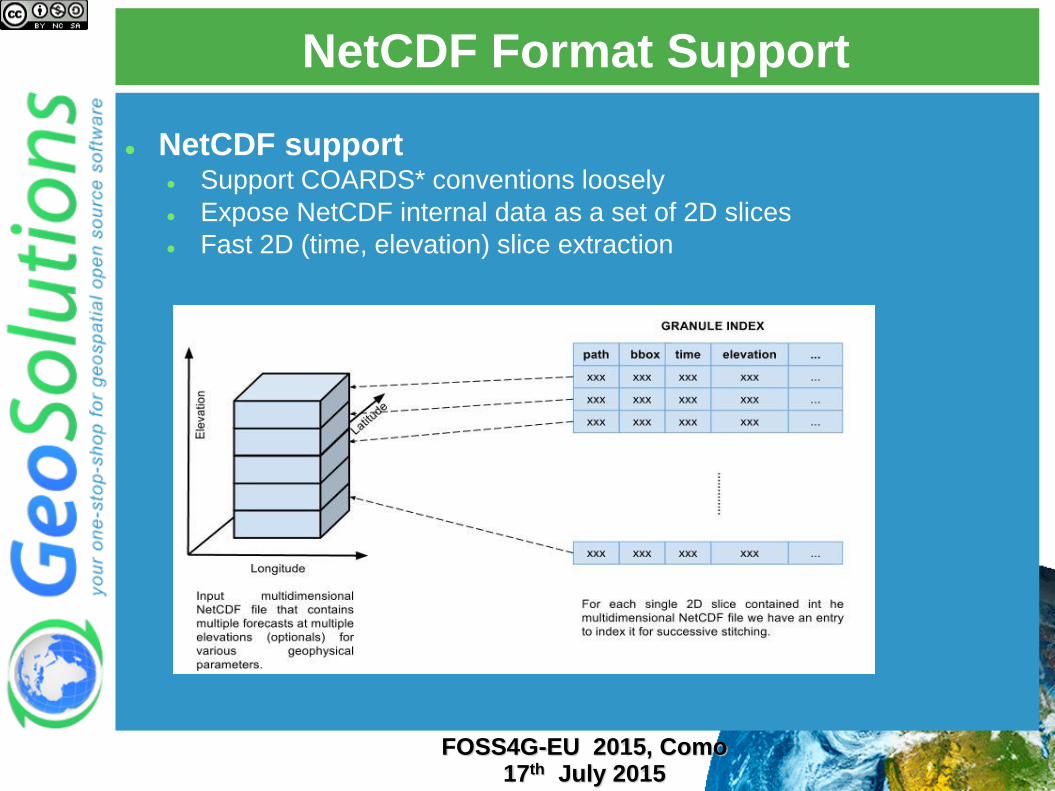
NetCDF support Support COARDS* conventions loosely
Expose NetCDF internal data as a set of 2D slices
Fast 2D (time, elevation) slice extraction
FOSS4G-EU 2015, Como 17th July 2015

Polyphemus Sample Dataset 1 File Multiple Coverages!
FOSS4G-EU 2015, Como 17th July 2015
NetCDF Format Support
FOSS4G-EU 2015, Como 17th July 2015
NetCDF Format Support
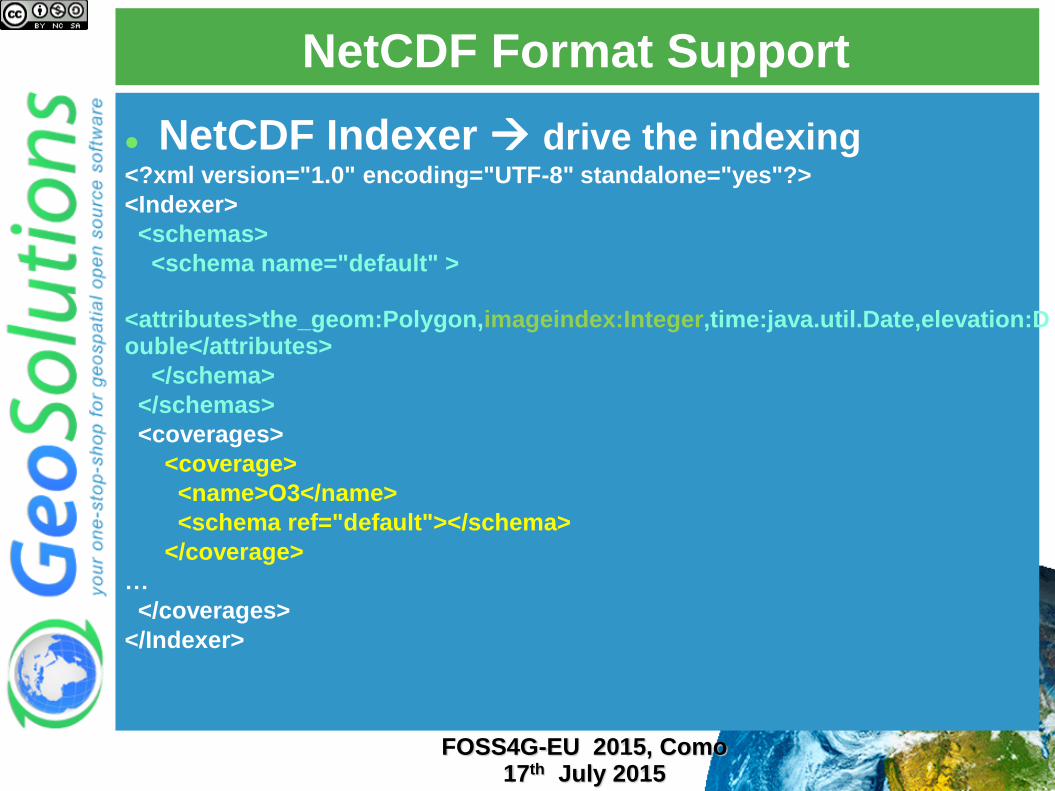
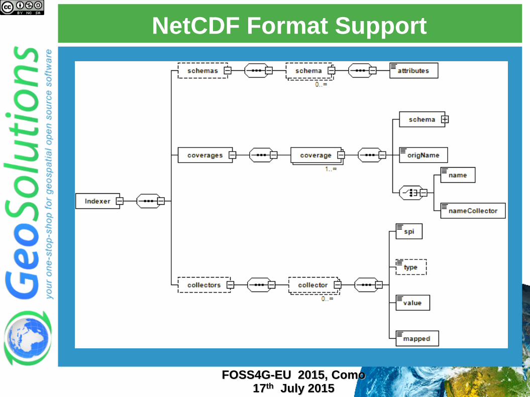
NetCDF Indexer drive the indexing <?xml version="1.0" encoding="UTF-8" standalone="yes"?>
<Indexer>
<schemas>
<schema name="default" >
<attributes>the_geom:Polygon,imageindex:Integer,time:java.util.Date,elevation:Double</attributes>
</schema>
</schemas>
<coverages>
<coverage>
<name>O3</name>
<schema ref="default"></schema>
</coverage>
…
</coverages>
</Indexer>
FOSS4G-EU 2015, Como 17th July 2015
NetCDF Format Support
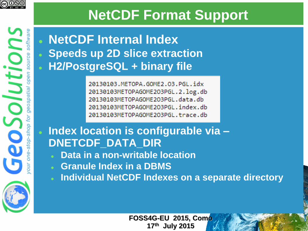
NetCDF Internal Index Speeds up 2D slice extraction
H2/PostgreSQL + binary file
Index location is configurable via –DNETCDF_DATA_DIR Data in a non-writable location
Granule Index in a DBMS
Individual NetCDF Indexes on a separate directory
FOSS4G-EU 2015, Como 17th July 2015
NetCDF Format Support
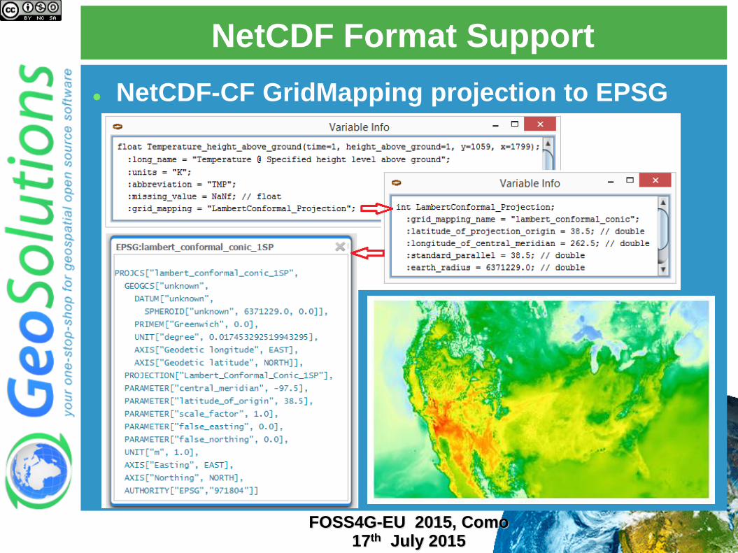
NetCDF-CF GridMapping projection to EPSG
FOSS4G-EU 2015, Como 17th July 2015
NetCDF Format Support
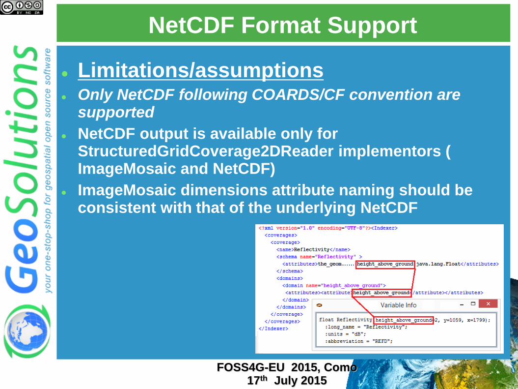
Limitations/assumptions Only NetCDF following COARDS/CF convention are
supported
NetCDF output is available only for StructuredGridCoverage2DReader implementors ( ImageMosaic and NetCDF)
ImageMosaic dimensions attribute naming should be consistent with that of the underlying NetCDF
FOSS4G-EU 2015, Como 17th July 2015
NetCDF Format Support
ImageMosaic – Part 2
FOSS4G-EU 2015, Como 17th July 2015
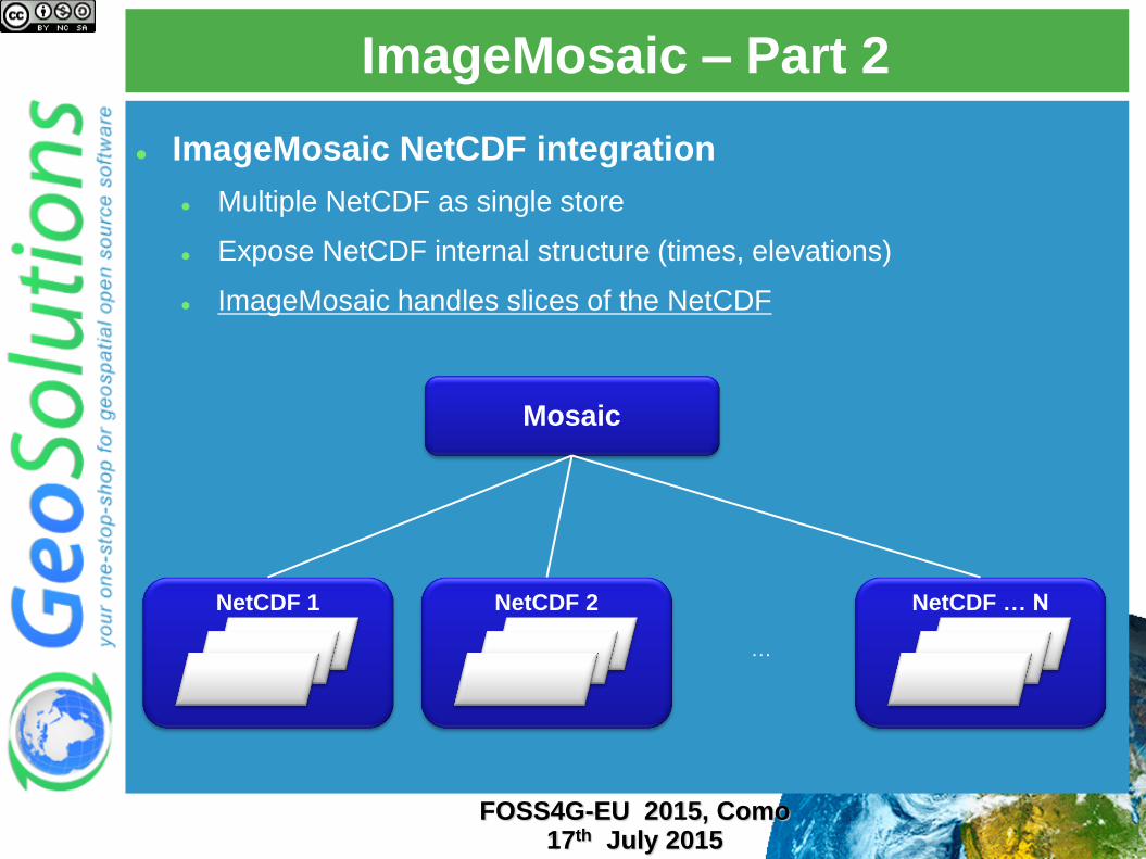
ImageMosaic – Part 2
ImageMosaic NetCDF integration
Multiple NetCDF as single store
Expose NetCDF internal structure (times, elevations)
ImageMosaic handles slices of the NetCDF
Mosaic
NetCDF 1 NetCDF 2 NetCDF … N
…
FOSS4G-EU 2015, Como 17th July 2015
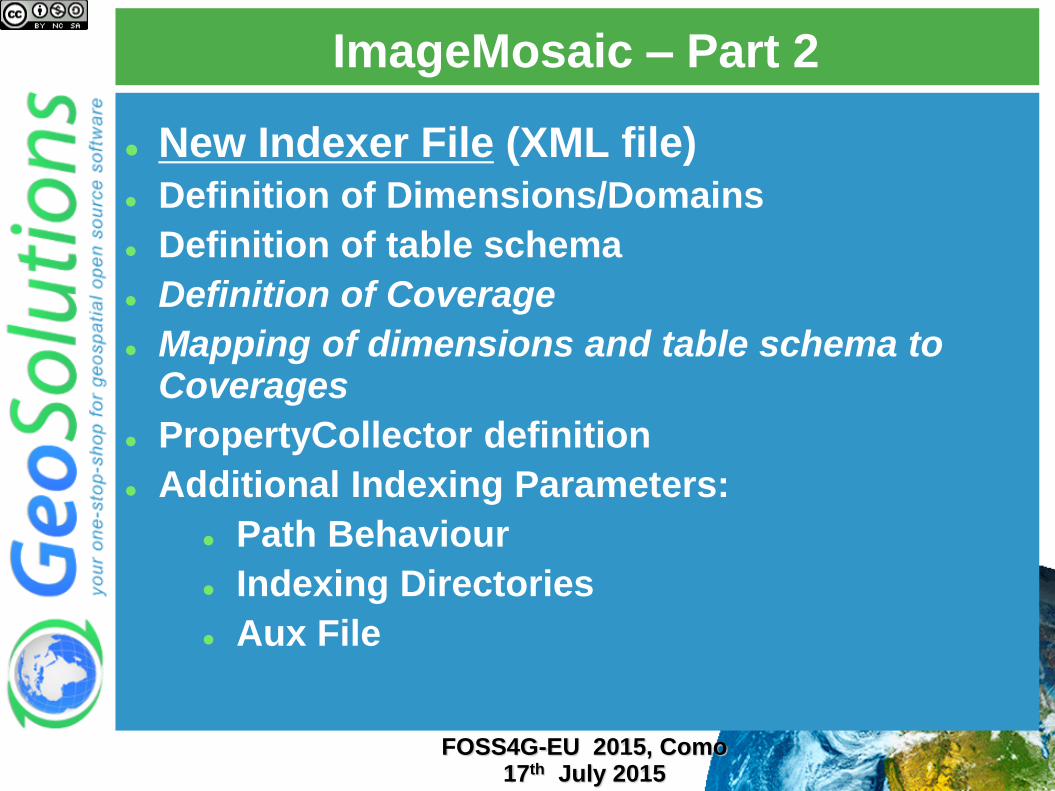
New Indexer File (XML file)
Definition of Dimensions/Domains
Definition of table schema
Definition of Coverage
Mapping of dimensions and table schema to Coverages
PropertyCollector definition
Additional Indexing Parameters:
Path Behaviour
Indexing Directories
Aux File
FOSS4G-EU 2015, Como 17th July 2015
ImageMosaic – Part 2
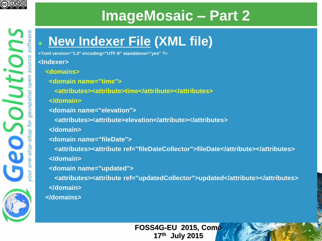
New Indexer File (XML file) <?xml version="1.0" encoding="UTF-8" standalone="yes" ?>
<Indexer>
<domains>
<domain name="time">
<attributes><attribute>time</attribute></attributes>
</domain>
<domain name="elevation">
<attributes><attribute>elevation</attribute></attributes>
</domain>
<domain name="fileDate">
<attributes><attribute ref="fileDateCollector">fileDate</attribute></attributes>
</domain>
<domain name="updated">
<attributes><attribute ref="updatedCollector">updated</attribute></attributes>
</domain>
</domains>
FOSS4G-EU 2015, Como 17th July 2015
ImageMosaic – Part 2
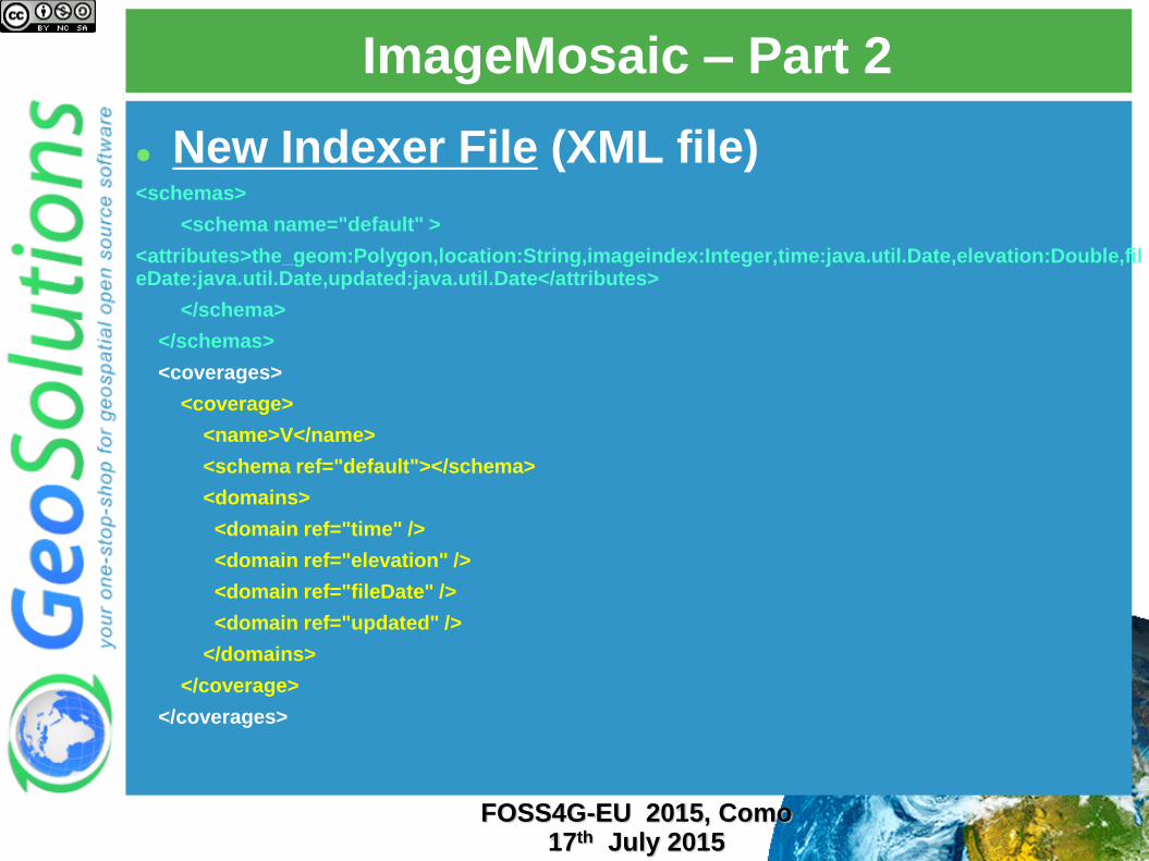
New Indexer File (XML file) <schemas>
<schema name="default" >
<attributes>the_geom:Polygon,location:String,imageindex:Integer,time:java.util.Date,elevation:Double,fileDate:java.util.Date,updated:java.util.Date</attributes>
</schema>
</schemas>
<coverages>
<coverage>
<name>V</name>
<schema ref="default"></schema>
<domains>
<domain ref="time" />
<domain ref="elevation" />
<domain ref="fileDate" />
<domain ref="updated" />
</domains>
</coverage>
</coverages>
FOSS4G-EU 2015, Como 17th July 2015
ImageMosaic – Part 2
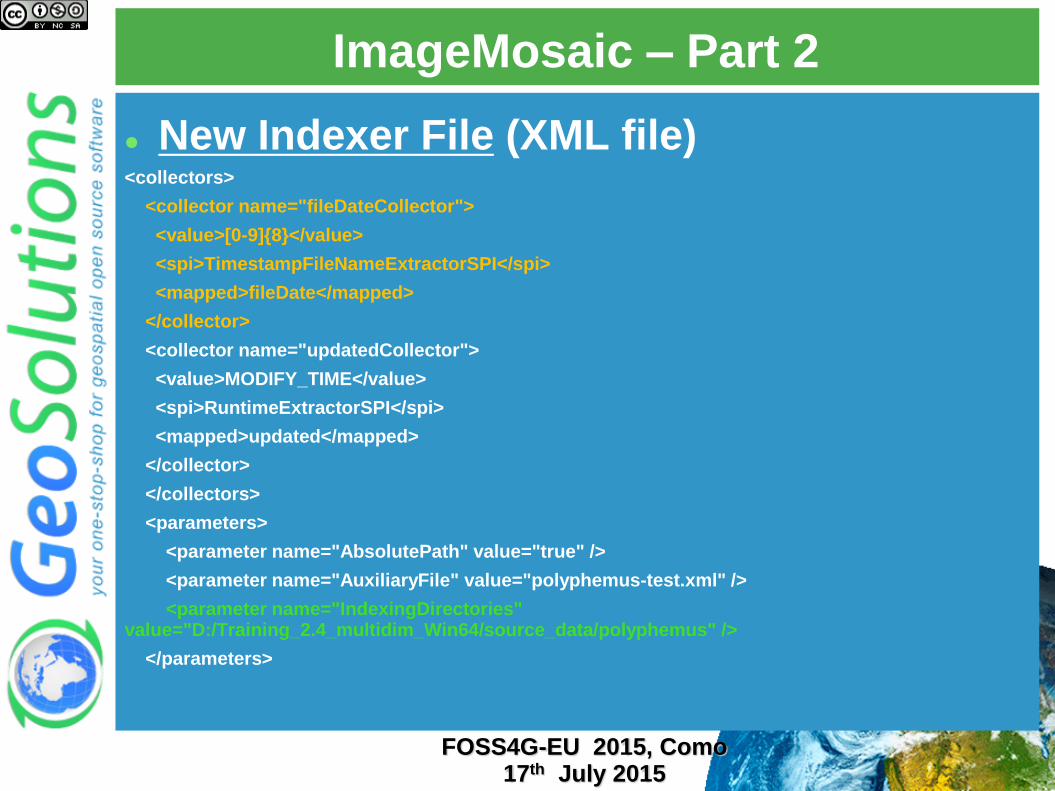
New Indexer File (XML file) <collectors>
<collector name="fileDateCollector">
<value>[0-9]{8}</value>
<spi>TimestampFileNameExtractorSPI</spi>
<mapped>fileDate</mapped>
</collector>
<collector name="updatedCollector">
<value>MODIFY_TIME</value>
<spi>RuntimeExtractorSPI</spi>
<mapped>updated</mapped>
</collector>
</collectors>
<parameters>
<parameter name="AbsolutePath" value="true" />
<parameter name="AuxiliaryFile" value="polyphemus-test.xml" />
<parameter name="IndexingDirectories" value="D:/Training_2.4_multidim_Win64/source_data/polyphemus" />
</parameters>
FOSS4G-EU 2015, Como 17th July 2015
ImageMosaic – Part 2
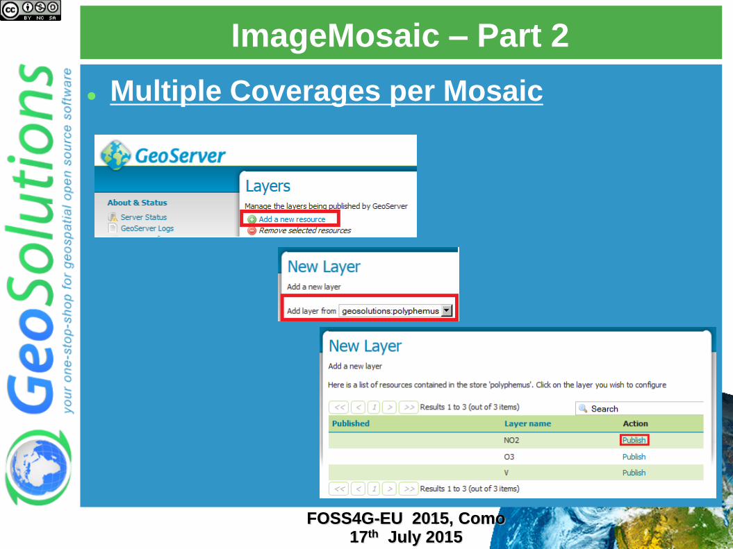
Multiple Coverages per Mosaic
FOSS4G-EU 2015, Como 17th July 2015
ImageMosaic – Part 2
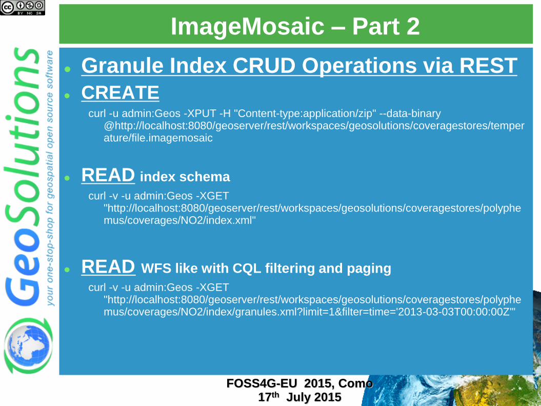
Granule Index CRUD Operations via REST
CREATE curl -u admin:Geos -XPUT -H "Content-type:application/zip" --data-binary
@http://localhost:8080/geoserver/rest/workspaces/geosolutions/coveragestores/temperature/file.imagemosaic
READ index schema
curl -v -u admin:Geos -XGET "http://localhost:8080/geoserver/rest/workspaces/geosolutions/coveragestores/polyphemus/coverages/NO2/index.xml"
READ WFS like with CQL filtering and paging
curl -v -u admin:Geos -XGET "http://localhost:8080/geoserver/rest/workspaces/geosolutions/coveragestores/polyphemus/coverages/NO2/index/granules.xml?limit=1&filter=time='2013-03-03T00:00:00Z'"
FOSS4G-EU 2015, Como 17th July 2015
ImageMosaic – Part 2
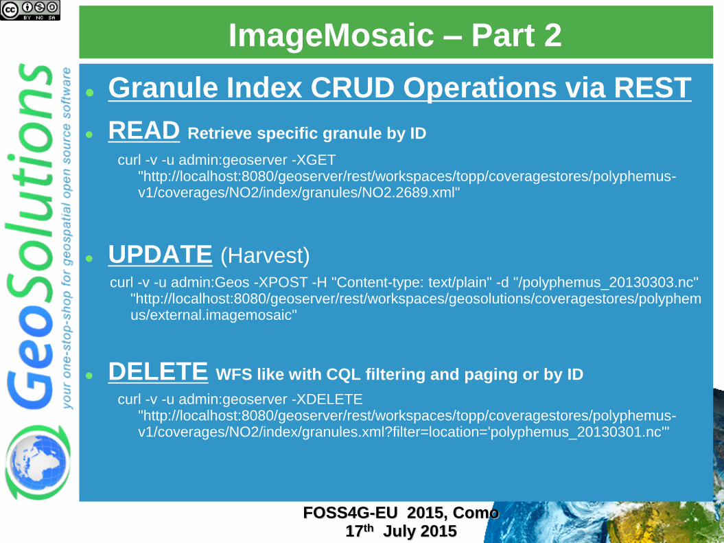
Granule Index CRUD Operations via REST
READ Retrieve specific granule by ID curl -v -u admin:geoserver -XGET
"http://localhost:8080/geoserver/rest/workspaces/topp/coveragestores/polyphemus-v1/coverages/NO2/index/granules/NO2.2689.xml"
UPDATE (Harvest) curl -v -u admin:Geos -XPOST -H "Content-type: text/plain" -d "/polyphemus_20130303.nc"
"http://localhost:8080/geoserver/rest/workspaces/geosolutions/coveragestores/polyphemus/external.imagemosaic"
DELETE WFS like with CQL filtering and paging or by ID
curl -v -u admin:geoserver -XDELETE "http://localhost:8080/geoserver/rest/workspaces/topp/coveragestores/polyphemus-v1/coverages/NO2/index/granules.xml?filter=location='polyphemus_20130301.nc'"
FOSS4G-EU 2015, Como 17th July 2015
ImageMosaic – Part 2
Based on same UCAR NetCDF Java libs used by NetCDF Format
Same capabilities of NetCDF Format
Same indexing logic
Same ImageMosaic support
FOSS4G-EU 2015, Como 17th July 2015
GRIB/GRIB2 Format Support
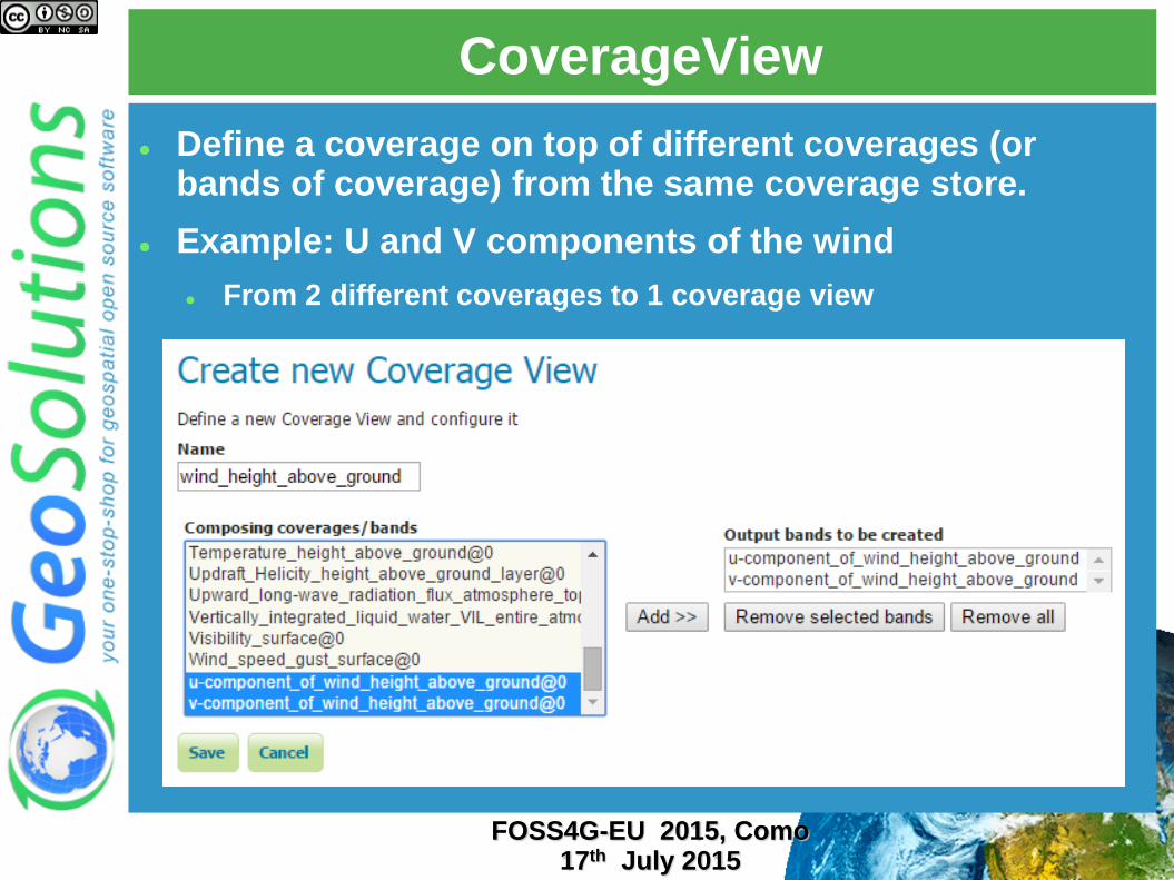
CoverageView
Define a coverage on top of different coverages (or bands of coverage) from the same coverage store.
Example: U and V components of the wind
From 2 different coverages to 1 coverage view
FOSS4G-EU 2015, Como 17th July 2015
CoverageView
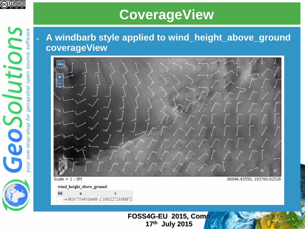
A windbarb style applied to wind_height_above_ground coverageView
FOSS4G-EU 2015, Como 17th July 2015
https://github.com/geosolutions-it/jai-ext
Replace Oracle’s JAI Ops (Image Processing operations)
Affine, Algebra, Band*, Binarize, Border, Buffer, Color*, Convolve, Crop, Lookup, Mosaic, Rescale, Scale, Stats, Translate, Warp, VectorBinarize, …
Add support for NoData and ROI (Region Of Interest)
Key elements for:
Proper WMS interpolation and processing
Data validity preserved in WCS requests
FOSS4G-EU 2015, Como
17th July 2015
JAI-EXT
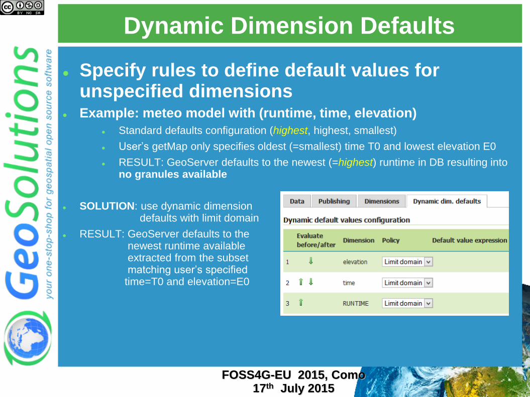
Specify rules to define default values for unspecified dimensions
Example: meteo model with (runtime, time, elevation)
Standard defaults configuration (highest, highest, smallest)
User’s getMap only specifies oldest (=smallest) time T0 and lowest elevation E0
RESULT: GeoServer defaults to the newest (=highest) runtime in DB resulting into no granules available
SOLUTION: use dynamic dimension defaults with limit domain
RESULT: GeoServer defaults to the newest runtime available extracted from the subset matching user’s specified time=T0 and elevation=E0
FOSS4G-EU 2015, Como 17th July 2015
Dynamic Dimension Defaults

OGC Services
FOSS4G-EU 2015, Como 17th July 2015
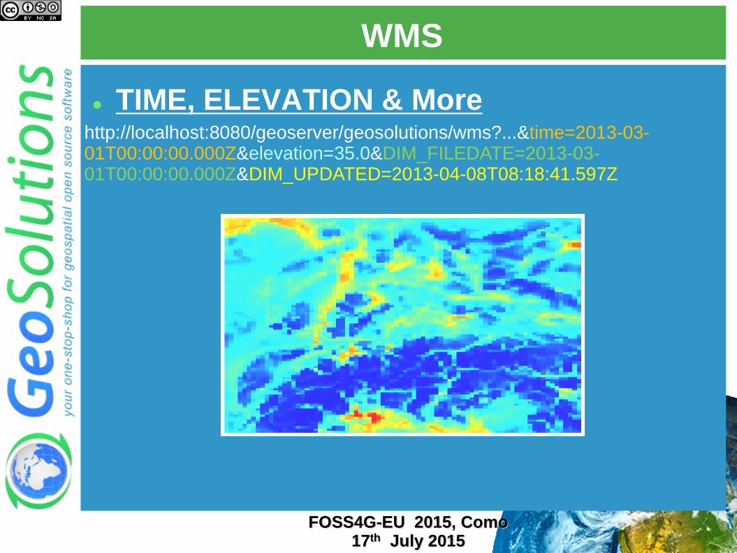
WMS
TIME, ELEVATION & More
http://localhost:8080/geoserver/geosolutions/wms?...&time=2013-03-01T00:00:00.000Z&elevation=35.0&DIM_FILEDATE=2013-03-01T00:00:00.000Z&DIM_UPDATED=2013-04-08T08:18:41.597Z
FOSS4G-EU 2015, Como 17th July 2015
WMS + WPS
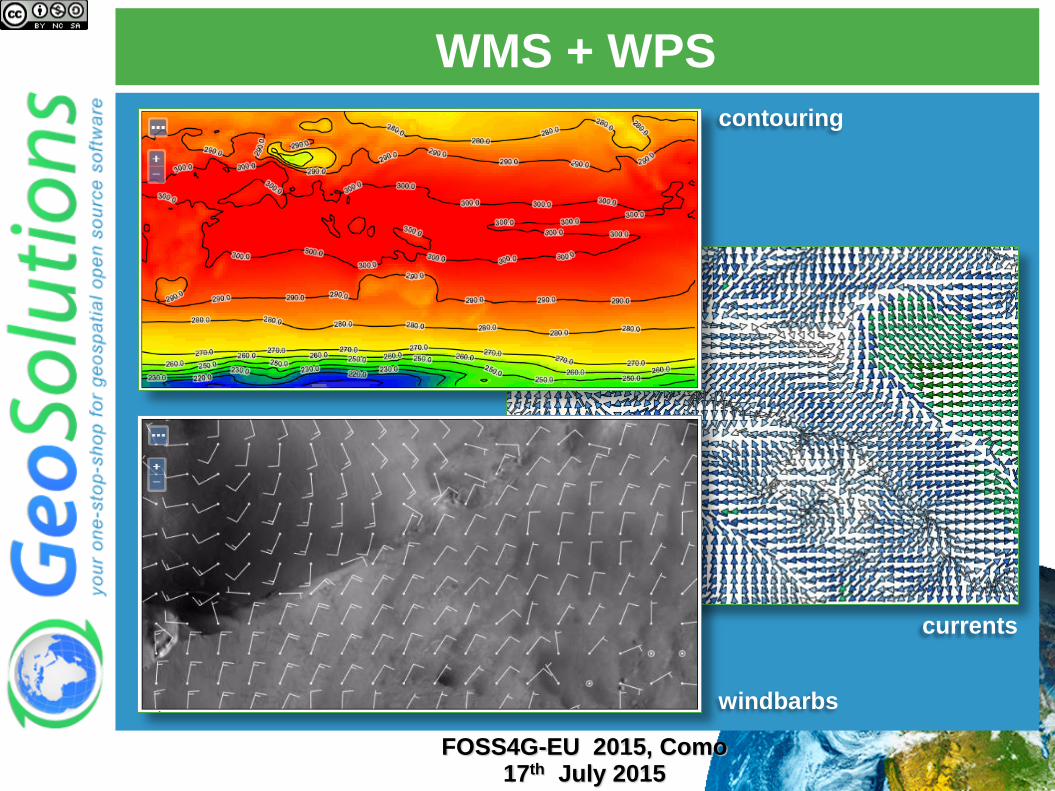
Rendering Transformations
SLD Based transformations
On-the-fly contouring
On-the-fly poligon extraction
Wind Barbs
Currents
Dynamic Color Maps
FOSS4G-EU 2015, Como 17th July 2015
WMS + WPS
FOSS4G-EU 2015, Como 17th July 2015
windbarbs
currents
contouring
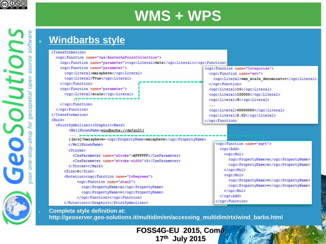
WMS + WPS
Windbarbs style
Complete style definition at: http://geoserver.geo-solutions.it/multidim/en/accessing_multidim/rtx/wind_barbs.html
FOSS4G-EU 2015, Como 17th July 2015
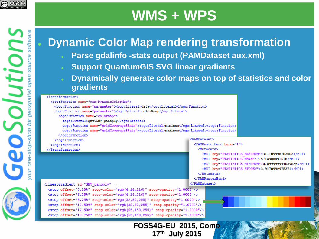
WMS + WPS
Dynamic Color Map rendering transformation Parse gdalinfo -stats output (PAMDataset aux.xml)
Support QuantumGIS SVG linear gradients
Dynamically generate color maps on top of statistics and color gradients
FOSS4G-EU 2015, Como 17th July 2015
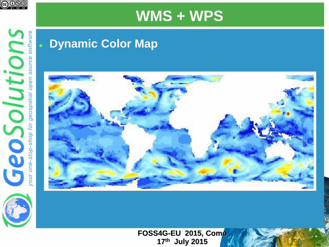
WMS + WPS
Dynamic Color Map
FOSS4G-EU 2015, Como 17th July 2015
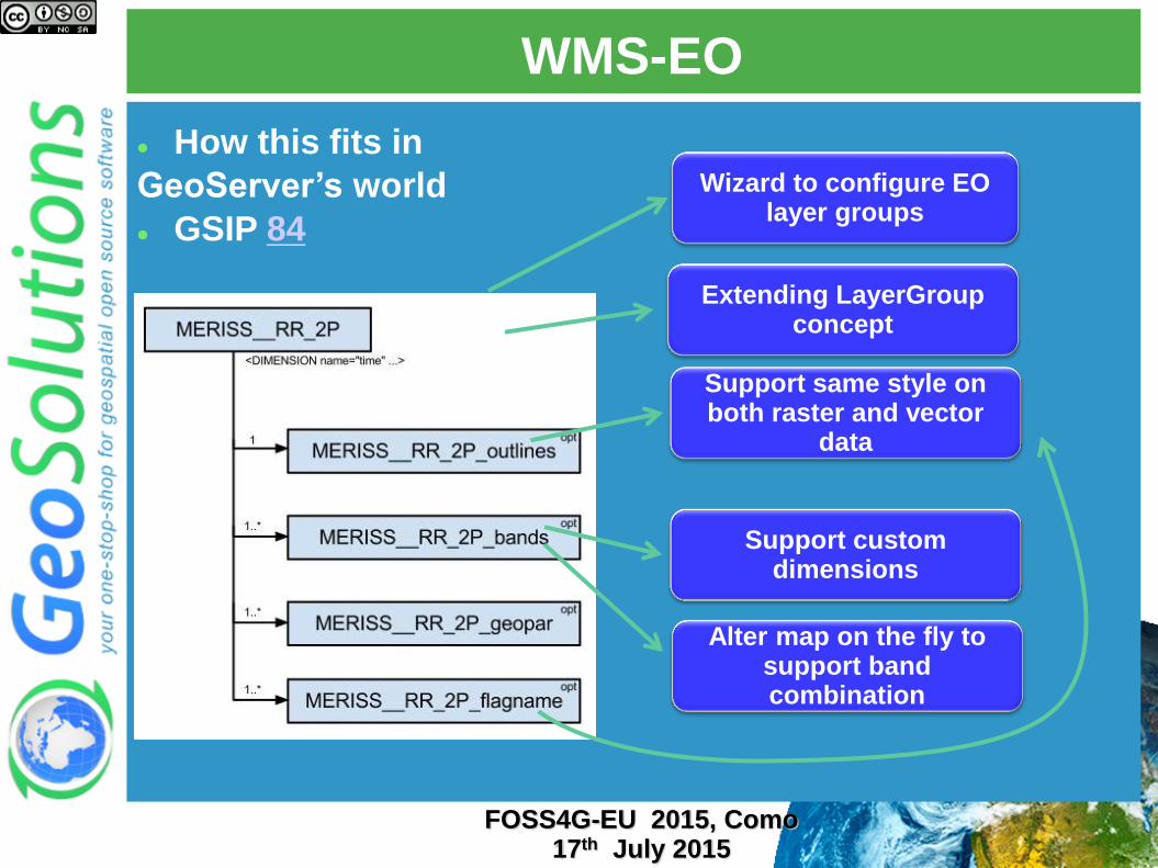
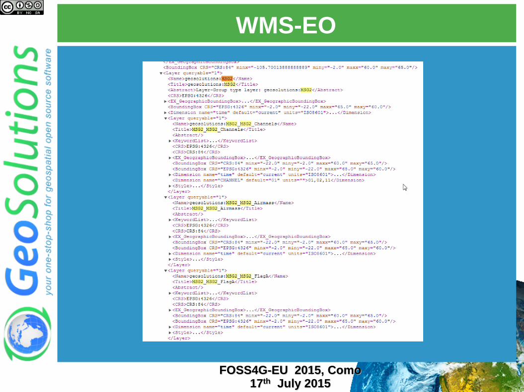
WMS-EO
Extending LayerGroup concept
Support same style on both raster and vector
data
Support custom dimensions
Alter map on the fly to support band combination
Wizard to configure EO layer groups
How this fits in
GeoServer’s world
GSIP 84
FOSS4G-EU 2015, Como 17th July 2015
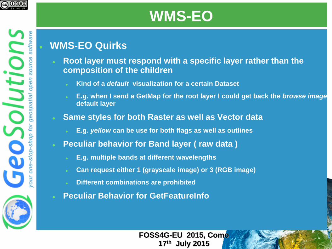
WMS-EO
WMS-EO Quirks
Root layer must respond with a specific layer rather than the composition of the children
Kind of a default visualization for a certain Dataset
E.g. when I send a GetMap for the root layer I could get back the browse image default layer
Same styles for both Raster as well as Vector data
E.g. yellow can be use for both flags as well as outlines
Peculiar behavior for Band layer ( raw data )
E.g. multiple bands at different wavelengths
Can request either 1 (grayscale image) or 3 (RGB image)
Different combinations are prohibited
Peculiar Behavior for GetFeatureInfo
FOSS4G-EU 2015, Como
17th July 2015
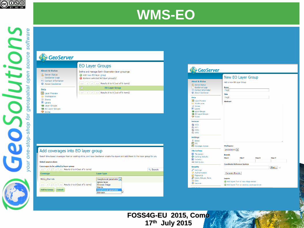
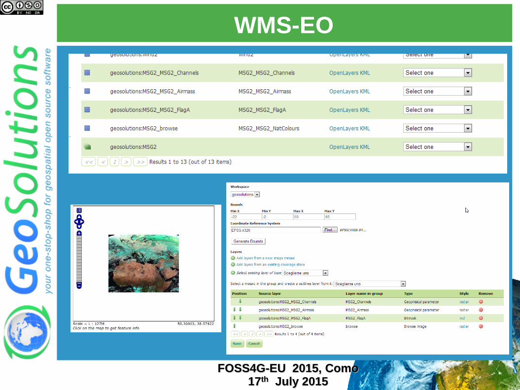
WMS-EO
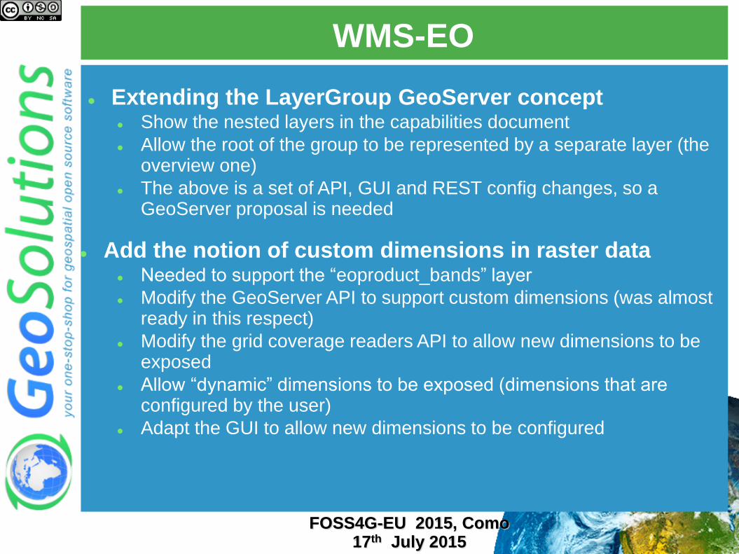
Extending the LayerGroup GeoServer concept Show the nested layers in the capabilities document
Allow the root of the group to be represented by a separate layer (the overview one)
The above is a set of API, GUI and REST config changes, so a GeoServer proposal is needed
Add the notion of custom dimensions in raster data Needed to support the “eoproduct_bands” layer
Modify the GeoServer API to support custom dimensions (was almost ready in this respect)
Modify the grid coverage readers API to allow new dimensions to be exposed
Allow “dynamic” dimensions to be exposed (dimensions that are configured by the user)
Adapt the GUI to allow new dimensions to be configured
FOSS4G-EU 2015, Como 17th July 2015
WMS-EO
FOSS4G-EU 2015, Como 17th July 2015
WMS-EO
FOSS4G-EU 2015, Como 17th July 2015
WMS-EO
FOSS4G-EU 2015, Como 17th July 2015
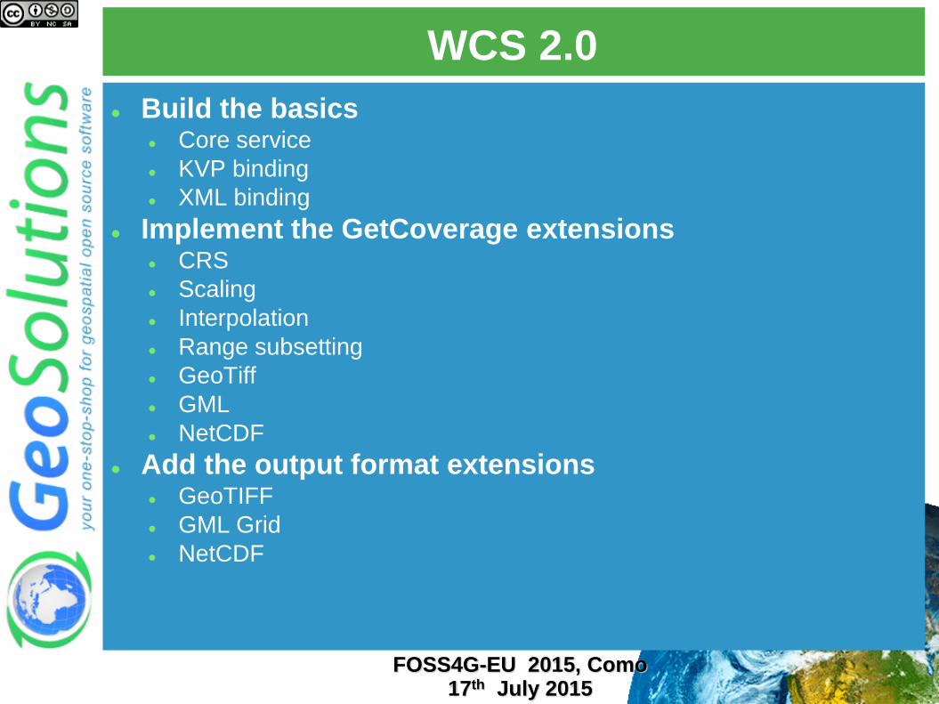
WCS 2.0
Build the basics Core service
KVP binding
XML binding
Implement the GetCoverage extensions CRS
Scaling
Interpolation
Range subsetting
GeoTiff
GML
NetCDF
Add the output format extensions GeoTIFF
GML Grid
NetCDF
FOSS4G-EU 2015, Como 17th July 2015
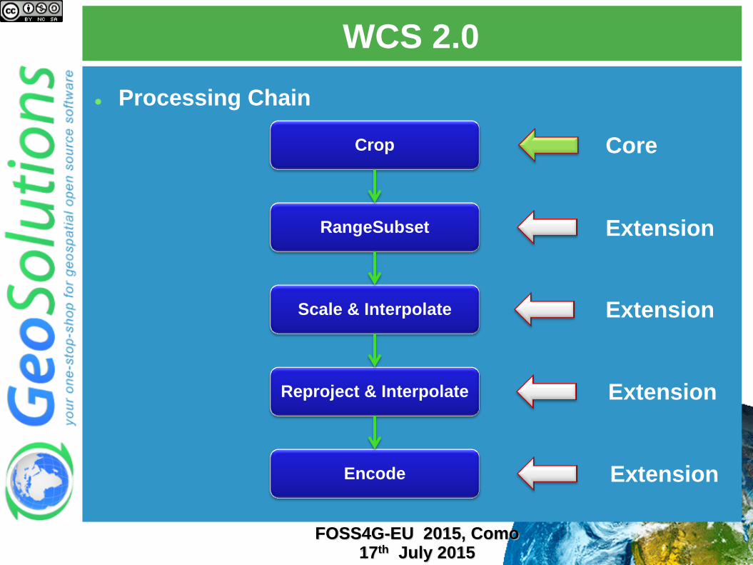
WCS 2.0
Processing Chain
Crop
RangeSubset
Scale & Interpolate
Reproject & Interpolate
Encode
Core
Extension
Extension
Extension
Extension
FOSS4G-EU 2015, Como 17th July 2015
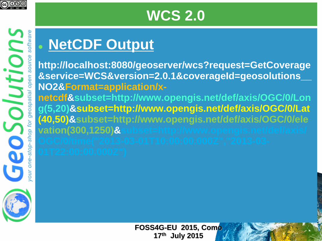
WCS 2.0
NetCDF Output
http://localhost:8080/geoserver/wcs?request=GetCoverage&service=WCS&version=2.0.1&coverageId=geosolutions__NO2&Format=application/x-netcdf&subset=http://www.opengis.net/def/axis/OGC/0/Long(5,20)&subset=http://www.opengis.net/def/axis/OGC/0/Lat(40,50)&subset=http://www.opengis.net/def/axis/OGC/0/elevation(300,1250)&subset=http://www.opengis.net/def/axis/OGC/0/time("2013-03-01T10:00:00.000Z","2013-03-01T22:00:00.000Z")
FOSS4G-EU 2015, Como 17th July 2015
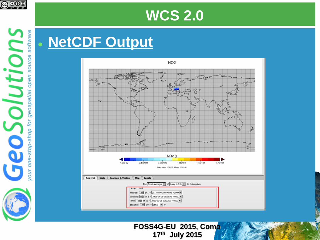
WCS 2.0
NetCDF Output
FOSS4G-EU 2015, Como 17th July 2015
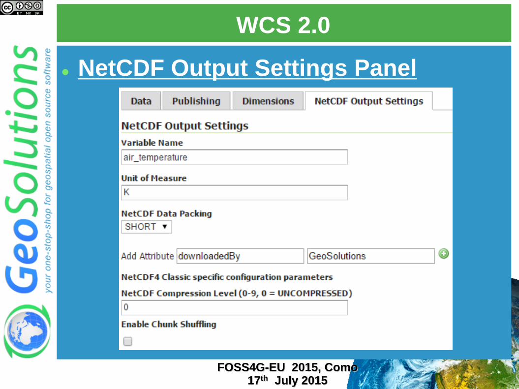
WCS 2.0
NetCDF Output Settings Panel
FOSS4G-EU 2015, Como 17th July 2015
WCS-EO
Build on top of a working WCS 2.0 with full extensions
WCS 2.0
CRS extension
Range subsetting extension
Interpolation extension
Scaling extension
GeoTiff extension
NetCDF extension
Add support for the WCS-EO extras
Listing coverage datasets in the capabilities documents (based on image mosaic contents, which will have to be marked as “exposed” so that we show their inner structure for EO)
Support describe coverage dataset
Support returning results for an entire dataset in GetCoverage
FOSS4G-EU 2015, Como 17th July 2015
WCS-EO
Add support for downloading the original file in case of no subsetting/reprojection/scaling/format change
Add support to GeoTools readers to signal they are returning us an original file
Use that information to download the original file directly
Add support for WCS EO metadata in readers
Associate each file with EO metadata
Include such information in DescribeCoverage/DescribeEODataset
FOSS4G-EU 2015, Como 17th July 2015
Use Cases
FOSS4G-EU 2015, Como 17th July 2015
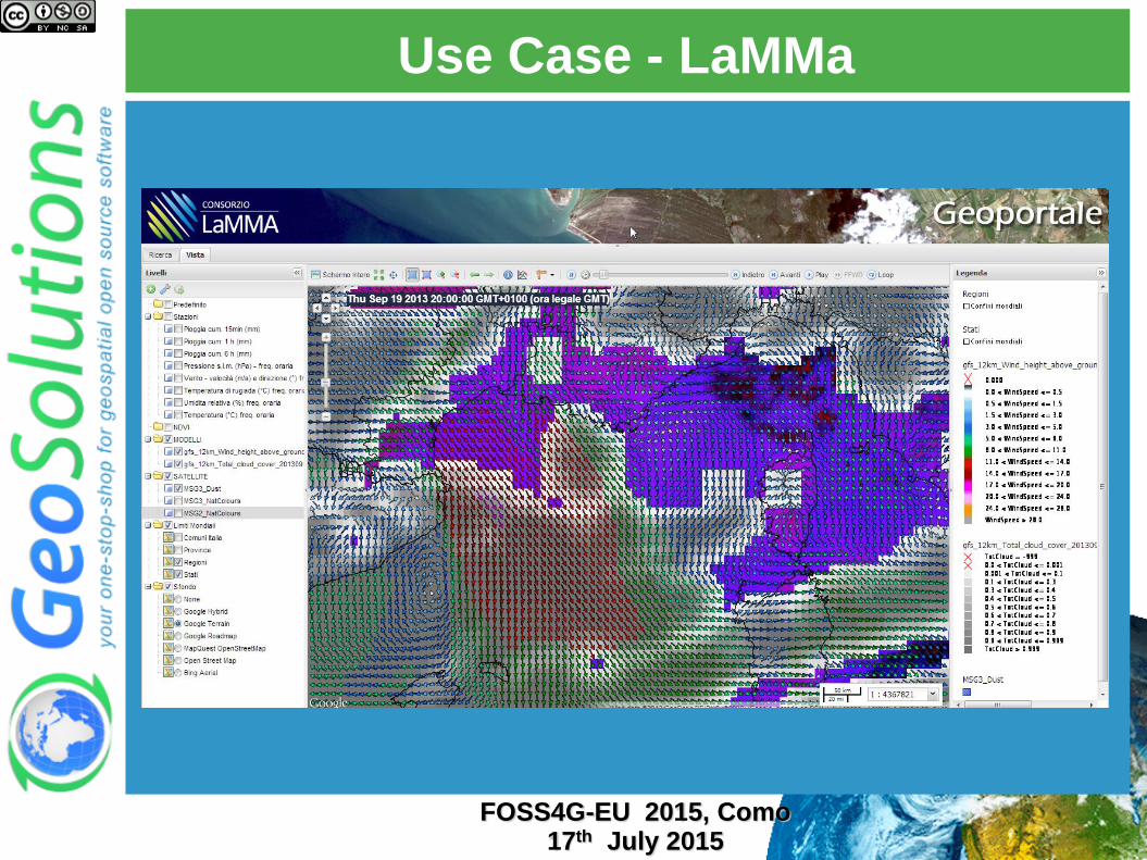
Use Case - LaMMa
FOSS4G-EU 2015, Como 17th July 2015
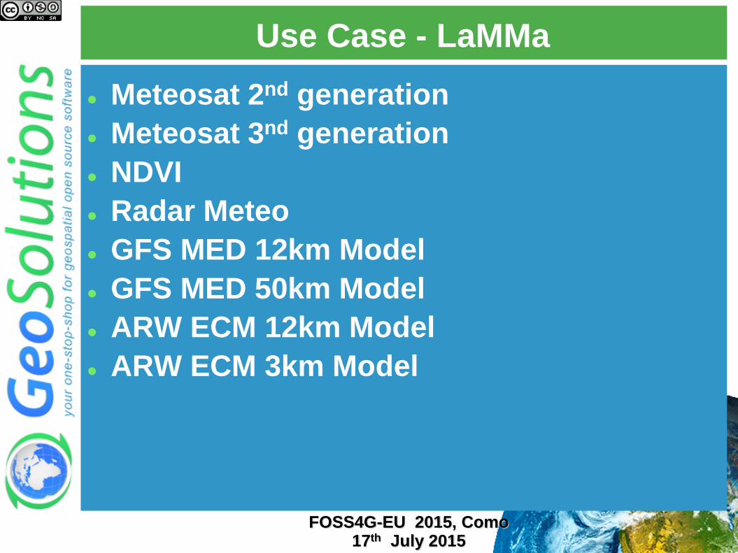
Use Case - LaMMa
Meteosat 2nd generation
Meteosat 3nd generation
NDVI
Radar Meteo
GFS MED 12km Model
GFS MED 50km Model
ARW ECM 12km Model
ARW ECM 3km Model
FOSS4G-EU 2015, Como 17th July 2015
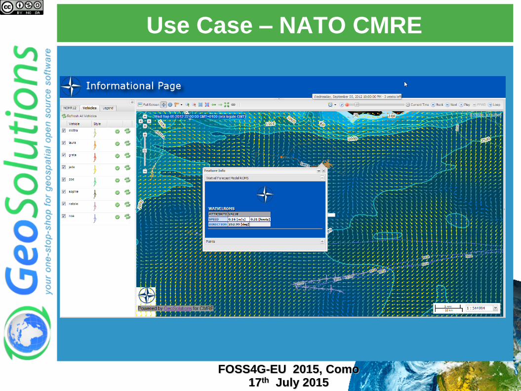
Use Case – NATO CMRE
FOSS4G-EU 2015, Como 17th July 2015
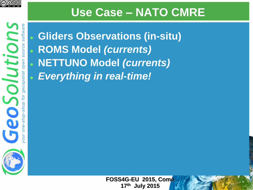
Use Case – NATO CMRE
Gliders Observations (in-situ)
ROMS Model (currents)
NETTUNO Model (currents)
Everything in real-time!
FOSS4G-EU 2015, Como 17th July 2015
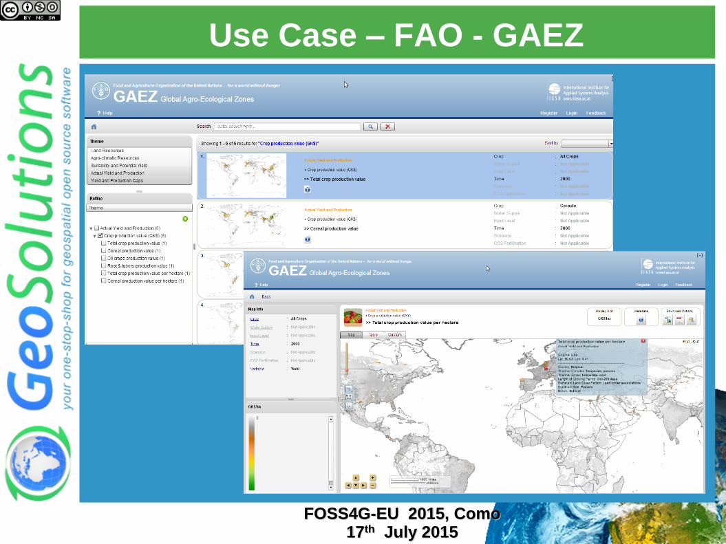
Use Case – FAO - GAEZ
FOSS4G-EU 2015, Como 17th July 2015
Use Case – FAO - GAEZ
Multidimensional Mosaic
50 Years of data
Soil
Water
Land Cover
Protected Areas
A few Mosaic Layer with dimensions rather than 100k layers
Search Engine for on-the-fly filtering of Mosaic Layers
FOSS4G-EU 2015, Como 17th July 2015
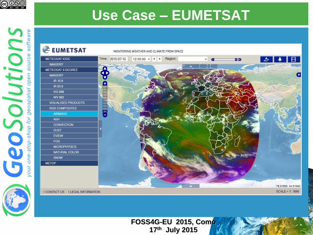
Use Case – EUMETSAT
FOSS4G-EU 2015, Como 17th July 2015
Use Case – EUMETSAT
Meteosat Second Generation (MSG)
Data from SEVIRI instrument
IR Channels
Visible Channels
WaterVapour Channels
RGB composites (Airmass, dust, fog, snow, natural color, …)
Weather and Climate applications
FOSS4G-EU 2015, Como 17th July 2015