Embed Size (px)
Citation preview
GEORGIA AVIATION SYSTEM PLAN
EXECUTIVE SUMMARY
Last Updated Summer 2003

AcknowledgmentThis document was produced under the auspices of the
GEORGIA DEPARTMENT OF TRANSPORTATION
J. Tom Coleman, Jr., Commissioner
OFFICE OF INTERMODAL PROGRAMS
Hal Wilson, Administrator
AVIATION PROGRAMS
Edward S. Ratigan, Manager
GEORGIA AVIATION SYSTEM PLAN UPDATE
Thomas B. Carr, Jr., Project Manager
STATE TRANSPORTATION BOARD
7th District – Steve Reynolds8th District – Sam Wellborn9th District – Jimmy Lester10thDistrict – Mike Evans11thDistrict – David Doss12thDistrict – Jon Burns13thDistrict – Dana L. Lemon
1st District – Harry Dixon2nd District – W. P. “Billy” Langdale3rd District – Ward Edwards4th District – Brad Hubbert5th District – Emory C. McClinton6th District – Johnny Gresham

Georgia is served by one of the most comprehensive and progressive aviation systems in the United
States. To prepare a long-term plan to guide the development of this aviation system, it was necessary
to follow an approach that will keep Georgia airports at the forefront of aviation.
In late 2001, Aviation Programs, Georgia Department of Transportation, began an update to its
statewide aviation system plan. It had been almost 10 years since the Georgia Aviation System Plan
had last been updated. This document is a summary of the technical report that was prepared to
document the System Plan.
The update to the Georgia Aviation System Plan contained four components:
• THE SYSTEM PLAN
• AN AIR SERVICE/PASSENGER DEMAND ANALYSIS
• A PAVEMENT MANAGEMENT STUDY
• AN AVIATION TAX REVENUE STUDY
More information on any of these studies can be obtained from Aviation Programs, Georgia
Department of Transportation.
Georgia’s aviation demand is served by a diverse mixture of airports ranging in size from small
general aviation airports to Hartsfield Atlanta International, the nation’s busiest commercial airport.
The Georgia Aviation System is made up of 103 public use airports conveniently located to meet a
full range of commercial, business, personal, recreational, and training activities.
To identify the development needs of Georgia airports, Aviation Programs took a strategic approach
to planning for the future aviation system. The approach to the Georgia Aviation System Plan was
performance-based, enabling Aviation Programs to determine how the airport system is currently
performing, to set objectives for its future performance, and to determine the actions necessary to
direct the airport system toward established goals.
G E O R G I A E X E C U T I V E S U M M A R Y 1
Introduction
This executive summary highlights the findings from the Georgia Aviation System Plan, as well as the Air Service/Passenger Demand Analysis. A separate study was conducted to analyze the condition of pavements at all Georgia airports. The Pavement Management Study outlines airport specific actions that are needed to maintain and enhance the condition of runways, taxiways, and apron areas at all system airports. The Aviation Tax Revenue Study estimates total annual aviation related taxes that are collected in Georgia each year. This analysis compares annual aviation related taxes collected to annual funding requests from all airports and to the current annual budget that is available to Aviation Programs. More information on all studies is available from Aviation Programs.

Georgia Aviation System Plan Overview
study process
The System Plan update considered a variety of technical tasks
and analyses that included each of the following:
• Inventory of the State’s existing public use airport system:
The inventory included on-site airport visits and cataloging
each airport’s historic and current facilities and
activity levels.
• Identification of each airport’s functional role within the
system: System leveling or stratification was accomplished
by determining how each airport currently contributes to
meeting Georgia’s air transportation needs and goals.
• Evaluation of each airport’s performance relative to its
functional role or system level: Specific facility and service
objectives were identified for each airport role or level,
and the ability of system airports to comply with
established facility and service objectives was determined.
• Identification of deficiencies in the system: The
performance-based approach to the System Plan update
resulted in the identification of long-range system needs.
• Documentation of specific airport projects: The System
Plan identified specific projects that should be implemented
to allow individual airports to fulfill their functional role and
to increase performance to targeted levels.
• Estimation of development costs: Costs that may be
incurred to enable system airports to comply with
established facility and service objectives and to elevate
the overall performance of the Georgia Aviation System
were estimated as part of the study.
G E O R G I A E X E C U T I V E S U M M A R Y2
Goals
PerformanceMeasures
Target Compliance
Ratings
Inventory
Revenue Study
Forecasts/Capacity
System Adequacy
Options/Costs
Recommendations
Benchmarking
Air ServiceAnalysis
System Role
Pavement Management
Georgia Aviation System Plan Overview
Public Outreach
G E O R G I A E X E C U T I V E S U M M A R Y 3
The purpose of the Georgia Aviation System Plan is to provide
Aviation Programs with a key decision making document and
guidance for:
• Identifying airports and related facilities that are needed to
meet study objectives and to promote aviation in Georgia.
• Determining current deficiencies in the Georgia
Aviation System.
• Recommending facilities and services that are needed
for each airport to comply with its identified system role.
• Identifying areas of Georgia where new, replacement,
or upgraded airport facilities are needed to meet
target performance objectives for operational capacity
and accessibility.
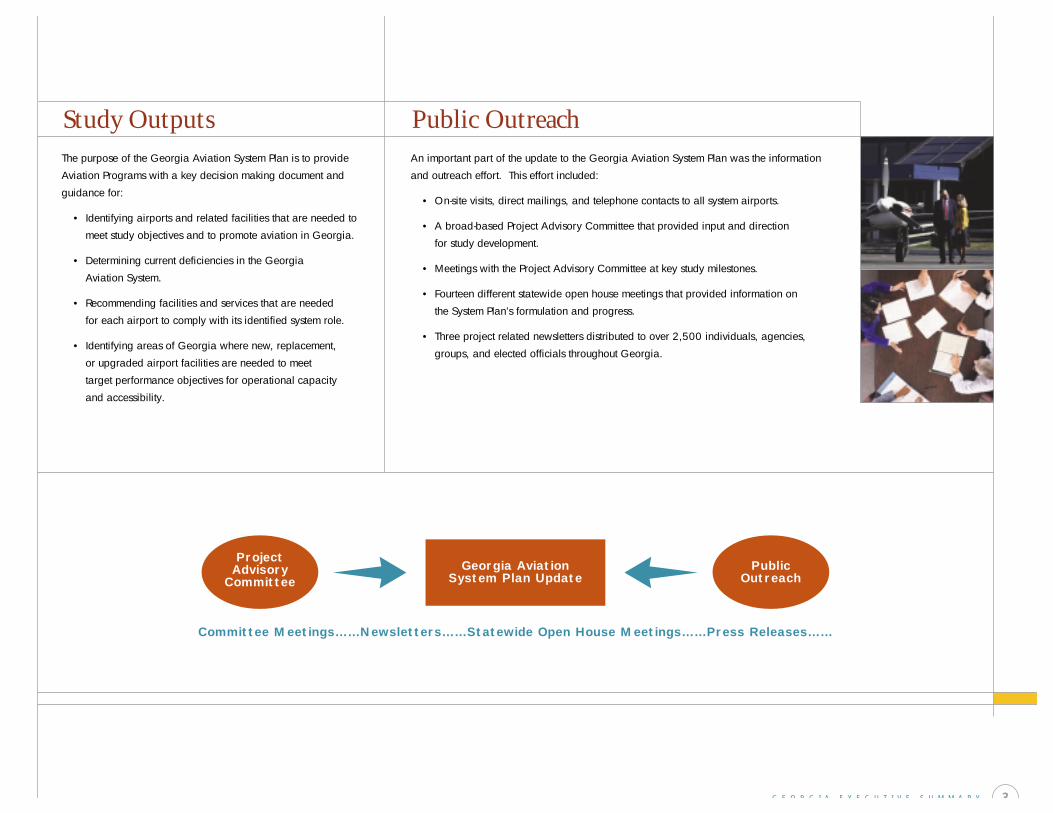
Committee Meetings……Newsletters……Statewide Open House Meetings……Press Releases……
ProjectAdvisory
CommitteePublic
OutreachGeorgia Aviation
System Plan Update
Study OutputsAn important part of the update to the Georgia Aviation System Plan was the information
and outreach effort. This effort included:
• On-site visits, direct mailings, and telephone contacts to all system airports.
• A broad-based Project Advisory Committee that provided input and direction
for study development.
• Meetings with the Project Advisory Committee at key study milestones.
• Fourteen different statewide open house meetings that provided information on
the System Plan’s formulation and progress.
• Three project related newsletters distributed to over 2,500 individuals, agencies,
groups, and elected officials throughout Georgia.
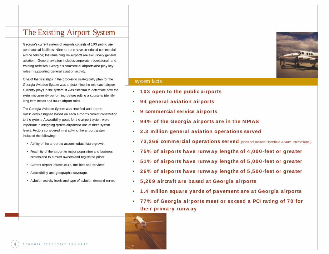
The Existing Airport SystemGeorgia’s current system of airports consists of 103 public use
aeronautical facilities. Nine airports have scheduled commercial
airline service; the remaining 94 airports are exclusively general
aviation. General aviation includes corporate, recreational, and
training activities. Georgia’s commercial airports also play key
roles in supporting general aviation activity.
One of the first steps in the process to strategically plan for the
Georgia Aviation System was to determine the role each airport
currently plays in the system. It was essential to determine how the
system is currently performing before setting a course to identify
long-term needs and future airport roles.
The Georgia Aviation System was stratified and airport
roles/levels assigned based on each airport’s current contribution
to the system. Accessibility goals for the airport system were
important in assigning system airports to one of three system
levels. Factors considered in stratifying the airport system
included the following:
• Ability of the airport to accommodate future growth.
• Proximity of the airport to major population and business
centers and to aircraft owners and registered pilots.
• Current airport infrastructure, facilities and services.
• Accessibility and geographic coverage.
• Aviation activity levels and type of aviation demand served.
G E O R G I A E X E C U T I V E S U M M A R Y4
• 103 open to the public airports
• 94 general aviation airports
• 9 commercial service airports
• 94% of the Georgia airports are in the NPIAS
• 2.3 million general aviation operations served
• 73,266 commercial operations served (does not include Hartsfield Atlanta International)
• 75% of airports have runway lengths of 4,000-feet or greater
• 51% of airports have runway lengths of 5,000-feet or greater
• 26% of airports have runway lengths of 5,500-feet or greater
• 5,209 aircraft are based at Georgia airports
• 1.4 million square yards of pavement are at Georgia airports
• 77% of Georgia airports meet or exceed a PCI rating of 70 for their primary runway
system facts
The Existing Airport System
G E O R G I A E X E C U T I V E S U M M A R Y 5
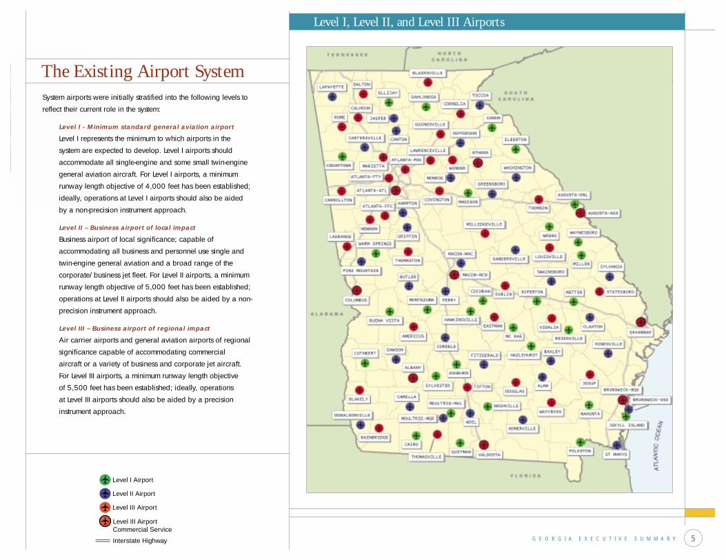
System airports were initially stratified into the following levels to
reflect their current role in the system:
Level I - Minimum standard general aviation airport
Level I represents the minimum to which airports in the
system are expected to develop. Level I airports should
accommodate all single-engine and some small twin-engine
general aviation aircraft. For Level I airports, a minimum
runway length objective of 4,000 feet has been established;
ideally, operations at Level I airports should also be aided
by a non-precision instrument approach.
Level II – Business airport of local impact
Business airport of local significance; capable of
accommodating all business and personnel use single and
twin-engine general aviation and a broad range of the
corporate/business jet fleet. For Level II airports, a minimum
runway length objective of 5,000 feet has been established;
operations at Level II airports should also be aided by a non-
precision instrument approach.
Level III – Business airport of regional impact
Air carrier airports and general aviation airports of regional
significance capable of accommodating commercial
aircraft or a variety of business and corporate jet aircraft.
For Level III airports, a minimum runway length objective
of 5,500 feet has been established; ideally, operations
at Level III airports should also be aided by a precision
instrument approach.
Level I, Level II, and Level III Airports
Interstate Highway
Level III AirportCommercial Service
Level II Airport
Level I Airport
Level III Airport

Facility And Service Objectives
Each Georgia airport contributes to the aviation system by
supporting different types and levels of aviation activity.
The types of facilities and services that should ideally be in
place at airports in each of three functional levels, Level I,
Level II, and Level III, were determined during the development
of the System Plan.
By comparing existing facilities and services to each airport’s
respective facility and service objectives, a report card for each
airport in the system was developed. The results of each airport’s
report card were subsequently used in the System Plan to identify
airport specific recommendations for improvement.
The facility and service objectives identified for Level I, Level II,
and Level III airports should be used as a guide for individual
system airports as they plan future development. Local
circumstances and needs may warrant the development of certain
system airports beyond these minimum objectives.
Airside Facilities Minimum Requirements
Runway Length 4,000 feet
Runway Width 75 feet
Taxiways Full parallel desirable; turnarounds at
each end minimum objective
Lighting Systems MIRL and MITL
Approach Non-Precision
NAVAIDs/Visual Aids Rotating beacon, segmented circle and
wind cone, PAPI’s, and other aids as required
for non-precision approach
Weather Reporting AWOS or ASOS desirable
Ground Communications Public telephone; GCO as needed
Fencing Operations area at a minimum; entire
airport desirable
General Aviation Facilities Minimum Requirements
Hangared Aircraft Storage 60% of based aircraft fleet
Apron Parking/Storage 40% of based aircraft fleet plus an additional
25% for transient aircraft
Terminal/Administration 750 square feet enclosed space for public use
with restrooms
Auto Parking One space for each based aircraft plus an
additional 25% for visitors/employees
Services Minimum Requirements
Fuel AvGas and/or jet fuel as required
FBO Limited Service
LEVEL I – Minimum Standard General Aviation Airport
G E O R G I A E X E C U T I V E S U M M A R Y6
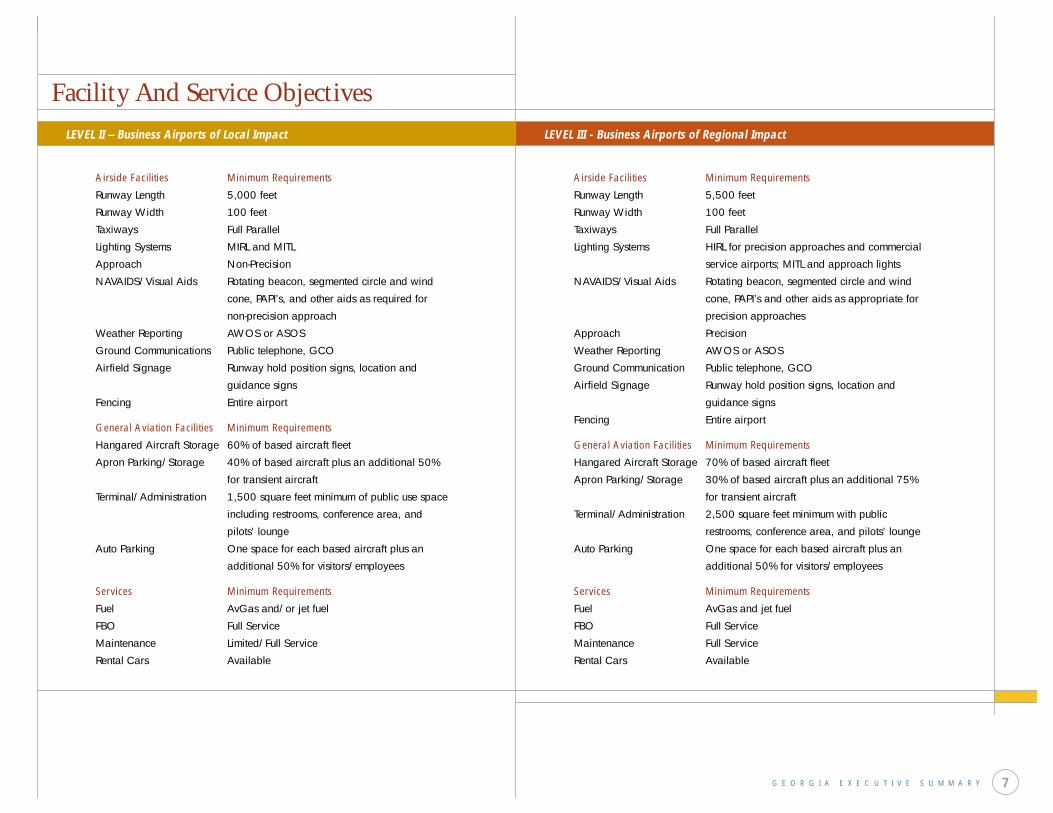
Facility And Service Objectives
Airside Facilities Minimum Requirements
Runway Length 5,000 feet
Runway Width 100 feet
Taxiways Full Parallel
Lighting Systems MIRL and MITL
Approach Non-Precision
NAVAIDS/Visual Aids Rotating beacon, segmented circle and wind
cone, PAPI’s, and other aids as required for
non-precision approach
Weather Reporting AWOS or ASOS
Ground Communications Public telephone, GCO
Airfield Signage Runway hold position signs, location and
guidance signs
Fencing Entire airport
General Aviation Facilities Minimum Requirements
Hangared Aircraft Storage 60% of based aircraft fleet
Apron Parking/Storage 40% of based aircraft plus an additional 50%
for transient aircraft
Terminal/Administration 1,500 square feet minimum of public use space
including restrooms, conference area, and
pilots’ lounge
Auto Parking One space for each based aircraft plus an
additional 50% for visitors/employees
Services Minimum Requirements
Fuel AvGas and/or jet fuel
FBO Full Service
Maintenance Limited/Full Service
Rental Cars Available
LEVEL II – Business Airports of Local Impact
Airside Facilities Minimum Requirements
Runway Length 5,500 feet
Runway Width 100 feet
Taxiways Full Parallel
Lighting Systems HIRL for precision approaches and commercial
service airports; MITL and approach lights
NAVAIDS/Visual Aids Rotating beacon, segmented circle and wind
cone, PAPI’s and other aids as appropriate for
precision approaches
Approach Precision
Weather Reporting AWOS or ASOS
Ground Communication Public telephone, GCO
Airfield Signage Runway hold position signs, location and
guidance signs
Fencing Entire airport
General Aviation Facilities Minimum Requirements
Hangared Aircraft Storage 70% of based aircraft fleet
Apron Parking/Storage 30% of based aircraft plus an additional 75%
for transient aircraft
Terminal/Administration 2,500 square feet minimum with public
restrooms, conference area, and pilots’ lounge
Auto Parking One space for each based aircraft plus an
additional 50% for visitors/employees
Services Minimum Requirements
Fuel AvGas and jet fuel
FBO Full Service
Maintenance Full Service
Rental Cars Available
LEVEL III - Business Airports of Regional Impact
G E O R G I A E X E C U T I V E S U M M A R Y 7

ForecastsDeveloping aviation activity projections for Georgia airports
was necessary to assess the need for and phasing of future
system improvements. Demand projections provide a foundation
for determining the future role of system airports, for evaluating
the system’s capacity to accommodate long-term aviation
demand, and for planning future airside and landside facilities
for the system.
The forecasts developed from the System Plan yielded
the following:
• Due to expected increases in population and employment,
based aircraft at Georgia’s public airports are predicted to
increase from 5,209 to 6,571 by 2021.
• Statewide general aviation operations are projected to reach
2.9 million annually in 2021, up from 2.3 million currently.
• Commercial enplanements at all commercial airports,
excluding Hartsfield Atlanta International, are projected to
grow from their current level of 1.3 million to 2.4 million
by 2021.
• Operations by commercial carriers, excluding those at
Hartsfield Atlanta International, are anticipated to grow
from 73,266 to 101,250 by 2021.
These projections were developed based on activity levels
reported by system airports at the time the inventory element of
the System Plan was completed.
G E O R G I A E X E C U T I V E S U M M A R Y8
system based aircraft
total annual general aviation operations
total annual commercial enplanements
0 1000 2000 3000 4000 5000 6000 7000 8000
2006
2011
2021
5,880
6,571
5,560
2006
2011
2021
2,571,506
2,884,862
2,429,781
0.0 0.5 1.0 1.5 2.0 2.5 3.0
0.0 0.5 1.0 1.5 2.0 2.5
2006
2011
2021
1,696,528
2,448,171
1,456,634
Source: Georgia Aviation System Plan 2002
System Goals
G E O R G I A E X E C U T I V E S U M M A R Y 9
Targets for future system performance provided the foundation for subsequent system
recommendations. These recommendations are summarized in the following sections.
The FAA has determined that as an airport’s annual operational demand reaches 60 percent or
more of the airport’s calculated airfield operating capacity, delays to aircraft on the ground and
in the air begin to increase. As annual demand exceeds or equals 80 percent of an airport’s
operational capacity, delays can increase dramatically.
Statewide, sufficient operational capacity exists to meet Georgia’s projected operational
demand. Systemwide, only 6 percent of all airports will have demand/capacity ratios that
approach the FAA’s critical demand/capacity trigger point of 60 percent.
Goal Performance Measure
To provide an airport system that can Capacitysupport current and future demand.
To provide an airport system that Standardsmeets applicable design standards.
To provide an airport system that can Flexibilityrespond to foreseen and unforeseen changes.
To provide an airport system that is Accessibility accessible from both the air and the ground.
To provide an airport system that meets Facilitiesestablished facility and service objectives.
Goals for the Georgia Aviation System and their performance measures
statewide demand/capacity ratios
Savannah International Airport, DeKalb-Peachtree Airport, Fulton County-Brown Field,
Cobb County-McCollum Field, Gwinnett County Airport-Briscoe Field and Winder-Barrow
Airport will approach or exceed the 60 percent demand/capacity threshold by 2021.
Demand/capacity ratios and potential shortfalls discussed in this section do not include
those projected for Hartsfield Atlanta International Airport.
These airports are located in Georgia’s two most densely populated urban areas, Savannah
and Atlanta. The System Plan supports efforts that may be underway locally to increase
operational capacity at these airports, but these efforts alone will not yield sufficient
operating capacity for these two metropolitan areas.
A demand management strategy which relies on under utilized capacity at existing airports,
combined with additional operational capacity provided by new system airports, is
recommended to meet the System Plan target for all Georgia airports to operate at a
demand/capacity ratio of less than 60 percent.
Performance Measure: Capacity
20%
25%{LEVEL III
10%
12%
15%
19%
0 5 10 15 20 25 30
{LEVEL II2001
2021
2001
2021
2001
2021
2001
2021
9%
10%{LEVEL I
{TOTAL SYSTEM
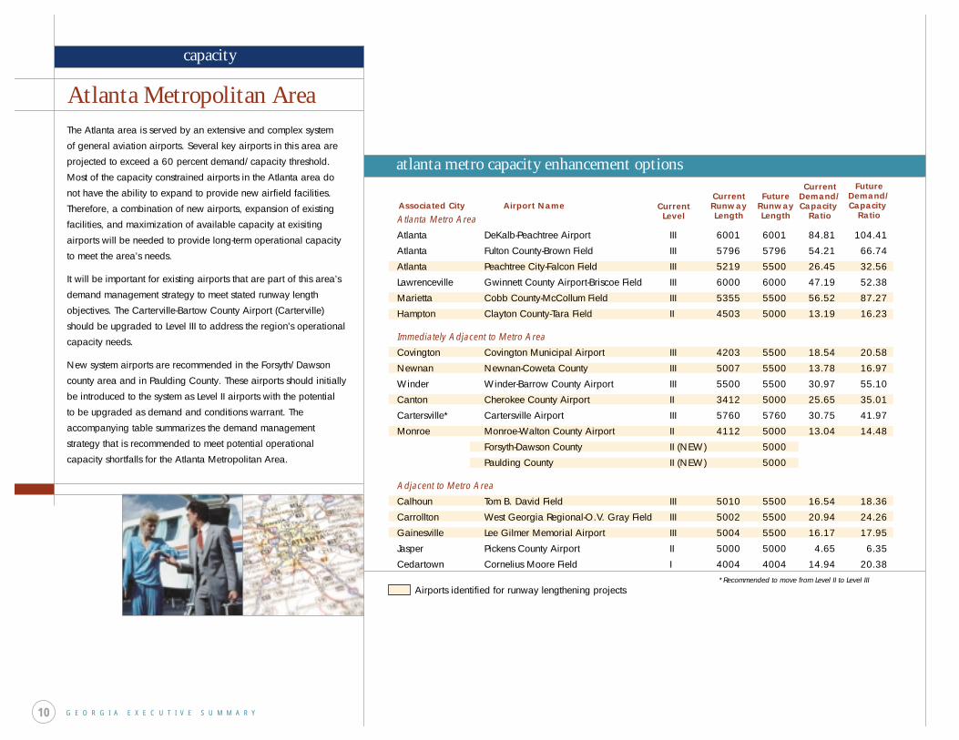
Atlanta Metro Area
Atlanta DeKalb-Peachtree Airport III 6001 6001 84.81 104.41
Atlanta Fulton County-Brown Field III 5796 5796 54.21 66.74
Atlanta Peachtree City-Falcon Field III 5219 5500 26.45 32.56
Lawrenceville Gwinnett County Airport-Briscoe Field III 6000 6000 47.19 52.38
Marietta Cobb County-McCollum Field III 5355 5500 56.52 87.27
Hampton Clayton County-Tara Field II 4503 5000 13.19 16.23
Immediately Adjacent to Metro Area
Covington Covington Municipal Airport III 4203 5500 18.54 20.58
Newnan Newnan-Coweta County III 5007 5500 13.78 16.97
Winder Winder-Barrow County Airport III 5500 5500 30.97 55.10
Canton Cherokee County Airport II 3412 5000 25.65 35.01
Cartersville* Cartersville Airport III 5760 5760 30.75 41.97
Monroe Monroe-Walton County Airport II 4112 5000 13.04 14.48
Forsyth-Dawson County II (NEW) 5000
Paulding County II (NEW) 5000
Adjacent to Metro Area
Calhoun Tom B. David Field III 5010 5500 16.54 18.36
Carrollton West Georgia Regional-O.V. Gray Field III 5002 5500 20.94 24.26
Gainesville Lee Gilmer Memorial Airport III 5004 5500 16.17 17.95
Jasper Pickens County Airport II 5000 5000 4.65 6.35
Cedartown Cornelius Moore Field I 4004 4004 14.94 20.38
Atlanta Metropolitan AreaThe Atlanta area is served by an extensive and complex system
of general aviation airports. Several key airports in this area are
projected to exceed a 60 percent demand/capacity threshold.
Most of the capacity constrained airports in the Atlanta area do
not have the ability to expand to provide new airfield facilities.
Therefore, a combination of new airports, expansion of existing
facilities, and maximization of available capacity at exisiting
airports will be needed to provide long-term operational capacity
to meet the area’s needs.
It will be important for existing airports that are part of this area’s
demand management strategy to meet stated runway length
objectives. The Carterville-Bartow County Airport (Carterville)
should be upgraded to Level III to address the region’s operational
capacity needs.
New system airports are recommended in the Forsyth/Dawson
county area and in Paulding County. These airports should initially
be introduced to the system as Level II airports with the potential
to be upgraded as demand and conditions warrant. The
accompanying table summarizes the demand management
strategy that is recommended to meet potential operational
capacity shortfalls for the Atlanta Metropolitan Area.
G E O R G I A E X E C U T I V E S U M M A R Y10
atlanta metro capacity enhancement options
capacity
*Recommended to move from Level II to Level III
Associated City Airport Name CurrentLevel
CurrentRunwayLength
FutureRunwayLength
CurrentDemand/Capacity
Ratio
FutureDemand/Capacity
Ratio
Airports identified for runway lengthening projects
G E O R G I A E X E C U T I V E S U M M A R Y 11
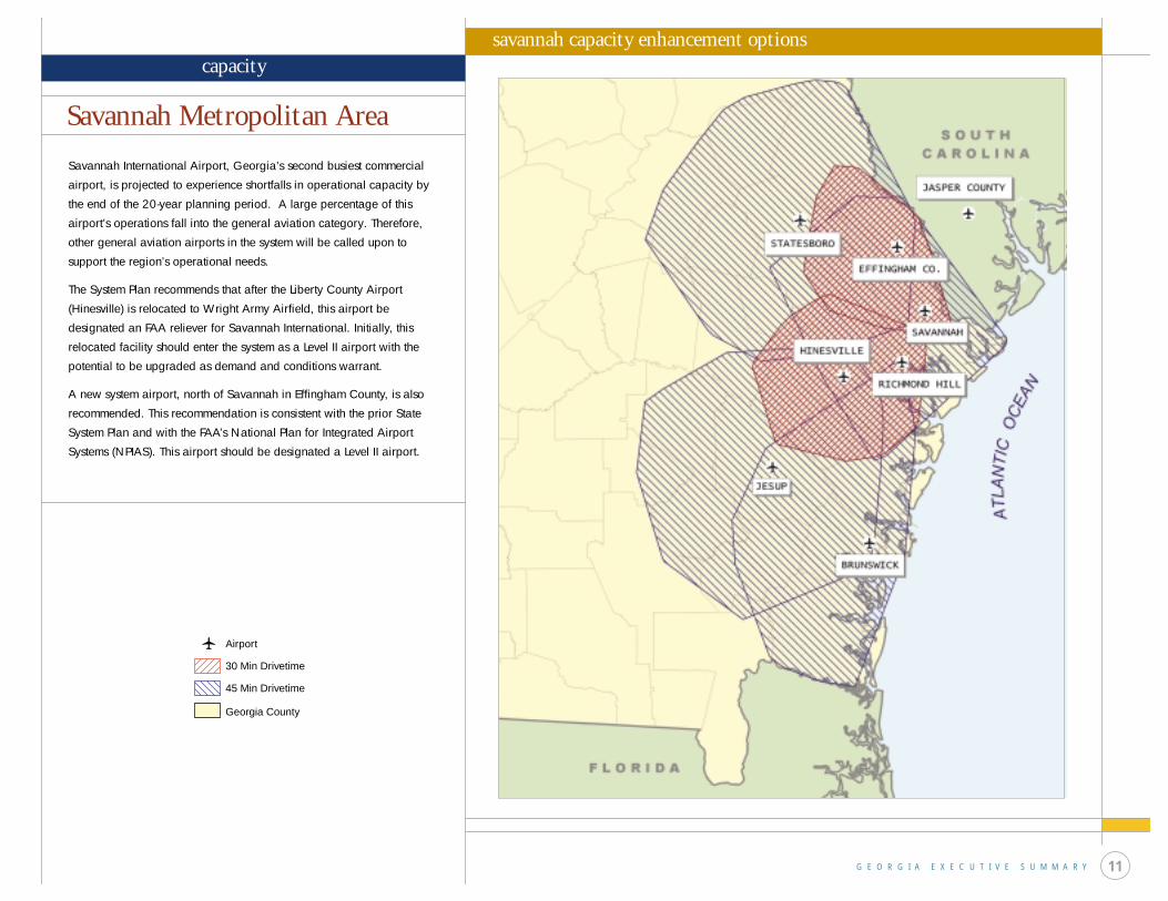
Savannah International Airport, Georgia’s second busiest commercial
airport, is projected to experience shortfalls in operational capacity by
the end of the 20-year planning period. A large percentage of this
airport’s operations fall into the general aviation category. Therefore,
other general aviation airports in the system will be called upon to
support the region’s operational needs.
The System Plan recommends that after the Liberty County Airport
(Hinesville) is relocated to Wright Army Airfield, this airport be
designated an FAA reliever for Savannah International. Initially, this
relocated facility should enter the system as a Level II airport with the
potential to be upgraded as demand and conditions warrant.
A new system airport, north of Savannah in Effingham County, is also
recommended. This recommendation is consistent with the prior State
System Plan and with the FAA’s National Plan for Integrated Airport
Systems (NPIAS). This airport should be designated a Level II airport.
Savannah Metropolitan Area
savannah capacity enhancement optionscapacity
30 Min Drivetime
Airport
45 Min Drivetime
Georgia County
G E O R G I A E X E C U T I V E S U M M A R Y12
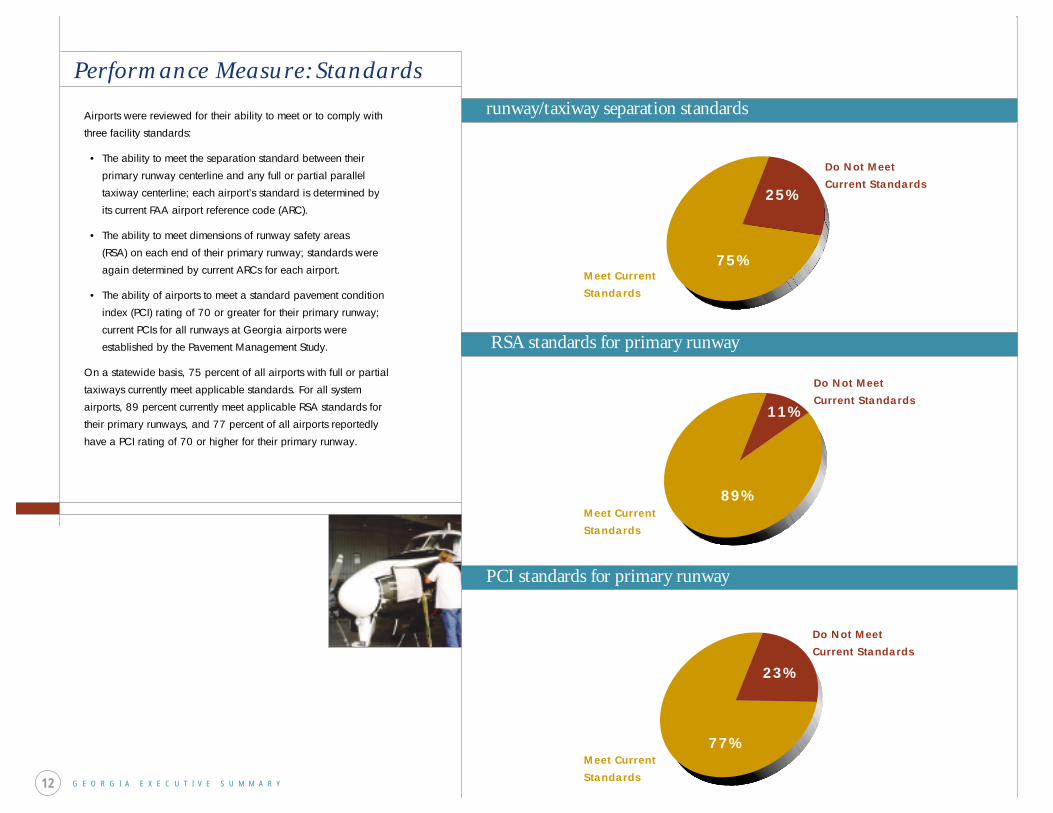
Performance Measure: Standards
Airports were reviewed for their ability to meet or to comply with
three facility standards:
• The ability to meet the separation standard between their
primary runway centerline and any full or partial parallel
taxiway centerline; each airport’s standard is determined by
its current FAA airport reference code (ARC).
• The ability to meet dimensions of runway safety areas
(RSA) on each end of their primary runway; standards were
again determined by current ARCs for each airport.
• The ability of airports to meet a standard pavement condition
index (PCI) rating of 70 or greater for their primary runway;
current PCIs for all runways at Georgia airports were
established by the Pavement Management Study.
On a statewide basis, 75 percent of all airports with full or partial
taxiways currently meet applicable standards. For all system
airports, 89 percent currently meet applicable RSA standards for
their primary runways, and 77 percent of all airports reportedly
have a PCI rating of 70 or higher for their primary runway.
runway/taxiway separation standards
RSA standards for primary runway
PCI standards for primary runway
Do Not Meet Current Standards
Do Not Meet Current Standards
Do Not Meet Current Standards
Meet Current Standards
Meet Current Standards
Meet Current Standards
25%
11%
75%
89%
23%
77%
G E O R G I A E X E C U T I V E S U M M A R Y 13
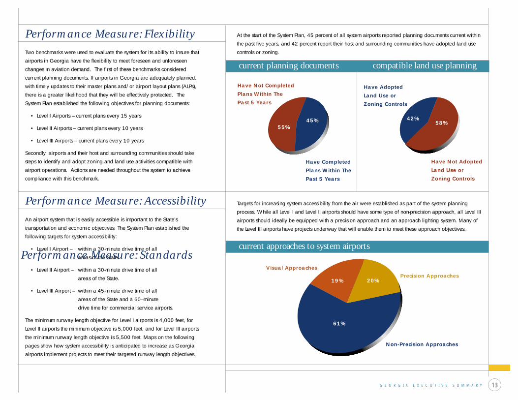
Performance Measure: Flexibility
Two benchmarks were used to evaluate the system for its ability to insure that
airports in Georgia have the flexibility to meet foreseen and unforeseen
changes in aviation demand. The first of these benchmarks considered
current planning documents. If airports in Georgia are adequately planned,
with timely updates to their master plans and/or airport layout plans (ALPs),
there is a greater likelihood that they will be effectively protected. The
System Plan established the following objectives for planning documents:
• Level I Airports – current plans every 15 years
• Level II Airports – current plans every 10 years
• Level III Airports – current plans every 10 years
Secondly, airports and their host and surrounding communities should take
steps to identify and adopt zoning and land use activities compatible with
airport operations. Actions are needed throughout the system to achieve
compliance with this benchmark.
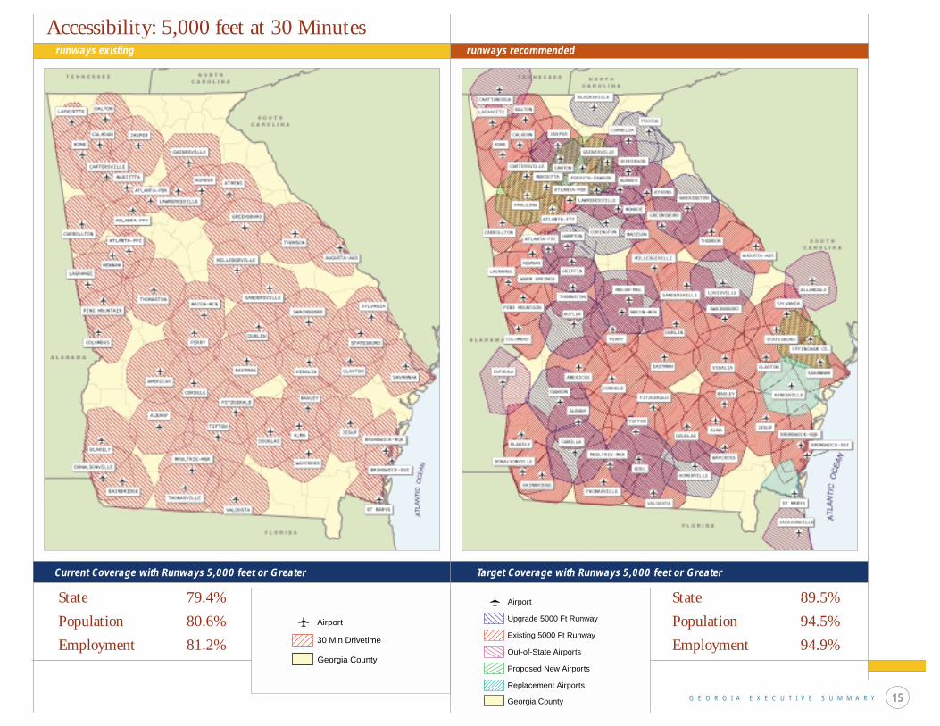
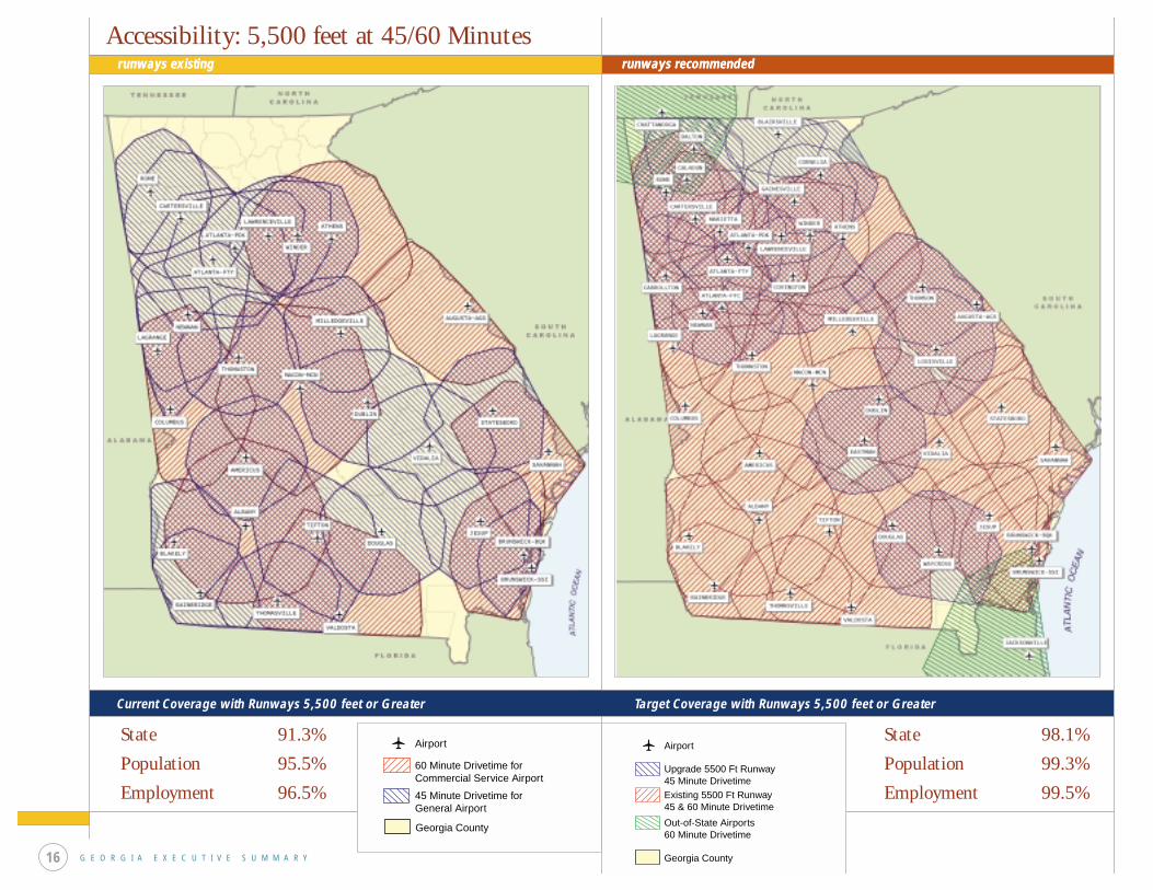
Performance Measure: Accessibility
An airport system that is easily accessible is important to the State’s
transportation and economic objectives. The System Plan established the
following targets for system accessibility:
• Level I Airport – within a 30-minute drive time of all
areas of the State.
• Level II Airport – within a 30-minute drive time of all
areas of the State.
• Level III Airport – within a 45-minute drive time of all
areas of the State and a 60–minute
drive time for commercial service airports.
The minimum runway length objective for Level I airports is 4,000 feet, for
Level II airports the minimum objective is 5,000 feet, and for Level III airports
the minimum runway length objective is 5,500 feet. Maps on the following
pages show how system accessibility is anticipated to increase as Georgia
airports implement projects to meet their targeted runway length objectives.
current planning documents
current approaches to system airports
compatible land use planning
Have Completed Plans Within The Past 5 Years
Have Not Completed Plans Within The Past 5 Years
Have Not Adopted Land Use or Zoning Controls
Have Adopted Land Use or Zoning Controls
45%55%
58%42%
20%19%
61%
Visual Approaches
Non-Precision Approaches
Precision Approaches
At the start of the System Plan, 45 percent of all system airports reported planning documents current within
the past five years, and 42 percent report their host and surrounding communities have adopted land use
controls or zoning.
Targets for increasing system accessibility from the air were established as part of the system planning
process. While all Level I and Level II airports should have some type of non-precision approach, all Level III
airports should ideally be equipped with a precision approach and an approach lighting system. Many of
the Level III airports have projects underway that will enable them to meet these approach objectives.
Performance Measure: Standards
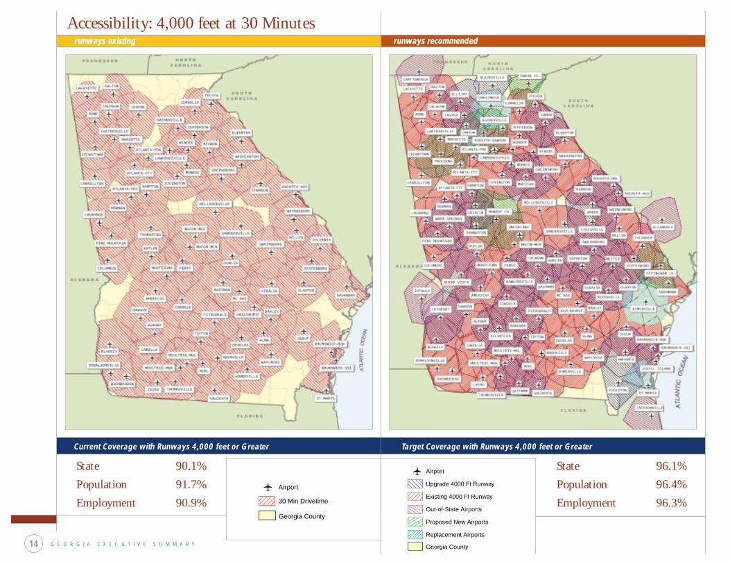
State 90.1%
Population 91.7%
Employment 90.9%
Accessibility: 4,000 feet at 30 Minutes
Upgrade 4000 Ft Runway
Airport
Existing 4000 Ft Runway
Out-of-State Airports
Proposed New Airports
Replacement Airports
Georgia County
30 Min Drivetime
Airport
Georgia County
G E O R G I A E X E C U T I V E S U M M A R Y14
runways existing runways recommendedrunways existing runways recommended
Current Coverage with Runways 4,000 feet or Greater
State 96.1%
Population 96.4%
Employment 96.3%
Target Coverage with Runways 4,000 feet or Greater
State 79.4%
Population 80.6%
Employment 81.2%
State 89.5%
Population 94.5%
Employment 94.9%
Accessibility: 5,000 feet at 30 Minutes
G E O R G I A E X E C U T I V E S U M M A R Y 15
runways existing runways recommended
Target Coverage with Runways 5,000 feet or Greater
Upgrade 5000 Ft Runway
Airport
Existing 5000 Ft Runway
Out-of-State Airports
Proposed New Airports
Replacement Airports
Georgia County
30 Min Drivetime
Airport
Georgia County
Current Coverage with Runways 5,000 feet or Greater
State 91.3%
Population 95.5%
Employment 96.5%
State 98.1%
Population 99.3%
Employment 99.5%
Current Coverage with Runways 5,500 feet or Greater Target Coverage with Runways 5,500 feet or Greater
Accessibility: 5,500 feet at 45/60 Minutes
Upgrade 5500 Ft Runway45 Minute Drivetime
Airport
Existing 5500 Ft Runway45 & 60 Minute Drivetime
Out-of-State Airports60 Minute Drivetime
Georgia County
60 Minute Drivetime forCommercial Service Airport
Airport
45 Minute Drivetime forGeneral Airport
Georgia County
G E O R G I A E X E C U T I V E S U M M A R Y16
runways existing runways recommendedrunways existing runways recommended

G E O R G I A E X E C U T I V E S U M M A R Y 17
Level I Airports
Level II Airports
Level III Airports
Airports in Georgia perform separate and distinct roles, serving
varying types of aviation demand and activity. The types of
facilities and services that are appropriate at each airport also
vary accordingly, and the System Plan has identified specific
facilities and services desirable for each airport.
Actions required to bring each airport into compliance with its
respective facility and service objectives are available from
Aviation Programs and have been distributed directly to each
system airport as part of this plan. The accompanying airport
facility and service graphs show the improvements needed to
make all system airports compliant with established facility and
service objectives.
current facility and service objective results
0% 20% 40% 60% 80% 100%
Fuel
Runway Length
Runway Width
Taxiway Design
Runway Lighting
Taxiway Lighting
NAVAIDS
Approach
GCO/Phone
Hangar Storage
Apron
Terminal/Admin
Auto Parking
FBO
33%
60%
73%
23%
43%
43%
43%
70%
70%
63%
17%
57%
43%
23%
67%
40%
77%
27%
57%
57%
57%
30%
30%
37%
83%
43%
57%
77%
Complies Does not Comply
Performance Measure: Facilities and Services current facility and service objective results
0% 20% 40% 60% 80% 100%
Runway Length
Runway Width
Taxiway Design
Runway Lighting
Taxiway Lighting
NAVAIDS
Approach
GCO/Phone
Weather Reporting
Hangar Storage
Apron Parking
Terminal/Admin
Auto Parking
Fuel
FBO
Maintenance
Rental Car
56%
47%
19%
72%
84%
88%
91%
53%
75%
38%
28%
28%
91%
81%
75%
31%
94%
44%
53%
81%
6%
28%
16%
12%
9%
47%
25%
62%
72%
72%
9%
19%
25%
69%
Complies
Does not Comply
Complies
Does not Comply
Funds are committed and project is pending/on-going
0% 20% 40% 60% 80% 100%
Runway Length
Runway Width
Taxiway Design
Runway Lighting
Taxiway Lighting
NAVAIDS
ALS
Approach
GCO/Phone
Weather Reporting
Hangar Storage
Apron Parking
Terminal/Admin
Auto Parking
Fuel
FBO
Maintenance
Rental Car
67%
77%
70%
78%
87%
93%
80%
95%
98%
85%
55%
25%
72%
30%
98%
93%
85%
80%
25%
10%
15%
2%
8%
8%
13%
15%
22%
13%
7%
20%
5%
7%
45%
75%
28%
70%
2%
7%
15%
20%
current facility and service objective results
Future Aviation System
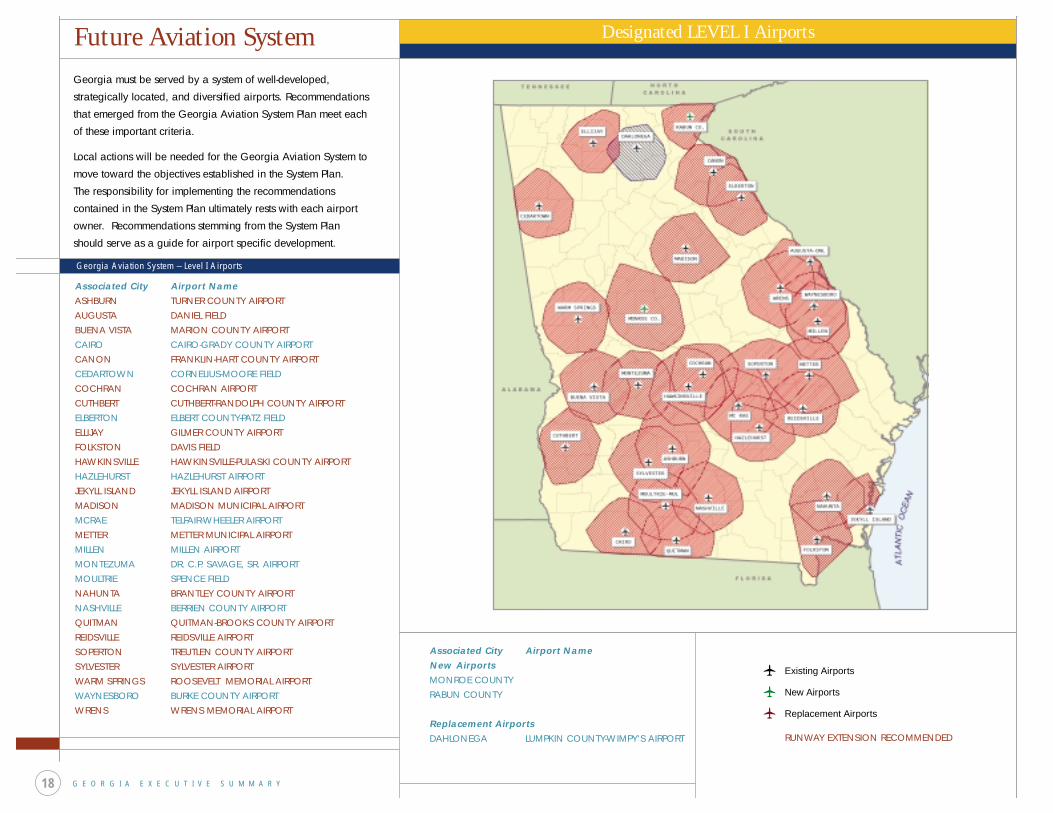
G E O R G I A E X E C U T I V E S U M M A R Y18
Designated LEVEL I Airports
Georgia must be served by a system of well-developed,
strategically located, and diversified airports. Recommendations
that emerged from the Georgia Aviation System Plan meet each
of these important criteria.
Local actions will be needed for the Georgia Aviation System to
move toward the objectives established in the System Plan.
The responsibility for implementing the recommendations
contained in the System Plan ultimately rests with each airport
owner. Recommendations stemming from the System Plan
should serve as a guide for airport specific development.
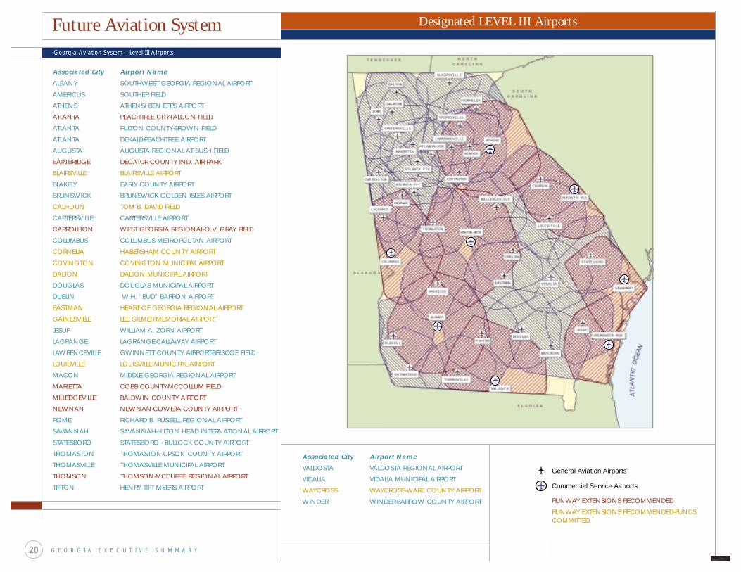
Georgia Aviation System – Level I Airports
Associated City Airport NameASHBURN TURNER COUNTY AIRPORTAUGUSTA DANIEL FIELDBUENA VISTA MARION COUNTY AIRPORTCAIRO CAIRO-GRADY COUNTY AIRPORTCANON FRANKLIN-HART COUNTY AIRPORTCEDARTOWN CORNELIUS-MOORE FIELDCOCHRAN COCHRAN AIRPORTCUTHBERT CUTHBERT-RANDOLPH COUNTY AIRPORTELBERTON ELBERT COUNTY-PATZ FIELDELLIJAY GILMER COUNTY AIRPORTFOLKSTON DAVIS FIELDHAWKINSVILLE HAWKINSVILLE-PULASKI COUNTY AIRPORTHAZLEHURST HAZLEHURST AIRPORTJEKYLL ISLAND JEKYLL ISLAND AIRPORTMADISON MADISON MUNICIPAL AIRPORTMCRAE TELFAIR-WHEELER AIRPORTMETTER METTER MUNICIPAL AIRPORTMILLEN MILLEN AIRPORTMONTEZUMA DR. C.P. SAVAGE, SR. AIRPORTMOULTRIE SPENCE FIELDNAHUNTA BRANTLEY COUNTY AIRPORTNASHVILLE BERRIEN COUNTY AIRPORTQUITMAN QUITMAN-BROOKS COUNTY AIRPORTREIDSVILLE REIDSVILLE AIRPORTSOPERTON TREUTLEN COUNTY AIRPORTSYLVESTER SYLVESTER AIRPORTWARM SPRINGS ROOSEVELT MEMORIAL AIRPORTWAYNESBORO BURKE COUNTY AIRPORTWRENS WRENS MEMORIAL AIRPORT
Associated City Airport NameNew Airports MONROE COUNTY RABUN COUNTY Replacement Airports DAHLONEGA LUMPKIN COUNTY-WIMPY'S AIRPORT
Existing Airports
New Airports
Replacement Airports
RUNWAY EXTENSION RECOMMENDED
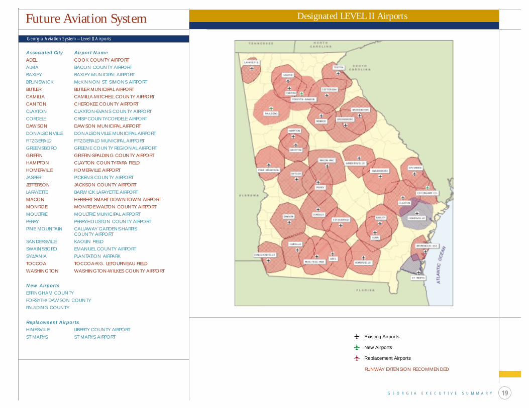
Georgia Aviation System – Level II Airports
G E O R G I A E X E C U T I V E S U M M A R Y 19
Designated LEVEL II Airports
Associated City Airport NameADEL COOK COUNTY AIRPORTALMA BACON COUNTY AIRPORTBAXLEY BAXLEY MUNICIPAL AIRPORTBRUNSWICK McKINNON ST. SIMONS AIRPORTBUTLER BUTLER MUNICIPAL AIRPORTCAMILLA CAMILLA-MITCHELL COUNTY AIRPORTCANTON CHEROKEE COUNTY AIRPORTCLAXTON CLAXTON-EVANS COUNTY AIRPORTCORDELE CRISP COUNTY-CORDELE AIRPORTDAWSON DAWSON MUNICIPAL AIRPORTDONALSONVILLE DONALSONVILLE MUNICIPAL AIRPORTFITZGERALD FITZGERALD MUNICIPAL AIRPORTGREENSBORO GREENE COUNTY REGIONAL AIRPORTGRIFFIN GRIFFIN-SPALDING COUNTY AIRPORTHAMPTON CLAYTON COUNTY-TARA FIELDHOMERVILLE HOMERVILLE AIRPORTJASPER PICKENS COUNTY AIRPORTJEFFERSON JACKSON COUNTY AIRPORTLAFAYETTE BARWICK LAFAYETTE AIRPORTMACON HERBERT SMART DOWNTOWN AIRPORTMONROE MONROE-WALTON COUNTY AIRPORTMOULTRIE MOULTRIE MUNICIPAL AIRPORTPERRY PERRY-HOUSTON COUNTY AIRPORTPINE MOUNTAIN CALLAWAY GARDENS-HARRIS
COUNTY AIRPORTSANDERSVILLE KAOLIN FIELDSWAINSBORO EMANUEL COUNTY AIRPORTSYLVANIA PLANTATION AIRPARKTOCCOA TOCCOA-R.G. LETOURNEAU FIELDWASHINGTON WASHINGTON-WILKES COUNTY AIRPORT
New Airports EFFINGHAM COUNTY FORSYTH/DAWSON COUNTY PAULDING COUNTY Replacement Airports HINESVILLE LIBERTY COUNTY AIRPORTST MARYS ST MARYS AIRPORT
Future Aviation System
Existing Airports
New Airports
Replacement Airports
RUNWAY EXTENSION RECOMMENDED
Future Aviation System
G E O R G I A E X E C U T I V E S U M M A R Y20
Associated City Airport Name
ALBANY SOUTHWEST GEORGIA REGIONAL AIRPORT
AMERICUS SOUTHER FIELD
ATHENS ATHENS/BEN EPPS AIRPORT
ATLANTA PEACHTREE CITY-FALCON FIELD
ATLANTA FULTON COUNTY-BROWN FIELD
ATLANTA DEKALB-PEACHTREE AIRPORT
AUGUSTA AUGUSTA REGIONAL AT BUSH FIELD
BAINBRIDGE DECATUR COUNTY IND. AIR PARK
BLAIRSVILLE BLAIRSVILLE AIRPORT
BLAKELY EARLY COUNTY AIRPORT
BRUNSWICK BRUNSWICK GOLDEN ISLES AIRPORT
CALHOUN TOM B. DAVID FIELD
CARTERSVILLE CARTERSVILLE AIRPORT
CARROLLTON WEST GEORGIA REGIONAL-O.V. GRAY FIELD
COLUMBUS COLUMBUS METROPOLITAN AIRPORT
CORNELIA HABERSHAM COUNTY AIRPORT
COVINGTON COVINGTON MUNICIPAL AIRPORT
DALTON DALTON MUNICIPAL AIRPORT
DOUGLAS DOUGLAS MUNICIPAL AIRPORT
DUBLIN W.H. "BUD" BARRON AIRPORT
EASTMAN HEART OF GEORGIA REGIONAL AIRPORT
GAINESVILLE LEE GILMER MEMORIAL AIRPORT
JESUP WILLIAM A. ZORN AIRPORT
LAGRANGE LAGRANGE-CALLAWAY AIRPORT
LAWRENCEVILLE GWINNETT COUNTY AIRPORT-BRISCOE FIELD
LOUISVILLE LOUISVILLE MUNICIPAL AIRPORT
MACON MIDDLE GEORGIA REGIONAL AIRPORT
MARIETTA COBB COUNTY-MCCOLLUM FIELD
MILLEDGEVILLE BALDWIN COUNTY AIRPORT
NEWNAN NEWNAN-COWETA COUNTY AIRPORT
ROME RICHARD B. RUSSELL REGIONAL AIRPORT
SAVANNAH SAVANNAH-HILTON HEAD INTERNATIONAL AIRPORT
STATESBORO STATESBORO - BULLOCK COUNTY AIRPORT
THOMASTON THOMASTON-UPSON COUNTY AIRPORT
THOMASVILLE THOMASVILLE MUNICIPAL AIRPORT
THOMSON THOMSON-MCDUFFIE REGIONAL AIRPORT
TIFTON HENRY TIFT MYERS AIRPORT
Georgia Aviation System – Level III Airports
Designated LEVEL III Airports
Associated City Airport Name
VALDOSTA VALDOSTA REGIONAL AIRPORT
VIDALIA VIDALIA MUNICIPAL AIRPORT
WAYCROSS WAYCROSS-WARE COUNTY AIRPORT
WINDER WINDER-BARROW COUNTY AIRPORT
General Aviation Airports
Commercial Service Airports
RUNWAY EXTENSIONS RECOMMENDED
RUNWAY EXTENSIONS RECOMMENDED-FUNDS COMMITTED

development costs by level
Development Costs
G E O R G I A E X E C U T I V E S U M M A R Y 21
Significant investment on the local, state and federal levels will be required to
enable Georgia airports to satisfy all facility and service objectives and to elevate
the performance of the system to satisfy each performance measure. An estimated
$313 million will be required to satisfy the System Plan‘s performance objectives over the
next twenty years. While the investment is significant, the potential return is far greater.
Georgia airports are a significant contributor to national, state, regional, and local
economies. Prior studies by Aviation Programs showed that aviation in Georgia produced
an estimated annual $1.8 billion in positive annual economic benefits in 1992. Based on
the annual rate of inflation alone, this annual economic benefit may now range between
$2.2 and 2.3 billion. When this annual economic return is compared to the estimated
investment needed over the next 20 years to enhance the performance of the system and
each airport in that system, it can be clearly seen that the economic return will substantially
exceed the needed investment.
These cost do not include most pavement maintenance costs, nor do they include all costs
that may be contained in individual airport capital improvement plans.
The Georgia Aviation System Plan identified costs that will be incurred to elevate the performance
of the airport system and enable individual airports in the system to fulfill their designated roles.
The Pavement Management Study has further identified costs needed to allow all airports in the
system to maintain their runways, taxiways and apron areas at a PCI of 70 or greater. At least
$27 million will be needed annually to improve and maintain the airport system. Aviation Programs
now has an annual budget ranging between $3 and $4 million to meet this need. The Aviation
Tax Revenue Study concluded that aviation contributes approximately $100 million to Georgia in
tax revenue alone, with $70 million contributed to Georgia’s General Revenue Fund. The annual
economic return from Georgia airports far exceeds the system investment needs.LEVEL ILEVEL IILEVEL IIIREPLACEMENT AIRPORTSNEW AIRPORTS
$10,429,506$38,653,981$83,273,557$1,791,100
$750,000
$12,399,133$25,114,865$12,363,550$10,594,700$29,454,400
$14,650,600$22,290,045$18,278,000$7,108,200
$25,559,600
$37,479,229$86,058,891
$113,915,107$19,494,000$55,764,000
AIRPORTLEVEL
28%
2% Other2% Short Term Primary Runway Maintenance
12%
24%
36%
LEVEL II Airports
LEVEL I Airports
LEVEL III Airports
New and Replacement Airports
development costs by type
Runways and Taxiways
Landside Facilitiesand Fuel
Land Aquistionand Earthwork
Source: 27JAN03 LPA airport data files
TOTALALL PHASESPHASE I PHASE II PHASE III
SYSTEM TOTAL $134,898,144 $89,926,638 $87,886,445 $312,711,226
44%16%
27%
Lighting and NAVAIDS 5%
Planning and Environmental Studies 4%
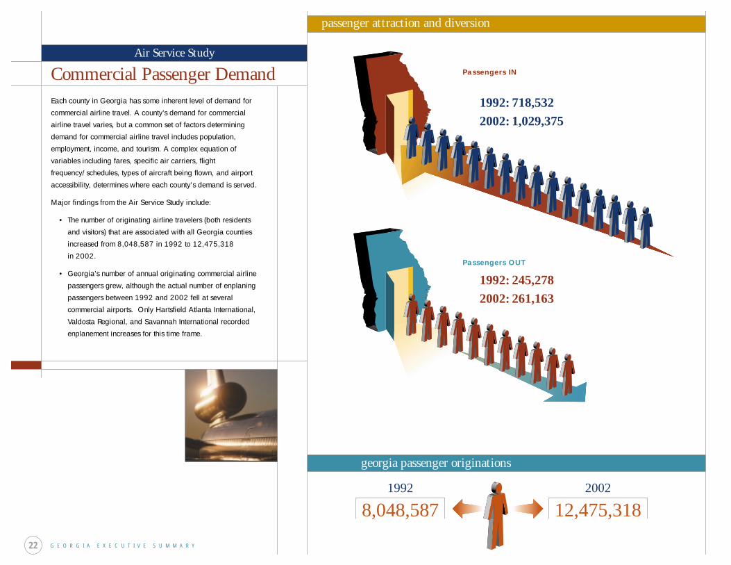
Commercial Passenger DemandEach county in Georgia has some inherent level of demand for
commercial airline travel. A county’s demand for commercial
airline travel varies, but a common set of factors determining
demand for commercial airline travel includes population,
employment, income, and tourism. A complex equation of
variables including fares, specific air carriers, flight
frequency/schedules, types of aircraft being flown, and airport
accessibility, determines where each county's demand is served.
Major findings from the Air Service Study include:
• The number of originating airline travelers (both residents
and visitors) that are associated with all Georgia counties
increased from 8,048,587 in 1992 to 12,475,318
in 2002.
• Georgia’s number of annual originating commercial airline
passengers grew, although the actual number of enplaning
passengers between 1992 and 2002 fell at several
commercial airports. Only Hartsfield Atlanta International,
Valdosta Regional, and Savannah International recorded
enplanement increases for this time frame.
G E O R G I A E X E C U T I V E S U M M A R Y22
passenger attraction and diversion
georgia passenger originations
1992
8,048,5872002
12,475,318
1992: 718,532
2002: 1,029,375
1992: 245,278
2002: 261,163
Air Service Study
Passengers IN
Passengers OUT
Air Service Study
G E O R G I A E X E C U T I V E S U M M A R Y
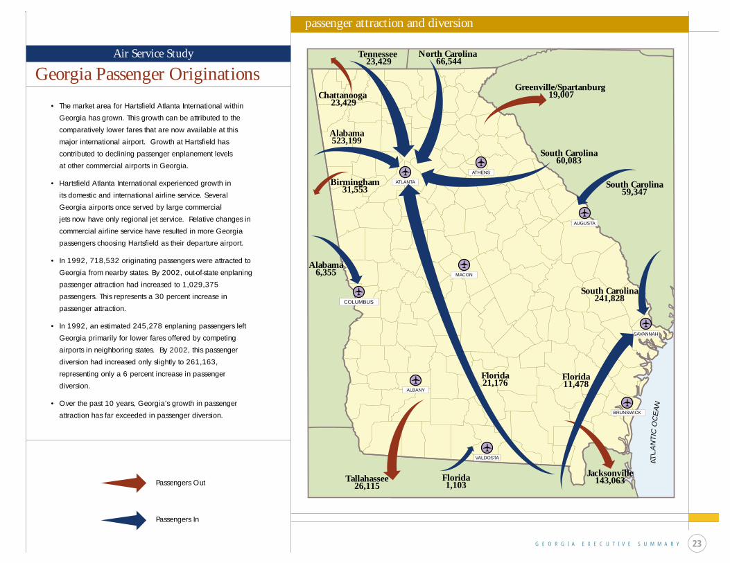
• The market area for Hartsfield Atlanta International within
Georgia has grown. This growth can be attributed to the
comparatively lower fares that are now available at this
major international airport. Growth at Hartsfield has
contributed to declining passenger enplanement levels
at other commercial airports in Georgia.
• Hartsfield Atlanta International experienced growth in
its domestic and international airline service. Several
Georgia airports once served by large commercial
jets now have only regional jet service. Relative changes in
commercial airline service have resulted in more Georgia
passengers choosing Hartsfield as their departure airport.
• In 1992, 718,532 originating passengers were attracted to
Georgia from nearby states. By 2002, out-of-state enplaning
passenger attraction had increased to 1,029,375
passengers. This represents a 30 percent increase in
passenger attraction.
• In 1992, an estimated 245,278 enplaning passengers left
Georgia primarily for lower fares offered by competing
airports in neighboring states. By 2002, this passenger
diversion had increased only slightly to 261,163,
representing only a 6 percent increase in passenger
diversion.
• Over the past 10 years, Georgia’s growth in passenger
attraction has far exceeded in passenger diversion.
AUGUSTA
ATHENS
ATLANTA
COLUMBUS
MACON
ALBANY
VALDOSTA
BRUNSWICK
SAVANNAH
ATLA
NT
ICO
CE
AN
Chattanooga 23,429
Tennessee 23,429
North Carolina 66,544
Greenville/Spartanburg 19,007
South Carolina60,083
South Carolina59,347
South Carolina241,828
Florida11,478
Jacksonville143,063
Florida21,176
Florida1,103
Tallahassee26,115
Alabama6,355
Birmingham31,553
Alabama523,199
Passengers Out
Passengers In
passenger attraction and diversion
Georgia Passenger Originations
23
The Georgia Aviation System is a comprehensive and progressive system of public airports
designed to meet the transportation and economic needs of Georgia. Aviation Programs,
Georgia Department of Transportation, has, through the update of its Aviation System Plan,
identified an aggressive approach to improve and enhance the statewide aviation system to
meet Georgia’s current and future aviation needs.
The update to the Georgia Aviation System Plan contained the following elements:
• PAVEMENT MANAGEMENT STUDY
• AVIATION TAX REVENUE STUDY
• AIR SERVICE/PASSENGER DEMAND STUDY
• AVIATION SYSTEM PLAN
The PAVEMENT MANAGEMENT STUDY evaluated runway, taxiway, and apron areas at 94
general aviation and 9 commercial airports.
• These 103 public use airports have over 1.4 million square yards of pavement.
• A pavement condition index (PIC) of 70 was established as a goal for all airports.
• Over the next 10 years, an average annual investment of $7 million will be needed to keep
all general aviation pavements at a PCI of 70 or greater and $4 million will be needed to
keep all commercial airport pavements at a PCI of 70 or greater.
• The overall PCI rating for the Georgia airports could drop below 60 within as little as
five years without investments noted.
The AVIATION TAX REVENUE STUDY determined that aviation related activities make a
significant contribution to state and local tax revenue streams.
• Over $100 million in aviation related taxes are collected in Georgia each year:
– aviation fuel - $35 million – aircraft sales - $4 million
– aviation goods and services - $31 million – aircraft ad valoreum taxes - $30 million.
• Approximately $70 million in aviation related taxes is contributed annually to the Georgia
General Revenue Fund. The remaining $30 million remains in the counties.
• More than $32 million in State aid is requested by Georgia airports annually.
The AIR SERVICE/PASSENGER DEMAND STUDY measured resident and visitor related
demand for commercial airline travel on a county-by-county basis.
• Georgia’s total originating commercial airline passengers increased from
8 million to 12.5 million over the past ten years.
• Many of Georgia’s smaller commercial airports experienced declining levels of enplaned
passengers as a result of intense airline fare and service competition.
• Georgia benefits from an estimated 1,029,375 travelers from neighboring states who fly
from Georgia’s commercial airports, up 30% over the past ten years.
• Georgia sends only 261,163 of its originating passengers to competing airports in
neighboring states.
• Georgia’s passenger attraction far exceeds its passenger diversion.
The GEORGIA AVIATION SYSTEM PLAN identified future needs for all public airports in
Georgia, providing Aviation Programs with a blueprint for the development of the Georgia
Aviation System.
• All airports were assigned to one of three levels or functional roles: Level I is the minimum
standard general aviation airport; Level II is business airports of local impact; and
Level III is business airports of regional impact.
• Five new and 3 replacement airports are recommended to meet operating capacity or
targets for system accessibility.
• System airports needing longer runways, improved instrument approaches, and facility
and service enhancements were identified.
• Specific airport and systemwide costs for airport development were calculated.
Approximately $142 million is needed over the next five years and $178 million is
needed over the following 15 years for airport development.
Georgia has experienced rapid growth over the past decade. Increased population,
new businesses, and industrial growth underline the need for a progressive airport
system. Airport development is a key factor in the economic growth and the well being
of all Georgia communities. The Georgia Aviation System Plan is an important tool for
ensuring the aviation system in Georgia will meet economic and transportation needs
of Georgia’s citizens now and in the future.
G E O R G I A E X E C U T I V E S U M M A R Y24
Summary


Prepared by: Wilbur Smith Associates, Inc. www.wilbursmith.com
For more information contact:Georgia Department of TransportationAviation Programs276 Memorial Drive SWAtlanta, GA 30303