Embed Size (px)
Citation preview

I Geophysical evaluation of rock massconditions for sub-sea tunnelling:Strategic Sewage Disposal Scheme,Hong Kongby Keith C Maynard MSc', AB2H Consultants', Hong Kong,and Ola K Fjeld MSc, A/S Geoteam, Trondheim, Norway.
SummaryA large geophysical survey has been undertaken as part of the siteinvestigation for the Strategic Sewage Disposal Scheme, Hong Kong.The scheme proposes a series of deep rock tunnels and associatedpumping stations and treatment works designed to improve the waterquality of Victoria Harbour. The geophysical survey involved theintegration of three techniques; analogue and digital reflection, andmarine seismic refraction. The digital reflection and marine seismicref'raction methods were used for the first time in Hong Kong.Results from the survey have interpreted the depth to bedrock androck quality (relating to seismic velocity), allowing the identification ofpossible weakness zones and amount of rock cover. Also, detailedinformation relating to the superficial fiments, bathymetry andseabed morphology have been determmed. In addition, thegeophysical data has been used to optimise borehole locations,increasing the effectiveness of the drilling programme.
'Currently: Consultant geophysicist, Spinney Cottage, The Pound,Hawstead, Bury St Edmunds, Suffolk IP24 5NJ.'B,H is a joint venture between consultants Acer, Binnies, Balfours andHaswells. The first author was an employee of Charles Haswell & Partners(Far East) Limited during this work.
l. IntroductionThe Strategic Sewage Disposal Scheme is proposed to improve thewater quality of Hong Kong's Victoria Harbour. The schemecomprises the collection of sewage from existing and possible futurecollection nodes to a series of deep rock tunnels with associatedpumping stations and treatment works. The effluent is to be initially
discharged through an interim outfaU to the west of Victoria Harbourand then, at a later stage, via an oceanic outfall to the south of HongKong. A plan of the proposed tunnel alignments is presented asFigure l.
The tunnel system and oceanic outfall are proposed to beconstructed within bedrock at a general depth of approximately 100mbelow seabed. For the majority of the proposed alignment thebedrock geology comprises Mesozoic volcanic and intrusive (granitic)rocks. The bedrock has undergone tropical weathering producing aresidual mantle of decomposed rock with a varying thickness and
profile. The rocks are also affected by faulting with associatedalteration and deep pervasive weathering. A detailed description ofthe geology can be found in Geology ofHongKongIsland and Kowloon(Strange &Shaw, 1986).
This paper reviews a geophysical survey carried out within VictoriaHarbour as the first stage ofa large site investigation undertaken aspart of the project preliminary design. Due to the nature of the projectthe geophysical site investigation comprised the integration of threetechniques: analogue and digital reflection, and marine seismicrefraction. The digital reflection and marine seismic refractionmethods were used for the first time in Hong Kong.
The aim of this paper is to present the application of geophysicalmethods to site investigation for sub-sea tunnelling and not as ageophysical reference. In this respect reference to the highlytechnical aspects of the geophysical operation and data interpretationmethods are not provided.
Interim on
40 Figure ir Location map, Strategic Sewage Disposal Scheme.
GROUND ENGINEERING NOVEMBER 1992
2. Project application ofgeophysicsThe proposed design of deep, sub-sea tunnels within rock is the firstlarge scale project of its type to be undertaken in Hong Kong. In thisrespect a very comprehensive site investigation was required todetermine the geology along the proposed tunnel alignment andlocate possible problem zones. An integral part of this siteinvestigation was a large geophysical survey.
The geophysical survey comprised three techniques designed toinvestigate differing aspects of seabed and sub-seabed groundconditions. Analogue and digital reflection and marine seismicrefraction methods were used to provide a comprehensivegeophysical site investigation.
The geophysical site investigation was proposed to determine thefollowing:a. depth to bedrock; to assess ideal tunnel depth, while maintaining
sufficient cover; and ultimately tunnel design (digital reflectionand marine seismic refraction).
b. location of possible zones of weakness within the rock mass(marine seismic refraction).
c. relative rock quality along the proposed tunnel alignment to assessthe suitability ofproposed construction methods (marine seismicrefraction).
d. assessment of superficial deposits for interim outfall immersedtube design and construction. Also for determining thelithologies of superficial sediments for permeability potential(analogue reflection).

ANALOGUE REFLECTION
ECHO SOUNDER
SE
of the geophysical methods and data interpretation theory (eg Telfordet al, 1976).
The basic field layout of each method is schematically presented in
Figure 2.
DIGITAL REFLECTION
SEISMIC REFRACTION
SEABEDAY RECORDING CABLE
ENERGY SOURCE
Figure 2:Geophysical techniques, basic Beldlayout.
e. location of boreholes at potential 'problem'ones increasing theeffectiveness and reducing the cost of the drilling investigation
programme (integration of all methods).Of particular concern was the possibility of faults or zones of deep
weathering acting as conduits for water in-flow into the tunnel, orcausing instability and associated problems during construction.
3.Geophysical methods and applicationsVictoria Harbour presents a very challenging environment in which toacquire geophysical data. In particular this is due to the high levels ofacoustic noise caused by shipping, shipping activity obstructing thedata acquisition operation and access limitations due to urban utilities.
Geophysical techniques previously used in the area also identified
areas of seabed and sub-seabed biogenic gas causing blind zones on
the geophysical profiies. Therefore the three geophysical methodswere used to provide an integrated approach to acquiring high quality,
reliable data.The nature of the project required that methods never used in
Hong Kong before be proposed. In this respect digital reflection and
marine seismic refraction methods were used in addition to morestandard analogue reflection techniques.
A brief outline of each method and its application to siteinvestigation for sub-sea tunnelling is given below. Any standard
geophysical text should be referenced for a more detailed description
3.1Analogue reflection methodThe analogue reflection method used a number of techniques (echosounder, side scan sonar and surface towed boomer) to investigatethe seabed and sub-seabed ground conditions. A marinemagnetometer was also tested to identify metallic services and
possible zones of basic dyke intrusion. However high levels ofmagnetic noise due to shipping caused this technique to beabandoned.
The following techniques were used, with the data acquisition and
recording carried out simultaneously for each survey line pass:~ Echo sounder —produced a bathymetric map of the seabed which
was of use in positioning drilling barges and platforms which wererestricted by water depth and seabed slopes. The data were also usedwith respect to the interim outfall construction (eg dredgingrequirements).~ Side scan sonar- produced a map of the seafloor and was used toidentify bedrock exposures and possible obstructions to drillhole
locations.~ Surface towed boomer produced a sub-seabed proSe with high
resolution of the units comprising the superficial sediments, including
the identification of corestones which occur as strong hyperbolicreflections. This was of particular importance with respect to theinterim outfall which is to be an immersed tube design. The techniquewas also able to profile the top of rockhead over the majority of theproposed tunnel route. Depending upon the extent of weathering therockhead reflector represented either Grade IV or to a lesser extentGrade III decomposed rock.
A 300m wide corridor centred on the proposed tunnel alignment
was surveyed in all accessible areas. The method is highly costeffective but in this case was restricted by a depth penetration limit ofapproximately 50m below sea bed. This was due to on site groundconditions and the method's low energy levels and high signalfrequencies. The method was used as a preliminary 'first
pass'echniqueto identify areas for further investigation by othergeophysical methods.
3.2Digital reflection methodThis technique used a high energy seismic source and a multi-channel
recording and signal enhancement system to give greater depthpenetration compared with the analogue reflection method. The datais stored digitally on tape allowing later specialised processing tomaximise data quality. The data processing is required to be carriedout by a specialised processing centre using advanced computerbased techniques. Due to the time delay involved with the dataprocessing and data transfer to and from the processing centre, a PCbased, portable processing system was used to rapidly producepreliminary results, on site, to assess the suitability of the method.
The method used a 490cm air gun as the energy source which
emits a pulse of high pressure air into the water column producing theseismic signal. The signals are reflected by seismic interfaces(generally corresponding to major geological boundaries) and thenrecorded by a 100m long, 16channel recording 'streamer'. This wastowed behind the survey vessel at a depth of 1m below the seasurface. A brightly coloured marker line was towed at the sea surface,above the recording streamer, to warn the numerous passing vessels
GROUND ENGINEERING NOVEMBER 1992

JIIIIIIJI'IE~IIIp'IwwfnIEEIEIT vs>>ivnwlppliemrev~seemEev~JIEltereEIIEETE'fTvwtllIImevw rm<wele Willimm~JElllllvlf~EDEE enwJIfvEIrww~mrewRJ" "
TD JR'
KD 'KD 'FD 'D 'Ol RD 'ID 'ID '.Dl
DISTANCE
CP WATER COLUMN
SEABE
LIPERFICIAI SEDIMENTS
—20EP
T
40 H
TOE OF ROCKREAOSEABED MULTIPLE (NOISEI .
NOTE: CDG — COMPLETELY DECOMPOSED GRAJ",ITE
—60
(ml
Figure 3a: Analogue reflection data example.DISTANCE
FEE Roll E I JE EEEEE FEE I IEE '. IJEIl
II, I'E I, I OO. IIEET,"IJE 'IIII 'EE illlEE JR JE REJF:F'EN
P TOP OF ROCKHEAD
I
DL DT-
IEJE 1IEJ IRJE IIII lOOI N 4 FJJJJ I I EJE ITEN I Jll EJIEJ I'lEFv
Il II Jl III,'I',;l,",I
E
JJE
l,J
TOP OF ROCKHEADE'
'ilgIII'~JERE"~l"'"'""~~-"~"""~~D"'",~~I.'I,",,",",>I,".D'~IIA Ii ~4+I'(JIiIItKJ-~KU~~IIIlLIIIFRF SEABED RFJII&. l
r0D—20
—40
j60—80
(ml- 100
O
Figure 3b: Digital reflection data example.
of its location. This warning device proved highly effective with nomajor problems encountered within the busy harbour area.
The digital reflection method was able to profile the top of theGrade III bedrock over the majority of the proposed tunnel alignment.Certain areas close to land could not be profiled due to the accesslimitations of towing a 100m cable. In particular the method identifiedareas of low cover with respect to the proposed tunnel design.
3.3Seismic refraction methodThis technique uses different data acquisition procedures from theanalogue and digital reflection methods and analyses refracted,seismic energy waves. From the analysis of the recorded signals it ispossible to determine seismic velocities and depths to refractinginterfaces. In general these interfaces will correspond to majorgeological boundaries. A major advantage of the method is that lateralvariations of the bedrock velocity can be determined.
A number of different techniques may be used to acquire marineseismic refraction data (eg Gardener, 1983).The technique usedduring this project was the 'bottom lay cable'ethod. This methodallows accurate positioning of receiver locations and hence therecorded information. Using this method the recorded data cantherefore be related to actual ground locations with a high degree ofaccuracy. This is of primary importance in locating with precision anypossible problem zones along the proposed tunnel alignment. Thismethod has been widely used for site investigation for sub-seatunnelling in Norway with over 50 projects using the technique.
42 l The method involved laying a 235m long, 48 channel recording
GROUND ENGINEERING NOVEMBER 1992
cable on the seabed, in all accessible areas along the proposed tunnelalignment. Additional recordings were undertaken offset from thetunnel alignment to investigate particular features eg to define theorientation of weakness zones. Explosive charges were used togenerate the seismic energy signals.
There were initial reservations with respect to laying a cable on thesea floor of a harbour prone to unauthorised dumping of debris and alarge number of services (eg gas lines, water and sewage pipes andimmersed tube road and rail tunnels). Delays were also anticipateddue to obtaining permits permitting this type of work, usingexplosives, within the harbour. However no such problems wereencountered during the survey and data of exceptionally high qualitywere acquired.
The method allowed compressional wave, seismic velocities to bedetermined for the bedrock along the majority of the proposed tunnelalignment with the exception of access limitations due to the use ofexplosives. Seismic velocities measured by the refraction techniquehave been correlated with RQD and the numbers ofjoints/cracks permetre of bedrock and hence rock mass quality (eg Sjogren et al,1979).A high bedrock velocity indicates a massive rock mass whilelow velocities indicate a highly jointed or crushed rock mass. Lowvelocities may also indicate zones of deep weathering. In addition theseismic velocities may be used to compute field values for dynamicYoung's Modulus (eg McDowell, 1990).
4. ResultsExamples of the results and their interpretation as provided by the

geophysical survey are presented in Figures 3, 4 and 5.Figure 3a presents an example of surface towed boomer data
(analogue reflection method) and the high resolution within thesuperficial sediments can be clearly seen. The boundary between thebase of superficial deposits and completely weathered bedrock isindistinct due to the similar seismic properties of the two units. Thetop of bedrock and isolated corestone weathering features can also beidentified to the limit of signal penetration.
Figure 3b presents an example of digital reflection data acquiredin the same location as Figure 3a. The bedrock reflector can be clearlyidentified allowing a complete interpretation with respect to thebedrock depth to be made from these data. It should be noted that noinformation is produced below the top of rock. This is due to theabsence of any seismic boundaries within the bedrock.
The seismic refraction method gave results of approximately5500m/s for unweathered rock and identified anomalously lowvelocity zones which were characterised by velocities of 3800m/s orless. Therefore the method readily identified areas interpreted asweak zones within the rock mass.
By integrating the results of all three methods, profiles givingdetails of superficial deposits, depths to bedrock and bedrockvelocities were produced along the majority of the proposed tunnelalignment (reference Figure 3). The results were correlated witharchive borehole information to provide a geological interpretation ofthegeophysicaldata.
Using the geophysical data it was possible to optimise the locationof boreholes programmed for the preliminary design siteinvestigation. Vertical boreholes were located in areas of low bedrockcover and inclined boreholes were located to intercept and testpossible fault or weakness zones. The results and correlation to thegeophysical data were very good and one typical example ispresented as Figure 4.
A number of major topographic lows in the bedrock profile wereidentified from the analogue and digital reflection data and generallycorrelated with low velocity zones identified by the seismic
refraction. From correlation with borehole results and existinggeological information these features have been identified as fracturezones. From the combination of geophysical, borehole and existinggeological information it has therefore been possible to interpret thegeological structure expected to affect the proposed tunnelalignment.
As stated in section 3, previous marine geophysical workundertaken in Hong Kong using analogue reflection methods wereaffected by the presence of seabed or sub-seabed biogenic gas. Thegas is produced either by the action of present day waste disposal orfrom the decomposition of organic debris within Quaternary deposits.The gas causes attenuation of the seismic signal and thereforeblanking of the geophysical profile. Due to the higher energy levels ofthe digital reflection method the technique overcame this problem to acertain extent.
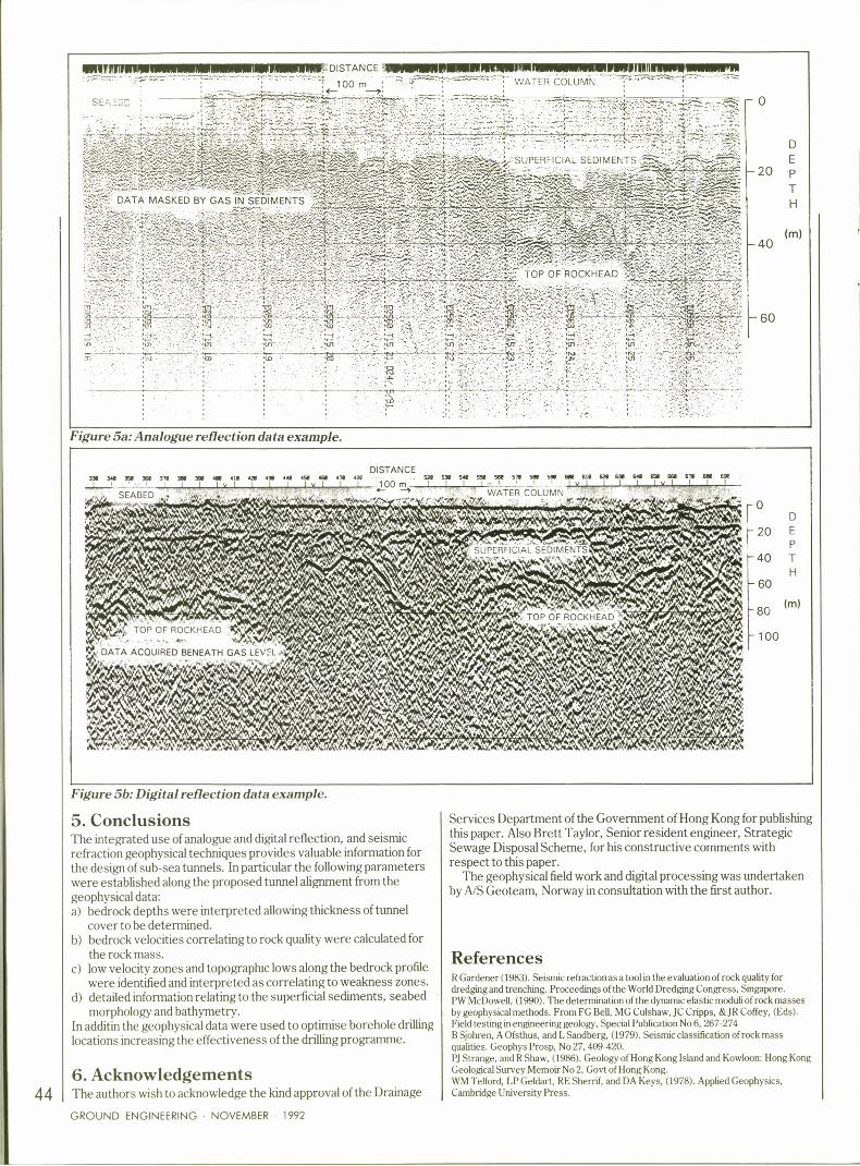
The results from analogue and digital data recorded in the samelocation are presented as Figures 5a and 5b respectively toillustrate the effect of the gas. A complete loss of data can beobserved in Figure 5a (analogue method) beneath the gas level. Theimprovement in data quality achieved by the digital data is clearly seenin Figure 5b where the bedrock reflections are easily identified. Thisexample also shows steps in the bedrock reflector which areinterpreted as due to either faulting, weathering or the location ofdyke swarms. Good seismic refraction data were also acquired in thisarea.
In areas directly in the vicinity of sewage outfalls or within enclosedtyphoon shelters no results were obtained from either the analogue ordigital reflection methods due to high gas concentrations within thesediments at or close to the seabed. Results indicating possiblebedrock depths and velocities were produced from the seismicrefraction method in these areas. It is expected that data quality andreliability could be improved by using larger explosive charges toincrease the seismic energy level and/or using special techniques tolocate the energy source and receiving hydrophones below theseabed.
Figure 4:Interpretedprofile withdrillholecorrelation.
Hong Kong principal datum0—
Borehole with lithology
Seabed (analogue)
Base marine (analogue)
20-nalogue)
40-E
o.eO
nalogue)
k (digital)
BO-fraction)
GROUND ENGINEERING NOVEMBER 1992
43
~lrmrr ~rmm Mm%OIETANCE .. a~rrm = . sEEnllllll&H.I OO
' " ' "'WATER COLUMN
Sc/ cc —0
D
E—20 p
TH
(ml—40
—60
Figure 5a: Analogue reflectio data example.
DISTANCEsw Era sl~ ws ETE m sw m oe ARE m rrs rss rss ATs AEs... EEE sw EEEE sss sse ETs Ew Ew Ea sE~ EEE Ew srs sEs sss era sw Ew
v I t I )PQ m I I I I v I ' ' v I I I I I v 1 I I I
SEABED WATER COLUMN
0
$20 E
P—40 T
H—60
-So
—100
Figure 5b: Digi tal reflection data example.
5. ConclusionsThe integrated use of analogue and digital reflection, and seismicrefraction geophysical techniques provides valuable information forthe design of sub-sea tunnels. In particular the following parameterswere established along the proposed tunnel alignment from thegeophysical data:a) bedrock depths were interpreted allowing thickness of tunnel
cover to be determined.b) bedrock velocities correlating to rock quality were calculated for
the rock mass.c) low velocity zones and topographic lows along the bedrock proSe
were identified and interpreted as correlating to weakness zones.d) detailed informa'.ion relating to the superficial sediments, seabed
morphology and bathymetry.In additin the geophysical data were used to optimise borehole drilling
locations increasing the effectiveness of the drilling programme.
6.Acknowledgements44 The authors wish to acknowledge the kind approval of the Drainage
GROUND ENGINEERING NOVEMBER 1992
Services Department of the Government of Hong Kong for publishingthis paper. Also Brett Taylor, Senior resident engineer, StrategicSewage Disposal Scheme, for his constructive comments withrespect to this paper.
The geophysical field work and digital processing was undertaken
by A/S Geoteam, Norway in consultation with the first author.
ReferencesR Gardener (1983).Seismic refraction as a tool in the evaluation of rock quality fordredging and trenching. Proceedings of the World Dredging Congress, Singapore.PW McDowell, (1990).The determination of the dynamic elastic moduli of rock massesby geophysical methods. From FG Bell, MG Culshaw, JC Cripps, gE JR Coffey, (Eds).Field testing in engineering geology, Special Publication No 6, 267-274BSjohren, A Ofsthus, and L Sandberg, (1979).Seismic classification of rock massqualities. Geophys Prosp, No 27, 409-420.PJ Strange, and R Shaw, (1986).Geology of Hong Kong Island and Kowloon: Hong KongGeological Survey Memoir No 2, Govt of Hong Kong.WM Telford, LP Geldart, RE Sherrif, and DA Keys, (1978).Applied Geophysics,Cambridge University Press.


![Paper 30 Geological Models, Rock Properties, and the 3D … · 2015-12-14 · Geological Models, Rock Properties, and the 3D Inversion of Geophysical Data McGaughey, J. [1] 1. Mira](https://img.pdfslide.us/doc/110x75/5ea9cfb598166968dc5abda6/paper-30-geological-models-rock-properties-and-the-3d-2015-12-14-geological.jpg)