Embed Size (px)
Citation preview
The English Riviera
Geopark ManaGeMent plan
English Riviera
ExEcutivE Summary
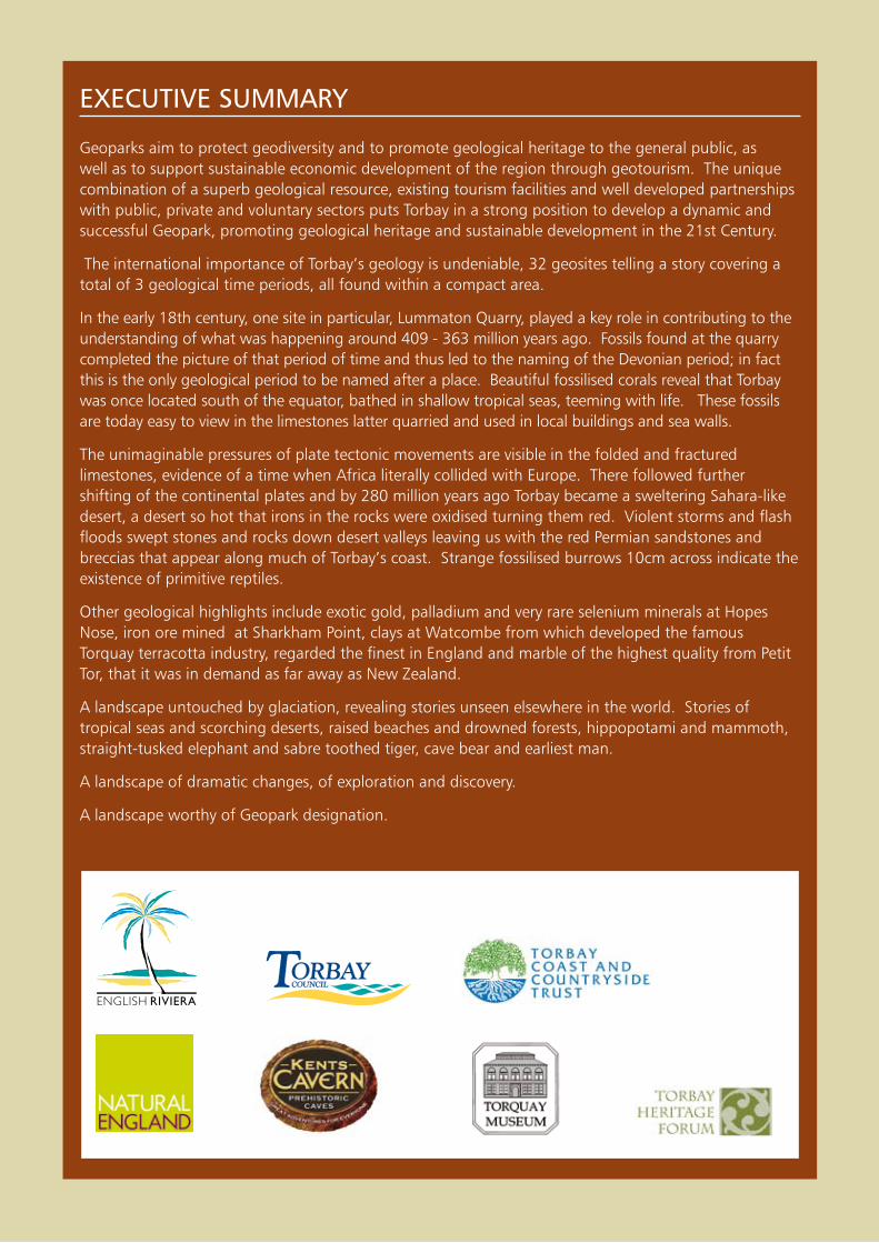
Geoparks aim to protect geodiversity and to promote geological heritage to the general public, as well as to support sustainable economic development of the region through geotourism. The unique combination of a superb geological resource, existing tourism facilities and well developed partnerships with public, private and voluntary sectors puts Torbay in a strong position to develop a dynamic and successful Geopark, promoting geological heritage and sustainable development in the 21st Century.
The international importance of Torbay’s geology is undeniable, 32 geosites telling a story covering a total of 3 geological time periods, all found within a compact area.
In the early 18th century, one site in particular, Lummaton Quarry, played a key role in contributing to the understanding of what was happening around 409 - 363 million years ago. Fossils found at the quarry completed the picture of that period of time and thus led to the naming of the Devonian period; in fact this is the only geological period to be named after a place. Beautiful fossilised corals reveal that Torbay was once located south of the equator, bathed in shallow tropical seas, teeming with life. These fossils are today easy to view in the limestones latter quarried and used in local buildings and sea walls.
The unimaginable pressures of plate tectonic movements are visible in the folded and fractured limestones, evidence of a time when Africa literally collided with Europe. There followed further shifting of the continental plates and by 280 million years ago Torbay became a sweltering Sahara-like desert, a desert so hot that irons in the rocks were oxidised turning them red. Violent storms and flash floods swept stones and rocks down desert valleys leaving us with the red Permian sandstones and breccias that appear along much of Torbay’s coast. Strange fossilised burrows 10cm across indicate the existence of primitive reptiles.
Other geological highlights include exotic gold, palladium and very rare selenium minerals at Hopes Nose, iron ore mined at Sharkham Point, clays at Watcombe from which developed the famous Torquay terracotta industry, regarded the finest in England and marble of the highest quality from Petit Tor, that it was in demand as far away as New Zealand.
A landscape untouched by glaciation, revealing stories unseen elsewhere in the world. Stories of tropical seas and scorching deserts, raised beaches and drowned forests, hippopotami and mammoth, straight-tusked elephant and sabre toothed tiger, cave bear and earliest man.
A landscape of dramatic changes, of exploration and discovery.
A landscape worthy of Geopark designation.

The English Riviera GEo
park m
an
aG
EmEn
t plan
3
contEntS
executive Summary . . . . . . . . . . . . . . . . . . . . . . . . . . . . . . . . . . . . 2
1 . the english riviera Geopark organisation . . . . . . . . . . . . . . 41.1 Introduction . . . . . . . . . . . . . . . . . . . . . . . . . . . . . . . . . . . . . . . . . . . . . . . . . . 4
1.2 Membership of the English Riviera Geopark Organisation . . . . . . . . . . . . . . . . . 5
2 . What is a Geopark? . . . . . . . . . . . . . . . . . . . . . . . . . . . . . . . . 62.1 The European Geopark Network . . . . . . . . . . . . . . . . . . . . . . . . . . . . . . . . . . . . 6
2.2 What is a European Geopark? . . . . . . . . . . . . . . . . . . . . . . . . . . . . . . . . . . . . . 7
3 . Description of the english riviera Geopark . . . . . . . . . . . . . . 8
4 . purpose of the management plan . . . . . . . . . . . . . . . . . . . . . 94.1 Management themes . . . . . . . . . . . . . . . . . . . . . . . . . . . . . . . . . . . . . . . . . . . . 9
5 . Management Issues for the Geological Heritage of torbay . 105.1 Generic issues affecting Torbay’s heritage SWOT analysis . . . . . . . . . . . . . . . . 10
5.2 Governance issues . . . . . . . . . . . . . . . . . . . . . . . . . . . . . . . . . . . . . . . . . . . . . 12
5.3 Site conservation issues . . . . . . . . . . . . . . . . . . . . . . . . . . . . . . . . . . . . . . . . . 13
6 . the potential for further development of the Geopark . . . 186.1 Site management . . . . . . . . . . . . . . . . . . . . . . . . . . . . . . . . . . . . . . . . . . . . . . 18
6.2 Infrastructure . . . . . . . . . . . . . . . . . . . . . . . . . . . . . . . . . . . . . . . . . . . . . . . . . 18
6.3 Geotourism . . . . . . . . . . . . . . . . . . . . . . . . . . . . . . . . . . . . . . . . . . . . . . . . . . 18
7 . Geology . . . . . . . . . . . . . . . . . . . . . . . . . . . . . . . . . . . . . . . . 207.1 Site Map . . . . . . . . . . . . . . . . . . . . . . . . . . . . . . . . . . . . . . . . . . . . . . . . . . . . 20
7.2 Geological map to the Torquay (350) sheet . . . . . . . . . . . . . . . . . . . . . . . . . . 22
7.3 Torbay’s Geology - A simple explanation from the beginning. . . . . . . . . . . . . . 23
7.4 Site designations and geological/ geomorphological features . . . . . . . . . . . . . 26
7.5 Site management . . . . . . . . . . . . . . . . . . . . . . . . . . . . . . . . . . . . . . . . . . . . . . 36
8 . priorities and policies for Sustainable Development . . . . . . 378.1 Priority 1: Management Framework . . . . . . . . . . . . . . . . . . . . . . . . . . . . . . . . 37
8.2 Priority 2: Site Conservation . . . . . . . . . . . . . . . . . . . . . . . . . . . . . . . . . . . . . . 37
8.3 Priority 3: Geoeducation and Geotourism . . . . . . . . . . . . . . . . . . . . . . . . . . . . 38
9 . action plan . . . . . . . . . . . . . . . . . . . . . . . . . . . . . . . . . . . . . . 39 English Riviera Geopark Organisation (ERGO) Work Program . . . . . . . . . . . . . 39
appendix a: torbay Coast and Countryside trust policy on Fossil and Mineral Collection . . . . . . . . . . . . . . . . . . . . . . . . . 45
photo credits . . . . . . . . . . . . . . . . . . . . . . . . . . . . . . . . . . . . . . . . 46
The
Engl
ish
Rivi
era
GEo
park
ma
na
GEm
Ent
pla
n
4
1. thE EnGliSh riviEra GEopark orGaniSation
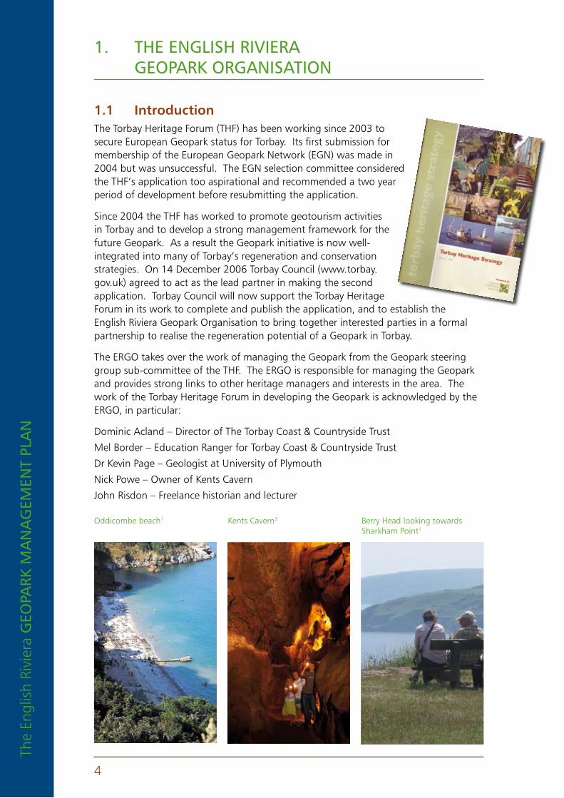
1 .1 IntroductionThe Torbay Heritage Forum (THF) has been working since 2003 to secure European Geopark status for Torbay. Its first submission for membership of the European Geopark Network (EGN) was made in 2004 but was unsuccessful. The EGN selection committee considered the THF’s application too aspirational and recommended a two year period of development before resubmitting the application.
Since 2004 the THF has worked to promote geotourism activities in Torbay and to develop a strong management framework for the future Geopark. As a result the Geopark initiative is now well-integrated into many of Torbay’s regeneration and conservation strategies. On 14 December 2006 Torbay Council (www.torbay.gov.uk) agreed to act as the lead partner in making the second application. Torbay Council will now support the Torbay Heritage Forum in its work to complete and publish the application, and to establish the English Riviera Geopark Organisation to bring together interested parties in a formal partnership to realise the regeneration potential of a Geopark in Torbay.
The ERGO takes over the work of managing the Geopark from the Geopark steering group sub-committee of the THF. The ERGO is responsible for managing the Geopark and provides strong links to other heritage managers and interests in the area. The work of the Torbay Heritage Forum in developing the Geopark is acknowledged by the ERGO, in particular:
Dominic Acland – Director of The Torbay Coast & Countryside Trust
Mel Border – Education Ranger for Torbay Coast & Countryside Trust
Dr Kevin Page – Geologist at University of Plymouth
Nick Powe – Owner of Kents Cavern
John Risdon – Freelance historian and lecturer
Oddicombe beach1 Kents Cavern3 Berry Head looking towards Sharkham Point1
The English Riviera GEo
park m
an
aG
EmEn
t plan
5
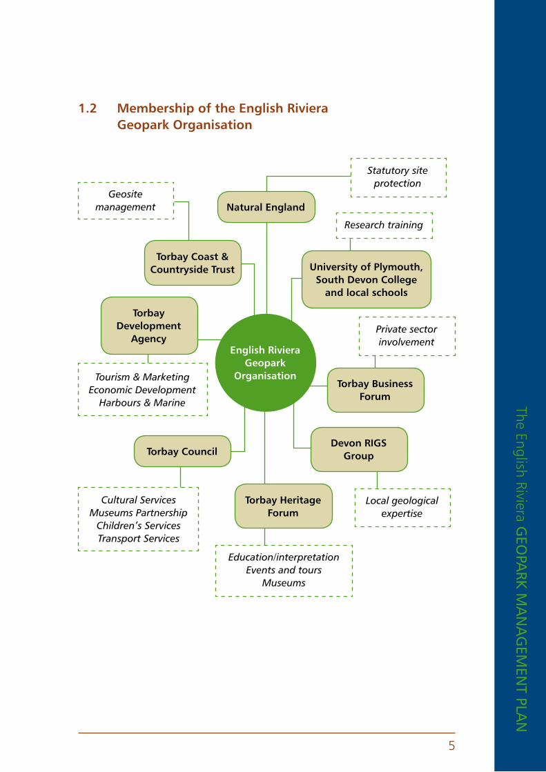
1 .2 Membership of the english riviera Geopark organisation
english riviera Geopark
organisation
torbay Coast & Countryside trust
natural england
University of plymouth, South Devon College
and local schools
torbay Business Forum
torbay Heritage Forum
torbay Development
agency
torbay CouncilDevon rIGS
Group
Statutory site protection
Research training
Private sector involvement
Local geological expertise
Education/interpretationEvents and tours
Museums
Cultural Services Museums Partnership
Children’s Services Transport Services
Geosite management
Tourism & Marketing Economic Development
Harbours & Marine

The
Engl
ish
Rivi
era
GEo
park
ma
na
GEm
Ent
pla
n
6
2. What iS a GEopark?
2 .1 the european Geopark network
Established in 2000, the European Geoparks Network (EGN) aims to protect geo-diversity and to promote geological heritage to the general public as well as to support sustainable economic development of geopark territories primarily through the development of geological tourism. Originally consisting of four territories, the network now has 29 territories across 12 European countries. There are five in the UK:
n Abberley and Malvern Hills Geopark, England
n North Pennines AONB Geopark, England
n Fforest Fawr Geopark, Wales
n North West Highlands Geopark, Scotland
n Marble Arch Caves and Cuilcagh Mountain Park, Northern Ireland
The structure of the network is relatively simple and comprises an advisory committee of 11 members including representatives of UNESCO, IUGS (International Union of Geological Sciences) and IUCN (International Union for the Conservation of Nature) and a coordination committee comprised of two representatives from each member territory.
The European Geoparks Network has signed formal agreements with UNESCO’s Division of Earth Sciences giving the network UNESCO endorsement and giving the EGN responsibility for regulating membership of the UNESCO Global Network of Geoparks in Europe. For information on the Global Geopark network visit http://www.worldgeopark.org.
Malvern Hills, Worcestershire, England9
Saltern Cove, Torquay1 Berry Head, Brixham4
The English Riviera GEo
park m
an
aG
EmEn
t plan
7
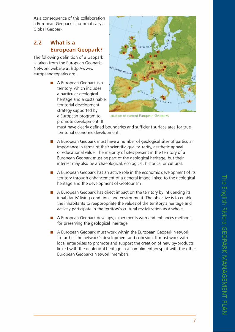
As a consequence of this collaboration a European Geopark is automatically a Global Geopark.
2 .2 What is a european Geopark?
The following definition of a Geopark is taken from the European Geoparks Network website at http://www.europeangeoparks.org.
n A European Geopark is a territory, which includes a particular geological heritage and a sustainable territorial development strategy supported by a European program to promote development. It must have clearly defined boundaries and sufficient surface area for true territorial economic development.
n A European Geopark must have a number of geological sites of particular importance in terms of their scientific quality, rarity, aesthetic appeal or educational value. The majority of sites present in the territory of a European Geopark must be part of the geological heritage, but their interest may also be archaeological, ecological, historical or cultural.
n A European Geopark has an active role in the economic development of its territory through enhancement of a general image linked to the geological heritage and the development of Geotourism
n A European Geopark has direct impact on the territory by influencing its inhabitants’ living conditions and environment. The objective is to enable the inhabitants to reappropriate the values of the territory’s heritage and actively participate in the territory’s cultural revitalization as a whole.
n A European Geopark develops, experiments with and enhances methods for preserving the geological heritage
n A European Geopark must work within the European Geopark Network to further the network’s development and cohesion. It must work with local enterprises to promote and support the creation of new by-products linked with the geological heritage in a complimentary spirit with the other European Geoparks Network members
Location of current European Geoparks
The
Engl
ish
Rivi
era
GEo
park
ma
na
GEm
Ent
pla
n
8
3. DEScription of thE EnGliSh riviEra GEopark
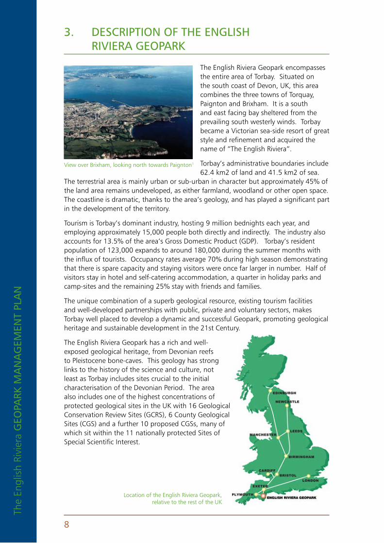
The English Riviera Geopark encompasses the entire area of Torbay. Situated on the south coast of Devon, UK, this area combines the three towns of Torquay, Paignton and Brixham. It is a south and east facing bay sheltered from the prevailing south westerly winds. Torbay became a Victorian sea-side resort of great style and refinement and acquired the name of “The English Riviera”.
Torbay’s administrative boundaries include 62.4 km2 of land and 41.5 km2 of sea.
The terrestrial area is mainly urban or sub-urban in character but approximately 45% of the land area remains undeveloped, as either farmland, woodland or other open space. The coastline is dramatic, thanks to the area’s geology, and has played a significant part in the development of the territory.
Tourism is Torbay’s dominant industry, hosting 9 million bednights each year, and employing approximately 15,000 people both directly and indirectly. The industry also accounts for 13.5% of the area’s Gross Domestic Product (GDP). Torbay’s resident population of 123,000 expands to around 180,000 during the summer months with the influx of tourists. Occupancy rates average 70% during high season demonstrating that there is spare capacity and staying visitors were once far larger in number. Half of visitors stay in hotel and self-catering accommodation, a quarter in holiday parks and camp-sites and the remaining 25% stay with friends and families.
The unique combination of a superb geological resource, existing tourism facilities and well-developed partnerships with public, private and voluntary sectors, makes Torbay well placed to develop a dynamic and successful Geopark, promoting geological heritage and sustainable development in the 21st Century.
The English Riviera Geopark has a rich and well-exposed geological heritage, from Devonian reefs to Pleistocene bone-caves. This geology has strong links to the history of the science and culture, not least as Torbay includes sites crucial to the initial characterisation of the Devonian Period. The area also includes one of the highest concentrations of protected geological sites in the UK with 16 Geological Conservation Review Sites (GCRS), 6 County Geological Sites (CGS) and a further 10 proposed CGSs, many of which sit within the 11 nationally protected Sites of Special Scientific Interest.
View over Brixham, looking north towards Paignton1
Location of the English Riviera Geopark, relative to the rest of the UK

The English Riviera GEo
park m
an
aG
EmEn
t plan
9
4. purpoSE of thE manaGEmEnt plan
The purpose of the management plan is to coordinate the management of the Geopark, strengthen existing partnerships and develop new networks to ensure that the geological qualities of the ERG are sustained and promoted for current and future generations.
4 .1 Management themesOur management aims are brought together under three overriding themes and it is these that determine the work program for managing the English Riviera Geopark.
4 .1 .1 Management frameworkn Maintain the ERGO and co-ordinate activities
n Ensure that geosites and other themes and/or sites with links to the geological heritage (archaeological, ecological, historical or cultural) are high on the agenda within the region’s Economic Regeneration Framework (www.torbay.gov.uk/efstrategy) for sustainable development.
n Work within the European Geopark Network to further the network’s construction and cohesion in partnership with other European and global geosites. Also liaise with other neighbouring designated territories in the south-west of England.
4 .1 .2 Site conservationn Facilitate the protection and enhancement of geosites.
n Encourage research into methods for the sustainable management of Torbay’s geosites and share best practice with other sites in the UK and abroad
4 .1 .3 Geoeducation and geotourismn Work with the tourism sector to actively promote economic development
through the enhancement of tourism activities linked to the geological heritage
n Encourage and enable access to geosites where this can be achieved sustainably for the benefit of the community
n Support and develop wide-reaching community-based educational and interpretation programmes concerning geosites and the geological heritage
Kents Cavern3 Environmental education with Torbay Coast and Countryside Trust1
The
Engl
ish
Rivi
era
GEo
park
ma
na
GEm
Ent
pla
n
10
5. manaGEmEnt iSSuES for thE GEoloGical hEritaGE of torbay
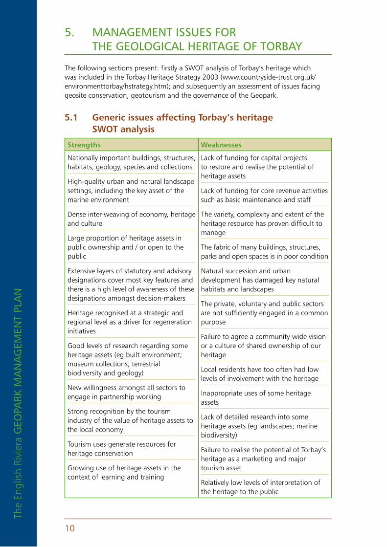
The following sections present: firstly a SWOT analysis of Torbay’s heritage which was included in the Torbay Heritage Strategy 2003 (www.countryside-trust.org.uk/environmenttorbay/hstrategy.htm); and subsequently an assessment of issues facing geosite conservation, geotourism and the governance of the Geopark.
5 .1 Generic issues affecting torbay’s heritage SWot analysis
Strengths Weaknesses
Nationally important buildings, structures, habitats, geology, species and collections
High-quality urban and natural landscape settings, including the key asset of the marine environment
Dense inter-weaving of economy, heritage and culture
Large proportion of heritage assets in public ownership and / or open to the public
Extensive layers of statutory and advisory designations cover most key features and there is a high level of awareness of these designations amongst decision-makers
Heritage recognised at a strategic and regional level as a driver for regeneration initiatives
Good levels of research regarding some heritage assets (eg built environment; museum collections; terrestrial biodiversity and geology)
New willingness amongst all sectors to engage in partnership working
Strong recognition by the tourism industry of the value of heritage assets to the local economy
Tourism uses generate resources for heritage conservation
Growing use of heritage assets in the context of learning and training
Lack of funding for capital projects to restore and realise the potential of heritage assets
Lack of funding for core revenue activities such as basic maintenance and staff
The variety, complexity and extent of the heritage resource has proven difficult to manage
The fabric of many buildings, structures, parks and open spaces is in poor condition
Natural succession and urban development has damaged key natural habitats and landscapes
The private, voluntary and public sectors are not sufficiently engaged in a common purpose
Failure to agree a community-wide vision or a culture of shared ownership of our heritage
Local residents have too often had low levels of involvement with the heritage
Inappropriate uses of some heritage assets
Lack of detailed research into some heritage assets (eg landscapes; marine biodiversity)
Failure to realise the potential of Torbay’s heritage as a marketing and major tourism asset
Relatively low levels of interpretation of the heritage to the public

The English Riviera GEo
park m
an
aG
EmEn
t plan
11
opportunities threats
Create a strong partnership of public, private and voluntary sectors through a Heritage Forum
The formation of a Regeneration Partnership for Torbay
Communicate a strong inclusive vision for Torbay’s heritage
Market a strong Torbay heritage brand
Exploit the unique selling point of Torbay’s maritime heritage assets
Develop specific, integrated action plans for each category of heritage asset
Improve volunteer involvement and community participation in heritage management
Reach out to communities and individuals that have historically experienced poor access to the heritage
Improve learning and training opportunities associated with the heritage
Improve interpretation and marketing initiatives, especially through partnership work
Develop / reinstate grant schemes to support the private and voluntary sectors in heritage conservation
Identify benefits from changes in national and international policies and funding, eg Common Agricultural Policy, Objective 2
Develop ICT-linked facilities for improving access to heritage
Carry out research to improve the knowledge base of heritage assets
Reductions in the availability of grant support for heritage in the medium term
Difficulties in conserving landscape-scale features in multiple ownerships
Inappropriate uses / over-use / falling out of use
Loss of some key features to coastal erosion
Incremental small-scale losses of quality of assets
Failure to integrate priorities between agencies and sectors and to communicate these to partners
Failure to develop community-based approach and to generate high levels of community participation
Haphazard development of heritage projects that fail to co-ordinate activities.
Uncertain impacts of changes in national and international policies and funding, eg Common Agricultural Policy
Berry Head, Brixham5

The
Engl
ish
Rivi
era
GEo
park
ma
na
GEm
Ent
pla
n
12
5 .2 Governance issues5 .2 .1 Co-ordinationThe English Riviera Geopark has an extensive urban infrastructure, giving the proposed Geopark some unique characteristics. One of these is a significant tourism economy that sits alongside struggling manufacturing and fishing sectors. There are dense areas of population, some considerable areas of deprivation, a great diversity of community and heritage and, as a result, a great diversity of organisations and enterprises aiming to make a living from the area. At the same time the area is now managed by a single, unitary local government in Torbay Council and a Community Plan (www.torbay.gov.uk/draft_community_plan_2007-_2027.pdf) that involves the local community in shaping the future of Torbay.
This diversity and density of activity means that co-ordination of Geopark activity is absolutely critical to the success of this initiative. Communication is key in bringing people together in a shared understanding of the way forward. Relevant sectors include local government, government agencies, tourism development and marketing, hoteliers, visitor attractions, transport operators, guides and tour organisers, food and drink, sport and recreation providers, schools and colleges, museums and the voluntary sector.
The challenge of coordinating such a wide variety of actors cannot be under-estimated. Initially this work can be delegated amongst a team of individuals drawn from different sectors but as the Geopark grows it is likely that a Geodiversity Officer will be required in order to efficiently manage the complexities of the ERGO.
5 .2 .2 BrandingThe English Riviera is a strong existing brand in wide use by multiple agents in Torbay and is widely recognised within the UK and abroad. It is highly practical to link the Geopark to this brand rather than establish a competing brand. However, experience elsewhere in the UK has shown that uncontrolled use of a brand can be damaging to its development in the long term. Therefore it would be wise to trademark and control the ERG brand from an early stage to ensure that its use is permitted only by agencies and organisations that fulfil the criteria of sustainability and responsible promotion of the Geopark.
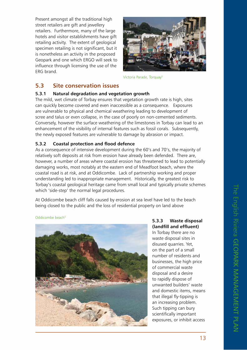
5 .2 .3 retailingThe region has three large town centres and numerous small village high streets.
Brixham harbourside5 Paignton town centre5 Torre Abbey Sands, Torquay5
The English Riviera GEo
park m
an
aG
EmEn
t plan
13
Present amongst all the traditional high street retailers are gift and jewellery retailers. Furthermore, many of the large hotels and visitor establishments have gift retailing activity. The extent of geological specimen retailing is not significant, but it is nonetheless an activity in the proposed Geopark and one which ERGO will seek to influence through licensing the use of the ERG brand.
5 .3 Site conservation issues5 .3 .1 natural degradation and vegetation growthThe mild, wet climate of Torbay ensures that vegetation growth rate is high, sites can quickly become covered and even inaccessible as a consequence. Exposures are vulnerable to physical and chemical weathering leading to development of scree and talus or even collapse, in the case of poorly on non-cemented sediments. Conversely, however the surface weathering of the limestones in Torbay can lead to an enhancement of the visibility of internal features such as fossil corals. Subsequently, the newly exposed features are vulnerable to damage by abrasion or impact.
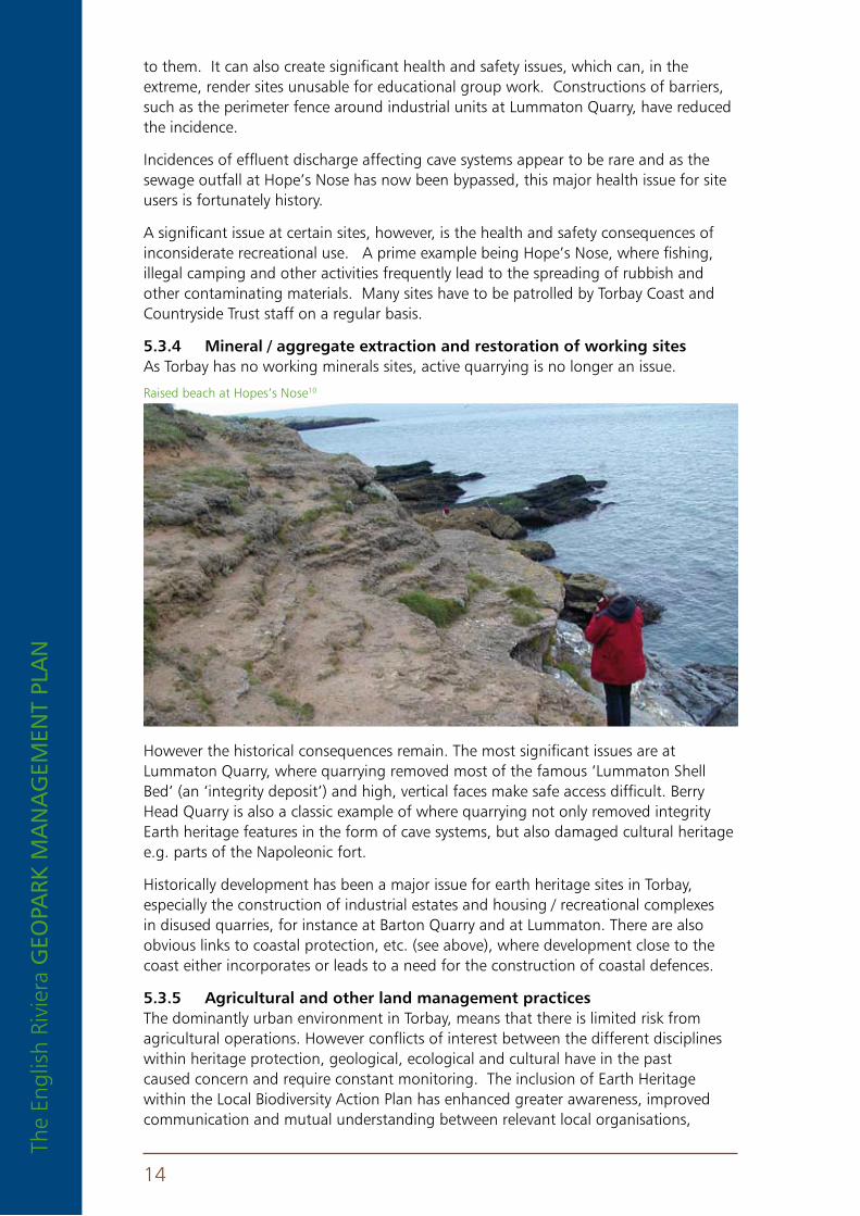
5 .3 .2 Coastal protection and flood defenceAs a consequence of intensive development during the 60’s and 70’s, the majority of relatively soft deposits at risk from erosion have already been defended. There are, however, a number of areas where coastal erosion has threatened to lead to potentially damaging works, most notably at the eastern end of Meadfoot beach, where the coastal road is at risk, and at Oddicombe. Lack of partnership working and proper understanding led to inappropriate management. Historically, the greatest risk to Torbay’s coastal geological heritage came from small local and typically private schemes which ‘side-step’ the normal legal procedures.
At Oddicombe beach cliff falls caused by erosion at sea level have led to the beach being closed to the public and the loss of residential property on land above
5 .3 .3 Waste disposal (landfill and effluent)In Torbay there are no waste disposal sites in disused quarries. Yet, on the part of a small number of residents and businesses, the high price of commercial waste disposal and a desire to rapidly dispose of unwanted builders’ waste and domestic items, means that illegal fly-tipping is an increasing problem. Such tipping can bury scientifically important exposures, or inhibit access
Oddicombe beach5
Victoria Parade, Torquay5
The
Engl
ish
Rivi
era
GEo
park
ma
na
GEm
Ent
pla
n
14
to them. It can also create significant health and safety issues, which can, in the extreme, render sites unusable for educational group work. Constructions of barriers, such as the perimeter fence around industrial units at Lummaton Quarry, have reduced the incidence.
Incidences of effluent discharge affecting cave systems appear to be rare and as the sewage outfall at Hope’s Nose has now been bypassed, this major health issue for site users is fortunately history.
A significant issue at certain sites, however, is the health and safety consequences of inconsiderate recreational use. A prime example being Hope’s Nose, where fishing, illegal camping and other activities frequently lead to the spreading of rubbish and other contaminating materials. Many sites have to be patrolled by Torbay Coast and Countryside Trust staff on a regular basis.
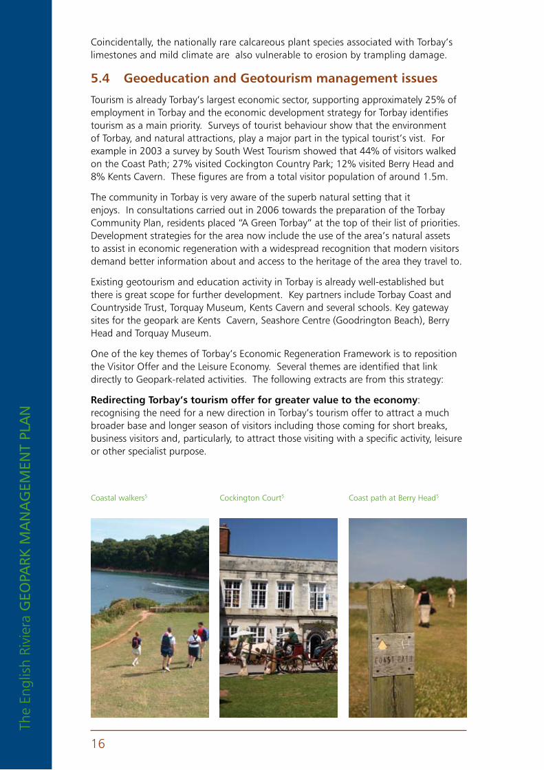
5 .3 .4 Mineral / aggregate extraction and restoration of working sitesAs Torbay has no working minerals sites, active quarrying is no longer an issue.
However the historical consequences remain. The most significant issues are at Lummaton Quarry, where quarrying removed most of the famous ‘Lummaton Shell Bed’ (an ‘integrity deposit’) and high, vertical faces make safe access difficult. Berry Head Quarry is also a classic example of where quarrying not only removed integrity Earth heritage features in the form of cave systems, but also damaged cultural heritage e.g. parts of the Napoleonic fort.
Historically development has been a major issue for earth heritage sites in Torbay, especially the construction of industrial estates and housing / recreational complexes in disused quarries, for instance at Barton Quarry and at Lummaton. There are also obvious links to coastal protection, etc. (see above), where development close to the coast either incorporates or leads to a need for the construction of coastal defences.
5 .3 .5 agricultural and other land management practicesThe dominantly urban environment in Torbay, means that there is limited risk from agricultural operations. However conflicts of interest between the different disciplines within heritage protection, geological, ecological and cultural have in the past caused concern and require constant monitoring. The inclusion of Earth Heritage within the Local Biodiversity Action Plan has enhanced greater awareness, improved communication and mutual understanding between relevant local organisations,
Raised beach at Hopes’s Nose10

The English Riviera GEo
park m
an
aG
EmEn
t plan
15
ensuring ongoing appropriate management. In the future, the maintenance and development of new partnerships, local, national and international will be essential to conservation efforts.
An excellent example of the benefits of collaboration from Torbay was the discovery of common Kidney Vetch at Lummaton Quarry during a routine inspection of the geological SSSI. Kidney Vetch is the food-plant for caterpillars of the rare Small Blue Butterfly which was previously recorded at only one Devon site. Subsequent visits revealed the county’s largest known colony of the butterfly and follow-up scrub-clearance has not only improved geological exposure but has also has enabled the
colony to expand.
5 .3 .6 overuse or misuseOne of the most significant remaining threats to a key group of sites where the key geological features are fossils and minerals, are third party collecting activities. In the extreme, this activity can lead to the virtual removal of sections of geological sites, as has happened to the gold-bearing deposits of Hope’s Nose. In the latter case, illegal collectors have used rock saws to extract mineral-bearing calcite veins from the Devonian limestone,
leaving the site in a badly damaged condition with most of the accessible sections of its internationally important deposits removed. This material has been sold via catalogues, mineral fairs and web sites. Hope’s Nose is a nationally extreme case, however, but specimen collecting can also inadvertently lead to a loss of geological resource at other sites, if the rate of removal outstrips erosion. For instance St. Mary’s Bay, south of Berry Head, has long been noted as a source of fossil corals and shells, which weather out of early Middle Devonian slaty mudrocks. Erosion at the site is, however, limited and fossils only typically become visible after a period of beach-tumbling of scree material. As a result, the collection of fossils in the bay over the last 20 years or so has led to a marked decrease in the availability of fossil material and whereas, for instance, large solitary corals were once common, they are now relatively rare.
Other non-geologically inspired recreational activities can also occasionally damage geosites, such as climbing and caving, although neither of these activities are believed to be currently a significant issue in Torbay as limestone rock-faces are relatively robust and the main cave systems at Kents Carvern and Brixham are all restricted access.
A more significant issue, however, especially where sites are to be promoted for public access, could be the abrasion of beautifully etched-out fossils, especially corals and stromatoporoids, by visitors walking or climbing over key exposures. Attempts to collect these faunas by inexperienced persons would also be extremely destructive.
Kidney Vetch
Coral fossil1
The
Engl
ish
Rivi
era
GEo
park
ma
na
GEm
Ent
pla
n
16
Coincidentally, the nationally rare calcareous plant species associated with Torbay’s limestones and mild climate are also vulnerable to erosion by trampling damage.
5 .4 Geoeducation and Geotourism management issues
Tourism is already Torbay’s largest economic sector, supporting approximately 25% of employment in Torbay and the economic development strategy for Torbay identifies tourism as a main priority. Surveys of tourist behaviour show that the environment of Torbay, and natural attractions, play a major part in the typical tourist’s vist. For example in 2003 a survey by South West Tourism showed that 44% of visitors walked on the Coast Path; 27% visited Cockington Country Park; 12% visited Berry Head and 8% Kents Cavern. These figures are from a total visitor population of around 1.5m.
The community in Torbay is very aware of the superb natural setting that it enjoys. In consultations carried out in 2006 towards the preparation of the Torbay Community Plan, residents placed “A Green Torbay” at the top of their list of priorities. Development strategies for the area now include the use of the area’s natural assets to assist in economic regeneration with a widespread recognition that modern visitors demand better information about and access to the heritage of the area they travel to.
Existing geotourism and education activity in Torbay is already well-established but there is great scope for further development. Key partners include Torbay Coast and Countryside Trust, Torquay Museum, Kents Cavern and several schools. Key gateway sites for the geopark are Kents Cavern, Seashore Centre (Goodrington Beach), Berry Head and Torquay Museum.
One of the key themes of Torbay’s Economic Regeneration Framework is to reposition the Visitor Offer and the Leisure Economy. Several themes are identified that link directly to Geopark-related activities. The following extracts are from this strategy:
redirecting torbay’s tourism offer for greater value to the economy: recognising the need for a new direction in Torbay’s tourism offer to attract a much broader base and longer season of visitors including those coming for short breaks, business visitors and, particularly, to attract those visiting with a specific activity, leisure or other specialist purpose.
Coastal walkers5 Cockington Court5 Coast path at Berry Head5
The English Riviera GEo
park m
an
aG
EmEn
t plan
17
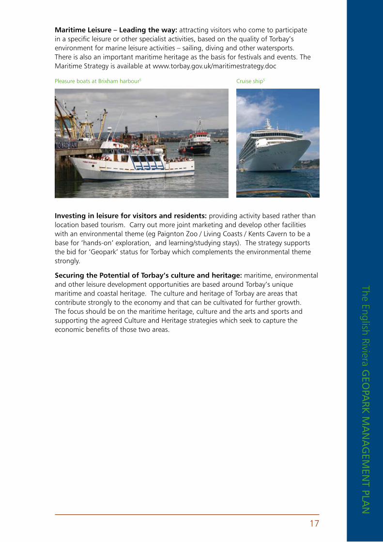
Maritime leisure – leading the way: attracting visitors who come to participate in a specific leisure or other specialist activities, based on the quality of Torbay’s environment for marine leisure activities – sailing, diving and other watersports. There is also an important maritime heritage as the basis for festivals and events. The Maritime Strategy is available at www.torbay.gov.uk/maritimestrategy.doc
Investing in leisure for visitors and residents: providing activity based rather than location based tourism. Carry out more joint marketing and develop other facilities with an environmental theme (eg Paignton Zoo / Living Coasts / Kents Cavern to be a base for ‘hands-on’ exploration, and learning/studying stays). The strategy supports the bid for ‘Geopark’ status for Torbay which complements the environmental theme strongly.
Securing the potential of torbay’s culture and heritage: maritime, environmental and other leisure development opportunities are based around Torbay’s unique maritime and coastal heritage. The culture and heritage of Torbay are areas that contribute strongly to the economy and that can be cultivated for further growth. The focus should be on the maritime heritage, culture and the arts and sports and supporting the agreed Culture and Heritage strategies which seek to capture the economic benefits of those two areas.
Pleasure boats at Brixham harbour5 Cruise ship5

The
Engl
ish
Rivi
era
GEo
park
ma
na
GEm
Ent
pla
n
18
6. thE potEntial for furthEr DEvElopmEnt of thE GEopark
The potential for further development of geo-tourism and geo-education in Torbay is excellent and is based upon these key attributes:
6 .1 Site managementn Good distribution of geosites throughout the area, the overwhelming
majority being open to the public. The geology of these sites is generally robust and can accept visitor pressures. There is potential to improve access to some of these sites.
n Management of the majority of geosites is carried out through a single organisation (Torbay Coast and Countryside Trust) with strong links to other managers / owners. Torbay Coast and Countryside Trust has received national recognition for the quality of its conservation work.
n A strong management partnership (ERGO) includes all of the key players in the area.
6 .2 Infrastructuren An excellent footpath network, including the South West Coast Path (the
UK’s longest trail), links the main geosites. Torbay Coast and Countryside Trust is responsible for management of this trail.
n An excellent public transport network (buses, ferries, trains) serves the area, as well as a busy regional airport at Exeter.
n An excellent tourist infrastructure exists with very high capacity (eg hotel spaces, parking). Future development plans include a greater emphasis on sustainability in the tourism sector and a reducing reliance on the private car as the main mode of transport for visitors.
6 .3 Geotourismn A dynamic Tourist Board with national and
international marketing skills and resources including three Tourist Information Centres (TICs) (www.torbay.gov.uk/index/liesure/tourism/tourism_strategy.htm). The business sector is closely integrated in this work, through the English Riviera Attractions Partnership and the Torbay Hospitality Association amongst others.
n A network of museums and other cultural sites and resources, co-ordinated through the Cultural Partnership. One of these museums (Torquay) has internationally significant geological and archaeological collections.
n The TICs, museums and other cultural sites will develop as Gateway sites to the Geopark, holding information and staging exhibitions about the Geopark.
The English Riviera GEo
park m
an
aG
EmEn
t plan
19
n Existing programmes of interpretation and events, with experienced guides and event organisers
n Growing links with other neighbouring areas with related designations (eg Jurassic Coast World Heritage Site; Cornish Mining World Heritage Site; North Devon Biosphere).
n A growing level of existing geotourism activity: one geological trail existing and a second one in development for 2007; geological cruises growing year on year; guided walks also growing in number and popularity.
n High potential to expand existing activities under the Geopark banner, eg: cycle-routes and tours; canoeing; scuba-diving; rock-climbing.
n A high level of existing educational activity organised by staff skilled in environmental education; school and college field visits to geosites are already in action and ready to be further developed; much of this activity is
by schools visiting Torbay from elsewhere in the country.
n The Coastlands partnership co-ordinates outdoor leisure activities for schools, based at two outdoor activity centres, with a third centre opening in 2007.
n Encouraging further visits by Cruise liners, Foreign language students and International visitors is part of Torbay’s development strategy, and Geopark status will be used to reinforce this work
n A network of volunteer Geo-Rangers will assist the Geopark Officer in the future.
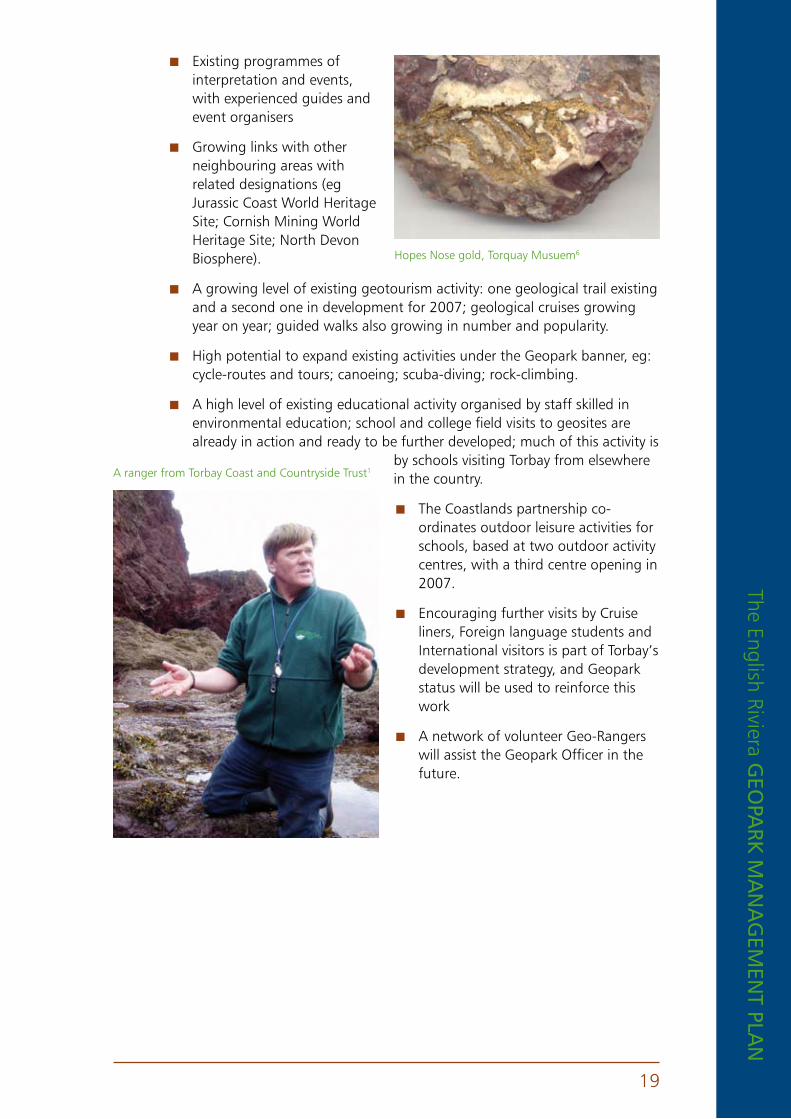
Hopes Nose gold, Torquay Musuem6
A ranger from Torbay Coast and Countryside Trust1
The
Engl
ish
Rivi
era
GEo
park
ma
na
GEm
Ent
pla
n
20
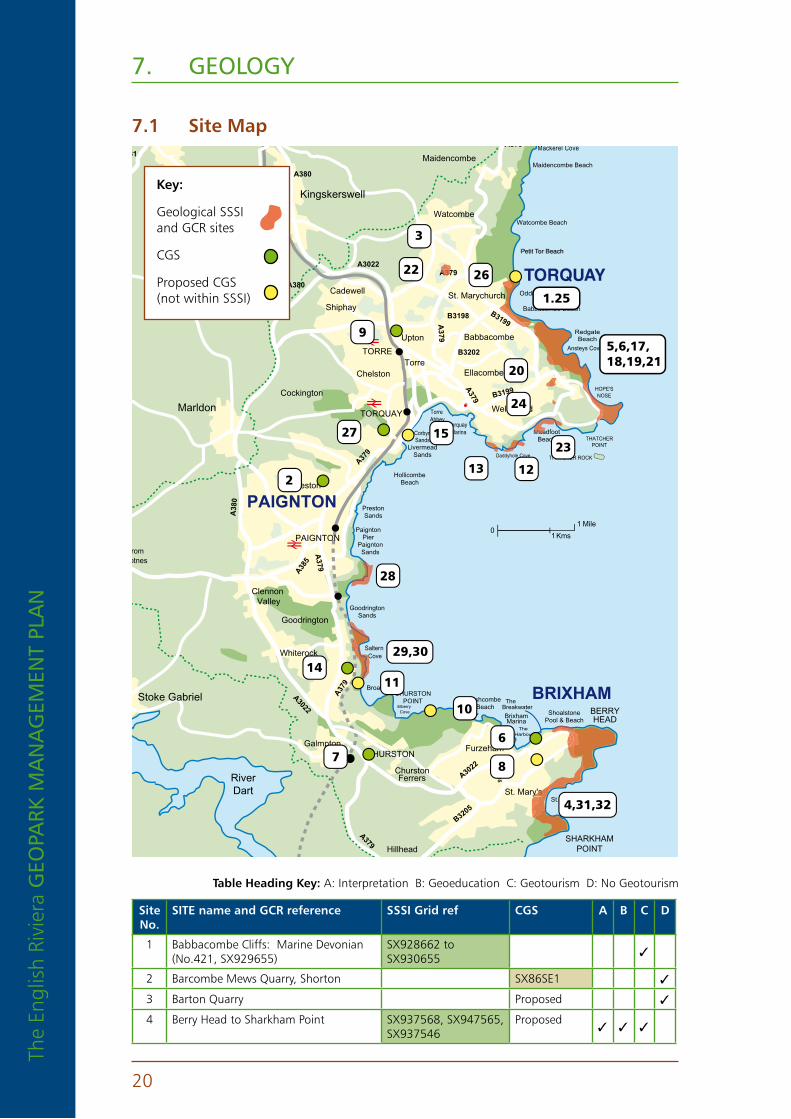
7. GEoloGy
7 .1 Site Map
TORQUAY
PAIGNTON
BRIXHAM
Abbotskerswell
Maidencombe
Kingskerswell
Marldon
Stoke Gabriel
Watcombe
Cadewell St. Marychurch
Babbacombe
Shiphay
Upton
TORRE
Chelston
Cockington
TorreEllacombe
Wellswood
Preston
PAIGNTON
Goodrington
ClennonValley
Whiterock
GalmptonCHURSTON
ChurstonFerrers
Furzeham
St. Mary's
HillheadSHARKHAM
POINT
BERRYHEAD
FishcombeBeach
BrixhamMarina
ShoalstonePool & Beach
BroadsandsCHURSTON
POINT
PaigntonSands
GoodringtonSands
PaigntonPier
PrestonSands
HollicombeBeach
LivermeadSands
TorreAbbeySands Torquay
Marina MeadfootBeach THATCHER
POINT
HOPE'SNOSE
RedgateBeach
Babbacombe Beach
Oddicombe Beach
Petit Tor BeachPetit Tor Beach
Watcombe Beach
Maidencombe Beach
From Dartmouth Via Car Ferry
St. Mary'sBay
TheHarbour
Elberry Cove
Saltern Cove
RiverDart
Daddyhole Cove
Ansteys Cove
Mackerel Cove
Herring Cove
From TeignmouthFromNewton Abbot, Exeter and M5
FromTotnes
TORQUAY
A381
A380
A379
A3022
A380
A379
B3198 B3199
B3202A
379
A379 B3199
A38
0
A3022
A379
B3205
B3205A3022
TheBreakwater
A379
A385
A379
A379
01
1
Mile
Kms
THATCHER ROCK
CorbynSands
37A37
Mea
C
sy s
3
22 26
1.25
5,6,17,18,19,21
20
24
9
1527
13 12
23
2
28
29,3014
11
7
10
6
8
4,31,32
key:
Geological SSSI and GCR sites
CGS
Proposed CGS (not within SSSI)
Site no .
SIte name and GCr reference SSSI Grid ref CGS a B C D
1 Babbacombe Cliffs: Marine Devonian (No.421, SX929655)
SX928662 to SX930655 3
2 Barcombe Mews Quarry, Shorton SX86SE1 3
3 Barton Quarry Proposed 3
4 Berry Head to Sharkham Point SX937568, SX947565, SX937546
Proposed3 3 3
table Heading key: A: Interpretation B: Geoeducation C: Geotourism D: No Geotourism
The English Riviera GEo
park m
an
aG
EmEn
t plan
21
Site no .
SIte name and GCr reference SSSI Grid ref CGS a B C D
5 Black Head and Anstey’s Cove SX932654 to SX944633 and SX944628
Proposed3
6 Breakwater Quarry, Brixham Ref:SX95NW1 3 3
7 Brokenbury Quarry, Churston Ferrers Ref:SX85SE1 3
8 Brixham Cavern Proposed 3
9 Chapel Hill, Torre Ref:SX96NW1 3 3
10 Churston Cove / Churston Point Proposed 3
11 Crystal Cove Proposed 3
12 Daddyhole: Marine Devonian (No 425, SX928628)
SX9276283 3
13 Dyers Quarry: Marine Devonian (No 468, SX921628)
SX9226283 3
14 Goodrington Quarry and Road Cutting Ref:SX85NE1 3
15 Hollicombe Head to Corbyns Head Proposed 3 3
16 Hopes Nose to Wall’s Hill: Marine Devonian (No 426, Hopes Nose, SX948635)
SX932654 to SX944633 and SX944628
3 3 3
17 Hopes Nose: Mineralogy of SW England (No 1725, Hopes Nose, SX949636)
SX932654 to SX944633 and SX944628
3 3 3
18 Hopes Nose and Thatcher Rock: SX932654 to SX944633 and SX944628
3 3 3
19 Hopes Nose South SX932654 to SX944633 and SX944628
Proposed3 3 3
20 Kents Cavern: Quaternary of SW England (No 1312, SX935641)
SX9346413 3 3
21 Long Quarry: Marine Devonian (No 420, SX937651)
SX932654 to SX944633 and SX944628
3
22 Lummaton Quarry: Marine Devonian (No 471, SX912665)
SX9126653
23 Meadfoot Sea Rd: Marine Devonian (No 422, SX934633)
SX9346333 3
24 New Cut: Marine Devonian (No 429, SX93526375)
SX9353, SX65753
25 Oddicombe: Permian-Triassic (No 1496, SX927660)
SX928662 to SX930655 3 3 3
26 Petitor, Maidencombe Proposed 3
27 Quarry Woods Quarry, Cockington Ref:SX96SE1 3
28 Roundham Head: Permian Triassic (No 1504, SX896603, SX894598)
SX8986013 3
29 Saltern Cove: Marine Devonian (No 424, SX89555880 to SX89655805)
SX8955853 3 3
30 Saltern Cove: Permian Triassic (No 1503, SX894591to SX896586)
SX8955853 3 3
31 Sharkham Iron Mine SX937568, SX947565, SX937546
Proposed3
32 Shoalstone: Permian-Triassic (No 1494, , SX934568, SX939568)
SX937568, SX947565, SX937546 3

The
Engl
ish
Rivi
era
GEo
park
ma
na
GEm
Ent
pla
n
22
7 .2 Geological map to the torquay (350) sheet
Geological map of Torquay and surrounding area11
perMIan DevonIanConglomerate; sandstone
Purple & green slate UDev
Grey slate M&UDev
Limestone M&UDev
Staddon formation L Dev
Meadfoot group L Dev
Dartmouth group L Dev
Igneous rocks
Fault thrust

The English Riviera GEo
park m
an
aG
EmEn
t plan
23
7 .3 torbay’s Geology - a simple explanation from the beginning .
In the grand scheme of things our view that we are standing on solid ground is deceptive. The Earth is dynamic both inside and out, and an understanding of geological processes in operation from the very beginning helps to explain why the geology we find around us today is how it is.
Having formed as part of the Solar System around 4600 million years ago, the internal structure of the earth is composed of condensed gases and particles in concentric layers. At extremely high temperature and pressure, the densest part of the earth is the central core, whilst the coolest, lightest and thinnest part of the earth is the outer layer, the crust. In between the two exists a thick layer known as the mantle, capable of movement, even though it is comprised of mostly solid rock. The movement of the mantle is key to the changes that have occurred on the Earth’s surface since its formation.
The earth’s crust moves across the mantle in great sections, known as plates. The plates fit together like a giant jigsaw, great sections constantly moving relative to each other at a rate of a couple of centimetres per year. Known as plate tectonics, this process is responsible for continents colliding as they move from one side of the globe to another, oceans opening and closing, sea levels dramatically altering and mountains rising; millennia of volcanic action, earthquakes and unbelievable pressures contorting the very rock itself.
Due to plate tectonics, 390 million years ago, Torbay was nowhere near its current position but was located south of the equator. Bathed in shallow tropical seas teeming with exotic marine life, massive coral reefs developed, but not quite like those of today. These were built of hard coral-like sponges known as stromatoporoids, with true corals growing in clumps inbetween. Sheltered lagoons behind
the reefs were often full of clam-like brachiopod shells and woodlice-like trilobites scurried by looking for a meal. Fish had yet to take over the seas, their place occupied by shelled relatives of modern squids, including some of the first coiled ammonoids.
The deposits of these tropical seas and the animals and plants that thrived in them accumulated to form the pale, hard limestones which dominate Torquay and Brixham today - they even dictate the very shape of Torbay itself as they form the headlands of both Hope’s Nose and Berry Head.
In the early 18th century when scientists were developing a system of naming the principal periods of geological time, fossils found in the limestones at sites in Torbay, such as Lummaton Quarry, made an important contribution to understanding what was happening on Earth from around 409-363 million years ago. As a result a period of geological time named the Devonian was proposed and was soon used globally to
An interpretation of Torbay’s coral reef, based on fossil evidence, artwork by Brin Edwards8
The
Engl
ish
Rivi
era
GEo
park
ma
na
GEm
Ent
pla
n
24
identify rocks and fossils with a similar age. Massively quarried, much of the fossilised stone can be seen in local buildings and the seawalls.
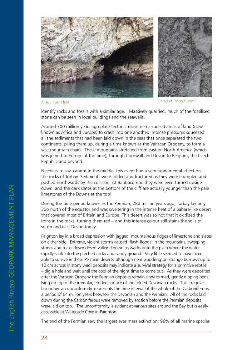
Around 300 million years ago plate tectonic movements caused areas of land (now known as Africa and Europe) to crash into one another. Intense pressures squeezed all the sediments that had been laid down in the seas that once separated the two continents, piling them up, during a time known as the Variscan Orogeny, to form a vast mountain chain. These mountains stretched from eastern North America (which was joined to Europe at the time), through Cornwall and Devon to Belgium, the Czech Republic and beyond.
Needless to say, caught in the middle, this event had a very fundamental effect on the rocks of Torbay. Sediments were folded and fractured as they were crumpled and pushed northwards by the collision. At Babbacombe they were even turned upside down, and the dark slates at the bottom of the cliff are actually younger than the pale limestones of the Downs at the top!
During the time period known as the Permian, 280 million years ago, Torbay lay only 30o north of the equator and was sweltering in the intense heat of a Sahara-like desert that covered most of Britain and Europe. This desert was so hot that it oxidized the irons in the rocks, turning them red – and this intense colour still stains the soils of south and east Devon today.
Paignton lay in a broad depression with jagged, mountainous ridges of limestone and slates on either side. Extreme, violent storms caused ‘flash-floods’ in the mountains, sweeping stones and rocks down desert valleys known as wadis onto the plain where the water rapidly sank into the parched rocky and sandy ground. Very little seemed to have been able to survive in these Permian deserts, although near Goodrington strange burrows up to 10 cm across in stony wadi deposits may indicate a survival strategy for a primitive reptile – dig a hole and wait until the cool of the night time to come out! As they were deposited after the Variscan Orogeny the Permian deposits remain undeformed, gently dipping beds lying on top of the irregular, eroded surface of the folded Devonian rocks. This irregular boundary, an unconformity, represents the time interval of the whole of the Carboniferous, a period of 64 million years between the Devonian and the Permian. All of the rocks laid down during the Carboniferous were removed by erosion before the Permian deposits were laid on top. The unconformity is evident at various sites around the Bay but is easily accessible at Waterside Cove in Paignton.
The end of the Permian saw the largest ever mass extinction; 96% of all marine species
Corals at Triangle Point1A recumbent fold1
The English Riviera GEo
park m
an
aG
EmEn
t plan
25
and 75% of all land vertebrates families were wiped out! The dinosaurs arose from the remnants of life that survived into the Triassic period, the evidence for which exists eastward along the Jurassic Coast.
At some point during the Permian Triassic low temperature hydrothermal fluids apparently produced a significant deposit of low-grade iron ore in the limestone plateaus at Brixham and Sharkham Point. Discovered in 1842 the ore was commercially mined for smelting and for the use in the manufacture of anti-corrosion paint by the Tor Bay Paint Co established in 1895. Another suite of fluids led to the formation of thin gold and palladium-bearing veins in the Devonian limestones of Hope’s Nose, Torquay, the former characteristically forming small, delicate feather-like crystals. Very rare selenium minerals are also present, together making these deposits unique in Britain and possibly within Europe.
More recently, having moved close to its present position, Britain has been subjected to repeated ice ages divided by warm periods when sea levels fluctuated. This period, known as the Quaternary, started 1.6 million years ago and continues to the present day. The warm periods saw hippopotami munching on abundant vegetation. During the cold periods, whilst most of the rest of the country was locked in ice, Torbay would have experienced tundra conditions.
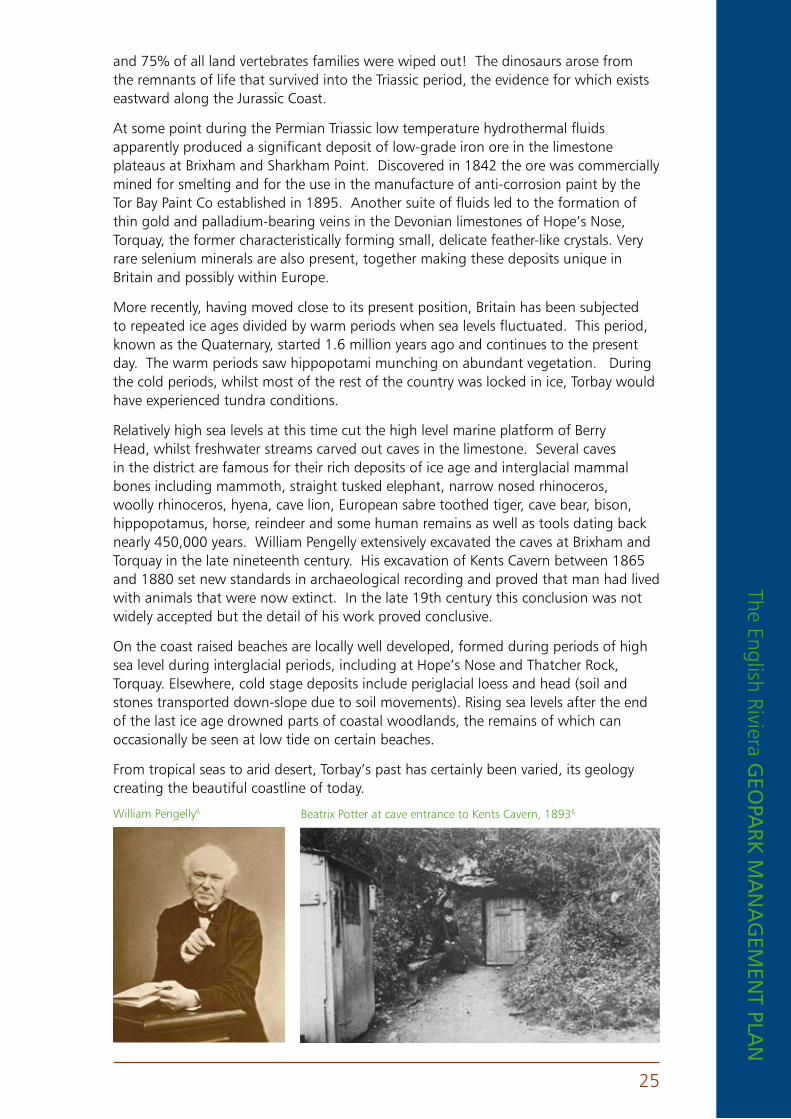
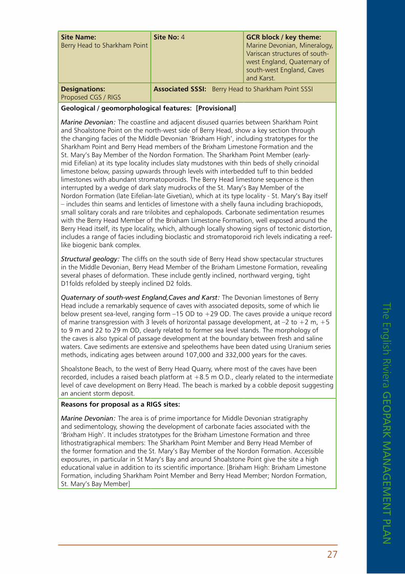
Relatively high sea levels at this time cut the high level marine platform of Berry Head, whilst freshwater streams carved out caves in the limestone. Several caves in the district are famous for their rich deposits of ice age and interglacial mammal bones including mammoth, straight tusked elephant, narrow nosed rhinoceros, woolly rhinoceros, hyena, cave lion, European sabre toothed tiger, cave bear, bison, hippopotamus, horse, reindeer and some human remains as well as tools dating back nearly 450,000 years. William Pengelly extensively excavated the caves at Brixham and Torquay in the late nineteenth century. His excavation of Kents Cavern between 1865 and 1880 set new standards in archaeological recording and proved that man had lived with animals that were now extinct. In the late 19th century this conclusion was not widely accepted but the detail of his work proved conclusive.
On the coast raised beaches are locally well developed, formed during periods of high sea level during interglacial periods, including at Hope’s Nose and Thatcher Rock, Torquay. Elsewhere, cold stage deposits include periglacial loess and head (soil and stones transported down-slope due to soil movements). Rising sea levels after the end of the last ice age drowned parts of coastal woodlands, the remains of which can occasionally be seen at low tide on certain beaches.
From tropical seas to arid desert, Torbay’s past has certainly been varied, its geology creating the beautiful coastline of today.
Beatrix Potter at cave entrance to Kents Cavern, 18936William Pengelly6

The
Engl
ish
Rivi
era
GEo
park
ma
na
GEm
Ent
pla
n
26
7 .4 Site designations and geological/ geomorphological features
Site name: Babbacombe cliffs
Site no: 1 GCr block / key theme: Marine Devonian
Designations: GCR (No. 421)
associated SSSI: Babbacombe Cliffs SSSI
GCr Statement of Interest: “This locality includes the type section of the Babbacombe Shales, which have yielded a rich goniatite fauna of early Frasnian age. The cliff section is inverted and displays interesting structural features, and the best accessible section through the richly fossiliferous Barton Limestone. This section is of great interest in demonstrating the marked facies change from a high-energy, reef environment of the Barton Limestone to deeper water conditions represented by the Babbacombe Shales.”
Site name: Barcombe Mews Quarry
Site no: 2 GCr block / key theme: Permian-Triassic
Designations: CGS / RIGS
associated SSSI: Not applicable
Geological / geomorphological features: “Permian breccia with large angular to sub-rounded clasts of sandstone, limestone. Quartz and slate, set in a bedded, well-cemented, coarse gravel matrix. Traces of cross-bedding indicate an approximately E-W depositional flow. Minor faulting can be seen.”
reasons for registration as a rIGS sites: “The site provides an excellent clean exposure of the Permian breccias of the Torbay area in a safe and accessible situation particularly suitable for educational use by younger children. The site also demonstrates the variation in proportion and composition of the rock fragments found in the breccias of the Torbay district.”
Site name: Barton Quarry
Site no: 3 GCr block / key theme: Marine Devonian
Designations: Proposed CGS / RIGS
associated SSSI: Berry Head to Sharkham Point SSSI
Geological / geomorphological features: [Provisional] The old quarry, now occupied by development, still shows important exposures of the bioclastic Barton Member of the Torquay Limestone Formation, and effectively forms the type locality of the unit. In the past the site has yielded a rich fauna, not dissimilar to that from the better known Lummaton Quarry, including varied brachiopods, bivalves, gastropods, trilobites and rare ammonoids. Current exposures show rich coral-stromatoporoid assemblages, with the tabulate Thamnopora being particularly abundant. The exposures have also yielded conodont faunas confirming an uppermost varcus to lower assymetricus biozone age (Upper Givetian).
reasons for proposal as a rIGS sites: The site is of key historical importance as a source of rich late Middle Devonian faunas and has the potential to yield additional material of palaeontological importance. Crucially, it is also effectively the type locality of the Barton Member of the Torquay Limestone Formation, and therefore has regional lithostratigraphical significance. Limited access makes the site primarily a research rather than educational locality. [Torbay High: Torquay Limestone Formation, Barton Member]
The English Riviera GEo
park m
an
aG
EmEn
t plan
27
Site name: Berry Head to Sharkham Point
Site no: 4 GCr block / key theme: Marine Devonian, Mineralogy, Variscan structures of south-west England, Quaternary of south-west England, Caves and Karst.
Designations: Proposed CGS / RIGS
associated SSSI: Berry Head to Sharkham Point SSSI
Geological / geomorphological features: [provisional]
Marine Devonian: The coastline and adjacent disused quarries between Sharkham Point and Shoalstone Point on the north-west side of Berry Head, show a key section through the changing facies of the Middle Devonian ‘Brixham High’, including stratotypes for the Sharkham Point and Berry Head members of the Brixham Limestone Formation and the St. Mary’s Bay Member of the Nordon Formation. The Sharkham Point Member (early-mid Eifelian) at its type locality includes slaty mudstones with thin beds of shelly crinoidal limestone below, passing upwards through levels with interbedded tuff to thin bedded limestones with abundant stromatoporoids. The Berry Head limestone sequence is then interrupted by a wedge of dark slaty mudrocks of the St. Mary’s Bay Member of the Nordon Formation (late Eifelian-late Givetian), which at its type locality - St. Mary’s Bay itself – includes thin seams and lenticles of limestone with a shelly fauna including brachiopods, small solitary corals and rare trilobites and cephalopods. Carbonate sedimentation resumes with the Berry Head Member of the Brixham Limestone Formation, well exposed around the Berry Head itself, its type locality, which, although locally showing signs of tectonic distortion, includes a range of facies including bioclastic and stromatoporoid rich levels indicating a reef-like biogenic bank complex.
Structural geology: The cliffs on the south side of Berry Head show spectacular structures in the Middle Devonian, Berry Head Member of the Brixham Limestone Formation, revealing several phases of deformation. These include gently inclined, northward verging, tight D1folds refolded by steeply inclined D2 folds.
Quaternary of south-west England,Caves and Karst: The Devonian limestones of Berry Head include a remarkably sequence of caves with associated deposits, some of which lie below present sea-level, ranging form –15 OD to +29 OD. The caves provide a unique record of marine transgression with 3 levels of horizontal passage development, at –2 to +2 m, +5 to 9 m and 22 to 29 m OD, clearly related to former sea level stands. The morphology of the caves is also typical of passage development at the boundary between fresh and saline waters. Cave sediments are extensive and speleothems have been dated using Uranium series methods, indicating ages between around 107,000 and 332,000 years for the caves.
Shoalstone Beach, to the west of Berry Head Quarry, where most of the caves have been recorded, includes a raised beach platform at +8.5 m O.D., clearly related to the intermediate level of cave development on Berry Head. The beach is marked by a cobble deposit suggesting an ancient storm deposit.
reasons for proposal as a rIGS sites:
Marine Devonian: The area is of prime importance for Middle Devonian stratigraphy and sedimentology, showing the development of carbonate facies associated with the ‘Brixham High’. It includes stratotypes for the Brixham Limestone Formation and three lithostratigraphical members: The Sharkham Point Member and Berry Head Member of the former formation and the St. Mary’s Bay Member of the Nordon Formation. Accessible exposures, in particular in St Mary’s Bay and around Shoalstone Point give the site a high educational value in addition to its scientific importance. [Brixham High: Brixham Limestone Formation, including Sharkham Point Member and Berry Head Member; Nordon Formation, St. Mary’s Bay Member]
The
Engl
ish
Rivi
era
GEo
park
ma
na
GEm
Ent
pla
n
28
Structural geology: Although not easily accessible, these spectacular folds can be viewed form the south side of the Berry Head Fort, although binoculars are recommended. In this way the site can be incorporated into educational visits to the headland. The features exposed, however, are some of the most dramatic and important structural features in the district.
Quaternary of south-west England,Caves and Karst: The site is unique in the region, and similar features related to cave development under the influence of changes in sea-level in the Plymouth limestone are either inaccessible or have now been largely destroyed by development. The scientific value of the site is potentially national, although educational use is limited by health and safety considerations too viewing openings form a safe distance.
Site name: Black Head and Ansteys Cove
Site no: 5 GCr block / key theme: Igneous rocks of south-west England
Designations: Proposed CGS / RIGS
associated SSSI: Hope’s Nose to Walls Hill SSSI
Geological / geomorphological features: [Provisional] The only significant outcrops of intrusive igneous rocks in the Torbay district are between Black Head and Anstey’s Cove, where microgabbros (‘dolerite’) are intruded into the Upper Devonian Saltern Cove Formation. The intrusions are associated with basic tuffs and believed to be typical of alkaline or sub-alkaline basalts of a within-plate Ocean Island type, as elsewhere in Devon and Cornwall.
reasons for proposal as a CGS / rIGS sites: The only significant outcrops of intrusive igneous rocks in the Torbay district, which are readily accessible and therefore suitable for educational use in Anstey’s Cove.
Site name: Breakwater Quarry
Site no: 6 GCr block / key theme: Permian-Triassic
Designations: CGS / RIGS
associated SSSI: Not applicable
Geological / geomorphological features: “Middle Devonian limestone, mainly massive and micritic but bioclastic in part. Bedding is obscure, the dip is steep to the SE. Cleavage seen in places dips about 20° NW. The limestone has an irregular palaeokarst surface and is penetrated by deep narrow fissures filled with brown Permian sandstone which contains angular limestone fragments in places, some of large size. Pleistocene/Holocene solution fissures in the limestone are associated with coatings of flowstone. Engineering geological applications include the use of rock bolts for the large scale stabilisation of rock faces in association with steel mesh to prevent falls of smaller rock fragments.”
reasons for registration as a rIGS sites: “The quarry provides an excellent demonstration of pre-Permian solution fissures in the Devonian limestone (palaeokarst) with later, Permian, sandstone and limestone fragment infilling. The vertical extent of the fissure is particularly notable. Other useful aspects included structural features and solution fissures with flowstone in the limestone; also engineering application of rock bolts to stabilise faces and the use of mesh to prevent falls of smaller material.”
Site name: Brokenbury Quarry
Site no: 7 GCr block / key theme: Variscan Structures of south-west England
Designations: CGS / RIGS
associated SSSI: Not applicable
Geological / geomorphological features: “Middle Devonian limestone. Foliated, micritic, light pinkish grey, partly dolomitised limestone. Most strongly foliated layers are probably more argillaceous and represent bedding. Crinoid stem fragments and traces of burrows in foliated layers. On the east side of the quarry the foliation/bedding dip is about 10° SW. On the west side of the quarry upright folds about 1m in amplitude with a NS trend, deform the earlier foliation. These folds have been partly excavated, possibly for research purposes and are exposed in three dimensions.”
The English Riviera GEo
park m
an
aG
EmEn
t plan
29
reasons for registration as a rIGS sites: “The main interest of the quarry lies in the later folds, which deform the early foliation, and are particularly well exposed at the present time. Later fold structures are seldom seen in inland exposures. The main quarry face provides evidence of the nature of the earlier structure and lithology to which the laterfolds are related and can assist the overall structural interpretation of the district.”
Site name: Brixham Cavern
Site no: 8 GCr block / key theme: Quaternary of south-west England and Pleistocene Vertebrata
Designations: Proposed CGS / RIGS
associated SSSI: Not applicable
Geological / geomorphological features: [Provisional] Quaternary: Brixham Cavern is a historically important source of Pleistocene vertebrate remains, indicating an assemblage similar to that known from Kent’s Cavern. The site is a Scheduled Ancient Monument and was formerly operated as a show cave. The cave was discovered in 1858 and subsequently excavated, yielding mammoth, horse, woolly rhinoceras, deer, cave lion, hyaena, bear, amongst other remains.
reasons for proposal as a CGS / rIGS sites: Brixham Cavern is a key historical site in Torbay, a former source of rich Pleistocene vertebrate faunas. Access is currently restricted and the cave is privately owned – use is therefore likely to be primarily for research purposes.
Site name: Chapel Hill
Site no: 9 GCr block / key theme: Permian-Triassic
Designations: CGS / RIGS associated SSSI: Not applicable
Geological / geomorphological features: “Roadside exposure of Permian breccia containing angular to sub-rounded clasts of Devonian limestone, together with some sandstone, volcanic and quartz fragments, in a matrix of red sandy gravel. Rare chert, and possible granitic fragments, also occur. Some limestone clasts contain fossil corals. Bedding traces have a 5° N dip, and imbrication indicates depositional flow from the north. Minor faults occur. Outcrops of Middle Devonian limestone above and to the east of the breccia demonstrate the infilling of Permian palaeotopography, possibly controlled by faulting, by the younger breccia. The limestone is generally massively bedded and bioclastic,with a dip of 60°-70° WSW. Cleaner exposure lies beside paths at the top of the hill show corals and stromatoporoids.”
reasons for registration as a rIGS sites: “The site demonstrates the palaeotopographical relationship between the Permian breccia and the underlying Devonian limestone. The excellent breccia exposure on Newton Road is very accessible for study. There is considerable potential for development as a valuable educational resource.”
Site name: Churston Cove / Churston Point
Site no: 10 GCr block / key theme: Marine Devonian
Designations: Proposed CGS / RIGS
associated SSSI: Not applicable
Geological / geomorphological features: [Provisional] Cliff and foreshore exposures between Churston Cove and Broad Sands show a thrust-bounded section through the Churston Member (Frasnian), the highest division of the Berry Head Limestone Formation, and constitute the stratotype for the unit. Slaty mudstones interbedded with thinly bedded crinoidal limestones and tuffs pass upwards into medium to massive bedded stromatoporoid-rich limestones, in part dolomitised.
reasons for proposal as a rIGS sites: The area is of regional stratigraphical importance as the type locality of the Churston Member of the Brixham Limestone Formation, and makes the final stages of carbonate sedimentation on the Brixham High. Accessibility gives the site educational value, especially when studied in association with the lower part of the sequence of the Brixham High, within the Sharkham Point to Berry Head CGS (proposed). [Brixham High: Brixham Limestone Formation (including Churston Member)]
The
Engl
ish
Rivi
era
GEo
park
ma
na
GEm
Ent
pla
n
30
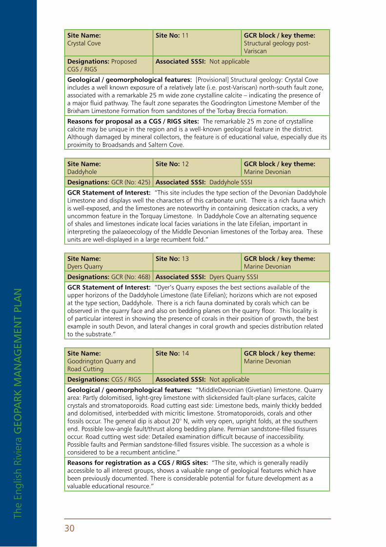
Site name: Crystal Cove
Site no: 11 GCr block / key theme: Structural geology post-Variscan
Designations: Proposed CGS / RIGS
associated SSSI: Not applicable
Geological / geomorphological features: [Provisional] Structural geology: Crystal Cove includes a well known exposure of a relatively late (i.e. post-Variscan) north-south fault zone, associated with a remarkable 25 m wide zone crystalline calcite – indicating the presence of a major fluid pathway. The fault zone separates the Goodrington Limestone Member of the Brixham Limestone Formation from sandstones of the Torbay Breccia Formation.
reasons for proposal as a CGS / rIGS sites: The remarkable 25 m zone of crystalline calcite may be unique in the region and is a well-known geological feature in the district. Although damaged by mineral collectors, the feature is of educational value, especially due its proximity to Broadsands and Saltern Cove.
Site name: Daddyhole
Site no: 12 GCr block / key theme: Marine Devonian
Designations: GCR (No: 425) associated SSSI: Daddyhole SSSI
GCr Statement of Interest: “This site includes the type section of the Devonian Daddyhole Limestone and displays well the characters of this carbonate unit. There is a rich fauna which is well-exposed, and the limestones are noteworthy in containing desiccation cracks, a very uncommon feature in the Torquay Limestone. In Daddyhole Cove an alternating sequence of shales and limestones indicate local facies variations in the late Eifelian, important in interpreting the palaeoecology of the Middle Devonian limestones of the Torbay area. These units are well-displayed in a large recumbent fold.”
Site name: Dyers Quarry
Site no: 13 GCr block / key theme: Marine Devonian
Designations: GCR (No: 468) associated SSSI: Dyers Quarry SSSI
GCr Statement of Interest: “Dyer’s Quarry exposes the best sections available of the upper horizons of the Daddyhole Limestone (late Eifelian); horizons which are not exposed at the type section, Daddyhole. There is a rich fauna dominated by corals which can be observed in the quarry face and also on bedding planes on the quarry floor. This locality is of particular interest in showing the presence of corals in their position of growth, the best example in south Devon, and lateral changes in coral growth and species distribution related to the substrate.”
Site name: Goodrington Quarry and Road Cutting
Site no: 14 GCr block / key theme: Marine Devonian
Designations: CGS / RIGS associated SSSI: Not applicable
Geological / geomorphological features: “MiddleDevonian (Givetian) limestone. Quarry area: Partly dolomitised, light-grey limestone with slickensided fault-plane surfaces, calcite crystals and stromatoporoids. Road cutting east side: Limestone beds, mainly thickly bedded and dolomitised, interbedded with micritic limestone. Stromatoporoids, corals and other fossils occur. The general dip is about 20° N, with very open, upright folds, at the southern end. Possible low-angle fault/thrust along bedding plane. Permian sandstone-filled fissures occur. Road cutting west side: Detailed examination difficult because of inaccessibility. Possible faults and Permian sandstone-filled fissures visible. The succession as a whole is considered to be a recumbent anticline.”
reasons for registration as a CGS / rIGS sites: “The site, which is generally readily accessible to all interest groups, shows a valuable range of geological features which have been previously documented. There is considerable potential for future development as a valuable educational resource.”
The English Riviera GEo
park m
an
aG
EmEn
t plan
31
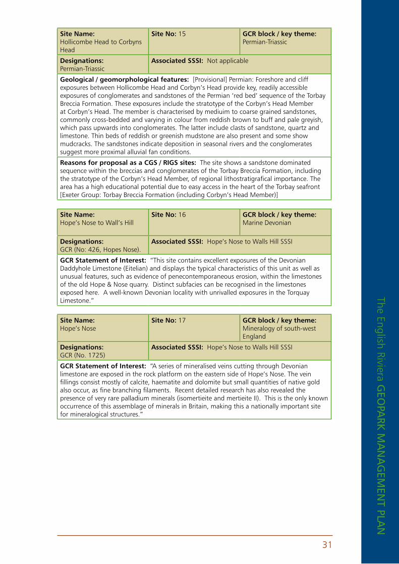
Site name: Hollicombe Head to Corbyns Head
Site no: 15 GCr block / key theme: Permian-Triassic
Designations: Permian-Triassic
associated SSSI: Not applicable
Geological / geomorphological features: [Provisional] Permian: Foreshore and cliff exposures between Hollicombe Head and Corbyn’s Head provide key, readily accessible exposures of conglomerates and sandstones of the Permian ‘red bed’ sequence of the Torbay Breccia Formation. These exposures include the stratotype of the Corbyn’s Head Member at Corbyn’s Head. The member is characterised by mediuim to coarse grained sandstones, commonly cross-bedded and varying in colour from reddish brown to buff and pale greyish, which pass upwards into conglomerates. The latter include clasts of sandstone, quartz and limestone. Thin beds of reddish or greenish mudstone are also present and some show mudcracks. The sandstones indicate deposition in seasonal rivers and the conglomerates suggest more proximal alluvial fan conditions.
reasons for proposal as a CGS / rIGS sites: The site shows a sandstone dominated sequence within the breccias and conglomerates of the Torbay Breccia Formation, including the stratotype of the Corbyn’s Head Member, of regional lithostratigrafical importance. The area has a high educational potential due to easy access in the heart of the Torbay seafront [Exeter Group: Torbay Breccia Formation (including Corbyn’s Head Member)]
Site name: Hope’s Nose to Wall’s Hill
Site no: 16 GCr block / key theme: Marine Devonian
Designations: GCR (No: 426, Hopes Nose).
associated SSSI: Hope’s Nose to Walls Hill SSSI
GCr Statement of Interest: “This site contains excellent exposures of the Devonian Daddyhole Limestone (Eitelian) and displays the typical characteristics of this unit as well as unusual features, such as evidence of penecontemporaneous erosion, within the limestones of the old Hope & Nose quarry. Distinct subfacies can be recognised in the limestones exposed here. A well-known Devonian locality with unrivalled exposures in the Torquay Limestone.”
Site name: Hope’s Nose
Site no: 17 GCr block / key theme: Mineralogy of south-west England
Designations: GCR (No. 1725)
associated SSSI: Hope’s Nose to Walls Hill SSSI
GCr Statement of Interest: “A series of mineralised veins cutting through Devonian limestone are exposed in the rock platform on the eastern side of Hope’s Nose. The vein fillings consist mostly of calcite, haematite and dolomite but small quantities of native gold also occur, as fine branching filaments. Recent detailed research has also revealed the presence of very rare palladium minerals (isomertieite and mertieite II). This is the only known occurrence of this assemblage of minerals in Britain, making this a nationally important site for mineralogical structures.”

The
Engl
ish
Rivi
era
GEo
park
ma
na
GEm
Ent
pla
n
32
Site name: Hope’s Nose and Thatcher Rock
Site no: 18 GCr block / key theme: Quaternary of south-west England
Designations: GCR, Devon (No: 1868)
associated SSSI: Hope’s Nose to Walls Hill SSSI
GCr Statement of Interest: “Hope’s Nose and Thatcher Rock are key sites for studies of Quaternary stratigraphy and sea-level change. At Hope’s Nose a shore platform at 8 m is overlain by cemented raised beach, comprised of cobbles and boulders at its base, fining upwards into bedded sands. Blown sand an hillwash lie above. A similar raised beach occurs on the offshore stack of Thatcher Rock. The beach deposits are particularly important for their assemblages of fossil marine molluscs and foraminifera. Seventeen species of mollusc have been recorded from Hope’s Nose and forty-three from Thatcher Rock. The assemblages from both sites are temperate in nature, although that from Thatcher Rock indicates slightly cooler conditions than those of the present day. Amino-acid dating suggests that the Hope’s Nose beach relates to oxygen isotope stage 7 (ca. 210,000 years BP). The well-preserved molluscan faunas and the sedimentary detail of the raised beaches are of crucial importance for dating and interpreting Quaternary sea-level changes and related environmental conditions in south-west England.”
Site name: Hopes Nose South
Site no: 19 GCr block / key theme: Variscan Structures of south-west England
Designations: Proposed CGS / RIGS
associated SSSI: Hope’s Nose to Walls Hill SSSI
Geological / geomorphological features: [Provisional] Structural geology: Exposed in the cliff face close to the raised beach on Hope’s Nose is one of Torbay’s best known structural geological features - an overturned F1 fold, verging north-west , in thinly bedded limestones and shales of the Daddyhole Member of the Torquay Limestone Formation, associated with a low-angle thrust A well known structure in the Torbay area.
reasons for proposal as a CGS / rIGS sites: A well known structural feature, useful for inclusion in educational visits to Hope’s Nose by older groups (due to proximity to a high cliff).
Site name: Kents Cavern
Site no: 20 GCr block / key theme: Quaternary of south-west England
Designations: GCR (No: 1312)
associated SSSI: Kents Cavern SSSI
GCr Statement of Interest: “Kents Cavern is a famous and important Quaternary site. It is significant for studies in palaeontology, dating and stratigraphy and for elucidating environmental and faunal changes during the Quaternary. It has yielded vertebrate remains of Middle and Late Devensian age and is also notable for the presence of deposits that are probably of Middle Pleistocene age.”
Site name: Long Quarry
Site no: 21 GCr block / key theme: Marine Devonian
Designations: GCR (No: 420)
associated SSSI: Hope’s Nose to Walls Hill SSSI
GCr Statement of Interest: “The Long Quarry area includes the type section of the Devonian Walls Hill Limestone. The best exposure of this stromatoporoid-rich unit can be seen here in the quarry floor. The steep dip of the beds allows an easy bed by bed examination to be made. Within the formation it is possible to recognise four distinct subfacies not seen elsewhere in the Torquay Limestone. The site is unique in so well-displaying the development, growth and form of a stromatoporoid reef.”
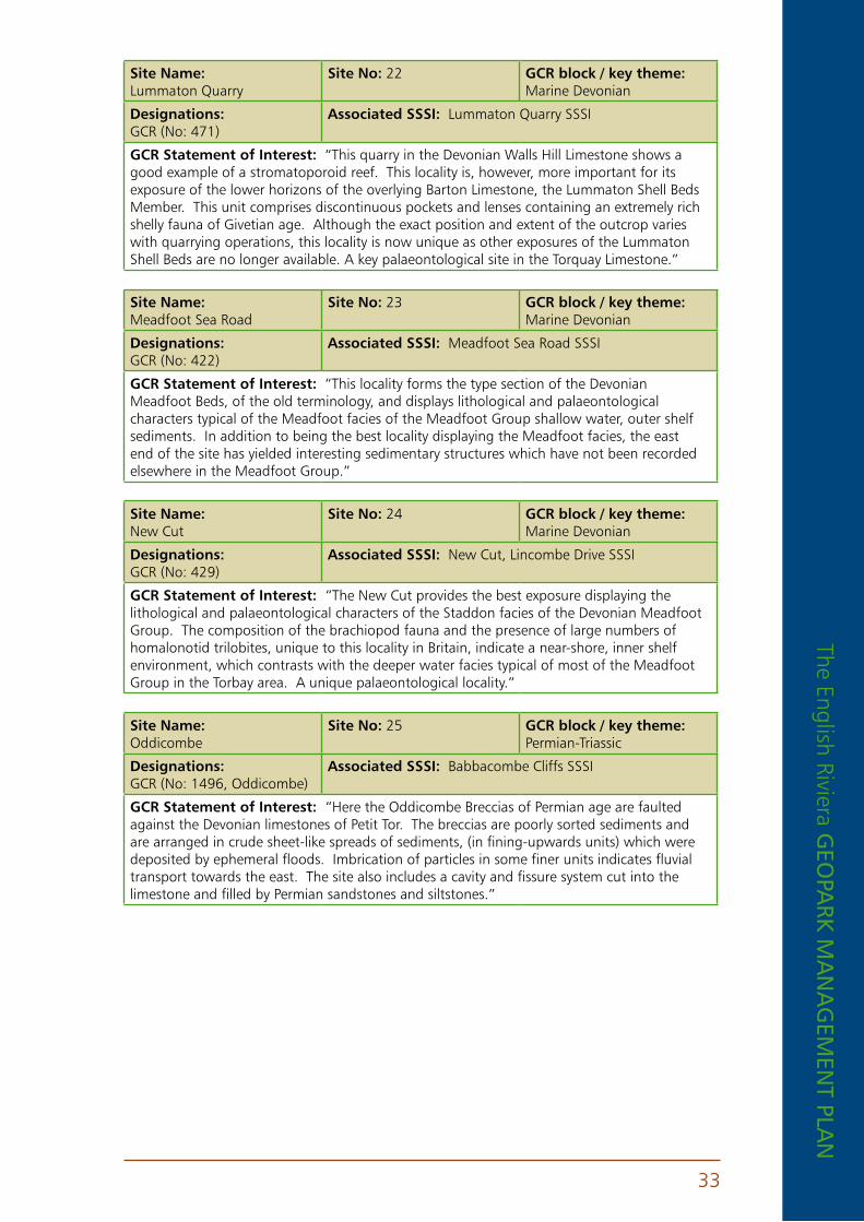
The English Riviera GEo
park m
an
aG
EmEn
t plan
33
Site name: Lummaton Quarry
Site no: 22 GCr block / key theme: Marine Devonian
Designations: GCR (No: 471)
associated SSSI: Lummaton Quarry SSSI
GCr Statement of Interest: “This quarry in the Devonian Walls Hill Limestone shows a good example of a stromatoporoid reef. This locality is, however, more important for its exposure of the lower horizons of the overlying Barton Limestone, the Lummaton Shell Beds Member. This unit comprises discontinuous pockets and lenses containing an extremely rich shelly fauna of Givetian age. Although the exact position and extent of the outcrop varies with quarrying operations, this locality is now unique as other exposures of the Lummaton Shell Beds are no longer available. A key palaeontological site in the Torquay Limestone.”
Site name: Meadfoot Sea Road
Site no: 23 GCr block / key theme: Marine Devonian
Designations: GCR (No: 422)
associated SSSI: Meadfoot Sea Road SSSI
GCr Statement of Interest: “This locality forms the type section of the Devonian Meadfoot Beds, of the old terminology, and displays lithological and palaeontological characters typical of the Meadfoot facies of the Meadfoot Group shallow water, outer shelf sediments. In addition to being the best locality displaying the Meadfoot facies, the east end of the site has yielded interesting sedimentary structures which have not been recorded elsewhere in the Meadfoot Group.”
Site name: New Cut
Site no: 24 GCr block / key theme: Marine Devonian
Designations: GCR (No: 429)
associated SSSI: New Cut, Lincombe Drive SSSI
GCr Statement of Interest: “The New Cut provides the best exposure displaying the lithological and palaeontological characters of the Staddon facies of the Devonian Meadfoot Group. The composition of the brachiopod fauna and the presence of large numbers of homalonotid trilobites, unique to this locality in Britain, indicate a near-shore, inner shelf environment, which contrasts with the deeper water facies typical of most of the Meadfoot Group in the Torbay area. A unique palaeontological locality.”
Site name: Oddicombe
Site no: 25 GCr block / key theme: Permian-Triassic
Designations: GCR (No: 1496, Oddicombe)
associated SSSI: Babbacombe Cliffs SSSI
GCr Statement of Interest: “Here the Oddicombe Breccias of Permian age are faulted against the Devonian limestones of Petit Tor. The breccias are poorly sorted sediments and are arranged in crude sheet-like spreads of sediments, (in fining-upwards units) which were deposited by ephemeral floods. Imbrication of particles in some finer units indicates fluvial transport towards the east. The site also includes a cavity and fissure system cut into the limestone and filled by Permian sandstones and siltstones.”
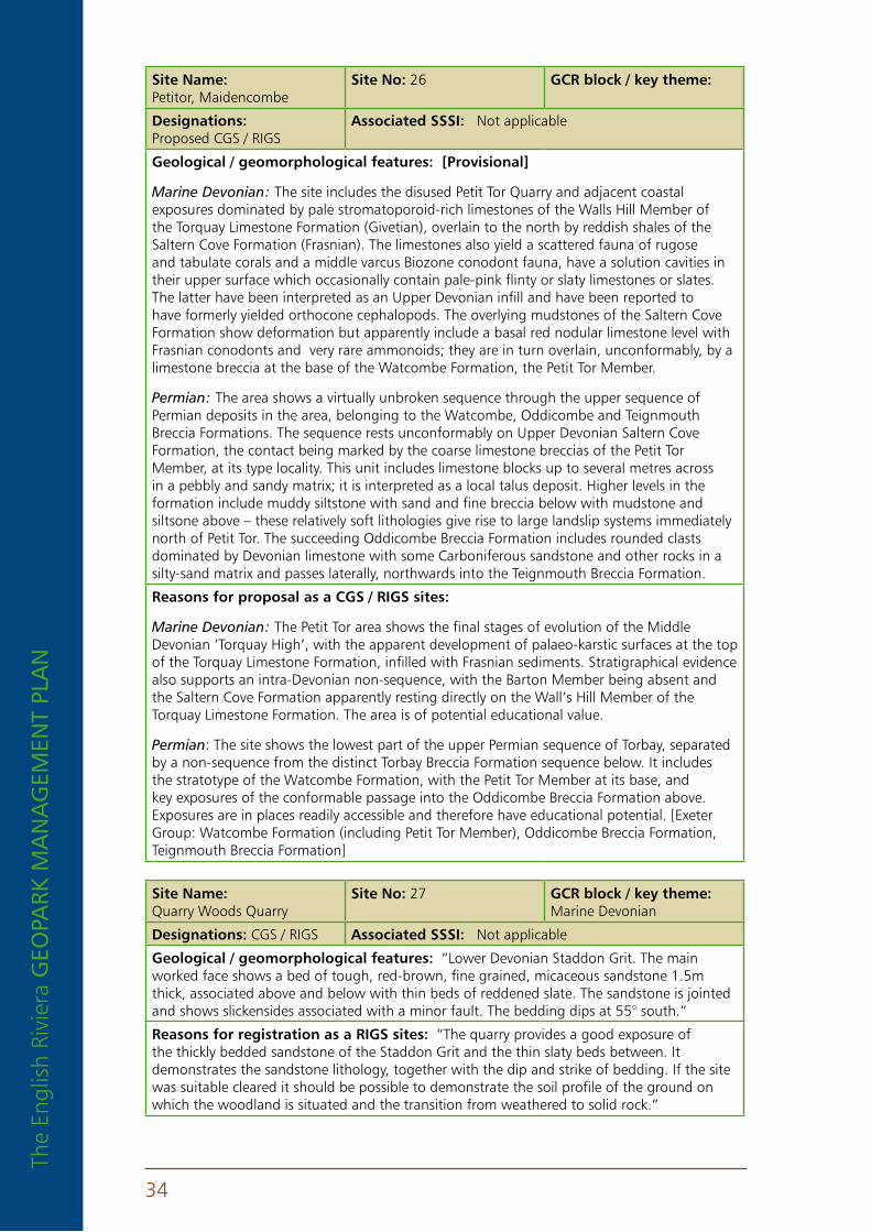
The
Engl
ish
Rivi
era
GEo
park
ma
na
GEm
Ent
pla
n
34
Site name: Petitor, Maidencombe
Site no: 26 GCr block / key theme:
Designations: Proposed CGS / RIGS
associated SSSI: Not applicable
Geological / geomorphological features: [provisional]
Marine Devonian: The site includes the disused Petit Tor Quarry and adjacent coastal exposures dominated by pale stromatoporoid-rich limestones of the Walls Hill Member of the Torquay Limestone Formation (Givetian), overlain to the north by reddish shales of the Saltern Cove Formation (Frasnian). The limestones also yield a scattered fauna of rugose and tabulate corals and a middle varcus Biozone conodont fauna, have a solution cavities in their upper surface which occasionally contain pale-pink flinty or slaty limestones or slates. The latter have been interpreted as an Upper Devonian infill and have been reported to have formerly yielded orthocone cephalopods. The overlying mudstones of the Saltern Cove Formation show deformation but apparently include a basal red nodular limestone level with Frasnian conodonts and very rare ammonoids; they are in turn overlain, unconformably, by a limestone breccia at the base of the Watcombe Formation, the Petit Tor Member.
Permian: The area shows a virtually unbroken sequence through the upper sequence of Permian deposits in the area, belonging to the Watcombe, Oddicombe and Teignmouth Breccia Formations. The sequence rests unconformably on Upper Devonian Saltern Cove Formation, the contact being marked by the coarse limestone breccias of the Petit Tor Member, at its type locality. This unit includes limestone blocks up to several metres across in a pebbly and sandy matrix; it is interpreted as a local talus deposit. Higher levels in the formation include muddy siltstone with sand and fine breccia below with mudstone and siltsone above – these relatively soft lithologies give rise to large landslip systems immediately north of Petit Tor. The succeeding Oddicombe Breccia Formation includes rounded clasts dominated by Devonian limestone with some Carboniferous sandstone and other rocks in a silty-sand matrix and passes laterally, northwards into the Teignmouth Breccia Formation.
reasons for proposal as a CGS / rIGS sites:
Marine Devonian: The Petit Tor area shows the final stages of evolution of the Middle Devonian ‘Torquay High’, with the apparent development of palaeo-karstic surfaces at the top of the Torquay Limestone Formation, infilled with Frasnian sediments. Stratigraphical evidence also supports an intra-Devonian non-sequence, with the Barton Member being absent and the Saltern Cove Formation apparently resting directly on the Wall’s Hill Member of the Torquay Limestone Formation. The area is of potential educational value.
Permian: The site shows the lowest part of the upper Permian sequence of Torbay, separated by a non-sequence from the distinct Torbay Breccia Formation sequence below. It includes the stratotype of the Watcombe Formation, with the Petit Tor Member at its base, and key exposures of the conformable passage into the Oddicombe Breccia Formation above. Exposures are in places readily accessible and therefore have educational potential. [Exeter Group: Watcombe Formation (including Petit Tor Member), Oddicombe Breccia Formation, Teignmouth Breccia Formation]
Site name: Quarry Woods Quarry
Site no: 27 GCr block / key theme: Marine Devonian
Designations: CGS / RIGS associated SSSI: Not applicable
Geological / geomorphological features: “Lower Devonian Staddon Grit. The main worked face shows a bed of tough, red-brown, fine grained, micaceous sandstone 1.5m thick, associated above and below with thin beds of reddened slate. The sandstone is jointed and shows slickensides associated with a minor fault. The bedding dips at 55° south.”
reasons for registration as a rIGS sites: “The quarry provides a good exposure of the thickly bedded sandstone of the Staddon Grit and the thin slaty beds between. It demonstrates the sandstone lithology, together with the dip and strike of bedding. If the site was suitable cleared it should be possible to demonstrate the soil profile of the ground on which the woodland is situated and the transition from weathered to solid rock.”

The English Riviera GEo
park m
an
aG
EmEn
t plan
35
Site name: Roundham Head
Site no: 28 GCr block / key theme: Permian-Triassic
Designations: GCR (No: 1504)
associated SSSI: Roundham Head SSSI
GCr Statement of Interest: “This is the type section of the Permian Tor Bay Breccias. These here include a variety of fluvial breccias, in which types formed during ephemeral sheet floods are the most abundant. On the south side of the headland are interbedded aeolian sands showing palaeowind directions towards the north-west. This contrasts with the directions of fluvial transport, deduced from sedimentary structures such as imbrication and cross-bedding in the breccias, which was towards the south-east. A key site for demonstrating Permian sedimentary environments.”
Site name: Saltern Cove
Site no: 29 GCr block / key theme: Marine Devonian
Designations: GCR (No: 424)
associated SSSI: Saltern Cove SSSI
GCr Statement of Interest: “The Saltern Cove area, including the north end of Shell Cove and the south end of Waterside Cove, displays an extensive section through the Upper Devonian, and includes interesting structures, and the richly fossiliferous Saltern Cove Goniatite Bed. The Lower Devonian beds exposed in Waterside Cove are a good example of the Staddon facies of the Meadfoot Group and are richly fossiliferous. Waterside Cove also displays well the unconformable contact between the Lower Devonian and the overlying Permian beds. One of the most important Upper Devonian stratigraphic localities in Britain.”
Site name: Saltern Cove
Site no: 30 GCr block / key theme: Permian-Triassic
Designations: GCR (No: 1503)
associated SSSI: Saltern Cove SSSI
GCr Statement of Interest: “At this locality coarse Permian fluvial breccias rest uncomformably on Devonian slates. The unconformity surface is very clearly seen as a cast on the base of the breccias. These contain much locally-derived material and are arranged in poorly organised, fining-upwards and sedimentary sequences. The coarsest Permian beds occur immediately above the unconformity. A key site showing a regionally significant unconformity.”
Site name: Sharkham Iron Mine
Site no: 31 GCr block / key theme: Mineralogy
Designations: Proposed CGS / RIGS
associated SSSI: Berry Head to Sharkham Point SSSI
Geological / geomorphological features: [Provisional] Sharkham Iron Mine is a remarkable but little known geological site. The deposit is characterised by hematite replacement of Devonian limestones, associated with limestone breccias and localised developments of botryoidal goethite, limonite and hematite. Some surfaces show patches and radiating crystals of white and pink barite. The source of the iron was almost certainly from Permian ‘red beds’ in the area, probably via circulating hot fluids migrating along fractures. The process of replacement is likely to be similar to that known in South Wales, where iron minerals replace zones in Lower Carboniferous limestones close to an unconformity with Triassic red-beds. Although the former opencast workings are largely filled in, good exposures remain in the coastal slope.
reasons for proposal as a CGS / rIGS sites: The former mine workings reveal a form of mineralisation that is virtually unique in the region, and which postdates the better known Variscan phase of metallogenesis in south-west England. An important site with an associated cultural significance, although requiring improvements to access to realise its full educational potential.
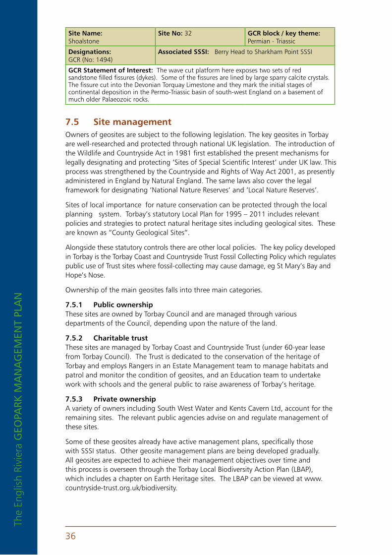
The
Engl
ish
Rivi
era
GEo
park
ma
na
GEm
Ent
pla
n
36
Site name: Shoalstone
Site no: 32 GCr block / key theme: Permian - Triassic
Designations: GCR (No: 1494)
associated SSSI: Berry Head to Sharkham Point SSSI
GCr Statement of Interest: The wave cut platform here exposes two sets of red sandstone filled fissures (dykes). Some of the fissures are lined by large sparry calcite crystals. The fissure cut into the Devonian Torquay Limestone and they mark the initial stages of continental deposition in the Permo-Triassic basin of south-west England on a basement of much older Palaeozoic rocks.
7 .5 Site managementOwners of geosites are subject to the following legislation. The key geosites in Torbay are well-researched and protected through national UK legislation. The introduction of the Wildlife and Countryside Act in 1981 first established the present mechanisms for legally designating and protecting ‘Sites of Special Scientific Interest’ under UK law. This process was strengthened by the Countryside and Rights of Way Act 2001, as presently administered in England by Natural England. The same laws also cover the legal framework for designating ‘National Nature Reserves’ and ‘Local Nature Reserves’.
Sites of local importance for nature conservation can be protected through the local planning system. Torbay’s statutory Local Plan for 1995 – 2011 includes relevant policies and strategies to protect natural heritage sites including geological sites. These are known as “County Geological Sites”.
Alongside these statutory controls there are other local policies. The key policy developed in Torbay is the Torbay Coast and Countryside Trust Fossil Collecting Policy which regulates public use of Trust sites where fossil-collecting may cause damage, eg St Mary’s Bay and Hope’s Nose.
Ownership of the main geosites falls into three main categories.
7 .5 .1 public ownershipThese sites are owned by Torbay Council and are managed through various departments of the Council, depending upon the nature of the land.
7 .5 .2 Charitable trustThese sites are managed by Torbay Coast and Countryside Trust (under 60-year lease from Torbay Council). The Trust is dedicated to the conservation of the heritage of Torbay and employs Rangers in an Estate Management team to manage habitats and patrol and monitor the condition of geosites, and an Education team to undertake work with schools and the general public to raise awareness of Torbay’s heritage.
7 .5 .3 private ownershipA variety of owners including South West Water and Kents Cavern Ltd, account for the remaining sites. The relevant public agencies advise on and regulate management of these sites.
Some of these geosites already have active management plans, specifically those with SSSI status. Other geosite management plans are being developed gradually. All geosites are expected to achieve their management objectives over time and this process is overseen through the Torbay Local Biodiversity Action Plan (LBAP), which includes a chapter on Earth Heritage sites. The LBAP can be viewed at www.countryside-trust.org.uk/biodiversity.
The English Riviera GEo
park m
an
aG
EmEn
t plan
37
8. prioritiES anD policiES for SuStainablE DEvElopmEnt
8 .1 priority 1: Management Framework The priority for the management of the EGN is:
8 .1 .1 partnershipEnsure the ERG’s objectives are firmly embedded in each of the key strategic documents relevant to the area and the partners in the ERGO. Part of ERGO’s role is to manage these strategies to ensure the Geopark is high on the agenda within the region’s economic regeneration framework for sustainable development.
8 .1 .2 trademarkProtect the use of the English Riviera Geopark brand by managing the brand as a registered trademark.
n The English Riviera Geopark management plan implements a policy of licensed use of the ER Geopark brand. Any organisation, company or private individual will only to allowed to associate itself with ERG following written authorisation from the ERGO.
n An annual fee, set by the ERGO, will be payable to obtain this authorisation which will only be issued if the applicant has signed up to the ERGO charter.
n This source of income will, in time, be used to pay for the administrative costs of ERGO, estimated at £30,000 per annum.
8 .1 .3 retailingEnsure retailing of geological material by licensed users of the ERG brand is strictly controlled in accordance with ERG policy and procedures.
n To be successful in its bid for Geopark status there is no flexibility on the sale of geological specimens. Any private retailers involved in this will not be able to use the ERG brand.
n Any private retailer wishing to use the ERG brand must stop the sale and this must be obtained in writing. The sale of existing stocks will be acceptable in the context of a managed and timetabled exit strategy from this retail activity.
8 .2 priority 2: Site Conservation The general issues concerning conservation of the geological heritage of Torbay are outlined in section 5.3 above. Detailed site-specific conservation actions are incorporated in the Torbay Local Biodiversity Action Plan and LGAP Review. These vary in their impact and the priorities, in terms of where resources need to be channelled most urgently, are:
n overuse and misuse
n vegetation growth
8 .2 .1 overuse and mis-useThe management of public access to vulnerable sites is the key challenge for Torbay.
The
Engl
ish
Rivi
era
GEo
park
ma
na
GEm
Ent
pla
n
38
Historically damage has been caused to the geological heritage, either through ignorance or maliciously. The framework of policies now in place, together with site management techniques and regular patrols, will reduce the risk of further damage.
8 .2 .2 vegetation growthMost exposures are not affected badly by vegetation growth but often the rare plants associated with limestone are threatened by uncontrolled scrub and Torbay Coast and Countryside Trust is active in managing the spread of scrub at many of its sites.
8 .3 priority 3: Geoeducation and GeotourismThe following themes are priorities for action in the new Geopark:
n Develop the use of the Geopark as a marketing tool – tourism development linked to the landscape and heritage
n Bring together existing geological interpretation and co-ordinate to ensure best use of resources
n Develop new markets around the existing well-established tourism base and develop new geotourism products and activities
n Link with European partners and develop joint projects to share best practice and develop new ideas, taking part in international projects and programmes
n Promote Civic Pride, motivating schools, community groups etc
n Encourage voluntary activity to support the geopark
n Reduce damage to geosites caused by public ignorance or neglect by increasing awareness and promoting codes of conduct
n Generate funding from national and international sources for geotourism development
n Stimulate further research activity and links to educational establishments
n Raise awareness amongst the international scientific community of Torbay’s geology
Examples of interpretations currently available in the Bay
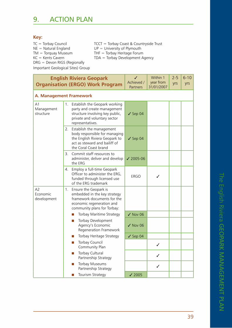
The English Riviera GEo
park m
an
aG
EmEn
t plan
39
9. action plan
key: TC = Torbay Council TCCT = Torbay Coast & Countryside Trust NE = Natural England UP = University of Plymouth TM = Torquay Museum THF = Torbay Heritage Forum KC = Kents Cavern TDA = Torbay Development Agency DRG = Devon RIGS (Regionally Important Geological Sites) Group
english riviera Geopark organisation (erGo) Work program
3 Achieved / Partners
Within 1 year from
31/01/2007
2-5 yrs
6-10 yrs
a . Management Framework
A1 Management structure
1. Establish the Geopark working party and create management structure involving key public, private and voluntary sector representatives.
3 Sep 04
2. Establish the management body responsible for managing the English Riviera Geopark to act as steward and bailiff of the Coral Coast brand
3 Sep 04
3. Commit staff resources to administer, deliver and develop the ERG
3 2005-06
4. Employ a full-time Geopark Officer to administer the ERG, funded through licensed use of the ERG trademark
ERGO 3
A2 Economic development
1. Ensure the Geopark is embedded in the key strategy framework documents for the economic regeneration and community plans for Torbay:
n Torbay Maritime Strategy 3 Nov 06
n Torbay Development Agency’s Economic Regeneration Framework
3 Nov 06
n Torbay Heritage Strategy 3 Sep 04
n Torbay Council Community Plan 3
n Torbay Cultural Partnership Strategy 3
n Torbay Museums Partnership Strategy 3
n Tourism Strategy 3 2005

The
Engl
ish
Rivi
era
GEo
park
ma
na
GEm
Ent
pla
n
40
english riviera Geopark organisation (erGo) Work program
3 Achieved / Partners
Within 1 year from
31/01/2007
2-5 yrs
6-10 yrs
A3 Membership of the European Geopark Network
1. Submit 2nd application dossier for acceptance to European Geopark Network in 2007
ERGO 3
2. Obtain endorsement letter from UNESCO - UK
ERGO
3. Obtain full council approval for Torbay Council to act as lead applicant to European Geopark Network
3 Dec 06 3
4. Develop codes of conduct and terms of reference for all participating organisations
ERGO 3
5. Monitor and steer the development of the Geopark and regulate activity as required
ERGO 3
A4 Brand protection
1. Develop logo and brand identity for ERG in line with existing English Riviera design guidelines
ERGO 3
2. Obtain protection for use of the English Riviera Geopark trademark and create source of income for the by registering as trademark and controlling use of the brand.
ERGO 3
3. Authorise, control and protect use of the ERG trademark
ERGO 3Ongoing
4. Draw up code of conduct for partners using the ERG trademark
ERGO 3
A5 Partnership
1. Develop links other Earth Heritage sites and Geoparks in Britain, Europe and the rest of the world
ERGO 3
2. Present paper at 2nd Global Geopark conference in Belfast 3Sep 06
3. Develop links with Jurassic Coast World Heritage Site, Cornish Mining World Heritage Site, North Devon Biosphere and other geosites in Devon
3Nov 06
4. Develop links to other Geoparks in the UK, Europe and the rest of the world.
ERGO 3
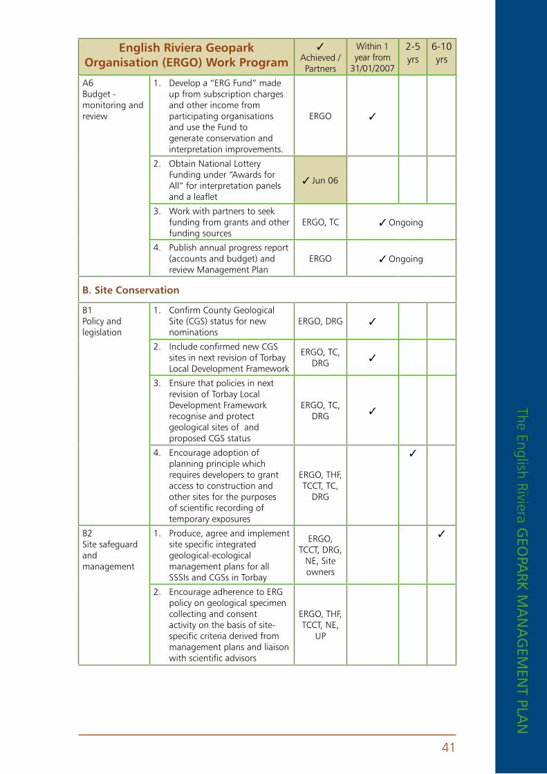
The English Riviera GEo
park m
an
aG
EmEn
t plan
41
english riviera Geopark organisation (erGo) Work program
3 Achieved / Partners
Within 1 year from
31/01/2007
2-5 yrs
6-10 yrs
A6 Budget - monitoring and review
1. Develop a “ERG Fund” made up from subscription charges and other income from participating organisations and use the Fund to generate conservation and interpretation improvements.
ERGO 3
2. Obtain National Lottery Funding under “Awards for All” for interpretation panels and a leaflet
3Jun 06
3. Work with partners to seek funding from grants and other funding sources
ERGO, TC 3Ongoing
4. Publish annual progress report (accounts and budget) and review Management Plan
ERGO 3Ongoing
B . Site Conservation
B1 Policy and legislation
1. Confirm County Geological Site (CGS) status for new nominations
ERGO, DRG 3
2. Include confirmed new CGS sites in next revision of Torbay Local Development Framework
ERGO, TC, DRG 3
3. Ensure that policies in next revision of Torbay Local Development Framework recognise and protect geological sites of and proposed CGS status
ERGO, TC, DRG 3
4. Encourage adoption of planning principle which requires developers to grant access to construction and other sites for the purposes of scientific recording of temporary exposures
ERGO, THF, TCCT, TC,
DRG
3
B2 Site safeguard and management
1. Produce, agree and implement site specific integrated geological-ecological management plans for all SSSIs and CGSs in Torbay
ERGO, TCCT, DRG,
NE, Site owners
3
2. Encourage adherence to ERG policy on geological specimen collecting and consent activity on the basis of site-specific criteria derived from management plans and liaison with scientific advisors
ERGO, THF, TCCT, NE,
UP

The
Engl
ish
Rivi
era
GEo
park
ma
na
GEm
Ent
pla
n
42
english riviera Geopark organisation (erGo) Work program
3 Achieved / Partners
Within 1 year from
31/01/2007
2-5 yrs
6-10 yrs
3. Ensure that all nationally significant sites are in “favourable condition” (as defined by Natural England), by carrying out a programme of site management works NB: Hope’s Nose will always remain in a destroyed state, as gold deposits were removed illegally.
ERGO, THF, TCCT, TC, NE, Site owners
3
4. Agree a Local Geodiversity Action Plan for Torbay (www.countryside-trust.org.uk/lbap.htm)
3Sep 06
B3 Advisory
1. Establish network of scientific advisors to guide site conservation, including with respect to development proposals, temporary section recording and assessment/ refereeing of proposals for sampling at sensitive sites and interpretation
ERGO, THF, TCCT, UP 3
2. Work with site owners and occupiers of geosites and establish constructive dialogue to aid site management and investigate potential, where appropriate, for developing access and interpretation
ERGO, THF, TCCT, DRG,
NE, Site owners
3Ongoing
3. Produce and distribute guidance notes and codes to encourage safe and responsible use of geological heritage sites
ERGO, TCCT, NE,
DRG.3
B4 Research and monitoring
1. Encourage research into Torbay’s geological heritage, including both site-based and document-based in particular where contemporary reviews are lacking (e.g. on regionally Devonian palaeontology) or sites have not yet been fully documented (e.g. Berry Head caves)
ERGO, TCCT, TM,
UP3
2. Ensure audit, research and monitoring information is linked with site protection and management.
ERGO 3Ongoing
3. Monitor all geosites in Torbay to appropriate timescale
ERGO, TCCT, NE,
DRG3

The English Riviera GEo
park m
an
aG
EmEn
t plan
43
english riviera Geopark organisation (erGo) Work program
3 Achieved / Partners
Within 1 year from
31/01/2007
2-5 yrs
6-10 yrs
C . Geoeducation and Geotoursim
C1 Promotion
1. Create and manage the ERG website www.englishrivierageopark.org
3Jan 07
2. Work with partners to organise an annual Geopark training and awareness event for tourism sector
ERGO 3
3. Liaise with the Tourist Board and TDA and other advertisers to ensure widespread use of the ERG in all marketing literature
32005-06
4. Review all signing to and within Torbay to feature the Geopark designation where appropriate
ERGO, TC 3
C2 Communication, Access and Education
1. Develop an education and interpretation strategy to ensure that interpretative provision is suitably targeted and integrated and addresses the needs of a range of different site users, including geological/technical groups, school groups (including teaching aids) and general visitors
ERGO, TCCT, TC,
TM3
2. Develop improved public access to key sites including Triangle Point, Dyer’s Quarry, Hopes Nose and Saltern Cove
ERGO, Site owners 3 3
3. Encourage the development of geological boat trips to view inaccessible sites from the sea (see also Torbay Marine Biodiversity Action Plan)
32005-06 3Ongoing
4. Develop new exhibition facilities at museums and other visitor facilities to give improved access to the geological heritage
ERGO, TCCT, KC, THF, TM
3
5. Incorporate geological heritage in touring exhibitions and other community facilities, eg mobile libraries, doctors surgeries
ERGO 3
6. Develop new interpretive media that are accessible to everyone, regardless of ability
ERGO 3
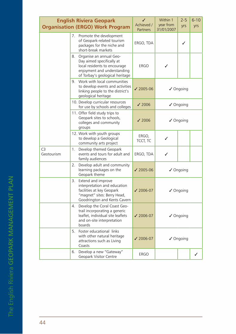
The
Engl
ish
Rivi
era
GEo
park
ma
na
GEm
Ent
pla
n
44
english riviera Geopark organisation (erGo) Work program
3 Achieved / Partners
Within 1 year from
31/01/2007
2-5 yrs
6-10 yrs
7. Promote the development of Geopark-related tourism packages for the niche and short-break markets
ERGO, TDA 3
8. Organise an annual Geo-Day aimed specifically at local residents to encourage enjoyment and understanding of Torbay’s geological heritage
ERGO 3
9. Work with local communities to develop events and activities linking people to the district’s geological heritage
32005-06 3Ongoing
10. Develop curricular resources for use by schools and colleges 32006 3Ongoing
11. Offer field study trips to Geopark sites to schools, colleges and community groups
32006 3Ongoing
12. Work with youth groups to develop a Geological community arts project
ERGO, TCCT, TC 3
C3 Geotourism
1. Develop themed Geopark events and tours for adult and family audiences
ERGO, TDA 3
2. Develop adult and community learning packages on the Geopark theme
32005-06 3Ongoing
3. Extend and improve interpretation and education facilities at key Geopark “magnet” sites: Berry Head, Goodrington and Kents Cavern
32006-07 3Ongoing
4. Develop the Coral Coast Geo-trail incorporating a generic leaflet, individual site leaflets and on-site interpretation boards
32006-07 3Ongoing
5. Foster educational links with other natural heritage attractions such as Living Coasts
32006-07 3Ongoing
6. Develop a new “Gateway” Geopark Visitor Centre
ERGO 3
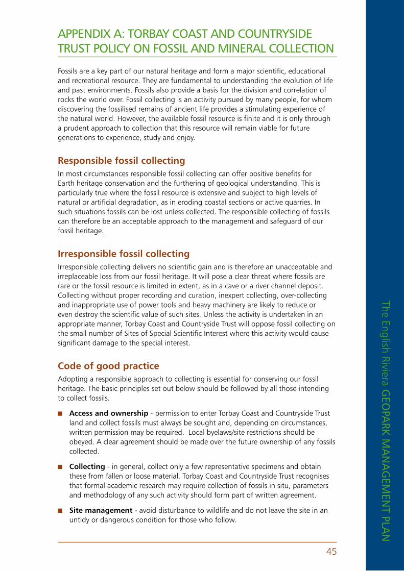
The English Riviera GEo
park m
an
aG
EmEn
t plan
45
appEnDix a: torbay coaSt anD countrySiDE truSt policy on foSSil anD minEral collEction
Fossils are a key part of our natural heritage and form a major scientific, educational and recreational resource. They are fundamental to understanding the evolution of life and past environments. Fossils also provide a basis for the division and correlation of rocks the world over. Fossil collecting is an activity pursued by many people, for whom discovering the fossilised remains of ancient life provides a stimulating experience of the natural world. However, the available fossil resource is finite and it is only through a prudent approach to collection that this resource will remain viable for future generations to experience, study and enjoy.
responsible fossil collectingIn most circumstances responsible fossil collecting can offer positive benefits for Earth heritage conservation and the furthering of geological understanding. This is particularly true where the fossil resource is extensive and subject to high levels of natural or artificial degradation, as in eroding coastal sections or active quarries. In such situations fossils can be lost unless collected. The responsible collecting of fossils can therefore be an acceptable approach to the management and safeguard of our fossil heritage.
Irresponsible fossil collecting Irresponsible collecting delivers no scientific gain and is therefore an unacceptable and irreplaceable loss from our fossil heritage. It will pose a clear threat where fossils are rare or the fossil resource is limited in extent, as in a cave or a river channel deposit. Collecting without proper recording and curation, inexpert collecting, over-collecting and inappropriate use of power tools and heavy machinery are likely to reduce or even destroy the scientific value of such sites. Unless the activity is undertaken in an appropriate manner, Torbay Coast and Countryside Trust will oppose fossil collecting on the small number of Sites of Special Scientific Interest where this activity would cause significant damage to the special interest.
Code of good practice Adopting a responsible approach to collecting is essential for conserving our fossil heritage. The basic principles set out below should be followed by all those intending to collect fossils.
n access and ownership - permission to enter Torbay Coast and Countryside Trust land and collect fossils must always be sought and, depending on circumstances, written permission may be required. Local byelaws/site restrictions should be obeyed. A clear agreement should be made over the future ownership of any fossils collected.
n Collecting - in general, collect only a few representative specimens and obtain these from fallen or loose material. Torbay Coast and Countryside Trust recognises that formal academic research may require collection of fossils in situ, parameters and methodology of any such activity should form part of written agreement.
n Site management - avoid disturbance to wildlife and do not leave the site in an untidy or dangerous condition for those who follow.

The
Engl
ish
Rivi
era
GEo
park
ma
na
GEm
Ent
pla
n
46
photo crEDitS
1. Torbay Coast and Countryside Trust
2. D Larkin
3. Kents Cavern Ltd
4. Still Imaging
5. Torbay Council
6. Torquay Museum
7. K Hallohan
8. Brin Edwards
9. Abberley and Malvern Hills Geopark
10. Dr Kevin Page
11. Dr B E Leveridge
n recording and curation - always record precisely the locality at which fossils are found and, if collected in situ, record relevant horizon details. Ensure that these records can be directly related to the specimens concerned. Where necessary, seek specialist advice on specimen identification and care. Fossils of prime scientific importance should be placed in a suitable repository, normally a museum with adequate curatorial and storage facilities. A copy of all records/ reports must be forwarded to Torbay Coast and Countryside Trust.
n Minerals - All principles and practices stated above also apply to the mineral resource and its collection at all Torbay Coast and Countryside Trust sites.
n SSSIs - Persons wishing to undertake the above activities on areas designated as Sites of Special Scientific Interest are reminded that Natural England must be consulted and may require an additional formal request for consent.

Cover images
Front cover - top: Boat trip to London Bridge1, middle: Corals at Hope’s Nose2, bottom: University of Manchester
and University of London at Saltern Cove10. Main image: An interpretation of Torbay’s coral reef, based on fossil
evidence, artwork by Brin Edwards8.
Back cover - Stone Age torch in Kents Cavern3

this document can be made available in other languages, on tape, in Braille, large print and in other formats . For further information please contact 01803 208832 .
For more information please contact
torbay Coast and Countryside trust Cockington Court
Cockington torquay tQ2 6Xa
tel: 01803 606035 email: geopark@countryside-trust .org .uk
www .englishrivierageopark .org .uk