Embed Size (px)
Citation preview
ORIGINAL ARTICLE
Geomorphology and its implication in urban groundwaterenvironment: case study from Mumbai, India
V. R. Rani • H. S. Pandalai • K. S. Sajinkumar •
A. P. Pradeepkumar
Received: 26 September 2013 / Accepted: 20 February 2014 / Published online: 14 March 2014
� The Author(s) 2014. This article is published with open access at Springerlink.com
Abstract Landforms of Mumbai Island have been largely
modified by the urban sprawl and the demand for
groundwater will increase exponentially in the future.
Quality and quantity of groundwater occurrence in island
are highly influenced by the geomorphic units. As this
metropolis receives heavy rainfall, the area rarely faces the
issue of water scarcity, nevertheless, quality always
remains a question. The landforms of Mumbai Island have
been shaped by a combination of fluvial, denudational and
marine processes. These landforms are categorized into
two broad zones on the basis of its influence in ground-
water occurrence. Denudational landforms are categorized
as runoff zones whereas the other two are categorized as
storage zones. This classification is on the basis of occur-
rence and storage of groundwater. Mumbai Island is
exposed to frequent sea water incursion and groundwater
quality has deteriorated. The varied hydrogeological con-
ditions prevalent in this area prevent rapid infiltration. This
combined with the overextraction of groundwater resources
for agriculture and industry has caused serious concern
about the continued availability of potable water. This
study aims at validating the geomorphic classification of
the landforms with hydrogeochemistry and borehole data
and it proved that geomorphology corroborates with
groundwater chemistry and subsurface geology.
Keywords Mumbai � Groundwater � Geomorphology �Sea water incursion � Hydrogeochemistry
Introduction
Mumbai Island is one of the most intensely urbanized and
industrialized regions of the world. It is included in the
United Nations (UN) list of ‘megacities’ (UN redefined a
‘megacity’ as a city with a population of at least ten million
people; Brockeroff 2000). The population of Mumbai has
also gradually increased to become the fourth highest in the
world—20.04 million (United Nations 2010). The island of
Mumbai usually experiences greater demand for high-
quality groundwater than other areas due to this increasing
population and because of the industrial boom along the
coastal belt as well as due to the demands of agriculture in
the flat fertile areas (Rani 2004). Moreover, groundwater
resources assume considerable importance in this area
because the monsoonal rainfall is limited to a four-month
period (Limaye 2010), while the water demand for the rest
of the year is met by the groundwater. In Mumbai, frequent
water shortages are the result of a combination of issues:
altered seasonality of rainfall, floods, salt water intrusion
and the contamination due to the poor drainage and
wastewater systems (Murthy et al. 2001; Nair 2009).
Ground and surface waters in Mumbai are polluted due to
the dumping of sewage and industrial effluents (Gupta
2009). Groundwater quality in the deeper regions of the
aquifer is brackish to slightly saline in Colaba, Dharavi,
and Khar which could be attributed to seawater incursion
(MPCB 2011). High concentrations of pollutants exist in
V. R. Rani � H. S. PandalaiDepartment of Earth Sciences, Indian Institute of Technology,
Mumbai 400 076, India
K. S. Sajinkumar (&) � A. P. Pradeepkumar
Department of Geology, University of Kerala,
Thiruvananthapuram 695 581, India
e-mail: [email protected]
Present Address:
V. R. Rani
Central Ground Water Board, Thiruvananthapuram 695 004,
India
123
Appl Water Sci (2015) 5:137–151
DOI 10.1007/s13201-014-0168-8
many places near the creek area (Haque et al. 2012) and its
content has exceeded the prescribed limits. In addition,
various alkali and dye industries are responsible for mer-
cury pollution in Thane Creek. Moreover, various effluents
from oil refineries and reactors, as well as fertilizer resi-
dues have polluted the groundwater (Sabnis 1984; Zingde
and Sabnis 1989).
The urban sprawl together with rapid industrialization
around this coastal city has modified the landforms to a
great extent, which in turn has profound effect on
groundwater systems. Landforms are the base for human
activity and they are continuously modified. Understanding
the geomorphic processes and the landscape helps us to
plan land development and management in a better way.
The majority of ‘‘hotspots’’ of groundwater depletion due
to the overextraction were found in the areas of coastal
megacities in the developing countries like Mumbai (Se-
kovski et al. 2012), though there exists a framework for
groundwater extraction mentioned by the Government of
Maharashtra Act (1993). The effect of urbanization on
groundwater systems is dependent on the geological and
hydrogeological setting (Barron et al. 2012) apart from the
geomorphic setting.
A study about the geomorphic set up of an area, par-
ticularly a reclaimed and amalgamated island like Mumbai
which has become the hub for all the developmental
activities, has paramount importance as the majority of the
population depends upon groundwater. The study aims at
delineating the different geomorphic landforms on the
basis of its hydrogeomorphic characteristics. These delin-
eated landforms are further characterized by their hydrog-
eochemistry and subsurface geology. A number of studies
on the hydrogeochemistry of Mumbai have been conducted
(cf. Naik et al. 2007; Tirumalesh et al. 2010; Kamble and
Vijay 2011) and the use of GIS in such studies explored
(Anbazhagan and Nair 2004; Shankar and Mohan 2006).
But a study, melding hydrogeomorphology, hydrogeo-
chemistry and subsurface geology, has not been attempted
so far and the present study may be a first of its kind. This
study also proves the need for a macro-analysis of geo-
morphology for better management of groundwater
resources.
Study area
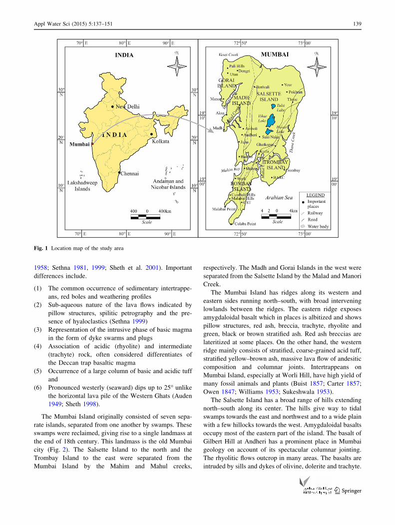
Mumbai Island is located on the western coast of India
(Fig 1) and experiences a tropical climate with copious
rainfall. Geographically it lies between North latitudes
18�500 and 19�180 and East longitudes 72�450 and 73�030.The study area is bounded by Vasai creek to the north,
Thane creek to the east and Arabian Sea to the south and
west. The creeks of Thane and Vasai separate this island
from the mainland. Besides the Thane and Vasai creeks,
Manori and Malad creeks are other smaller creeks on the
east of Mumbai Islands. The creeks are the sites where six
major streams which traverse the length and breadth of
Mumbai Island debouch. The area is densely populated
and highly urbanized and is characterized by industrial,
commercial and residential land uses. Vast regions of the
Mumbai Island are also covered by dense forests. Hilly
areas are characterized by moderate to thick vegetation
and many such areas have been designated as reserve
forests. Three large reservoirs occur in this island like
Tulsi, Vihar and Powai. Agriculture and fishing are the
major occupations. Salt panning is another important
activity.
Methodology
The present study focuses on the study of role of geo-
morphology on groundwater occurrence. A macro-analysis
of geomorphology was carried out through field studies
supplemented with Survey of India (SOI) topographic
sheets on 1:50,000 scale and remotely sensed data (IRS—
1C LISS III digital data). The geomorphic features iden-
tified were classified on the basis of hydrogeomorphic
characteristics. These categorized zones are further vali-
dated through hydrogeochemistry of groundwater (analysis
carried out as per APHA 1998) collected from both dug
well and bore wells and sampled from different geomor-
phic terrains. Further, this was validated with the subsur-
face geology. The study, on a whole, proved that the
geomorphic classification of landforms by field studies on
the basis of groundwater occurrence was well validated
with hydrogeochemistry and subsurface geology. The
geomorphology not only tells the tale of the quantity but
also the quality of groundwater occurrence.
Geological setup
Mumbai Island forms a part of Deccan Volcanic Province
(DVP). DVP represents the remnants of one of the largest
volcanic events on earth and is one of the best studied
continental flood basalt provinces of the world. It originally
covered an area of 1.5 million sq. km. (Krishnan 1982)
with a total erupted volume of 2 9 106 km3 (Krishnan
1960; Pascoe 1964; Rao et al. 1978). The geological for-
mations found in Mumbai include the Deccan Basalts and
its acid variants, volcanic tuffs, intertrappean sediments,
dykes, laterite and alluvium. The geology of Mumbai
Island is rather unusual compared to that of the main
Deccan flood basalt province, particularly the Western
Ghats in several aspects (Sukeshwala and Poldervaart
138 Appl Water Sci (2015) 5:137–151
123
1958; Sethna 1981, 1999; Sheth et al. 2001). Important
differences include.
(1) The common occurrence of sedimentary intertrappe-
ans, red boles and weathering profiles
(2) Sub-aqueous nature of the lava flows indicated by
pillow structures, spilitic petrography and the pre-
sence of hyaloclastics (Sethna 1999)
(3) Representation of the intrusive phase of basic magma
in the form of dyke swarms and plugs
(4) Association of acidic (rhyolite) and intermediate
(trachyte) rock, often considered differentiates of
the Deccan trap basaltic magma
(5) Occurrence of a large column of basic and acidic tuff
and
(6) Pronounced westerly (seaward) dips up to 25� unlikethe horizontal lava pile of the Western Ghats (Auden
1949; Sheth 1998).
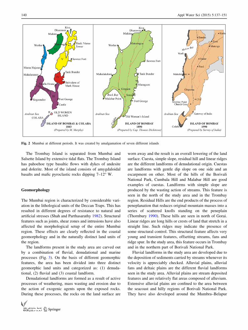
The Mumbai Island originally consisted of seven sepa-
rate islands, separated from one another by swamps. These
swamps were reclaimed, giving rise to a single landmass at
the end of 18th century. This landmass is the old Mumbai
city (Fig. 2). The Salsette Island to the north and the
Trombay Island to the east were separated from the
Mumbai Island by the Mahim and Mahul creeks,
respectively. The Madh and Gorai Islands in the west were
separated from the Salsette Island by the Malad and Manori
Creek.
The Mumbai Island has ridges along its western and
eastern sides running north–south, with broad intervening
lowlands between the ridges. The eastern ridge exposes
amygdaloidal basalt which in places is albitized and shows
pillow structures, red ash, breccia, trachyte, rhyolite and
green, black or brown stratified ash. Red ash breccias are
lateritized at some places. On the other hand, the western
ridge mainly consists of stratified, coarse-grained acid tuff,
stratified yellow–brown ash, massive lava flow of andesitic
composition and columnar joints. Intertrappeans on
Mumbai Island, especially at Worli Hill, have high yield of
many fossil animals and plants (Buist 1857; Carter 1857;
Owen 1847; Williams 1953; Sukeshwala 1953).
The Salsette Island has a broad range of hills extending
north–south along its center. The hills give way to tidal
swamps towards the east and northwest and to a wide plain
with a few hillocks towards the west. Amygdaloidal basalts
occupy most of the eastern part of the island. The basalt of
Gilbert Hill at Andheri has a prominent place in Mumbai
geology on account of its spectacular columnar jointing.
The rhyolitic flows outcrop in many areas. The basalts are
intruded by sills and dykes of olivine, dolerite and trachyte.
Fig. 1 Location map of the study area
Appl Water Sci (2015) 5:137–151 139
123
The Trombay Island is separated from Mumbai and
Salsette Island by extensive tidal flats. The Trombay Island
has pahoehoe type basaltic flows with dykes of andesite
and dolerite. Most of the island consists of amygdaloidal
basalts and mafic pyroclastic rocks dipping 7–12� W.
Geomorphology
The Mumbai region is characterized by considerable vari-
ation in the lithological units of the Deccan Traps. This has
resulted in different degrees of resistance to natural and
artificial stresses (Shah and Parthasarathy 1982). Structural
features such as joints, shear zones and intrusions have also
affected the morphological setup of the entire Mumbai
region. These effects are clearly reflected in the coastal
geomorphology and in the naturally distinct land units of
the region.
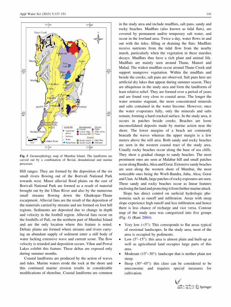
The landforms present in the study area are carved out
by a combination of fluvial, denudational and marine
processes (Fig. 3). On the basis of different geomorphic
features, the area has been divided into three distinct
geomorphic land units and categorized as: (1) denuda-
tional, (2) fluvial and (3) coastal landform.
Denudational landforms are formed as a result of active
processes of weathering, mass wasting and erosion due to
the action of exogenic agents upon the exposed rocks.
During these processes, the rocks on the land surface are
worn away and the result is an overall lowering of the land
surface. Cuesta, simple slope, residual hill and linear ridges
are the different landforms of denudational origin. Cuestas
are landforms with gentle dip slope on one side and an
escarpment on other. Most of the hills of the Borivali
National Park, Cumbala Hill and Malabar Hill are good
examples of cuestas. Landforms with simple slope are
produced by the wasting action of streams. This feature is
seen in the north of the study area and in the Trombay
region. Residual Hills are the end products of the process of
peneplanation that reduces original mountain masses into a
series of scattered knolls standing on the peneplain
(Thornbury 1990). These hills are seen in north of Gorai.
Linear ridges are long hills or crests of land that stretch in a
straight line. Such ridges may indicate the presence of
some structural control. This structural feature affects very
young and transient features, offsetting streams, fans and
ridge spur. In the study area, this feature occurs in Trombay
and in the northern part of Borivali National Park.
Fluvial landforms in the study area are developed due to
the deposition of sediments carried by streams whenever its
velocity is appreciably checked. Alluvial plains, alluvial
fans and deltaic plains are the different fluvial landforms
seen in the study area. Alluvial plains are stream deposited
features and are relatively flat areas composed of alluvium.
Extensive alluvial plains are confined to the area between
the seacoast and hilly regions of Borivali National Park.
They have also developed around the Mumbra–Belapur
Fig. 2 Mumbai at different periods. It was created by amalgamation of seven different islands
140 Appl Water Sci (2015) 5:137–151
123
Hill ranges. They are formed by the deposition of the six
small rivers flowing out of the Borivali National Park
towards west. Minor alluvial flood plains on the east of
Borivali National Park are formed as a result of material
brought out by the Ulhas River and also by the numerous
small streams flowing down the Ghatkopar–Thane
escarpment. Alluvial fans are the result of the deposition of
the materials carried by streams and are formed on foot hill
regions. Sediments are deposited due to change in depth
and velocity in the foothill region. Alluvial fans occur on
the foothills of Pali, on the northern part of Mumbai Island
and are the only location where this feature is noted.
Deltaic plains are formed where streams and rivers carry-
ing an abundant supply of sediment enter a still body of
water lacking extensive wave and current scour. The flow
velocity is retarded and deposition occurs. Vihar and Powai
Lakes exhibit this feature. These deltas are exposed only
during summer months.
Coastal landforms are produced by the action of waves
and tides. Marine waters erode the rock at the shore and
this continued marine erosion results in considerable
modifications of shoreline. Coastal landforms are common
in the study area and include mudflats, salt pans, sandy and
rocky beaches. Mudflats (also known as tidal flats), are
covered by permanent and/or temporary salt water, and
occur in the lowland area. Twice a day, water flows in and
out with the tides, filling or draining the flats. Mudflats
receive nutrients from the tidal flow from the nearby
marsh, particularly when the vegetation in these marshes
decays. Mudflats thus have a rich plant and animal life.
Mudflats are mainly seen around Thane, Manori and
Malad. The widest mudflats occur around Thane Creek and
support mangrove vegetation. Within the mudflats and
beside the creeks, salt pans are observed. Salt pans here are
artificial dry lakes that appear during summer season. They
are ubiquitous in the study area and form the landforms of
least relative relief. They are formed over a period of years
and are found very close to coastal areas. The longer the
water remains stagnant, the more concentrated minerals
and salts contained in the water become. However, once
the water evaporates fully, only the minerals and salts
remain, forming a hard cracked surface. In the study area, it
occurs in patches beside creeks. Beaches are loose
unconsolidated deposits made by marine action near the
shore. The lower margins of a beach are commonly
beneath the waves whereas the upper margin is a few
meters above the still area. Both sandy and rocky beaches
are seen in the western coastal tract of the study area.
Usually rocky beaches occur along the base of sea cliffs.
They show a gradual change to sandy beaches. The most
prominent ones are seen at Malabar hill and small patches
occur alongBandra,Aksa andGorai. Extensive sandy beaches
are seen along the western shore of Mumbai, the most
noticeable ones being the Worli-Bandra, Juhu, Aksa, Gorai
andUtan. AtMadh, large patches of rocky exposures are seen.
These sandy and rocky beaches occur as linear features
enclosing the landandprotecting it from furthermarine attack.
Slope has direct control on surficial hydrologic phe-
nomena such as runoff and infiltration. Areas with steep
slope experience high runoff and less infiltration and hence
there is less chance of recharge and vice versa. Contour
map of the study area was categorized into five groups
(Fig. 4) (Rani 2004):
• Very low (\5�): This corresponds to flat areas typical
of erosional landscapes. In the study area, most of the
area is occupied by pediments.
• Low (5�–15�): this area is almost plain and built-up as
well as agricultural land occupies large parts of this
area.
• Moderate (15�–30�): landscape that is neither plain nor
steep.
• Steep (30�–45�): this class can be considered to be
uneconomic and requires special measures for
cultivation.
Fig. 3 Geomorphology map of Mumbai Island. The landforms are
carved out by a combination of fluvial, denudational and marine
processes
Appl Water Sci (2015) 5:137–151 141
123
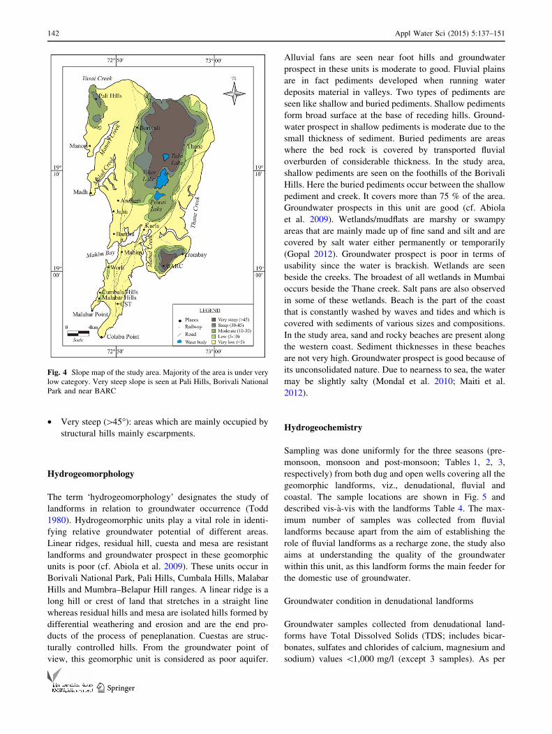
• Very steep ([45�): areas which are mainly occupied by
structural hills mainly escarpments.
Hydrogeomorphology
The term ‘hydrogeomorphology’ designates the study of
landforms in relation to groundwater occurrence (Todd
1980). Hydrogeomorphic units play a vital role in identi-
fying relative groundwater potential of different areas.
Linear ridges, residual hill, cuesta and mesa are resistant
landforms and groundwater prospect in these geomorphic
units is poor (cf. Abiola et al. 2009). These units occur in
Borivali National Park, Pali Hills, Cumbala Hills, Malabar
Hills and Mumbra–Belapur Hill ranges. A linear ridge is a
long hill or crest of land that stretches in a straight line
whereas residual hills and mesa are isolated hills formed by
differential weathering and erosion and are the end pro-
ducts of the process of peneplanation. Cuestas are struc-
turally controlled hills. From the groundwater point of
view, this geomorphic unit is considered as poor aquifer.
Alluvial fans are seen near foot hills and groundwater
prospect in these units is moderate to good. Fluvial plains
are in fact pediments developed when running water
deposits material in valleys. Two types of pediments are
seen like shallow and buried pediments. Shallow pediments
form broad surface at the base of receding hills. Ground-
water prospect in shallow pediments is moderate due to the
small thickness of sediment. Buried pediments are areas
where the bed rock is covered by transported fluvial
overburden of considerable thickness. In the study area,
shallow pediments are seen on the foothills of the Borivali
Hills. Here the buried pediments occur between the shallow
pediment and creek. It covers more than 75 % of the area.
Groundwater prospects in this unit are good (cf. Abiola
et al. 2009). Wetlands/mudflats are marshy or swampy
areas that are mainly made up of fine sand and silt and are
covered by salt water either permanently or temporarily
(Gopal 2012). Groundwater prospect is poor in terms of
usability since the water is brackish. Wetlands are seen
beside the creeks. The broadest of all wetlands in Mumbai
occurs beside the Thane creek. Salt pans are also observed
in some of these wetlands. Beach is the part of the coast
that is constantly washed by waves and tides and which is
covered with sediments of various sizes and compositions.
In the study area, sand and rocky beaches are present along
the western coast. Sediment thicknesses in these beaches
are not very high. Groundwater prospect is good because of
its unconsolidated nature. Due to nearness to sea, the water
may be slightly salty (Mondal et al. 2010; Maiti et al.
2012).
Hydrogeochemistry
Sampling was done uniformly for the three seasons (pre-
monsoon, monsoon and post-monsoon; Tables 1, 2, 3,
respectively) from both dug and open wells covering all the
geomorphic landforms, viz., denudational, fluvial and
coastal. The sample locations are shown in Fig. 5 and
described vis-a-vis with the landforms Table 4. The max-
imum number of samples was collected from fluvial
landforms because apart from the aim of establishing the
role of fluvial landforms as a recharge zone, the study also
aims at understanding the quality of the groundwater
within this unit, as this landform forms the main feeder for
the domestic use of groundwater.
Groundwater condition in denudational landforms
Groundwater samples collected from denudational land-
forms have Total Dissolved Solids (TDS; includes bicar-
bonates, sulfates and chlorides of calcium, magnesium and
sodium) values \1,000 mg/l (except 3 samples). As per
Fig. 4 Slope map of the study area. Majority of the area is under very
low category. Very steep slope is seen at Pali Hills, Borivali National
Park and near BARC
142 Appl Water Sci (2015) 5:137–151
123
Table 1 Chemical analysis data for major ions: pre-monsoon 2012
Sample
No.
pH Temperature
(�c)EC (ls/cm)
TDS
(ppm)
TH
(ppm)
Na?
(ppm)
K?
(ppm)
Ca2?
(ppm)
Mg2?
(ppm)
Cl-
(ppm)
SO42-
(ppm)
CO32-
(ppm)
HCO3-
(ppm)
1 8.3 29 1,343 860 277 170 15 63.5 29 211 46.3 30 295
2 8.5 31 447 286 139 11 14 31.7 14 57 9.6 20 120
3 8.7 30.5 648 415 158 90 7 31.7 19 110 30.1 0 120
4 8.8 29.5 492 315 158 33 15 55.6 5 57 33.7 20 125
5 8.8 30 1,937 1,240 257 275 28 95.2 5 575 98.4 80 440
6 9 29.5 1,143 732 336 135 50 55.6 48 101 2.6 40 375
7 8.2 30 1,571 1,005 435 175 13 79.4 58 187 150.2 20 410
8 8.9 30 0 515 245 45 198 5 440 54.5 50 390
9 8.2 813 520 237 115 2.5 39.7 34 34 41.8 40 310
10 8.7 30 1,111 711 396 90 45 111 29 115 75.8 40 200
11 8.6 30 1,292 827 237 21.5 70 31.7 39 144 53 50 345
12 8.7 30 1,286 823 317 150 55 87.3 24 191 63.5 0 215
13
14 8.2 32 695 445 277 35.5 11 63.5 29 57 62.9 40 185
15 8.4 28 608 389 238 34 7 55.6 24 53 46.1 60 180
16 8.5 30 743 476 238 90 4.5 63.5 19 86 38.7 20 235
17 8.9 31 701 119 277 35.5 6 87.3 14 81 45.9 40 195
18 8.4 31 368 236 158 21.5 5 397 14 38 11.8 0 140
19 9 29 851 545 337 75 9.5 87.3 29 101 29.1 60 225
20 8.4 29 500 320 218 30.5 2.5 55.6 19 53 35.5 20 160
21 8.8 30.5 623 399 297 27.5 3.5 63.5 34 62 32.3 30 190
22
23 8.7 29 416 266 158 130 6 55.6 5 86 3.2 0 160
24 8.7 29 1,255 803 237 160 100 31.7 39 163 37.7 30 420
25
26 8.9 29 513 328 257 22 5.5 95.2 5 43 35.3 30 190
27 8.1 29 564 361 238 31 9 63.5 19 48 12.9 30 210
28 8.1 30 971 621 356 35 10 55.6 53 115 44.4 0 280
29 8.2 29 580 371 178 33 15 47.6 14 62 56.3 50 255
30 8.6 29 813 520 238 95 27 79.4 10 67 20.9 20 305
31 8 29.5 1,161 743 455 70 2 119 38 278 35.7 0 135
32
33 8.3 32 367 235 178 22.5 3 63.5 5 38 162.1 0 145
34 8.7 31 706 452 257 30 8 63.5 24 45 27.8 60 165
35 8.4 34 148 947 79 8 2.5 23.8 5 11 6.3 0 55
36 8.8 30 378 242 237 15 0.5 39.7 34 11 14 50 115
37 8.2 30 548 351 297 14 0.5 71.4 29 17 30.5 0 215
38 8.2 28.5 1,003 642 495 23.5 0.5 111 53 56 177.2 0 105
39
40
41 8.7 30 761 487 297 70 9 71.4 29 45 46.5 0 270
42 7.9 29 1,074 687 376 75 21 111 24 56 63.5 0 365
43 7.9 29.5 875 560 297 75 3 63.5 34 56 51.4 50 225
44 8.3 29 909 582 297 80 1.5 63.5 34 56 24.6 10 175
45 8.4 29 533 341 198 30 4 55.6 14 28 29 50 120
46 8.5 29 604 387 238 33.5 3 71.4 14 22 59.1 0 210
47 8.2 30 0 574 270 5.5 119 67 258 91.2 0 230
Appl Water Sci (2015) 5:137–151 143
123
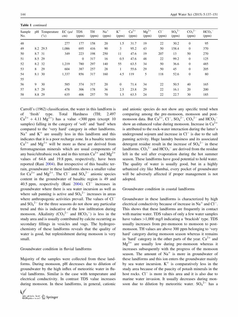
Carroll’s (1962) classification, the water in this landform is
of ‘fresh’ type. Total Hardness (TH; 2.497
Ca2? ? 4.11 Mg2?) has a value \300 ppm (except 10
samples) falling in the category of ‘soft’ and ‘hard’ when
compared to the ‘very hard’ category in other landforms.
Na? and K? are usually less in this landform and this
indicates that it is a poor recharge zone. In a basaltic terrain
Ca2? and Mg2? will be more as these are derived from
ferromagnesian minerals which are usual components of
any basic/ultrabasic rock and in this terrain Ca2? and Mg2?
values of 64.6 and 19.8 ppm, respectively, have been
reported (Rani 2004). But irrespective of this basaltic ter-
rain, groundwater in these landforms shows a smaller value
for Ca2? and Mg2?. The Cl- and SO42- anionic species
content in the groundwater of basaltic region is 49 and
40.5 ppm, respectively (Rani 2004). Cl- increases in
groundwater where there is sea water incursion as well as
where salt panning is active and SO42- increases in areas
where anthropogenic activities prevail. The values of Cl-
and SO42- for the three seasons do not show any particular
trend and this is indicative of the low infiltration during
monsoon. Alkalinity (CO32- and HCO3
-) is less in the
study area and is usually contributed by calcite occurring as
secondary fillings in vesicles and vugs. The hydrogeo-
chemistry of these landforms reveals that the quality of
water is good, but replenishment during monsoon is very
small.
Groundwater condition in fluvial landforms
Majority of the samples were collected from these land-
forms. During monsoon, pH decreases due to dilution of
groundwater by the high influx of meteoritic water in flu-
vial landforms. Similar is the case with temperature and
electrical conductivity. In contrast TDS value increases
during monsoon. In these landforms, in general, cationic
and anionic species do not show any specific trend when
comparing among the pre-monsoon, monsoon and post-
monsoon data. But Ca2?, Cl-, SO42-, CO3
2- and HCO3-
show an enhanced value during monsoon. Increase in Ca2?
is attributed to the rock-water interaction during the latter’s
underground sojourn and increase in Cl- is due to the salt
panning activity. Huge laundry business and its associated
detergent residue result in the increase of SO42- in these
landforms. CO32- and HCO3
- are derived from the residue
left in the soil after evaporation during the hot summer
season. These landforms have good potential to hold water.
The quality of water is usually good, but in a highly
urbanized city like Mumbai, every pocket of groundwater
will be adversely affected if proper management is not
adopted.
Groundwater condition in coastal landforms
Groundwater in these landforms is characterized by high
electrical conductivity because of increase in Na? and Cl-.
This shows that these landforms are frequently in contact
with marine water. TDS values of only a few water samples
have values[1,000 mg/l indicating a ‘brackish’ type. TDS
usually increases from pre-monsoon to monsoon to post-
monsoon. TH values are above 300 ppm belonging to ‘very
hard’ category during monsoon season whereas it remains
in ‘hard’ category in the other parts of the year. Ca2? and
Mg2? are usually low during pre-monsoon whereas it
increases subsequently with the progress of the monsoon
season. The amount of Na? is more in groundwater of
these landforms and this ion enters the groundwater mainly
by sea water incursion. K? is comparatively less in the
study area because of the paucity of potash minerals in the
host rocks. Cl- is more in this area and it is also due to
marine water invasion. It usually decreases during mon-
soon due to dilution by meteoritic water. SO42- has a
Table 1 continued
Sample
No.
pH Temperature
(�c)EC (ls/cm)
TDS
(ppm)
TH
(ppm)
Na?
(ppm)
K?
(ppm)
Ca2?
(ppm)
Mg2?
(ppm)
Cl-
(ppm)
SO42-
(ppm)
CO32-
(ppm)
HCO3-
(ppm)
48 277 177 158 20 1.5 31.7 19 22 30.2 0 95
49 8.2 29.5 1,086 695 416 90 3 95.2 43 50 158.4 0 370
50 8.7 31 349 223 198 250 11 47.6 19 207 13 50 270
51 8.5 29 0 317 16 0.5 47.6 48 22 99.2 0 125
52 8.2 32 1,219 780 297 140 55 63.5 34 50 36.6 0 485
53 8 29 604 387 257 28 1 55.6 29 50 45 0 205
54 8.1 30 1,337 856 317 160 4.5 119 5 118 52.6 0 80
55
56 9 30 585 374 317 20 0 71.4 34 22 50.5 40 165
57 8.7 29 478 306 178 36 2.5 23.8 29 22 16.1 20 200
58 8.8 29 635 406 257 70 1.5 63.5 24 22 22.7 30 185
144 Appl Water Sci (2015) 5:137–151
123
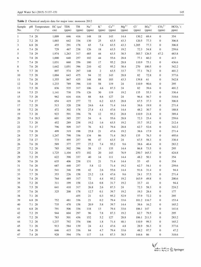
Table 2 Chemical analysis data for major ions: monsoon 2012
Sample
No.
pH Temperature
(�c)EC (ls/cm)
TDS
(ppm)
TH
(ppm)
Na?
(ppm)
K?
(ppm)
Ca2?
(ppm)
Mg2?
(ppm)
Cl-
(ppm)
SO42-
(ppm)
CO32-
(ppm)
HCO3-(
ppm)
1 7.4 28 1,009 646 416 148 18 143 14.4 130.2 69.4 0 354
2 7.2 28 1,003 642 336 130 25 63.5 43.3 120.5 77.3 0 306.8
3 6.8 28 455 291 178 65 7.4 63.5 43.3 1,205 77.3 0 306.8
4 7.4 28 729 467 238 126 18 63.5 19.2 72.3 54.8 0 259.6
5 7.8 29 1,974 1,263 317 485 44 63.5 38.5 303.7 126.5 47.2 483.8
6 7.8 28 1,000 640 257 102 44 55.6 28.8 77.1 60.2 0 413
7 7.4 28 1,031 660 356 180 17 95.2 28.8 110.9 75.1 0 436.6
8 7.6 28 1,642 1,051 396 210 42 95.2 38.4 270 100.5 0 342.2
9 7.7 28 897 574 297 148 2 63.5 33.7 77.1 78.2 0 401.2
10 7.5 28 1,004 643 475 94 32 143 28.8 82 72.8 0 377.6
11 7.6 28 1,355 867 435 148 88 103 43.3 139.8 61 0 542.8
12 7.4 28 1,233 789 396 110 58 119 24 110.9 90.6 0 295
13 7.5 28 836 535 317 106 4.6 87.3 24 82 39.6 0 401.2
14 7.5 25 1,141 730 376 126 30 119 19.2 135 55.3 0 330.4
15 7.5 28 962 616 416 88 8.6 127 24 96.4 56.7 0 318.6
16 7.4 27 654 419 277 72 6.2 63.5 28.8 67.5 37.3 0 306.8
17 7.2 28 513 328 238 24.6 4.4 71.4 14.4 38.6 19.9 0 271.4
18 7.2 28 472 302 178 27.4 4.1 47.6 14.4 48.2 30.7 0 188.8
19 7.3 28 923 591 356 78 12 95.2 28.8 110.9 21.8 0 389.4
20 7.4 28.5 601 385 257 54 6 55.6 28.8 72.3 25.4 0 259.6
21 7.3 28 452 289 238 19.2 1.6 63.5 19.2 33.7 35.2 0 212.4
22 7.1 27 796 509 317 76 8.2 79.4 28.8 62.7 52.6 0 342.2
23 7.8 28 499 319 198 25.8 21 47.6 19.2 38.6 17.9 0 271.4
24 7.7 28 1,247 798 336 134 86 71.4 38.5 135 76.3 0 495.6
25 7.8 27 773 495 257 98 47 63.5 24 67.5 58.3 0 330.4
26 7.6 28 589 377 277 27.2 7.4 95.2 9.6 38.6 40.4 0 283.2
27 7.2 28 785 502 396 58 13 135 14.4 86.8 73.5 0 295
28 7.2 28 1,725 1,104 673 102 20 143 76.9 250.7 165.3 0 424.8
29 7.2 29 622 398 337 40 14 111 14.4 48.2 50.1 0 354
30 7.6 28 635 406 238 131 21 71.4 14.4 53 45 0 354
31 7.6 28 687 440 257 5.8 12 71.4 19.2 62.7 54.1 0 259.6
32 7.4 28 541 346 198 42 2.6 55.6 14.4 91.6 31.4 0 94.4
33 7.7 28 353 226 158 23.2 1.8 47.6 9.6 24.1 37.5 0 271.4
34 7.4 28 764 489 317 72 4.4 95.2 19.2 163.9 49.8 0 200.6
35 7.2 28 311 199 158 12.6 0.8 31.7 19.2 33.7 41 0 94.4
36 7.5 28 641 410 317 26.8 2.6 87.3 24 72.3 58.3 0 224.2
37 7.6 28 325 208 178 12.7 0.1 39.7 19.2 19.3 28.4 0 177
38 7.1 28 455 21 0.3 95.2 52.9 57.9 72.2 0 295
39 6.8 28 752 481 336 21 0.2 79.4 33.6 101.2 116.7 0 153.4
40 7.1 28 735 470 158 20.9 5.8 39.7 14.4 38.6 16.2 0 165.2
41 6.8 28 791 506 336 118 13 79.4 33.6 106.1 147 0 141.6
42 7.2 29 944 604 297 96 7.8 87.3 19.2 62.7 79.5 0 295
43 7.2 28 783 501 436 152 5.2 127 28.8 106.1 211.3 0 283.2
44 7.2 28 1,237 792 376 106 1.8 71.4 48.1 110.9 99.3 0 165.2
45 7.1 28 913 584 139 24 4.1 47.6 4.8 28.9 56.3 0 377.6
46 7.4 28 646 415 336 84 4.7 79.4 33.6 48.2 97.7 0 47.2
47 7.4 28 928 594 376 117 1.6 87.3 38.5 144.6 86 0 318.6
Appl Water Sci (2015) 5:137–151 145
123
slightly higher value in this landform when compared to
the groundwater of typical basaltic region where its content
will be around 40.5 ppm. These landforms are good in
recharging the aquifer, but due to repeated marine incur-
sion the quality always is questionable.
Validation through borehole data
Basaltic lava flow shows contrasting water-bearing prop-
erties in the different units constituting them. A study of
subsurface geology of Mumbai Island reveals that the area
has a multi-layered aquifer system comprising aquicludes
of basalt and aquifers of vesicular and fractured/jointed
zones (Cook 2003). Shallow aquifers are made up of
weathered, jointed and fractured zones (Agashe 1989).
These aquifers form an important source of water supply
for domestic, agricultural and industrial needs.
Groundwater occurs under water table conditions in
both the weathered jointed zones of massive and vesicular
units. These units show both lateral and vertical variations
in the degree of weathering and porosity. The primary
porosity of Deccan basalts is very low. The secondary
features developed in it due to spheroidal weathering,
jointing, fracturing and fissuring, thereby enhancing the
porosity of the rocks and thereby increasing the storativity
and transmissivity of basaltic rocks. But in the case of
intertrappeans and tuffaceous rocks, weathering decreases
the groundwater yield capacity. The extent of yield
capacity of different rock units also depends upon the
topography.
Borehole data provide reliable information about the
subsurface lithology, extent of weathering and thickness of
subsurface layers. The litholog data of about 108 bore wells
(Fig. 5; of the 108 only 10 are shown in the figure) of the
study area were prepared and studied. These lithologs
provide data about the subsurface lithology up to a depth of
85 m. Based on the lithologs, the subsurface layers can be
broadly classified into three categories.
(1) Shallow depth aquifer: extends up to a depth of 20 m
bgl (below ground level) and mainly consists of top
soil and weathered rock.
(2) Medium depth aquifer: extends from 20 to 60 m bgl.
(3) Deep aquifer: occurring beneath 65 m bgl.
In most borewells, the top soil is brownish gray to black
in color with weathered rock debris and varies in thickness
from 2 to 13 m. This forms the shallow depth aquifer.
Mainly two types of basalt—massive basalt and the
vesicular amygdaloidal basalt that constitute the medium
depth aquifer underlie this zone. The thickness of the layer
varies from 10 to 40 m. In some locations, the medium
depth aquifer, i.e., the zone beneath the weathered rock
consists of trachyte, rhyolite or tuff. The nature of the
lithology of medium depth aquifer varies from one location
to another.
In the Churchgate area, lenses of sand are seen. While
comparing the boreholes in the southern part of Mumbai it
is very evident that the discharge mainly depends upon the
thickness of the weathered material. It varies from 2,000 to
4,000 l/hr in southern Mumbai. In the Cumbala Hill py-
roclastics occur beneath the massive basalt. In Worli-Juhu
area also pyroclastics form the medium aquifer, but here it
occurs just beneath the weathered rock unlike Cumbala
Hill where it occurs beneath the massive basalt. The py-
roclastics usually have low discharge values, but perme-
ability is varied when fractures and red boles are present. In
Vikhroli–Powai area, pyroclastics as well as massive basalt
occur as the medium depth aquifer. Tuffaceous rocks act as
medium depth aquifers at Parel, Sion and Ghodbhander
area. Around Matunga and Parel, pillow lavas mainly
dominate the medium depth aquifer. Near Akse, Madh,
Table 2 continued
Sample
No.
pH Temperature
(�c)EC (ls/cm)
TDS
(ppm)
TH
(ppm)
Na?
(ppm)
K?
(ppm)
Ca2?
(ppm)
Mg2?
(ppm)
Cl-
(ppm)
SO42-
(ppm)
CO32-
(ppm)
HCO3-(
ppm)
48 7.2 28 233 149 83.4 18.4 0.3 31.7 9.6 14.5 41.6 0 106.2
49 7.2 28 1,357 869 524 136 5.3 206 43.2 101.2 334.8 0 483.8
50 349 223 178 9.6 1 39.7 19.2 28.9 27.4 0 165.2
51 7.4 28 1,826 1,169 416 258 10 111 33.6 351.9 35.5 0 354
52 7.4 28 1,380 883 416 148 4.4 135 19.2 173.6 69.5 0 401.2
53 7.3 28 297 190 139 18.4 1 31.7 14.4 24.1 22.7 0 129.8
54 7.4 29 571 365 297 25.6 3 79.4 24 82 55.9 0 177
55 640 410 396 26.4 1 95.2 38.4 101.2 20.4 0 295
56 7.6 28 533 341 297 17.2 0 63.5 33.7 43.4 45.1 0 236
57 7.2 28 371 237 257 20.6 4 71.4 19.2 38.6 31.7 0 236
58 7.2 28 554 355 178 72 4 55.6 9.6 43.4 35.5 0 236
146 Appl Water Sci (2015) 5:137–151
123
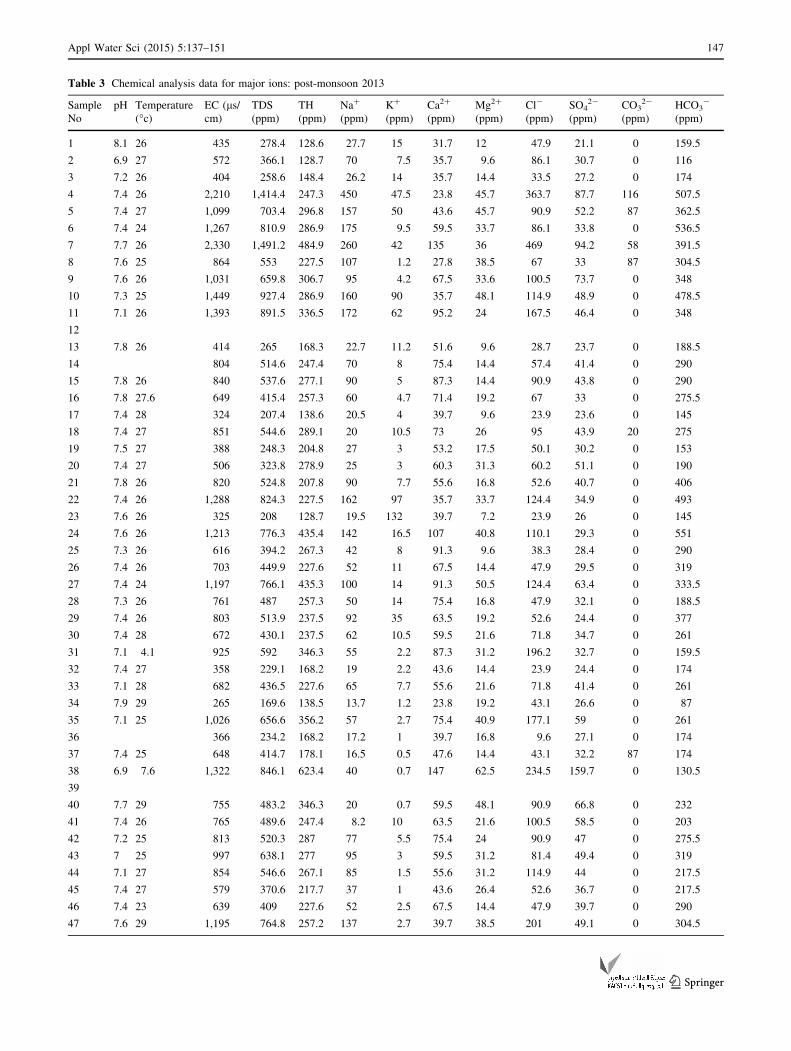
Table 3 Chemical analysis data for major ions: post-monsoon 2013
Sample
No
pH Temperature
(�c)EC (ls/cm)
TDS
(ppm)
TH
(ppm)
Na?
(ppm)
K?
(ppm)
Ca2?
(ppm)
Mg2?
(ppm)
Cl-
(ppm)
SO42-
(ppm)
CO32-
(ppm)
HCO3-
(ppm)
1 8.1 26 435 278.4 128.6 27.7 15 31.7 12 47.9 21.1 0 159.5
2 6.9 27 572 366.1 128.7 70 7.5 35.7 9.6 86.1 30.7 0 116
3 7.2 26 404 258.6 148.4 26.2 14 35.7 14.4 33.5 27.2 0 174
4 7.4 26 2,210 1,414.4 247.3 450 47.5 23.8 45.7 363.7 87.7 116 507.5
5 7.4 27 1,099 703.4 296.8 157 50 43.6 45.7 90.9 52.2 87 362.5
6 7.4 24 1,267 810.9 286.9 175 9.5 59.5 33.7 86.1 33.8 0 536.5
7 7.7 26 2,330 1,491.2 484.9 260 42 135 36 469 94.2 58 391.5
8 7.6 25 864 553 227.5 107 1.2 27.8 38.5 67 33 87 304.5
9 7.6 26 1,031 659.8 306.7 95 4.2 67.5 33.6 100.5 73.7 0 348
10 7.3 25 1,449 927.4 286.9 160 90 35.7 48.1 114.9 48.9 0 478.5
11 7.1 26 1,393 891.5 336.5 172 62 95.2 24 167.5 46.4 0 348
12
13 7.8 26 414 265 168.3 22.7 11.2 51.6 9.6 28.7 23.7 0 188.5
14 804 514.6 247.4 70 8 75.4 14.4 57.4 41.4 0 290
15 7.8 26 840 537.6 277.1 90 5 87.3 14.4 90.9 43.8 0 290
16 7.8 27.6 649 415.4 257.3 60 4.7 71.4 19.2 67 33 0 275.5
17 7.4 28 324 207.4 138.6 20.5 4 39.7 9.6 23.9 23.6 0 145
18 7.4 27 851 544.6 289.1 20 10.5 73 26 95 43.9 20 275
19 7.5 27 388 248.3 204.8 27 3 53.2 17.5 50.1 30.2 0 153
20 7.4 27 506 323.8 278.9 25 3 60.3 31.3 60.2 51.1 0 190
21 7.8 26 820 524.8 207.8 90 7.7 55.6 16.8 52.6 40.7 0 406
22 7.4 26 1,288 824.3 227.5 162 97 35.7 33.7 124.4 34.9 0 493
23 7.6 26 325 208 128.7 19.5 132 39.7 7.2 23.9 26 0 145
24 7.6 26 1,213 776.3 435.4 142 16.5 107 40.8 110.1 29.3 0 551
25 7.3 26 616 394.2 267.3 42 8 91.3 9.6 38.3 28.4 0 290
26 7.4 26 703 449.9 227.6 52 11 67.5 14.4 47.9 29.5 0 319
27 7.4 24 1,197 766.1 435.3 100 14 91.3 50.5 124.4 63.4 0 333.5
28 7.3 26 761 487 257.3 50 14 75.4 16.8 47.9 32.1 0 188.5
29 7.4 26 803 513.9 237.5 92 35 63.5 19.2 52.6 24.4 0 377
30 7.4 28 672 430.1 237.5 62 10.5 59.5 21.6 71.8 34.7 0 261
31 7.1 4.1 925 592 346.3 55 2.2 87.3 31.2 196.2 32.7 0 159.5
32 7.4 27 358 229.1 168.2 19 2.2 43.6 14.4 23.9 24.4 0 174
33 7.1 28 682 436.5 227.6 65 7.7 55.6 21.6 71.8 41.4 0 261
34 7.9 29 265 169.6 138.5 13.7 1.2 23.8 19.2 43.1 26.6 0 87
35 7.1 25 1,026 656.6 356.2 57 2.7 75.4 40.9 177.1 59 0 261
36 366 234.2 168.2 17.2 1 39.7 16.8 9.6 27.1 0 174
37 7.4 25 648 414.7 178.1 16.5 0.5 47.6 14.4 43.1 32.2 87 174
38 6.9 7.6 1,322 846.1 623.4 40 0.7 147 62.5 234.5 159.7 0 130.5
39
40 7.7 29 755 483.2 346.3 20 0.7 59.5 48.1 90.9 66.8 0 232
41 7.4 26 765 489.6 247.4 8.2 10 63.5 21.6 100.5 58.5 0 203
42 7.2 25 813 520.3 287 77 5.5 75.4 24 90.9 47 0 275.5
43 7 25 997 638.1 277 95 3 59.5 31.2 81.4 49.4 0 319
44 7.1 27 854 546.6 267.1 85 1.5 55.6 31.2 114.9 44 0 217.5
45 7.4 27 579 370.6 217.7 37 1 43.6 26.4 52.6 36.7 0 217.5
46 7.4 23 639 409 227.6 52 2.5 67.5 14.4 47.9 39.7 0 290
47 7.6 29 1,195 764.8 257.2 137 2.7 39.7 38.5 201 49.1 0 304.5
Appl Water Sci (2015) 5:137–151 147
123
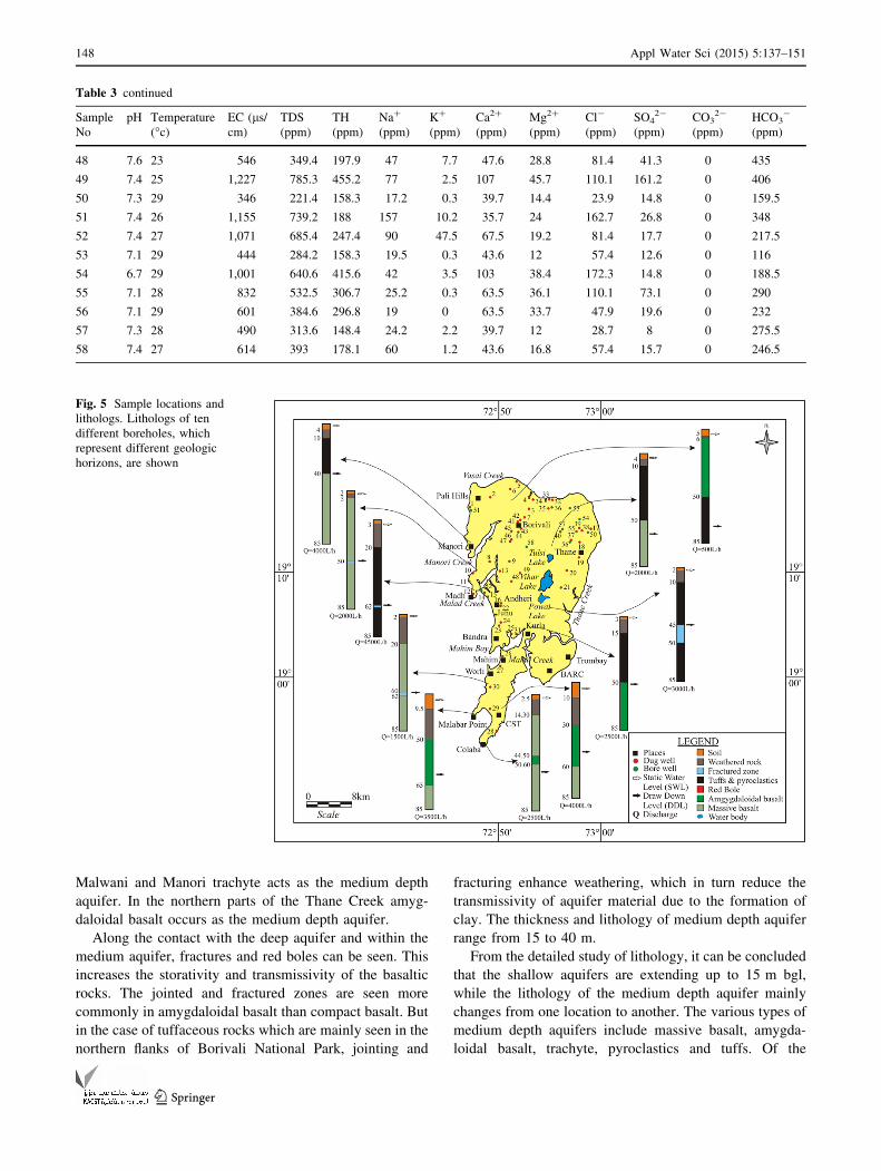
Malwani and Manori trachyte acts as the medium depth
aquifer. In the northern parts of the Thane Creek amyg-
daloidal basalt occurs as the medium depth aquifer.
Along the contact with the deep aquifer and within the
medium aquifer, fractures and red boles can be seen. This
increases the storativity and transmissivity of the basaltic
rocks. The jointed and fractured zones are seen more
commonly in amygdaloidal basalt than compact basalt. But
in the case of tuffaceous rocks which are mainly seen in the
northern flanks of Borivali National Park, jointing and
fracturing enhance weathering, which in turn reduce the
transmissivity of aquifer material due to the formation of
clay. The thickness and lithology of medium depth aquifer
range from 15 to 40 m.
From the detailed study of lithology, it can be concluded
that the shallow aquifers are extending up to 15 m bgl,
while the lithology of the medium depth aquifer mainly
changes from one location to another. The various types of
medium depth aquifers include massive basalt, amygda-
loidal basalt, trachyte, pyroclastics and tuffs. Of the
Table 3 continued
Sample
No
pH Temperature
(�c)EC (ls/cm)
TDS
(ppm)
TH
(ppm)
Na?
(ppm)
K?
(ppm)
Ca2?
(ppm)
Mg2?
(ppm)
Cl-
(ppm)
SO42-
(ppm)
CO32-
(ppm)
HCO3-
(ppm)
48 7.6 23 546 349.4 197.9 47 7.7 47.6 28.8 81.4 41.3 0 435
49 7.4 25 1,227 785.3 455.2 77 2.5 107 45.7 110.1 161.2 0 406
50 7.3 29 346 221.4 158.3 17.2 0.3 39.7 14.4 23.9 14.8 0 159.5
51 7.4 26 1,155 739.2 188 157 10.2 35.7 24 162.7 26.8 0 348
52 7.4 27 1,071 685.4 247.4 90 47.5 67.5 19.2 81.4 17.7 0 217.5
53 7.1 29 444 284.2 158.3 19.5 0.3 43.6 12 57.4 12.6 0 116
54 6.7 29 1,001 640.6 415.6 42 3.5 103 38.4 172.3 14.8 0 188.5
55 7.1 28 832 532.5 306.7 25.2 0.3 63.5 36.1 110.1 73.1 0 290
56 7.1 29 601 384.6 296.8 19 0 63.5 33.7 47.9 19.6 0 232
57 7.3 28 490 313.6 148.4 24.2 2.2 39.7 12 28.7 8 0 275.5
58 7.4 27 614 393 178.1 60 1.2 43.6 16.8 57.4 15.7 0 246.5
Fig. 5 Sample locations and
lithologs. Lithologs of ten
different boreholes, which
represent different geologic
horizons, are shown
148 Appl Water Sci (2015) 5:137–151
123
different types of aquifers, the most important aquifer
influenced by geomorphology is the shallow aquifer. In
fact, shallow aquifers, and to larger extent medium aqui-
fers, are subsurface extensions of the landforms. An
understanding of these landforms will help in understand-
ing the shallow aquifer system.
Discussion and conclusions
Studies of landforms of any area have predominant
importance in understanding the hydrogeology of that
particular area. The landforms of Mumbai are considerably
modified by anthropogenic activities which altered the
groundwater regime. Therefore, the evaluation of ground-
water scenario of Mumbai Island with respect to geomor-
phology is very necessary as the demand for quantity of
freshwater increases whereas the quality decreases day
after day (Haque et al. 2012).
Geomorphology of the area gives an insight into the
landforms, which in turn, influences the occurrence as
well as the quality of groundwater. The studies show that
the denudational landforms are, generally, areas of greater
surface runoff whereas coastal and fluvial landforms
represent regions of relatively high infiltration. Mesa,
linear ridges, simple slope and residual hills have steep
slopes which enhance the runoff process and hence these
zones will never entertain the process of groundwater
occurrence. In contrast, alluvial plains, fans and deltaic
plains are favorable sites for infiltration and are capable of
forming groundwater reservoirs since these are composed
of loose unconsolidated sediments. Deltaic plain in the
study area is not marine, but lacustrine in origin. The
presence of water throughout the year in the area facili-
tates groundwater infiltration. Coastal landforms are often
favorable sites of groundwater occurrence, but are often
invaded by marine water. Hence deterioration in
groundwater quality occurs due to the invasion. The
quality deteriorates more near to the salt pans. The aqui-
fers of this area are enriched in salt content round the year.
Groundwater prospect inmudflats also shows the same nature
due to the presence of brackish water and high presence of
litter. So in the study area, groundwater occurrence increases
in the order: denudational—fluvial—coastal landforms
whereas the order is reversed as far as the quality of water is
concerned.
The average slope map of the study area shows that most
of the area has very low slope (\5�). The low-slope cate-
gory is mainly in areas of fluvial landforms that cover
about 56 % of the study area. The denudational landforms
have an average slope slightly higher than other landforms
and are located in the inland. In general, on the basis of
slope, the areas having slopes greater than 15� can be
categorized as runoff zones and those below 5� as storagezones. The runoff zone covers 33 % of the study area
whereas the storage zone covers 58 % indicating the rele-
vance of slope towards groundwater occurrence.
Hydrogeomorphology of the study area also has the
same result. Linear ridges, residual hills, cuestas and mesa
which are of denudational nature enhance the runoff pro-
cess whereas alluvial fan and pediments of fluvial origin
greatly enhance infiltration process. The beaches, salt pans
and mudflats are marine landforms, which continuously
deteriorate the quality of water.
The classification of landforms on the basis of hydrog-
eomorphic characteristics is further validated with the hy-
drogeochemistry and subsurface geology. Both the studies
validate the hydrogeomorphic classification of landforms
studied through field work and remote sensing techniques.
The hydrogeochemistry of denudational landforms reveals
that the quality of water is good, but replenishment during
monsoon is very small. Hence, these landforms have to be
preserved from deterioration and are ideal target for arti-
ficial recharge for a better tomorrow in Mumbai Island.
Continuous contour trenches (CCT), loose boulder struc-
tures (gully plugs) are the most suitable structures for hilly
area as these structures will function initially as soil con-
servation structure and subsequently improve the soil
moisture retention and also enhance the recharge to
groundwater. These structures will also improve sustain-
ability of springs thereby improving water supply scenario
in the small hamlets situated in hilly areas. But fluvial
landforms have good potential to hold water and the quality
of water is usually good. This landform is the feeder for
domestic supply of water to the majority of the population
in the city and has to be protected from deterioration.
Marine landforms have good storativity, but are frequently
invaded by seawater.
Table 4 Sample location vis-a-vis landforms
Denudational Fluvial Coastal
Sample location no. 1, 32, 33, 34, 35, 37, 39,
40, 51, 53, 54, 55, 56, 57
3, 4, 6, 7, 9, 10, 11, 12, 16, 17,
18, 19, 20, 21, 22, 23, 24, 25, 26,
27, 28, 29, 30, 31, 36, 38, 41, 42,
43, 44, 45, 46, 47, 48, 49, 50, 58
2, 5, 8, 13, 14, 15, 52
Appl Water Sci (2015) 5:137–151 149
123
Borehole data reveal that three types of aquifers exist in
Mumbai basaltic terrain: shallow, medium and deep aqui-
fer. There is a considerable difference in the hydrogeo-
chemistry of water samples collected from shallow,
medium and deep aquifers. Dug wells usually tap the
shallow and medium level aquifers whereas bore wells are
confined to deep level aquifers. Shallow level aquifers are
controlled by the geomorphology of the area whereas
medium and deep aquifers are controlled by the subsurface
geology. Hence, shallow level aquifers are more discussed
in this part. Shallow level aquifers exist in the tune of
2–5 m depth. Majority of the population depends on these
aquifers. The presence of these aquifers at these depths is
determined by the geomorphology. The denudational and
fluvial landforms are usually marked by soil at the top
followed by a weathered horizon. The thickness of
weathered horizon is less in denudational landforms when
compared to fluvial. Marine landforms encounter massive
or amygdaloidal basalts soon after the top soil. Usually
these are the areas characterized by rocky beaches. The
subsurface data reveal that the shallow level aquifers are
easily accessible for deterioration where as the deeper
levels are less vulnerable. Hence, considerable attention
has to be done on shallow level aquifers.
The study as a whole shows that an understanding of the
geomorphology of any area helps in the mapping of the
aquifer and the quality of the water therein. Realizing this
situation, it is imperative that runoff which is going waste
should be harvested and utilized for augmenting depleted
aquifers.
Acknowledgments This work forms a part of the M.Tech disser-
tation carried out by the first author. The first author thanks the Indian
Institute of Technology (IIT) Bombay for providing scholarship
during the course. We thank the authorities of Brihan Mumbai Cor-
poration (BMC) for providing subsurface data.
Open Access This article is distributed under the terms of the
Creative Commons Attribution License which permits any use, dis-
tribution, and reproduction in any medium, provided the original
author(s) and the source are credited.
References
Abiola O, Enikanselu PA, Oladapo MI (2009) Groundwater potential
and aquifer protective capacity of overburden units in Ado-Ekiti,
southwestern Nigeria. Int J Phys Sci 4(3):120–132
Agashe RM (1989) A review of activities and achievements of
Central Ground Water Board in Maharashtra. Theme paper:
Sem. On role of groundwater in use of water resource in
Maharashtra state, Nagpur. Joint Publ: Central Ground Water
Board, Dept. of Irrigation-Govt. of Maharashtra and GSDA 36p
Anbazhagan S, Nair AM (2004) Geographic information system and
groundwater quality mapping in Panvel Basin, Maharashtra,
India. Environ Geol 45:753–761
APHA (American Public Health Association) (1998) Standard
methods for the examination of water and wastewater, 20th
edn. American Public Health Association, Washington, p 20005
Auden JB (1949) Dykes in Western India—a discussion of their
relationships with the Deccan Traps. Trans Nat Inst Sci India
VIII:123–157
Barron OV, Barr AV, Donn MJ (2012) Effect of urbanization on the
water balance of a catchment with shallow groundwater.
J Hydrol doi: 10.1016/j.jhydrol.2012.04.027
Brockeroff M (2000) An urbanizing world. Popul Bull 55(3):1–57
Buist G (1857) Geology of the island of Bombay, geological papers
on Western India, Bombay. Education Society’s press, Bombay,
pp 169–206
Carter HJ (1857) Geology of the Island of Bombay. Geol. Papers on
W. India. Bombay Education Society’s press, Bombay,
pp 116–168
Cook PG (2003) A guide to regional groundwater flow in fractured
rock aquifers. CSIRO, Australia, p 107
Gopal B (2012) Future of wetlands in tropical and subtropical Asia,
especially in the face of climate change. Aquat Sci. doi:10.1007/
s00027-011-0247-y
Government of Maharashtra (1993) Maharashtra groundwater: regu-
lation of drinking water purposes, Act 1993, chapter 2, clause 3.
Government of Maharashtra, Mumbai, p 2. http://www.ielrc.org/
content/e9301.pdf. Accessed 5 Mar 2014
Gupta S (2009) Groundwater information. Greater Mumbai district,
Maharashtra. Central Ground Water Board, Nagpur, p 10
Haque SJ, Onodera S, Shimizu Y (2012) An overview of the effects
of urbanization on the quantity and quality of groundwater in
South Asian megacities. Limnology. doi:10.1007/s10201-012-
0392-6
Kamble SR, Vijay R (2011) Assessment of water quality using cluster
analysis in coastal region of Mumbai, India. Environ Monit
Assess 178:321–332
Krishnan MS (1960) Geology of India and Burma. Higginboothams,
Madras, p 604
Krishnan MS (1982) Geology of India and Burma, IVth edn.
Higginbothams, Madras, p 536
Limaye SD (2010) Review: groundwater development and manage-
ment in the Deccan Traps (basalts) of western India. Hydrogeol J
18:543–558
Maiti S, Erram CV, Gupta G, Tiwari RK (2012) ANN based inversion
of DC resistivity data for groundwater exploration in hard rock
terrain of western Maharashtra (India). J Hydrol 464–465:
294–308
Mondal NC, Singh VP, Singh VS, Saxena VK (2010) Determining the
interaction between groundwater and saline water through
groundwater major ions chemistry. J Hydrol 388:100–111
MPCB (2011) Water quality for the year 2007–2008 under GEMS
MINARS project. Maharashtra Pollution Control Board, Mum-
bai. Data downloaded on 20 March 2011 http://www.mpcb.gov.
in/envtdata/InnerPg_gmsmnrs32007.php. Accessed 20 Mar 2011
Murthy RC, Rao YR, Inamdar AB (2001) Integrated coastal
management of Mumbai metropolitan region. Ocean Coast
Manag 44:355–369
Naik PK, Dehury BN, Tiwari AN (2007) Groundwater pollution
around an industrial area in the coastal stretch of Maharashtra
State, India. Environ Monit Assess 132:207–233
Nair KS (2009) An Assessment of the impact of climate change on
the megacities of India and of the current policies and strategies
to meet associated challenges, fifth urban research symposium
2009, Marseille, France
Owen R (1847) On the Batracholite, indicative of a small species of
frog (from Bombay). Q J Geol Soc Lond 3:224–225
Pascoe EH (1964) A manual of geology of India and Burma, 3rd edn.
Govt. of India publ, New Delhi, pp 1345–2130
150 Appl Water Sci (2015) 5:137–151
123
Rani VR (2004) Hydrogeochemistry of coastal wetlands and inland
aquifers of Mumbai and Mumbra-Belapur region, Maharashtra.
M.Tech thesis (Unpublished). Indian Institute of Technology
Bombay, Mumbai, p 260
Rao RCS, Sahasrabudhe YS, Deshmukh SS, Raman R (1978)
Distribution, structure and petrography of the Deccan Traps,
India. Rep Geol Surv India (Unpub)
Sabnis MM (1984) Studies of some major and minor elements in the
polluted Mahim River estuary (PhD. thesis). University of
Bombay (now Mumbai), Mumbai, p 288
Sekovski I, Newton A, Dennison WC (2012) Megacities in the coastal
zone: using a driver-pressure-state-impact-response framework
to address complex environmental problems. Estuar Coast Shelf
Sci 96:48–59
Sethna SF (1981) Geology around Bombay: some intriguing
problems. Mem Geol Soc Ind Bangalore 3:279–286
Sethna SF (1999) Geology of Mumbai and surrounding areas and its
position in the Deccan Volcanic Stratigraphy, India. J Geol Soc
India 53:359–365
Shah SD, Parthasarathy A (1982) Deccan volcanics: rock materials
and rock masses characteristics and their significance in
engineering geology in Deccan Volcanism. Mem Geol Soc
India Bangalore 3:233–243
Shankar RMN, Mohan G (2006) Assessment of the groundwater
potential and quality in Bhatsa and Kalu river basins of Thane
district, western Deccan Volcanic Province of India. Environ
Geol 49:990–998
Sheth HC (1998) A reappraisal of the coastal Panvel Deccan Flexure,
Deccan Traps, as a listric-fault-controlled reverse drag structure.
Tectonophysics 294:143–149
Sheth HC, Pande K, Bhutani R (2001) 40 Ar-39 Ar ages of Bombay
trachytes: evidence for a Palaeocene phase of Deccan Volca-
nism. Geophys Res Lett 28:3513–3516
Sukeshwala RN (1953) Notes on the field occurrence and petrography
of the rocks of the Bombay Island, Bombay. Trans Min Met Soc
India 50:101–126
Sukeshwala RN, Poldervaart A (1958) Deccan basalts of Bombay
area, India. Geol Soc Am Bull 69:1475–1494
Thornbury WD (1990) Principles of geomorphology. Wiley, New
York
Tirumalesh K, Shivanna K, Sriraman AK, Tyagi AK (2010)
Assessment of quality and geochemical processes occurring in
groundwaters near central air conditioning plant site in Trombay,
Maharashtra, India. Environ Monit Assess 163:171–184
Todd DK (1980) Groundwater hydrology, II edn. John Wiley & Sons,
New York
United Nations (2010) World population prospects: the 2008 revision
and world urbanization prospects: the 2009 revision. Population
Division of the Department of Economic and Social Affairs of
the United Nations Secretariat, New York. http://esa.un.org/
wup2009/unup
Williams E (1953) Fossils and the distribution of chelyid turtles.
‘‘Hydraspis’’ leithii (Carter) in the Eocene of India is a
pelomedusid. Breviora (Mus. Comp. Zoology, Cambridge,
Mass) 13:8
Zingde MD, Sabnis MM (1989) Flushing characteristics of Mahim
River estuary. Adv Biosci 8:1–7
Appl Water Sci (2015) 5:137–151 151
123