Embed Size (px)
Citation preview
GEOMORPHOLOGICAL FEATURES OF MT. ERCIYES USING BY DTM AND REMOTE SENSING TECHNOLOGIES
C. Gazio�lu a, 1, Z.Y. Yücel a, H. Kaya b, E. Do�an c
a Istanbul University, Institute of Marine Sciences and Management,
BERKARDA Remote Sensing and GIS Laboratory 34116 Vefa Istanbul, Turkey - (cemga, zyy)@istanbul.edu.tr b MSc Geographer, Ministry of National Education ([email protected])
c Istanbul University, Institute of Marine Sciences and Management, Department of Marine Environment ([email protected])
Commission TS WG II/6; Spatial Analysisi and Visualization System
KEY WORDS: Geomorphology, DEM/DTM, Landsat, GIS, Cartography, Visualization, Glaciology. ABSTRACT: Satellite data and Digital Terrain Models (DTM), complemented by field structural analysis permit a new understanding of relations between tectonics and volcanism. A DTM of Mt. Erciyes (3917 m.) is presented; it has 10m vertical and horizontal resolutions, respectively, and covers an area of about 3800 km2. Landsat ETM data were used to identification of morphological features of Erciyes Stratovolcano Complex (ESVC). This observations and analysis are able to improved by measure, monitor and analysis forms of terrain using by satellite and DTM data. Using both DTM and remote sensing together open new dimension on earthsciences and investigation morphological features of mountains and volcanoes. Perspective view of Mt. Erciyes allowed both recognition and location of the main morphological and volcanotectonic features of the valcano. A slope, aspect maps have been generated from the DTM. Geomorphological features of Mt. Erciyes including glaciations of ESVC and lineaments of surroundings area are discussed by remote sensing technologies and DTM both indepentedly and together in this paper
1 Corresponding Author
1. INTRODUCTION
Globally significant interactions between surfce processes, tectonics and climate have been proposed to explain strucutre of mountain areas (Bishop et al., 2003). Aspecially, volcanic areas, the study of the geomorphological aspects represents an important tool for constraining their structural and volcanological features and evaulations (Favalli, et al., 1999). Observation of morphologic relationships between volcanism and tectonics is a effective approach in geology and geomorphology (Dhont, et al., 1998). DTM reveal linear features resulting from complex interplay between regional and local tectonic regimes and eruptive dynamic and rhelogical characteristics of the emitted products. Revevant morphological units are displayed in the slope, relief and aspect maps which are show us important insights into the volcanic systems (Favalli, et al., 1999) In this paper, morphological features of the highest and the largest stratovolcano of Central Anatolia is analysed and described by DTM and Satelite data (Landsat ETM). Erciyes Mountain is located in the north-eastern part of the Coppadocian Volcanic Plateau. Erciyes Stratovolcano Complex (ESVC) is characterized by four valleys and one ridge that contain a glacier and Late Quaternary glacial deposits on its flanks (Sarıkaya, et al. 2003a). Additionally glaciations of ESVC is investigated in this paper. Analysis of the topography of mountain areas, however, is increasingly being used to study surface processes due to the more availability of DTM from both remote sensing and digitizing topographic maps (Bishop et al., 2003).
2. STUDY AREA
Central Anatolia Volcanism has developed since the late Miosene (Innocenti et al., 1975; Innocenti et al., 1982; Pasquare et al., 1988). This mechanism has been considered to be related to compression (Pearce et al., 1990; Yılmaz, 1990) or it may also be the consequence of regional extension (Temel, 1992). Erciyes Mountain is a gigantic volcanic cone (3917 m.). Whole Central Anatolia is dominating by Erciyes Mountain.
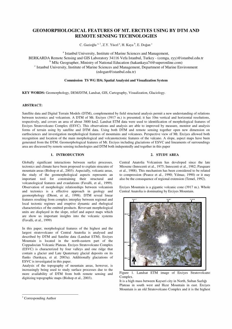
Figure 1. Landsat ETM image of Erciyes Stratovolcano Complex. It is a high mass between Kayseri city in North, Sultan Sazlı�ı Plateau in south west and Hızır Mountain in east. Erciyes Mountain is an old Stratovolcano Complex and it is the highest
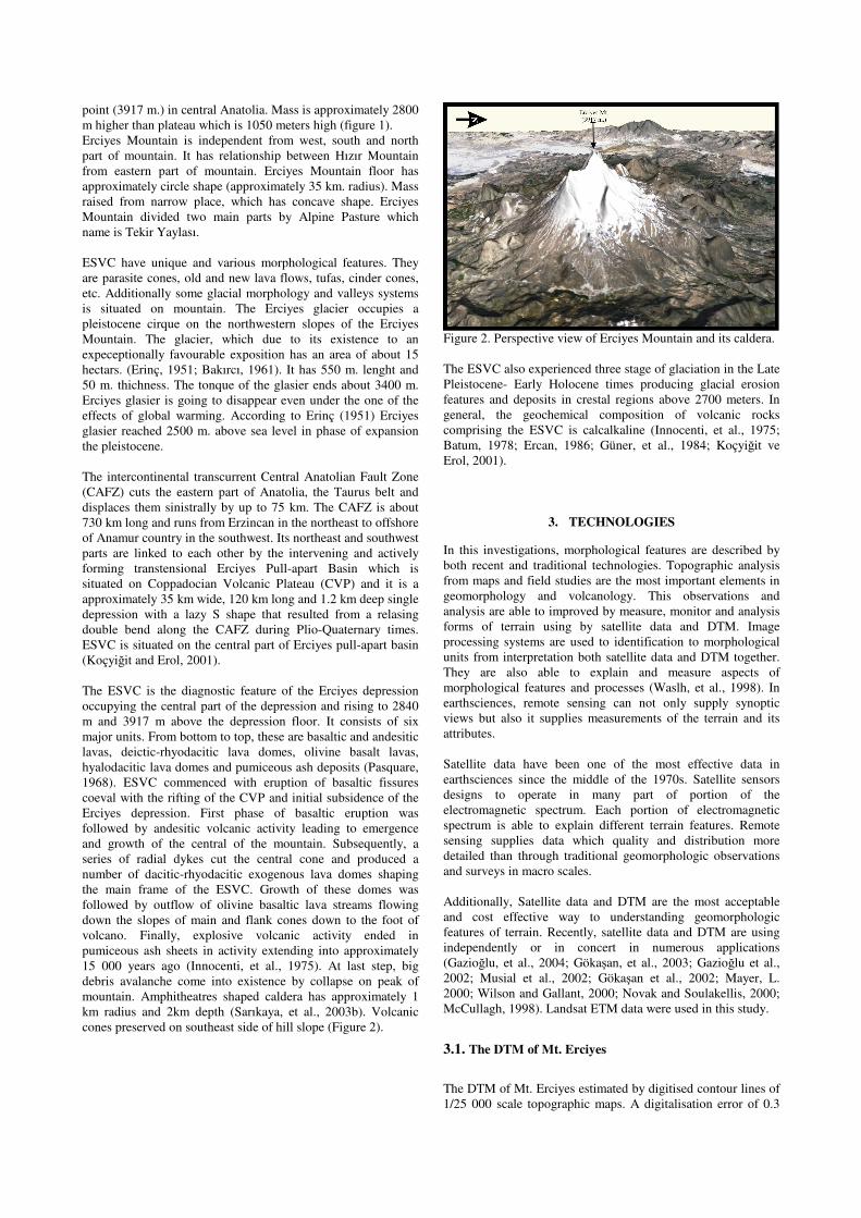
point (3917 m.) in central Anatolia. Mass is approximately 2800 m higher than plateau which is 1050 meters high (figure 1). Erciyes Mountain is independent from west, south and north part of mountain. It has relationship between Hızır Mountain from eastern part of mountain. Erciyes Mountain floor has approximately circle shape (approximately 35 km. radius). Mass raised from narrow place, which has concave shape. Erciyes Mountain divided two main parts by Alpine Pasture which name is Tekir Yaylası. ESVC have unique and various morphological features. They are parasite cones, old and new lava flows, tufas, cinder cones, etc. Additionally some glacial morphology and valleys systems is situated on mountain. The Erciyes glacier occupies a pleistocene cirque on the northwestern slopes of the Erciyes Mountain. The glacier, which due to its existence to an expeceptionally favourable exposition has an area of about 15 hectars. (Erinç, 1951; Bakırcı, 1961). It has 550 m. lenght and 50 m. thichness. The tonque of the glasier ends about 3400 m. Erciyes glasier is going to disappear even under the one of the effects of global warming. According to Erinç (1951) Erciyes glasier reached 2500 m. above sea level in phase of expansion the pleistocene. The intercontinental transcurrent Central Anatolian Fault Zone (CAFZ) cuts the eastern part of Anatolia, the Taurus belt and displaces them sinistrally by up to 75 km. The CAFZ is about 730 km long and runs from Erzincan in the northeast to offshore of Anamur country in the southwest. Its northeast and southwest parts are linked to each other by the intervening and actively forming transtensional Erciyes Pull-apart Basin which is situated on Coppadocian Volcanic Plateau (CVP) and it is a approximately 35 km wide, 120 km long and 1.2 km deep single depression with a lazy S shape that resulted from a relasing double bend along the CAFZ during Plio-Quaternary times. ESVC is situated on the central part of Erciyes pull-apart basin (Koçyi�it and Erol, 2001). The ESVC is the diagnostic feature of the Erciyes depression occupying the central part of the depression and rising to 2840 m and 3917 m above the depression floor. It consists of six major units. From bottom to top, these are basaltic and andesitic lavas, deictic-rhyodacitic lava domes, olivine basalt lavas, hyalodacitic lava domes and pumiceous ash deposits (Pasquare, 1968). ESVC commenced with eruption of basaltic fissures coeval with the rifting of the CVP and initial subsidence of the Erciyes depression. First phase of basaltic eruption was followed by andesitic volcanic activity leading to emergence and growth of the central of the mountain. Subsequently, a series of radial dykes cut the central cone and produced a number of dacitic-rhyodacitic exogenous lava domes shaping the main frame of the ESVC. Growth of these domes was followed by outflow of olivine basaltic lava streams flowing down the slopes of main and flank cones down to the foot of volcano. Finally, explosive volcanic activity ended in pumiceous ash sheets in activity extending into approximately 15 000 years ago (Innocenti, et al., 1975). At last step, big debris avalanche come into existence by collapse on peak of mountain. Amphitheatres shaped caldera has approximately 1 km radius and 2km depth (Sarıkaya, et al., 2003b). Volcanic cones preserved on southeast side of hill slope (Figure 2).
Figure 2. Perspective view of Erciyes Mountain and its caldera. The ESVC also experienced three stage of glaciation in the Late Pleistocene- Early Holocene times producing glacial erosion features and deposits in crestal regions above 2700 meters. In general, the geochemical composition of volcanic rocks comprising the ESVC is calcalkaline (Innocenti, et al., 1975; Batum, 1978; Ercan, 1986; Güner, et al., 1984; Koçyi�it ve Erol, 2001).
3. TECHNOLOGIES
In this investigations, morphological features are described by both recent and traditional technologies. Topographic analysis from maps and field studies are the most important elements in geomorphology and volcanology. This observations and analysis are able to improved by measure, monitor and analysis forms of terrain using by satellite data and DTM. Image processing systems are used to identification to morphological units from interpretation both satellite data and DTM together. They are also able to explain and measure aspects of morphological features and processes (Waslh, et al., 1998). In earthsciences, remote sensing can not only supply synoptic views but also it supplies measurements of the terrain and its attributes. Satellite data have been one of the most effective data in earthsciences since the middle of the 1970s. Satellite sensors designs to operate in many part of portion of the electromagnetic spectrum. Each portion of electromagnetic spectrum is able to explain different terrain features. Remote sensing supplies data which quality and distribution more detailed than through traditional geomorphologic observations and surveys in macro scales. Additionally, Satellite data and DTM are the most acceptable and cost effective way to understanding geomorphologic features of terrain. Recently, satellite data and DTM are using independently or in concert in numerous applications (Gazio�lu, et al., 2004; Göka�an, et al., 2003; Gazio�lu et al., 2002; Musial et al., 2002; Göka�an et al., 2002; Mayer, L. 2000; Wilson and Gallant, 2000; Novak and Soulakellis, 2000; McCullagh, 1998). Landsat ETM data were used in this study.
3.1. The DTM of Mt. Erciyes The DTM of Mt. Erciyes estimated by digitised contour lines of 1/25 000 scale topographic maps. A digitalisation error of 0.3
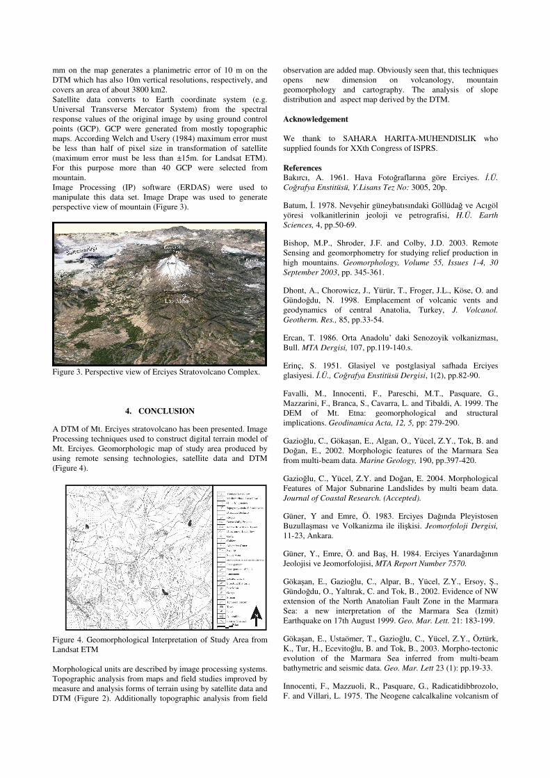
mm on the map generates a planimetric error of 10 m on the DTM which has also 10m vertical resolutions, respectively, and covers an area of about 3800 km2. Satellite data converts to Earth coordinate system (e.g. Universal Transverse Mercator System) from the spectral response values of the original image by using ground control points (GCP). GCP were generated from mostly topographic maps. According Welch and Usery (1984) maximum error must be less than half of pixel size in transformation of satellite (maximum error must be less than ±15m. for Landsat ETM). For this purpose more than 40 GCP were selected from mountain. Image Processing (IP) software (ERDAS) were used to manipulate this data set. Image Drape was used to generate perspective view of mountain (Figure 3).
Figure 3. Perspective view of Erciyes Stratovolcano Complex.
4. CONCLUSION
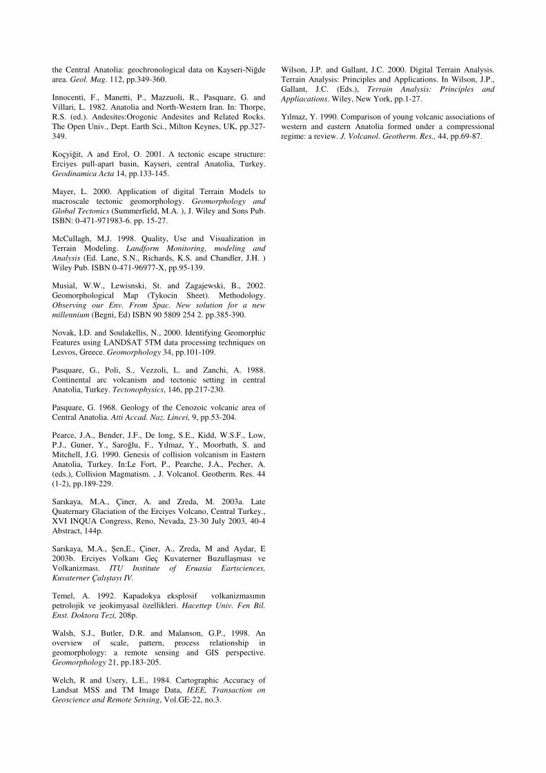
A DTM of Mt. Erciyes stratovolcano has been presented. Image Processing techniques used to construct digital terrain model of Mt. Erciyes. Geomorphologic map of study area produced by using remote sensing technologies, satellite data and DTM (Figure 4).
Figure 4. Geomorphological Interpretation of Study Area from Landsat ETM Morphological units are described by image processing systems. Topographic analysis from maps and field studies improved by measure and analysis forms of terrain using by satellite data and DTM (Figure 2). Additionally topographic analysis from field
observation are added map. Obviously seen that, this techniques opens new dimension on volcanology, mountain geomorphology and cartography. The analysis of slope distribution and aspect map derived by the DTM. Acknowledgement We thank to SAHARA HARITA-MUHENDISLIK who supplied founds for XXth Congress of ISPRS. References Bakırcı, A. 1961. Hava Foto�raflarına göre Erciyes. �.Ü. Co�rafya Enstitüsü, Y.Lisans Tez No: 3005, 20p.
Batum, �. 1978. Nev�ehir güneybatısındaki Göllüda� ve Acıgöl yöresi volkanitlerinin jeoloji ve petrografisi, H.Ü. Earth Sciences, 4, pp.50-69.
Bishop, M.P., Shroder, J.F. and Colby, J.D. 2003. Remote Sensing and geomorphometry for studying relief production in high mountains. Geomorphology, Volume 55, Issues 1-4, 30 September 2003, pp. 345-361.
Dhont, A., Chorowicz, J., Yürür, T., Froger, J.L., Köse, O. and Gündo�du, N. 1998. Emplacement of volcanic vents and geodynamics of central Anatolia, Turkey, J. Volcanol. Geotherm. Res., 85, pp.33-54.
Ercan, T. 1986. Orta Anadolu’ daki Senozoyik volkanizması, Bull. MTA Dergisi, 107, pp.119-140.s.
Erinç, S. 1951. Glasiyel ve postglasiyal safhada Erciyes glasiyesi. �.Ü., Co�rafya Enstitüsü Dergisi, 1(2), pp.82-90.
Favalli, M., Innocenti, F., Pareschi, M.T., Pasquare, G., Mazzarini, F., Branca, S., Cavarra, L. and Tibaldi, A. 1999. The DEM of Mt. Etna: geomorphological and structural implications. Geodinamica Acta, 12, 5, pp: 279-290.
Gazio�lu, C., Göka�an, E., Algan, O., Yücel, Z.Y., Tok, B. and Do�an, E., 2002. Morphologic features of the Marmara Sea from multi-beam data. Marine Geology, 190, pp.397-420.
Gazio�lu, C., Yücel, Z.Y. and Do�an, E. 2004. Morphological Features of Major Subnarine Landslides by multi beam data. Journal of Coastal Research. (Accepted).
Güner, Y and Emre, Ö. 1983. Erciyes Da�ında Pleyistosen Buzulla�ması ve Volkanizma ile ili�kisi. Jeomorfoloji Dergisi, 11-23, Ankara.
Güner, Y., Emre, Ö. and Ba�, H. 1984. Erciyes Yanarda�ının Jeolojisi ve Jeomorfolojisi, MTA Report Number 7570.
Göka�an, E., Gazio�lu, C., Alpar, B., Yücel, Z.Y., Ersoy, �., Gündo�du, O., Yaltırak, C. and Tok, B., 2002. Evidence of NW extension of the North Anatolian Fault Zone in the Marmara Sea: a new interpretation of the Marmara Sea (Izmit) Earthquake on 17th August 1999. Geo. Mar. Lett. 21: 183-199.
Göka�an, E., Ustaömer, T., Gazio�lu, C., Yücel, Z.Y., Öztürk, K., Tur, H., Ecevito�lu, B. and Tok, B., 2003. Morpho-tectonic evolution of the Marmara Sea inferred from multi-beam bathymetric and seismic data. Geo. Mar. Lett 23 (1): pp.19-33.
Innocenti, F., Mazzuoli, R., Pasquare, G., Radicatidibbrozolo, F. and Villari, L. 1975. The Neogene calcalkaline volcanism of
the Central Anatolia: geochronological data on Kayseri-Ni�de area. Geol. Mag. 112, pp.349-360.
Innocenti, F., Manetti, P., Mazzuoli, R., Pasquare, G. and Villari, L. 1982. Anatolia and North-Western Iran. In: Thorpe, R.S. (ed.). Andesites:Orogenic Andesites and Related Rocks. The Open Univ., Dept. Earth Sci., Milton Keynes, UK, pp.327-349.
Koçyi�it, A and Erol, O. 2001. A tectonic escape structure: Erciyes pull-apart basin, Kayseri, central Anatolia, Turkey. Geodinamica Acta 14, pp.133-145.
Mayer, L. 2000. Application of digital Terrain Models to macroscale tectonic geomorphology. Geomorphology and Global Tectonics (Summerfield, M.A. ), J. Wiley and Sons Pub. ISBN: 0-471-971983-6. pp. 15-27.
McCullagh, M.J. 1998. Quality, Use and Visualization in Terrain Modeling. Landform Monitoring, modeling and Analysis (Ed. Lane, S.N., Richards, K.S. and Chandler, J.H. ) Wiley Pub. ISBN 0-471-96977-X, pp.95-139.
Musial, W.W., Lewisnski, St. and Zagajewski, B., 2002. Geomorphological Map (Tykocin Sheet). Methodology. Observing our Env. From Spac. New solution for a new millennium (Begni, Ed) ISBN 90 5809 254 2. pp.385-390.
Novak, I.D. and Soulakellis, N., 2000. Identifying Geomorphic Features using LANDSAT 5TM data processing techniques on Lesvos, Greece. Geomorphology 34, pp.101-109.
Pasquare, G., Poli, S., Vezzoli, L. and Zanchi, A. 1988. Continental arc volcanism and tectonic setting in central Anatolia, Turkey. Tectonophysics, 146, pp.217-230.
Pasquare, G. 1968. Geology of the Cenozoic volcanic area of Central Anatolia. Atti Accad. Naz. Lincei, 9, pp.53-204.
Pearce, J.A., Bender, J.F., De long, S.E., Kidd, W.S.F., Low, P.J., Guner, Y., Saro�lu, F., Yılmaz, Y., Moorbath, S. and Mitchell, J.G. 1990. Genesis of collision volcanism in Eastern Anatolia, Turkey. In:Le Fort, P., Pearche, J.A., Pecher, A. (eds.), Collision Magmatism. , J. Volcanol. Geotherm. Res. 44 (1-2), pp.189-229.
Sarıkaya, M.A., Çiner, A. and Zreda, M. 2003a. Late Quaternary Glaciation of the Erciyes Volcano, Central Turkey., XVI INQUA Congress, Reno, Nevada, 23-30 July 2003, 40-4 Abstract, 144p.
Sarıkaya, M.A., �en,E., Çiner, A., Zreda, M and Aydar, E 2003b. Erciyes Volkanı Geç Kuvaterner Buzulla�ması ve Volkanizması. ITU Institute of Eruasia Eartsciences, Kuvaterner Çalı�tayı IV.
Temel, A. 1992. Kapadokya eksplosif volkanizmasının petrolojik ve jeokimyasal özellikleri. Hacettep Univ. Fen Bil. Enst. Doktora Tezi, 208p.
Walsh, S.J., Butler, D.R. and Malanson, G.P., 1998. An overview of scale, pattern, process relationship in geomorphology: a remote sensing and GIS perspective. Geomorphology 21, pp.183-205.
Welch, R and Usery, L.E., 1984. Cartographic Accuracy of Landsat MSS and TM Image Data, IEEE, Transaction on Geoscience and Remote Sensing, Vol.GE-22, no.3.
Wilson, J.P. and Gallant, J.C. 2000. Digital Terrain Analysis. Terrain Analysis: Principles and Applications. In Wilson, J.P., Gallant, J.C. (Eds.), Terrain Analysis: Principles and Appliacations. Wiley, New York, pp.1-27.
Yılmaz, Y. 1990. Comparison of young volcanic associations of western and eastern Anatolia formed under a compressional regime: a review. J. Volcanol. Geotherm. Res., 44, pp.69-87.


![Overview and Scutiny Power BI slides.pptx [Read-Only]€¦ · Dtm 4 Consultant Pod g Dtm I Dtm 8 7 Dtm 3 8 7 Dtm 6 Dtm Pod 4 8 Dtm Pod 4 5 Dtm 2 8 Dtm Pod 8 Dtm I 7 Dtm 4 Dtm Pod](https://img.pdfslide.us/doc/110x75/5fb41d34b5c9a8274925974c/overview-and-scutiny-power-bi-read-only-dtm-4-consultant-pod-g-dtm-i-dtm-8-7-dtm.jpg)