Embed Size (px)
Citation preview
1
Geomorphological and geological observations at the coast of Tripiti Hill (Heraklion harbour, Crete), in relation to reported
active faulting
Ganas A.1, Palyvos N.2, Mavrikas G.3, Kollias S.1 and Tsimi C.1
1 Institute of Geodynamics, National Observatory of Athens, 11810 Athens, Greece, [email protected]
2 Freelance Geologist, Navarinou 21, 152 32 Halandri, Athens, Greece, [email protected]
3 Freelance Geologist, Anastaseos 3 155 61 Athens, Greece, [email protected]
Abstract
Heraklion is a fast-growing urban centre where knowledge of active faulting is necessary for city planning and infrastructure projects. Neotectonic faults (not all necessarily active at present) most probably traverse the built-up coastal part of Heraklion, but they require subsurface geological and geophysical studies to be precisely located and characterised. In the frame of a research project assigned to the Institute of Geodynamics by the Heraklion Municipality, we made detailed geomorphological and geological observations in the coastal area of the Tripiti Hill, where previous workers report a NNW-SSE trending, WSW-dipping, presently active normal fault crossing the port of Heraklion as well as a densely built-up part of the city. Based on our observations, we conclude that this fault does not exist. In support of our conclusion, we discuss: (1) the nature of a steep contact between Neogene bedrock and Quaternary deposits exposed at a roadcut along the coastal avenue, (2) the depositional environment of Quaternary deposits at the above outcrop and surrounding area, (3) the buried relief and stratigraphic features exposed in a trench excavated by previous workers across the alleged fault trace, and (4) the geomorphological context of coastal deposits and marine terrace remnants used by previous workers for fault slip rate estimation. This case study is presented as a vivid example of the importance Geomorphology and Quaternary Geology have in studies of active faulting. Keywords: Active faulting, Coastal Geomorphology, Marine terraces, Heraklion (Crete)
1. Introduction
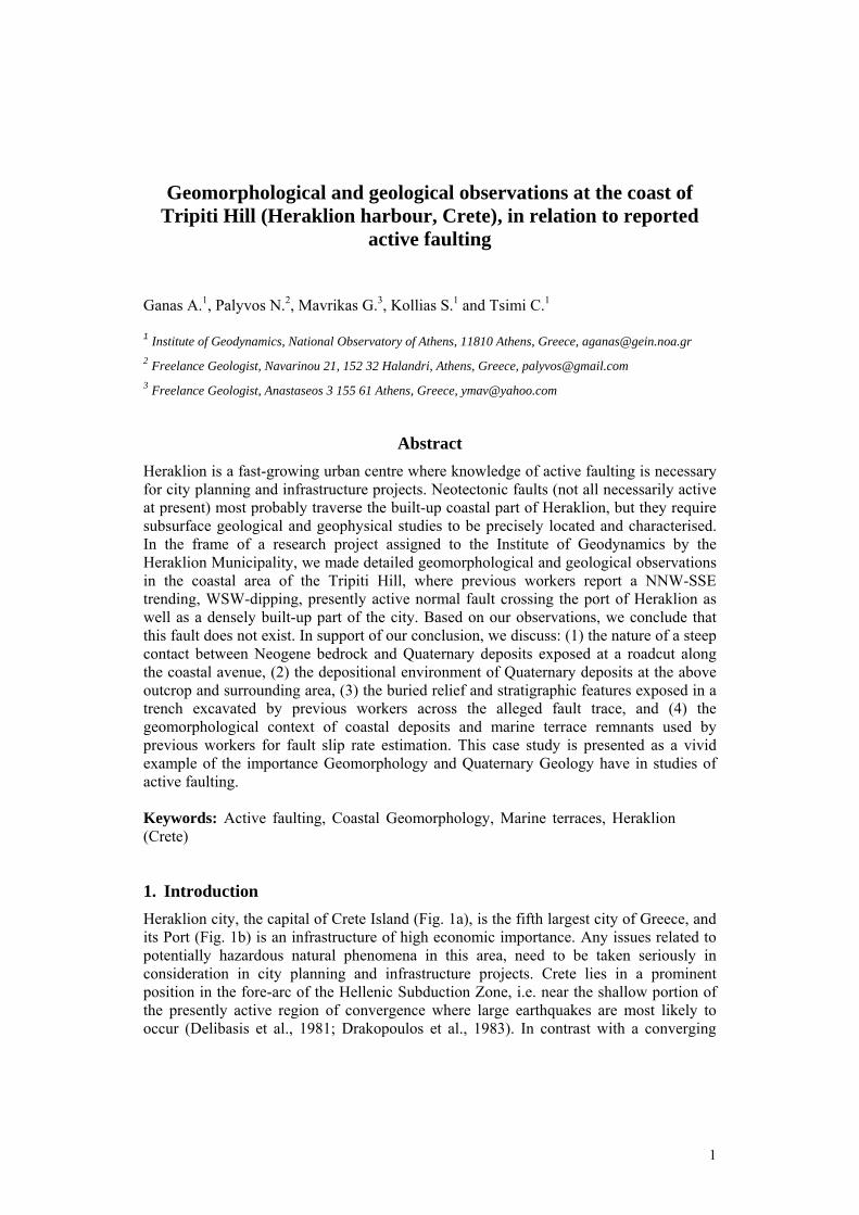
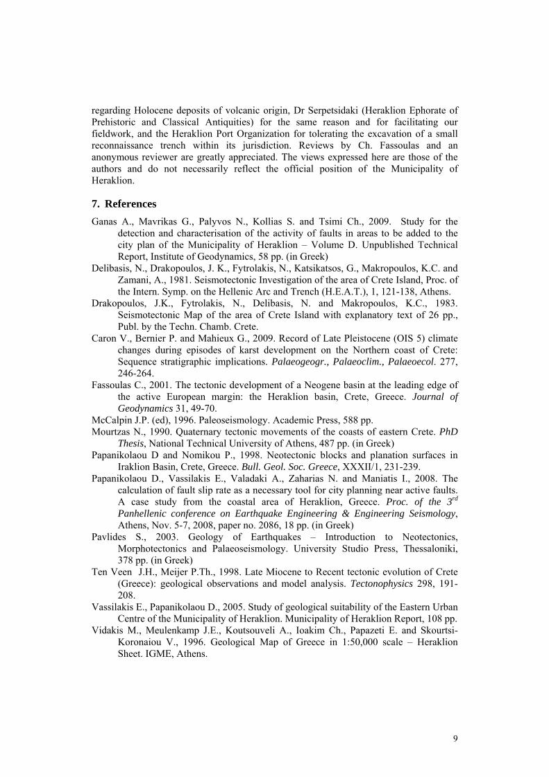
Heraklion city, the capital of Crete Island (Fig. 1a), is the fifth largest city of Greece, and its Port (Fig. 1b) is an infrastructure of high economic importance. Any issues related to potentially hazardous natural phenomena in this area, need to be taken seriously in consideration in city planning and infrastructure projects. Crete lies in a prominent position in the fore-arc of the Hellenic Subduction Zone, i.e. near the shallow portion of the presently active region of convergence where large earthquakes are most likely to occur (Delibasis et al., 1981; Drakopoulos et al., 1983). In contrast with a converging
2
tectonic regime at depth, the upper crust of Crete displays numerous evidence of extensional deformation along both arc-parallel, high-angle, E-W striking faults and along arc-normal, high-angle pure-normal and oblique-normal faults that strike on average N-S (e.g. Fassoulas 2001 and references therein; Ten Veen and Meijer 1998). Other sets of normal faults striking NW-SE and NE-SW occur as well. Since the mid-1990s there have been requests from the local authorities to conduct detailed geological investigations on fault activity in the urban and suburban area of the Heraklion city. However, until today, the onshore active-tectonic setting of the broader area, including the broader northern part of Heraklion basin (of Tertiary age – Vidakis et al. 1996) remains poorly known (e.g. Fassoulas 2001; Ten Veen and Meijer 1998). A recent study by Papanikolaou et al. (2008) proposes that the harbour and a part of the densely built Heraklion city is traversed by a NNW-SSE trending, WSW-dipping, certain and active normal fault (“F2” in Fig. 1c) at least 1.5 km long, possibly at least 2.5 km long (including its possible offshore part), which affects Late Quaternary deposits and slips at a rate of ~0.5 mm/yr. This fault has been mapped as a neotectonic structure also in earlier studies by the same group (e.g. Papanikolaou and Nomikou, 1998 and the unpublished tectonic map of microzonation project “AUTO-SEISMO-GEOTECH” by the Geology Department of the Univ. of Athens, 1998). Upon request of the Heraklion Municipality to the Institute of Geodynamics (National Observatory, Athens), we attempted to study this fault and to collect more data about its recent activity, in the frame of a broader study aiming at the identification and characterization of faults inside the city and its suburbs.
2. Study methods
Our study included field mapping (at 1:2500 scale – map in Fig. 1c) of the Late Quaternary deposits that crop out along the coast in the area around the reported fault F2, and observations on their geomorphological context (in the field and on 1:5000 scale topographic diagrams of the Hellenic Army Geographical Service). The outcrop of the contact that is interpreted in previous studies as an active fault (F2) juxtaposing Neogene and Quaternary deposits was cleaned thoroughly and examined in detail, as if it were a wall of a paleoseismological trench (except for gridding). Non-extensive excavation of the outcrop was also carried out in order to obtain more information on the nature and 3D geometry of the above contact. In addition, published data from a trench excavated by previous workers across the proposed surface trace of “fault F2” were evaluated and re-interpreted.
3. Geomorphological context and Quaternary deposits
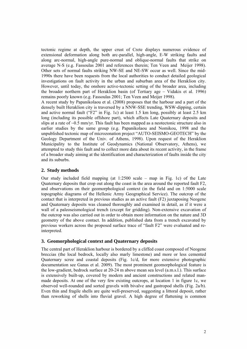
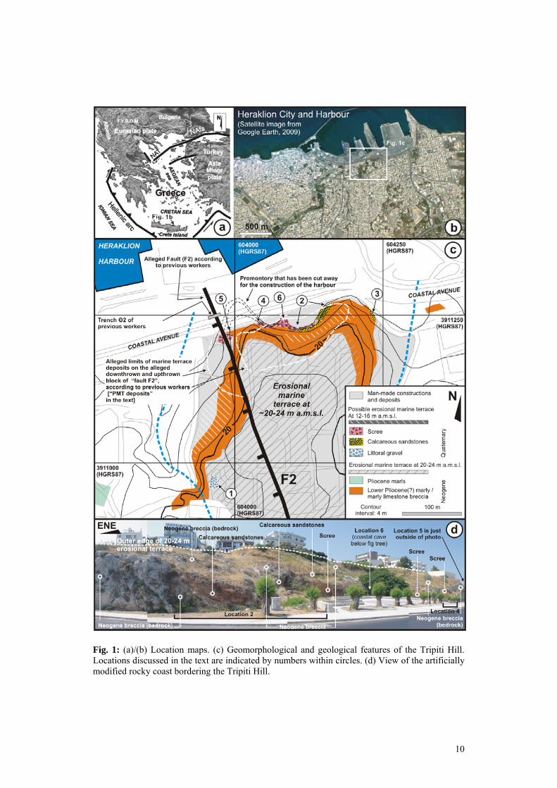
The central part of Heraklion harbour is bordered by a cliffed coast composed of Neogene breccias (the local bedrock, locally also marly limestone) and more or less cemented Quaternary scree and coastal deposits (Fig. 1c/d, for more extensive photographic documentation see Ganas et al. 2009). The most prominent geomorphological feature is the low-gradient, bedrock surface at 20-24 m above mean sea level (a.m.s.l.). This surface is extensively built-up, covered by modern and ancient constructions and related man-made deposits. At one of the very few existing outcrops, at location 1 in figure 1c, we observed well-rounded and sorted gravels with bivalve and gastropod shells (Fig. 2a/b). Even thin and fragile shells are quite well-preserved, suggesting a littoral deposit, rather than reworking of shells into fluvial gravel. A high degree of flattening is common
3
among the softer (marl) gravel clasts but, high sphericity predominates in the hardest (siliceous) gravel clasts, a feature indicating that the probable littoral gravels may consist of clasts reworked from older, fluvial gravels, which exist in the Neogene formations farther South (Vidakis et al. 1996).
Based only on the broader-scale geomorphological context of slow uplift and formation of successive erosional surfaces of marine origin (at least those below ~100 m a.m.s.l. and more) along the Heraklion coast and farther East (Mourtzas 1990, and references therein), we interpret the 20-24 m surface as a remnant of a Pleistocene erosional marine terrace. We note though, that we do not have the evidence that definitively exclude alternative interpretations for its origin (e.g. whether it may be an exhumed Neogene paleo-relief). One critical such piece of evidence is the –unknown- age of the gravel covering the surface at location 1.
If our working hypothesis that the 20-24 m surface is probably a Pleistocene erosional terrace is correct, a -very crude- age estimate for this terrace can be obtained from the available knowledge on uplifted Pleistocene marine deposits in the broader area of Central Crete. In general, along the northern coast of central Crete (e.g. at Chersonissos and Malia areas east of Heraklion), marine deposits with “Senegalese” warm-water fauna with Strombus bubonius (MIS5 or MIS7 highstands, i.e. ~75-125 or ~190-230 ka BP) occur at elevations of 2-8 and 20-30 m a.m.s.l. (Mourtzas 1990, Caron et al. 2009 and references therein), suggesting uplift rates of the order of 0.3 mm/yr maximum. Based on this crude estimate, the ~20-24 m terrace would correspond to a MIS5 or older highstand. In the area of Heraklion, the only available ages of Quaternary marine deposits are optical and radiocarbon ages obtained by Papanikolaou et al. (2008) in their trench Θ2 at the foot of the present-day coastal cliff at Tripiti (at about present-day sea level – location in Fig. 1c). The ~35-40 kyr age reported by Papanikolaou et al. (2008) yields a coastal uplift rate, of the order of 1.25 mm/yr, or higher, depending on which Late Pleistocene sea level curve is adopted (this is so, because sea level during 35-40 ka BP -MIS3- was at least 50 meters below present m.s.l.). Until more data become available, we would hesitate to endorse the above age and the high uplift rate that results from it, considering (a) the available data on the coastal uplift rate of the broader region and the general morphotectonic configuration, (b) that optical dating of marine deposits can yield apparently older ages due to incomplete solar resetting (only one optical dating performed at the specific site), and (c) that the two reported radiocarbon ages are contradicting each other (one modern age and one at 36.70-40.95 ka BP). Thus, our preferred interpretation for the time being is to accept a crude estimate of ~0.3 mm/yr maximum uplift rate, based on which the ~20-24 m probable marine terrace would correspond to a MIS5 or older highstand.
Coastal deposits are exposed in the natural and artificial outcrops along the present-day coastal cliff, at locations 2 and 3 (Fig. 1c). They consist of hard calcareous - siliciclastic sandstones with large-scale clinostratification (seaward-dipping strata – Fig. 2d). These sandstones are possibly products of aeolian deposition (Papanikolaou et al. 2008, and as suggested by their increased content in angular quartzitic sand clasts, as seen in 10x magnification). In one location, a layer of well-rounded beach gravels with rare gastropod shells (Fig. 2e) indicates deposition by waves, i.e. vicinity to a paleo-beach, this not necessarily contradicting with aeolian deposition of the sandstones. Detailed sedimentological study is necessary for more robust conclusions though. The calcareous
4
sandstones also contain smaller or larger angular clasts derived directly from the coastal bedrock (Neogene breccias), without reworking by waves. This reflects the fact that the sandstones deposited against a palaeo-cliff, a relationship clearly seen in outcrop at the eastern part of location 2 (Fig. 1d, left) and at location 3. At location 2 the palaeo-cliff has an amphitheatric shape in plan view, a shape that predetermined also the present-day morphology of the coast.
The aforementioned sandstones, as well as the Neogene bedrock at location 2 are covered by Pleistocene scree that is also exposed in the natural or artificial exposures along the present-day coastal cliff (e.g. Fig. 1d and Fig. 2c/f). Calcareous sandstone blocks (possibly displaced) are also found underneath scree at location 4 (not shown in Fig. 1c). The scree consists of generally poorly sorted clasts of Neogene breccias sized up to large boulders. Bedding is locally observable in the less coarse parts of the deposit. The scree covers anomalous palaeo-relief, as seen at the artificial outcrop at location 4, or at location 6 (Fig. 2f).
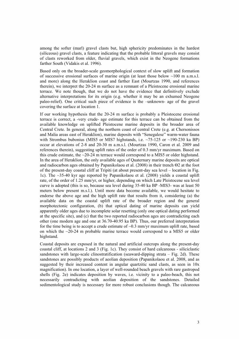
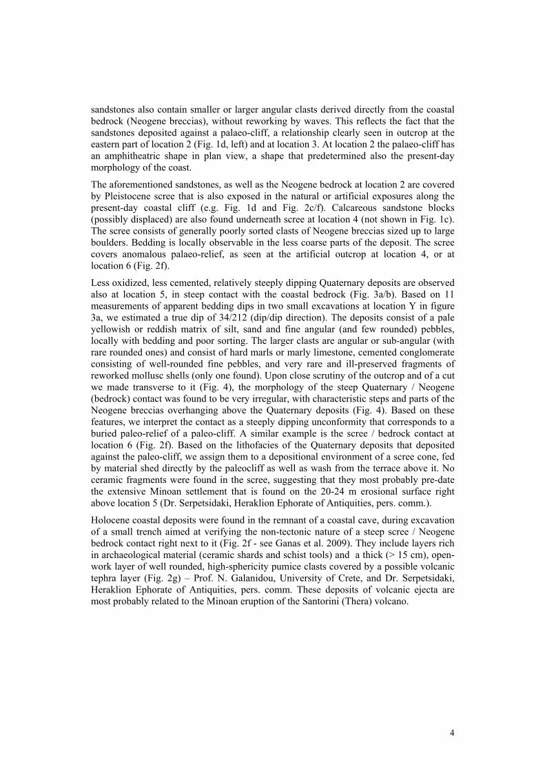
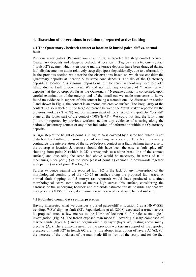
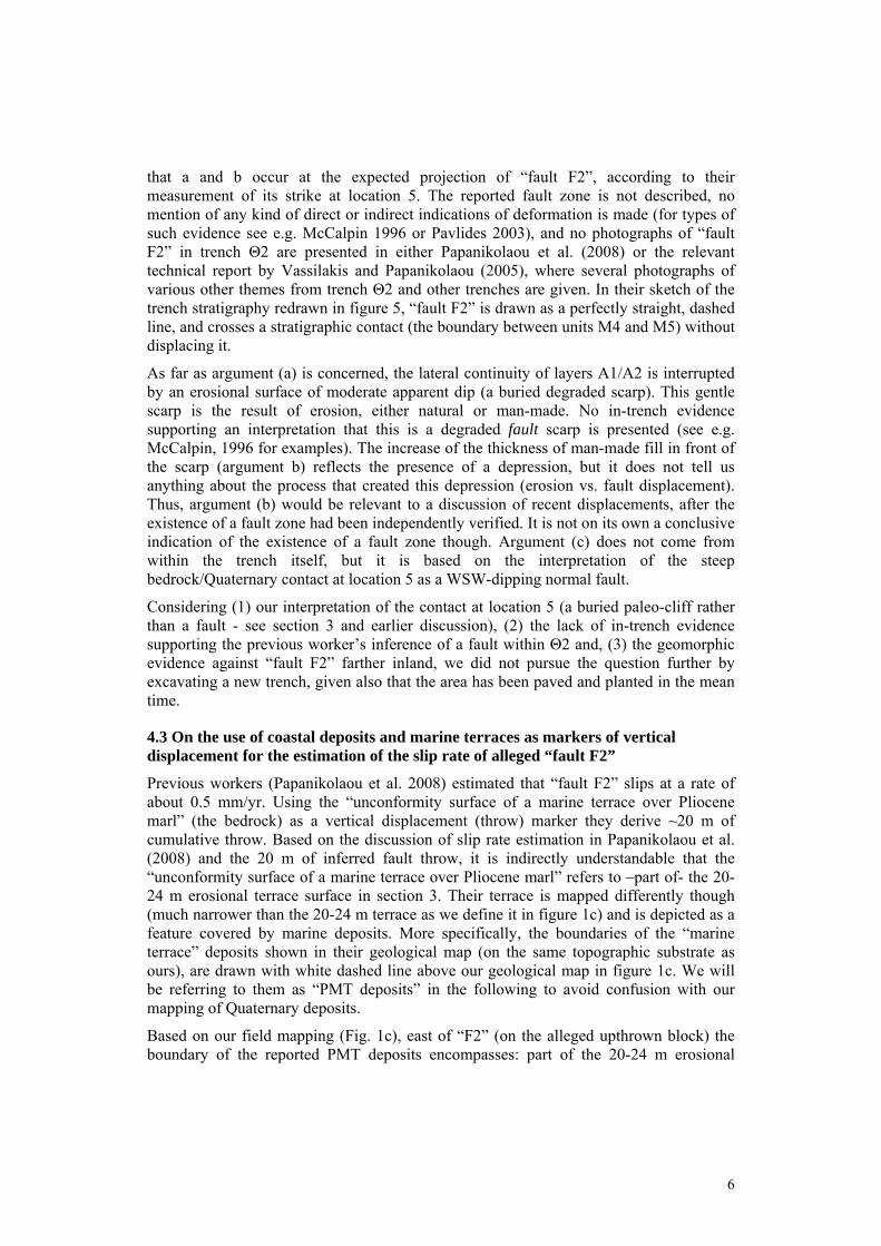
Less oxidized, less cemented, relatively steeply dipping Quaternary deposits are observed also at location 5, in steep contact with the coastal bedrock (Fig. 3a/b). Based on 11 measurements of apparent bedding dips in two small excavations at location Y in figure 3a, we estimated a true dip of 34/212 (dip/dip direction). The deposits consist of a pale yellowish or reddish matrix of silt, sand and fine angular (and few rounded) pebbles, locally with bedding and poor sorting. The larger clasts are angular or sub-angular (with rare rounded ones) and consist of hard marls or marly limestone, cemented conglomerate consisting of well-rounded fine pebbles, and very rare and ill-preserved fragments of reworked mollusc shells (only one found). Upon close scrutiny of the outcrop and of a cut we made transverse to it (Fig. 4), the morphology of the steep Quaternary / Neogene (bedrock) contact was found to be very irregular, with characteristic steps and parts of the Neogene breccias overhanging above the Quaternary deposits (Fig. 4). Based on these features, we interpret the contact as a steeply dipping unconformity that corresponds to a buried paleo-relief of a paleo-cliff. A similar example is the scree / bedrock contact at location 6 (Fig. 2f). Based on the lithofacies of the Quaternary deposits that deposited against the paleo-cliff, we assign them to a depositional environment of a scree cone, fed by material shed directly by the paleocliff as well as wash from the terrace above it. No ceramic fragments were found in the scree, suggesting that they most probably pre-date the extensive Minoan settlement that is found on the 20-24 m erosional surface right above location 5 (Dr. Serpetsidaki, Heraklion Ephorate of Antiquities, pers. comm.).
Holocene coastal deposits were found in the remnant of a coastal cave, during excavation of a small trench aimed at verifying the non-tectonic nature of a steep scree / Neogene bedrock contact right next to it (Fig. 2f - see Ganas et al. 2009). They include layers rich in archaeological material (ceramic shards and schist tools) and a thick (> 15 cm), open-work layer of well rounded, high-sphericity pumice clasts covered by a possible volcanic tephra layer (Fig. 2g) – Prof. N. Galanidou, University of Crete, and Dr. Serpetsidaki, Heraklion Ephorate of Antiquities, pers. comm. These deposits of volcanic ejecta are most probably related to the Minoan eruption of the Santorini (Thera) volcano.
5
4. Discussion of observations in relation to reported active faulting
4.1 The Quaternary / bedrock contact at location 5: buried paleo-cliff vs. normal fault
Previous investigators (Papanikolaou et al. 2008) interpreted the steep contact between Quaternary deposits and Neogene bedrock at location 5 (Fig. 3a), as a tectonic contact (“fault F2”) against which Pleistocene marine terrace deposits have been dragged during fault displacement to attain relatively steep dips (post-depositionally, due to deformation). In the previous section we describe the observations based on which we consider the Quaternary deposits at location 5 as scree cone deposits. The dip of the Quaternary deposits at location 5 is a normal depositional dip for scree, without any need to evoke tilting due to fault displacement. We did not find any evidence of “marine terrace deposits” at the outcrop. As far as the Quaternary / Neogene contact is concerned, upon careful examination of the outcrop and of the small cut we made transverse to it, we found no evidence in support of this contact being a tectonic one. As discussed in section 3 and shown in Fig. 4, the contact is an anomalous erosive surface. The irregularity of the contact is also reflected in the large difference between the “fault strike” reported by the previous workers (N145oE) and our measurement of the strike of a hypothetic “best-fit” plane at the lower part of the contact (N089oE ±5o). We could not find the fault plane (“mirror”) reported by previous workers, neither any evidence of shearing along the bedrock/Quaternary contact or any other indication of deformation within the Quaternary deposits.
A large step at the height of point X in figure 3a is covered by a scree bed, which is not disturbed by faulting or some type of cracking or shearing. This feature directly contradicts the interpretation of the scree/bedrock contact as a fault striking transverse to the outcrop at location 5, because should this have been the case, a fault splay off-shooting from point X (which in 3D, corresponds to a slope break-line of the contact surface) and displacing the scree bed above would be necessary, in terms of fault mechanics, since part (1) of the scree (east of point X) cannot slip downwards together with part (2) west of point X – Fig. 3a.
Further evidence against the reported fault F2 is the lack of any interruption of the morphological continuity of the ~20-24 m surface along the proposed fault trace. A normal fault slipping at 0.5 mm/yr (as reported) would have produced a distinct morphological scarp some tens of metres high across this surface, considering the hardness of the underlying bedrock and the crude estimate for its possible age that we may propose (MIS5 or older, if a marine terrace, even older, if an exhumed surface).
4.2 Published trench data re-interpretation
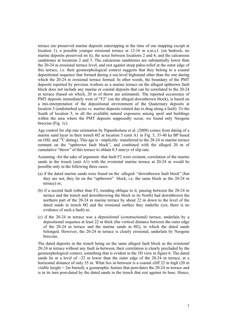
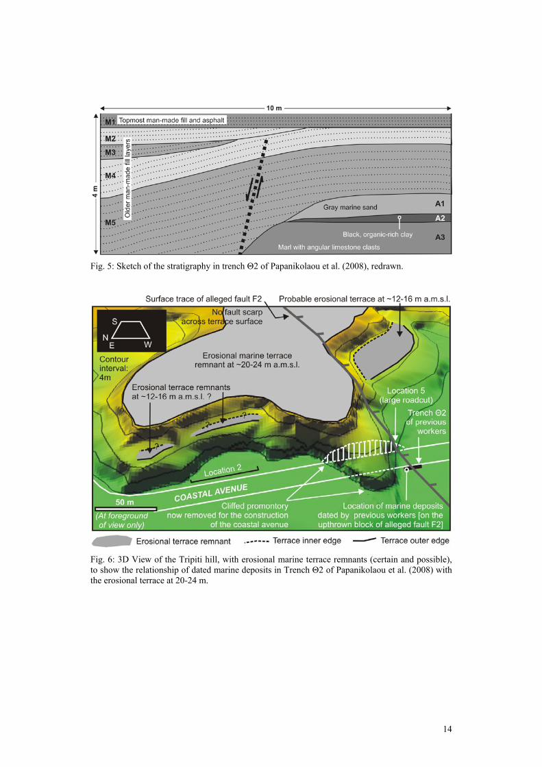
Having interpreted what we consider a buried paleo-cliff at location 5 as a NNW-SSE trending, WSW dipping fault (F2), Papanikolaou et al. (2008) excavated a trench across its proposed trace a few metres to the North of location 5, for paleoseismological investigation (Fig. 5). The trench exposed man-made fill covering a scarp composed of marine sands (layer A1) and an organic-rich clay layer (layer A2) resting above marly breccias (A3). The arguments given by the previous workers in support of the reported presence of “fault F2” in trench Θ2 are: (a) the abrupt interruption of layers A1/A2, (b) the increase of the thickness of the man-made fill in front of the scarp, and (c) the fact
6
that a and b occur at the expected projection of “fault F2”, according to their measurement of its strike at location 5. The reported fault zone is not described, no mention of any kind of direct or indirect indications of deformation is made (for types of such evidence see e.g. McCalpin 1996 or Pavlides 2003), and no photographs of “fault F2” in trench Θ2 are presented in either Papanikolaou et al. (2008) or the relevant technical report by Vassilakis and Papanikolaou (2005), where several photographs of various other themes from trench Θ2 and other trenches are given. In their sketch of the trench stratigraphy redrawn in figure 5, “fault F2” is drawn as a perfectly straight, dashed line, and crosses a stratigraphic contact (the boundary between units M4 and M5) without displacing it.
As far as argument (a) is concerned, the lateral continuity of layers A1/A2 is interrupted by an erosional surface of moderate apparent dip (a buried degraded scarp). This gentle scarp is the result of erosion, either natural or man-made. No in-trench evidence supporting an interpretation that this is a degraded fault scarp is presented (see e.g. McCalpin, 1996 for examples). The increase of the thickness of man-made fill in front of the scarp (argument b) reflects the presence of a depression, but it does not tell us anything about the process that created this depression (erosion vs. fault displacement). Thus, argument (b) would be relevant to a discussion of recent displacements, after the existence of a fault zone had been independently verified. It is not on its own a conclusive indication of the existence of a fault zone though. Argument (c) does not come from within the trench itself, but it is based on the interpretation of the steep bedrock/Quaternary contact at location 5 as a WSW-dipping normal fault.
Considering (1) our interpretation of the contact at location 5 (a buried paleo-cliff rather than a fault - see section 3 and earlier discussion), (2) the lack of in-trench evidence supporting the previous worker’s inference of a fault within Θ2 and, (3) the geomorphic evidence against “fault F2” farther inland, we did not pursue the question further by excavating a new trench, given also that the area has been paved and planted in the mean time.
4.3 On the use of coastal deposits and marine terraces as markers of vertical displacement for the estimation of the slip rate of alleged “fault F2”
Previous workers (Papanikolaou et al. 2008) estimated that “fault F2” slips at a rate of about 0.5 mm/yr. Using the “unconformity surface of a marine terrace over Pliocene marl” (the bedrock) as a vertical displacement (throw) marker they derive ~20 m of cumulative throw. Based on the discussion of slip rate estimation in Papanikolaou et al. (2008) and the 20 m of inferred fault throw, it is indirectly understandable that the “unconformity surface of a marine terrace over Pliocene marl” refers to –part of- the 20-24 m erosional terrace surface in section 3. Their terrace is mapped differently though (much narrower than the 20-24 m terrace as we define it in figure 1c) and is depicted as a feature covered by marine deposits. More specifically, the boundaries of the “marine terrace” deposits shown in their geological map (on the same topographic substrate as ours), are drawn with white dashed line above our geological map in figure 1c. We will be referring to them as “PMT deposits” in the following to avoid confusion with our mapping of Quaternary deposits.
Based on our field mapping (Fig. 1c), east of “F2” (on the alleged upthrown block) the boundary of the reported PMT deposits encompasses: part of the 20-24 m erosional
7
terrace (no preserved marine deposits outcropping at the time of our mapping except at location 1), a possible younger erosional terrace at 12-16 m a.m.s.l. (on bedrock, no marine deposits preserved on it), the scree between locations 2 and 4, and the calcareous sandstones at locations 2 and 3. The calcareous sandstones are substantially lower than the 20-24 m erosional terrace level, and rest against steep paleo-relief at the outer edge of this terrace, i.e. their geomorphological context suggests that they belong to a coastal depositional sequence that formed during a sea-level highstand other than the one during which the 20-24 m erosional terrace formed. In other words, the boundary of the PMT deposits reported by previous workers as a marine terrace on the alleged upthrown fault block does not include any marine or coastal deposits that can be correlated to the 20-24 m terrace (based on which, 20 m of throw are estimated). The reported occurrence of PMT deposits immediately west of “F2” (on the alleged downthrown block), is based on a mis-interpretation of the depositional environment of the Quaternary deposits at location 5 (undisturbed scree vs. marine deposits rotated due to drag along a fault). To the South of location 5, in all the available natural exposures among spoil and buildings within the area where the PMT deposits supposedly occur, we found only Neogene breccias (Fig. 1c).
Age control for slip rate estimation by Papanikolaou et al. (2008) comes from dating of a marine sand layer in their trench Θ2 at location 5 (unit A1 in Fig. 5, 35-40 ka BP based on OSL and 14C dating). This age is –implicitly- transferred to the 20-24 m marine terrace remnant on the “upthrown fault block”, and combined with the alleged 20 m of cumulative “throw” of this terrace to obtain 0.5 mm/yr of slip rate.
Assuming -for the sake of argument- that fault F2 were existent, correlation of the marine sands in the trench (unit A1) with the erosional marine terrace at 20-24 m would be possible only in the following three cases:
(a) if the dated marine sands were found on the -alleged- “downthrown fault block” (but they are not, they lie on the “upthrown” block, i.e. the same block as the 20-24 m terrace) or,
(b) if a second fault (other than F2, trending oblique to it, passing between the 20-24 m terrace and the trench and downthrowing the block to its North) had downthrown the northern part of the 20-24 m marine terrace by about 22 m down to the level of the dated sands in trench Θ2 and the erosional surface they underlie (yet, there is no evidence of such a fault) or,
(c) if the 20-24 m terrace was a depositional (constructional) terrace, underlain by a depositional sequence at least 22 m thick (the vertical distance between the outer edge of the 20-24 m terrace and the marine sands in Θ2), to which the dated sands belonged. However, the 20-24 m terrace is clearly erosional, underlain by Neogene breccias.
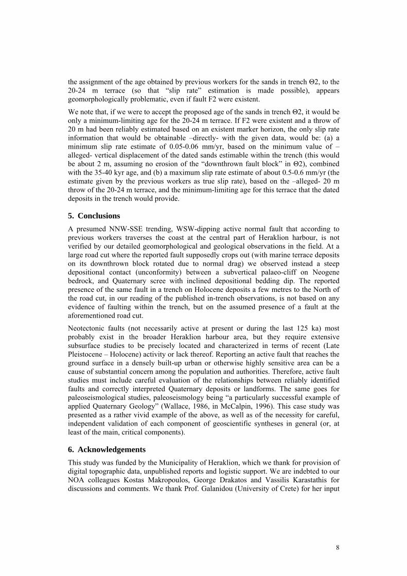
The dated deposits in the trench being on the same alleged fault block as the erosional 20-24 m terrace without any fault in-between, their correlation is clearly precluded by the geomorphological context, something that is evident in the 3D view in figure 6. The dated sands lie at a level of ~22 m lower than the outer edge of the 20-24 m terrace, at a horizontal distance of only 55 m. What lies in-between is a coastal cliff 22 m high (20 m visible height + 2m buried), a geomorphic feature that post-dates the 20-24 m terrace and is in its turn post-dated by the dated sands in the trench that rest against its base. Hence,
8
the assignment of the age obtained by previous workers for the sands in trench Θ2, to the 20-24 m terrace (so that “slip rate” estimation is made possible), appears geomorphologically problematic, even if fault F2 were existent.
We note that, if we were to accept the proposed age of the sands in trench Θ2, it would be only a minimum-limiting age for the 20-24 m terrace. If F2 were existent and a throw of 20 m had been reliably estimated based on an existent marker horizon, the only slip rate information that would be obtainable –directly- with the given data, would be: (a) a minimum slip rate estimate of 0.05-0.06 mm/yr, based on the minimum value of –alleged- vertical displacement of the dated sands estimable within the trench (this would be about 2 m, assuming no erosion of the “downthrown fault block” in Θ2), combined with the 35-40 kyr age, and (b) a maximum slip rate estimate of about 0.5-0.6 mm/yr (the estimate given by the previous workers as true slip rate), based on the –alleged- 20 m throw of the 20-24 m terrace, and the minimum-limiting age for this terrace that the dated deposits in the trench would provide.
5. Conclusions
A presumed NNW-SSE trending, WSW-dipping active normal fault that according to previous workers traverses the coast at the central part of Heraklion harbour, is not verified by our detailed geomorphological and geological observations in the field. At a large road cut where the reported fault supposedly crops out (with marine terrace deposits on its downthrown block rotated due to normal drag) we observed instead a steep depositional contact (unconformity) between a subvertical palaeo-cliff on Neogene bedrock, and Quaternary scree with inclined depositional bedding dip. The reported presence of the same fault in a trench on Holocene deposits a few metres to the North of the road cut, in our reading of the published in-trench observations, is not based on any evidence of faulting within the trench, but on the assumed presence of a fault at the aforementioned road cut.
Neotectonic faults (not necessarily active at present or during the last 125 ka) most probably exist in the broader Heraklion harbour area, but they require extensive subsurface studies to be precisely located and characterized in terms of recent (Late Pleistocene – Holocene) activity or lack thereof. Reporting an active fault that reaches the ground surface in a densely built-up urban or otherwise highly sensitive area can be a cause of substantial concern among the population and authorities. Therefore, active fault studies must include careful evaluation of the relationships between reliably identified faults and correctly interpreted Quaternary deposits or landforms. The same goes for paleoseismological studies, paleoseismology being “a particularly successful example of applied Quaternary Geology” (Wallace, 1986, in McCalpin, 1996). This case study was presented as a rather vivid example of the above, as well as of the necessity for careful, independent validation of each component of geoscientific syntheses in general (or, at least of the main, critical components).
6. Acknowledgements
This study was funded by the Municipality of Heraklion, which we thank for provision of digital topographic data, unpublished reports and logistic support. We are indebted to our NOA colleagues Kostas Makropoulos, George Drakatos and Vassilis Karastathis for discussions and comments. We thank Prof. Galanidou (University of Crete) for her input
9
regarding Holocene deposits of volcanic origin, Dr Serpetsidaki (Heraklion Ephorate of Prehistoric and Classical Antiquities) for the same reason and for facilitating our fieldwork, and the Heraklion Port Organization for tolerating the excavation of a small reconnaissance trench within its jurisdiction. Reviews by Ch. Fassoulas and an anonymous reviewer are greatly appreciated. The views expressed here are those of the authors and do not necessarily reflect the official position of the Municipality of Heraklion.
7. References
Ganas A., Mavrikas G., Palyvos N., Kollias S. and Tsimi Ch., 2009. Study for the detection and characterisation of the activity of faults in areas to be added to the city plan of the Municipality of Heraklion – Volume D. Unpublished Technical Report, Institute of Geodynamics, 58 pp. (in Greek)
Delibasis, N., Drakopoulos, J. K., Fytrolakis, N., Katsikatsos, G., Makropoulos, K.C. and Zamani, A., 1981. Seismotectonic Investigation of the area of Crete Island, Proc. of the Intern. Symp. on the Hellenic Arc and Trench (H.E.A.T.), 1, 121-138, Athens.
Drakopoulos, J.K., Fytrolakis, N., Delibasis, N. and Makropoulos, K.C., 1983. Seismotectonic Map of the area of Crete Island with explanatory text of 26 pp., Publ. by the Techn. Chamb. Crete.
Caron V., Bernier P. and Mahieux G., 2009. Record of Late Pleistocene (OIS 5) climate changes during episodes of karst development on the Northern coast of Crete: Sequence stratigraphic implications. Palaeogeogr., Palaeoclim., Palaeoecol. 277, 246-264.
Fassoulas C., 2001. The tectonic development of a Neogene basin at the leading edge of the active European margin: the Heraklion basin, Crete, Greece. Journal of Geodynamics 31, 49-70.
McCalpin J.P. (ed), 1996. Paleoseismology. Academic Press, 588 pp. Mourtzas N., 1990. Quaternary tectonic movements of the coasts of eastern Crete. PhD
Thesis, National Technical University of Athens, 487 pp. (in Greek) Papanikolaou D and Nomikou P., 1998. Neotectonic blocks and planation surfaces in
Iraklion Basin, Crete, Greece. Bull. Geol. Soc. Greece, XXXII/1, 231-239. Papanikolaou D., Vassilakis E., Valadaki A., Zaharias N. and Maniatis I., 2008. The
calculation of fault slip rate as a necessary tool for city planning near active faults. A case study from the coastal area of Heraklion, Greece. Proc. of the 3rd Panhellenic conference on Earthquake Engineering & Engineering Seismology, Athens, Nov. 5-7, 2008, paper no. 2086, 18 pp. (in Greek)
Pavlides S., 2003. Geology of Earthquakes – Introduction to Neotectonics, Morphotectonics and Palaeoseismology. University Studio Press, Thessaloniki, 378 pp. (in Greek)
Τen Veen J.H., Meijer P.Th., 1998. Late Miocene to Recent tectonic evolution of Crete (Greece): geological observations and model analysis. Tectonophysics 298, 191-208.
Vassilakis E., Papanikolaou D., 2005. Study of geological suitability of the Eastern Urban Centre of the Municipality of Heraklion. Municipality of Heraklion Report, 108 pp.
Vidakis Μ., Meulenkamp J.E., Koutsouveli A., Ioakim Ch., Papazeti E. and Skourtsi-Koronaiou V., 1996. Geological Map of Greece in 1:50,000 scale – Heraklion Sheet. IGME, Athens.
10
Fig. 1: (a)/(b) Location maps. (c) Geomorphological and geological features of the Tripiti Hill. Locations discussed in the text are indicated by numbers within circles. (d) View of the artificially modified rocky coast bordering the Tripiti Hill.
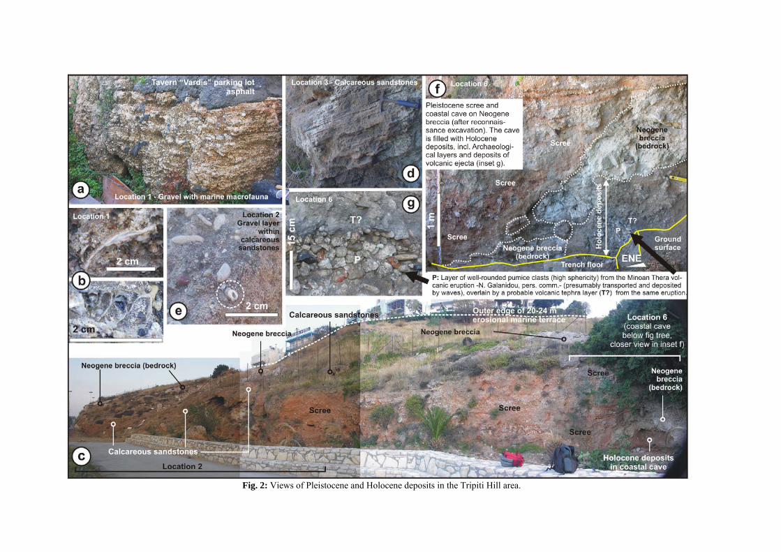
Fig. 2: Views of Pleistocene and Holocene deposits in the Tripiti Hill area.
Fig. 3: (a) The scree / bedrock depositional contact (unconformity) at the artificial road cut at location 5 (Fig. 1c). 1/2 and X/Y: locations discussed in the text. (b) Close-up views of the scree.

13
Fig. 4: The scree / bedrock depositional contact (unconformity) at the artificial road cut at location 5 (Fig. 1c), as seen in a cut made transverse to the existing outcrop.
14
Fig. 5: Sketch of the stratigraphy in trench Θ2 of Papanikolaou et al. (2008), redrawn.
Fig. 6: 3D View of the Tripiti hill, with erosional marine terrace remnants (certain and possible), to show the relationship of dated marine deposits in Trench Θ2 of Papanikolaou et al. (2008) with the erosional terrace at 20-24 m.