Embed Size (px)
Citation preview
GeoMax GNSS Zenith35 Pro Series Product Presentation V 3.0
GeoMax Zenith35 Pro Series Table of Contents • Receiver Overview
• Specs
• Options
• GeoMax Geo Office
• Datalogger
• Field Software
• Packages
• Promotion Material
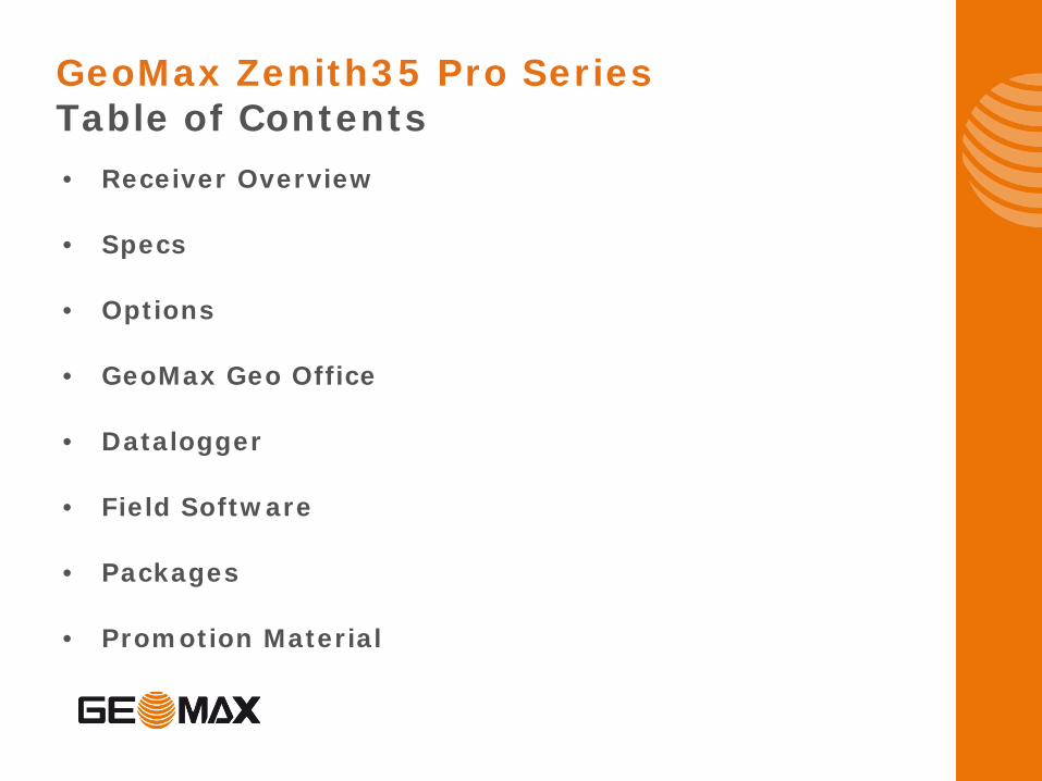
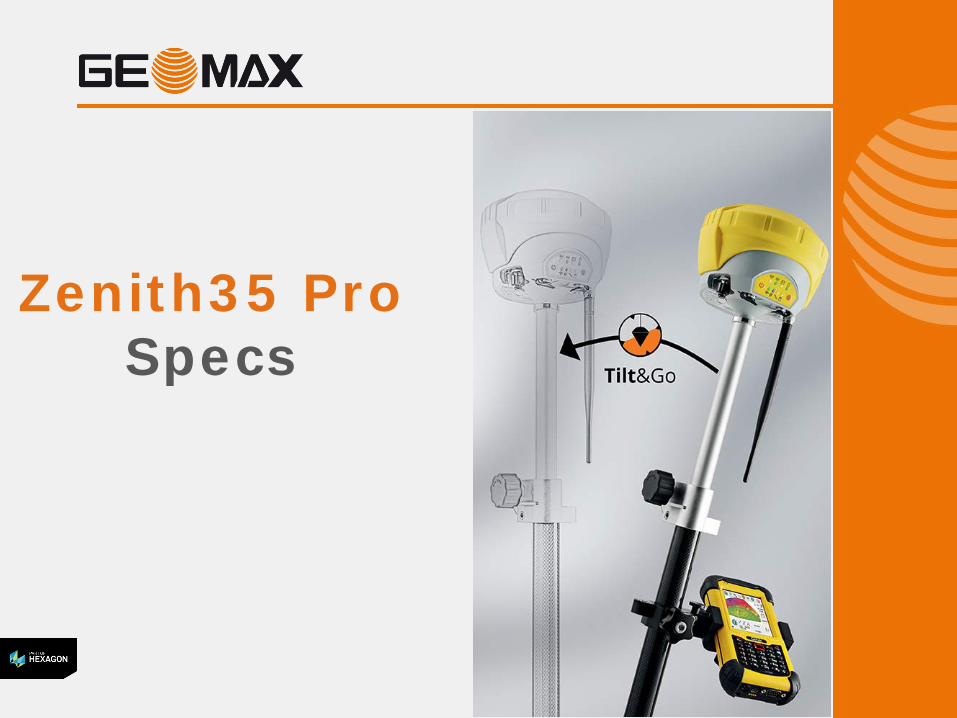
Zenith35 Pro GNSS
Receiver
Integrated Wi-Fi®
Integrated Bluetooth®
4
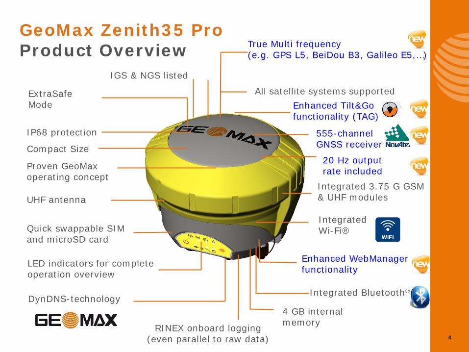
GeoMax Zenith35 Pro Product Overview
IP68 protection
LED indicators for complete operation overview
Integrated 3.75 G GSM & UHF modules
555-channel GNSS receiver
All satellite systems supported
Quick swappable SIM and microSD card
Proven GeoMax operating concept
UHF antenna
Compact Size
4 GB internal memory
ExtraSafe Mode
DynDNS-technology
RINEX onboard logging (even parallel to raw data)
Enhanced WebManager functionality
IGS & NGS listed
Enhanced Tilt&Go functionality (TAG)
True Multi frequency (e.g. GPS L5, BeiDou B3, Galileo E5,…)
20 Hz output rate included
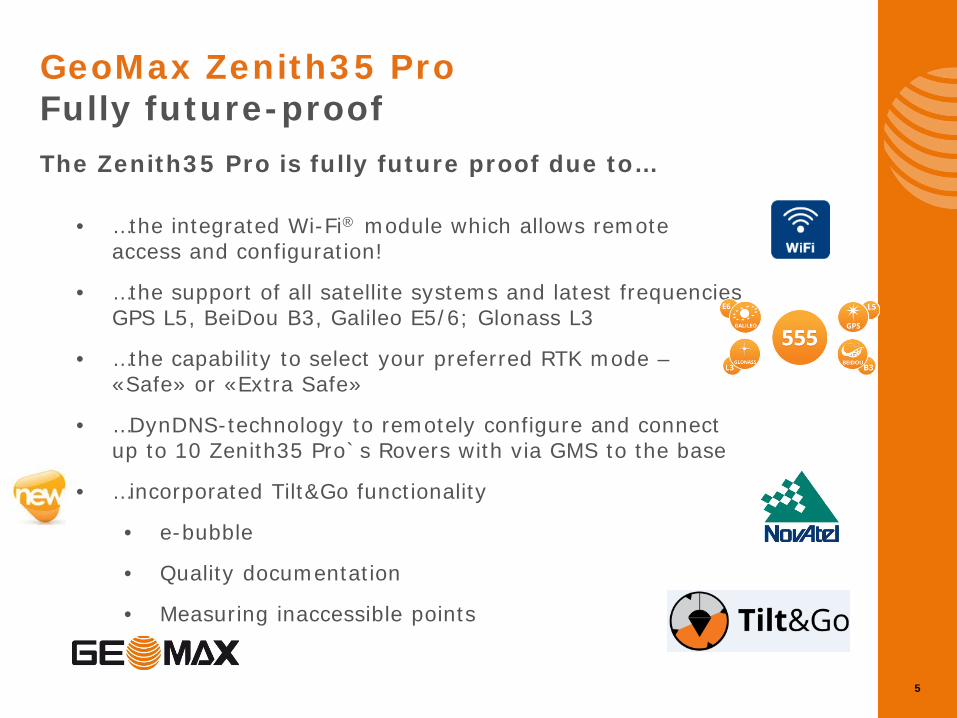
• …the integrated Wi-Fi® module which allows remote access and configuration!
• …the support of all satellite systems and latest frequencies GPS L5, BeiDou B3, Galileo E5/6; Glonass L3
• …the capability to select your preferred RTK mode – «Safe» or «Extra Safe»
• …DynDNS-technology to remotely configure and connect up to 10 Zenith35 Pro`s Rovers with via GMS to the base
• …incorporated Tilt&Go functionality
• e-bubble
• Quality documentation
• Measuring inaccessible points
5
GeoMax Zenith35 Pro Fully future-proof
The Zenith35 Pro is fully future proof due to…
6
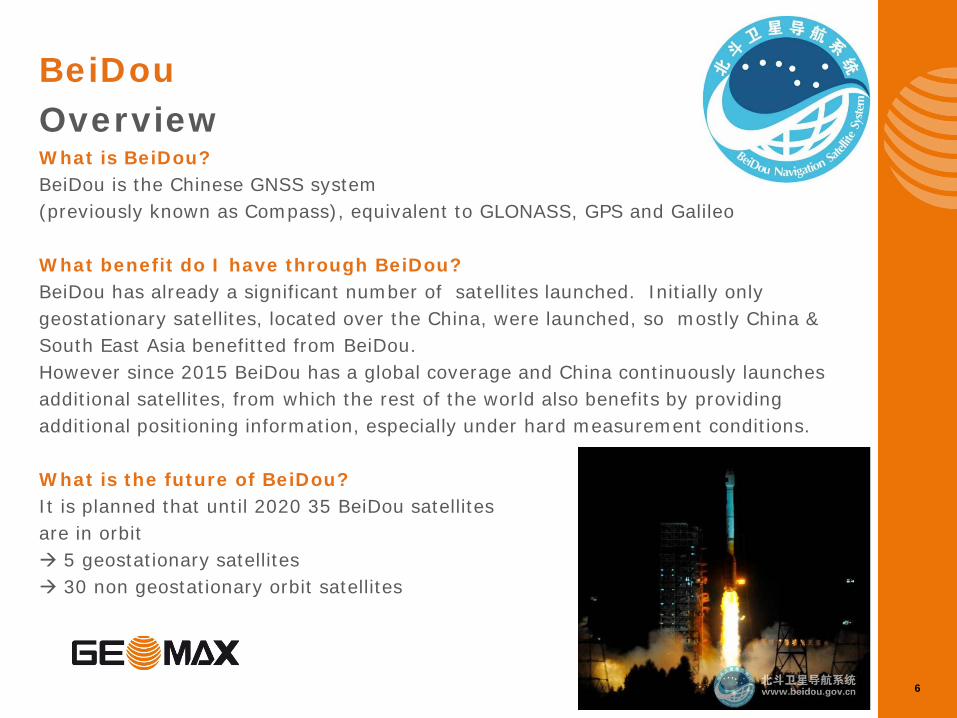
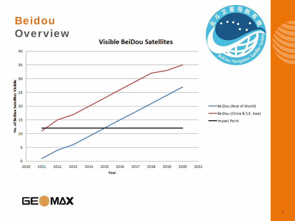
BeiDou Overview What is BeiDou? BeiDou is the Chinese GNSS system (previously known as Compass), equivalent to GLONASS, GPS and Galileo What benefit do I have through BeiDou? BeiDou has already a significant number of satellites launched. Initially only geostationary satellites, located over the China, were launched, so mostly China & South East Asia benefitted from BeiDou. However since 2015 BeiDou has a global coverage and China continuously launches additional satellites, from which the rest of the world also benefits by providing additional positioning information, especially under hard measurement conditions. What is the future of BeiDou? It is planned that until 2020 35 BeiDou satellites are in orbit 5 geostationary satellites 30 non geostationary orbit satellites
Beidou Overview
7
8
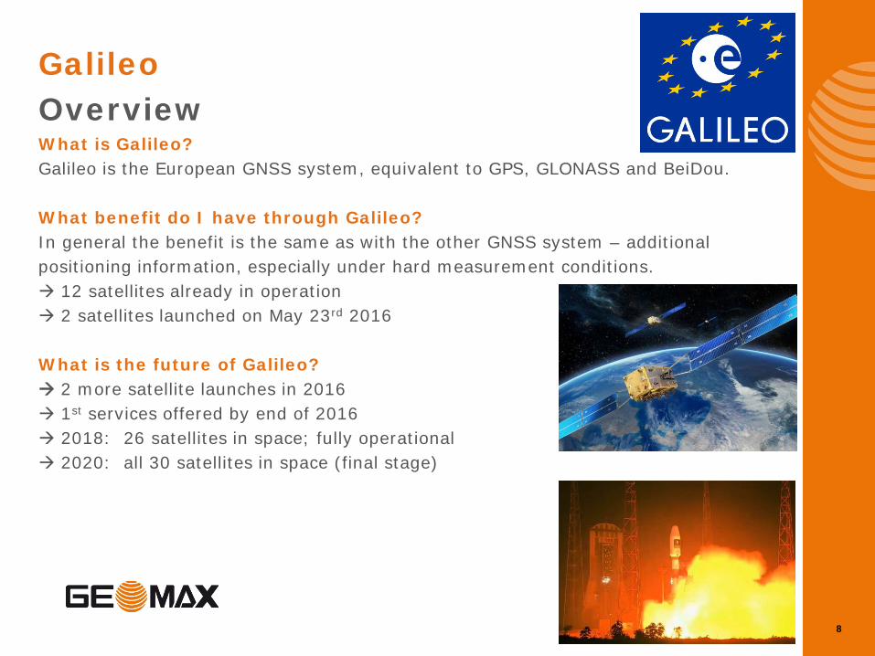
Galileo Overview What is Galileo? Galileo is the European GNSS system, equivalent to GPS, GLONASS and BeiDou. What benefit do I have through Galileo? In general the benefit is the same as with the other GNSS system – additional positioning information, especially under hard measurement conditions. 12 satellites already in operation 2 satellites launched on May 23rd 2016 What is the future of Galileo? 2 more satellite launches in 2016 1st services offered by end of 2016 2018: 26 satellites in space; fully operational 2020: all 30 satellites in space (final stage)
9
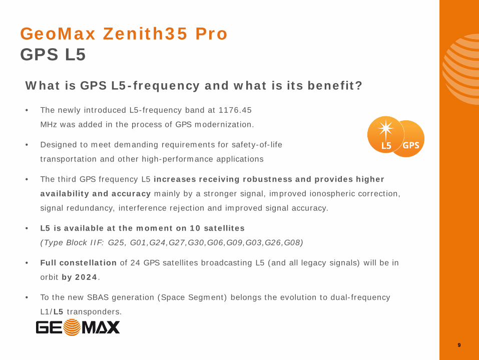
GeoMax Zenith35 Pro GPS L5
What is GPS L5-frequency and what is its benefit?
• The newly introduced L5-frequency band at 1176.45
MHz was added in the process of GPS modernization.
• Designed to meet demanding requirements for safety-of-life
transportation and other high-performance applications
• The third GPS frequency L5 increases receiving robustness and provides higher
availability and accuracy mainly by a stronger signal, improved ionospheric correction,
signal redundancy, interference rejection and improved signal accuracy.
• L5 is available at the moment on 10 satellites
(Type Block IIF: G25, G01,G24,G27,G30,G06,G09,G03,G26,G08)
• Full constellation of 24 GPS satellites broadcasting L5 (and all legacy signals) will be in
orbit by 2024.
• To the new SBAS generation (Space Segment) belongs the evolution to dual-frequency
L1/L5 transponders.
10
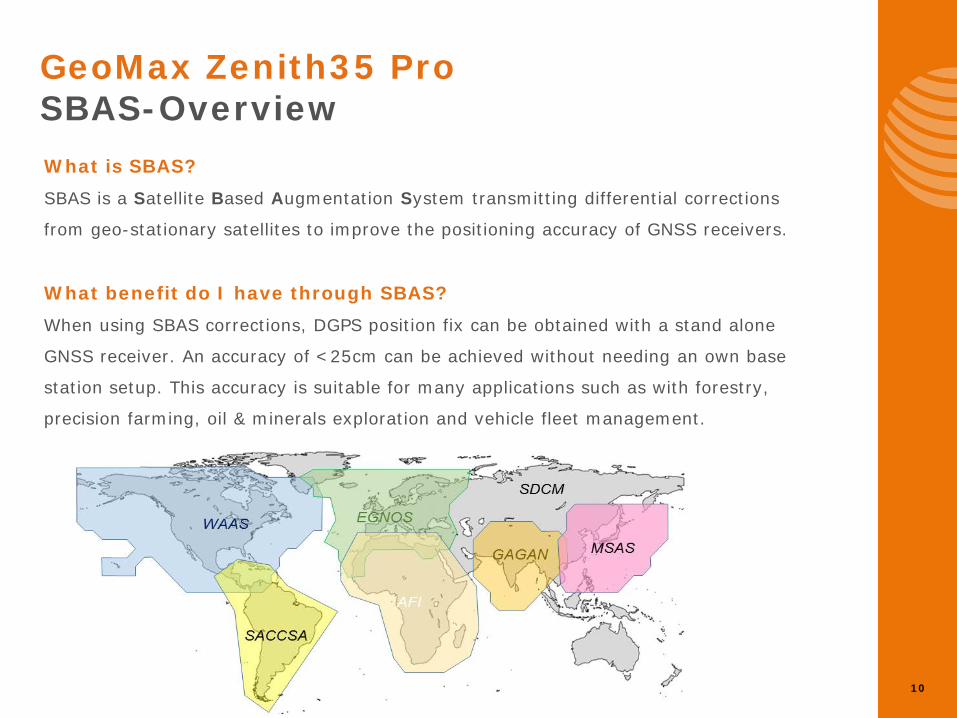
What is SBAS? SBAS is a Satellite Based Augmentation System transmitting differential corrections
from geo-stationary satellites to improve the positioning accuracy of GNSS receivers.
What benefit do I have through SBAS? When using SBAS corrections, DGPS position fix can be obtained with a stand alone
GNSS receiver. An accuracy of <25cm can be achieved without needing an own base
station setup. This accuracy is suitable for many applications such as with forestry,
precision farming, oil & minerals exploration and vehicle fleet management.
GeoMax Zenith35 Pro SBAS-Overview
11
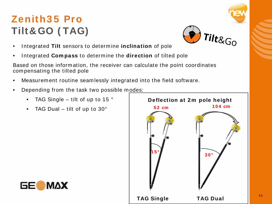
Zenith35 Pro Tilt&GO (TAG)
• Integrated Tilt sensors to determine inclination of pole
• Integrated Compass to determine the direction of tilted pole
Based on those information, the receiver can calculate the point coordinates compensating the tilted pole
• Measurement routine seamlessly integrated into the field software.
• Depending from the task two possible modes:
• TAG Single – tilt of up to 15 °
• TAG Dual – tilt of up to 30°
30° 15°
52 cm 104 cm
TAG Single TAG Dual
Deflection at 2m pole height
12
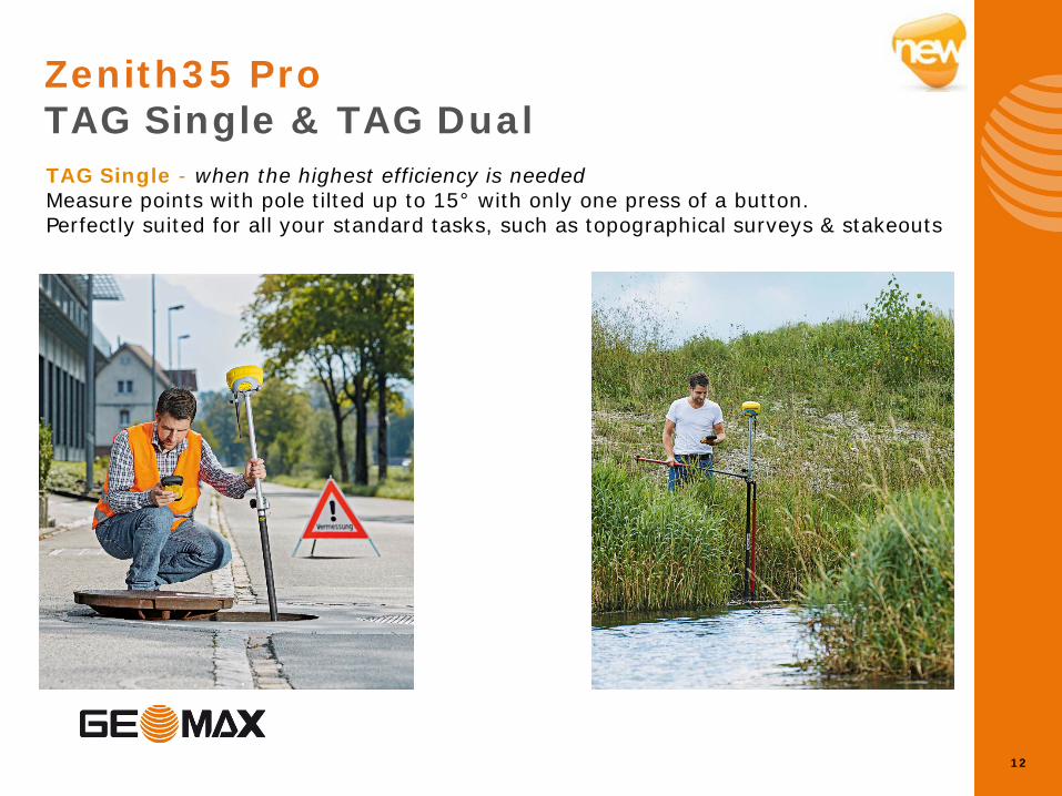
TAG Single - when the highest efficiency is needed Measure points with pole tilted up to 15° with only one press of a button. Perfectly suited for all your standard tasks, such as topographical surveys & stakeouts
Zenith35 Pro TAG Single & TAG Dual
13
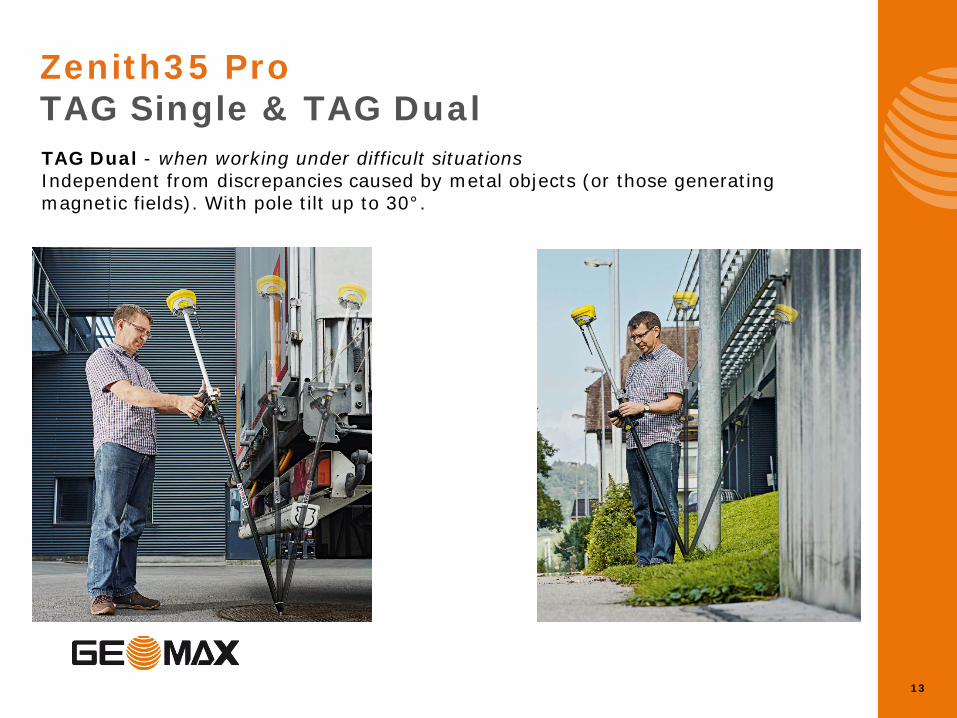
Zenith35 Pro TAG Single & TAG Dual TAG Dual - when working under difficult situations Independent from discrepancies caused by metal objects (or those generating magnetic fields). With pole tilt up to 30°.
14
Zenith35 Pro TAG Benefits
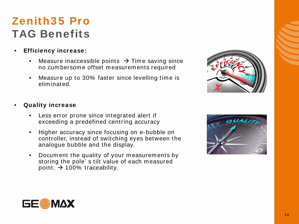
• Efficiency increase:
• Measure inaccessible points Time saving since no cumbersome offset measurements required
• Measure up to 30% faster since levelling time is eliminated.
• Quality increase
• Less error prone since integrated alert if exceeding a predefined centring accuracy
• Higher accuracy since focusing on e-bubble on controller, instead of switching eyes between the analogue bubble and the display.
• Document the quality of your measurements by storing the pole`s tilt value of each measured point. 100% traceability.
15
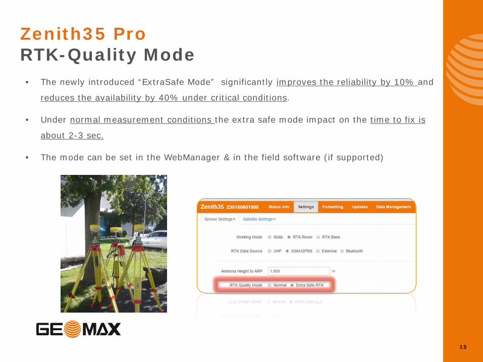
Zenith35 Pro RTK-Quality Mode
• The newly introduced “ExtraSafe Mode” significantly improves the reliability by 10% and
reduces the availability by 40% under critical conditions.
• Under normal measurement conditions the extra safe mode impact on the time to fix is
about 2-3 sec.
• The mode can be set in the WebManager & in the field software (if supported)
16
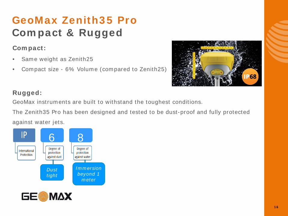
GeoMax Zenith35 Pro Compact & Rugged
Compact: • Same weight as Zenith25
• Compact size - 6% Volume (compared to Zenith25)
Rugged: GeoMax instruments are built to withstand the toughest conditions.
The Zenith35 Pro has been designed and tested to be dust-proof and fully protected
against water jets.
Dust- & Water protection
Dust tight
Immersion beyond 1
meter
6 8
17
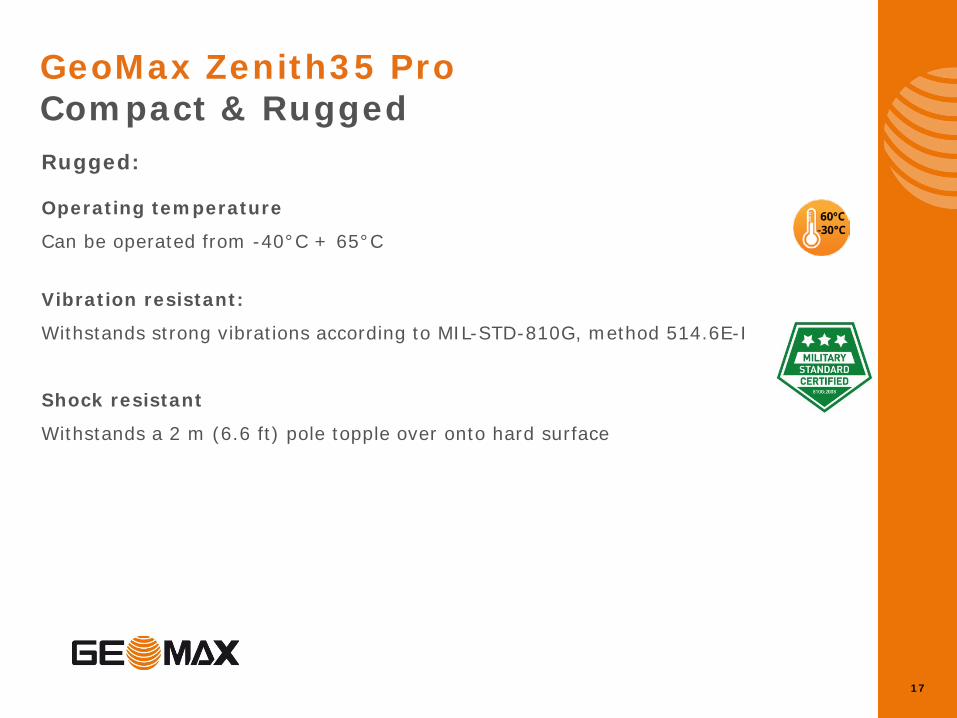
GeoMax Zenith35 Pro Compact & Rugged
Rugged:
Operating temperature
Can be operated from -40°C + 65°C
Vibration resistant:
Withstands strong vibrations according to MIL-STD-810G, method 514.6E-I
Shock resistant
Withstands a 2 m (6.6 ft) pole topple over onto hard surface
18
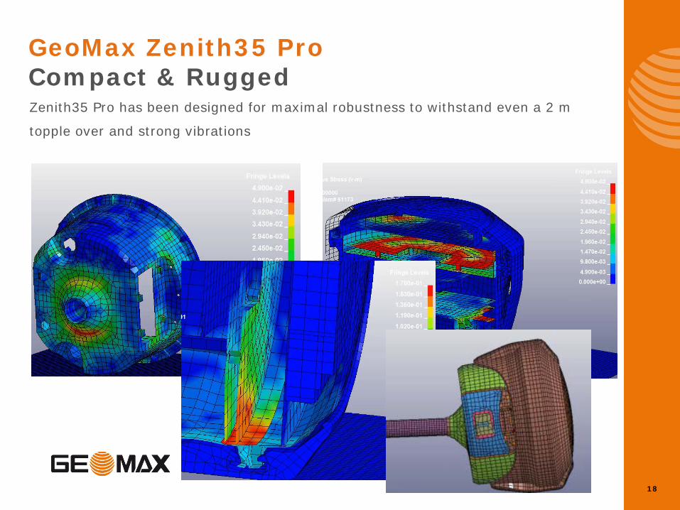
GeoMax Zenith35 Pro Compact & Rugged
Zenith35 Pro has been designed for maximal robustness to withstand even a 2 m
topple over and strong vibrations
19
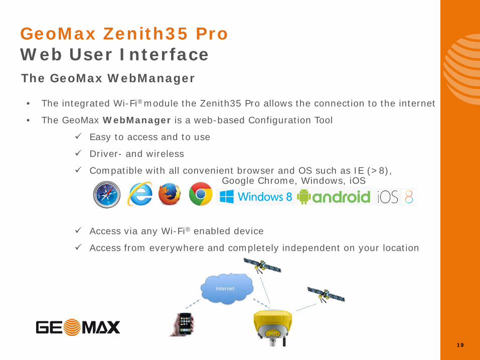
GeoMax Zenith35 Pro Web User Interface
The GeoMax WebManager
• The integrated Wi-Fi®module the Zenith35 Pro allows the connection to the internet
• The GeoMax WebManager is a web-based Configuration Tool
Easy to access and to use
Driver- and wireless
Compatible with all convenient browser and OS such as IE (>8), Google Chrome, Windows, iOS
Access via any Wi-Fi® enabled device
Access from everywhere and completely independent on your location
20
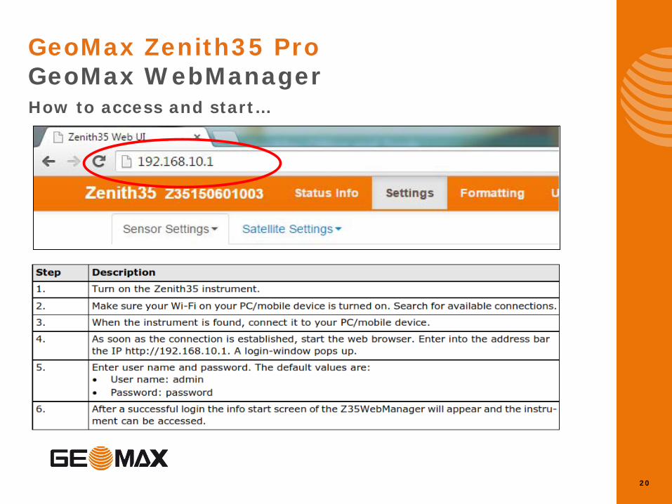
GeoMax Zenith35 Pro GeoMax WebManager How to access and start…
21
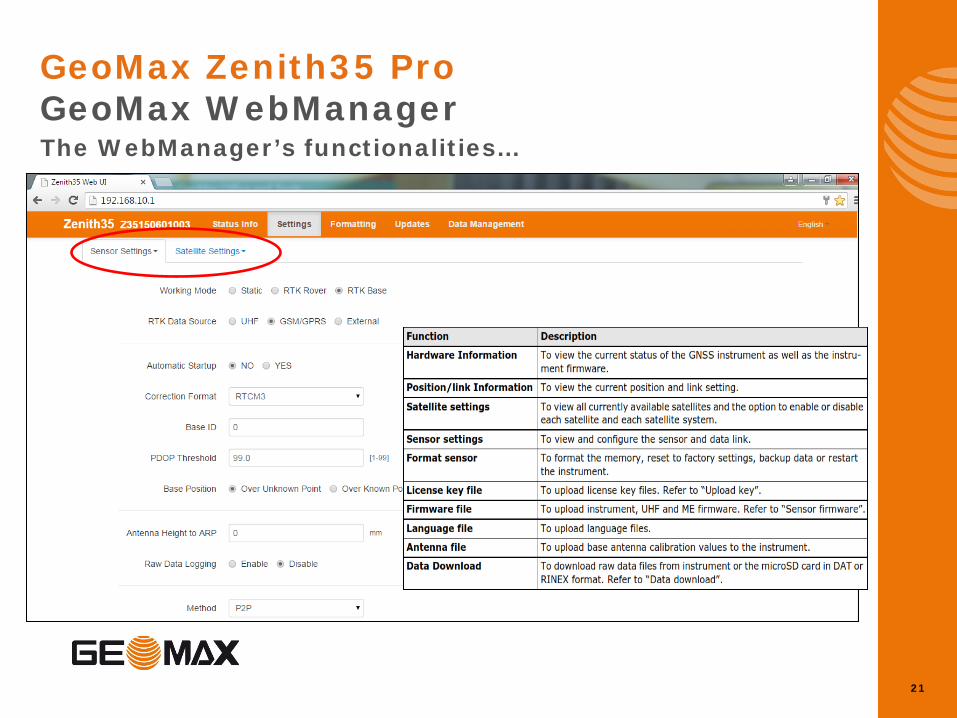
GeoMax Zenith35 Pro GeoMax WebManager The WebManager’s functionalities…
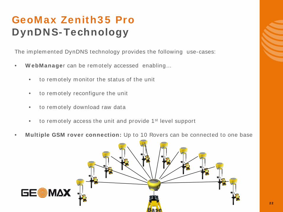
The implemented DynDNS technology provides the following use-cases:
• WebManager can be remotely accessed enabling…
• to remotely monitor the status of the unit
• to remotely reconfigure the unit
• to remotely download raw data
• to remotely access the unit and provide 1st level support
• Multiple GSM rover connection: Up to 10 Rovers can be connected to one base
22
GeoMax Zenith35 Pro DynDNS-Technology
Base
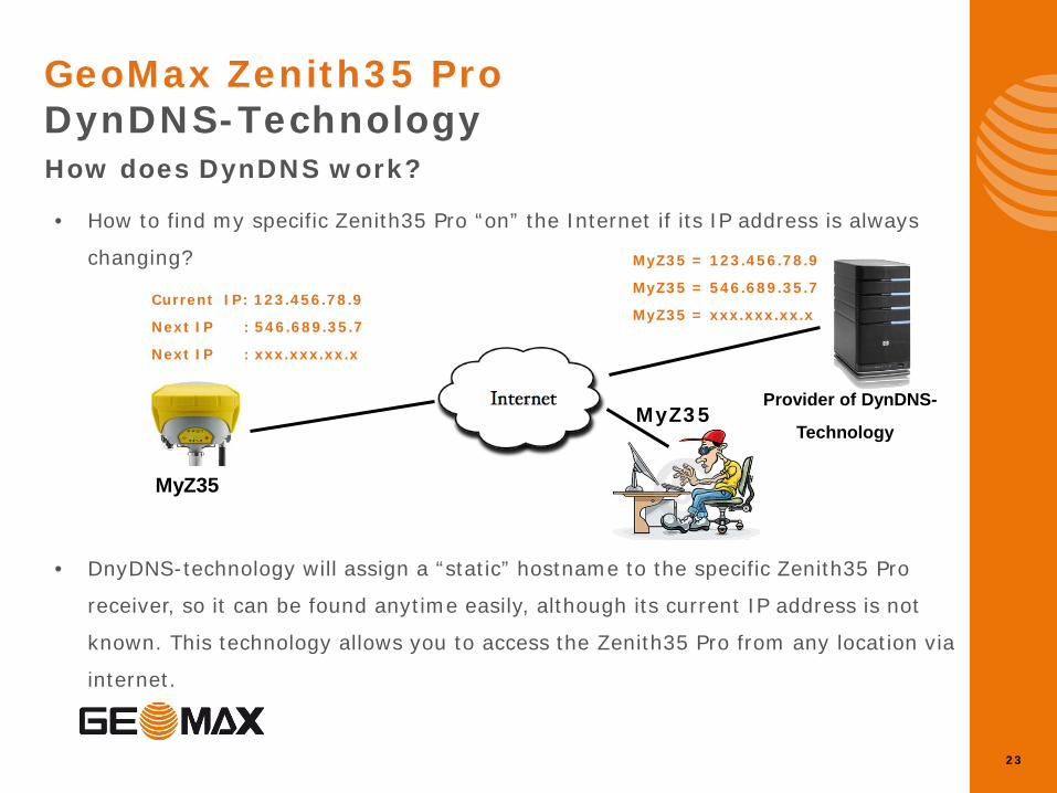
• How to find my specific Zenith35 Pro “on” the Internet if its IP address is always
changing?
• DnyDNS-technology will assign a “static” hostname to the specific Zenith35 Pro
receiver, so it can be found anytime easily, although its current IP address is not
known. This technology allows you to access the Zenith35 Pro from any location via
internet.
23
GeoMax Zenith35 Pro DynDNS-Technology
How does DynDNS work?
MyZ35
Provider of DynDNS-
Technology
Current IP: 123.456.78.9
Next IP : 546.689.35.7
Next IP : xxx.xxx.xx.x
MyZ35 = 123.456.78.9
MyZ35 = 546.689.35.7
MyZ35 = xxx.xxx.xx.x
MyZ35
24
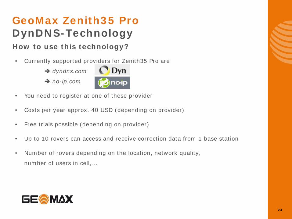
GeoMax Zenith35 Pro DynDNS-Technology
How to use this technology?
• Currently supported providers for Zenith35 Pro are
dyndns.com
no-ip.com
• You need to register at one of these provider
• Costs per year approx. 40 USD (depending on provider)
• Free trials possible (depending on provider)
• Up to 10 rovers can access and receive correction data from 1 base station
• Number of rovers depending on the location, network quality,
number of users in cell,…

25
GeoMax Zenith35 Pro UHF Radio
• Integrated UHF Radio Satel M3-TR4
• Latest Radio technology provided by SATEL
• 16 programmable frequencies
• Support of Forward Error Correction (FEC) for maximum reliability
• Password protected settings to ensure legal conformity
• Support of 7 protocols for maximum flexibility
• SATEL • SATEL 4 FSK • SATEL8 FSK • PCC-4FSK • PCC-GMSK • TrimTalk (T) • TrimTalk (P)
26
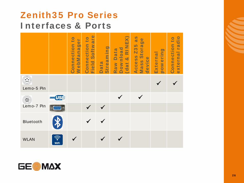
Zenith35 Pro Series Interfaces & Ports
Con
nec
tion
to
Web
Man
ager
C
onn
ecti
on t
o Fi
eld
Sof
twar
e
Dat
a S
trea
min
g
Raw
Dat
a D
own
load
(d
at &
RIN
EX)
Acc
ess
Z3
5 a
s M
ass
Sto
rag
e d
evic
e
Exte
rnal
p
ower
ing
Con
nec
tion
to
exte
rnal
rad
io
Lemo-5 Pin
Lemo-7 Pin
Bluetooth
WLAN
27
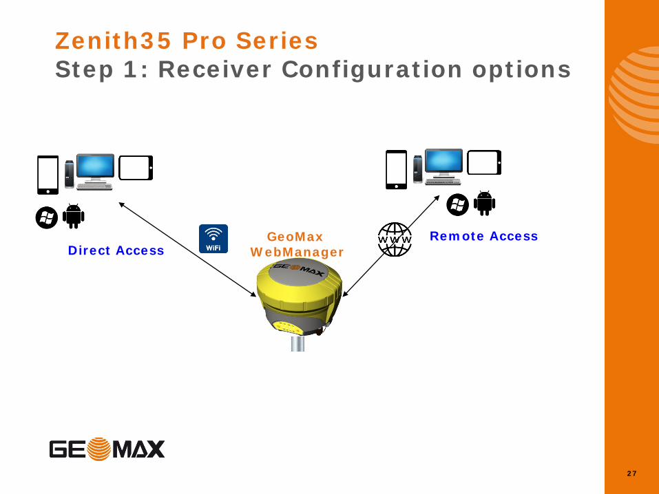
Zenith35 Pro Series Step 1: Receiver Configuration options
Remote Access Direct Access
GeoMax WebManager
28
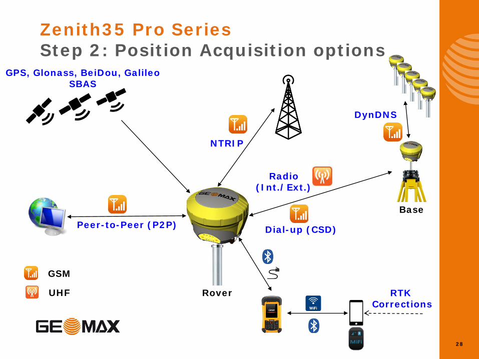
Zenith35 Pro Series Step 2: Position Acquisition options
Base
Rover
Dial-up (CSD)
NTRIP
GPS, Glonass, BeiDou, Galileo SBAS
Peer-to-Peer (P2P)
DynDNS
RTK Corrections
Radio (Int./Ext.)
GSM
UHF
Zenith35 Pro Specs
30
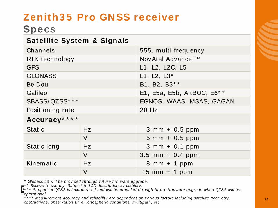
Zenith35 Pro GNSS receiver Specs
* Glonass L3 will be provided through future firmware upgrade. ** Believe to comply. Subject to ICD description availability. *** Support of QZSS is incorporated and will be provided through future firmware upgrade when QZSS will be operational. **** Measurement accuracy and reliability are dependent on various factors including satellite geometry, obstructions, observation time, ionospheric conditions, multipath, etc.
Satellite System & Signals Channels 555, multi frequency RTK technology NovAtel Advance ™ GPS L1, L2, L2C, L5 GLONASS L1, L2, L3* BeiDou B1, B2, B3** Galileo E1, E5a, E5b, AltBOC, E6** SBASS/QZSS*** EGNOS, WAAS, MSAS, GAGAN Positioning rate 20 Hz Accuracy**** Static Hz 3 mm + 0.5 ppm V 5 mm + 0.5 ppm Static long Hz 3 mm + 0.1 ppm V 3.5 mm + 0.4 ppm Kinematic Hz 8 mm + 1 ppm V 15 mm + 1 ppm
31
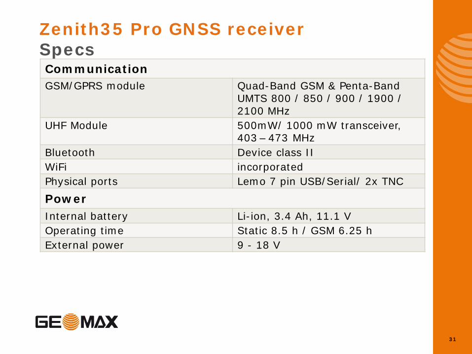
Zenith35 Pro GNSS receiver Specs Communication GSM/GPRS module Quad-Band GSM & Penta-Band
UMTS 800 / 850 / 900 / 1900 / 2100 MHz
UHF Module 500mW/ 1000 mW transceiver, 403 – 473 MHz
Bluetooth Device class II WiFi incorporated Physical ports Lemo 7 pin USB/Serial/ 2x TNC
Power Internal battery Li-ion, 3.4 Ah, 11.1 V Operating time Static 8.5 h / GSM 6.25 h External power 9 - 18 V
32
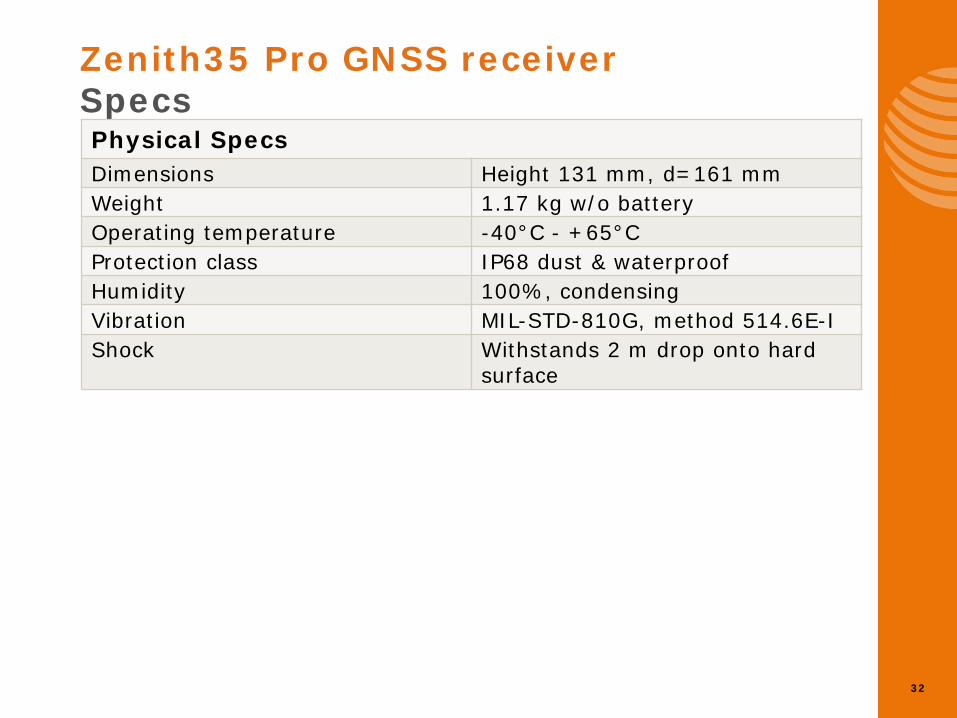
Zenith35 Pro GNSS receiver Specs
Physical Specs Dimensions Height 131 mm, d=161 mm Weight 1.17 kg w/o battery Operating temperature -40°C - +65°C Protection class IP68 dust & waterproof Humidity 100%, condensing Vibration MIL-STD-810G, method 514.6E-I Shock Withstands 2 m drop onto hard
surface

Zenith35 Pro Options
34
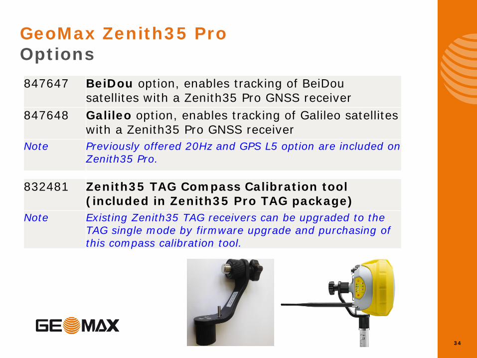
GeoMax Zenith35 Pro Options 847647
BeiDou option, enables tracking of BeiDou satellites with a Zenith35 Pro GNSS receiver
847648
Galileo option, enables tracking of Galileo satellites with a Zenith35 Pro GNSS receiver
Note Previously offered 20Hz and GPS L5 option are included on Zenith35 Pro.
832481
Zenith35 TAG Compass Calibration tool (included in Zenith35 Pro TAG package)
Note Existing Zenith35 TAG receivers can be upgraded to the TAG single mode by firmware upgrade and purchasing of this compass calibration tool.
GeoMax Geo Office
36
GeoMax Geo Office Office Software • Support for GeoMax GNSS and TPS instruments
• Basic tools for data preparation, data up- and download, codelist management
• Project management to import raw data, visualize data, quality control and basic editing
• GNSS processing support for GeoMax sensors, RINEX Import/Export, Coordinate system management and datum transformations to convert between WGS84 and Local Grid
• Network Adjustment (combined GPS and TPS)
• Exports to ASCII
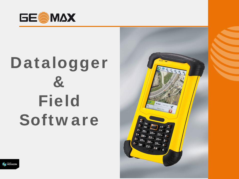
Datalogger &
Field Software
38
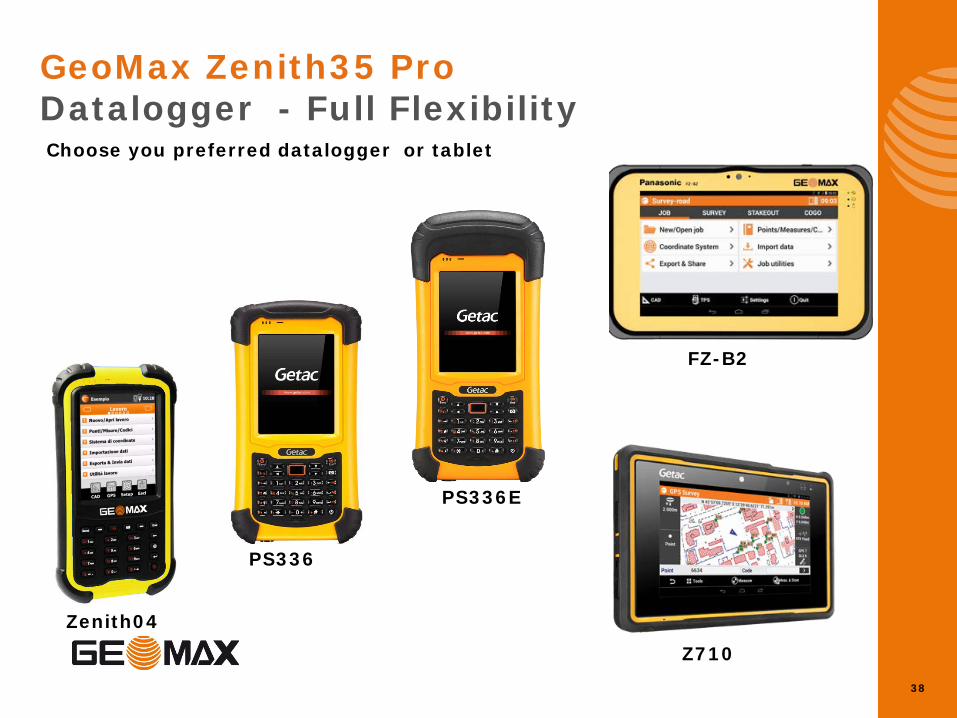
GeoMax Zenith35 Pro Datalogger - Full Flexibility Choose you preferred datalogger or tablet
Zenith04
PS336
PS336E
FZ-B2
Z710
39
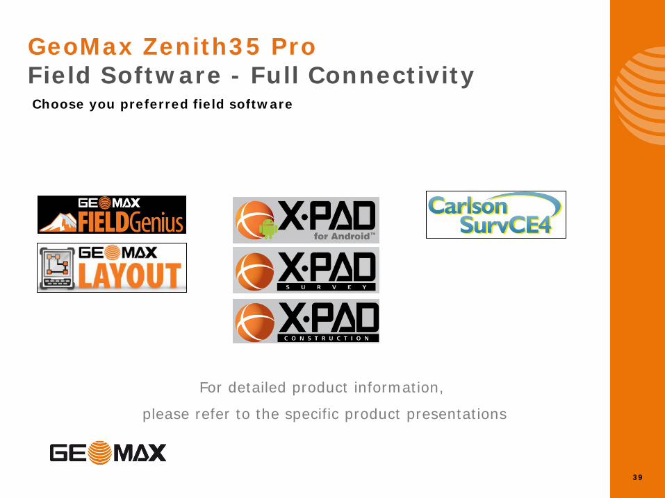
For detailed product information,
please refer to the specific product presentations
GeoMax Zenith35 Pro Field Software - Full Connectivity Choose you preferred field software

Zenith35 Pro Packages
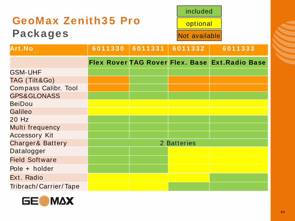
41
GeoMax Zenith35 Pro Packages
included
optional
Art.No 6011330 6011331 6011332 6011333
Flex Rover TAG Rover Flex. Base Ext.Radio Base GSM-UHF TAG (Tilt&Go) Compass Calibr. Tool GPS&GLONASS BeiDou Galileo 20 Hz Multi frequency Accessory Kit Charger& Battery 2 Batteries Datalogger Field Software Pole + holder Ext. Radio Tribrach/Carrier/Tape
Not available
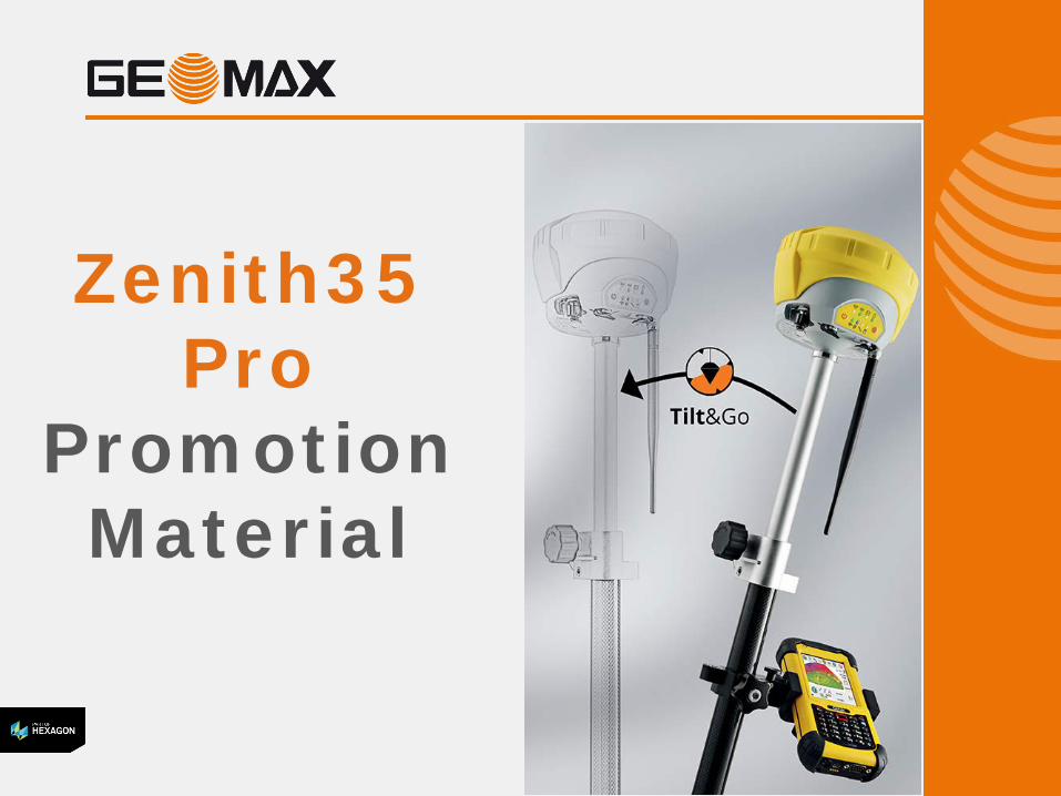
Zenith35 Pro
Promotion Material
43
• 4 page brochure
• Poster
• Image Library
• FAQ
GeoMax Zenith35 Pro Promotion Material