Embed Size (px)
Citation preview
Geology of Part of the
Horseshoe Atoll in Scurry
and Kent Counties,TexasGEOLOGICAL SURVEY PROFESSIONAL PAPER 315-A
Prepared in cooperation with the
Bureau of Economic Geology
The University of Texas
Geology of Part of the
Horseshoe Atoll in Scurryw
and Kent Counties,TexasBy PHILIP T. STAFFORD
PENNSYLVANIAN AND LOWER PERMIAN ROCKS OF PARTS OF WESTAND CENTRAL TEXAS
GEOLOGICAL SURVEY PROFESSIONAL PAPER 315-A
Prepared in cooperation with the
Bureau of Economic Geology
The University of Texas
UNITED STATES GOVERNMENT PRINTING OFFICE, WASHINGTON : 1959
UNITED STATES DEPARTMENT OF THE INTERIOR
FRED A. S EATON, Secretary
GEOLOGICAL SURVEY
Thomas B. Nolan, Director
For sale by the Superintendent of Documents, U. S. Government Printing OfficeWashington 25, D. C.
CONTENTS
Abstract..-. __________________________Introduction. _______ ____________ ______Acknowledgments ____ _ ____ _ _ __Methods of study______________________Stratigraphy. _________________________
Regional stratigraphic relationships _. Stratigraphy of rocks below the atoll- Stratigraphy of rocks in the atoll- Stratigraphy of rocks above the atoll-
Characteristics of the reef rock .._._______Lithologic components __ __________Chemical composition ______________Porosity and permeability. ___ __ __Zonation of the atoll- ______________
Age of the atoll __ Faunal associations
Page 1 1 3 3 5 5 5 58999
1010101011
Structure. ___ __________________ ________ 11Geologic history______________________-_-___________ 12
Applicability of reef definition to the Horseshoe,atoll. _________.______ 12
Reef growth and sedimentation _________ ___ 14Development of the Horseshoe atolL ____ ____ 15
Oil and gas________________ _ _____ ____ 15History of development____________ _________ 15Reservoirs.___________________ _____________ 16Source of the oil_______________________ 16Economic aspects of porosity zonation___________ 17
Literature cited___________________________________ 17Index. ______________________________ 19
ILLUSTRATIONS
[Plates 1, 2, and 4-9 are in pocket]
PLATE 1. Map showing contours on the top of the Horseshoe atoll in parts of Scurry, Kent, Borden, and Garza Counties, Tex.
2. Map showing contours on the top of rocks of Strawn age and thicknesses of rocks of Bend and Strawn age in parts of Scurry, Kent, Borden, and Garza Counties, Tex.
3. Photographs of a core from the Horseshoe atoll in Scurry County, illustrating calcilutite, calcarenite, and calciru- dite________________________________________________________________ _ _____ _ __________
4. Correlation of data from Chapman & McFarlin Producing Co.'s No. 25 (Cogdell) well in Kent County, showing radioactivity log, microlog, porosity, insoluble residue, lithologic character, and age.
5. Map showing areas of oil production, index to wells, and lines of cross sections in parts of Scurry, Kent, Borden, and Garza Counties, Tex.
6. Cross sections showing porous zones and stratigraphic relationships of the reef complex in Scurry County.7. Map showing contours on top of limestone of the Mississippian(?) system and the thickness of limestone assigned
to the Pennsylvanian and lower part of the Permian system in parts of Scurry, Kent, Borden, and Garza Coun ties, Tex.
8. Map showing contours on top of rocks of Canyon age in parts of Scurry, Kent, Borden, and Garza Counties, Tex.9. Map showing contours on top of rocks approximately equivalent in age to the Coleman Junction limestone mem
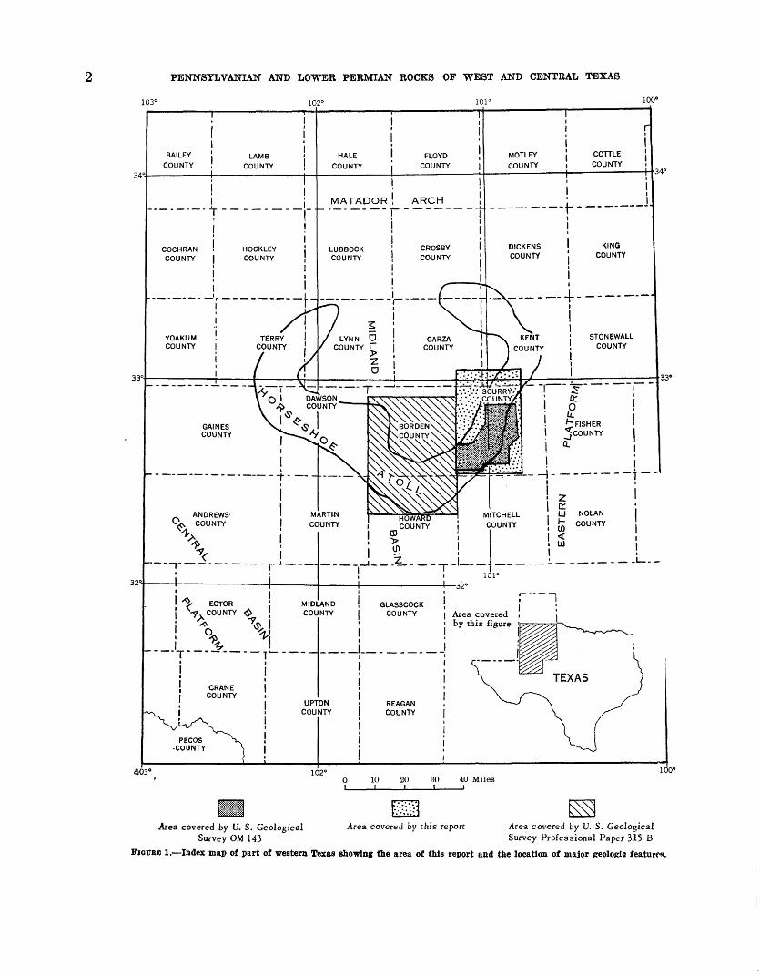
ber of the Putnam formation in parts of Scurry, Kent, Borden, and Garza Counties, Tex. FIGURE 1. Index map of part of western Texas, showing the area of this report and the location of major geologic features....
2. Quantitative evaluation of microlog classifications in terms of effective porosities._ ___ _______3. Quantitative evaluation of microlog classifications in terms of permeabilities_________________________4. Cross section showing stratigraphic relationships of rocks of the Ordovician, Mississippian(?), Pennsylvanian,
and Permian rocks.______..._____________________________________________5. Composite electrical and lithologic log from Scurry and Kent Counties, showing Ordovician, Mississippian(?),
Pennsylvanian, and Permian rocks__________________________________________________.________
12
TABLES
TABLE 1. Quantitative comparison of microlog classifications with laboratory analyses of effective porosity and perme ability __ __ ___ _ ____ _____ 4
2. Correlation chart of Mississippian(?), Pennsylvanian, and Permian rocks in Scurry and Kent Counties_______ 63. Oil production from reef limestone________________________________________________________________ 164. Oil production from nonreef rocks of Wolfcamp age_____________________________________ 16
nx

PENNSYLVANIAN AND LOWER PERMIAN ROCKS OF PARTS OF WEST AND CENTRAL TEXAS
GEOLOGY OF PART OF THE HORSESHOE ATOLL IN SCURRY AND KENT COUNTIES, TEXAS
By PHILIP T. STAFFORD
ABSTBACT
The subsurface Horseshoe atoll is an arcuate accumulation of fossiliferous limestone 70 to 90 miles across in the northern part of the Midland basin, in western Texas. The stratigraphy, the lithologic character of the rocks, and the petroleum reser voirs of the southeastern part of the atoll in Scurry County and parts of adjacent counties are described herein.
Rocks of Strawn, Canyon, and Cisco ages, belonging to the Pennsylvanian system, and rocks of Wolfcamp age, belonging to the Permian system, form the Horseshoe atoll. Reworking of these rocks at several times during the growth of the atoll has resulted in the formation of large amounts of limestone breccia, in the mixing of the fusulinid faunas used to date the rocks, and in the complex age relations between rocks in different parts of the atoll. Thin beds of shale within this limestone mass are the only lithologic units that can be cor related for any appreciable distance in the atoll, but studies of micrologs from wells penetrating the atoll have revealed many zones of low porosity that can be correlated with reason able certainty over much of the area described in this report.
The atoll rests on a platform of bedded limestone and shale, which has been designated as equivalent in age to the Bend and Strawn groups of the Pennsylvanian system. It is covered mainly by shale, which has been designated as equivalent in age to the Wolfcamp series of the Permian system and is partly equivalent in age to the youngest rocks within the atoll.
Reworking of the rocks, the complex distribution of rocks of different ages, the presence of thin beds of shale, and the stratification of porosity in the atoll suggest that this structure has many of the characteristics of a reef. Its growth in the Midland basin was apparently cyclic and may have been re lated to changes of sea level during the Late Pennsylvanian and early Permian periods.
Oil is contained in porous zones within the atoll, mainly in reservoirs in hills along the crest of the structure where the overlying shale formed an impervious cap, but some is found in the lower part of the limestone mass where the reasons for the oil traps are not as apparent. The source of the oil was probably the shale of Wolfcamp age that surrounds the atoll.
INTRODUCTION
The Horseshoe atoll, which has been identified and described by Adams and others (1951), Heck and others (1952), and Andersen (1953), is a subsurface
accumulation of limestone in the northern part of t>e Midland basin in western Texas (fig. 1). The atcU has an east-to-west diameter of about 90 miles and a north-to-south diameter of about 70 miles. This re port describes the part of the atoll and its lagoon<\l area that lies in Scurry and southern Kent Counti-^ and in adjacent parts of Borden and Garza Counties.
The arcuate mass of fossiliferous limestone of Penn sylvanian and Permian ages that constitutes the Horse shoe atoll is very irregular in shape. Its surface con tains buried hills, depressions, and irregular reentrants, and its flanks slope gently away from the crest on bo*h sides. The area covered by this report includes the highest part of the atoll, the top of which is 3,738 to 5,900 feet below sea level and about 6,150 to 7,900 fe*t below the ground surface (pi. 1).
The terms "atoll" and "reef" have generally been ap plied to this subsurface accumulation of limestone, r-1- though as noted by Heck and others (1952, p. 5) t>e limestone does not contain large amounts of readily recognizable frame-building reef organisms. Evidence indicates that this limestone feature may have had most of the characteristics of a reef during the time of its growth, and therefore the use of the terms "atoll" and "reef" is appropriate.
This report is the result of geologic investigations made during the period from 1950 to 1953 by the U. S. Geological Survey in cooperation with the Bureau of Economic Geology of The University of Texas, as part of a regional study of the Horseshoe atoll. It sum marizes the available information on the thickness, age, and characteristics of the rocks in and near the south eastern part of this limestone mass and information on the distribution of petroleum in the atoll. The report incorporates the results of studies made by Heck ard others (1952), Eothrock (1952), Bergenback and Ter-
1
PENNSYLVANIA!* AND LOWER PERMIAN ROCKS OF WEST AND CENTRAL TEXAS
103° 102° 101°100°
Area covered by this figure
32°
403' 102° 100°
10 20 30 40 Miles
Area covered by U. S. Geological Area covered by this report Area covered by U. S. Geological Survey OM 143 Survey Professional Paper 315 B
PIGTJEB 1. Index map of part of western Texas showing the area of this report and the location of major geologic feature
GEOLOGY OF PART OF THE HORSESHOE ATOLL IN SCURRY AND KENT COUNTIES, TEXAS
riere (1953), and Rothrock and others (1953), which have dealt with some aspects of the geology of the atoll in Scurry County. It includes new information and interpretations based on additional studies of the data used for previous reports and new data acquired after the earlier reports were prepared for publication. The new information on porous zones in the atoll may be helpful in oil-recovery operations, and the new inter pretations on the growth of this structure may aid in developing concepts of environmental conditions in the Midland basin during the Pennsylvanian period.
Inasmuch as the Horseshoe atoll is entirely a sub surface feature, the information and interpretations contained in this report are based entirely on the study of cores, well cuttings, radioactivity logs, and electri cal logs. Detailed megascopic and petrographic de scriptions were made from cores of 79 wells in the mapped area. Where cores were not available, sample logs from wells drilled by rotary methods were used to obtain lithologic data. About 2,750 electrical and radio activity logs were studied to determine the lithologic characteristics of the atoll and the surrounding rocks and to extend the correlations of rock units into areas in which cores or samples were not available. Age determinations were based on the study of fusulinids in cores from 52 wells in the area. This report incor porates subsurface information available before August 1,1953.
ACKNOWLEDGMENTS
This investigation was made possible by the coopera tion of many organizations and individuals. Cores of wells penetrating the atoll were contributed by the fol lowing companies: Chapman & McFarlin Producing Co., Cities Service Oil Co., General Crude Oil Co., Hiawatha Oil Co., Lone Star Producing Co., Montex Drilling Co., Ohio Oil Co., Pan-American Producing Co., Phillips Petroleum Co., Slick-Moorman Oil Co., Standard Oil Co. of Texas, Stanolind Oil and Gas Co., Sun Oil Co., Sunray Oil Corp., Tidewater Oil Co., and Wilshire Oil Co.
R. V. Hollingsworth, of the Paleontological Labora tory at Midland, Tex., furnished fusulinid determina tions and other data from wells in this area from which cores were not available. Without much of this data many details of the stratigraphy and geologic history could not have been worked out. Donald A. Myers and Keith A. Yenne, of the U. S. Geological Survey, iden tified the fusulinids from cores. The Bureau of Eco nomic Geology of The University of Texas, John T. Lonsdale, director, provided financial assistance and laboratory space for this investigation,
METHODS OF STUDY
Initial studies of the Horseshoe atoll in Scurry County made use of standard techniques and methods of subsurface investigation. Conventional electrical and radioactivity logs, representing about 99 percent of the bore holes, were studied and correlated. For a discussion of the electrical log, see Stratton and Ford, 1950; for a discussion of the radioactivity log, f^e Mercier, 195Q. Cores were studied both megascopically and with a microscope. Fusulinids were collected and age determinations were made. The data obtained f rcrn these studies were compiled and analyzed in an attempt to find answers to the problems of how the reef grow and why the oil is present within the atoll. This wo^k indicated that there were no diagnostic lithologic or stratigraphic features that could be correlated over lar^e parts of the atoll and used to reconstruct the geologic history.
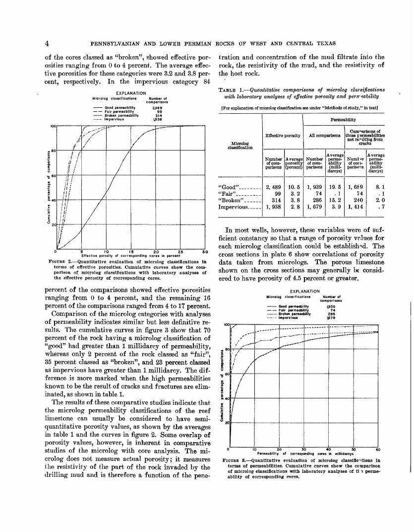
The microlog, which is a resistivity curve developed primarily to determine relative permeability, was th?-n studied to determine if it could be used to show zona- tion of porosity or permeability. (For a discussion of the microlog, see Doll, 1950.) An evaluation of the mi- crologs of wells penetrating the atoll was made by com paring them with quantitative analyses for permea bility and effective porosity. These analyses, availaFe for cores from 53 wells, confirmed the usefulness of the interpretations of the micrologs and furnished seiri- quantitative values for the microlog permeability clas sifications. The core analyses for permeability and porosity were compared with permeability classifica tions for corresponding intervals designated on the mi crologs by the categories "good", "fair", or "broken" permeability, or with the impervious rock. The com parisons were tabulated according to both millidarcys of permeability and percentages of effective porosity. Cumulative curves were prepared to show the ranges in value of the permeability and porosity for each of the microlog classifications (fig. 2 and 3).
The comparison of the microlog permeability classi fications with laboratory analyses of the effective por osity of corresponding cores showed that although each microlog classification includes a wide range of actual porosity values, most of the comparisons give actual values consistent with the terminology of the microlog categories. Thus, 89 percent of the cores of reef lime stone classed as "good" on the micrologs showed effec tive porosity of 4 to 30 percent; whereas only 11 per cent showed effective porosity of less than 4 percert. The average effective porosity of all rocks classed as "good" was 10.5 percent. In contrast to these values, 86 percent of the cores classed as "fair" and 70 percent
PENNSYLVANIAN AND LOWER PERMIAN ROCKS OF WEST AND CENTRAL TEXAS
of the cores classed as "broken", showed effective por osities ranging from 0 to 4 percent. The average effec tive porosities for these categories were 3.2 and 3.8 per cent, respectively. In the impervious category 84
EXPLANATIONMicrolog clossificotlons Number of
comparisons
Good permeability Fair permeability Broken permeability ......._. impervious
300 5 10 IS 20 25Effective porosity of corresponding cores in percent
FIGURE 2. Quantitative evaluation of microlog classifications In terms of effective porosities. Cumulative curves show the com parison of microlog classifications with laboratory analyses of the effective porosity of corresponding cores.
percent of the comparisons showed effective porosities ranging from 0 to 4 percent, and the remaining 16 percent of the comparisons ranged from 4 to 17 percent.
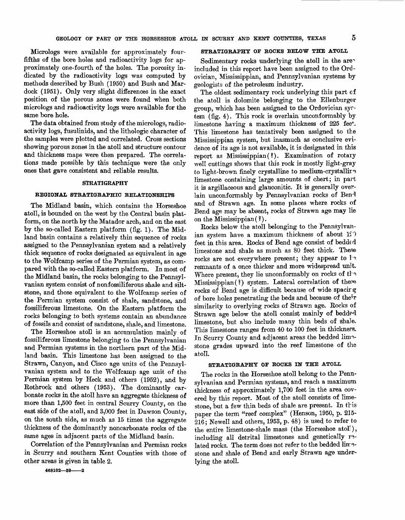
Comparison of the microlog categories with analyses of permeability indicates similar but less definitive re sults. The cumulative curves in figure 3 show that 70 percent of the rock having a microlog classification of "good" had greater than 1 millidarcy of permeability, whereas only 2 percent of the rock classed as "fair", 35 percent classed as "broken", and 23 percent classed as impervious have greater than 1 millidarcy. The dif ference is more marked when the high permeabilities known to be the result of cracks and fractures are elim inated, as shown in table 1.
The results of these comparative studies indicate that the microlog permeability classifications of the reef limestone can usually be considered to have semi- quantitative porosity values, as shown by the averages in table 1 and the curves in figure 2. Some overlap of porosity values, however, is inherent in comparative studies of the microlog with core analysis. The mi crolog does not measure actual porosity; it measures the resistivity of the part of the rock invaded by the drilling mud and is therefore a function of the pene
tration and concentration of the mud filtrate into the rock, the resistivity of the mud, and the resistivity of the host rock.
TABLE 1. Quantitative comparisons of microlog classifications with laboratory analyses of effective porosity and perrreability
[For explanation of microlog classification see under "Methods of study," In text]
Microlog classification
"Good" --"Fair"___ ___ _"Broken". _____
Effective porosity
Number of com parisons
2,489 99
314 1,938
Average porosity (percent)
10.5 3.2 3. 8 2. 8
Permeability
All comparisons
Number of com parisons
1,939 74
286 1, 679
Average perme ability (milli-
darcys)
19.5 . 1
15.2 3.9
Comparisons of those permeabilities not refuting from
cracks
Numlor of con- parisoTS
1,689 74
240 1,414
Average perme ability (milli
darcys)
8. 1 . 1
2.0.7
In most wells, however, these variables were of suf ficient constancy so that a range of porosity vrlues for each microlog classification could be established. The cross sections in plate 6 show correlations of porosity data taken from micrologs. The porous limestone shown on the cross sections may generally be consid ered to have porosity of 4.5 percent or greater.
EXPLANATION Microlog classifications Number of
comparisons
100
_ 80
|
*«>
Good permeability l£39 Fair permeability 74 Broken permeability 286 ......... impervious IJB79
/
/ -"--*f' /
: /if /
/! / § /S-40
5
1 3 to
0
1~
/^
' - -
^-^
- .-» ---
^- "
' " -
^ * -
10 20 30 40 50 6 Permeability of corresponding cores in millidarcys
FIGURE 3. Quantitative evaluation of microlog classifications In terms of permeabilities. Cumulative curves show the comparison of microlog classifications with laboratory analyses of tl ? perme ability of corresponding cores.
GEOLOGY OF PART OF THE HORSESHOE ATOLL IN SCURRY AND KENT COUNTIES, TEXAS
Micrologs were available for approximately four- fifths of the bore holes and radioactivity logs for ap proximately one-fourth of the holes. The porosity in dicated by the radioactivity logs was computed by methods described by Bush (1950) and Bush and Mar- dock (1951). Only very slight differences in the exact position of the porous zones were found when both micrologs and radioactivity logs were available for the same bore hole.
The data obtained from study of the micrologs, radio activity logs, fusulinids, and the lithologic character of the samples were plotted and correlated. Cross sections showing porous zones in the atoll and structure contour and thickness maps were then prepared. The correla tions made possible by this technique were the only ones that gave consistent and reliable results.
STRATIGRAPHY
REGIONAL STRATIGRAPHIC RELATIONSHIPS
The Midland basin, which contains the Horseshoe atoll, is bounded on the west by the Central basin plat form, on the north by the Matador arch, and on the east by the so-called Eastern platform (fig. 1). The Mid land basin contains a relatively thin sequence of rocks assigned to the Pennsylvanian system and a relatively thick sequence of rocks designated as equivalent in age to the Wolf camp series of the Permian system, as com pared with the so-called Eastern platform. In most of the Midland basin, the rocks belonging to the Pennsyl vanian system consist of nonfossiliferous shale and silt- stone, and those equivalent to the Wolfcamp series of the Permian system consist of shale, sandstone, and fossiliferous limestone. On the Eastern platform the rocks belonging to both systems contain an abundance of fossils and consist of sandstone, shale, and limestone.
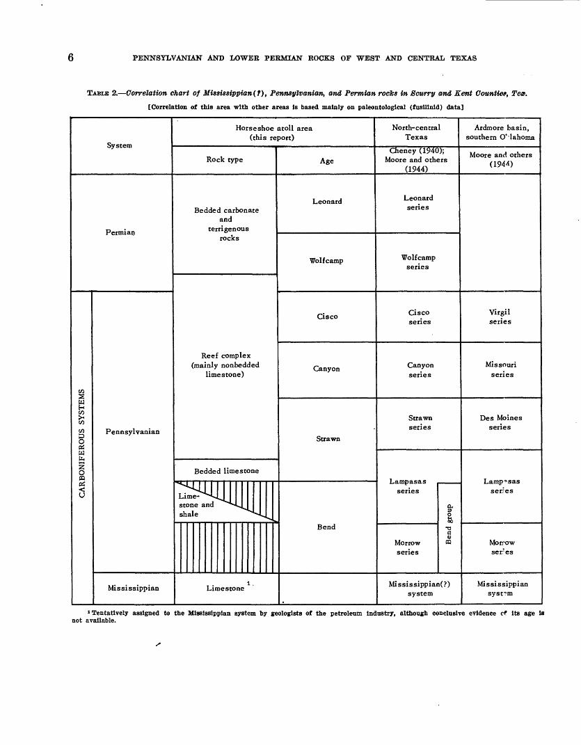
The Horseshoe atoll is an accumulation mainly of fossiliferous limestone belonging to the Pennsylvanian and Permian systems in the northern part of the Mid land basin. This limestone has been assigned to the Strawn, Canyon, and Cisco age units of the Pennsyl vanian system and to the Wolfcamp age unit of the Permian system by Heck and others (1952), and by Eothrock and others (1953). The dominantly car bonate rocks in the atoll have an aggregate thickness of more than 1,500 feet in central Scurry County, on the east side of the atoll, and 3,000 feet in Dawson County, on the south side, as much as 15 times the aggregate thickness of the dominantly noncarbonate rocks of the same ages in adjacent parts of the Midland basin.
Correlation of the Pennsylvanian and Permian rocks in Scurry and southern Kent Counties with those of other areas is given in table 2,
468102 59 2
STRATIGRAPHY OF ROCKS BELOW THE ATOLL
Sedimentary rocks underlying the atoll in the are** included in this report have been assigned to the Ord- ovician, Mississippian, and Pennsylvanian systems by geologists of the petroleum industry.
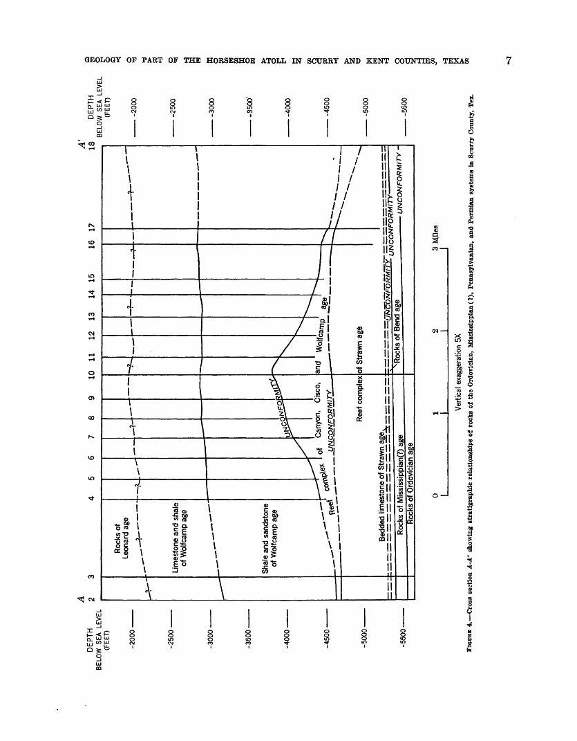
The oldest sedimentary rock underlying this part of the atoll is dolomite belonging to the Ellenburger group, which has been assigned to the Ordovician syr- tem (fig. 4). This rock is overlain uncoiiformably by limestone having a maximum thickness of 225 fee*. This limestone has tentatively been assigned to the Mississippian system, but inasmuch as conclusive evi dence of its age is not available, it is designated in this report as Mississippian (?). Examination of rotary well cuttings shows that this rock is mostly light-gray to light-brown finely crystalline to medium-crystallir^ limestone containing large amounts of chert; in part it is argillaceous and glauconitic. It is generally over lain unconformably by Pennsylvanian rocks of Ben 3 and of Strawn age. In some places where rocks of Bend age may be absent, rocks of Strawn age may lie on the Mississippian (?).
Rocks below the atoll belonging to the Pennsylvan ian system have a maximum thickness of about 1^0 feet in this area. Rocks of Bend age consist of bedded limestone and shale as much as 80 feet thick. These rocks are not everywhere present; they appear to H remnants of a once thicker and more widespread unit. Where present, they lie unconformably on rocks of tH Mississippian(?) system. Lateral correlation of thefe rocks of Bend age is difficult because of wide spacirg of bore holes penetrating the beds and because of the^r similarity to overlying rocks of Strawn age. Rocks of Strawn age below the atoll consist mainly of bedded limestone, but also include many thin beds of shale. This limestone ranges from 40 to 100 feet in thickners. In Scurry County and adjacent areas the bedded lime stone grades upward into the reef limestone of the atoll.
STRATIGRAPHY OF ROCKS IN THE ATOLL
The rocks in the Horseshoe atoll belong to the Penn sylvanian and Permian systems, and reach a maximum thickness of approximately 1,700 feet in the area cov ered by this report. Most of the atoll consists of lime stone, but a few thin beds of shale are present. In this paper the term "reef complex" (Henson, 1950, p. 215- 216; Newell and others, 1953, p. 48) is used to refer to the entire limestone-shale mass (the Horseshoe atoll), including all detrital limestones and genetically re lated rocks. The term does not refer to the bedded liir^- stone and shale of Bend and early Strawn age under lying the atoll.
6 PENNSYLVANIAN AND LOWER PERMIAN ROCKS OP WEST AND CENTRAL TEXAS
TABLE 2. Correlation chart of Mississippian(t), Pennsylvanian, and Permian rocks in Scurry and Kent Counties, Teas.
[Correlation of this area with other areas Is based mainly on paleontologlcal (fusillnld) data]
Permian
CARBONIFEROUS SYSTEMS
Pennsylvanian
Mississippian
Horseshoe atoll area (this report)
Rock type
Bedded carbonate and
terrigenous rocks
Reef complex (mainly nonbedded
limestone)
Bedded limestone
stone and ^"""^vjl shale ^">v» v
Limestone
Age
Leonard
Wolfcamp
Cisco
Canyon
Strawn
Bend
North-central Texas
Cheney (1940); Moore and others
(1944)
Leonard series
Wolfcamp series
Cisco series
Canyon series
Strawn secies
series
o
-am
Morrow Wseries
Mississippian(?) system
Ardmore basin, southern Oklahoma
Moore and others (1944)
Virgil series
Missouri series
Des Moines series
serfes
Morrow seres
Mississippian system
1 Tentatively assigned to the Mlssissippian system by geologists of the petroleum industry, although conclusive evidence cf Its age is not available.
AD
EP
TH
2
BE
LOW
SE
A LE
VE
L (F
EET)
-200
0
-250
0
-300
0
-3500
-4000-
-4500'
-5000-
-550
0-
4 5
6 7
8 9
10
11
12
13
14
1516
17
A'
18D
EP
THO
Roc
ks o
f Le
onar
d ag
e
Lim
esto
ne a
nd s
hale
of
Wol
fcam
p ag
e
Shal
e an
d sa
ndst
one
of W
olfc
amp
age
Ree
f com
plex
Bed
ded
limes
tone
of
Stra
wn
Roc
ks o
f Ord
ovic
ian
age
of S
traw
n ag
e
UN
CO
NF
OR
MIT
Y-
UN
CO
NFO
RM
ITY
-
BELO
W
SEA
LEV
EL
2
(FE
ET)
O
-200
0
-250
0
-30
00
-35
00
'
-4000
-45
00
-50
00
-550
0
Ver
tical
exa
gger
atio
n 5X
FI
GUBB
4. C
ross
sec
tion
A-A
' sh
owin
g st
ratig
raph
ic r
elat
ions
hips
of
rock
s of
the
Ord
ovic
ian,
Mis
siss
ippi
an(?
), P
enns
ylva
nia^
and
Per
mia
n sy
stem
s in
Scu
rry
Cou
nty,
Tex
.
o ft) 1 o
o
8 PENNSYLVANIAN AND LOWER PERMIAN ROCKS OF WEST AND CENTRAL TEXAS
The rocks of the atoll are considered to be equiv alent in age to the Strawn, Canyon, and Cisco groups of the Pennsylvanian and to the Wolfcamp of the Permian (see table 2). Ages of different parts of the reef complex have been determined by study of the Fusulin- idae, but the age relationships are complex and the rocks are difficult to correlate because fossils from older parts of the limestone mass have been reworked and in corporated into younger parts of the atoll. For ex ample, fragments of reef limestone that contain fusu- linids of Canyon age are too often found in carbonate matrices that contain fusulinids of Cisco age. Careful study of cores of limestone breccia believed to be of Cisco age shows that fusulinids of Canyon age are present only in the fragments, whereas fusulinids of Cisco age are found only in the matrix.
Fragmental debris eroded from higher and older parts of the atoll has accumulated on both flanks of this structure and has been scattered laterally for many miles from the crest of the atoll and locally incor porated into shale of Wolfcamp age adjacent to the atoll. The mixture of older and younger fusulinid faunas has resulted in difficult problems of correlation and age determination of rocks on the flanks of the reef.
Rocks of Strawn age in the atoll have a maximum thickness of 750 feet. The combined thicknesses of these rocks and rocks of Bend and Strawn age under lying the atoll are shown in plate 2. Reef rocks of Can yon age lie unconformably on rocks of Strawn age, and have a maximum thickness of 750 feet. Rocks of Cisco age in the atoll, which lie unconformably on rocks of Canyon age, are locally as much as 500 feet thick, but in many places in the atoll no reef limestone of Cisco age is present. Reef rocks of Wolfcamp age, which reach a maximum thickness of 85 feet in this area, are probably present only in a few isolated places, as indi cated by the stratigraphic relations based on fusulinids and other data used for correlation and dating of the atoll.
STRATIGRAPHY OF ROCKS ABOVE THE ATOLL
Most of the rocks immediately surrounding and over lying the Horseshoe atoll are equivalent to the Wolf- camp series of the Permian system. In the eastern part of the area, however, seaward from the atoll, a few hundred feet of shale may be of Cisco age.
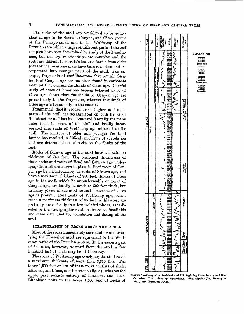
The rocks of Wolfcamp age overlying the atoll reach a maximum thickness of, more than 3,350 feet. The lower 1,500 feet or less of these rocks consists of shale, siltstone, sandstone, and limestone (fig. 5), whereas the upper part consists entirely of limestone and shale. Lithologic units in the lower 1,500 feet of rocks of
EXPLANATION
Sandstone
Shale
Limestone
Dolomite
FIGURE 5. Composite electrical and lltbologlc log from Scurry and Kent Counties, Tex., showing Ordovlclan, Mississippian(?), Pennsylva nian, and Permian rocks.
GEOLOGY OF PART OF THE HORSESHOE ATOLL IN SCURRY AND KENT COUNTIES, TEXAS 9
Wolfcamp age are not persistent, and because of the general lithologic characteristics, apparent primary structural features, and general stratigraphic relation ships, it seems likely that these rocks were deposited as deltaic sediments. Lithologic units in the upper part are laterally more uniform in thickness and lithology and can be traced throughout the mapped area. The age of the rocks equivalent to the upper part of the Wolfcamp has been assigned by paleontologists on the basis of fusulinid determinations.
Rocks overlying the upper part of the rocks of Wolf- camp age consist of dolomite, limestone, and shale. These rocks have been designated as equivalent to the Leonard series of the Permian system on the basis of fusulinid determinations.
CHARACTERISTICS OF THE REEF ROCK
LITHOLOGIC COMPONENTS
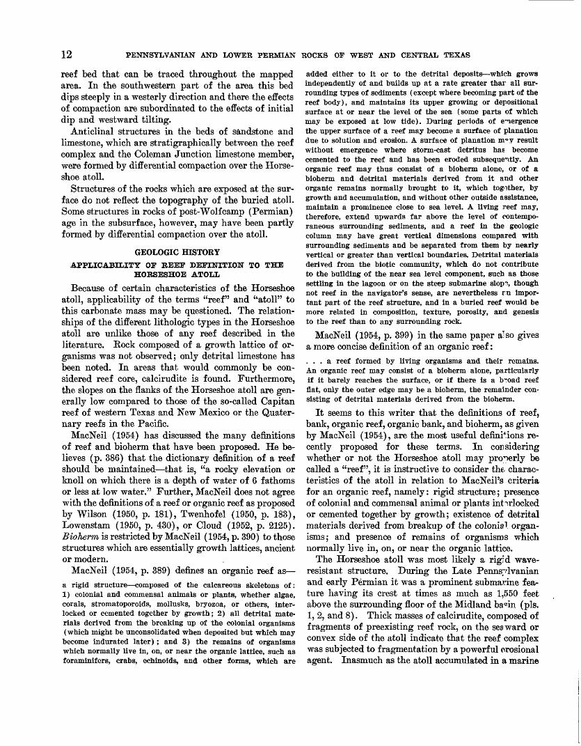
The limestone of the Horseshoe atoll is composed of organic debris bonded by crystalline calcite and by lithified carbonate mud (Rothrock and others, 1953). The organic debris consists of the hard parts of marine animals, most of which have been broken and ground into fragments ranging in size from a few millimeters to submicroscopic particles. These lithified aggregates are classified according to grain size into three types after Grabau, as described by Petti John (1949, p. 300- 307) : calcilutite (limestone composed of particles of clay size), calcarenite (limestone composed of parti cles of sand size), and calcirudite (limestone composed of particles greater than sand size). Typical specimens of these three lithologic types are shown in plate 3.
The calcilutite consists mainly of submicroscopic particles but commonly contains some coarser un- sorted organic debris. Some of the fine material is pulverized organic debris, some may be chemically pre cipitated ooze, some or most of it may have been precipitated by blue-green algae. Approximately one- third of the core examined consists of calcilutite.
The calcarenite is composed mainly of well-rounded to angular fragments 1/16 mm to 2 mm in diameter. Fragments of reef limestone larger than 2 mm, oolites, and pisolites are present in small amounts. The calcarenite grades into calcilutite and calcirudite. It makes up about one-half of the core examined.
The calcirudite is composed of angular fragments larger than 2 mm in diameter in a matrix of lime sand or lime mud. The matrix commonly contains admixed argillaceous material, and in a few places is composed almost entirely of shale. The calcirudite consists of two main types: organic fragments and fragments of older reef limestone. The finer grained calcirudite is usually
composed of both organic and older reef limestone fragments in approximately equal amounts; t\e coarser-grained calcirudite usually contains more re°sf fragments than organic fragments. Fragments of reef limestone in most calcirudite are angular and un doubtedly were lithified before breakage and recfe- position. Calcirudite is the least common but most dis tinctive of the three textural varieties of limestor 0,. It is present in about one-sixth of the total footage of core examined.
Sorting and clearly-defined bedding planes are al most everywhere poor to lacking in the limestor0.. None of the calcarenite or calcilutite in the cores could be definitely traced from well to well; the calcirudite could be traced only when fusulinid and microlog determinations were made. These formal and physical characteristics are discussed in the section on zonation of the atoll.
The shale of the reef complex is dark gray to black, because of a high percentage of bituminous material. Locally unsorted carbonate debris and concentrations of pyrite are common. The shale is present as tongms that project into the limestone from the shale sur rounding the atoll, as thin lenses and beds which cr.n generally be traced over widespread areas within the body of the atoll, and as stringers from a few milli meters to a few centimeters thick which cannot be traced from well to well. The thin lenses of shale with in the body of the reef complex are always present in certain fairly well defined zones, which are discussed in the part of the text on zonation.
A comprehensive description of the lithology of the reef complex has been presented by Bergenback and Terriere (1953).
CHEMICAL COMPOSITION
Chemical analyses of cores from the atoll show th^.t except for argillaceous limestone in certain well-defined zones, the limestone is almost pure calcium carbonate (pis. 4 and 5, well 1).
An average of 2.05 percent of insoluble residue is shown by 135 analyses of core taken from Chapman & McFarlin Producing Company's No. 25 Cogdell well in the reef complex. An average of considerably less than 1 percent of insoluble residue, however, is present in the more porous zones of the reef, as most of the analyses containing over 2 percent of insoluble ma terial are in zones of relatively low porosity. There zones of relatively low porosity have time significance when correlated with paleontological data. Thus, it appears that the high amount of insoluble residue in the less porous of these zones was the result of an in-
10 PENNSYLVANIA AND LOWER PERMIAN ROCKS OF WEST AND CENTRAL TEXAS
crease in terrigenous material coming into this area during certain times.
POROSITY AND PERMEABILITY
The effective porosity of the reef limestone, deter mined by core analyses, generally ranges from almost zero to 30 percent, and averages about 6 percent when viewed megascopically. Openings in cores of the lime stone appear to range in size from tiny openings of pin point size to vugs 5 cm in diameter, but most of the openings are smaller than 3 mm in diameter.
Originally, the clastic limestone in the atoll was probably very porous. It is probable that most of the primary interstitial pore space was subsequently filled with calcium carbonate cement. Eventually, leaching formed the secondary porosity now present in the lime stone. Only a relatively insignificant amount of pri mary porosity exists in the reef limestone, such as that found in the hollow interiors of some shells.
The permeability of the reef limestone, as determined by laboratory analyses, generally ranges from a few hundredths to 85 millidarcys with an average of about 4.5 millidarcys (measured horizontally to air). Per meability measured vertically to air has a range of values that is considerably less. This average and range of values does not include those relatively high permea bilities which are known to have been caused by open cracks, fractures, and joints in the limestone.
ZONATION OF THE ATOLL
Rothrock and others (1953) in a discussion of the zonal arrangement of the reef complex in Scurry County presented a map showing contours on the top and the base of an "intermediate zone." This "inter mediate zone" was based on differences in lithologic character and effective porosity of the reef limestone. The zone as presented in that publication was a rea sonable interpretation on the basis of the data which were then available and the criteria that were used. Additional data and detailed study have indicated, however, that as many as three distinct zones of low porosity were included as part of the "intermediate zone," and that the relationships of this zone to the standard geologic time units were not entirely correct. In the following discussion, therefore, some revisions of the zonation of the reef complex have been made.
Two distinct types of zones appear to be present in the reef complex: zones consisting of relatively large amounts of rocks having low porosity and zones con sisting of relatively large amounts of rocks having high porosity. Both types of zones, as shown in cross sections B-B' through E-E' (pi. 6), are based on poros ity determinations from micrologs and neutron curves,
the stratigraphic distribution of shale and calcirudite, and age determinations. The utility of the microlog as an indicator of semiquantitative porosity values of the reef limestone has been previously discussed in the section on methods of study.
Zones of low porosity consist mainly of reef lime stone of low effective porosity (less than 4.5 percent). Study of cores and insoluble residues indicates that zones of this type contain one or more thin beds of shale and more argillaceous material than the zones of high porosity. Calcirudite consisting of olc^.r reef fragments makes up as much as 60 percent of the rock.
Zones of high porosity consist mainly of re^.f lime stone of high effective porosity (greater than 4.5 per cent). They contain neither calcirudite made of older reef fragments nor beds of shale; they have a rela tively small amount of insoluble residue (usually less than 1 percent).
Faunal horizons which are plotted relativn to the porosity zones show that these zones of low porosity and high porosity are definitely related to th*. stand ard units of the Pennsylvanian and Permian(?) sys tems. The cross sections B-B' through E-E' (pi. 6) show the relationships of effective porosity to thin beds of shale and to age. Evidence indicates that rooks con taining fusulinids typical of the Canyon gro^ip have two zones of low porosity and two of high porosity, that rocks containing fusulinids typical of the Cisco group have two zones of low porosity and one zone of high porosity, and that rocks containing fusulinids typical of the Wolfcamp series have but one zone of low porosity.
Some zones can be traced throughout the area cov ered by this report; others have limited distribution, either having been eroded in places or never deposited. The difference in these low-porosity and high-porosity zones is the result of a varied and complex geologic history which is discussed in the section on history of the reef complex. Economic aspects of the zonation are covered in the section on oil and gas.
PALEONTOLOGY
AGE OF THE ATOLL
The presence of several species of fusulinids belong ing to the genus Fusulina indicates that much of the reef limestone is of Strawn age. Reef limestone of Canyon age is indicated by the presence of Trititites cf. T. irregularis (Schellwein and Staff) and ofher spe cies of Triticites which are typical of the Canyon group in outcropping rocks of north-central Texas. Fusu linids of Cisco age are represented by forms which belong to the group of Triticites ventricosus (Meek and
GEOLOGY OF PART OF THE HORSESHOE ATOLL IN SCURRY AND KENT COUNTIES, TEXAS 11
Hayden). Duribarinella sp. has been found. A form of Triticites related to Triticites ventricosus (Meek and Hayden) is present in most of the cores that contain fusulinids typical of the Cisco group. This species of Triticites is apparently conspecific with a form that is abundant in the Wayland shale member of the Graham formation in north-central Texas.
Fusulinids of Wolfcamp age were found in cores from several wells. The diagnostic fusulinid Schwag- erina sp. (now known as Pseudofusulina sp.), was re ported (Heck, Yenne, and Henbest, 1952) from the Wilshire Oil Co.'s No. 8 Lunsford well (pi. 5, well 43). As previously stated, age determinations of parts of the atoll containing large amounts of calcirudite have been complicated by the presence of reworked fusu linid faunas.
FAUNAL ASSOCIATIONS
The f aunal associations and ecology of the reef were determined from a megascopic study of cores from 78 wells. The major f aunal groups in the atoll are echi- noderms, foraminifers, brachiopods, bryozoans, coelen- terates, and mollusks. The commonest group is the Echinodermata, which were noted in about 80 percent of the core footage. The echinoderms are represented by abundant crinoid columnals, by a few crinoidal calyx plates and arm segments, and by echinoid spines.
Fusulinids were observed in about 75 percent of the core footage. Foraminifera other than fusulinids were noted in about 10 percent of the footage. This figure is probably low as many of the smaller Foraminifera may have been overlooked in the methods of study that were employed. Numerous small, irregular tubelike bodies resembling Oalcitornella have been found in the finer grained parts of the reef limestone.
Brachiopods were noted in about 50 percent of the core footage. Productidae, Athyridae, and Rhyncho- spirinidae are common. Discinoid brachiopods are fairly common in the argillaceous beds in the atoll, but have not been noted elsewhere. Bryozoa were found in about 25 percent of the core footage. The large amount of bryozoan debris observed in thin sections suggests that they were probably more numerous than mega scopic descriptions indicate. Fenestellid bryozoans are commonest, although encrusting and ramose types are present.
Coelenterates are of minor importance in the atoll, although they were found in about 10 percent of the core footage. They are represented by tetracorals that resemble Lophophyllidium and colonial corals that re semble Ohaetetes.
Mollusca were observed in about 10 percent of the core footage. Gastropods are the most common and
have a random distribution. Ammonoids are most com mon in the shale and argillaceous limestone, but they are present also in the purer limestone. Pelecypods, represented by the Pectinacea, generally are prerent in the shale.
Other faunal groups were observed in less than 1 percent of the core footage. These groups consist of the arthropods, represented by ostracodes and very rarely by trilobite fragments; vertebrates, represented by fish scales; Porifera, represented by sponge spic- ules; and conodonts.
Algae may have been present, but only a few identi fiable traces have been observed. Bergenback and Ter- riere (1953, p. 1017) state that no evidence of algae was found in the reef in Scurry County. However, re- evaluation of the organic content of the core which they studied suggests that some of the calcareous ma terial may be of algal origin. Elliot and Kirn (1952) in a study of core from a well in Terry County, Tex.. indicated algae as being the most abundant of all the organisms present in the reef complex.
STRUCTURE
The sedimentary rocks underlying the atoll in this area have a general west-southwest dip averaging about 30 feet per mile. This tilting is best portrayed by the upper surface of rocks assigned to the Mississippian (?) system (pi. 7). Structural relations of the ro^ks throughout the northern part of the Midland basin suggest that the time of most of the tilting was post- Paleozoic.
The structure of the rocks of the atoll is obscured by the complex distribution of rock types, resulting mainly from nontectonic processes. The progressive development of the atoll, as shown by contours on the tops of rocks of the Strawn age (pi. 2) and Canyon age (pi. 8), and on the top of the atoll (pi. 1), is main ly a result of the interaction of deposition and erosion. Each of the structure-contour maps shows a similar type of irregular surface, upon which younger sedi ments were deposited. A general west-southwest tilt ing has been superimposed upon these surfaces. The thin beds of shale within the atoll, some of which have wide lateral extent, reveal little deformation except for the effects of differential compaction and regional tilting.
The contours on the top of rocks overlying the atoll (pi. 9) show the effects of differential compaction ?,nd regional tilting of the post-reef rocks. The top of ro"-ks approximately equivalent in age to the Coleman Junc tion limestone member of the Putnam formation was selected for contouring because it is the oldest post-
12 PENNSYLVANIA^ AND LOWER PERMIAN ROCKS OF WEST AND CENTRAL TEXAS
reef bed that can be traced throughout the mapped area. In the southwestern part of the area this bed dips steeply in a westerly direction and there the effects of compaction are subordinated to the effects of initial dip and westward tilting.
Anticlinal structures in the beds of sandstone and limestone, which are stratigraphically between the reef complex and the Coleman Junction limestone member, were formed by differential compaction over the Horse shoe atoll.
Structures of the rocks which are exposed at the sur face do not reflect the topography of the buried atoll. Some structures in rocks of post-Wolf camp (Permian) age in the subsurface, however, may have been partly formed by differential compaction over the atoll.
GEOLOGIC HISTORYAPPLICABILITY OF REEF DEFINITION TO THE
HORSESHOE ATOLL
Because of certain characteristics of the Horseshoe atoll, applicability of the terms "reef" and "atoll" to this carbonate mass may be questioned. The relation ships of the different lithologic types in the Horseshoe atoll are unlike those of any reef described in the literature. Rock composed of a growth lattice of or ganisms was not observed; only detrital limestone has been noted. In areas that would commonly be con sidered reef core, calcirudite is found. Furthermore, the slopes on the flanks of the Horseshoe atoll are gen erally low compared to those of the so-called Capitan reef of western Texas and New Mexico or the Quater nary reefs in the Pacific.
MacNeil (1954) has discussed the many definitions of reef and bioherm that have been proposed. He be lieves (p. 386) that the dictionary definition of a reef should be maintained that is, "a rocky elevation or knoll on which there is a depth of water of 6 fathoms or less at low water." Further, MacNeil does not agree with the definitions of a reef or organic reef as proposed by Wilson (1950, p. 181), Twenhofel (1950, p. 183), Lowenstam (1950, p. 430), or Cloud (1952, p. 2125). Bioherm is restricted by MacNeil (1954, p. 390) to those structures which are essentially growth lattices, ancient or modern.
MacNeil (1954, p. 389) defines an organic reef as a rigid structure composed of the calcareous skeletons of: 1) colonial and commensal animals or plants, whether algae, corals, stromatoporoids, mollusks, bryozoa, or others, inter locked or cemented together by growth; 2) all detrital mate rials derived from the breaking up of the colonial organisms (which might be unconsolidated when deposited but which may become indurated later) ; and 3) the remains of organisms which normally live in, on, or near the organic lattice, such as foraminifers, crabs, echinoids, and other forms, which are
added either to it or to the detrital deposits which grows independently of and builds up at a rate greater thar all sur rounding types of sediments (except where becoming part of the reef body), and maintains its upper growing or depositional surface at or near the level of the sea (some parts of which may be exposed at low tide). During periods of emergence the upper surface of a reef may become a surface of planation due to solution and erosion. A surface of planation m^y result without emergence where storm-cast detritus has become cemented to the reef and has been eroded subsequently. An organic reef may thus consist of a bioherm alone, or of a bioherm and detrital materials derived from it and other organic remains normally brought to it, which together, by growth and accumulation, and without other outside assistance, maintain a prominence close to sea level. A living reef may, therefore, extend upwards far above the level of contempo raneous surrounding sediments, and a reef in the geologic column may have great vertical dimensions compared with surrounding sediments and be separated from them by nearly vertical or greater than vertical boundaries. Detrital materials derived from the biotic community, which do not contribute to the building of the near sea level component, such as those settling in the lagoon or on the steep submarine slop?, though not reef in the navigator's sense, are nevertheless rn impor tant part of the reef structure, and in a buried reef would be more related in composition, texture, porosity, and genesis to the reef than to any surrounding rock.
MacNeil (1954, p. 399) in the same paper also gives a more concise definition of an organic reef:... a reef formed by living organisms and their remains. An organic reef may consist of a bioherm alone, particularly if it barely reaches the surface, or if there is a b~oad reef flat, only the outer edge may be a bioherm, the remainder con sisting of detrital materials derived from the bioherm.
It seems to this writer that the definitions of reef, bank, organic reef, organic bank, and bioherm, as given by MacNeil (1954), are the most useful definitions re cently proposed for these terms. In considering whether or not the Horseshoe atoll may properly be called a "reef", it is instructive to consider the. charac teristics of the atoll in relation to MacNeil's criteria for an organic reef, namely: rigid structure; presence of colonial and commensal animal or plants interlocked or cemented together by growth; existence of detrital materials derived from breakup of the colonial organ isms; and presence of remains of organisms which normally live in, on, or near the organic lattice.
The Horseshoe atoll was most likely a rigid wave- resistant structure. During the Late Penns7lvanian and early Permian it was a prominent submarine fea ture having its crest at times as much as 1,550 feet above the surrounding floor of the Midland ba^in (pis. 1, 2, and 8). Thick masses of calcirudite, composed of fragments of preexisting reef rock, on the seaward or convex side of the atoll indicate that the reef complex was subjected to fragmentation by a powerful orosional agent. Inasmuch as the atoll accumulated in a marine
GEOLOGICAL SURVEY PROFESSIONAL PAPER 315 PLATE 3
.: . .. ,. .... **...
A. CALCILUTITE. B. CALCARENITE.
C. CALCIRUDITE CONSISTING OF PREEXISTING REEF LIMESTONE FRAGMENTS.
D. CALCIRUDITE CONSISTING OF ORGANIC FRAGMENTS.
CORE FROM THE HORSESHOE ATOLL IN SCURRY COUNTY, TEX., ILLUSTRATING ROCK TYPES
GEOLOGY OF PART OF THE HORSESHOE ATOLL IN SCURRY AND KENT COUNTIES, TEXAS 13
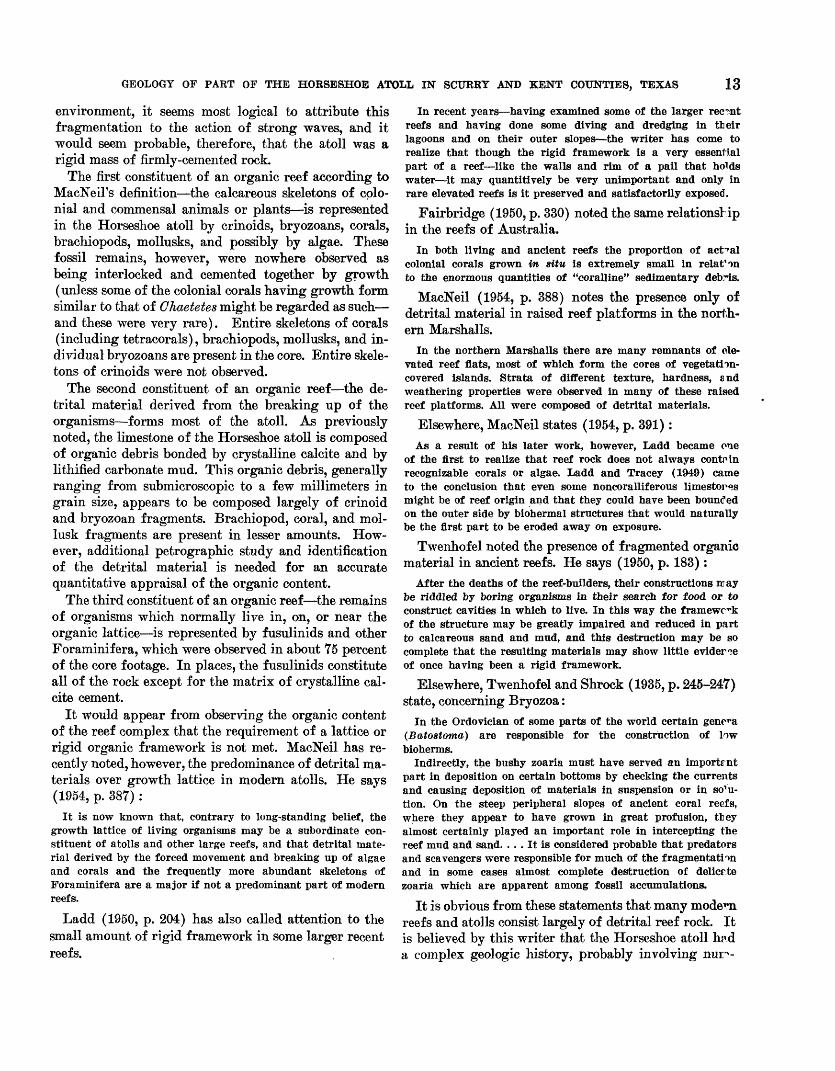
environment, it seems most logical to attribute this fragmentation to the action of strong waves, and it would seem probable, therefore, that the atoll was a rigid mass of firmly-cemented rock.
The first constituent of an organic reef according to MacNeiFs definition the calcareous skeletons of colo nial and commensal animals or plants is represented in the Horseshoe atoll by crinoids, bryozoans, corals, brachiopods, mollusks, and possibly by algae. These fossil remains, however, were nowhere observed as being interlocked and cemented together by growth (unless some of the colonial corals having growth form similar to that of Chaetetes might be regarded as such and these were very rare). Entire skeletons of corals (including tetracorals), brachiopods, mollusks, and in dividual bryozoans are present in the core. Entire skele tons of crinoids were not observed.
The second constituent of an organic reef the de trital material derived from the breaking up of the organisms forms most of the atoll. As previously noted, the limestone of the Horseshoe atoll is composed of organic debris bonded by crystalline calcite and by lithified carbonate mud. This organic debris, generally ranging from submicroscopic to a few millimeters in grain size, appears to be composed largely of crinoid and bryozoan fragments. Brachiopod, coral, and mol- lusk fragments are present in lesser amounts. How ever, additional petrographic study and identification of the detrital material is needed for an accurate quantitative appraisal of the organic content.
The third constituent of an organic reef the remains of organisms which normally live in, on, or near the organic lattice is represented by fusulinids and other Foraminifera, which were observed in about 75 percent of the core footage. In places, the fusulinids constitute all of the rock except for the matrix of crystalline cal cite cement.
It would appear from observing the organic content of the reef complex that the requirement of a lattice or rigid organic framework is not met. MacNeil has re cently noted, however, the predominance of detrital ma terials over growth lattice in modern atolls. He says (1954, p. 387) :
It is now known that, contrary to long-standing belief, the growth lattice of living organisms may be a subordinate con stituent of atolls and other large reefs, and that detrital mate rial derived by the forced movement and breaking up of algae and corals and the frequently more abundant skeletons of Foraminifera are a major if not a predominant part of modern reefs.
Ladd (1950, p. 204) has also called attention to the small amount of rigid framework in some larger recent reefs.
In recent years having examined some of the larger recent reefs and having done some diving and dredging in their lagoons and on their outer slopes the writer has come to realize that though the rigid framework is a very essential part of a reef like the walls and rim of a pail that holds water it may quantittvely be very unimportant and only in rare elevated reefs is it preserved and satisfactorily exposed.
Fairbridge (1950, p. 330) noted the same relationship in the reefs of Australia.
In both living and ancient reefs the proportion of actual colonial corals grown in situ is extremely small in relat'on to the enormous quantities of "coralline" sedimentary debT-is.
MacNeil (1954, p. 388) notes the presence only of detrital material in raised reef platforms in the north ern Marshalls.
In the northern Marshalls there are many remnants of ele vated reef flats, most of which form the cores of vegetation- covered islands. Strata of different texture, hardness, and weathering properties were observed in many of these raised reef platforms. All were composed of detrital materials.
Elsewhere, MacNeil states (1954, p. 391):As a result of his later work, however, Ladd became one
of the first to realize that reef rock does not always contain recognizable corals or algae. Ladd and Tracey (1949) came to the conclusion that even some noncoralliferous limestor«s might be of reef origin and that they could have been bounded on the outer side by biohermal structures that would naturally be the first part to be eroded away on exposure.
Twenhofel noted the presence of fragmented organic material in ancient reefs. He says (1950, p. 183):
After the deaths of the reef-builders, their constructions may be riddled by boring organisms in their search for food or to construct cavities in which to live. In this way the framework of the structure may be greatly impaired and reduced in part to calcareous sand and mud, and this destruction may be so complete that the resulting materials may show little eviderce of once having been a rigid framework.
Elsewhere, Twenhof el and Shrock (1935, p. 245-247) state, concerning Bryozoa:
In the Ordoviclan of some parts of the world certain genera (Batostoma) are responsible for the construction of low bioherms.
Indirectly, the bushy zoaria must have served an importrnt part in deposition on certain bottoms by checking the currents and causing deposition of materials in suspension or in so^u- tion. On the steep peripheral slopes of ancient coral reefs, where they appear to have grown in great profusion, tley almost certainly played an important role in intercepting the reef mud and sand. ... It is considered probable that predators and scavengers were responsible for much of the fragmentation and in some cases almost complete destruction of delicr te zoaria which are apparent among fossil accumulations.
It is obvious from these statements that many modem reefs and atolls consist largely of detrital reef rock. It is believed by this writer that the Horseshoe atoll hn.d a complex geologic history, probably involving
14 PENNSYLVANIA^ AND LOWER PERMIAN ROCKS OF WEST AND CENTRAL TEXAS
erous eustatic changes of sea level. If such were true, then the living bioherm would have been repeatedly destroyed, forming detritus and leaving only a fossil structure having little or no organic lattice. Further, if cores were available from every well drilled into the Horseshoe atoll, only a relatively insignificant amount of the reef rock would be represented. As it is, cores from only 78 wells in the mapped area were studied which is approximately 70 percent of all cores taken from the Horseshoe atoll. Thus, the remains of any framework could easily have been missed because of lack of adequate sampling of the atoll.
Although no growth lattice was observed in the rocks of the Horseshoe atoll, the writer believes that the struc ture may be an ancient organic reef as defined by Mac- Neil. Organic lattices were probably present, but they were destroyed by the repeated attack of waves or other erosive agents, as a result of repeated changes of sea level, and by scavengers and boring organisms. If any growth lattice is still preserved, it forms an insignificant part of the atoll.
BEEF GROWTH AND SEDIMENTATION
Any analysis of the history of the Horseshoe atoll must consider the following facts:1. The atoll is a buried carbonate mass having hundreds
of feet of relief and is surrounded and overlain by younger terrigenous rocks.
2. The reef complex consists largely of detrital reef limestone.
3. The flanks of the atoll dip more gently than those noted in most reefs.
4. Limestone debris is spread laterally at least 15 miles from the crest of the atoll into terrigenous rocks that are younger than the reef complex.
5. Fusulinid faunas indicate reworking of older rocks into younger sediments.
6. Large amounts of calcirudite, composed of fragments of older reef rock, are present at certain strati- graphic positions in parts of the atoll that would normally be considered the reef core.
7. Terrigenous rocks of Wolfcamp age lie on an irreg ular surface, which is developed on reef limestone of Strawn, Canyon, Cisco, and Wolfcamp age.
8. Eeef limestone of Wolfcamp age in the atoll is in contact with reef rocks of Strawn, Canyon, or Cisco age at different places.
Cyclical deposition in the Pennsylvanian and early Permian has been described by many writers. Wanless and Shepard (1936), Wanless (1950), and Wanless and Patterson (1951) have interpreted these cycles as being related to eustatic changes of sea level. The rocks of
Pennsylvanian and Wolfcamp age of north-central Texas exhibit similar cyclic deposition in which the marine deposits of each cycle were generall7 thicker and the nonmarine deposits thinner than thos^ in east ern United States (Lee, Nickell, Williams, and Hen- best, 1938).
Burnside (in press) considers the historj of the Pennsylvanian and Wolfcamp in the southern part of the Horseshoe atoll as a time of cyclical growth and deposition controlled by eustatic changes of sea level. The geologic history as presented by Burnside appears to be applicable also to the eastern part of th<5 atoll.
Two interpretations of reef growth can be postulated. The first maintains that topographic relief of the atoll was caused by rapid subsidence below the biotic zone, and thus normal reef growth was restricted to smaller areas along the crestline of the atoll. However, this interpretation does not account for these facts:
1. Large amounts of calcirudite composed of elder reef rock, which are present at certain stratigraphic positions in the atoll.
2. Eeworked fusulinid faunas of older reef rocks whichare included with those of younger reef rocks.
The second interpretation is one which maintains that the topography of the atoll resulted fronr erosion, modified by reef growth, which left the present hills, depressions, and valleys on the surface of the atoll. The sequence of events appears to have been alternating submersion and exposure of the reef complex and may be summarized as follows:1. Normal reef growth and deposition took place just
below sea level.2. Sea level was lowered and the atoll emerged.3. The islands (emergent atoll) were subjected to wave
action and subaerial erosion; large wave-cut benches and a topography of hills and valleys were formed. Leaching of the older rocks by circulating meteoric waters possibly aided by humic acids caused the development of secondary porosity. Terrigenous clay-sized materials and reef breccia were deposited on the wave-cut benches and other submarine features. Normal reef growth was limited to the flanks of the islands.
4. Sea level rose, covering most or all emergent parts of the atoll. As the water level rose, terrigenous muds and reef breccia continued to be c1 ̂ posited in lessening amounts on the wave-cut benches and in the low areas of the eroded surface. Normal reef growth became more widespread as marine life flourished. As much as several hundred feet of reef limestone accumulated, the most pro nounced growth usually taking place on the old
GEOLOGY OF PAET OF THE HOESESHOE ATOLL IN SCUEEY AND KENT COUNTIES, TEXAS 15hills. When all islands were below sea level, nor mal reef growth continued across the entire atoll.
The foregoing hypothesis appears to explain the anomalous relationships pointed out at the beginning of this section, and it seems that the Horseshoe atoll may have originated in this way.
DEVELOPMENT OF THE HORSESHOE ATOLL
The oldest known rocks of Pennsylvanian age in the area are those of Bend age. An unknown thickness of these rocks was eroded before the deposition of the rocks of Strawn age, leaving scattered patches of rocks of Bend age which formed hills having as much as 80 feet of relief. During Bend time, particles ranging from clay to pebble size and terrigenous particles of clay size were deposited as evenly bedded sediments on limestone of Mississippian(?) age. The exact time rela tionships between the rocks of Bend age and the rocks of pre-Strawn (Pennsylvanian) age which crop out at the surface in central Texas and elsewhere are un known. However, they may be equivalent in age to the Lampasas series (Moore and others, 1941).
During early Strawn time, carbonate particles rang ing from clay to sand size were deposited initially on rocks of Bend and Mississipian age. These nonreef sediments consist of 40 to 100 feet of bedded limestone and thin beds of shale.
Eeef growth began during early Strawn time and ap pears to have continued cyclically throughout the re mainder of the Pennsylvanian period and into the early Permian. This is indicated by the zones of low and high porosity which may have been the result of changes of sea level during Pennsylvanian and early Wolfcamp time.
In Scurry County at least four major reef cycles are indicated by rocks of Strawn age, two by rocks of Canyon age, and two by rocks of Cisco and Wolfcamp age. Undoubtedly, these major reef cycles include several minor cycles, but because of the complexity of the atoll rocks and lack of adequate information, these cycles cannot be defined. Sufficient data are not avail able for a detailed description of events during the time of deposition of rocks of Strawn age. However, a sequence of events probably took place similar to that occurring during later Pennsylvanian time.
At the beginning of Canyon time, sea level was low ered and the atoll emerged to an unknown height. The emergent atoll was subjected to extensive wave action and subaerial erosion. Fragments were broken from the older reef rock and were distributed to the lower areas of the atoll. Terrigenous clay-sized material entered the area, probably because the lowered water level brought the continental land areas nearer to the atoll. The en
vironment at this time was unfavorable for prolific marine life; hence, relatively little normal reef growth occurred. The rocks of Strawn age immediately under lying the eroded surface were leached by circulating meteoric waters containing humic acids from plant life on the emerged parts of the atoll. Eventually a rela tively flat surface was formed along the crestline of the atoll. During early Canyon time, sea level rose and the atoll was again submerged. Terrigenous clay-sized pa r- ticles entered the basin in lessening amounts. Smaller areas were subjected to wave arosion; therefore, there was less distribution of fragments from older reef rock. Soon the entire area was again below sea level and nor mal reef growth resumed.
A similar sequence of events appears to have c-v- curred during late Canyon time, and twice during Cis".o and early Wolfcamp time. During the time of reef s c- cumulation, relatively little terrigenous material w*s being deposited in the adjacent areas of the Midland basin. In late Cisco time, however, mud and silt may have been deposited in some of the deeper parts of the sea.
During early Wolfcamp time terrigenous sedimerts which probably were in and near an advancing delta en tered the area possibly from the northeast and progres sively smothered reef growth toward the west and southwest. Many parts of the reef complex were wdl above the sea floor during the encroachment of the delf-a, as indicated by the presence of calcirudite lenses pr<v- jecting from the older reef complex into the younger deltaic rocks. Eventually, these sediments covered r,tl of the dead atoll, creating an impervious seal over t>e reef complex, and forming traps for oil aecumulaticn.
During late Wolfcamp time, subsequent to the deposi tion of the terrigenous material, carbonate sediments containing a small amount of clay-sized terrigenous ma terial were laid down in fairly uniform beds.
OIL AND GASHISTORY OF DEVELOPMENT
The first hole drilled to rocks below those of Leonard age in a test for oil in the area described in this reporto *
was Humble Oil & Refining Company's No. 1 Davis well (pi. 5, well 93). This hole was drilled to a total dep^h of 8,027 feet (5,614 feet below sea level) in the Ellen- burger group (Ordovician) and was abandoned in January 28,1947.
The first well in the mapped area that produced oil from the Horseshoe atoll was Sun Oil and Humble C "1 and Eefining Cos.' No. 1 Schattel well (pi. 5, well 94), which was completed on July 16,1948. By the end of that year four widely separated wells were producing oil from the reef rock. Numerous other oil discovert
16 PENNSYLVANIAN AND LOWER PERMIAN ROCKS OF WEST AND CENTRAL TEXAS
in the atoll were made in 1949 and subsequent years. Exploitation of the fields producing from the reef rocks continued at a rapidly increasing pace through 1950. Since 1950 the number of holes drilled each year has de creased, but exploration still remains at a high level.
On August 1, 1953, oil was being produced from 26 reservoirs at four stratigraphic positions in the atoll; one additional reservoir had been abandoned. Produc tion of oil from the reservoirs (pi. 5) is tabulated below.
TABLE 3. Oil production from reef limestones
[See pi. 6]
Year
WeUs pro ducing at
end of yearOil production (barrels)
Yearly Cumulative1948._____________ 4 24,530 24,5301949___________._ 315 4,249,645 4,274,1751950______..______ 1,641 38,112,461 42,386,6361951_____________ 1,952 49,749,313 92,135,9491952______________ 2,065 47,393,572 139,529,521
Oil was first produced from nonreef rocks of Wolf- camp age in April 1950. Most oil discoveries in the nonreef rocks of Wolfcamp age have resulted from studies of subsurface data obtained during development of the fields producing from the reef rocks.
On August 1,1953, oil was being produced from eight reservoirs at four stratigraphic positions in the rocks of Wolfcamp age overlying the atoll.
Production of oil from these reservoirs (pi. 5) is tabulated below:
TABLE 4. Oil production from nonreef rocks of Wolfcamp age
[See pi. 5]SSwJrf Oil production (barrels)
Year end of year Yearly Cumulative1950...___.-____-.___ 3 52,060 52,0601951________________ 48 467,614 519,6741952_______________ 125 2,045,340 2,565,014
Free gas caps do not exist in any of the reservoirs in the atoll nor in the postreef rocks of Wolfcamp age. The only gas production has been solution gas inci dental to oil production and estimates of the quantities produced are not available. Oil is also produced in this area from rocks of the Ordovician and Mississippian (?) systems and from those of Leonard and Guadalupe ages of the Permian system; discussion of the fields and res ervoirs in these rocks is beyond the scope of this report. For a more comprehensive summary of the distribution and production of oil in the area, see Stafford (1957).
RESERVOIRS
Oil is produced from four stratigraphic positions within the Horseshoe atoll. These are commonly called the Canyon and Strawn zones Z?, <7, and D reef-res
ervoir rocks (fig. 5). Production is from reef limestone of Strawn, Canyon, Cisco, and Wolfcamp age in the so-called Canyon reef reservoirs, and from reef lime stone of early Strawn age in the so-called Strr.wn zones Z?, <7, and D reservoirs. The oil in the so-called Canyon reservoirs is trapped in the higher parts of the atoll, which are overlain by impervious shale (fig. 4). The ages of the rocks in which the oil is found differ consid erably from place to place, but in general the oil-water interface is in progressively older rocks to the north east.
The reasons for most of the traps forming the so- called Strawn zones #, <7, and D reservoirs have not been determined. Inasmuch as all oil accumulations in the lower reservoirs are in porous zones which are over lain by younger rocks of the atoll, an updip decrease in porosity and permeability is the factor controlling ac cumulation at some places; other traps may be a com bination of porosity changes and anticlinal structures involving zones of porous and relatively nonporous reef rock.
Oil is produced from four stratigraphic positions in nonreef rocks of Wolfcamp age overlying the Horse shoe atoll. These are commonly called the Oco, Cog- dell, Fuller, and Wolfcamp reservoir rocks (fig. 5). The traps forming the so-called Cisco sandstone, Cog- dell limestone, and Fuller sandstone reservoir rocks in the Wolfcamp series overlying the atoll we^e appar ently caused by flexures resulting from differential compaction of the terrigenous deposits over the Horse shoe atoll. In the Cisco sandstone of local usage, how ever, some accumulation of oil was caused by the len ticular nature of some of the porous sandstones within the body of the bituminous shales of Wolfcamp age. The oil in the so-called Wolfcamp limestone reservoir accumulated in traps caused primarily by updip de crease in permeability and porosity.
SOURCE OF THE OIL
The source of the oil in the reef reservoir is a matter of much importance in the search for petrobum. The oil could not have originated within the atoll inasmuch as the porosity of the reef is almost entirely secondary (Bergenback and Terriere, 1953, p. 1023). It must, therefore, have migrated into it from an external source. In the reef reservoirs this migration must have occurred after each reservoir had been covered by an impervious seal of terrigenous sediments composed mainly of clay-sized material. The oil coulcf not have migrated from rocks at older stratigraphic and lower structural positions because at all places impermeable and nonporous rocks separate the older nonreef rocks from the reef rocks.
GEOLOGY OF PART OF THE HORSESHOE ATOLL IN SCtJRRT AND KENT COUNTIES, TEXAS 17According to Grout (1932, p. 337), if a shale has an
initial porosity of 50 percent in the first 100 feet, an overburden of 1,000 feet will reduce that porosity to about 30 percent; 2,000 feet to about 23 percent; 3,000 feet to about 18 percent; and 8,000 feet to about 8 per cent. The decrease in porosity and volume represents fluids squeezed out of the shale. The migration of the fluids from source rock to reservoir rock therefore may have been accomplished by the compaction of the source rocks with the inherent loss of fluids in the process of compaction. It is probable that both water and oil were squeezed out of the compacted shales. These fluids might have migrated into the porous parts of the leached reef rocks. Therefore, the shales in the terri genous rocks which enclose the reef rocks are considered to be the most likely source of the oil in the reef rocks.
The process of compaction probably began during early Wolfcamp time before the dead reef was com pletely covered with terrigenous rocks. Differential separation of the oil and water in the reef rocks prob ably occurred as soon as a reservoir was effectively sealed by the covering impervious shales. The source of the oil in the postreef reservoirs of Wolfcamp age is probably also the shale that surrounds both the reef and postreef reservoir rocks.
ECONOMIC ASPECTS OF POROSITY ZONATION
The expansion of gas from solution is the main source of reservoir energy in the reef rock. Little water drive or encroachment of water is evident. Most of the oil reservoirs of the atoll are interconnected by the lower porous parts of the reef. They are connected also with the structurally high, water-saturated barren-reef hills (such as in northeastern Garza and northwestern Kent Counties north of the mapped area). A large hydro static head, therefore, must be present in the oil reser voirs. If the reef were homogeneous and uniformly porous, a natural water drive would be effective, but the zonation of porosity (pi. 6) indicates that this is not true. A natural water drive will be effective only in zones that have relatively high porosity and perme ability and are in direct contact with the oil-water in terface.
It is not known to what extent the zones of low porosity act as barriers to vertical circulation of fluids. That some of these zones are definitely impermeable is indicated by the presence of large amounts of perched water above the main oil-water interface in the south- central edge of the largest so-called Canyon reservoir in Scurry County (Rothrock and others, 1953). Bum- side (in press) considers that the low porosity zones
have inhibited the vertical movements of fluids in the southern part of the Horseshoe atoll as well.
Observations made on cores from wells in the Horre- shoe atoll show relatively few vertical or nearly verti cal open joints; calcite-filled fractures, however, r,re common. It is therefore probable that insufficient op^n joints and fractures are present to allow appreciable vertical circulation. Because the zones of relatively low porosity form partial or complete barriers to vertical circulation of fluids, it is essential that these zones be taken into account in secondary recovery in the res^r- voirs of the atoll.
LITERATURE CITED
Adams, J. E., Frenzel, H. N., Rhodes, M. I/., and Johnson, D. P.,1951, Starved Pennsylvanian Midland basin: Am. Ass'oc.Petroleum Geologists Bull., v. 35, no. 12, p. 2600-2607.
Anderson, K. C., 1953, Wellman field, Terry County, Tex<is:Am. Assoc. Petroleum Geologists Bull., v. 37, no. 3,p. 509-521.
Bergenback, B. B., and Terriere, B. T., 1953, The petrograrVand petrology of the Scurry reef, Scurry County, Tex^s:Am. Assoc. Petroleum Geologists Bull., v. 37, no. 5,p. 1014-1029.
Burnside, B. J., Geology of part of the Horseshoe atoll inBorden and Howard Counties, Texas: U. S. Geol. SurreyProf. Paper 315-B. (In press.)
Bush, B. B., 1950, Porosities can be obtained from radioactivityin West Texas: Oil and Gas Jour., v. 37, no. 51, p. 153-365.
Bush, B. B., and Mardock, B. S., 1951, The quantitative appli cation of radioactivity logs: Am. Inst. Min. Met. E^<r.Petroleum Trans. 3075, v. 192, p. 191-198.
Cheney, M. G., 1940, Geology of north-central Texas: Am. Asroc.Petroleum Geologists Bull., v. 24, no. 1, p. 65-118.
Cloud, P. E., Jr., 1952, Facies relationships of organic reefs:Am. Assoc. Petroleum Geologists Bull., v. 36, no. 11,p. 2125-2149.
Doll, H. G., 1950, The microlog, in L. W. LeBoy, ed., S^v-surface geologic methods: Colorado School of Mir^s,p. 399-419.
Blliott, B. H. J., and Kirn, O. J., 1952, Pennsylvanian reef lime stone, Terry County, Texas: Colorado School of Mi^esQuart., v. 47, no. 2, p. 71-94.
Fairbridge, B. W., 1950, Becent and Pleistocene coral reefs ofAustralia: Jour. Geology, v. 58, p. 330-401.
Grout, F. F., 1932, Petrography and petrology: New York,McGraw-Hill Book Co., 522 p.
Heck, W. A., Yenne, K. A., and Henbest, L. G., 1952, Boundaryof the Pennsylvanian and Permian (?) in the subsurfaceScurry reef, Scurry County, Tex.: Texas Univ. Bept. I^v.no. 13 [1953].
Henson, F. B. S., 1950, Cretaceous and Tertiary reef fom-a-tions and associated sediments in Middle Bast: Am. As£ oc.Petroleum Geologists Bull., v. 34, no. 2, p. 215-238.
Ladd, H. S., 1950, Becent reefs: Am. Assoc. PetroleumGeologists Bull., v. 34, no. 2, p. 203-214.
Ladd, H. S., and Tracey, J. I., Jr., 1949, The problem of co~alreefs: Sci. Monthly, v. 69, p. 296-305.
18 P"EN]SrSYLVANIAN AND LOWER PERMIAN ROCKS OF WEST AND CENTRAL TEXAS
Lee, Wallace, Nickell, C. O., Williams, J. S., and Henbest, L. G.,1938, Stratigraphic and paleontologic studies of the Penn-sylvanian and Permian rocks in north-central Texas:Texas Univ. Bull. 3801.
Lowenstam, H. A., 1950, Niagaran reefs of the Great Lakesarea: Jour. Geology, v. 38, no. 4, p. 430-487.
MacNeil, F. S., 1954, Organic reefs and banks and associateddetrital sediments: Am. Jour. Sci., v. 252, no. 7, p. 385-401.
Mercier, V. J., 1950, Radioactivity well logging, in L. W.LeBoy, ed., Subsurface geologic methods: Colorado Schoolof Mines, p. 419-439.
Moore, R. C., and others, 1944, Correlations of Pennsylvanianformations of North America: Geol. Soc. America Bull.,v. 55, no. 6, p. 657-706.
Newell, N. D., Bigby, J. K, Fischer, A. G., Whiteman, A. J.,Hickox, J. C., and Bradley, J. S., 1953, The Permian reefcomplex of the Guadalupe Mountains region, Texas andNew Mexico: San Francisco, Calif., H. W. Freeman &Co., 226 p.
Pettijohn, F. J., 1949, Sedimentary rocks: New York, Harper &Bros., 526 p.
Rothrock, H. E., 1952, Descriptions of cores from seventy-fivewells in the Scurry reef, Scurry County, Texas: U. S.Geol. Survey open-file report.
Rothrock, H. E., Bergenback, R. E., Myers, D. A., Stafford,P. T., and Terriere, R. T., 1953, Preliminary report on
the geology of the Scurry reef in Scurry Cor-ity, Tex.:U. S. Geol. Survey Oil and Gas Inv. Map OM 143.
Stafford, P. T., 1957, The Scurry field, in F. A. Farold, ed.,Occurrence of oil and gas in west Texas: Tixas Univ.Pub. 5716, p. 295-302.
Startton, E. F., and Ford, B. D., 1951, Electric logging, inL. W. LeBoy, ed., Subsurface geologic methods: ColoradoSchool of Mines, p. 364-392.
Twenhofel, W. H., 1950, Coral and other organic r?efs in thegeologic column: Am. Assoc. Petroleum Geolo;Tists Bull.,v. 34, no. 2, p. 182-202.
Twenhofel, W. H., and Shrock, B. R., 1935, Invertebratepaleontology: New York and London, McGraw-Hill BookCo., 511 p.
Wanless, H. B., 1950, Late Paleozoic cycles of sedimentationin the United States: Internat. Geol. Cong., 18"h, London1948, Bept, pt. 4, p. 17-28.
Wanless, H. RM and Patterson, J., 1951, Cyclic sedimentationin the marine Pennsylvanian of the southwestern UnitedStates: 3" Cong. de Stratigraphie et de Geologic du Car-bonifere Heerlen, p. 655-664.
Wanless, H. B., and Shepard, F. P., 1936, Sea level and climaticchanges related to late Paleozoic cycles: Geol. Toe. Ameri ca Bull., v. 47, no. 8, p. 1177-1206.
Wilson, W. B., 1950, Beef definition: Am. Assoc. PetroleumGeologists Bull., v. 34, no. 2, p. 181.
INDEX
Page Abstract... ...... _ 1Age of rocks in the area ._______ 5,6,7Algae, occurrence. . _______ 11,13
precipitation of fine material by__ ,.._________ 9Ammonoids..... __ ___. ___.___________ 11Anticlinal structure__ ___ ____._______________ 12,16 Arthropods. ...______ 11 Athyridae -__ - .......... _.___..___._________ 11Atoll, defined_ . __...___________ 1,12
Bank, definition referred to _ . ________ 12 Bend series . . . ...... ....... . .....__._ 6,6,7,15Bioherm.- .. ... 12,13 Bituminous material in the shale___-____________________ 9 Brachiopods- ...___.__ 11,13 Bryozoans.. . _ ....________ 11
Calcarenite. ., . ._____.__ 9 Calcilntite..___ . ..____.___.________________ 9 Calcirudite. -. . . ............................ 9,12,13Calcite, crystalline_-_ _________________________ 9,13 Calcitornella............................................................... __ 11Canyon series..... .... 5,6,7,8,13,16,16Carbonate mud, lithified.. .. ... __ ...______ 9,13 Central basin platform, boundary of Midland basin__._ ________ 5 Chaetetes ..................................................,............ 11,13Cisco series. . . _.. _ ___ 6,6,7,8,13,15 Coelenterates . .. . 11 Cogdell reservoir rocks. __ _ 16 Coleman Junction limestone member of the Putnam formation...___ __ 11,12 Colonial or commensal animals. ____________________,____ 12 Conodonts 11 Corals . - ..... _______ ......________ 13Correlation of rocks, in Scurry and Kent Counties,. ____..__ 6
in the reef._ _ ___.___ _ ____.__ 8on the flanks of the reef. ____________.__._______ 8
Correlation problems.._ _________________________. 5,8Crinoid calyx... . _......._ 11Crinoid columnals.. ... . . ... . ..___..__ 11 Crinoids . ......__....__....._...________ 13Cyclical deposition_...... _.__.________...__._______. 14Detrital limestone . . 12,14 Differential compaction__..._________________________ 16 Discinoid brachiopods .. . _ ... 11 Dunbarinetta sp... .... .... __ ... ____..__ 11
Eastern platform, boundary of Midland basin__ ...__ __ Echinoderms.. . .._______ ___..._ _____.__ 11 Effective porosity, determined from micrologs and quantitative analyses of
cores 3,4 Electrical logs, correlated .. . 3 Ellenburger group. .. __ ..___ .. ..__ . 5,7,8,15 Eolian deposits, features.. _____________..___________ 40-41 Eustatic changes of sea level _____________.___________ 14
Fenestellid bryozoans._ ..________________________ 11 Fish scales. 11 Foraminifers. _ ., 11,13 Framework, remains.._ ... ___ __ . ____..__ 14 Fuller reservoir rocks _.. _ . ___ .... 16 Futultna, occurrence of the genus... . . __ .... 10 Fusulinids -_ ____________._________ 3,5,11,13,14
Garza County, oil in .. . 16 Gastropods. . __ ..._ ___ .... 11
Hnmic acids . ___ _ __ . 14,15
Impervious shale_ __ _... 16 Insoluble residue, percent on analysis_____-__...... ..___ .... 9,10
Kent County, oil in__ 16
Lampasas series.. 15 Leaching___ 10.14 Leonard series . 6,7,8,9 Limestone debris. 14 Lithologic character of sample, correlated. 5 LophophyUMum.-............................... ... 11Matador arch, boundary of Midland basin.... . . 5 Meteoric waters 15 Micrologs, availability of .. . 5
use of. . . 3 Microlog classification 4 Midland basin, location 5 Mississippian rocks . 6,6,7-15 MoHusks . . -. .- 11 13Nonreef rocks. . 16 Oil accumulation 16 16 Oil-water interface 16 Oolites___ .__ .._ 9 Openings in the cores, pinpoint size . 10
vugs . 10 Ordovioian rocks 6,7 Organic debris, in reef rock 9 Organic lattice_.__ 12,13 14 Organic reef .... 12 Ostracodes 11Pectinacea... 11Pelecypods . . 11Pennsylvanian rocks... 6,6,7Permeability, categories 3
determined from micrologs and quantitative analyses of cores. 3,4Permeability of the limestone. 10Permian rocks _ 6,6,7Pisolites . - - ........ .................. .- 9Plants, cemented together 12Porifera .. ......... ................... . 11Porosity, high. ... - . . 10
low... .. . .___.......................... ...... 10primary. 10secondary- 10
Porous limestone, porosity of. 4Porous zones, importance of new information on 3
position- ___._ ..._ . . 6 16Productidae.. . 11Pseudofusulina sp 11Putnam formation . 11Pyrite concentrations in the shale . 9Radioactivity logs, correlated 3
use in determining position of porous zones... 6 Reef, denned__ _ 1.12 Reef breccia. . 14 Reef complex, defined 5
stratigraphy 7 Reef core__ 12 Reef organisms, frame-building. _ 1 Reef-resistant rocks . . 8 16 Reef rook- . - - .- - .-. - fi, 8,9 15Reservoir energy.._ . 16 Reworked fossils, problems in correlation. . . 8 11 Rhynchospirinidae... __ 11 Rocks of Horseshoe Atoll, Midland basin, and Eastern platform, compared... 5Schwagerina sp..... . Sorting in the limestone. Source of oil. .
19
20 INDEX
PageStratigraphy of rocks, iu the atoll . . _ _ ...__ 5,6,7
overlying the atoll - _____________ 6,7,8underlying the atoll--._ ____ ______________ 5,6,7
Strawn series. . . . .. 5,6,7,8,13,15,16
Ten-igneous material-.. . _ _ ____ 14,15Thickness of rocks, in Scurry and Dawson Counties, compared_ ...___ 5
in the atoll. . ...__ . ...__.________ 8; pi. 2overlying the atoll- - . ____ - __ ______________ 8-9underlying the atoll- _ _____-___________________ 5
Topographic relief- . . .. .-. . . - .. . 14Trilobite fragments. . - . ... - .. _ 11
PageTritititesirregularii. - 10
ventrkosus-- - 10,11 sp.__... ._........ . . .. . 10
Vugs in the cores... 10Water drive.. - 16Wayland shale member of Graham formation . . 11 Wolfcamp series.. - -__-_-. ------ 5,6,7,8,13,15Zones, in the Strawn series.- 8
intermediate._ - 10of high porosity_ 10of low porosity 10
o