Embed Size (px)
Citation preview
•
"='Q6lfj ,o~ " ;~J ' c ' .'
,
COMMONWEALTH OF AUSTRALIA,
DEPARTMENT OF NATIONAL DEVELOPMENT.
BUREAU OF MINERAL RESOURCES GEOLOGY AND GEOPHYSICS.
RECORDS:
1964/105
GEOLOGY OF A POSSIBLE HYDRO-ELECTRIC SCHEME ON THE LOWER WARANGOI RIVER, NEW BRITAIN, T.N.G. PRELIMINARY INSPECTION MARCH 1964.
by •
E.K. Carter and J.P. MacGregor
The information contained in this report has been obtained by the Department of National Development, as part of the policy oFthe Commonwealth Government, to assist in the exploration and development of mineral resources. It · may Dot be published in any form or used in a company prospectus without the permission in writing of the Director, Bureau of Mineral Resources, Geology and Geophysics.
...•
•
I
GEOLOGY OF A POSSIBLE HYDRO-ELECTRIC sgHEME ON THE LOWER WARANGOI RIVER, NEW BRITAIN, T.N. G.
PRELIMINARY INSPECTION MARCH 1964.
by
E. K. ,Carter and J. P. MacGregor
SUMMARY INTRODUCTION
Location Access
Records 1964/ 105
CONTENTS
Climatej TopographY and Vegetation Hydrology. , Itinerary of Investigation PreviouS Investigations
REGIONAL GEOLOGY : ENGINEERING GEOLOGY
Damsit'e , Storage and Catchment Areas Construction ~terials
Concrete Aggregate and Sand Impervious core material Rock-fill
Seismicity and ,Vulcanicity Siltation
CONCLUSIONS AND RECO~mNDATIONS ACKNOWLEDGEMENTS . REFERENCES
1
1 2 2 3 3 3 3 4
4 7 8 8 8 8 9
10 11
12
13
APPENDIX 1 Petrographic descriptions of three basalt specimens from Damsite A. - by W. Oldershaw.
2 : Upper Miocene Foraminifera in specimen from Damsite A. - by A.R. Lloyd.
The informatio:n contained in this report has been . obtained by the Department of National Development, as part of the 'policy of the Commonwealth Government, to assist in the exploration and development of mineral reSO\lrces". It may not be published in any form or used in a company' prospectu& without the permission in writing of the D1~ector, Bureau of Mine ral Resources, GeOlogy and GeophYsics •
'. '
', '
•
11
Contents
PLATES :
Plate 1, Fig.1: 'Aerial vi ew of Damsite..A, from downstream. 2: Damsite A from gravel bank upstream of axis .
Plate 2, Fig.1: Left abutment of Dam.ite A - volcanic
Plate 3:
Plate 4:
Plate 5:
FIGURES:
: agglomerate, with jointed basaltic dyke near , l eft of pho"tograph.
2: Gravel bank near Damsite A. I
'Locality pl an. Scale 1:500,000 and , 1inch : 160 miles.
Recorded earthquakes 1958-1963, Gazelle Peninsula area . Scale 1:500,000.
Papua and New Guinea Earthquake Intensity • Zone Map, 25-year period. Scale 1 inch: 100 miles. Reproduced from Brooks (1963)~
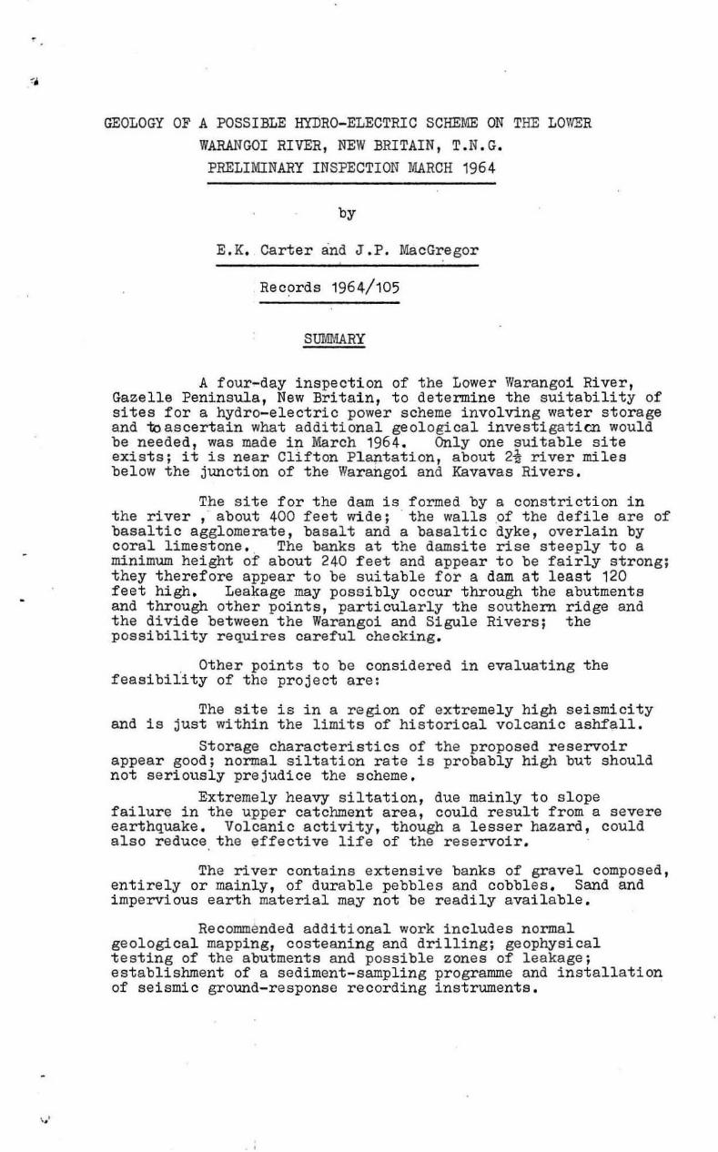
Figure 1: Lower Warangoi River, showing alternative damsitee. Scale approximately 1 inch: 2 miles .
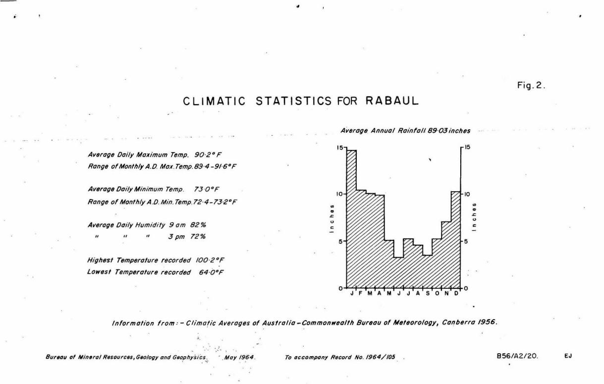
, 2: Climat~c statistics for Rabaul.
3: Schematic profi l e through abutments of Damsite A. ,
4: Schematic section a long river at north abutment of Damsite A. ,
5: Geological observations a long Warangoi River near Damsite A. Scale approximate ly 3 inches: 1 mile.
6, Isoseismic lines for January 1941 earthquake ' (reproduced from Fisher, 1944). Scale 1 inch: 70 miles.
o
,.'
GEOLOGY OF A POSSIBLE HYDRO-ELECTRIC SCHEME ON THE LOVffiR WARANGOI RIVER, NEW BRITAIN, T.N.G.
PHELIMINARY INSPECTION MARCH 1964
by
E.K. Carter and J .P. MacGregor
Records 1964/105
SUMMARY
A four-day inspection of the Lower Warangoi River, Gazelle Peninsula, New Britain, to determine the suitability of sites for a hydro-electric power scheme involving water storage and toascertain what additional geological investigaticn would be needed, was made in March 1964. Only one suitable site exists; it is near Clifton Pl aptatlon, about 2! river mi les below the junction of the Warangoi and Kavavas Rivers .
The site for the dam is formed by a constricti on in the river , about 400 feet wide ; the walls .of the defile are of basaltic agglomerate, basalt and a basaltic dyke, overlain by coral limestone. The banks at t he damsite rise steeply to a minimum height of about 240 feet and appear to be fairly strong; they therefore appear to be sui table for a dam at least 120 feet high. Leakage may possibly occur through the abutments and through othe r pOints, particularly the southern ridge and the divide between the Warangoi and Sigule Rivers; the possibility requires careful checking.
. Other pOints to be considered in evaluating the feasibility of the project are:
The s ite is in a region of extremely high seismicity and is just within the limits of historical volcanic ashfall.
Storage characteristics of the proposed reservoir appear good; normal siltation rate is probably high but should not seriously prejudice the scheme .
Extremely heavy siltati on , due mainly t o s lope failure in the upper catchment area, could result from a sever e earthquake . Volcanic activity, though a l esser hazard , could also reduce the effective life of the reservoir .
The river contains extensive banks of grave l composed, entirely or mainly, of durable pebbles and cobbles. Sand and i mpervious earth material may not be readily avai l able .
Recommended additional work includes normal geological mapping, costeaning and drilling; geophysical testing of the abutments and possibl e zones of leakage; establi shment of a sedi ment - sampling pr ogramme and installation of se i smic ground- response recording instruments.
" • • • • • ,
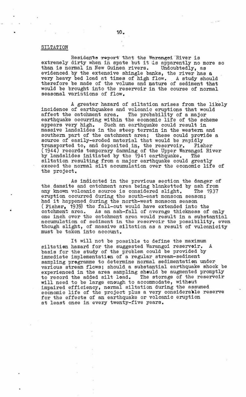
- - - -_ Gully
LOWER WARANGOI RIVER, NEW BRITAIN SHOWING LOCATION OF ALTERNATIVE OAMSITES GULLI[S AHDHAAROW DIVIDE NEAll aAIIISITE" ALSO SHOWN
VI 0
,. " II I"
._ ._ ._ . DIvitill Forming soutll-80s/. rn and Appror. imof. Scole
•
Fig .1.
Woron~oi
Boy
soutll8rn boundary of storog8 orN for Damsi ltl A . _ o:i";"';O. · __ ";===i"~~"'s IIIn ..
To accompany R.cord No. 196-1/ 105
Bur.ou of Mineral ResDurces, Gtlology Qnd Gflophysics . "'0)'1964 . B56/ A2119 . EJ
'.
"
'.
"
,...,.. ....... ---
INTRODUCTION
Future ,electricity supply requirements for Rabaul, New Britain, make the early development of a source of hydroelectric power desirable. The hydraulic characteristics of the streams of the Gazelle Peninsula appear to limit the available energy, at economic cost, t 'o the T.wanokoko - Pando Rive r system and the Warangoi River. Geological investigations show that the Towanokoko - Pondo project would be very expensive and that it might n0t be possible to guarantee the integrity of the scheme against l andslides. (Fisher, 1959; Carter, 19£2 and Best in prep . ) .
The Commonwealth Department of Works therefore requested the Bureau of Mineral Resources in a l etter dated 31st December, 1963, to carry out a geological investigati on of two possible ~ites for a dam and power station on the Lower Warangoi River. This re port is the result of a four-~ay i nspection .y the authors , in the company of Mr. H. Berg, Commonwealth Department of Works Engineer, carried out from the 7th to 11th March 1964, and contains r ecommendations for further investig$tions.
, , Of the two sites se l ected f or inspection the l ower
site (see Figure ,1) proved to have a very low right abutment, an inadequate l eft abutment , and to be composed of soft, ,gently dipping Siltstone, pebble beds and probably permeable conglomerate . The upper site was found to be a very suitabl e site on grounds of topography r eservoir capacity, and geology.. No further suitable site was found between the junction of the Kavavas and Vpper Warangoi* Rivers and the sea. The remainder of this report is therefore concerned only with the upper site shown :in Figure 1 as Damsite A.
Location
The Warangoi River and its tributaries drain a large part of south-eastern and central Gazelle Peninsula, and discharge into t~e sea on the east coast of the Peninsula, 24 sir miles south- east of Rabaul and 13 miles south-south-east of Kokopo (Plate ,3 and Figure 1). Dam site A is about 8 air miles from the mouth of the river and about 2 air miles -2t river miles - 'below the junction of the Upper Warangoi and Kavavas Rivers. , It is about one mi l e south of Clifton Plantation Homestead.
I
* Also known as ~he Nengmukta River.
•
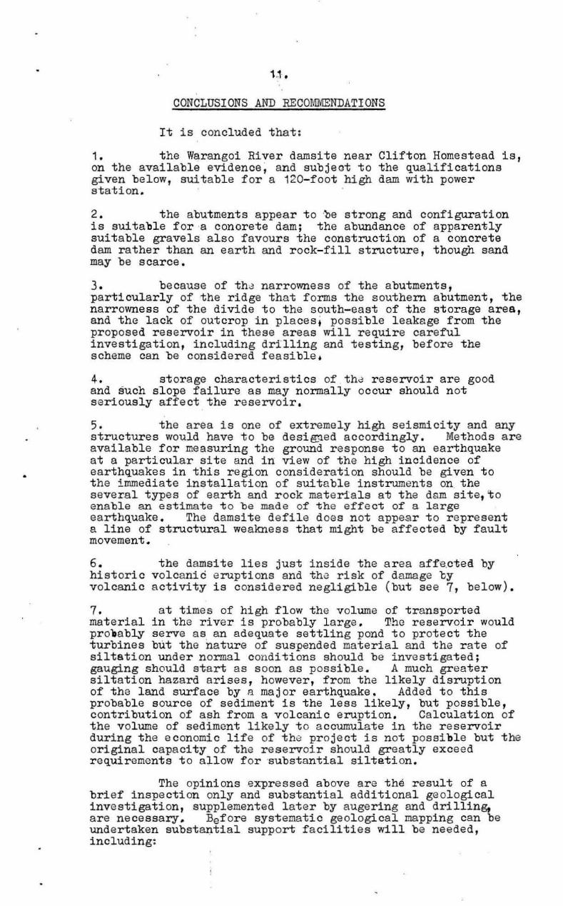
CLIMATIC STATISTICS FOR RABAUL
Average Doily Moximum Temp. 90-2 0 F
Ronge of Mon/hly A.D Mox. Temp. 89·4 _91-6" F
Averogtl Doily Minimum Temp. 73 'O°F
Range of Monthly A .a . Min. Temp.72·4-73·2°F
Averoge Ooily Humidi fy 9 om 82 %
" " I' 3pm 72%
Highesl Tempera/ure recor ded IOO'2°F
Lowest Templlrolure recorded 64·b oF
• • ~
u
•
Average Annual Rainfall 89-03 inches
15 15
10
5
0·~~~f"<1':"+~~4''+''~1<:4-0 J F M A M J J A SON 0
• • ~
u
•
Informal/on from : - ClimatiC Averages of Australia -Commonwealth 8ur8ou of Meteorology, Canberra 1956.
'.
Bur."11 01 Mln.'D' R8SDurctJs, G~/ogy lind G80physics . . '
. May 1964 . To (lccompany Rscord No. 1964/ 105 .
•
Fig . 2 .
856 /A2/20 . EJ
•
•
,
2.;
Access
Access from Rebaul is by the coast road to Kokopo and Cape Gazelle, ' a distance of 19-20 miles i.e. about one mi le past Kokopo , where the Upper Warangoi Road via Tobera is taken for seven miles - ' about one mile past the war-time Tobera airstrip. Plantation roads are then followed for five miles to Clifton Homestead. The turn-off from the Upper Warangoi Road is indicated by a sign bearing a number of vlantation names, headed by Wonga-Wonga (and not including Clifton). On the plantation r oads the left hand road is taken throughout ignoring minor tracks except where a sign indicates the Clifton Homestead to the right or straight ahead . From Clifton Homestead access may be obtained by plantati on r oat with gravel surface to the river about one river mile upstream from the damsite. The north abutment may be approached within about a quarter of a mile by pl antation tracks. No tracks to the south of the river approach within usable distance of the southern abutment of the damsite. The onl y practicable way to approach the southern abutment is by boat or by swimming across the river. All public roads are serviceable at most times, and plantation roads are gene~ally maintained except afte~ heavy rain.
Climate , TopOgraphy and Vegetation
The Warangai area is subject to two seasonal influences : the north- west monsoon from the months of November to April , and the south-east monsoon from April t o November. Consequently, the area has a constant high temperature and humidity but judging from statistics for Rebeul (see Figure 2), most rain falls during the north-west monsoonal season . Details of rainfall are not presently available. The average annual r ainfall at Rabaul is 89 inches and at Kokopo is 83i inches. These figures are l owe r than for most parts of New Britain and it may be assumed that the rainfall in the catchment area is rather higher than 90 inches. The Lower War angoi Hi ver and its tributaries drain the e s st-central portion of the Gazelle Peninsula , e?st from the nearby 8,000 foot-high Mount Sinewit . The dam site is sbout 100 feet above sea l e.vel at river level and is f ormed by two steep spurs about 400 feet apart at river level. In this area the Warangoi vs lley is approximately 2 miles wide and f alls from country 500 to 4, 000 feet high, in a series of dissected gullies and ridges. Relief is moderste but some of the gullies are extremely steep , and deeply incised. The fall of the river above the damsite is f airly gent le; for example,
the f all from the junction of the Kavsvas and Upper Wsr angoi Rivers to the damsite, a distance of about 2! river miles, is only about ZIl feet. A 120-foot high dam would probably impound water back some eight 0, ten miles . The damsite therefore has excellent storage chara cteristics.
Natural .vegetation consists of tropioal rain forest with tall timber and extensive undergrowth. Much of the northern side of the Warangoi Vall ey has , however, been planted with cocoa and coconut. Minor portions of these woul d be inund~ted by the proposed dam.

• 3.
Hydrology
No sa~isfactory gauging has been carried out on the Warangoi river>. A. stream gauging station with float recorder and gauge stick was established in October 1955 at Kamarere on the Upper Warangoi River (see Plate 1) but the section proved to be most unstable and the station was abandoned in September 1959. The maximum flow measured during the period of operation was 1157 cusecs (oubio feet per second) and the minimum flow was 45 cusecs. The station gauged only a small part of the river system.
At the damsite the river normally runs strongly, and in time of spate a very considerable volume of swiftly-moving, turbulent, silt- and debris-laden water passes through the defile.
Itinerary of Investigation
Two and one half days were spent inspecting the abutments and environs of the damsite, and noting suitable construction material s. In the course of a 50-minute charter flight by Piper Aztec the Site, including most of the storage area, was inspecte4 from the air , and on the final day a dinghy trip was made from theWarangoi (Nengmukta) Bridge to below the alternative damsite to form some opinion as to the geology of the storage areaj availability of construction materials, and to ensure that no other suitabl e damsites were available .
Previous Investigations
No previous investigations of the engineering geology of the area have been carried out. A general account of the geol ogy of the area is included in Noakes (1942), which presents the geology of New Britain.
REGIONAL GEOLOGY
The follOwing account of the regiona l geology is drawn from Noakes (1942) and Fisher (1939), supplemented by the observations in the immediate vicinity of the damsite, including particularly an examination of river gravels. Nost of the western part of the catchment area appears to ' consist of Baining 'Series t - metamorphics and intrusives - t ogether with , presumably Lower Tertiary, volcanic rocks. Gravels in the vicinity of the damsite consist mainly of intrusive igneous and volcanic cobbles md pebbles with some ~uartzite and jasper. The Miocene limestone, marl and mudstone which is a feature of the Pondo - Towanokoko area , and which were 'referred to by Noakes as the Neogene Series, appear to be absent in the catchment and storage area of the Warangoi damsite. At l east no pebble s of lime stone and mudstone were observed.
* Since the site inspection was made a gauging station was installed a few hundred f eet· upstream from tho damsite .
•
,-- ~
,
s
4.
The abutments of t4e damsite consist of basic, largely fragme~tal, volcanics, presumably of Lower Tertiary age, overlain in part by Upper Mi ocene coralline limestone (see Appendix 2). These strata appear to be gently dipping to flat-lying and have possibly been faulted. Upstream from the damsite the valley of the river contains exposures of flatlying sil1;s, ' gravels and some minor conglomerate. Some of the silts are probably limey and near the damsi te contain frag-ments of Qoth c,oral limestone and volcanic rocks. They dip off the volcanips and coral of the abutments, and elsewhere are flat-lying to gently folded. Downstream from the damsite similar sediments, although generally perhaps more marly, occur widely; one cliff appeared to be about 60 feet high. These presumably form ', part of Noakes' 'Lamogai Series'. At alternative damsite B the 'Lamogai Series' is overlain by poorly consolidated conglomerate. Noakes regards the 'Lamogai Series' as Pleistocene in age and presumably the conglomerate io sub-Recent.
ENGINEERING GEOLOGY
DAMSITE ,
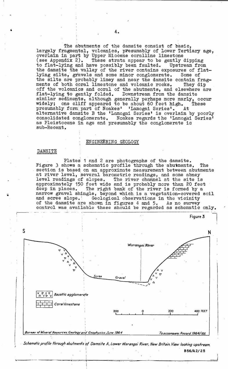
Plates 1 Rnd 2 are photographs of the damsite. Figure 3 showe a: schematic profile through the ·abu .. ments. The section is based: on an approximate measurement between abutments at river level, :several barometric r eadings, and some abnay level readings of slopes. The river channel at the site is approximately 150 feet wide and is probably more than 20 feet deep in places. The right bank of the river is formed by a narrow gravel shingle, beyond which is a vegetation-covered s oil and scree slope. ~ Geological observations in the viCinity of the damsite are shown in figures 4 and 5. As no survey control was avai~able these should be regarded as schematic only.
v • " . v • • • v • • v
v v
I "L:. t"v ~ '0 v I BaSi/llic ~g910mer'ate
II: I ; I : II Cor.t/;imestone
Figure 3 -I
N
Warangoi River
200 0 ZOO 400 FEET L' :......_~~----', _____ .LI __ ~_---"'
Schem4fic profile fhro/Jgh ahufmenfs ~f Damsife A, Lower Warango; River, New Bri/ain. View looking upsfream.
856/42/25
•. --
0'
I I I
5 •
. _ - - - - -.--- -
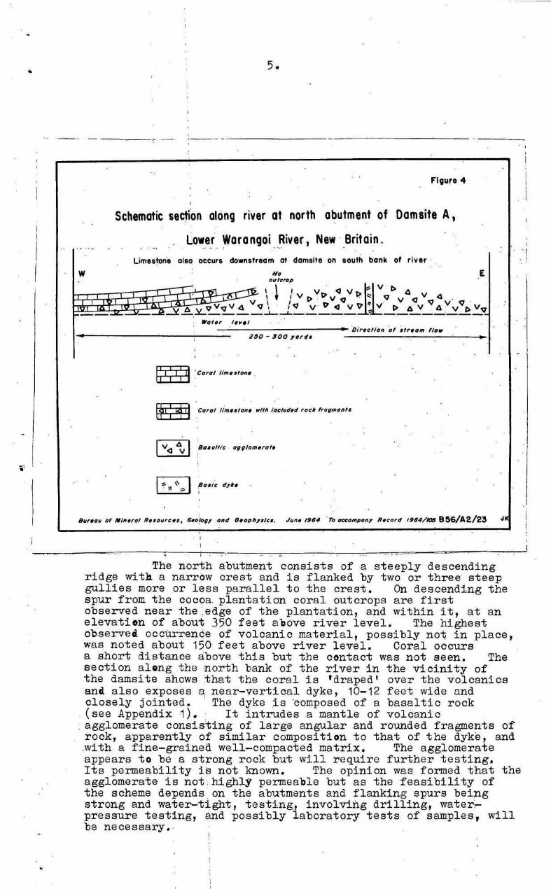
FI9ure 4
Schematic seclion along river at north abutment of Damsite A.
Lower Warangoi ~iver. New ' Britain.
• 2~O - SOO yorv • •
r •
, 8I1r,,,,, ill lII/fI.rol Rutltl";U, G.o{c>", "ltd tlU'''ItJ'Ii~'. Jun. ,g.4 . To _'M'p''', RIelI'd 1984/1tJ8 8 ~6/A 2/23 ,J
,
'" ----The north abutment consists of a steeply descending
ridge with a narrow crest and is flanked by two or three' steep gullies more or less parallel to the crest. On descending the spur from the cocoa. plantation coral outcrops are first observed near the :edge of the plantation, and within it, at an elevation of about 350 feet above river level. The highest observea occ~renqe of volcanic material, possibly no~ in place, was noted about 150 feet above river level. Coral occurs a short distance above this but the contact was not seen. The section along the ,north bank of the river in the vicinity of the damsite shows ',that the coral is 'draped' over the volcanics anti also exposes a near-vertical dyke, 10-12 feet wide and closely jOinted. ' The dyke .is 'composed of a basaltic rock (see Appendix ·1). It intrudes a mantle of volcanic
: agglomerate consisting of large angular and rounded fragments of rock, apparently of similar composition to that of the dyke, and .with a fine-grainea well-compacted matrix. The agglomerate appears to be a st~ong rock but will require further testing. Its permeability is not known. The opinion was formed that the agglomerate is not ~ highly permeable but as the feasibility of the scheme depends on the abutments and flanking spurs being strong and water-tight, testing, involviilg drilling, water,pressure testing, and possibly laboratory tests of samples, will be necessary. ·
I
I
, , .,
6.
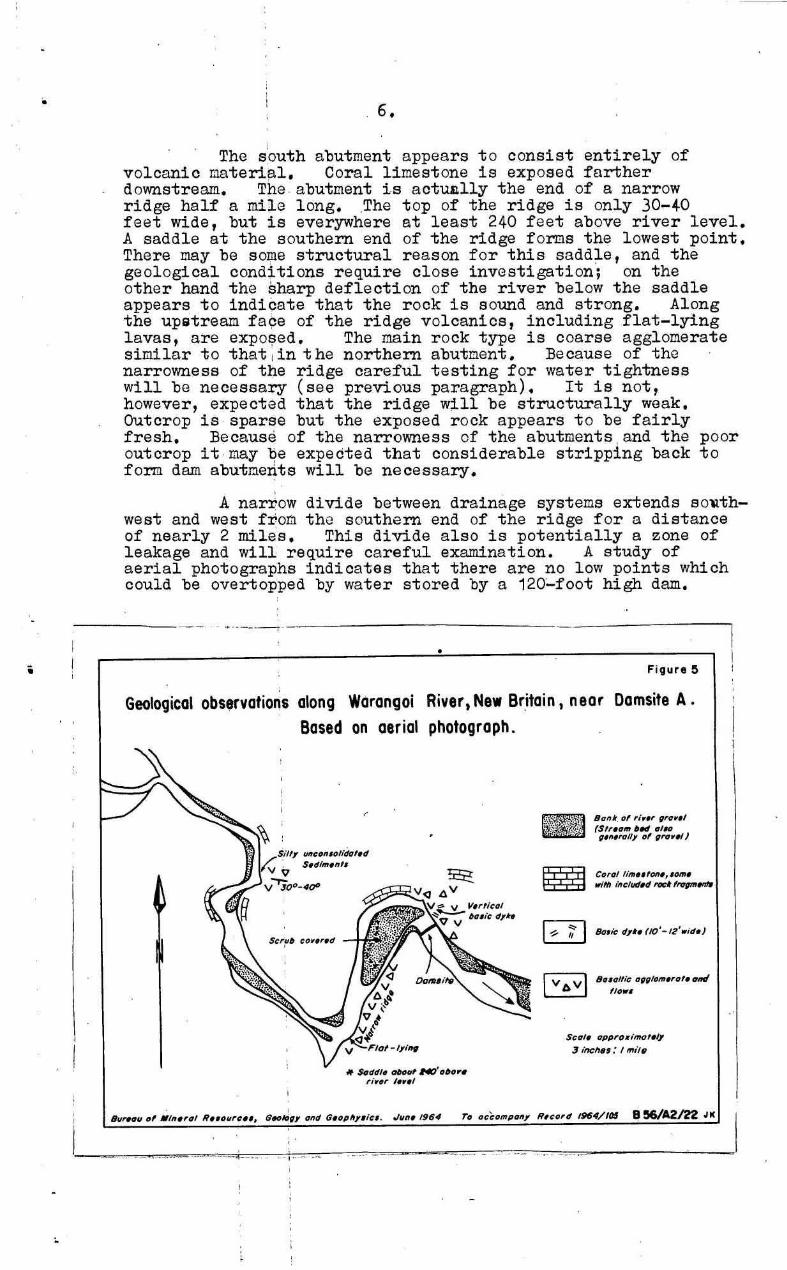
The s 'outh abutment appears to consist entirely of volcanic materi~l. Coral limestone is exposed farther downstream. The . abutment is actU1l11y the end of a narrow ridge half a mile long. .The top of the ridge is only 30-40 feet wide, but is everywhere at least 240 feet above river level. A saddle at the southern end of the ridge fOrDS the lowest paint. There may be some structural reason for this saddle, and the geological conditions require close investigation; on the other hand the sharp deflection of the river below the saddle appears to indicate that the rock is sound and strong. Al ong the upstream fa~e of the ridge volcanics, including flat-lying lavas, are expo~ed. The main rock type is coarse agglomerate similar to that I in t he northern abutcent. Because of the narrowness of the ridge careful testing for water tightness will be necessary (see previous paragraph). It is not, however, expected that the ridge will be structurally weak. Outcrop is sparse but the exposed rock appears to be fairly fresh. Because of the narrowness of the abutments . and the poor outcrop it may ~e expected that considerable stripping back to form dam abutments will be necessary.
, A narrow divide between drainage systems extends so~th
west and west fro~ the southern end of the ridge for a distance of nearly 2 miles. This divide also is potentially a zone of leakage and will require careful examination. A study of aerial photographs indicates that there are no low paints which could be overtopped by water stored by a 120~foot high dam.
i Figure ~
Geological obs~valians along WCirangol River, New Britain, near Damsile A.
-- -,~ .... --
Based on aerial photograph.
tIIIctl"."IIdf/f.d 5.<11",.""
-1),1".
if $o<1dl. «Hid , .. ;lOfH,,'. rf •• r , ... 1
J~". 1964 To
--,- - .-
lIoMr of ""., fI"" •• ' (5"."", • ., tI'N '1.,.."On, of fin",,, J
Scotti I1PP'(lIIimalttV
;] [nc".,: I "'lf~
•
No evidence was found for any structural control of the river course at the centre line of the damsite. The f ounda tions at this. point will, of course, have to be tested; the material of which they are composed is unknown. The remarkably sharp line of the north-west side of the southern ridge suggests some structural control. This view is re-inforced by the absence of volcanics on the opposite, left hand, bank of the river. If this is indeed a f ault lineament it would appear to pre-date the coral which overlies the v olcanics, as the impression was gained that the coral was draped over the volcanics, without dislocation. Outcrop, however, is discontinuous. An alternative interpretation is that the southern ridge forms the north-western a rm of a sYncline.
Owing to lack of time and poor exposures no opinion was formed of the geology to the north of the northern abutment and to the south ·of the southern ridge. Mr.J.DunberReid, partowner and manager of Clifton Plantation, r eports that near the homestead the following near-surface succession occurs: 1 foot of black soil, underlain by.4 feet of pumice, which in turn is underlain by an unknown thickness of red clay. The red clay is described as generally Silty, not very plastic, and is stated to dry t o a very hard, severely cracked , surface .
Both the volcanics and the reef limestone by their nature are probably irregularly dist~ibuted. It will therefore be necessary to investigate thoroughly their distribution where possible leakage paths exist. The volcanics ar~~xpected to have highly magnetic properties and to have high,oGismic velocities than the surrounding coral limestone and unconsolidated sediments, and should ·therefore be amenable to delineation by geophysical methods •
STORAGE AND CATCHMENT AREAS
The geology of the storage area is described in general terms under regional geology. No limestone other than the re ef limestone described above was observed; however, . little of the storage area has been exwcined. No pumiceous material was seen below top water level for the proposed dam although some of the sediments may contain volcanic debris. The reconnaissance inspection did not indicate any grounds for anticipating leakage problems from the storage area, other than through the s outhern ridge and divide, and possibly around the north abutment, as described above. More detailed examination of the geology of the storage area is required.
In general the land surfaoe in the s torage area has quite gentle slopes and it is not expected that slope stability will prove a serious problem. Undoubtedly minor slope failures will occur but this should not result in any serious diminution i ·n the ,volume of the storage nor jeopardise the dam structure. Fisher (194"4) r eports only minor cracking and slipping as a r esult of the very strong J anuary 1941 earthquake.
The upper part of the catchment area (which was not visited) is in steep terrain and probably minor land slips occur quite frequently. Fisher ( 1944) records damming of the Upper Warangoi River by the 19+1 earthquake. Large-scale slope failure in steep parts of the cotchment area during earthquakes could r esult in serious siltation of the storage area,
•
8.
The possibility of serious siltation due to seismic or volcanic activity is discussed further in a later section (p . 10 ' ).
CONSTRUCTION MATERI ALS
Concrete Aggregate and Sand
A most impressive feature of the Warangoi River course both above and below the damsite is the extensive gravel banks (see Plate 1, Fig.1, and Figure 5). The cobbles and pebbles i n these banks generally do not exceed 8 inches in length and most of the pebbles appear to be betweeh 1 and 3 inches in diameter. They are well-rounded and consist of hard , durable material. Most appear to be of igneous origin - both intrusive and volcanic; some quartzite was seen and A few jasper pebbles al so were noted. Pebbles and cobbles appear to consist of material suitable for concrete aggregate , but opaline or cryptocrystalline s ilica may possibly occur in some of the volcanic pebbles and normal reactivity tests would heve to be conducted. Some sand banks were observed but sand does not ' appear to be as abundant as gravel. The gravel banks appear to consist only of coarse material at the surface but probably extensive finer material occurs between the pebbles at depth. The _ gre~.test thickness of gravel observed was a bout five feet but it is probable that greater thicknesses exist.
Impervious Core Material
Extensive occurrences of flat-lying, ' soft, silty . sediments immediately upstream and downstream from the damsite appear to offer possibilities for i mpervious core material • Str a ta examined pr oved to be non-plastic silts; the compactability and permeability of the sediments is not known. Further, the variability in lithology and thin bedding make the material unattractive. If an earth-cored rook-fill dam is considered the red clays reported by Mr . Dunbar-Reid should also be examined. These clays, judging by Mr . Dunbar-Reid's description, may not in themselves be suitable but may pr ovide useful blending material .
Rock-fill
The shingl e banks described above contain a very l arge volume of r ock material. Surface material appears to l ack adequate fine-grained components, but augering or pitting may reveal a considerably higher proportion at depth. In view of the high seismicity of the area (see below) very thorough testing of the compactability and shear strength of the gravels will be necessary before they could be accepted for rock-fill.
Only small quantit ies of other materia l suitable for quarried rock-fillfother than that in the abutments,was . observed. Presumably other volcanic materials are present in the vicinity .and, failing any near source, Mount Var zin, 7 miles distant, might provide suitable materia l .
,
"
, , , , , , , , , , , , , , , , , , , ,
"
--, /~ ",, , , ,
I , ,, , , , , ,
,
( , , , , , , , , ,
, , ,
, , ,
, , , , , , ,
, , ,
t7 ------- --- - ~ '1{. ,.,i •. --_ '\) ----
-. --
---
-' --_ .--
, , , , , , , , ,
----------, .
.--
-----------_ ...
• ,
. , ,
; -,
---, ,
Figure 6
" . ,
· · , •
, , ,
, , , , ,
,
,
, , , , , ,
,
, , , , ,
"
, , , , , , , , , , , , , , , "
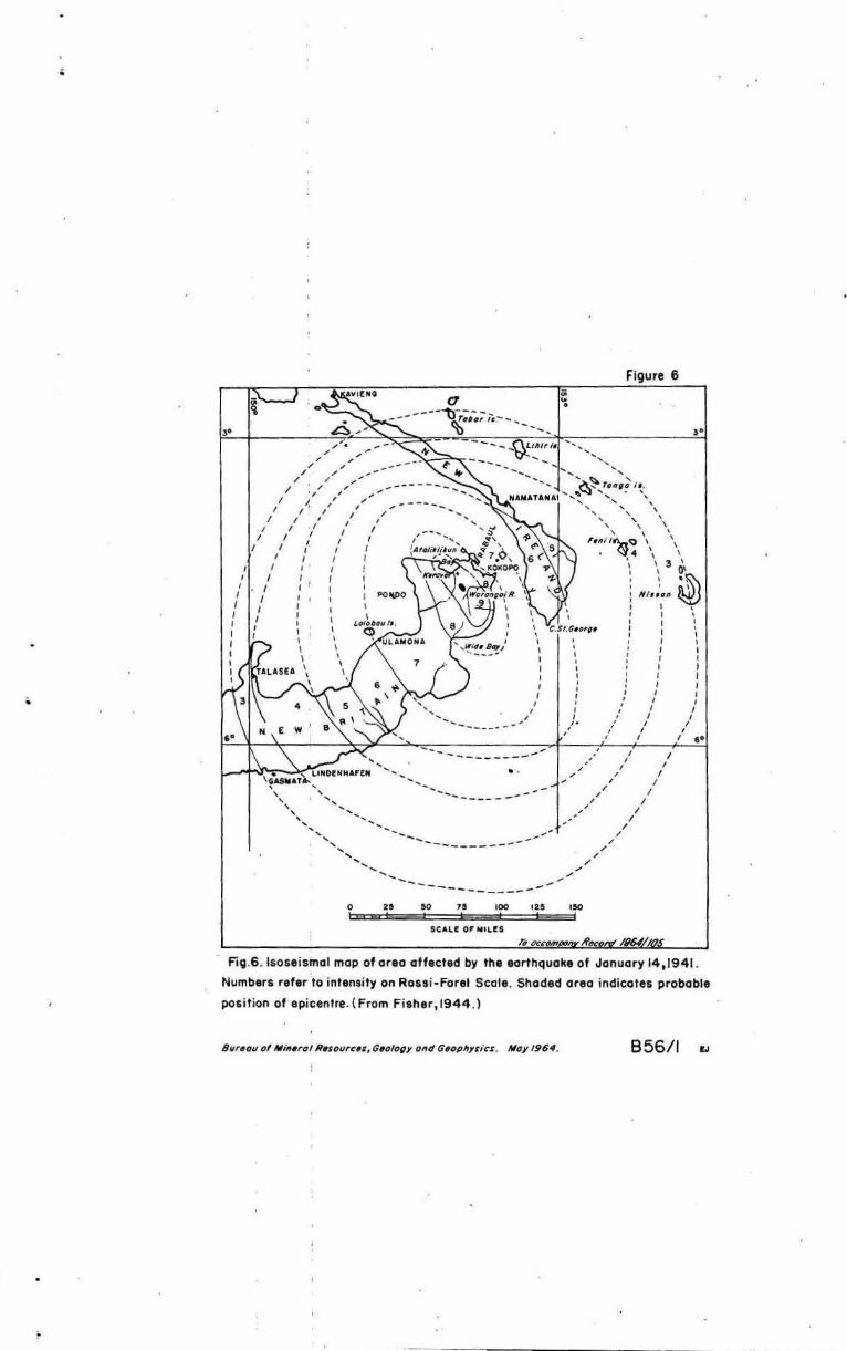
Fig.6 . lsose ismol mop of or. a ott.cted by the earthquake of January 14,1941.
Numbers ref.r to intensity on Rossi -Forel Scol • . Shaded area indicates probable
position of epic.nfre. ( From Fisher,1944 .)
856/1
..
•
•
9.
SEISMICITY AND VULCANICITY
All earthquakes of magnitude 5 (Richter scale) or greater" r ecorded by, or r eported to, the United States Coast and Geodetic Survey fOE the ygars 1956-1963, t hat hSve occurred wit~in the l atitudes 4 and 5 S. and l ongitudes 151 30' and 152 45'E, are shown in Plate ••
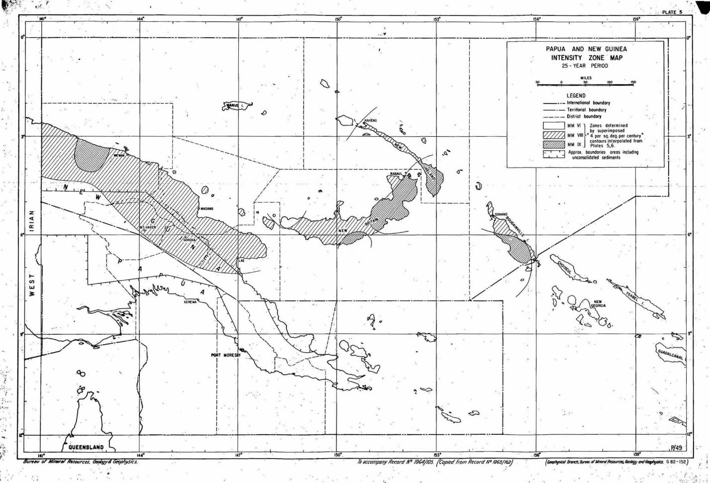
Brooks (1963) has s tudied the available r ecords of seismicity in the New Guinea Islands and has produced maps showing the probability of occurrence of an earthquake of given intensity in those areas . One map _repr oduced in this r eport as Plate 5 - shows that the Warangoi damdlte lies within a zone in which earthquakes of intensity 9 (Modified Mercalli scale) can be expected within n ·25-year period; another shows that an earthquake of intensity 10 can be expe c~ed in a 100-year period . Any hydr~olectric project er ected in the a rea would therefore have t o ~e designed f or high ac ce l er ations. Fisher (1944, Figure 2 ; reproduced as Figure 6) indicates that the damsite was subjected t o an intensity of 9 (Rossi-Forel sca l e) in t he January 1941 earthquake (see alsO Fisher, 1946). Damage a long the Lower Warangoi Valley was reported t o be slight: some incipient land slipping and cracking. It therefore appears that structures suitably designed and positioned would not sus tain damage from l and slides " except in very exceptional circumstances.. The inspE;! ction failed .t o r eve al any structural e l ements within the aamsite al ong which f ault movement in the course of an earthquake .coul d be expe cte d.
As detailed seismic dat a , particularly about ground response to earthquakes of variOUS magr. 1tudes , are needed for the design of insta llati ons,steps should be t aken t o install s i mpl e ground-response instruments on volcanics, coral limestone and soil as s oon as possible (see Brooks, 1963). Model studies will be needed l ater t o ascertain the hydraulic effects of earthquake-induced waves in the r eservoir.
Plate 01 of Fisher ( 1939) shows that the War angoi d amsite is just within the limit of aehfall in the 1937 eruption of Vulcan and Matapi (Tavurvur). This erllpti on was the most viol ent in the Blanche Bay area in historic time and is considered by Fisher to have been the most violent f or a very considerable time .
Mount Varzin t 7 miles distant, is part of the Blanche Bay vol cani c complex (Fi sher, 1939) . Ther e is, however, no historical record of a ctivity or present signs of thermal a ctivity and ther ef or e the possibility of eruption need not be c ons idered seriqusly.
* The Richter sca l e is a me asure of the energy released at the foca l point in the form of el astic waves. The greatest r e corded magnitude is about Si . Two scales ar e used to indioate the in~ensity of an earthquake at any given point on the earth's crust: the Rossi-Forel scale has a range of 1-10 and the more oommonly used Modified Mercalli scale has a range of 1-12. In each scale Value 1 r epr esents a" tremor which is barely perceptible by human senses under the most f avourable conditions and the upper figure represents an earthquake t hat produces total, or almost total, destruction.
, .'
SILTATION
Residenl1e 'reporl" that the Wnransoi "'River is extremely dirty when in spote but it ~s apparently no more so than is normal in New Guinea rivers. Undoubtedly, as evidenced , by the extensive shingle banks, the river has a very heavy bed load at times of high flow. A study should therefore be made of the volume and nature of sedtment that would be brought into the reservoir in the course of normal seasonal variations of flow.
A greater hazard of siltation arises from the likely incidence of earth'luakes and volcanic eruptions that would affect the catchment area . The probability of a major earth'luake occurring within the economic life of the scheme appears very high. Such an earth'luake could result in massive l ands l ides in the steep terrain in the western and southern part Of the catchment area; these could provide a source of easily- eroded material that would be r apidly transported to, and deposited in, the reservoir. Fisher (1944) records temporary damming of the Upper War angoi River by landslides initiated by the 1941 earth'luake. The siltation r esulting from a major earth'luake could greatly exceed the normal silt accumulation over the economic life of the project.
As indicated in the previous section the danger of the , damsite and catchment a rea being blanketted by ash from any known volcanic source is considered slight . The 1937 eruption occurred during the south-east monsoon season; had it happened ,during the north-west monsoon season (Fisher, 1939) the fall-out would have extended into the catchment ares. As an ash-fall of average thickness of only one inch over the catchment area would result in a SUbstantial accumulation of sediment in the reservoir the possibility, even though slight, of massive' siltation as a result of vulcanicity must be t aken into accoUnt.
It will not be possible to define the maximum siltati on hazard for the suggested War angoi reservoir. A basis for the study of the problem could be provided by immediate implementati on of a regular stream-sediment sampling programme to determine normal sedimentation under various stream flows; should. a substantial earthquake shock be experienced in the area sampling should be augmented promptly to r ecord the added silt load. The storage of the reservoir will need to be large enough to accommodate, without impaired efficiency, normal siltation during the assumed economic life of the project plus a very considera_le reserve for the effects of an earthquake or volcanic eruption at least once in every twenty-five years.
u.
CONCLUSI ONS AND RECOMMENDATIONS
It i s concluded t hat :
1. the Warangoi River damsite near Clifton Homestead is, on the available evidence , and subjeot to the qualificati ons given bel ow, suitable f or a 120-foot high dam with power s t ation. .
2. the abutments appear t o 'be strong and configurati on is suitable f or a concre t e dam ; the abundance of apparently suitable gravels also f avours the construction of a concrete dam r a ther than an earth and r ock-fill structure , though sand may be s carce .
3. because of th~ narrowness of the abutments, particularly of the ridge t hat f orms the s outhern abutment, the narrowness of the divide t o the south-east of the s torage area, and the l ack of outcrop in placesj possible l eakage from the pr oposed reservoir in t he se areas will r equire careful investigati on, including drilling and testing, bef or e the scheme can be considered f easible .
4. storage characteristics of ,thd reservoir are good and such slope f ailure as may normally occur should not seriously affe ct t he re servoir.
5. the ar ea is one of extremel y high s eismicity and any structures would have t o be de si g,ed accordingly. Methods are available f or moasuring the ground r esponse t o an earthquake at a particula r site and in view of the high incidence of earthquakes in thi s r egi on consider ati on should be given t o the i mmediat e installati on of suitable instruments on. the severa l types of earth and r ock mat erials at t he dsm site, t o en able an est imat e t o b e made of t he e f fe ct of a l a rge earthquake. The damsite defile does n ot a ppear t o r epres ent a line of structural weakness that mi ght be affected by f ault movement.
6 . hist oric v olcanic
the damsite lies just volcanic eruptions and activity is cons id e red
ins i de the area affe.ctes by the r isk of damage by negligible (but see 7, bel ow) .
7. at times of high fl ow the volume of transported materi al in the river is pr obably l a r ge . The r e servoir would proi ably serve as. an adequat e settling pond t o pr ot ect the turbine s but the nature of suspend ed material and the rat e of siltati on under normal conditions should be investi gated; gauging should s t art as soon as possible . A much great er siltati on hazard arises, however, from t he likely disrupti on of the land surface by A ma j or earthquake . Add ed t o this probable s ource of s ediment i s the l e s s likely, but possible, contribution of ash from a v olcanic erupti on. Calculation of the v olume of s ediment like ly t o a c cumulat e in t he r e s ervoir during the e conomic life of the pr oj e ct i s not pos sible but the original capacity of the r e s ervoir should greatly exceed r equirements t o allow f or ·subs t antial siltation.
The opini ons express ed abov e are the result of a brief inspection on ly and SUbstantia l additi ona l ge ol ogical investigation, suppl emented l at er by augering and drillin~ ar e ne ce esary. Before sy st ematic geol ogical mapping can be und ertaken SUbstantial support f acilities will be needed, including:
(a)
1.2.
secure means of transport or passage from the north to south abutments.
(b) stripping of undergrowth on the north and s outh abutments with some pitting or stripping of soil to expose bedrock. Tr ees should be left standing.
(c) close survey contr ol about ·the north and s outh abutments , with lesser control a l ong the s outhern ridge and the divide shown in Figure 1.
(d) because of the ext ensive area that must be examined f or possible l eakage paths systematic geological mapping would be expedited by large-scale air phot ography (which wi ll, in any case, be needed f or r eservoir storage c omputations) at an early stage of the investigation .
$CAAT' .... l:!:i Owing t o the ~ of outcrop the geological
mapping should be supplemented by geophysica l surveys. The contrasting properties of 80il, coral limestone and volcanics should enabl e excellent results to be obtained by seismic, magnetic and resistivity methods ;
Steps should be taken as s oon as possible to set up, operate a nd maintain ground response measuring instruments to give information on likely foundation and embankment behaviour during earthquakes. It is provisionally suggested that instruments. should be installed on the volcanics, limestone, soil (e.g. at Clifton homestead) and, if prqcticable , on a grave 1 bank.
It is reported that a Japanese defensive line was established in the area during World War II. Enqui ries should t[terefore be made of military authorities as to the danger of unexploded devices such as grenades, bombs and l and mines being prGsent~ and if necessary the area should be checked by mine detectors operated by a bomb disposal unit.
As an investigation is at pr esent under way to select a site f or futUre development of a settlement that would form a satellite to.wnship t o Rabaul, considerati on should possibly be given to the use of any reservoir constructed on the Warangoi River as a town water supply.
ACKNOWLEDGEMENTS
Arrangemen~s and f acilities for ~he insPQc~ion were made by officers of the Commonwealth Department of Works. In particular, in New Brita in Mr. A • . Kinnane, Regi ona l Works Officer, Rabaul, and Mr. H. Berg, Engineer, by their help gr eatly . facilitated the inspection.
The co- operation of Mr. J. Dunbar-Reid, of Clifton Plantation, was also much appreciated .
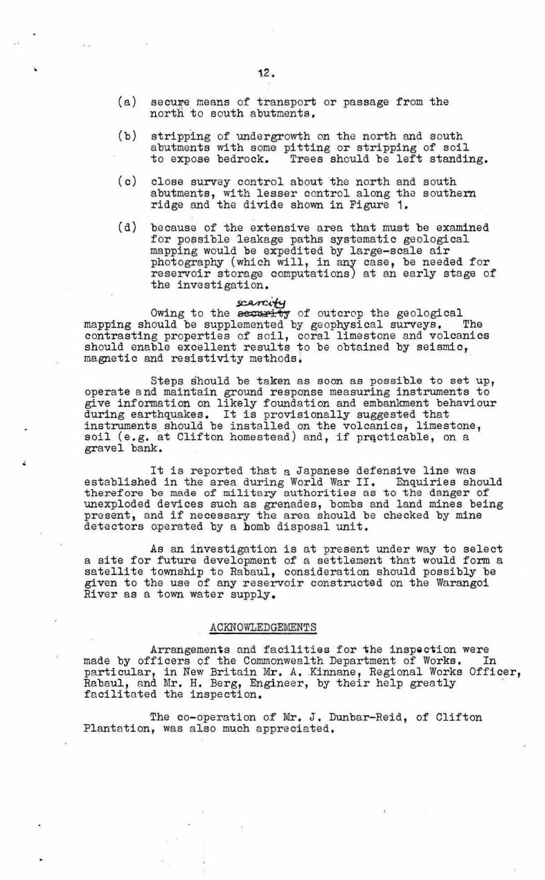
REFERENCES
BEST " E.J., in' prepar ation - Unpublished ~eport on geological investigation of pos's ible Towanokoko -Pondo hydro- electric scheme , September December 1962. To appear in Bur.Min. Resour .Aust . Record Series.
BROOKS, J. A., , 1963 - Earthquake activity and seismic riek in Papua and New Guinea . Bur .Min.Resour . Auet. Rec . 1963/ 162 (unpubl,).
, CARTER, E,.K., ' 1962 - Geol ogical investigation of t he Towan okoko - Pondo hydro-electric scheme, New Britain, Territory of Papua and New Guinea . Bur .Min,Resour. Aust.Rec. 1962/1~0 (unpubl.).
COMMONWEALTH BVREAU OF METREOROLOGY, 1956 - Met eor ol ogical Summary. Climatic averagee Of Australia: temperature, humidity and rainfall 195i. Bur.Meteor. , Cnnberra .
FISHER, N.H., ' 1939 - Geol ogy and vulcanology of Blanche Bay , and the surrounding area , New Britain. Terr.N. Guin . Geol .Bull. 1. '
FISHER, N.H., ,
FISHER, N.H.,
,1944 - The Gazelle Peninsul a, New Britain, earthquake of J anuary 14{ 1941. Bull.Seism . Soc .Amer.34( 1).
:1946 - Administrative centre for the Rabaul distri ct . Bur. Min. Resour. Aust.Rec .1946/32 (unpubl. ) .
FISHER, N.H., :1959 Geological r econnai ssance of the Towanokoko River hydro- el ectric Bcheme . Bur.Min.Resour.Aust . Re c. 1959/120 (unpubl. ).
NOAKES, L.C., 1942 - Geological report on the is l and of New Britain . In nGeol ogical .reports on New Brit ain" by Fisher, N.H ., and Noakes, L.C. Terr .N.Guin. Geol.Bull.3.
.•
-----T----------------------------________________________ __
APPENDIX 1
PETROGRAP,HIC DESCRIPTION OF THREE BASALT sPEcl~mNS FROM DAMSITE A,
,
LOWER, WARANGOI RIVER , NEW BRITAIN
by
W. Oldershaw
i The following petrographic descriptions are of three
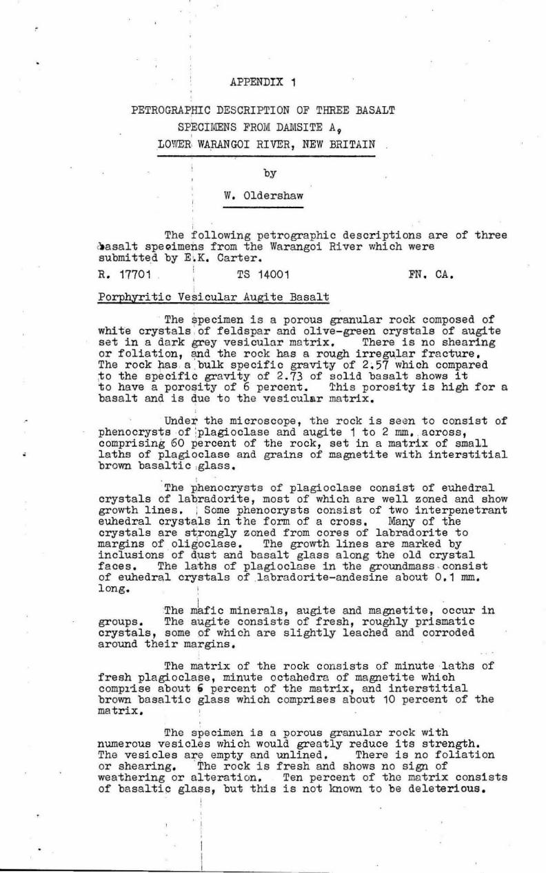
(.asalt spegimens from the Warangoi River which were submi tted by E, K. Carter. R. 17701 TS 14001 FN. CA.
Porphyritic Vesicular Augite Basalt
The specimen is a porous granular rock composed of whi t 'e crystals ' of feldspa r and olive-green crystale of augite set in a dark grey vesicular matrix. There is no shearing or foliation, ~d the rock has a rough irregu.l ar fracture. The rock hasa .bulk specific gravity of 2,57 which compared ,to the specific gravity of 2.73 of solid basalt shows it to have a porOsity of 6 percent . ~his porosity is high for a basalt and is due t o the vesicular matrix.
Under the microscope , the rock is s een to consist of phenocrysts of :plagioclase and augite 1 to 2 mm • . aoross, comprising 60 percent of the rock, set in a matrix of small l aths of plagioclase and grains of magnetite with interstitial brown basaltic ,glass.
The phenocrysts of plagi ocl ase consist of euhedral crystals of laqradorite, most of which are well zoned and show growth li:r:le s . 1 Some phenocrysts consist of two interpenetrant euhedral crystals in t he form of a cross. Many of the crystals are st,r ongly z oned from cores of l abradorite to margins of oligoclase . The growth lines are marked by inclusions of dust and basalt glass along the old cryst a l faces. The l aths of pl agioclase in the groundmass . consist of euhedral crystals of .l abradorite- andesine about 0 .1 mm . long.
The mkfiC minerals, augite and magnetite , occur in groups. The augite consists of fresh, r oughly prismatic crystals, s ome of which are s lightly leached and corroded around their margins .
The mat rix of the rock consists of minute laths of fresh plagioclase, minute octahedra of magaetite which compl~se about' percent of the matrix , and interstitial brown basaltic glass which comprises about 10 percent of the matrix.
The specimen is a porous granular r ock with numerous vesicles which would greatly reduce its strength. The vesicles a~~ empty and unli~ed. Ther e is no foliation or shearing. The rock is fresh and shows no sign of weathering or alteration . Ten percent of the matrix consists of basaltip glass, but this is not known t o be deleterious.
•
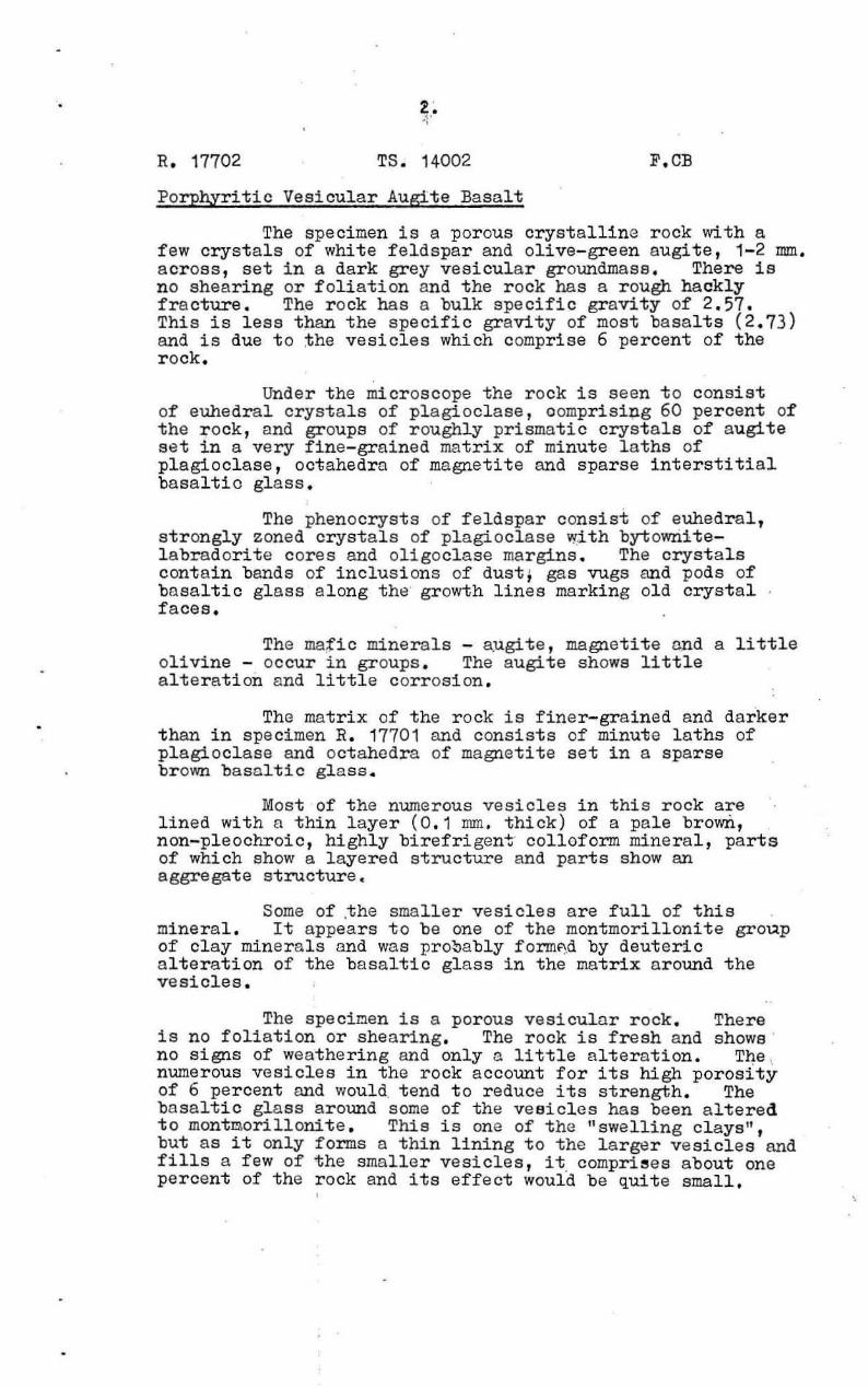
R. 17702
z. " "
TS. 14002
Porphyritic Vesicular Augite Basalt
F.CB
The specimen is a porous crystalline r ock with a few crystals of white feldspar and olive-green augite, 1-2 mm. acr oss , set in a dark grey vesicular groundmase. There 1s no shea ring or foliation and the rock has a r ough hackly fra cture. The r ock has a bulk specific gravity of 2.57. This is less than the specific gravity of most basalts (2.73) and is due to the vesicles which comprise 6 percent of the rock.
Under the microscope the rock is seen to consist of euhedra l crystals of plagioclase, o omprisi~g 60 percent of the rock, and groups of roughly prismatic crystals of augite set in a very fine-grained matrix of minute laths of plagioclase, octahedra of magnetite and sparse interstitial basaltic glass.
The phenocrysts of feldspar consist of euhedral, strongly zoned crystals of pl agiocl ase with bytownitel abradorite cores and oli goclase margins. The crystals contain bands of inclusions of dust, gas vugs and pods of basaltic glass a long tho growth lines marking old crystal faces.
The mafiC minerals - a).lgi te, magnetite ruld a 11 ttle olivine - occur in groups. The augite shows littla alteration and little corrosion.
The matrix of the rock is finer-grained and darker than in specimen R. 17701 and consists of minute laths of plagioclase and octahedra of magnet ite set in a spaTse brown basoltic g l ass 4
Most of the numerous vesicles in this r ock are lined with a thin layer (0.1 mm . thick) of a pa le brown, non-pleochroic, highly birefrigen"!;" colloform mineral, parts of which show a layered structure and parts show an aggregate structure.
Some of ,the small er vesicles ar e full of this mineral. It appears to be one of the montmorillonite group of clay miner a ls and was pro~ably form~d by deuteric a lteration of the basaltic gl ass in the matrix a round the vesicles.
The speci~en is a porous vesicular rock. There is no foliation or shearing. The rock is fresh and shows ' no signs of weathering and only a little alte ration. T~e \ numerous vesicles in the rock account for its high porOSity of 6 percent and WOUld. tend t o r educe its strength. The basaltic glass around some of the vesicles has been altered to mont~orillonite . This is one of the "swelling clays", but as it only forms a thin lining to the larger vesicles and fills a few of the smaller vesicles, it, comprises about one percent of the rock and its effect would be quite small.
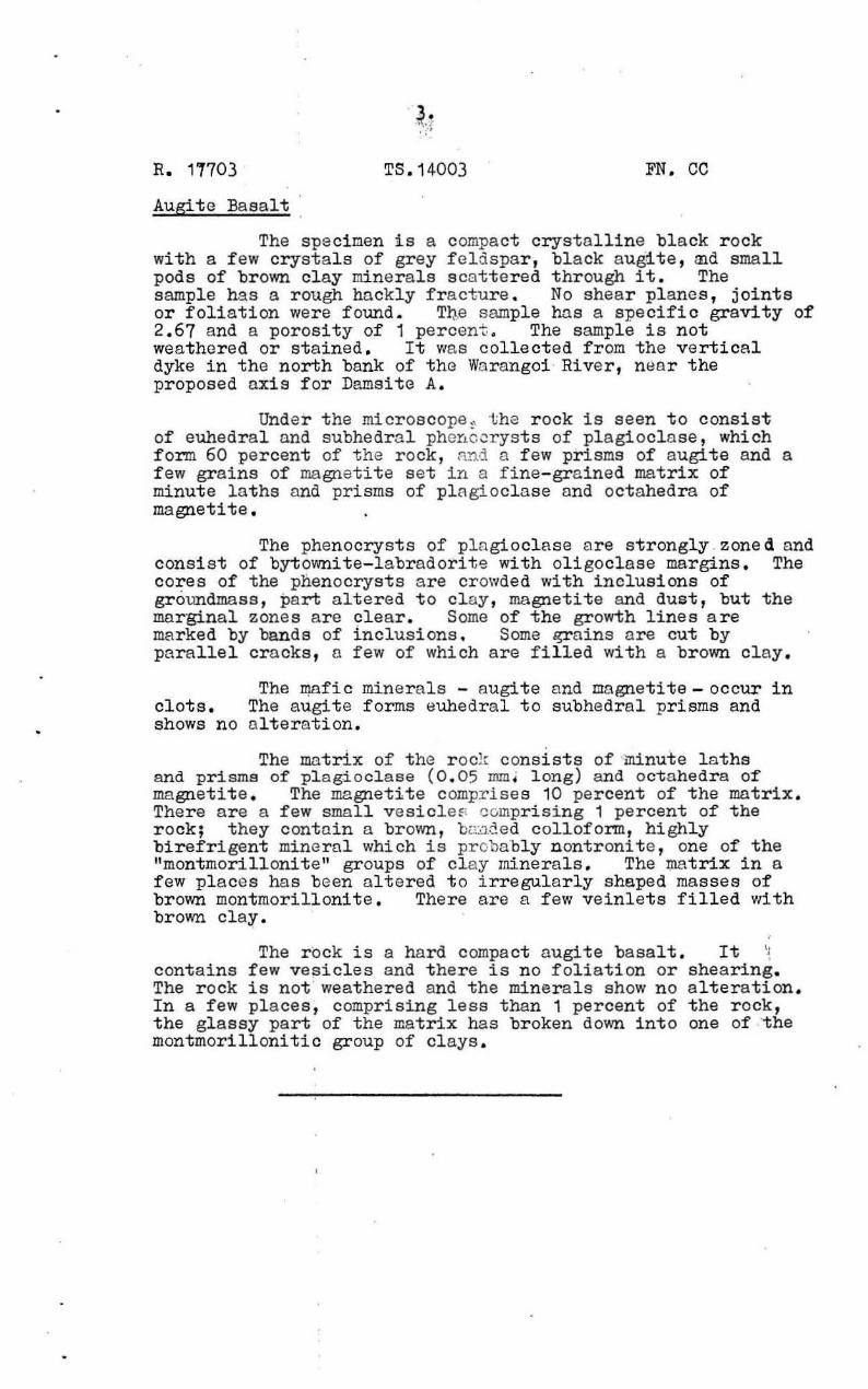
R. 17703 TS.14003 FN. CC
Augite Basalt
The specimen !s a compact crystalline black rock with a few crystals of grey f el dspar, black augite, ~d small pods of brown clay minerals scattered through it. The sample has a rough hnckly fracture . No shear planes, joints or foliation were found. T~e sample has a specific gravity of 2.67 and a porosity of 1 percent . The sample is not weathered or stained. It was collected from the vertical dyke in the north bank of the Wa rangoi · Rive r, n.ar the proposed axis for Damsite A.
Under the rnicro8cope ~ t he r ock is seen to consist of euhedral and subhedra l phe~c orysts of plagioclase, which form 60 percent of the rock, R!ld a few prisms of augite and a few grains of magnetite s et in a fine-grained matrix of minute laths and prisms of plagioclase and octahedra of magnetite.
The phenocrysts of plagioclase a re strongly . zoned and consist of bytownite-labradorite with oligoclase margins. The cores of the pnenocrysts are crowded with inclusions of groundmass, part altered to clay, magnetite and dust, but the marginal zones are clear. Some of the growth lines are marked by bands of inclusions. Some ~ains are cut by parallel cracks, 0 few of which are filled with a brown clay.
The mafic minerals - augite Dnd magnetite - occur in clots. The augite forms euhedral to subhedral prisms and shows no alteration.
The matrix of the r oc}r consists of 'minute l aths and prisms of plag.ioclaae (0 . 05 mmJ long) and oc-tahedra 0-[ magnetite. The megnetite comprises 10 percent of the matrix. There are a few small vesicleE: compriSing 1 percent of the rock; they contain a brown , b~1ded colloform, highly birefrigent minernl which is proba"bly nontronite , one of the "montmorillonite" groups of clay minerals. The matrix in a few pl aces has been altered to irregularly shaped masses of brown montmorillonite . There are a few veinlets filled vdth broMl claro
The r Ock is a hard compact augite basalt. It '; contains few ve~icles and there is no foliation or shearing. The r ock is not" weathered and the minerals show no alteration . In a few pl aces, comprising less than 1 percent of the rock, the glassy part of the matrix has broken down into one of "the montmorillonitic group of clays .
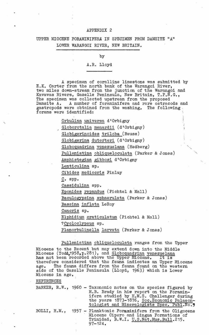
APPENDIX 2
UPPER MIOCENE FORAMINIFERA IN SPECIMEN FROM DAMSITE "A" LOWER WARANGOI RIVER, NEW BRITAIN.
by
A.R. Lloyd
A specimen of coralline limestone was submitted by E.K. Carter from the north bank of the Warangoi River, two miles down-stream from the junction of the Warangoi and Kavavas Rivers, Gazelle Peninsula, New Britain, T.P .N.G., The specimen was collected upstream from the proposed Damsite A. A number of foraminifera and rare ostracods and gastropods were obtained from the washing . The following , fcrams were identified:
Orbulina universa d'Orbigny Globorotalia menardii (d ' Orbigny) Globigerinoides triloba (Reuss) Globigerina duterteri (d'Orbigny) Globoquadrina venezuelana (Hedberg) Pulleniatina obliqueloculata (Parker & J ones) Amphistegins gibbosi d'Orbigny Lenticulina sp. Cibides mediocris Finlay C. spp. Cassidulina sPP. Eponides repandus (Ficht el & Mall) Baculogypsina sphaerulat a (Parker & J one s) Bassina inflata LeRoy Cancris sp. Elphidium craticulatum (Fichtel & Mall ) ?Cycloclypeus sp. Planorbulinella larvata (Parker & J ones)
Pulleniatins obliqueloculats ranges from the Upper Miocene to the Recent but may extend down into the Middle Miocene (Todd,1958,p. 281), and Globoguadrina venezuelana hae not been recorded above the Uppe r Miocene. It is therefore considered that the fauna indicates an Upper Miocene age . The fauna differs from the f auna f ound on the western side of the Gazelle Peninsula (Lloyd, 1963) which is Lower Miocene in age. REFERENCES
".
BARKER, R.W., 1960 Taxonomic notes on the species figured by H.B. Brady in hig report on the Foraminifers studied by H.M.S. Challenger during the years 1873- 1876 . Soc.Economic Palseont ol ogist and Mineralogists Spec . PUbl.No.9
BOLLI , H.M., 1957 - Planktonic Foraminifera from the Oligocene Mi ocene Cipero and Lingua Formati ons of Trinidad, B.W.I. U.S.Nst.U.us .Bull. 215. 97-124.
2,
Refer ences (cqnt.) ,
LLOYD, A.R., 1,963 - For aminifera and other f ossils from the Tertiary of the Gazelle Peninsula,
TODD, R.; 1,5'58
, , ,
New Britain. TIur.Min.Resour.Aust.Rec. 1963/91 (unpubl. J.
Smaller Foraminifera in Geol ogy of Saipan Mariana I slands. U.S. Ge ol.Surv. Prof.Paper 280-H, 265-320.
PLATE 1
Figure 1: Aerial view of Damsite A, Werengoi River , New Britain . View from downstream.
Figure 2: Damsi te A from gravel bank in river upstream of proposed axis.
Figure 1: Left abutment of Damsite A - volcanic agglomer ate with jointed basaltic dyke near left hand of photograph.
Figure 2: Gravel bank near Damsite A.
PLATE 2.
4°30 I
MT SINEW/T
4 °45 '
152°00'
/-, @ fA /~
\.
I I
Q}/ I {/ '\
~ I \
~/ ~~/
'5:;' 01
J & / I
f:'~~') \\ :
I
~~ ) Old f0 1> /' gaugmg
\\ ",,' station
,,,~ fL
Plate J
LOCAL! TV PLAN SHOWING ACCESS, CATCHMENT &. LOCATION OF DAMSITES & GAUGING STATION
WARANGOI RIVER, GAZELLE PENINSULA.
NEW BRITAIN
Based on Army Map T59/ - Gazelle Peninsuld 1947
5 10 15 Miles ~~~Fd~~bd~==========~I~~~~~1
"i.-_ II
I, '\
fL \\
II [ II It II
(MT VARZIN II
I)
;~~ ~ .. ...... -----,~~ '7'
~ II "i ",':-:;:9 TOBERA \I , .II \ II \ II II ,
~ CLiFTON\~ I il §6
~t"/' " t lI17/'o/). ~ /lJom SIte "A. Pw ~~ I ,
4°.30 ,
I , , , , ~ ,
I \ I ,()'} /' ,
C) ~~1,/ ,
---\ ~ \ " / \
~ , , \ I I ,
~ I t I I ,
I
,1 \
• \ \ \ \ \ \ \ \ \ , --, , -...
~ IP " ~ [L ~ J I \ \ I
" I
" I " ~ " " " , " ,
" , /' \
" , " \ / , /
152°00 , " / '----~ ...... -." 152°15'
3°14[-,4_0 _________ ~Ir47-o _________ ~15~Do----___.;::__.;:_---~153;0
E
o Vitu 15,- (::>
<>Unea I.
adang Long I' f:J I) Toloki~a I. aid or Umboi ~ ~----""'
(Rooke) I. '\..,j
SOLOMON sEft.
g0l--__________ _
IOO~====i50====~O===========t'OO========~200 '= I 1 I
12' 14~4~-----
MILES
I
I
I --- 14l::oI7'~~
------------------
150 ------- 12· ·~---c:-',53·
4° 45'
'ilt/ 0/ MInerai A'esoun:es. tJeolo/y d a.OphYSICJ: 856-2-21 S.M,
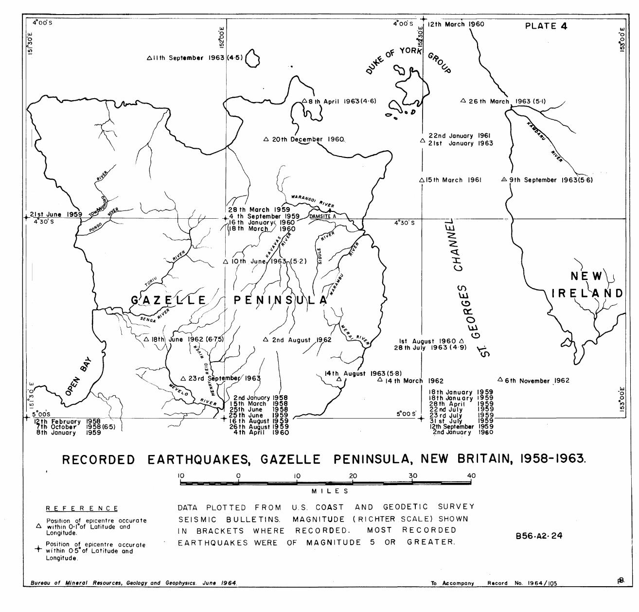
PLATE 4 ------------------~--------------------------------------~. ~ .----~--------------------------------~
4°00' 5 LLI 12th March 1960
U)
o , 5005 12th February 7th October 8th January
RECORDED
REFERENCE
Position of eplcentre accura te 6. within O·loof Latitude and
Longitude.
+ Position of epicentre accurate within 0'5°of Latitude and Longitude.
LLI '0
~ an
6.llth September 1963 (4·5) 0 ..
·0 It)
~ of YORk G
~+~ ~ ~O~ () \oJ '<)
~ Apdl 1963(4-6)
6. 20th December 1960 .. ~
22nd January 1961 6. 21st January 1963
6.15 th March 1961
(J) W ~ ~ o Ul ~
1st August 1960 6 28 th July 1963 (4'9) 'c-':
~
1963 (5·8) 6. 14 th March 1962
18th January 1959 18thJanu a ry 1959 28th April 1959 22nd July 1959
89th September 1963(5·6)
'> NEW\J
IRE L~ N 0
6. 6th November 1962
23rdJuly 1959 31 st Ju Iy 1959 _________________________ ---1
12th September 1959 2nd Jcinuar y 1960
EARTHQUAKES, GAZELLE PENINSULA, NEW BRITAIN, 1958-1963. 10 I
o
DATA PLOT TED FRO M
S E ISM I C B U L LET INS.
IN BRACKETS WHERE
EARTHQUAKES WERE
10 .20
MIL E S
30 !
40 !
U.S. COAST AND GEODETIC SURVEY
MAGNITUDE (RI CHTER SCALE) SHOWN
RECORDED. MOST RECORDED
OF MAGNITUDE 5 OR GREATER. B56·A2· 24
Bureau of Mineral Resources, Geology and GeophYSICS. June 1964. To Accompany Record No. 1964/105
------ - - .. --.-·C·-C· ·--·- 4·7 - -'-·--~
I
i I
•
. :,; ' .. ' j .
" .
• ' ..
...•
-/' _____ L. _ _ . ___ . ~ -- - - - - - ---.~.~ C~
• •
I I I I I
'1-•
'.
.
PAPUA AND NEW GUINEA INTENSITY ZONE MAP
25 • YEAR PERIOD
• LEGEND
__ • __ InltmoTional boundllr'/
---_ T trritorial bou~dary _ _ _ _ Ditt.ict boItn6ory
I 11,1111 VI } ZOfIe$ deleronined b, IWpe. impou d t'/VA MM VIII ' 4 per $q. de9. ptf C~IUry'
W~ conIOll '$ inlerpo!ated trom . . _ _ 101M IX . Plales 5,6.
F " ,'~ AP!I'o.o. boundaries Of!01 intWding _. . - \IIICOII$OIidaled sedimell t$
. .
~o ~ .
'~ .~. <{ . .1'""> . ~ V6, . ..- ..
,