Embed Size (px)
Citation preview

The U.S. Exclusive Economic
Zone A Summary of its
Geology, Exploration, and Resource Potential
GEOLOGICAL SURVEY CIRCULAR 912 Publlo Inquiries O:f':f'ice ~-·. s . . Geological Survey .? .,_;4 ~Uf3tom House 555 Battery Street San Francisco, California 94111
• ·' •

The U.S. Exclusive Economic Zone A Summary of its Geology, Exploration, and Resou r·ce Potential By Robert W. Rowland, Margaret R. Goud, and Bonnie A. McGregor
GEOLOGICAL CIRCULAR 912
1983

United States Department of the Interior
JAMES G. WATT, Secretary
Geological Survey Dallas L. Peck, Director
Library of Congress catalog card No. 83-600597
Free on application to Branch of Distribution, U.S. Geological Survey
604 South Pickett Street, Alexandria, VA 22304
CONTENTS
Introduction ----------------------------------------------------------------------------------------------- 1 Ackno\\rledgments ------------------------------------------------------------------------------------------ 1 Description and history of the EEZ ---------------------------------------------------------------------- 1 Geology ------------------------------------------------------------------------------------------ 2 Resource potential of the EEZ --------------------------------------------------------------------- 5
Oil and gas resources -------------------------------------------------------------------- 5 Atlantic region ---------------------------------------------------------- 7 Gulf of Mexico region ---------------------------------------------------------- 8 Pacific region -------------------------------------------------- 8 Alaska region ------------------------------------------- 9 Island regions ------------------------------------ 11
Hard-mineral resources ------------------------------------- 11· Polymetallic sulfides ------------------------------------ 12 Cobalt-rich manganese crusts and nodules ---------------------------------------- 15
Exploration methods ---------------------------------------- 16 Seismic reflection ---------------------------------- 16 Long range side-scan sonar (GLORIA) -------------------------------------- 16 Wide-angle multibeam echo sounding (Seabeam) ---------------------------------------- 17 Midrange side-scan sonar (Sea MARC) --------------------------------------------- 17
Conclusion ----------------------------------------- 18 References ------------------------------------------- 19 Appendix A: White House press release ------------------------------------------------- 2 4 Appendix B: White House fact sheet ----------------------------------------------- 26 Appendix C: 'I1le continental shelf, article 76, Third United Nations Conference on the Law of
the Sea ----------------------------------- 2 8
III
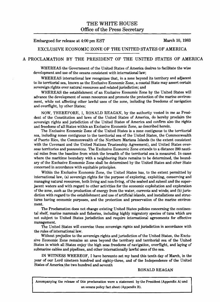
THE WHITE HOUSE Office of the Press Secretary
Embargoed for release at 4:00 pm EST March 10, 1983
EXCLUSIVE ECONOMIC ZONE OF THE UNITED STATES OF AMERICA
A PROCLAMATION BY THE PRESIDENT OF THE UNITED STATES OF AMERICA
WHEREAS the Government of the United States of America desires to facilitate the wise development and use of the oceans consistent with international law;
WHEREAS international law recognizes that, in a zone beyond its territory and adjacent to its territorial sea, known as the Exclusive Economic Zone, a coastal State may assert certain sovereign rights over natural resources and related jurisdiction; and
WHEREAS the establishment of an Exclusive Economic Zone by the United States will advance the development of ocean resources and promote the protection of the marine environment, while not affecting other lawful uses of the zone, including the freedoms of navigation and overflight, by other States;
NOW, THEREFORE, I, RONALD REAGAN, by the authority vested in me as President of the Constitution and laws of the United States of America, do hereby proclaim the sovereign rights and jurisdiction of the United States of America and confirm also the rights and freedoms of all St~tes within an Exclusive Economic Zone, as described herein.
The Exclusive Economic Zone of the United States is a zone contiguous to the territorial sea, including zones contiguous to the territorial sea of the United States, the Commonwealth of Puerto Rico, the Commonwealth of the Northern Mariana Islands (to the extent consistent with the Covenant and the United Nations Trusteeship Agreement), and United States overseas territories and possessions. The Exclusive Economic Zone extends to a distance 200 nautical miles from the baseline from which the breadth of the territorial sea is measured. In cases where the maritime boundary with a neighboring State remains to be determined, the boundary of the Exclusive Economic Zone shall be determined by the United States and other State concerned in accordance with equitable principles.
Within the Exclusive Economic Zone, the United States has, to the extent permitted by international law, (a) sovereign rights for the purpose of exploring, exploiting, conserving and managing natural resources, both living and non-living, of the seabed and subsoil and the superjacent waters and with regard to other activities for the economic exploitation and exploration of the zone, such as the production of energy from the water, currents and winds; and (b) jurisdiction with regard to the establishment and use of artificial islands, and installations and structures having economic purposes, and the protection and preservation of the marine environment.
The Proclamation does not change existing United States policies concerning the continental shelf, marine mammals and fisheries, including highly migratory species of tuna which are not subject to United States jurisdiction and require international agreements for effective management.
The United States will exercise these sovereign rights and jurisdiction in accordance with the rules of international law.
Without prejudice to the sovereign rights and jurisdiction of the United States, the Exclusive Economic Zone remains an area beyond the territory and territorial sea of the United States in which all States enjoy the high seas freedoms of navigation, overflight, and laying of submarine cables and pipelines, and other internationally lawful uses of the sea.
IN WITNESS WHEREOF, I have hereunto set my hand this tenth day of March, in the year of our Lord nineteen hundred and eighty-three, and of the Independence of the United States of America _the two hundred and seventh
RONALD REAGAN
Accompanying the release of this proclamation were a statement by the President (Appendix A) and
an oceans policy fact sheet (Appendix B).
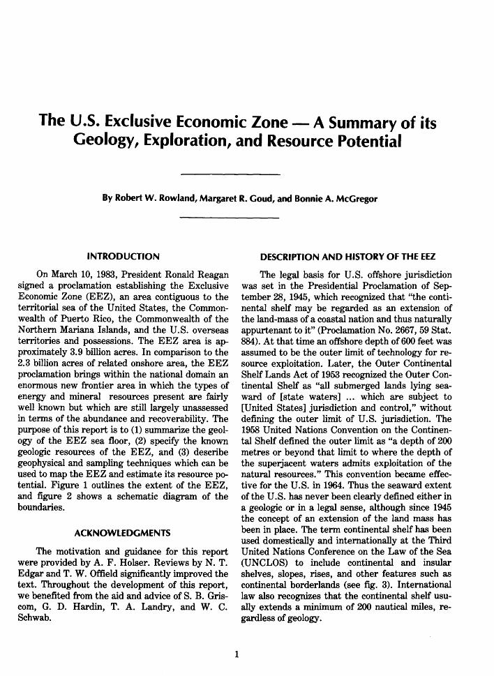
The U.S. Exclusive Economic Zone- A Summary of its Geology, Exploration, and Resource Potential
By Robert W. Rowland, Margaret R. Goud, and Bonnie A. McGregor
INTRODUCTION
On March 10, 1983, President Ronald Reagan signed a proclamation establishing the Exclusive Economic Zone (EEZ), an area contiguous to the territorial sea of the United States, the Commonwealth of Puerto Rico, the Commonwealth of the Northern Mariana Islands, and the U.S. overseas territories and possessions. The EEZ area is approximately 3. 9 billion acres. In comparison to the 2.3 billion acres of related onshore area, the EEZ proclamation brings within the national domain an enormous new frontier area in which the types of energy and mineral resources present are fairly well known but which are still largely unassessed in terms of the abundance and recoverability. The purpose of this report is to (1) summarize the geology of the EEZ sea floor, (2) specify the known geologic resources of the EEZ, and (3) describe geophysical and sampling techniques which can be used to map the EEZ and estimate its resource potential. Figure 1 outlines the extent of the EEZ, and figure 2 shows a schematic diagram of the boundaries.
ACKNOWLEDGMENTS
The motivation and guidance for this report were provided by A. F. Holser. Reviews by N. T. Edgar and T. W. Offield significantly improved the text. Throughout the development of this report, we benefited from the aid and advice of S. B. Griscom, G. D. Hardin, T. A. Landry, and W. C. Schwab.
1
DESCRIPTION AND HISTORY OF THE EEZ
The legal basis for U.S. offshore jurisdiction was set in the Presidential Proclamation of September 28, 1945, which recognized that "the continental shelf may be regarded as an extension of the land-mass of a coastal nation and thus naturally appurtenant to it" (Proclamation No. 2667, 59 Stat. 884). At that time an offshore depth of 600 feet was assumed to be the outer limit of technology for resource exploitation. Later, the Outer Continental Shelf Lands Act of 1953 recognized the Outer Continental Shelf as "all submerged lands lying seaward of [state waters] . . . which are subject to [United States] jurisdiction and control," without defining the outer limit of U.S. jurisdiction. The 1958 United Nations Convention on the Continental Shelf defined the outer limit as "a depth of 200 metres or beyond that limit to where the depth of the superjacent waters admits exploitation of the natural resources." This convention became effective for the U.S. in 1964. Thus the seaward extent of the U.S. has never been clearly defined either in a geologic or in a legal sense, although since 1945 the concept of an extension of the land mass has been in place. The term continental shelf has been used domestically and internationally at the Third United Nations Conference on the Law of the Sea (UNCLOS) to include continental and insular shelves, slopes, rises, and other features such as continental borderlands (see fig. 3). International law also recognizes that the continental shelf usually extends a minimum of 200 nautical miles, regardless of geology.
. Midway Island ,-;_ ! .. "'--.. ', .. - ........
...... _ . ......,
30
Mariana Islands\,....\
(\. \ l • 1
Guam 1 ·1
1
Wake Island;<,....,.
! . )
""' """ .. ·- \
Johnston r "'\ ._'-.. •/Hawaii Island -+- · .
1 ' _,....
\'· I - _, \,_:
/ \ HowlandX: J
Island '-,....
(--:;-Palmyra Atoll '-.I
,-.)......Jarvis Island l \ ........
~ ;l;w-- American (:_ ....,} Samoa
150'W 120' 90' 60'
FIGURE !.-Exclusive Economic Zone (EEZ) of the United States, Commonwealth of Puerto Rico, Commonwealth of the Northern Mariana Islands, and United States overseas territories and possessions (outlines of map are approximate). Acreage now deemed within the U.S. EEZ includes: United States proper, 2.787 billion acres; Commonwealth of Northern Mariana Islands, 0.299 billion acres; territories and possessions, 0.839 billion acres.
The March lOth announcement did not specifically designate the geographic coordinates of the outer extent of the EEZ, but a general indication of its extent is the U.S. fisheries conservation zone, since the operational language of the EEZ proclamation generally follows the language of the Fisheries Conservation and Management Act. The limits of the fisheries zone were set forth in the Federal Register on March 7, 1977, and successive notices issued in 1977, 1978, and 1979 have corrected errors and made modifications to the original notice. An official depiction of these boundaries can be found on the National Ocean Survey's marine boundary charts and maps listed in the N ationa! Oceanic and Atmospheric Administrations's Map and Chart Catalogue 5.
Also relevant in the definition of the EEZ outer limit is the fact that in some places the natural geologic prolongation of an undersea land mass can be more than 200 nautical miles from the shoreline. Article 76 of the UNCLOS treaty (Appendix C) addressed this issue, and the merits of this article have been widely discussed (see Hed-
2
berg 1979, 1983; McKelvey, 1983). In any event, the EEZ is a vast new frontier to study and understand. It also is an immense region with potential resources of possibly economic importance.
GEOLOGY
Geologic features and processes, as we study them, do not stop at the ocean's edge, but extend offshore into the area known as the continental margin, which constitutes much of the EEZ. For the U.S. this margin area includes the edge of the North American continent as it extends out under the Atlantic, Pacific, and Arctic Oceans, the Gulf of Mexico, and the Caribbean and Bering Seas and is very diverse in its geologic history. Geologists have been conducting studi~s here because it affords an opportunity to learn more about the processes and forces responsible for shaping our continent and controlling the distribution of resources.
The continental margin can be divided into a series of provinces called the continental shelf, continental slope, and continental rise, which occur in progressively deeper water (fig. 3). As the water
FIGURE 2.-Schematic diagram showing the location of the baseline, territorial sea, contiguous zone, and EEZ with respect to the coastline.
depth increases, the complexity of studying each province-and developing its resources-also increases. A brief discussion of the geologic history of the North American continent, and its place on the Earth's surface, will provide an example of how continental margins are formed.
The Earth's crust is made up of gigantic plates of continental crust and oceanic crust. Most continental plates extend far out under the covering ocean and eventually meet a neighboring plate of oceanic crust or (in areas of narrow seas) an adjacent continental plate. According to the widely ac-
3
cepted plate-tectonic theory, crustal plates are in motion relative to each other; from time to time over hundreds of millions of years they are broken along rift zones, and the huge fragments then spread away from the rift as though borne on conveyor belts in the underlying Earth's mantle. As each fragment moves, its leading edge may collide with another plate. Depending on the kinds of plates and the nature of their collision, this process may result in the building of a mountain range (such as the Rocky Mountains) or an oceanic island arc (such as the Mariana Islands or Aleutian Is-
CONTINENTAL
~ II
MARGIN
ATLANTIC: (trailing edge)
sea level
YSSAL PLAIN
;:~'!li~it~~~i)[lt~1!1~;it1't~~~~-·-·R· ~~~~~:z~=;~~~====~~~~~r-~~~v~ NORTH PACIFIC MARGIN· (collision)
SOUTHERN CALIFORNIA BORDERLAND: (extentional)
SOUTH PACIFIC: (volcanic arcs trenches, and carbonate reefs)
FIGURE 3.-Idealized physiography of a continental margin and some common margin types.
4

lands), or a fault zone (such as the San Andreas). The collision, or subduction, zones as well as the rift zones are sites of volcanism and seismicity. In this process of plate collision, rocks formed in the oceans, even whole marine basins, can be emplaced onto continents, where erosion may later expose them so that they may be studied. Also in this process, broad reaches of continental crust can subside and be invaded by the sea; subsequent uplift then presents to geologists the resulting record of marine deposition and erosion over that part of the continental plate. Similarly, mineral deposits that form on the ocean floor and petroleum deposits within marine sedimentary basins may end up on the dry land of a continent.
Two hundred million years ago the supercontinent called Pangea, composed of North and South America, Africa, and Europe, began to break up, with North America moving to the west-northwest. As North America moves on the Earth's surface, the Pacific coast-the leading edge-overrides the sea floor of the Pacific Ocean. Because this continental-oceanic plate interaction involves plate collision, characterized by tectonic and volcanic activity, the Pacific coast of North America is termed an active continental margin. The Atlantic coast is the trailing edge and is called a passive margin.
Although the ocean severely limits the observations a geologist can make of the seabed, it does provide an excellent laboratory for studying ancient as well as modern marine sedimentary or mineral deposits. In addition, observations of active processes of marine deposition and erosion can be directly applicable in understanding our onshore geologic surroundings, and in the search for resources. Conversely, studies of former marine settings, now on land, together with offshore geophysical data and drillhole or surface samples, can provide an understanding of today's sea floor geology-the setting and makeup of the continental shelves, slopes, and rises, as well as the deep ocean floor. It is these studies that have already led to a vastly improved understanding of the processes shaping the Earth and moreover to the discovery of significant resources.
RESOURCE POTENTIAL OF THE EEZ
Major deposits of oil and gas and potentially important deposits of minerals, including strategic commodities, occur in the EEZ. However, because of its extreme size, resource estimates are based
5
on spotty data coverage requiring extrapolation of findings into unsurveyed and unsampled areas. Future exploration, technological developments, and economic conditions will determine which of these resources will be developable and when. Here, we present a general assessment of the hydrocarbon and mineral potential of the EEZ, as far as present understanding of the environments and processes will allow, and outline· techniques for improving this preliminary appraisal.
OIL AND GAS RESOURCES
Of offshore resources worldwide, oil and gas are the most extensively developed; accordingly, more reliable estimates of their abundance are available than for any other resources in the EEZ. The appraisal by Dolton and others (1981) of conventionally producible crude oil and natural gas on a portion of the U.S. outer continental shelf was used as the basis for our discussion of U.S. estimates. We use the commonly accepted terminology which defines "reserves" as proved and economically recoverable accumulations and "resources" as both reserves and undiscovered potential resources based on geologic knowledge of an area (fig. 4). The estimates presented below for the four major U.S. offshore regions (figs. 5, 8) are for undiscovered recoverable resources and are given as statistical mean values determined from data of Dolton and others (1981).
The major geologic factors related to hydrocarbon occurrence and exploration are: (1) an adequate thickness of sedimentary rocks; (2) source beds containing considerable dispersed organic matter; (3) a suitable environment for the maturation of organic matter; ( 4) porous and permeable reservoir beds; (5) hydrodynamic conditions favorable for both early migration and ultimate entrapment of oil and gas; (6) a favorable thermal history; (7) adequate trapping mechanisms; and (8) suitable timing of hydrocarbon generation and migration in relation to the development of traps. Many other features can indicate favorability, for example, the presence of oil and gas seeps, a varied sequence of rock types, some organically rich marine sediments as source beds for the generation of oil and associated gas, nonmarine organically rich sediments for genesis of nonassociated gas, structural features that show progressive growth through geologic time, unconformities, and the presence of evaporite deposits.
IDENTIFIED RESOURCES
Demonstrated Inferred
Measured Indicated
ECONOMIC Reserves Inferred Reserves
t-------11-----L---
MARGINALLY ECONOMIC
t-------tt----------------
SUBECONOMIC
UNDISCOVERED RESOURCES
u ~ 0 z 0 u UJ
(!) z en <{ UJ 0:: u z
> 1-..J
IIl en <{ UJ u..
INCREASING GEOLOGIC ASSURANCE------------
FIGURE 4.-0il and gas resources classification. (Modified from U.S. Bureau of Mines and U.S. Geological Survey, 1980.)
5IZIN
14IZIW
4IZIN
3IZIN
13IZIW
2IZIN
14/W
JUAN DE FVCAGORDA .
SUBMARIM.E ·
"'I
131!lW 12IZIW
120W 11IZIW
The Un1ted States has not resolved most of 1ts Contmental Shelf and Exclusive EconomiC Zone boundanes w1th other states. The llnft'j on this map are only approx•mate, and they do not necessanly reflect the pos1t1ons 01 v.ews of the United States With respect to those boundanes
1 !IZIW lOOW
liZIIZIW
500
400
90W SIZIW 7IZIW
90W SIZIW
1000 MILES
800 KILOMETERS
6IZIW
SOUTHEAST ATLANTIC
SEDIMENTARY BASINS
70W
5IZIW
5IZIN
5IZIW
4IZIN
3IZIN
6IZIW
2IZIN
200 nautteal m11e ltm1t data based on NOS F1shenes Conservatton and Management Zone delmeat•on
FIGURE 5.-Location of basins with oil and gas potential within the EEZ. Dashed lines indicate the boundary location discussed in Appendix C.
6
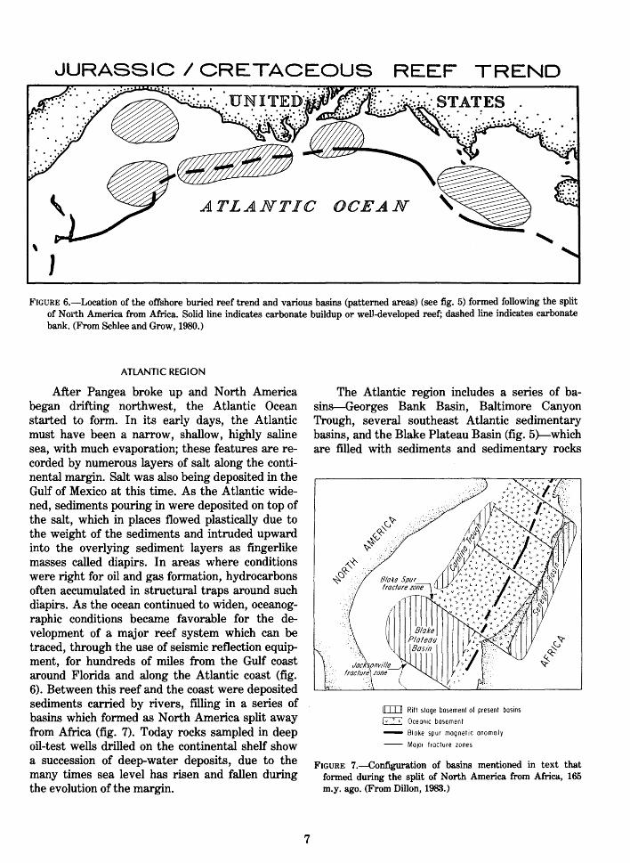
JURASSIC I CRETACEOUS REEF TREND
ATLANTIC OCEAN
\
J
FIGURE 6.-Location of the offshore buried reef trend and various basins (patterned areas) (see fig. 5) formed following the split of North America from Africa. Solid line indicates carbonate buildup or well-developed reef; dashed line indicates carbonate bank. (From Schlee and Grow, 1980.)
ATLANTIC REGION
After Pangea broke up and North America began drifting northwest, the Atlantic Ocean started to form. In its early days, the Atlantic must have been a narrow, shallow, highly saline sea, with much evaporation; these features are recorded by numerous layers of salt along the continental margin. Salt was also being deposited in the Gulf of Mexico at this time. As the Atlantic widened, sediments pouring in were deposited on top of the salt, which in places flowed plastically due to the weight of the sediments and intruded upward into the overlying sediment layers as fingerlike masses called diapirs. In areas where conditions were right for oil and gas formation, hydrocarbons often accumulated in structural traps around such diapirs. As the ocean continued to widen, oceanographic conditions became favorable for the development of a major reef system which can be traced, through the use of seismic reflection equipment, for hundreds of miles from the Gulf coast around Florida and along the Atlantic coast (fig. 6). Between this reef and the coast were deposited sediments carried by rivers, filling in a series of basins which formed as North America split away from Africa (fig. 7). Today rocks sampled in deep oil-test wells drilled on the continental shelf show a succession of deep-water deposits, due to the many times sea level has risen and fallen during the evolution of the margin.
7
The Atlantic region includes a series of basins-Georges Bank Basin, Baltimore Canyon Trough, several southeast Atlantic sedimentary basins, and the Blake Plateau Basin (fig. 5}--which are filled with sediments and sedimentary rocks
0:::0 Rift stage basement of present basins
~ Oceon1c basement
- Bloke spur magnetic anomaly
- MaJOr fracture zones
FIGURE 7.-Configuration of basins mentioned in text that formed during the split of North America from Africa, 165 m.y. ago. (From Dillon, 1983.)
sometimes reaching a thickness of 43,000 feet. In addition, the continental slope and rise are underlain by a great wedge of sediments. The deep basins and the continental rise are all targets for petroleum exploration. Another potential resource is the offshore buried reef (fig. 6), noted in the previous paragraph; depending on the porosity of the reef rock and the thermal history of the nearby slope and shelf, this ancient reef might serve as a hydrocarbon reservoir. Because of the depth of water in which they are located, these areas are just beginning to be evaluated for their resource potential.
Much detailed marine geophysical work and rock coring from deep wells remain to be done to show what the Atlantic region's hydrocarbon potential really is. However, oil and gas resources have been estimated for Georges Bank, the Baltimore Canyon Trough, and three sedimentary basins in the southeast Atlantic. The total estimate as of 1981 is 5.4 billion barrels (bbl) of oil and 23.5 trillion cubic feet (tcf) of gas.
GUlF OF MEXICO REGION
As for the Atlantic region, the early history of the Gulf of Mexico region was characterized by the deposition of a thick low-density salt layer. Later, the Mississippi River flowing into the Gulf deposited a thick accumulation of sediment, eroded from the central United States. This accumulation has built a large delta, the weight of which on top of the salt has resulted in extensive plastic flow of the salt upward into the sediments to form diapirs as well as deforming the sediments and shaping the morphology of the sea floor into ridges, troughs, and hills. The Gulf is bounded on the east and south by the large carbonate platforms of Florida and the Yucatan Peninsula, which were constructed by marine organisms; in fact coral reefs can be found growing today on the tops of ridges or hills underlain by salt diapirs in the shallow waters. Over millions of years, abundant organic material generated by these marine organisms in the warm, nutrient-rich water and a high rate of sedimentation have served to provide conditions favorable for the generation of oil and gas, and it is the vertical walls of the diapirs that provide numerous structural traps in which the oil and gas can accumulate.
The Mississippi River, its delta, and deepwater fan afford geologists a view of a modern active river delta system and its associated hydrocar-
8
bon reservoirs. On land in buried basins, oil and gas are often found in ancient river deltas and fans. Therefore, by studying the dynamic processes active today in the Mississippi River system, scientists can understand and more efficiently exploit both modern and ancient delta and fan reservoirs.
The Gulf of Mexico shelf area has been extensively and successfully developed; however, the area more than 200 meters deep has not. This deeper area has been separated into eastern and western slope zones for the purpose of resource assessment (fig. 5). Study of the eastern zone suggests that there is little potential for oil and gas reserves as indicated by resource estimates of 0.2 bbl of oil and 0.5 tcf of gas. The western zone is much more favorable, containing a complex pattern of salt intrusions and thick sediments; resource estimates for that area are 2. 4 bbl oil and 26.1 tcf gas. No resource estimates are available for the deep abyssal plain within the EEZ, but it is also covered with thick sediments containing large structures capable of trapping large amounts of oil and gas.
PACIFIC REGION
The Pacific region constitutes the leading edge of the North American continent and is an active margin in which the continental plate of North America is in collision with the sea-floor plate of the Pacific Ocean. This active margin has, as most all generally have, a much narrower continental shelf, slope, and rise than a passive margin. Flanking the narrow margin to seaward is a broad continental borderland composed of numerous islands, banks, and basins, some of the basins which are over 6,000 feet deep, where sediments transported by ocean currents or eroded from surrounding ridges have accumulated (fig. 3). Several basins close to the coast contain old deep-water fan deposits and have proven oil reservoirs, such as those in the Santa Barbara Channel.
The Pacific region has been split into three areas for purposes of resource assessment: the southern California borderland, the northern and central California margins, and the OregonWashington basins (fig. 5). No assessment of oil and gas potential has been made by the U.S. Geological Survey seaward of the 2,500-meter depths of the slope, though the possibility for economically exploitable hydrocarbon deposits may exist in the area of the enormous Monterey deep-

70
60
50
sea fan off central California (Wilde and others, 1976) (fig. 5). The resource estimates for the Santa Barbara Channel are 1.3 bbl of oil and 2.5 tcf gas; for the more southerly borderland basins the estimates are 1.1 bbl and 1.4 tcf, for a total of 2.4 bbl of oil and 3. 9 tcf of gas. The northern and central California margins have been subject to large-scale faulting which formed a series of five sedimentfilled basins. Test wells have generally had negative results in the basins, despite promising source rocks and structures. Total resource estimates are 1.0 bbl of oil in three basins, with individual basins containing from 0.1 to 0. 7 bbl; gas estimates are 1. 7 and 0.2 tcf in only two of the basins. The Oregon-Washington basins represent a single, large sedimentary trough separated into structural basins; however, there appear to be few rocks with
:40
BATH YMETR Y (200 AND 2 500m)
=0 200 NAUTICAL MILE LIMIT
AREA S OF POTENTIAL AND
PROVEN HYDROCARBONS
c:::::::c,
USSR
organic deposits, and moreover the thermal history is believed to be unfavorable for hydrocarbon development. The area resource estimates are 0.3 bbl of oil and 1.5 tcf of gas.
ALASKA REGION
The Alaska region is an enormous area comprising diverse geologic elements. Whereas southern Alaska is a complex of small connected plates that extend offshore into the Gulf of Alaska (fig. 8), the Aleutian Islands represent a full-fledged active margin forming a volcanic arc which is flanked on the seaward side by a deep basin, or trench. Along this trench, the sea floor of the Pacific Ocean is being pushed down, or subducted, under the continental margin; over 5,000 linear miles of ocean crust have been consumed along this trench.
140 120 100
... _ .......... , \ I I I I
ALASKA
60
50
so-.o~~-=~~====~50~0~====g;ID•OO miles
180
The Un•ted States has not resolved most of •t s Cant mental Shelf and bclus•ve Econom•c Zone boundanes with other states. The tines on th•s map are only approJumate, and they do not necessan ly reflect the pos•tlons or v1ews of the Un•ted States w1th respect to those boundanes
! 60E
La mbert Equal Area Pro je cti on
140
200 naut1ca! m1le l •m•t data based on NOS F1sher1es ConservatiOn and Management Zone delmeat •on
FIGURE 8.-Location of basins with oil and gas potential within the EEZ. Dashed line indicates the boundary location discussed in Appendix C.
9

As this crust is pushed down deep within the Earth, it melts and then rises to form the volcanic rocks of the Aleutian Islands. Minerals originally deposited within the rocks of the sea floor are also subducted beneath and redeposited within the Aleutian arc. Geologists are particularly interested in island-arc regions because they include deep sedimentary basins, which if conditions are right, can contain oil and gas. In front of the arc, between the arc and the trench, is the forearc basin, where compressional forces can deform the sediments eroded from land, erupted by volcanoes, or composed of organisms settling out of the water column and deposited in the basin. Cook Inlet and several other basins located near shore in this forearc region are being evaluated for their hydrocarbon potential. Behind the arc are backarc basins, formed by tensional forces caused by the downgoing sea-floor slab, that, if conditions are right, may contain hydrocarbon deposits.
The northern coast of the Alaska region is a passive type margin with thick accumulations of sediments, diapirs, and other features similar to the Atlantic margin. The giant oil field onshore at Prudhoe Bay suggests that the continental margin, under the shelf, slope, and rise, also may have important hydrocarbon reserves.
The vastness of the region and the hostile climatic conditions make exploration for resources difficult. When resources are found, the winter storms and ice make it difficult to build permanent recovery stations. In some areas, ice extends all the way down to the sea floor in the waters overlying the shelf, and so ice movement leaves large gouges in the sediment. Under these conditions, drilling for oil or production itself are extremely difficult. For the sake of brevity, the Alaskan region is divided into three sections (fig. 8), despite inhomogeneities, and described only briefly: (1) the Gulf of Alaska area, south of the Aleutians, (2) the Bering Sea area between the Aleutians and the Bering Strait, and (3) the area north of the Bering Strait.
South of the Aleutians the resource estimates are as follows:
Gulf of Alaska----------Kodiak Basin -----------Lower Cook Inlet------
Total -----------------
Oil (bbl)
0.4 .4 .4
1.2
Gas (tcf)
2.2 2.0 2.4
6.4
The thermal and structural history of these three basins suggests that gas rather than oil was generated. The western Gulf of Alaska area has thick sediments (up to 5 km) and abundant structures capable of containing hydrocarbons, but drilling results have been poor, apparently due to lack of suitable reservoir rocks. The same is true for the Cook Inlet area. The eastern Gulf of Alaska area is most promising, with excellent source rocks and fair trap potential, though the reservoir potential is questionable.
Resource estimates for Bering Sea and environs are as follows:
Bristol Bay Basin ----St. George Basin ------N avarin Basin----------Norton Basin ------------
Total -----------------
Oil(bbl)
0.2 .4 .9 .2
1.7
Gas (tcf)
1.0 2.3 5.6 1.2
10.1
The basins in the Bering Sea area vary widely in geologic origin. Bristol Bay Basin is a single, broad structural depression with a sediment thickness as much as 7 km; St. George Basin is a 10-km deep, sediment-filled, fault-bounded basin; Navarin Basin is actually three elongate basins with a sediment thickness of as much as 15 km; and Norton Basin is broken by faults into sections with sediment thicknesses as much as 7 km. Only Bristol Bay has been drilled, showing some oil and gas in its southern reaches. Resource potential estimates for the other basins are based on seismic information and surface sampling.
For the area north of Bering Strait, the resource estimates are as follows:
Hope Basin--------------Chukchi Basin----------Beaufort Basin ----------
Total -----------------
Oil(bbl)
Negligible 1.4 7.8
9.2
Gas (tcf)
0.3 6.4
39.3
46.0
The Hope Basin has a sediment thickness of only 3 km, barely enough for hydrocarbon generation. The Chukchi Basin is more than twice as thick and has structural features providing potential hydrocarbon traps. By far the most promising basin of the three for hydrocarbon production, is the Beaufort Basin, where the onshore producing oil fields are within 10 km of the coastline; here, petroliferous onshore deposits are thought to extend offshore, and sediments at least 6 km thick occur
10
all the way to the edge of the broad shelf. It is critical to point out that the continental shelf in the vicinity of the Chukchi and Beaufort Seas extends well beyond 200 nautical miles from shore (fig. 8). Thus if the "natural prolongation" criterion discussed in the section "Description and History of the EEZ" is applied, this extended portion could fall within U.S. jurisdiction.
ISLAND REGIONS
Besides the U.S. part of the North American continent, the EEZ also includes waters and subsea lands adjacent to Puerto Rico and the Virgin Islands in the Caribbean Sea, and the Hawaiian Islands, Northern Mariana Islands, and numerous other islands in the Pacific Ocean. Puerto Rico, the Virgin Islands, and the Northern Mariana Islands, like the Aleutian Islands, are parts of island arcs.
The potential for oil and gas resources within the EEZ of the U.S. Pacific possessions has not yet been evaluated. Most island areas were not until recently believed to have any potential for hydrocarbon resources. However, the facts and
:-~ .1: ._/$-- -,;-
~~;~.}~ _ ~
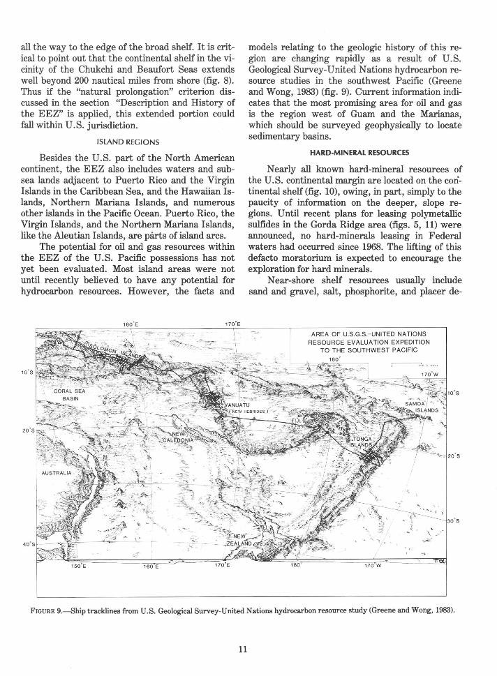
models relating to the geologic history of this region are changing rapidly as a result of U.S. Geological Survey-United Nations hydrocarbon resource studies in the southwest Pacific (Greene and Wong, 1983) (fig. 9). Current information indicates that the most promising area for oil and gas is the region west of Guam and the Marianas, which should be surveyed geophysically to locate sedimentary basins.
HARD-MINERAL RESOURCES
Nearly all known hard-mineral resources of the U.S. continental margin are located on the continental shelf (fig. 10), owing, in part, simply to the paucity of information on the deeper, slope regions. Until recent plans for leasing polymetallic sulfides in the Gorda Ridge area (figs. 5, 11) were announced, no hard-minerals leasing in Federal waters had occurred since 1968. The lifting of this defacto moratorium is expected to encourage the exploration for hard minerals.
Near-shore shelf resources usually include sand and gravel, salt, phosphorite, and placer de-
AREA OF U.S.G.S.-UNITED NATIONS RESOURCE EVALUATION EXPEDITION
TO THE SOUTHWEST PACIFIC
FIGURE 9.-Ship tracklines from U.S. Geological Survey-United Nations hydrocarbon resource study (Greene and Wong, 1983).
11

FIGURE 10.-Hard-mineral resources contained within the U.S. EEZ include manganese, phosphorite, gold, platinum, and titanium. Many of these minerals are found in sand and gravel deposits on the continental shelf. (From Manheim and Hess, 1981.)
posits (Manheim and Hess, 1981). Sand and gravel deposits are reasonably well known and have attracted commercial interest where dictated by local need. Salt deposits of the Gulf of Mexico may contain evaporite minerals enriched in potassium, bromine, or other economic commodities. Phosphorite, necessary for agriculture, is known to be present off southern California and the southeast Atlantic margin. Other surveys have revealed the presence of phosphorite and of pavement-like deposits and nodules of manganese covering the Blake Plateau, off the Carolina coast (fig. 10).
Glaciers and rivers disgorge large quantities of sediments onto the continental shelf, including minerals of economic interest. Ocean currents and storm-driven currents rework these sediments, often concentrating mineral deposits as placers, of titanium, platinum, rare-earth elements, and gold. Several such deposits are known offshore of
12
Alaska, California, Oregon, and Washington, and others are likely buried within the continental margin.
Development of salt and evaporite, phosphorite, and placer deposits is presently not economically feasible, but advanced technologies and increases in prices might make them profitable. These deposits, therefore, warrant study. The two other possibly economic hard-mineral resources located farther offshore but still within the EEZ are polymetallic sulfides and cobalt-rich manganese crusts.
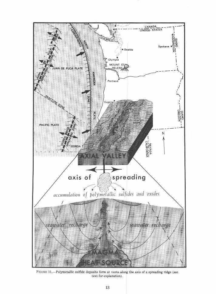
POlYMETAlliC SUlFIDES
Spreading oceanic rift zones are sites where molten rock rises from the Earth's interior and is injected along the axis of the rift (fig. 11). The rock then cools and creates new sea floor. Sea water is believed to percolate deep into cracks near the rift
DE FUCA PLATE
PACIFIC PLATE
. OX IS
-:.r CANADA __ -- --'7"------ -UNITED -sTATES l
, , I f:l
~~-i50 :ZI>
Spok•ne •£11~ • Seattle ~~
I I
I '
--- --1.. ... ' j
N
\
spreading
~ allic sulfides
I I
J I I
"\
\
I I
'
\
FIGURE 11.-Polymetallic sulfide deposits form at vents along the axis of a spreading ridge (see text for explanation).
13
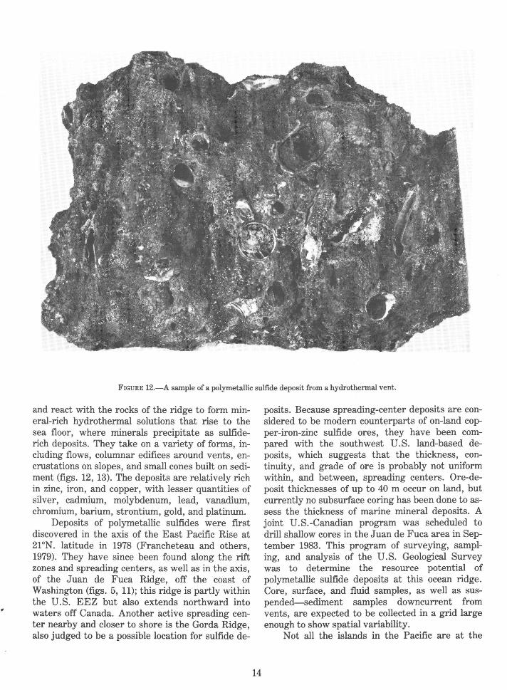
FIGURE 12.-A sample of a polymetallic sulfide deposit from a hydrothermal vent.
and react with the rocks of the ridge to form mineral-rich hydrothermal solutions that rise to the sea floor, where minerals precipitate as sulfiderich deposits. They take on a variety of forms, including flows, columnar edifices around vents, encrustations on slopes, and small cones built on sediment (figs. 12, 13). The deposits are relatively rich in zinc, iron, and copper, with lesser quantities of silver, cadmium, molybdenum, lead, vanadium, chromium, barium, strontium, gold, and platinum.
Deposits of polymetallic sulfides were first discovered in the axis of the East Pacific Rise at 21°N. latitude in 1978 (Francheteau and others, 1979). They have since been found along the rift zones and spreading centers, as well as in the axis, of the Juan de Fuca Ridge, off the coast of Washington (figs. 5, 11); this ridge is partly within the U.S. EEZ but also extends northward into waters off Canada. Another active spreading center nearby and closer to shore is the Gorda Ridge, also judged to be a possible location for sulfide de-
14
posits. Because spreading-center deposits are considered to be modern counterparts of on-land copper-iron-zinc sulfide ores, they have been compared with the southwest U.S. land-based deposits, which suggests that the thickness, continuity, and grade of ore is probably not uniform within, and between, spreading centers. Ore-deposit thicknesses of up to 40 m occur on land, but currently no subsurface coring has been done to assess the thickness of marine mineral deposits. A joint U.S.-Canadian program was scheduled to drill shallow cores in the Juan de Fuca area in September 1983. This program of surveying, sampling, and analysis of the U.S. Geological Survey was to determine the resource potential of polymetallic sulfide deposits at this ocean ridge. Core, surface, and fluid samples, as well as suspended-sediment samples downcurrent from vents, are expected to be collected in a grid large enough to show spatial variability.
Not all the islands in the Pacific are at the

FIGURE 13.-Polymetallic sulfide deposit with a columnar shape.
edge of a plate capping an island arc. Some, like the Hawaiian and Midway Islands, occur within the Pacific plate. They form over what geologists call hot spots, places where plumes of molten rock are rising from deep within the Earth. These plumes are fixed in location, and as the crustal plate of the Pacific moves over them, a line of volcanoes or seamounts-volcanoes that do not reach above the sea surface--is formed. The island of Hawaii today is over a hot spot which is causing volcanic activity. The trend of the chain of islands from Midway to Hawaii shows the northwesterly direction that the Pacific plate is moving. Each island was originally over the hot spot where Hawaii is today. Although no deep basins filled with sediment are associated with this type of island, minerals accumulating on the volcanic edifice may be important. Polymetallic sulfides may be deposited at, or just beneath, the sea floor in the vicinity of the hot spot where volcanic activity is occurring.
Geologists have only just begun to study the
15
geology and resources of these hot spot islands. The underwater flanks of the volcanoes are relatively steep and the water is over 12,000 feet deep in places, which makes their study difficult. The very basic question of their particular types of resources and distribution still needs to be answered.
COBALT-RICH MANGANESE CRUSTS AND NODULES
Recent work by the U.S. Geological Survey suggests that cobalt-rich manganese crusts on the flanks of seamounts and oceanic islands in the central Pacific could represent a significant mineral resource. The crusts appear to average 2 em in thickness and are fairly uniformly distributed at depths of 1,000-2,600 m (Geotimes, 1982). They are known to be present on many of the islands which are U.S. territories and possessions in the Pacific, and there are over 200 such islands and seamounts within the U.S. EEZ boundaries in the Pacific.
The crusts generally contain 1. 0 percent or more cobalt, 0.5 percent nickel, and 15-25 percent manganese. Though the concentrations vary, they may represent an economic resource. Crusts at depths shallower and deeper than 1,000-2,500 m are generally not as rich in cobalt. Deep-sea manganese nodules, believed to be forming by processes similar to those which produce the crusts, have a mean cobalt content for high-grade samples in the Pacific of 0.27 percent (McKelvey and others, 1983). The crusts thus apparently contain significantly more cobalt than the nodules, which have received so much attention in recent years. However, preliminary analysis of a sample collected on the top of Horizon Guyot, a seamount southeast of Hawaii, yielded a cobalt content of 0. 74 percent. As a result the economic potential of shallow-water nodules is being reevaluated. If the seamounts prove to be covered with the crusts or nodules, a single seamount could yield enough ore for a commercial mining operation. The importance of this is highlighted by the fact that the U.S. has no domestic sources of cobalt, depending largely on Mrica for its supplies of this strategic mineral.
EXPLORATION METHODS
The resource assessments in this report are tentative, for they are based, in most cases, on extrapolation of the data available from uneven geographical coverage of the vast area of the EEZ. Conclusions, especially for the cobalt crusts and nodules and the polymetallic sulfides, have been drawn without a complete understanding of the spatial extent of the resources or variability in composition.
A variety of geophysical and sampling techniques is available for identifying resources and assessing their potential in the EEZ. Some employ traditional seismic reflection and sampling equipment; their capabilities and limitations for resource assessment are well documented and thus are only briefly mentioned here. Newer techniques, for mapping broad swaths of the sea floor, are especially well suited to surveys of the large areas of the EEZ, and three such systems are described here.
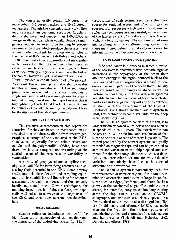
SEISMIC REFLECTION
Seismic reflection techniques are useful for identifying the physiography of the sea floor and the character of the underlying strata (fig. 14). In-
16
terpretation of such seismic records is the basic source for regional assessment of oil and gas resources. For resources which are surficial, seismic reflection techniques are less useful, since no idea of the lateral extent of a feature can be extracted without a lengthy survey. The combination of seismic profiling with a swath-mapping system, as those mentioned below, dramatically increases the information value of an oceanographic trackline.
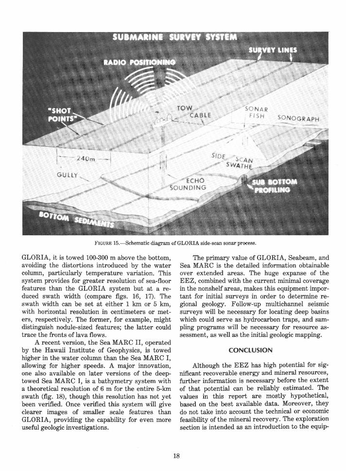
LONG RANGE SIDE-SCAN SONAR (GLORIA)
Side-scan sonar is a process in which a swath of the sea floor is ensonified with acoustic signals; variations in the topography of the ocean floor alter the energy in the signal bounced back to the receiver, and these irregularities are used to produce an acoustic picture of the ocean floor. The signals are sensitive to changes in shape as well as bottom composition, and thus side-scan systems are able to map bedforms in addition to such deposits as sand and gravel deposits on the continental shelf. With the development of the GLORIA (Geological Long Range Inclined Asdic) system in 1970, this technique became available for the deep ocean as well (fig. 15).
The GLORIA system consists of a 2-ton, 8-m long transducer towed 50 m below the sea surface at speeds of up to 10 knots. The swath width can be set at 14, 30, or 60 km, and resolution of features on the scale of tens of meters is possible. The record produced by the newest systems is digitally recorded on magnetic tape and can be processed to account for variation in the ship's speed and corrected for the slant range distance to the sea floor. Additional corrections account for water-density variation, particularly those due to the thermal structure of the water column.
The GLORIA system is particularly useful for reconnaissance of frontier regions, for it can determine the orientation and extent of large linear features such as ridges, bedforms, and channels. In a survey of the continental slope off the mid-Atlantic states, for example, canyons 20 km long cutting across the slope can be traced on the GLORIA sonographs, and tributaries as closely spaced as a few hundred meters can be also distinguished (fig. 16). In this case, and others, GLORIA has made clear for the first time the intricate patterns of meandering gullies and channels of oceanic canyon and fan systems (Twichell and Roberts, 1982; Damuth and others, 1983).

SEDIMENT FILLED BASIN
_j
w > <! 0::: f-
><! 5:
I N
u w (f)
FIGURE 14.---Seismic profile across the Blake Escarpment showing the continental margin with a reef and stratified sediments abutting the escarpment (Dillon and others, 1979).
WIDE-ANGLE MULTIBEAM ECHO SOUNDING (SEABEAM)
The Seabeam wide-angle multibeam profiling system produces a bathymetric map in real time from a swath of the ocean floor beneath a ship's track. The contoured strip covers a 43° arc beneath the ship so that the width of coverage varies from about 150 m on the outer shelf to 4 km in the deep ocean. The contour interval can be set as low as 2 m. The hull-mounted transducer system is presently available, or in the process of installation, on three U.S. university ships, on Surveyor (operated by the National Oceanic and Atmospheric Administration), and on several French and German research vessels.
The Seabeam system can be used simultaneously with seismic reflection equipment, so that the lateral extent of a surface feature can be related to its vertical structure. This combination is valuable for delineating the surface expression and
17
lithologic character of structural traps for hydrocarbons, such as salt domes and diapirs.
One of the resident ships for the Seabeam system is the Atlantis II, of the Woods Hole Oceanographic Institution; it also is the mother ship for the deep-sea research submersible vehicle Alvin. With this dual operation, the exact nature of bottom features can be observed and sampled from Alvin at the same time their extent is being mapped by the Atlantis II. This type of survey will be especially valuable for identifying and assessing surface res_gurces such as cobalt crusts.
MIDRANGE SIDE-SCAN SONAR (SEA MARC)
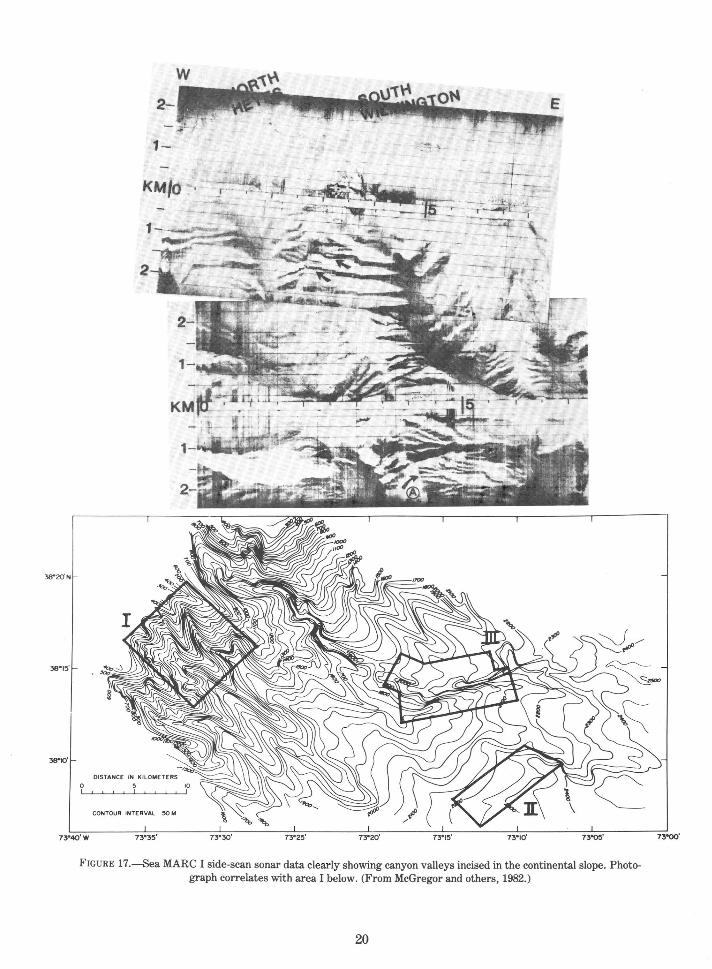
The Sea MARC I* side-scan sonar, was developed for Lamont-Doherty Geological Observatory, records, like GLORIA, differences in acoustic reflectivity of the sea floor. Unlike
• Any use of trade names is for descriptive purposes only and does not imply endorsement by the USGS.
GUllY ,
SONAR FISH SONOGRAPH -
' " ECHO SOUNDING
FIGURE 15.--Schematic diagram of GLORIA side-scan sonar process.
GLORIA, it is towed 100-300 m above the bottom, avoiding the distortions introduced by the water column, particularly temperature variation. This system provides for greater resolution of sea-floor features than the GLORIA system but at a reduced swath width (compare figs. 16, 17). The swath width can be set at either 1 km or 5 km, with horizontal resolution in centimeters or meters, respectively. The former, for example, might distinguish nodule-sized features; the latter could trace the fronts oflava flows.
A recent version, the Sea MARC II, operated by the Hawaii Institute of Geophysics, is towed higher in the water column than the Sea MARC I, allowing for higher speeds. A major innovation, one also available on later versions of the deeptowed Sea MARC I, is a bathymetry system with a theoretical resolution of 6 m for the entire 5-km swath (fig. 18), though this resolution has not yet been verified. Once verified this system will give clearer images of smaller scale features than GLORIA, providing the capability for even more useful geologic investigations.
18
The primary value of GLORIA, Seabeam, and Sea MARC is the detailed information obtainable over extended areas. The huge expanse of the EEZ, combined with the current minimal coverage in the nonshelf areas, makes this equipment important for initial surveys in order to determine regional geology. Follow-up multichannel seismic surveys will be necessary for locating deep basins which could serve as hydrocarbon traps, and sampling programs will be necessary for resource assessment, as well as the initial geologic mapping.
CONCLUSION
Although the EEZ has high potential for significant recoverable energy and mineral resources, further information is necessary before the extent of that potential can be reliably estimated. The values in this report are mostly hypothetical, based on the best available data. Moreover, they do not take into account the technical or economic feasibility of the mineral recovery. The exploration section is intended as an introduction to the equip-

Western flank of Lydonia Canyon
uncharted canyon
Gilbert Canyon
Chebacco Canyon
File bottom Canyon
Eastern flank of --Oceanographer Canyon
downslope------ ------ 13 km ----
+ + 4'PliJ'
40•HI'
~-----------~--------L------~-------- ... ... FIGURE 16.---Stereopair sonographs and location map of the upper continental slope off Georges
Bank showing a high density of canyons extending across the Atlantic slope (Teleki and others, 1981).
19
38"15'
2-
1-
KM/Cl
0
CONTOUR INTERVAL ·
FIGURE 17.-Sea MARC I side-scan sonar data clearly showing canyon valleys incised in the continental slope. Photograph correlates with area I below. (From McGregor and others, 1982.)
20

FIGURE 18.-Sea MARC II operation system and mapping geometry. (From Blackington, 1983.)
21
ment and methods available for making relatively rapid, reasonably accurate assessments of geologic environments. This advancing technology is extending our scientific reach, so that surveys are increasingly improving our knowledge of the geologic processes and the presence and distribution of resources in the EEZ.
REFERENCES
Blackington, J. G., 1983, First results from a combination sidescan sonar and sea floor mapping system (Sea MARC II): Offshore Technology Conference, 15th, OTC 4478, p. 1-5.
Damuth, J. E., Kolla, V., Flood, R. D., Kowsmann, R. 0., Monteiro, M. C., Gorini, M. A., Palma, J. J. C., and Belderson, R. H., 1983, Distributary channel wandering and bifurcation patterns on the Amazon deep-sea fan as revealed by long-range side scan sonar (GLORIA): Geology, v. 11, no. 2, p. 94-98.
Dillon, W. P., 1983, Regional geology and petroleum potential, in Dillon, W. P., ed., Geology report for proposed oil and gas lease sale No. 90; continental margin off the southeastern United States: U.S. Geological Survey Open-File Report 83-186, p. 6-66.
Dillon, W. P., Poag, C. W., Valentine, P. C., and Paull, C. K., 1979, Structure, biostratigraphy, and seismic stratigraphy along a common-depth-point seismic profile through three drill sites on the continental margin off Jacksonville: U.S. Geological Survey Miscellaneous Field-Studies Map MF-1090.
Dolton, G. L., Carlson, K. H., Charpentier, R. R., Coury, A. B., Crovelli, R. A., Frezon, S. E., Khan, A. S., Lister, J. H., McMullin, R. H., Pike, R. S., Powers, R. B., Scott, E. W., and Varnes, K. L., 1981, Estimates of undiscovered recoverable conventional resources of oil and gas in the United States: U.S. Geological Survey Circular 860, 87 p.
Francheteau, J., Needham, H. D., Choukroune, P., Juteau, T., Seguret, M., Ballard, R. D., Fox, P. J., Normark, W., Carranza, A., Cordoba, D., Guerrero, J., Rangin, C., Bougault, H., Cambon, 0., and Hekinian, R. 1979, Massive deep-sea sulfide ore deposits discovered on the East Pacific Rise: Nature, v. 227, p. 523-528.
22
Geotimes, 1982, Cobalt found in Pacific, Geotimes, v. 27, no. 12, p. 25-26.
Greene, H. G., and Wong, F. L., 1983, Hydrocarbon resource studies in the southwest Pacific, 1982: U.S. Geological Survey Open-File Report 83-293.
Hedberg, H. D., 1979, Ocean floor boundaries: Science, v. 204, p. 135-144.
--1983, Letters and comments: A critique of boundary provisions in the Law of the Sea Treaty: Ocean Development and International Law Journal, v. 12, no. 3-4.
Manheim, F. T., and Hess, H. D., 1981, Hard mineral resources around the U.S. continental margin: Offshore Technology Conference, 13th, OTC 4131, p. 129-138.
McGregor, B. A., Stubblefield, W. L., Ryan, W. B. F., and Twichell, D. C., 1982, Wilmington submarine canyon: a marine fluvial-like system: Geology, v. 10, p. 27-30.
McKelvey, V. E., 1983, Letter to the editor: Ocean Development and International Law Journal, v. 12, nos. 3-4, p. 343-344.
McKelvey, V. E., Wright, N. A., and Bowen, R. W., 1983, Analysis of the world distribution of metal-rich subsea manganese nodules: U.S. Geological Circular 886, 101 p.
Schlee, J. S., and Grow, J. A., 1980, Buried carbonate shelf edge beneath the Atlantic continental slope: Oil and Gas Journal, v. 78, no. 8, p. 148-156.
Teleki, P. G., Roberts, D. G., Chavez, P. S., Somers, M. L., and Twichell, D. C., 1981, Sonar survey of the U.S. Atlantic continental slope; acoustic char:lcteristics and image processing techniques: Offshore Technology Conference, 13th, OTC 4017, p. 91-95.
Twichell, D. C., and Roberts, D. G., 1982, Morphology, distribution, and development of submarine canyons on the United States Atlantic continental slope between Hudson and Baltimore Canyons: Geology, v. 10, p. 408-412.
United States Bureau of Mines and the U.S. Geological Survey, 1980, Principles of a resource/reserve classification for minerals: U.S. Geological Survey Circular 831, 5 p.
United Nations Conference on the Law of the Sea, 1982, Convention on the Law of the Sea and resolutions I-IV: New York, 11th session, March-April1982, p. 38-39.
Wilde, P., Normark, W. R., and Chase, T. E., 1976, Petroleum potential of continental rise off central California - summary, in Circum-Pacific Energy and Mineral Resources, American Association of Petroleum Geologists, Memoir No. 25, p. 313-317.
APPENDIXE'S A-C

APPENDIX A
THE WHITE HOUSE
Office of the Press Secretary
Embargoed for release at 4:00 pm est March 10, 1983
STATEMENT BY THE PRESIDENT
The United States has long been a leader in developing customary and conventional law of the sea. Our objectives have consistently been to provide a legal order that will, among other things, facilitate peaceful, international uses of the oceans and provide for equitable and effective management and conservation of marine resources. The United States also recognizes that all nations have an interest in these issues.
Last July I announced that the United States will not sign the United Nations Law of the Sea Convention that was opened for signature on December 10. We have taken this step because several major problems in the Convention's deep seabed mining provisions are contrary to the interests and principles of industrialized nations and would not help attain the aspirations of developing countries.
The United States does not stand alone in those concerns. Some important allies and friends have not signed the Convention. Even some signatory States have raised concerns about these problems.
However, the Convention also contains provisions with respect to traditional uses of the oceans which generally confirm existing maritime law and practice and fairly balance the interests of all States.
Today I am announcing three decisions to promote and protect the oceans interests of the United States in a manner consistent with those fair and balanced results in the Convention and international law.
First, the United States is prepared to accept and act in accordance with the balance of interests relating to traditional uses of the oceans-such as navigation and overflight. In this respect, the United States will recognize the rights of other States in the waters off their coasts, as reflected in the Convention, so long as the rights and freedoms of the United States and others under international law are recognized by such coastal States.
24
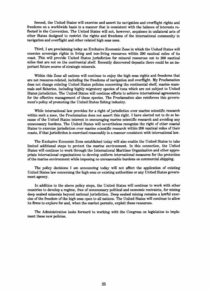
Second, the United States will exercise and assert its navigation and overflight rights and freedoms on a worldwide basis in a manner that is consistent with the balance of interests reflected in the Convention. The United States will not, however, acquiesce in unilateral acts of other States designed to restrict the rights and freedoms of the international community in navigation and overflight and other related high seas uses.
Third, I am proclaiming today an Exclusive Economic Zone in which the United States will exercise sovereign rights in living and non-living resources within 200 nautical miles of its coast. rhl.s will provide United States jurisdiction for mineral resources out to 200 nautical miles that are not on the continental shelf. Recently discovered deposits there could be an important future source of strategic minerals.
Within this Zone all nations will continue to enjoy the high seas rights and freedoms that are not resource-related, including the freedoms of navigation and overflight. My Proclamation does not change existing United States policies concerning the continental shelf, marine mammals and fisheries, including highly migratory species of tuna which are not subject to United States jurisdiction. The United States will continue efforts to achieve international agreements for the effective management of these species. The Proclamation also reinforces this government's policy of promoting the United States fishing industry.
While international law provides for a right of jurisdiction over marine scientific research within such a zone, the Proclamation does not assert this right. I have elected not to do so because of the United States interest in encouraging marine scientific research and avoiding any unnecessary burdens. The United States will nevertheless recognize the right of other coastal States to exercise jurisdiction over marine scientific research within 200 nautical miles of their coasts, if that jurisdiction is exercised reasonably in a manner consistent with international law.
The Exclusive Economic Zone established today will also enable the United States to take limited additional steps to protect the marine environment. In this connection, the United States will continue to work through the International Maritime Organization and other appropriate international organizations to develop uniform international measures for the protection of the marine environment while imposing no unreasonable burdens on commercial shipping.
The policy decisions I am announcing today will not affect the application of existing United States law concerning the high seas or existing authorities or any United States government agency.
In addition to the above policy steps, the United States will continue to work with other countries to develop a regime, free of unnecessary political and economic restraints, for mining deep seabed minerals beyond national jurisdiction. Deep seabed mining remains a lawful exercise of the freedom of the high seas open to all nations. The United States will continue to allow its firms to explore for and, when the market permits, exploit these resources.
The Administration looks forward to working with the Congress on legislation to implement these new policies.
25

APPENDIX 8
THE WHITE HOUSE
Office of the Press Secretary
Embargoed for releast at 4:00 pm est March 10, 1983
UNITED STATES OCEANS POLICY FACT SHEET
Today the President announced new guidelines for U.S. oceans policy and proclaimed an Exclusive Economic Zone (EEZ) for the United States. This follows his consideration of a senior interagency review of these matters.
The EEZ Proclamation confirms U.S. sovereign rights and control over the living and nonliving natural resources of the seabed, subsoil and superjacent waters beyond the territorial sea but within 200 nautical miles of the United States coasts. This will include, in particular, new rights over all minerals (such as nodules and sulphide deposits) in the zone that are not on the continental shelf but are within 200 nautical miles. Deposits of polymetallic sulphides and cobalt/manganese crusts in these areas have only been recently discovered and are years away from being commercially recoverable. But they could be a major future source of strategic and other minerals important to the U.S. economy and security.
The EEZ applies to waters adjacent to the United States, the Commonwealth of Puerto Rico, the Commonwealth of the Northern Mariana Islands (consistent with the Covenant and UN Trusteeship Agreement), and United States overseas territories and possessions. The total area encompassed by the EEZ has been estimated to exceed two million square nautical miles.
The President's statement makes clear that the proclamation does not change existing policies with respect to the outer continental shelf and fisheries within the U.S. zone.
Since President Truman proclaimed U.S. jurisdiction and control over the adjacent continental shelf in 1945, the U.S. has asserted sovereign rights for the purpose of exploration and exploitation of the resources of the continental shelf. Fundamental supplementary legislation, the Outer Continental Shelf Lands Act, was passed by Congress in 1953. The President's proclamation today incorporates existing jurisdiction over the continental shelf.
Since 1976 the United States has exercised management and conservation authority over fisheries resources (with the exception of highly migratory species of tuna) within 200 nautical miles of the coasts, under the Magnuson Fishery Conservation and Management Act. The U.S. neither recognizes nor asserts jurisdiction over highly migratory species of tuna. Such species are best managed by international agreements with concerned countries. In addition to confirming the United States sovereign rights over mineral deposits beyond the continental shelf but within 200 nautical miles, the Proclamation bolsters U.S. authority over the living resources of the zone.
26
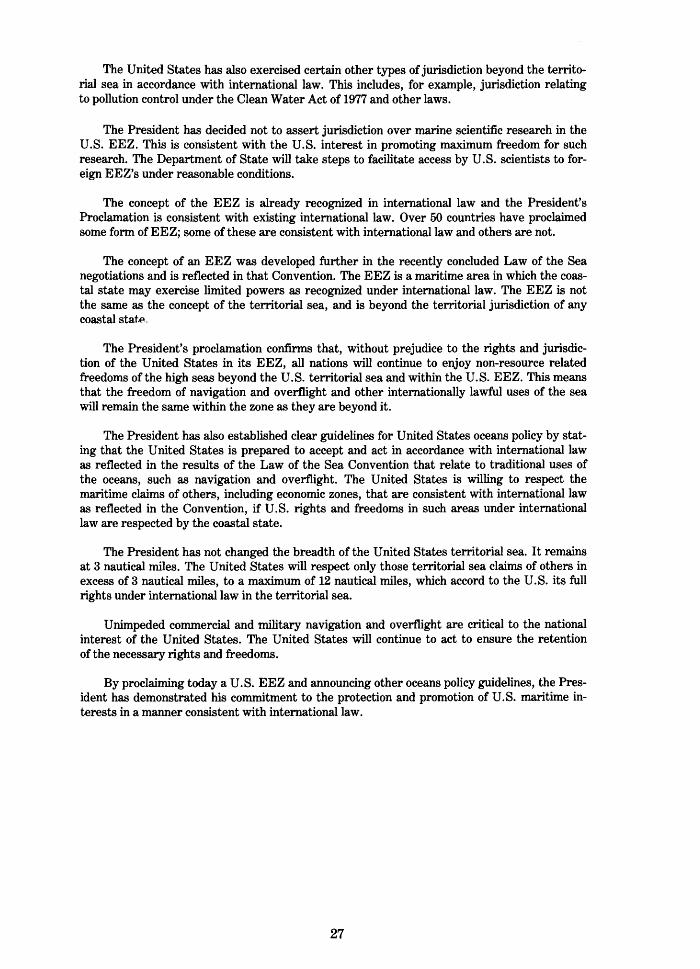
The United States has also exercised certain other types of jurisdiction beyond the territorial sea in accordance with international law. This includes, for example, jurisdiction relating to pollution control under the Clean Water Act of 1977 and other laws.
The President has decided not to assert jurisdiction over marine scientific research in the U.S. EEZ. This is consistent with the U.S. interest in promoting maximum freedom for such research. The Department of State will take steps to facilitate access by U.S. scientists to foreign EEZ's under reasonable conditions.
The concept of the EEZ is already recognized in international law and the President's Proclamation is consistent with existing international law. Over 50 countries have proclaimed some form of EEZ; some of these are consistent with international law and others are not.
The concept of an EEZ was developed further in the recently concluded Law of the Sea negotiations and is reflected in that Convention. The EEZ is a maritime area in which the coastal state may exercise limited powers as recognized under international law. The EEZ is not the same as the concept of the territorial sea, and is beyond the territorial jurisdiction of any coastal statf~.
The President's proclamation confirms that, without prejudice to the rights and jurisdiction of the United States in its EEZ, all nations will continue to enjoy non-resource related freedoms of the high seas beyond the U.S. territorial sea and within the U.S. EEZ. This means that the freedom of navigation and overflight and other internationally lawful uses of the sea will remain the same Within the zone as they are beyond it.
The President has also established clear guidelines for United States oceans policy by stating that the United States is prepared to accept and act in accordance with international law as reflected in the results of the Law of the Sea Convention that relate to traditional uses of the oceans, such as navigation and overflight. The United States is willing to respect the maritime claims of others, including economic zones, that are consistent with international law as reflected in the Convention, if U.S. rights and freedoms in such areas under international law are respected by the coastal state.
The President has not changed the breadth of the United States territorial sea. It remains at 3 nautical miles. The United States will respect only those territorial sea claims of others in excess of 3 nautical miles, to a maximum of 12 nautical miles, which accord to the U.S. its full rights under international law in the territorial sea.
Unimpeded commercial and military navigation and overflight are critical to the national interest of the United States. The United States will continue to act to ensure the retention of the necessary rights and freedoms.
By proclaiming today a U.S. EEZ and announcing other oceans policy guidelines, the President has demonstrated his commitment to the protection and promotion of U.S. maritime interests in a manner consistent with international law.
27
APPENDIX C
PART VI, CONTINENTAL SHELF
Article 76, Definition of the continental shelf
1. The continental shelf of a coastal State comprises the sea-bed and subsoil of the submarine areas that extend beyond its territorial sea throughout the natural prolongation of its land territory to the outer edge of the continental margin, or to a distance of 200 nautical miles from the baselines from which the breadth of the territorial sea is measured where the outer edge of the continental margin does not extend up to that distance.
2. The continental shelf of a coastal State shall not extend beyond the limits provided for in paragraph 4 to 6.
3. The continental margin comprises the submerged prolongation of the land mass of the coastal State, and consists of the sea-bed and subsoil of the shelf, the slope and the rise. It does not include the deep ocean floor with its oceanic ridges or the subsoil thereof.
4. (a) For the purposes of this Convention, the coastal State shall establish the outer edge of the continental margin wherever the margin extends beyond 200 nautical miles from the baselines from which the breadth of the territorial sea is measured, by either:
(i) a line delineated in accordance with paragraph 7 by reference to the outermost fixed points at each of which the thickness of sedimentary rocks is at least 1 per cent of the
shortest distance from such point to the foot of the continental slope; or
(ii) a line delineated in accordance with paragraph 7 by reference to fixed points not more than 60 nautical miles from the foot of the continental slope.
(b) In the absence of evidence to the contrary, the foot of the continental slope shall be determined as the point of maximum change in the gradient at its base.
5. The fixed points comprising the line of the outer limits of the continental shelf on the sea-bed, drawn in accordance with paragraph 4 (a) (i) and (ii), either shall not exceed 350 nautical miles from the baselines from which the breadth of the territorial sea is measured or shall not exceed 100 nautical miles from the 2,500 metre isobath, which is a line connecting the depth of 2,500 metres.
6. Notwithstanding the provisions of paragraph 5, on submarine ridges, the outer limit of the continental shelf shall not exceed 350 nautical miles from the baselines from which the breadth of the territorial sea is measured. This paragraph does not apply to submarine elevations that are natural components of the continental margin, such as its plateaux, rises, caps, banks and spurs.
28

7. The coastal State shall delineate the outer limits of its continental shelf, where that shelf extends beyond 200 nautical miles from the baselines from which the breadth of the territorial sea is measured, by straight lines not exceeding 60 nautical miles in length, connecting fixed points, defined by co- ordinates of latitude and longitude.
8. Information on the limits of the continental shelf beyond 200 nautical miles from the baselines from which the breadth of the territorial sea is measured shall be submitted by the coastal State to the Commission on the Limits of the Continental Shelf set up under Annex II on the basis of equitable geographical representation. The Commission shall make recommendations to coastal States on matters related to the establishment of the outer limits of their continental shelf. The limits of the shelf established by a coastal State on the basis of these recommendations shall be final and binding.
9. The coastal State shall deposit with the Secretary-General of the United Nations charts and relevant information, including geodetic data, permanently describing the outer limits of its continental shelf. The Secretary-General shall give due publicity thereto.
10. The provisions of this article are without prejudice to the question of delimitation of the continental shelf between States with opposite or adjacent coasts.
Article 77, Rights of the coastal State over the continental shelf
1. The coastal State exercises over the continental shelf sovereign rights for the purpose of exploring it and exploiting its natural resources.
2. The rights referred to in paragraph 1 are exclusive in the sense that if the coastal State does not explore the continental shelf or exploit its natural resources, no one may undertake these activities without the express consent of the coastal State.
3. The rights of the coastal State over the continental shelf do not depend on occupation, effective or notional, or on any express proclamation.
4. The natural resources referred to in this Part consist of the mineral and other non-living resources of the sea-bed and subsoil together with living organisms belonging to sedentary species, that is to say, organisms which, at the harvestable stage, either are immobile on or under the sea-bed or are unable to move except in constant physical contact with the sea-bed or the subsoil.
29

GPO 787-042/108


![Geology Geophysics in Oil Exploration[1]](https://img.pdfslide.us/doc/110x75/55258648550346f36e8b48a1/geology-geophysics-in-oil-exploration1.jpg)
