Embed Size (px)
Citation preview
GEOLOGY AND MINERALIZATION OF THE LAKE ZONE
WOLF LAKE PROPERTY
Vancouver Island, BC
for
NANAIMO P~~NING ~IVISION
LAT. 49' 46' 42" N.
BY
James Laird, Project Manager
and
G.R. Thomson B.Sc. P. Geo., Project Geologist
July, 2005
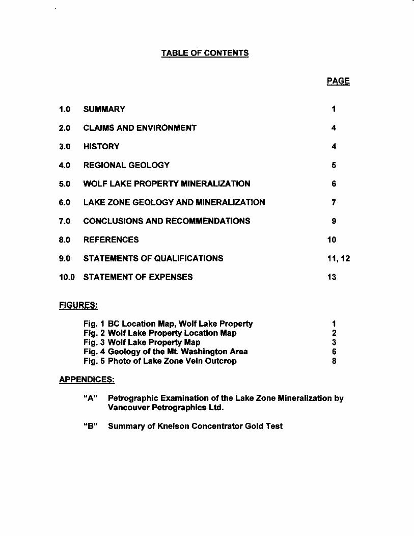
TABLE OF CONTENTS
1 .o
2.0
3.0
4.0
5.0
6.0
7.0
8.0
9.0
SUMMARY
CLAIMS AND ENVIRONMENT
HISTORY
REGIONAL GEOLOGY
WOLF LAKE PROPERTY MINERALIZATION
LAKE ZONE GEOLOGY AND MINERALIZATION
CONCLUSIONS AND RECOMMENDATIONS
REFERENCES
STATEMENTS OF QUALIFICATIONS
10.0 STATEMENT OF EXPENSES
FIGURES:
Fig. 1 BC Location Map, Wolf Lake Property Fig. 2 Wolf Lake Property Location Map Fig. 3 Wolf Lake Property Map Fig. 4 Geology of the Mt Washington Area Fig. 5 Photo of Lake Zone Vein Outcrop
1
4
4
5
6
7
9
10
11,12
13
APPENDICES:
WAY3 Petrographic Examination of the Lake Zone Mineralization by Vancouver Petrographics Ltd.
Summary of Knelson Concentrator Gold Test “B”
1
1.0 SUMMARY F This report was prepared at the request of Pearl Asian Mining Industries Inc. of Vancouver, BC, 100% owner of the Wolf Lake Property, by James Laird, Project Manager, and Greg Thomson, geologist. The Wolf Lake Property is located on the eastern slope of Mt. Washington near the town of Courtenay, Vancouver Island, BC. It comprises 12 mineral claims situated at north end of Wolf Lake, about 12 km by paved highway and gravel logging roads from the major Island Highway.
BC LOCATION MAP, WOLF LAKE PROPERTY
The Wolf Lake Property is underlain by basaltic volcanic rocks of the Upper Triassic KarmNsen Formation unconformably overlain by Cretaceous Nanaimo Group sediments. The Mt. Washington-Constitution Hill area is host to a major ,(-
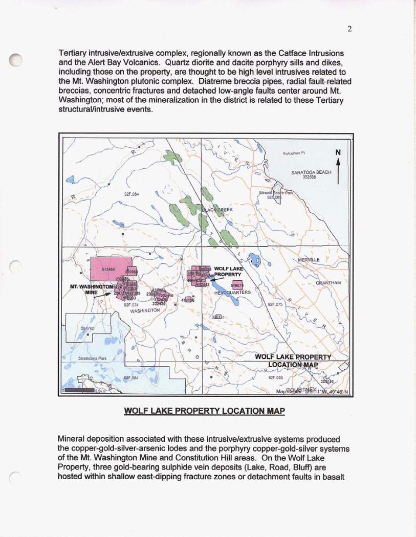
Tertiary intrusivelextrusive complex, regionally known as the Catface Intrusions and the Alert Bay Volcanics. Quartz diorite and dacite porphyry sills and dikes, including those on the property, are thought to be high level intrusives related to the Mt. Washington plutonic complex. Diatreme breccia pipes, radial fault-related breccias, concentric fractures and detached low-angle faults center around Mt. Washington; most of the mineralization in the district is related to these Tertiary struCturaVintrusive events.
c
WOLF LAKE PROPERTY LOCATION MAP
Mineral deposition associated with these intrusive/extrusive systems produced the copper-gold-silver-arsenic lodes and the porphyry copper-gold-silver systems of the Mt. Washington Mine and Constitution Hill areas. On the Wolf Lake Property, three gold-bearing sulphide vein deposits (Lake, Road, Bluff) are hosted within shallow east-dipping fracture zones or detachment faults in basalt r
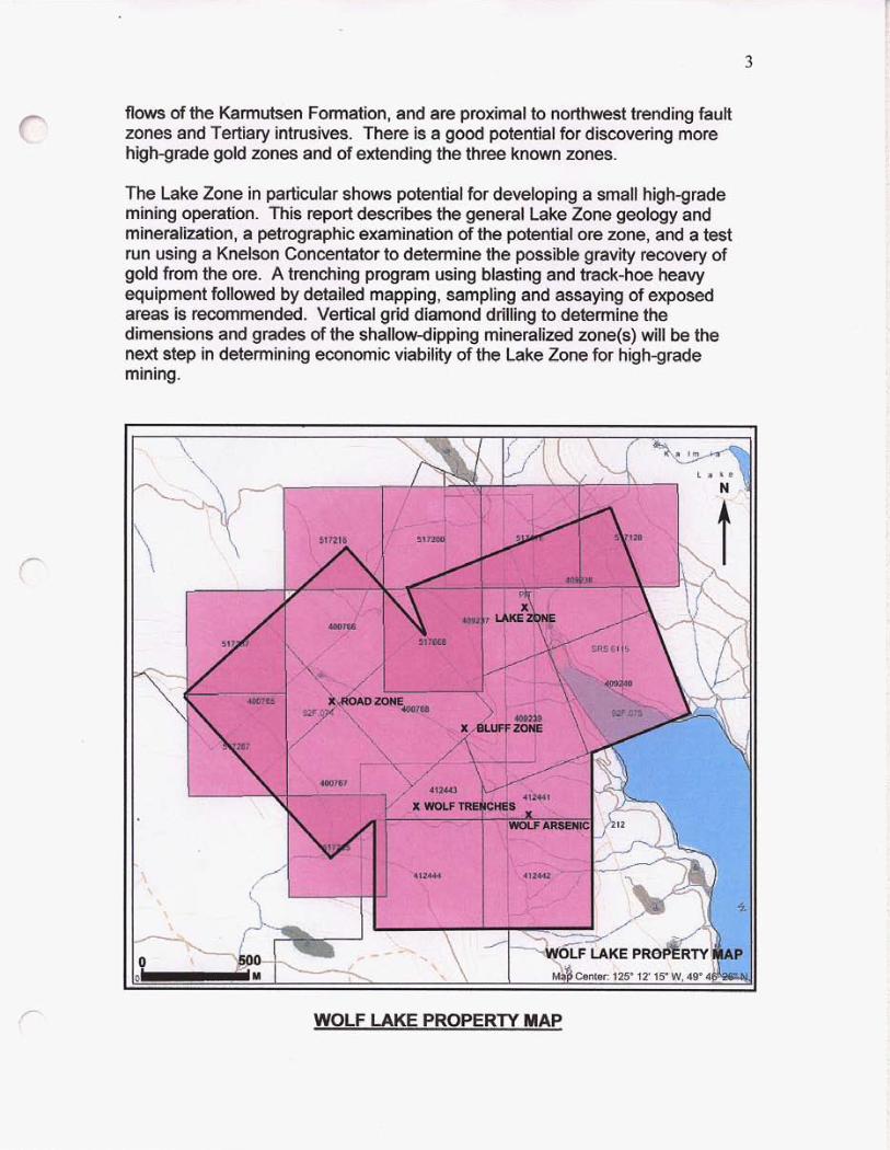
flows of the Karmutsen Formation, and are proximal to northwest trending fault zones and Tertiary intrusives. There is a good potential for discovering more high-grade gold zones and of extending the three known zones.
r The Lake Zone in particular shows potential for developing a small high-grade mining operation. This report describes the general Lake Zone geology and mineralization, a petrographic examination of the potential ore zone, and a test run using a Knelson Concentator to determine the possible gravity recovery of gold from the ore. A trenching program using blasting and track-hoe heavy equipment followed by detailed mapping, sampling and assaying of exposed areas is recommended. Vertical grid diamond drilling to determine the dimensions and grades of the shallow-dipping mineralized zone(s) will be the next step in determining economic viability of the Cake Zone for high-grade mining.
WOLF LAKE PROPERTY MAP c
2.0 CLAIMS AND ENVIRONMENT
Access to the property is from the Island Highway: drive 2 km west along the Strathcona Parkway towards Mt. Washington, turn north on the Duncan Bay main logging road and travel about 10km to the north end of Wolf Lake. Topography within the claims area is relatively subdued with the main mineralized outcrop areas being between 250-350 metres above sea level.
The climate is mild and typical of low elevation areas near the eastern coast of Vancouver Island. Vegetation is largely second growth cedar, hemlock, spruce and fir with dense underbrush. Wildlife noted in the area includes; deer, black bear, elk, cougar and a variety of smaller animals and birds. Several trout species inhabit Wolf Lake and it is a popular fishing spot.
The Wolf Lake Property is comprised of twelve 2-post mineral claims, Bluff 1 to 4, Lake 1 to 4, and the Wolf 1 to 4. The following Mineral Tenures are held in the name of Pearl Asian Mining Industries Inc.;
Claim Bluff 1 Bluff 2 Bluff 3 Bluff 4 Lake 1 Lake 2 Lake 3 Lake 4 wolf 1 Wolf 2 wolf 3 Wolf 4
- Tenure Number 400765 400766 400767 400768 409237 409238 409239 409240 412441 41 2442 412443 4 1 2444
Due Date Feb. 25,2006 Feb. 25,2006 Feb. 25,2006 Feb. 25,2006 March 16,2012 March 16,2012 March 16,2012 March 16,2012 July 18, 2005 July 18, 2005 July 18. 2005 July 18, 2005
3.0 HISTORY
The earliest known information on showings in the claims area is found in a 1924 government report, which describes a realgar (arsenic) deposit on the Good Hope claim. These showings are now covered by the Wolf claims.
High-grade gold mineralization was discovered on Mt. Washington in the Domineer zone, about 6.5 km west of the claims, in 1943. Approximately 400,000 tons of 1.16% copper with gold and silver credits was mined from two open pits on Mt. Washington during 1964-1965.
Since 1983, Better Resources Ltd. has explored the gold and silver potential at Mt. Washington and by the end of 1989 had established a (pre-NI 43-101) drill-
5
indicated resource of 550,298 tonnes at a grade of 6.75 glt gold and 32.23 glt silver in the Domineer and Lakeview zones.
In his report on the Tertiary Mineral Deposits of Vancouver Island, Carson (1969) shows the geology and mineral deposits of the Mt. Washington and Constitution Hill area to be similar in character and origin.
Several companies, including Proquest Resources Corporation, Cactus West Explorations Ltd. and Homestake Mineral Development Company have explored the present claims area when it was held as part of the Lupus claims in the mid 1980s. During these programs two gold bearing showings were discovered, the Lake Zone and the Road Showing.
A private prospecting report by James Laird for Cactus West Explorations Ltd. documenting work during the period March 10 to 27, 1987, describes the nature and mineralogy of the three important showings, the Lake Zone, Road Showing and the newly discovered Bluff Gold Vein.
The most recent work is a geological assessment report done in 2004 by K. W. Geiger, Ph.D. examining the general geology and mineral deposits of the claims area.
4.0 REGIONAL GEOLOGY
Vancouver Island is built on a thick platform of Paleozoic volcanic-sedimentary rocks known as the Sicker Group. The Sicker Group hosts all of the large polymetallic volcanogenic deposits mined at Myra Falls near Buttle Lake and several other former mines, and all of the known rhodonite gemstone deposits. This rock package is not exposed in the Mt. Washington area, although it is found in the Buttle Lake area to the west.
Rocks of the Mt. Washington-Constitution Hill area overlie the Sicker Group platform and comprise an unconformable sequence of oldest to youngest, Karmutsen Formation basaltic volcanics of Upper Triassic age and gently dipping Upper Cretaceous sediments of the Nanaimo Group. A thin but distinctive intra- volcanic sedimentary package comprised of limestone, chert and volcanic conglomerate occurs near the top of the Karmutsen Formation locally.
The Mt. Washington-Constitution Hill area is within a major Tertiary intrusive/extrusive complex. Radial fracture patterns, concentric fractures and detached low-angle faults center around a magnetic high at Mt. Washington suggesting that an extensive plutonic complex underlies the whole area. Quartz diorite and dacite porphyry sills and dikes including those on the Wolf Lake Property, are thought to be high level intrusives related to this pluton. Mineral deposition associated with these intrusivelextrusive events produced the
6
r
,--
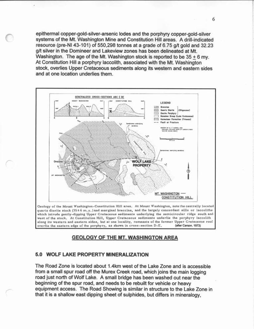
epithermal copper-gold-silver-arsenic lodes and the porphyry copper-gold-silver systems of the Mt. Washington Mine and Constitution Hill areas. A drill-indicated resource (pre-NI 43-101) of 550,298 tonnes at a grade of 6.75 g/t gold and 32.23 glt silver in the Domineer and Lakeview zones has been delineated at Mt. Washington. The age of the Mt. Washington stock is reported to be 35 6 my. At Constitution Hill a porphyry laccolith, associated with the Mt. Washington stock, overlies Upper Cretaceous sediments along its western and eastern sides and at one location underlies them.
eology of the Mount Washington-Con.titution Hill area. At Mount Washington, note the centrally locate< uartz diorite stock ( 3 5 + 6 m.y.)and marginal breccias, and the largely concordant sills or laccoliths hich intrude gently-dipping Upper Cretaceous sediments underlying the semicircular ridge south and est of the stock. At Constitution Hill, Upper Cretaceous sediments underlie the porphyry laccolith long its western and eastern sides. but at one locality. remnants of the former Upper Cretaceous roof verlie the eastern edge of the porphyry, as shown in cross-section D-E. (Mer Camon, 1973)
GEOLOGY OF THE MT. WASHINGTON AREA
5.0 WOLF LAKE PROPERTY MINERALIZATION
The Road Zone is located about 1.4km west of the Lake Zone and is accessible from a small spur road off the Murex Creek road, which joins the main logging road just north of Wolf Lake. A small bridge has been washed out near the beginning of the spur road, and needs to be rebuilt for vehicle or heavy equipment access. The Road Showing is similar in structure to the Lake Zone in that it is a shallow east dipping sheet of sulphides, but differs in mineralogy,
which includes: pyrite, chalcopyrite, pyrrhotite, minor malachite and azurite in a gangue of vuggy quartz veins and silicified basalt. A grab sample reported in Minfile assayed 21.94 glt gold and 30.86 glt. silver.
The Bluff Zone, situated roughly half way between the Road Zone and the Lake Zone is a narrow (0.1 m), vuggy quartz-pyrite vein with rare native gold exposed in the wall of a small cliff on the opposite side of the hill that contains the Lake Showing. The vein has the same general attitude as the Lake Zone and Road Zone. Old trenches were recently found along the southwest boundary of Bluff claims and on the Wolf claims near Wolf Creek; they contain sulphide and gangue mineralization similar to that at the Road, Bluff and Lake zones, and may well lie along the same or similar zone or zones.
6.0 LAKE ZONE GEOLOGY AND MINERALIZATION
On March 9" and1 0th. 2005 a geological examination was done of the Lake Zone mineral showing, one of several similar mineral occurrences on the Wolf Lake Property. The Lake Zone, which has been previously trenched and sampled, is situated in a rock quarry beside the main logging road at the north end of Wolf Lake. The gold-bearing zone is a shallow east dipping tabular sheet of sulphides and altered wallrock about 2 m thick. Visual mineralogy is pyrite, sphalerite, arsenopyrite, minor galena and chalcopyrite in a gangue of vuggy quartz, carbonate, and dark brecciated wallrock fragments. The vein breccia was discovered during quarrying operations and did not outcrop, indicating good potential for similar "blind" zones on strike or parallel to the Lake Zone. A 0.90 m sample reported in BC Minfile assayed 4.42 glt gold and 20.57gh silver.
Twelve samples taken by Cactus West Explorations Ltd. in 1988 show consistent ore-grade values from the Lake Zone.
Sample# Width (m) Gold orlt Silver orlt Zinc % 1 1 .o 0.175 0.747 2.86 2 0.7 0.056 0.21 1 1.06 3 0.43 0.318 0.04 1 .oo 4 Grab 2.442 12.44 4.45 5 0.11 2.30 4.23 9.48 6 0.23 0.779 2.74 4.17 7 Grab 1.40 3.40 6.58 8 0.11 2.64 5.61 9.58 9 1 .o 0.245 2.03 3.59 10 1.56 0.415 1.43 2.01 Composite samples of the upper alteration zone, the vein breccia, and the lower alteration zone range from: A 1.41 0.415 1.76 1.75 B 2.0 0.357 2.01 2.86
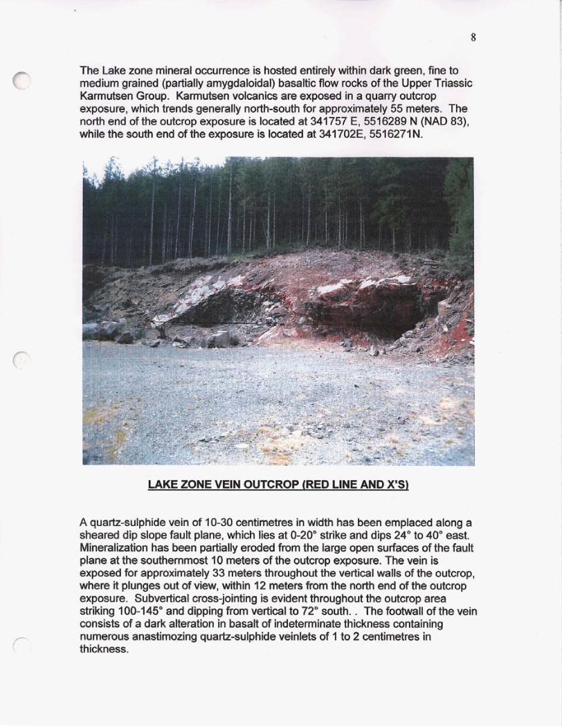
The Lake zone mineral occurrence is hosted entirely within dark green, fine to medium grained (partially amygdaloidal) basaltic flow rocks of the Upper Triassic Karmutsen Group. Karmutsen volcanics are exposed in a quarry outcrop exposure, which trends generally north-south for approximately 55 meters. The north end of the outcrop exposure is located at 341757 E, 5516289 N (NAD 83), while the south end of the exposure is located at 341702E, 5516271N.
c
LAKE ZONE VEIN OUTCROP (RED LINE AND X'S)
A quartz-sulphide vein of 10-30 centimetres in width has been emplaced along a sheared dip slope fault plane, which lies at 0-20" strike and dips 24" to 40" east. Mineralization has been partially eroded from the large open surfaces of the fault plane at the southernmost 10 meters of the outcrop exposure. The vein is exposed for approximately 33 meters throughout the vertical walls of the outcrop, where it plunges out of view, within 12 meters from the north end of the outcrop exposure. Subvertical cross-jointing is evident throughout the outcrop area striking 100-145" and dipping from vertical to 72" south. . The footwall of the vein consists of a dark alteration in basalt of indeterminate thickness containing numerous anastimozing quartz-sulphide veinlets of 1 to 2 centimetres in PI thickness.
9
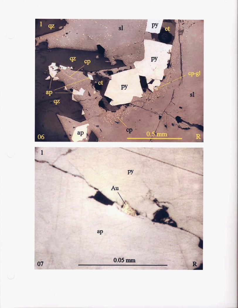
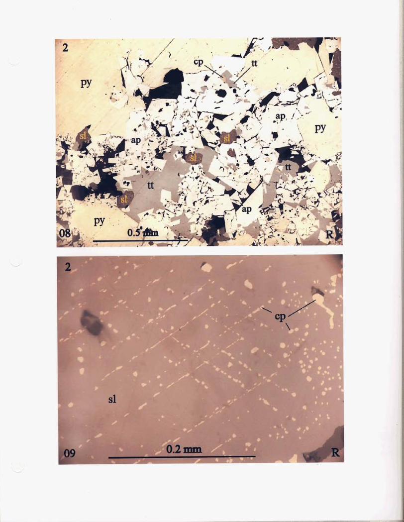
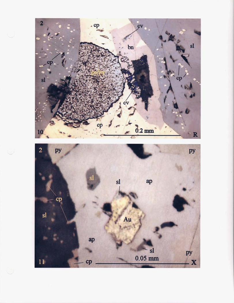
The vein mineralogy consists primarily of massive to Semimassive concentrations of medium to coarse-grained pyrite and black sphalerite with lesser amounts of arsenopyrite, chalcopyrite and galena. Tetrahedrite, bornite and native gold were also identified in the polished section report. Native gold occurs mainly with the arsenopyrite. Two samples of representative mineralized rock were submitted to Vancouver Petrographics Ltd. for petrographic descriptions; results of this study are presented in Appendix "A".
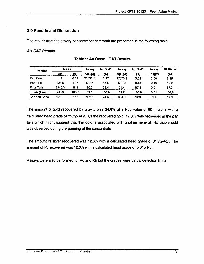
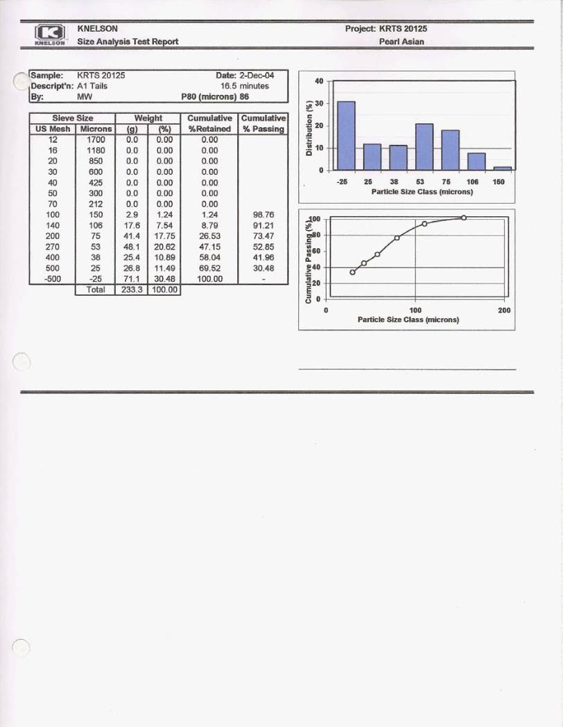
Knelson Concentrators Ltd. of Langley BC were commissioned to run gravity concentrator tests for gold recovery on Lake Zone ore. The sample weight was 9.5 kg, which was crushed and ground to 86 microns before processing. The overall amount of gold recovered by gravity was 24.6% with a calculated head grade of 39.3 gh gold. The recovery indicates a moderate amenability to gravity concentration. No visible gold was observed in the panned concentrates. The overall silver and platinum recoveries were 12.9% and 12.3% respectively with calculated head grades of 61.7 gh silver and 0.01 gh platinum.
7.0 CONCLUSIONS AND RECOMMENDATIONS
The Wolf Lake Property hosts several high-grade gold vein systems and prospects within a complex geological environment comprised of Upper Triassic basalt flows, unconformably overlying Cretaceous sediments, and Tertiary intrusives. The Lake Zone in particular is wellexposed and very accessible, and hosts a rich gold vein system. Testing has shown that approximately 25% of the gold is recoverable by gravity based on a head-grade of about 40 gR gold. A standard flotation process would likely recover a high percentage of the remaining gold, silver and base metals.
Additional resources may be developed by detailed exploration of the known showings on the property, and there is a good possibility of new discoveries. Prospecting, mapping and sampling of these showings should be included in the initial work program, followed by trenching and diamond drilling on the most promising zones.
At the Lake Zone, a trenching program using blasting and a trackhoe followed by detailed geological mapping, sampling and assaying at exposed areas is recommended. Vertical grid diamond drilling to determine the dimensions and grades of the shallow-dipping mineralized zone@) will be the next step in determining economic viability of the Lake Zone for high-grade mining.
10
8.0 REFERENCES
Barr, D.A., (1980): Gold in the Canadian Cordillera, CIM Bulletin, June, Pages 59-76.
Survey of Canada, Paper 7244,70 pages.
Carson, D.J.T. (1968): Metallogenic study of Vancouver Island with emphasis on the Relationship of Plutonic Rocks to Mineral Deposits, Ph.D thesis, Carlton University, Ottawa.
Carson, D.J.T. (1973): The plutonic rocks of Vancouver Island: Geological
Carson, D.J.T. (1969): Tertiary Mineral Deposits of Vancouver Island; CIM Bulletin, Volume 62, Number 685, May, pages 511-519.
Cooke, D. (1986): Geological , Geochemical and Geophysical Report on the Wolf Claims, , B.C. Geological Branch Assessment Report Number 14434
Geiger, K.W. (2004): Geology and Mineral Deposits of the Wolf Lake Property
Harrap, K.L. (1986): Geology and Geochemistry of the Lupus 1-6 Claims, B.C.
Geological Branch Assessment Report Number 27430
Geological Branch Assessment Report Number 14442,20 pages.
Mineralization on Mt. Washington, Vancouver Island B.C. Ministry of Energy, Mines and Petroleum Resources, Paper 1989-1.
Geological Branch Assessment Report Number 1201 5
Verley, C.G. and Keyser, H.J. (1985): Geological and Geochemical Report on the
Muller, J.E. (1989-1): Tertiary Low-Angle Faulting and Related Gold and Copper
Peto, P. (1983): Geochemical and Prospecting Report of the Wolf Claims, B.C.
Lupus 1,3,5 and 6 Claims, B.C. Geological Branch Assessment Report Number 13426,36 pages.
Verley, C.G. (1 986): Geochemical, Geological, Geophysical and Physical Work done on the Lupus Claims , B.C. Geological Branch Assessment Report Number 15034
11
9.0 STATEMENT OF QUALIFICATIONS
I, James W. Laird do state that;
My address is PO Box 672, Lions Bay, BC VON 2E0
I am a prospector and mining exploration contractor and have been for more than 25 years, and I have over 20 years experience working in the Mt. Washington area.
I have completed the BC EMPR course "Advanced Mineral Exploration for Prospectors, 1980".
I managed and participated in all phases of this exploration program, the opinions and conclusions stated herein are entirely my own.
James W. Laird
Laird Exploration Ltd.
July 12,2005
12
9.0 STATEMENT OF QUALIFICATIONS
I: Gregory R. Thomson, of Langley, B.C., do hereby certify:
That I am a Professional Geoscientist registered in the Province of British Columbia.
That I am a graduate Geologist from the University of British Columbia (1970) and have over 25 years of mineral exploration experience in the province of British Columbia.
That the information contained in this report was based upon a review of previous reports and geological studies related to the property area, and a property visit on March 9" and loth, 2005.
Dated at Vancouver, BC, July 10,2005
13
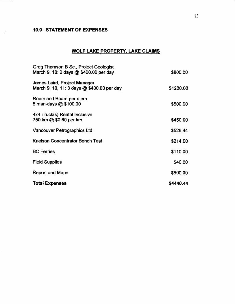
10.0 STATEMENT OF EXPENSES
WOLF LAKE PROPERTY. LAKE CLAIMS
Greg Thomson B Sc., Project Geologist March 9, 10: 2 days @ $400.00 per day
James Laird, Project Manager March 9, 10, 11: 3 days @ $400.00 per day
Room and Board per diem 5 man-days @ $100.00
4x4 Truck(s) Rental Inclusive 750 km @ $0.60 per km
Vancouver Petrographics Ltd.
Knelson Concentrator Bench Test
BC Ferries
Field Supplies
Report and Maps
Total Expenses
$800.00
$1 200.00
$500.00
$450.00
$526.44
$214.00
$1 10.00
$40.00
$600.00
$4440.44

APPENDIX “A”
Report 050222 for
Greg Thompson, April 2005
Samples: Two sections
Summary:
Sample 1 is a rock of uncertain origin that was altered strongly to quartz, sericite, and ankerite with disseminated patches of leucoxene-(pyrite) after ilmenite. Several replacement patches are of muscovite and lesser ankerite. Irregular veins and veinlets are dominated by quartz with patches of one or more of sphalerite, arsenopyrite, and pyrite, with lesser chalcopyrite, minor tetrahedrite and galena, and a trace of native gold. Ankerite forms patches in the veins, in part associated with sulphides.
Sample 2 is a vein or replacement dominated by sphalerite, quartz, arsenopyrite, and pyrite, with lesser tetrahedrite and chalcopyrite, minor galena and ankerite and trace bornite, pyrrhotite, and native gold. Native gold occurs mainly with arsenopyrite. A few late veinlets are of ankerite with much less abundant quartz, sphalerite, and pyrite.
Photographic Notes:
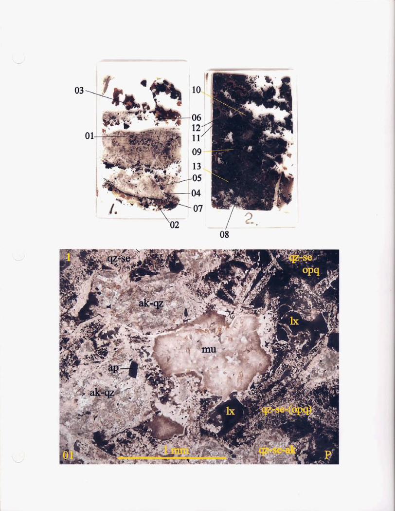
The scanned sections show the gross textural features of the sections; these features are seen much better on the digital image than on the printed image. Sample numbers are shown in or near the top left of the photos and photo numbers at or near the lower left. The letter in the lower right-hand corner indicates the lighting conditions: P = plane light, X = plane light in crossed nicols, and R = reflected light. Locations of digital photographs (by photo number) are shown on the scanned sections. Descriptions of individual photographs are given at the end of the report.
John G. Payne, Ph.D., P.Geo1. Tel: (604)-597-1080 Fax: (604)-597-1080 (call first) email: [email protected]
Sample 1 Quartz-Sericite-Ankeritehucoxene Altered Rock Replacement Patches: Muscovite-(Ankerite) Quartz-Pyrite-Sphalerite-Calcite Vein
The sample is a rock of uncertain origin that was altered strongly to quartz, sericite, and ankerite with disseminated patches of leucoxene-(pyrite) after ilmenite. Several replacement patches are of muscovite and lesser ankerite. Irregular veins and veinlets are dominated by quartz with patches of one or more of sphalerite, arsenopyrite, and pyrite, with lesser chalcopyrite, minor tetrahedrite and galena, and a trace of native gold. Ankerite forms patches in the veins, in part associated with sulphides
mineral quartz sericite opaque ankerite leucoxene/pyrite arsenopyrite replacement muscovite ankerite quartz
veins, veinlets quartz
percentage 20-25% 10-12 4- 5 3- 4 3- 4 0.2
4- 5 0.2
minor
20-25%
ankerite tetrahedrite galena native gold pyrrhotite
The host rot
sphalerite 7- 8 arsenopyrite 4- 5 pyrite 4- 5 chalcopyrite 1
1- 2 0.3 0.1
trace trace
is dominate
main grain size range (mm) 0.005-0.02 0.005-0.02 dusty
0.1-0.3 0.02-0.05
0.01-0.03
0.03-0.07 0.02-0.03 0.01-0.015
0.5-2 0.5-2 0.1-0.5 1 - 2 0.7-1.5 0.3-0.8
0.03-0.1
0.005-0.01 5
(a few grains up to 3 mm)
0.05-0.3
0.01-0.03
y extremely fine graine partz with lesser sericite, patc--:s of non- reflective opaque, and irregular patches of ankerite.
less abundant anhedral grains of ankerite and minor grains of quartz. One patch 2.5 mm across consists of an intergrowth of muscovite and slightly less abundant ankerite.
Several patches up to 2 mm in size consist of aggregates of radiating muscovitekericite with much
Pyrite forms disseminated, subhedral to euhedral grains and clusters of a few to several grains. Leucoxene and much less abundant pyrite occur together in disseminated patches up to 0.3 mm in
size; these probably are secondary after ilmenite.
In the veins, quartz forms anhedral to subhedral and locally euhedral grains that contain moderately abundant dusty inclusions. Grains commonly have euhedral terminations against sphalerite.
(continued)
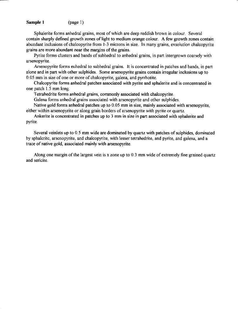
Sample 1 (page 1)
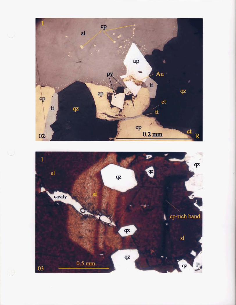
Sphalerite forms anhedral grains, most of which are deep reddish brown in colour. Several contain sharply defined growth zones of light to medium orange colour. A few growth zones contain abundant inclusions of chalcopyrite from 1-3 microns in size. In many grains, exsolution chalcopyrite grains are more abundant near the margins of the grains.
arsenopyrite.
alone and in part with other sulphides. Some arsenopyrite grains contain irregular inclusions up to 0.05 mm in size of one or more of chalcopyrite, galena, and pyrrhotite.
one patch 1.5 mm long.
Pyrite forms clusters and bands of subhedral to anhedral grains, in part intergrown coarsely with
Arsenopyrite forms euhedral to subhedral grains. It is concentrated in patches and bands, in part
Chalcopyrite forms anhedral patches associated with pyrite and sphalerite and is concentrated in
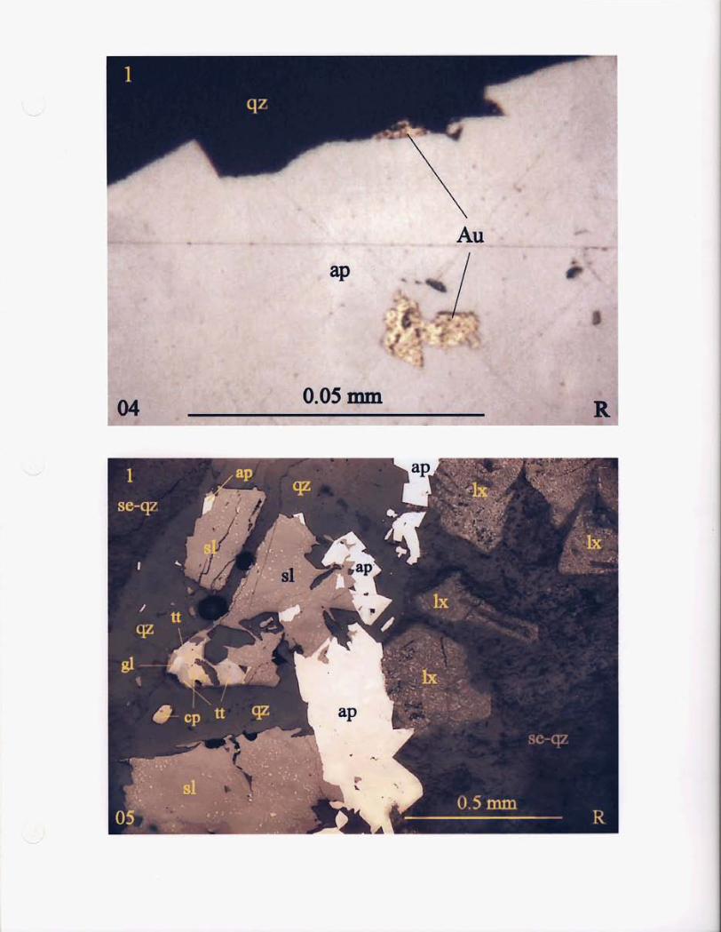
Tetrahedrite forms anhedral grains, commonly associated with chalcopyrite. Galena forms anhedral grains associated with arsenopyrite and other sulphides. Native gold forms anhedral patches up to 0.05 mm in size, mainly associated with arsenopyrite,
either within arsenopyrite or along grain borders of arsenopyrite with pyrite or quartz. Ankerite is concentrated in patches up to 3 mm in size in part associated with sphalerite and
pyrite.
Several veinlets up to 0.5 mm wide are dominated by quartz with patches of sulphides, dominated by sphalerite, arsenopyrite, and chalcopyrite, with lesser tetrahedrite, and pyrite, and galena, and a trace of native gold, associated mainly with arsenopyrite.
Along one margin of the largest vein is a zone up to 0.3 mm wide of extremely fine grained quartz and sericite.
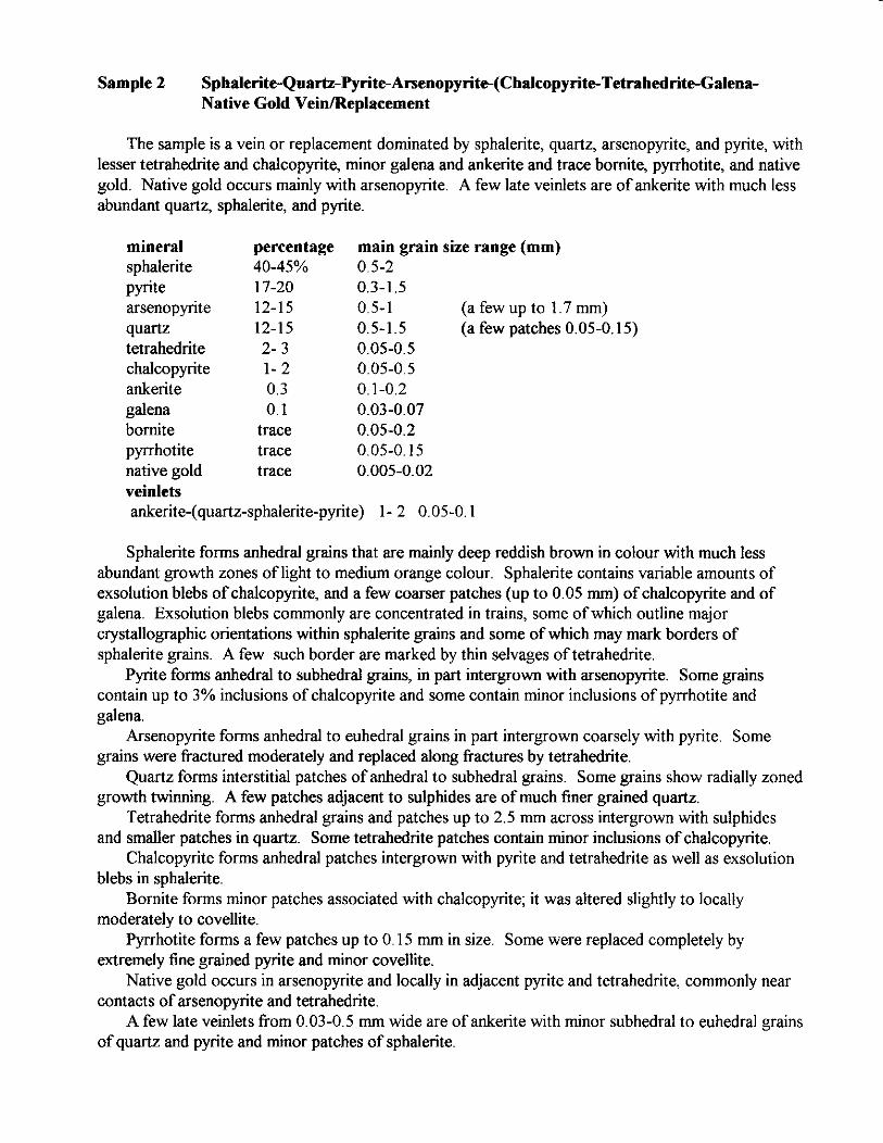
Sample 2 Sphalente-Qua~-Pynte-A~enopynte-(Ch~copynt~Tetrah~nt~Galena- Native Gold VeinlReplacement
The sample is a vein or replacement dominated by sphalerite, quartz, arsenopyrite, and pyrite, with lesser tetrahedrite and chalcopyrite, minor galena and ankerite and trace bomite, pyrrhotite, and native gold. Native gold occurs mainly with arsenopyrite. A few late veinlets are of ankerite with much less abundant quartz, sphalerite, and pyrite.
mineral percentage main grain size range (mm) sphalerite 40-45% 0.5-2 pyrite 17-20 0.3-1.5 arsenopyrite 12-15 0.5-1 (a few up to 1.7 mm) quartz 12-15 0.5-1.5 (a few patches 0.05-0.15) tetrahedrite 2- 3 0.05-0.5 chalcopyrite 1- 2 0.05-0.5 ankerite 0.3 0.1-0.2 galena 0.1 0.03-0.07 bomite trace 0.05-0.2 pyrrhotite trace 0.05-0.15 native gold trace 0.005-0.02 veinlets ankerite-(quartz-sphalerite-pyrite) 1- 2 0.05-0.1
Sphalerite forms anhedral grains that are mainly deep reddish brown in colour with much less abundant growth zones of light to medium orange colour. Sphalerite contains variable amounts of exsolution blebs of chalcopyrite, and a few coarser patches (up to 0.05 mm) of chalcopyrite and of galena. Exsolution blebs commonly are concentrated in trains, some of which outline major crystallographic orientations within sphalerite grains and some of which may mark borders of sphalerite grains. A few such border are marked by thin selvages of tetrahedrite.
contain up to 3% inclusions of chalcopyrite and some contain minor inclusions of pyrrhotite and galena.
Arsenopyrite forms anhedral to euhedral grains in part intergrown coarsely with pyrite. Some grains were fractured moderately and replaced along fractures by tetrahedrite.
Quartz forms interstitial patches of anhedral to subhedral grains. Some grains show radially zoned growth twinning. A few patches adjacent to sulphides are of much finer grained quartz.
Tetrahedrite forms anhedral grains and patches up to 2.5 mm across intergrown with sulphides and smaller patches in quartz. Some tetrahedrite patches contain minor inclusions of chalcopyrite.
Chalcopyrite forms anhedral patches intergrown with pyrite and tetrahedrite as well as exsolution blebs in sphalerite.
Bornite forms minor patches associated with chalcopyrite; it was altered slightly to locally moderately to covellite.
Pyrrhotite forms a few patches up to 0.15 mm in size. Some were replaced completely by extremely h e grained pyrite and minor covellite.
Native gold occurs in arsenopyrite and locally in adjacent pyrite and tetrahedrite, commonly near contacts of arsenopyrite and tetrahedrite.
A few late veinlets from 0.03-0.5 mm wide are of ankerite with minor subhedral to euhedral grains of quartz and pyrite and minor patches of sphalerite.
Pynte forms anhedral to subhedral grains, in part intergrown with arsenopyrite. Some grains
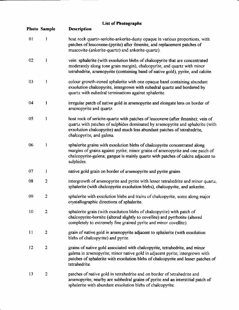
List of Photographs Photo Sample Description
01 1 host rock quartz-sericite-ankerite-dusty opaque in various proportions, with patches of leucoxene-(pyrite) after ilmenite, and replacement patches of muscovite-(ankerite-quartz) and ankerite-quartz).
02 1
03 1
04 1
05 1
06 1
07 1
08 2
09 2
10 2
1 1 2
12 2
13 2
vein: sphalerite (with exsolution blebs of chalcopyrite that are concentrated moderately along tone grain margin), chalcopyrite, and quartz with minor tetrahedrite, arsenopyrite (containing band of native gold), pyrite, and calcite
colour growth-zoned sphalerite with one opaque band containing abundant exsolution chalcopyrite, intergrown with euhedral quartz and bordered by quartz with euhedral terminations against sphalerite.
irregular patch of native gold in arsenopyrite and elongate lens on border of arsenopyrite and quartz.
host rock of sencite-quartz with patches of leucoxene (after ilmenite); vein of quartz with patches of sulphides dominated by arsenopyrite and sphalerite (with exsolution chalcopyrite) and much less abundant patches of tetrahedrite. chalcopyrite, and galena.
sphalerite grains with exsolution blebs of chalcopyrite concentrated along margins of grains against pyrite; minor grains of arsenopyrite and one patch of chalcopyrite-galena; gangue is mainly quartz with patches of calcite adjacent to sulphides.
native gold grain on border of arsenopyrite and pyrite grains.
intergrowth of arsenopyrite and pyrite with lesser tetrahedrite and minor quartz, sphalerite (with chalcopyrite exsolution blebs), chalcopyrite, and ankerite.
sphalerite with exsolution blebs and trains of chalcopyrite, some along major crystallographic directions of sphalerite.
sphalerite grain (with exsolution blebs of chalcopyrite) with patch of chalcopyrite-bornite (altered slightly to covellite) and pyrrhotite (altered completely to extremely fine grained pyrite and minor covellite).
grain of native gold in arsenopyrite adjacent to sphalerite (with exsolution blebs of chalcopyrite) and pyrite.
grains of native gold associated with chalcopyrite, tetrahedrite, and minor galena in arsenopyrite; minor native gold in adjacent pyrite; intergrown with patches of sphalerite with exsolution blebs of chalcopyrite and lesser patches of tetrahedrite.
patches of native gold in tetrahedrite and on border of tetrahedrite and arsenopyrite; nearby are subhedral grains of pyrite and an interstitial patch of sphalerite with abundant exsolution blebs of chalcopyrite.
u5
'02
1 rr
, " ,- =I
08
sl
I. ' . ..: .
02
ct r /
1 se-az c
' Sl f
..

.4 Y
APPENDIX “B”
Metallu rg ica I Test Report
Asian Mining
Project No: KRTS 20125
Report Prepared For: Mr. Jim Laird
Report Prepared By: lshwinder Grewal, M.A.Sc, P.Eng.
Manager, Knelson Research & Technology Centre
Matt Wilson - Lab Technician
December 20.2004
Proiect KRTS 20125 -Pearl Asian Mining
Table of Contents
1.0 Introduction ............................................................................................................................. 2
1.1 Background ......................................................................................................................... 2
1.2 Test Program ....................................................................................................................... 2
2.0 Procedura ................................................................................................................................ 2
2.1 GAT Test Procedure ........................................................................................................... 2
3.0 Results and Discussion ....................................................................................................... 3
3.1 GAT Results ........................................................................................................................ 3
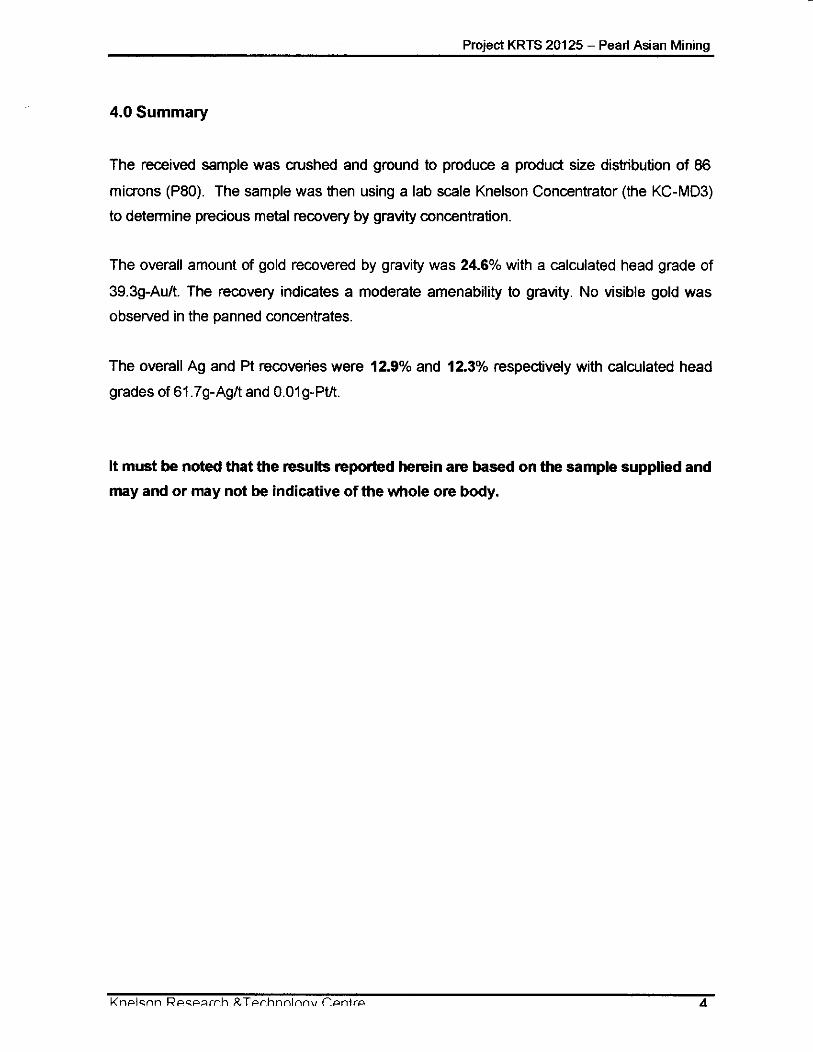
4.0 Summary .................................................................................................................................. 4
APPENDIX
Project KRTS 20125 - Pearl Asian Mining
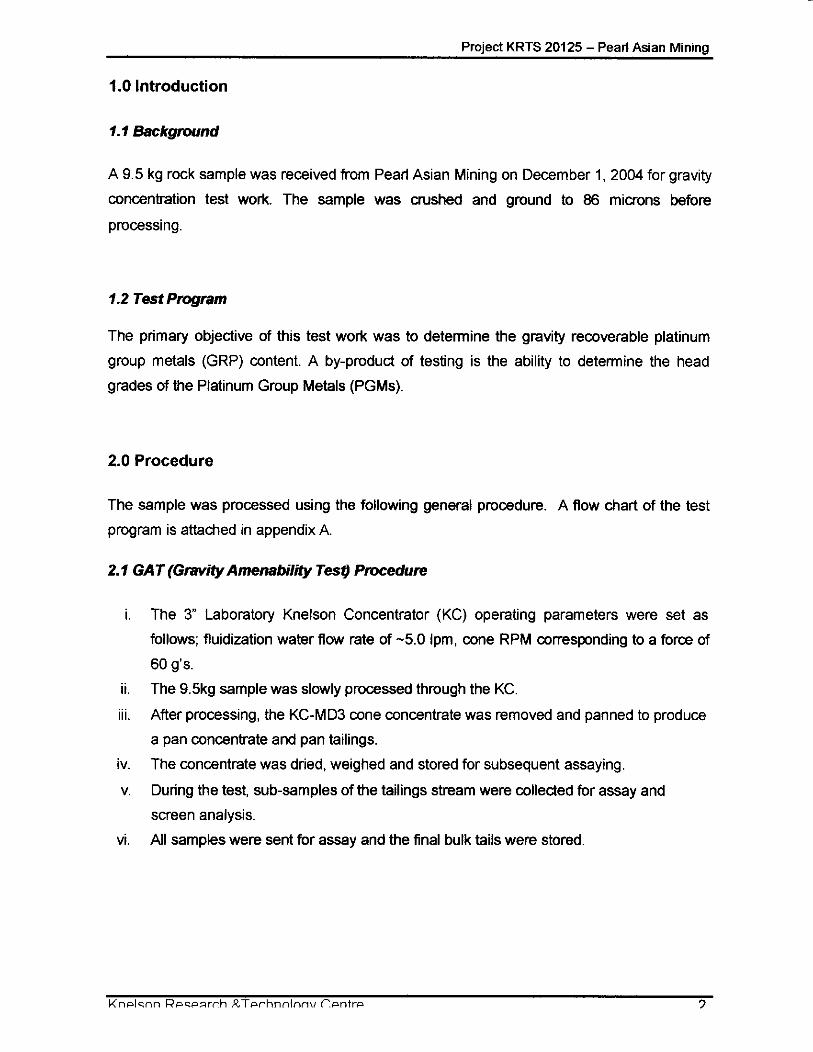
1.0 Introduction
1.1 Background
A 9.5 kg rock sample was received from Pearl Asian Mining on December 1, 2004 for gravity
concentration test work. The sample was crushed and ground to 86 microns before
processing.
1.2 Test Program
The primary objective of this test work was to determine the gravity recoverable platinum
group metals (GRP) content. A by-product of testing is the ability to determine the head
grades of the Platinum Group Metals (PGMs).
2.0 Procedure
The sample was processed using the following general procedure. A flow chart of the test
program is attached in appendix A.
2.1 GAT (Gravity Amenability Tesq Procedure
I.
II.
Ill. ...
iv.
V.
vi.
The 3 Laboratory Knelson Concentrator (KC) operating parameters were set as
follows; fluidization water flow rate of -5.0 Ipm, cone RPM corresponding to a force of
60 g's.
The 9.5kg sample was slowly processed through the KC.
After processing, the KC-MD3 cone concentrate was removed and panned to produce
a pan concentrate and pan tailings.
The concentrate was dried, weighed and stored for subsequent assaying.
During the test, sub-samples of the tailings stream were collected for assay and
screen analysis.
All samples were sent for assay and the final bulk tails were stored.
Project KRTS 20125 - Pearl Asian Mining
3.0 Results and Discussion
The results from the gravity concer ... jtion test work are presented in the following table.
3.1 GAT Results
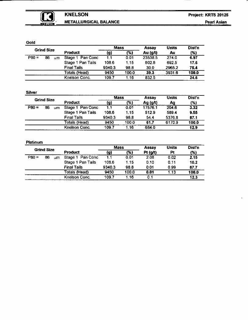
Table 1: Au Overall GAT Results
Mass Assay AuDist'n Assay Ag Dist'n Assay PtDist'n Product (9) Au (g/t) W) Ag (g/t) w Pt (grt) (%I
Pan Conc 1 1 001 235385 6.97 175761 3.32 2 08 2.15 Pan Tails 1086 115 6026 17.6 512 9 9.55 0 10 10.2 Final Tails 93403 988 30 0 75.4 54 4 07.1 0 01 87.7 Totals (Head) 9450 100 0 39.3 100.0 61.7 100.0 0.01 100.0 Knelson Conc 109 7 116 8325 24.6 684 0 12.9 01 12.3
The amount d gold recovered by gravity was 24.6% at a P80 value of 86 microns with a
calculated head grade of 39.3g-Auh. Of the recovered gold, 17.6% was recovered in the pan
tails which might suggest that this gold is associated with another mineral. No visible gold
was observed during the panning of the concentrate.
The amount of silver recovered was 12.9% with a calculated head grade of 61.7pAgA. The
amount of Pt recovered was 12.3% with a calculated head grade of 0.Olg-Pa.
Assays were also performed for Pd and Rh but the grades were below detection limits
Project KRTS 20125 - Pearl Asian Mining
4.0 Summary
The received sample was crushed and ground to produce a product size distribution of 86 microns (PSO). The sample was then using a lab scale Knelson Concentrator (the KC-MD3)
to determine precious metal recovery by gravity concentration.
The overall amount of gold recovered by gravity was 24.6% with a calculated head grade of
39.3g-Auk. The recovery indicates a moderate amenability to gravity. No visible gold was
observed in the panned concentrates.
The overall Ag and Pt recoveries were 12.9% and 12.3% respectively with calculated head
grades of 61.7g-Agtt and 0.Olg-Pttt.
It must be noted that the results repotted herein are based on the sample supplied and may and or may not be indicative of the whole ore body.
Project KRTS 20125 - Pearl Asian Mining
APPENDICES
Appendix A Program Flowsheet
Appendix B Metallurgical Test Reports
Appendix C Screen Analysis Reports
KNELSON Project: KRTS 20125
Feed Sample 94500 d Stage 1
- KNELSOM Test program Flow Magram ~eari ASlan
3 Knelson Concentrator
1st pass
Sample Received
to P80 approximatly
KCMD3 tails i subsampe for Assay
Knel. I Tails
KNELSON Project: KRTS 20125
I METALLURGICAL BALANCE Pearl Asian
Gold Mass Assay Units Dist'n
(9) (%I Au(QR) Au (%) Grind Size product
P80= 86 urn Stage 1 PanConc 1.1 0.01 23538.5 274.0 6.97 Stage 1 Pan Tails 108.6 1.15 602.6 692.5 17.6 Final Tails 9340.3 98.8 30.0 2965.2 75.4 Totals (Head) 9450 100.0 39.3 3931.6 100.0 Knelson Conc. 109.7 1 . I6 832.5 24.6
Silver Mass Assay Units Dist'n
Product (9) (%I A g W ) Ag (W Grind Size
P80= 86 urn Stage1 PanConc 1.1 0.01 17576.1 204.6 3.32 Stage 1 Pan Tails 108.6 1.15 512.9 589.4 9.55 Final Tails 9340.3 98.8 54.4 5376.8 87.1
Knelson Conc. 109.7 1.16 684.0 12.9 Totals (Head) 9450 100.0 61.7 6170.9 100.0
Platinum Mass Assay Units Dist'n
(9) pt (QR) Pt (%) Grind Size Product
P80= 86 urn Stage 1 PanConc 1.1 0.01 2.08 0.02 2.15 Stage 1 Pan Tails 108.6 1.15 0.10 0.11 10.2 Final Tails 9340.3 98.8 0.01 0.99 87.7 Totals (Head) 9450 100.0 0.01 1.13 100.0 Knelson Conc. 109.7 1 .I6 0.1 12.3
I
i i KNELSON Project: KRTS 20125
Pearl Asian
Date: 2-Ded)4 16.5 minutes
PBO (microns) 88
-26 26 38 5s 75 106 $50 Parlick Size Class (microns)
I 0 100 Particle Size Class (microns)