Embed Size (px)
Citation preview
Ancient Pacific Margin Part III:Regional Geology and Mineralization of the Big Salmon Complex
(NTS 104N/9E,16 & 104O/12,13,14W)
By Mitchell G. Mihalynuk1, JoAnne L. Nelson1, Charlie F. Roots2,Richard M. Friedman3 and Martin de Keijzer4
KEYWORDS: Regional geology, Big Salmon Complex,Nisutlin Assemblage, Klinkit Assemblage, Swift RiverAssemblage, Yukon-Tanana Terrane, Kootenay Terrane,Dorsey Terrane, Slide Mountain Terrane, Teslin Fault,volcanogenic massive sulphide, mineralization, Atlin,Teslin, Jennings River.
INTRODUCTION
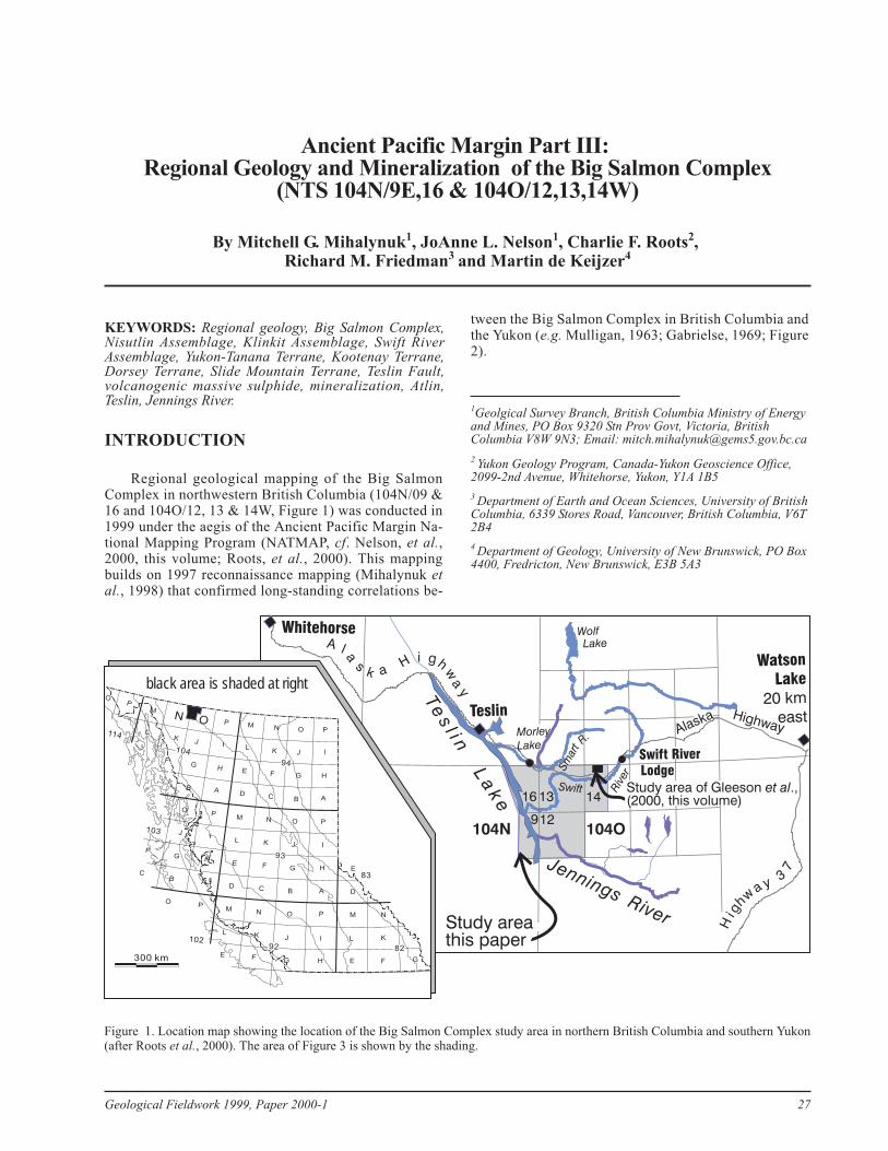
Regional geological mapping of the Big SalmonComplex in northwestern British Columbia (104N/09 &16 and 104O/12, 13 & 14W, Figure 1) was conducted in1999 under the aegis of the Ancient Pacific Margin Na-tional Mapping Program (NATMAP, cf. Nelson, et al.,2000, this volume; Roots, et al., 2000). This mappingbuilds on 1997 reconnaissance mapping (Mihalynuk etal., 1998) that confirmed long-standing correlations be-
tween the Big Salmon Complex in British Columbia andthe Yukon (e.g. Mulligan, 1963; Gabrielse, 1969; Figure2).
Geological Fieldwork 1999, Paper 2000-1 27
1Geolgical Survey Branch, British Columbia Ministry of Energyand Mines, PO Box 9320 Stn Prov Govt, Victoria, BritishColumbia V8W 9N3; Email: [email protected]
2 Yukon Geology Program, Canada-Yukon Geoscience Office,2099-2nd Avenue, Whitehorse, Yukon, Y1A 1B5
3 Department of Earth and Ocean Sciences, University of BritishColumbia, 6339 Stores Road, Vancouver, British Columbia, V6T2B4
4 Department of Geology, University of New Brunswick, PO Box4400, Fredricton, New Brunswick, E3B 5A3
Highway
A l a
sk a
H i gh
wa
yTe
sl i n
La
ke
Jennings River
R.
Swift Riv
erWolfLake
Teslin
Watson
Lake
20 km
east
Whitehorse
Lodge
104N 104O912
16 13 14
300 km
I
L
E
D
M
L
E
J
G
P
I
H
A
P
I
H
A
P
I
H
P
I
H
A
P
H
A
P
PO
M
M
L
E
D
M
L
E
D
M
L
E
O
J
G
B
O
J
G
B
O
J
G
O
J
G
B
O
J
G
B
O
N
K
F
N
K
F
C
N
K
F
C
N
K
F
N
K
F
F
C
114
104
94
103
93
83
10292 82
black area is shaded at right
Swift River
AlaskaH
ig
hwa
3y
7
Morley
Lake
Sm
art
Study area of Gleeson .,(2000, this volume)
et al
Study areathis paper
Figure 1. Location map showing the location of the Big Salmon Complex study area in northern British Columbia and southern Yukon(after Roots et al., 2000). The area of Figure 3 is shown by the shading.
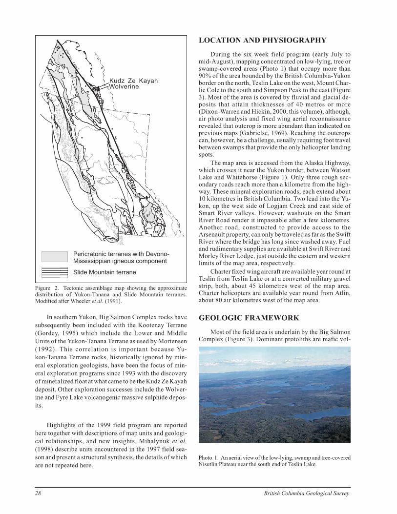
In southern Yukon, Big Salmon Complex rocks have
subsequently been included with the Kootenay Terrane
(Gordey, 1995) which include the Lower and Middle
Units of the Yukon-Tanana Terrane as used by Mortensen
(1992). This correlation is important because Yu-
kon-Tanana Terrane rocks, historically ignored by min-
eral exploration geologists, have been the focus of min-
eral exploration programs since 1993 with the discovery
of mineralized float at what came to be the Kudz Ze Kayah
deposit. Other exploration successes include the Wolver-
ine and Fyre Lake volcanogenic massive sulphide depos-
its.
Highlights of the 1999 field program are reported
here together with descriptions of map units and geologi-
cal relationships, and new insights. Mihalynuk et al.
(1998) describe units encountered in the 1997 field sea-
son and present a structural synthesis, the details of which
are not repeated here.
LOCATION AND PHYSIOGRAPHY
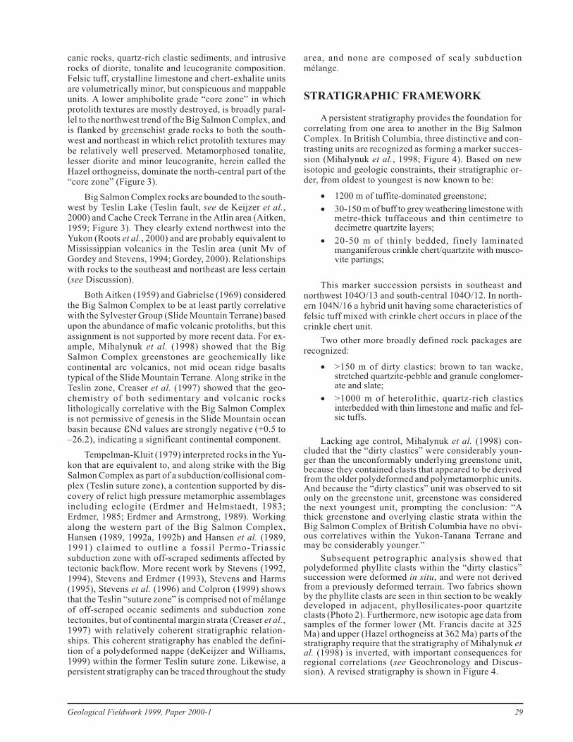
During the six week field program (early July tomid-August), mapping concentrated on low-lying, tree orswamp-covered areas (Photo 1) that occupy more than90% of the area bounded by the British Columbia-Yukonborder on the north, Teslin Lake on the west, Mount Char-lie Cole to the south and Simpson Peak to the east (Figure3). Most of the area is covered by fluvial and glacial de-posits that attain thicknesses of 40 metres or more(Dixon-Warren and Hickin, 2000, this volume); although,air photo analysis and fixed wing aerial reconnaissancerevealed that outcrop is more abundant than indicated onprevious maps (Gabrielse, 1969). Reaching the outcropscan, however, be a challenge, usually requiring foot travelbetween swamps that provide the only helicopter landingspots.
The map area is accessed from the Alaska Highway,which crosses it near the Yukon border, between WatsonLake and Whitehorse (Figure 1). Only three rough sec-ondary roads reach more than a kilometre from the high-way. These mineral exploration roads; each extend about10 kilometres in British Columbia. Two lead into the Yu-kon, up the west side of Logjam Creek and east side ofSmart River valleys. However, washouts on the SmartRiver Road render it impassable after a few kilometres.Another road, constructed to provide access to theArsenault property, can only be traveled as far as the SwiftRiver where the bridge has long since washed away. Fueland rudimentary supplies are available at Swift River andMorley River Lodge, just outside the eastern and westernlimits of the map area, respectively.
Charter fixed wing aircraft are available year round atTeslin from Teslin Lake or at a converted military gravelstrip, both, about 45 kilometres west of the map area.Charter helicopters are available year round from Atlin,about 80 air kilometres west of the map area.
GEOLOGIC FRAMEWORK
Most of the field area is underlain by the Big SalmonComplex (Figure 3). Dominant protoliths are mafic vol-
28 British Columbia Geological Survey
DE
NA
LI
FA
ULT
TN
TI
IN
AFA
ULT
Pericratonic terranes with Devono-Mississippian igneous component
Slide Mountain terrane
Kudz Ze KayahWolverine
Figure 2. Tectonic assemblage map showing the approximatedistribution of Yukon-Tanana and Slide Mountain terranes.Modified after Wheeler et al. (1991).
Photo 1. An aerial view of the low-lying, swamp and tree-coveredNisutlin Plateau near the south end of Teslin Lake.
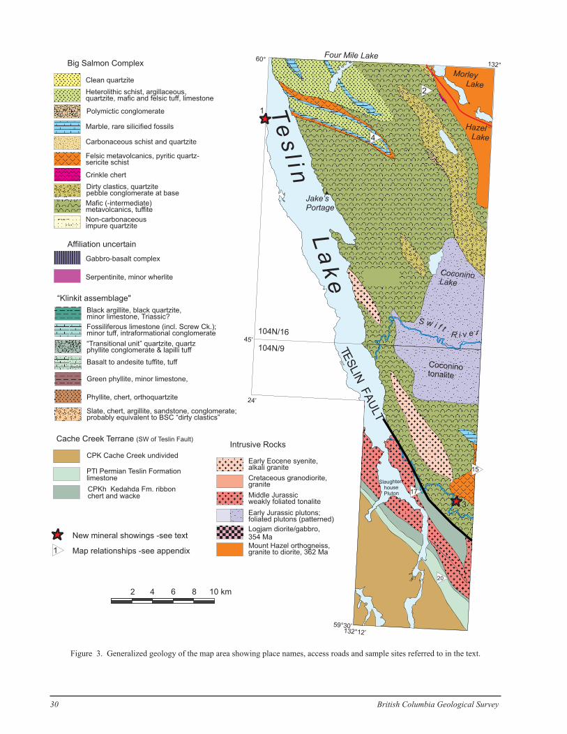
canic rocks, quartz-rich clastic sediments, and intrusiverocks of diorite, tonalite and leucogranite composition.Felsic tuff, crystalline limestone and chert-exhalite unitsare volumetrically minor, but conspicuous and mappableunits. A lower amphibolite grade “core zone” in whichprotolith textures are mostly destroyed, is broadly paral-lel to the northwest trend of the Big Salmon Complex, andis flanked by greenschist grade rocks to both the south-west and northeast in which relict protolith textures maybe relatively well preserved. Metamorphosed tonalite,lesser diorite and minor leucogranite, herein called theHazel orthogneiss, dominate the north-central part of the“core zone” (Figure 3).
Big Salmon Complex rocks are bounded to the south-west by Teslin Lake (Teslin fault, see de Keijzer et al.,2000) and Cache Creek Terrane in the Atlin area (Aitken,1959; Figure 3). They clearly extend northwest into theYukon (Roots et al., 2000) and are probably equivalent toMississippian volcanics in the Teslin area (unit Mv ofGordey and Stevens, 1994; Gordey, 2000). Relationshipswith rocks to the southeast and northeast are less certain(see Discussion).
Both Aitken (1959) and Gabrielse (1969) consideredthe Big Salmon Complex to be at least partly correlativewith the Sylvester Group (Slide Mountain Terrane) basedupon the abundance of mafic volcanic protoliths, but thisassignment is not supported by more recent data. For ex-ample, Mihalynuk et al. (1998) showed that the BigSalmon Complex greenstones are geochemically likecontinental arc volcanics, not mid ocean ridge basaltstypical of the Slide Mountain Terrane. Along strike in theTeslin zone, Creaser et al. (1997) showed that the geo-chemistry of both sedimentary and volcanic rockslithologically correlative with the Big Salmon Complexis not permissive of genesis in the Slide Mountain oceanbasin because �Nd values are strongly negative (+0.5 to–26.2), indicating a significant continental component.
Tempelman-Kluit (1979) interpreted rocks in the Yu-kon that are equivalent to, and along strike with the BigSalmon Complex as part of a subduction/collisional com-plex (Teslin suture zone), a contention supported by dis-covery of relict high pressure metamorphic assemblagesincluding eclogite (Erdmer and Helmstaedt, 1983;Erdmer, 1985; Erdmer and Armstrong, 1989). Workingalong the western part of the Big Salmon Complex,Hansen (1989, 1992a, 1992b) and Hansen et al. (1989,1991) claimed to outline a fossil Permo-Triassicsubduction zone with off-scraped sediments affected bytectonic backflow. More recent work by Stevens (1992,1994), Stevens and Erdmer (1993), Stevens and Harms(1995), Stevens et al. (1996) and Colpron (1999) showsthat the Teslin “suture zone” is comprised not of mélangeof off-scraped oceanic sediments and subduction zonetectonites, but of continental margin strata (Creaser et al.,1997) with relatively coherent stratigraphic relation-ships. This coherent stratigraphy has enabled the defini-tion of a polydeformed nappe (deKeijzer and Williams,1999) within the former Teslin suture zone. Likewise, apersistent stratigraphy can be traced throughout the study
area, and none are composed of scaly subductionmélange.
STRATIGRAPHIC FRAMEWORK
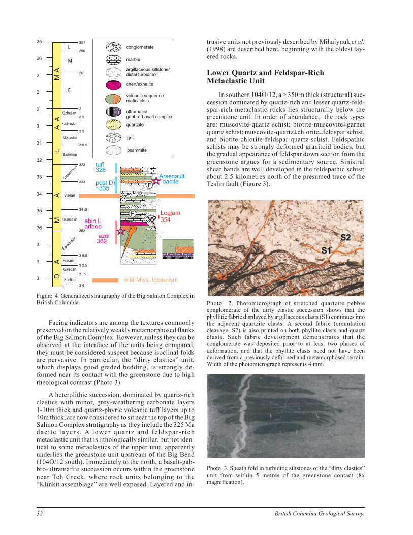
A persistent stratigraphy provides the foundation forcorrelating from one area to another in the Big SalmonComplex. In British Columbia, three distinctive and con-trasting units are recognized as forming a marker succes-sion (Mihalynuk et al., 1998; Figure 4). Based on newisotopic and geologic constraints, their stratigraphic or-der, from oldest to youngest is now known to be:
� 1200 m of tuffite-dominated greenstone;
� 30-150 m of buff to grey weathering limestone withmetre-thick tuffaceous and thin centimetre todecimetre quartzite layers;
� 20-50 m of thinly bedded, finely laminatedmanganiferous crinkle chert/quartzite with musco-vite partings;
This marker succession persists in southeast andnorthwest 104O/13 and south-central 104O/12. In north-ern 104N/16 a hybrid unit having some characteristics offelsic tuff mixed with crinkle chert occurs in place of thecrinkle chert unit.
Two other more broadly defined rock packages arerecognized:
� >150 m of dirty clastics: brown to tan wacke,stretched quartzite-pebble and granule conglomer-ate and slate;
� >1000 m of heterolithic, quartz-rich clasticsinterbedded with thin limestone and mafic and fel-sic tuffs.
Lacking age control, Mihalynuk et al. (1998) con-cluded that the “dirty clastics” were considerably youn-ger than the unconformably underlying greenstone unit,because they contained clasts that appeared to be derivedfrom the older polydeformed and polymetamorphic units.And because the “dirty clastics” unit was observed to sitonly on the greenstone unit, greenstone was consideredthe next youngest unit, prompting the conclusion: “Athick greenstone and overlying clastic strata within theBig Salmon Complex of British Columbia have no obvi-ous correlatives within the Yukon-Tanana Terrane andmay be considerably younger.”
Subsequent petrographic analysis showed thatpolydeformed phyllite clasts within the “dirty clastics”succession were deformed in situ, and were not derivedfrom a previously deformed terrain. Two fabrics shownby the phyllite clasts are seen in thin section to be weaklydeveloped in adjacent, phyllosilicates-poor quartziteclasts (Photo 2). Furthermore, new isotopic age data fromsamples of the former lower (Mt. Francis dacite at 325Ma) and upper (Hazel orthogneiss at 362 Ma) parts of thestratigraphy require that the stratigraphy of Mihalynuk etal. (1998) is inverted, with important consequences forregional correlations (see Geochronology and Discus-sion). A revised stratigraphy is shown in Figure 4.
Geological Fieldwork 1999, Paper 2000-1 29
30 British Columbia Geological Survey
Gabbro-basalt complex
Serpentinite, minor wherlite
Slate, chert, argillite, sandstone, conglomerate;probably equivalent to BSC “dirty clastics”
Black argillite, black quartzite,minor limestone, Triassic?
Fossiliferous limestone (incl. Screw Ck.);minor tuff, intraformational conglomerate
Green phyllite, minor limestone,
Phyllite, chert, orthoquartzite
Basalt to andesite tuffite, tuff
“Transitional unit” quartzite, quartzphyllite conglomerate & lapilli tuff
Non-carbonaceousimpure quartzite
Clean quartzite
Heterolithic schist, argillaceous,quartzite, mafic and felsic tuff, limestone
Dirty clastics, quartzitepebble conglomerate at base
Marble, rare silicified fossils
Crinkle chert
Mafic (-intermediate)metavolcanics, tuffite
Carbonaceous schist and quartzite
Polymictic conglomerate
Felsic metavolcanics, pyritic quartz-sericite schist
Big Salmon Complex
Affiliation uncertain
Intrusive Rocks
“Klinkit assemblage"
Cache Creek Terrane (SW of Teslin Fault)
PTl Permian Teslin Formationlimestone
CPKh Kedahda Fm. ribbonchert and wacke
CPK Cache Creek undivided
Logjam diorite/gabbro,354 Ma
Mount Hazel orthogneiss,granite to diorite, 362 Ma
Early Jurassic plutons;foliated plutons (patterned)
Cretaceous granodiorite,granite
Early Eocene syenite,alkali granite
Middle Jurassicweakly foliated tonalite
Map relationships -see appendix
New mineral showings -see text
1
Te
sl i n
La
ke
MorleyLake
HazelLake
Four Mile Lake
CoconinoLake
S w i f tR i v e r
60°132°
24’
132°12’
45’
59°30’
Coconinotonalite
TES
LIN
FA
ULT
Jake’sPortage
Slaughter-
house
Pluton
2
4
17
20
15
2 4 6 8 10 km
1
3
104N/16
104N/9
Figure 3. Generalized geology of the map area showing place names, access roads and sample sites referred to in the text.
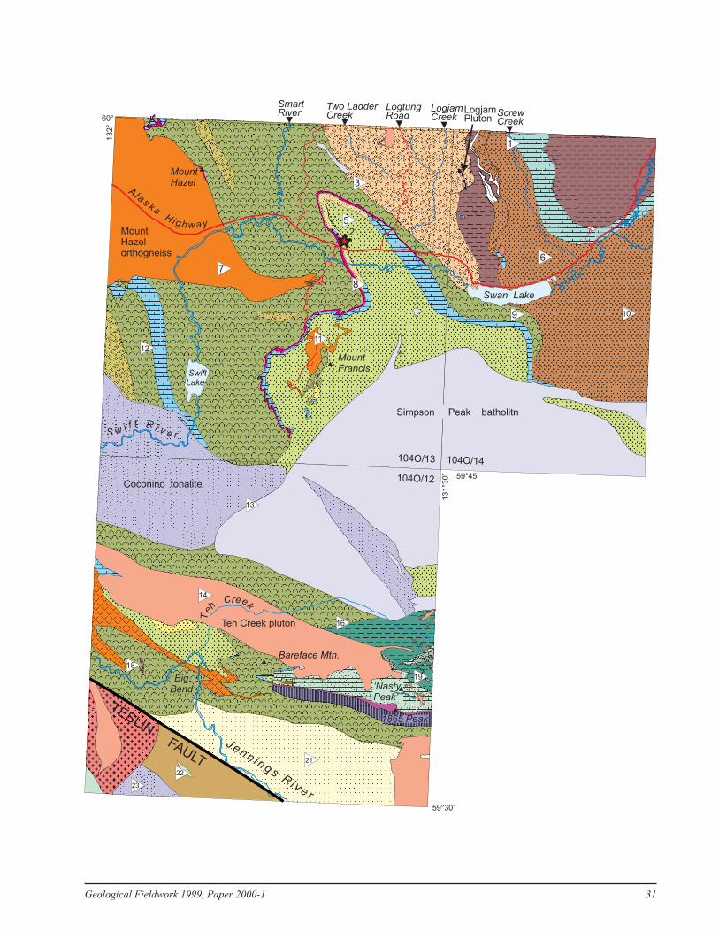
Geological Fieldwork 1999, Paper 2000-1 31
13
1°3
0’
13
2°
59°30’
59°45’
60°
9
3
5
1
6
10
11
13
16
14
18
21
23
19
22
7
12
8
Simpson Peak batholitn
Coconino tonalite
MountHazelorthogneiss
MountHazel
Teh Creek pluton
TESLINFAULT
Swan Lake
Alas ka
H ighway
ScrewCreek
LogjamCreek
LogjamPluton
LogtungRoad
Two LadderCreek
SmartRiver
S w i f t R i v e r
SwiftLake
MountFrancis
Bareface Mtn.
1865 Peak
‘NastyPeak’
Jenn i ngsR i ve r
BigBend
Teh
Creek
2
104O/13 104O/14
104O/12
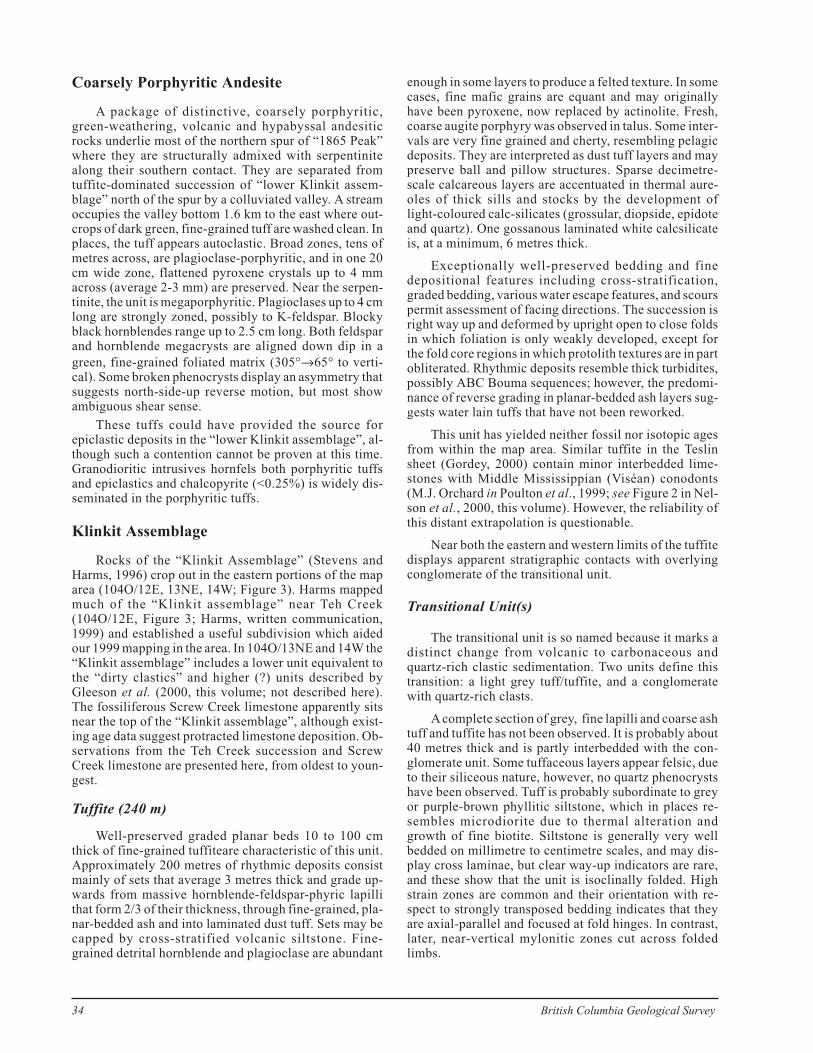
Facing indicators are among the textures commonlypreserved on the relatively weakly metamorphosed flanksof the Big Salmon Complex. However, unless they can beobserved at the interface of the units being compared,they must be considered suspect because isoclinal foldsare pervasive. In particular, the “dirty clastics” unit,which displays good graded bedding, is strongly de-formed near its contact with the greenstone due to highrheological contrast (Photo 3).
A heterolithic succession, dominated by quartz-richclastics with minor, grey-weathering carbonate layers1-10m thick and quartz-phyric volcanic tuff layers up to40m thick, are now considered to sit near the top of the BigSalmon Complex stratigraphy as they include the 325 Madaci te layers . A lower quar tz and feldspar-r ichmetaclastic unit that is lithologically similar, but not iden-tical to some metaclastics of the upper unit, apparentlyunderlies the greenstone unit upstream of the Big Bend(104O/12 south). Immediately to the north, a basalt-gab-bro-ultramafite succession occurs within the greenstonenear Teh Creek, where rock units belonging to the“Klinkit assemblage” are well exposed. Layered and in-
trusive units not previously described by Mihalynuk et al.(1998) are described here, beginning with the oldest lay-ered rocks.
Lower Quartz and Feldspar-RichMetaclastic Unit
In southern 104O/12, a > 350 m thick (structural) suc-cession dominated by quartz-rich and lesser quartz-feld-spar-rich metaclastic rocks lies structurally below thegreenstone unit. In order of abundance, the rock typesare: muscovite-quartz schist; biotite-muscovite±garnetquartz schist; muscovite-quartz±chlorite±feldspar schist,and biotite-chlorite-feldspar-quartz-schist. Feldspathicschists may be strongly deformed granitoid bodies, butthe gradual appearance of feldspar down section from thegreenstone argues for a sedimentary source. Sinistralshear bands are well developed in the feldspathic schist;about 2.5 kilometres north of the presumed trace of theTeslin fault (Figure 3).
32 British Columbia Geological Survey
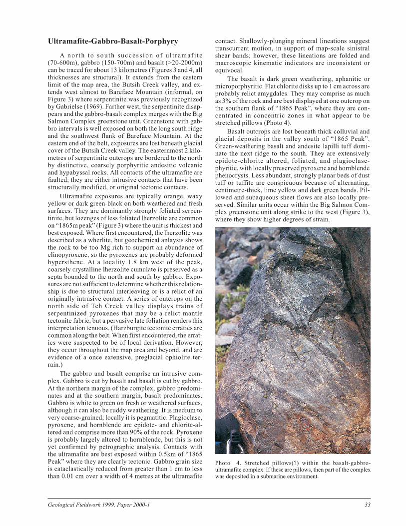
Photo 2. Photomicrograph of stretched quartzite pebbleconglomerate of the dirty clastic succession shows that thephyllitic fabric displayed by argillaceous clasts (S1) continues intothe adjacent quartzite clasts. A second fabric (crenulationcleavage, S2) is also printed on both phyllite clasts and quartzclasts. Such fabric development demonstrates that theconglomerate was deposited prior to at least two phases ofdeformation, and that the phyllite clasts need not have beenderived from a previously deformed and metamorphosed terrain.Width of the photomicrograph represents 4 mm.
3
3
3
36
35
34
33
32
31
3
2
2
2
26
25
DA
MA
LA
AM
A
L
M
E
Gzhelian
Kasimovian
Moscovian
Bashkirian
Serpu
khov
ian
Visean
Tournaisian
Famen
nian
Frasnian
Givetian
Eifelian
3 4
3 .5
3 2.5
3 6.5
362
34 .5
333
323
311.5
3 3
2 5
2
26
256
251
mid-Miss. tectonism
volcanic sequencemafic/felsic
marble
chert/exhalite
quartzite
grit
psammite
conglomerate
argillaceous siltstone/distal turbidite?
ultramafic/gabbro-basalt complex
F
F
Arsenaultdacite
azel362
Logjam354
tuff326
post D~335
1
abin Lariboo
Figure 4. Generalized stratigraphy of the Big Salmon Complex inBritish Columbia.
Photo 3. Sheath fold in turbiditic siltstones of the “dirty clastics”unit from within 5 metres of the greenstone contact (8xmagnification).
Ultramafite-Gabbro-Basalt-Porphyry
A nor th to sou th success ion of u l t ramaf i t e(70-600m), gabbro (150-700m) and basalt (>20-2000m)can be traced for about 13 kilometres (Figures 3 and 4, allthicknesses are structural). It extends from the easternlimit of the map area, the Butsih Creek valley, and ex-tends west almost to Bareface Mountain (informal, onFigure 3) where serpentinite was previously recognizedby Gabrielse (1969). Farther west, the serpentinite disap-pears and the gabbro-basalt complex merges with the BigSalmon Complex greenstone unit. Greenstone with gab-bro intervals is well exposed on both the long south ridgeand the southwest flank of Bareface Mountain. At theeastern end of the belt, exposures are lost beneath glacialcover of the Butsih Creek valley. The easternmost 2 kilo-metres of serpentinite outcrops are bordered to the northby distinctive, coarsely porphyritic andesitic volcanicand hypabyssal rocks. All contacts of the ultramafite arefaulted; they are either intrusive contacts that have beenstructurally modified, or original tectonic contacts.
Ultramafite exposures are typically orange, waxyyellow or dark green-black on both weathered and freshsurfaces. They are dominantly strongly foliated serpen-tinite, but lozenges of less foliated lherzolite are commonon “1865m peak” (Figure 3) where the unit is thickest andbest exposed. Where first encountered, the lherzolite wasdescribed as a wherlite, but geochemical anlaysis showsthe rock to be too Mg-rich to support an abundance ofclinopyroxene, so the pyroxenes are probably deformedhypersthene. At a locality 1.8 km west of the peak,coarsely crystalline lherzolite cumulate is preserved as asepta bounded to the north and south by gabbro. Expo-sures are not sufficient to determine whether this relation-ship is due to structural interleaving or is a relict of anoriginally intrusive contact. A series of outcrops on thenorth side of Teh Creek valley displays trains ofserpentinized pyroxenes that may be a relict mantletectonite fabric, but a pervasive late foliation renders thisinterpretation tenuous. (Harzburgite tectonite erratics arecommon along the belt. When first encountered, the errat-ics were suspected to be of local derivation. However,they occur throughout the map area and beyond, and areevidence of a once extensive, preglacial ophiolite ter-rain.)
The gabbro and basalt comprise an intrusive com-plex. Gabbro is cut by basalt and basalt is cut by gabbro.At the northern margin of the complex, gabbro predomi-nates and at the southern margin, basalt predominates.Gabbro is white to green on fresh or weathered surfaces,although it can also be ruddy weathering. It is medium tovery coarse-grained; locally it is pegmatitic. Plagioclase,pyroxene, and hornblende are epidote- and chlorite-al-tered and comprise more than 90% of the rock. Pyroxeneis probably largely altered to hornblende, but this is notyet confirmed by petrographic analysis. Contacts withthe ultramafite are best exposed within 0.5km of “1865Peak” where they are clearly tectonic. Gabbro grain sizeis cataclastically reduced from greater than 1 cm to lessthan 0.01 cm over a width of 4 metres at the ultramafite
contact. Shallowly-plunging mineral lineations suggesttranscurrent motion, in support of map-scale sinistralshear bands; however, these lineations are folded andmacroscopic kinematic indicators are inconsistent orequivocal.
The basalt is dark green weathering, aphanitic ormicroporphyritic. Flat chlorite disks up to 1 cm across areprobably relict amygdales. They may comprise as muchas 3% of the rock and are best displayed at one outcrop onthe southern flank of “1865 Peak”, where they are con-centrated in concentric zones in what appear to bestretched pillows (Photo 4).
Basalt outcrops are lost beneath thick colluvial andglacial deposits in the valley south of “1865 Peak”.Green-weathering basalt and andesite lapilli tuff domi-nate the next ridge to the south. They are extensivelyepidote-chlorite altered, foliated, and plagioclase-phyritic, with locally preserved pyroxene and hornblendephenocrysts. Less abundant, strongly planar beds of dusttuff or tuffite are conspicuous because of alternating,centimetre-thick, lime yellow and dark green bands. Pil-lowed and subaqueous sheet flows are also locally pre-served. Similar units occur within the Big Salmon Com-plex greenstone unit along strike to the west (Figure 3),where they show higher degrees of strain.
Geological Fieldwork 1999, Paper 2000-1 33
Photo 4. Stretched pillows(?) within the basalt-gabbro-ultramafite complex. If these are pillows, then part of the complexwas deposited in a submarine environment.
Coarsely Porphyritic Andesite
A package of distinctive, coarsely porphyritic,green-weathering, volcanic and hypabyssal andesiticrocks underlie most of the northern spur of “1865 Peak”where they are structurally admixed with serpentinitealong their southern contact. They are separated fromtuffite-dominated succession of “lower Klinkit assem-blage” north of the spur by a colluviated valley. A streamoccupies the valley bottom 1.6 km to the east where out-crops of dark green, fine-grained tuff are washed clean. Inplaces, the tuff appears autoclastic. Broad zones, tens ofmetres across, are plagioclase-porphyritic, and in one 20cm wide zone, flattened pyroxene crystals up to 4 mmacross (average 2-3 mm) are preserved. Near the serpen-tinite, the unit is megaporphyritic. Plagioclases up to 4 cmlong are strongly zoned, possibly to K-feldspar. Blockyblack hornblendes range up to 2.5 cm long. Both feldsparand hornblende megacrysts are aligned down dip in a
green, fine-grained foliated matrix (305°→65° to verti-cal). Some broken phenocrysts display an asymmetry thatsuggests north-side-up reverse motion, but most showambiguous shear sense.
These tuffs could have provided the source forepiclastic deposits in the “lower Klinkit assemblage”, al-though such a contention cannot be proven at this time.Granodioritic intrusives hornfels both porphyritic tuffsand epiclastics and chalcopyrite (<0.25%) is widely dis-seminated in the porphyritic tuffs.
Klinkit Assemblage
Rocks of the “Klinkit Assemblage” (Stevens andHarms, 1996) crop out in the eastern portions of the maparea (104O/12E, 13NE, 14W; Figure 3). Harms mappedmuch of the “Klinkit assemblage” near Teh Creek(104O/12E, Figure 3; Harms, written communication,1999) and established a useful subdivision which aidedour 1999 mapping in the area. In 104O/13NE and 14W the“Klinkit assemblage” includes a lower unit equivalent tothe “dirty clastics” and higher (?) units described byGleeson et al. (2000, this volume; not described here).The fossiliferous Screw Creek limestone apparently sitsnear the top of the “Klinkit assemblage”, although exist-ing age data suggest protracted limestone deposition. Ob-servations from the Teh Creek succession and ScrewCreek limestone are presented here, from oldest to youn-gest.
Tuffite (240 m)
Well-preserved graded planar beds 10 to 100 cmthick of fine-grained tuffiteare characteristic of this unit.Approximately 200 metres of rhythmic deposits consistmainly of sets that average 3 metres thick and grade up-wards from massive hornblende-feldspar-phyric lapillithat form 2/3 of their thickness, through fine-grained, pla-nar-bedded ash and into laminated dust tuff. Sets may becapped by cross-stratified volcanic siltstone. Fine-grained detrital hornblende and plagioclase are abundant
enough in some layers to produce a felted texture. In somecases, fine mafic grains are equant and may originallyhave been pyroxene, now replaced by actinolite. Fresh,coarse augite porphyry was observed in talus. Some inter-vals are very fine grained and cherty, resembling pelagicdeposits. They are interpreted as dust tuff layers and maypreserve ball and pillow structures. Sparse decimetre-scale calcareous layers are accentuated in thermal aure-oles of thick sills and stocks by the development oflight-coloured calc-silicates (grossular, diopside, epidoteand quartz). One gossanous laminated white calcsilicateis, at a minimum, 6 metres thick.
Exceptionally well-preserved bedding and finedepositional features including cross-stratification,graded bedding, various water escape features, and scourspermit assessment of facing directions. The succession isright way up and deformed by upright open to close foldsin which foliation is only weakly developed, except forthe fold core regions in which protolith textures are in partobliterated. Rhythmic deposits resemble thick turbidites,possibly ABC Bouma sequences; however, the predomi-nance of reverse grading in planar-bedded ash layers sug-gests water lain tuffs that have not been reworked.
This unit has yielded neither fossil nor isotopic agesfrom within the map area. Similar tuffite in the Teslinsheet (Gordey, 2000) contain minor interbedded lime-stones with Middle Mississippian (Viséan) conodonts(M.J. Orchard in Poulton et al., 1999; see Figure 2 in Nel-son et al., 2000, this volume). However, the reliability ofthis distant extrapolation is questionable.
Near both the eastern and western limits of the tuffitedisplays apparent stratigraphic contacts with overlyingconglomerate of the transitional unit.
Transitional Unit(s)
The transitional unit is so named because it marks adistinct change from volcanic to carbonaceous andquartz-rich clastic sedimentation. Two units define thistransition: a light grey tuff/tuffite, and a conglomeratewith quartz-rich clasts.
Acomplete section of grey, fine lapilli and coarse ashtuff and tuffite has not been observed. It is probably about40 metres thick and is partly interbedded with the con-glomerate unit. Some tuffaceous layers appear felsic, dueto their siliceous nature, however, no quartz phenocrystshave been observed. Tuff is probably subordinate to greyor purple-brown phyllitic siltstone, which in places re-sembles microdiorite due to thermal alteration andgrowth of fine biotite. Siltstone is generally very wellbedded on millimetre to centimetre scales, and may dis-play cross laminae, but clear way-up indicators are rare,and these show that the unit is isoclinally folded. Highstrain zones are common and their orientation with re-spect to strongly transposed bedding indicates that theyare axial-parallel and focused at fold hinges. In contrast,later, near-vertical mylonitic zones cut across foldedlimbs.
34 British Columbia Geological Survey
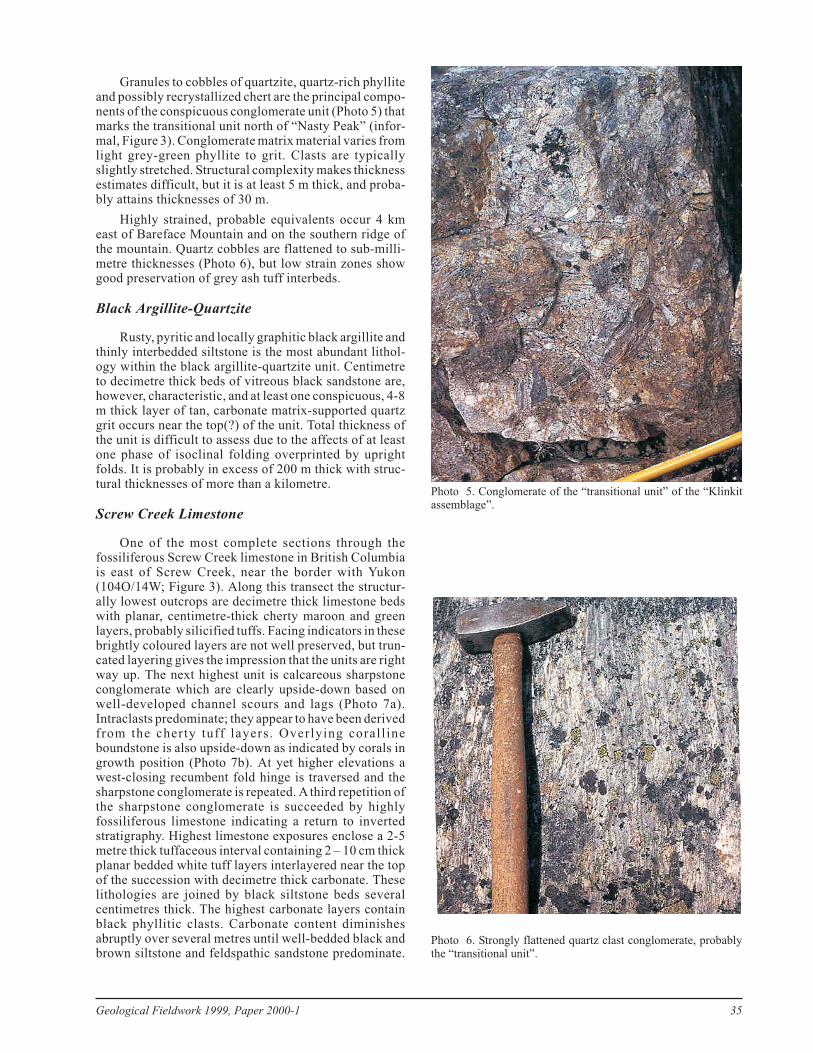
Granules to cobbles of quartzite, quartz-rich phylliteand possibly recrystallized chert are the principal compo-nents of the conspicuous conglomerate unit (Photo 5) thatmarks the transitional unit north of “Nasty Peak” (infor-mal, Figure 3). Conglomerate matrix material varies fromlight grey-green phyllite to grit. Clasts are typicallyslightly stretched. Structural complexity makes thicknessestimates difficult, but it is at least 5 m thick, and proba-bly attains thicknesses of 30 m.
Highly strained, probable equivalents occur 4 kmeast of Bareface Mountain and on the southern ridge ofthe mountain. Quartz cobbles are flattened to sub-milli-metre thicknesses (Photo 6), but low strain zones showgood preservation of grey ash tuff interbeds.
Black Argillite-Quartzite
Rusty, pyritic and locally graphitic black argillite andthinly interbedded siltstone is the most abundant lithol-ogy within the black argillite-quartzite unit. Centimetreto decimetre thick beds of vitreous black sandstone are,however, characteristic, and at least one conspicuous, 4-8m thick layer of tan, carbonate matrix-supported quartzgrit occurs near the top(?) of the unit. Total thickness ofthe unit is difficult to assess due to the affects of at leastone phase of isoclinal folding overprinted by uprightfolds. It is probably in excess of 200 m thick with struc-tural thicknesses of more than a kilometre.
Screw Creek Limestone
One of the most complete sections through thefossiliferous Screw Creek limestone in British Columbiais east of Screw Creek, near the border with Yukon(104O/14W; Figure 3). Along this transect the structur-ally lowest outcrops are decimetre thick limestone bedswith planar, centimetre-thick cherty maroon and greenlayers, probably silicified tuffs. Facing indicators in thesebrightly coloured layers are not well preserved, but trun-cated layering gives the impression that the units are rightway up. The next highest unit is calcareous sharpstoneconglomerate which are clearly upside-down based onwell-developed channel scours and lags (Photo 7a).Intraclasts predominate; they appear to have been derivedfrom the cherty tuff layers. Overlying corall ineboundstone is also upside-down as indicated by corals ingrowth position (Photo 7b). At yet higher elevations awest-closing recumbent fold hinge is traversed and thesharpstone conglomerate is repeated. Athird repetition ofthe sharpstone conglomerate is succeeded by highlyfossiliferous limestone indicating a return to invertedstratigraphy. Highest limestone exposures enclose a 2-5metre thick tuffaceous interval containing 2 – 10 cm thickplanar bedded white tuff layers interlayered near the topof the succession with decimetre thick carbonate. Theselithologies are joined by black siltstone beds severalcentimetres thick. The highest carbonate layers containblack phyllitic clasts. Carbonate content diminishesabruptly over several metres until well-bedded black andbrown siltstone and feldspathic sandstone predominate.
Geological Fieldwork 1999, Paper 2000-1 35
Photo 5. Conglomerate of the “transitional unit” of the “Klinkitassemblage”.
Photo 6. Strongly flattened quartz clast conglomerate, probablythe “transitional unit”.
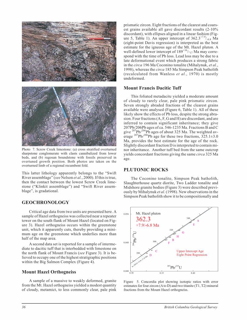
This latter lithology apparently belongs to the “SwiftRiver assemblage” (see Nelson et al., 2000). If this is true,then the contact between the lowest Screw Creek lime-stone (“Klinkit assemblage”) and “Swift River assem-blage”, is gradational.
GEOCHRONOLOGY
Critical age data from two units are presented here. Asample of Hazel orthogneiss was collected near a repeatertower on the south flank of Mount Hazel (located on Fig-ure 3). Hazel orthogneiss occurs within the greenstoneunit, which it apparently cuts, thereby providing a mini-mum age on the greenstone which underlies more thanhalf of the map area.
A second data set is reported for a sample of interme-diate to dacitic tuff that is interbedded with limestone onthe north flank of Mount Francis (see Figure 3). It is be-lieved to occupy one of the highest stratigraphic positionswithin the Big Salmon Complex (Figure 4).
Mount Hazel Orthogneiss
A sample of a massive to weakly deformed, granitefrom the Mt. Hazel orthogneiss yielded a modest quantityof cloudy, metamict, to less commonly clear, pale pink
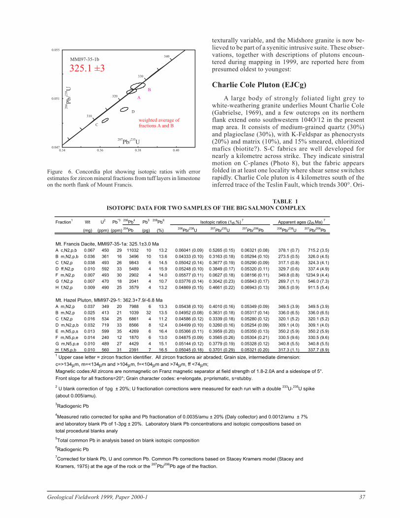
prismatic zircon. Eight fractions of the clearest and coars-est grains available all gave discordant results (2-10%discordant), with ellipses aligned in a linear fashion (Fig-ure 5, Table 1). An upper intercept of 362.3+7.9/-6.8 Ma(eight-point Davis regression) is interpreted as the bestestimate for the igneous age of the Mt. Hazel pluton. Awell-defined lower intercept of 189+16/-17 Ma may corre-spond with the time of Pb loss. Lead loss may be due to alate deformational event which produces a strong fabricin the circa 196 Ma Coconino tonalite (Mihalynuk, et al.,1998), whereas the circa 185 Ma Simpson Peak batholith(recalculated from Wanless et al., 1970) is mostlyundeformed.
Mount Francis Dacitic Tuff
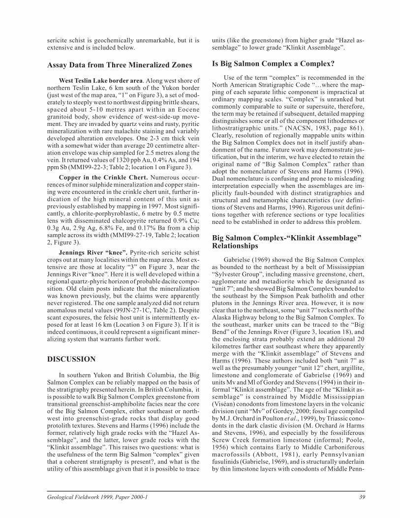
This foliated metadacite yielded a moderate amountof cloudy to rarely clear, pale pink prismatic zircon.Seven strongly abraded fractions of the clearest grainsavailable were analysed (Figure 6, Table 1). All of theselikely show the effects of Pb loss, despite the strong abra-sion. Four fractions (A, F, G and H) are discordant, and areinferred to contain significant inheritance; they give207Pb/206Pb ages of ca. 546-1235 Ma. Fractions B and Cgive 207Pb/206Pb ages of about 325 Ma. The weighted av-erage 207Pb/206Pb age for these two fractions, 325.1±3.0Ma, provides the best estimate for the age of the rock.Slightly discordant fraction D is interpreted to contain mi-nor inheritance. Another tuff bed from the same outcropyields concordant fractions giving the same circa 325 Maage.
PLUTONIC ROCKS
The Coconino tonalite, Simpson Peak batholith,Slaughterhouse quartz diorite, Two Ladder tonalite andMidshore granite bodies (Figure 3) were described previ-ously by Mihalynuk et al. (1998). New observations in theSimpson Peak batholith show it to be compositionally and
36 British Columbia Geological Survey
Photo 7. Screw Creek limestone: (a) cross stratified overturnedsharpstone conglomerate with clasts cannibalized from lowerbeds, and (b) rugosan boundstone with fossils preserved inovertuned growth position. Both photos are taken on theoverturned limb of a regional recumbent fold.
280
300
320
340
0.35 0.400.040
0.048
0.056
0.30
207 235Pb/ U
206
238
Pb
U/
Mt. Hazel pluton
362.3+7.9/-6.8 Ma
Upper Intercept AgeEight Point Regression
to189.0+15.9/-1
7.0M
a
A
E
G
H
BF
C
D
Figure 5. Concordia plot showing isotopic ratios with errorestimates for four zircon (A to D) and two titanite (T1, T2) mineralfractions from the Mount Hazel orthogneiss.
texturally variable, and the Midshore granite is now be-lieved to be part of a syenitic intrusive suite. These obser-vations, together with descriptions of plutons encoun-tered during mapping in 1999, are reported here frompresumed oldest to youngest:
Charlie Cole Pluton (EJCg)
A large body of strongly foliated light grey towhite-weathering granite underlies Mount Charlie Cole(Gabrielse, 1969), and a few outcrops on its northernflank extend onto southwestern 104O/12 in the presentmap area. It consists of medium-grained quartz (30%)and plagioclase (30%), with K-Feldspar as phenocrysts(20%) and matrix (10%), and 15% smeared, chloritizedmafics (biotite?). S-C fabrics are well developed fornearly a kilometre across strike. They indicate sinistralmotion on C-planes (Photo 8), but the fabric appearsfolded in at least one locality where shear sense switchesrapidly. Charlie Cole pluton is 4 kilometres south of theinferred trace of the Teslin Fault, which trends 300°. Ori-
Geological Fieldwork 1999, Paper 2000-1 37
TABLE 1ISOTOPIC DATA FOR TWO SAMPLES OF THE BIG SALMON COMPLEX
Fraction1
Wt U2
Pb*3 206
Pb4
Pb5 208
Pb6
Isotopic ratios (1σ,%)7
Apparent ages (2σ,Ma)7
(mg) (ppm) (ppm)204
Pb (pg) (%)206
Pb/238
U207
Pb/235
U207
Pb/206
Pb206
Pb/238
U207
Pb/206
Pb
Mt. Francis Dacite, MMI97-35-1a: 325.1±3.0 Ma
A c,N2,p,b 0.067 450 29 11032 10 13.2 0.06041 (0.09) 0.5265 (0.15) 0.06321 (0.08) 378.1 (0.7) 715.2 (3.5)
B m,N2,p,b 0.036 361 16 3496 10 13.6 0.04333 (0.10) 0.3163 (0.18) 0.05294 (0.10) 273.5 (0.5) 326.0 (4.5)
C f,N2,p 0.038 493 26 9843 6 14.5 0.05042 (0.14) 0.3677 (0.19) 0.05290 (0.09) 317.1 (0.8) 324.3 (4.1)
D ff,N2,p 0.010 592 33 5489 4 15.9 0.05248 (0.10) 0.3849 (0.17) 0.05320 (0.11) 329.7 (0.6) 337.4 (4.9)
F m,N2,p 0.007 493 30 2902 4 14.0 0.05577 (0.11) 0.0627 (0.18) 0.08156 (0.11) 349.8 (0.8) 1234.9 (4.4)
G f,N2,p 0.007 470 18 2041 4 10.7 0.03776 (0.14) 0.3042 (0.23) 0.05843 (0.17) 269.7 (1.1) 546.0 (7.3)
H f,N2,p 0.009 490 25 3579 4 13.2 0.04869 (0.15) 0.4661 (0.22) 0.06943 (0.13) 306.5 (0.9) 911.5 (5.4)
Mt. Hazel Pluton, MMI97-29-1: 362.3+7.9/-6.8 Ma
A m,N2,p 0.037 349 20 7988 6 13.3 0.05438 (0.10) 0.4010 (0.16) 0.05349 (0.09) 349.5 (3.9) 349.5 (3.9)
B m,N2,p 0.025 413 21 1039 32 13.5 0.04952 (0.08) 0.3631 (0.18) 0.05317 (0.14) 336.0 (6.5) 336.0 (6.5)
C f,N2,p 0.016 534 25 6861 4 11.2 0.04586 (0.12) 0.3339 (0.18) 0.05280 (0.12) 320.1 (5.2) 320.1 (5.2)
D m,N2,p,b 0.032 719 33 8566 8 12.4 0.04499 (0.10) 0.3260 (0.16) 0.05254 (0.09) 309.1 (4.0) 309.1 (4.0)
E m,N5,p,s 0.013 599 35 4269 6 16.4 0.05366 (0.11) 0.3959 (0.20) 0.05350 (0.13) 350.2 (5.9) 350.2 (5.9)
F m,N5,p,e 0.014 240 12 1870 6 13.0 0.04875 (0.09) 0.3565 (0.26) 0.05304 (0.21) 330.5 (9.6) 330.5 (9.6)
G m,N5,p,e 0.010 489 27 4429 4 15.1 0.05144 (0.12) 0.3779 (0.19) 0.05328 (0.12) 340.8 (5.5) 340.8 (5.5)
H f,N5,p,b 0.010 560 31 2391 7 16.5 0.05045 (0.18) 0.3701 (0.29) 0.05321 (0.20) 317.3 (1.1) 337.7 (8.9)1
Upper case letter = zircon fraction identifier. All zircon fractions air abraded; Grain size, intermediate dimension:
c=>134µm, m=<134µm and >104µm, f=<104µm and >74µm, ff <74µm;
Magnetic codes:All zircons are nonmagnetic on Franz magnetic separator at field strength of 1.8-2.0A and a sideslope of 5°.
Front slope for all fractions=20°; Grain character codes: e=elongate, p=prismatic, s=stubby.
2U blank correction of 1pg ± 20%; U fractionation corrections were measured for each run with a double
233U-
235U spike
(about 0.005/amu).
3Radiogenic Pb
4Measured ratio corrected for spike and Pb fractionation of 0.0035/amu ± 20% (Daly collector) and 0.0012/amu ± 7%
and laboratory blank Pb of 1-3pg ± 20%. Laboratory blank Pb concentrations and isotopic compositions based on
total procedural blanks analy
5Total common Pb in analysis based on blank isotopic composition
6Radiogenic Pb
7Corrected for blank Pb, U and common Pb. Common Pb corrections based on Stacey Kramers model (Stacey and
Kramers, 1975) at the age of the rock or the207
Pb/206
Pb age of the fraction.
310
320
330
340
0.34 0.36 0.38 0.400.047
0.051
0.055
MMI97-35-1b
207 235Pb/ U
206
238
Pb
U/ A
B
D
Cweighted average offractions A and B
325.1 ±3
Figure 6. Concordia plot showing isotopic ratios with errorestimates for zircon mineral fractions from tuff layers in limestoneon the north flank of Mount Francis.

entation of most of the C-planes is 185° to 020° such thattheir development cannot be attributed to simple kine-matic linkage with the Teslin Fault. Because of apparentlate folding of the S-C fabrics, their use in constrainingany regional structural interpretation would be suspect.However, a sample collected for isotopic age datingshould provide a maximum age for this fabric.
Simpson Peak Batholith(EJSg1, 2, 3, EJSgd)
Four li thologies comprise the Simpson Peakbatholith. These are described from oldest to youngestbased on field relationships:
Hornblende>biotite granite (EJSg1) with flattenedpink K-feldspar megacrysts is well foliated, but poorlylineated. This unit was sampled at two localities and van-tage point mapping suggests that rocks with similarweathering characteristics crop out in a gently northwesttapering wedge of pluton in northeastern 104O/12.
Medium-grained grey to tan granite (EJSg2) containswhite to pink intergrowths of plagioclase and K-feldspar(60%), fresh biotite (10%, or up to 5% chloritized) andcoarse smoky quartz (30%). It is blocky weathering withdistinctive low angle jointing, and weathers to abundantgrus. Joint surfaces may be chlorite coated. Foliation isweak to absent. It is the most abundant unit in thebatholith.
Biotite porphyry dominates a gently northwest-dip-ping tabular complex about 240 metres thick (EJSg3). It ismedium-grained,with subequant feldspar and grey quartzphenocrysts and medium to fine-grained rusty biotite, in atan to flesh coloured, non-foliated, sucrosic siliceous ma-trix. Numerous 0.5 to 3 metre thick quartz dioritic sills cutthe complex, giving it a strongly jointed appearance froma distance. The complex clearly cuts foliated K-feldsparmegacrystic granite as do irregular fleshy pink apliticdikelets interpreted as coeval.
Weakly to non-foliated quartz-diorite to granodiorite(EJSgd) forms medium-grained tabular zones within thebatholith, and occurs as fine to medium-grained dikes thatcut the sill complex porphyry.
Teh Creek Pluton (KGg)
White hornblende < biotite granodiorite, granite andlesser grey quartz diorite comprise this elongate, westnorthwest-trending body that stretches across mapsheet104O/12. Mafics, including about 1% yellow-brownsphene, comprise about 16% of the rock. Slightly porphy-ritic K-feldspar comprises 10% (to 30% including ma-trix), plagioclase ~25% and xenomorphic quartz about30% of the rock.
Originally mapped as belonging to three separatesuites, including parts of the Klinkit and Simpson Peakbatholiths (Gabrielse, 1969), the Teh Creek pluton is mostlikely an extension of the Klinkit batholith, a satellite ofwhich is mapped east of upper Butsih Creek (just east of104O/12). Although, the Klinkit batholith is described asfoliated (Gabrielse, 1969), no planar fabric is developedwithin the map area. Thus, the Teh Creek pluton is treatedseparately. It appears to have intruded by stoping ofblocks controlled by two sets of joints; north andwest-northwest sets, resulting in pluton margins that aredemarked by sets of orthogonal dikes (see headwaters ofTeh Creek, Figure 3).
Early Eocene Syenite (EEsy)
Pink, varitextured, unfoliated syenite occurs as twoelongate, high-level plutons east of Teslin Lake. Thesouthern body gives way on its southern margin to a sillcomplex. Xenoliths of complexly folded Big SalmonComplex are common. Textures range from fine-grained,felted intergrowth of feldspar and amphibole in whichfeldspar phenocrysts may range from a sparse to domi-nant component. Feldspars are up to 3 centimetres acrossand are typically zoned; they have white calcic? cores andpink potassic rims. The northern pluton was called theMidshore granite by Mihalynuk et al. (1998). Acompositionally distinctive zone at its northern end iscomposed of 75% coarse, zoned feldspar and is pink withtan weathering. Amphiboles are typically acicular. Thesouthern syenite body is reported to contain the sodicpyroxene aegerine (Aitken, 1959). U-Pb isotopic analysisof zircons extracted from the Midshore granite indicate anEarly Eocene age (unpublished). A sample collected fromthe southern body should confirm correlation with thedated pluton to the north.
New Occurrences and Mineral Potential
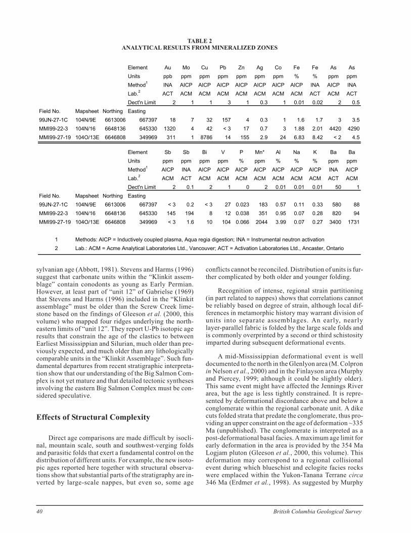
Several new mineralized zones were discovered dur-ing the course of mapping in 1999. They are either intru-sion-related gold veins or stratabound copper-rich lensesin crinkle chert. The most prospective examples are re-ported below together with analytical results where avail-able (analyzed by Instrumental Neutron Activation andInductively Coupled Plasma Emission Spectroscopy(note that ICP digestion is by aqua regia which is incom-plete for most elements); see also Table 2). One pyritic
38 British Columbia Geological Survey
Photo 8. S-C fabrics are well displayed in outcrops on the northflank of Mount Charlie Cole about 4 kilometres south of the TeslinFault.
sericite schist is geochemically unremarkable, but it isextensive and is included below.
Assay Data from Three Mineralized Zones
West Teslin Lake border area. Along west shore ofnorthern Teslin Lake, 6 km south of the Yukon border(just west of the map area, “1” on Figure 3), a set of mod-erately to steeply west to northwest dipping brittle shears,spaced about 5-10 metres apart within an Eocenegranitoid body, show evidence of west-side-up move-ment. They are invaded by quartz veins and rusty, pyriticmineralization with rare malachite staining and variablydeveloped alteration envelopes. One 2-3 cm thick veinwith a somewhat wider than average 20 centimetre alter-ation envelope was chip sampled for 2.5 metres along thevein. It returned values of 1320 ppb Au, 0.4% As, and 194ppm Sb (MMI99-22-3; Table 2; location 1 on Figure 3).
Copper in the Crinkle Chert. Numerous occur-rences of minor sulphide mineralization and copper stain-ing were encountered in the crinkle chert unit, further in-dication of the high mineral content of this unit aspreviously established by mapping in 1997. Most signifi-cantly, a chlorite-porphyroblastic, 6 metre by 0.5 metrelens with disseminated chalcopyrite returned 0.9% Cu;0.3g Au, 2.9g Ag, 6.8% Fe, and 0.17% Ba from a chipsample across its width (MMI99-27-19, Table 2; location2, Figure 3).
Jennings River “knee”. Pyrite-rich sericite schistcrops out at many localities within the map area. Most ex-tensive are those at locality “3” on Figure 3, near theJennings River “knee”. Here it is well developed within aregional quartz-phyric horizon of probable dacite compo-sition. Old claim posts indicate that the mineralizationwas known previously, but the claims were apparentlynever registered. The one sample analyzed did not returnanomalous metal values (99JN-27-1C, Table 2). Despitescant exposures, the felsic host unit is intermittently ex-posed for at least 16 km (Location 3 on Figure 3). If it isindeed continuous, it could represent a significant miner-alizing system that warrants further work.
DISCUSSION
In southern Yukon and British Columbia, the BigSalmon Complex can be reliably mapped on the basis ofthe stratigraphy presented herein. In British Columbia, itis possible to walk Big Salmon Complex greenstone fromtransitional greenschist-amphibolite facies near the coreof the Big Salmon Complex, either southeast or north-west into greenschist-grade rocks that display goodprotolith textures. Stevens and Harms (1996) include theformer, relatively high grade rocks with the “Hazel As-semblage”, and the latter, lower grade rocks with the“Klinkit assemblage”. This raises two questions: what isthe usefulness of the term Big Salmon “complex” giventhat a coherent stratigraphy is present?, and what is theutility of this assemblage given that it is possible to trace
units (like the greenstone) from higher grade “Hazel as-semblage” to lower grade “Klinkit Assemblage”.
Is Big Salmon Complex a Complex?
Use of the term “complex” is recommended in theNorth American Stratigraphic Code “…where the map-ping of each separate lithic component is impractical atordinary mapping scales. “Complex” is unranked butcommonly comparable to suite or supersuite, therefore,the term may be retained if subsequent, detailed mappingdistinguishes some or all of the component lithodemes orlithostratigraphic units.” (NACSN, 1983, page 861).Clearly, resolution of regionally mappable units withinthe Big Salmon Complex does not in itself justify aban-donment of the name. Future work may demonstrate jus-tification, but in the interim, we have elected to retain theoriginal name of “Big Salmon Complex” rather thanadopt the nomenclature of Stevens and Harms (1996).Dual nomenclature is confusing and prone to misleadinginterpretation especially when the assemblages are im-plicitly fault-bounded with distinct stratigraphies andstructural and metamorphic characteristics (see defini-tions of Stevens and Harms, 1996). Rigorous unit defini-tions together with reference sections or type localitiesneed to be established in order to address this problem.
Big Salmon Complex-“Klinkit Assemblage”Relationships
Gabrielse (1969) showed the Big Salmon Complexas bounded to the northeast by a belt of Mississippian“Sylvester Group”, including massive greenstone, chert,agglomerate and metadiorite which he designated as“unit 7”; and he showed Big Salmon Complex bounded tothe southeast by the Simpson Peak batholith and otherplutons in the Jennings River area. However, it is nowclear that to the northeast, some “unit 7” rocks north of theAlaska Highway belong to the Big Salmon Complex. Tothe southeast, marker units can be traced to the “BigBend” of the Jennings River (Figure 3, location 18), andthe enclosing strata probably extend an additional 20kilometres farther east southeast where they apparentlymerge with the “Klinkit assemblage” of Stevens andHarms (1996). These authors included both “unit 7” aswell as the presumably younger “unit 12” chert, argillite,limestone and conglomerate of Gabrielse (1969) andunits Mv and Ml of Gordey and Stevens (1994) in their in-formal “Klinkit assemblage”. The age of the “Klinkit as-semblage” is constrained by Middle Mississippian(Viséan) conodonts from limestone layers in the volcanicdivision (unit “Mv” of Gordey, 2000; fossil age compiledby M.J. Orchard in Poulton et al., 1999), by Triassic cono-donts in the dark clastic division (M. Orchard in Harmsand Stevens, 1996), and especially by the fossiliferousScrew Creek formation limestone (informal; Poole,1956) which contains Early to Middle Carboniferousmacrofossils (Abbott, 1981), early Pennsylvanianfusulinids (Gabrielse, 1969), and is structurally underlainby thin limestone layers with conodonts of Middle Penn-
Geological Fieldwork 1999, Paper 2000-1 39
sylvanian age (Abbott, 1981). Stevens and Harms (1996)suggest that carbonate units within the “Klinkit assem-blage” contain conodonts as young as Early Permian.However, at least part of “unit 12” of Gabrielse (1969)that Stevens and Harms (1996) included in the “Klinkitassemblage” must be older than the Screw Creek lime-stone based on the findings of Gleeson et al. (2000, thisvolume) who mapped four ridges underlying the north-eastern limits of “unit 12”. They report U-Pb isotopic ageresults that constrain the age of the clastics to betweenEarliest Mississippian and Silurian, much older than pre-viously expected, and much older than any lithologicallycomparable units in the “Klinkit Assemblage”. Such fun-damental departures from recent stratigraphic interpreta-tion show that our understanding of the Big Salmon Com-plex is not yet mature and that detailed tectonic synthesesinvolving the eastern Big Salmon Complex must be con-sidered speculative.
Effects of Structural Complexity
Direct age comparisons are made difficult by isocli-nal, mountain scale, south and southwest-verging foldsand parasitic folds that exert a fundamental control on thedistribution of different units. For example, the new isoto-pic ages reported here together with structural observa-tions show that substantial parts of the stratigraphy are in-verted by large-scale nappes, but even so, some age
conflicts cannot be reconciled. Distribution of units is fur-ther complicated by both older and younger folding.
Recognition of intense, regional strain partitioning(in part related to nappes) shows that correlations cannotbe reliably based on degree of strain, although local dif-ferences in metamorphic history may warrant division ofunits into separate assemblages. An early, nearlylayer-parallel fabric is folded by the large scale folds andis commonly overprinted by a second or third schistosityimparted during subsequent deformational events.
A mid-Mississippian deformational event is welldocumented to the north in the Glenlyon area (M. Colpronin Nelson et al., 2000) and in the Finlayson area (Murphyand Piercey, 1999; although it could be slightly older).This same event might have affected the Jennings Riverarea, but the age is less tightly constrained. It is repre-sented by deformational discordance above and below aconglomerate within the regional carbonate unit. A dikecuts folded strata that predate the conglomerate, thus pro-viding an upper constraint on the age of deformation ~335Ma (unpublished). The conglomerate is interpreted as apost-deformational basal facies. Amaximum age limit forearly deformation in the area is provided by the 354 MaLogjam pluton (Gleeson et al., 2000, this volume). Thisdeformation may correspond to a regional collisionalevent during which blueschist and eclogite facies rockswere emplaced within the Yukon-Tanana Terrane circa346 Ma (Erdmer et al., 1998). As suggested by Murphy
40 British Columbia Geological Survey
TABLE 2ANALYTICAL RESULTS FROM MINERALIZED ZONES
Element Au Mo Cu Pb Zn Ag Co Fe Fe As As
Units ppb ppm ppm ppm ppm ppm ppm % % ppm ppm
Method1
INA AICP AICP AICP AICP AICP AICP AICP INA AICP INA
Lab.2
ACT ACM ACM ACM ACM ACM ACM ACM ACT ACM ACT
Dect'n Limit 2 1 1 3 1 0.3 1 0.01 0.02 2 0.5
Field No. Mapsheet Northing Easting
99JN-27-1C 104N/9E 6613006 667397 18 7 32 157 4 0.3 1 1.6 1.7 3 3.5
MMI99-22-3 104N/16 6648136 645330 1320 4 42 < 3 17 0.7 3 1.88 2.01 4420 4290
MMI99-27-19 104O/13E 6646808 349969 311 1 8786 14 155 2.9 24 6.83 8.42 < 2 4.5
Element Sb Sb Bi V P Mn* Al Na K Ba Ba
Units ppm ppm ppm ppm % ppm % % % ppm ppm
Method1
AICP INA AICP AICP AICP AICP AICP AICP AICP INA AICP
Lab.2
ACM ACT ACM ACM ACM ACM ACM ACM ACM ACT ACM
Dect'n Limit 2 0.1 2 1 0 2 0.01 0.01 0.01 50 1
Field No. Mapsheet Northing Easting
99JN-27-1C 104N/9E 6613006 667397 < 3 0.2 < 3 27 0.023 183 0.57 0.11 0.33 580 88
MMI99-22-3 104N/16 6648136 645330 145 194 8 12 0.038 351 0.95 0.07 0.28 820 94
MMI99-27-19 104O/13E 6646808 349969 < 3 1.6 10 104 0.066 2044 3.99 0.07 0.27 3400 1731
1 Methods: AICP = Inductively coupled plasma, Aqua regia digestion; INA = Instrumental neutron activation
2 Lab.: ACM = Acme Analytical Laboratories Ltd., Vancouver; ACT = Activation Laboratories Ltd., Ancaster, Ontario
and Piercey (1999), this deformational pulse may proveto be a useful feature for regional correlations.
Broader map coverage and new kinematic data showthat the deformational history culminated in an importantnorth-south compressional event that affects the southernmargin of the Simpson Peak batholith, although thisevent is not everywhere in evidence. New discovery ofsuperb exposures of the Teslin fault along Jennings Riverreveal a broad zone of mylonite with sinistral kinematics,overprinted by quasi-ductile dextral fabrics (de Keijzer etal., 2000), but the age and duration of these kinematicevents and how they relate to deformational events in theadjacent rocks are unknown.
Stratigraphy Inverted, or Not?
The revised stratigraphy here relies heavily on the in-trusive relationship of Hazel orthogneiss into greenstone,providing a minimum age of 362 Ma for the greenstoneand underlying rocks. However, the contact relationshipbetween the main body of the Hazel orthogneiss andgreenstone has not been unequivocally established. Out-crop patterns support such an interpretation as do thinapophyses of orthogneiss within greenstone, but suchapophyses have not been traced back to the main body ofHazel orthogneiss. No such apophysies have been recog-nized in presumably younger units. Neither are presum-ably younger units cut by the main body, even though theoutcrop pattern on Figure 3 would seem to show this forboth the crinkle chert and carbonate units. At three locali-ties, the margin of the Hazel body follows and does notcross-cut crinkle chert (at Mount Hazel, and near locali-ties 2 and 7 on Figure 3), or carbonate (north of locality12). Where outcrop control is best, from Mount Hazel tothe BC-Yukon border, the crinkle chert apparently occurswithin a synformal keel immediately northeast of the Ha-zel orthogneiss. At Mount Hazel a septa of strongly foli-ated felsic, muscovite- and magnetite porphyroblast-richtuff (?) or intrusive border phase (not shown on Figure 3)separates the chert from less deformed Hazel pluton.
Syndepositional Faulting?
The “dirty clastics” unit and crinkle chert unit areboth observed to record the same deformational eventsand both rest depositionally atop greenstone. They rest onno other units. Crinkle chert is clearly overlain by lime-stone and a succession of other lithologies. In contrast,the “dirty clastics” unit is not overlain by other units westof Two Ladder Creek. If the “slate, chert, argillite, con-glomerate” unit of the “Klinkit assemblage” that extendseastward from Two Ladder Creek (where it was origi-nally included with the “dirty clastics” unit by Mihalynuket al., 1998 because of close lithologic similarity) is cor-relative with the “dirty clastics”, then it is overlain by a“phyllite and minor limestone” unit and both are intrudedby the 354 Ma Logjam intrusion (Gleeson et al., 2000,this volume). Thus, the crinkle chert may have been de-posited at the same time as the conglomeratic “dirtyclastics”, suggesting that the extents of these contrasting
facies were controlled by syndepositional faults. Crinklechert may have accumulated as mixed hydrothermal andbiogenic sediment in a rift graben, protected from the in-f l u x o f v o l u m i n o u s “ d i r t y c l a s t i c s ” . S i m i l a rsynsedimentary faults are suggested to control mineral-ization controls at the Fyre Lake and Kudz Ze Kayah de-posits (Murphy, personal communication, 1999). Thisrift event apparently marks a fundamental change in thecontinental arc in which the greenstone was deposited,because younger volcanic rocks in the Big Salmon Com-plex are much less voluminous.
An enigmatic basalt-gabbro-ultramafite successionbetween Teh and Butsih Creeks (southeastern 104O/12)is 2 kilometres thick and 13 kilometres long and envel-oped by Big Salmon Complex greenstone. If it is an oce-anic crustal fragment, the structure that emplaced it doesnot appear to extend west of Bareface Mountain, becausegreenstone crops out over extensive areas both north andsouth of where such a hypothetical structure should exist.Alternatively, it could have been emplaced during arcrifting and cessation of circa 362 Ma volcanism in thecontinental arc, which led to exhalative contributions andcrinkle chert deposition. It does appear to sit near the top(termination?) of the greenstone succession. Alterna-tively, it may be a differentiated sill that pinches out to thewest, in similar fashion to those believed to have beenemplaced along syndepositional faults in the Finlaysonarea (Murphy and Piercy, 1999). In either case, suchfaults are important conduits for mineralizing fluids andthe coincidence of 95th percentile regional geochemicalresults in this area (Cook and Pass, 2000, this volume)may reflect such a mineralizing system. Geochemical re-sults aimed at this problem are pending.
SUMMARY
U-Pb isotope geochronological data is key to unrav-eling the stratigraphy and geological history of the BigSalmon Complex and adjacent terrains. Two new agedates are reported here. A 362 Ma age from the Hazelorthogneiss provides a minimum age for the greenstone,which it appears to intrude, and underlying rocks. Theother isotopic age is 325 Ma from some of the structurallyhighest felsic tuffaceous units. These ages require thatmost of the stratigraphy outlined by Mihalynuk et al.(1998) is inverted. Regardless of the stratigraphicyounging direction, the greenstone-chrinkle chert-lime-stone marker succession can be confidently tracedthroughout the Big Salmon Complex in British Columbiaand southernmost Yukon (cf. Roots et al., 2000), and acrude metallogenic history can be pieced together.
Vigorous continental arc volcanism in the late Devo-nian to Early Mississippian (circa 370-360 Ma) resultedin the accumulation of voluminous, submarine, domi-nantly mafic tuff and tuffite on a substrate of pericratonicstrata. A pulse of felsic volcanism and arc rifting andprobably marks the end of the magmatic cycle and the for-mation and preservation of a regionally developed exha-lative chert horizon known as the “crinkle chert” as well
Geological Fieldwork 1999, Paper 2000-1 41
as coeval clastic facies preserved in fault-bounded basins.Felsic volcanic intervals immediately beneath the crinklechert commonly contain pyritic quartz-sericite schist in-tervals. These may serve as potential pathways tovolcanogenic massive sulphide deposits. Within the crin-kle chert, a Cu-Zn-Fe-Mn-Ba-rich lens several metreslong points to the potential for volcanogenic exhalativedeposits.
Carbonate deposition atop crinkle chert probablymarks a rise in carbonate productivity in the Early Missis-sippian, following the Late Devonian crisis and extinc-tion reef organisms. Thick carbonate banks probably co-existed with basins in which terrigenous clastics weredeposited. Complex facies may have been linked bypulses of volcanism and widespread tuff deposition. Amid-Mississippian deformational event (between 354 and335 Ma) may have peaked with emplacement of 346 Maeclogite and blueschist (cf. Erdmer et al., 1998). It causeduplift and erosion of units and deposition of widespreadconglomeratic facies. The ensuing strata display at leastas much lithologic variability as do pre-deformation sedi-ments, but felsic volcanism is again proximal as it was atthe close of greenstone deposition. Base metal sulphidesare associated with these felsic volcanics such as at theArsenault property.
The youngest Big Salmon Complex strata recognizedin the Jennings River area are 325 Ma dacitic tuffs in car-bonate. They do not correspond in any way to a clearbreak in deposition, and much younger Big Salmon Com-plex strata could exist in other areas. Peak metamorphismpredates the 196 Ma Coconino tonalite and may have oc-curred around 270 Ma when blueschist and eclogites wereincorporated into the Yukon Tanana Terrane (Erdmer etal., ibid.). The youngest regional deformational eventproduced a strong fabric in the ~196 Ma Coconinotonalite, but affected only the southern margin of the circa185 Ma Simpson Peak batholith. Youngest magmatism isEocene, and one Eocene pluton west of north Teslin Lakehosts a set of veins with elevated gold values. Clearly, thearea has a long and complex history and significant min-eral potential.
ACKNOWLEDGMENTS
Thanks to Tom Gleeson for top notch field assistanceand to Steve Gordey (GSC) and Tekla Harms (AmherstCollege) for sharing their regional geological insight. EdBalon and Wojtek Jakubowski of Fairfield Resources pro-vided access to their Cabin Lake property and freelyshared their ideas about mineral potential in the BigSalmon Complex. Geoff Bradshaw, James Smith andTerry Tucker of Brett Resources provided access to theirCariboo Creek property and a steady flow of observations(together with hand samples) during their stay in ourcamp. Retrospective thanks to Andy Page of FireweedHelicopters who helped to develop both our rapidbush-crash technique and our resilience to thigh-deepswamp water. Flying skills and keen eye of DennyDennison (Coyote Air) greatly aided our aerial reconnais-
sance. His air sickness tips were appreciated, if ultimatelyfutile. Our successful field season is owed in part to thehospitable Breeden family at Morley River Lodge. Criti-cal review by Dave Lefebure is gratefully acknowledged.
REFERENCES
Abbott, J.G. (1981): Geology of the Seagull Tin District; in YukonExploration and Geology 1979-1980, Indian and NorthernAffairs Canada, pages 32-44.
Aitken, J.D. (1959): Atlin Map-area, British Columbia; Geologi-cal Survey of Canada, Memoir 307, 89 pages.
Creaser, R.A., Erdmer, P., Stevens, R.A. and Grant, S.L. (1997):Tectonic affinity of Nisutlin and Anvil assemblage stratafrom the Teslin Tectonic Zone, Northern Canadian Cordil-lera: Constraints from neodymium isotope and geochemicalevidence; Tectonics, Volume 16, pages 107-121.
Colpron, M. (1999): Glenlyon project: Preliminary stratigraphyand structure of Yukon-Tanana Terrane, Little Kalzas Lakearea, central Yukon (105L/13); in Roots, C.F. and Emond,D.S. (editors), Yukon Exploration and Geology 1998, Ex-ploration and Geological Services Division, Yukon, Indianand Northern Affairs Canada, pages 63-71.
Cook, S. and Pass, H. (2000): Ancient Pacific Margin Part V: Pre-liminary results of geochemical studies for VMS deposits inthe Big Salmon Complex, Northern British Columbia, inGeological Fieldwork 1999, B.C.Ministry of Energy andMines, Paper 2000-1, this volume.
deKeijzer, M., Williams, P. and Brown, R.L. (1999): Kilo-metre-scale folding in the Teslin zone, northern CanadianCordillera, and its tectonic implications for the accretion ofthe Yukon-Tanana Terrane to North America; CanadianJournal of Earth Science, Volume 36, pages 479-494.
de Keijzer, M., Mihalynuk, M.G. and Johnston, S.T. (2000): Struc-tural investigation of an exposure of the Teslin Fault; in Cur-rent Research, Geological Survey of Canada, Paper 2000-A,(in press).
Dixon-Warren, A. and Hickin, A. (2000): Ancient Pacific MarginNATMAP Part IV: Surficial mapping and till geochemistryin the Swift River Area, north western British Columbia; inGeological Fieldwork 1999, B.C. Ministry of Energy andMines, Paper 2000-1, (in press).
Erdmer, P. (1985): An examination of cataclastic fabrics and struc-tures of parts of Nisutlin, Anvil and Simpson allochthons,central Yukon: test of the arc-continent collision model;Journal of Structural Geology, Volume 7, pages 57-72.
Erdmer, P. and Helmstaedt, H. (1983): Eclogite from central Yu-kon: a Record of subduction at the western margin of An-cient North America; Canadian Journal of Earth Sciences,Volume 20, pages 1389-1408.
Erdmer, P. and Armstrong, R.L. (1989): Permo-Triassic isotopicdates for blueschist, Ross River area, Yukon; in Yukon Ex-ploration and Geology, Volume 2: Exploration and Geologi-cal Services Division, Yukon, Indian and Northern AffairsCanada, pages 33-36.
Erdmer, P., Ghent, E.D., Archibald, D.A. and Stout, M.Z. (1998):Paleozoic and Mesozoic high pressure metamorphism at themargin of ancestral North America in central Yukon; Geo-logical Society of America Bulletin, Volume 110, pages615-629.
Gabrielse, H. (1969): Geology of the Jennings River Map-Area,British Columbia (104-O); Geological Survey of Canada,Paper 68-55.
Gleeson, T.P., Friedman, R.M. and Wahl, K. (2000): Stratigraphy,structure, geochronology and provenance of the LogjamCreek area, northwestern British Columbia (NTS
42 British Columbia Geological Survey
104O/14W); in Geological Fieldwork 1999, B.C. Ministry ofEnergy and Mines, Paper 2000-1, (in press).
Gordey, S.P. (1995): Structure and Terrane Relationships ofCassiar and Kootenay (Yukon-Tanana) Terranes, TeslinMap Area, Southern Yukon Territory; in Current Research1995-A; Geological Survey of Canada, pages 135-140.
Gordey, S.P. (2000): Geology, Teslin, Yukon Territory (105C);Geological Survey of Canada, Open File 2886, scale 1:250000.
Gordey, S.P. and Stevens, R.A. (1994): Preliminary interpretationof bedrock geology of the Teslin area (105C), southern Yu-kon; Geological Survey of Canada, Open File 2886, scale1:250 000.
Hansen, V.L. (1989): Structural and kinematic evolution of theTeslin suture zone, Yukon: Record of an ancienttranspressional margin; Journal of Structural Geology, Vol-ume 11, pages 717-733.
Hansen, V.L., (1992a): P-T Evolution of the Teslin suture zone andCassiar tectonites, Yukon, Canada: evidence for A- andB-type subduction; Journal of Metamorphic Geology, Vol-ume 10, pages 239-263.
Hansen, V.L. (1992b): Backflow and margin-parallel shear withinan ancient subduction complex; Geology, Volume 20, pages71-74.
Hansen, V.L., J.K. Mortensen, and Armstrong, R.L. (1989): U-Pb,Rb-Sr, and K-Ar isotopic constraints for ductile deformationand related metamorphism in the Teslin suture zone, Yu-kon-Tanana terrane, south-central Yukon; Canadian Jour-nal of Earth Sciences, Volume 26, pages 2224-2235.
Hansen, V.L., M.T. Heilzer, and Harrison, T.M. (1991): Mesozoicthermal evolution of the Yukon-Tanana composite terrane:New evidence from 40Ar/39Ar data; Tectonics, Volume 10,pages 51-76.
Harms, T.A. and Stevens, R.A. (1996): A working hypothesis forthe tectonostratigraphic affinity of the Stikine Ranges and aportion of the Dorsey Terrane; in Cook, F. and Erdmer, P.(compilers), Slave-Northern Cordillera Lithospheric Evolu-tion Transect and Cordilleran Tectonics Workshop Meeting,University of Calgary, Lithoprobe Report No. 50, pages93-95.
Mihalynuk, M.G., Nelson, J. and Friedman, R.M. (1998): Regionalgeology and mineralization of the Big Salmon Complex(104N NE and 104O NW) in Geological Fieldwork 1997,B.C. Ministry of Employment and Investment, Paper 1998-1,pages 157-170.
Mortensen, J.K. (1992): Pre-mid-Mesozoic tectonic evolution ofthe Yukon-Tanana terrane, Yukon and Alaska; Tectonics, 11,pages 836-853.
Mortensen, J. K., Ghosh, D.K. and Ferri, F. (1995): U-Pb geo-chronology of intrusive rocks associated with copper-goldporphyry deposits in the Canadian Cordillera; in PorphyryDeposits of the Northwestern Cordillera of North America,Schroeter, T.G., Editor, Canadian Institute of Mining, Metal-lurgy and Petroleum; Special Volume 46, pages 142-158.
Mulligan, R. (1963): Geology of the Teslin Map-Area, Yukon Ter-ritory; Geological Survey of Canada, Memoir 326, 96 pages.
Murphy, D.C. and Piercey, S.J. (1999): Finlayson project: Geolog-ical evolution of Yukon-Tanana Terrane and its relationshipto Campbell Range belt, northern Wolverine Lake map area,southeastern Yukon; in Roots, C.F. and Emond, D.S. (edi-tors.), Yukon Exploration and Geology 1998, Explorationand Geological Services Division, Yukon, Indian and North-ern Affairs Canada, pages 47-62.
Nelson, J.L., Mihalynuk, M. G., Murphy, D.C., Colpron, M.,Roots, C.F., Mortensen, J.K. and Friedman, R.M. (2000):Ancient Pacific Margin Part II: Apreliminary comparison ofpotential VMS-hosting successions of Yukon-TananaTerrane, from Finlayson district to northern British Colum-
bia; in Geological Fieldwork 1999, B.C. Ministry of Energyand Mines, Paper 2000-1, (this volume).
North American Commission on Stratigraphic Nomenclature(1983): North American stratigraphic code; The AmericanAssociation of Petroleum Geologists Bulletin, Volume 67,pages 841-875.
Poole, W.H. (1956): Geology of the Cassiar Mountains in the vi-cinity of the Yukon-British Columbia boundary; unpub-lished Ph.D. thesis, Princeton University, 247 pages.
Poulton, T., Orchard, M.J., Gordey, S.P. and Davenport, P. (1999):Selected Yukon fossil determinations; in Yukon digital geol-ogy, S.P. Gordey and A.J. Makepeace (compilers), Geologi-cal Survey of Canada, Open File D3826, and Explorationand Geological Services Division, Yukon, Indian andNorthern Affairs Canada, Open File 1999-1(D).
Roots, C.F., de Keijzer, M., Nelson, J.L. and Mihalynuk, M.G.(2000): Revision mapping of the Yukon-Tanana and equiva-lent terranes in northern B.C. and southern Yukon between131° and 132°W; in Current Research, Geological Survey ofCanada, Paper 2000-1A, pages (in press).
Stevens, R.A. (1992): Regional geology, fabric and structure of theTeslin suture zone in Teslin map area, Yukon Territory; inCurrent Research, Geological Survey of Canada, Paper92-1A, pages 287-296.
Stevens, R.A. (1994): Geology of the Teslin suture zone in parts ofLaberge (105E/1), Quiet Lake (105F/4) and Teslin(105C/11, 13, 14) map areas, Yukon Territory; GeologicalSurvey of Canada, Open File 2768.
Stevens, R.A. and Erdmer, P. (1993): Geology and Structure of theTeslin suture zone and related rocks in parts of Laberge,Quiet Lake and Teslin map areas, Yukon; in Current Re-search, Geological Survey of Canada, Paper 93-1A, pages22-20.
Stevens, R.A. and Harms, T.A. (1995): Investigations in theDorsey Terrane, Part 1: Stratigraphy, Structure and Meta-morphism in the Dorsey Terrane, Southern Yukon Territoryand Northern British Columbia; in Current Research, Geo-logical Survey of Canada, Paper 95-1A, pages 117-128.
Stevens, R.A. and Harms, T.A. (1996): Geology in the vicinity ofthe Dorsey Range, southern Yukon Territory and northernBritish Columbia; scale 1:50 000; in Cook, F. and Erdmer, P.(compilers), Slave-Northern Cordillera Lithospheric Evolu-tion Transect and Cordilleran Tectonics Workshop Meeting,University of Calgary, Lithoprobe Report No. 50, pages222-225.
Stevens, R.A., Erdmer, P., Creaser, R.A. and Grant, L.S. (1996):Mississippian assembly of the Nisutlin assemblage: Evi-dence from primary contact relationships and Mississippianmagmatism in the Teslin tectonic zone, part of the Yu-kon-Tanana Terrane of south-central Yukon; Canadian Jour-nal of Earth Sciences, Volume 33, pages 103-116.
Tempelman-Kluit, D.J. (1979): Transported cataclasite, ophioliteand granodiorite in Yukon: evidence of arc-continent colli-sion; Geological Survey of Canada, Paper 79-14.
Wheeler, J.O., Brookfield, A.J., Gabrielse, H. Monger, J.W.H.,Tipper, H.W. and Woodsworth, G.J. (1991): Terrane map ofthe Canadian Cordillera; Geological Survey of Canada, Map1713A.
Appendix I: Notes on Figure 3
Thick Quaternary deposits completely blanket someparts of the map area for tens of square kilometres. Theseare problem areas in which tenuous extrapolations are re-quired to produce the map of Figure 3. Many extrapola-tions, if correct, carry important implications. Other ex-trapolations, drawn to mimic local structural style, imply
Geological Fieldwork 1999, Paper 2000-1 43
detailed knowledge of unit distributions that does not ex-ist. Most limitations of Figure 3 will become apparentwith future publication of 1:50 000 scale Open File mapswhich will show inferred contacts and limits of outcrop;however, many of the following remarks are germane tothose maps as well. The numbered points below corre-spond to the numbers, ordered from north to south, en-closed by triangles on Figure 3.
1. Western contacts of the Screw Creek limestone have notbeen found in the Screw Creek valley bottom. Lowestexposures of limestone are apparently right way upbased on poorly preserved grading in siliceoustuffaceous layers. Structurally higher parts of the lime-stone are clearly upside down (described above).
2. Crinkle chert occurs in the old Alaska Highway road cut,but the area to the west is swamp; no greenstone ismapped.
3. This contact is well constrained between the elongatepluton of presumed Jurassic age and the Alaska High-way, but has not been observed north or south of thosepoints.
4. The syncline is constrained along the shoreline and near“4”. However, closure could not be confirmed by map-ping. Felsic volcanics on the southern limb are locallyvery siliceous and might be a volcanic-crinkle chert hy-brid.
5. Closure of the fold has not been demonstrated unequivo-cally. However, all indications point to fold closure:only greenstone is mapped along the Smart River road,both limbs have been mapped to within a couple kilo-metres of the hinge and layer-cleavage relationships onthe limbs are consistent with closure.
6. Mapping of 104O/14W is incomplete. Low outcrops inthe downstream stretches of the Screw Creek valley in-clude small areas of limestone, perhaps hinges of foldsdeveloped on the lower limb of the Screw Creek lime-stone.
7. Crinkle chert occurs as a large area of angular bouldersatop Hazel orthogneiss where it is assumed to be locallyderived. Crinkle chert is known to occur along the con-tact of the Hazel orthogneiss at location 2 and near thePeak of Mount Hazel.
8. Only small lenses of carbonate are found in the axial zoneof the fold. Carbonate on the fold limbs apparentlygrades laterally into graphitic wacke near the fold core.
9. Only three areas of outcrop constrain the eastern lime-stone belt south of the Alaska Highway. One is near thenorth margin of the Simpson Peak batholith another issouth of central Swan Lake on Hook Creek (creek notshown on Figure 3), and third is an area of sparse out-crops in the forest west of Swan Lake. At none of theselocalities is the crinkle chert unit exposed.
10. Geology near “10” and an equal distance due north of thehighway has been compiled mainly from vantage pointmapping. It requires confirmation by direct observa-tions.
11. Orthogneiss near Mt. Francis is lithologically similar tothe Hazel orthogneiss in many respects; however, it ap-parently cuts younger stratigraphy. It is presumably be-tween 362 and 335Ma, because it is younger than thegreenstone, but is overlain by conglomerate believed de-rived subsequent to a deformational event around 345Ma. (see Discussion).
12. Only scattered outcrops of limestone and greenstone cutby tonalite are present at the southern end of the carbon-ate belt. More persistent outcrop near the northern end ofthe belt leads to a map pattern that implies that the Hazelorthogneiss also cuts the limestone, but this is probablynot the case. It appears more likely that the limestonebelt outlines a tight synformal keel that is bent to thewest and extends over the Hazel orthogneiss (see loca-tion 7). The crinkle chert unit was apparently not depos-ited at this locality below the limestone.
13. All contacts between Coconino tonalite and SimpsonPeak batholith are covered. Since Coconino tonalite isolder and more deformed than the Simpson Peakbatholith, the interpreted contact configuration is meantto show the former cut by the latter.
14. Teh Creek pluton is shown as an elongate body trending290°. In fact, most of the central portion traversed byTeh Creek is covered and two separate bodies could bepresent. However, the plutonic rocks exposed at eitherend of the body lithologically indistinguishable, and thebody is known to continue in similar fashion to the eastbeneath a carapace of Klinkit assemblage rocks to whereit is exposed in the Butsih Creek valley. Several corre-lated geochemical anomalies coincide with carapacerocks in easternmost 104O/12 (near 19; see also Cookand Pass, 2000, this volume).
15. Felsic volcanics are not mapped north of “15”, but areshown extending through a covered area to the lime-stone belt because of their common association withlimestone elsewhere.
16. As is the case for locality “14”, no outcrop exists to sup-port the interpretation of a continuous septa ofgreenstone. However, clear relationships occur at boththe western and eastern ends of the septa. The contactshown between greenstone and Klinkit argillite is purelyconjectural.
17. Teslin fault is beautifully exposed here (see deKeijzer etal., 2000).
18. A tight synformal keel of crinkle chert and limestone isenveloped by greenstone. In particular, limestone layersare strongly folded and rodded, producing a “falsestretched monomict conglomerate” in which the appar-ent stretched limestone “cobbles” are actually decapi-tated, isoclinal interference folds. Protolith textures aredestroyed due to the coincidence of interference foldcores; however, good protolith textures are displayed ingreenstone where it occurs out along the relatively pla-nar fold limbs.
19.Teh Creek pluton in subsurface produces hornfels andmultielement geochemical anomalies in local streamsediments (see “14” above and Cook and Pass, this vol-
44 British Columbia Geological Survey

ume). Roof rocks are cut by abundant thick dikes and thepluton is again exposed in Butsih valley to the east.
20. Cherty argillite believed to be part of the Cache CreekKedahda Formation is strongly hornfelsed near the in-trusive contact.
21. Most of the unit is covered within 5 kilometres of theRiver. Observations are restricted to within 2 kilometresof the northern contact.
22. A few scattered outcrops of strongly foliated, blue greylimestone occur in the middle of a broad glacial outwashplain east of Kachook Creek. They are included with thePermian Teslin Formation based only upon lithologicalsimilarity. Thus, the trace of the Teslin Fault must run tothe north, down the Jennings River.
23. Both northwest and northeast contacts of the CharlieCole pluton are covered.
Geological Fieldwork 1999, Paper 2000-1 45

46 British Columbia Geological Survey