Embed Size (px)
Citation preview

UNITED STATES DEPARTMENT OF THE INTERIOR J. A. Krug, Secretary
GEOLOGICAL SURVEY W. E. Wrather, Director
Bulletin 960-F
GEOLOGY AND MANGANESE DEPOSITSOF THE LUCIFER DISTRICT
NORTHWEST OF SANTA ROSALIABAJA CALIFORNIA, MEXICO
BY
IVAN F. WILSON AND MARIO VEYTIA
Prepared in cooperation with the
UNIVERSIDAD NACIONAL AUTONOMA DE MEXICO, INSTJTUTO DEGEOLOGIA and SECRETARIA DE LA ECONOMIA NACIONAL
DIRECCION GENERAL DE MINAS Y PETROLEO
Under the auspices of the
INTERDEPARTMENTAL COMMITTEE ON SCIENTIFIC AND CULTURAL COOPERATION, DEPARTMENT OF STATE
Geologic Investigations in the American Republics, 1947 (Pages 177-234)
UNITED STATES
GOVERNMENT PRINTING OFFICE
WASHINGTON : 1949
For sale bv the Suoerintendent of Documents. U. S. Government Printing Office, Washington 25, D. C.


CONTENTS
Abstract__________________________--_---__--____-----_-_-____-__ 177Introduction _____________________.-_--_-_--_---__-----__----______ 178
Field work._.___._____._...-..----..-.-.-------.-.-.---....... 178Acknowledgments..---____--__--------------------------.----_ 179Geography. ____________ ________---_-_--_-_--___--_-____-_-_-_- 181History and production._______________________________________ 184Previous geologic investigations. -______--.__-____-_.___._______. 186
Geology.____________.______________--_-_--.__-__-_-__-_-_________ 186Rock formations-------.--------------------------------------- 187
General sequence-_________________________________________ 187Quartz monzonite.__________-__-_--_---____-______________ 187Comondii volcanics (Miocene)___.___________________________ 188Boleo formation (lower Pliocene)__--_-__-____-_.___-___.___- 189
Tuff--.---------------------------------------------. 191Conglomerate.---------------------------------------- 191Tuffaceous limestone__---------------_----_---.-_-_-___- 192Fossiliferous sandstone-________________________________ 192Gypsum.._._..__._..___.____.____..___._._._..._..._. 193Fossils and age_________-_----_-_--___-_--___-____-_-__ 193Origin of the Boleo formation-___--_____--____.___-_-.__ 194
Gloria formation (middle Pliocene)_-----_____-____-__.___-__ 194Infierno formation (upper Pliocene)__________________________ 197Santa Rosalia formation (Pleistocene)________________________ 198Tres V.rgenes volcanics (Pleistocene or Recent).._-._.___.._.__ 199Terrace and talus deposits (Recent)__________________________ 201Alluvium (Recent)..--------------------------------------- 201
Structure.-----..--------------------------------------------- 201Manganese deposits._________________----__-_--_-_-___-_-_-___--._- 203
General features..______________---_-__-_--_-_-__-____-_-___--_ 203Occurrence.._________________________________________________ 203Structure of the Lucifer deposit. ________________________________ 204
Structure contours.._______________________________________ 204Faults--.---.-------------------------I------------------- 207
Thickness of ore____.__________---_-_-__-_-_------_-----___--__ 209Extent of ore.-_-_----_----.----------------------------_----- 210Mineralogy- _____________________-_--_-__-______-_-_-__-__-.-_ 211Grade and chemical composition of ore...________________________ 212Uses of ore.._________________________________________________ 214Deposits other than the Lucifer. ________________________________ 214Relation to copper deposits.____________________________________ 216Origin of the manganese deposits._______________________________ 217Mining methods.._____________________________________________ 219Exploratory drilling program..._________________________________ 223Reserves and future possibilities.____-__-_-_-__l___-__-__._______ 228
Literature cited____________________-__-_--_-_-____-_--_--____.____ 229Metric equivalents_________________-_-_--_---_-__-_---_---_-_-._- 231Index. _.._________________._..__.___.__._...__._._ 233

IV CONTENTS
ILLUSTRATIONS
PagePLATE 37. A, Aerial view of Lucifer manganese mine, Baja California,
Mexico, looking westward; B, Lucifer mine as seen from bottom of Arroyo del Infierno___________________________ 183
38. A, Gravity tramway at Lucifer mine; B, Sediments of Boleo formation exposed on north side of Arroyo del Infierno, east of Lucifer mine______________________________________ 195
39. Geologic map and structure section of Lucifer manganese dis trict- ______________________________________________ In pocket
40. Topographic and geologic map and structure sections of Lucifermanganese mine and surrounding area________________ In pocket
41. A, Aerial view looking eastward toward mouth of Arroyo del Infierno; B, Aerial view looking northwest toward head of Arroyo de las Palmas__________________________________ 196
42. Block diagram of area surrounding Lucifer manganese mine. In pocket43. A, Outcrop at south end of Lucifer mine; B, Mine entry at
southeast end of Lucifer mine___________________________ 20544. Map of underground workings of Lucifer manganese mine. In pocket45. Structure-contour map of manganese ore body, Lucifer mine. In pocket46. Block diagram showing structure and thickness of manganese
ore--__-__---_-_-_____--___-__-_-_-_-_------_-___- In pocket47. A, Open-cut at northeast end of Lucifer mine; B, Outcrops of
manganese ore on dip slope northeast of Lucifer mine._____ 20648. Geologic sections along principal underground workings, Luci
fer manganese mine._______________________________ In pocket49. Isopach map, showing thickness of manganese ore, Lucifer
mine______________________________________________ In pocket50. A, Churn-drilling rig used for exploratory drilling in 1948; B,
Sorting belt and loading bin at mouth of main Lucifer mine entry in 1948____..____________________________________ 221
51. A, Drag line used in stripping overburden from the outcrop at the southeast end of Lucifer mine; B, Open-cut formed by stripping at northeast end of Lucifer mine._______________ 222
52. Map showing drill holes, mine workings, and structure con tours of Lucifer manganese mine and surrounding area- In pocket
53. Structure sections of area explored by drill holes around Lucifermanganese mine-__________________________________ In pocket
54. Map showing areas favorable for drilling in Lucifer district. _ In pocket
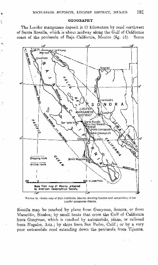
FIGURE 15. Index map of Baja California, Mexico, showing location andaccessibility of Lucifer manganese district._______________ 181

GEOLOGY AND MANGANESE DEPOSITS OF THE LUCIFER DISTRICT, NORTHWEST OF SANTA ROSALfA, BAJA CALL FORNIA, MEXICO
By IVAN F. WILSON and MARIO VEYTIAABSTRACT
The Lucifer manganese mine is northwest of the town of Santa Rosalia, midway along the Gulf coast of Baja California. Although its development did not begin until late in 1941, it has produced more manganese than any other mine in Mexico. Its total production to May 16, 1948, was 159,718 long tons of ore.
Topographically, the region is characterized by mesas and arroyos. The Lucifer mine lies on the north side of Arroyo del Infierno, 150 meters above the valley floor. Ore is lowered to the arroyo by a gravity tram and is transported by truck and rail to Santa Rosalia. Three shipping routes have been used: aeross the Gulf of California to Guaymas, Sonora; by steamer to San Pedro, Calif.; and more recently, through the Panama Canal to Atlantic coast ports.
The main mountain range in the region is formed of tilted and faulted volcanic and pyroclastic rocks of the Miocene Comondu formation. This formation is overlain unconformably by the Boleo formation, of lower Pliocene age, consisting of interbedded conglomerate and tuff. The Lucifer manganese deposits and the Boleo copper deposits are within the tuff. The Boleo formation is overlain by middle and upper Pliocene and Pleistocene marine sediments. The mesas are partly covered with lava flows of Pleistocene or Recent age. The main period of deformation was at the close of the Miocene, when the Comondu volcanics were tilted into a series of blocks cut by westward-dipping normal faults having dis placements of 50 to 100 meters. The Pliocene and Pleistocene sediments have been gently tilted and faulted, but much of their inclination is due to initial dip and to differential compaction around hills and ridges of the Comondu volcanics. The Pliocene sediments were deposited on a surface of strong relief, and islands and headlands of the Comondu volcanics projected from the Pliocene sea.
The ore at the Lucifer mine forms a gently dipping tabular deposit enclosed in tuff. Its thickness ranges from 1 to 6 meters and averages 2}£ meters. In May 1948 a series of intersecting drifts had blocked out ore over an area of 53,000 square meters; scattered outcrops are found as much as 410 meters north of the blocked-out area. The ore lies on a structural terrace trending toward the west- northwest, and it turns steeply upward and pinches out against a projecting ridge of Comondu volcanics in the southwestern part of the mine. As indicated by a map showing structure contours on the base of the ore body and by an isopach map showing the variations in the thickness of the ore, the thickest part of the ore body follows the middle of the structural terrace. The ore is overlain by a nearly flat fault, which may be premineral. The ore body is offset by small normal faults haying a maximum displacement of 8 meters.
As the ore is mostly fine-grained and incoherent, it contains a large percentage of "fines." A plant has been installed to sinter the fines for metallurgical purposes. The ore consists of fine-grained cryptomelane and pyrolusite, and contains from 4.5 to 50 percent of manganese. The content is increased to 52 or 53 percent in the sintered ore. The soft fine-grained ore encloses lenses of a hard siliceous ore and of hematitic and limonitic jasper, but the over-all silica content averages less
177

178 GEOLOGIC INVESTIGATIONS IN THE AMERICAN REPUBLICS, 1947
than 5 percent. The pyrolusite ore is of chemical grade and is mined selectively.Small manganese deposits are scattered over an area extending 4 kilometers
north and 4}^ kilometers southeast of the Lucifer mine, but all of them are thin, of low grade, and unpromising.
The deposits are believed to have been formed by hydrothermal solutions that rose along faults in the Comondu volcanics, spread laterally into the tuff beds of the Boleo formation, and partly replaced the tuff. There is evidence that the deposition of the ore was structurally controlled. These manganese deposits are thought to be closely related in origin to the Boleo copper deposits.
The total size of the Lucifer ore body is of the order of 300,000 tons, of which about half has already been mined, one quarter is expected to be mined in the next 2 or 3 years, and the remaining quarter will probably have to be left in the form of pillars.
INTRODUCTION
FIELD WORK
At the Lucifer mine, northwest of Santa Rosalia in Baja California, Mexico, is a newly discovered deposit of manganese ore. Although this deposit was not actively developed until late in 1941, it has proven to be the largest manganese deposit known in Mexico.
The present report is based upon a cooperative study of the Lucifer deposit and the surrounding area by the Geological Survey, United States Department of the Interior, and the Direcci6n General de Mines y Petr61eo of the Secretaria de la Economla Nacional de Mexico. This study forms a part of a series of geologic investigations in the American Republics, sponsored by the Interdepartmental Committee on Scientific and Cultural Cooperation, which is under the auspices of the United States Department of State.
Parker D. Trask first examined the Lucifer mine on behalf of the Geological Survey in the early part of 1943, and it was his recommenda tion that a detailed survey be made of the ore deposit and surrounding region. Ivan F. Wilson, of the United States Geological Survey, and Mario Veytia, of the Direcci6n General de Minas y Petr61eo, were assigned to the project. Most of their field work was done in the period October 1943 to January 1944, but Wilson revisited the district at several later dates in 1944, 1945, 1946, and 1948 to bring the maps and data on the mine workings up to date. Most of the development of the mine was during this period, for in 1943 the mine workings had only about one-fourth the extent which they had in 1948. Altogether about 6 months of field work were spent in the district.
Geologic, structure-contour, and isopach maps of the Lucifer mine were constructed on a field scale of 1:500, using as a base a map of the mine workings furnished by the Lucifer company. By plane-table methods a topographic and geologic map, on a field scale of 1:2000, was made of an area 1,200 meters 1 long and 800 meters wide sur-
1 The metric system of measurement is used throughout this report. A chart of metric equivalents is given at the end of the report.

MANGANESE DEPOSITS, LUCIFER DISTRICT, MEXICO 179
rounding the Lucifer mine. A smaller-scale geologic map, covering an area of 80 square kilometers, was made on trimetrogon high- oblique aerial photographs, controlled by plane-table triangulation. A planimetric map on a compilation scale of 1:15,000 was converted from the photos by the sketchmaster method in the office of the Geological Survey in Washington, D. C. A geologic map of the Boleo copper district, which adjoins the Lucifer manganese district to the southeast, was made by Wilson and Victor S. Rocha in 1946. This will be published at a later date in a separate report on the Boleo district.
This report was written essentially in its present form in 1944, but the sections concerning history and production, mine workings, extent of ore and related topics have been brought up to date as of May 1948. The most important recent development in the district was an exploratory program of churn drilling carried out from December 1947 to Juno 1948, by means of which the main ore body of the Lucifer mine was completely delimited. The results of the drilling program have been incorporated in the present report, and the map of the drill holes shows the extent of the mine workings as of May 1948. As the other maps in this report had been finally drafted for publication, however, they show the extent of the mine workings only as of May 1946.
ACKNOWLEDGMENTS
Sr. Ing. P. Mahieux and Sr. Ing. F. L. Garcia Quintanilla put the writers under great obligations by their kind hospitality and assistance during the course of the field work. All the officials of the Compagnie du Bole"o at Santa Rosalia were most hospitable and helpful. The Instituto de Geologia de Mexico and its director, Sr. Ing. Teodoro Flores, extended full cooperation and provided office facilities in Mexico City. The Direcci6n General de Minas y Petr61eo and its director, Sr. Ing. German Garcia Lozano, were most cordial. The staffs of the Foreign Economic Administration and the American Embassy in Mexico City gave us valuable aid. Parker D. Trask gave helpful advice both before and during the investigation. C. A. Anderson kindly lent a copy of his manuscript on the geology of the Gulf of California. Discussions with James A. Noble concerning the geologic problems of the region were very stimulating. James S. Martin was very cooperative during the study of the exploratory drill ing program.
Various members of the Geological Survey contributed to the study: Robert L. Smith and Clarence S. Ross examined a number of thin sections; M. K. Carron, R. E. Stevens, and Michael Fleischer made chemical analyses, and Fleischer also identified the ore minerals; J. M. Axelrod made X-ray examinations of some of the manganese minerals; K. J. Murata made a spectrographic analysis of the ore;

180 GEOLOGIC INVESTIGATIONS IN THE AMERICAN REPUBLICS, 1947
and H. E. Vokes identified the fossils collected. Kenneth Segerstrom took the aerial photographs which are reproduced in this report. The manuscript has benefited greatly by the helpful criticism of F. C. Calkins, J. V. N. Dorr 2d, Ward C. Smith, and F. W. Stead. Carl Fries, Jr., gave valuable aid in reviewing the maps. The work was under the general supervision of D. F. Hewett, J. V. N. Dorr 2d, and W. F. Foshag.
MANGANESE DEPOSITS, LUCIFER DISTRICT, MEXICO
GEOGRAPHY
181
The Lucifer manganese deposit is 17 kilometers by road northwest of Santa Kosalia, which is about midway along the Gulf of California coast of the peninsula of Baja California, Mexico (fig. 15). Santa
^VMermosino i
\ S Q\\N 0 R A V
Base from map of Mexico prepared by American Geographical Society.
FIGURE 15. Index map of Baja California, Mexico, showing location and accessibility of the Lucifer manganese district.
Eosalia may be reached by plane from Guaymas, Sonora, or from Mazatlan, Sinaloa; by small boats that cross the Gulf of California from Guaymas, which is reached by automobile, plane, or railroad from Nogales, Ariz.; by ships from San Pedro, Calif.; or by a very poor automobile road extending down' the peninsula from Tijuana.

182 GEOLOGIC INVESTIGATIONS IN THE AMERICAN REPUBLICS, 1947
Three routes have been used in shipping ore to the United States. The first, across the Gulf to Guaymas by boat and thence by rail to Nogales, was used for only a short while. During most of World War II ore was shipped to San Pedro, Calif., using ships of the Compagnie du Boleo. Recently shipments have been made to Atlantic coast ports by way of the Panama Canal.
Santa Rosalia, a town of some 6,000 inhabitants, is headquarters for the Boleo copper mines, which have been operated by the French- owned Compagnie du Boleo since 1885. For most of its history the Boleo district has been the second or third largest copper producer in Mexico. The company has constructed an artificial harbor enclosed in a breakwater of furnace slag, a smelter to produce blister copper, and a narrow-gage railroad to some of the copper mines.
Topographically, the Santa Rosalia area consists of a series of mesas reaching altitudes of 300 to 400 meters, cut by arroyos that drain eastward into the Gulf of California. The mesas slope grad ually eastward, ending at the gulf in cliffs bordered by narrow beaches. South of Santa Rosalia the mesas descend gradually to the San Bruno Plain, which is only a little above sea level. On the west the mesas are bordered by the Sierra de Santa Lucia, which is the main moun tain range of the peninsula of Baja California in that latitude. The crest of this range lies 20 to 30 kilometers west of the gulf, and 1,500 to 1,600 meters higher. The Tres Virgenes, three prominent vol canic cones which have erupted within historic times, rise above the mesa 35 kilometers northwest of Santa Rosalia. The highest of them has an altitude of 1,995 meters. Another prominent volcanic moun tain, Cerro de Santa Maria, which is 1,348 meters high, lies 25 kilo meters north of Santa Rosalia.
The Lucifer mine lies on the north side of Arroyo del Infierno, at an elevation of 280 to 300 meters above sea level or 150 meters above the valley floor. (See pi. 37.) It is about 8 kilometers inland from the gulf. The town of Lucifer, housing a hundred-odd mine workers and their families, is in the arroyo below the mine. The Santa Rosalia-San Ignacio road crosses Arroyo del Infierno 1 1A kilometers east of the mine and proceeds along the top of the mesa 1 kilometer north of the mine. A branch road follows the arroyo to a point directly below the mine, and in 1946 a narrow road \vas constructed up the side of the arroyo to the main mine entry. Ore is lowered from the mine to the arroyo by a 3-rail gravity tram 350 meters long (pi. 38A); it is then trucked 10 kilometers to a railhead in Arroyo del Boleo and carried 7 kilometers by rail to the wharfs at Santa Rosalia.
Small manganese deposits are scattered at wide intervals over an area extending 4 kilometers northward to Arroyo de las Palmas, which

GEOLOGICAL SURVEY BULLETIN 960 PLATE 37
A. AERIAL VIEW OF LUCIFER MANGANESE MINE, LOOKING WESTWARD UP AKROYODEL INFIERNO.
Black streak near center is outcrop of manganese ore. Town of Lucifer is in bottom of arroyo in lower center.
B. LUCIFER MINE, AS SEEN FROM BOTTOM OF AKROYO DEL 1NFIKKXO, LOOKINGWESTWARD.
183

184 GEOLOGIC INVESTIGATIONS IN THE AMERICAN REPUBLICS, 1947
is a northern branch of Arroyo del Infierno, and 4% kilometers south eastward to Arroyo del Boleo and its branch Canada de la Gloria. (See pi. 39.)
The manganese deposits occur in the geologic formation that con tains the Boleo copper deposits. Certain beds in the formation are mainly manganiferous and others are mainly cupriferous, though in some places the manganese and copper deposits occur together. The manganese deposits are found mainly north of Arroyo del Boleo and the copper deposits mainly south of it, though there are small copper deposits in Arroyo del Infierno, east of the Lucifer mine, and low-grade manganiferous beds are found throughout the Boleo cop per district. The copper deposits are scattered over an area that extends as far south as Arroyo de Santa Agueda, south of Santa Rosalia, the total area known to contain copper deposits being about 17 kilometers long from northwest to southeast and 1 to 4 kilometers wide.
The climate of the region is warm and extremely arid. The mean temperature of the coldest month is 15.8° C. (60.4° F.) and that of the warmest month 31.0° C. (87.8° F.) (Mexico, Direcci6n General de Geografia, 1942). The annual rainfall is said to average 138.3 mm. (5K inches), but it is extremely variable. Rain generally falls only in brief showers occurring three or four times a year, and some years are said to pass without any rain whatever. On the other hand, a few severe storms have caused great damage to habitations in the arroyos. The arroyos are generally dry except for a few small pools of water in rock basins. One such pool, in Arroyo del Infierno 1 kilo meter west of the Lucifer mine, yields a supply of water barely suffi cient for mining operations and for the domestic needs of the dwellers in the town of Lucifer. The water supply for Santa Rosalia comes partly from Santa Agueda, 12 kilometers to the west, and partly from the deep copper mines. The vegetation in the region consists mainly of cactus and other thorny plants, so that lumber and mining timber all must be imported.
HISTORY AND PRODUCTION
The Lucifer manganese deposit received no attention until the advent of World War II. The deposit is on the former concession of the Compagnie du Boleo, and about 30 years or more ago the com pany drove two tunnels into the ore body in search of copper ore; these tunnels, however, were soon abandoned. As the ore body has a prominent outcrop 2 to 5 meters thick, it is strange that no mention of it has been made in any of the reports dealing with the Boleo cop per district, and it is especially strange that it attracted no attention

MANGANESE DEPOSITS, LUCIFER DISTRICT, MEXICO 185
during World War I, when there was considerable activity at the manganese deposits on Point Concepci6n, 80 kilmeters to the south.
The Lucifer mine and adjoining deposits are covered by 36 mining claims. These claims are in two groups, the Lucifer group and the Navidad group, and cover a total area of about 10 square kilometers. (See pi. 39.) The Lucifer mine was developed by the partnership of Mahieux y Garcia Quintanilla, S. en N. C., which in 1946 was changed to the Compailia Minera "Lucifer," S. A. de C. V., the officers of which are Ing. F. L. Garcia Quintanilla, president; Ing. Pierre Mahieux, vice president; and Ing. Victor Pierre Mussio, secretary.
Operations began in November 1941, and the first shipment of ore to the United States was made in January 1942. The mine's produc tion in the ensuing 6 years far exceeded the total production of any other manganese mine in Mexico. The total production through May 16, 1948, is reported as 159,718 long tons, distributed as follows:
Long tons
1942.---,_-__----__------_- 10, 4121943- -___--_- ---- -__ 22, 8061944..._-____-_..._.._...._ 33,4471945-----.-----------,------ 20, 366
Long tons
1946 _____ _ __ 14, 2891947________.___ _________ 37, 1851948 through May 16_-.----_ 21, 213
Total. _____________ 159,718
Some of the early shipments of ore were made to the Metals Reserve Co., but this company later rejected the ore because of the high percentage of "fines." Most of the ore produced until the middle of1944 was shipped to the Kaiser Co., Iron and Steel Division, at Fontana, Calif. A sintering plant was installed at Santa Rosalia in1945 in order to eliminate the difficulty of the "fines," and beginning in that year and continuing through 1946 the sintered ore was sold for metallurgical purposes to various consumers in the eastern United States. In 1945 and 1946, part of the ore was shipped for chemical purposes to the Tennessee Eastman Corp. During that epoch the ore was selectively mined and hand sorted into two classes, chemical grade (high in pyrolusite) and metallurgical grade, of which only the latter was sintered. The decline in production in 1945 and 1946 was due mostly to difficulties in marketing the ore. Since 1946 most of the ore has been shipped to the United States Steel Corp. As that buyer made no objection to the "fines" contained in the ore, the sintering plant was shut down-because of its high cost of operation.
From December 1947 to June 1948 an exploratory churn-drilling program was carried out to determine the extent of the Lucifer ore body. The results of this program are summarized later in the report.

186 GEOLOGIC INVESTIGATIONS IN THE AMERICAN REPUBLICS, 1947
PREVIOUS GEOLOGIC INVESTIGATIONS
Reconnaissance studies have been made in several parts of Baja California, including the Santa Rosalia area. One of the earliest was made by Gabb (1868, pp. 630-642). Some brief papers on Baja Cali fornia were published by Lindgren (1889-91). A later report by Darton (1921) shows 21 sections across the peninsula, including one in the latitude of Santa Rosalia. An extensive geographic summary has been given by Nelson (1921). The stratigraphy of the area around La Purisima and Comoridii was studied by Heim (1922), and his account of this area has formed the basis for later stratigraphic work in other parts of the peninsula. The stratigraphy was also con sidered in some detail in an unsigned report on the results of a survey by the Marland Oil Co. of Mexico (1924). This report includes a geologic map of Baja California. Other reports on the oil-producing possibilities of the peninsula that include a description of the Santa Rosalia area have been made by Bustamente (1921), Pastor Giraud (1922), and Hisazumi (1930). A geologic map of Baja California and a general summary of the geology have been given by.Flores (1931). The geology of the islands in the Gulf of California has been sum marized by Anderson (1941).
Although a number of papers describe the Boleo copper district, not one of them refers to manganese except incidentally, as a con stituent of the copper ore. Aside from papers dealing exclusively with some of the rare minerals, the district is described in early reports by Fuchs (1886a, 1886b), Fuchs and de Launay (1893), Krusch (1899), and Saladin (1892); the data from later studies are presented by Touwaide (1930), Pena (1931), and Locke (1935).
GEOLOGY
The mountain range of Baja California consists, in the latitude of Santa Rosalia, of tilted and faulted volcanic and pyroclastic rocks composing the Miocene Comondu formation. The peninsular divide, which lies east of the middle of the peninsula, is bordered on the east by a narrow belt of recently uplifted Pliocene and Pleistocene pyro- clastics and sediments dipping gently eastward, and it is in these rocks that the Boleo copper deposits and the Lucifer manganese deposits occur. The Pliocene sediments were deposited on a surface of strong relief, and above them rise many hills of the underlying Comondu, which evidently once formed islands. The mesa that over looks the Lucifer mine and extends northward from it is covered by lava flows erupted in Pleistocene or Recent time.

MANGANESE DEPOSITS, LUCIFER DISTRICT, MEXICO 187
BOCK FORMATIONS
GENERAL, SEQUENCE
The strati graphic sequence in the Lucifer manganese district is as follows:
Recent: Meters Alluvium___ ______________________________________ 0-5Terrace and talus deposits._________________________ 0-20
Unconformity. Pleistocene or Recent:
Tres Vfrgenes volcanics latite flows, pumice, and welded tuff; olivine basalt flows, volcanic breccia, and cinder cones__________________'_________________ 0-30
Unconformity (angular). * Pleistocene:
Santa Rosalia formation fossiliferous sandstone andconglomerate_ _ _ -_--_-___-__-____-___________-_ 5-1.5
Unconformity. Upper Pliocene:
Infierno formation fossiliferous sandstone.___________ 5-10Unconformity. Middle Pliocene:
Gloria formation fossiliferous sandstone, gypsiferous silt, and clay______-_-__________________________ 50-150
Unconformity (at least in part of area). Lower Pliocene:
Boleo formation l latitic to andesitic tuff, conglomerate, fossiliferous tuffaceous limestone, fossiliferous sand stone, and gypsum. Ores of manganese and copper occur in the tuff. In the Boleo district five copper-ore horizons have been distinguished, each in a tuff mem ber underlain by conglomerate___________________ 100-250
Unconformity (angular). Miocene:
Comondu volcanics andesitic and basaltic flows, sills, tuff, breccia, agglomerate, volcanic conglomerate, and tuffaceous sandstone _____________________________ 500 ±
Unconformity. Age unknown:
Quartz monzonite.
QUARTZ MONZONITE
Three small outcrops of quartz monzonite occur in Arroyo de las Palmas, (See pi. 39, near intersection of coordinates 10,000 N. and 10,000.,W.) The overlying rock is mostly tuff of the Comondu forma tion, but part of one outcrop is overlapped by tuffaceous limestone of the Boleo formation. Robert L. Smith, who studied the rock in thin
1 See chapter on the Boleo formation for a section of the formation at the Lucifer mine.

188 GEOLOGIC INVESTIGATIONS IN THE AMERICAN REPUBLICS, 1947
section, describes it as consisting of quartz, orthoclase, andesine, biotite, and accessory magnetite and sphene. Some of the sphene has altered to leucoxene, but most of it is replaced by calcite.
Granitic rocks are widely exposed in both the northern and southern parts of the peninsula of Baja California, but in the latitude of Santa Rosalia they are buried for the most part under the Comondu vol- canics. Their age is known to be pre-Tertiary but has not been determined more accurately. They have generally been regarded as pre-Cretaceous (Darton, 1921, p. 725; Marland Oil Co., 1924, vol. 18, p. 49), but evidence has been given that the granite in northwestern Baja California, near Ensenada, is Cretaceous (Bose and Wittich, 1913, pp. 347-351; Woodford and Harris's, 1938, p. 1328; Woodford, 1940, p. 256).
COMONDU VOLCANICS (MIOCENE)
The Comondu volcanics consist of a great thickness of volcanic and pyroclastic rocks, which form the main mountain range of the penin sula in the vicinity of Santa Rosalia and underlie the later sediments containing the ore deposits. The formation was named by Heim (1922, p. 542) for exposures near the town of Comondu (fig. 15). In the Lucifer district the formation is represented by interbedded flows, sills, tuff, breccia, agglomerate, volcanic conglomerate, and tuffaceous sandstone, of andesitic and basaltic composition. These rocks are of many colors, chiefly orange, pink, purple, and brown. The rocks are resistant and form rugged hills with jagged crests and steep slopes.
A specimen from one of the flows, studied in thin section by Robert L. Smith, was classified by him as a hornblende andesite. It contains resorbed phenocrysts of green hornblende and plagioclase in a ground- mass of andesine, together with considerable magnetite. Another specimen, classified as basalt, shows an excellent flow structure and consists chiefly of labradorite laths and interstitial augite, but it also contains a few phenocrysts of labradorite, augite, altered biotite, and olivine replaced by iddingsite.. A specimen of volcanic breccia was examined by Clarence S. Ross, who describes it as consisting of frag ments of andesite enclosed in a fine-grained vesicular groundmass, which originally was partly glass but is similar in composition to the included fragments. The pyroclastic rocks consist mostly of frag ments of volcanic rocks, but in a few places they contain much granitic debris. In the upper parts of Arroyo del Infierno and Arroyo de las Palmas volcanic conglomerate and tuffaceous sandstone are intercalated with the volcanic rocks.
Westward the volcanic series grades into sedimentary rocks, mainly sandstone and conglomerate, which form a part of the "mesa sand stone" of Gabb (1868, p. 633) and Darton (1921, pp. 741-742). This

MANGANESE DEPOSITS, LUCIFER DISTRICT, MEXICO 189
term, however, has also been applied to Cretaceous sandstone in Baja California (Willis, 1912, p. 644). At Comondu the formation con sists of brownish sandstone and conglomerate, but in Cerro de la Giganta, according to Heim (1922, p. 543) the bulk of the formation is a basaltic volcanic breccia. The series underlies most of the area between Cerro de la Giganta and Santa Rosalia, being overlapped by later sediments near the coast. It makes up most of the Point Con- cepci6n peninsula, and also occurs on the neighboring islands in the Gulf of California (Anderson, 1941). It is evident from the eastward coarsening of the beds that the bulk of the formation was derived from the east, the present site of the Gulf of California. This deduc tion was made by Gabb (1868, p. 634) and Heim (1922, p. 543). The formation is apparently of terrestrial origin.
According to Heim (1922, p. 542) the Comondu overlies, in places with a distinct angular unconformity, the Isidro formation, which is regarded as lower Miocene (Hertlein and Jordan, 1927, pp. 609-618; Loel and Corey, 1932, p. 160; Marland Oil Co., 1924, vol. 17, p. 422). As the Comondu is overlain, in the Santa Rosalia district, with strong angular unconformity by the lower Pliocene Boleo formation, it appears to be limited in age to the middle and upper Miocene.
The Comondu volcanics underlie the minable deposits of manganese and copper near Santa Rosalia, but veinlets of manganese and copper minerals may be seen to cut the formation in many places, and the Gavilan manganese deposits at Point Concepcidn, 80 kilometers to the south, consist of veinlets of manganese oxide cutting basaltic members of the Comondu.
BOLEO FORMATION (LOWER PLIOCENE)
The Boleo formation, of lower Pliocene age, consists of interbedded latitic to andesitic tuff and conglomerate, fossiliferous tuffaceous lime stone, fossiliferous sandstone, and gypsum. The Boleo copper deposits and the Lucifer manganese deposits occur in the tuff members of the formation (pi. 385). In the Boleo copper district five ore horizons have been distinguished numbered by the company engi neers from 0 at the top to 4 at the base each in a tuff layer underlain by conglomerate.
At the center of the Lucifer mine the ore body is underlain by 4 meters of tuff and 4 meters of conglomerate, but toward the west first the tuff and then the conglomerate wedge out against a pro jecting ridge of the underlying Comondii volcanics. A similar pinching-out of various members of the Boleo formation against hills and ridges of the Comondu rocks was noted at many places in the district. Some islands of the Comondu were never covered by the Pliocene seas. The strong unconformity between the Comondu and
827631 49 2

190 GEOLOGIC INVESTIGATIONS IN THE AMERICAN REPUBLICS, 1947
Boleo formations is marked in places by angular discordance as great as 35°.
The Boleo formation is here named for the Boleo copper district. It has hitherto been referred to as the Salada formation, which was named by Heim (1922, pp. 544-546) for Arroyo de la Salada, southeast of Magdalena Bay on the Pacific coast of Baja California. The geologists of the Marland Oil Co. (1924, vol. 18, p. 43) put all the marine Pliocene of Baja California into the Salada formation. Tou- waide (1930, p. 120) and Locke (1935, p. 410) referred to the ore- bearing rocks in the Boleo district as the "Lower Salada" or "Ore Series." In the vicinity of Santa Rosalia, however, the Pliocene sediments may be divided lithologically and faunally into three forma tions, separated by unconformities and representing the lower, middle, and upper Pliocene respectively, and the relation of these formations to the type Salada is unknown. The type locality for the Salada is on the opposite side of the peninsula and probably was never directly connected with the embayment at Santa Rosalia. It there fore seems desirable to apply new names to these formations. The lower Pliocene formation is accordingly named the Boleo, the middle Pliocene formation the Gloria, and the upper Pliocene formation the Infierno. Dr. C. A. Anderson noted a similar three-fold division of the Pliocene beds on the islands in the Gulf of California, and in a paper prepared for publication has named the San Marcos, Carmen, and Marquer formations. It seems likely that these are equivalent at least faunally to the Boleo, Gloria, and Infierno formations, respec tively. Anderson suggests 2 that his names be used for islands in the Gulf and the writer's names for the Santa Rosalia area. The Boleo, Gloria, and Infierno formations belong to the Salada group in the sense in which that term was used by the Marland Oil Co. (1924, vol. 18, p. 43), but their statement (1924, vol. 17, p. 422) that the Salada (Pliocene) is the marine equivalent of a part of the terrestrial Comondii formation can hardly be credited, in view of the strong angular unconformity between the Comondii and rocks containing lower Pliocene fossils. The same unconformity was found by Ander son (1941) on the islands in the Gulf of California.
The stratigraphic sequence in the Boleo formation in the immediate vicinity of the Lucifer mine is as follows:
Top Meters Tuffaceous conglomerate.______________________________ 20Tuff, arenaceous. Fingers out into 2 or 3 thin layers. Small,
thin deposits of manganese ore at this horizon, which is above the main Lucifer deposit-.______________________ 0-15
2 Personal communication, May 17,1947,

MANGANESE DEPOSITS, LUCIFER DISTRICT, MEXICO 191
Meters Tuffaceous conglomerate.______________________________ 25-30Tuff, arenaceous; silty to clayey at top (4 meters thick at
center of mine). Main Lucifer manganese ore body occurs near top of this member_____.________________________ 0-15
Conglomerate. Forms a lens in tuff member listed immedi ately above. Pebbles better rounded than in basal con glomerate or tuffaceous conglomerate. Probably marine, 0-5
Tuffaceous limestone, fossiliferous, marine (average thickness1 or 2 meters)_____________________________________ 0-4
Basal conglomerate (4 meters thick at center of mine). Consists of angular, poorly sorted fragments; probably uonmarine. _ ___-_-___-_-__-_________-__---___--_____ 0-.10
Ty/ff. The tuft'aceous members of the Boleo formation are sandy to silty and clayey and are well stratified. They generally have pinkish to purplish tints, but the main tuff horizon at the Lucifer deposits is buff to nearly white. It grades upward from sandy tuff below the manganese ore to highly sheared silty and clayey tuff overlying the ore.
A thin section of the tuff from below the ore at the Lucifer mine is described by Robert L. Smith as follows:
This rock is a stratified tuff with a composition near that of a latite or an andesite. It contains crystals and fragments of crystals of highly calcic andesine, green hornblende, basaltic hornblende, and biotite, fragments of glassy volcanic rocks with lathlike crystals of plagioclase, and much interstitial montmorillonite.
A specimen of tuff directly overlying the ore was described as a bentonitic tuff consisting largely of montmorillonite, which is mixed with fragments of glass, biotite, feldspar, and other tuffaceous material.
Conglomerate. The conglomerate members of the Boleo formation are in general poorly sorted, containing pebbles that are mostly sub- angular, in a sandy tuffaceous matrix. The tuffaceous material has been largely altered to montmorillonite. The pebbles consist almost entirely of various kinds of Comondii volcanic rocks, mostly andesite and basalt, but a few pebbles of quartz monzonite were noted near the outcrop of that rock in Arroyo de las Palmas. The sand grains in the conglomerate have in many places a bluish to purplish coating, probably of opal, which gives a purplish cast to the rock as»a whole. The conglomerates are fairly well bedded, and in .many places they are strongly cross-bedded. In Arroyo del Infierno east of the Lucifer mine, most of the Boleo formation, which is there at least 150 meters thick, is conglomerate, but toward the east the conglomerate members grade into sandy and silty rocks. This gradation indicates that the source of the sediments lay farther to the west, the opposite condition from that found in the Comondii.
Below the Lucifer deposit the base of the Boleo formation consists of an especially coarse conglomerate, which is distinguished on the

192 GEOLOGIC INVESTIGATIONS IN THE AMERICAN REPUBLICS, 1947
larger-scale geologic map (pi. 40) as the "basal conglomerate." It contains boulders up to 1 meter in diameter, and consists so largely of fragments that are almost sharply angular that it resembles a breccia. This basal conglomerate is found only in parts of the district, generally close to projecting hills or ridges of the Comondu volcanics. The basal conglomerate appears to be a nonmarine deposit, perhaps a fanglomerate.
At the north end of the Lucifer mine a lens of conglomerate, dis tinguished on the larger-scale map (pi. 40), is intercalated with the main ore-bearing tuff bed, lying slightly below the ore horizon. This conglomerate differs from the others in that the pebbles are mostly subrounded and are rather widely scattered through a sandy matrix.
Tuffaceous limestone. A characteristic member of the Boleo for mation is a hard, brown, fossiliferous layer of tuffaceous limestone. Three specimens of this rock were studied in thin section by Robert L. Smith, who describes one as a tuffaceous rock containing much secondary carbonate, and the other two as consisting chiefly of calc'ite, which has probably replaced tuff. The rock was called a dolomitic limestone by Touwaide (1930, p. 120) and Locke (1935, p. 410), but according to Srs. Mahieux and Quintanilla, analyses show that the content of magnesia is low. It contains numerous poorly preserved casts and molds of pelecypods and gastropods.
This layer is generally 1 or 2 meters thick, though in places it attains a thickness of 4 meters. Though widely distributed, it is far from continuous. It crops out on the slope east of the Lucifer mine, where it overlies the basal conglomerate and is overlain by sandy tuff, but it wedges out toward the west below the mine. It underlies some of the other small manganese deposits in the surrounding district, and in a few places, as on the San Pedro claim, the rock is itself manganiferous and the fossil casts have been replaced by manganese oxide. At many places in the district the tuffaceous limestone rests directly on the underlying Comonolu, without any intervening basal conglomerate, and it overlaps one of the quartz monzonite outcrops in Arroyo de las Palmas. The tuffaceous limestone is regarded as the basal marine deposit of the Pliocene seas. Where the bedrock surface is irregular, the limestone may form a continuous mantle on the sloping side of an island of the Comondu rocks, the higher members of the Boleo form ation wedging out against it. It is thus overlain in different places by tuff, conglomerate, or gypsum of the Boleo formation, or even by the Gloria formation.
The rock has been quarried to some extent for use as a flux in the Boleo copper smelter.
Fossiliferous sandstone. In Canada de la Gloria, near the eastern border of the Santa Gertrudis claim, marine fossils have been found

MANGANESE DEPOSITS, LUCIFER DISTRICT, MEXICO 193
in a small lens of brownish sandstone 5 meters thick that lies a short distance above the tuffaceoiis limestone. The fossils consist of a number of pectens and a few oysters, which are listed below under "Fossils and age." This sandstone was not identified elsewhere in the district.
Gypsum. Massive beds of gypsum, some of them as much as 80 meters thick, occur here and there in the Boleo formation (pi. 4 LA). Their distribution is erratic and they wedge out abruptly. No gypsum is exposed near the Lucifer mine, but widely scattered out crops of it occur elsewhere in the district, particularly in Arroyo de las Palmas and Arroyo del Boleo. The gypsum is massive to thin- bedded and of various colors: brown, white, red, purple, and green. It occurs at several horizons; some rests directly on the Comondu volcanics, some rests on the basal conglomerate of the Boleo formation, and some is intercalated with tuff. In one part of Arroyo de las Palmas there are two layers of gypsum separated by conglomerate; the upper layer wedges out between layers of tuff. (See pi. 39, coordinates 8000 N. and 6500 W.) Gypsum underlies the small manganese deposits at Las Palmas, north of the Lucifer mine, where in one place a 1-meter layer of manganese ore cuts across from tuff into the underlying gypsum for a distance of several meters. The gypsum exhibits a number of wrinkles and folds, particularly of a domelike nature, which are not shared by the surrounding rocks.
Only a little gypsum has been mined in this area for use in the copper smelter at Santa Rosalia, but similar though somewhat purer deposits on nearby San Marcos Island have been mined for several years and the gypsum has been exported to the United States by the Cia. Occidental Mexicana, S. A.
The origin of the gypsum is uncertain; it may have been formed by evaporation in partly enclosed bodies of water, or, as suggested by Touvvaide (1930, p. 119), by precipitation from hydrothermal sub marine springs.
Fossils and age. The tuffaceous limestone contains, aside from a cerithiid and some pelecypods and minute gastropods that have not been identified, a new species of Laevicardium, described by H. E. Vokes as follows: 3
The Laevicardium is quite unlike any described species from the west coast fauna, the shell being more quadrate in outline, the radial ribbing heavier, and the smooth posterior area wider and more sulcate. In certain respects it reminds one of the east-coast species L. serratum (Linn6), but it clearly does not belong to that species.
^From locality Fl, San Pcdro claim, and locality F5, Lcgendario claim. Fossil localities are Indicated on plate 39

194 GEOLOGIC INVESTIGATIONS IN THE AMERICAN REPUBLICS, 1947
The fossiliferous sandstone in Canada de la Gloria, at locality F3, near the east border of the Santa Gertrudis claim, contains the follow ing species, identified by Vokes:
Species Known range Ostrea vespertina Conrad_---_---__-_----__ Lower-upper Pliocene.Pecten (Euvola) keepi Arnold-_____________ Lower Pliocene.Aequipecten abietis (Jordan and Hertlein)___ Lower-upper Pliocene.Pecten (Pecten} beali Hertlein _____________ With lower Pliocene species at type
locality.
Vokes makes this general comment: "The fauna seems to be of lower Pliocene age, and to be contemporaneous with the Imperial fauna of southern California."
Origin of the Boleo formation. The bulk of the Boleo formation is probably marine, judging from the presence of definitely marine fossils and from the fact that individual beds are continuous over wide areas. There may, however, be an interfingering of nonmarine beds, partic ularly toward the west, in which direction the conglomerates thicken. The bulk of the conglomerates and tuffs have yielded no fossils except fragments of petrified wood, which have been reported by Sr. P. Mahieux. The coarse basal conglomerate exposed below the Lucifer mine is of local distribution, being generally found along projecting ridges of Comondu rocks, and it is interpreted as a nonmarine deposit, probably a fanglomerate. The first deposit laid down by the en croaching Pliocene sea is believed to have been the fossiliferous tuffa- ceous limestone. Repeated explosive volcanic eruptions are indicated by the successive tuff deposits, which were probably laid down in shallow water.
GLORIA FORMATION (MIDDLE PLIOCENE)
Directly overlying the Boleo formation are gypsiferous silts and clays, white to buff or yellow in color, which grade upward into yellow to brown fossiliferous sandstone containing abundant pectens and oysters. These rocks constitute the Gloria formation, named for Canada de la Gloria. The silts and clays are soft and form a bad lands topography, but the sandstones are more resistant and form cliffs along the edges of the mesas. Occasional conglomeratic layers are found, composed of pebbles of Comondu volcanics, some of which may have been reworked from conglomerates of the Boleo formation.
The Gloria formation is not exposed at the Lucifer mine. Its nearest outcrops are about 2 kilometers to the east, in Arroyo del Infierno; from there it rapidly thickens eastward toward the gulf. The shore line at the time of its deposition was probably not far from the Lucifer mine. In Canada de la Gloria there is a distinct uncon formity at the base of the fossiliferous sandstone, which cuts across

GEOLOGICAL SURVEY BULLETIN 960 PLATE 38
JS. **- . .--.S^. - ^-, -.<- ' .». e . . >-.- ^.JZi^Jz^A. GRAVITY TRAMWAY AT LUCIFER MINE.
Outcrop of manganese ore may be seen near top of cliff, near tramway. Volcanic rocks in foreground belong to the Miocene Comondu formation.
B. SEDIMENTS OF BOLEO FORMATION EXPOSED ON NORTH SIDE OF ARROYO DELINFIERNO, EAST OF LUCIFER MINE.
Prominent dark-colored cliff in center is formed of conglomerate. A thin tuff layer is intercalated in the conglomerate, below the cliff; and a thin manganese deposit, in which some small openings have been excavated, may be seen in the tuff slightly below center. The moderately dark-colored layer just above the conglomerate is tuff; the lighter-colored beds above this are sandstones and siltstones of the Gloria formation. Lava caps the mesa.
195

GEOLOmfAL SURVEY BULLETIN 960 PLATE 41
A. AEK1AL VIEW EASTWARD, TOWARD MOUTH OF AKItOYO DEL LXl-'lERXO.
Prominent cliffs dissected by arroyo in upper central part of photo are formed of gypsum of the Boleo forma tion. Badlands in foreground formed of the Gloria formation. Dark-colored mesas in upper left are covered by basalt. Gulf of California may be seen at upper right.
B. AERIAL VIEW NORTHWEST TOWARD UEAD OF ARROYO DE LAS PALMAS.
Dark-colored areas in center and upper right are formed of basalt, of the Tres Virgenes volcanics. Light- colored areas on the mesa are formed of latite. Terraces along sides of arroyo may be seen.
196

MANGANESE DEPOSITS, LUCIFER DISTRICT, MEXICO 197
tuff and conglomerate layers of the Boleo formation. In Arroyo del Infierno, however, there is no visible unconformity between the Boleo formation and the overlying silt and clay, and none between the silt and clay and the fossiliferous sandstone. Where the silt rests directly on the tuff the contact is not well marked, being distinguished mainly by a difference in color; the tuff is pinkish and the silts and clays white to buff or yellowish green. In many parts of plate 39 the mapping of the Boleo-Gloria contact is only approximate.
A fossil collection from locality F7, on the western border of the Agua Azul claim, north of Canada de la Gloria, is listed by H. E. Vokes as follows:
Species Known range Ostrea megodon Hanley.__________________ Lower and middle Pliocene; Recent.Ostrea vespertina Conrad--._______________ Lower-upper Pliocene.Anomia sp. indet.Aequipecten n. sp. Durham manuscript (A)__ Middle Pliocene.Aequipecten aff. n. sp. Durham manuscript Middle Pliocene.
(B).Aequipecten n. sp. Patinopecten bakeri (Hanna and Hertlein) Middle Pliocene.
n. subsp. Durham manuscript. Patinopecten n. sp.Turritella aff. T. gonostoma Valenciennes. __ Lower Pliocene, Pleistocene-Recent. Balanus sp.
Vokes adds:The new species described by Durham are clearly recognizable in the present
fauna, and there is no doubt that it is of middle Pliocene age, in terms of Durham's age assignments.
The following forms were identified in a collection from locality F8, on the south side of Arroyo del Infierno:
Species Known range
Ostrea megodon Hanley --______-_-________ Lower and Middle Pliocene; Recent.Ostrea cf. 0. angelica Rochebrune.Aequipecten abietis (Jordan and Hertlein)___ Lower-upper Pliocene. Patinopecten bakeri var. (Hanna and Hert
lein) . Patinopecten cf. P. stearnsii (Dall) _________ (P. stearnsii is middle Pliocene).
Vokes regards this fauna as probably middle Pliocene.No manganese or copper deposits are known to occur in the Gloria
formation or in any of the overlying formations.
INFIERNO FORMATION (UPPER PLIOCENE)
On the south side of Arroyo del Infierno the fossiliferous sandstone at the top of the Gloria formation is unconformably overlain by another sandstone, here named the Infierno formation, which is

198 GEOLOGIC INVESTIGATIONS IN THE AMERICAN REPUBLICS, 1947
somewhat softer, finer-grained, and even more abundantly fossihferous. The type locality is at fossil locality FlO (pi. 39, coordinates 6300 N. and 4400 W.). At one place the unconformity is marked by an angular discordance of 5°, but it cannot be traced far along the strike. A similar unconformity was observed on the south side of Arroyo de las Palmas, but there the rocks were not definitely identified by faunal evidence. Elsewhere the Gloria-Infierno contact is so obscure that it could not be located accurately without collecting many fossils, which there was not time to do in the course of the present study. The same is true of the contact between the Infierno and the overlying Santa Rosalia formation, and on part of the small-scale geologic map (pi. 39) these two formations are shown as " undifferentiated upper Pliocene and Pleistocene beds." The Infierno formation is cut out by an unconformity at the base of the Santa Rosalia formation both west and south of the type locality.
H. E. Vokes has identified the following forms from locality FlO, directly above the unconformable contact with the underlying Gloria formation:
Species Known range Ostrea fischeri DalL______________________ Lower Pliocene-Recent.Aequipeclen dbietis (Jordan and Hertlein)____ Lower-upper Pliocene.Patinopecten n. sp. (described in Durham Upper Pliocene.
manuscript). "Pecten" sp. Crucibulum sp. cf. C. spinosum (Sowerby).
Vokes regards this fauna as upper Pliocene.
SANTA ROSALIA FORMATION (PLEISTOCENE)
The highest marine sediments, which are probably of Pleistocene age, consist mainly of fossiliferous sandstone and coarse-grained con glomerate. They include some beds so highly fossiliferous that they might be called coquina. These sediments are named the Santa Rosalia formation, for the town of Santa Rosalia, but the type locality is at fossil locality F9, on the south side of Arroyo de las Palmas, just below the top of the mesa, on Lucifer claim 6. An unconformity marked by slight angular discordance may be noted in places at the base of the Santa Rosalia formation, which overlies different rocks in different places. At locality F6, on the south side of Arroyo del Infierno, the beds descend from near the top of the mesa for a con siderable distance down the slope of the arroyo, having apparently been deposited in an embayment cut into the Boleo formation. The base of the formation was not located with certainty in all parts of the area, and further collecting of fossils would be necessary to locate its boundaries precisely.

MANGANESE DEPOSITS, LUCIFER DISTRICT, MEXICO 199
The beds at locality F9 contain, in addition to a number of micro scopic gastropods which have not been studied, the following forms identified by H. E. Vokes:
Species ' Known range Anadara (Larkinia) multicostata (Sowerby). _ Upper Pliocene-Recent. Aequipecten sp.Americardia biangulatum (Sowerby)-___--__ Middle Pliocene-Recent. Divaricella eburnea (Reeve)_______________ Upper Pliocene-Recent.Dosinia (Dosinidia) n. sp.Chione succincta (Valenciennes)____________ Pliocene-Recent.Chione sp. aff. C. kelletlii (Hinds). Megapitaria squalida (Sowerby) (immature
specimen).Megapitaria aurantiacus (Sowerby) n. subsp. Pilar n. sp.Oliva cf. 0. venulata Lamarck. OLwella n. sp.?Paramentaria coniformis (Sowerby). Cerithium uncinatum Gmelin. Nassarius sp. (immature specimen). Terebra variegata Gray. Crepidula sp. (fragments). Bullaria sp. (fragments). Balanus sp.
In Yokes' opinion the traces of color patterns preserved in a number of the specimens, together with the known range of the few forms pre viously reported, which have been listed by Durham, suggest a Pleistocene age for the fauna. He remarks that the unusually large number of new species (or subspecies) must be attributed to some unusual ecologic conditions.
Fossils from locality F6 on the south side of Arroyo del Infierno were identified as follows:
Species Known range Ostrea cummingiana Dunker______________ Uppermost Pliocene-Recent.Ostrea fischeri DalL._____________________ Lower Pliocene-Recent.Aequipecien circularis (Sowerby)___________ Uppermost Pliocene-Recent.Indeterminate echinoid fragments.
Vokes adds that the fauna is of uppermost Pliocene or of Pleistocene age, and that dim remnants of color patterns preserved on some of the specimens of A. circularis favor an assignment to the Pleistocene.
TRBS VIRGENES VOLCANICS (PLEISTOCENE OR RECENT)
Most of the mesa extending north and west of Arroyo del Infierno is covered with volcanic rocks, which consists of latite flows, pumice and welded tuff, later olivine basalt flows, volcanic breccia, and cinder cones. These rocks are named the Tres Virgenes volcanics, after the three volcanic cones to the northwest, which probably formed the

200 GEOLOGIC INVESTIGATIONS IN THE AMERICAN REPUBLICS, 1947
main center of eruption. Another center was around Cerro de Santa Maria to the north, and there were subsidiary centers within the mapped area surrounding the Lucifer deposit. The lava did not completely cover the mesas, for several ridges of the underlying rocks project above the flows. The volcanic rocks attain their greatest thickness in former small valleys in the mesas. South of Arroyo del Infierno the lava covered only small areas.
In many places two separate flows of latite may be observed, each with a thin layer of welded tuff at the base. In a few places there is a thin layer of gravel between the two flows. The lower flow is less extensive than the upper and is generally found only in former valleys in the mesa. The welded tuff is black and glassy, resembling obsidian in its field appearance, but a thin-section studied by Robert L. Smith is described by him as follows: "This rock contains phenocrysts of oligoclase and augite in a groundmass of glass. The glass has formed by refusion of tuff fragments." In places the welded tuff is overlain by a thick layer of pumice, a specimen of which is described by Smith as follows:
This specimen is a pumiceous-textured rock which contains phenocrysts of oligoclase and some augite in a groundmass of feldspar and devitrified glass. It contains what appears to be alkalic feldspar and considerable tridymite as late-phase constituents. Numerous inclusions of tuffaceous material are also present.
A specimen from one of the flows is classified by Smith as a por- phyritic tridymite latite, and is described as containing phenocrysts of hypersthene and oligoclase in a groundmass consisting mainly of alkalic feldspar, accompanied by considerable tridymite.
Olivine basalt flows, younger than,the latite, are exposed on the sides of Arroyo de las Palmas (pi. 41J5). A specimen studied in thin section is described by Smith as containing phenocrysts of lab- radorite, olivine, hypersthene, and augite in a groundmass of labra- dorite. Another contains a few large phenocrysts of olivine in a groundmass of labradorite laths, augite, and some second-generation olivine; this specimen shows a well-developed flow structure.
Arroyo de las Palmas has cut through one side of a volcanic center, which is designated as the Las Palmas volcano on the accompanying map (pi. 39, coordinates 9,000 N. and 9,000 W.). The lowest volcanic rock here exposed is a breccia, which is overlain by a thick accumula tion of olivine basalt, scoriaceous at the top. Some of the basalt is intruded into the older latite. A basaltic cinder cone rests on top of the basalt flows. Two prominent red basaltic cinder cones lie north of Arroyo de las Palmas (pi. 39, coordinates 11,000 N. and 5,000 W.). In the latite flows south of Arroyo de las Palmas there is a large crater, surrounded by an area covered with basaltic cinders

MANGANESE DEPOSITS, LUCIFER DISTRICT, MEXICO 201
and bombs (pi. 39, coordinates 8,000 N. and 10,000 W.). A few pieces of manganese oxides were blown out from this crater.
As the Tres Virgenes volcanics overlie Pleistocene sediments, they must be either Pleistocene or Kecent. Some of the basaltic flows around the Tres Virgenes were probably erupted during historic times; furaaroles are still active near the bases of the cones. Grewingk (1848, pp. 143-144) says that the volcanoes erupted in 1746, and Nelson (1921, p. 60) gives the same date for the last eruption, but according to Russell (1897, p. 190) an eruption occurred in 1857. None of these authors gives the original source of his information.
TERRACE AND TAIAJS DEPOSITS (RECENT)
Terrace and talus deposits line the sides of the arroyos, the under lying geology being obscured in many places by accumulations of gravel 1 to 20 meters thick. Some of the older terrace deposits in. Arroyo de las Palmas consist of well-cemented conglomerate. Most of the deposits, however, consist of unconsolidated gravel, which overlies the ore at the main Lucifer mine. Most of these deposits were evidently formed during an earlier cycle of erosion, for they are now being dissected by the arroyos and side canyons. Three or four different terrace levels may be distinguished in many places.
ALLUVIUM (RECENT)
Recent alluvium, consisting of poorly sorted boulders, gravel, sand, and silt, is limited mainly to the bottoms of the arroyos. On. top of the mesas are a few dry-lake beds containing thin deposits of silt and clay.
STRUCTURE
The effects of two main periods of deformation can be distinguished in the region. The earlier deformation caused steep tilting and normal faulting of the Comondu rocks before the deposition of the Boleo formation, and it may thus be dated as late Miocene. In the later period of deformation, the Pliocene sediments were subjected to gentler tilting and to further normal faulting. Most of this deforma tion occurred during the late Pliocene or Pleistocene, before the erup tion of the Tres Virgenes volcanics. The volcanic rocks are cut, however, by a few faults, which indicates a renewal or continuance of faulting in late Pleistocene or Recent time. Slight unconformities at the top of the lower Pliocene, of the middle Pliocene, and particularly of the upper Pliocene beds give evidence of at least three stages of gentle warping and perhaps tilting.
The Comondu volcanics in the vicinity of Arroyo del Infierno have been tilted to the east at angles ranging from 20° to 45°, and have been

202 GEOLOGIC INVESTIGATIONS IN THE AMERICAN REPUBLICS, 1947
offset by a series of "compensating" normal faults, downthrown on the west, having displacements of 50 to 100 meters. (See west part of section, pi. 39.) Most of the faults strike northwest and dip 40° to 50° SW. At the head of Arroyo del Infierno and farther west the Comondu volcanics dip more gently (see extreme west end of section, pi. 39), as they also do in the western part of Arroyo de las Palmas; and Barton's (1921, p. 723, sec. 11) cross sections indicate a gentle westerly dip between the peninsular divide and the Pacific coast. The zone of strong tilting and faulting thus appears to he limited to a narrow belt along the Gulf coast.
The gentle dips of the later sediments are in part initial dips, reflecting the irregular underlying surface developed in the Comondu rocks. Superposed upon these initial dips, however, are the effects of tilting and faulting. The general dip of the younger sediments is 5° to 10° E., toward the Gulf of California, but in some places, near buried hills or irregular projections of the underlying Comondu the sediments dip in various directions at angles as high as 30°. The dips particularly of the higher beds have probably been accentuated by differential compaction. The tuffaceous limestone member of the Boleo formation, usually the basal bed on these buried hills, shows the steepest dips.
In places the Pliocene sediments wedge out abruptly against cliffs of the Comondu. The steep east side of the northernmost outcrop of quartz monzonite in Arroyo de las Palmas is overlapped by the tuffaceous limestone generally present near the base of the Boleo formation. The limestone cuts across the contact between quartz monzonite and the Comondu, which here has a westerly dip. At the time of the submergence recorded by the fossils in the limestone, the shore line appears to have been irregular and of strong relief, showing headlands, promontories, and islands; it probably had the same bold character as the present shore line of Concepci6n Bay, 80 kilometers south of Santa Rosalia. A similar irregular surface below Pliocene sediments was found by Anderson (1941) on the islands of the Gulf of California.
The Boleo formation is cut by a few normal faults that dip westward like those in the Comondu but have less displacement. One with a displacement of 15 to 20 meters is visible in the side canyon just east of the Lucifer mine. (See pi. 40, sec. A-A'.) Most of the faults, however, that cut the Pliocene sediments in the vicinity of the Lucifer mine dip eastward, and their downthrow, which is to the east, ranges from less than 1 meter to about 20 meters. In the Lucifer mine the ore zone is cut by a few such" faults, the largest having a displacement of 8 meters and another a displacement of 4 meters. The ore is also

MANGANESE DEPOSITS, LUCIFER DISTRICT, MEXICO 203
cut by a westward dipping normal fault with a displacement of 6 meters. A nearly flat fault above the ore can be seen at many places in the Lucifer mine; in some places it limits the ore at the top, though elsewhere it lies a short distance above the ore. This flat fault and the faults offsetting the ore body are discussed in more detail in the section on structure of the Lucifer deposit.
Most of the faults cutting the Pliocene sediments are older than the Tres Virgenes volcanics, but in two or three places the lava is offset 2 to 5 meters by small faults.
MANGANESE DEPOSITS
GENERAL FEATURES
The Lucifer deposit is a gently dipping tabular body of high-grade manganese oxide ore enclosed in tuff. The main ore body is 1 to 6 meters in thickness, averaging 2% meters; in May 1948 it had been blocked out by a series of intersecting drifts over an area of 53,000 square meters. The ore is mostly fine-grained and incoherent, and gives rise to a large percentage of "fines." It consists chiefly of fine grained cryptomelane and pyrolusite. Its average manganese content is between 45 and 50 percent. Its silica content averages less than 5 percent, but within the soft fine-grained ore there are lenses of a hard siliceous ore or "hueso," and occasional lenses of hematitic and limonitic jasper. Some of the ore is of chemical grade, and occurs in such a way that it can be mined selectively. The ore body's axis of maximum thickness extends toward the west-northwest along a struc tural terrace. Outcrops of thinner and poorer ore continue 410 meters north-northwest of the northernmost part of the area of blocked-out ore (pi. 42). The ore is believed to have been deposited by hydro- thermal solutions rising along faults and spreading out along tuff beds. Other manganese deposits are scattered over an area extending 4 kil ometers north and 4% kilometers southeast of the Lucifer mine, but all of them are small and of lower grade than the Lucifer.
OCCURRENCE
The ore lies near the top of a bed of tuff intercalated in conglomerate of the Boleo formation. The ore zone roughly follows the bedding of the tuff, but locally it cuts across the bedding. In the outcrop at the southeast end of the Lucifer mine, the ore is underlain by 4 meters of tuff and that in turn by 4 meters of conglomerate, which rests on the underlying Comondu volcanics (pi. 43). Toward the west the tuff pinches out and the ore rests directly on conglomerate. Within the mine the conglomerate likewise wedges out against a projecting ridge of the Comondu volcanics, so that in the southwestern part of
204 GEOLOGIC INVESTIGATIONS IN THE AMERICAN REPUBLICS, 1947
the mine the ore rests directly on agglomerate and vesicular volcanic rocks of the Comondu. A short distance farther south the ore pinches out against the Comondu.
The boundaries of the ore are sharply defined in many places, but in some places, particularly at the base, they are gradational. In places the ore grades down into a zone of tuff containing only stringers and irregular spots and pockets of manganese oxide. Tuffaceous layers or thin lenses that may be traced for several meters are inter calated with the ore. In the western part of the mine, where the ore rests directly on the basal conglomerate, some manganese oxide extends down and surrounds the pebbles of the conglomerate. Manganese oxide also extends down into the agglomerate of the Comondu where the ore body rests on that rock. In a ventilation tunnel through the Comondu volcanics at the south end of the mine (pi. 44, southeast of intersection of coordinates 5,000 N. and 8,400 W.), veinlets of man ganese oxide penetrate the agglomerate. Patches and veinlets of manganese oxide also extend into the overlying conglomerate in other parts of the mine. In places there appears to have been selec tive replacement of certain constituents of the conglomerates. In many of the smaller deposits surrounding the Lucifer mine the ore is not a solid body but an irregular network of stringers, patches, and pockets of manganese oxide in tuff.
In the surrounding area, veinlets of manganese oxide, accompanied by jasper and by copper minerals, cut the tuff and conglomerate members of the Boleo formation and also the underlying Comondu volcanics. Many of these veinlets extend along faults: the fault in the side canyon east of the Lucifer mine is followed by a series of such veinlets, and a number of others were found along the faults mapped in Arroyo del Infierno west of the mine. Although most of the veinlets are only 1 to 10 centimeters in thickness, there is a veinlike mass 1 meter thick of jasper, manganese oxide, and copper minerals in the Comondu volcanics near the head of Arroyo del Boleo (pi. 39, co ordinates 3400 N. and 5400 W.).
STRUCTURE OF THE LUCIFER DEPOSIT
STRUCTURE CONTOURS
The thickest part of the ore body extends along a structural terrace that dips 5° to 10° NE. The beds turn sharply upward to dips as high as 45° at the southwest, and turn steeply downward to the north east. A structure contour map (pi. 45) has been constructed with contours drawn along the base of the ore bed at intervals of 2 meters, and an isometric block diagram (pi. 46), drawn by means of elevated structure contours, shows the relation between structure and thickness of ore.

GEOLOGICAL SURVEY BULLETIN" Ofif) PLATE 43
A. OUTCROP AT SOUTII END 01'" LUCIFER MINE.
From top to bottom are exposed terrace gravels, the prominent black outcrop of manganese ore, well- stratified tuff, basal conglomerate, and Comondu volcanic rocks, which form the small ridge in foreground slightly to right of center.
B. MINE ENTRY AT SOUTHEAST END OF LUCIFER MINE.
Shows prominent outcrop of manganese ore underlain by thin light-colored layer of sheared clayey tuff. Light-colored cliff below ore is 4-meter layer of well-stratified sandy tuff, underlain by basal conglomerate.
827631 49- 205

GEOLOGIC AT, PURVEY BULLETIN 960 PLATE 47
A. OPEN-CUT AT NORTUEAST EXIJ OF LUCIFER MINE.
Shows flat fault overlying ore. The workings are in ore; a thin wedge of tuff and tuffaceous conglomerate occurs between top of ore and fault, and a narrow zone of ore occurs above fault. Terrace gravels at top.
B. OUTCROPS OF MANGANESE OHK ON DIPMINE.
SLOPE NORTHEAST OF LUCIFER
View south toward Arroyo del Infierno. Ore has been mined from outcrops by means of open-cuts. In background, on south side of Arroyo del Infierno, may be noted the rounded foothills of Cerro del Infierno, composed of Comondu volcanics, which rise above the general mesa level.
206

MANGANESE DEPOSITS, LUCIFER DISTRICT, MEXICO 207
A striking feature shown by the structure contour map is the rapid steepening of the dip along the southwest side of the mine. This steepening is due to a projecting ridge or hill of the Comondu vol- canics (pi. 45, southeast of intersection of coordinates 5000 N. and 8400 W.); the contours curve around the nose of this ridge, the strike changing from N. 30° W. along the outcrop to nearly due west in the western part of the mine.
The broad structural terrace may be seen to extend from southeast to northwest across the central part of the map. In the western part of the mine is a syncline that plunges northwest, and a northwestward- plunging nose lies north of the syncline. There is also a small trough or syncline at the extreme eastern end of the mine. The structure contours are modified by faults, the most important of which are shown on the map.
Aside from the modifying influences of the faults and possible later tilting, the major features revealed by the structure contours are believed to reflect irregularities in the surface of Comondu volcanics on which the later sediments were deposited. The structure contours on the base of the ore do not, however, represent exactly the contours on the Comondu surface except at the southwest end of the mine, where the ore rests directly on the Comondu. Between the ore and this surface is a wedge of sediments that thins to nothing at the south west end and thickens to 8 meters or more to the northeast, so that the surface of the Comondu is steeper than the base of the ore.
The structure of a broader area surrounding the Lucifer mine is shown by the structure contours, drawn at an interval of 5 meters, on the map of the drill holes. (See pi. 52.) The structural terrace on which the Lucifer deposit lies is seen to merge toward the west into an eastward-plunging syncline. There seems to be little doubt that this syncline reflects an eastward flowing valley in the buried topo graphic surface of the Comondu volcanics; the structure contours have all the aspects of topographic contours except for slight complications due to faulting. The valley or syncline splits into two branches on either side of drill hole 1. Northwest of this valley the structure takes the form of a broad dome reaching a high point in drill hole 8. Minable manganese ore occurs only on the south flank of the valley or syncline mentioned; where the dip turns up to the north the ore bed terminates and gives way to a zone only slightly replaced by manganese oxides. This is revealed in the northernmost mine work ings and in the holes drilled north of the Lucifer mine.
FAULTS
A nearly flat fault lies immediately upon the ore body or at a short distance above it through a large part of the Lucifer mine. This fault

208 GEOLOGIC INVESTIGATIONS IN THE AMERICAN REPUBLICS, 1947
may be observed in the outcrop at the southeast end of the mine, in the open-cut at the northeast end (pi. 47A), and at many places in the mine where the top of the ore has been broken through in the back of the drifts. This fault cannot be shown on the mine map, but it is indicated on the sections wherever possible. (See pi. 48.) The fault surface is in part nearly horizontal, but in most places it dips 10° to 30° NE. It closely parallels the ore body. It is followed by smooth slickensided surfaces, which are mostly in tuff though in some places they are bordered on one or both sides by conglomerate. The fault is composite in many places, and steeper faults of small displace ment branch from its lower side, some of them gradually curving into it. The displacement of the fault cannot be measured, as the movement nearly parallels the bedding, but it probably is not very great. It seems possible that this fault may have resulted from slumping or sliding of the sediments away from the adjoining ridge of Comondu volcanics.
The top of the ore generally lies a little below this flat fault but joins it at iregular intervals; there is in many places a zone of sheared tuff as much as half a meter thick between the ore and the fault. Above the fault there may be another thin layer of tuff, or of con glomerate. In many places the conglomerate above the fault is per meated with manganese oxide for a height of a few tenths of a meter, and in some places a lens of solid ore lies above the fault, separated from the main ore body below by tuff.
The ore body is cut by a few steeply dipping faults of northwesterly strike and small displacement. The largest of them is a fault zone, composed of several branching fractures, in the southwest part of the mine. (See pi. 44, coordinates 5000 N., 8440 W.) The fault zone strikes northwest, and the southwest side has been upthrown. At the southeast end the displacement is 8 meters or more, but it gradually decreases toward the northwest. The main fracture strikes N. 45° W. and dips 65° SW. to 85° NE. Striae on the fault surface pitch 10° to 15° NW., indicating a large horizontal component. Another fracture, 2 to 5 meters northeast of the main one, strikes N. 42° to 43° W. and dips 80° SW. to vertical. Another branch fracture lying southwest of the main fault is exposed in the raise at the west end of section IV-IV. ,(See pi. 48.) In the raise both the ore and the flat fault on top of the ore have been upthrown between two branches of the fault. The ore body has been upturned to a vertical position along part of the fault zone. The various branches of this fault zone cannot be classified strictly either as normal or as reverse faults, be cause their dips change in direction along the strike and are for the most part nearly vertical.

MANGANESE DEPOSITS, LUCIFER DISTRICT, MEXICO 209
In the eastern part of the mine there is a fault having a displacement of about 4 meters. (See pi. 44, just west of coordinate 8300 W. and on both sides of coordinate 5000 N.) This fault strikes N. 10° E., dips 60° to 65° E., and is normal, with the east side down thrown. A southwest-dipping fault, with .a downthrow on the southwest of as much as 6 meters, is exposed in the central part of the mine. (See pi. 48, near west end of section II-II'.) This fault strikes N. 65° W. and dips 65° S. Most of the other faults shown on the map (pi. 44) are of even smaller displacement, and many are branches of the flat fault overlying the ore.
A small fault is exposed on the surface at the east end of the south ern outcrop of ore, near the head of the gravity tram. The ore has been downdropped on the east side and was eroded immediately adjacent to the west side before the deposition of the overlying terracegravels.
THICKNESS OF ORE
The thickness of ore within the blocked-out area of the Lucifer mine ranges from 1 meter to more than 6 meters and probably averages about 2}£ meters. A mathematical average from about 320 measure ments is 2.4 meters, which is probably a minimum figure, because in many parts of the mine the workings have not been extended either to the top or to the bottom of the ore. In the area of 36,000 square meters that had been blocked out by May 1946, the average thickness was 2.8 meters. In the additional 17,000 square meters blocked out between May 1946 and May 1948 however in an area west of the mine workings shown in plate 44, the average thickness was only 1.5 meters, bringing the average in general, weighted for areas, down to 2.4 meters.
An isopach map has been constructed to show the variations in thickness of ore in the area that had been blocked out by May 1946, using an isopach interval of 1 meter. (See pi. 49.) From this map it is seen that almost throughout the mine, as developed in May 1946, the thickness is greater than 2 meters, and in nearly half the area it is greater than 3 meters. The relation of thickness to structure is clearly shown by comparing the isopach map with the structure contour map (pi. 45), and also by the block diagram (pi. 46), which shows the thickness of ore by means of sections superposed on the structure contours. Thickness-structure relations are also shown on the structure sections of the areas explored by clriU holes (pi. 53). The most marked change in thickness is found along the steep dip bordering the ridge of Comondii volcanics in the southwestern part of the mine, where the ore rapidly pinches down to a meter or half a meter in thickness. The greatest thickness occurs where the -dip flattens out along the slope of this ridge. Wherever the bed tufiis up again to the north it rapidly decreases in thickness.

210 GEOLOGIC. INVESTIGATIONS IN THE AMERICAN REPUBLICS, 1947
The major axis of maximum thickness of ore runs in a westerly dirction, closely following the trend of the structural terrace. The ore has its greatest observed thickness of over 6 meters in a syncline in the central part of the mine coordinates 5050 N. and 8430 W. The axis of maximum thickness also branches off into the syncline found at the east end of the mine. The northwestward-trending nose in the vicinity of coordinates 5060 N. and 8400 W. is paralleled by an axis of minimum thickness. Some of the minor axes of maxi mum and minimum thickness have not been definitely related to the structure.
In the western part of the mine, developed between May 1946 and May 1948, the thickness of ore decreases. In most of this area the ore has a thickness between 1 and 2 meters, only locally reaching 3 to 4 meters, and over a considerable area northwest of the Lucifer shaft the thickness is only 0.6 to 0.7 meter.
EXTENT OF ORE
In May 1948, the ore had been blocked out by intersecting drifts over an area of 53,000 square meters, having a maximum length of 590 meters in a westerly direction and a width of 50 to 130 meters. The ore body is bounded to the southeast and northeast by outcrops, to the southwest by wedging out against a buried ridge of Comondu volcanics, and to the northwest and north by "assay walls". To the southeast the outcrops have been cut off abruptly by erosion. To the northeast the ore bed spreads down a dip slope over a broad area, and recently the ore has been mined in open-cuts from some of the outcrops in this area. (See pi. 47#.) This dip slope is covered with terrace gravel; on some parts of the slope the ore has been largely eroded, but elsewhere there is ore left below the gravel. To the southwest the ore pinches out against a projecting ridge of Comondu volcanics. The elevation at which the ore wedges out against this ridge ranges from 320 meters in certain parts of the mine to 340 meters in the southwesternmost outcrop. The line of wedging out is indicated on the map of the area explored by drill holes (pi. 52); it has a general westerly trend, although it is irregular in detail.
To the northwest and north the ore body gives way to a zone which is too thin and low in grade to be minable; the boundaries in those directions may thus be classified as "assay walls". The ore-bearing zone crops out discontinuously for at least 410 meters north-northwest of the mine, and it continues beneath the lava-covered mesa north west of the mine for at least 850 meters, as shown by drill holes, but over most of this distance it is a thin, low-grade bed or merely a zone of tuff slightly or partially replaced by manganese oxides.

MANGANESE DEPOSITS, LUCIFER DISTRICT, MEXICO 211
In the northern outcrops and short mine workings the ore is generally not more than 1 meter thick, is discontinuous, and contains many inclusions of tuff. It seems unlikely that much of this zone could be mined. A description of the ore zone found in the drill holes northwest of the Lucifer mine is given in a later section on the explora tory drilling program.
MINERALOGY
The ore in the Lucifer deposit consists chiefly of manganese oxides' which J. M. Axelrod has identified by X-ray examination as crypto~ melane 4 and pyrolusite (Mn02). In one sample he found an un~ identified mineral that showed "a weak pattern similar to that given by a fluffy unidentified material from Embreeville, Tenn.", and an unnamed hydrous manganese oxide was noted in another sample.
The cryptomelane is mostly fine-grained and incoherent, although in places it is massive or occurs in rodlike or platy forms. The pyro lusite occurs in minute crystals, which form coatings on massive cryptomelane and also make up aggregates of considerable size. The ore encloses lenslike bodies consisting mainly of pyrolusite that are large enough to be mined selectively, and some ore mined from such bodies has been shipped for chemical use.
A large part of the ore is so fine-grained, earthy, and incoherent as to make a high percentage of "fines." Fines below 20-mesh have averaged about 30 percent and have run as high as. 43 percent. This is the only distinctly troublesome feature of the ore, and early in 1945 a sintering plant was installed to correct it.
Within the normal fine-grained ore are lenses of hard, massive, tough, siliceous ore which the miners call "hueso." The hueso may contain 20 to 30 percent of silica and less than 40 percent of manganese, whereas the general run of ore contains less than 5 percent of silica and more than 45 percent of manganese. An X-ray determination by 0. M. Axelrod of a sample of hueso revealed opal, pyrolusite, and a trace of an unnamed hydrous manganese oxide. The hueso probably constitutes about 10 percent of the volume of the ore deposit. It would : be possible to sort out the hueso, and that was actually done during the early operations, but in 1944 and 1945 the hueso was being shipped with the higher-grade ore.
Associated with the hueso in some places and occurring separately in others are lenses of red or brown jasper mixed with the iron oxides hematite and limonite. An analysis of red hematitic jasper showed it to contain 10.13 percent of manganese, 24.76 percent of silica, and
4 Composition KRsOu (?), R = Muf chiefly, also Mn11 , Zn,.Co. See Fleischer and Richmond (1943, pp. 273-274).

212 GEOLOGIC INVESTIGATIONS IN THE AMERICAN REPUBLICS, 1947
37.71 percent of iron; an analysis of brown limonitic jasper showed 4.62 percent of manganese, 52.15 percent of silica, and 21.94 percent of iron. The jasper makes up only a small part of the ore body and is sorted out in the mine. The principal occurrences are indicated on the map and sections of the underground workings. (See pis. 44 and 48.) It has been noted that jasper accompanies manganese deposits in many places, as for example in Washington (Park, 1942b, p. 442), California (Trask and others, 1943, pp. 62-63), Cuba (Park, 1942a, pp. 81-82; Park and Cox, 1944, p. 315), and Costa Rica (Roberts, 1944, p. 389), to mention only a few.
Few minerals other than the manganese oxides, jasper, and iron oxides are visible in the ore. A few thin veinlets of calcite and of chalcedony were seen. Halite, though nowhere visible, was identified by X-ray methods, and from 1 to nearly 5 percent was found in some samples by chemical analysis. Copper stains were noted in one of the drifts north of the blocked-out area and also in some of the smaller outlying deposits, but none was seen in the main Lucifer ore body. Gypsum^ also is found in some of the smaller deposits, especially at the Las Palmas mine, but it was not observed at the Lucifer mine.
The specific gravity, which, is difficult to determine on most of the fine-grained incoherent ore, varies greatly with the type of ore, depending especially on whether the ore is massive or fine-grained and porous. Some determinations by the Section of Chemistry and Physics of the Geological Survey follow:
Specific gravity Nature of ore 2.?____:.______________ Fine-grained cryptomelane; typical ore.2.2___________________ Fine-grained cryptomelane; typical ore.3.5_-__-__----__-_____ Crystalline pyrolusite and massive cryptomelane.3.4__._--____-_________ Massive siliceous ore ("hueso").1.6___________________ Fine-grained, earthy, porous ore.1.7.___.__...j_.._..._ Do. !.?___ ________________ Do.
GRADE AND CHEMICAL COMPOSITION OF ORE
Analyses of samples taken by the writers indicate that the man ganese content ranges from 37 to 57 percent and averages close to 47 or 48 percent. The richest material consists of crystalline pyrolusite, and the leanest of hard siliceous ore or hueso. The fine-grained cryptomelane that makes up a large part of the ore body contains between 45 and 50 percent of manganese. Tests on the sintered ore, made since installation of the sintering plant in early 1945, are said to indicate a manganese content of 52 or 53 percent.
Determinations of some constituents of the ore follow:

MANGANESE DEPOSITS, LUCIFER DISTRICT, MEXICO 213
Chemical determinations on Lucifer manganese ores, 1 in percent
Sample No.
la... ........................lb. .........................Al4_. ...... ___.-_ ...........Jl M12__ ......................\\.... ........................68..........................11.... .......................IS...........................18... ........................23...........................25.. ........................37 ..........................40.. ...................... ..48..... ......................
Mn
52.551.357.744.154.257.137.053.1748.3449. 9853. 9151.9948. 5049. 5749.91
Si02
0.2751.34
1.63.42.60
«31.3.92
2.981.671.401.37
7.524.28
Fc
1.061.36.92.87.75.90.83
2.12
Pb
0 49.12.05.15.01.51M
.78
.74
.78
.981.74.62
1.02.82
Cu
0.11.16
1 1
.71
.18
.70
.30
.24
.25
.30
.28
.19
.26
BaO
0.50.06
1.181.62.80.89.94
VZ 05 2
0 1622161210
08
NaCl»
4.854.08.10.11.02
trace.08.92
1.89.85.87.46
1.081.461.49
0<
14.8212.9314.5014.4714. 6313.8013.4113.60
1 Analyses of first seven samples by Michael Fleischer, of samples 11 to 37 by 11. E. Stevens, and of samples 40 and 48 by M. K. Can-on.
2 All determinations of V20s were made by M. D. Foster.3 Calculate'! from water-soluble chloride..4 Available oxygen. * Insoluble. 0 Hueso.
The range and average of these constituents in percent is summa rized below:
Mn......... ....................................................SiOt........ ....................................................FQ................. .............................................Pb.......... ....................................................Cu... ..........................................................BaO..... ...-.-.............---........................ .VtOs........ ....................................................VSaCl.......................... .................................
Range
37. 00 to 57. 700.27 to 31. 3.75 to 2.12
.11 to .71
.06 to 1.62. 08 to . 22
12. 93 to 14. 82
A verage
49.031 4.47
1.10.59.28.86.14
1.2214.02
Number of analyses
51158
1515
77
158
1 Excluding the sample of "hiieso," No. 6, the average Si02 content is 2.57 percent.
No W03 was found in any of the samples.According to analyses made available to the writers by Srs. Mahicux
and Garcia Qumtanilla, some additional constituents of the ore range as follows:
HaO. .................... ......... ............................ .AljOs... . .. ... . CaO .......MgO. ..-... .....Zn............................... ...............................S.. ......................................... ............ .P . .. . .._00,...... .... ................Co... ...Mo.... ....... ... .. ........ ............... ....Sb.. - . -. _ _ Ni ...... ...... . ............... ................ .....A.S . Ag............. .......... ......... ..............................
Range
. 13 to 4. 21
. 01 to . 19
.02 to .20
.65none to .098
.081
.024
Average
8.211.731.10.83.11
.05
Number of analyses
302395
442549
1311321

214 GEOLOGIC INVESTIGATIONS IN THE AMERICAN REPUBLICS, 1947
Spectrographic examination by K. J. Murata of a composite sample of the manganese ore, made up of 8 samples collected from various parts of the mine, gave the following results:
Spectrographic analysis of composite sample, Lucifer manganese ore
1 percent and more__________________ Mn, Si, K, Na, Fe, Ba..X percent________________________ Pb, Cu, Ca, Al, Mg..OX percent..._______________________ V, Mo, Co, Sr..OOX percent or less-__---__--_------- Tl, Ti, Cr, Li.Looked for but not found___________ As, Sb, Bi, Zn, Cd, Rb, Cs, Ni, Ga, In,
Sn, Ge, Au, Pt, Pd, W, Ag, Re, Th,Cb, Ta.
The high percentage of NaCl is noteworthy. It is regarded as an original constituent of the tuff, derived from sea water, for Weed (1908, p. 245) reports that the tuff associated with the Boleo copper ore contains 0.1 to 6 percent of NaCl.
USES OF ORE
The Lucifer ore by its chemical composition is well suited for metal lurgical purposes. The bulk of the ore will meet the usual peacetime standard for high-grade metallurgical ore of a manganese content of 48 percent. The sintering plant furnishes a product containing about 52 or 53 percent of manganese, and eliminates the problem of excessive "fines." The percentages of silica and iron are well below the maxima generally allowed. The only constituents that might draw penalties under peacetime specifications are lead and copper, whose content appears to vary in different parts of the ore body.
The Tennessee Eastman Corp. has found the pyrolusite ore suitable for chemical purposes in the photographic industry. For this use a large amount of available oxygen is the main requisite, and the speci fications are based on the percentage of Mn02 in the ore. The Lucifer ore that has been sorted out for this purpose has had a content of Mn02 ranging from 76 to 82 percent. Perhaps one-third of the ore body, the part consisting largely of pyrolusite, could be selectively mined for chemical ore. For use in batteries, the lead and copper content of the Lucifer ore exceed the maximum amounts usually allowed, although the exact requirements of manganese ore for battery purposes do not yet appear to be well established.
DEPOSITS OTHER, THAN THE LUCIFER
Small deposits of manganese ore occur in tuff at several places near the Lucifer mine. Some are above and north of the Lucifer deposit, at a higher stratigraphic level, and scattered outcrops are found at two different horizons in the canyon east of the Lucifer mine and along the slope just "below the mesa north of the mine (pis. 40 and 42).

MANGANESE DEPOSITS, LUCIFER DISTRICT, MEXICO 215
These deposits are generally less than 1 meter thick and are mostly of low grade, being mixed with considerable tuff. In one of the depos its near the mesa north of the mine (pi. 40, east of coordinate 8400 W. near north end of map) the manganese oxide appears to have spread out along a tuff bed from a small fault. Along the fault .the manganese oxide is concentrated in a zone about 2 meters wide and is cut by a number of vertical ribs of calcite. Toward the east the deposit thins out rapidly, separating into three or four layers of manganese oxide a few centimeters thick, and disappears entirely within a few meters. Some of the other deposits wedge out into thin streaks of ore. In the side canyon east of the Lucifer mine (pi. 40, near east edge of map, between coordinates 5100 and 5500 N.), there is ore overlain by a nearly flat fault, as at the Lucifer mine.
Deposits are also scattered over an area extending north to Arroyo de las Palmas, 4 kilometers from the Lucifer mine, and southeast to Canada de la Gloria and Arroyo del Boleo, 4^ kilometers from the mine. The outcrops of ore and the location of the mining claims are shown in plates 39 and 54. In many places these deposits have been developed by open-cuts and short drifts, and some ore has been extracted from them by gambusinos individual prospectors. So far as developed, however, all the deposits are small, irregular, and discontinuous, and mostly of lower grade than the Lucifer ore body. On the whole they show little promise. The production from all these outlying deposits to 1944 was about 1,100 tons, but, as the gambusinos sold the ore to the operators of the Lucifer mine, it was included in the total production reported for the Lucifer. Some of the ore from these deposits contained, gypsum and hence added to the sulfur content of the Lucifer ore. In 1945 these deposits were no longer being developed, and many of them had been completely worked out.
These deposits illustrate, more clearly than the Lucifer deposit, crosscutting relations to the bedding and extreme localization of the manganese oxides. Many of them contain much intercalated tuff, and some consist of an irregular patchwork of manganese oxide in tuff or, at a few places, in tuffaceous conglomerate. In one of the deposits on the Las Palmas claim, on the south side of Arroyo de las Palmas, a body of manganese ore 1 meter thick cuts across from tuff into underlying massive gypsum for a distance of several meters.
The deposits occur in tuff, at two or possibly three horizons. On parts of the Neptuno and San Pedro claims, ore occurs in the fossilif- erous tuffaceous limestone that lies at the base of the Boleo formation in this area. The manganese oxide has impregnated and apparently replaced fossil molds in the limestone.

216 GEOLOGIC INVESTIGATIONS IN THE AMERICAN REPUBLICS, 1947
Siliceous manganese oxide accompanied by jasper and copper minerals forms a veinlike mass, 1 meter thick, in the Comondu volcanic rocks near the head of Arroyo del Boleo (pi. 39, coordinates 3400 N. and 5400 W.). Veinlets of manganese oxide, accompanied by jasper and copper minerals (probably chrysocolla for the most part), were observed at a number of places in the Comondu volcanics.
RELATION TO COPPER DEPOSITS
The manganese deposits occur in the same group of rocks that contains the Boleo copper deposits. Manganese oxides are found throughout the Boleo copper district, as a matter of fact, either in timately mixed with the copper minerals or occurring in separate beds. The major manganese deposits, however, are north of Arroyo del Boleo, whereas the major copper deposits are found south of this arroyo.
Copper stains are noted in some of the manganese deposits, par ticularly in one of the short drifts at the north end of the Lucifer mine. The analyzed samples of the Lucifer ore contain 0.11 to 0.71 percent of copper. Copper stains are visible in the agglomerate of the Comondu volcanics just below the southernmost outcrop oi' the Lucifer ore body, and copper minerals, probably chrysocolla for the most part, along with manganese oxides, jasper, arid chalcedony form veinlets in the Comondu volcanics in many places. Manganese oxide is found in nearly all the copper-bearing beds. In seven analyses of the copper ores given by Fuchs (1886a, p. 85, 1886b, p. 419) the man ganese oxide content ranges from 7 to 24 percent, and Saladin (1892, p. 22) gives four analyses in which it ranges from 3.3 to 15.4 percent. Touwaide (1930, p. 129) gives the average percentage of MnO in the copper ore mined in 1926 as 3.74, remarking that it is "very variable," and Locke (1935, p. 411) gives the MnO in a composite analysis of smelting ore taken from May to August 1923 as 3.25 percent. The manganese-copper oxide crednerite (Cu Mn204) has been noted in the oxidized portion of the copper ore (Krusch, 1899, p. 86).
The copper ore occurs in beds of clay derived from altered tuff and containing 30 percent of water. The principal copper mineral is chal- cocite, but bornite and chalcopyrite are present in minor quantity, forming particles rarely larger than a pin head and commonly micro scopic (Locke, 1935, p. 410; Touwaide, 1930, p. 128). The average copper content of the ore does not exceed 5 percent. In the oxidized zone several rare copper minerals were discovered, such as boleite, pseudoboleite, and cumengite.
Five copper horizons are recognized in the Boleo district, each at the base of a tuff member underlain by conglomerate; the Lucifer manganese deposit, it will be remembered, is near the top of a tuff

MANGANESE DEPOSITS, LUCIFER DISTRICT, MEXICO 217
member. The horizons are numbered by the engineers of the Com- pagnie du Boleo from 0 at the top to 4 at the bottom. Although these five horizons cannot be definitely identified in the area mapped north of Arroyo del Boleo, the company engineers believe that the Lucifer manganese-ore horizon is stratigraphically equivalent to copper horizon 4, a conclusion that seems likely.
It seems probable that the manganese and copper deposits had a similar origin. Two theories have been advanced as to the origin of the copper deposits. A general theory of hydrothermal solutions ris ing along fissures and spreading along the beds has been invoked by Fuchs (1886a, p. 92; 1886b, p. 425), Krusch (1899, pp. 85-86), Pena (1931, p. 164), and Weed (1908, p. 266), and tentatively supported by Locke (1935, p. 411). Touwaide (1930, pp. 140-141), on the other hand, assumes that the copper was extracted from the tuff by sub surface waters, carried into the clay by diffusion, and precipitated as chalcocite. It may be said that we favor a hydrothermal origin for the copper deposits, but the evidence will not be discussed in detail here, except as it relates to the origin of the manganese deposits considered below.
ORIGIN OF THE MANGANESE DEPOSITS
The manganese ore is thought to have been deposited by hydro- thermal solutions that rose along faults through the Comondii vol canic rocks and spread out along the bedding planes of the tuff mem bers of the Boleo formation, impregnating and replacing the tuff. Structural control of deposition appears to have played a large part in localizing the main Lucifer ore body and some of the smaller de posits. Among the lines of evidence favoring this theory are the following :
1. Veinlets of manganese oxide accompanied in various places by copper minerals, iron oxides, and jasper occur in the underlying Comondu volcanics. They are localized especially along faults, one of which occurs just east of the Lucifer deposit. A veinlike body 1 meter thick in the Comondu volcanics near the head of Arroyo del Boleo has been described.
2. The ore is accompanied by jasper. The jasper is clearly not a sedimentary deposit, for it cuts across the bedding; it transgresses the Comondu volcanics and locally cuts across the conglomerate both above and below the tuff member enclosing the Lucifer deposit. Wherever found, it is commonly accompanied by manganese oxide.
3. In many places the manganese oxide transgresses from tuff into the overlying or underlying conglomerate. Some of this crosscutting could be explained by secondary migration. In Arroyo de las Palmas,

218 GEOLOGIC INVESTIGATIONS IN THE AMERICAN REPUBLICS, 1947
however, a 1-meter layer of manganese ore transgresses from tuff into underlying gypsum for a distance of several meters, and this trans gression appears to be a primary feature of the ore body.
4. The distribution of the deposits is irregular, and when the total area covered by the tuff layers of the Boleo formation is considered, the manganese deposits are seen to be highly localized. The great thickness of the Lucifer deposit is not even approached in any of the other beds of tuff, which are exposed for an aggregate length of several kilometers. In most of the small deposits the ore consists of small bodies that wedge out abruptly along the length or pinch down into thin sheets; many of them consist merely of patches or of a complex of veinlets, pockets, and irregular masses of manganese oxide in tuff. Some of these deposits, such as the one that crops out just below the mesa north of the Lucifer deposit, appear to be related to faults.
5. The deposition of the main Lucifer deposits appears to have been structurally controlled. The close relation between structure and thickness shown by the structure contour and isopach maps has been pointed out. The gently dipping fault overlying the ore may be pre- mineral and may have influenced ore deposition. Like the ore, it has been offset by later faults.
As no manganese deposits are known in the middle Pliocene or later sediments, it seems likely that the mineralization occurred near the close of the lower Pliocene, perhaps as a late phase of the vulcanism represented by the tuffs of the Boleo formation. The manganese deposits on Point Concepcion, together with some between that place and the Lucifer mine, and some that lie south of Point Concepci6n; may have been formed at the same time. The main deposit on Point Concepcion consists of veinlets of manganese oxide cutting basaltic members of the Comondu formation. Such veinlets also cut volcanic conglomerate that may be equivalent to the Boleo formation.
The deposits were probably formed close to the surface, for it seems unlikely that the Boleo formation in the vicinity of the Lucifer deposit ever had a very thick cover. No evidence has yet been found of the presence of any manganese minerals other than oxides.
Numerous channels along which the mineralizing solutions could have ascended cut across the Comondu volcanic rocks underlying the Boleo formation, the Comondu rocks having been tilted and faulted before the Boleo formation was deposited. The mineralizing solutions may have risen along fissures through the Comondu and then followed the irregular contact with the Boleo formation before spreading out along the tuff beds.
Compared with other manganese deposits that have been described from \rarious parts of the world, the Lucifer deposits seem to resemble

MANGANESE DEPOSITS, LUCIFER DISTRICT, MEXICO 219
most closely some of the deposits occurring in tuff in Cuba. The Cuban deposits are commonly accompanied by jasper, as are the Lucifer deposits. Park (1942a, p. 84) describes the Cuban "tuff ores'' as consisting of "grains, nodules, pockets, and veinlets of manganese oxides irregularly distributed through beds of altered tuff. Their form is essentially tabular." This description would fit many of the outlying deposits in the Lucifer district, but the main Lucifer deposit appears to be a thicker and more concentrated body of high-grade ore than those commonly found in Cuba. Park (1942a, p. 93; Park and Cox, 1944, pp. 315-317) attributed the Cuban deposits to ascending warm waters, from which the manganese was deposited in part as sedimentary beds and in part as replacement bodies.
MINING METHODS
The ore body has been developed by means of a series of intersecting drifts, forming a room-and-pillar system. In general, one set of drifts has fairly closely followed the strike of the ore body to the northwest, and another set has been driven to the southwest, rising upward along the dip of the body. Some of the latter workings are inclined, but others rise upward by steps 3 to 4 meters high, generally provided with ore chutes. Many of the workings are of irregular level. The attempt has been made to keep the floor of the workings at the base of the ore bed, but in many places the roof has not been extended up ward to the top of the ore body. Most of the workings are in solid orej except for a ventilation entry at the south end of the mine and a main haulageway at the north end of the mine.
Development started at the south and east ends of the mine and has gradually progressed northwestward. Since 1946 the main haulage- way has been the northernmost mine entry (pi. 44, coordinates 5.150 N. and 8420 W.), which has several branches inside the mine. This haulageway and its branches are driven principally in Comondii volcanics and in conglomerate. Formerly all haulage was done by cars propelled by hand, but recently the cars have been hauled by mules along the main haulageways and also outside the mine, from the main entry to the head of the gravity tram. A sorting belt has been installed at the mouth of the main haulage tunnel. (See pi. 505.) Here the obvious pieces of waste are discarded, and for a time the ore was sorted into two classes, chemical grade consisting mainly of pyrolusite, recognized by its crystalline form and metal lurgical grade. In 1948, however, only ore of metallurgical grade was being shipped.
Ventilation in the mine was satisfactory in the early workings, because of the many entries from the southeast and northeast. In the newer (western) part of the mine the ventilation has been poor,

220 GEOLOGIC INVESTIGATIONS IN THE AMERICAN REPUBLICS, 1947
however, and in 1946 a shaft was sunk on the mesa west of the mine to provide ventilation in that area (pi. 44, coordinates 4982 N. and 8910 W.).
In general no timbering has been done where the workings are in solid ore, but timbering has usually been necessary where the roof is in tuff, gravel, or conglomerate. The zone of sheared tuff that com monly overlies the ore is particularly susceptible to caving. In December 1945 a large cave-in occurred, affecting an area about 110 meters long and 30 to 70 meters wide, in the central part of the mine. The approximate boundary of this caved area is shown on plate 44. In 1948 this area was being reentered from workings driven in wall rock at a lower level.
In 1948 two other mining methods were being employed in addition to the room-and-pillar system described above. In the southeast part of the mine near the outcrops the surface was being stripped by drag lines and the manganese ore was being removed from open-cuts. (See pi. 51 A, B.) Plate 51J5 shows one of these open-cuts from which the overburden has been stripped away. The original intersecting drifts of the room-and-pillar system in the manganese ore bed may still be seen. This stripping will be carried out only in the eastern part of the mine where the ore body has a shallow cover consisting largely of loose gravel. Probably a maximum thickness of 15 meters of overburden can profitably be removed in this area. In the western part of the mine, where the overburden reaches 60 to 70 meters, stripping is considered to be out of the question.
In the extreme western part of the mine where the ore bed is only 0.6 to 1.0 meter thick over a broad area, a stoping method has been employed similar to the one used in the Boleo copper mines. This is called locally the system of "tallas," and is similar to the longwall method of the coal-mining industry. The ore is stoped out com pletely along an advancing face, and at the same time an equal or somewhat greater thickness of wall rock above the ore is removed and shoveled back into the stopes to serve as fill. Timbering is necessary at the time of stoping, but after the stopes are filled with waste the roof is allowed to cave. This method is considered prac tical only where the ore bed has a thickness of about 1 meter or less; where the bed is thicker it is not considered economical to mine enough wah1 rock to fill the stopes. In a few places where the ore is about 2 meters thick stoping has been accomplished by using a square set system of timbering. In most of the mine, however, the room-and- pillar system has been followed, and no method has been devised for the removal of pillars without great danger of caving. Because of

GEOLOGICAL SURVEY BULLETIN 960 PLATE 50
.-xi v > - ' ' ~ ^*^*^^. a *\*2JMi£ijk>>M» ,* , ' .' . ^ -;. ^Ife^SSil
.1. CHl.'KN UK1LI.;.\,; U1G- USED FOR EXPLORATOliV UIULLIXG IN 1948.
This is on lava-covered mesa northwest of Lucifer mine, looking northward toward Cerro deSmitfi Maria.
B. SOKTIMi 1IKLT AND LOADING BIN AT MOUTH OF MAIN LUCIFER MINEENTRY IN 1948.
Tracks to left lead to head of gravity tramway.221

GEOLOGICAL SURVEY BULLETIN 960 PLATE fll
A. DRAG LINE USED IN STRIPPING () VE1UJU l{ I) K.N KKOM UUTCKUP AT SOUTHEAST END OF LUCIFER MINE.
This photo, taken in 1948, shows same general area as in plate 43B, which was taken in 1943.
B. OPEN-CUT FORMED BY STRIPPING AT NORTHEAST END OF LUCIFERMINE.
Original underground workings made by room-and-pillar system in manganese ore bed may still be seen. Flattish fault appears above ore in center, running off into conglomerate at right-hand side.
222

MANGANESE DEPOSITS, LUCIFER DISTRICT, MEXICO 223
the large size of pillars left under the present methods it is very doubtful if the total extraction of ore from the mine will exceed 75 percent of the tonnage existent in the ore body.
EXPLORATORY DRILLING PROGRAM
An exploratory churn-drilling program was carried out in the Lucifer district from December 1947 until June 1948. Altogether 31 holes were drilled, of which 29 were situated on the mesa west and northwest of the Lucifer mine, and two were drilled in the bottom of the arroyo east of the mine. The holes ranged in depth from 56 to 160 meters, averaging 98 meters. The total depth of drilling amounted to 3,037 meters. A table showing the results of drilling, including location,..elevations, and depth of holes, and data on the ore beds encountered, is presented herewith. A map showing the location of the drill holes, as well as structure contours at the base of the principal manganese ore bed in the area drilled, is given in plate 52. This map also shows the extent of the Lucifer mine work ings as of May 4, 1948. Structure sections showing the ore beds and structure encountered by the drill holes are given in plate 53. A photograph of the drilling rig is given in plate BOA, which also shows the typical topography and vegetation of the lava-covered mesa northwest of the Lucifer mine.
Although nearly all the drill holes penetrated the principal man ganese ore horizon, they revealed that it is too thin and low in grade to be minable over most of the area that was explored. In many of the holes, indeed, there was no solid ore bed but rather a zone of tuff or tuffaceous conglomerate only slightly or partially replaced by manganese'oxides. An idea of the degree of replacement represented in the various holes is given in the accompanying table.

Dri
ll h
oles
in
the
Luc
ifer
man
gane
se d
istr
ict
No.
of
dril
l ho
le
I..
....
..
0 6
---
---
7 --
----
-
9.............
10 16
17
-.-
--
18 ----.
19 -
20 -
Co
ord
inat
es
in
met
ers
from
San
F
ranc
isco
sha
ft
Nor
th
5, 0
59. 0
2 5,
060
. 86
5, 0
62. 1
4
5,15
9.41
5, 2
59.
52
5, 3
59. 4
5
5, 4
59. 3
9
5, 6
59. 6
0
5, 8
59. 3
2
5, 4
59. 9
1
5, 4
59.
15
5, 4
58.
16
5, 4
58. 3
0
5,45
6.11
Wes
t
8,81
9.57
8,
924
. 76
9, 0
24. 7
6
8, 8
22. 6
4
8, 8
20. 7
2
8, 8
19. 0
0
8, 8
17. 2
2
8, 8
20. 1
2
8, 8
20.
14
8, 9
10. 7
4
9, 0
18. 7
8
9, 1
24. 1
1
9, 2
20. 9
8
9, 3
17. 8
6
Alt
itud
e at
sur
face
(m
eter
s ab
ove
sea
leve
l)
387.
95
381.
37
380.
91
390.
80
393.
81
392.
88
391.
94
380.
82
381.
58
384.
00
381.
29
389.
02
404.
63
405.
14
Alt
itu
de
at
bott
om
(m
eter
s ab
ov
e se
a le
vel)
320.
65
284.
37
289.
51
305.
40
233.
71
299.
88
238.
64
275.
72
297.
78
227.
00
304.
99
312.
82
322.
93
304.
24
Tota
l dep
th o
f ho
le
. (m
eter
s)
67.3
0 97
.00
91.4
0
85.4
0
160.
10
93.0
0
153.
30
105.
10
83.8
0
157.
00
76.3
0
76.2
0
81.7
0
100.
90
Dat
a on
pri
ncip
al m
anga
nese
ore
bed
.
enco
unte
red
in d
rill
hol
es
Alt
itud
e at
bas
e of
bed
(m
eter
s ab
ove
sea
lev
el)
'
322.
95
316.
80
348.
21
351.
38
343.
74
327.
02
322.
48
347.
60
336.
19
336.
32
333.
93
338.
64
Dep
th o
f ba
se o
f b
ed
bel
ow
su
rfac
e (m
eter
s)
65.0
0
74.0
0
45.6
0
41.5
0
48.2
0
53.8
0
59.1
0
36.4
0
45.1
0
52.7
0
70.7
0
66.5
0
Thi
ck
ness
of
ore
bed
(met
ers)
2
1.0
f 1.
01
-6
I 1.
0 .15
1.3 .3
Gra
de o
f or
e (p
er
cent
m
an
gane
se)
3
28.1
30
.1
47.6
40.7
Alt
itud
e of
top
of
Com
ondu
vo
lcan
ics
(met
ers
abov
e se
a le
vel)
357.
87
346.
71
323.
71
321.
88
315.
64
318.
50
310.
79
Nat
ure
of o
re a
nd r
emar
ks
No
sam
ple
avai
labl
e.
Ore
bed
s la
ckin
g be
caus
e of
non
depo
sitio
n ov
er a
rid
ge o
f C
omon
du v
olca
nics
. M
anga
nese
oxi
de s
trin
ger
zone
in
Com
ondu
vol
cani
cs a
t 31
5.87
met
ers.
O
re b
eds
lack
ing
beca
use
of n
onde
posi
tion
over
a r
idge
of
Com
ondu
vo
lcan
ics.
M
anga
nese
oxi
de s
trin
ger
zone
s in
C
omon
du v
olca
nics
at
318.
71 a
nd 2
93.7
1 m
eter
s.
[Hig
h-gr
ade
ore
bed.
tu
cife
r m
ine
wor
king
s ex
tend
ed i
n th
is
< di
rect
ion
upon
co
mpl
etio
n of
the
dri
ll ho
le.
Tuf
face
ous
I li
mes
tone
dir
ectl
y un
derl
ies
the
ore
bed.
T
uffa
ceou
s co
nglo
mer
ate
slig
htly
re
plac
ed
by
man
gane
se
oxid
es, 3
.1 m
eter
s th
ick.
A
lso
a hi
gher
bed
of s
ame
natu
re,
1.5
met
ers
thic
k, a
t 36
8.01
met
ers.
0
Tuf
Face
ous
cong
lom
erat
e sl
ight
ly
repl
aced
by
m
anga
nese
ox
ides
, 4.
0 m
eter
s th
ick.
A
lso
a hi
gher
bed
of s
ame
natu
re,
3.1
met
ers
thic
k, a
t 365
.38
met
ers.
O
re b
ed 0
.15
met
er t
hick
, un
derl
ain
by t
uff
part
iall
y re
plac
ed
by m
anga
nese
oxi
des.
A
lso
a hi
gher
bed
of
tuff
aceo
us c
on
glom
erat
e sl
ight
ly re
plac
ed b
y m
anga
nese
oxi
des,
3.1
met
ers
thic
k, a
t 386
.04
met
ers.
T
uff
and
tuff
aceo
us c
ongl
omer
ate
very
slig
htly
rep
lace
d by
m
anga
nese
oxi
des,
2.1
met
ers
thic
k.
Tuf
f pa
rtia
lly
repl
aced
by
m
anga
nese
ox
ides
, 3.
2 m
eter
s th
ick.
U
nder
lain
by
unm
iner
aliz
ed t
uff.
T
uffa
ceou
s co
nglo
mer
ate
very
slig
htly
rep
lace
d by
man
ga
nese
oxi
des,
1 .5
met
ers
thic
k. A
lso
man
gane
se o
xide
str
inge
rs
in C
omon
du v
olca
nics
at
309.
20 a
nd 2
63.4
0 m
eter
s.
Tuf
f ve
ry s
ligh
tly
repl
aced
by
man
gane
se o
xide
s, 3
.5 m
eter
s th
ick.
U
nder
lain
by
unm
iner
aliz
ed t
uff.
Sm
all
stri
nger
s of
man
gane
se o
xide
s in
tuf
f at
336
.32
met
ers
and
346.
02 m
eter
s.
Reg
ular
ore
bed
1.3
met
ers
thic
k, u
nder
lain
by
3.2
met
ers
and
over
lain
by
2.9
met
ers
of t
uff
part
iall
y re
plac
ed b
y m
anga
nese
oxi
des.
O
re b
ed 0
.3 m
eter
thi
ck,
unde
rlai
n by
3.6
met
ers
of tu
ff p
ar
tial
ly r
epla
ced
by m
anga
nese
oxi
des.
to
to

23..........
26 . .
27-.
....
.-.
28 ..
....
.
29..
....
....
30 .....
31 . .
32..
. .
..
33 ....
34
35 ......
5Q74. ,40
5, 552
. 40 .
5, 455. 62
5, 457
. 60
5, 976
. 92
5,769.17
5, 853
. 23
5, 562
. 55
5, 305
. 40
9,15
7.09
9, 539
. 96
8, 717
. 24
9, 056
. 28
8, 683
. 37
8, 714
. 50
8, 697
. 96
381.
67
399.07
414 *?7
400.
04
386.
15
395.
95
398. 98
391.04
907 47
314.27
221.
92
oin Qc.
259.
19
279.04
300. 96
327.
38
335.
24
94.20
84.80
158.
50
74.1
0
75.2
0
123.
70
116.
90
80.80
71.6
0
55.8
0
one 07
335. 47
337.
37
332.
29
316.65
310.
40
337.
18
oc on
63.6
077
.00
49.00
67.7
5
ftQ
en
98.90
61.8
0
.7 .35
.3 .4
43.6
37.4
273.
32
Ore
bed
ove
rlai
n by
7.3
met
ers
of tu
ff p
arti
ally
rep
lace
d by
m
anga
nese
oxi
des
and
lim
onit
e; u
nder
lain
by
0.7
met
er o
f tu
ff p
arti
ally
rep
lace
d by
man
gane
se o
xide
s, t
hen
3.6
met
ers
of li
mon
itic
tuff
, the
n 22
.9 m
eter
s of
sand
y tu
ff w
ith
part
icle
s of
man
gane
se o
xide
s, c
oppe
r m
iner
als,
and
lim
onit
e.
Als
o a
high
er b
ed o
f tuf
f pa
rtia
lly
repl
aced
by
man
gane
se o
xide
s at
366
.70
met
ers.
Har
d or
e be
d 0.
7 m
eter
thi
ck;
anot
her
man
gane
se o
xide
bed
0.
4 m
eter
thi
ck a
t 30
1.87
met
ers,
sep
arat
ed b
y tu
ff.
Ore
bed
un
derl
ain
by 4
.8 m
eter
s of
tuff
par
tial
ly r
epla
ced
by l
imo
ni
te.
Als
o a
high
er b
ed o
f tu
ffac
eous
con
glom
erat
e sl
ight
ly
repl
aced
by
man
gane
se o
xide
s, 0
.9 m
eter
thi
ck,
at 3
55.7
7 m
eter
s.T
uff
part
iall
y re
plac
ed b
y m
anga
nese
oxi
des,
0.5
met
er th
ick.
Tuf
f pa
rtia
lly
repl
aced
by
man
gane
se o
xide
s, 4
.7 m
eter
s th
ick.
Tuf
f ve
ry s
ligh
tly
repl
aced
by
man
gane
se o
xide
s, 3
.2 m
eter
s th
ick.
Ore
bed
0.3
5 m
eter
thi
ck,
over
lain
by
1.25
met
ers
of tu
ff p
ar
tial
ly r
epla
ced
by m
anga
nese
oxi
des,
the
n a
man
gane
se
oxid
e be
d 0.
25 m
eter
thic
k, t
hen
2.1
met
ers
of u
nmin
eral
ized
tu
ff,
then
1.9
met
ers
of tu
ff p
arti
ally
rep
lace
d by
man
gane
se
oxid
es.
Low
-gra
de o
re b
ed
in t
uff.
A
lso
a hi
gher
tuf
face
ous
con
gl
omer
ate
'par
tial
ly
repl
aced
by
m
anga
nese
ox
ides
, 2.
9 m
eter
s th
ick,
at
323.
25 m
eter
s.T
uff
part
iall
y re
plac
ed b
y m
anga
nese
oxi
des,
0.6
met
er t
hick
, un
derl
ain
by 1
.2 m
eter
s of
tuf
f sl
ight
ly r
epla
ced
by m
an
gane
se o
xide
s, l
imon
ite,
and
cop
per
min
eral
s.
Als
o a
high
er
-tuf
face
ous
cong
lom
erat
e sl
ight
ly r
epla
ced
by m
anga
nese
ox
ides
, 0.9
met
er t
hick
, at
287
.39
met
ers.
Ore
bed
0.3
met
er t
hick
, in
a t
uff
1.8
met
ers
thic
k, p
arti
ally
re
plac
ed b
y m
anga
nese
oxi
des.
F
arth
er d
own,
at
299.
45
met
ers,
is
a tu
ff 5
.8 m
eter
s th
ick
part
iall
y re
plac
ed b
y m
an
gane
se o
xide
s an
d li
mon
ite.
A
lso
a hi
gher
tuf
face
ous
con
gl
omer
ate
slig
htly
rep
lace
d by
man
gane
se o
xide
s, 4
.5 m
eter
s th
ick,
at
356.
45 m
eter
s.T
uff
very
sli
ghtl
y re
plac
ed b
y m
anga
nese
oxi
des,
2.3
met
ers
thic
k.
Sam
e at
318
.86
met
ers,
ov
erla
in b
y 0.
9 m
eter
of
tuff
aceo
us c
ongl
omer
ate
slig
htly
rep
lace
d by
man
gane
se
oxid
es.
Als
o a
low
er
tuff
aceo
us
cong
lom
erat
e sl
ight
ly
repl
aced
by
man
gane
se o
xide
s, 3
.3 m
eter
s th
ick,
at
305.
46
met
ers.
Ore
bed
0.4
met
er t
hick
, ov
erla
in b
y 1.
6 m
eter
s an
d un
der
la
in b
y 5.
4 m
eter
s of
tuf
f sl
ight
ly r
epla
ced
by m
anga
nese
ox
ides
.T
uff
part
iall
y re
plac
ed
by
man
gane
se
oxid
es,
2.1
met
ers
thic
k, o
verl
ain
by 3
.0 m
eter
s of
tuf
face
ous
cong
lom
erat
e w
ith
a li
ttle
man
gane
se o
xide
. A
lso
a hi
gher
bed
of t
uffa
ce
ous
cong
lom
erat
e w
ith
a li
ttle
man
gane
se o
xide
, 3.9
met
ers
thic
k, a
t 35
2.84
met
ers.
See
footn
ote
s at
end
of t
able
.to
to C
n

226 GEOLOGIC INVESTIGATIONS IN THE AMERICAN REPUBLICS, 1947
OO
" 3a a . a 2^ o
o
!«IfbO'C
lai principal [countered
§§o3"Sfi
E
v c
*
§c £
. 3 S9+*
CO'03
S S'S
rt.§8
1^§
O
e and remarks
Nature of 01
§ S w -o S-gojg
S'tS C3^ t> s""' m
° <8« ' ^
Jg 86 !
jio'S^
J3 QJ 03 "Qeafeg
loss's So'go.SSsj^slQ-0 OT 5-
§ ® £ 05 S?
S 8|®s| >^«°fi«|
M O CA
"^ r* O fT>
" § 5.
a to so t. co a)
^-§«|
03 t-. <o O"C.8 ^ >w §^""rt^"1 !
S>
*
4J)
Oz
1
I Jsil 8*6*1 If i so "S E^ ^ "3 - ±f ^ o Tt< 3 9a ^".s g^e^E 2g a§ « &I§S. -s 5|M. °a -11 1-1^ |1°|: S| sji -is; fji-i ^ |i p c^^o g-aSox «s iz-"
S iiH l&\ !l d1 §111 «l^ll |!.g§ I !^| ||||| 3| ||8 |s§E tSfcl^ oo *«.^ "& Grn'S ff in P>> 4J« ^_O
* ££?8S ^o 0 !-0 |S ^^
! 111 ^isi:!s£i|ii ii: Iol||l;Ile|E I,;|1 ililill'^^Iiil?s|lS«^Iil!silg|3lE-1 ,o d MB
S 55t-» OS
CO tN
CO CO
§ g
£5 S5
>0 CO"*! ^I §CO *O t^- C^J ^t^ 00 00 CD ^OQj g; oo o 00
»c o w oo o co *c c^ co «5
§ (N I-H CO C^00 O CO CSc* cc
^ 8 s a s00 rH O) CS t^00 00 GO ' CS O
Oi to co o t--od i~* *o <N coCO 0 00 CO 08oo" os" oo" iC cc"
S 5 c5 S? ^t^. GO OO O5 Ot^» OS O CO O r-t CS CS Tji CS
li3 9
:ides, as indicated in the col lly equivalent to the mang£
e replaced by manganese os hought to be stratigraphica
g*>e?C
X) °
Isa§*'S
sga|S-2O ^^0 fl
IItp boiff or tuffac iea level is
S ®og§ §gas N O03-d
g-203 o3M 01
° CO-a^tp 0fa£ »
3*^1-1+^> o
3O;
s-H a05 £S'O <!as-,O <P '
^ o *
o Si-rt "t-1 In mai
headed "N£
a ° ^a 1 §
te si
xi w
fe 035- «
>>£ S

MANGANESE DEPOSITS, LUCIFER DISTRICT, MEXICO 227
A definite solid ore bed of measurable thickness was found in 11 holes, but in only a few of them were the thickness and grade suffi cient to be minable. The best showing was in hole 6, which revealed 1.0 meter of ore containing 47.6 percent of manganese, overlain by an additional 1.6 meters containing 28 to 30 percent of manganese. As this bed was considered to be of minable quality and thickness, the Lucifer mine workings were directed toward this hole shortly after its completion, and they were being communicated with the drill hole in June 1948.
In hole 1 an ore bed 1 meter thick was found which may also be of minable quality, but unfortunately no sample was obtained because the coring technique had not yet been perfected at the time this hole was drilled. Another hole revealing ore of possible minable quality and thickness is hole 19, 500 meters northwest of hole 6, in which an ore bed 1.3 meters thick had a manganese content of 40.7 percent. As this hole was completely surrounded by four other holes in none of which minable ore was found, however, it appears that the ore bed in hole 19 is a pocket or lens of small extent, which would probably not be economically exploitable because of its isolated position. In hole 23 an ore body 0.7 meter thick was found to have a grade of 43.6 percent of manganese. As this was the northwesternmost hole drilled the possibility was not eliminated that a minable ore body might extend northwest of that hole.
In only three of the holes drilled on the mesa was the ore horizon not found at all. In holes 2 and 3 the drill went directly from the Tres Virgenes volcanics into the Comondu volcanics, and it seems clear that the absence of the ore horizon is due to nondeposition over a ridge of Comondu volcanics the same ridge against which the ore pinches out along the southwest border of the mine. The ore evi dently wedges out between holes 1 and 2, as is indicated in section D-D' of plate 53. In hole 37, in the middle of the dry lake bed on top of the mesa northwest of the Lucifer mine, the absence of the ore horizon is evidently due to erosion in an old valley that was filled in with the Tres Virgenes volcanics, as is shown in section C-C' of plate 53. Holes 39 and 40, drilled in the arroyo east of the Lucifer mine, failed to strike the ore horizon. These two holes are not shown on the map because of their distance from the other holes, but they are listed in the table. Hole 40 struck gypsum at an altitude of 45 metei-s above sea level, possibly representing a continuation of the same gyp sum body found in Arroyo de las Palmas, although its presence in this part of Arroyo del Infierno had not previously been known.
Among the purely geologic results of the drilling program should be mentioned the striking picture it reveals of two buried erosion sur faces that on top of the Comondu volcanics, which is closely paral-

228 GEOLOGIC INVESTIGATIONS IN THE AMERICAN REPUBLICS, 1947 j
leled by the structure of the principal manganese ore bed in the Boleo ' formation, and an entirely discordant erosion surface carved in the Boleo formation at the base of the Tres Virgenes volcanics. The filling in of valleys by Tres Virgenes volcanics had been noted in out crops, but the magnitude of the buried valley underlying the dry lake bed northwest of the Lucifer mine had not been suspected; this valley was filled in by lava flows and cinder beds to depths of 30 to 40 meters. (See sections, pi. 53.)
RESERVES AND FUTURE POSSIBILITIES
The total size of the Lucifer ore body, as outlined by mine workings ' and drill holes, has proved to be about 300,000 tons. Of this amount approximately half has already been mined, one-quarter is expected to be mined in the next 2 or 3 years, and the remaining quarter will probably have to be left in the form of pillars, unless a more complete system of extraction can be devised than that used to date. As com pared with other manganese deposits of the world, it may be said that the Lucifer deposit is by far the largest in Mexico; it is also larger than any of the high-grade manganese oxide deposits known in the United States, although it is not so large as the manganese carbonate deposits of Butte, Mont. It does not compare in size with the deposits of Brazil, India, the Gold Coast, and Russia, however, which are meas ured in millions of tons.
Although the drill holes completely outlined the Lucifer ore body proper, they did not eliminate the possibility that additional ore bodies might be found elsewhere in the general region. The drilling was confined to a relatively small area adjacent to the Lucifer mine, but there remain large areas extending from the Lucifer mine northward to Arroyo de las Palmas and farther west, in which the underlying geology is concealed by lava flows and where additional manganese deposits might be discovered by drilling. That manganiferous beds exist in this area is revealed by the fact that pieces of manganese oxides were blown out by the volcanic crater on the mesa south of Arroyo de las Palmas, northwest of the Lucifer mine. The unan swered question, however, is,as to whether there may be a minable ore body in this area or whether the manganese oxides are merely scattered through replacement zones, as in most of the area that has been drilled and as in the outcrops that are known to occur in Arroyo de las Palmas. The relative apparent promise of various areas in which drilling might lead to the discovery of unknown deposits of manganese is shown in plate 54, on which the known outcrops of manganese ore also are plotted.
Extensive low-grade manganiferous beds occur in the Boleo copper district, south of the Lucifer manganese mine, and also in the area

MANGANESE DEPOSITS, LUCIFER DISTRICT, MEXICO 219
between Arroyo del Boleo and Arroyo del Innerno. No high-grade concentrations of importance have been noted in this area, however, and probably the only means of working such beds would be by some type of leaching operation. Metallurgical tests are being conducted on these low-grade ores in connection with experiments on the low- grade Boleo copper ores.
LITERATTJKE CITED
Anderson, C. A., 1941, Geology of the Gulf of California [abstract]: Geol. Soc.America Bull., vol. 52, p. 1888.
Bose, E. and Wittich, E., 1913, Informe relative a la exploraci6n de la regi6nnorte de la costa occidental de la Baja California: Inst. geol. M6xico Parer-gones, tomo 4, pp. 307-529.
Bustamente, Miguel, 1921, Informe sobre la geologfa y la existencia de los yaci-mientos petrollferos en el distrito sur de la Baja California (costa delPacffico): Bol. petr61eo, vol. 11, pp. 469-543.
Darton, N. H., 1921, Geologic reconnaissance in Baja California: Jour. Geology,vol. 29, pp. 720-748.
Fleischer, Michael, and Richmond, W. E., Jr., 1943, The manganese oxideminerals: a preliminary report: Econ. Geology, vol. 38, pp. 269-286.
Flores, Teodoro, 1931, Carta geo!6gica de la Baja California: Inst. geol. M6xico,Cartas geol. y min. 1, 22 pp.
Fuchs, Edmond, 1886a, Note sur le gitede cuivre du Bole'0: Soc. ge*ol. France Bull.,3d ser., vol. 14, pp. 79-92.
b, 1886, Note sur les gisements du cuivre de Bole'0: Assoc. frang. av. sci.,Comptes Rendus, 14th sess., Grenoble, 1885, 2d part, pp. 410-426.
Fuchs, Edmond, and de Launay, L., 1893, Traite" des gttes mine'raux et me'talli-feres, vol. 2, pp. 349-352, Paris.
Gabb, W. M., 1868, Lower California, in Browne, J. Ross, Report on the mineralresources of the States and Territories west of the Rocky Mountains: 40thGong., 2d sess., H. Ex. Doc. 273, pp. 630-642.
Grewingk, C. 1848, Beitrag zur Kenntniss der geognostischen BeschaffenheitCaliforniens: Verh. der Russisch-Kaiserlichen mineralog. Gesell. zu St.Petersburg (1847), pp. 142-162.
Heim, Arnold, 1922, The Tertiary of southern Lower California: Geol. Mag.,vol. 59, pp. 529-547.
Hertlein, L. G., and Jordan, E. K.,- 1927, Paleontology of the MJocene of LowerCalifornia: California Acad. Sci. Proc., 4th ser., vol. 16, pp. 605-647.
Hisazumi. Hisakichi, 1930, El distrito sur de la Baja California: Inst. geol.Mexico Anales, tomo 5, pp. 41-82.
Krusch, P., 1899, Ueber eine Kupfererzlagerstatte in Nieder-Californien: Zeitschr.prakt. Geologic, vol. 7, pp. 83-86.
Lindgren, Waldemar, 1889, Notes on the geology of Baja California, Mexico:California Acad. Sci. Proc., 2d ser., vol. 1, pp. 173-196.
, 1890, Petrographical notes from Baja California, Mexico: California Acad. Sci. Proc.. 2d ser., vol. 2, pp. 1-17.
, 1891, Notes on the geology and petrography of Baja California, Mexico:California Acad. Sci. Proc., 2d ser., vol. 3, pp. 25-33.
Locke, Augustus, 1935, The Boleo copper area, Baja California, Mexico, in Copperresources of the world, vol. 1, pp. 407-412, Washington, 16th Internat.Geol. Cong.

230 GEOLOGIC INVESTIGATIONS IN THE AMERICAN REPUBLICS, 1947
Loel, Wayne, and Corey, W. H., 1932, The Vaqueros formation, lower Mioceneof California; I, Paleontology: California Univ. Dept. Geol. Sci. Bull.,vol. 22, pp. 31-410.
Marland Oil Co. of Mexico, 1924, Informs sobre la exploracion geo!6gica de laBaja California: Bol. petr61eo, vol. 17, pp. 417-453; vol. 18, pp. 14-53.
Mexico, Direcci6n General de Geografia, Meteorologia, e Hidrologia, 1942, Atlasgeografico de la Republica mexicana.
Nelson, E. W., 1921, Lower California and its natural resources: Nat. Acad.Sci. Mem., vol. 16, mem. 1, 194 pp.
Park, C. F., Jr., 1942a, Manganese deposits of Cuba: U. S. Geol. Survey Bull.935-B, pp. 75-97.
b, 1942, Manganese resources of the Olympic Peninsula, Wash., a prelimi nary report: U. S. Geol. Survey Bull. 931-R, pp. 435-457.
Park, C. F., Jr., and Cox, M. W., 1944, Manganese deposits in part of the SierraMaestra, Cuba: U. S. Geol. Survey Bull. 935-F, pp. 307-355.
Pastor Giraud, Antonio, 1922, Exploracion geo!6gica en la region de La Purisima:Inst. geol. Mexico Bol. 39, pp. 93-108.
Pena, Salvador, 1931, Las minas que actualmente explota la Cornpania del Boleo,S. A., de Santa Rosalia, Territorio Sur de la Baja California: Bol. minero,vol. 31, pp. 160-173.
Roberts, R. J., 1944, Manganese deposits in Costa Rica: U. S. Geol. Survey Bull.935-H, pp. 387-414.
Russell, I. C., 1897, Volcanoes of North America, 346 pp., New York. Saladin, Edouard, 1892, Note sur les mines de cuivre du Bol6o (Basse Californie):
Soc. ind. min. Bull., 3d ser., vol. 6, pp. 5-46. Touwaide, M. E., 1930, Origin of the Boleo copper deposit, Lower California,
Mexico: Econ. Geology, vol. 25, pp. 113-144. Trask, P. D., Wilson, I. F., and Simons, F. S., 1943, Manganese deposits of
California; a summary report: California Dept. Nat. Resources, Div.Mines Bull. 125, pp. 51-215.
Weed, W. H., 1908, The copper mines of the world, 375 pp., New York. Willis, Bailey, 1912, Index to the stratigraphy of North America: U. S. Geol.
Survey Prof. Paper 71, 894 pp. Woodford, A. 0., 1940, Pre-Tertiary diastrophism and plutonism in southern
California and Baja California: 6th Pacific Sci. Cong. 1939 Proc., vol. 1,pp. 253-258.
Woodford, A. 0., and Harriss, T. F., 1938, Geological reconnaissance across SierraSan Pedro Martir, Baja California: Geol. Soc. America Bull., vol. 49, pp.1297-1335.

ME
TR
IC
EQ
UIV
ALE
NT
ST
EM
PE
RA
TU
RE
JL
Co
po
70
\ -
60
'
50
4.O
"
TW
-
30 _ -
20
_ ~
10
_ -0-:
--1
0-^
?n
" 1
50
1
40 1
30 1
20 1
10 1
00~-
~
80
7
0
6
0
' 50
4
0
3
0
2
0
1
0
0
LIN
EA
R
ME
AS
UR
E
' C
en
ti
me
ters
In
ches
M
ete
rs
Fe
et
_ /m
100^
90
80
70
60
-
50
40
30
20
10
-
n
10
00
-^ £90
0 -jr
3000
80
0
-30
;
700 .
600 -i -
500 . ~
40
0-^
30
0-^
10
"
200 J
;
100 1
ft f»
: 25
00
2
000
_ : 15
00
10
00
- 5
00i.
ft
Kilo
- ....
me
ters
M
lles
100 -^
90
80
-
70-^
60^
50-^
;40-^
30-^
20-^
:;
10
-;
n
"
6
0
. 5
0' - 4
0
.
0w
v
- 2
0
- 1
0
:«
WE
IGH
TS
__
__
__
__
__
__
__
_^______________
Kilo
- P
ounds
Metr
ic
Lo
ng
M
etr
ic
Sh
ort
g
ram
s
(avo
ir)
tons
tons
ton
s to
ns
I cm
. = 0
.3937 i
n.
I m.=
3.2
80
8ft
. I k
m. =
0.6
214 m
ile
lin.=
2.5
400cm
. I f
t. =
0.3
04
8m
: I m
ile=
1.6
093 k
m.
I sq
. m
.(m
2) =
|.20.s
q.
yd.
I h
ect
are
(lO
Oxl
OO
m.)
= 2
.47 a
cres
I cu
.m.
(m3)
=
1.31
cu.
yd.
100
90
80
70
60
50
40
30
20
10
ft =- 200
- 150
- 100
- - 50
f
t
100
90
80
70
60
50
-40
30
20
10
n
90
80
70
60
50
- 40
30
20
10 A
100
90
80
70
-60
-
50
40
.30
20
10
ft
110
100
9
0
80
70
. 60
50
- 40
30
20
10 ft
I kg
.- 2
.2046 I
b.
I m
etr
ic t
on
= 0
.9842
long t
on
I l
b.=
0.4
53
6 k
g.
I m
etr
ic t
on
=l.l0
23
sh
ort
tons
I m
etr
ic t
on
= 2
,205 I
b.
I lo
ng t
on =
1.
0161
m
etr
ic t
on
I
short
ton
= 0
.9072 m
etr
ic
ton
a to oo


INDEX
Acknowledgments............'.............. 179-180Alluvium in the area......._............... 201Analyses, chemical........................... 213
spectrographic......._.-__.._-___._-__--_- 214Boleo formation, conglomerate members of... 191-
192; pi. 40 features of...................... 189-194; pi. 38Bfossiliferous sandstone in................ 192-193fossils and age of........................ 193-194gypsum beds in...................... 193; pi. 39origin of.-.---.-------------.-----.-----.- 194stratigraphic sequence in...._-..--..... 190-
191; pis. 38£, 39, 41A tuffaceous limestone member of........... 192tuffaceous members of.............. 191; pi. 38B
Comondu volcanics, features of........ ... 188-189Drilling in the area.............. 223-228; pis. 52, 53Field work in the area...................... 178-179Geography of the area............... 181-184; pi. 37Gloria formation, features of. 194,197; pis. 38B, 4\A
fossils in..-.-....-..--.--..-....---....... 197Infierno formation, features of........ 197-198; pi. 39
fossils in...---.-.--.--......-.....-.. 198; pi. 39Location of the area.......................... 181Lucifer deposit, extent of ore in...__........ 210-
211; pis. 47 B, 52
I'ago Lucifer deposit, faults in.... 207-209; pis. 41, 48grade and chemical composition of ore in. 212-214 history of mining of..... ....... 184-185; pi. 39mineralogy of................ 211-212; pis. 44, 48structure contours of............. 204, 207; pi. 52thickness of ore in....- 209-210; pis. 45, 46, 49, 53uses of ore in............................. 214
Manganese deposits, origin of....__....... 217-219relation of to copper deposits........... 216-217
Manganese deposits other than the Luciferdeposit, features of................ 214-
216; pis. 39, 40, 42, 54Manganese ore, occurrence of.. 203-204; pis. 39, 43, 44 Mining, methods of.........'..... 219-223; pis. 44, 51Previous investigations..--.'--.-.............. 186Quartz monzonite, features of-------- 187-188; pi. 39Keserves of manganese ore in the area. 228-229; pi. 54 Rock formations, general sequence of.. _.... 187Santa Rosalia, formation, features of. 198-199; pi. 39 Smith, R. L., quoted.--------------..-.--.-.. 200Specific gravity of the ore_.................. 212Structure in the area..........._... 201-203; pi. 40Terrace and talus deposits, features of........ 201Tres Vfrgenes volcanics, features of........... 199-
201; pis. 39, 41B Yokes, H. E., quoted.......... 193-194, 197, 198, 199
o233