Embed Size (px)
Citation preview
UNITED STATES DEPARTMENT OF THE INTERIOR Harold L. Ickes, Secretary
GEOLOGICAL SURVEY W. E. Wrather, Director
Bulletin 940-G
MANGANESE DEPOSITS OF THE
SWEET SPRINGS DISTRICT
WEST VIRGINIA AND VIRGINIA
BY
HARRY S. LADD
Strategic Minerals Investigations, 1943
(Pages 199-217)
UNITED STATES
GOVERNMENT PRINTING OFFICE
WASHINGTON : 1944
For sale by the Superintendent of Documents, U. S. Government Printing Office, Washington 25, D. C..Price 35 cents

CONTENTS
Page
Abstract................................................ 199Introduction............................................ 199Geology................................................. 201
Structure........................................... 201Manganese deposits...................................... 203
Beekinantown dolomite................................ 203Clinton formation................................... 204Helderberg group. .................................... 204
Reserves.................................................. 205Mines and prospects ..................................... 206
Gap Mountain properties........................:.... 206Appalachian Ores Co. mine ....................... 206
Geology..................................... 206Production.................................. 207
Baker prospect.................................. 208Paudree prospect.......................'......... 210
Potts Creek Valley properties....................... 211Traynham mine................................... 211Paint Bank mine ................................. 213Arms prospect................................... 214Bell prospect................................... 215Thayer prospects .............................o.. 215
Upper Linton prospect....................... 216Perdue prospect............................. 216Lower Linton prospect....................... 216
Little Mountain prospect.................... 217
ILLUSTRATIONS
Plate 35. Geologic nap and section, Sweet Springs dis trict, W. Va. and Va................ In pocket
36. Map and section of Gap Mountain properties,Sweet Springs, W. Va................ In pocket
Figure 19. Index map of part of West Virginia and Vir ginia showing location of the Sweet Springs district.......................... 200
20. Pence diagram showing distribution of mainore zones on Baker tract, Gap Mountain.... 209
III


MANGANESE DEPOSITS
OF THE SWEET SPRINGS DISTRICT,
WEST VIRGINIA AND VIRGINIA
By Harry S. Ladd
ABSTRACT
The manganese deposits of the Sweet Springs district, in Monroe County, W. Va., and Craig County, Va., occur in three geological formations. The largest deposit yet found is in a residual clay derived from Ordovician cherty dolomite, on the crest of Gap Mountain, close to a major thrust fault. In Potts Creek Valley, where manganese occurs in Silurian and Devonian sandstones, deposits have been opened at various alti tudes. Throughout the district the commonest manganese min eral is psilomelane, but pyrolusite and wad occur in smaller quantities.
Up to 1942 the district had produced about 4,000 tons of concentrates containing 40 percent or more of manganese. In 1942 only one mine was in continuous operation, but a number of prospects were being investigated. It is estimated that the district is capable of producing 7,000 to 0,000 additional tons of concentrates containing 40 percent or more of manga nese and 6,000 tons of lower-grade concentrates.
INTRODUCTION
Manganese deposits in the Sweet Springs district are found in three geological formations, the oldest of which is the Beekmantown dolomite. The largest deposit yet discovered in the district is in the residual clay derived from this for mation near Sweet Springs. This deposit is yielding a small but steady production. Prospecting is being carried on in the Clinton formation and Helderberg group at a number of places, and a few hundred tons of concentrates has recently been pro duced- from these rocks.
The Sweet Springs district lies in the folded rocks of the Appalachian Valley Ridges, partly in Monroe County, W. Va., and partly in Craig County, Va., which adjoins Monroe County on the southeast (see fig. 19). Manganese was reported from the district in 1906, and during the first World War a few tons of it was produced. The main deposit on Gap Mountain and
199

200 STRATEGIC MINERALS INVESTIGATIONS, 1943
other occurrences in the district were briefly described by Reeves in 1935.I/
In 1941 the writer was assigned to make a detailed geo logic map of the district, examine known deposits, .and obtain information that might be of value in estimating reserves and planning additional prospecting. Field work occupied three months during the summer and fall of 1941. Plane-table maps of the Gap Mountain properties were made by David Gallagher and William G. Pierce. In January 1942 a Bureau of Mines party in charge of A. M. Cummings began a program of drilling
Figure 19. Index map of part of West Virginia and Virginia showing location of the Sweet Springs district.
and shaft-sinking on the Gap Mountain properties. Early in February Harold B. Ewoldt took charge of the prospecting oper ations and proved up additional tonnage. The party was assisted by Frank W. Stead of the Geological Survey.
\J Reeves, Frank, Manganese deposits of eastern West Virginia: West Virginia Ceol. Survey Mimeograph ser., Bull. 6, 1935.
A second report by Reeves, Summary of recent prospecting for manganese and iron ores in southeastern West Virginia, West Virgiaia Ceol. Survey Bull. 6, was issued in 1942 after the present report had been written.
MANGANESE, SWEET SPRINGS DISTRICT, W. VA.-VA. 201
The writer wishes to acknowledge the assistance and coop eration of Mr. Simon Meyer, Dr. B. L. Traynham, and others in the district who are interested in the development of various manganese properties. The work was done under the direction of H. D. Miser, and the writer is indebted to him, Josiah Bridge, G. W. Stose, and Charles Butts for helpful advice in the' field and during the preparation of the report. F. C. Calkins read the manuscript critically and offered many valu able suggestions.
GEOLOGY
In the Sweet Springs district a thick sequence of sedimen tary rocks ranging in age from Ordovician to Devonian is exposed. The units mapped during the present investigation are listed in the table on the following page; their thick nesses and chief lithologic characters are also shown and the manganese-bearing horizons are indicated.
The rocks have been folded, faulted, and eroded. All folds and faults trend northeastward; the rock units are con sequently exposed in a series of belts that extend northeast ward across the area (pi. 35), and the ridges and valleys trend in this same direction. All four of the main ridges are held up by the Clinch quartzite, the most resistant formation of the region; lower and less persistent ridges are held up by sandstones of the Helderberg group. The main valleys are excavated in more easily eroded rocks, such as the Beekiaantown dolomite and the Devonian shales. There are two faults in the district, one extending entirely across the area mapped. Both are thrust faults along which rock masses appear to have been pushed northwestward over other beds. On the longer of the two faults, the St. Glair fault, the older beds are to the southeast. This fault passes close to the Gap Mountain manga nese properties, where the beds southeast of it are much folded and fractured. The folding and fracturing appear to have been partly responsible for the formation of a thick deposit of residual clay that contains manganese. Along the Back Valley faxilt, the younger rocks are on the southeast, or upthrust, side. Although this relation is unusual on thrust faults, the evidence as a whole indicates that the fault is not normal. The beds in the upper block dip eastward, at a lower angle than the fault. No manganese deposits have.been 'found near the Back Valley fault.
Structure
The St. Glair fault is described in some detail below because it appear^ to have played an important part in the concentration of the manganese. The fault enters the district at -Gap Mills and trends about N. 60° E. along the southeast slope of Gap Mountain, past the summits known as High Head Mountain and Moss Mountain. Throughout this distance of 10 miles the overriding beds on the southeast belong to the Beek- mantown dolomite, except for one small patch of Stones River limestone half a mile northwest of Centennial School. At the western margin of the district the Beekmantown is faulted against the red beds of the Juniata formation, but northeast ward along the fault other formations both older and younger than the Juniata make their appearance in one or more places (see pi. 3.5). Most of these overridden formations are verti cal or overturned. They form a belt half a mile to more than

202 STRATEGIC MINERALS INVESTIGATIONS, 1943
Age
d as H
Devon
Silurian
§ H
H
0T( fno
Mapped unit
Shales. ............
Helderberg group...
Cayuga group .......
Clinton formation. .
Clinch quartzite...
Juniata formation. .
Martinsburg shale..
Moccasin limestone.
Stones River lime stone. I/
Beekmantown dolo mite.
Thickness (feet)
sured.
100-150
50-100
460-625
40-250
260
1,500-3,000
110-210
945
1,300+
Character
Fissile black shales .overlain by greenish shales and sandy shales
Porous white and ferrugi nous sandstones over lain by fossilif erous cherty limestones; car ries manganese and iron
stones .Buff, brown, and pink
ripple-marked sand stones and greenish shales and shaly sand stones; some sandstones highly ferruginous; white quartzite near top of formation. Up per layers carry manga nese in some places.
White quartzite and sand stone .
Red sandstones and shaly sandstones .
Chiefly yellow to brown shales; some sandstones near top; some thin- bedded, highly fossil- iferous limestones near base.
Red and gray earthy lime stones.
Gray, fine-grained to coarsely crystalline limestone with some black chert.
Gray, cherty dolomite; may contain manganese where weathered to clay
I/ As used by David B. Iteger and Paul H. Price in report on Mercer, Monroe, and Summers Counties, W. Va., published by the West Virginia Geo logical Survey, 1936.
a mile In width, which includes Gap Mountain and the lowlands to the northwest. The trend of Gap Mountain is determined by the strike of these steeply inclined beds. In the vicinity of the manganese deposits, between High Head and Moss Mountains, the strike of the beds and the trend of Gap Mountain change so as to form a buttress whose convex side faces southeast. The crest of this buttress is formed by the resistant quartzites of the Clinch and Clinton formations. When the rocks were faulted the Beekmantown dolomite was pushed far up on the buttress, so that in this area it overrode the Stones River, Moccasin, Martinsburg, Juniata,- Clinch, and part' of the Clinton. The thickness of the strata faulted out exceeds 3,000 feet. In the vicinity of the buttress the Beekmantown was fractured and thrown into minor folds.
MANGANESE, SWEET SPRINGS DISTRICT, W. VA.-VA. 203
If the High Head-Moss Mountain buttress is a deeply rooted structure it might conceivably have caused a bulge or arch in the thrust plate, resulting in fractures and minor folds for a distance of several miles southeast of the exposures on Gap Mountain. Two folds of'this type are found in the Beekmantown dolomite, in the valley of Sweet Springs Creek, east of the buttress. Four others occur in the sandstones of the Clinton that form the southeast side of Peters Mountain. A fifth, near the village of Paint Bank, is an anticline on which are exposed the sandstone beds of the Helderberg group that con tain the manganese at the Paint Bank mine. Another and some what larger fold brings up limestones of the Cayuga group at the village in the valley of Potts Creek. The Paint Bank iron deposits occur in the sandstones of the Helderberg group on the southeast flank of this fold. Farther to the southeast another small fold again brings up the Cayuga limestones, and still farther in the same direction the vertical beds of the Helderberg of Little Mountain contain some manganese. Beyond Little Mountain another fold brings up the Beekmantown dolo mite. As shown on the map, these structural features all cross a line leading southeast from the High Head-Moss Moun tain buttress (see sec. A-A', pi. 35). Other small folds occur in other parts of the district, but nowhere, apparently, are they so numerous as in the belt southeast of the buttress.
MANGANESE DEPOSITS
There are two types of manganese deposits in the Sweet Springs district: (1) deposits composed chiefly of hard nodu lar psilomelane contained in residual clays derived from the Beekmantown dolomite, and (2) deposits of more siliceous man ganese oxides occiirring in sandstones and sandy clays of the Clinton and Helderberg units. Both kinds of deposits are found close to the surface.
Beekmantown dolomite
In many parts of the dis.trict the Beekmantown dolomite is covered with a blanket of residual clay, but the covering must be rather thin in most places, for there are many outcrops of the dolomite. Near the crest of Gap Mountain, however, between High Head and Moss Mountain, the clay deposit is more than 100 feet thick and contains unevenly distributed manga nese oxides. The exact size and shape of the one or more ore bodies in the clay are not known, but float-,ore mixed with residual Beekmantown cherts has been found along the strike of the fault for a distance of 2 miles.
The part of this deposit worked by the Appalachian Ores Co. until 1943 has a length of at least 600 feet, a width of 60 to 100 feet, and a maximum depth of about 100 feet. The manganese oxides, however, are very irregularly distributed in the clay and chert, and the ore body contains large masses of barren clay. The oxides continue northeastward to the Baker prospect and southwestward toward the Faudree prospect. Most of the ore is hard psilomelane, in nodular masses which can be washed from the stiff clay without great difficulty, but some of the masses contain chert and must be crushed and jigged in order to reduce the silica content.
The original source of the manganese now found on Gap Mountain is not known. The manganese may have been present as
569969 O - 44 - 2
204 STRATEGIC MINERALS INVESTIGATIONS, 1943
an original manganese carbonate in the Beekmantown dolomite, but evidence in support of this view is lacking. Two samples of fairly fresh dolomite, one from a natural outcrop on Sweet Springs Creek below the manganese deposit and one from a test pit near the main ore body, were analyzed for manganese car bonate in the Geological Survey laboratory. The outcrop sam ple showed 0.006 and the test pit sample 0.005 percent of man ganese carbonate, but these traces are of no significance.
There is, in any event, no evidence to suggest that the manganese was brought upward from great depths by hot solu tions. It appears to form a surficial deposit >clearly related to a residual clay developed in the zone of weathering. The clay, in turn, is probably related to the St. Clair fault, which fractured the beds and thus facilitated weathering at this locality. While the dolomite was weathering to a clay the manganese was being deposited by cold solutions in nodular form, replacing some of the clay and filling fissures and cav ities in the faulted rocks. The rock decay and the deposition of manganese probably took place at a time when drainage was at a higher level that it is now, for, like many of the larg- es.t manganese deposits in West Virginia and Virginia, the one on Gap Mountain lies several hundred feet above present drain age.
Clinton formation
On the southeast slope of Peters Mountain, in the vicinity of Paint Bank, Va., the buff and pink clays, sands, and sandy clays of the upper part of the Clinton formation contain man ganese oxides. Some of the sands are cemented with manganese, and nodular masses occur in the clays. The material is in general of a lower grade' than that found at other stratigraphic horizons in the district. The manganese of the Perdue and Lower Linton prospects appears to be derived from the Clinton formation. No large deposits at this horizon have as yet been located in the Sweet Springs district, but very similar mate rial has been mined in Giles County, Va., and is known to occur in Bland and Tazewell Counties. The manganese oxides appear to be associated with clayey beds near the top of the Clinton formation. So far as known there is no clear evidence of topo graphic or structural control.
Helderberg group
Manganese oxides are widely distributed in the ferruginous and cherty sandstones of the Helderberg group, in" which half a dozen mines and prospects have been opened in the Sweet Springs district. Pour are located in the belt of folds southeast of the High Head-Moss Mountain buttress, but the 'other two are on sandstone slopes on the southeast side of Peters Mountain, several miles from that belt of folding. Field work has shown that small quantities of manganese are more widely distributed in the Helderberg rocks than in any of the other stratigraphic units. The manganese occurs at various levels and \mder a variety of structural conditions Imt appears always to be found at and very close to the surface.
MANGANESE, SWEET SPRINGS DISTRICT, W. VA.-VA. 205
RESERVES
The known reserves of the district in January 1942 are estimated at 7,000 to 8,000 tons of concentrates containing 40 percent or more of manganese and about 6,000 tons of con centrates of lower grade. In making these estimates data from several sources have been used, as mentioned below.
In the fall of 1941 the Appalachian Ores Co. carried out a program of churn drilling and assaying in an attempt to deter mine the dimensions of their main ore body and the grade of the ore. Eight holes were drilled, the four deeper ones to depths of 60 to 75 feet through the residual clay into unweath- ered dolomite and chert (pi. 36). All four of the deeper holes penetrated workable ore and enabled the company to estimate reserves in the immediate vicinity of , the main cut. The com pany drilling did hot determine the width of the ore body nor limit its extension down dip to the south. To obtain informa tion of this sort the Bureau of Mines drilled holes 1A and IB to the south of the main pit (pi. 36). Neither of these holes encountered any trace of ore though both were drilled in clay, one to a depth of 145 feet.
Two of -four drill holes put down by the Bureau of Mines to the southwest of the main cut penetrated ore. In drill hole 22 the ore occurred at from 15 to 25 feet; in drill hole 23 at from 0 to 40 feet.
The Bureau of Mines drilled nine holes on the Baker pros pect, most of which showed some manganese. Three of the holes encountered thick deposits of low-grade ore, the occurrences' in two of them being checked by shafts and drifts. On the Faudree tract traces of manganese were found in only three of the ten holes drilled by the Bureau. In one of these, drill hole 14, the ore occurred at from 25 to 55 feet. The occur rence was checked by a shaft and four short drifts. Data obtained by the Bureau of Mines from churn drilling, shaft sinking, and the analysis of systematically collected samples were used by Frank Stead and the writer in estimating ore reserves on all of the Gap Mountain properties^.
Excavations on the Traynham property in Potts Creek Valley have been examined on a number of occasions by the writer and other members of the Geological Survey. On April 15, 1942, Frank Stead of the Geological Survey and Harold Ewoldt of the Bureau of Mines made a ground plan of the workings, measured the exposed beds of ore and overburden, and estimated tonnage of low-grade and higher-grade ores. The ground plan showed that an area of 30,000 square feet had been prospected. On this area an average thickness of 3.1 feet of ore was exposed under overburden averaging 5.25 feet. Most of the ore appeared to be very siliceous.
No measurable quantities of ore have been proved at any of the remaining properties in Potts Creek Valley. The main pit of the Paint Bank mine yielded 500 tons of concentrates but now appears to be worked out. No ore is exposed in the lower pit and drilling failed to reveal hidden pockets in the sur rounding area. Such ore as remains in the upper pit cannot be mined except at great cost. One of the more promising of the remaining properties would probably not produce more than a carload of concentrates at best. Sufficient work has not been done at other prospects to justify any predictions.

206 STRATEGIC MINERALS INVESTIGATIONS, 1943
MINES AND PROSPECTS
Gap Mountain properties
The Gap Mountain properties are located in a series of three topographic saddles on the crest of Gap Mountain, in Monroe Coxuity, W. Va. The main workings lie in the northeast- ernmost of the three saddles, 3 miles southwest of the village of Sweet Springs (see pis. 35 and 36). The main cut is 2,600 feet above sea level and 350 feet above a paved highway (West Virginia State Route 3) in the valley on the southeast. This mine, which is the property of the Appalachian Ores Co., will be described first. The Baker prospect adjoins the Appalachian Ores property on the northeast, lying in the same topographic saddle. No prospecting has been done in the middle saddle, but the southwest saddle contains the Faudree'prospect (pi. 36).
Appalachian Ores Co. mine
The mine now operated by the Appalachian Ores Co.-was first prospected in 1906 by R. H. Rumbarger and John Pullman of Ellcins, W. Va. In 1916 W. W. Goodykoontz and others sank a shaft to a depth of 50 feet and took out about 65 tons of man ganese-bearing clay. In 1930 the property was acquired by the Iron Mountain Manganese Corporation of Clifton Forge, Va., and a 250-foot tunnel was driven into the side of the ridge 65 feet below its crest. It is reported that clay containing some man ganese was found throughout the length of 4:his tunnel and in other shallow excavations close to the original shaft. Trenches excavated along the crest of the mountain to the northeast exposed only iron-bearing rocks. The company installed a washer on the southeast slope of the ridge and pre pared to pump water to it from Sweet Springs Creek. In 1933 operations were stopped for lack of funds, only.one small car load of ore having been shipped.-2/
In 1936-37 additional prospecting and some mining were carried on by the Monroe Manganese Mining Co. A tunnel 80 feet long was driven from a point 1,350 feet south of the saddle in which operations were being carried on from 1940 to 1943. This tunnel was.driven in clay and is reported to have exposed some ore. In 1938 Mr. Simon Meyer bought the property and formed the Appalachian Ores Co. The mill was rebuilt in 1939, and during the following year the main ore deposit was uncovered.
The Appalachian Ores Co. controls a strip 1,200 feet long and 100 feet wide along the crest of the moun.tain, but opera tions have been largely confined to the northeastern half of this strip. 'The main pit has been excavated to a depth of 60 feet by gas shovel and carry-all. After being washed and jigged the material is trucked over a paved road to Alleghany, Va., which is situated on the Chesapeake & Ohio Railroad 13 miles from the mill.
Geology.--In the saddle where the mine is located the trace Of the St. Glair fault lies less than 100 feet northwest of the mountain crest. The quartzites of the upper Clinton and the sandstones of the Helderberg are vertical or slightly over turned. The over-riding beds of the Beekmantown lie at similar
2/ Above data taken from Reeves, op. cit., pp. 17-18, 1935.
MANGANESE, SWEET SPRINGS DISTRICT, W. VA.-VA. 207
angles close to .the fault but dip southeastward at compara tively low angles on the mountainside below. On the mountain crest the dolomite has been weathered to clay to a depth of more- than 100 feet. (See structure section, pi. 36.)
The main pit is excavated entirely in stiff clay. Most of the material is brown, but there are streaks of pink, yellow, and' even pure white. The deposit shows traces^ of original bed ding, but only rarely do such traces persist for more than a few feet. Much of the clay appears to be disturbed, and slick- ensides are abundant. Apparently the disturbance is due pri marily to the proximity of the St. Glair fault. Pits located some distance from the fault show bedding that is much more regular.
Masses of chert are scattered through the clay. Most of them are fresh and hard, but a few are partly decomposed by weathering. Many of the chert masses ^ppear to be brecciated, the matrix consisting of psilomelane; in other masses the man ganese oxide may be replacing the chert. Casts of.dolomite .crystals are numerous, and some are filled with manganese oxides. Some stringers of chert are as riuch as 20 feet in length and a foot in width.
Manganese is irregularly distributed in the clay. It occurs in nodules of hard psilomelane, some of which are con centrated in long stringers. Soft pyrolusite also occurs. Some of the clay is stained with manganese in narrow bands that appear to mark bedding and joint cracks, and some of it has been partly replaced to form wad. Most of the material in the cut is sufficiently soft to be worked by gas shovel or carry all', but one mass near the center of the pit had to be blasted before being removed.
The manganese-bearing clay at the site of the main pit has a thickness of more than 100 feet and is underlain by unweath- ered cherty dolomi'te. The contact between clay and unaltered rock appears to be irregular (pi. 36).
The Bureau of Mines drilled six holes on the Appalachian Ores Co. tract. .Two of these, drill holes 1A and IB, lie southeast of the main pit (pi. 36). They were put dpwn to supplement the drilling data previously obtained by the company and to help determine the southeastern limits of the ore body. Drill hole 1A, after being driven through 67 feet of yellow clay with chert fragments but no trace of ore, entered an old drift and had to be abandoned. Drill hole IB, 70 feet farther to the southeast, passed through 145 feet of cherty white and gray clay showing no trace of manganese, and ended in unweath- ered Beekmantowri dolomite. Drill holes 20-23 inclusive were located in the area immediately southwest of the main pit. No. 20 was drilled through 55 feet of yellow clay with chert fragments, showing no ore. No. 21 passed through 140 feet of such barren material before reaching unweathered red sandstone bedrock. Nos. 22 and 23 were drilled 65 and 50 feet respec tively through cherty residual Clay containing some manganese .ore.
Production.--The Monroe Manganese Mining Co. is reported to have shipped 41 carloads of manganese concentrates during 1936-37. Under the present operators the mine produced 5 car loads in 1940, during which year the company was experimenting with various mining methods and milling processes. In the first seven months of 1941, 19 carloads were shipped. In August of that year the plant was operated 14 hours daily for six days a week. Ten carloads of concentrates,were produced
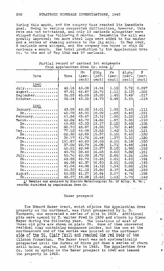
208 STRATEGIC MINERALS INVESTIGATIONS, 1943
during this month, and the company thus reached its immediate goal. Owing to various unexpected diff icxilties, however, this rate was not maintained, and only 19 carloads altogether were shipped during the following 8 months. Meanwhile the mill was greatly improved; two more steel logs were added to the washer and a series of shaking screens to the jig mill. In May 1942, 8 carloads were shipped, and the company now hopes to ship 20 carloads a month. The total production by the Appalachian Ores Co. to the end of May 1942 was 57 carloads.
Partial record of carload lot shipments from Appalachian Ores Co. mine I/
Date
1940 .July. ...............
September. ..........October. ............
1941January .............Do ................
Do ................Do ................
May. ................Do ................
Do ................DoDo ................Do ................
July. ...............Do ................Do ................Do ................Do ................
August. .............Do ................
Tons
40.1647.9135.834? Q4
43.3840.7841 ?442.2446.8386.7077 1 ?82.3836.17
1 Q1 R737.0945.514Q 7fi50.7442.3544.5641.0450.3050.8348.57
Mn (per cent)
45.0646.4745.8943.35
44.2843.3045.4743.7343.334^ Q744.0842.6941.7640.60Ap 7Q
40.96^Q 4Q40.084-9 7Q40.3744.0641.1941.2744.28
Si02 (per cent)
1 4 Q412.7913.0514.75
14.0116.0913.1214.8615.1714.5815.8315.3716.4816.0516.0615.2716.6516.7215.2516.6014 1 ?15.8016.6413.63
Fe (per cent)
' 1.101.111.45
' 2.48
1.951.651.561.87PIP1 7Q1.402.151 "^7P 1 fi
1.713.102.602.651.51? PI1.542.372.071.23
Al203 (per cent)
3.723.133.493.53
3.453.403.223.363.483.463.162.433 KCL
3.184.484 Qfl3.825.224.655.033.894.834.743.78
P(per cent)
0 097.105.017.118
.1111 PI.113.110.108.1461 PI.130i ^n.150.144.152.151.135124.145.134.150.156.142
I/ Sampled and analyzed by Electro Metallurgical Co. of Alloy, W. records furnished by Appalachian Ores Co.
Vs.;
Baker prospect
The Edward Baker tract, which adjoins the Appalachian Ores property on the northeast, was first prospected by L. D. Thompson, who excavated a series of pita in 1958. Additional pits were opened by T. Walter Fred in 1939 and others by Simon Meyer during the following year. The locations of most of these old pita are shown on plate 36. Some of them uncovered residual clay containing manganese oxides, but the one at the northeastern end of the series was located on the northwestside of the St, Glair fault ana readied tne red beds or tueClinton formation. The Baker tract was not systematically prospected until the Bureau of Mines put' down a series of churn drill holes, shafts, and drifts in 1942. The Appalachian Ores Co. took an option on the'Baker prospect'in 1940 and leased the property in 1942.

»-!>
en
4
W
p.
O
H-
CD
O£
P
J (it!
H3
0)
P
OP
L H
lj CO
-j
O
CD
CO
H-
H-
l-i)
»^
CD
ct
3
^
p.
CDct
.pl
ct p
'os
ct p
pr
CD
H- p
* ct
H-
P
^
CO
03 O
O
p.
ct
£
£
CDp'
co en
"o
O
p4
rt-
M O
O"
p1
CD
h-1
CD H
CO
. p
p
, K
^(-
» CO
U
\ O
4
M>
3
01
-t,
O
Ht,
H)
CD
tOCO
P
CD
CO
ct
£
ct
ct
H p
" P
O
ct
CD
O
3
H,
. H
*, pj
Oct
M O
U
1 P
4 «
H
-p-
O
CD
O
3
CDct
4
"-<>
p, f
i o
ct C
D4
3
t3
^<!
CD
H-
S
ct
M C
D 1-1
) O
M
P
O
M ^
ct
4
P
CDpr
pr
3 «<
j co
O
CD
P
>C!
M ^
ct
P
CD
CD
CD
H-
3
O
U
PJ
O
PI
ct
3
H'
M>
P,
ct
<
O
O
O
P1
CD
No.
3N
o. I
O
CO
ct
CD 3
O
CD
ct t)
03
3
CD ^
H)
CD
S
O
*i
H-
(B
4
CD
M
pco
ct S CD
p
* O
CO
CD
I-
" C
t CD
No.
2
Figure EO. Fence di
agra
m sh
owin
g axcavations
and
assu
med
dist
ribu
tion
of
main
ore
zones
on
Baker
tract, Cap Mo
unta
in.
Draw
n by F
. W.
Stead.
Drill
holes
made
by Bu
reau
of
Mines.
Cd p
" p.
P
p.
CD
O
CD H
CD
CD
M C
D CO
>Cf
S'
CD
>d
O
ct
3
co
CD
p" 1
-3p
co
ca
co p
1ct
p
CD
P O
0"
WP
ct
P
O p
CDP
W
p
. P
<
J ^
P"
P
H-
O C
DPJ
p o
q P
PO
1-1
) CD
ct
£
H ct
CD
O
O
CO
O
l CO
O
3
p-M
H)
H-
Cf
M)
P
ȣ
ct
CD
CD
H)
~J 3
CD
0<J
CD
ct
H-
. P
ct
CO
M,
P
P
<
CD
CD
pj
CD
CO
CO H
- CD
S
ct
^ ct
O
ct
ct
p-
CO
CD
CO
CDCD
S
CD
M
O
CD
CD
P
P.
OP
' *1
<
O
CD
^d
CD
CD
P
'
^
M
4
H-
p
Ct
rf
k p
P
P
^
OC
R
CD
PI
OJ
CD
CD
PI
CB
CDM
CD
M C
OO
H-
P-
CD
&
^
P
»d
H1
O CO
O
CD I-
1 H
> CD
P
P- P
Ct
P
> H
- p
'
HP
P
I
O
<
p.
I-1
d
caP S
OCD
>-*
>P ct
ct
P'
P"
CD
C6^ CD P
I
^
ct P
p*
P'O
T
«O O
CD
CD
OJ
M CD
^
CD
CD
H-^
d
CD
ct
ct
ctO
ct
Mp-
CD
210 STRATEGIC MINERALS INVESTIGATIONS, 1943
holes (Nos. 3 and 9) were checked by shafts on the same sites. In the shaft at drill hole 3 the samples from 53 ,to 64 feet contained 5.1 percent of manganese. Drifts from the shaft found lean pockets of nodular ore. The distribxition of the ore near the shaft at drill hole 9 was also checked by drifts, which found occasional lean pockets of nodular ore.
Faudree prospect
The Faudree property, comprising 102 acres, occupies a position topographically and geologically similar to that of the Appalachian Ores Co. half a mile to the northeast it lies in a saddle on the crest of Gap Mountain and includes a part of the southeast slope adjacent to the saddle. The area is under lain by Beekmantown dolomite near the St. Glair fault, which is close to the crest of the mountain.
Early excavations on the Faudree tract were not located close to' the fault but on the southeast slope of the mountain, 50 to 100 feet below the crest. G. A. Andrews did the first prospecting in 1939 but found little ore and soon stopped his operations. Messrs. Fred and York then took a 60-day option and put two men to work. They recovered some manganese and shipped one wagonload of ore, which included part of the'mate rial obtained by Andrews, and this is the only ore that has been shipped from the prospect. In 1941 L. D. Thompson of Beckley, W. Va., signed a lease on a 40-acre tract which included the area prospected by his predecessors and an exten sion to the crest in the saddle. During the spring of 1942 the Bureau of Mines found some ore on the property by systematic prospecting.
The location of the work done by Andrews, Fred, and York is shown on plate 36. The vertical shaft, now only 12 feet deep because of caving, is in residual clay and chert of the Beek mantown 'dolomite. 'The original bedding is but little dis turbed, the beds s^i-iking N. 65° E. and dipping 33° SE. The vertical shaft exposes pink and yellow sandy clays stained with manganese and some very tight red clay, along with variable quantities of hard chert. Small nodules of dense psilomelane are scattered throughout the clay, but they appear to be most abundant in a zone lying only a little below the overburden. Manganese oxides also' occur in fractures in the chert, forming a breccia. Small showings of manganese oxides were found in shallow surface excavations near the old shaft and in a 40-foot timbered adit at a lower level, which was begun in an unsuc cessful attempt to reach the bottom of the vertical shaft.
Using a churn drill, the Bureau of Mines put down 10 holes to depths of-38 to 151 feet, the average depth being 72 feet (pi. 36). All of these holes were drilled in the yellow, gray, and reddish cherty residual clays of the Beekmantown dolomite. Drill hole 10 reached unaltered dolomite at a depth of 75 feet. Traces of manganese were found in only 3 holes. In one of these, drill hole 14, manganese oxides occurred at depths of 25 to 55 feet, and samples from this zone contained 3.05 percent of manganese. A shaft with four short drifts was put down on the site of drill hole 14 to check the occurrence of the ore, and some analyses from the shaft samples showed as much as 10.2 percent of manganese. Most of the drill samples from the other holes contained less than 1 percent of manganese; samples from apparently barren clay contained 0.4 percent of manganese.
MANGANESE, SWEET SPRINGS DISTRICT, W. VA.-VA. 211
Potts Creek Valley properties
On the southeast side of Peters Mountain, the sandstones and cherty sandstones of the Helderberg group, dipping at low angles to the southeast, form a series of flatironlike spurs along the side of the mountain. In the vicinity of Laurel Branch, W. Va., the Helderberg outcrops lie well up on the side of the mountain at least 500 feet above Potts Creek. Traced northeastward the belt of outcrops gradxially descends the moun tain, until at Paint Bank, Va., the uppermost strata crop out in the bed of Potts Creek. (See pi. 35.) The flatironlike spurs of the Hslderberg group were examined at a number of points in the area covered by the map. The general pattern of outcrop is perhaps not quite as regular as that shown on the map, but the mapping is fairly representative; the flatironlike forms are not fully expressed, however, by the contours. Minor reversals caused by local folds were recognized in several placesj and, as outcrops are not numerous, similar features may occur in other places where they could not be seen. Whatever the conditions on these spurs are, they appear to have favored the deposition of small quantities of manganese in many places. Where the spurs were examined carefully some trace of manganese was almost invariably found, yet it is doubtful whether any very large deposit will be located on them. Known occurrences are briefly described below.
Traynham mine
The Traynham mine is in Monroe County, W. Va., on the southeast side of Peters Mountain, 1-g- miles northeast of Laurel Branch and 400 feet higher than Potts Creek.3/
The site was first prospected for iron many years ago, when deposits of iron ore were being actively worked in the valley of Potts Creek. In 1940 and 1941 a number of shallow pits and trenches were excavated by the owner, Dr. B. L. Traynhara, in a search for manganese. In the fall of 1941 Dr. Traynham gave an option to purchase to the Sweet Springs Manganese Co., and extensive prospecting under the direction of C. W. Massie was begun. In April 1942 Mr. 0. E. Thorne continued these opera tions. One carload of low-grade ore was shipped to the E. J. Lavin.o Co. in December 1941.. In the spring of 1942 a carload of the better-grade ore was shipped.
In order to develop the Traynham property it would be nec essary to improve the quarter mile of road which leads from the mine to Potts Creek, where water for a washing plant is avail able. Prom the creek a good graveled road has been built on the bed of the now abandoned Norfolk & Western branch line to Paint Bank, Va., and from there a paved road leads over Peters Mountain to Alleghany, Va., 11 miles from the mine.
The manganese of the Traynham property occurs in the upper cherty sandstones of the Helderberg group. The mine lies near the lower edge of one of the flatironlike spurs of the Helder berg group, where the rocks dip 20° SE., and the area being worked is on a dip slope. All the known manganese bodies lie within 20 feet of the surface. They are irregularly distrib uted in this interval, moat of them lying within 12 feet of the surface.
3/ This appears to be the Mary Crump prospect described by Reeves, op. cit., p. 18.

212 STRATEGIC MINERALS INVESTIGATIONS, 1943
The shallow pits and. trenches excavated by Dr. Traynham were examined during the summer of 1941. One of these was a T-shaped trench, the top of the "T" extending 35 feet from east to west, the stem leading southward for a distance of 20 feet. Much of the best material obtained by Dr. Traynham came from this trench. A pit excavated near the middle of the floor of the east-west trench extended the exposed section to 16 feet, as given below.
FeetSoil and sandstone talus........................ 1Sandstone, partly impregnated with manganese
oxides........................................ 4Chert and 'Sandstone............................. 7Reddish-brown quartzitic sandstone.............. 1Soft brown sandstone............................ 2Reddish-brown quartzitic sandstone.............. 1
16
The chert, which forms lenticular masses, makes up only a small part of the exposed section. At the east end of the trench the ..top of the chert, which is slightly glauconitic, is overlain directly by soil arid talus. The glauconitic chert appears to be the youngest bedrock exposed in the trench.
The manganese oxides are scattered, some occurring in the sandstones and some in the chert In an area 12 feet long and 4 feet high on the north wall of the trench the better grade of manganese-bearing material covered 25 percent of the surface.
Other shallow excavations nearby penetrated similar manga nese-bearing sandstones and cherts. At a point 120 feet east of the T-trench the following vertical section was uncovered:
Feet InchesSoil and talus.......................... 5 3Soft sandstones impregnated with manga nese oxides........................... 7 3
Fractured chert, cemented with manganeseoxides................................ 3 0
Sandstones of variable hardness, impreg nated with manganese oxides........... 2 6
18 0
In the more siliceous parts of the deposit the manganese oxides merely impregnate the sandstones, in other places they fill intervals between angular fragments of chert, forming a breccia. In the cherty material there are numerous small cavi ties lined with crystals of manganese oxides, which completely fill the smaller cracks and fissures. Impregnated sandstone grades into masses of manganese oxides containing few sand grains or none at all. This type of distribution suggests replacement rather than fracturing and cavity filling. In a few places the sandstone evidently was fissured before the arrival of the manganese-bearing waters, for some masses of pure oxide are sharply set off from masses of light-colored friable sand. In some places the manganese oxides accentuate the bedding black impregnated sandstone alternates with lighter sandstone stained red or brown with iron oxides.
The Sweet Springs Manganese Co. has excavated a number of additional pits and trenches. When examined in April 1942 the area covered by these excavations was about three-quarters of an acre. The materials encountered were similar to those found by Dr. Traynham in the pits already described.

MANGANESE, SWEET SPRINGS DISTRICT, W. VA.-VA. 213
The results of a number of analyses of the Traynham ore are given in the table below. It will be noted that the man ganese content varies inversely with the silica.
Analyses of ore from Traynham mineMn (per cent)
49.87 48.7744.1547.20 50.4750.1739.0724.57 29.97 45.90 44.8227.2818.87 36.70
Si0 2 (per cent)
5.12 8.26
16.647.48 7.829.38
24.1254.84 43.52 8.37 16.2541.0661.29 23.40
Pe (per cent )
1.12 1.123.141.72 1.602.204.801.30 1.00 1.62 1.902.12.45
2.70
A1203 (per cent)
....
....
....
. . . .
....
1.95 3.33 1.132.142.13 1.17
P (per cent)
0.35 .26.31.22 .259.274.300.115 .139 .285 .315.302.101
2.58
S (per cent)....
....0.02
....
....
....
....
Analyst
Marshall Haney Do.Do.
Pittsburg Testing Lab. E. J. Lavino Co.
Do.Do.Do. Do. I/
Electro Metallurgical Co. Do. Do.'
Do. I/, 2/2/ Contained 6.06 percent BaO.I/ Carload lot.
Paint Bank mine
The Paint Bank mine is near the foot of Peters Mountain, 0.6 mile northeast of the village of Paint Bank, Va. The main (lower) pit is about 150 feet above the level of Potts Creek but below the paved road (Virginia State Route 311). A smaller pit and a drift lie somewhat higher, immediately above the paved road. Manganese was known in this area at least as early as 1934.4/ The deposit below the road was discovered in 1939 by T. Walter Fred, who formed the Stanhope Wiedeman Co. and constructed a small washing.plant. Five hundred tons of con centrates of good grade was recovered and marketed in 1940. In March 1941 the property was leased by the Blue Ridge Manganese Co., which improved the mill and washed two carloads of concen trates from ore taken out of the main pit. Operations ceased in June because of the small amount of recoverable mineral in the deposit.
The manganese deposit occurs in sandstones and sandy clays of the Helderberg group, which form one of a series of small folds on the southeast side of Peters Mountain. The axis of the fold, trending roughly northeast, passes through the main pit.
The main pit is roughly circular in outline, about 100 feet in diameter, and 45 feet in maximum depth. On the southwest side a smaller pit and a trench were excavated between the main pit and the washer. The axis of the fold passes southeast of the smaller pit. Dips on the southeast side of the fold are 10° to 15°, those om the northwest side slightly steeper.
The sandstones and sandy clays are red and brown with a few greenish layers. Little manganese can be seen in the main pit at the present time, though slightly northeast of the center some manganese oxide occurs in reddish clay, which is interbed- ded with white sandstone enclosing irregularly distributed masses of white fossiliferous chert.
4/ Reeves, Frank, op. cit., p. 19, 1935.

214 STRATEGIC MINERALS INVESTIGATIONS, 1943
In some hand specimens of ore the manganese oxides impreg nate the sandstone irregularly, enclosing rounded areas of unstained sandstone. In other pieces sand grains are widely scattered through fairly pure manganese oxides, which appear to have replaced the rock almost completely. Hr. Fred states that some of the high-grade ore sold to the Tennessee Eastman Corpo ration contained as much as 55 percent of manganese. Analyses representing three carloads of ore are given below. The first carload was shipped by the Stanhope Wiedeman Co., the other two by the Blue Ridge Manganese Co.
Analyses of ore from the Paint Bank mine
Weight (Dry long
tons )
33.55 30.34
Mn (percent)
41.7840.85 42.47
Si02 (percent)
4.463.26 3.60
Fe (percent)
10.5912.90 12.20
Al2°3 (percent)
0.18 1.15
P (percent)
0.214 .224
On the highway above the main pit, sandstones of the Hel- derberg group impregnated with manganese oxides are exposed in the road gutter. A pit 25 feet in diameter, with its uphill face 12 feet high, was excavated above the road. A drift opened oh the north side of this pit leads to a large double chamber, from which ore yielding 70 tons of concentrates was removed- The timbered roof of the drift is 5 feet above the floor of the pit and is at the contact of the sandstone with a layer of talus, which contains large boulders of sandstone and quartzite derived from the older formations cropping out at higher levels on Peters Mountain. Ho manganese is found in the talus. The manganese-bearing bedrock is porous sandstone slightly stained with iron; it is cross-bedded and contains irregular .masses of weathered white chert.
Much of the manganese ore in the upper workings is hard .and blue, appearing to be of very good grade. It occurs in thin sheets and irregular masses, many of which tend to lie parallel either to the bedding or to the joint cracks of the sandstone. Small cavities occur along the bedding planes, many of them bordered by layers of nearly pure manganese oxide. Below the uppermost 5 f'eet of bedrock the sandstone becomes softer, lami nated, friable, and somewhat finer in grain.
The deposit in the upper pit appears to lie near the base of the Helderberg group. Ripple-marked sandstone layers in the Clinton formation, dipping 65° SE., are exposed along the paved road above the prospect. Between the Clinton and the Helder berg there is room for limestones of the Cayuga group, and, according, to Mr. Fred, limestone was encountered in churn-drill holes put down in this area-.-.
The prospect above the road was abandoned while still show ing some good ore. A continuation of either stripping or underground work would have been expensive.
Arras prospect
Before closing down the Paint Bank washer, in .June 1941, Mr. Ray Arms of the Blue Ridge Manganese Co. opened a new pros pect 0.6 mile west of Paint Bank, in a gully on the southeast side of Peters Mountain, at an altitude of 290 feet above Potts Creek (pi. 35). By means of a gas shovel, a pit 30 feet by 15 feet was excavated to a maximum depth of 10 feet in a talus
MANGANESE, SWEET SPRINGS DISTRICT, W. VA.-VA. 215
deposit consisting of soft, sandy, mottled clay with boulders of hard sandstone. Some of the sandstone boulders are impreg nated with manganese oxides, and some hard nodules of psilome- lane also were found. When broken the nodules exhibit a dull luster except for tiny shrinkage cracks filled with bright steel-blue manganese oxide. Thirty-seven truckloads of'mate rial from the prospect were hauled to the Paint Bank mill and over half of this amount was washed. The concentrate, though not jigged, looked fairly rich. A sample of the nodular ore was examined by the E. J. Lavino Co., and silica finer than 200 mesh was noted. Chemical analysis gave: Mn, 48.13; SiOg, 6.84; Pe, 3.10; P, 0.212.
Southwest of the pit a long trench was opened to an average depth of 3 feet. This trench revealed some manganese in the talus, and in a few spots it exposed sandstone bedrock of the Helderberg group, locally impregnated with manganese. Part if not all of the hard nodular psilomelane of the pit was probably derived from shaly beds older than the Helderberg, which are exposed higher up on Peters Mountain.
Bell prospect
The Bell prospect, owned by Ira and Corbett Bell, is located in a gully on the southeast side of Peters Mountain, nearly 500 feet higher than Potts Creek, and 1.2 miles west of Laurel Branch, W. Va. The property was visited by the writer in September 1941.
Cherty and somewhat brecciated sandstones of the Helderberg group, striking N. 70° E. and dipping 34° SE., are exposed in the bottom of the gully. These rocks are impregnated irregu larly with manganese oxides. Half a dozen pits which had been excavated on both sides of the creek near the sandstone out crop were slumped at the time of examination, but some good- grade material in sandy clay is said to have been obtained.
Late in 1941 the owners made arrangements with George L. Collord of Pittsburgh, Pa., to do additional prospecting, and several trenches 20 to 30 feet long and 5 to 10 feet deep were opened up.
Helderberg sandstones impregnated with manganese oxides were found in a gully lying 0.4 mile southwest of the Bell prospect and at a slightly lower altitude. Apparently no work has been done at this place. The same sandstones'are exposed at an altitude of 2,625 feet- along the road crossing Peters Mountain northwest of Laurel Branch, and there they are slightly impregnated with manganese and iron.5/
Thayer prospects
Mr. G. T. Thayer of Charleston, W. Va., who controls the mineral rights on large tracts of land in Potts Creek Valley, has opened shallow pits in search of manganese at several places in the area mapped. The more promising of these are briefly described on the following pages.
5/ This occurrence is noted by Reeves, op. cit., pp. 18-19, 1935.

216 STRATEGIC MINERALS INVESTIGATIONS, 1943
Upper Linton prospect.--Sandstones and cherty sandstones of the Helderberg group, impregnated with manganese oxides, are exposed in a cut on the State road 2 miles southwest of Paint Bank, Va. The emergence of these rocks on the floor of Potts Creek Valley appears to be due to a minor anticline in the larger syncline that forms the shale valley.6/ In the fall of 1941 Mr. Thayer gave an option to George L. Collord of Pitts burgh, Pa., and prospecting was begun almost immediately. Three pits were excavated along a line 60 feet in length, par allel to the road and 30 feet south of the cut in which the above-mentioned exposure is found. A pit at the western end of this line, excavated to a depth of 14 feet, passed through 6 feet of valley fill into cherty sandstones of the Helderberg group. On the northwest face of the pit and in the side walls, the bedrock for a vertical distance of 6 feet was impregnated with manganese oxides. These beds apparently represent the top of the Helderberg group, for soft Devonian shales are exposed in the southeast side of the pit. Sands above the shales on the southeast were also slightly impregnated with manganese.
A second pit, 24 feet east of the first, was put down to a depth of 16 feet, the lower 10 feet being in cherty sandstone, also slightly impregnated with manganese oxides. A small drift was extended 8 feet southeastward from the bottom of the pit, but it passed into barren shales".
A third pit, 12 feet deep, 36 feet farther east, exposed 7 feet of cherty sandstones impregnated with a small amount of manganese oxides. A fourth pit, 250 feet to the south of the second, apparently exposed only shales with no trace of manga nese.
The manganiferous material found in the pits is no better than that exposed in the road cut, all of it being highly sili ceous. An analysis of the road-cut material supplied by Mr. Thayer gave: Mn, 31.88; SiOg, 18.66; P, 0.31; S, 0.11. A better grade of material might be found by additional prospect ing, but there is little reason to believe that a sizeable deposit occurs in this area. Apparently the sandstones carry ing the manganese do not continue very far to the south, and they likewise appear to be limited by younger shales to the west; and exploration to the north would be handicapped by the presence of the road" and Potts Creek. Future prospecting might best be carried on to the east, where the impregnated sand stones might be traced into material of higher grade.
Perdue prospect. -A prospect on land owned by W. B. Perduelies on the southeast side of Peters Mountain 1.5 miles north east of Paint Bank, Va. In 1939 G. A. Paxton opened a number of small shallow trenches on the property. These excavations lie 265 to 310 feet above the road. They appear to be in a talus deposit that contains nodular masses of psilomelane and pieces of coarse, conglomeratic sandstone impregnated with man ganese oxides. All this material probably is derived from the Clinton formation. No high-grade ore was found. The following analysis of a sample from this locality was furnished by Tlr. Thayer: Mn, 40.21; Si02 , 16.00; Fe, 4.62; P, '0.13; S, 0.11.
Lower Linton prospect. In 1939 Mr. Thayer opened a pros pect on the southeast side of Peters Mountain about 2 miles
&/ Stose, G. W., and Miser, H. D., in Bull. 23, Virginia Ceol. Survey, p. 114, 1922, cited a report that 0. B. Adkins of Radford and Mr. Persinger of Salem mined some ore at a point 2 miles southwest of Paint Bank ajnd shipped a carload in the spring of 1918.
MANGANESE, SWEET SPRINGS DISTRICT, W. VA.-VA. 217
northeast of Paint Bank, in the left bank of Potts Creek at a point 280 feet higher than the valley road. The prospect is on a 248-acre tract of land owned by L. L. Linton.
Pits and a shallow trench 10 feet long were opened near the bottom of a small gully leading down the side of Peters Moun tain. The excavations were slumped when first examined in August 1941, but additional work was done several months later by 0. E. Thorne, who took a short-term option on the property. The manganese oxides occur in a series of well-bedded buff and pink clays, sands, and sandy clays. Some of the material is a medium-grained sandstone tightly cemented with manganese oxides, and some of it is heavy nodular psilomelane.
Immediately below the prospect, thick ledges of sandstone in the Clinton formation, 15 feet in total thickness, are exposed in the left side of the gully. They strike N. 60° E. and dip 30° NW. Other outcrops of Clinton sandstones were uncovered above-the prospect by Mr. Thorne. Apparently the beds form part of a small fold in the Clinton, probably one of the series of folds exposed in the cuts on the State road'that descends Peters Mountain immediately to the northwest (pi. 35). The manganese apparently lies in clays of the upper Clinton. As delimited by exposures of underlying sandstones, the clay deposit is probably small. An analysis furnished by Mr. Thayer is as follows: manganese oxide, 56.62; silica, 10.82; phos phorus, 0.09; sulphuric acid, 0.027.
Little Mountain prospect.--On the northwest side of Little Mountain, a mile southeast of Paint Bank, Va., the upper part of the sandstones of the Helderberg group close to its contact with the overlying Devonian shales is impregnated with manga nese. Beds of both formations are exposed in excavations opened many years ago in search for iron. These excavations lie southwest of the paved road (Virginia State Route 311) leading southeast from Paint Bank and 250 feet higher, their altitude being about 2,250 feet.
The Helderberg' at this place consists of soft, friable, porous, slightly ferruginous sandstone, irregularly impregnated with manganese oxides that render the material almost as hard as quartzite. Small masses of white chalklike silica may rep resent weathered chert. The shale beds in contact with the sandstone on the northwest are distinctly glauconitic. There is no good evidence that the fossiliferous cherty limestones exposed along the road between Little Mountain and Paint Bank are present at this place. At the pits the section appears to be overturned, for the beds near the contact, striking N. 40° E., dip so\itheast at an angle of 54°.
The two trenches examined are now slumped, but they still show some exposures of bedrock. Both trenches, which cross the strike for a distance of about 20 feet, were excavated to depths of 5 to 7 feet. They expose sandstones', some of which are sufficiently impregnated with manganese oxides to be fairly heavy, but no specimen-of nonsiliceous manganese material could be found in either trench or on the dumps. An analysis fur nished by Mr. Thayer is as follows: Mn, 38.78; SiOp, 11.62; Pe, 2.56; P, 0.17; S, 0.24.
O


![Sweet&Bittero Sweet & Bitter Sweet Bitter *Ota E') r ...yokohamashakyo.sakura.ne.jp/sblo_files/nagatsuta/... · Sweet&Bittero Sweet & Bitter Sweet Bitter *Ota E') r +ÃZSweet&Bitter]](https://img.pdfslide.us/doc/110x75/5fc88504d86f533ff96954fb/sweetbittero-sweet-bitter-sweet-bitter-ota-e-r-sweetbittero.jpg)