Embed Size (px)
Citation preview
F-26 Vol. 2
c.I~
~ 91100749
STATE OF WASHINGTON Daniel J, Evans, Governor
DEPARTMENT OF CONSERVATION H. Maurice Ahlq:.iist, Director
DIVISION OF WATER RESOURCES
Murray G. Walker, Supervisor
Water Supply Bulletin No.10
Geology and Ground-Water Resources of
Thur st on County, Wash in gt on
Volume 2
By
J:i.1r. B. Noble <:rttl Et::icne F. \Vailace
P1epared i~ cooptrJ.!ion wi!t:
UNITED STATES GEOLOGICAL SURVEY
\'VATER RESOURCES DIVISION
1966
F-26 Vo 1. 2 C.5
Noble, John B. Geology and ground-water resources of
91100749Thurston County, '------" ~--~
B ~
r ]
f I
. ·'--,
,'.;-o r~'
STATE OF WASHINGTON Daniel J. Evans, Governor
DEPARTMENT OF CONSERVATION H. Maurice Ahlquist, Director
DIVISION OF WATER RESOURCES Murray G. Walker 1 Supervisor
Water Supply Bulletin No. 10
GEOLOGY AND GROUND-WATER RESOURCES
OF
THURSTON COUNTY, WASHINGTON
·VOLUME 2
By
John B. Noble and Eugene F. Wallace
Prepared in cooperation With UNITED STATES GEOLOGICAL SURVEY
WATER RESOURCES DIVISION 1966.
111=7'17
Price $2.00, Division of Water Resources, Olympia, Wn.

•
•
•
•
FOREWORD
Publication of Volume 2 of Water Supply Bulletin No. 10 brings to a close the present geohydrologic mapping program for Thurston County. This work was done as a part of the Washington State Division of Water Resources-LI. S. Geological Survey cooperative program.
Volume 1, published in 1961, presented well logs, water level measurements, chemical analyses and other basic data obtained from well drillers' reports, field canvassing of wells and discussions with well owners and well drillers. Volume 2 contains a description of the geologic formations found in the area and their water-bearing characteristics, a geologic map and cross sections, a ground water availability map,· water level contours on the regional ground-water surface and hydrographs which reflect water level changes that have occurred during the period of observation. The two volumes combined compose a comprehensive report of the Pleistocene geology and ground water resources of Thurston County, Washington.
In this work the authors have made two significant contributions to a better understanding of the Pleistocene geology of the Puget Sound area: they. have defined the southern terminus of the Vashon glacier in Thurston County and collaborated in identifying, describing and naming the 11 Kitsap Formation". Their recognizing this formation as a separate interglacial unit, together with similar work being done by other geologists on formations equivalent to the Kitsap in other parts of Puget Sound and southwestern British Columbia, have brought some semblance of order to the chaos that has persisted in Pleistocene nomenclature in the Puget Sound area for many years.
-Robert H. Russell Assistant Supervisor Division of Water Resources

•
\
l \
•
-.
•
•
CONTENTS
Abstract---------------------------------------------------------lntroduction-------------------------------------------------------
Purpose and scope of the investigation ---------------------------Location and extent of the area ----------------------------------Numbering system of wells and locations--------------------------Prev i au s i nvestig ati ans -- --- ---- - -- -- -- --- - - --- - - -- ---- ---- --- - --Acknow I edgm en ts --- --- ---- ------- -- ---- -- -- ---- --- - - -- ---- - --- -
Geography ------------------------------------------------------~Gen era I features - --- --- - --- ---- ---- - --- - ---- ------ -- -- -- --- ---- -G ea hydro I og i c areas -- -- -- --- - --- --- --- -- --- --- ---- - -- -- -- ---- -- -Orainage------------------------------------------------------C I im ate - --- --- - - -- --- - - - - --- -- -- --- ----- --- - -- -- - - - ---- -- -- ----Native veg eta ti on - - - - - -- - -- ---- ---- - --- __ ,:_ ---- ---- ---- -- -- -- -- -Agriculture and industry-- - --------------------------------------
Geology ----------------------------------------------------------Geo I og ic setting --- ---- --- -- - - ---- ---- - --- ---- -- -- --- - - - -- --- --Geo 1 og y of stratigraphic units --- - --------------------------------
Tertiary System--------------------- - -----------------------Eocene Series --- -- -- -- - - - -- -- -- -- -- -- ___________________ _
Mcintosh Formation (Eocenel----------------------------Northcraft Formation (late Eocene) -----------------------Skookumchuck Formation (late Eocene)--------------------
01 igocene Series --------------------------------- --------Lincoln Formation of Weaver (1912) (Oligocene)-----------
Miocene Series -------------------------------------------Astoria(?) Formation (middle Miocene) -------------------Columbia River<?) Group (Miocene) ----------------------Mashel Formation (middle and late Miocene) ---------------
Intrusive rocks of Tertiary age -----------------------------
Quaternary System -------------------------------------------Pleistocene Seri es ---------------------------------------
Mineralogy and petrology of deposits of the Pleistocene Series Weathering of deposits of the Pleistocene Series ----------Logan Hill Formation (early Pleistocene)-----------------Pre-Salmon Springs(?) deposits, undifferentiated
(Pleistocene, pre-Wisconsin) ------.:.-----------------Salmon Springs(?) Drift (early Wisconsin) -----------------Kitsap Formation NYisconsin) _: __________________________ _
Vashon Drift (late Wisconsin) ----------------------------Colvos Sand and Vashon advance outwash ------------~--Vashon till------------------------------------------
iii
Page 1 3 3 4 4 6 6 6 6 7 7 8
10 10 12 12 12 12 12 12 13 14 15 15 16 16 16 16 17 18 18 19 20 21
23 27 32 40 40 41
CONTENTS
Geology-~Continued Geology of stratigraphic units (continued)
Quaternary System (continued) Pleistocene Series (continued)
Vashon Drift (continued) Vashon end moraine --------------------------------Vashon recessional gravel --------------------------Vashon recessional sand----------------------------Deposits of glacial Lake Russell ---------------------
Recent alluvium-----------------------------------------Geologic hi story -- -- -- -- --- ----- --- -- -- ---- ---- - --- -------- ---
Tertiary Period --- ---- ---- -------- ---- -- - ----- ---- - -- ------Quaternary Period --- - - - -- -- ---- - ---------- -- -- - ---- --- -----
Pleistocene Epoch until Wisconsin age --------------------Pleistocene Epoch, Wisconsin age-------------------------
Economic geology --------------------------------------------Sand and gravel --------------------------------------------Peat------------- - ---------------------------------------Coal ------------------------------------------------------Riprap and crushed stone ------------------------------------0 imens ion stone --- --- ----- --- ---- ---- -- -- ---- ---- ---- -----Hydrous iron oxides ----------------------------------------Ornamental and semiprecious stones---------------------------Oil and gas ------------------------------------------------Clays, bauxites, laterites -----------------------------------
Geology of individual geohydrologic areas ------------------------Bald Hi /Is ------------------------------------------------Black Hills ------------------------------------------------Michigan Hill ---------------------------------------------Maytown Upland --------------------------------------------Kame-Kettle Area ----- -- ---- ----- ------------ ---- --- - --- ----
Northern sub area --- ---- ---- ----- --- ---- - -------- --- -----Centra I sub area -- - - -- ---- - --- ---- ---- ------------- ------Southern subarea-----------------------------------------
Peninsular Area --------------------------------------------Prairie Area ---- --- ----- ------ ------ --- ---- --- ----- ---- ---- -
Groundwater----------------------------------------------------Hydro logic setting ---- -------- -- -- ---- ---- -- -- - --- -- -- - - -- ----The ground-water regimen --------------------------------------
Recharge -------------------------------------------------Discharge--------------------------------------------------Storage----------------------------------------------------
Ground-water occurrence in the stratigraphic units ----------------McIntosh Formation ----------------- ---- --- -- --- ------------
iv
• Page
44 45 50 51 52 53 53 54 54 56 61 61 61 62 ' 62 62 62 • 63 63 63 63 63 64 65 66 66 66 67 67 67 67 72 72 73 73 75 76 83 83
•
•
• CONTENTS ..
Page Ground water--Continued
Ground-water occurrence in the stratigraphic units (continued) Northcraft Formation ----------------------------------------- 83 Skookumchuck Formation -----------------------------"------- 83 Lincoln Formation of Weaver Cl 912) -------------------------- 84 Astoria(?) Formation----------------------------------------- 84 Columbia River(?) Group ------------------------------------- 84 Mashel Formation ------------------------------------------- 84 Logan Hill Formation ---------------------------------------- 85 Pre-Salmon Springs{?) deposits, undifferentiated --------------- 85 Salmon Springs(?) Drift-------------------------------------- 85 Kitsap Formation-------------------------------------------- 86 Vashon Drift-------------------"---------------------------- 87
Colvos Sand and Vashon advance outwash ------------------- 87 Vashon till----------------------------------------------- 87 Vashon end moraine --------------------------------------- 88 Vashon recessional gravel --------------------------------- 88
• Vashon recessional sand----------------------------------- 88 Recent alluvium --------------------------------------------- 89
Areal occurrence of ground water --------------------------------- 89
• Bald Hills-------------------------------------------------- 89 Black Hills ------------------------------------------------- 90 Michigan Hi! I ------------------·----------------------------- 91 Maytown Upland--------------------------------------------- 91 Kame-Kettle Area ------------------------------------------- 92
Northern subarea ------------------------------------------ 92 Central subarea ------------------------------------------- 93 Southern subarea ----------------------------------------- 93
Peninsular Area --------------------------------------------- 93 Prairie Area ------------------------------------------------ 95
Southern prairie subarea ----------------------------------- 95 Southwestern prairie subarea ------------------------------- 96 Western prairie subarea ------------------------------------ 97 North-central prairie subarea ------------------------------- 97 Northeastern prairie subarea -------------------------------- 98
East Olympia-Chambers Prairie unit ---------------------- 98 Lakes unit -------------------------------------------- 99 Hawks Prairie ----------------------------------------- 99 Ni squally River flood plain ------------------------------ 100
Southeastern prairie subarea ------------------------------- 100 Central prairie sub area ------------------------------------ 101
Chemical character of ground water------------------------------- 101 Specific determinations -------------------------------------- 102
Hardness------------------------------------------------- 102
• v
CONTENTS
Ground water--Conlinued Chemical character of ground water (continued)
Specific determinations (continued) Chloride -----------------------------------------------Iron ----------------------------------------------------Electrical conductivity --- ---- ---- ---- ---- ---- - --- ---- ---- -
Quality comparison with other western Washington water--------Water of unsuitable quality----------------------------------
lron-beari ng water --- ---- ---- ---- ---- -- -- ---- ---- -- -- --- - -Sea-water contamination --- - --- - --- -- -- -- -- ---- - - - - -- -- ---
Use of ground water-------------------------------------------Domestic supplies -----------------------------------------Irrigation supplies -----------------------------------------Pub I ic supplies --------------------------------------------lndustri a I supp Ii es - -- -- -- -- -- ---- -- - ----- ------ -- - - ---- -- - --
Future development - - - - - -- -- --- - --- - --- - --- - --- ----- --- - --- - --We 11 construction - ---- --- - ---- ---- -- -- ---- --- - -- - - -- - - --- - --- - -Need for future studies -----------------------------------------
Water quantity studies--------------------------------------Water quality studies----------------------------------------
Conclusions -------------------------------------------------References cited -- ---- -- -- ---- ---- -- - ---- ----- --- - --- - --- ---- -- - -Appendix--------------------------"-----------------------------G lossary of hydro logic terms---------------------------------------Index -- ---- -- - - - -- -- --- ---- -- -- -- -- - - --- -- -- - ---- --- -- --- - --- - --
Plate 'l. 2.' 3. 4.
5.
ILLUSTRATIONS
~lates 1-5 in accompanying packet]
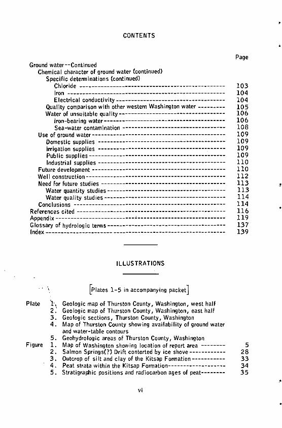
Geologic map of Thurston County, Washington, west half Geologic map of Thurston County, Washington, east half Geologic sections, Thurston County, Washington Map of Thurston County showing availability of ground water and water-table contours Geohydrologic areas of Thurston County, Washington
Page
103 104 104 105 106 106 108 109 109 109 109 110 110 112 113 113 114 114 116 119 137 139
Figure 1. Map of Washington showing location of report area -------- 5 2. Salmon Springs(?) Drift contorted by ice shove------------ 28 3. Outcrop of silt and clay of the Kitsap Formation----------- 33 4. Peat strata within the Kitsap Formation------------------- 34 5. Stratigraphic positions and radiocarbon ages of peat-------- 35
vi
'
,•
•
•
Figure
•
•
Table
.
CONTENTS
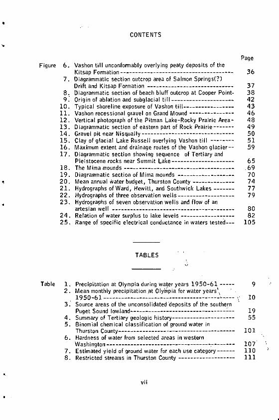
6. Vashon till unconformably overlying peaty deposits of the Kitsap Formation--------------------------------------
7. Diagrammatic section outcrop area of Salmon Springs(?) Drift and Kitsap Formation -----------------------------
8. Diagrammatic section of beach bluff outcrop at Cooper Point-9: Origin of ablation and subglacial till---------------------
10. Typical shoreline exposure of Vashon till-----------------11. Vashon recessional gravel on Grand Mound ---------------12. Vertical photograph of the Pitman Lake-Rocky Prairie Area-13. 0 iagrammatic section of eastern part of Rock Prairie-------14. Gravel pit near Nisqually-------------------------------15. Clay of glacial Lake Russell overlying Vashon till --------16. Maximum extent and drainage routes of the Vashon glacier--17. Diagrammatic section showing sequence of Tertiary and
Pleistocene rocks near Summit Lake---------------------18. The M ima mounds ----- --------------------------------19. Diagrammatic section of Mirna mounds -------------------20 . Mean annual Water budget, Thurston County --------------21. Hydrographs of Ward, Hewitt, and Southwick Lakes-------22. Hydrographs of three observation wells-------------------23 . Hydrographs of seven observation wel Is and flow of an
artesian wel I -----------------------------------------24. Relation of water surplus to lake levels --------------c---25. Range of specific electrical conductance in waters tested---
TABLES
1. Precipitation at Olympia during water years 1950-61-----2. Mean monthly precipitation at Ol"yhipia for water years\
19 50-61 ---------------------------------------"---- ,. 3: Source areas of the unconsolidated ·deposits of the southe~n
Puget Sound low land---- --- - --- - --- - -- - - ---- --- - --- ----4. Summary of Tertiary geologic history---------------------5. Binomial chemical classification of ground water in
Thurs ton County-- --- - -- --- - - -- - - --- - ----- -- -- -- - --- -- -6. Hardness of water from selected areas in western
Washington -- --- ---- ---- --- ---- ----- - -- ---- -- -.- -- -- ---7. Estimated yield of ground water for each use category------8. Restricted streams in Thurston County -------------------
vii
Page
36
37 38 42 43 46 48 49 so 51 59
65 69 70 74 77 79
80 82
105
9
10
19 55
101
107 110 111

'
•
•
•
•
•
•
•
GEOLOGY AND GROUND-WATER RESOURCES OF
THURSTON COUNTY, WASHINGTON, VOLUME 2
By
John B. Noble and Eugene F. Wallace
ABSTRACT
Thurston County, containing a land area of approximately 736 square miles, Iles at the southern end of Puget Sound. Most of the county Is within the Puget Trough section of the Pacific Border Province. Its principal city Is Olympia which is the county seat and the State capital.
The climate is characterized by wet winters and dry summers. Of the average--53.51 inches at the Olympia airport and 38.66 Inches at Yelm--more than 80 percent of the precipitation occurs In the period from October to April. Consequently, Irrigation of many crops Is a necessity Jn summer. Ground water is used to an increasing degree for Irrigation as the demand grows and surface-water supplies become fully appropriated.
Most of the land surface of the county consists largely of lowland prairies; loath i 11 s of the Cascade and Coast Range occupy the southern and western parts of the county, respectively. The area Is drained by three major river systems, the Skookumchuck-Black-Chehalis, the Deschutes, and the Nlsqually.
The oldest rocks In the county are of the Tertiary System and range Jn age from Eocene through Miocene. The Tertiary rocks are represented by the Eocene Mcintosh, Northcraft, and Skookumchuck Fonnatlons; the Oligocene Lincoln Formation of Weaver (1912); and the Miocene Astoria(?) Formation, Columbia River(?) Group, and Mashel Formation. Most of these rock units are unimportant as aquifers because of their low permeability, the poor quality of water Jn them, and their remoteness from areas of major use. Only the Mashel Formation, consisting of semiconsolldated and unconsolidated terrestrial deposits, is capable of yielding small to moderate amounts of ground water. This unit is limited to a small area along the NI squally River.
Unconsolidated deposits of the Quaternary System yield most of the ground water In Thurston County. These deposits cover about two-thirds of the county, mostly within the lowland areas. This system Is divided into pre-Wisconsin deposits which generally are poor aquifers and Wisconsin deposits which are the best aquifers.
The Logan Hill Formation, a deeply weathered fluvlatile sand and gravel deposit of local origin, is the oldest unit and is of early Pleistocene age. Although an important aquifer in Lewis County to the south, it is relatively unimportant in Thurston County •
2 GEOLOGY AND GROUND-WATER RESOURCES, THURSTON CO., WASH.
The designation of pre-Salmon Springs(?) deposits, undifferentiated, is applied to a thick sequence of pre-Wisconsin glacial and nonglacial deposits underlying the northern parts of the county. They lie unconformably below deposits of Wisconsin age. At most places they are fine grained (often referred to as "blue clay") and are of low permeability. Many successful wells have been developed within coarse-grained facies of these deposits, but their yields are highly variable from place to place. Most of the water is under artesian pressure.
The oldest Wisconsin unit is the Salmon Springs(?) Drift which generally underlies younger deposits but occurs at the surface at the south end of the Puget Sound lowland. In northern areas it serves as an important aquifer. Low to moderate yields are obtained from partially cemented gravels that occur near sea level and that are generally less than 30 feet thick. Deposits tentatively considered to be Salmon Springs(?) outwash lie below Vashon outwash in valleys near Tenino, Grand Mound, and Rochester; they form important aquifers of high yield. Salmon Springs(?) Drift mantling upland areas is generally unimportant as an aquifer.
The Kitsap Fonnation overlies the Salmon Springs(?) Drift, in places comformably, and generally serves as an aquiclude due to its fine-grained materials. A nonglacial deposit containing numerous peat strata, the Kitsap Formation has been given an age range from more than 34, 700 to at least 2 7, 900 radiocarbon years.
Glacial outwash, usually sandy and of highly variable thickness, conformably overlies the Kitsap Formation, and is an important aquifer for domestic use in the northern part of the county. Two names, Colvos Sand and Vashon advance outwash, are assigned to these sandy outwash deposits which are overlain by ti 11 of the Vashon Stade.
The Vashon (latest> glacier was responsible for sculpturing the topography of the lowlands and as it receded it deposited great amounts of fluvial outwash across extensive drainage routes leading to the Chehalis River. Sand and gravel of this outwash provide important aquifers, where beneath the water table, and allow rapid percolation downward to older (lower) units, where above the water table. The Vashon ti 11 is generally thinner in Thurston County than in northern parts of the Puget Sound lowland but serves as an effective aquiclude in numerous local areas.
Thurston County has an abundance of ground water except in the uplands which are predominatly underlain by Tertiary rocks. More than 90 percent of the wells are less than 150 feet deep and more than 80 percent of the water levels in the wells are within 50 feet of land surface. The ground-water reservoir in the county is recharged almost entirely by precipitation on the immediate area. Water levels in the shallow aquifers show almost immediate response to precipitation whereas those of deeper aquifers overlain by impermeable strata exhibit definite lag features.
Yield characteristics of aquifers vary markedly throughout the county; yields of wells range from 1 to more than 1,000 gpm (gallons per minute). To adequately develop many of the fine-grained aquifers, proper well construction is essential.
Chemical analyses indicate that almost all wells yield water of good quality suitable for all common uses. At a few places, wells yield water that contains objectionable amounts of iron compounds or is saline.
!
•
.
..
•
•
•
INTRODUCTION 3
0 INTRODUCTION
This report is the second of two volumes composing Water Supply Bulletin 10. Volume 1 (Wallace and Molenaar, 1961> presents the basic data collected during the investigation and contains specific information for 2,156 wells. These basic data were compiled and published immediately after the well-canvassing was completed so the infonnation would be readily available to those individuals and organizations interested in ground-water development.
The authors have attempted to avoid duplication of material presented in Volume 1 except where 'an omission of previously presented information would materially lessen the effectiveness of this volume as a separate reference. However, interpretations and evaluations of ground-water avai labi I ity on a local scale will demand the use of both volumes, conjunctively.
PURPOSE AND SCOPE OF THE INVESTIGATION
The investigation was undertaken by the Division of Water Resources of the Washington State Department of Conservation in cooperation with the Water Resources Division of the U.S. Geological Survey. This study is a part of a continuing program to inventory and evaluate both the surface- and ground-water resources of the State of Washington.
The primary purpose of the report is to describe the occurrence, availability, and quality of ground water in Thurston County (fig. 1). Areas of poor ground-water potential as well as areas of abundant potential are discussed. This information will be of use to municipalities, communities, industries, farmers, realtors, land developers, and individual homeowners interested in obtaining water supplies. Well drillers and water-supply consultants will find this report a usefu 1 refererrce.
To accomplish the purpose of the report it was necessary to map and describe the geology of Thurston County. The resultant geologic map and text compose an important source of material useful in fields other than an evaluation of water supplies. The geologic map depicts the surficial rock materials of the county. It shows the parent materials from which the soils were derived and, hence, provides a basis for the study of all mineral resources in the county. It also provides basic data for engineering works such as highway and foundation construction, landslide problems, and drainage works.
The geologic mapping consisted of a thorough study of the areas underlain by rocks of Pleistocene age which are the most important water-bearing materials in Thurston County and a brief reconnaissance of the areas underlain by rocks of Tertiary age, most of which had been mapped previously. This information was used in conjunction with the basic data included in Volume 1 to describe the ground-water hydrology of the study area.
Although the report is intended as a technical geologic publication, parts of it should be helpful also to the layman with a minimum knowledge of geology in interpreting potential ground-water conditions in any specific area.
The fieldwork and mapping was done by the senior author during parts of 1960, 1961, and 1962, with frequent assistance from and consultation with the junior author. Most of the fieldwork was done in the lowland parts of the county because the upland areas are largely.undeveloped and very little data are
4 GEOLOGY AND GROUND-WATER RESOURCES, THURSTON CO., WASH.
" available for them. The junior author interpreted and described the hydrologic features. S. E. Shumway, meteorologist, compiled and prepared the climatological data, and Dee Molenaar, geologist, assisted in fieldwork and preparation of illustrations.
The investigation was made under the general direction of M. G. Walker, Supervisor, Division of Water Resources and 0. M. Hackett, Chief, Ground Water Branch, U.S. Geological Survey and under the direct supervision of R.H. Russell, Assistant Supervisor, Division of Water Resources and A. A. Garrett, District Engineer of the Ground Water Branch in the State of Washington, U.S. Geological Survey.
LOCATION AND EXTENT OF THE AREA
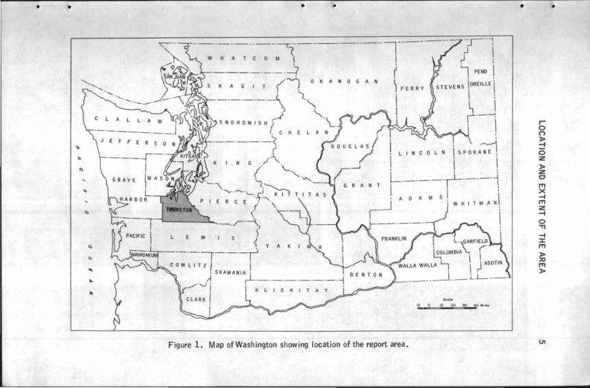
Thurston County is in western Washington at the southern end of Puget Sound (see fig. ll. The total land area of the county is approximately 736 square miles.
The county is separated from Pierce County by the Ni squally River. Many narrow inlets of Puget Sound form most of the northern boundary. The county is adjoined on the northwest by Mason County, on the west by Grays Harbor County, and on the south by Lewis County.
Olympia, the county seat and State capital, is in the north-central part of Thurston County. It is the largest city in the county; in 1960 it had a population of 18,057. Olympia is 30 miles southwest of Tacoma, 60 miles southwest of Seattle, and 120 miles north of Portland, Oregon.
NUMBERING SYSTEM OF WELLS AND LOCATIONS
In Volume 1 of this report (Wallace and Molenaar, 1961), as well as in many reports of similar nature, a numbering system for wells was used that indicates their location according to the official rectangular Public-Land ·survey. In this report that numbering system is extended to includP. area locations. By using · this system, the reader can quickly locate any area of 40 acres or more in size. For example, in the area designated by l 7/2W-20B, the part of the designation preceding the hyphen indicates successively the township and range CT. 17 N., R. 2 W.) north and west of the Willamette base line and meridian. Those areas lying east of the Willamette meridian are designated by an 11 E" following the range number. The number following the hyphen indicates the section (sec. 201, alld the letter (B) indicates the 40-acre subdivision of the section as shown in the accompanying diagram.
Thus, the 40-acre area described as 17/2W-20B is the NW!NE!, sec. 20, T. 17 N., R. 2 W. A wel I in that tract has the same description plus an additional number representing the serial number of the well in that particular tract. For example, well l 7/2W-20B2 is the second well in that tract to be listed.
D c E F
M L
N p
B A
G H
K J
Q R
•
•
•
• • • •
0 K A N 0 C A N
LINCOLN
Figure 1. Map of Washington showing location of the report area .
•
I 0 n )> -f 0 z )> z 0 l'T'I >< -f l'T'I z -f 0 .,, -f :c l'T'I )> A:! l'T'I )>
\J1
•
6 GEOLOGY AND GROUND-WATER RESOURCES, THURSTON CO., WASH.
PREVIOUS INVESTIGATIONS
Ground-water investigations have been made by the U. S. Geological Survey in two smal I local areas that extend into Thurston County. An area including part of southwestern Thurston County was studied by Sch lax Cl 94 7); no geologic mapping was done for that report but basic data from it are included in Volume 1 of this report (Wallace and Molenaar, 1961). Mundorf! and others (1955) described conditions in the Yelm area and mapped it geologically; basic data are included in Volume 1 and many features of the geologic map by Mundorf! were incorporated in the geologic map that accompanies this report (pis, 1, 2).
The geology of most of the southern part of the county--with emphasis on the coal resources--was studied and mapped in detai I by Snavely and others (1958). Virtually all their material dealing with Tertiary geology was used in the preparation of the present report.
A soil survey by the U. S. Soil Conservation Service (Ness and others, 1958) contains maps of the county's soils and gives a good description of land use.
During the course of this investigation, two studies were being made in adjacent areas. Dee Molenaar (1965) of the State Division of Water Resources, mapped the Kitsap Peninsula to the north and Kenneth L. Walters and Grant E. Kimmel (in preparation) of the U. S. Geological Survey mapped part of Pierce County to the northeast. All five authors exchanged ideas and information.
ACKNOWLEDGMENTS
This investigation was facilitated by the cooperation of many individuals. The Thurston County residents and property owners, without exception, freely allowed access to their properties in order that the rocks could be studied and mapped. The Weyerhaeuser Company',and the State Department of Natural \ Resources offered access to their respective forest areas. The State Division of Mines and Geology gave the authors permission to use their laboratory equip-ment for mineral analyses. Charles Wagner of the Agricultural Stabilization and Conservation Service made available aeri;3.I photographs which aided materially in geologic mapping. The assistance and cooperation of all is gratefully acknow-ledged. ·
The authors owe special than~s to Dr. J. Hoover Mackin, previously of the University of Washington, for his guidar1ce in both field and office on complex stratigraphic problems and also:for review of parts of the manuscript.
GEOGRAPHY
GENER.AL FEATURES
Thurston County lies almost.entirely within a topographic and structural basin called the Puget Sound lowland, which in the north is partly occupied by
•
•
•
!
•
•
..
GEOGRAPHY 7
Puget Sound. The lowland is underlain by unconsolidated deposits of the Pleistocene Epoch. Its southern boundary is at the north edge of a dissected upland of Tertiary rocks that proje.cts westward from the Cascade Range into Thurston County and the adjacent part of Lewis County. South of the spur, in Lewis County, the basin reopens and is no longer considered part of the Puget Sound lowland but is a continuation of the Puget Trough as defined by Fenneman (1931, p. 443). The western boundary of the lowland is fonned by the Black Hills and Michigan Hill. These uplands are extensions of the Olympic Mountains and the Oregon Coast Range, respectively.
GEOHYDROLOGIC AREAS
As a basis for reporting on the ground-water resources in Thurston County, seven areas, each with somewhat distinct geologic and hydrologic characteristics (see pl. 5) have been designated. The areas do not everywhere form contiguous units nor can they be considered discrete physiographic provinces. The geology and ground-water features of them are discussed on pages 63-101. These geohydrologic areas are:
Bald Hills Black Hills Michigan Hill Maytown Upland
Kame-Kettle Area Peninsular Area Prairie Area
The first four areas are uplands that are underlain, for the most part, by consolidated rocks. The Bald and Black Hills are mostly utilized for timber production; ground-water use is now and will probably continue to be very minor inasmuch as supplies are meager. The Michigan Hill and Maytown Upland areas sustain both timber production and conventional agriculture; ground-water production is minor but there is an increasing need for more water in parts of these two areas.
The Kame-Kettle, Peninsular, and Prairie Areas are lowlands underlain by unconsolidated rocks capable of producing large supplies of ground water. These areas support almost all the population and most of the agriculture. Consequently, the use of ground water here is large and is increasing steadily.
DRAINAGE
Three major river systems, the Skookumchuck-Black-Chehalis, Ni squally, and Deschutes, drain most of the county. None of them is completely enclosed within the county. The Chehalis River is fed in part by Skookumchuck River, Black River, and Scatter Creek--its major Thurston County tributaries. It flows in a general westward direction to the Pacific Ocean at Grays Harbor. The Nisqually and Deschutes Rivers flow northward to Puget Sound .
8 GEOLOGY AND GROUND-WATER RESOURCES, THURSTON CO., WASH.
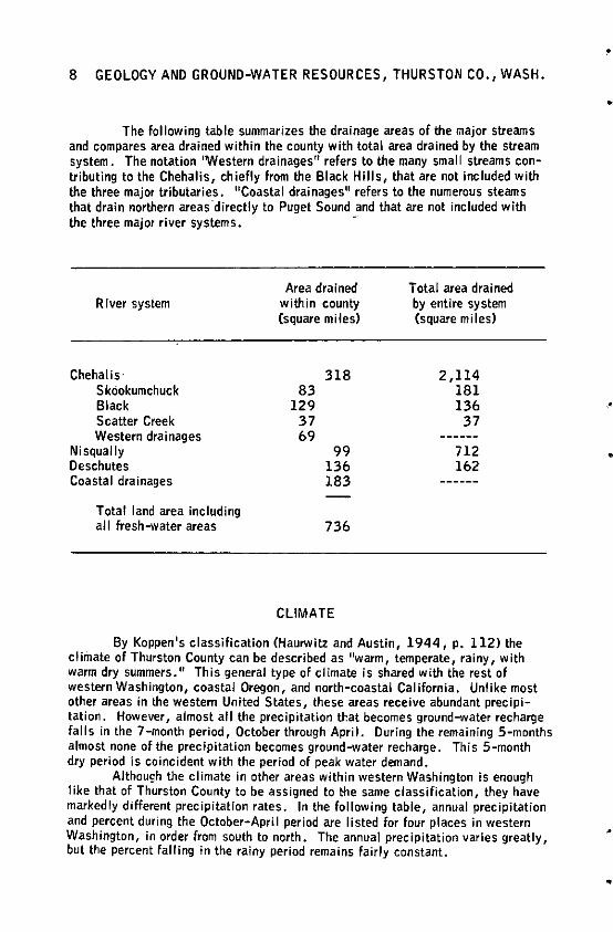
The following table summarizes the drainage areas of the major streams and compares area drained within the county with total area drained by the stream system. The notation 1Western drainages 11 refers to the many small streams contributing to the Chehalis, chiefly from the Black Hills, that are not included with the three major tributaries. 11 Coastal drainages" refers to the numerous steams that drain northern areas ·directly to Puget Sound and that are not included with the three major river systems. -
Area drained Total area drained River system within county by entire system
(square miles) (square miles)
Chehalis· 318 2,114 Skookumchuck 83 181 Black 129 136 Scatter Creek 37 37 Western drainages 69
Ni squally 99 712 Deschutes 136 162 Coastal drainages 183
Total land area including all fresh-water areas 736
CLIMATE
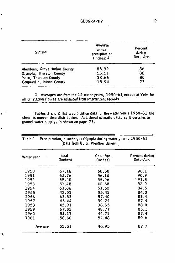
By Koppen's classification (Haurwitz and Austin, 1944, p. 112) the clirriate of Thurston County can be described as 11warm, temperate, rainy, with warm dry summers." This general type of climate is shared with the rest of western Washington, coastal Oregon, and north-coastal California. Unlike most other areas in the western United States, these areas receive abundant precipitation. However, almost all the precipitation that becomes ground-water recharge falls in the 7-month period, October through April. During the remaining 5-months almost none of the precipitation becomes ground-water recharge. This 5-month dry period is coincident with the period of peak water demand.
Although the climate in other areas within western Washington is enough like that of Thurston County to be assigned to t:he same classification, they have markedly different precipitation rates. In the following table, annual precipitation and percent during the October-April period are listed for four places in western Washington, in order from south to north. The annual precipitation varies greatly, but the percent falling in the rainy period remains fairly constant.
•
•
•
•
•
"
Station
Aberdeen, Grays Harbor County Olympia, Thurston County Yelm, Thurston County Coupeville, Island County
GEOGRAPHY
Average annual
precipitation (Inches) l
85.92 53.51 38.66 18.94
Percent during
Oct. -Apr.
86 88 80 73
l Averages are from the 12 water years, 1950-61,except at Yelm for which station figures are adjusted from Intermittent records.
Tables land 2 list precipitation data for the water years 1950-61 and show Its uneven time distribution. Additional climatic data, as it pertains to ground-water supply, is shown on page 73 .
Table l - Preclpltatlon,in inches, at Olympia during water years, 1950-61 [Data from U. S. Weather Bureau ]
Water year total Oct.-Apr. Percent durinq (inches) (inches) Oct.-Apr.
1950 67.16 60.50 90.l 1951 61.76 56.15 90.9 1952 38.40 35.06 . 91.3 1953 51.48 42.68 82.9 1954 61.06 51.62 84.5 1955 42.03 35.43 84.3 1956 63.83 57.40 83.4 1957 45.44 39.74 87 .4 1958 43.91 38.65 88.0 1959 57.33 48. 77 85.1 1960 51.17 44.71 87.4 1961 58.60 52.48 89.6
Average 53.51 46.93 87.7
9
10 GEOLOGY AND GROUND-WATER RESOURCES, THURSTON CO., WASH.
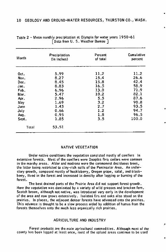
Table 2 - Mean monthly precipitation at Olympia for water years 1950-61 [Data from U. S. Weather Bureau ]
Month
Oct. Nov. Dec. Jan. Feb. Mar. Apr. May June July Aug. Sept.
Total
Precipitation Percent (in Inches) of total
5.99 11.2 8.27 15.4 8.45 15.8 8.83 16.5 6.96 13.0 5.47 10.2 2.96 5.5 1.69 3.2 1.43 2.7 0.66 1.2 0.95 1.8 1.85 3.5
53.51
NATIVE VEGETATION
Cumulative percent
11.2 26.6 42.4 58.9 71.9 82.l 87 .6 90.8 93.5 94.7 96.5
100.0
Under native conditions the vegetation consisted mostly of conifers In extensive forests. Most of the conifers were Douglas flrsi cedars were common In the marshy areas. Alder and madrona were the commonest deciduous trees, the latter being restricted to clay-rich soils of the Peninsular Area. An understory growth, composed mostly of huckleberry, Oregon grape, salal, and blackberry, lived in the forest and increased In density after logging or burning of the forest.
The best drained parts of the Prairie Area did not support forest growth. Here the vegetation was dominated by a variety of wild grasses and bracken fern. Scotch broom, although not native, was Introduced very early In the development of the area and now grows extensively. Isolated firs and oaks also stood on the prairies. In places, the adjacent denser forests have advanced onto the prairies. This advance is thought to be a slow process aided by addition of humus from the forests themselves onto the much less organically rich prairies.
AGRICULTURE AND INDUSTRY
Forest products are the main agrlcultural commodities. Although most of the county has been logged at least ()nee, m&st of the upland areas continue to be used
..
.
•
•
•
•.
GEOGRAPHY 11
for timber production on a sustained yield basis. A large part of the lowlands has been cleared and is now devoted to conventional agriculture. The chief conventional agricultural pursuit in the county is grazing for dairy and beef production. Most of the grazing land is on the Prairie and Peninsular Areas; some is on Michigan Hill and the Maytown Upland.
Field and row crops are of secondary importance. Most are grown on the sandier parts of the Prairie Area or the alluvial soils of the stream valleys. The gravel soils of the Prairie Area do not support good crops unless extensive soil conditioning is accomplished. Specialty crops such as strawberries, on the sandy prairies, and blueberries, on boggy parts of the Peninsular Area, are grown in increasing quantities.
Irrigation is essential to some forms of agriculture throughout the county and is highly desirable in most others. Most irrigation water is applied during the period from June through September, generally by overhead sprinklers supplied by both ground- and surface-water sources.
The only irrigation di strict in the county operated on the Yelm Prairie (pl. 4) was deemed unsuccessful and was discontinued at the end of the 1950 season. Water for the district's ditch was diverted from the Nisqually River in 16/3E-26. An unlined canal transported this water about 16 miles across gravel terraces and through several wooden flumes. Seepage losses were large and maintenance costs were high. Consequently, locally derived ground water was found to be preferable for irrigation on the prairie. A thorough study of the ground-water conditions was made by Mundorff and others (1955) at the request of the State Division of Water Resources. The Yelm Prairie is one of the gravel prairies covered with black silty soil which was outwardly attractive to early settlers. However, the soil is not as productive as was at first hoped: it is of low fertility and too coarse to retain water.
Several light industries including lumber and plywood mills operate in the Olympia area. The largest industry is the Olympia Brewery in Tumwater which is also the largest water user. The brewery draws water from wells tapping aquifers that underlie the alluvium of the Deschutes flood plain about a mile south of Capitol Lake. Most of the other industrial water users buy m·unicipal water.
Several small oyster farms are located on shallow-water inlets, but due to oyster diseases and natural fluctuations in the size of crop, this industry has not been a steady one.
12 GEOLOGY AND GROUND-WATER RESOURCES; THURSTON CO., WASH.
GEOLOGY
GEOLOGIC SETTING
The rocks exposed in Thurston County range in age from Eocene to Recent; rocks older than Eocene are unknown, Rocks of the Tertiary Period compose the bedrock of the area, have low permeability, occur mainly in unpopulated upland areas, and are generally unimportant as aquifer materials. The rocks are mostly of basic igneous and a variety of sedimentary types ranging in coarseness from siltstone to conglomerate. Most are highly consolidated. Quaternary rocks are thin where they mantle Tertiary rocks on the uplands and are much thlcker--1,000 feel or more--on the lowlands. These rocks, particularly the younaer of them, contain the important aquifers Cfi>nsisting of unconsolidated sand and gravel.
Most of the Tertiary rocks are the result of extensive geosynclinal sedimentation and volcanism accompanied and followed by considerable folding and faulting. Quaternary rocks were deposited during comparative tectonic quiescence. Most of them, of glacial origin, were deposited during repeated advances of the Puget lobe of the Cordllleran glacier. The last two glaciations caused deposition of nearly all the exposed Quaternary rocks.
GEOLOGY OF STRATIGRAPHIC UNITS
Tertiary System
Rocks of the Tertiary System underlie all the mountainous regions and much of the forested areas of less relief. Because they don't yield much water they have not been studied in detail during this investigation. However, because the Eocene Series contains proven coal reserves and possibilities of oil and gas production, these rocks and others of the Tertiary Period have been studied and mapped In detail by Snavely and others (195la, 195lb, 1958) and earlier workers. During the present Investigation, the mapping of the Tertiary rocks was simplified to include only three basic units which are designated as sedimentary rocks, volcanic rocks, and the Mashel Fonnation. However, a synopsis of the Tertiary formations, chiefly as described by Snavely and others (1958, p. 12-61) follows.
Eocene Serles
Mcintosh Formation (Eocene)
The Mcintosh Formation was named and described by Snavely and others (195la) from beds that are well exposed in road cuts along the south side of Mcintosh Lake (sometimes called Clear Lake) in 16/lW-23. In the southern part of the county this fonnation consists chiefly of dark-gray well-indurated tuffaceous siltstone and claystone that contain thin lnterbedded luff layers. It is easily recognized in most road cuts and soil exposures by a characteristic habit of
.
•
•
•
GEOLOGY 13
weathering to iron-stained chips which are mottled light gray or light yellowish orange. Incorporated with the siltstone and claystone are tuffs and vesicular basalt flows which commonly contain zeolite amygdales. The upper 250 feet of the-Mcintosh Formation is a massive arkosic sandstone formerly quarried near Tenino for building stone. Because the rock is dark colored, it has not been a popular building stone.
Most of the rocks of the Mcintosh Formation, where they crop out north of Tenino, are arkose. South and west of Tenino the lower finer grained sediments are more common. The Mcintosh Formation occurs in the Bald Hills, Maytown Upland, and Black Hills.
In the Bald Hills north and east of the Skookumchuck River the Mcintosh Formation is mapped as Tertiary sedimentary rocks.
In the Maytown Upland it crops out locally near Tenino and Maytown and has been tentatively identified 2 miles soutflwest of East Olympia Cl 7 /2W-24C). In an excel lent exposure on the U. S. 99 freeway northwest of Maytown (16/2W-5Fl, gently north-dipping shale is overlain by very line-grained arkosic sandstone which in turn is overlain by blocky jointed basalt containing zeolite amygdales and brecciated zones.
In the Black Hills, Mcintosh siltstone crops out north of Gate (16/4W-24, 25, 26) and in road cuts northward up the Black River valley to 16/3W-20B. More Mcintosh sedimentary rocks would be expected to occur elsewhere in the Black Hills but the heavy forest cover and thick mantle of residual soil have hampered detailed geologic mapping. Most of the rocks in the Black Hills in Thurston County have been mapped as Tertiary volcanics for this report. Snavely and others (1958, p. 13) suggest that those sedimentary rocks of the Mcintosh Formation exposed near Gate are contemporaneous with the adjacent basalt flows. Pease and Hoover (1957) believe that in the vicinity of the Black Hills part of the Mcintosh Formation is contemporaneous with the Crescent(?} Formation.
According to W.W. Rau of the State Division of Mines and Geology (oral communication, 1963), sedimentary rocks in the vicinity of Gate are of two types, those that distinctly overlie the basalt flows and contain fossils of late Eocene age and those that are interbedded with basalt flows and are of middle Eocene age. Rau considers the older sedimentary rocks to be a part of the Crescent(?) Fonnation and the younger sedimentary deposits to belong to the lower part of the Mcintosh Fomiation.
The volcanic rocks of the eastern flank' of the Olympic Mountains are also correlative with the basalts of the Black Hills. Thus, the Black Hills basalt in Thurston County, though not studied during this investigation, has been tentatively identified with the Crescent(?) and Mcintosh Fonnations, and is assigned to early(?), middle, and late Eocene time. The best accessible outcrops of these volcanics are along freeway cuts of the new U. S. Highway 101 south of Summit Lake. Here the basalt is both columnar and of massive zeolite-patterned glass so· dense and black that it is mistaken for coal by many passersby.
Northcraft Formation (Late Eocene)
The Northcraft Formation was named by Snavely and others (195lbl from typical exposures in the vicinity of Northcraft Mountain (16/lW-32, 33). In most places where mapped by Snavely and others (1958), the Northcraft overlies the Mcintosh Formation with apparent conformity. In the type area the Northcraft
14 GEOLOGY AND GROUND-WATER RESOURCES, THURSTON CO., WASH.
Formation is about 1,000 feet thick (Snavely and others, 1958, p. 23). The formation consists chiefly of andesite and some basalt lava flows and flow breccias. Basaltic conglomerate, basaltic sandstone and pyroclastic rocks occur in the lower part. The most characteristic rock of the Northcraft Formation in Thurston County is a dull gray porphyritic andesite containing lath-shaped phenocrysts of plagioclase. The groundmass has a distinct trachytic texture (Snavely and others, 1958, fig. 8l.
In Thurston County the Northcraft Formation is confined to the Bald Hills and a few local outcrops in the Maytown Upland. In this report all the rocks in the Bald Hills that were mapped as Tertiary volcanics are considered to be of the Northcraft Formation. Snavely and others (1958) mapped only as far east as the east border of R. 1 E .; al I the volcanic rocks observed beyond that line to the eastern boundary of Thurston County probably belong to the Northcraft Formation as well. In the Bald Hills the senior author and oil company geologists were prompted to investigate the location of two provocative geographic names--Shell Rock Ridge {15/2E-El and Fossil Rock (16/3E-33l. In neither location were fossiliferous rocks found, only andesite.
In the Maytown Upland, the characteristic gray porphyritic andesite crops out at 16/lW-lD and in three locations in 17 /lW-21. The drift-covered hills in this area are probably underlain by both the Northcraft and Mcintosh Formations. Scattered exposures of Northcraft Formation are also seen on the south flank of Lemon Hill, west of Tenino. This, too, is a drift-mantled hill that is probably composed of rocks of the Mcintosh and Northcraft Formations, as well as of rocks
•
•
of the overlying Skookumchuck Formation. •
Skookumchuck Formation (Late Eocene)
The Skookumchuck Formation was named and described by Snavely and others (19 5lbl from exposures along the Skookumchuck River west of the Willamette meridian. It includes strata included in the Puget series by Culver (1919, pl. ll and is equivalent to part of the Cowlitz Formation as used by Weaver (1937, pl. 6l. Snavely and others (1958, p. 26) say that the Skookumchuck Formation consists of marine, nonmarine, and brackish-water sedimentary rocks and intercalated coal beds. It has a maximum thickness of about 3,500 feet and, near the type area, apparently is unconformable with the underlying Northcraft Formation. In the vicinity of Thompson Creek, a conglomerate derived from rocks of the Northcraft Formation is at the base of the Skookumchuck Formation. West of Snavely's mapped area there is apparent conformity with Mcintosh siltstones.
The Skookumchuck Formation consists primarily of plagioclase-rich arkosic sandstone and siltstone. Conglomerate beds occur locally, especially near the base. At most places the rocks of the formation weather to a pale orange color. Carbonaceous and tuffaceous sediments are also present. Much of the sandstone depositional structure indicates a littoral, or near shore, depositional environment.
In Thurston County most rocks of the Skookumchuck Formation crop out in the western parts of the Bald Hills (Snavely and others, 1958, pl. ll. Smaller areas of outcrop occur on the Grand Mound (15/3W-10R) about a mile northwest of the town of Grand Mound and against the south flank of the Maytown Upland 3 miles north of Grand Mound.
Thf Skookumchuck is the only Tertiary formation in the county of known major economic worth; it contains at least 14 coal beds. They extend over more than 200 square miles and compose the Centralia-Chehalis coal district of south-
•
•
•
I '
GEOLOGY 15
western Thurston County and the adjacent part of Lewis County CBeikman and othe..S, 1961, p. 87). In Thurston County, coal was extensively mined close to the Lewis County line in Rs. 1 and 2W. As of 1962 only small-scale mining operations are being carried on In the vicinity of Tona (15/lW-20, 21) but the reserves of subbltumlnous, and some llgnitic, coal are large. Beikman and others (1961, p. 99-100), modifying the estimates of Snavely and others (1958, p. 119-125), report estimated reserves of 3,694 million tons in the whole district and 1,008 million tons in T. 15 N., Rs. lW. and 2W., which includes most of the reserves of Thurston County and the adjacent part of Lewis County. These estimates are based on an assumed 100 percent recovery of minable coal within 3,000 feet of the surface. The maximum annual production at the Tono mine, the largest strip mining operation in so"uthwestern Washington, was 21,000 tons.
Although of minor economic value, the sand above the coal at Tona contains fragments of chert, chalcedony, and siliclfied wood of a great variety of colors, textures, and sizes. Rock collectors have prized this area as a collection locality for many years. There has been no known detailed study of the origin of these highly siliceous rocks. Because they are resistant to both attrition and weatliering, th.ey may have been carried in from areas of volcanic rocks to the east and south together with more labile constituents which later weathered away. Because some single pieces of the siliceous rocks weigh several pounds and are very angular, development In place must also be considered .
Oligocene Series
Lincoln Formation of Weaver (1912) (Oligocene)
The Lincoln Formation was named by Weaver (1912, p. 10-22) from strata exposed along the left bank of the Chehalis River about 1.3 miles south of the Thurston County line. Although Snavely and others (1958, p. 35-53) correlated the rocks in Weaver 1s type area with rocks farther east, in Thurston County the Lincoln Formation is represented only by the stJata described by Weaver. Most of these strata are composed of tuffaceous silty sandstone and siltstone; Snavely and others (p. 35) referred to those gtrata as the tuffaoeous si It-stone member as opposed to the lower basaltic sandstone member .. The upper siltstone m~mber is a shallow-water offshore marine deposit with a large assemblage of marine invertebrate megafossils and microfossils. The combined thickness of both members was reported to be approximately 2 ,000 feet, though in Thurston County it may be somewhat less. The Lincoln Formation of Weaver is thaught to lie conformably on the Skookumchuck Formation.
In Thurston County, exposures of the Lincoln Formation are on Michigan Hill in the southwest ·corner of the county and a small outlier south of Rochester. Good exposures are seen above the railroad tracks that are parallel to the left bank of the Chehalis River from Helsing Junction Ci5/4W-12Al for about 3 miles southeastward. Rocks of both the Lincoln and Skookumchuck Formations probably underlie the Quaternary deposits of Grand Mound Prairie.
16 GEOLOGY AND GROUND-WATER RESOURCES, THURSTON CO., WASH.
Miocene Serles
Astoria(?) Formation (Middle Miocene)
Snavely and others (1958, p. 54-57) applied the name Astoria(?) Formation to rocks near Independence in the southwest corner of Thurston County. These rocks are described as a "lower unit of friable medium-grained tuffaceous fossiliferous sandstone with a few siltstone lenses, and an upper unit of finegrained arkoslc sandstone with numerous fragments of siltstone and pebbles of mottled quartzite." Marine megafossiis and some coniferous plant fragments indicate that the formation is of middle Miocene age. Previously Etherington (1931, p. 4ll described and mapped the area as the farthest known inland exposure of the Astoria Formation in Washington. Etherington correlated rocks of this area with the type area of the Astoria Formation as named by Condon (Cope, 1880) near Astoria, Oregon. Snavely and others (p. 54) accepted Etherington's cor-
. relation with reservation; although they considered It to be of middle Miocene age they did not effect a direct stratigraphic correlation from the type area. W.W. Rau <oral communication, 1963) and other workers considered the typo area of Astoria Formation, as well as the Astoria(?) Formation of this report, to be of early Miocene age. Their early Miocene dating Is based on marine mlcrofossil assemblages rather than on the megafosslls and plant remains used by the earlier workers.
The Astoria(?) Formation Is exposed only In the southwesternmost part of Thurston County, where it overlies the Lincoln Formation of Weaver (1912). On plate 1, In secs. 11, 12, 13, and 24 in T. 15 N., R. 4 W., it is Included In most of the area underlain by Tertiary sedimentary rocks.
Columbia River(?) Group (Miocene)
A dark-gray to blue-gray aphanitlc basalt crops out locally In and on both sides of a small valley In 15/3W-l 9M. Small exposures are also seen on the upland surface in 15/4W-25. Although this outcrop of basalt is only a few miles south of the Black Hills, where basalt of Eocene age occurs (p. l3l, It Is younger Inasmuch as It lies on rocks of Lincoln and Astoria(?) age. it doubtless Is a remnant of the extensive basalt flows in the Centralia-Chehalis area. Snavely and others (1958, p. 58) named the basalt in the CentraliaChehalis area Columbia River(?) basalt because It is a correlative of the Columbia River basalt along the lower gorge of the Columbia River. They considered it to be Miocene in age. The Columbia River basalt was elevated to group status by Waters (1961, p. 607>. In eastern Washington the Columbia River Group is considered to be of Miocene and Pliocene age.
Mashei Formation (Middle and Late Miocene)
The Mashei Formation was named by Walters (1965) from ex-posures along both sides of the Ni squally River between the mouth of the Mashel River (16/4E-29F) and the mouth of Tanwax Creek (16/3E-20C). Both streams
•
•
•
•
•
•
GEOLOGY 17
enter the Ni squally River from its Pierce County. side. The Mashel Formation apparently is much more extensive in Pierce County than in Thurston County; the deposits in Thurston County, adjacent to the Ni squally River, do not extend very far southwestward.
A large quantity of fossi I plant material from the Ma she I in Pierce County was studied by Jack A. Wolfe of the U. S. Geological Survey (Walters, 1965). His studies show that the plant material is of middle and late Miocen~ age and that It existed during a time when the climate was warm and temperate as opposed to the present cool, temper~te climate.
In Pierce County the best sections are seen at the mouths of the Mashel River and Ohop Creek. In these places about 200 feet of poorly sorted and poorly stratified sand and gravel Is exposed from river level upward. This sand and gravel exhibits red staining but is otherwise unaltered except where an old erosion surface has subjected the upper several feet to weathering that has reduced it to clay. The gravel is chiefly andesitic and basaltic--few.granitic and no metamorphic rocks are present and no garnet or hypersthene is in the heavy mineral fraction. The deposits are typical of a central and southern Cascade provenance before Mount Rainier came Into existence (p. 19). The upper part of the Mashel Formation is fine-grained material that Is of stream and lake origin; plant fossils f
are locally numerous. Between the Mashel and Ohop drainages, the lower gravel of the Mashel Formation rests on deeply weathered volcanic and volcanic-derived sedimentary rocks of the Northcraft Formation. Farther downstream the upper fine-grained deposits approach river level.
In Thurston County the Mashel Formation has been mapped as being continuous from the Mashel River north to 16/2E-1L. In a part of this area, northwest of Tanwax Creek, there is an Influx of Mount Rainier provenance materials. Because of this influx that part of the deposits mapped as Mashel here may be of Pleistocene age and hence not a part of the Mashel Fonnation. A terrestrial deposit, probably younger than the Mashel but mapped with that formation, occurs In the banks of the Ni squally River east of Smith Prairie.
Intrusive Rocks of Tertiary Age
Intrusive rocks, not common in Thurston County, have not been mapped separately for. this report; instead, they have been mapped with the Tertiary volcanic rocks. Snavely and others (1958, p. 80-84) discussed the intrusive rocks in detail and mapped them separately. They classified the intrusive rocks as porphyritic basalt and gabbro porphyry, both of which are thought to be of the . · same period of igneous activity. The intrusive bodies are found both as dikes and sills which intrude Eocene and Oligocene volcanic and sedimentary rocks. The youngest rocks intruded, as reported by the above authors, are lower beds of the Lincoln Formation of Weaver (1912). They tentatively assigned a late Oligocene age to the time of intrusion. The abandoned Columbia quarry south of Miller Hill in the upper Skookumchuck Valley provides one of the best areas for study of these rocks.
Two notable intrusions of basic rock were seen in this investigation outside of the area of Snavely and others. The first forms a hill composed of both porphyritic basalt and gabbro west of Offutt Lake at 17/1W-31E M. Some
18 GEOLOGY AND GROUND-WATER RESOURCES, THURSTON CO., WASH.
quarrying is done at this location. The second is a dike In the gorge just downstream from the Deschutes Falls (15/3E-10Cl. The dike was not sampled but It appeared to be of basic rock with horizontal columns or joints. It intrudes a massive volcanic body in association with a volcanic breccia. The falls have progressed beyond the dike now, but the dike apparently held the falls for some time and forced a sharp bend in the river.
During this investigation a much younger and "1ore leucocratic intrusive body was found in the walls of the Nisqually River valley in 16/4E-30R. This body, a fine-grained dike, intrudes the Miocene Mashel Formation as well as andesites and basalts of the Northcraft Formation. The dike is highly decomposed, as Is the gravel of the Mashel Formation at that point, and it is apparently composed almost entirely of plagioclase feldspar and very minor amounts of quartz. This dike is younger than late Miocene and probably older than Pleistocene. According to W. A. G. Bennett of the State Division of Mines and Geology (oral communication, 1963) a small dike swarm composed of what is probably similar rock intruding sediments of the Mcintosh Formation has been reported at the approximate location of 16/lW-lOM northeast of Tenino.
Quaternary System
Unconsolidated deposits of the Quaternary Period cover approximately two-thirds of Thurston County and produce nearly ail of the ground water presently used. These deposits are represented by a great variety of unconsolidated rocks ranging in age from earl lest Pleistocene and continuing, with notable interruptions, through latest Pleistocene and Recent time.
A positive differentiation between the Tertiary and Quaternary Systems Is locally very difficult to make and In some places deposits described as Quaternary In this report may In fact be late Tertiary in age. For the purpose of this report the Quaternary Period is considered to have begun when glacially derived materials were first deposited, at the start of a time during which the climate was much cooler than it was in Tertiary time. It was difficult to detennine whether certain older terrestrial deposits in many places in Thurston County were glacially derived.
Pleistocene Series
During the Pleistocene Epoch, two or more continental ice sheets originated in Canada and advanced southward into Thurston County. Deposits derived from these glaciers, as well as those from local Cascade Range valley and piedmont glaciers to the east, and minor amounts of fluvial deposits laid down during interglacial times compose the Pleistocene Series. The Pleistocene materials are mostly glaciofluvial sand, sand and gravel, glaciolacustrine silt and clay, heterogeneous morainal deposits, and glacial till. The younger late Pleistocene glacial materials, except for the subglacial till, tend to be less compact than the older Pleistocene deposits. These younger materials comprise the most important aquifers in the county. In southern Thurston County, the older Pleistocene materials are much more limited in extent and,owing to subaerial weathering, have low permeability, and are relatively unimportant for ground-water production.
•
•
•
•
•
•
GEOLOGY 19
Mineralogy and Petrology of Deposits of the Pleistocene Series
Many of the glacial deposits of the Pleistocene Series can be identified by the presence of rocks and minerals distinctly different from those in deposits of similar general appearance in the Tertiary System or nonglacial deposits of the Quaternary System. This identification is based on the differences in the bedrock of Mount Rainier and the southern Cascades from that of the central and northern Cascades extending into Canada. Locally derived sedimentary materials are chiefly from basic and intermediate volcanic rocks; metamorphic rocks are unknown in the local drainage area. Sedimentary deposits from the Canadian and northern Washington Cascades are in large part derived from metamorphic and granitic intrusive sources.
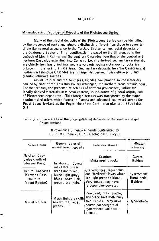
Mount Rainier and the southern Cascades now provide source materials carried by most of the Thurston County drainages; the northern areas provide none. For that reason, the presence of detritus of northern provenance, unlike the locally derived materials in mineral content, is indicative of glacial origin, and of PleiStocene deposition. This foreign detritus was transported by the major continental glaciers which formed in Canada and advanced southward across the Puget Sound lowland as the Puget lobe of the Cordilleran glaciers. (See table 3.)
Table 3. - Source areas of the unconsolidated deposits of the southern. Puget Sound low land
Source area
Northern Cas-cades (north of Stevens Pass)
(Provenance of heavy minerals contributed by D.R. Mullineaux, U.S. Geological Survey.)
General color of Indicator stones unweathered deposit!
Granites
In Thurston County Metamorphic rocks
rocks from these Central Cascades areas are mixed. Granodiorites, Keechelus (Stevens Pass Much light gray, and Northcraft lavas which
south to black, some pink, are light green to black.
Mount Rainier) green. No reds. Very dense, may have feldspar phenocrysts.
Pink, red, gray, purple,
Much light gray with and black lava with many
Mount Rainier few whites, reds, small voids. May have
greens. coarse phenocrysts of hypersthene and horn-blende •
Indicator minerals
Garnet Epidote
Hypersthene Hornblende Epidote
Hypersthene
20 GEOLOGY AND. GROUND-WATER RESOURCES, THURSTON CO., WASH.
Granite, especially that containing pink potassium feldspar, is the most easily identified northern indicator stone. Also easily identified are schist and gneiss. The commonest indicator stone Is granodiorite which Is typically medium to coarse grained and very light in color. Granodiorite itself, however, is not absolutely diagnostic of a foreign provenance because the headwaters of the Nisqually River on Mount Rainier flow through granodiorite intrusive bodies. Where It occurs In large quantity, especially in association with other northern rocks, granodiorite is a reliable indicator.
The most distinctive mineral indicative of rocks of northern origin Is garnet derived from metamorphic sources. The garnets are bright pink grains; most are clear but some are frosted. Many retain an euhedral isometric crystal form. The heavy minerals from a glacially derived sand sample invariably include an appreciable amount of garnet. Detrltal epidote, also a good indicator of both central and northern Cascade sources, is apparently absent In rocks of Mount Rainier provenance. Hypersthene Is a distinctive heavy mineral found In large quantities In Mount Rainier rocks.
Weathering of Deposits of the Pleistocene Serles
Degree of weathering is an Important criterion for recognizing relative age of deposits within the Pleistocene. Throughout Pleistocene time, periods of deposition apparently have been followed by long periods of non deposition during which deep chemical weathering of materials proceeded at a rate greater than erosional removal. Most outcrops of the older Pleistocene deposits occur on ·upland surfaces where they have not been covered by younger deposits and have been subjected to the maximum possible degree of subaerial weathering.
The degree of development of rinds on stones Is a useful criterion in detennining the degree of weathering. J. H. Mackin <oral communication, 1961) states that rinds are significant only when developed on dense rocks, particularly basalts and andesites. Siliceous rocks may withstand weathering completely; coarser grained plutonic rocks react unpredictably--some remain sound; others are permeated evenly with alteration products or else fal I apart into their constituent unaltered minerals.
When weathered to a maximum degree, the oldest Pleistocene materials are completely weathered to clay except highly siliceous rocks or rocks large enough that sound cores remain. Deposits of mid-Pleistocene age exhibit a definite de'creased intensity of weatheringi at shallow depths sand grains may be coated and stained but are otherwise unaltered. Pebbles and cobbles in deposits of mid-Pleistocene age commonly have a well-developed weathering rind thick enough so that they emit a dull sound rather than a sharp ring when struck by a hammer, but they have sound cores. Late Pleistocene deposits are either unweathered or have very thin weathering rinds.
The mineralogy, petrology, and degree of weathering of rock materials are very useful criteria In differentiating Pleistocene unconsolidated deposits where their stratigraphic relationships are not clear.
•
•
'
..
•
•
•
•
I •
GEOLOGY 21
Logan Hill Formation (Early Pleistocene)
The name Logan Hill Formation was applied by Snavely and others Cl95lbl to deeply weathered deposits of sand and gravel on Logan Hill in Lewis County. Weigle and Foxworthy (1962, p. ·28-31) pointed out that it is one of the most productive aquifers in Lewis County. The Logan Hill Formation is assigned to the Pleistocene on the basis of incorporated ti II, poor sorting of gravel, and faceted and striated pebbles. Because all observed pebbles were apparently derived from rocks within local drainage basins, the above cited authors regarded the Logan Hill Formation as glacial and glaciofluvial deposits formed by Cascade Range Valley glaciers in early Peistocene time.
Mundorff and others (1955, p. 6) described certain deposits in southeastern Thurston County and the adjacent part of Pierce County and correlated them with the Logan Hill Formation. However, In the present Investigation and also In the one of Walters and Kimmel On preparation) In Pierce County, it has been found·that most of these deposits belong to the Mashel Formation of Miocene age.
In the publications by both Snavely and Mundorff, the Logan Hill Formation is considered to be a once continuous apron or complex of piedmont alluvial fans deposited from the western flank of the Cascades westward across the Puget Basin and extending into Grays Harbor County. The deposits were laid down on truncated strata of older sediments •
Exposed parts of the Logan Hill Formation have been subjected to intense subaerlal weathering. As a result, as much as the upper 50 feet of the formation has been so deeply weathered that most pebbles have been completely altered to clay. Some larger or denser pebbles still retain a hard core and many silica-rich pebbles remain unaltered. Typical surface exposures, when wet, exhibit brightly colored shades of red, yellow, and orange and also blue and green. The gravel In most exposures looks sound but is easily cut through with a knife. A chisel blow will smear a wet exposure to give the appearance of paints on a palette, as aptly noted by Weigle and Foxworthy (1962, p. 28).
The deep weathering effectively masks many of the llthologic and textural characteristics of the Logan Hill. The authors have observed several exposures of sand and gravel weathered to clay, where the matrix Is so altered that the deposit has the appearance of ti II. However, by tracing down the section to less Intensely weathered deposits, It can be seen that they are very poorly sorted deposits of fluvial sand and gravel. This deep weathering has been seen_ in Thurston County on gravel deposits that look lithologically similar to the Logan Hill although some are known to be younger and some older. The authors believe that many younger deposits of this nature may be mistakenly mapped as a part of the Logan Hill Formation on the basis of deep weathering alone.
The lithology of pebbles In the· Logan Hill Formation Is apparently similar to that of the Mashel Formation--andesites and basalts are most common, and tuffaceous rocks, red volcanic rocks, and dark sandstones are less common. Examinations of heavy minerals from the sand fractions show that some garnet and epldote are present but in much smaller quantities than in younger glacial deposits.
In Thurston County there is no positive evidence that the Logan Hill Formation is of glacial derivation. The small quantity of garnet and epidote may be
22 GEOLOGY AND GROUND-WATER RESOURCES, THURSTON CO., WASH.
local detritus or it may have been carried in with drift of an early Puget lobe glacier. Most, if not all of the materials, were derived locally. However, most of the Logan Hill deposits are directly correlative with part of the Logan Hill Formation in Lewis County <Weigle and Foxworthy, 1962, p. 28) where the formation contains till. For this reason, the Logan Hill Fonnation is accepted as the earliest Pleistocene fluvial and glaciofluvial deposit within Thurston County.
In the Puget Sound lowland there were frequent prolonged periods of nondeposition from late Miocene through Pleistocene time. Nevertheless, geologic history Indicates that terrestrial deposits derived from the Cascades and preCascades were deposited in this area during much of this interval. For this reason, the Logan Hill Formation may include fluvlal deposits younger than Mashel age but old enough to have deeply weathered during Pliocene or early Pleistocene time.
The chief areas of occurrence of the Logan Hill Formation are the upland surface of Michigan Hill and the upland surface of the southwestward extension of the Bald Hills surrounding Bucoda. The Bald Hills area is so heavily forested and access is so poor that very little is known of the thickness or composition. On Michigan Hill the preserved top of the formation is at an altitude of 480 feet. The basal contact where it lies directly on rocks of the Astoria(?) Formation and Lincoln Fonnation of Weaver (1912) is Irregular, ranging in altitude from 240 to 360 feet. The average thickness is estimated to be about 80 feet. Weathering Is intense throughout but decreases markedly toward the base. On the higher parts of Michigan Hill only shallow exposures of a dark-red clayey soil are visible. In valley fnclsions deeper sections are seen. Here, the soil grades downward to completely weathered sands with a visible bedding structure. The deposit becomes coarser toward the base where it Is composed of lnterbedded sand, and pebble and granule gravel. The bottom 30 to 40 feet are fresh enough that pebbles have solid cores but the matrix material is a gritty clay. The clay provides enough binder to make the deposit a P.oorly consolidated pebble conglomerate that is
. strikingly similar to the type section of the lower part of the Mashel Formation. The Logan Hill Formation is present in much of the Maytown Upland where,
at many places, It is covered by younger glacial drift. In the Prairie Area the formation has been removed by erosion. Most of the central and eastern Bald Hills stood too high to receive deposits; instead, these areas probably acted as a primary source for the deposits laid down at their base. A deeply dissected alluvial fan south of Clear Lake in T. 15 N., R. 3 E., was mapped as Logan Hill Formation by Mundorff and others (1955). An old terrace is preserved near the head of the Skookumchuck River Cl5/2E-18); this terrace is probably contemporaneous with the fan to the east and both deposits are considered in this report to be of the Logan Hill Formation although neither show the degree of weathering seen on and near Michigan Hill.
There Is some evidence that Logan Hill time Included an appreciable interval of nondeposition and erosion, followed by renewed fluvial deposition. This evidence is seen west and south of Maytown where a large area is mantled with what appears to be a younger part of the Logan Hill Formation. Here weathering is generally less intense although there is a possibility that the more deeply weathered upper parts have been removed by erosion. A few northern rock types were observed but garnet is extremely scarce among the heavy minerals.
•
•
•
•
•
•
•
•
GEOLOGY
Bretz Cl 913, p. 176) ai so noted weathered drift near Maytown to which he tentatively assigned an Admiralty age (seep. 25 ).
23
In concluding, It can be stated that continental sediments, mostly sand, gravel and a minor amount of silt, have been deposited in the area since late Miocene time. During a large part of this time the area stood near base level, erosion was gentle, valley incision was probably negligible, and subaerial weathering was intense. This weathering deeply altered all of the surface deposits throughout the time it prevailed and produced a nearly lateritic soil profile. These deposits ranged from Eocene volcanic rocks of the Bald and Black Hills to the lower lying continental deposits of Miocene, Pliocene(?), and Pleistocene Epochs. Thus, at many places there is a strong possibility of mlscorrelating a time-lithologlc unit on the basis of its weathering characteristics.
Deposits equivalent in age to the Logan Hill Fonnation may deeply underlie the Peninsular Area and the northern Prairie Area. Logs of some deeper wells In these areas suggest that penetration below later Pleistocene deposits has occurred but no stratigraphic distinction ls possible on the basis of.these.
Pre-Salmon Springs(?) Deposits, Undifferentiated (Pleistocene, Pre-Wisconsin)
All Pleistocene unconsolidated deposits older than Salmon Springs(?) (seep. 27) and not assigned to the Logan Hill Formation are here designated as undifferentiated pre-Salmon Springs(?) deposits. They are chiefly fine-grained deposits of both glacial and nonglacial origin but they also Include sands and gravels that are Important aquifers.
The pre-Salmon Springs(?) deposits are best observed on the bluffs and beaches of the Peninsular Area where numerous exposures of fine-grained material, mostly silty clay, are seen. It ls described as blue clay by many people, including well drillers. For example, the tenn blue clay Is reported In many well logs in Volume 1 of this report (Wallace and Molenaar, 1961). It is generally a dark blue-gray but is also gray, brown, and buff. At few places is the material a pure clay, but the proportion of clay is large enough to impart at least some plasticity to the deposit. At many places, well sorted fine-grained sand is thinly interbedded with the finer grained material. The bedding may be horizontal, but at most places the deposit is massive and exhibits a blocky jointing.
Where it crops out on the shoreline bluffs the blue clay is extremely susceptible to sliding. It Is virtually lmpermeable-~sprlngs flow from its upper surface and across its face. There Is constant wave erosion at the base and consequently a standing outcrop of blue clay more than 5 feet high is seen at only very few places. Owing to its proclivity for sliding, the upper surface of the blue clay rarely is exposed. Where younger materials are in lateral contact with the blue clay, there is invariably a small stream within a densely wooded canyon.
A few well logs indicating the depth, and variations in grain size, are 19/1W-6Jl, 19/2W-11Rl, 12Ll, 23Ql, 24Gl, 25Al, and 26Bl. These logs show the upper surface to be very Irregular but in only a few cases is it more than a few feet above .sea level. Gravel incorporated in the pre-Salmon Springs(?) deposits at random depths is riot traceable laterally. Some of the blue clay shown in the Jogs, particularly that which Is more than a few feet above sea level, probably ls within the Kitsap Formation.
24 GEOLOGY AND GROUND-WATER RESOURCES, THURSTON CO., WASH.
Samples of pre-Salmon Springs(?) deposits from the east side of Budd Inlet north of Olympia are composed of sandy silt. Grains are rounded only slightly and are otherwise unaltered. Quartz and feldspar are the most abundant minerals and there Is a fairly high proportion of llthlc fragments and maflc minerals including epidote, pyroxenes, hornblende, and garnet. The mineral assemblage Is that of glacially derived material; probably much rock flour Is present. Diatoms are present but no other fossil material Is evident.
The depositional environment was probably cold still water, very likely a lake. The gravel lenses noted In the logs were probably deposited near shore or In peripheral stream channels and their existence suggests that much oscillation of shoreline occurred.
Not all the deeper materials within the pre-Salmon Springs(?) deposits are of glacial origin. The log of well 18/1W-31F2 shows two peat deposits at 31 and 82 feet below sea level. These may have been deposited during a preSalmon Springs(?) nonglaclal lnterval--posslbly the Puyallup Interval of Crandell and others (1958, p. 393). The base of the pre-Salmon Springs(?) deposits Is unknown. The geologic sections (pl. 3) arbitrarily stop at 200 feet below sea level. ·
In two localities Cl 9/lW-llK and J) sandy beds of the pre-Salmon Springs(?) deposits crop out on the beach surface. They have easterly dips of 35° and 43°, but they are not exposed In the bluff Immediately behind the beach. In the first locality the bluff is composed of Vashon till that must lie on the tilted beds just below beach level. At the second location, about 1,500 feet east, red gravel of the Salmon Springs(?) Drift Is exposed in the bluff but in neither place Is a contact visible. The sand beds were probably not tilted by landsliding or ice shove. Where till is over the dipping beds the area Is not subject to landsliding and the straight striking, truncated dipping beds, apparently continuous for nearly a quarter of a mile, are not suggestive of Ice-shove which generally causes contorted bedding. (See fig. 2 .) Thus, It Is likely that the tilting Is the result of tectonic action though probably on a very small scale. The displacement could have been caused by faulting rather than folding, In pre-Wisconsin Pleistocene time. In most areas the undifferentiated pre-Salmon Springs{?) deposits are virtually flat-lying.
In the Peninsular Area deposits of fine-grained materials locally containing beds of gravel extend as much as 1,000 feet below sea level. Although well logs do not indicate the presence of till, at least the upper part Is glacially derived and possibly Is time-correlative with part of the Logan Hill Formation (Pleistocene). The lower sediments may be much older and could conceivably be time-correlative with the Mashel Formation <Miocene>.
The undifferentiated pre-Salmon Springs(?) deposits, are correlative with much of the fine-grained material that frequently has been called Admiralty till and clay as named by Willis (1898). The Admiralty was considered to be the only Puget Sound lowland glaciation prior to the Vashon. Bretz Cl 913, p. 175-177) strengthened the usage although he recognized two distinct tills within the Admiralty. Newcomb Cl952a, p. 13) and Sceva (1957, p. 14-15) used the lenn 11 Admiralty 11 in ground-water studies of Snohomish and Kitsap Counties, respectively. Later workers, particularly Crandell and others (1958, p. 395-396) and J. Hoover Mackin Coral communication, 191>1) found the concept of an
'
•
•
•
•
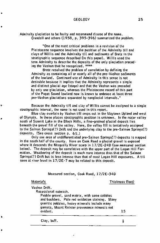
•
•
•
•
•
•
GEOLOGY
Admiralty glaciation to be faulty and recommend disuse of the name. Crandell and others (1958, p, 395-396) summarized the problem:
"One of the most critical problems In a revision of the Pleistocene sequence Involves the position of the Admiralty till and clays of Willis and the Admiralty till and sediments of Bretz in the stratigraphic sequence described (In this paper). Willis used the term Admiralty to describe the deposits of the only glaciation preceding the Vashon that he recognized. **"*
Bretz resolved the problem of correlation by defining the Admiralty as containing all or nearly all of the pre-Vashon sediments of the lowland. Continued use of Admiralty In this sense is not desirable because It Implies that the Admiralty represents a single and distinct glacial age (stage) and that the Vashon was preceded by only one glaciation, whereas the Pleistocene record of this part of the Puget Sound lowland now Is known to embrace at least three pre-Vashon glaciations separated by nonglaclal Intervals."
25
Because the Admiralty till and clay of WI Ills cannot be assigned to a single stratigraphic interval, the name Is not used In this report.
Blue clay overlain by Vashon till crops out Jn the Maytown Upland and west of Olympia. In these places stratigraphic position Is unknown. In the major valley south of Summit Lake In the Black Hiiis, a line-grained glacial deposit lies beneath the gravel fill of the valley. Here, the valley fill Is tentatively assigned to the Salmon Springs(?) Drift and the underlying clay to the pre-Salmon Springs(?) deposits. (See cross section p. 65.l
Only one area of undifferentiated pre-Salmon Springs(?) deposits Is mapped In the south half of the county. Here on Cook Road a glacial gravel is exposed where It descends the Nlsqually River scarp in l 7/2E-24D (see measured section below). The deposit may be correlative with the upper part of the Logan Hill Formation. Weathering of the deposit is much more intense than that of the Salmon Springs(?) Drift but Is less Intense than that of most Logan Hill exposures. A till seen at river level Jn 17 /2E-7 may be related to this deposit.
Measured section, Cook Road, 17/2E-34D
Materials
Vashon Drift. Recessional outwash.
Thickness (feet)
Pebble gravel, sand matrix, with some cobbles and boulders. Pale red oxidation staining. Many granitic pebbles, heavy minerals Include many garnets, Mount Rainier provenance minerals not evident. 15
Clay, buff •
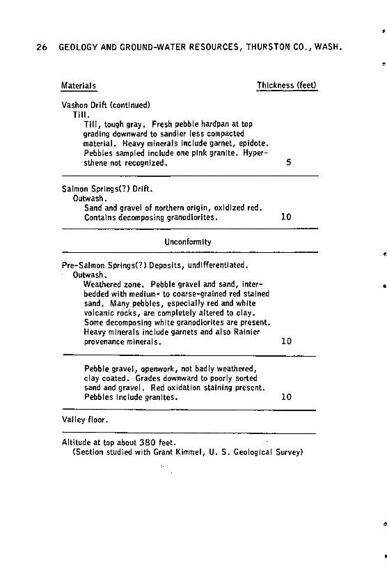
26 GEOLOGY AND GROUND-WATER RESOURCES, THURSTON CO., WASH.
Materials Thickness (feet)
Vashon Drift (continued) Till.
Till, tough gray. Fresh pebble hardpan at top grading downward to sandier less compacted material. Heavy minerals Include garnet, epidote. Pebbles sampled include one pink granite. Hyper-sthene not recognized. 5
Salmon Springs(?) Drift. Outwash.
Sand and gravel of northern origin, oxidized red. Contains decomposing granodiorltes. 10
Unconform lty
Pre-Salmon Springs(?) Deposits, und lflerentlated. Outwash.
Weathered zone. Pebble gravel and sand, interbedded with medium- to coarse-grained red stained sand. Many pebbles, especially red and white volcanic rocks, are completely altered to clay. Some decomposing white granodlorltes are present. Heavy minerals include garnets and also Rainier provenance minerals. 10
Pebble gravel, openwork, not badly weathered, clay coated. Grades downward to poorly sorted sand and gravel. Red oxidation staining present. Pebbles Include granites. 10
Valley floor.
Altitude at top about 380 feet. (Section studied with Grant Kimmel, U. S. Geological Survey)
•
•
•
•
•
'
•
•
•
•
•
GEOLOGY 27
Salmon Springs(?) Drift (Early Wisconsin)
The Salmon Springs Drift was named by Crandell and others (1958, p. 394) from a type section near Sumner In Pierce County and has been tentatively traced to Browns Point, north of Tacoma. At the type section two drift sheets are separated by nonglaclal sediments containing peat and ash. Deposits whose stratigraphic relationships are similar to those of the Salmon Springs Drift have been mapped In Thurston County, but owing to certain differences in age Interpretations plus a lack of direct correlation through surface exposures, the authors considered it advisable to correlate these deposits with reservation and to call them the Salmon Springs(?) Drift. Also, the occurrence of two separate drift sheets has not been observed in Thurston County.
In Thurston County the Salmon Springs(?) Drift Is best seen in a thick (as much as 90 feet) sequence of stratified sand and gravel that is exposed, with only minor interruptions, In the steep banks of the Nisqually River from north of Yelm to its mouth. The same unit Is exposed along the bluffs of Nisqually Reach of Puget Sound from the mouth of the Nlsqually River north to Johnson Point (fig. 2). The Salmon Springs(?) Drift containing granite and metamorphic rocks characteristic of northern sources was unquestionably deposited by the Puget lobe • The sand and gravel Is commonly stained by iron oxides to a yellowish brown to reddish brown color of varying Intensity, which at many places makes the deposit distinctly different In appearance from the overlying Vashon Drift. In thick outcrops, alteration by weathering, other than staining, Is not evident but moderate to strong cementation is common. One lithologlc criterion for recognizing this unit may be the existence of pumice which at many places is found both as granules and In thin lenses. Older glacial deposits also contain pumlceous particles, but the authors have not noticed any appreciable amount In Vashon Drift. Very compact till is incorporated in these gravels at beach level In Henderson and Budd Inlets. At most places the base of the Salmon Springs(?) Drift Is below sea level; It Is believed to lie unconformably on the undifferentiated pre-Salmon Springs(?) deposits.
The Salmon Springs(?) Drift in Thurston County is visually correlative with exposures of glacial outwash gravels on the Pierce County side (right bank) of the lower Nisqually River. Walters and Kimmel Cin preparation) have also applied the name Salmon Springs(?) Drift to these deposits. A similar correlation can be made across NI squally Reach to the Longbranch peninsula where Molenaar Cl965, p. 28) applied the same nomenclature.
The Salmon Springs(?) Drift was called the lower member of the Orting Gravel In Kitsap County by Sceva (1957, p. 15) who correlated It with the Orting Gravel of Willis (1898) near the town of Orting. Crandell and others (1958, p. 387) redescribed Willis' type section and renamed it the Orting Drift. They said, 11 --it Is the oldest known Pleistocene deposit of the area-:.. 11 (p. 397). The authors of this report accept Crandell's definition of Orting Drift and have therefore found it impossible to retain the term as used by Sceva. However, Sceva1s lower member of the Orting Gravel occupies a stratigraphic position similar to that of the Salmon Springs(?) Drift in Thurston County.
In Thurston County, Salmon Springs(?) Drift Is Intermittently exposed in beach bluffs around the entire Peninsular Area. The base Is usually near sea level. The top, when seen in bluff exposures, is from a few feet to about 30 feet above
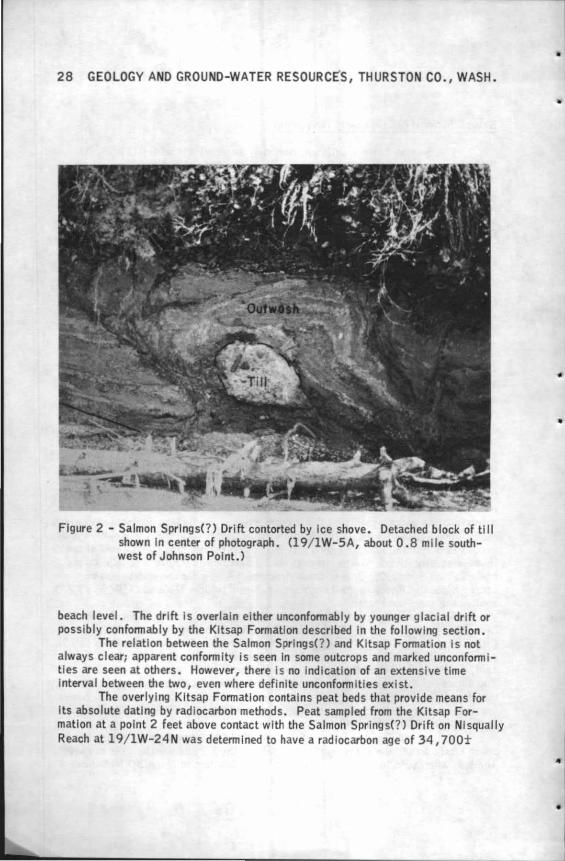
28 GEOLOGY AND GROUND-WATER RESOURCES, THURSTON CO., WASH.
Figure 2 - Salmon Springs(?) Drift contorted by Ice shove . Detached block of t i ll shown In center of photograph. (19/ lW-SA, about 0.8 mile southwest of Johnson Point.)
beach level. The drift Is overlain either unconfonnably by younger glacial drift or possibly confonnably by the Kitsap Fonnatlon described In the follow Ing section.
The relation between the Salmon Springs(?) and Kitsap Fonnation Is not always clear; apparent confonnlty is seen In some outcrops and marked unconfonnit les are seen at others. However, there is no Indication of an extensive t ime Interval between the two, even where definite unconfonnities exist.
The overlying Kitsap Fonnatlon contains peat beds that provide means for Its absolute dating by rad iocarbon methods. Peat sampled from the Kitsap Formation at a point 2 feet above contact with the Salmon Springs(?) Drift on Nlsqually Reach at l 9 / 1W- 24N was detennlned to have a radiocarbon age of 34, 700t
•
•
•
•
..
•
•
•
·•
•
•
•
GEOLOGY 29
1, 100 years by the University of Washington CDorn and others, 1962, p. 4).1 At this location the Salmon Springs(?) Drift Is thought to be only In part recessional glacial outwash as It contains a high percentage of Rainier provenance rocks related to the Kitsap Fonnatlon.
Crandell and others (1958, p. 396) report that a wood sample collected from the top of deposits tentatively Identified as Salmon Springs near Browns Point had a radiocarbon age of more than 37 ,000 years • .This dating does not Imply any age close to 37,000 years, but simply an age older than that time. Those authors suggest a pre-Wisconsin and Imply an llllnolan age for the Salmon Springs Drift but state that there Is no direct substantiating evidence for this dating. They tentatively correlate the Vashon with the maximum of the Wisconsin Glaciation of the midwestern United States. If the youngest deposits of Salmon Springs(?) Drift in Thurston County are only about 40,000 years old, they may be only about 12 ,000 years older than the oldest Vashon Drift (see fig. 3) and are herein considered to be of early Wisconsin age.
In beach bluffs the Salmon Springs(?) Drift is easily recognized both by its stratigraphic position and by its characteristic red-stained, but otherwise fresh condition. The red staining, caused by ground-water movement, Is postdeposltional and not direct evidence of age. However, it Is thought that a reasonably long time is required to accomplish the oxidation. Staining Is the rule rather than the exception, whereas in deposits of Vashon age staining is only a local exception. Some deposits of Salmon Springs(?) Drift are unoxidized, but these are located Jn topographically higher areas where ground water could have been absent during most of post-Salmon Springs(?) time.
The existence of two late Pleistocene drift sheets near Tenino has been suspected for many years by J. H. Mackin Coral communication, 1961). During this investigation and under Mack In's guidan~e, the senior author attempted to identify and map them. The result has been the mapping of broad areas of Salmon Springs(?) Drift on the upland areas south of the Peninsular beaches. The two drift sheets identified by Mackin are designated here as the Salmon Springs(?) Drift and the Vashon Drift. The Salmon Springs(?) lies below and extends slightly farther south of the Vashon. Near the terminus of both glaciers it Is difficult to distinguish between Vashon and Salmon Springs(?) deposits. However, where the deposits of both glaciations are superimposed there is a_distinct stratigraphic difference and there are major differences In ground-water production.
In the Peninsular Alea the Salmon Springs(?) outwash deposits were unquestionably deposited by the Puget lobe prior to the Vashon glaciation. The drift
1 A. W. Falrhall of the University of Washington (written communication, 1962) reports slightly different dates due to two different values of the half-life of cl4. All dates reported by Dorn and others (1962) are based on a standard half-life value. Newer infonnation indicates that this standard Is slightly In error and It is thought that a closer approximation of true calendar age is obtained by multiplying the older data by 1.03. The ages used in this report are all referred to the older half-life and are thus based on the same datum as all present and previously published dates reported In Radiocarbon •
30 GEOLOGY AND GROUND-WATER RESOURCES, THURSTON CO., WASH.
preserved on the uplands beyond the Inferred Vashon terminus Is unquestionably much younger than the Logan Hill and pre-Salmon Springs(?) deposits described earlier and shows no evidence of being a great deal older than Vashon Drift. On this basis, the upland pre-Vashon younger drift Is considered to be correlative with the Salmon Springs(?) Drift of the lowlands, but no direct correlation Is evident. (See cross section A-A', pl. 3.)
The differences between Vashon and Salmon Springs(?) deposits on the upland are extremely subtle. The two are differentiated by slight differences In appearance caused by weathering and erosion plus supporting geomorphic evidence. Thin upland deposits of Salmon Springs(?) ti 11 are seldom as compact as Vashon tlll. At most places they consist of gravelly, brown or gray soil with lag boulders sparsely scattered on the surface. Pebbles and cobbles from the soil zone commonly exhibit a rind of about' to 2 mm thick ii they are of dense rock, or show a complete permeation of alteratlon products If they are of coarser grained rocks (see p. 20). Granitic rocks usually crumble with a hammer blow. Vashon deposits may exhibit the same character I sties but only as an exceptlon--lew of the stones In these deposits have rinds or any other alteratlon features.
The general appearance of areas suspected to be underlain by Salmon Springs(?) suggests that these areas have undergone much more erosion than those underlain by Vashon deposits. In most places only a very thin mantle of drift covers the bedrock and In some places only lag gravel covers it. Where they are thick enough to be exposed in standing banks, unstratified deposits have what Is best described as a 11 dull" appearance ln contrast to the tough 11 brlghter 11 exposures of Vashon tlll. These unstratified deposits are generally so thin and sporadic that they do not mask the underlying rocks of Tertiary age. They are mapped primarily to depict an approximate southern terminus of the Salmon Springs(?) glacier. Stratified deposits of Salmon Springs<?) Drift are not common In the uplands but occur In the Maytown Upland just north of Tenino and just north of Offutt Lake, and In the Bald Hills Area south of Tenino and near Cozy Valley east of Tenino. In the Maytown Upland Area they are stained red and are slightly altered by weathering. In the Bald Hills Area stratified drift of the Salmon Springs(?) Is Identical In appearance with Vashon Drift; It Is considered to be older solely on geomorphic evidence.
The geomorphlc evidence is based on the hypothesis that the topography of most of the areas near the terminus of the Vashon Drift Is constructional whereas the topography of the areas of older materials Is erosional. Constructional topographic features are kame-kettle complexes, drum I Ins, and linear developme"nt of drainage areas paralleling the direction of ice flow. In areas considered to be underlain by Salmon Springs(?) Drift, none of these conditions Is present. Instead, they exhibit the same type of topography as do the neighboring drlftless areas of Tertiary rocks. There is also evidence for much deeper erosion of the deposits.
The most anomalous area mapped as Salmon Springs(?) Drift Is the gravel terrace between Tenino and Cozy Valley and the related drift north and west in the Maytown Upland. The terrace and a related delta deposit in Cozy Valley were formed when Ice stood In the valley just west of Lake Mcintosh after it had receded from Its greatest extent about 1 mile farther south. Bretz (1913, p. 118) regarded the terrace deposits as Vashon outwash. Mackin (oral communication, 1961), in looking for a morainal dam to explain the origin of Lake: Mcintosh, found no drift on the
•
•
!
•
•
..
GEOLOGY 31
valley floor near that lake or along the sides which are of very deeply weathered sedimentary rocks. Mackin considered the removal of drift and the considerable depth of weathering that must have developed since ice last occupied the valley to be reliable evidence that the last ice lobe in the valley was older than Vashon. Consequently, these terrace gravels are considered to be Salmon Springs(?) outwash.
If the gravel is Salmon Springs(?), the drift on the upland north of Lake Mcintosh, which consists of a thin mantle of fresh gravelly soil plus abundant granodiorite boulders so typical of Vashon Drift, cannot be derived from Vashon ice. The ice that deposited this coarse material up to an altitude of 871 feet certainly would have flowed through the valley of Scatter Creek and occupied the west end of Lake Mcintosh at an altitude of 336 feet, but even the upper valley sides of Scatter Creek are devoid of fresh till or terraces. Therefore, these areas have been mapped as Salmon Springs(?) Drift.
Stratified outwash in the general area of the Maytown Upland is considered to be of Salmon Springs(?) age for two reasons: (1) Most of the outwash gravels are red stained and (2) they occupy topographic positions much higher than the Vashon recessional outwash, yet show no terrace relationship to Vashon outwash. Some of this Salmon Springs(?) outwash is terrace material, but that found north of Tenino and northwest of Deep Lake appears to be older ice-contact sand and gravel similar to the younger kame-kettle complexes of Vashon material but subsequently eroded •
The material underlying the area near and south of Summit Lake was mapped as Salmon Springs(?) Drift as was that near Mcintosh Lake. The uplands above the lake have a sparse assortment of erratic boulders lying on soil derived from weathered basalt. The valley sides Immediately adjacent to the lake are deeply weathered basalt; no drift remains, yet Ice has unquestionably flowed through the valley now occupied by Summit Lake, terminating high against the slopes south of the east-west valley south of Summit Lake. Till on the valley sides east of Summit Lake is deep red, locally pumiceous, and contains crumbling granodiorite typical of Salmon Springs(?) Drift.
Summit Lake was formed by an outwash dam at the west end of the lake. In this report the dam is considered to be composed of Salmon Spriilgs(?) deposits, although Bretz (1913, p. 31) believed it to be of Vashon outwash. The remnant of the dam consists of deep red gravel as do associated terrace deposits nearby. The gravel iFl this vicinity is fresh but contains crumbling granite, and locally is deeply stained, but generally shows only minor staining. The entire Mox-Chehalis Creek-Perry Creek valley never contained Vashon ice but did contain Salmon Springs(?) ice. The valley definitely contains both pre-Salmon Springs(?) and Salmon Springs(?) deposits (see cross section, fig. 17), but it is also conceivable that the valley acted as a short-lived outwash channel for Vashon ice standing in Eld Inlet. If so, the outwash dam of Summit Lake would be of Vashon age. If Vashon outwash Is present it is surflcial on the older outwash, but its general appearance, as compared to Vashon outwash occupying similar areas northwest of Black Lake, suggests that the total deposit is of Salmon Springs(?) age except for the western end which was occupied by a Vashon drainage route througH Kennedy Creek.
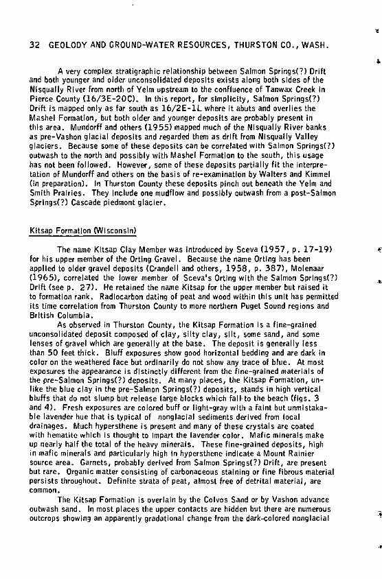
32 GEOLODY AND GROUND-WATER RESOURCES, THURSTON CO., WASH.
A very complex stratigraphic relationship between Salmon Springs(?) Drift and both younger and older unconsolidated deposits exists along both sides of the Ni squally River from north of Yelm upstream to the confluence of Tanwax Creek In Pierce County (16/3E-20CJ. In this report, for simplicity, Salmon Springs(?) Drift is mapped only as far south as 16/2E-ll where it abuts and overlies the Mashel Formation, but both older and younger deposits are probably present In this area. Mundorf! and others (1955) mapped much of the Nlsqually River banks as pre-Vashon glacial deposits and regarded them as drift from Nlsqually Valley glaciers. Because some of these deposits can be correlated with Salmon Springs(?) outwash to the north and possibly with Mashel Formation to the south, this usage has not been followed. However, some of these deposits partially flt the interpretation of Mundorf! and others on the basis of re-examination by Walters and Kimmel (in preparation). In Thurston County these deposits pinch out beneath the Yelm and Smith Prairies. They Include one mudflow and possibly outwash from a post-Salmon Springs(?) Cascade piedmont glacier.
Kitsap Formation <Wisconsin)
The name Kitsap Clay Member was Introduced by Sceva (1957, p. 17-19) for his upper member of the Orting Gravel. Because the name Orting has been applied to older gravel deposits (Crandell and others, 1958, p. 387), Molenaar (1965), correlated the lower member of Sceva's Orting with the Salmon Springs(?) Drift (seep. 27). He retained the name Kitsap for the upper member but raised it to formation rank. Radiocarbon dating of peat and wood within this unit has permitted Its time correlation from Thurston County to more northern Puget Sound regions and British Columbia.
As observed in Thurston County, the Kitsap Formation is a ffne-grained unconsolidated deposit composed of clay, silty clay, s!lt, some sand, and some lenses of gravel which are generally at the base. The deposit is generally less than 50 feet thick. Bluff exposures show good horizontal bedding and are dark in color on the weathered face but ordinarily do not show any trace of blue. At most exposures the appearance is dlstinctly different from the fine-grained materials of the pre-Salmon Springs(?) deposits. At many places, the Kitsap Formation, unlike the blue clay in the pre-Salmon Springs(?) deposits, stands In high vertical bluffs that do not slump but release large blocks which fall· to the beach (figs. 3 and 4). Fresh exposures are colored buff or light-gray with a faint but unmistakable lavender hue that is typical of nonglacial sediments derived from local drainages. Much hypersthene is present and many of these crystals are coated with hematite which is thought to Impart the lavender color. Mafic minerals make up nearly half the total of the heavy minerals. These fine-grained deposits, high in mafic minerals and particularly high In hypersthene indicate a Mount Rainier source area. Garnets, probably derived from Salmon Springs(?) Drift, are present but rare. Organic matter consisting of carbonaceous staining or fine fibrous material persists throughout. Definite strata of peat, almost free of detrital material, are common.
The Kitsap Formation is overlain by the Colvos Sand or by Vashon advance outwash sand. In most places the upper contacts are hidden but there are numerous outcrops showing an apparently gradational change from the dark-colored nonglacial
..
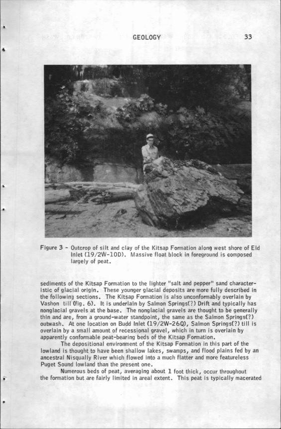
•
•
•
GEOLOGY 33
Figure 3 - Outcrop of silt and clay of the Kitsap Formation along west shore of Eld Inlet Cl9/ 2W-10D). Massive float block in foreground is composed largely of peat.
sediments of the Kitsap Formation to the I lghter "salt and pepper" sand characteristic of glacial origin. These younger glacial deposits are more fully described In the following sections. The Kitsap Formation Is also unconfonnably overlain by Vashon till (fig. 6). ft Is underlain by Salmon Springs(?) Drift and typically has nonglaclal gravels at the base. The nonglaclaf gravels are thought to be generally thin and are, from a ground-water standpoint, the same as the Salmon Springs(?) outwash. At one location on Budd Inlet Cl 9/2W-26Q), Salmon Springs(?) ti II Is overlain by a smal I amount of recessional gravel, which In turn Is overlain by apparently conformable peat-bearing beds of the Kitsap Formation.
The depositional environment of the Kitsap Formation in thl s part of the lowland is thought to have been shallow lakes, swamps, and flood plains fed by an ancestral Ni squally River which flowed into a much flatter and more featureless Puget Sound lowland than the present one.
Numerous beds of peat, averaging about 1 foot thick, occur throughout the formation but are fairly limited in areal extent. This peat is typically macerated
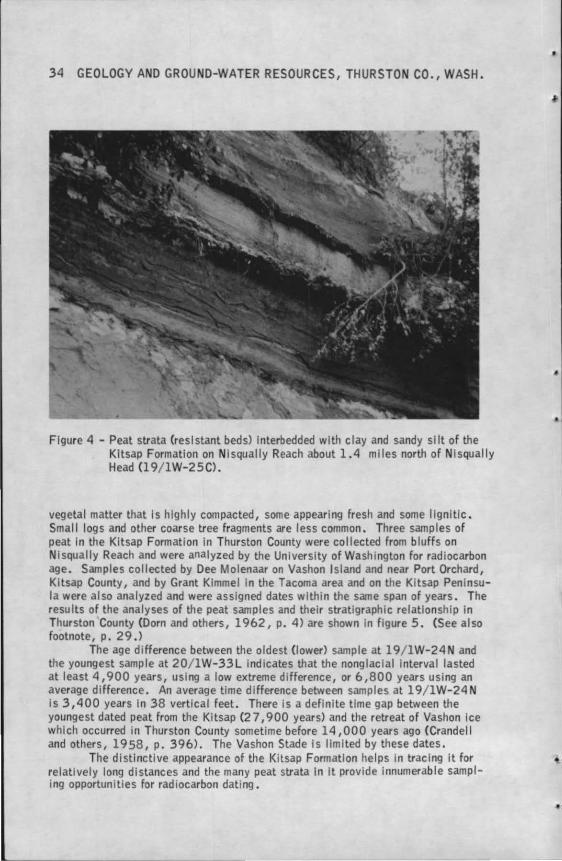
34 GEOLOGY AND GROUND-WATER RESOURCES, THURSTON CO., WASH.
Figure 4 - Peat strata (res I slant beds) interbedded with clay and sandy silt of the Kitsap Formation on Nisqually Reach about 1.4 miles north of Nlsqually Head (19/ 1W-25C).
vegetal matter that Is highly compacted, some appearing fresh and some llgnltlc. Small logs and other coarse tree fragments are less common. Three samples of peat In the Kitsap Formation In Thurston County were collected from bluffs on Ni squally Reach and were analyzed by the University of Washington for radiocarbon age. Samples collected by Dee Molenaar on Vashon Island and near Port Orchard, Kitsap County, and by Grant Kimme I In the Tacoma area and on the Kitsap Peninsula were al so analyzed and were assigned dates within the same span of years. The results of the analyses of the peat samples and their stratigraphic relationship in Thurston County (Dorn and others, 1962, p. 4) are shown in figure 5. (See al so footnote, p. 29 .)
The age difference between the oldest Clower) sample at 19/ 1W-24N and the youngest sample at 20/ 1W-33L indicates that the nonglaclal interval lasted at least 4,900 years, using a low extreme difference, or 6,800 years using an average difference. An average time difference between samples at l 9/ lW-24 N is 3,400 years In 38 vertical feet. There is a definite time gap between the youngest dated peat from the Kitsap (2 7, 900 years) and the retreat of Vashon Ice which occurred in Thurston County sometime before 14,000 years ago (Crandell and others, 19 58, p. 396). The Vashon Stade Is llmlted by these dates.
The distinctive appearance of the Kitsap Formation helps In tracing It for relatively long distances and the many peat strata In It provide Innumerable sampling opportunities for radiocarbon dating.
•
• I
I
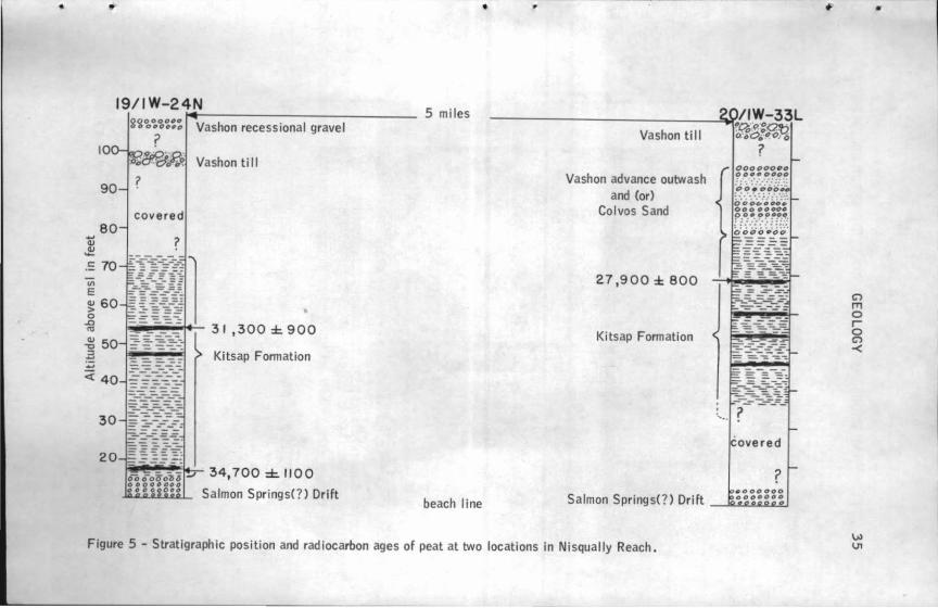
• •
19/IW-24N
10
90
80
.: 70
"' E ~ 60 0
~
g~~~~::: Vashon recessional gravel ?
1'o'Wi:rJ~ Vashon ti 11 ?
covered
?
31,300±900 ~ 50 .3 ·--"'-I Kitsap Fonnation _,
;;: 40
30
20 ~~~i...:.... 34,700::C.1100
Salmon Springs(?) Drift
•
5 miles
beach line
Vashon till
Vashon advance outwash and (or)
Colvos Sand
2.7 ,900 ± 800
Kitsap Fonnation
Figure 5 - Stratigraphic position and radiocarbon ages of peat at two locations in Nisqually Reach.
00000000 o o••.!>•oo
~c:> O.• ~00
C)
m 0 r 0 C)
~
•
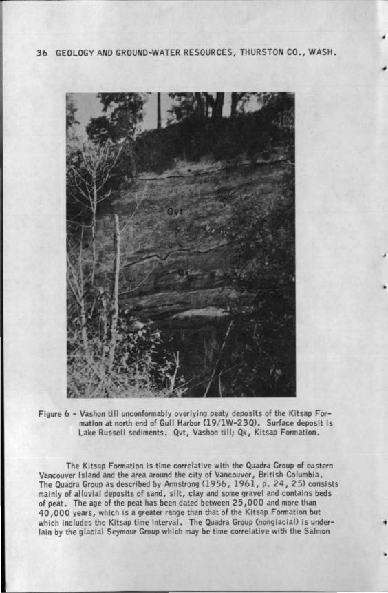
36 GEOLOGY AND GROUND-WATER RESOURCES, THURSTON CO., WASH.
Figure 6 - Vashon till unconformably overlying peaty deposits of the Kitsap Formation at north end of Gull Harbor Cl9/ 1W-23Q). Surface deposit Is Lake Russell sediments. Qvt, Vashon ti II; Qk, Kitsap Formation.
The Kitsap Formation Is time correlative with the Quadra Group of eastern Vancouver Island and the area around the city of Vancouver, British Columbia. The Quadra Group as described by Armstrong (1956, 1961, p. 24, 25) consists mainly of alluvial deposits of sand, silt, clay and some gravel and contains beds of peat. The age of the peat has been dated between 25,000 and more than 40, 000 years, which Is a greater range than that of the Kitsap Formation but which Includes the Kitsap time Interval. The Quadra Group (nonglaclal> Is underlain by the glacial Seymour Group wh ich may be time correlative with the Salmon
•
•
..
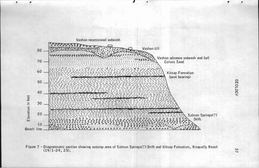
•
..... Q)
~ c c 0
:.;:; IQ > Q)
LU
Beach
80
70
60
50
40
30
20
10 line
Vashon recessional outwash
Vashon advance outwash and (or) Colvos Sand
Kitsap Formation ••~~~~i:PM~~~~~~~mjii~~~~~ (peat bearing)
Figure 7 - Diagrammatic section showing outcrop area of Salmon Springs(?) Drift and Kitsap Formation, Nisqually Reach (19/ 1-24, 25).
C"> m 0 I 0 C"> -<
•
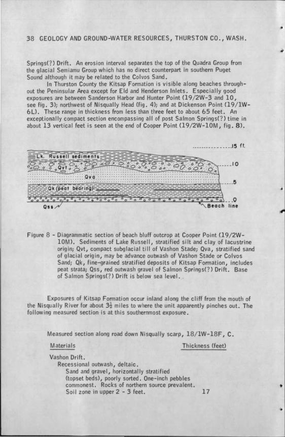
38 GEOLOGY AND GROUND-WATER RESOURCES, THURSTON CO., WASH.
Springs(?) Drift. An erosion interval separates the top of the Quadra Group from the glacial Semiamu Group which has no direct counterpart in southern Puget Sound although it may be related to the Colvos Sand.
In Thurston County the Kitsap Formation 1s visible along beaches throughout the Peninsular Area except for Eld and Henderson Inlets. Especially good exposures are between Sanderson Harbor and Hunter Point Cl9/ 2W-3 and 10, see fig. 3); norlhwest of Nisqually Head (fig. 4); and at Dickenson Point (19/ lW-6 U. These range in thickness from less than three feet to about 65 feet. An exceptionally compact section encompassing al I of post Salmon Springs(?) time in about 13 vertical feet is seen at the end of Cooper Point (19/ 2W-10M, fig. 8 ).
··---·----- - ••• .15 ft.
Figure 8 - Diagrammatic section of beach bluff outcrop at Cooper Point (19/2W-10M). Sediments of Lake Russell, stratified silt and clay of lacustrine orig in; Qvt, compact subglacial till of Vashon Stade; Qva, stratified sand of glacial origin, may be advance outwash of Vashon Stade or Colvos Sand; Qk, fine-grained stratified deposits of Kitsap Formation, includes peat strata; Qss, red outwash gravel of Salmon Springs(?) Drift. Base of Salmon Springs(?) Drift is below sea level.
Exposures of Kitsap Formation occur inland along the cliff from the mouth of the Nisqually River for about 3! mi les to where the unit apparently pinches out. The following measured section is at this southerrvnost exposure.
Measured section along road down Nisqually scarp, 18/ 1W-18F, C.
Materials
Vashon Drift. Recessional outwash, deltaic.
Sand and gravel, horizontally stratified
Thickness (feet)
(topset beds), poorly sorted. One-inch pebbles commonest. Rocks of northern source prevalent. Soi I zone in upper 2 - 3 feet. 17
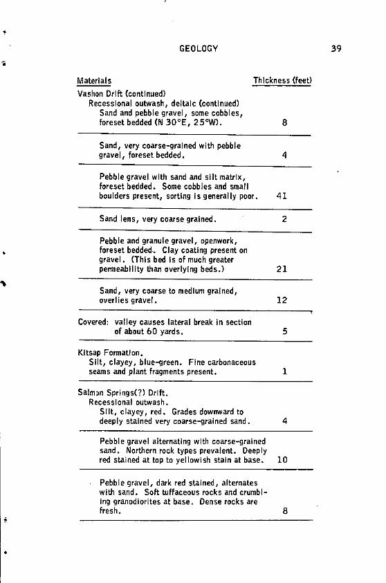
•
•
•
GEOLOGY
Materials Thickness (feet)
Vashon Drift (continued) Recessional outwash, deltalc (continued)
Sand and pebble gravel, some cobbles, foreset bedded (N 30°E, 25"W). 8
Sand, very coarse-grained with pebble gravel, foreset bedded. 4
Pebble gravel with sand and slit matrix, foreset bedded. Some cobbles and small boulders present, sorting Is generally poor. 41
Sand lens, very coarse grained. 2
Pebble and granule gravel, openwork, foreset bedded. Clay coating present on gravel. <This bed Is of much greater penneablllty than overlying beds.)
Sand, very coarse to medium grained,
21
overlies gravel. 12
Covered: valley causes lateral break In section of about 60 yards. 5
Kitsap Formation, Silt, clayey, blue-green. Fine carbonaceous seams and plant fragments present. 1
Salmon Springs(?) Drift. Recessional outwash.
Silt, clayey, red. Grades downward to deeply stained very coarse-grained sand. 4
Pebble gravel alternating with coarse-grained sand. Northern rock types prevalent. Deeply red stained at top to yellowish stain at base. 10
Pebble gravel, dark red stained, alternates with sand. Soft tuffaceous rocks and crumbling granodlorites at base. Dense rocks are fresh. 8
39
40 GEOLOGY AND GROUND-WATER RESOURCES, THURSTON CO., WASH.
Materials Thickness (feet>
Salmon Springs(?) Drift (continued) Recessional outwash (continued)
Sand with occasional thin gravel beds, red stained. Some strata of black manganese(?) staining present. 27
Covered to valley floor. 40
Altitude at top about 220 feet.
Well logs suggest that the Kitsap Formation Is beneath much of the Peninsular and Prairie Areas from the above section to about the south end of Olympia and then northward and northwestward to Include areas beneath the peninsulas.
Vashon Drift (Late Wisconsin)
Willis (1898, p. 126) first applied the name Vashon Drift to the glacial drift mantling the Tacoma area and considered It to represent the latest largescale glacial event. Vashon Drift was first studied In great detail by Bretz (1913) and was shown to mantle most of the Puget Sound lowland. Recent studies (see Easterbrook, 1963) show the existence of a younger g laciatlon originating In Canada that barely entered the State of Washington north of Bellingham; the effect of this latest Ice sheet is not evident In Thurston County.
The Vashon glacier formed In British Columbia, as did Its predecessors, and flowed southward through the Puget Sound lowland and terminated In the southern part of Thurston County some time before 14,000 years ago. This glacier Is responsible for much of the present day topography and sedimentary deposits In the Puget Sound lowland.
Colvos Sand and Vashon advance outwash--The Colvos Sand and Vashon advanCe outwash have been mapped as a single unit In this lnvestlgat1on1 on the geologic map both are shown as Vashon advance outwash. These units are most prevalent beneath the Peninsular Area and are best exposed In the beach bluffs (see figs. 7 and Bl.
The Colvos Sand was named by Molenaar (1965, p. 32) from thick deposits (as much as 300 feet) of fine- to coarse-grained glacially derived sand and subordinate gravel that rests conformably on the Kitsap Formation. The type area is on Vashon Island along Colvos Passage, where the deposits immediately underlie Vashon Drift.
In-Thurston County Colvos Sand consists of materials lithologlcally similar to those described by Molenaar. They have a maximum outcrop thickness of about 80 feet, average 30 feet or less, and blend imperceptibly Into Vashon
'
•
t
i
•
•
GEOLOGY 41
advance outwash deposits. However, well-log interpretations as shown on geologic sections A-A', B-B', and C-C' indicate that Colvos Sand Is more than 150 feet thick inland from the beach bluffs. The upper surface of the Colvos Sand has been greatly dissected either by stream cutting or glacial scour (seep. 57).
Immediately below Vashon till, which caps the beach bluffs, deposits that are true Vashon advance outwash are exposed. These deposits generally are of stratified gravel and sand. Silt and clay, representative of local ice-dammed water bodies are also present, but the overall texture of the deposits Is coarser than that of the Colvos Sand. Both Colvos Sand and Vashon advance outwash are mainly composed of unweathered material; sand deposits may be described as "salt and pepper" colored which Is typical of younger glacial outwash. Some deposits of Colvos Sand, especially where they occur south of Hunter Point, are stained red or brown but not as Intensely as Is most of the sand In the Salmon Springs(?) Drift.
The thickest observed deposits of the Colvos Sand-Vashon advance outwash sequence are on both sides of the westernmost peninsula, and especially on the east side of Gallagher Cove where about 80 feet of nearly gravel-free sand extends from the upland surface to beach level.
Vashon advance outwash may be reliably Identified only where It Is directly overlain by Vashon till. This relation Is best seen In the Peninsular Area bluffs as noted above, but It also occurs locally as far south as the Maytown Upland east of East Olympia where what Is probably advance putwash lies directly under the till-capped uplands. Logs of wells throughout much of the northern Prairie Area show sand and gravel directly beneath Vashon till; the upper part of the sand and gravel Is probably advance outwash. Colvos Sand may occur at greater depths.
Vashon till--Vashon till occurs as two varieties, ablation and subglacial tills; the origin of each Is shown In figure 9.
Ablation till Is seldom more than a few feet thick and at many places Incorporated In the soil zone. It Is preserved only in areas that have not been subjected to concentrated surface runoff; most of these areas are on higher ground that has moderately low relief. Most of the ablation till is on glaciated uplands In the central and southern part of the county. Blending with ablation till and virtually Impossible to distinguish from It is colluvlum that has accumulated on the lower slopes of till-mantled uplands. This colluvium Is mapped as till because It Is llthologically identical with ablation till and was derived from glacial drift. The ablation till Is a brown sandy and gravelly soil that commonly is accompanied by large boulders. Many of these boulders are granodiorltes of northern origin but show no evidence of having been transported by melt water. They must have had a protected journey of as much as several hundred miles while encased In, or riding upon, the Ice.
Subglacial till is commonly referred to as hardpan In drillers' logs--lt Is an unsorted deposit of gravel that Is fi""IY encased In a matrix of sandy silt and clay. Much of this type of till has the appearance, and may approach the hardness, of concrete (fig. 10). Subglacial till tends to be composed of the materials that were overridden by the glacier; thus the ratio of gravel tC!I matrix is dependtnt on the nature of the pre-existing surficial deposits and this ratio is highly variable. Most Vashon till
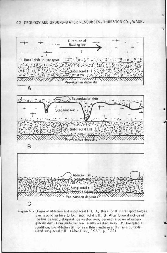
42 GEOLOGY AND GROUND-WATER RESOURCES, THURSTON CO., WASH.
A
..J.
B
c
-'
Direction of flowing ice
Stagnant ice ;-
+
F igure 9 - Origin of abl ation and subg lacial till. A, Basal drift in transport lodges over ground surface to form subg lac ial till. B, After forward mot ion of ice has ceased , stagnant ice wastes away beneath a cover of super-g lac ial drift; finer partic les are usually washed away. C, Postglacial condition; the ablation till forms a thin mantle over the more consolidated subglacial ti ll. (After Flint, 1957, p. 121)
..
•
•
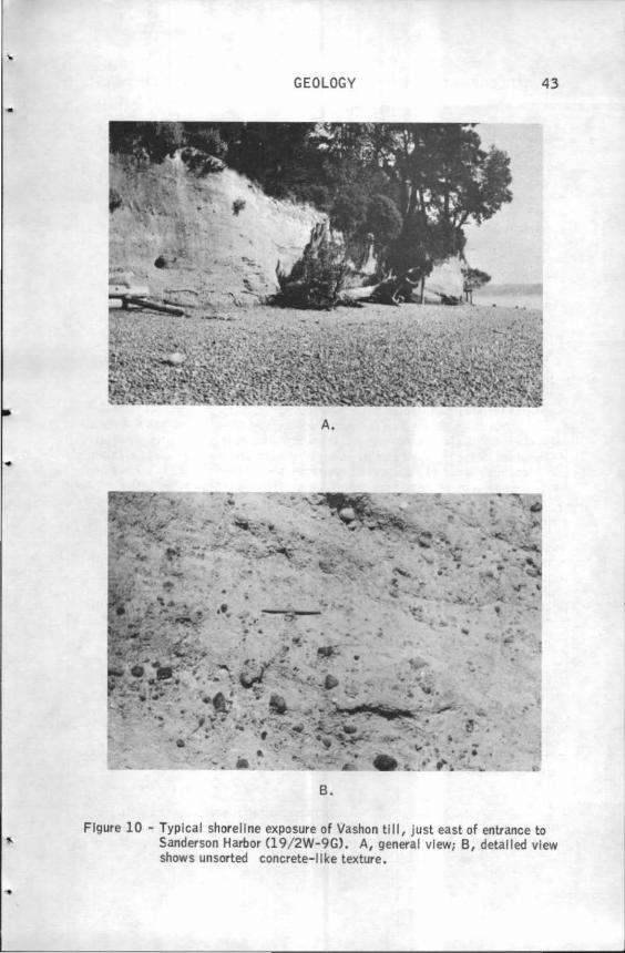
•
GEOLOGY 43
A.
B.
Figure 10 - Typical shoreline exposure of Vashon till, just east of entrance to Sanderson Harbor Cl 9/ 2W-9G). A, general view; B, detailed view shows unsorted concrete-I Ike texture.
44 GEOLOGY AND GROUND-WATER RESOURCES, THURSTON CO., WASH.
lies upon and Is derived from either Vashon advance outwash deposits or Salmon Springs(?) Drift. Because this source material Is largely stream-worked gravel, the gravel In till Is generally well rounded but may show faceting. Clay-rich till Is common In the Peninsular Area and Is best seen at Dover Point (19/2W-11Kl where It directly overlies fine-grained deposits of pre-Salmon Springs(?) deposits, Most exposures of subglaclal till south of Olympia are very gravelly; the till Is derived from the outwash gravel upon which It lies.
The mapping of Vashon till is of necessity generalized. Tiil-covered areas are usually poorly drained and have a heavy vegetation cover. Further, the exact nature of the material and Its contacts with other materials are seen at only a few places. At other places, as on Smith Prairie, a very thin and sporadic deposit of recessional outwash overlies Vashon till. The northern Peninsular Area is partially mantled with clay of glacial Lake Russell which Is mapped with Vashon till In this report. This clay Is underlain by Vashon till In most places (figs. 8 and 15) and has little effect on ground-water supplies. (See also p. 51.l
Vashon till, where shown on the geologic map, is from about 3 to 45 feet thick. In most cases It Is of the subglacial variety but at many places Is mantled by ablation till. Ablation till resting directly on pre-Vashon deposits occurs locally In the Maytown Upland.
Distinct llneatlons both In topography and vegetation on Vashon till covered areas are especially visible on aerial photographs; at least the more pronounced of these are caused by the scouring action of the Ice sheet and are parallel to the most recent direction of flow at the base of the glacier (see fig. 12). These llneatlons are shown by arrows on the geologic map, the arrowheads being at the point of maximum visual llneatlon. The arrow west of Tumwater denotes Ice striae on basalt bedrock.
An Interpretation of the configuration of t!Je Vashon glacier at Its maximum extent Is shown In figure 16. The directions of flow are derived from the topographic evidence just discussed, but the tennlnal line Is less definite because It Is reconstructed from the less straightforward geomorphlc and llthologlc criteria that were discussed In that section of the report that presented the problems of identifying the southern parts of the Salmon Springs(?) Drift (p. 30 ). The difficulties In mapping the limits of Salmon Springs(?) and Vashon Drift are the same, and any deposit Incorrectly assigned to the one glacial episode will Instead belong to the other.
The mapped distribution of Vashon till Indicates a terminus just short of the southern uplands. Most of the central area between the terminus and the Peninsular Area Is covered with Vashon recessional outwash which in most places covers Vashon till. Upon recession of the Vashon glacier, some streams draining the area cut deeply enough to remove the underlying till, but well logs Indicate that enough till remains to suggest that this is only a local feature. Most major streams during the glacial retreat were forced to aggrade rather than cut their channels and thus they preserved the underlying till.
Vashon end moralne--ln this report, end moraine means glacial drift that was deposited at the terminus of still~standlng or slowly retreating Ice. Areas of end moraine are delineated chiefly on the basis of topographic expression of the
·•
..
·•
.•
•
..
GEOLOGY 45
Vashon Drift rather than on lithology. These areas have a kame and kettle topography formed by drift deposited in contact with wasting Ice. Closed depressions (kettles) are numerous; many contain lakes but most are dry. These areas of hummocky topography are composed mainly of rudely stratified outwash sand and gravel containing local lenses or pods of till; locally this outwash material Is overlain by line sand and slit several feet thick. These deposits are similar In lithology to the Vashon recessional gravel found on adjacent terraces of the Prairie Area. There Is no true morainal ridge marking the farthest advance of the Vashon glacier In Thurston County--11 any did exist, subsequent outwash streams have removed them. All the end moraines mapped In this report are north of the inferred southernmost extent of the glacier.
Locally, end-moraine deposits are topographically lower than adjacent outwash terraces and provide evidence that large masses of Ice acted as valley sides when the glaciolluvlal deposits were being deposited. Upon further wasting of glacial ice, sand and gravel was deposited around and over remnant blocks of Ice which later melted to form numerous kettles.
The largest moralnal area Is an interlobate moraine that fanned between the westward-flowing lobe that crossed Yelm Prairie and the oouthward-llowing lobe that flowed across Hawks and Chambers Prairies. Two smaller moralnal complexes lie west of the major lnterlobate moraine. The Offutt Lake moraine In the center of the county Is not much bigger than Offutt Lake Itself which was formed by melting of a huge block of stagnant Ice left from a small lobe which protruded into the Deschutes Valley from the west. This block was subsequently covered by outwash gravels In the Deschutes-Rocky Prairie channel (fig. 16), and evidently remained unmelted for many years while this channel was In operation. Several dry kettles are present In the same area. The end moraine north of Mirna Prairie flanking the Black Hiiis has a less hummocky topography but Is distinctly different from the adjacent outwash plains (seep. 68).
In their natural state, the morainal areas have heavy forest covers whereas the adjacent outwash terraces are usually grass-covered prairies that support on!y sparse stands of trees. This Is probably due to a greater amount of finegrained material having been Incorporated in the moralnal outwash to fonn a forestsupporting soil. The open gravels of the prairies form a poorer, quickly draining soil.
Vashon recessional gravel--Durlng recession of the Vashon glacier, heavily loaded melt water streams deposited tremendous quantities of coarse gravel and sand In numerous drainage channels. These deposits are the most widespread geologic units in Thurston County. The major gravel deposits occur In the southern parts of the Prairie Area on the recessional outwash dralnageways.
The thickness of Vashon recessional gravel Is not definitely known. Gravel pits In the southern Prairie Area expose 10 to 20 feet of gravel, but bottom contacts are not exposed. Many of the exposures along the Nlsqually River banks show only a few feet of Vashon recessional gravel lying on older deposits. Many well logs note that 11 cemented gravel 11 or 11 hardpan 11 was penetrated a few feet below land surface. Some of this material was reported as till In Volume 1, but the
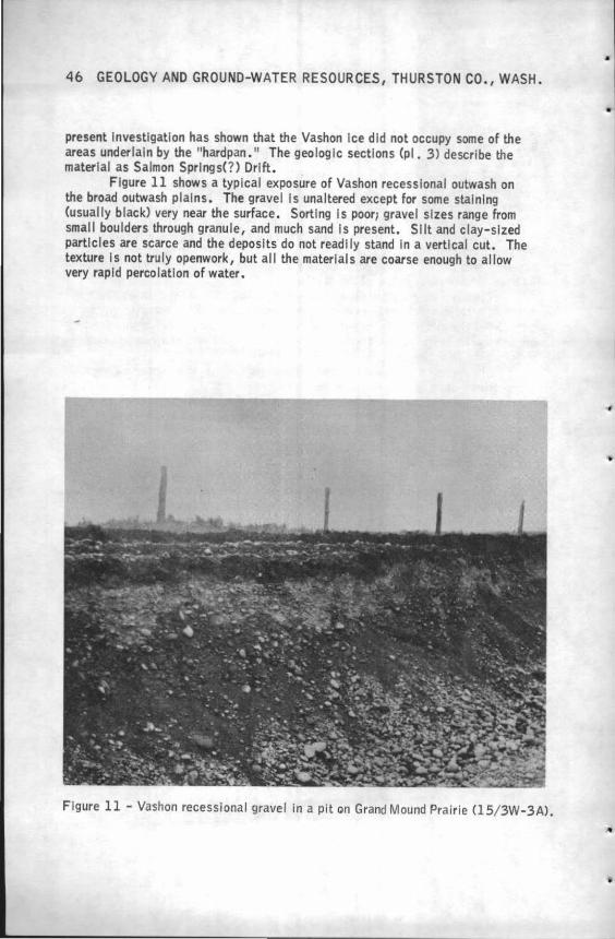
46 GEOLOGY AND GROUND-WATER RESOURCES, THURSTON CO., WASH.
present Investigation has shown that the Vashon Ice did not occupy some of the areas underlain by the "hardpan. 11 The geolog le sections (pl. 3) describe the material as Salmon Springs(?) Drift.
Figure 11 shows a typical exposure of Vashon recessional outwash on the broad outwash plains. The gravel Is unaltered except for some staining (usually black) very near the surface. Sorting Is poor; gravel sizes range from small bou lders through granule, and much sand Is present. Slit and clay-sized particles are scarce and the deposits do not read I ly stand In a vertical cut. The texture Is not truly openwork, but all the materials are coarse enough to allow very rapid percolation of water.
Figure 11 - Vashon recessional gravel in a pit on Grand Mound Prairie Cl5/ 3W-3A).
•
•
•
•.
•
•
GEOLOGY 47
The black area on the upper part of the deposit seen in figure 11 Is a darkbrown to black pebbly silt, containing no large stones and very little sand. It Is a characteristic surface deposit on the gravel outwash plains. This material constitutes the shallow soil of the gravel outwash plains and its dark color is probably due to carbonaceous staining from the prairie vegetation. The Mima mounds, the most striking small-scale topographic feature in southwestern Washington, are well developed only on black-soil-covered prairies composed of Vashon recessional gravel--they are discussed in greater detail on p. 68 and seen In figures 12, 18, and 19.
Most of the Vashon recessional gravel was deposited as valley fills. Bedding Is not sharply defined, but is easily seen and Is usually horizontal but at some places It is crossbedded. Alteration and large-scale staining are negligible. Several pebble counts from widely separated areas were made, the general average amount of rock types is shown below:
Material
Basic volcanic, mostly dense basalt
Sedimentary, mostly dark sandstone
Fine-grained porphyritic, mostly andesite
Acidic plutonic, mostly granodiorite and coarse feldspar porphyry
Siliceous, mostly vein quartz and chert
Metamorphic
Unidentified
Total
Percent
31.8
21.5
17.9
15.1
6.5
3.1 4.1
100.0
This pebble assortment cannot be expected to be duplicated In any particular place because there is a considerable variation in rock-type percentages ·throughout the county. Samples from the Penlnsular Area contain much more acidic plutonlc rocks than do samples from terraces near the Bald Hills where local basic rock types are abundant. Although not examined as thoroughly / this same relation is apparently true in Salmon Springs(?) outwash where granitic rocks made up 20 percent of one sample near Dickenson Point but are difficult to find on the old outwash terraces south of Tenino.
The surface of most of the Vashon recesslonal gravel of the Prairie Area occurs as terraces above the present streams. These terraces are numerous and have risers ranging in height from 10 feet or less to 50 feet. Figure 13 shows a
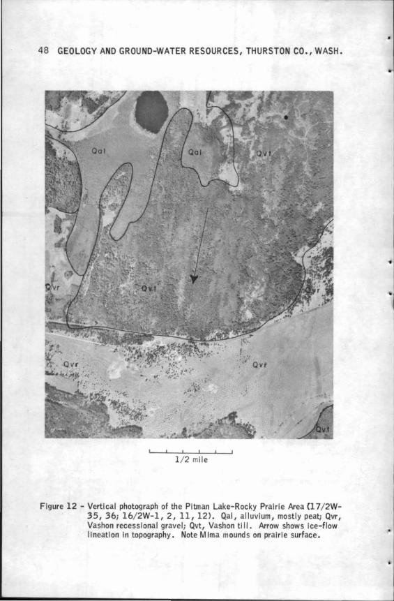
48 GEOLOGY AND GROUND-WATER RESOURCES, THURSTON CO., WASH.
1/ 2 mile
Figure 12 - Vertlcal photograph of the Pitman Lake-Rocky Prairie Area Cl 7/ 2W-35, 36; 16/ 2W-l, 2, 11, 12) . Qal, alluvium, mostly peat; Qvr, Vashon recessional gravel; Qvt, Vashon tlll. Arrow shows Ice-flow llneatlon In topography. Note Mirna mound s on prairie surface.
•
•
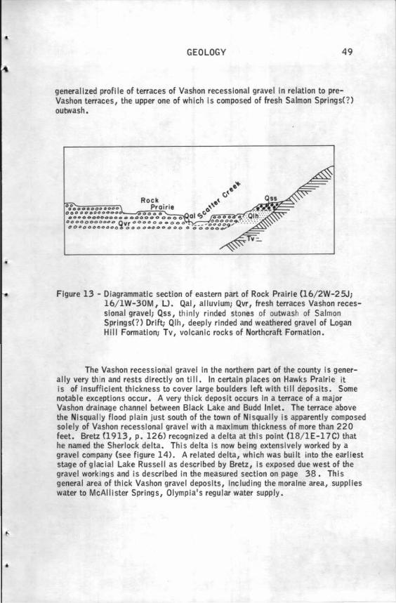
..
•
GEOLOGY 49
general I zed profl le of terraces of Vashon recessional gravel In re lat Ion to preVashon terraces, the upper one of which Is composed of fresh Salmon Springs(?) outwash .
Figure 13 - Diagrammatic section of eastern part of Rock Prai rie (16/ 2W-2 SJ; 16/ 1W-30M, U. Qal, alluvium; Qvr, fresh terraces Vashon recessional gravel, Qss, thinly rinded stones of outwash of Salmon Springs(?) Dri ft; Qlh, deeply rinded and weathered gravel of Logan H 111 Formation; Tv, volcanic rocks of Northcraft Formation.
The Vashon recessional gravel In the northern part of the county Is generally very th in and rests directly on till. In certain places on Hawks Prairie it is of Insufficient thickness to cover large boulders left with till deposits. Some notable exceptions occur. A very thick deposit occurs In a terrace of a major Vashon drainage channel between Black Lake and Budd Inlet. The terrace above the Nlsqual ly flood plain just south of the town of Nlsqually Is apparently composed solely of Vashon recessional gravel with a maximum thickness of more than 220 feet. Bretz (1913, p. 126) recognized a delta at this point Cl8/ 1E-l 7C) that he named the Sherlock delta. This delta is now being extensively worked by a gravel company (see figure 14). A related delta, which was built into the earliest stage of glacial Lake Russell as described by Bretz, Is exposed due west of the gravel workings and is described In the measured section on page 38. This general area of thick Vashon gravel deposits, Including the moraine area, supplies water to McAllister Springs, Olympia's regular water supply •
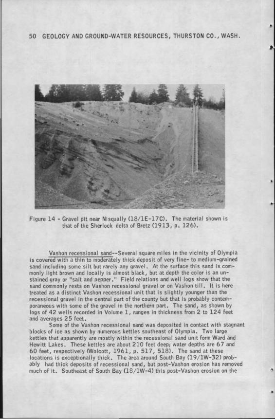
50 GEOLOGY AND GROUND-WATER RESOURCES, THURSTON CO., WASH.
F igure 14 - Gravel pit near Nlsqually (18/ 1E-l 7C). The material shown Is that of the Sherlock delta of Bretz (1913, p. 126).
Vashon recessional sand--Several square miles in the vicinity of Olympia is covered with a thin to moderately thick deposit of very fine- to medium-grained sand Including some slit but rarely any gravel. At the surface this sand Is commonly light brown and locally is almost black, but at depth the color Is an unstained gray or "salt and pepper." Field relations and wel I fogs show that the sand commonly rests on Vashon recessional gravel or on Vashon till. It Is here treated as a distinct Vashon recessional unit that Is slightly younger than the recessional gravel In the central part of the county but that Is probably contemporaneous with some of the gravel in the northern part. The sand, as shown by logs of 42 wells recorded in Volume l, ranges in thickness from 2 to 124 feet and averages 25 feet.
Some of the Vashon recessional sand was deposited In contact with stagnant blocks of ice as shown by numerous kettles southeast of Olympia. Two large kettles that apparently are mostly within the recessional sand unit form Ward and Hewitt Lakes. These kettles are about 210 feet deep; water depths are 6 7 and 60 feet, respectively <Wolcott, 1961, p. 51 7, 518). The sand at these locations Is exceptionally thick . The area around South Bay (19/ lW-32) probably had thick deposits of recessional sand, but post-Vashon erosion has removed much of It. Southeast of South Bay (18/ lW-4) this post-Vashon erosion on the
•
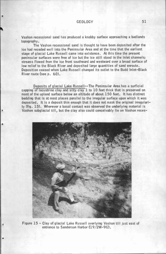
•
•
•
GEOLOGY 51
Vashon recessional sand has produced a knobby surface approaching a badlands topography.
The Vashon recessional sand Is thought to have been deposited after the Ice had receded well Into the Peninsular Area and at the time that the earliest stage of glacial Lake Russell came Into existence. At this tlme the present pen insular surfaces were free of Ice but the Ice still stood In the Inlet channels; streams flowed from the ice front southward and westward over a broad surface of low relief to the Black River and deposited large quantities of sand enroute. Deposition ceased when Lake Russell changed Its outlet to the Budd Inlet-Black River route (seep. 60).
Deposits of glacial Lake Russell--The Peninsular Area has a surflclal capping of lacustrlne clay and silty clay 1 to 10 feet thick that Is preserved on most of the upland surface below an altitude of about 150 feet. It has distinct bedd ing that Is at most places parallel to the Irregular surface upon whlch it was deposited. It Is a deposit thin enough that lt does not mask the original Irregularity (fig. 15). Wherever a basal contact was observed the underlying material Is Vashon subglaclal till, but the clay also could concelvably lie on Vashon reces-
Figure 15 - Clay of glacial Lake Russell overlying Vashon till just east of entrance to Sanderson Harbor Cl 9/ 2W-9G).
52 GEOLOGY AND GROUND-WATER RESOURCES, THURSTON CO., WASH.
slonal outwash sand or gravel. This material Is mapped with Vashon till and It probably has similar water-transmitting properties although It Is above the water ta.ble.
These lake deposits, not formally named, are thought to have been deposited In glacial Lake Russell as named by Bretz 0910) and more fully described In his later work (1913, p. 122, 123) which Is quoted here. (See also p. 60 .)
"But in Puget Sound all water escaping from glacial lakes In the different valleys was forced to pass over the Chehalis-Sound divide into one drainage line. The result of this control of glacial drainage by one pass was to limit subsidence of ponded waters whose valleys had successively lower outlets exposed by Ice retreat. Gradually, waters In the troughs and fiords of sufficient depth in the southern part of the area united at a common level; that determined by the present Chehalis-Sound divide east of the Black Hills. The water body whose level was thus controlled has been named Lake Russell. Its Inception was coeval with glacial retreat from Budds Inlet, the most southern arm of Puget Sound. Its maximum was attained just before its final disappearance, the lake then extending from Olympia nearly to Everett, a distance of at least fifty miles."
The common level of Bretz was about 160 feet above present sea level and represents a lake level draining by way of the Black River (seep. 60 ). Bretz made little mention of lacustrlne deposits in the lake, but those seen In this Investigation occur as high as 160 feet and are never seenhlgher, suggesting additional evidence for a maximum major shoreline altitude of 160 feet for the lake. Bretz mentioned that thin, unfossillferous clays occur In the Peninsular Area but believed that they owed their origin to post-Vashon marine submergence rather than to glacial Lake Russell. He suspected the existence of a short lived higher shoreline of about 200 feet on the basis of a delta surface altitude of 200 feet near Tacoma. This higher level, Bretz believed, was caused by a readvance of the Vashon glacier about to Lacey, south of Olympia. This Investigation has uncovered no field evidence that the readvance took place and the lake clays are thought to be representative of the maximum stand of Lake Russell in this area after It had become large enough to discharge through the Black River from Budd Inlet.
Recent Alluvium
Most of the present flood plains are mapped as Recent alluvium and consist mainly of silt and sand and some gravel deposited after the complete recession of the Vashon Ice sheet. At many places, peat deposits are incorporated with the alluvium and have not been mapped separately.
The most extensive alluvial deposits are In the downstream areas of the Ni squally and Deschutes Rivers, the headwaters of the Black River, and north of
•
;,
·•
•
..
•
GEOLOGY 53
Michigan Hill on the flood plain of the Chehalis River. The Nisqually River deposits consist typically of very dark sand whose mineral composition indicates that Is was derived from Mount Rainier; the sand Is mlneralogically similar to that of the Kitsap Formation. The Deschutes River deposits are lighter colored and contain much reworked glacial outwash. The Black R,iver flows through broad thick peat deposits from Black Lake to just north of Little Rock. This peaty swamp Is mapped as Recent alluvium.
Recent alluvium not deposited by modern streams occurs as marine alluvium at the heads of Henderson and Totten Inlets and as lacustrine deposits, many of them peaty, deposited in shallow lakes that recently have become dry. The deposits mapped as Recent alluvium In the southward-trending valleys west and south of Bucoda are of Pleistocene origin except the uppermost layer. These valleys were originally more deeply cut to flow into a deeper Skookumchuck Valley before Vashon time. Vashon outwash aggraded the Skookumchuck Valley and caused flooding of the tributary valleys which subsequently filled with alluvial materials and peat. Thus, most of the fill is directly related to Vashon recessional out-wash but is completely local in origin. A similar relation occurs In the westwardtrending valley heading at Tono (15/lW-20) and its south fork, Hanaford Creek, in Lewis County. ·
In most places, the alluvium is a shallow valley fill covering the underlying deposits. The alluvium of the Nisqually deltaic area and the Black River swamps is thicker; just south of Black Lake the peat is more than 30 feet thick (Rigg, 1958, p. 218).
GEOLOGIC HISTORY
Tertiary Period
The deposits of the Mcintosh Formation of middle and late Eocene age provide the earliest geologic record in Thurston County. During this time the area was submerged beneath shallow, warm seas, but intermittent volcanism added basaltic and tuffaceous materials to the marine deposits. Toward the close of Mcintosh time volcanism apparently Increased and thick flows of basaltic and andesltlc lavas were laid down both above and below the sea. Water-laid sediments derived from these lavas were also deposited throughout the entire region. All the Eocene materials were deposited in a northward-trending geosyncline; in its upwarped margins volcanic activity was taking place CSna11ety and others, 1958, p. 84). By late Eocene time volcanic activity had lessened considerably and thick deposits of the lnterfingerlng marine and nonmarlne Skookumchuck Formation succeeded by those of the Lincoln Formation of Weaver (1912) (Oligocene) were laid down. During all of this early Tertiary time subsidence and deposition were about equal so that most of the materials were deposited In shallow seas.
In the Miocene Epoch there was an uplift of the ancestral Cascade Range, at that time a northwestward-trending range. The western part of the lowlands were still inundated by shallow seas, but large amounts of sand and gravel were being deposited on the piedmont areas to the east. Eventually nonmarine sediments and
54 GEOLOGY AND GROUND-WATER RESOURCES, THURSTON CO., WASH.
crustal deformation forced a retreat of the Miocene seas from the southwestern part of the county. During the close of the Miocene and much of the Pliocene Epoch the mountain ranges were subjected to erosion that reduced their altitude considerably. The detritus carried from the mountains was being deposited nearby as piedmont deposits represented Jn part by the Mashel Formation. Toward the end of Pliocene time the Miocene Cascades and the Black Hills had been reduced to a surface of gentle relief and subjected to laterltic weathering in many places.
In Pliocene(?) time the Cascades were uplifted anew and attained their present north-south alinement. The Olympic mountains were probably uplifted at this time also. The Puget Trough was simultaneously downwarped and renewed erosion and deposition began. Table 4 (p. 55) summarizes the Tertiary history.
Quaternary Period
Pleistocene Epoch Until Wisconsin Age
Jn Thurston County the earliest Pleistocene events were similar to those that occurred in late Pliocene--contlnued uplift of the adjacent mountains and deposition of flu vial sediments on the adjacent piedmont areas. However, cooling climates caused the formation of mountain glaciers which extended toward the lowlands and caused development of an ice sheet Jn the mountains of British Columbia. The location and extent of these earliest glaciers are little known, but they are believed to have diverted drainages from northern areas southward through Thurston County whereas previous drainage had been northerly. The deposits laid down during this time are not thought to be chiefly of glacial origin. Rather, they are thought to be a normal continuation of terrestrial deposits derived from the adjacent mountainous areas. At least the upper part of the Logan Hill Fonnatlon was deposited during this time.
Early Pleistocene glaciation ceased with the advent of a warmer climate that probably prevailed for many tens of thousands of years. This warmer climate probably represents the longest time interval of the Pleistocene Epoch as shown by the deep residual clay produced by mechanical and chemical weathering of the surface deposits. The topography of the lowland and piedmont areas approached maturity--valleys were broad, the nonmountainous uplands were gently rolling, and streams probably developed wide flood plains. Sometime during this Interval a later pre-Wisconsin glacier, of unknown extent, appears to have Invaded the northern part of the county. Then nonglacial conditions reoccurred.
Sometime before the latest pre-Wisconsin interglacial age Mount Rainier came Into existence. Most of this Interglacial age probably was similar to the preceding one, but toward the close of this time, conditions had radically changed, such that canyon cutting began in the Puget Sound lowland. This canyon cutting probably started as a result of regional uplift, but the lowering of sea level due to the growth of the Salmon Springs(?) glacier may have been partly responsible- The homoclinal structure seen in the pre-Salmon Springs(?) deposits of the Peninsular Area may have been formed during this pre-Wisconsin uplift (p. 24).
•
•
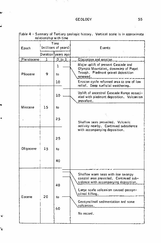
GEOLOGY 55
""able 4 - Summary of Tertiary geologic history. Vertical scale is in approximate relationship with time
Time
Epoch (millions of years) Events
Duration years ago
Pleistocene 1 0 to 1 Glaciation and erosion
1 -Major uplift of present Cascade and Olympia Mountains, downwarp of Puget
Pliocene 9 to Trough. Piedmont gravel deposition renewed.
10 Erosion cycle reformed area to one of low relief. Deep surficial weathering.
10 -Uplift of ancestral Cascade Range associ-
~ ated with piedmont deposition. Volcanism prevalent • ..
Miocene 15 to
25 Shallow seas prevailed. Vulcanic activity nearby. Continued subsidence with accompanying deposition.
25
Oligocene 15 to
40
-
-\'\Shallow warm seas with low swampy
coastal area prevailed. Continued sub-sidence with accomoanving deposition.
40 Large scale volcanism caused geosyn-
Eocene 20 clinal filling.
to -
I Geosynclinal sedimentation and some volcanism.
I
60 No record.
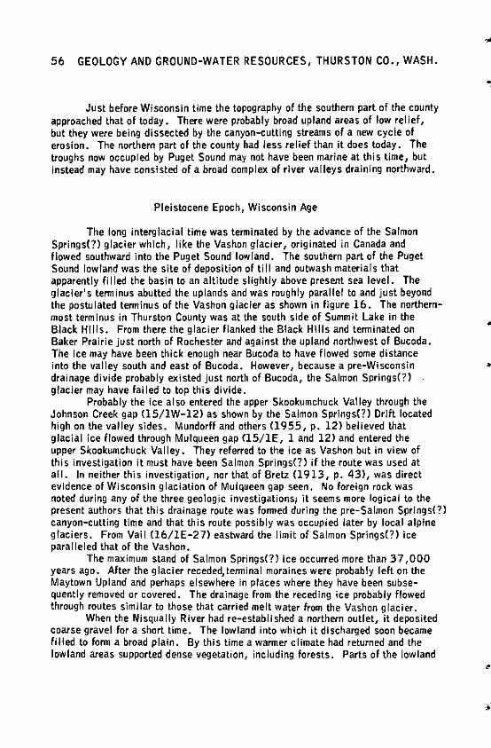
56 GEOLOGY AND GROUND-WATER RESOURCES, THURSTON CO., WASH.
Just before Wisconsin time the topography of the southern part of the county approached that of today. There were probably broad upland areas of low relief, but they were being dissected by the canyon-cutting streams of a new cycle of erosion. The northern part of the county had less relief than it does today. The troughs now occupied by Puget Sound may not have been marine at this time, but instead may have consisted of a broad complex of river valleys draining northward.
Pleistocene Epoch, Wisconsin Age
The long interglacial time was terminated by the advance of the Salmon Springs(?) glacier which, like the Vashon glacier, originated in Canada and flowed southward into the Puget Sound lowland. The southern part of the Puget Sound lowland was the site of deposition of till and outwash materials that apparently Ii lied the basin to an altitude slightly above present sea level. The glacier's tenninus abutted the uplands and was roughly parallel to and just beyond the postulated terminus of the Vashon glacier as shown in figure 16. The northernmost terminus in Thurston County was at the south side of Summit Lake in the Black Hills. From there the glacier flanked the Black Hills and terminated on Baker Prairie just north of Rochester and against the upland northwest of Bucoda. The Ice may have been thick enough near Bucoda to have flowed some distance into the valley south and east of Bucoda. However, because a pre-Wisconsin drainage divide probably existed just north of Bucoda, the Salmon Springs(?) glacier may have failed to top this divide.
Probably the ice also entered the upper Skookumchuck Valley through the Johnson Creek gap (15/lW-12) as shown by the Salmon Springs(?) Drift located high on the valley sides. Mundorf! and others (1955, p, 12) believed that glacial ice flowed through Mulqueen gap (15/lE, 1 and 12) and entered the upper Skookumchuck Valley. They referred to the ice as Vashon but in view of this investigation it must have been Salmon Springs(?) ii the route was used at all. In neither this investigation, nor that of Bretz <1913, p. 43), was direct evidence of Wisconsin glaciation of Mulqueen gap seen. No foreign rock was noted during any of the three geologic investigations; it seems more logical to the present authors that this drainage route was formed during the pre-Salmon Springs(?) canyon-cutting time and that this route possibly was occupied later by local alpine glaciers. From Vail (16/lE-27) eastward the limit of Salmon Springs(?) ice paralleled that of the Vashon.
The maximum stand of Salmon Springs(?) Ice occurred more than 37 ,000 years ago. After the glacier receded, terminal moraines were probably left on the Maytown Upland and perhaps elsewhere in places where they have been subsequently removed or covered. The drainage from the receding ice probably flowed through routes similar to those that carried melt water from the Vashon glacier.
When the Nisqually River had re-established a northern outlet, it deposited coarse gravel for a short time. The lowland into which it discharged soon became filled to form a broad plain. By this time a warmer climate had returned and the lowland areas supported dense vegetation, including forests. Parts of the lowland
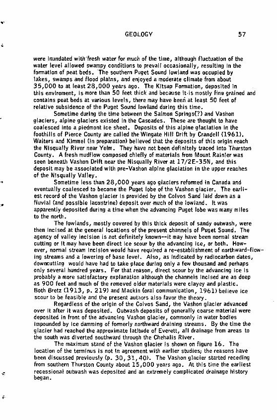
..
..
•
GEOLOGY 57
were Inundated with'fresh water for much of the time, although fluctuation of the water level allowed swampy conditions to prevail occasionally, resulting In the fonnatlon of peat beds. The southern Puget Sound lowland was occupied by lakes, swamps and flood plains, and enjoyed a moderate climate from about 35,000 to at least 28,000 years ago. The Kitsap Fonnation, deposited In this envlroment, Is more than 50 feet thick and because it, is mostly fin• grained and contains peat beds at various levels, there may have beeri at least 50 feet of relative subsidence of the Puget Sound lowland during this lime.
Sometime during the time between the Salmon Springs(?) and Vashon glaciers, alpine glaciers existed In the Cascades. These are thought to have coalesced Into a piedmont Ice sheet. Deposits of this alpine glaciation in the foothills of Pierce County are called the Wingate Hill Drift by Crandell (1961). Walters and Kimmel On preparation) believed that the deposits of this origin reach the NI squally River near Yelm. They have not been definitely traced Into Thurston County. A fresh mudflow composed chiefly of materials from Mount Rainier was seen beneath Vashon Drift near the Nlsqually River at l 7/2E-35N, and this deposit may be associated with pre-Vashon alpine glaciation in the upper reaches of the Nisqually Valley.
Sometime less than 28,000 years ago glaciers reformed in Canada and eventually coalesced to become the Puget lobe of the Vashon glacier. The earliest record of the Vashon glacier Is provided by the Colvos Sand laid down as a fluvlal (and possible lacustrlne) deposit over much of the lowland. It was apparently deposited during a time when the advancing Puget lobe was many miles to the north.
The lowlands, mostly covered by this thick deposit of sandy outwash, were then Incised at the general locations of the present channels of Puget Sound. The agency of valley incision is not definitely known--it may have been nonnal stream cutting or It may have been direct Jee scour by the advancing ice, or both. How-ever, normal stream incision would have required a re-establishment of northward-flowing streams and a lowering of base level. Also, as Indicated by radiocarbon dates, downcutting would have had to take place during only a few thousand and perhaps only several hundred years. For that reason, direct scour by the advancing ice Is probably a more satisfactory explanation although the channels Incised are as deep as 900 feet and much of the removed older materials were clayey and plastic. Both Bretz Cl913, p. 219) and Mackin Coral communication, 1961) believe ice scour to be feasible and the present authors also favor the theory.
Regardless of the origin of the Colvos Sand, the Vashon glacier advanced over It after It was deposited. Outwash deposits of generally coarse material were deposited In front of the advancing Vashon glacier, commonly in water bodies Impounded by Ice damming of fonnerly northward draining streams. By the time the glacier had reached the approximate latitude of Everett, all drainage from areas to the south was diverted southward through the Chehalis River.
The maximum stand of the Vashon glacier is shown on figure 16. The locatlon of the terminus Is not In agreement with earlier studies; the reasons have been discussed previously (p. 30, 31, 40). The Vashon glacier started receding from southern Thurston County about 15,000 years ago. At this time the earliest recessional outwash was deposited and an extremely complicated drainage history began.
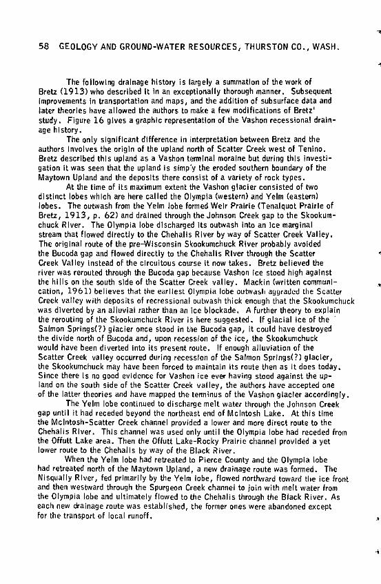
58 GEOLOGY AND GROUND-WATER RESOURCES, THURSTON CO., WASH.
The following drainage history is largely a summation of the work of Bretz (1913) who described It In an exceptionally thorough manner. Subsequent Improvements In transportation and maps, and the addition of subsurface data and later theories have allowed the authors to make a few modifications of Bretz' study. Figure 16 gives a graphic representation of the Vashon recessional drainage h I story.
The only significant difference in interpretation between Bretz and the authors Involves the origin of the upland north of Scatter Creek west of Tenino. Bretz described this upland as a Vashon tennlnal moraine but during this Investigation It was seen that the upland Is simply the eroded southern boundary of the Maytown Upland and the deposits there consist of a variety of rock types.
At the time of Its maximum extent the Vashon glacier consisted of two distinct lobes which are here called the Olympia (western) and Yelm (eastern) lobes. The outwash from the Yelm lobe formed Weir Prairie CTenalquot Prairie of Bretz, 1913, p. 62) and drained through the Johnson Creek gap to the Skookumchuck River. The Olympia lobe discharged Its outwash Into an Ice marginal stream that flowed directly to the Chehalis River by way of Scatter Creek Valley. The original route of the pre-Wisconsin Skookumchuck River probably avoided the Bucoda gap and flowed directly to the Chehalis River through the Scatter Creek Valley Instead of the circuitous course It now takes. Bretz believed the river was rerouted through the Bucoda gap because Vashon ice stood high against the hi 11 s on the south side of the Scatter Creek valley. Mackin (written communication, 1961) believes that the earliest Olympia lobe outwash aggraded the Scatter Creek valley with deposits of recressional outwash thick enough that the Skookumchuck was diverted by an alluvial rather than an ice blockade. A further theory to explain the rerouting of the Skookumchuck River is here suggested. If glacial ice of the · Salmon Springs(?) glacier once stood In the Bucoda gap, it could have destroyed the divide north of Bucoda and, upon recession of the ice, the Skookumchuck would have been diverted Into its present route. If enough alluviation of the Scatter Creek valley occurred during recession of the Salmon Springs(?) glacier, the Skookumchuck may have been forced to maintain its route then as it does today. Since there ls no good evidence for Vashon ice ever having stood against the up-land on the south side of the Scatter Creek valley, the authors have accepted one of the latter theories and have mapped the tenninus of the Vashon glacier accordingly.
The Yelm lobe continued to discharge melt water through the Johnson Creek gap until it had receded beyond the northeast end of Mcintosh Lake. At this time the Mcintosh-Scatter Creek channel provided a lower and more direct route to the Chehalis River. This channel was used only until the Olympia lobe had receded from the Offutt Lake area. Then the Offutt Lake-Rocky Prairie channel provided a yet lower route to the Chehalis by way of the Black River.
When the Yelm lobe had retreated to Pierce County and the Olympia lobe had retreated north of the Maytown Upland, a new drainage route was formed. The Nisqually River, fed primarily by the Yelm lobe, flowed nortl'ward toward the ice front and then westward through the Spurgeon Creek channel to join with melt water from the Olympia lobe and ultimately flowed to the Chehalis through the Black River. As each new drainage route was established, the former ones were abandoned except for the transport of local runoff.
·•
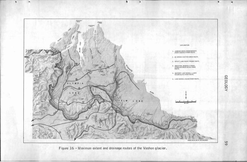
..
Figure 16 - Maximum extent and drainage routes ot the Vashon glacier.
I ..,,.Clffl·~ICOOIMfCllUCC . •Mt.QllllAtA lr'IC.l IOIHI.
•
C')
l'T1 0 r 0 C')
-<
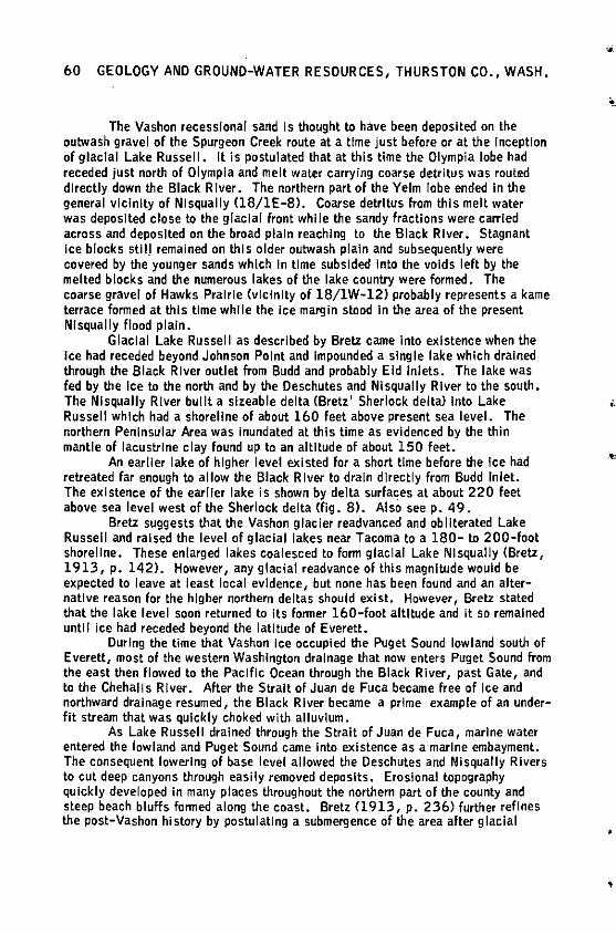
60 GEOLOGY AND GROUND-WATER RESOURCES, THURSTON CO., WASH.
The Vashon recessional sand is thought to have been deposited on the outwash gravel of the Spurgeon Creek route at a time just before or at the Inception of glacial Lake Russell. It is postulated that at this time the Olympia lobe had receded just north of Olympia and melt water carrying coarse detritus was routed directly down the Black River. The northern part of the Yelm lobe ended In the general vicinity of Ni squally (18/lE-8>. Coarse detritus from this melt water was deposited close to the glacial front while the sandy fractions were carried across and deposited on the broad plain reaching to the Black River. Stagnant Ice blocks still remained on this older outwash plain and subsequently were covered by the younger sands which In time subsided Into the voids left by the melted blocks and the numerous lakes of the lake country were formed. The coarse gravel of Hawks Prairie (vicinity of 18/lW-12) probably represents a kame terrace formed at this time while the ice margin stood In the area of the present Nlsqually flood plain.
Glacial Lake Russell as described by Bretz came Into existence when the Ice had receded beyond Johnson Point and Impounded a single lake which drained through the Black River outlet from Budd and probably Eld Inlets. The lake was fed by the Ice to the north and by the Deschutes and Nisqually River to the south. The Nisqually River built a sizeable delta (Bretz' Sherlock delta) Into Lake Russell which had a shoreline of about 160 feet above present sea level. The northern Peninsular Area was inundated at this time as evidenced by the thin mantle of iacustrlne clay found up to an altitude of about 150 feet.
An earlier lake of higher level existed for a short time before the Ice had retreated far enough to allow the Black R Iver to drain directly from Budd Inlet. The existence of the earlier lake is shown by delta surfaces at about 220 feet above sea level west of the Sherlock delta Cfig. 8). Also seep. 49.
Bretz suggests that the Vashon glacier readvanced and obliterated Lake Russell and raised the level of glacial lakes near Tacoma to a 180- to 200-foot shoreline. These enlarged lakes coalesced to form glacial Lake Nlsquaily (Bretz, 1913, p. 142). However, any glacial readvance of this magnitude would be expected to leave at least local evidence, but none has been found and an alternallve reason for the higher northern deltas should exist. However, Bretz stated that the lake level soon returned to its former 160-foot altitude and it so remained untl I ice had receded beyond the latitude of Everett.
During the time that Vashon Ice occupied the Puget Sound lowland south of Everett, most of the western Washington drainage that now enters Puget Sound from the east then flowed to the Pacific Ocean through the Black River, past Gate, and to the Chehalis River. After the Strait of Juan de Fuca became free of Ice and northward drainage resumed, the Black River became a prime example of an underfit stream that was quickly choked with alluvium.
As Lake Russell drained through the Strait of Juan de Fuca, marine water entered the lowland and Puget Sound came Into existence as a marine embayment. The consequent lowering of base level allowed the Deschutes and Ni squally Rivers to cut deep canyons through easily removed deposits. Erosional topography quickly developed in many places throughout the northern part of the county and steep beach bluffs fanned along the coast. Bretz (1913, p. 236) further refines the post-Vashon history by postulating a submergence of the area after glacial
•
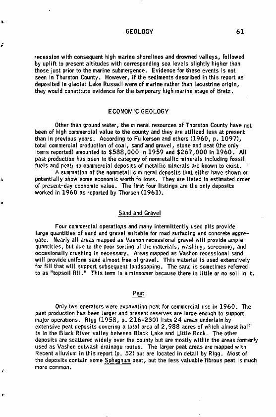
;
•
GEOLOGY 61
recession with consequent high marine shorelines and drown.O valleys, followed by uplift to present altitudes with corresponding sea levels slightly higher than those just prior to the marine submergence. Evidence for these events Is not seen In Thurston County. However, If the sediments described In this report as deposited In glacial Lake Russell were of marine rather than lacustrine origin, they would constitute evidence for the temporary high marine stage of Bretz.
ECONOMIC GEOLOGY
Other than ground water, the mineral resources of Thurston County have not been of high commercial value to the county and they are utilized less at present than In previous years. According to Fulkerson and others (1960, p. 1097), total commercial production of coal, sand· and gravel, stone and peat (the only Items reported) amounte< to $588,000 In 1959 and $267 ,000 In 1960. All past production has been In the category of nonmetallic minerals Including fossil fuels and peat; no commercial deposits of metallic minerals are known to exist. ·
A summation of the nonmetallic mineral deposits that either have shown or potentially show some economic worth follows. They are listed In estimated order of present-day economic value. The first four listings are the only deposits worked In 1960 as reported by Thorsen (1961) •
Sand and Gravel
Four commercial operatlOJlS and many lntennlttently used pits provide large quantities of sand and gravel suitable for road surfacing and concrete aggregate. Nearly all areas mapp.O as Vashon recessional gravel will provide ample quantities, but due to the poor sorting of the materials, washing, screening, and occasionally crushing is necessary. Areas mapped as Vashon recessional sand will provide uniform sand almost free of gravel. This material Is used extensively for fill that will support subsequent landscaping. The sand is sometimes referr.O to as "topsoil fill." This tenn Is a misnomer because there is little or no soil In it.
Peat
Only two operators were excavating peat for commercial use In 1960. The past production has been larger and present reserves are large enough to support major operations. Rigg (1958, p. 216-230) lists 24 areas underlain by extensive peat deposits covering a total area of 2, 988 acres of which almost half Is In the Black River valley between Black Lake and Little Rock. The other deposits are scattere< widely over the county but are mostly within the areas fonnerly used as Vashon outwash drainage routes. The larger peat areas are mapped with Recent alluvium In this report (p. 52) but are located In detail by Rigg. Most of the deposits contain some Sphagnum peat, but the less valuable "fibrous peat Is much more common.
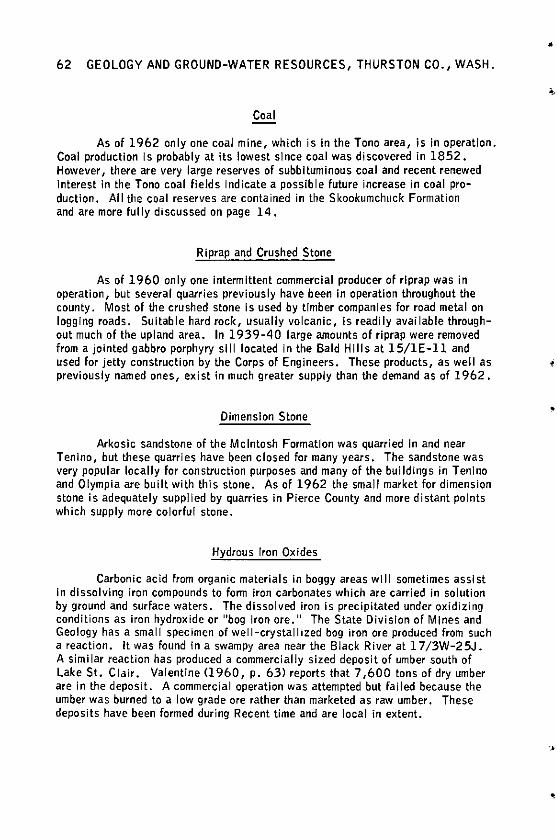
62 GEOLOGY AND GROUND-WATER RESOURCES, THURSTON CO., WASH.
Coal
As of 1962 only one coal mine, which is in the Tona area, is in operation. Coal production Is probably at its lowest since coal was discovered in 1852. However, there are very large reserves of subbituminous coal and recent renewed Interest in the Tona coal fields indicate a possible future increase in coal production. All the coal reserves are contained in the Skookumchuck Formation and are more fully discussed on page 14.
Riprap and Crushed Stone
As of 1960 only one intermittent commercial producer of rlprap was in operation, but several quarries previously have been in operation throughout the county. Most of the crushed stone Is used by timber companies for road metal on logging roads. Suitable hard rock, usually volcanic, is readily available throughout much of the upland area. In 1939-40 large amounts of rlprap were removed from a jointed gabbro porphyry sill located in the Bald Hills at 15/lE-ll and used for jetty construction by the Corps of Engineers. These products, as well as previously named ones, exist in much greater supply than the demand as of 1962.
Dimension Stone
Arkosic sandstone of the Mcintosh Formation was quarried In and near Tenino, but these quarries have been closed for many years. The sandstone was very popular locally for construction purposes and many of the buildings in Tenino and Olympia are built with this stone. As of 1962 the small market for dimension stone is adequately supplied by quarries in Pierce County and more distant points which supply more colorful stone.
Hydrous Iron Oxides
Carbonic acid from organic materials in boggy areas will sometimes assist in dissolving iron compounds to fonn iron carbonates which are carried in solution by ground and surface waters. The dissolved iron is precipitated under oxidizing conditions as iron hydroxide or 11bog iron ore. 11 The State Division of Mines and Geology has a small specimen of well-crystallized bog iron ore produced from such a reaction. It was found in a swampy area near the Black River at l 7/3W-25J. A similar reaction has produced a commercially sized deposit of umber south of Lake St. Clair. Valentine Cl 960, p. 63) reports that 7, 600 tons of dry umber are In the deposit. A commercial operation was attempted but failed because the umber was burned to a low grade ore rather than marketed as raw umber. These deposits have been formed during Recent time and are local in extent.
•
i
•
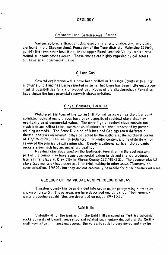
•
GEOLOGY 63
Orriamental and Semiprecious Stones
Various colored slliceous rocks 1 especially chert, chalcedony, and opal, are found in the Skookumchuck Fonnation of the Tona district. Valentine (1960, p. 44) lists two other localities, in the upper Skookumchuck Valley, where ornamental siliceous stones occur. These stones are highly regarded by collectors but have small commercial value.
Oil and Gas
Several exploration wells.have been drilled in Thurston County with minor showings of oil and gas being reported in some, but there has been little encouragement of possibilities for major production. Rocks of the Skookumchuck Fonnation have shown the best potential reservoir characteristics.
Clays, Bauxites, Laterltes
Weathered surfaces of the Logan Hill Formation as well as the older con." solidated rocks at many places have thick deposits of residual clays that may eventually be of commercial value. The more highly leached clays contain too much Iron and silica to be important as aluminum ore when processed by present refining methods. The State Division of Mines and Geology ran a differential thermal analysis on residual clays collected by the authors at the northeast corner of 17 /1W-29H. The results indicated high kaolin content and no gibbsite which is one of the primary bauxite minerals. Deeply weathered soils on the volcanic rocks are iron rich but are not of ore quality.
Residual clay developed on the Northcraft Formation in the southeastern part of the county may have some commercial value; brick and tile are produced from similar clays at Clay City in Pierce County (17 /4 E-2 5). The younger glacial clays (sedimentary) have been used for brick making in other areas (Thorsen, oral communication, 1962), but they are not ordinarily desirable for other commercial uses.
GEOLOGY OF INDIVIDUAL GEOHYDROLOGIC AREAS
Thurston County has been divided into seven major geohydrologic areas as shown on plate 5. These areas are here described geologically. Their groundwater producing capabilities are described on pages 89-101.
Bald Hills
Virtually all of t:1e area within the Bald Hills mapped as Tertiary volcanic rocks consists of basalt, andesite, and related s.edimentary deposits of the Northcraft Formation. In most exposures, the volcanic rock is very dense and may be
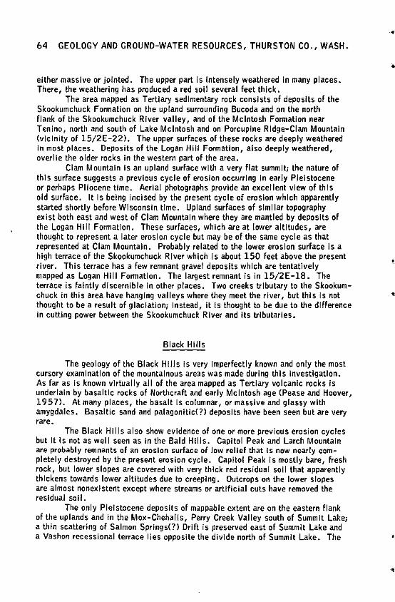
64 GEOLOGY ANO GROUND-WATER RESOURCES, THURSTON CO., WASH.
either massive or jointed. The upper part is Intensely weathered In many places. There, the weathering has produced a red soil several feet thick.
The area mapped as Tertiary sedimentary rock consists of deposits of the Skookumchuck Formation on the upland surrounding Bucoda and on the north flank of the Skookumchuck River valley, and of the Mcintosh Formation near Tenino, north and south of Lake Mcintosh and on Porcupine Ridge-Clam Mountain (vicinity of 15/2E-22). The upper surfaces of these rocks are deeply weathered In most places. Deposits of the Logan Hill Formation, also deeply weathered, overlie the older rocks In the western part of the area.
Clam Mountain Is an upland surface with a very flat summit; the nature of this surface suggests a previous cycle of erosion occurring In early Pleistocene or perhaps Pliocene time. Aerial photographs provide an excellent view of this old surface. It Is being incised by the present cycle of erosion which apparently started shortly before Wisconsin time. Upland surfaces of similar topography exist both east and west of Clam Mountain where they are mantled by deposits of the Logan Hill Formation. These surfaces, which are at lower altitudes, are thought to represent a later erosion cycle but may be of the same cycle as that represented at Clam Mountain. Probably related to the lower erosion surface Is a high terrace of the Skookumchuck River which Is about 150 feet above the present river. This terrace has a few remnant gravel deposits which are tentatively mapped as Logan Hill Formation. The largest remnant is in 15/2E-18. The terrace is faintly discernible In other places. Two creeks tributary to the Skookumchuck In this area have hanging valleys where they meet the river, but this Is not thought to be a result of glaciation; Instead, It Is thought to be due to the difference In cutting power between the Skookumchuck River and Its tributaries.
Black Hills
The geology of the Black Hills Is very Imperfectly known and only the most cursory examination of the mountainous areas was made during this investigation. As far as is known virtually all of the area mapped as Tertiary volcanic rocks Is underlain by basaltic rocks of Northcraft and early Mcintosh age (Pease and Hoover, 1957). At many places, the basalt Is columnar, or massive and glassy with amygdales. Basaltic sand and palagonltlc(?) deposits have been seen but are very rare.
The Black Hills also show evidence of one or more previous erosion cycles but It Is not as well seen as In the Bald Hills. Capitol Peak and Larch Mountain are probably remnants of an erosion surface of low relief that is now nearly completely destroyed by the present erosion cycle. Capitol Peak is mostly bare, fresh rock, but lower slopes are covered with very thick red residual soil that apparently thickens towards lower altitudes due to creeping. Outcrops on the lower slopes are almost nonexistent except where streams or artificial cuts have removed the residual soil.
The only Pleistocene deposits of mappable extent are on the eastern flank of the uplands and in the Mox-Chehalis, Perry Creek Valley south of Summit Lake; a thin scattering of Salmon Springs(?) Drift Is preserved east of Summit Lake and a Vashon recessional terrace lies opposite the divide north of Summit Lake. The
•
•
'

•
'
GEOLOGY 65
Figure 17 - Diagrammatic section showing sequence of Tertiary and Pleistocene rocks near Summit Lake Cl8/ 3W-19H). Qss1, Salmon Springs(?) ti II; Qss2, Salmon Springs(?) stratified drift; QlhC?) weathered fluvlal deposits thought to be of Logan Hiii age; Tv, volcanic rocks •
cross section shown In figure 17 is believed to be typical of the stratigraphy In this valley. The named units of the diagram are only tentatively applied Inasmuch as regional correlation was not possible.
As noted on page 31 there are good exposures of Salmon Springs(?) till with the characteristic red staining and partial decomposition. These deposits are smeared on the valley sides throughout this valley and there ls no evidence that Vashon Ice ever occupied It . The valley deposits consist chiefly of pre-Vashon glacial drift; It has not been established that the youngest outwash deposits are of pre-Vashon age although It Is suspected that they are.
Michigan Hill
The Michigan Hi ii area Includes the small upland south of Rochester as well as Michigan Hiii Itself. The Tertiary core of these uplands Is composed of poorly consolidated sediments of the Lincoln Formation of Weaver Cl 912) plus small amounts of the Astoria( ?) Formation on the western part of Michigan Hill. A very small remnant of a Columbia River(?) basalt flow crops out In secs. 19 and 24, T. 15 N., Rs 3 W and 4 W., respectively. This flow may be somewhat more extensive beneath the adjacent Logan Hiii Formation which mantles the upland surface of the area.
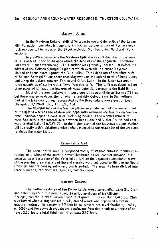
66 GEOLOGY AND GROUND-WATER RESOURCES, THURSTON CO., WASH.
Maytown Upland
In the Maytown Upland, drift of Wisconsin age and deposits of the Logan Hill Formation form what is generally a thick mantle over a core of Tertiary bedrock represented by rocks of the Skookumchuck, Mcintosh, and Northcraft Formations.
In pre-Wisconsin time the Maytown Upland was continuous with the lowrelief surfaces to the south upon which the deposits of the Logan Hill Formation underwent Intense weathering. This surface was probably Incised just before the advent of the Salmon Springs(?) glacier w~ich overrode the entire Maytown Upland and terminated against the Bald Hills. Thick deposits of stratified drift of Salmon Springs(?) age occur near Maytown, on the upland north of Deep Lake, and along the upland between Tenino and Offutt Lake. In the latter two areas large quantities of spring water flows from this drift. Thin drift was deposited on other parts which have the low ground-water potential common to the Bald Hills.
Most of the area underwent intense erosion in post-Salmon Springs(?) time but there was some deposition of what Is probably Colvos Sand in the northern part of the Maytown Upland represented by the three upland areas east of East OlympiaC17/lW-9, 10, 11, 12, 13).
The Olympia lobe of the Vashon glacier overrode much of the western part of the upland whereas the eastern part apparently remained ice free during Vashon time. Vashon deposits consist of thick subglacial till and a small amount of stratified drift in the general area between Deep Lake and Violet Prairie and eastward to Mud Lake (16/lW-7). In the higher parts of the Maytown Upland Vashon till is mostly a thin ablation product where mapped In the remainder of the area and Is above the water table.
Kame-Kettle Area
The Kame-Kettle Area is composed mostly of Vashon outwash locally containing till. Most of the materials were deposited as ice-contact outwash laid down as an end moraine of the Yelm lobe. Unlike the adjacent recessional gravel of the prairies the materials of the end moraine were subjected to little or no fluvial transport and are consequently very poorly sorted. The area has been divided into three subareas, the Northern, Central, and Southern.
Northern Subarea
The northern subarea of the Kame-Kettle Area, surrounding Lake St. Clair and extending north to a point about 1-! miles northeast of McAllister Springs, has the thickest known deposits of gravel in the county. Lake St. Clair was formed when a stagnant Ice block, around which was deposited outwash gravels, melted. Its bottom· is 37 feet below present sea level CWolcott, 1961, p. 526) and the outwash gravels are continuous from that depth to a height of at least 250 feet, a total thickness of at least 287 feet.
•
•
•
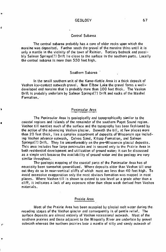
'
;
•
•
GEOLOGY 67
Central Subarea
The central subarea probably has a core of older rocks upon which the moraine was deposited. Farther south the gravel of the moraine thins until it is only a mantle in the vicinity of the town of Rainier. Tertiary bedrock and possibly Salmon Springs(?) Drift lie close to the surface in the southern parts. Locally the central subarea is more than 550 feet high.
Southern Subarea
In the small southern unit of the Kame-Kettle Area is a thick deposit of Vashon ice-contact outwash gravel. Near Elbow Lake the gravel forms a welldeveloped end moraine that is probably more than 100 feet thick. The Vashon Drift is probably underlain by Salmon Springs(?) Drift and rocks of the Mashel Formation.
Peninsular Area
The Peninsular Area is geologically and topographically similar to the coastal regions and islands of the remainder of the southern Puget Sound region . Vashon till mantles much of the surface and the topography has been fashioned by the action of the advancing Vashon glacier. Beneath the till, at few places more than 20 feet thick, lies a complex assortment of deposits of Wisconsin age including Vashon advance outwash, Colvos Sand, Kitsap Fonnation, and Salmon Springs(?) Drift. They lie unconformably on the pre-Wisconsin glacial deposits. This area includes four large peninsulas and is second only to the Prairie Area in both residential development and utilization of ground water; it can be discussed as a single unit because the availability of ground water and the geology are very siml lar throughout.
The geologic mapping of the coastal parts of the Peninsular Area has of necessity been somewhat generalized. Where deposits older than Vashon ti 11 crop out they do so in near-vertical cliffs of which most are less than 40 feet high. To avoid excessive exaggeration only the most obvious formation was mapped in most places. Where Vashon till is shown to extend to sea level on a grade other than a cliff, it indicates a Jack of any exposure other than slope wash derived from Vashon materials.
Prairie Area
Most of the Prairie Area has been occupied by glacial melt water during the receding stages of the Vashon glacier and consequently is of gentle relief. The surface deposits are almost entirely of Vashon recessional outwash. Most of the southern prairies and those adjacent to the Nisqually River are underlain by gravel outwash whereas the northern prairies bear a mantle of silty and sandy outwash of
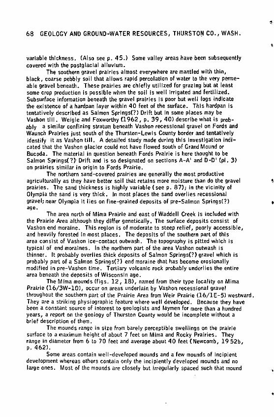
68 GEOLOGY AND GROUND-WATER RESOURCES, THURSTOtl CO., WASH.
variable thickness. (Also seep. 45.) Some valley areas have been subsequently covered with the postglaclal alluvium.
The southern gravel prairies almost everywhere are mantled with thin, black, coarse pebbly soi I that allows rapid percolation of water to the very permeable gravel beneath. These prairies are chiefly utilized for grazing but at least some crop production is possible when the soil is well irrigated and fertilized. Subsurface information beneath the gravel prairies Is poor but well logs indicate the existence of a hardpan layer within 40 feet of the surface. This hardpan is tentatively described as Salmon Springs(?) Drift but In some places may be Vashon till. Weigle and Foxworthy (1962, p. 39, 40) describe what is probably a similar confining stratum beneath Vashon recessional gravel on Fords and Waunch Prairies just south of the Thurston-Lewis County border and tentatively identify it as Vashon till. A detailed study made during this Investigation indicated that the Vashon glacier could not have flowed south of Grand Mound or Bucoda. The material in question beneath Fords Prairie is here thought to be Salmon Springs(?) Drift and is so designated on sections A-A' and D-D' (pl. 3) on prairies similar In origin to Fords Prairie.
The northern sand-covered prairies are generally the most productive agriculturally as they have better soil that retains more moisture than do the gravel prairies. The sand thickness is highly variable (seep. 87); in the vicinity of Olympia the sand is very thick. In most places the sand overlies recessional gravel; near Olympia it lies on fine-grained deposits of pre-Salmon Springs(?) age.
The area north of Mirna Prairie and east of Waddell Creek is included with the Prairie Area although they differ genetically. The surface deposits consist of Vashon end moraine. This region is of moderate to steep relief, poorly accessible, and heavily forested In most places. The deposits of the southern part of this area consist of Vashon ice-contact outwash. The topography is pitted which Is typical of end moraines. In the northern part of the area Vashon outwash is thinner. It probably overlies thick deposits of Salmon Springs(?) gravel which is probably part of a Salmon Springs(?) end moraine that has become erosionally modified in pre-Vashon time. Tertiary volcanic rock probably underlies the entire area beneath the deposits of Wisconsin age.
The Mirna mounds (figs. 12, 18), named from their type locality on Mirna Prairie (16/3W-10), occur on areas underlain by Vashon recessional gravel throughout the southern part of the Prairie Area from Weir Prairie (16/1 E-5) westward. They are a striking physiographic feature where well deveJoped. Because they have been a constant source of interest to geologists and laymen for more than a hundred years, a report on the geology of Thurston County would be incomplete without a brief description of them.
The mounds range in size from barely perceptible swellings on the prairie surface to a maximum height of about 7 feet on Mirna and Rocky Prairies. They range In diameter from 6 to 70 feet and average about 40 feet (Newcomb, 19 52b, p. 462).
Some areas contain well-developed mounds and a few mounds of incipient development whereas others contain only the incipiently developed mounds and no large ones. Most of the mounds are closely but irregularly spaced such that mound
•
•
•
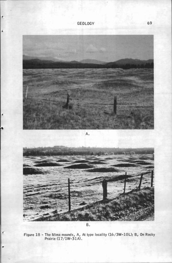
•
GEOLOGY 69
A.
B.
Figure 18 - The Mlma mounds, A, At type locality Cl6 / 3W-10U; B, On Rocky Prairie Cl 7/ 1W-31A) .
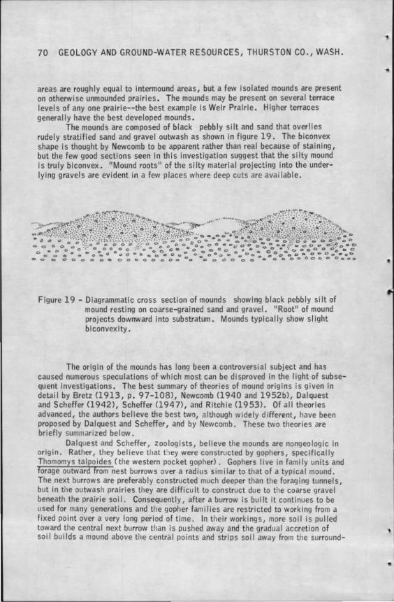
70 GEOLOGY AND GROUND-WATER RESOURCES, THURSTON CO., WASH.
areas are roughly equal to intermound areas, but a few isolated mounds are present on otherwise unmounded prairies. The mounds may be present on several terrace levels of any one pralrle--the best example Is Weir Prairie. H lg her terraces generally have the best developed mounds .
The mounds are composed of black pebbly silt and sand that overlies rudely stratified sand and gravel outwash as shown in figure 19. The biconvex shape Is thought by Newcomb to be apparent rather than real because of staining, but the few good sections seen In this investigation suggest that the silty mound Is truly biconvex. "Mound roots" of the silty material projecting into the underlying gravels are evident in a few places where deep cuts are available.
Figure 19 - Diagrammatic cross section of mounds showing black pebbly silt of mound resting on coarse-9rained sand and gravel. "Root" of mound projects downward into substratum. Mounds typically show sl lght bl convexity.
The origin of the mounds has long been a controversial subject and has caused numerous speculations of which most can be disproved In the light of subsequent Investigations. The best summary of theories of mound origins is given In detail by Bretz (1913, p. 97-108>, Newcomb (1940 and 1952b), Dalquest and Scheffer (1942), Scheffer (1947), and Ri tchie (1953). Of all theories advanced, the authors believe the best two, alt.hough widely different, have been proposed by Dal quest and Scheffer, and by Newcomb. These two theories are briefly summarized below.
Dalquest and Scheffer, zoologists, believe the mounds are nongeologic in origin. Rather, they believe that t iey were constructed by gophers, specifically Thomomys talpoides (the western pocket gopher) . Gophers I ive in family units and forage outward From nest burrows over a radius similar to that of a typical mound. The next burrows are preferably constructed much deeper than the foraging tunnels, but In the outwash prairies they are difficu It to construct due to the coarse gravel beneath the prairie sol I. Consequently, after a burrow is bui It 1t continues to be used for many generations and the gopher families are restricted to working from a fixed point over a very long period of time. In their workings, more soil is pulled toward the central next burrow than is pushed away and the gradual accretion of soi I bul Ids a mound above the central points and strips sol I away from the surround-
•
,.
'
••
•.
GEOLOGY 71
ing areas. The 11 mound roots0 described by Bretz are remnants of old gopher burrows penetrating Into the submound gravels. Gophers live today on some of the mound prairies but are absent on others. The chief objection to the gopher theory Is simply that It is difficult to visualize small gophers being responsible for the construction of mounds as much as 7 foet high. A later report on this theory·was written by Scheffer (1947, p. 68-86).
The theory of Newcomb (1940, p. 182, 1952b, p. 461-472) satisfies the seemingly logical corollary that because the mounds are found only on Vashon recessional gravel their origin should be due to ice and glacial climates. After the outwash prairies were formed, permafrost conditions produced a 11 fl ssure polygon 11
network in ground Ice such as that observed In arctic Alaska. Newcomb states that "Ice wedges, polygonal In pattern, might have thickened laterally and thrust the silt into center spaces, where it remained and sloughed down into mounds upon the melting of the Ice wedges." A similar objection can also be applied to Newcomb's theory--can the thrusting action of ice wedges force silt into mounds 7 feet high? Also there Is no evidence at present that permafrost conditions occurred at the close of Vashon time.
Both theories require a constructional hypothesis for the origin of the mounds. They cannot be formed PY erosion unless extremely similar conditions occurred at the time that the gravel of each terrace was being deposited and before downcuttlng to subsequent terrace levels, or unless the erosion was somehow caused by water flowing simultaneously over all the terraces. Ritchie (1953, p. 41-50) supports the latter Idea by theorizing an ice-dammed lake with a shoreline above an altitude of 500 feet that flooded the prairies that were already covered with mound nuclei formed by the process described by Newcomb •. Upon destruction of the ice dam, floodwaters flowed over all the prairie areas, scoured away the lntermound areas and exaggerated the shajre of the mounds. However, the geologic Investigation of the southern part of the county has shown no evidence whatsoever of the area having been Inundated after Vashon time. Also, the only plausible location for an ice dam Is between the Black Hills and Michigan Hill near Gate; a dam nearly 3 miles long and at least 400 feet high Is difficult to ellvlsion. A certain amount of surface runoff can occur in low-lying mounded areas, but none could occur in the wel I-mounded highest terrace level of Weir Prairie where the water table Is deep and the percolation rate Is high .
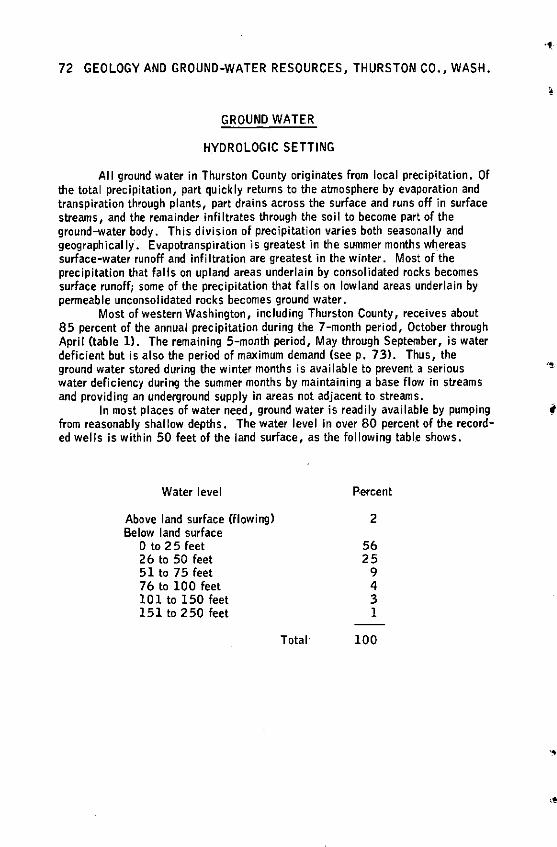
72 GEOLOGY AND GROUND-WATER RESOURCES, THURSTON CO., WASH.
GROUND WATER
HYDROLOGIC SETTING
All ground water in Thurston County originates from local precipitation. Of the total precipitation, part quickly returns to the atmosphere by evaporation and transpiration through plants, part drains across the surface and runs off in surface streams, and the remainder infiltrates through the soil to become part of the ground-water body. This division of precipitation varies both seasonally and geographically·. Evapotranspiration ls greatest in the summer months wh_ereas surface-water runoff and infiltration are greatest in the winter. Most of the precipitation that falls on upland areas underlain by consolidated rocks becomes surface runoff; some of the precipitation that falls on lowland areas underlain by permeable uncor1solidated rocks becomes ground water.
Most of western Washington, including Thurston County, receives about 85 percent of the annual precipitation during the 7-month period, October through April (table ll. The remaining 5-montli period, May through September, is water deficient but is also the period of maximum demand (seep, 73). Thus, the ground water stored during the winter months is available to prevent a serious water deficiency during the summer months by maintaining a base flow in streams and providing an underground supply in areas not adjacent to streams.
In most places of water need, ground water is readily available by pumping from reasonably shallow depths. The water level in over 80 percent of the recorded wells is within 50 feet of the land surface, as the following tabl.e shows.
Water level
Above land surface (flowing) Below land surface
0 to 25 feet 26 to 50 feet 51 to 75 feet 76 to 100 feet 101to150 feet 151 to 250 feet
Total
Percent
2
56 25
9 4 3 l
100
' ;I
.,
•·
<
GROUND WATER 73
THE GROUND-WATER REGIMEN
Recharge
Virtually al I the ground-water recharge, a function of precipitation, occurs during the months of October through April. About 15 percent of the annual precipitation falls during the remaining 5 months and of this almost none In-fl ltrates to the water table because of loss by evapotransplratlon. Thurston County would obviously experience a serious water deficiency If there were no ground-water storage to carry through the dry months.
Figure 20 graphically shows the mean annual water budget in terms of precipitation income and evapotranspiration outgo. These curves were derived by S. E. Shumway ,Meteorologist of the Washington State Department of Conservation, from the Thornthwaite method (Thornthwalte and Mather, 1957). This method utilizes an empirical formula for detennlning evapotranspiration rates based on temperature and latitude.
Because a comparison of the water surplus with fluctuations in the water table is desired, the period of record for averaging climatological data was reduced to the 12 water-year period 1950-61, so as to be commensurate with the time span of the well hydrographs. The average monthly precipitation for the 12-year period, however, exhibits an anomalous maximum In January whereas most any· other combination of years, especially over a long term, wlll lnvarlably show that the average monthly precipitation Is greatest In December.
The solid line on the graph (fig. 20) connects points representing the annual march of mean monthly precipitation. The dashed line joins points of computed mean monthly potential evapotransplration. Because the air temperature is the dominant factor in the computation, the shape of this curve would closely parallel a graph of the march of mean monthly temperature.
The nature of the water budget of Thurston County is plainly exhibited In the complete opposition of these two curves. Starting near the right side of the graph, the recharge resulting from precipitation usually begins in the fall when the diminishing evapotranspiralion losses are overcome by onset of the winter rains. This point Is represented on the graph In mid-September at the crossing of the precipitation and potential evapotransplration curves. Because the potential evapotranspirallon has, for the past 5 months, exceeded the rainfall, any water which had been stored In the soil has been depleted mainly through transpiration by plants. The soil moisture Is replenished by the October rains and as the ground now becomes completely saturated, additional precipitation either contibutes directly to streamflow or to ground-water storage by deep percolation. Throughout the winter, supply far exceeds demand and a surplus condition prevciils.
With the arrival of spring, the semiperman•nt Pacific anticyclone begins a slow migration northward, shunting the rain-bearing storms to higher latitudes. Accompanying this dwindling supply is a growing evapotranspiration demand brought on by the increasing temperature and length of day. Early in May, as depicted on the graph, the requirements of potential evapotranspiration exceed precipitation and the water budget is in deficit. Initially this shortage of water supply Is alleviated by th11 reserve in soil moisture actumulated during the winter. However,
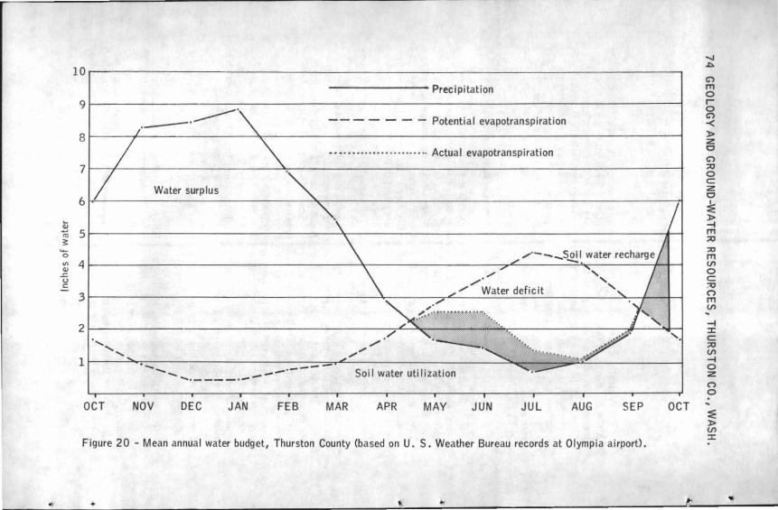
-------- Precipitation
Potential evapotranspiration
Bl----..J--------- .Jo.---------------------------------1 - • •· · •····•· · · ·· ···· ·• ·· Actual evapotranspiration
71----'--- ------- - --l.------------------------------t Water surplus
t m 51---------------------'<--------------- -------------..-1 !!:: ..... 0 ...,..·---S~I water recharge ~ 41----------------------~-------------,,,..C..-----='c:-------+--t---1
L / ' (.) ,,,,. ' c: / Water deficit ' 31----------------------4.----""""7"L------------~-+-~l-1
Soil water utilization
OCT NOV DEC JAN FEB MAR APR MAY JUN JUL AUG SEP OCT
Figure 20 - Mean annual water budget, Thurston County (based on U. S. Weather Bureau records at Olympia airport).
....... A
C')
ITI 0 r-0 C')
-< )> z 0 C')
Al 0 c z 0 :: )> -I ITI Al ::c ITI VI 0 c ~ (") ITI VI
-I :::c: c Al VI -I 0 z (")
0 ~
:E )> VI :::c:
•
•
..
'
GROUND WATER 75
as the deficit persists and intensifies throughout the summer, drafts on the soil moisture are inadequate to maintain plant growth. The water balance Is maintained only by resorting to Irrigation. For example, during July evapotransplratlon exceeds precipitation by 3. 73 Inches. The solknoisture reserve has been depleted to the extent that only O. 72 Inch is available, so it is necessary to enter a deficit of 3.01 inches of water for the month. Deficits for May C0.15 inch), June (1. 04 inches), August (2. 92 inches), and September CO. 97 inch) make an annual total deficit of 8.09 inches. This must be replaced in the soil to maintain optimum plant growth.
The relative amount of precipitation that becomes ground-water rechal'9e varies greatly from place to place. Areas underlain by a penneable soil such as that derived from recessional outwash receive much more recharge than areas underlain by bedrock or soil derived from )>edrock. This is made evident by a comparison of drainage .patterns. Most of the Prairie Area north of the Maytown Upland is nearly devoid of streams; most surplus precipitation recharges the ground-water body. Conversely, the Black and Bald Hills have an intense development of streams; most surplus water runs off.
Discharge
Ground-water dlscha1'9e occurs naturally and artificially. Artificial groundwater discharge occurs by pumping from wells or by allowing wells to flow. To date artificial discharge Is a very small part of the total ground-water discharge in Thurston County (see p. 110). Natural ground-water di scha1'9e is the natural passage of ground water into surface-water bodies. Most discharge occurs where the water table is Intercepted by a stream. In coastal areas much of the groundwater discha1'9es directly to Puget Sound.
All perennial streams In the county carry a large contribution of ground water. During late summer months nearly all stream water has a ground-water origin except that in the Nisqually River which has a glacial source on Mount Rainier.
The direction of ground-water movement toward discharge points is partially Indicated by the water-table contours on plate 4. These contours, representing the altitude of the water table or the piezometric surface in confined aquifers, are constructed from numerous measurements of Water levels in wells. Because the wells were measured during all seasons of the year there is a small introduced error due to seasonal fluctuations of the levels. The contours do show the general configuration of the water table. Ground water flows from higher to lower altitudes and it is readily seen that this flow is roughly parallel to surface drainage routes. At discharge areas the flow tends to swing nonnal to the direction of surface flow.
Most natural discharge probably occurs beneath the surface of surface-water bodies. In areas where the water table is Intersected by an escarpment such as along much of the Ni squally River and steep bluffs of the Peninsular Area, springs and seeps are the diScharge points.
76 GEOLOGY AND GROUND-WATER RESOURCES, THURSTON CO., WASH.
Storage
Ground water is stored in porous rocks; the amount stored within a unit volume of rock varies with Its porosity. Storage changes when recharge and discharge rates differ; this is reflected by the change in level of the water table or piezometrlc surface. Water levels fluctuate both seasonally and from year to year as shown by long range water-level hydrogiaphs. Figure 21, 22, and 23 are designed to show this fluctuation and consequent change of storage.
The hydrographs on figure 21 for Ward, Hewitt, and Southwick Lakes are derived from unpublished measurements started by the city of Olympia in October 1929 and continued by the State Division of Water Resources in January 1949. These lakes are a part of the ground-water system; their surfaces represent the water table. The records for them provide the longest range groundwater level lnfonnatlon in the county. The hydrographs in figure 22 are derived from published (U.S. Geological Survey) and unpublished tabulations of water levels In three observation wells in the county that have been measured at somewhat sporadic Intervals since 1941, 1949, and 19 51, respectively. They are the longest records of well measurements in the county. Figure 23 shows hydrographs of wells selected for observation during the course of this study Cl 958-1962) and previously published, in part, In Volume 1. They are based on monthly measurements.
The lake hydrographs <fig. 21) are representative of the water table beneath the sandy areas south of Olympia where permeability Is moderate and there are virtually no surface streams. These graphs show that the water table commonly begins Its annual rise around the first of October or shortly after the advent of the surplus water season (as shown on fig. 20). It generally continues to rise until about April or about the time of the advent of the deficit water season.
There is an exceptionally close relation between total annual fluctuation In lake level and the computed amount of water surplus. This relation is shown on figure 24. The gray bars represent water surplus resulting from precipitation after soil-moisture storage and evapotranspiration losses have been deducted. These losses total less than 15 percent and are based on an assumed sol 1-moi sture capacity of 3 inches of precipitation. The black bars represent the mean rise in the level of Ward and Hewitt Lakes from the minimum in the fall to the maximum in the spring. It is readily apparent from the graph that water levels in this area are closely allied with precipitation during each water year. It is reasonable to assume that a similar relation exists in all other areas of the county.
The hydrographs on figures 22 and 23, except that for 18/2W-7Rl, show that each year the water levels begin to rise at about the same.time as the levels In the lakes do, shortly after the advent of the surplus water season. Usually, however, the high-water date for these wells precedes the start of the deficit season by 2 or 3 months. An exception is well l 9/2W-35Ql In which the water level is highest 1 or 2 months later than the others and is phased slightly earlier than the lakes.
The hydrograph for well 18/2W-7Rl shows a definite time lag of 2 to 3 months between the start of the surplus season and the start of water level rise. This lag continues throughout the year and the high-water date is also much later
•
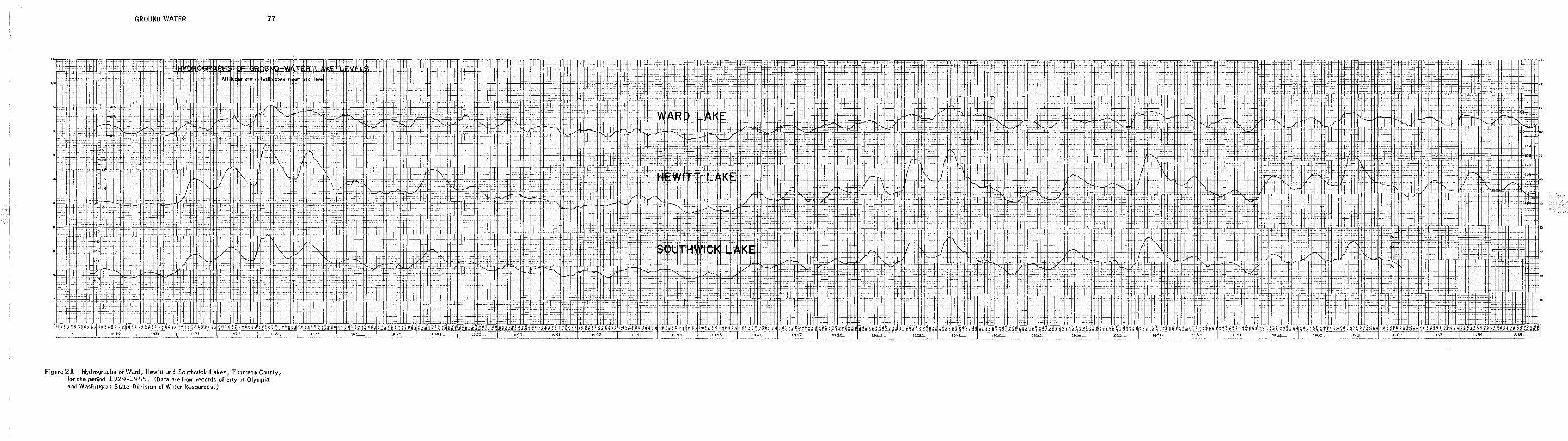
GROUND WATER 77
Figure 21 - Hydrographs of Ward, Hewitt and Southwick Lakes, Thurston County, for the period 1929-1965. <Data are from records of city of Olympia and Washington State Division of Water Resources.)
+1± :I+, H:l±iJ, ' ' '
ii ~
-1-1
78 GEOLOGY AND GROUND-WATER RESOURCES, THURSTON CO., WASH.
than that for the other wells. The log of this well notes that there Is 51 feet of hardpan above the aquifer, so a time lag necessary for recharge to the aquifer would be expected.
The trend of water-level fluctuations over, a period of,several years Is an Important criterion In determining the long-tenn yield of an aquifer. A consistent decline in average annual water levels during several successive years may Indicate that the withdrawals from the aquifer are excessive; that is, the total annual discharge exceeds the annual recharge. Should this occur, withdrawals could be regulated In such a way that the aquifer could be returned to a state of equilibrium. In Thurston County, there Is no indication of any long-tenn depletion of groundwater storage. I

GROUND WATER 79
19_42...... 19.43 ' 1945 - 1953_ 195A_ __ _ 1955- 1962__ 19
Figure 22 - Hydrographs of wells 16/1W-19Gl, 17/1W-4C2 and 17/2E-19M2.
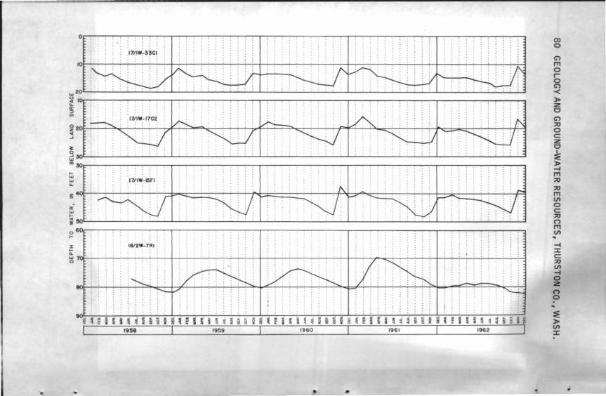
I 111sa I 1959 I 1960 I 1961 I 1962 I
• •
CX> 0
C') ,,, 0 r 0 C')
-< )> z 0 C')
::ti 0 c z 0
~ )> -I ,,, ::ti ::ti ,,, (/)
0 c ::ti (") ,,, (/)
-I ::x: c ::ti (/)
-I 0 z n 0
...
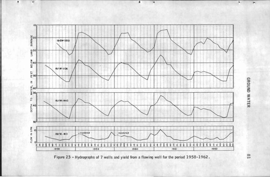
•
ti w ... !
... ~ 0 ...
;1;;s;r~.~~ M•~ !IS ~1Si~l~i2 11i• ~tQil~~~ ! lt•~'Q~l~~~!SiS~'QilNl~llll~~is li I 1958 I 1959 I 1960 I 1961 I 1962 I
Figure 23 - Hydrographs of 7 wells and yield from a flowing well for the period 1958-1962.
r
C'> ;:o 0 c z 0
== l> -4 ITI ;:o
ex> .....
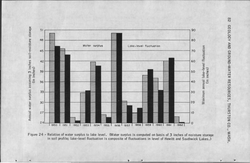
Cll en
"' 51 90 ... 0 .... Ill
Cll 48 80 ... :l .... Ill Wot er surplus Loke-level fluctuation c: 0 0 E 45 70 ~ I
:l .... 0 0 Ill :l Ill 42 60 ~ Cll ~ "ii 0 > c: -- Cll --·-Ill - Ill
(<"\~ 39 50 I Cll Cll~
en g .:..: 0
c: ·- ~ .= ·e ·= 40 - c: 36 "' ·-:l ....... :l ....... Ill c: Ill c: "' "' Ill
30 E :l :l e- E
:l
~ Ill ... 20 ~ Cll
~ 3 iii 10 :l c: c: ct
0
Figure 24 - Relation of water surplus to lake level. (Water surplus is computed on basis of 3 inches of moisture storage in soil profile; lake-level fluctuation is composite of fluctuations in level of Hewitt and Southwick Lakes.)
•
C") IT1 0 I 0 C")
-< )> z 0 C") ;o 0 c: :z 0
~ )> -I IT1 :::u :::u IT1 U'> 0 c: ;o (") IT1 CJ) .. -I ::i:: c: ;o CJ)
-I 0 z (")
0
:iE )> CJ)
::i::
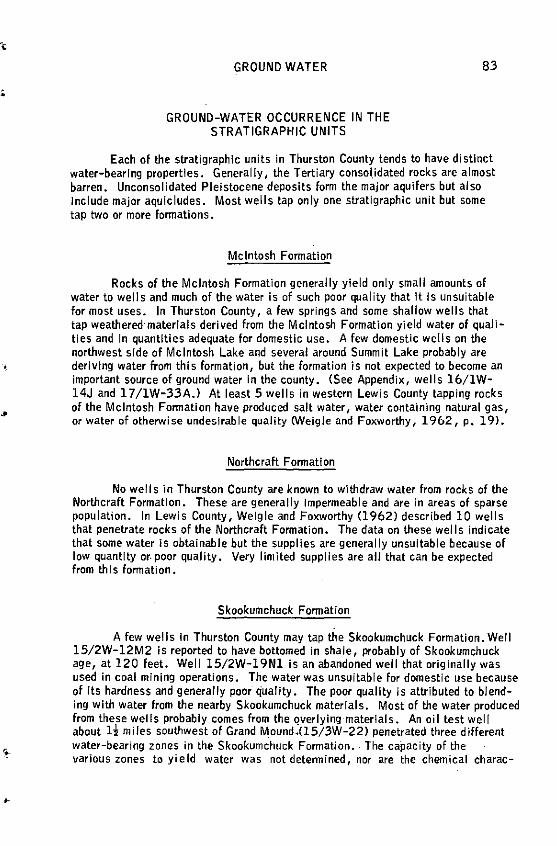
..
•
GROUND WATER
GROUND-WATER OCCURRENCE IN THE STRATIGRAPHIC UNITS
83
Each of the stratigraphic units in Thurston County tends to have distinct water-bearing properties. Generally, the Tertiary consolidated rocks are almost barren. Unconsolidated Pleistocene deposits form the major aquifers but also Include major aquicludes. Most wells tap only one stratigraphic unit but some tap two or more formations.
Mcintosh Formation
Rocks of the Mcintosh Formation generally yield only small amounts of water to wells and much of the water is of such poor quality that It Is unsuitable for most uses. In Thurston County, a few springs and some shallow wells that tap weathered·materlals derived from the Mcintosh Formation yield water of qualities and In quantities adequate for domestic use. A few domestic wells on the northwest side of Mcintosh Lake and several around Summit Lake probably are deriving water from this formation, but the formation is not expected to become an important source of ground water In the county. (See Appendix, wells 16/1W-14J and 17 /1W-33A.) At least 5 wells in western Lewis County tapping rocks of the Mcintosh Fonnation have produced salt water, water containing natural gas, or water of otherwise undeslrable quality CWeigle and Foxworthy, 1962, p. 19).
Northcraft Formation
No wells in Thurston County are known to withdraw water from rocks of the Northcraft Formation. These are generally Impermeable and are ln areas of sparse population. In Lewis County, Weigle and Foxworthy (1962) described 10 wells that penetrate rocks of the Northcraft Formation. The data on these wells indicate that some water Is obtainable but the supplies are generally unsuitable because of low quantity or. poor quality. Very limited supplies are all that can be expected from this formation.
Skookumchuck Formation
A few wells In Thurston County may tap the Skookumchuck Formation. Well 15/2W-12M2 is reported to have bottomed in shale, probably of Skookumchuck age, at 120 feet. Well 15/2W-19Nl Is an abandoned well that originally was used in coal mining operations. The water was unsuital>le for domestic use because of its hardness and generally poor quality. The poor quality is attributed to blending with water from the nearby Skookumchuck materials. Most of the water produced from these wells probably comes from the QVerlying-materials. An oil test well about H miles southwest of Grand M.ound.(15/3W-22) penetrated three different water-bearing zones in the Skookumchuck Formation .. The ca·pacity of the various zones to yield water was not determined, nor are the chemical charac-
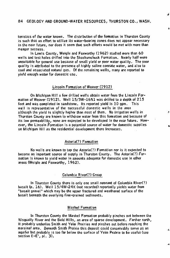
84 GEOLOGY ANO GROUND-WATER RESOURCES, THURSTON CO., WASH.
teristics of the water known. The distribution of the fonnation In Thurston County Is such that an effort to utilize its water-bearing zones does not appear necessary In the near future, nor does It seem that such efforts would be met with more than meager success.
In Lewis County, Weigle and Foxworthy (1962) studied more than 60 wells and test holes drilled Into the Skookumchuck Fonnation. Nearly half were unsuitable for general use because of small yield or poor water quality. The poor quality Is attributed to the presence of highly saline connate water, and also to coal and associated natural gas. Of the remaining wells, many are reported to yield enough water for domestic use.
Lincoln Formation of Weaver (1912)
On Michigan Hill a few drilled wells obtain water from the Lincoln Formation of Weaver (1912). Well 15/3W-16Nl was drilled to a depth of 215 feet and was completed In sandstone. Its reported yield Is 10 gpm. This well is representative of the successful domestic wells in the area although the yield Is slightly higher than most of them. No irrigation wells in Thurston County are known to withdraw water from this lonnation and because of its low permeability, none are expected to be developed in the near future. However, the Linea In Formation is a potential source of water for domestic supp lies on Michigan Hill as the residential development there Increases.
Astoria(?) Formation
No wells are known to tap the Astoria(?) Formation nor is it expected to become an important source of supply in Thurston County. The Astoria(?) Formation Is known to yield water In amounts adequate for domestic use in other areas <Weigle and Foxworthy, 1962).
Columbia River(?) Group
In Thurston County there is only one small remnant of Columbia River(?) basalt (p, 16). Well 15/4W-24K (not recorded) reportedly yields water from "basalt gravel 11 which may be the upper fractured and weathered surface of the basalt beneath the overlying fine-9rained sediments.
Mashel Fonnatlon
In Thurston County the Mashel Formation probably pinches out between the NI squally River and the Bald Hills, an area of sparse development. Farther north, it probably underlies Smith and Yelm Prairies and pinches out before reaching the morainal area. Beneath Smith Prairie this deposit could conceivably serve as an aquifer but probably is too far below the surface of Yelm Prairie to be useful (see section E-E', pl. 3).
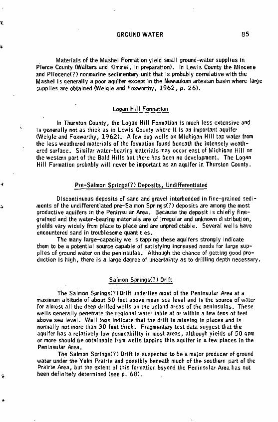
•
GROUND WATER 85
Materials of the Mashel Formation yield small ground-water supplies In Pierce County <Walters and Kimmel, In preparation). In Lewis County the Miocene and Pliocene(?> nonmarine sedimentary unit that is probably correlative.with the Mashel Is generally a poor aquifer except in the Newaukum artesian basin where large supplies are obtained <Weigle and Foxworthy, 1962, p. 26).
Logan Hill Formation
In Thurston County, the Logan Hill Fonnatlon Is much less extensive and is generally not as thick as in Lewis County where It Is an important aquifer (Weigle and Foxworthy, 1962). A few dug wells on Michigan Hill tap water from the less weathered materials of the formation found beneath the intensely weathered surface. Similar water-bearing materials may occur east of Michigan Hill on the western part of the Bald Hills but there has been no development. The Logan Hill Formation probably will never be important as an aquifer In Thurston County.
Pre-Salmon Springs(?) Deposits, Undifferentiated
Discontinuous deposits of sand and gravel interbedded in fine-grained sediments of the undifferentiated pre-Salmon Springs(?> deposits are among the most productive aquifers in the Peninsular Area. Because the deposit is chiefly finegrained and the water-bearing materials are of irregular and unknown distribution, yields vary widely from place to place and are unpredictable. Several wells have encountered sand in troublesome quantities.
The many large-capacity wells tapping these aquifers strongly Indicate them to be a potential source capable of satisfying Increased needs for large supplies of ground water on the peninsulas. Although the chance of getting good production is high, there is a large degree of uncertainty as to drilling depth necessary.
Salmon Springs(?) Drift
The Salmon Springs(?) Drift underlies most of the Peninsular Area at a maximum altitude of about 30 feet above mean sea level and Is the source of water for almost all the deep drilled wells on the upland areas of the peninsulas. These wells generally penetrate the regional water table at or within a few tens of feet above sea level. Well logs Indicate that the drift Is missing in places and Is normally not more than 30 feet thick. Fragmentary test data suggest that the aquifer has a relatively low permeability in most areas, although yields of 50 gpm or more should be obtainable from wells tapping this aquifer in a few places in the Peninsular Area.
The Salmon Springs(?) Drift is suspected to be a major producer of ground water under the Yelm Prairie and possibly beneath much of the southern part of the Prairie Area, but the extent of this formation beyond the Peninsular Area has not been definitely determined (seep, 68>.
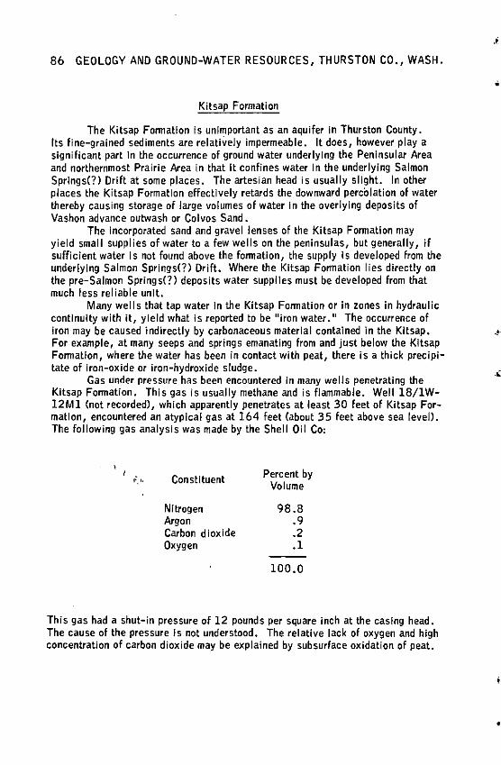
86 GEOLOGY AND GROUND-WATER RESOURCES, THURSTON CO., WASH.
Kitsap Formation
The Kitsap Formation is unimportant as an aquifer In Thurston County. Its fine-grained sediments are relatively impermeable. It does, however play a significant part In the occurrence of ground water underlying the Peninsular Area and northernmost Prairie Area in that It confines water In the underlying Salmon Springs(?) Drift at some places. The artesian head is usually slight. In other places the Kitsap Formation effectively retards the downward perc'olation of water thereby causing storage of large volumes of water In the overlying deposits of Vashon advance outwash or Colvos Sand.
The incorporated sand and gravel lenses of the Kitsap Formation may yield small supplies of water to a few wells on the peninsulas, but generally, if sufficient water Is not found above the formation, the supply Is developed from the underlying Salmon Springs<?) Drift. Where the Kitsap Formation I ies directly on the pre-Salmon Springs(?) deposits water supplles must be developed from that much less reliable unit.
Many wel Is that tap water In the Kitsap Formation or In zones in hydraulic continuity with it, yield what ls reported to be 11 iron water. 11 The occurrence of Iron may be caused indirectly by carbonaceous material contained in the Kitsap. For example, at many seeps and springs emanating from and just below the Kitsap Formation, where the water has been in contact with peat, there is a thick precipitate of iron-oxide or iron-hydroxide sludge.
Gas under pressure has been encountered In many wells penetrating the Kitsap Formation. This gas is usually methane and is flammable. Well 18/1W-12Ml (not recorded), which apparently penetrates at least 30 feet of Kitsap Formation, encountered an atypical gas at 164 feet (about 35 feet above sea level). The following gas analysis was made by the Shell Oil Co:
"·'' Constituent Percent by Volume
Nitrogen 98.8 Argon .9 Carbon dioxide .2 Oxygen .1
100.0
This gas had a shut-in pressure of 12 pounds per square inch at the casing head. The cause of the pressure Is not understood. The relative lack of oxygen and high concentration of carbon dioxide may be explained by subsurface oxidation of peat.
,.
•
..
i
GROUND WATER 87
Vashon Drift
Colvos Sand and Vashon Advanco Outwash
These units cannot readily be differentiated In well logs; therefore, in dl scu ssing their water-bearing character, they are considered to compose a single unit except in the southern part of the county where Colvos Sand does not occur. The Colvos Sand-Vashon advance outwash is generally of moderate permeability and is the source of many domestic supplies throughout the Peninsular Area where the deposits are under water-table conditions. Because of the irregular surface of the Colvos Sand and the manner of deposition of advance outwash, their occurrence cannot be predicted except Jn local areas where.well-log data are plentiful.
Wells in the Immediate vicinity of South Bay (l 9/lW-.32) are representative of most that withdraw water from the Colvos Sand-Vashon advance outwash. Here, the aquifer materials are overlain by Vashon till and recessional outwash. The aquifer Is sandy and screen installation is necessary for optimum yield. Supplies are adequate but some of these wells yield water of high iron content.
Mundorf! and others (1955, p. 8-10) described Vashon advance outwash as being one of the most important aquifers in tile Yelm area. There, it consists of a permeable sand and gravel whose average thickness is about 22 feet. Two of the best wells on Yelm Prairie, 17 /2 E-l 9Nl and l 9N2, belonging to the town of Yelm, tap advance outwash; they yield more than 1,000 gpm with very I ittle drawdown.
It is possible that aquifers of high yield underlying much of the southern Prairie Area between Rochester and Tenino are advance outwash, but In this report these aquifers are generally regarded as belonging to the Salmon Springs(?} Drift.
Vashon Tl II
Vashon till generally has a very low penneabiilty which makes it unusable as an aquifer for large supplies of ground water in Thurston County. Due to its Jmpenneable character, till has a great influence on the availability of water in a given area. Till nonnally acts as an effective aqulclude which retards the downward percolation of water, and perched zones of water often occur on and within Its upper parts. Till also confines ground water in parts of the underlying aquifers.
The perched aquifers provide water for many domestic supplies in the county. Most of the wells that produce water from till have low yields, particularly during late summer and fall months. Some go dry. The most successful wells constructed In till are large-diameter dug wells because they have large infiltration areas and large storage capacities.
In areas of sparse development, wells Jn till have proved to be an economical method of obtaining household water. However, such wells are much more susceptible to contamination than the deeper drilled wells. Special care should be given to well placement relative to septic tank drain fields and other potential sources of contamination.
88 GEOLOGY AND GROUND-WATER RESOURCES, THURSTON CO., WASH.
Vashon End Moraine
Some of the morainal deposits are sufficiently permeable to yield large supplies of ground water. However, the demand Is small. The relief In the end moraines Is much more rugged than that of the adjac.ent areas covered by Vashon recessional outwash and the areas underlain by morainal materials are only sparsely used for farming. The consequent lack of development has considerably limited the amount of data which are available for an evaluation of the groundwater potential of these deposits. CSee also p. 92.)
Vashon Recessional Gravel
Vashon recessional gravel Is generally a coarse-grained, ~.rmeable. deposit that allows rapid percolation of water to lower units if it Is above the water table, and easy movement of ground water If It is below the water table. For these reasons It Is one of the best stratigraphic units in the county from the standpoint of water production.
Water In recessional gravel occurs under regional water-table conditions at many places throughout the county. The chief area of use extends from east of Black Lake eastward across Bush Prairie to the Lakes area southeast of Lacey. Throughout much ot this area the gravel is overlain by Vashon recessional sand. Most wells withdrawing water from the recessional gravel are equipped with small capacity pumps and are used for domestic supplies.
Perched or semiperched supplies occur In many places where recessional gravel is underlain by till--the water accumulates on top of and within the till. These supplies are commonly withdrawn from large diameter dug wells and are for domestic use.
Yields In. excess of 250 gpm have been obtained from wells along the Scatter Creek Valley between Rochester and Tenino. The aquifers here may belong to deposits of either Vashon or Salmon Springs(?) Drifts but most of the drainage Is subsurface because of the highly permeable nature of the recessional gravel beneath the valley floor.
Vashon Recessional Sand
The recessional sand unit occurs above the regional water table at more places than does the recessional gravel and It cannot be considered a major aquifer. However, like the recessional gravel, It Is a per.neable deposit that mostly occurs near the surface and allows rapid percolation of water to the water table. Where the deposits are saturated, for example, southwest of Olympia near Bush Prairie, they constitute the source of water for a large number of domestic supplies. Here, most wells are driven and equipped with sandpolnts.
'
·•
,I
GROUND WATER 89
Recent Alluvium
Large ground-water supplies can be developed from alluvial deposits. Most of the wells in the area west of Rochester withdraw water from coarser grained alluvium of the Chehalis and Black River flood plains. Development of some wells has been rendered difficult because of the fine-grained materials within the alluvium.
Water tables are high in the alluvium that underlies many flood plains and vegetation is sub-irrigated. Consequently, overhead irrigation is unnecessary and only domestic wells are developed in alluvium.
AREAL OCCURRENCE OF GROUND WATER
Most ground water In Thurston County occurs In areas underlain by glacial deposits. Areas underlain by Tertiary rocks are of small Importance. Within the areas of glacial deposits yields vary from place to place largely because of the
·,; lenticular nature of the a'1lifers.
,.
Plate 4 shows the yields that can be expected from properly constructed wells. Four categories of yield are shown. They were arbitrarily established and were determined by integrating the maximum practical yield of specific wells with the topographic and geologic relationships. The maximum practical yield was determined by multiplying the specific capacity of selected wells by two-thirds of the available drawdown.
It is emphasized that plate 4 indicates the probable amount of water that can be obtained from a correctly constructed well drilled deep enough to penetrate the uppermost major water-bearing zone. In each of these areas local conditions may cause a variance from the yield indicated. Also, deeper drilling may tap lower zones not reached by recorded wells and yields could be substantially greater.
The following sections discuss the ground-water characteristics of the geohydrologlc areas defined on plate 5.
Bald Hiils
No important aquifers occur in the Bald Hills. There are a few wells near the edge of the area and adjacent to stream channels and a few more on the north shore of Mcintosh Lake (16/lW-14) that supply domestic water for single residences. The present smal I water demand Jn the area is not expected to increase appreciably.
Water is obtained from three types of aquifer materials--alluvlum, finegrained overburden materials lying on the Tertiary bedrock, and the uppermost zones of the Tertiary sedimentary rocks. There are no known producing water wells tapping the volcanic rocks of the Bald Hills, but many springs have been observed which issue from zones between the weathered and unweathered rock. Well 16/1W.-14J (see Appendix) yields some water from Mcintosh sandstone.
90 GEOLOGY AND GROUND-WATER RESOURCES, THURSTON CO., WASH.
The wells of record in the Bald Hills area are characterized by low yield, In general Jess than 10 gpm.
Black Hills
The only known aquifers in the Black Hiiis underlie Cedar Flats (18/3W-22, 23, 24); Mox-Chehalis Creek, Perry Creek Valley; and a narrow strip surrounding Summit Lake. The major aquifers are In alluvial and glacial deposits; minor ones are In weathered or fractured Tertiary rocks.
No wells have been drilled in the southern half of the Black Hills area. The few inhabitants depend on spring or stream sources for domestic and stock water. The Capitol Forest Youth Camp (16/4W-11J is supplied with water from Cedar Creek and a spring. Owing to the rough terrain and forest cover large water supplies will not be needed In the area within the foreseeable future, nor would they be available from other than surface-water sources.
At low altitude on the northern half of the Black Hills, some ground water Is used although surface-water supplies are used whenever available because of
•
the uncertainty of drilling success. ., On Cedar Flats wells are the chief source of domestic and stock water for
several small farmsteads. The principal water-bearing materials underlying Cedar Flats are composed of Vashon recessional outwash and till. Apparently the till contains some layers of cemented gravel that yield a small amount of water. The water table is shallow. Several large-diameter dug wells range In depth from 9 to 30 feet. The possibility that a deeper aquifer exists is indicated by the data for well 18/3W-22H2. It is a 6-inch well reportedly drilled to a depth of 198 feet; no well log is available. Yields of 10 to 50 gpm should be obtainable from the shallow aquifer. Recharge of the Cedar Flats aquifer is chiefly dependent upon the precipitation that falls on the slopes of the Tertiary volcanic uplands which enclose the Flats on three sides, and to a lesser degree upon the precipitation on the Flats proper. There are no high-yielding wells of record on Cedar Flats and no major increase In water demand Is anticipated.
Wells in the Mox-Chehalis, Perry Creek Valley along U. S. Highway 410 supply part of the demand for domestic, stock and Irrigation supplies. An additional demand for domestic water is expected along the valley from south of Summit Lake to the-mouth of Perry Creek. No immediate increase In use of ground water is foreseen for the rest of the valley. Aquifer materials consist chiefly of alluvium, Vashon recessional outwash, and Salmon Springs(?) Drift. These deposits form a relatively thin mantle overlying the Tertiary bedrock along the valley floor. Most of the wells In the easterly three-fourths of the "alley derive water from finegrained Salmon Springs(?) Drift of low permeability. Except for shallow wells adjacent to Perry Creek, the wells penetrate either basaltic soil or glacial drift and commonly bottom on the unweathered Tertiary volcanic rocks. West of Summit Lake, near the headwaters of Mox-Chehalis Creek, the valley is about half a mile wide and the glacial drift which Includes some Vashon recessional outwash is thicker and more permeable than in the easterly part of the valley.
Yields of most wells in the Mox-Chehalis, Perry Creek Valley are low, but at places yields of 10 to 50 gpm probably can be obtained. Yields in excess of
-,
GROUND WATER 91
200 gpm might be expected in the extreme western part of the valley. Seep developments or dug wells bottoming on bedrock might supply only 2 or 3 gpm in the eastern part of the valley.
In the Summit Lake area ground-water development Is sparse. Several wells supply domestic water for summer cabins and a few permanent residences. Many domestic supplies are derived directly from the lake. The water demand is expected to rise commensurate with the modernizing of summer cabins and conversion of some to permanent residences. The ground water occurs chiefly in the weathered Tertiary volcanic rocks,although some occurs in the uppermost zones of the underlying unweathered rocks. Most supplies are obtained from seep developments or dug wel Is which Intercept the shallow ground waters moving toward the lake, but some water has been obtained from the volcanic rocks at a depth of about 60 feet. Yields of as much as 10 gpm can be exp•cted in this area.
Michigan Hill
On Michigan Hill the only ground-water use is from wells that supply domestic and stock water for small farms. Large-scale development of ground water for irrigation or other purposes probably would not be economically feasible.
Two aquifers of low permeability occur in this area. They consist of fluvial deposits of the Logan Hill Fonmation and marine sedimentary rocks of the Lincoln Formation of Weaver (1912). Some shallow perched water has been developed by means of dug wells that bottom In the Logan Hill deposits. These deposits are of very low permeability. Although the average thickness of the Logan Hill Formation Is about PO feet in this area and the penmeability probably increases with depth, no wells are known to tap the lower part of the formation. Furthennore, because the water table in the Logan Hill is more than 60 feet below land surface, the likelihood of getting substantial yields from the lower part is small. A few drilled wells in the area partially penetrate sedimentary rocks of the Lincoln Formation of Weaver (1912). They range in depth from 190 to 300 feet. These wells are characterized by low yield and high pumping lift, but are generally capable of satisfying domestic needs.
It Js unlikely that yields in excess of 10 gpm from either the perched aquifer or the deep aquifer can be obtained.
Maytown Upland
Aquifers In the Maytown Upland have not been well defined because of the great variation in geology and the lack of detailed well data. They consist chiefly of deposits of both Vashon and Salmon Springs(?) Drifts. Small amounts of water may be obtained from Logan Hill deposits.
Ground-water development Is sparsely scattered throughout the area. More than 50 wells that supply domestic and stock water are recorded on the Maytown Upland. No irrigation wells are recorded. Because of the topography and forest cover, settlement of the area has been slow and wl II continue to be slow. No large increase in water demand is foreseen for the upland in the immediate future. How-
92 GEOLOGY AND GROUND WATER RESOURCES, THURSTON CO., WASH.
ever, about two-thirds of the existing wells have been dug and many well owners report that the yields of these wells are inadequate during certain periods of the year. If a dependable supply is needed, some of them could be deepened to sustain yields during dry periods or they could be replaced by drilled wells. Unless drilled wells encounter Tertiary bedrock at shallow depth, they generally yield enough water for domestic use. The water table Is discontinuous beneath the upland so the depth to water and well depth cannot be predicted.
Aquifers presently being utilized In the Maytown Upland are in the alluvium, Vashon till, Salmon Springs(?) Drift and Logan Hill Formation. The aquifers in the Vashon till and Logan Hill Formation, normally of small lateral extent, are commonly perched. At a few places beneath the upland between Tenino and Maytown a water-table aquifer underlies the till. The water table is about 60 to 80 feet below land surface. The aquifer materials probably consist of Salmon Springs(?) Drift. Where Salmon Springs(?) Drift constitutes the surface deposits in the area, it is likely that perched water could be obtained in places.
The authors believe the best aquifers in the Maytown Upland have not yet been appreciably developed. Because of the Internal drainage throughout much of the upland, large quantities of ground water are expected to exist beneath much of
•
the area where the glacial drift Is thick enough to absorb and store precipitation. ., Gravel in the Salmon Springs(?) Drift probably Is the best aquifer underlying the area. Although local in extent, the Colvos Sand should also contain good aquifers. It underlies Vashon till in the three small areas at the northeast corner of the upland. Several large springs issue from this deposit, one of which forms the headwaters of Eaton Creek Cl 7 /1W-13H).
Yields of 10 to 50 gpm probably can be obtained at most places on the Maytown Upland where the glacial drift is thick. Where the drift thinly mantles the Tertiary rocks, the low ground-water potential common to the Bald Hills can be expected.
Kame-Kettle Area
The principal aquifers In the Kame-Kettle Area consist of gravel outwash incorporated with the Vashon end moraine. Deposits of till that support perched bodies of ground water occur locally. Ground water has not been developed extensively in any of the three subareas.
Northern Subarea
Ground-water development in the northern subarea is limited to several drilled wells in the immediate vicinity of Lake St. Clair and a few wells east and northeast of McAllister Springs Cl8/1E-19KJ. The wells are used chiefly for domestic purposes and stock supply. Because of the hummocky topography of this subarea, future development will probably be slow and additional use of groundwater will be slight except around Lake St. Clair.
·•
•
•
GROUND WATER 93
The water-bearing materials consist of permeable Vashon sand and gravel. The deposits are more than 287 feet thick in places, but are generally not saturated above an altitude of 65 to 70 feet. The surface of Lake St. Clair represents the water table around the lake. The water table slopes toward McAllister Springs which is the source of water for the city of Olympia. An investigation by James W. Carey and Associates in 1945 indicated the average discharge of the springs to be 18,000,000 gallons per day, 28 cubic feet per second or about 20,000 acre-feet annually. This group of springs constitutes the chief discharge point for ground water in this subarea. The area Is recharged both from local precipitation and subsurface flow from beneath the adjoining Prairie Area, and from Eaton Creek. ·
Yields as much as 50 gpm probably can be obtained around the southern end of Lake St. Clair and much larger quantities could be developed north of the lake toward McAllister Springs.
Central Subarea
The development of ground water in the central subarea has been restricted to the southern part because much of the northern part is within the Fort Lewis Military Reservation. All the 31 wells inventoried supply water for domestic and stock-watering purposes. The area appears not to need large-scale development of ground water In the foreseeable future •
Numerous aquifers underlie this morainal area but no definite correlation or differentiation between them has been possible because of insufficient well data. Of 11 dug wells recorded, 10 range in depth from 11 to 36 feet. They tap water that is perched on Vashon till. The drilled wells range in depth from 70 to 285 feet and average 129 feet. The depth of the water table below the perched zones is not well known; it may occur anywhere between 50 feet and 250 feet below the land surface.
Yields in excess of 50 gpm probably can be obtained from most of the watertable wells. Small yields sufficient for domestic and stock water should be available from perched zones of ground water.
Southern S'ubarea
Almost no development of ground water in the southern subarea has occurred. It is not likely that large supplies will be needed In the future.
Shallow aquifers underlying this area consist of Vashon Drift. The existence of several shallow lakes suggest the occurrence of perched water throughout much of the area. Deeper aquifers probably occur too but no information is available on them. Yields of wells in this unit should be comparable to those in the rest of the KameKettle Area.
Peninsular Area
Ground-water development has been extensive on all four peninsulas that make up the Peninsular Area. Several hundred domestic and stock wells have been
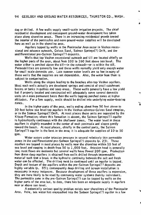
94 GEOLOGY AND GROUND WATER RESOURCES, THURSTON CO., WASH.
dug or drilled. A few wells supply small-scale irrigation projects. The chief residential development and consequent ground-water development has taken place along shoreline areas. There is an Increasing residential growth toward the interior of the peninsulas and more ground-water supplies will be developed here as well as in the shoreline area.
Aquifers tapped by wells in the Peninsular Area occur in Vashon recessional and advance outwash, Colvos Sand, Salmon Springs(?) Drift, and the undifferentiated pre-Salmon Springs(?) deposits.
Wells that tap Vashon recessional outwash and till are located chiefly on the higher parts of the area, about from 100 to 160 feet above sea level. The water either is perched above the till--in the outwash--or is within the till. Permeabilities are generally low and these wells normally yield only enough water for small scale domestic use. Late summer water levels are so low in many of these wells that the supplies are not dependable. Also, the water from them is subject to contamination.
Wells along the slopes leading to the beaches also tap Vashon aquifers. Most such wells actually are developed springs and consist of small catchment basins or tanks In gullies and seep areas. These wells generally have a low yield but If properly located and constructed will adequately serve several domestic units on a more permanent basis than the wells tapping perched zones at higher altitudes. For a firm supply, wells should be drilled into underlying water-bearing zones.
In the higher parts of the area, wells ending about from 50 feet above to 30 feet below sea level tap aquifers in the Vashon advance-Colvos Sand c~mplex, or in the Salmon Sprlngs(?JDrift. At most places these units are separated by the Kitsap Formation; where this formation is absent, the Salmon Springs(?) aquifer is hydraulically continuous with the shallower zones. The water level In these aquifers is slightly mounded in the center of each peninsula and slopes gently toward the beach. At most places, chiefly in the central parts, the Salmon Springs(?) aquifer is the best in the area; it is adequate for supplies of 10 to 50 gpm.
W·ater occurs under artesian pressure in several relatively thin permeable zones in the undifferentiated pre-Salmon Springs(?) deposits (p. 23). These aquifers are tapped in most places by wells near the shoreline within 10 feet of sea level and ranging In depth from 50 to 1,000 feet. Artesian head is generally low; most flows are moderate but several wells have flowed 200 gpm. Production from these deep aquifers is obtained from wells drilled through impermeable material such that a break in the hydraulic continuity between the salt and fresh water can be effected. The drilling must be continued until an aquifer Is tapped. Depth and texture of the aquifers within the pre-Salmon Springs<?) deposits are highly variable (p. 85 ); consequently deep drilling and screen installation is necessary in many instances. ·Because development of these aquifers is expensive, they are more likely to be used by community water systems than by individuals. The permeable zone in the pre-Salmon Springs(?) can be tapped by wells on the higher parts of the area but, to date, there has been an adequate supply in aquifers near or above sea level.
A potentially serious quality problem exists near shorelines of the Peninsular Area. Here, sea water has encroached into the Salmon Springs(?} aquifer in a few
•
•
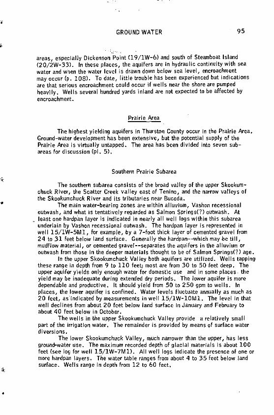
~:
•
GROUND WATER 95
areas, especially Dickenson Point (19/lW-6) and south of Steamboat Island (20/2W-33l. In these places, the aquifers are in hydraulic continuity with sea water and when the water level is drawn down below sea level, encroachment may occur (p, 108). To date, little trouble has been experienced but indications are that serious encroachment could occur If wells near the shore are pumped heavily. Wells several hundred yards ·inland are not expected to be affected by encroachment.
Prairie Area
The highest yielding aquifers in Thurston County occur In the Prairie Area, Ground-water development has been extensive, but the potential supply of the Prairie Area is virtually untapped. The area has been divided into seven subareas for discussion (pl. 5).
Southern Prairie Subarea
The southern subarea consists of the broad valley of the upper Skookumchuck River, the Scatter Creek valley east of Tenino, and the narrow valleys of the Skookumchuck River and its tributaries near Bucoda.
The main water-bearing zones are within alluvium, Vashon recessional outwash, and what is tentatively regarded as Salmon Springs(?) outwash. At least one hardpan layer is indicated in nearly all well logs within this subarea underlain by Vashon recessional autwash. The hardpan layer is represented in well 15/1W-5Ml, for example, by a 7-foot thick layer of cemented gravel from 24 to 31 feet below land surface. Generally the hardpan--which may be till, mudflow material, or cemented gravel--separaies the aquifers in the alluvium or outwash from those in the deeper materials thought to be of Salmon Springs(?) age.
Jn the upper Skookumchuck Valley both aquifers are utilized. Wells tapping these range in depth from 9 to 110 feet; most are from 30 to 50 feet deep. The upper aquifer y'1elds only enough water for domestic use and in some places. the yield may be inadequate during extended dry periods. The lower aquifer is more dependable and productive. It should yield from 50 to 250 gpm to wells. In places, the lower aquife~ ls confined. Water levels fluctuate annually as much as 20 feet, asindicated by measurements in well 15/lW-lOMl. The level In that well declines from about 20 feet below land surface In January and February to about 40 feet below in October.
The wells in the upper Skookumchuck Valley provide a relatively small part of the irrigation water. The remainder is provided by means of surface water diversions.
The lower Skookumchuck Valley, much narrower than the upper, has less ground-water use. The maximum recorded depth of glacial materials is about 100 feet (see log for well 15/1W-7Ml). All well logs indicate the presence of one or more hardpan layers. The water table ranges from about 4 to 35 feet below land surface. Wells range in depth from 12 to 60 feet.
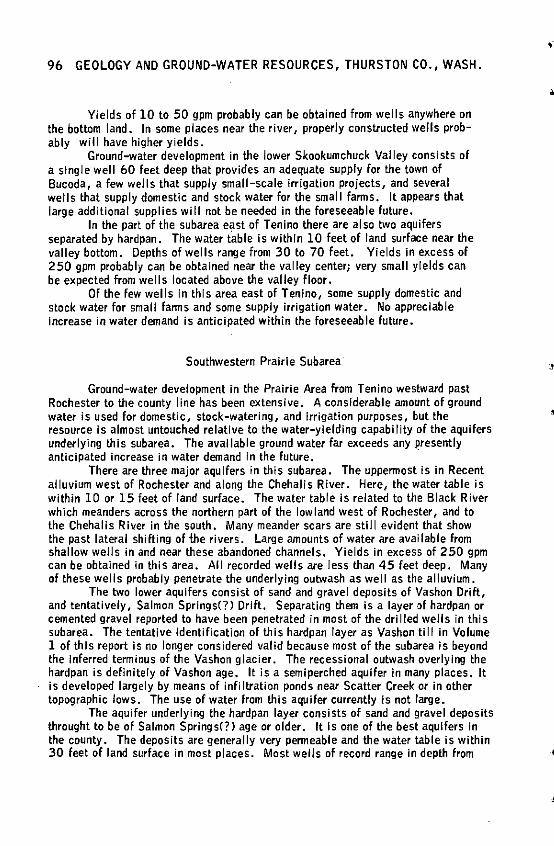
96 GEOLOGY AND GROUND-WATER RESOURCES, THURSTON CO., WASH.
Yields of 10 to 50 gpm probably can be obtained from wells anywhere on the bottom land. In some places near the river, properly constructed wells probably will have higher yields.
Ground-water development in the lower Skookumchuck Valley consists of a single well 60 feet deep that provides an adequate supply for the town of Bucoda, a few wells that supply small-scale Irrigation projects, and several wells that supply domestic and stock water for the small farms. It appears that large additional supplies will not be needed in the foreseeable future.
In the part of the subarea east of Tenino there are also two aquifers separated by hardpan. The water table is within 10 feet of land surface near the valley bottom. Depths of wells range from 30 to 70 feet. Yields In excess of 250 gpm probably can be obtained near the valley center; very small yields can be expected from wells located above the valley floor.
Of the few wells in this area east of Tenino, some supply domestic and stock water for small farms and some supply irrigation water. No appreciable increase in water demand is anticipated within the foreseeable future.
Southwestern Prairie Subarea
Ground-water development In the Prairie Area from Tenino westward past Rochester to the county line has been extensive. A considerable amount of ground water is used for domestic, stock-watering, and Irrigation purposes, but the resource is almost untouched relative to the water-yielding capability of the aquifers underlying this subarea. The available ground water far exceeds any presently anticipated increase in water demand in the future. ·
There are three major aquifers in this subarea. The uppermost Is in Recent alluvium west of Rochester and along the Chehalis River. Here, the water table is within 10 or 15 feet of land surface. The water table Is related to the Black River which meanders across the northern part of the lowland west of Rochester, and to the Chehalis River in the south. Many meander scars are still evident that show the past lateral shifting of the rivers. Large amounts of water are available from shallow wells in and near these abandoned channels. Yields in excess of 250 gpm can be obtained in this area. All recorded wells are less than 45 feet deep. Many of these wells probably penetrate the underlying outwash as well as the alluvium.
The two lower aquifers consist of sand and gravel deposits of Vashon Drift, and tentatively, Salmon Springs(?) Drift. Separating them is a layer of hardpan or cemented gravel reported to have been penetrated in most of the dri I led wells in this subarea. The tentative Identification of this hardpan layer as Vashon till in Volume 1 of this report is no longer considered valid because most of the subarea is beyond the inferred terminus of the Vashon glacier. The recessional outwash overlying the hardpan is definitely of Vashon age. It is a semiperched aquifer in many places. It is developed largely by means of infiltration ponds near Scatter Creek or in other topographic lows. The use of water from this aquifer currently is not large.
The aquifer underlying the hardpan layer consists of sand and gravel deposits throught to be of Salmon Springs(?> age or older. It is one of the best aquifers in the county. The deposits are generally very permeable and the water table is within 30 feet of land surface in most places. Most wells of record range in depth from
•
·•.
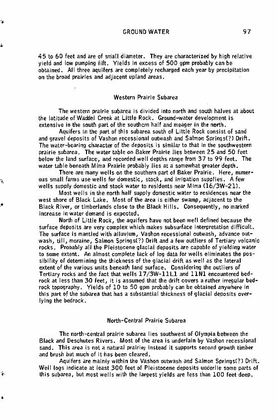
.•
•
GROUND WATER 97
45 to 60 feet and are of small diameter. They are characterized by high relative yield and low pumping lift. Yields In excess of 500 gpm probably can be obtained. All three aquifers are completely recharged each year by precipitation on the broad prairies and adjacent upland areas.
Western Prairie Subarea
The western prairie subarea is divided into north and south halves at about the latitude ofWacldel Creek at Little Rock. Ground-water development is extensive in the south part of the southern half and meager in the north.
Aquifers In the part of this subarea south of Little Rock consist of sand and gravel deposits of Vashon recessional outwash and Salmon Springs(?) Drift. The water-bearing character of the deposits is similar to that in the southwestern prairie subarea. The water table on Baker Prairie lies between 25 and 50 feet below the land surface, and recorded well depths range from 37 to 99 feet. The water table beneath Mirna Prairie probably lies at a somewhat greater depth.
There are many wells on the southern part of Baker Prairie. Here, numerous small farms use wells for domestic, stock, and irrigation supplies. A few wells supply domestic and stock water to residents near M Ima 06/3W-2 l).
Most wel Is in the north half supply domestic water to residences near the west shore of Black Lake. Most of the area is either swamp, adjacent to the Black River, or timberlands close to the Black Hills. Consequently, no marked increase in water demand is expected.
North of Little Rock, the aquifers have not been well defined because the surface deposits are very complex which makes subsurface interpretation difficult. The surface is mantled with alluvium, Vashon recessional outwash, advance outwash, till, moraine, Salmon Springs(?) Drift and a few outliers of Tertiary volcanic rocks. Probably all the Pleistocene glacial deposits are capable of yielding water to some extent. An almost complete lack of log data for wells eliminates the possibility of determining the thickness of the glacial drift as well as the lateral extent of the various units beneath land surface. Considering the outliers of Tertiary rocks and the fact that wells l 7/3W-11Ll and llNl encountered bedrock at less than 30 feet, it is assumed that the drift covers a rather irregular bedrock topography. Yields of 10 to 50 gpm probably can be obtained anywhere in this part of the subarea that has a substantial thickness of glacial deposits overlying the bedrock.
North-Central Prairie Subarea
The north-central prairie subarea I ies southwest of Olympia between the Black and Deschutes Rivers. Most of the area is underlain by Vashon recessional sand. This area is not a natural prairie; Instead it supports second growth timber and brush but much of It has been cleared.
Aquifers are mainly within the Vashon outwash and Salmon Springs(?) Drift. Well logs indicate at least 300 feet of Pleistocene deposits underlie some parts of this subarea, but most wells with the largest yields are less than 100 feet deep •
98 GEOLOGY AND GROUND-WATER RESOURCES, THURSTON CO., WASH.
The water table is within 20 feet of land surface at most places. The contact between the deposits of Vashon age and the older materials could not be defined from available data, but it is very probable that most of the existing wells are obtaining their water from Vashon deposits.
There is extensive use of ground water for domestic supplies and irrigation of small farms. Because of its proximity to Olympia and Tumwater, use will increase in the north-central prairie subarea. Sufficient water is available for all contemplated future uses.
Yields in excess of 2 50 gpm probably can be obtained from the Vashon recessional gravels or Vashon advance outwash deposits. The Vashon recessional sands will yield adequate water from shallow wells for domestic use. The deeper deposits of Salmon Springs(?) age and older are not expected to yield large amounts of water because of their fine-grained character. The aquifers underlying this subarea are fully recharged each year by local precipitation.
Northeastern Prairie Subarea
That part of the Prairie Area east of the Deschutes River Is further subdivided according to area and water-yielding capability. These units, four In all, have no definite boundaries. They are: East Olympia-Chambers Prairie unit, Lakes units, Hawks Prairie, and Nisqually River flood plain.
East Olympia-Chambers Prairie Unit
The East Olympia-Chambers Prairie unit extends from the Deschutes River east to the Maytown Upland. It is bordered on the south by the Maytown Upland and on the north by the approximate latitude of Patterson Lake.
Upper aquifers in this area are within a thick sequence of Vashon Drift. Lower aquifers probably are partly within the Salmon Springs(?) Drift. In most of the area enough water for domestic supplies is available at depths less than 100 feet. Wells should be completed above this depth if possible because the lower materials are finer grained. The Jogs of well l 7/1W-7Rl, shows coarse-grained materials to 130 feet and very fine sand and silt from 130 to 320 feet (see also log of well 17 /1W-7R2).
In the part of Chambers Prairie northeast of East Olympia wel I owners report that only a thin mantle of the coarse Vashon recessional outwash overlies as much as 90 feet of Vashon till. Wells that do not penetrate the entire thickness of the till will in general yield amounts adequate for domestic supply only. Deeper wells withdrawing water from the Vashon advance outwash likely will have capacities in excess of 50 gpm.
The yields from properly constructed wells In the area can be expected to range from 50 to 250 gpm. Although adequate ground-water supplies are available in the East Olympia-Chambers Prairie unit, many residents have had difficulty in obtaining successful wells due to fine-grained sediment entering the wells.
•
•
'
•
GROUND WATER 99
Lakes Unit
The Lakes unit extends from the Deschutes River east to the Willamette meridian and in general includes the lake complex of Ward, Hewitt, Chambers, Hicks, Patterson, Long, Southwick, and Smith Lakes. The topography of the area Is marked by many kettles and by a gently rolling surface between them (p. 60). Five of the lakes mentioned above are ground-water lakes; that is, they are maintained largely by ground water and the lake level is representative of the surrounding water table. Lake-level data are presented on figure 21 and discussed on page 76.
The two or more major aquifers underlying this area are within Vashon outwash deposits and probably Salmon Springs(?} Drift. Because of the lenticular character of these glacial deposits, aquifers merge in places and water levels vary considerably from place to place.
Large quantities of ground water are available but extreme care is required In well construclion--the aquifers in many places are sandy and their permeability Is relatively low. Consequently, for development of large capacity wells, perforated casings or well screens are necessary to' provide a large entrance area to the well. Pollution from septic tanks Is a problem In areas with shallow water tables. In most places this shallow water Is perched on till. The area around Lacey and the various lakes has an increasingly large residential development. Because community supplies are all from local wells and no sewers are in the area, much care must be taken to properly locate and construct wells to avoid pollution.
The availability of ground water throughout the Lakes area is variable as indicated on plate 4, but, in general, large yields can be expected. For example, well 18/1W-31Nl, 135 feet deep, and perforated 85-135 feet, was tested at 285 gpm; Its drawdown was 33 feet from a static water level of 12 feet below the land surface.
Hawks Prairie
The Hawks Prairie area extends from South Bay east to the Willamette meridian and south to the Olympia-Tacoma highway CU. S. 99). The boundaries are indefinite but the area includes roughly the north half of T. 18 N., R. 1 W. The major development of ground water has been along highway U. S. 99.
At least two aquifers underlie this outwash-covered prairie. The upper aquifer is composed of Vashon Drift and its top is within 100 feet of the land surface. The wells penetrating this shallow aquifer range in depth from about 50 to 100 feet and most are used to furnish domestic supplies. Records indicate that some of these wells serve as many as five homes so the aquifer apparently has an adequate yield potential to satisfy average domestic needs. For a demand in excess of 50 gpm, drilling Into the deeper aquifer may be necessary. This aquifer is mostly within the Salmon Springs(?) Drift. Wells withdrawing water from the lower aquifer generally exceed 150 feet in cfepth. For example, well 18/lW-llJl, 284 feet deep, was cased and finished at 260 feet. Most deep wells have been drilled to depths between 175 and 200 feet which is near sea level. The water table in the deeper aquifer is from 10 to 80 feet above mean sea level. Reports indicate the water has a high iron content in places, probably from the overlying Kitsap Formation .
100 GEOLOGY AND GROUND-WATER RESOURCES, THURSTON CO., WASH.
Nisqually River Flood Plain
The flood plain between the Nisqually River and McAllister Creek, ranging in altitude from sea level to about 25 feet, is underlain by fine-grained alluvium which provides some of the best farm land in the county.
The upper part of the alluvium is mostly sand, silt, and clay that is saturated almost to land surface. Most wells are drilled in excess of 100 feet where coarser grained aquifers under low artesian head exist. Most of these wells flow and have high specific capacities. For example, well 18/1E-18Al, 120 feet deep, flowed 250 gpm in 1953. The upper part of the alluvium is not impermeable but the permeability is low enough to make It a partial aquiclude that will confine water In the deeper materials.
Recharge to the artesian zone is from the lower aquifer in the surrounding upland area, the kettled area north of Lake St. Clair, and the Ni squally River upstream from 18/lE-16.
Southeastern Prairie Subarea
As indicated previously, Mundorff and others made a thorough study of ground water Jn the Yelm Area which includes most of the southeastern prairie area. Their conclusions (1955, p, 32) are as follows:
"The unconsolidated deposits of Pleistocene age that underlie the Yelm Area contain aquifers of sand and gravel at many horizons, ranging from a few feet to several hundred feet below the surface. Some of these aquifers are very permeable and are capable of yielding large amounts of water. The water occurs chiefly under watertable conditions. The depth to water generally ranges from 20 to 70 feet.
"Many Irrigation wells are Jess than 100 feet deep, but a few have been drilled to depths of more than 200 feet. It Is possible that the deeper drilling has been necessitated, In part, by failure to effectively utilize the shallower aquifers. Most of the irrigation wells are perforated, but some of the wells yield only a small part of the water available In the aquifers because of the limited intake area of the perforations. Jn some wells the total area perforated would be sufficient to let in all of the water that the aquifer Is capable of yielding, ii the perforations were ali cut opposite productive horizons. However, In some of these wells, possibly 75 percent of the perforations are use_less because they are cut opposite Impermeable strata.
11 Ground water In the Yelm Area is derived principally from precipitation on the area; the supply is rep Jeni shed annually, chiefly during the winter and spring. Ground water under the Yelm Prairie moves generally northward and northwestward, discharging into the Nisqually River. The total annual underflow and discharge from the 11 square miles Included in the Yelm Prairie is estimated to be roughly 25,000 acre-feet. Probably 7 ,000 to 8,000 acre-feet annually could be recovered by wells for irrigation on the pralrle. 11
•
•
•
·•
'.•
•
•
GROUND WATER 101
Central Prairie Subarea
The central prairie subarea extends from Weir Prairie, down the Deschutes River to near Offut Lake, across part of Rocky Prairie and down Beaver Creek through Maytown to Little Rock. It has a very irregular boundary but except for Weir Prairie It can, In a general way, be described as the narrow strip dissecting the Maytown Upland that was formerly occupied by the Offut Lake-Rocky Prairie outwash route (p. SS).
Most of the area is underlain by Vashon recessional outwash. Utilization of ground water for other than dome5~ic purposes has been slight. Although substantiating well information is not available, it is thought that moderate groundwater supplies can be obtained throughout most of this area from Maytown east to Rainier.
CHEMICAL CHARACTER OF GROUND WATER
Chemical analyses of 210 ground-water samples are reported In Volume 1. Of these, 34 are "complete" analyses <Tables 2 and 2A) and 176 are "partial" analyses (Table 2B and 2C). Unless indicated otherwise, all results are reported In ppm (parts per million).
The "complete" analyses show that all the waters sampled are of a calciummagneslum bicarbonate type. It Is expected that most ground water in the county Is of the same type except that markedly cont3.lllinated by sea water which'is a sodium chloride type. The following tabulation shows the results of the study of the complete analyses. The water type is shown by a binomial system in which the first number Is the percent of calcium plus magnesium among the total cations, and the second number is the percent of bicarbonate among the total anions. As similarly done by Walters and Kimmel (In preparation) those waters with symbols of SO.SO or greater have been assigned to the calcium-magnesium bicarbonate type.
Table S - Binomial chemical classification of ground water in Thurston County. Data derived from Wallace and Molenaar (1961, p. 130-132).
Well
1S/1W-6Al -7El
1S/2W-SE1 -lSRl
15/3W-5Bl -14C2
16/1W-19Ml 16/3W-16Ll
Classification (Percent Ca+ Mg • Percent HC03)
72.65 65.56 69.61 68.71 57.62 73.75 69.66 70.80
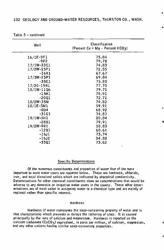
102 GEOLOGY AND GROUND-WATER RESOURCES, THURSTON CO., WASH.
Table 5 - continued
Well
16/1E-9Fl -9F2
l 7 /1W-33Cl 17/2W-15Pl
-16Rl l 7 /3W-25Pl
-35El l 7 /2E-19Nl 18/1W-11Q6
-15Hl -20Ql
18/2W-35M 18/1E-5Ml
-8D4 -31Gl
l 9/1W-5Hl -2881
19/2W-9Rl -1281 -16Jl -16J2 -35Ql
Classification (Percent Ca+ Mg · Percent HC03)
Specific Determinations
75.84 79.78 74.83 72.55 67.67 69.84 75.85 77.70 79.71 78.91 72.71 74.82 59.91 68.92 74.87 80.84 79.91 50.83 60.61 73.74 84.88 73.62
Of the numerous constituents and properties of water four of the more Important to most water users are reported below. These are hardness, chloride, iron, and total dissolved solids which are indicated by electrical conductivity. Determinations for other chemical constituents show no concentrations that would be adverse to any domestic or irrigation water users in the county. These other determinations are of most value in assigning water to a chemical type and are mainly of regional rather than specific interest.
Hardness
Hardness of water represents the soap-consuming property of water and Is that characteristic which prevents or delays the lathering of soap. It is caused principally by the ions of calcium and magnesium. Hardness is reported as the
•
•
•
calcium carbonate (CaC03) equivalent, in parts per million, of calcium, magnesium, ·t!. and any other cations having similar soap-consuming properties.
'
•
GROUND WATER 103
The adjectives 11hard 11 and 11 soft 11 are highly relative. Jnd!viduals from areas of very hard water (such as parts of the Midwest> would consider almost all western Washington water soft. The following table shows the hardness scale that is in general use by the U.S. Geological Survey.
Hardness as CaC03 (ppm}
0-60 - - - - - - - - - - - - - - - - - -61-120 - - - - - - - - - - - - - - - - -
121-200 - - - - - - - - - - - - - - - - -Above 200 - - - - - - - - - - - - - - - -
Degree of hardness
Soft SI ightly hard Hard Very hard
Of the 201 ground-water samples whose hardness analyses are tabulated in Volume l of this report, 174 can be classified as soft, 21 as slightly hard, 2 as hard, and 4 as very hard. The range in hardness of water Is 5 ppm to 795 ppm. The hardness of waters that have a large amount of dissolved solids is high. These waters are generally contaminated by sea water or are derived at least in part from many of the Tertiary or lower Pleistocene deposits. The reason for high hardness of water from other sources Is unknown. For example, the hardness of water from wells 19/1W-5Hl and 2881, 113 ppm and 89 ppm, respectively, shows no evidence of salt-water contamination as evidenced by low chloride values, and are derived from deposits of Wisconsin age.
Chloride
Chloride analyses were made on 211 samples in Thurston County. Chloride was present in quantities less than 12 ppm in 193 of the samples, from 12 to 25 ppm in 11 of the samples, and more than 25 ppm In 7 of the samples. The range in chloride is from l to 10 ,500 ppm.
Of the 7 samples containing more than 25 ppm of chloride, 6 are from coastal or lowland areas where there is sea-water Intrusion Into the aquifers (p. 108). An additional well (17/1W-33A, Appendix} sampled late Jn the study, contained 10,500 ppm chloride. This aquifer is never expected to be used. This well shows the only evidence for direct contamination by connate Tertiary water within Thurston County. Values between 12 and 25 ppm are probably indicative of incipient contam.ination either by sea water or by water from Tertiary or older Pleistocene deposits. Samples with less than 12 ppm may be considered to be free of saline contamination.
Of the wells sampled, only 3 (from l7/1W"33A, 10,500 ppm; 19/1W-6M2, l, 795 ppm; and 20/2W-33Ll, 677 ppm} exceed the maximum chloride limit of 250 ppm that Is recommended by the U. S. Public Health Service (1962, p. 7) •
104 GEOLOGY AND GROUND-WATER RESOURCES, THURSTON CO., WASH.
Iron
Iron or iron associated with manganese Is the most common objectionable constituent of ground water In Thurston County. Both elements have slml lar reactions In water and often their effects are almost indistinguishable. Because Iron Is a much more abundant constituent of rocks and soils, it usually occurs In greater concentrations In natural waters than does manganesf?.
Iron, the fourth most abundant rock-forming element, occurs In most ground water, but usually In low concentration. Unfortunately, the existence of only a small amount of Iron in water will make it unsatisfactory for many uses. The iron remains in solution and the water Is generally clear until exposed to the oxygen In the air at which time the iron begins to oxidize from a ferrous state (bivalent> to the ferric state (trivalent) and ultimately to precipitate as Iron oxide, Fe203 , or Iron hydroxide, FeCOHl3. The precipitate causes undesirable brow_nish or redaish stains on almost everything that Is touched by the iron-bearing water. This staining has been a common objection of water users in many areas throughout the county. Manganese differs from iron In that the resultant staining is black.
In addition to the objectionable staining, Iron may also cause tastes and odor through the growth of iron-forming bacteria. The accumulation and decomposition of these bacteria may result in clogging of water pipes and consequently Iron-removal treatment Is generally necessary before the water enters the distribution system. Chlorination to kill the bacteria Is a part of this treatment process.
Of 33 samples tested, the range In iron was from less than 1 part per billion to 2 .2 ppm and 5 had concentrations exceeding the 0 .3 ppm that has been recommended by the United States Public Health Service as a maximum concentration of Iron and manganese in water that is to be used for domestic purposes. Manganese occurs in very low concentrations in all waters tested. Higher concentrations of Iron In water are not detrimental to health but are generally unsuitable because of their objectionable characteristics.
Also see page 106.
Electrical Conductivity
Electrical conductivity Is the ability of water to conduct a current of electricity. When reported in units of mlcromhos at 77°F (25°Cl it is called specific electrical conductance. (A mho is a reciprocal ohm, the unit of electrical resistance.) Conductivity analyses give a quick indication of water impurities occurring as Ionized dissolved solids. A high conductivity value is reflected by a high dissolved solids content but is not generally indicative of any particular ion or group of ions.
According to Hem (1959, p. 40) there Is a very rough quantitative relationship between specific electrical conductance and dissolved solids. For most waters, the specific conductance multiplied by a factor that ranges from 0. 55 to 0. 75 wi 11 give the dissolved solids In parts per million. However, the comparison of conductivity and dissolved solids as reported in Volume 1, Table 2A, provides an average factor of 0.81 and a range from 0.70 to 0.88. Figure 25 shows the range In specific conductance of the 164 samples analyzed. Thus, by applying the factor 0.81 to the
!
conductivity scale In figure 25, the units can be converted to read directly in parts per -~
•
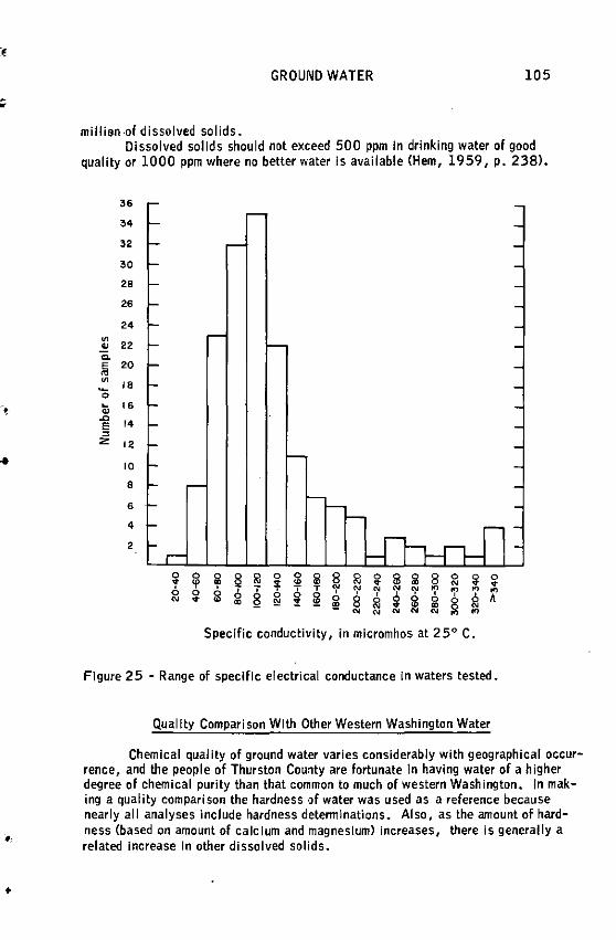
•
•
GROUND WATER 105
million ·Of dissolved solids. Dissolved solids should not exceed 500 ppm In drinking water of good
quality or 1000 ppm where no better water Is available (Hem, 1959, p. 238).
36
34
32
30
20
26
24 ~
" 22 Q.
Iii 20 ~
18 'O li; 16 .0
14 E = z 12
10
8
6
4
2
0 0 0 ~ "1 0 0 iii 8 "1 0 s iii 8 0 ~ 0 ~ 'f' 'l' 'I' "' ~ N ~ 6 6 -; T T N ')' N N ')' " " " " 0 0
~ 0 ~ ~ ' ' ' ' 8 6 A N ~ "' "' "'
0 8 "1 ~ iii 0 !!! "' N
N N N N N " " Specific conductivity, in micromhos at 2 5° C.
Figure 25 - Range of specific electrical conductance In waters tested.
Quality Comparison With Other Western Washington Water
Chemical quality of ground water varies considerably with geographical occurrence, and the people of Thurston County are fortunate In having water of a higher degree of chemical purity than that common ta much of western Washington. in making a quality comparison the hardness of water was used as a reference because nearly ail analyses include hardness determinations. Also, as the amount of hardness (based on amount of calclum and magnesium) increases, there is generally a related Increase In other dissolved solids •
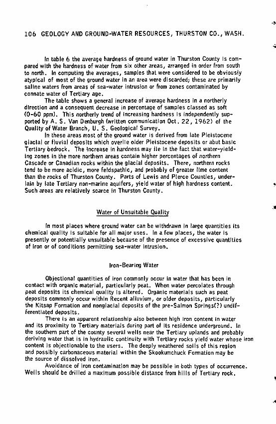
106 GEOLOGY AND GROUND-WATER RESOURCES, THURSTON CO., WASH.
In table 6 the average hardness of ground water in Thurston County Is compared with the hardness of water from six other areas, arranged in order from south to north. In computing the averages, samples that were considered to be obviously atypical of most of the ground water In an area were discarded; these are primarily saline waters from areas of sea-water intrusion or from zones contaminated by connate water of Tertiary age.
The table shows a general increase of average hardness in a northerly direction and a consequent decrease in percentage of samples classed as soft (0-60 ppm). This northerly trend of increasing hardness Is independently supported by A. S. Van Denburgh (written communication Oct. 22, 1962) of the Quality of Water Branch, U.S. Geological Survey.
In these areas most of the ground water is derived from late Pleistocene glacial or fluvial deposits which overlie older Pleistocene deposits or abut basic Tertiary bedrock. The Increase In hardness may lie In the fact that water-yielding zones in the more northern areas contain higher percentages of northern Cascade or Canadian rocks within the glacial deposits. There, northern rocks tend to be more acidic, more feldspathlc, and probably of greater lime content than the rocks of Thurston County. Parts of Lewis and Pierce Counties, underlain by late Tertiary non-marine aquifers, yield water of high hardness content. Such areas are relatively scarce In Thurston County.
Water of Unsuitable Quality
In most places where ground water can be withdrawn in large quantities Its chemical quality Is suitable for all major uses. In a few places, the water is presently or potentially unsuitable because of the presence of excessive quantities of Iron or of conditions permitting sea-water intrusion.
Iron-Bearing Water
Objectlonal quantities of iron commonly occur In water that has been in contact with organic material, particularly peat. When water percolates through peat deposits its chemical quality Is altered. Organic materials such as peat deposits commonly occur within Recent alluvium, or older deposits, particularly the Kitsap Formation and nonglacial deposits of the pre-Salmon Springs(?) undifferentiated deposits.
There Is an apparent relationship also between high Iron content in water and its proximity to Tertiary materials during part of its residence underground. In the southern part of the county several wells near the Tertiary uplands and probably deriving water that is in hydraulic continuity with Tertiary rocks yield water whose iron content is objectionable to the users. The deeply weathered soils of this region and possibly carbonaceous material within the Skookumchuck Fonnation may be the source of dissolved iron.
Avoidance of iron contamination may be possible in both types of occurrence. Wells should be drilled a maximum possible distance from hills of Tertiary rock.
•
••
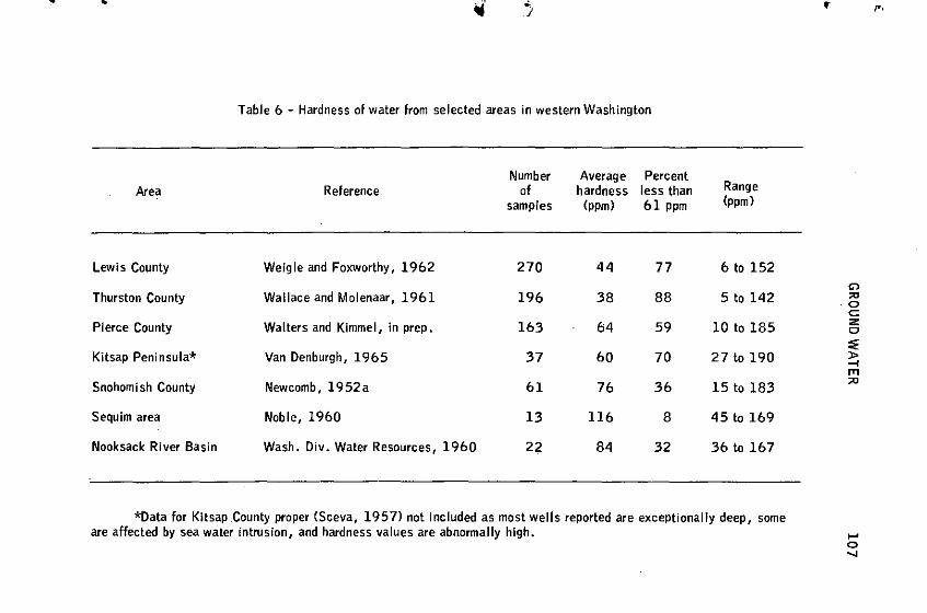
•
Area
Lewis County
Thurston County
Pierce County
Kitsap Peninsula*
Snohomish County
Sequim area
Nooksack River Basin
Table 6 - Hardness of water from selected areas in western Washington
Reference
Weigle and Foxworthy, 1962
Wallace and Molenaar, 1961
Walters and Kimmel, in prep.
Van Denburgh, 1965
Newcomb, 1952a
Noble, 1960
Wash. Div. Water Resources, 1960
Number of
samples
270
196
163
37
61
13
22
Average hardness
(ppm)
44
38
fi4
60
76
116
84
Percent less than 61 ppm
77
88
59
70
36
8
32
Range (ppm)
6 to 152
5 to 142
10 to 185
27tol90
15 to 183
45 to 169
36 to 167
*Data for Kitsap County proper (Sceva, 1957) not included as most wells reported are exceptionally deep, some are affected by sea water intrusion, and hardness values are abnormally high.
"' "' ·O c z c :;; )> --i
"' "'
..... 0 ....
108 GEOLOGY AND GROUND-WATER RESOURCE·S, THURSTON CO., WASH.
. This practice is advisable for purposes of quantity as well as quality. An effort should be made to case off water from zones containing organic materials If it is possible to develop the supply above or below. In the case of surface accumulations of peat, a surface seal should be set around the casing and water-tight casing should extend as far.beneath the surface as is practical. Iron contamination probably would not be eliminated, but should be reduced If these practices are followed.
Of the five wells that yield water-containing more than 0.3 ppm of iron, wells 15/2W-5El Cl.9 ppm) and 15/3W-5Bl (2.2 ppm) probably receive the .Iron from waters that have traveled from the nearby Skookumchuck Formation. The water from the Skookumchuck Formation is blended with water In Vashon out
.wash. Well 19/2W-9Rl C0.62 ppm) is a flowing well that apparently taps a zone beneath about 50 feet of blue clay which, at many places in the county, is associated with peat within the pre-Salmon Springs(?) deposits. The wateryieldlng zone is from about 335 to 350 feet below sea level. Well l 7/3W-2 5Pl (1.4 ppm) is in a peaty area near a marshy creek that drains into the Black River Valley swamp. The occurrence of bog iron crystals reported on page 107 is in the same drainage and about a quarter mile upstream. The analysis of
. .
well 16/1E-9F2 C0.8 ppm), when compared to the analysis of well 9Fl (trace), -• demonstrates the capriciousness of iron occurrence. The wells are only a few feet apart and both are 120 feet deep. Well 9F2 may be perforated in a zone of high iron concentration that is not tapped by 9Fl. .-,
Most water containing an objectionable amount of iron can be treated to make it satisfactory for domestic use. The best treatment is aeration and filtration; however, this treatment is generally an expensive process not economically feasible for domestic wells of limited use.
Sea-Water Contamination
Sea-water intrusion has not been a major problem in the county. During the Investigation 15 wells were known to have been contaminated, but in a few the sea water was cased off and deeper drilling enabled water from uncontaminated aquifers to be withdrawn from the wells. Of the remainder,water from at least six are subject to sea-water contamination as inferred from their high chloride content (p. 103). The greatest recorded chloride concentration due to sea-water contamination Cl, 795 ppm, about one-tenth that of sea water) was that for water in well l 9/1W-6M2. Chief known areas of sea-water contamination are at Dickenson Point, Cooper Point, south of Steamboat Island, and south of the head of Mud Bay.
Intrusion may occur where a fresh-water aquifer is in hydraulic continuity with sea water. Fresh water tends to float upon salt water which is heavier. In wells near shore, when the fresh water is pumped at such a rate that the water level is drawn down below sea level, intrusion may occur. One procedure to reduce sea-water contamination is to reduce or rearrange the pumping draft of all wells tapping an affected aquifer so that pumping levels remain above sea level. The hydraulic relations are complex (see Todd, 1957, p. 277>, and little is known about them in areas of contamination within Thurston County. •
..
•
•
GROUND WATER 109
An awareness and knowledge of the relation between fresh and salt water will become Increasingly important to the proper management of ground-water supplies in the Peninsular Area of Thurston County as residential development continues. All areas close to marine waters should be considered subject to potential encroachment of sea water Into the aquifers.
USE OF GROUND WATER
Most of the wells in Thurston County are used for single unit domestic supplies. The greatest quantity of water Is used for irrigation. Most other wells are used for public and Industrial supplies. Table 7 presents an estimate of ground-water withdrawals based on the wel I data recorded In Volumes 1 and 2.
Domestic Supplies
Domestic wells constitute the major source of water in all rural areas. The shallower wells are commonly dug and the deeper are usually drilled and provided with 6-inch casings. Centrifugal pumps are used in most wells In which the water level is consistently less than 20 feet below land surface; jet pumps are used In those In which the water level Is greater than 20 feet. Both types are powered by electric motors ranging in capacity from! to 1 horsepower. For table 7, the annual withdrawal from domestic wells has been computed by assuming the average well to pump 7 gpm about 6 percent of the time.
Irrigation Supplies
Most of the ground water pumped in Thurston County Is used for Irrigation. Most of the agricultural crops grown in the county need Irrigation for optimum growth. Irrigation of domestic lawns and gardens is also an Important use but In table 7 only irrigation of areas larger than 2 acres are included.
Most Irrigation wells are equipped with turbine pumps driven by motors ranging from about 3 to 20 horsepower. The average yield of 231 wells is 175 gpm; some yield as much as 1,000 gpm.
The total area capable of being irrigated by ground water in 1964 Is estimated as 5,500 acres (8.6 square miles). This estimate Is based on data for 158 wells, each of which Irrigates or has irrigated an average of 20.2 acres. The annual withdrawal figure In table 7 is based on the assumption that an average of 1 acre-foot per acre is applied for irrigation. This quantity tends to be excessive but most people over-irrigate.
Public Supplies
In 1964, about 13,200 people are served by public ground-water supplies. Olympia, served by McAllister Springs, is not Included. The city of Tumwater and

110 GEOLOGY AND GROUND-WATER RESOURCE.S, THURSTON CO., WASH.
a private water company serving the community of Lacey provide water to about 72 percent of this population. About 65 wells belonging to smaller towns and water systems supply the remaining population.
The annual pumpage of the largest systems Indicates that the average per capita consumption is about 100 gallons per day. Lawn and garden irrigation in summer may cause peak demands of several hundred gallons per day. The figure for annual withdrawal in table 7 is based on the assumed per capita demand of 100 gallons per day.
Industrial Supplies
Several light industries in the county use small quantities of ground water from their own wells. The largest user, the Olympia Brewery, Is supplied from about 10 wells located on the Deschutes River flood plain south of Tumwater. These wells are not recorded in this report.
Annual withdrawals for industrial use (table 7) are very rough estimates based on the assumption that the average well produces 125 gpm, about 20 percent of the time.
Table 7 - Estimated yield of ground water for each use category
Use Number of wells Yield 1
Annual Recorded Total 1 Avg. per well, withdrawal
(gpm) (acre-feet)
Domestic 1,800 3,000 7 2,000 Irrigation 248 275 175 5,500 Public supply · 58 73 200 1,450 Industrial 17 27 125 1,000
Total 2 ,200 2 3,375 9.,950
l Estimated 2 Includes multiple use
FUTURE DEVELOPMENT
Most new major water supplies in Thurston County will be from ground-water sources. Increased use will be principally for single domestic and community resi-
..
•
•
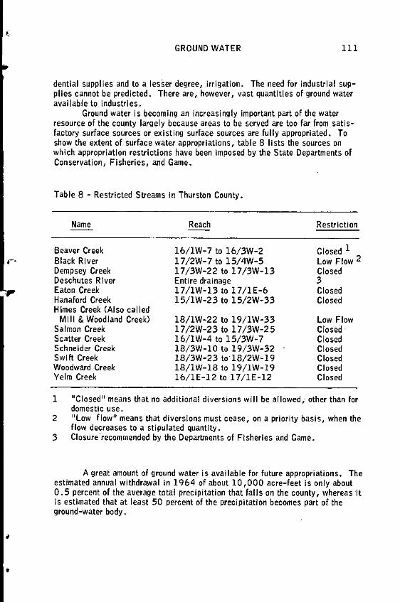
•
•
GROUND WATER 111
dential supplies and to a lesser degree, irrigation. The need for industrial supplies cannot be predicted. There are, however, vast quantities of ground water aval lable to industries.
Ground water is becoming an increasingly important part of the water resource of the county largely because areas to be served are too far from sati sfactory surface sources or existing surface sources are fully appropriated. To show the extent of surface water appropriations, table 8 lists the sources on which appropriation restrictions have been imposed by the State Departments of Conservation, Fisheries, and Game.
Table 8 - Restricted Streams In Thurston County.
Name
Beaver Creek Black River Dempsey Creek Deschutes River Eaton Creek Hanaford Creek Himes Creek (Also called
Mill & Woodland Creek) Salmon Creek Scatter Creek Schneider Creek Swift Creek Woodward Creek Yelm Creek
Reach
16/lW-7 to 16/3W-2 17/2W-7 to 15/4W-5 l 7 /3W-22 to l 7 /3W-13 Entire drainage l 7 /lW-13 to 17 /lE-6 15/lW-23 to 15/2W-33
18/lW-22 to l 9/lW-33 17/2W-23 to 17/3W-25 16/lW-4 to 15/3W-7 18/3W-10 to l 9/3W-32 18/3W-23 to 18/2W-l 9 18/lW-18 to l 9/lW-19 16/lE-12 to 17/lE-12
Restriction
Closed 1
Low Flow 2 Closed 3 Closed Closed
Low Flow Closed· Closed Closed Closed Closed Closed
1 11 Closed 11 means that no additional diversions will be allowed; other than for domestic use.
2 11 Low flow 11 means that diversions must cease, on a priority basis, when the flow decreases to a stipulated quantity.
3 Closurerecommended by the Deparbnents of Fisheries and Game.
A great amount of ground water is available for future appropriations. The estimated annual withdrawal in 1964 of about 10,000 acre-feet is only about 0. 5 percent of the average total precipitation that falls on the county, whereas It is estimated that at least 50 percent of the precipitation becomes part of the ground-water body .
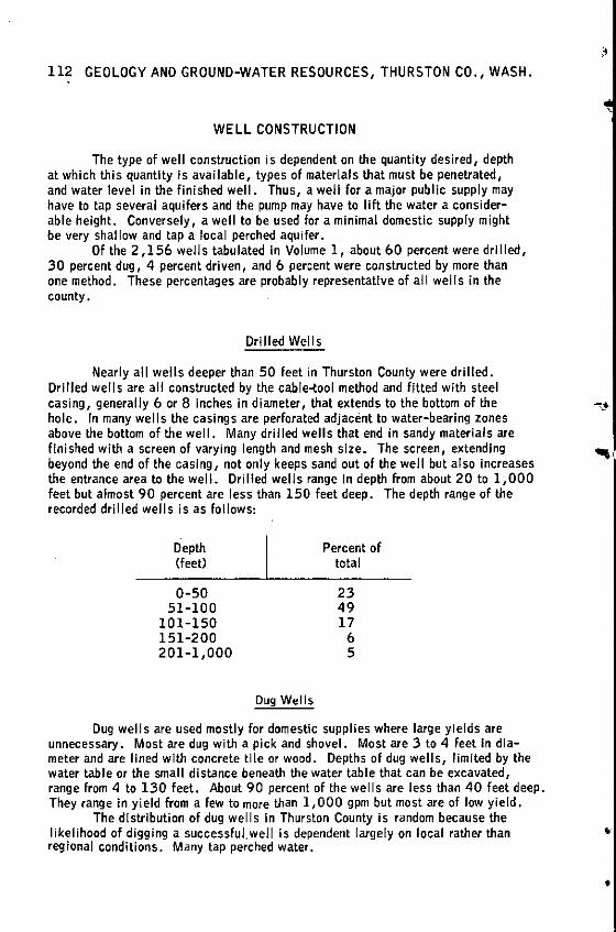
112 GEOLOGY ANO GROUND-WATER RESOURCES, THURSTON CO., WASH.
WELL CONSTRUCTION
The type of well construction is dependent on the quantity desired, depth at which this quantity Is available, types of materials that must be penetrated, and water level in the finished well. Thus, a well for a major public supply may have to tap several aquifers and the pump may have to lift the water a considerable height. Conversely, a well to be used for a minimal domestic supply might be very shallow and tap a local perched aquifer.
Of the 2,156 wells tabulated In Volume 1, about 60 percent were drilled, 30 percent dug, 4 percent driven, and 6 percent were constructed by more than one method. These percentages are probably representative of ail wells in the county.
Ori lied Wei Is
Nearly all wells deeper than 50 feet in Thurston County were drilled. Drilled wells are ail constructed by the cable-tool method and fitted with steel casing, generally 6 or 8 Inches in diameter, that extends to the bottom of the hole. In many wells the casings are perforated adjacent to water-bearing zones above the bottom of the well. Many drilled wells that end in sandy materials are finished with a screen of varying length and mesh size. The screen, extending beyond the end of the casing, not only keeps sand out of the well but also Increases the entrance area to the well. Drilled wells range In depth from about 20 to 1,000 feet but almost 90 percent are less than 150 feet deep. The depth range of the recorded drilled wells is as follows:
Depth (feet)
0-50 51-100
101-150 151-200 201-1,000
Dug Wells
Percent of total
23 49 17
6 5
Dug wells are used mostly for domestic supplies where large yields are unnecessary. Most are dug with a pick and shovel. Most are 3 to 4 feet In diameter and are lined with concrete tile or wood. Depths of dug wells, limited by the water table or the small distance beneath the water table that can be excavated, range from 4 to 130 feet. About 90 percent of the wells are less than 40 feet deep, They range In yield from a few to more than 1,000 gpm but most are of low yield.
The distribution of dug wells In Thurston County is random because the likelihood of digging a successful.well is dependent largely on local rather than regional conditions. Many tap perched water.
""'
•
•
GROUND .WATER 113
The chief advantage of dug wells is their low cost. Also, because of theirgreater diameter, they have greater storage capacity than drilled wells. This is important where the water-bearing materials are of low permeability and where the draft is intennlttent. Disadvantages are the greater chance of surface pollution and the limitation of depth. Many dug wells cannot be relied on for perennial supplies during years of low precipitation. To achieve maximum depth, dug wells should be completed during the low water time in late summer or early fall (see figs. 22, 23, 23al.
Driven Wei Is
Driven wells are the least expensive type. Many of them provide adequate domestic supplies. In Thurston County driven wells are feasible only in certain areas.
A well of this type is constructed by driving a pipe (generally 1 to 4 inches In diameter) into the ground. A perforated or screened drive point Is attached to the lower end. Because of the small casing diameter the well generally must be pumped with a suction-type pump and consequently the water table must be within 20 feet of the land surface. A well cannot be driven through a hardpan or a coarse gravel formationi thus, the driven wells are limited to areas underlain by sandy deposits in which the water table is shallow. They are concentrated on the sandy prairie between Tumwater and Black Lake, and on the Nisqually flood plain, where many flow. The chief advantage is low cost. The chief disadvantage Is low yield.
NEED FOR FUTURE STUDIES
The principal purpose of this report is to describe the occurrence and quality of ground water within Thurston County. It is hoped that the authors have succeeded in th! s purpose to the extent that future developers and present users of ground-water supplies will be materially aided. However, as new supplies are required, it is expected that detailed studies of smal I areas wi II be required to assure proper development of thes.e supplies.
Water Quantity Studies
Potential developers demanding very large ground-water withdrawals should seek professional advice· to evaluate the safe yield of the aquifers within their area of withdrawal. This can only be done by interpretation of extensive data collected from within the area of influence.' · As need develops in areas of questionable ground-water production (such as the Maytown Upland and periphery of the Black Hills) test holes should be drilled. In such places it may prove advantageous to develop a supply in a nearby area of good production and transport it by pipeline to the area of use •
114 GEOLOGY AND GROUND-WATER RESOURCES, THURSTON CO., WASH.
Water Qua I ity Studies
Sea-water intrusion is a potential major problem. Aquifers now affected by incipient intrusion can be expected to be further affected as yields are Increased. Detailed aquifer studies should be made where large supplies are to be withdrawn from any aquifers suspected to be in hydraulic continuity with sea water.
The presence of excessive amounts of iron in ground water should be suspected anywhere in the county. In most cases, the iron is very local in occurrence and can be avoided by drilling deeper or moving to a nearby new location.
CONCLUSIONS
Rocks of the Tertiary Period which make up most of the foothills and upland areas In Thurston County are generally of low permeability and yield only small quantities of water to wells. Additionally, the mineral content of much of the water withdrawn from these rocks is high. Consequently, these rocks will never be Important as aquifers in the county.
Rocks of the Quaternary Period cover about two-thirds of the land surface ·•·'· of Thurston County and the unconsolidated deposits within this system constitute the principal aquifers In the county.
1. The Logan Hill Formation (oldest Pleistocene deposits) Is of low permeability and is unimportant as an aquifer in Thurston County.
2. The pre-Salmon Springs<?) deposits, undifferentiated, and underlying deposits, although generally of clay and silt, include some highly productive confined aquifers. These deposits will supply much of the ground water for the future development of the Peninsular Area.
3. The Salmon Springs(?) Drift includes some of the most extensive aquifers In the county. The drift is known to underlle most of the Peninsular Area and is thought to underlie the Yelm Prairie and much of the southern part of the Prairie Area. Although a substantial inci-ease in withdrawal from these aquifers in areas close to marine waters may result in sea-water intrusion, the aquifers in general are regarded as having very good potential for future ground-water development in inland areas.
4. The Kitsap Formation is unimportant as an aquifer because of its low penneabllity. However, in places Kitsap deposits form an aquiclude which confines water in the underlying aquifers. In other places, it retards downward percolation of water thereby causing storage of large volumes of water in the overlying deposits. The formation also serves as a stratigraphic marker in drilling operations. Peat within this formation is responsible for objectionable iron content in ground water in some places.
. ..
•

GROUND WATER
5. The unconsolidated deposits of Colvos Sand and Vashon advance outwash are moderately permeable and are very good aquifers In many places. Some of the highest yielding wells in the county derive water from these materials. These deposits lie above the water table in numerous places and In some areas are not present.
6. Vashon till, a poor aquifer, serves as an effective aquiclude upon which perched water zones often occur. Dug wells that bottom In till provide small quantities of water for many domestic supplies throughout the county. The wells are characterized by low yield and, in many, by inadequacy during late summer and early lal I.
7. Vashon recessional outwash deposits are generally good aquifers but the deposits occur above the regional water table in many places. The sandy phase of outwash is the source of many domestic supplies. The recessional gravel deposits yield large quantities of ground water.
115
Nearly all the ground water in Thurston County is generally suitable for all nonnal uses. The county has a favorable areal distribution of ground water such that most areas of greatest need are underlain by good aquifers. The Peninsular Area, in which residential development probably will Increase materially In the next few years, is underlain by aquifers adequate for domestic supply on the inland part. These aquifers are composed of deposits of either Salmon Springs(?) Drift or the composite unit of Colvos Sand and Vashon advance outwash. In areas of concentrated residential development along the beaches, community supplies should be obtainable from the deeper aquifers in the deposits of pre-Salmon Springs(?) deposits, undifferentiated.
The Prairie Area is generally underlain by aquifers of moderate lo high yield. Ample ground water Is available for residential development and irrigation supplies. The area Is geographically adaptable to Industrial use and sufficient ground water Is available to industries. The principal aquifers to be utilized are in deposits of either Vashon advance outwash or Salmon Springs(?) Drift, although presently manY ground water withdrawals are from Vashon recessional outwash. Additionally, large supplies are available from Vashon outwash on the southernmost prairies.
The availability of ground water Is rather questionable in the Maytown Upland. Because population is sparse, the need for water Is slight and very little exploration for ground water Is taking place. It is thought that there are local areas within the upland where good supplies of ground water occur and ii future need arises exploratory wells should be drilled.
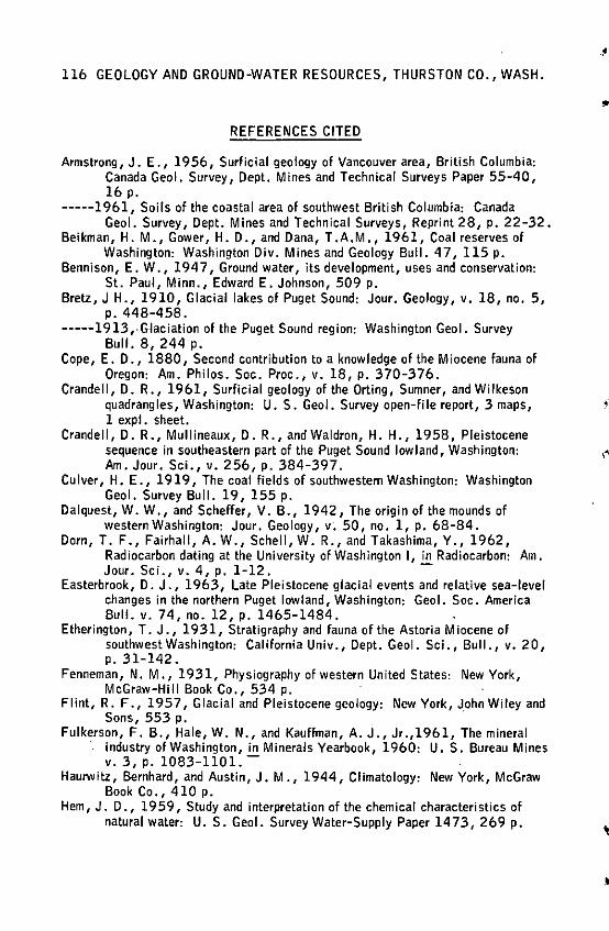
116 GEOLOGY AND GROUND-WATER RESOURCES, THURSTON CO., WASH.
REFERENCES CITED
Armstrong, J. E., 1956, Surficial geology of Vancouver area, British Columbia: Canada Geol. Survey, Dept. Mines and Technical Surveys Paper 55-40, 16 p.
-----1961, Soils of the coastal area of southwest British Columbia: Canada Geol. Survey, Dept. Mines and Technical Surveys, Reprint 28, p. 22-32.
Beikman, H. M., Gower, H. D., and Dana, T.A.M., 1961, Coal reserves of Washington: Washington Div. Mines and Geology Bull. 47, 115 p.
Bennison, E. W., 194 7, Ground water, its development, uses and conservation: St. Paul, Minn., Edward E. Johnson, 509 p.
Bretz, J H., 1910, Glacial lakes of Puget Sound: Jour. Geology, v. 18, no. 5, p. 448-458.
-----1913,.Glaciation of the Puget Sound region: Washington Geol. Survey Bull. 8, 244 p.
Cope, E. D., 1880, Second contribution to a knowledge of the Miocene fauna of Oregon: Am. Philos. Soc. Proc., v. 18, p. 370-376.
Crandell, D.R., 1961, Surficial geology of the Orting, Sumner, and Wilkeson quadrangles, Washington: U.S. Geol. Survey open-file report, 3 maps, 1 expl. sheet.
Crandell, D.R., Mullineaux, D.R., and Waldron, H. H., 1958, Pleistocene
..
sequence in southeastern part of the Puget Sound lowland, Washington: ,, Am. Jour. Sci., v. 256, p. 384-397.
Culver, H. E., 1919, The coal fields of southwestern Washington: Washington Geol. Survey Bull. 19, 155 p.
Dalquest, W.W., and Scheffer, V. B., 1942, The origin of the mounds of western Washington: Jour. Geology, v; 50, no. 1, p. 68-84.
Dorn, T. F., Fairhall, A. W., Schell, W.R., and Takashima, Y., 1962, Radiocarbon dating at the University of Washington I, in Radiocarbon: Am. Jour. Sci., v. 4, p. 1-12. -
Easterbrook, D. J., 1963, Late Pleistocene glacial events and relative sea-level changes in the northern Puget lowland, Washington: Geol. Soc. America Bull. v. 74, no. 12, p. 1465-1484.
Etherington, T. J., 1931, Stratigraphy and fauna of the Astoria Miocene of southwest Washington: California Univ., Dept. Geol. Sci., Bull., v. 20, p. 31-142.
Fenneman, N. M., 1931, Physiography of western United States: New York, McGraw-Hill Book Co., 534 p.
Flint, R. F., 1957, Glacial and Pleistocene geology: New York, John Wiley and Sons, 553 p. .
Fulkerson, F. B., Hale, W. N., and Kauffman, A. J., Jr.,1961, The mineral · industry of Washington, in Minerals Yearbook, 1960: U.S. Bureau Mines
v. 3, p. 1083-1101. -Haurwitz, Bernhard, and Austin, J.M., 1944, Climatology: New York, McGraw
Book Co., 410 p. Hem, J. D., 1959, Study and interpretation of the chemical characteristics of
natural water: U. S. Geol. Survey Water-Supply Paper 1473, 269 p.
••

•
•
•
REFERENCES CITED 117
Molenaar, Dee, 1965, Geology and ground-water resources, in Garling, M. E. Molenaar, Dee, and others, Water resources and geology of the Kitsap Peninsula and certain adjacent islands: Washington Div. Water Resources Bull. 18.
Mundorff, M. J., 1960, Geology and ground-water resources of Clark County, Washington: Washington Div. Water Resources, Water Supply Bull. 9, 659 p, (Prepared in cooperation with U. S. Geol. Survey.)
Mundorff, M. J., Weigle, J.M., and Holmberg, G.D., 1955, Groundwater in the Yelm area, Thurston and Pierce Counties, Washington: U.S. Geol. Survey Circ. 356, 58 p, (Prepared in cooperation with Washington Div. Water Resources.)
Ness, A. 0., Glassey, T. W., Lunsberry, C., and Poulsen, E. N., 1958, Soil Survey for Thurston County, Washington: Soil Conservation Service, U.S. Dept. Agriculture, ser. 1947, no. 6, 79 p., 26 maps.
Newcomb, R. C., 1940, Hypothesis for the periglacial "fissure polygon" origin of the Tenino mounds, Thurston County, Washington /abs/: Geo I. Soc. Oregon Country Geol. News Letter, v. 6, no. 21, p, 182, Nov. 10.
-----l 952a, Ground-water resources of Snohomish County, Washington: U. S. Geol. Survey Water-Supply Paper 1135, 133 p, (Prepared in cooperation with Snohomish County P .U .D. No. 1 and Washington Dept. Conservation.)
-----1952b, Origin of the Mirna.mounds, Thurston County region, Washington: Jour. Geology, v. 60, no. 5, p •. 461-472.
Noble, J.B., 1960, A preliminary report on the geology and ground-water resources of the Sequim-Dungeness area, Clallam County, Washington: Washington Div. Water Resources, Water Supply Bull. 11, 43 p.
Pease, M. H., Jr., and Hoover, Linn, 1957, Geology of the Doty-Minot Peak area, Washington: U. S. Geo I. Survey Oi I and Gas Inv. Map OM 188, 1:62, 500.
Rigg, G. B., 1958, Peat resources of Washington: Washington Div. Mines and Geology Bull. 44, 272 p.
Ritchie, A. M., 1953, The erosional origin. of the Mirna mounds of southwest Washington: Jour. Geology, v. 61, no. 1, p, 41-50.
Roberts, A. E., 1958, Geology and coal resources of the Toledo-Castle Rock district, Cowlitz and Lewis Counties, Washington: U.S. Geol. Survey Bull. 1062, 71 p.
Sceva, J. E., 1957, Geology and ground-water resources of Kitsap County, Washington: U.S. Geol. Survey Water-Supply Paper 1413, 178 p, (Prepared in cooperation with Washington Div. Water Resources.)
Scheffer, V. B., 1947, ThemysteryoftheMimamounds: Sci. Monthly, v. 65, no. 5, p. 283-294.
Sch lax, W. N., Jr., 194 7, Pre I iminary report on ground-water resources of the central Chehalis Valley, Washington: U.S. Geol. Survey open-file report, 43 p, (Prepared in cooperation with Washington Div. Water Resources.)
Snavely, P. D., Jr., Rau, W.W., Hoover, Linn, and Roberts, A. E., 195la, Mcintosh formation, Centralia-Chehalis coal district, Washington: Am. Assoc. Petroleum Geologists Bull., v. 35, p. 1052-1061.
Snavely, P. D., Jr., Roberts, A. E.,Hoover, Linn, and Pease, M. H., Jr., 195lb, Geology of the eastern part of the Centralia-Chehalis coal district, Lewis and Thurston Counties, Washington: U.S. Geol. Survey Coal Inv. Map C 8, 2 sheets •
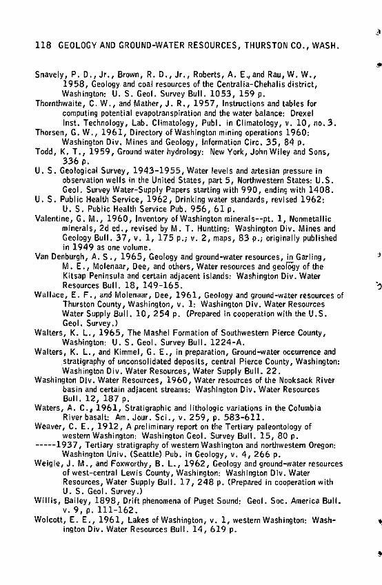
118 GEOLOGY AND GROUND-WATER RESOURCES, THURSTON CO., WASH.
Snavely, P. D., Jr., Brown, R. D., Jr., Roberts, A. E.,and Rau, W.W., 1958, Geology and coal resources of the Centralia-Chehalis district, Washington: U. S. Geol. Survey Bull. 1053, 159 p.
Thornthwaite, C. W., and Mather, J. R., 1957, Instructions and tables for computing potential evapotranspiration and the water balance: Drexel Inst. Technology, Lab. Climatology, Publ. in Climatology, v. 10, no. 3.
Thorsen, G. W., 1961, Directory of Washington mining operations 1960: Washington Div. Mines and Geology, Information Gire. 35, 84 p,
Todd, K. T., 1959, Ground water hydrology: New York, John Wiley and Sons, 336 p,
U.S. Geological Survey, 1943-1955, Water levels and artesian pressure in observation wells in the United States, part 5, Northwestern States: U.S. Geo I. Survey Water-Supply Papers starting with 990, ending with 1408.
U.S. Public Health Service, 1962, Drinking water standards, revised 1962: U.S. Public Health Service Pub. 956, 61 p.
Valentine, G. M., 1960, Inventory of Washington minerals--pt. 1, Nonmetallic minerals, 2d ed., revised by M. T. Huntting: Washington Div. Mines and Geology Bull. 37, v. 1, 175 p.; v. 2, maps, 83 p.; originally published in 1949 as one volume.
Van Denburgh, A. S ., 1965, Geology and ground-water resources, in Garling, .I
M. E., Molenaar, Dee, and others, Water resources and geology of the Kitsap Peninsula and certain adjacent islands: Washington Div. Water Resources Bull. 18, 149-165. )
Wallace, E. F., and Molenaar, Dee, 1961, Geology and ground-water resources of Thurston County, Washington, v. 1: Washington Div. Water Resources Water Supply Bull. 10, 254 p. (Prepared in cooperation with the U.S. Geo I. Survey.}
Walters, K. L., 1965, The Mashel Formation of Southwestern Pierce County, Washington: U. S. Geo I. Survey Bull. 1224-A.
Walters, K. L., and Kimmel, G. E., in preparation, Ground-water occurrence and stratigraphy of unconsolidated deposits, central Pierce County, Washington: Washington Div. Water Resources, Water Supply Bull. 22.
Washington Div. Water Resources, 1960, Water resources of the Nooksack River basin and certain adjacent streams: Washington Div. Water Resources Bull. 12, 187 p.
Waters, A. C., 1961, Stratigraphic and lithologic variations in the Columbia River basalt: Am. Jour. Sci., v. 259, p, 583-611.
Weaver, C. E., 1912, A preliminary report on the Tertiary paleontology of western Washington: Washington Geol. Survey Bull. 15, 80 p.
-----1937, Tertiary stratigraphy of western Washington and northwestern Oregon: Washington Univ. (Seattle} Pub. in Geology, v. 4, 266 p.
Weigle, J.M., and Foxworthy, B. L., 1962, Geology and ground-water resources of west-central Lewis County, Washington: Washington Div. Water Resources, Water Supply Bull. 17, 248 p. (Prepared in cooperation with U.S. Geol. Survey.}
Willis, Bailey, 1898, Drift phenomena of Puget Sound: Geol. Soc. America Bull. v. 9, p, 111-162.
Wolcott, E. E., 1961, Lakes of Washington, v. 1, western Washington: Wash- •. ington Div. Water Resources Bull. 14, 619 p.
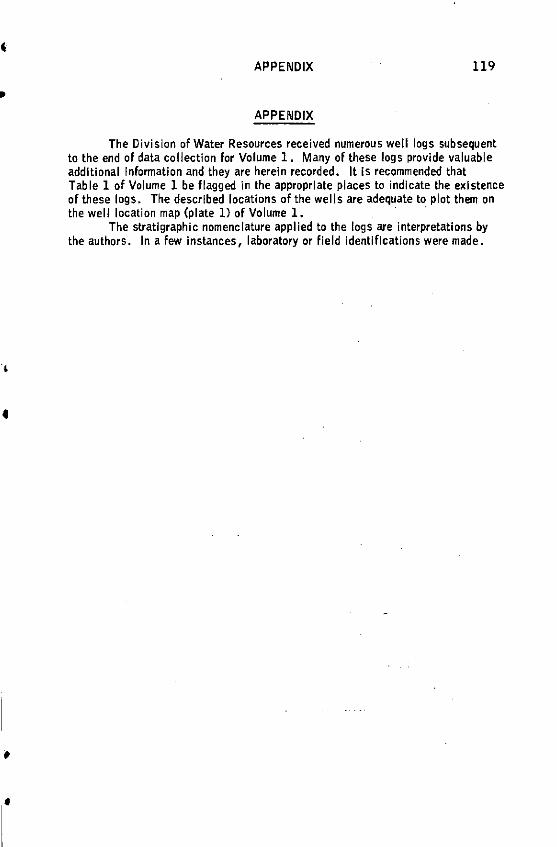
•
•
•
APPENDIX 119
APPENDIX
The Division of Water Resources received numerous well logs subsequent to the end of data collection for Volume 1. Many of these logs provide valuable additional Information and they are herein recorded. It Is recommended that Table 1 of Volume 1 be flagged in the appropriate places to indicate the existence of these fogs. The described locations of the wells are adequate to plot them on the well location map (plate ll of Volume 1. ·
The stratigraphic nomenclature applied to the logs are interpretations by the authors. In a few instances, laboratory or field identifications were made •
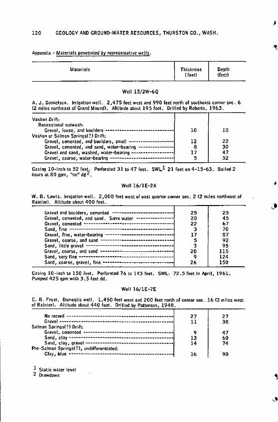
120 GEOLOGY AND GROUND-WATER RESOURCES, THURSTON CO., WASH.
Appendix - Materials penetrated by representative wells.
Materials
Well 15/2W-6Q
Thickness (feet)
Depth Cfeet>
A. J. Danielson. Irrigation well. 2 ,4 75 feet west and 990 feet north of southeast corner sec. 6 (2 miles northeast of Grand Mound). Altitude about 195 feet. Drllled by Roberts, 1963.
Vashon Drift: Recesslonal outwash:
Gravel, loose, and boulders -----------------------------Vashon or Salmon Springs(?) Drift:
Gravel, cemented, and boulders, small .. -----------------Gravel, cemented, and sand, water-bearing --------------Gravel and sand, washed, water-bearing-----------------Gravel, coarse, water-bearing ---------------------------
10
12 8
17 5
10
22 30 47 52
Casing 10-lnch to 52 feet. Perforated 31 to 47 feet. SWLl 21 feet on 4-15-63. Bailed 2 hours at 80 gpm, "no'1 dd 2.
Well 16/IE-2K
W. B. Lewis. Irrigation well. 2,000 feet west of east quarter corner sec. 2 (2 miles northeast of Rainier). Altitude about 400 feet.
Gravel and boulders, cemented ------------------------Gravel, cemented, and sand. Some water ----------------Gravel, cemented -------------------------------------Sand, fine -------------------------------------------Gravel, fine, water-bearing ---------------------------Gravel, coarse, and sand -------------------------------Sand, little gravel -------------------------------------Gravel / coarse, and sand -------------------------------Sand, very fine--------------------------.:.·------------Sand, coarse, gravel, fine------------------------------
25 20 22
3 17
5 3
20 9
26
25 45 67 70 87 92 95
115 124 150
Casing 10-inch to 150 feet. Perforated 70 to 143 feet. SWL: 72.5 feet In April, 1901. Pumped 425 gpm with 3.5 feet dd.
Well 16/1E-7E
C. 8. Frost. Domestic well. 1,450 feet west and 200 feet north of center sec. lb (2 miles west of Rainier). Altitude about 440 feet. Drilled by Patterson, 1948.
No record --------------------------------------------Gr ave I -- - - - --- - ---------------------------------------
Salmon Springs(?) Drift: Gravel, cemented -------------------------------------Sand, clay------------------------------------------Sand, clay, gravel -------------------------------------
Pre-Salmon Springs(?), undifferentiated: Clay, blue-------------------------------------------
l Static water level 2 Orawdown
27 !l
9 13 14
16
27 38
47 60 74
90
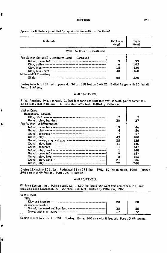
..
'
• •
APPENDIX
Appendix - Materials penetrated by representative wells. -- Continued
Materials
Well 16/1E-7E -- Continued
Pre-Salmon Springs(?), undifferentiated - Continued Gravel, cemented -------------------------------------Clay, yellow -----------------------------------------Clay, blue -------------------------------------------Clay, blue, hard --------------------------------------
Mcintosh(?) Formation:
Shale ------------------------------------------------
Thickness Cfeet)
9 6
15 40
60
Depth (feet}
99 105 120 160
220
121
Casing 6-inch to 181 feet, open end. SWL: 118 feet on 6-4-52. Bailed 41 gpm with BO feet dd. Pump, 1 HP jet.
Well 16/1E-12L
R. W. Peoples. Irrigation well. 1,400 feet north and 600 feet west of south quarter corner sec. 12 (3 miles east of Rainier}. Altitude about 425 feet. Drilled by Patterson.
Vashon Drift: Recessional outwash:
Clay, sand -------------------------------------------Gravel, clay, boulders ---------------------------------
Pre-Vashon, undifferentiated: Gravel, cemented -------------------------------------Gravel, clay -----------------------------------------Gravel, cemented-------------------------------------Gravel, clay ------------------------------------~-----Gravel, hee1vy, clay and sand ---------------------------Gravel, clay, hard ------------------------------------Gravel, cemented-------------------------------------Gravel, clay, sand------------------------------------Gravel, cemented -------------------------------------Gravel, clay, hard------------------------------------Gravel, clay, sand -----------------------------------Gravel, clay ------- -----------------------------------
7 20
19 4 7
43 25 11 11
1 9 8
21 22
7 27
46 50 57
100 . 125
136 147 148 157 165 186 208
Casing 12-lnch to 208 fe!et. Perforated 96 to 183 feet. SWL: 59 feet in spring, 1960. Pumped 290 gpm with 49 feet dd. Pump, 25 HP turbine.
Well 16/2E-21L
Wildaire Estates, Inc. Public supply well. 600 feet south 35° west from center sec. 21 (near east side Lake Lawrence). Altitude about 470 Feet. Drilled by Patterson, 1961.
Vashon Drift: Till:
Clay and boulders--------------------------------------Advance outwash(?):
Gravel, cemented and boulders -------------------------Gravel with clay layers ---------------------------------
20
35 17
20
55 72
Casing 8-inch to 72 feet. SWL: flowing. Bailed 100 gpm with 8 feet dd. Pump, 3 HP turbine .
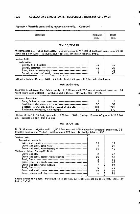
122 GEOLOGY AND GROUND-WATER RESOURCES, THURSTON CO., WASH
Appendix - Materials penetrated by representative wells. --Continued
Materials
Well lb/3E-29N
Thickness (feet)
Depth (feet)
Weyerhaeuser Co. Public park supply. 1,053 feet north 74° east of southwest corner sec. 29 Cat north end Elbow Lake). Altitude about 485 feet. Drilled by Roberts, 1960. ·
Vashon Drift: End moraine:
Gravel, smal J boulders ----------------------------------Gravel, cemented --------------------------------------Sand, blue, water-bearing -----------------------------Gravel, washed, and sand, coarse -----------------------
17 12
9 7
17 29 38 45
Casing 6-lnch to 45 feet. SWL: 24 feet. Tested 20 gpm with 4 feet dd. Hand pump.
Well lb/1W-14J
Mountain Development Co. Public supply. 2 ,050 feet north 26° west of southeast corner sec. 14 (north shore Lake Mcintosh). Altitude about 345 feet. Drilled by King, 1963.
Mcintosh Forinatlon: Rock, broken------------------------------------------Sandstone, blue-gray----------------------------------Siltstone, brown-gray and thi_n streaks of hard clay--------Sandstone, blue-gray, water-bearing ---------------------
4 35
181 50
4 39
220 270
Casing 10-inch to 39 feet, open hole to 270 feet. SWL: flowing. Pumped 60 gpm with 180 feet dd. Hardness 35 ppm, Iron 0.1 ppm.
Well lb/2W-28Q
M. S. Wheaton. Irrigation well. 1,800 feet west and 400 feet north of southeast corner sec. 28 (4 miles southwest of Tenino). Altitude about 229 feet. Drilled by Roberts, 1961.
Vashon Drift: Recessional outwash:
Gravel and boulders -----------------------------------Gravel and sand, some water ---------------------------Gravel and sand, water-bearing--------------------------
Vashon or Salmon Springs(?} Drift: Gravel and clay ----------------------------------------Gravel and sand, coarse, water-bearlng-------------------Sand, fine -------------------.:------------------------Gravel, fine, and sand---------------------------------Gravel and sand, water-bearing --------------------------Sand, fl ne --------------------------------------------Gravel and sand, coarse -------------------------------Gravel, coarse and clay---------------------------------
19 7
14
8 10
3 2 7 b
14 b
19 2& 40
48 58 bl &3 70 7& 90 9b
Casing 8-inch to 96 feet. Perforated 45 to 58 feet, 63 to 68 feet, and 80 to 88 feet. SWL: 19 feet on 1-3-61.
)
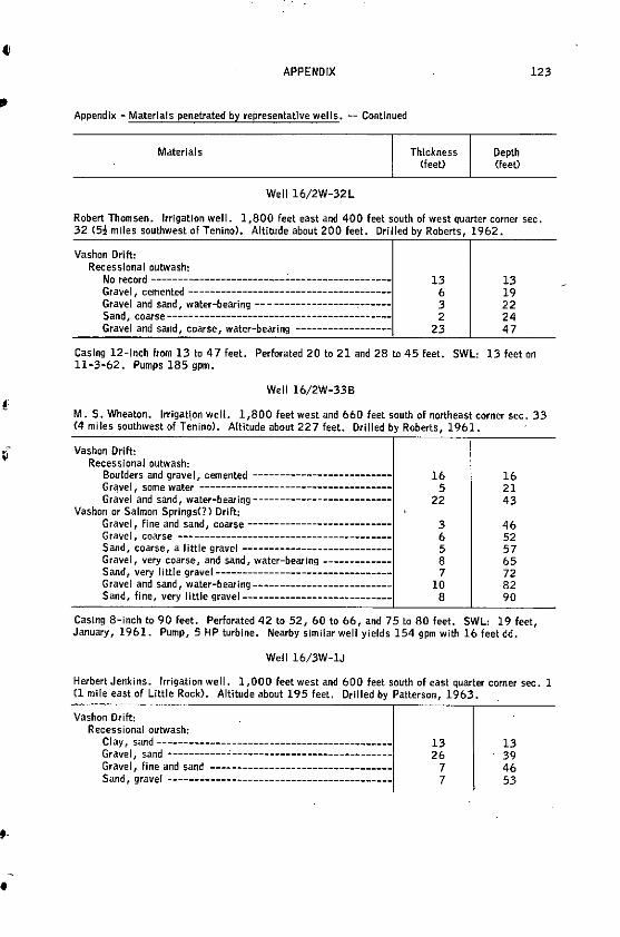
Ci
·-•
APPENDIX
Appendix - Materials penetrated by representative wells. -- Continued
Materials
Well 16/2W-32L
Thickness <feet}
Depth Cfeet)
123
Robert Thomsen. Irrigation well. 1,800 feet east and 400 feet south of west quarter corner sec. 32 {5! mlles southwest of Tenino). Altitude about 200 feet. Drilled by Roberts, 1962.
Vashon Drift: Recessional outwash:
No record ---------------------------------------------Gravel, cemented --------------------------------------Gravel and sand, water-bearing -- - ----------------,------Sand, coarse------------------------------------------Gravel and sand, coarse, water-bearing ------------------
13 6 3 2
23
13 19 22 24 47
Casing 12-inch from 13 to 4 7 feet. Perforated 20 to 21 and 28 t.o 45 feet. SWL: 13 feet on 11-:3-62. Pumps 185 gpm.
Well 16/2W-33B
M. S. Wheaton. lrrigat\on well. 1,800 feet west and 660 feet south of northeast corner sec. :33 (4 miles southwest of Tenino). Altitude about 227 feet. Drilled by Roberts, 1961.
Vashon Drift: Recessional outwash:
Boulders and gravel, cemented --------------------------Gravel some water ------------------------------------Gr.:lvel
1
and sand, water-bearing--------------------------Vashon or Salmon Springs(?) Drift:
Gravel, fine and sand, coarse---------------------------Grave I, coarse ----------------------------------------Sand, coarse, a little gravel ---------------------------Grave I, very coarse, and sand, water-bearing------------Sand, very little gravel--------------------------------Gravel and sand, water-bearing-------------------------Sand, fine, very little gravel----------------------------
16 5
22
3 6 5 8 7
10 8
16 21 43
46 52 57 65 72 82 90
Casing 8-inch to 90 feet. Perforated 42 to 52, 60 to 66, and 75 to 80 feet. SWL: 19 feet, January, 1961. Pump, 5 HP turbine. Nearby similar well yields 154 gpm with 16 feet dd.
Well 16/3W-1J
Herbert Jenkins. Irrigation well. 1,000 feet west and 600 feet south of east quarter corner sec. 1 Cl mile east of Little Rock). Altitude about 195 feet. Drilled by Patterson, 1963.
Vashon Drift: Recessional outwash:
Clay, sand-------------------------------------------Gravel, sand-----------~------------------------------Gravel, fine and sand ----------------------------------Sand, gravel ------------------------------------------
13 26
7 7
13 39 46 53
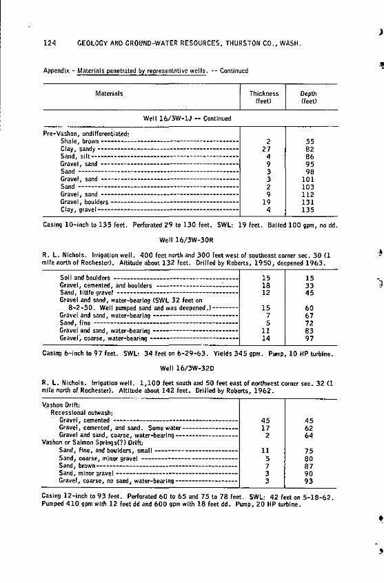
124 GEOLOGY AND GROUND-WATER RESOURCES, THURSTON CO., WASH.
Appendix - Materials penetrated by representative wells. -- Continued
Materials
Well 16/3W-1J -- Continued
Pre-Vashon, undiffereniiated: Shale, browri -----------------------------------------Clay, sandy------------------------------------------Sand, si It--------------------------------------------Gravel, sand -----------------------------------------Sand ------------------------------------------------Gravel, sand ------------------------------------------Sand ------------------------------------------------Gravel, sand -----------------------------------------Gravel, boulders --------------------------------------Clay, gravel-------------------------------------------
Thickness (feet>
2 27
4 9 3 3 2 9
19 4
Depth (feet}
55 82 86 95 98
101 103 112 131 135
Casing 10-inch to 135 feet. Perforated 29 to 130 feet. SWL: 19 feet. Bailed 100 gpm, no dd.
Well 16/3W-30R
R. L. Nichols. Irrigation well. 400 feet north and 300 feet west of southeast corner sec. 30 Cl mile north of Rochester). Altitude about 132 feet. Drilled by Roberts, 1950, deepened 1963.
Soi I and boulders --------------------------------------Gravel, cemented, and boulders --------------------:. ___ _ Sand, little gravel ------------------------------------Gravel and sand, water-bearing CSWL 32 feet on
8-2-50. Well pumped sand and was deepened.)-------Gravel and sand, water-bearl"9 --------------------------Sand, fine --------------------------------------------Gravel and sand, water-bearing -------------------------Gravel~ coarse, water-bearing ---------------------------
15 18 12
15 7 5
11 14
15 33 45
60 67 72 83 97
Casing 6-inch to 97 feet. SWL: 34 feet on 6-29-63. Yields 345 gpm. Pump, 10 HP turbine.
Well 16/3W-32D
R. L. Nichols. Irrigation well. 1,100 feet south and 50 feet east of northwest corner sec. 32 Cl mile north of Rochester). Altitude about 142 feet. Drilled by Roberts, 1962.
~ashon Drift: Recesslonal outwash:
Gravel, cemented --------------------------------------Gravel, cemented, and sand. Some water----------------Gravel and sand, coarse, water-bearlng-------------------
Vashon or Salmon Springs(?) Drift: Sand, fine, and boulders, small------------------------Sand, coarse, minor gravel -----------------------------Sand, brown------------------------------------------Sand, minor gravel-------------------------------------Gravel, coarse, no sand, water-bearing-------------------
45 17
2
11 5 7 3 3
45 62 64
75 80 87 90 93
Casing 12-inch to 93 feet. Perforated 60 to 65 and 75 to 78 feet. SWL: 42 feet on 5-18-62. Pumped 410 gpm with 12 feet dd and 600 gpm with 18 feet dd. Pump, 20 HP turbine.
)
•
'
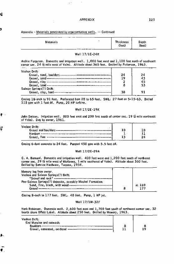
APPENDIX
Appendix - Materials penetrated by representative welts. -- Continued
Materials
Well 17/1E-24R
Thickness (feet)
Depth (feet)
125
Archie Ferguson. Domestic and irrigation well. 1,000 feet west and 1, 100 feet north of southeast corner sec. 24 (!mile west of Yelm). Altitude about 360 feet. Drilled by Patterson, 1963.
Vashon Drift: Gravel, sand, boulders----------------------------------Gravel, sand------------------------------------------Gravel, clay ------------------------------------------Gravel, sand-------------------------------------------
Salmon Springs(?) Drift: Gravel, clay, hard--------------------------------------
24 19
2 8
38
24 43 45 53
91
Casing 10-inch to 91 feet. Perforated horn 28 to b5 feet. SWL: 27 feet on 5-15-63. Bailed 115 gpm with 1 foot dd. Pump, 20 HP turbine.
Well 17/2E-19K
John Dotson. Irrigation well. 800 feet east and 200 feet south of center sec. 19 C1: mlle northeast of Yelm). Dug by owner, 1961.
Vashon Ori ft: Gravel and boulders-------------------------------------
Hardpan ----------------------------------------------Gravel, fine -------------------------------------------
Casing 6-foot concrete to 24 feet. Pumped 450 gpm with 5.5 feetdd.
Well 17/2E-29A
ID 1
13
10 11 24
C. A. Barnard. Domestic and Irrigation well. 400 feet west and 1,200 feet south of northeast corner sec. 29 <!mile west of McKenna, 1 mlle southeast of Yelm). Altitude about 350 feet. Drilled by Service Hardware, Tacoma, 1954.
Memory log from owner, Vashon and Salmon Springs(?) Drift:
"Gravel and rock" --------------------------------------Pre-Salmon Springs(?) deposits, possibly Mashel Formation:
Sand, fine, black, with wood----------------------------Gravel ---------------------- ---------------------------
Casing 8-inch to 177 feet. SWL: 40 feet. Pump, 1 HP jet.
Well l 7/1W-32F
8 at 169
177
Herb Robinson. Domestic well. 2,600 feet east and 1, 700 feet south of northwest comer sec. 32 (north shore Offutt Lake>. Altitude about 250 feet. Drilled by Mowery, 1963.
Vashon Drift: End Moraine and outwash:
Boulders-----------------------------------------------Gravel, cemented, oxidized ------------------------------
8 11
8 19
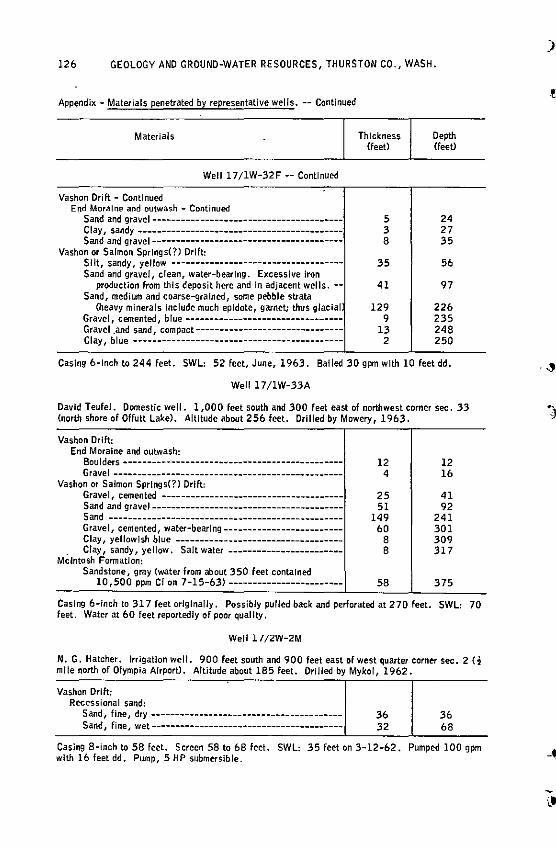
126 GEOLOGY AND GROUND-WATER RESOURCES, THURSTON CO., WASH.
Appendix - Materials penetrated by representative wells. -- Continued
Materials
Well l 7/1W-32F -- Continued
Vashon Drift - Continued End Moraine and outwash - Continued
Sand and gravel---------------------------------------Clay, sandy------------------------------------------Sand and gravel----------------------------------------
Vashon or Salmon Springs(?) Ori~: Silt, sandy, yellow -----------------------------------Sand and gravel, clean, water-bearing. Excessive Iron
production from this deposit here and In adjacent wells. -Sand, medium and coarse-grained, some pebble strata
(heavy minerals include much epldote, garnet; thus glacial Gravel, cemented, blue --------------------------------Gravel and sand compact-------------------------------Clay, blue ----:---------------------------------------
Thickness <feet)
5 3 8
35
41
129 9
13 2
Depth Cfeet>
24 27 35
56
97
226 235 248 250
Casing 6-lnch to 244 feet. SWL: 52 feet, June, 1963. Bailed 30 gpm with 10 feet dd,
Well 17/1W-33A
David Teufel. Domestic well. 1,000 feet south and 300 feet east of northwest corner sec. 33 (north shore of Offutt Lake}. Altitude about 256 feet. Drilled by Mowery, 1963.
Vashon Drift: End Moraine and outwash:
Boulders ---------------------------------------------- 12 Gravel ------------------------------------------------ 4
Vashon or Salmon Springs(?) Drift: Gravel, cemented -------------------------------------- 25 Sand and gravel---------------------------------------- 51 Sand ------------------------------------------------- 14 9 Gravel, cemented, water-bearing------------------------- 60 Clay, yellowish blue----------------------------------- 8
. Clay, sandy, yellow. Salt water ------------------------ 8 Mcintosh Formation:
Sandstone, gray (water from about 350 feet contained 10,500 ppm Cl on 7-15-63) ------------------------ 58
Casing 6-fnch to 317 feet originally. Possibly pulled back and perforated at 270 feet. feet. Water at 60 feet reportedly of poor quality.
Well l 7 /2W-2M
12 16
41 92
241 301 309 317
375
SWL 70
N. G. Hatcher. Irrigation well. 900 feet south and 900 feet east of west quarter corner sec. 2 ( -2 mile north of Olympia Airport). Altitude about 185 feet. Drilled by Mykol, 1962.
Vashon Drift: Recessional sand:
Sand, fine, dry---------------------------------------Sand, fine, wet----------------------------------------
36 32
36 68
Casing 8-inch to 58 feet. Screen 58 to 68 feet. SWL: 35 feet on 3-12-62. Pumped 100 gpm with 16 feet dd. Pump, 5 HP submersible.
)
. .,
-t
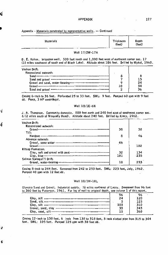
II
APPENDIX
Appendix - Materlals penetrated by_representatlve wells. -- Continued
Materials
Well 17/2W-17A
Thickness <feet)
Depth Cfeet>
127
D. E. Kohse. Irrigation well. 500 feet south and 1,000 feet west of northeast corner sec. 17 Cl! miles southeast of south end of Black Lake). Altitude about 186 feet. Drilled by Mykol, 1960.
Vashon Drift: Recessional outwash:
Sand-------------------------------------------------Sand and gravel ----------------------------------------Gravel and sand, water-bearlng---------------------------Gravel------------------------------------------------Sand and gravel ----------------------------------------
8 7 9
10 2
8 15 24 34 36
Casing 6-lnch to 36 feet. Perforated 25 to 33 feet. SWL: 9 feet. Pumped 60 gpm with 9 feet dd. Pump, 3 HP centrifugal.
Well 18/IE-6N
J. A. Thompson. Community domestic. 800 feet north and 240 feet east of southwest corner sec. 6 (2 miles south of NI squally Head). Altitude about 240 feet. Drilled by Kincy, 1962.
Vashon Drift: Recessional outwash:
Gravel-------------------------------------------------Tll I,
Hardpan -----------------------------------------------Advance outwash:
Gravel, some water------------------------------------Gravel-------------------------------------------------
Kitsap Fonnation: Clay, soft and gravel with peat---------------------------Clay, blue---------------------------------------------
Salmon Springs(?) Drift: Gravel, water-bearing-----------------------------------
38
8
.46
32 IOI
18
38
46
102
134 .235
253
Casing 8-inch to 244 feet. Screened from 242 to 253 feet. SWL: 223 feet, July, 1962. Pumped 40 gpm with 12 feet dd.
Well 18/lW-lOL
Olympia Sand and Gravel. to 360 feet by Patterson,
Industrial supply. I! miles northeast of Lacey. Deepened from 9& feet 19&1. For log of well to original depth, see volume 1 of this report.
Clay, silt --------------------------------------------Sand, silt--------------------------------------------Clay, si It --------------------------------------------Gravel, sand, clay ------------------------------------Clay, sand, sift----------------------------------------
96 96 24 120
5 125 185 310
35 345 15 360
Casing 12-inch to 138 feet, & inch from 138 to 318 feet, 5 Inch slotted pipe from 315 to 344 feet. SWL: 105 feet. Pumped 125 gpm with 30 feet dd.
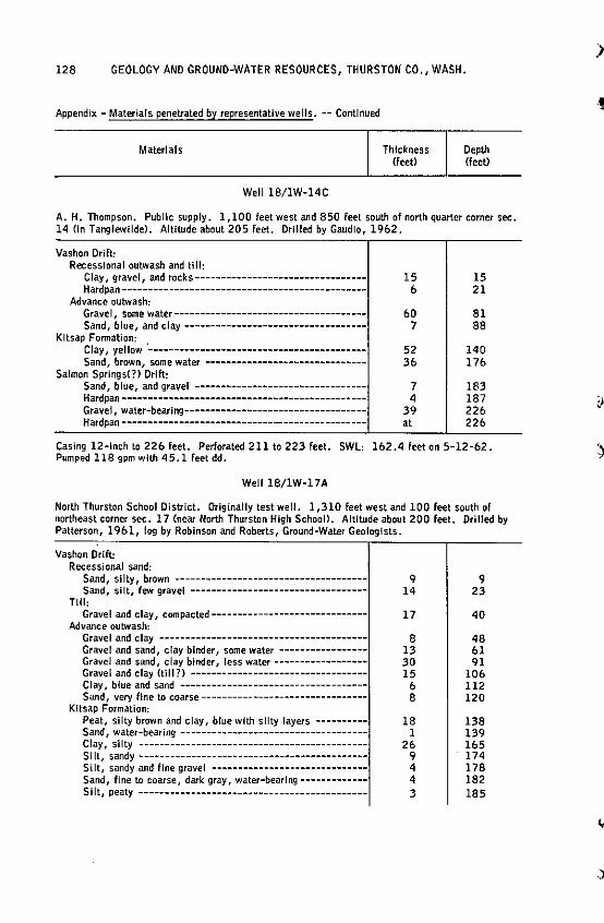
128 GEOLOGY AND GROUND-WATER RESOURCES, THURSTON CO., WASH.
Appendix - Materials penetrated by representative wells. -- Continued
Materials
Well 18/1W-14C
Thickness Cfeet)
Depth <feet)
A. H. Thompson. Pub lie supply. l, 100 feet west and 850 feet south of north quarter corner sec. 14 (in Tanglewilde). Altitude about 205 feet. Drilled by Gaudio, 1962.
Vashon Drift: Recessional outwash and tlll:
Clay, gravel, and rocks---------------------------------Hardpan-----------------------------------------------
Advance outwash: Gravel, some water-------------------------------------Sand, blue, and clay----------------------------------
Kitsap Formation: Clay, yellow ·------------------------------------------Sand, brown, some water -------------------------------
Salmon Springs(?) Drift: Sand, blue, and gravel ---------------------------------Hardpan-----------------------------------------------Gravel, water-bearing-----------------------------------Hardpan -----------------------------------------------
15 b
bO 7
52 3b
7 4
39 at
15 21
81 88
140 17b
183 187 22b 22b
Casing 12-inch to 226 feet. Perforated 211 to 223 feet. SWL: 162.4 feet on 5-12-62. Pumped 118 gpm with 45.1 feet dd.
Well 18/1W-17A
North Thurston School District. Originally test well. 1,310 feet west and 100 feet south of northeast corner sec. 17 (near North Thurston High School>. AIUtude about 200 feet. Drilled by Patterson, 1961, log by Robinson and Roberts, Ground-Water Geologists.
Vashon Drift: Recessional sand:
Sand, silty, brown ------------------------------------Sand, silt, few gravel ---------------------------------
TUI: Gravel and clay, compacted·-----------------------------
Advance outwash: Gravel and clay ----------------------------------------Gravel and sand, clay binder, some water----------------Gravel and sand, clay binder, less water-----------------Gravel and clay (till?) ---------------------------------Clay, blue and sand -----------------------------------Sand, very fine to coarse--------------------------------
Kitsap Formation: Peat, silty brown and clay, blue with silty layers ----------Sand, water-bearing -----------------------------------Clay, silty -------------------------------------------Si It, sandy --------------------------------------------Silt, sandy and fine gravel -----------------------------Sand, fine to coarse, dark gray, water-bearing-------------Si It, peaty --------------------------------------------
9 14
17
8 13 30 15
b 8
18 l
2b 9 4 4 3
9 23
40
48 bl 91
I Ob 112 120
138 139 lb5 174 178 182 185
)
!
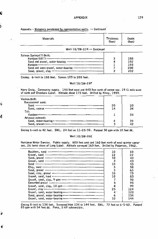
APPENDIX
Appendix - Materials penetrated by representative wells. -- Continued
Materials
Well 18/1W-17A -- Continued
Salmon Springs(?) Drift: Hardpan (ti 11 ?) ------------------------------------------Sand and gravel, water-bearing ---------------------------
Hardpan----------------------------~-------------------Sand and some gravel, water-bearing ----------------------Sand, gravel, clay --------------------------------------
Casing: 6-lnch to 188 feet. Screen 185 to 200 feet.
Well 18/1W-19F
Thickness <feet)
3 4 l 7 2
Depth (feet)
188 192 193 200 202
Harry Craig. Community supply. 155 feet west am! 640 feet north of center sec. 19 Cl mile west of north end Chambers Lake>. Altitude about 175 feet. Drilled by Kincy, 1959.
Vashon Drift: Recessional sand:
Sand -------------------------------------------------Sand, coarse-------------------------------------------
Till, Hard pan -·--- - --------- - - --------------------------------
Advance outwash: Sand, Water-bear Ing-------------------------------------Sand, gravel--------------------------------------------
20 14
l
4 3
20 34
35
39 42
Casing 6-inch to 42 feet. SWL: 24 feet on 11-25-59. Pumped 30 gpm with 10 feet dd.
Well 18/1W-26E
Huntamer Water Service. Public supply. 600 feet east and 160 feet north of west quarter corner sec. 26 (west shore of Long Lake). Altitude surveyed 163 feet. Drllled by Patterson, 1962.
Boulders, san<j ----------------------------------------Gravel, sand ------------------------------------------Sand, gravel ------------------------------------------Gravel, sand ------------------------------------------Sand -------------------------------------------------Clay, sand-------~-------------------------------------Sand, gravel ------------·---------.----------------------Sand, clay, gravel ----.:.--------------------------------Gravel, sand, hard ------------,..------------------------Gravel, sand, clay, 9 gpm -------------------------------Cemented grave I --------------- - - - - - --------------------Gravel, sand, clay, 10 gpm ------------------------------Gravel , clay ---------------------------------_: _________ _ Gravel, sand, water-bearing -----------------------------Sand, gravel, water-bearlng-----------------------------Gravel, sand, water-bearing------------------------------
10 12 18
3 10
5 5
10 10
7 5 4
25 4· 6
10
10 22 40 43 53 58 63 73 83 90 95 99
124 128 134 144
Casing 8-inch to 134 feet. Screened from 134 to 144 feet. SWL: 72 feet on 6-5-62. Pumped 85 gpm with 54 feet dd. Pump, 5 HP submersible.
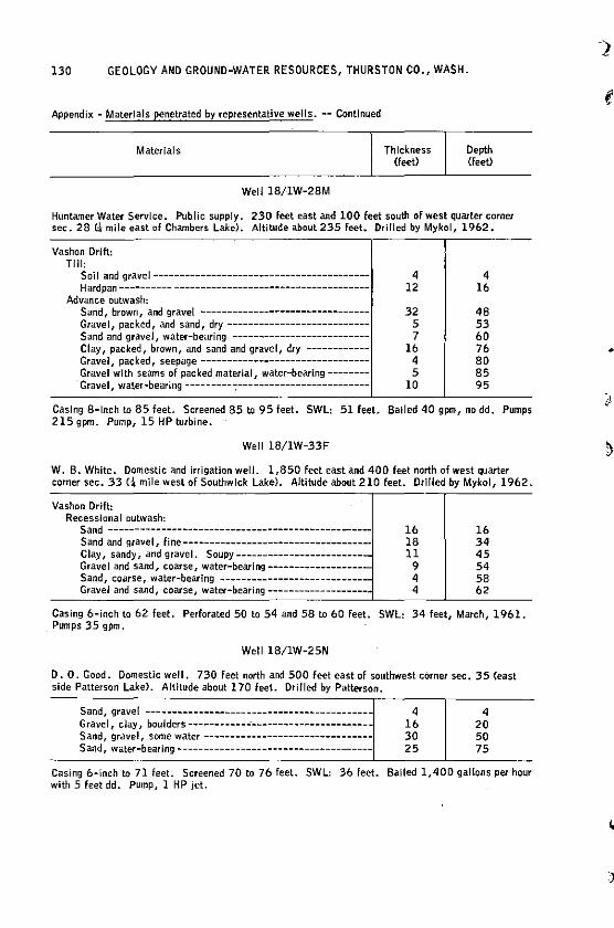
130 GEOLOGY AND GROUND-WATER RESOURCES, THURSTON CO., WASH.
Appendix - Materials penetrated by representative wells. -- Continued
Materials
Weli 18/1W-28M
Thickness (feet)
Depth <feeO
Huntamer Water Service. Public supply. 230 feet east and 100 feet south of west quarter corner sec. 28 (;t mile east of Chambers Lake}. Altitude about 235 feet. Drilled by Mykol 1 1962.
Vashon Drift: TJll:
Soil and gravel----------------------------------------Hardpan ---------- -------------------------------------
Advance outwash: Sand, brown, and grave[ -------------------------------Gravel, packed, and sand, dry--------------------------Sand and gravel, water-bearing -------------------------Clay, packed, brown, and sand and gravel, dry-----------Gravel, packed, seepage-------------------------------Gravel with seams of packed material / water-bearing-------Gravel, water-bearing---------:-------------------------
4 12
32 5 7
16 4 5
10
4 16
48 53 60 76 80 85 95
Casing 8-lnch to 85 feet. Screened 85 ta 95 feet. SWL: 51 feet. Bailed 40 gpm, no dd. Pumps 215 gpm. Pump, 15 HP turbine.
Well 18/1W-33F
W. B. White. Domestic and irrigation well. 1,850 feet east and 400 feet north of west quarter corner sec. 33 L\- mile west of Southwick Lake). Altitude about 210 feet. Drllled by Mykol, 1962.
Vashon Drift: Recessional outwash:
Sand -------------------------------------------------Sand and gravel, fine----------------------------------Clay, sandy, and gravel. Soupy------------------------Gravel and sand, coarse, water-bearing------------------Sand, coarse, water-bearing ---------------------------Gravel and sand, coarse, water-bearing--------------------
16 18 11
9 4 4
16 34 45 54 58 62
Casing 6-inch to 62 feet. Perforated 50 to 54 and 58 to 60 feet. SWL: 34 feet, March, 1961. _Pumps 35 gpm,
Well 18/1W-25N
D. 0. Good. Domestic well. 730 feet north and 500 feet east of southwest corner sec. 35 {east side Patterson Lake>. Altitude about 170 feet. Drilled by Patterson.
Sand, gravel -------------------------------------------Grave I, clay, boulders ------------·----------------------Sand, gravel, some water -------------------------------Sand, water-bearing -------------------------------------
4 16 30 25
4 20 50 75
Casing 6-inch to 71 feet. Screened 70 to 76 feet. SWL: 36 feet. Balled 1,400 gallons per hour with 5 feet dd. Pump, l HP jet.
)
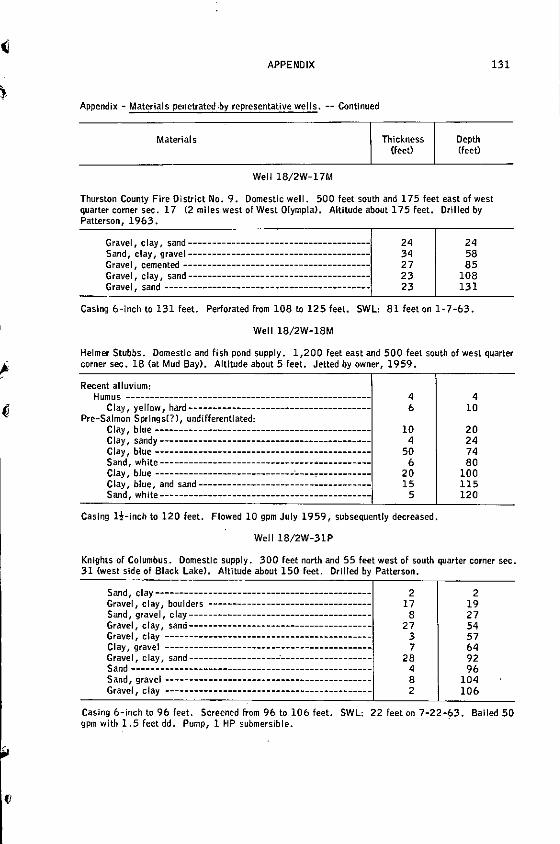
APPENDIX
Appendix - Materials penetrated•by representative wells. -- Continued
Materials
Well 18/2W-l 7M
Thickness (feet)
Depth (feet)
131
Thurston County Fire District No. 9. Domestic well. 500 feet south and 175 feet east of west quarter corner sec, 17 (2 miles west of West Olympia). Altitude about 1 75 feet. Orllled by Patterson, 1963.
Gravel, clay, sand-------------------------------------Sand, clay, gravel-------------------------------------Gravel, cemented --------------------------------------Gravel, clay, sand-------------------------------------Gravel, sand ----------------------- --------------------
24 34 27 23 23
24 58 85
108 131
Casing 6-inch to 131 feet. Perforated from 108 to 125 feet. SWL: 81 feet on 1-7-63.
Well 18/2W-18M
Helmer Stubbs. Domestic and fish pond supply. 1,200 Feet east and 500 feet south of west quarter corner sec. 18 Cat Mud Bay). Altitude about 5 feet. Jetted by owner, 1959.
Recent alluvium: Humus --------------------------------------------------
Clay, yellow, hard--------------------------------------Pre-Salmon Springs(?), undifferentiated:
Clay, blue --------------------------------------------Clay, sandy -------------------------------------------Clay 1 blue --------------------------------------------Sand, white -------------------------------------------Clay, blue ----------------------------------':'-----------Clay, blue, and sand ------------------------------------Sand 1 white--------------------------------------------
4 6
10 4
50 6
20 15
5
Casing l!-inch to 120 feet. Flowed 10 gpm July 1959, subsequently decreased.
Well 18/2W-31P
4 10
20 24 74 80
100 115 120
Knights of Columbus. Domestic supply. 300 feet north and 55 feet west of south quarter corner sec. 31 (west side of Black Lake). Altltude about 150 feet. Drilled by Patterson.
Sand, clay ---------------------------------------------Gravel, clay 1 boulders ---------------------------------Sand, gravel, clay-------------------------------------Gravel 1 clay 1 sand--------------------------------------Gravel, clay ------------------------------------------Clay 1 gravel ------------------------------------------Grave I, clay, sand ------------------..:------------------Sand ------------------------------- ------------------$and, gravel ------------------------------------------Gravel, clay -------------------------------------------
2 17
8 27
3 7
28 4 8 2
.
2 19 27 54 57 64 92 96
104 106
Casing 6-inch to 96 feet. Screened from 96 to 106 feet. SWL: 22 feet on 7-22-~3. Bailed 50 gpm with 1.5 feet dd. Pump, 1 HP submersible.
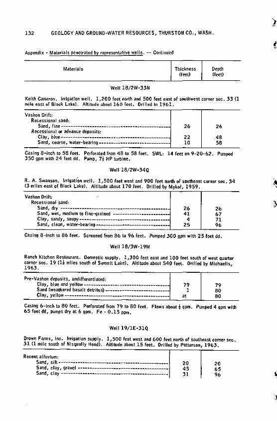
132 GEOLOGY AND GROUND-WATER RESOURCES, THURSTON CO., WASH.
Appendix - Materials penetrated by representative wells. -- Continued
Materials
Well 18/2W-33N
Thickness (feet)
Depth (feet)
Keith Cameron. Irrigation well. 1,200 feet nortli and 500 feet east of southwest corner sec. 33 (1 mile east of Black Lake). Altitude about 160 feet. Ori I led In 1961.
Vashon Drift: Recessional sand;
Sand, fine ----------------------------------------------R ecessi ona I or advance deposits:
Clay, blue---------------------------------------------Sand, coarse, water-bearing-----------------------------
26
22 10
26
.48 58
Casing 8-inch to 58 feet. Perforated from 48 to 58 feet. SWL: 14 feet on 9-20-62. Pwnped 350 gpm with 24 feetdd. Pump, 7! HP turbine.
Well 18/2W-34Q
R. A. Swanson. lrrlgatJOn well. 1,500 feet west and 900 feet north of southeast corner sec, 34 <3 miles east of Black Lake). Altltude about 170 feet. Drllled by Mykol, 1959.
Vashon Drift: Recessional sand:
Sand, dry ----------------------------------------------Sand, wet, medium to fine-grained -----------------------· Clay, sandy, soupy-------------------------------------Sand, clean / water-bearing-------------------------------
26 41
4 25
26 67 71 96
Casing 8-inch to 86 feet. Screened from 86 to 96 feet. Pumped 300 gpm with 25 feet dd.
Well 18/3W-19M
Ranch Kitchen Restaurant. Domestic supply. 1,300 feet east and 100 feet south of west quarter corner sec. 19 Cl! miles south of Summit Lake>. Altitude about 540 feet. Drilled by Michaelis, 1963.
Pre-Vashon deposits, undifferentiated: Clay, blue and yellow-----------------------------------Sand (weathered basalt detrltus)---------------------------Clay, yellow--------------------------------------------
79 1
at
79 80 80
Casing 6-lnch to 80 feet. Perforated from 79 to 80 feet. Flows about 2 gpm. Pumped 4 gpm with 65 feet dd1 pumps dry at 6 gpm. Fe - 0.15 ppm.
Well 19/1E-31Q
Brown Farms, Inc. Irrigation supply. 1,500 feet west and 600 feet north of southeast comer sec. 31 Cl mile south of Nlsqually Head). AltlbJde about 15 feet. Drilled by Patterson, 1963.
Recent alluvium: Sand, si It---------------------------------------------Sand, clay, gravel -------------------------------------Sand1 clay ---------------------------------------------
20 45 31
20 65 96
2
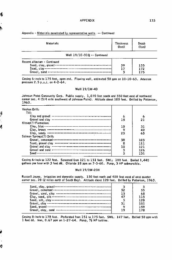
(i
APPENDIX
Appendix - Materials penetrated by representative wells. -- Continued
Materials
Well 19/1E-31Q -- Continued
Recent alluvium - Continued Sand, clay, gravel -------------------------------------Sand, clay--------------------------------------'------Grave I, sand -------------------------------------------
Thickness (feet)
59 17
3
Depth (feet>
155 172 175
133
Casing 6-inch to 175 feet, open end. Flowing well, estimated 50 gpm on 10-10-63. Artesian pressure 2.5 p.s.i. on 4-2-64.
Well 19/lW-40
Johnson Point Community Corp. Public supply. 1,070 feet south and 550 feet east of northwest corner sec. 4 (3/4 mile southwest of Johnson Point}. Altitude about 100 feel. Drilled by Patterson, 1960.
Vashon Drift: Till:
Clay and gravel ---------------------------------------Gravel and clay ----------------------------------------
Kitsap(?) Fonnation: Clay, blue--------------------------------------------Clay, brown ------------------------------------------Clay, sandy -------------------------------------------
Salmon Springs(?) Drift: · Grave I, cemented --------------------------------------Sand, gravel clay -------------------------------------Gravel and clay ----------------------------------------Gravel and sand --------------------------------------"."-Sand--------------------------------------------------
6 6 15 21
10 31 9 40
25 65
38 103 8 111
10 121 5 126 5 131
Casing 6-inch to 122 feet. Screened from 121to131 feet. SWL: 100 feet. Bailed 1,440 gallons per hour with 3 feet dd. Chloride 18 ppm on 7-5-60. Pump, 3 HP submersible.
Well 19/1W-20H
Russell Jouno. Irrigation and domestic supply. 150 feet north and 400 feet west of east quarter corner sec. 20 (2 miles north of South Bay). Altitude about 120 feet. Drilled by Patterson, 196:3.
Sand, clay, gravel-------------------------------------Gravel, cemented--------------------------------------Gravel, sand, clay ------------------------------------Clay, sand, silt---------------------------------------Sand, silt, clay---------------------------------------Gravel, clay ------------------------------------------Sand, gravel------------------------------------------Gravel, clay, sand -------------------------------------
3 52 13 47
5 31
9 19
3 55 68
115 120 151 159 178
Casing 8-lnch to 178 feet. Perforated from 151 to 175 feet. SWL: 147 feet. Balled 50 gpm with l footdd. Iron, 0.67 ppm on 1-27-64. Pump, 7~ HP turbine.
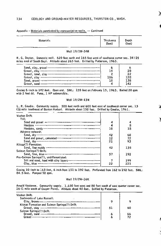
134 GEOLOGY AND GROUND-WATER RESOURCES, THURSTON CO., WASH.
Appendix - Materials penetrated by representative wells. -- Continued
Materials
Well 19/1W-34R
Thickness (feet)
Depth <feet)
R. G. Dayton. Domestic well. 620 feet north and 165 feet west of southeast comer sec. 34 ( 2! miles east of South Bay). Altitude about 265 feet. Drilled by Patterson, 1963.
Sand, clay, gravel--------------------------------------Grave I, clay -------------------------------------------Grave I, sand, clay --------------------------------------Gravel, clay ------------------------------------------Sand, gravel -------------·-----------------------------Gravel, sand -------------------------------------------
6 14
2 106
10 4
6 20 22
128 138 142
Casing 6-inch to lq2 feet. Open end, SWL: 120 feet on February 15, 1963. Bailed 20 gpm with 2 feet dd. Pump, 1 HP submersible.
Well 19/2W-13N
L. R. Gaudio. Community supply. 500 feet north and 600 feet east of southwest corner sec. 13 (li mite southeast of Boston Harbor). Altitude about 150 feet. Drilled by Gaudio, 1961.
Vashon Drift: THI:
Sand and gravel ---------------------------------------Hardpan ----------------------------------------------Hard pan, sandy -- ----------------- - - - -- --- - - - -- - - - - - -- - -
Advance outwas~: Sand, dry ----------------------------------------------Sand and gravel, cemented-------------------------------Sand, dry ----------------------------------------------
Kitsap(?) Formation: Sand, fine muddy--------------------------------------
Salmon Springs(?) Drift: Sand, fine, blue----------------------------------------
Pre-Salmon Springs(?), undifferentlated: Silt and sand, hard with clay layers-----------------------Clay, blue ---------------------------------------------
4 4
10
42 12 21
42
57
7 22
4 8
18
60 72 93
135
192
199 221
Casing 10-!nch to 163 feet, 6 Inch from 151to192 feet. Perforated from 162 to 192 feet. SWL: aq. 5 feet. Pumped SO gpm.
Well l 9/2W-16K
Arnold Koutonen. Community supply. 1,650 feet west and 80 feet south of east quarter corner sec. 16 (1 mile south of Cooper Point>. Altitude about 40 feet. Drilled by Patterson.
Vashon Drift: Sediments of Lake Russell:
Clay, brown--------------------------------------------Kitsap Formation and Salmon Springs(?) Drift:
Gravel, clay -------------------------------------------Salmon Springs(?) Drift:
Gravel, sand------------------------------------------Gravel-------------------------------------------------
9
51
6 6
9
60
66 72
)
·.ti
.)
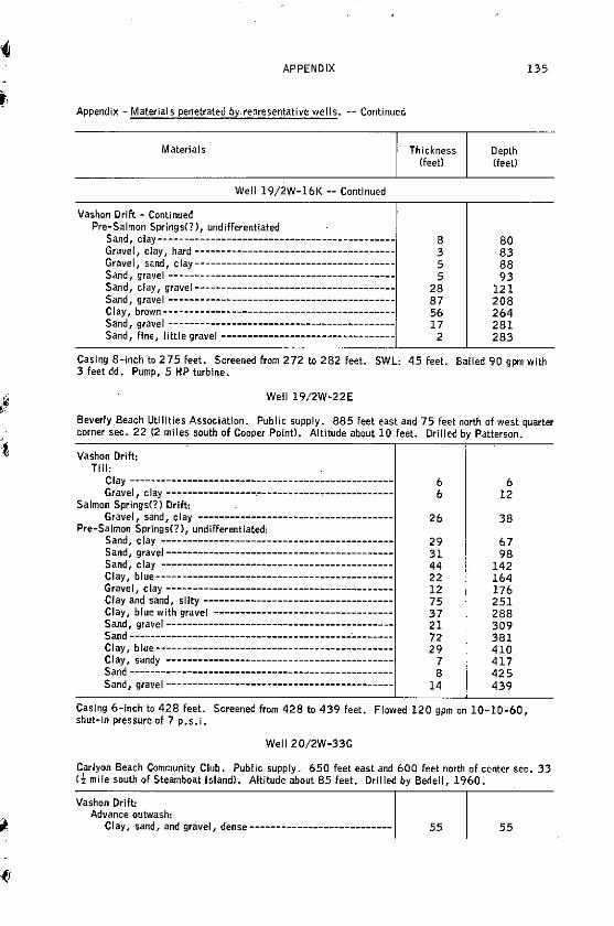
APPENDIX
Appendix - Materials penetrated by.representative wells. -- Continued
Materials
Well l 9/2W-16K -- Continued
Vashon Drift - Continued Pre-Salmon Springs(?), undifferentiated
Sand, clay--------------------------------------------Gravel, clay, hard--------------------------------------Gravel, sand, clay--------------------------------------Sand, gravel -------------------------------------------Sand, clay, gravel--------------------------------------Sand, gravel ------------------------------------------CI ay, brown-------------------------------------------Sand, grave I -------------------------------------------Sand, fine, little gravel ---------------------------------
Thickness (feet)
8 3 5 5
28 87 56 17
2
Depth (feet)
80 83 88 93
121 208 264 281 283
135
Casing 8-lnch to 275 feet. Screened from 272 to 282 feet. SWL: 45 feet. Balled 90 gpm with :3 feet dd. Pump, 5 HP turbine.
Well l 9/2W-22E
Beverly Beach Utilities Association. Public supply. 885 feet east and 75 feet north of west quarter corner sec. 22 (2 miles south of Cooper Point). Altitude about 10 feet. Drilled by Patterson.
Vashon Drift: Till:
Clay -------------------------------------------------Gravel, clay -----------------.--------------------------
Salmon Springs(?) Drift: Gravel, sand, clay -------------------------------------
Pre-Salmon Springs(?), undifferentiated: Sand, clay -------------------------------------------Sand, gravel-------------------------------------------Sand, clay -------------------------------------------Clay, blue-----------------.,.---------------------------Gravel, clay -------------------------------------------Clay and sand, silty-----------------------------------Clay, blue with gravel ----------------------------------Sand, gravel------------------------------------------Sand-------------------------------------------------Cl ay, blue--------------------------------------------Clay, sandy ------------------------------------------Sand ----------- - - --------------- - -- - ------ - - -- - --- - - -Sand / gravel -------------------------------------------
6 6
26
29 31 44 22 12 75 37 21 72 29
7 8
14
6 12
38
67 98
142 164 176 251 288 309 381 410 417 425 439
Casing 6-inch to 428 feet. Screened from 428 to 439 feet. Flowed 120 gpm an 10-10-60, shut-in pressure of 7 p.s.i.
Well 20/2W-33G
Carlyon Beach Community Club. Public supply. 650 feet east and 600 feet north of center sec. :33 (!mile south of Steamboat Island). Altitude about 85 feet. Drilled by Bedell, 1960.
Vashon Drift: Advance outwash:
Clay, sand, and gravel, dense--------------------------- 55 55
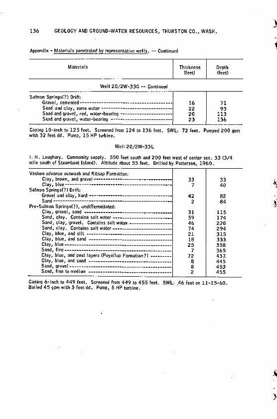
136 GEOLOGY AND GROUND-WATER RESOURCES, THURSTON CO., WASH.
Appendix - Materials penetrated by representative wells. -- Continued
Materials
Well 20/2W-33G -- Continued
Satmon Springs(?) Drift: Gravel / cemented---------------------------------------Sand and clay, some water-----------------------------Sand and gravel, red, water-bearing---------------------Sand and gravel, water-bearing ---------------------------
Thickness (feet)
16 22 20 23
Depth (feet)
71 93
113 136
Casing 10-inch to 125 feet. Screened from 124 to 136 feet. SWL: 72 feet. Pumped 200 gpm with 32 feet dd. Pump, 15 HP turbine.
Well 20/2W-33L
I. H. Loughary. Community supply. 550 feet south and 200 feet west of center sec. 33 C3/4 mile south of Steamboat Island). Altitude about 55 feet. Drilled by Patterson, 1960.
Vashon advance outwash and Kitsap Formation: Clay, brown, and gravel---------------------------------Clay, blue---------------------------------------------
Salmon Springs(?) Drift: Gravel and clay hard -----------------------------------Sand~--------:----------------------------------------
Pre-Salmon Springs(?), undifferentiated: Clay, gravel, sand -------------------------------------Sand, clay. Contains salt water------------------------Sand, clay, gravel. Contains salt water-----------------Sand, clay. Contains salt water------------------------Clay, blue, and silt-----------------------------------Clay, blue, and sand -----------------------------------Clay, blue------------------------------------~------Sand, fine---------------------------------------------Clay, blue, and peat layers {Puyallup Formation?>--------Clay, blue, and sand -----------------------------------Sand, gravel -------------------------------------------Sand, fine to medium -----------------------------------
33 7
42 2
31 59 46 74 21 18 25
7 72
8 8 2
33 40
82 84
115 174 220 294 315 333 358 365 437, 445 453 455
Casing 6-lnch to 449 feet. Screened from 449 to 455 feet. SWL: _46 feet on 11-15-60. Balled 45 gpm with 3 feet dd. Pump, 5 HP turbine.
\ -.
}
; ' -,,~
GLOSSARY OF HYDROLOGIC TERMS
The following definitions have been based on those given by numerous earlier workers, most of whom were cited by Mundorf! Cl 964, p. 111-113).
137
Aquiclude. A formation which, although porous and capable of absorbing water slowly, will not transmit it fast enough to furnish an appreciable supply for a well or spring.
Aquifer. A formation, group of formations, or part of a formation that is water bearing.
Area of influence. The area beneath which ground-water or pressure-surface contours are modified by pumping.
Artesian well. One in which the water level rises above the top of the aquifer, whether or not the water flows at the surface.
Base flow. The discharge entering stream channels from ground water or other delayed sources.
Cone of pressure relief. An imaginary surface indicatjng pressure-relief conditions in a confined aquifer due to pumping or during wel I flow.
Discharge, ground-water. Discharge of water from an aquifer, either by natural means such as evapotranspiration and flow from seeps and springs, or by artificial means such as pumping from_ wells.
Drawdown. Lowering of the water level in a well as a result of withdrawal of water. Evapotranspiration. Total discharge of water to the air by direct evaporation and
plant transpiration. Ground water. That part of the subsurface water in the zone of saturation. Hydrostatic pressure. The pressure exerted by the water at any given point in a
body of water at rest. That of ground water generally is due to the weight of water at higher levels in the same zone of saturation.
Infiltration. The flow of a fluid into a substance through pores or small openings. It connotes flow into a substance in contradistinction to the word percolation, which connotes flow through a porous substance.
Perched ground water. Ground water separated from an underlying body of ground water by unsaturated rock. ·its water table is a perched water table.
Permeability. The capacity of aquifer materials to transmit water under pressure. In general the larger the connected pore spaces or other openings in the materials, the greater the permeability.
Piezometric surface. An imaginary surface that everywhere coincides with the static level of the water in the aquifer.
Porosity. The ratio of the volume of openings to the total volume of rock or soil. A high porosity does not necessarily indicate a high permeability.
Recharge, ground-water. Addition of water to an aquifer from all sources, both natural and artificial.
Runoff. The quar:itity of water discharged by surface streams, expressed usually in units of volume, such as gallons, cubic feet, or acre-feet.
Semi perched ground water. Ground water is semi perched if it has a greater pressure head than an underlying body of ground water, from which it is, however, not separated· by any unsaturated rock.
Specific capacity. The discharge of a wel I expressed as a rate of yield per unit" of drawdown, generally expressed in gallons per minute per foot of drawdown.
138 GEOLOGY AND GROUND-WATER RESOURCES, THURSTON CO., WASH.
Transpiration. The process by which water vapor escapes from a living plant and enters the atmosphere.
Water table. The upper surface of the zone of saturation, except where that surface is formed by impermeable material.
Zone of aeration. The zone in which the interstices of the functional penmeable rocks are not filled (except temporarily) with water. The water is under pressure less than atmospheric.
Zone of saturation. The zone in which the functional permeable rocks are saturated with water under pressure equal to or greater than atmospheric.
I
~ - I
J
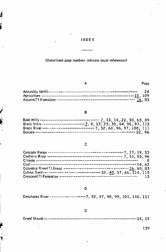
fr
INDEX
(Underlined page numbers indicate major references)
A Page
Admiralty (drift>--- -- -- -- ------- - -------- -- ----- ----------.---c--- - 2 4 Agriculture ----------------------------------------------------10 109 Astoria(?) Formation---------------------------~---------------- lb, 83
B
Bald Hills--------------------------------- z, 13, 14, 22, 30, 63, 89 Black Hills------------------------1, 8, 13, 25, 30, 64, 90, 97, 113 Black River-----------------------------7, 52, 60, 96, 97, 108, 111 Bucoda-------------------------------------------------------- 22, 96
c Cascade Range ------------------------------------------ 7, 17, 19, 53 Chehalis River------------------------------------------ 7, 15, 53, 96 CI imate --------------------------------------------------------- 8 Coal----------------------------------------------------------- 14, 62 Columbia River(?) Group -------------------------------------16, 65, 83 Colvos Sand-------------------------------- 32, 40, 57, 66-;l 14, 115 Crescent<?) Formation -------------------------------------------- 13
D
Deschutes River --------------------7, 52, 97, 98, 99, 101, 110, 111
G
Grand Mound ----------------------------------------------------14, 15
139
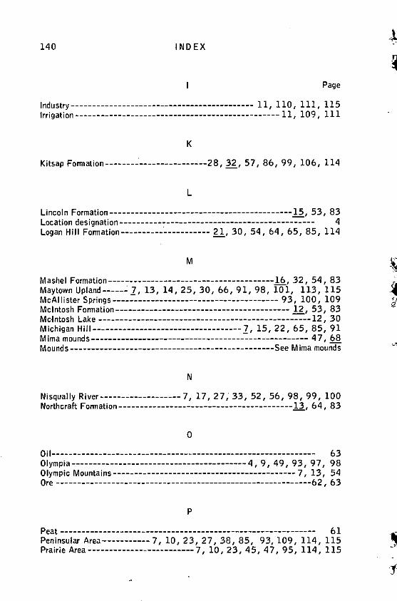
140 I ND EX
Page
Industry------------------------------------------- 11, 110, 111, 115 Irrigation------------------------------------------------ 11, 109, 111
K
Kitsap Formation--------·----------------28, 32, 5 7, 86, 99, 106, 114
L
Lineal n Formation-------------------------------------------.)2, 53, 83 Location designation ---- -- -- ---- ---- ---- --------- ---- -------- ----- 4 Logan Hill Fonnation----------·----------- ~. 30, 54, 64, 65, 85, 114
M
Mashel Formation----~----------------------------------1§., 32, 54, 83 Maytown Upland------1, 13, 14, 25, 30, 66, 91, 98, 101, 113, 115 Mc Al Ii ster Springs--------------------------------------- 9 3, 100, 109 Mcintosh Formation----------------------------------------- g, 53, 83 Mcintosh Lake --------------------------------------------------12, 30 Michigan Hill-----------------------------------1, 15, 22, 65, 85, 91 M ima mounds--------------------------------------------------- 4 7, 68 Mounds ------------------------------------------------See M ima mounds
N
Nisqually River-------------------7, 17, 27; 33, 52, 56, 98, 99, 100 Northcraft Fonnation-----------------------------------------11., 64, 83
0
Oil-------------------------------------------------------------- 63 Olympia----------------------------------------- 4, 9, 49, 93, 97, 98 Olympic Mountains------------------------------------------- 7, 13, 54 Ore ------------------------------------------------------------62, 63
p
Peat------------------------------------------------------------ 61 Peninsular Area-----------7, 10, 23, 27, 38, 85, 93, 109, 114, 115 Prairie Area------------------------- 7, 10, 23, 45, 4 7, 95, 114, 115
IND EX 141
Page
Pree ipitation ----------------------------------------------------- 8, 72 Pre-Salmon Springs(?> deposits --- 23, 30, 85, 94, ,106, 108, 114, 115 Puget Sound----------------------------------------------------- 7, 60
R
Radiocarbon dating------------------------------------------ 2 8, 32, 34 Rochester --------------------------------------------------15, 88, 96 Russell, glacial Lake ----------------------C----------- 44, 4 9, .21., 60
s Salmon Springs(?) Drift-fl., 46, 64, 66, 68, 92, 94, 97, 98, 99, 114, 115 Salmon Springs(?) Glacier ----------------------------------- 2 7, 54, 56 Salt water------------------------------------------------ See sea water Scatter Creek --------------------------------------------- 31, 58, 111 Sea water contamination------------ 94, 101, 103, 106, 107, 108, 114 Skookumchuck Formation------------------------- .!1, 53, 83, 106, 108 Skookumchuck River------------------------------------------ 7, 22, 95 South Bay ------------------------------------------------------87, 99 Stone------------------------------------------------------------ 62 Summit Lake ---------------------------------------13, 31, 56, 64, 91
T
T enino-------------------------------------------------13, 66, 88, 96 Ti 11 -----------------------------------------41, 87, 97, 98, 99, 115 Tono------------------------------------------------------------ 15
v Vashon Drift-24, 29, 33, 40, 47 ,66, 87, 94, 97, 98, 99, 101, 108, 115 Vashon Glacier -----------=---------------------------44, 51, 57, 6 7 Vegetation------------------------------------------------------- 10
w
Water levels------------------------------------------------------ 72
y
Yelm----------------------------------------------- 6, 100, 111, 114
I I '
I I I
I l I I
! !
l !