Embed Size (px)
Citation preview
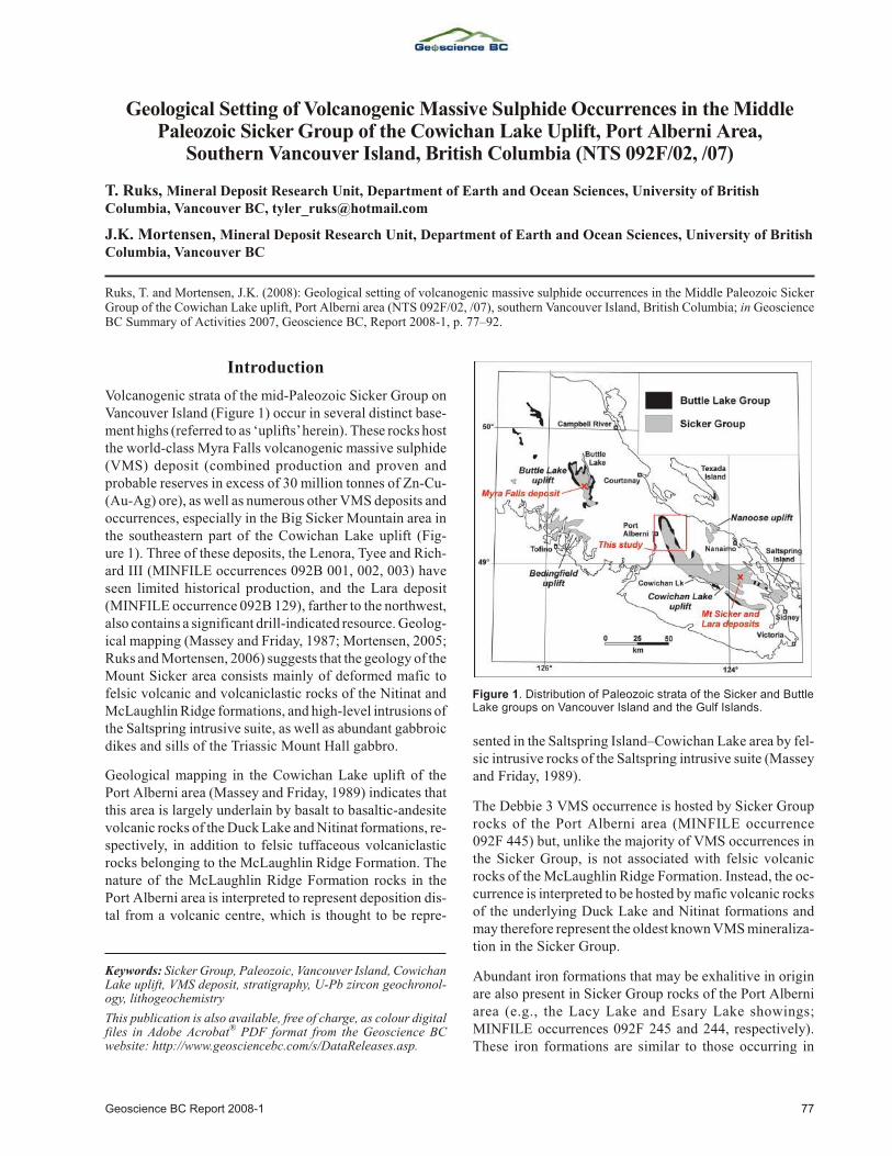
Geological Setting of Volcanogenic Massive Sulphide Occurrences in the MiddlePaleozoic Sicker Group of the Cowichan Lake Uplift, Port Alberni Area,
Southern Vancouver Island, British Columbia (NTS 092F/02, /07)
T. Ruks, Mineral Deposit Research Unit, Department of Earth and Ocean Sciences, University of BritishColumbia, Vancouver BC, [email protected]
J.K. Mortensen, Mineral Deposit Research Unit, Department of Earth and Ocean Sciences, University of British Columbia, Vancouver BC
Ruks, T. and Mortensen, J.K. (2008): Geo log i cal set ting of volcanogenic mas sive sul phide oc cur rences in the Mid dle Pa leo zoic SickerGroup of the Cowichan Lake up lift, Port Alberni area (NTS 092F/02, /07), south ern Van cou ver Is land, Brit ish Co lum bia; in GeoscienceBC Sum mary of Ac tiv i ties 2007, Geoscience BC, Re port 2008-1, p. 77–92.
Introduction
Volcanogenic strata of the mid-Pa leo zoic Sicker Group onVan cou ver Is land (Fig ure 1) oc cur in sev eral dis tinct base -ment highs (re ferred to as ‘up lifts’ herein). These rocks host the world-class Myra Falls volcanogenic mas sive sul phide(VMS) de posit (com bined pro duc tion and proven andprob a ble re serves in ex cess of 30 mil lion tonnes of Zn-Cu-(Au-Ag) ore), as well as nu mer ous other VMS de pos its andoc cur rences, es pe cially in the Big Sicker Moun tain area inthe south east ern part of the Cowichan Lake up lift (Fig -ure 1). Three of these de pos its, the Lenora, Tyee and Rich -ard III (MINFILE oc cur rences 092B 001, 002, 003) haveseen lim ited his tor i cal pro duc tion, and the Lara de posit(MINFILE oc cur rence 092B 129), far ther to the north west,also con tains a sig nif i cant drill-in di cated re source. Geo log -i cal map ping (Massey and Fri day, 1987; Mortensen, 2005;Ruks and Mortensen, 2006) sug gests that the ge ol ogy of the Mount Sicker area con sists mainly of de formed mafic tofel sic vol ca nic and volcaniclastic rocks of the Nitinat andMcLaughlin Ridge for ma tions, and high-level in tru sions of the Saltspring in tru sive suite, as well as abundant gabbroicdikes and sills of the Triassic Mount Hall gabbro.
Geo log i cal map ping in the Cowichan Lake up lift of thePort Alberni area (Massey and Fri day, 1989) in di cates thatthis area is largely un der lain by ba salt to ba saltic-an de sitevol ca nic rocks of the Duck Lake and Nitinat for ma tions, re -spec tively, in ad di tion to fel sic tuffaceous volcaniclasticrocks be long ing to the McLaughlin Ridge For ma tion. Thena ture of the McLaughlin Ridge For ma tion rocks in thePort Alberni area is in ter preted to rep re sent de po si tion dis -tal from a vol ca nic cen tre, which is thought to be rep re -
sented in the Saltspring Is land–Cowichan Lake area by fel -sic in tru sive rocks of the Saltspring intrusive suite (Masseyand Friday, 1989).
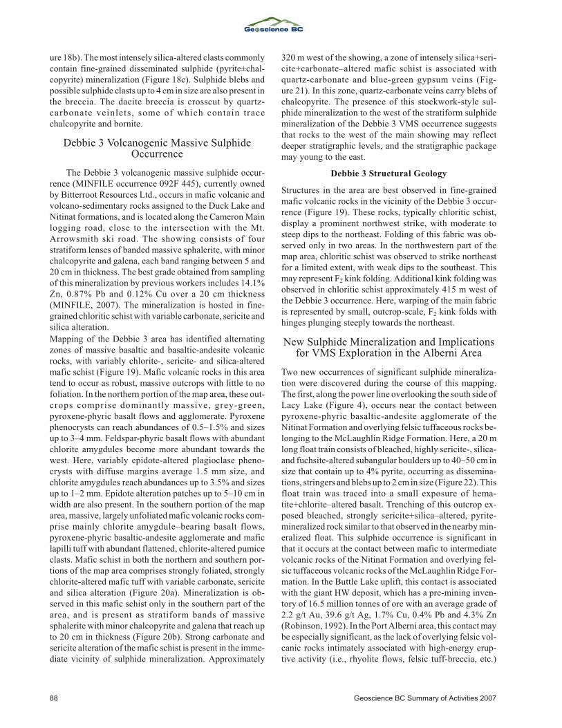
The Deb bie 3 VMS oc cur rence is hosted by Sicker Grouprocks of the Port Alberni area (MINFILE oc cur rence092F 445) but, un like the ma jor ity of VMS oc cur rences inthe Sicker Group, is not as so ci ated with fel sic vol ca nicrocks of the McLaughlin Ridge For ma tion. In stead, the oc -cur rence is in ter preted to be hosted by mafic vol ca nic rocksof the un der ly ing Duck Lake and Nitinat for ma tions andmay there fore rep re sent the old est known VMS min er al iza -tion in the Sicker Group.
Abun dant iron for ma tions that may be exhalitive in or i ginare also pres ent in Sicker Group rocks of the Port Alberniarea (e.g., the Lacy Lake and Esary Lake show ings;MINFILE oc cur rences 092F 245 and 244, re spec tively).These iron for ma tions are sim i lar to those oc cur ring in
Geoscience BC Re port 2008-1 77
Keywords: Sicker Group, Pa leo zoic, Van cou ver Is land, CowichanLake up lift, VMS de posit, stra tig ra phy, U-Pb zir con geo chron ol -ogy, lithogeochemistry
This pub li ca tion is also avail able, free of charge, as col our dig i talfiles in Adobe Ac ro bat® PDF for mat from the Geoscience BCwebsite: http://www.geosciencebc.com/s/DataReleases.asp.
Fig ure 1. Dis tri bu tion of Pa leo zoic strata of the Sicker and ButtleLake groups on Van cou ver Is land and the Gulf Is lands.
rocks that are stratigraphically above VMS min er al iza tionat the Myra Falls, Lara, Lenora, Tyee and Rich ard III oc cur -rences, and are be lieved to rep re sent ox ide-fa cies iron min -er al iza tion re lated to hy dro ther mal min er al iz ing sys temssim i lar to those that formed the un der ly ing VMS de pos its.As with the Deb bie 3 VMS oc cur rence, how ever, the ironfor ma tions of the Port Alberni area are un der lain by maficvolcanic rocks of the Duck Lake or Nitinat formations.
If the Deb bie 3 VMS oc cur rence is in deed the same age asthe po ten tial VMS-re lated exhalitive iron for ma tions in thesame gen eral area, this makes the Port Alberni area, spe cif i -cally where it is un der lain by rocks of the Nitinat and DuckLake for ma tions, sig nif i cantly more pro spec tive for VMSmin er al iza tion than was pre vi ously ap pre ci ated. Log gingac tiv ity in the area over the past de cade has pro vided abun -dant new out crops and greatly im proved ac cess, and hasprompted a re-ex am i na tion of the geo log i cal set ting ofVMS min er al iza tion and of the potential for newdiscoveries in this area.
Both re con nais sance and de tailed geo log i cal map ping, to -gether with sam pling for lithogeochemistry, U-Pb zir condat ing, and Nd, Hf and Pb iso to pic stud ies, were con ductedover a 20-day pe riod in the Port Alberni area in Oc to ber2007. This work was con cen trated in the vi cin ity of theDeb bie 3 VMS oc cur rence and the area of po ten tially cor re -la tive exhalitive iron for ma tions to the west. This re portpres ents a pre lim i nary ver sion of re vised geo log i cal map -ping in this area, with em pha sis on un der stand ing the ge ol -ogy in the vi cin ity of the Deb bie 3 VMS oc cur rence and thepo ten tially cor re la tive Lacy and Esary Lake exhalitive ironformations.
Regional Geology of the Sicker Group
The mid-Pa leo zoic Sicker Group on south ern and cen tralVan cou ver Is land rep re sents the stratigraphically low estpor tion of the Wrangellia Terrane. Equiv a lents of theSicker Group are not pres ent in Wrangellia in north west ernBrit ish Co lum bia, south west ern Yu kon and south ernAlaska, where the old est rock units are the Skolai Group,which is no older than Penn syl va nian (e.g., Katvala, 2006).This, and other dif fer ences be tween the Wrangellian stra -tig ra phy on Van cou ver Is land and that in more north erly ex -po sures, em pha sizes the lack of un der stand ing re gard ingmuch of Wrangellia (e.g., Katvala, 2006) and the need forfur ther stud ies. The Cowichan Lake up lift on Van cou ver Is -land and ad ja cent por tions of the Gulf Is lands, which is themain fo cus of this study, is the larg est of four up lifts that ex -pose the Sicker and overlying late Paleozoic Buttle Lakegroups (Figure 1).
Pre vi ous de tailed stud ies of the Sicker Group have fo cusedmainly on the strati graphic set ting of VMS min er al iza tionat the Myra Falls de pos its in the Buttle Lake up lift (Fig -ure 1; e.g., Juras, 1987; Barrett and Sherlock, 1996). Re -
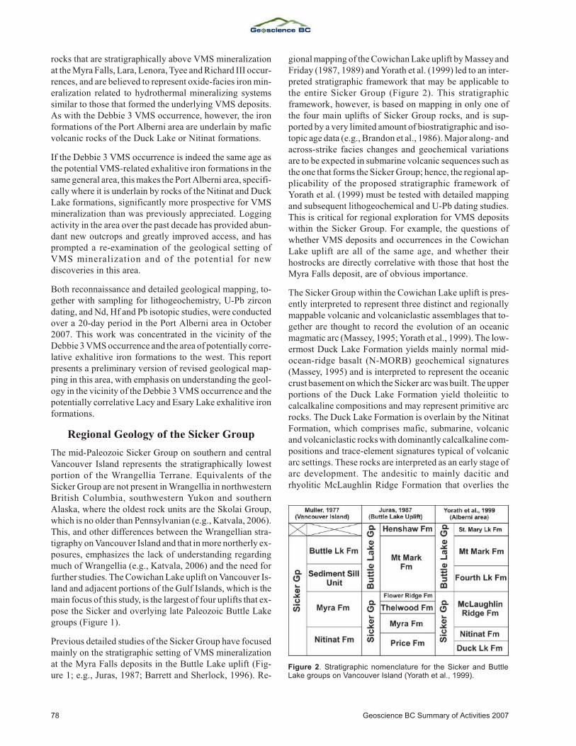
gional map ping of the Cowichan Lake up lift by Massey and Fri day (1987, 1989) and Yorath et al. (1999) led to an in ter -preted strati graphic frame work that may be ap pli ca ble tothe en tire Sicker Group (Fig ure 2). This strati graphicframe work, how ever, is based on map ping in only one ofthe four main up lifts of Sicker Group rocks, and is sup -ported by a very lim ited amount of biostratigraphic and iso -to pic age data (e.g., Brandon et al., 1986). Ma jor along- and across-strike fa cies changes and geo chem i cal vari a tionsare to be ex pected in sub ma rine vol ca nic se quences such asthe one that forms the Sicker Group; hence, the re gional ap -pli ca bil ity of the pro posed strati graphic frame work ofYorath et al. (1999) must be tested with de tailed map pingand sub se quent lithogeochemical and U-Pb dat ing stud ies.This is crit i cal for re gional ex plo ra tion for VMS de pos itswithin the Sicker Group. For ex am ple, the ques tions ofwhether VMS de pos its and oc cur rences in the CowichanLake up lift are all of the same age, and whether theirhostrocks are di rectly cor re la tive with those that host theMyra Falls deposit, are of obvious importance.
The Sicker Group within the Cowichan Lake up lift is pres -ently in ter preted to rep re sent three dis tinct and re gion allymappable vol ca nic and volcaniclastic as sem blages that to -gether are thought to re cord the evo lu tion of an oce anicmag matic arc (Massey, 1995; Yorath et al., 1999). The low -er most Duck Lake For ma tion yields mainly nor mal mid-ocean-ridge ba salt (N-MORB) geo chem i cal sig na tures(Massey, 1995) and is in ter preted to rep re sent the oce aniccrust base ment on which the Sicker arc was built. The up per por tions of the Duck Lake For ma tion yield tholeiitic tocalcalkaline com po si tions and may rep re sent prim i tive arcrocks. The Duck Lake For ma tion is over lain by the NitinatFor ma tion, which com prises mafic, sub ma rine, vol ca nicand volcaniclastic rocks with dom i nantly calcalkaline com -po si tions and trace-el e ment sig na tures typ i cal of vol ca nicarc set tings. These rocks are in ter preted as an early stage ofarc de vel op ment. The andesitic to mainly dacitic andrhyolitic McLaughlin Ridge For ma tion that over lies the
78 Geoscience BC Sum mary of Ac tiv i ties 2007
Fig ure 2. Strati graphic no men cla ture for the Sicker and ButtleLake groups on Van cou ver Is land (Yorath et al., 1999).
Nitinat and hosts the Myra Falls de posit re flects a moreevolved stage of arc ac tiv ity. Erup tion of Nitinat vol ca nicand volcaniclastic rocks ap pears to have oc curred fromsev eral widely scat tered cen tres, whereas the McLaughlinRidge For ma tion within the Cowichan Lake up lift isthought to rep re sent erup tion from one or more ma jor vol -ca nic ed i fices. The abun dance of prox i mal fel sicvolcaniclastic rocks and the pres ence of vo lu mi nouscomagmatic fel sic in tru sions (Saltspring in tru sions) in theSaltspring Is land and Duncan ar eas (Fig ure 1) in di catesthat one of these ma jor vol ca nic cen tres was lo cated in thisarea. Plant ma te rial and trace fos sils in di cate that at least ami nor amount of the McLaughlin Ridge vol ca nism oc -curred in a subaerial set ting. In the Port Alberni area, theMcLaughlin Ridge For ma tion com prises fel sic, fine-grained tuffaceous volcaniclastic and epiclastic rocks, in di -cat ing de po si tion dis tal from a vol ca nic cen tre. De po si tionof sed i men tary and vol cano-sed i men tary rocks of the over -ly ing Fourth Lake For ma tion of the Buttle Lake Group fol -lowed the ces sa tion of Sicker arc magmatism, and scarcemafic vol ca nic rocks con tained within the Fourth Lake For -ma tion yield en riched tholeiitic rather than the calcalkalinecom po si tions that characterize the McLaughlin Ridge.Massey (1995) speculated that the Buttle Lake Group mayrepresent a marginal-basin assemblage that developed ontop of the Sicker arc.
Stud ies of the Sicker and Buttle Lake groups on south ernSaltspring Is land at the south east ern end of the CowichanLake up lift by Sluggett (2003) and Sluggett and Mortensen(2003) pro vided new U-Pb zir con age con straints on bothfel sic vol ca nic rocks of the McLaughlin Ridge For ma tionand sev eral bod ies of Saltspring in tru sions. This work dem -on strates that two dis tinct ep i sodes of fel sic magmatism oc -curred in this por tion of the Cowichan Lake up lift. Onesam ple of fel sic vol ca nic rocks from the McLaughlin Ridge For ma tion and three sam ples of Saltspring in tru sionsyielded U-Pb ages in the range 359.1–356.5 Ma. A some -what older U-Pb age of 369.7 Ma was ob tained from a sep a -rate body of the Saltspring in tru sions at Burgoyne Bay onthe south west side of Saltspring Is land, in di cat ing thatmagmatism rep re sented by the McLaughlin Ridge For ma -tion and as so ci ated Saltspring in tru sions oc curred over atime span of at least 15 mil lion years. There is in suf fi cientage con trol avail able at this point to de ter mine whether themagmatism was continuous or episodic during this timeperiod.
Results of New Mapping in the Port AlberniArea
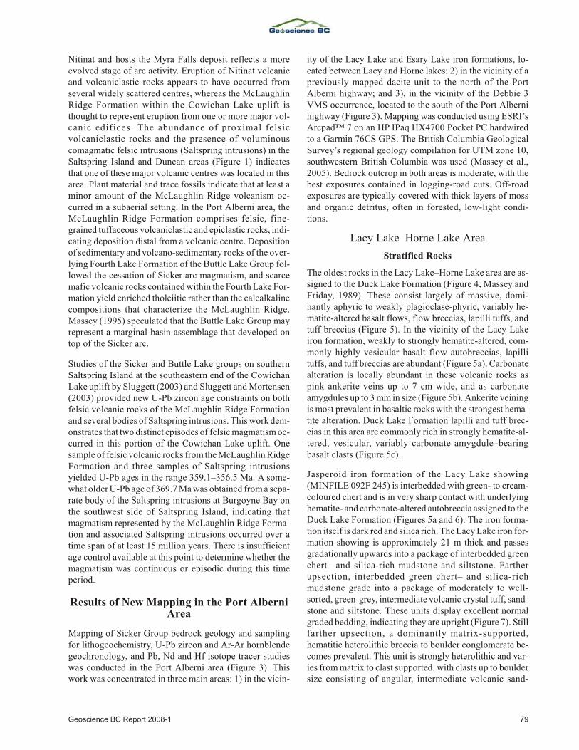
Map ping of Sicker Group bed rock ge ol ogy and sam plingfor lithogeochemistry, U-Pb zir con and Ar-Ar hornblendegeo chron ol ogy, and Pb, Nd and Hf iso tope tracer stud ieswas con ducted in the Port Alberni area (Fig ure 3). Thiswork was con cen trated in three main ar eas: 1) in the vi cin -
ity of the Lacy Lake and Esary Lake iron for ma tions, lo -cated be tween Lacy and Horne lakes; 2) in the vi cin ity of apre vi ously mapped dacite unit to the north of the PortAlberni high way; and 3), in the vi cin ity of the Deb bie 3VMS oc cur rence, lo cated to the south of the Port Albernihigh way (Fig ure 3). Map ping was con ducted us ing ESRI’sArcpad™ 7 on an HP IPaq HX4700 Pocket PC hard wiredto a Garmin 76CS GPS. The Brit ish Co lum bia Geo log i calSur vey’s re gional ge ol ogy com pi la tion for UTM zone 10,south west ern Brit ish Co lum bia was used (Massey et al.,2005). Bed rock out crop in both ar eas is mod er ate, with thebest ex po sures con tained in log ging-road cuts. Off-roadex po sures are typ i cally cov ered with thick lay ers of mossand or ganic de tri tus, of ten in for ested, low-light con di -tions.
Lacy Lake–Horne Lake Area
Stratified Rocks
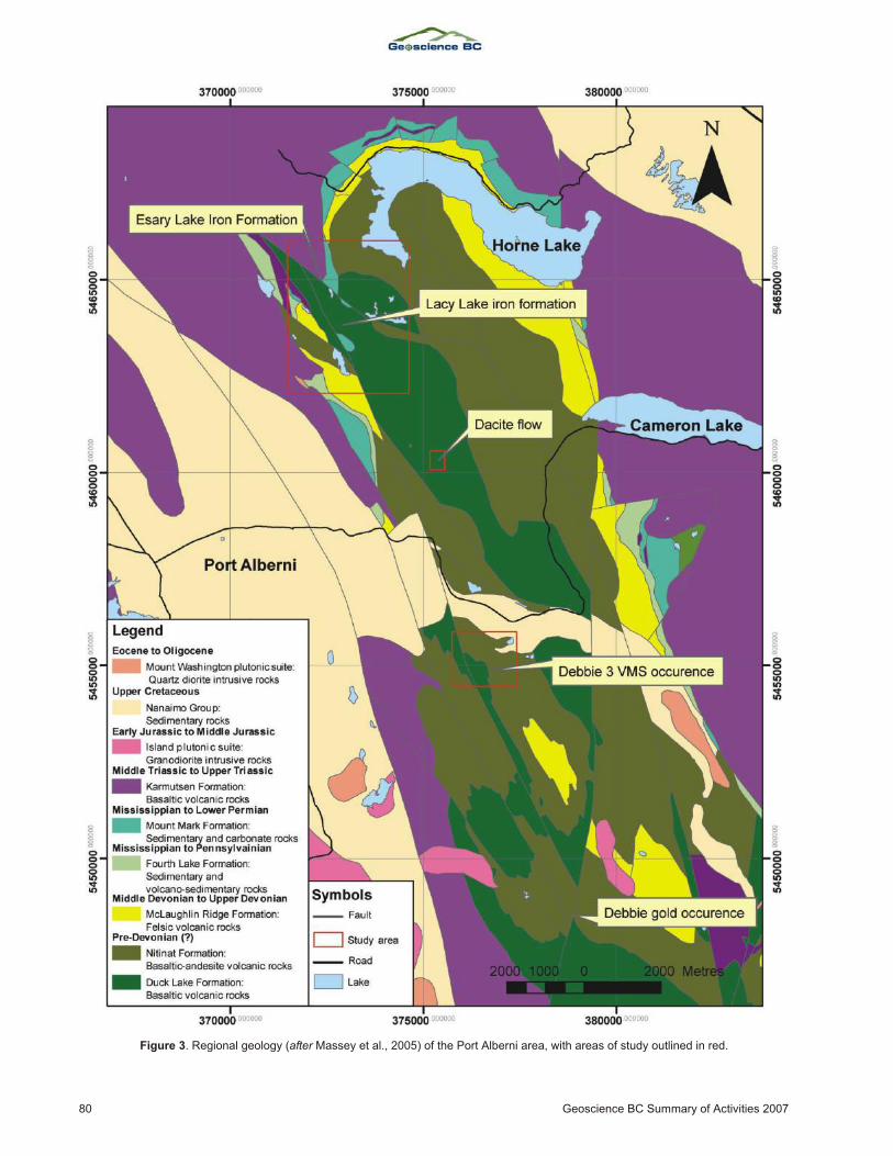
The old est rocks in the Lacy Lake–Horne Lake area are as -signed to the Duck Lake For ma tion (Fig ure 4; Massey andFri day, 1989). These con sist largely of mas sive, dom i -nantly aphyric to weakly plagioclase-phyric, vari ably he -ma tite-al tered ba salt flows, flow brec cias, lapilli tuffs, andtuff brec cias (Fig ure 5). In the vi cin ity of the Lacy Lakeiron for ma tion, weakly to strongly he ma tite-al tered, com -monly highly ve sic u lar ba salt flow autobreccias, lapillituffs, and tuff brec cias are abun dant (Fig ure 5a). Car bon ateal ter ation is lo cally abun dant in these vol ca nic rocks aspink an ker ite veins up to 7 cm wide, and as car bon ateamygdules up to 3 mm in size (Fig ure 5b). An ker ite vein ingis most prev a lent in ba saltic rocks with the stron gest he ma -tite al ter ation. Duck Lake For ma tion lapilli and tuff brec -cias in this area are com monly rich in strongly he ma tite-al -tered, ve sic u lar, variably carbonate amygdule–bearingbasalt clasts (Figure 5c).
Jasperoid iron for ma tion of the Lacy Lake show ing(MINFILE 092F 245) is interbedded with green- to cream-col oured chert and is in very sharp con tact with un der ly inghe ma tite- and car bon ate-al tered autobreccia as signed to the Duck Lake For ma tion (Fig ures 5a and 6). The iron for ma -tion it self is dark red and sil ica rich. The Lacy Lake iron for -ma tion show ing is ap prox i mately 21 m thick and passesgradationally up wards into a pack age of interbedded greenchert– and sil ica-rich mudstone and siltstone. Far therupsection, interbedded green chert– and sil ica-richmudstone grade into a pack age of mod er ately to well-sorted, green-grey, in ter me di ate vol ca nic crys tal tuff, sand -stone and siltstone. These units dis play ex cel lent nor malgraded bed ding, in di cat ing they are up right (Fig ure 7). Stillfar ther upsection, a dom i nantly ma trix-sup ported,hematitic heterolithic brec cia to boul der con glom er ate be -comes prev a lent. This unit is strongly heterolithic and var -ies from ma trix to clast sup ported, with clasts up to boul dersize con sist ing of an gu lar, in ter me di ate vol ca nic sand -
Geoscience BC Re port 2008-1 79
80 Geoscience BC Sum mary of Ac tiv i ties 2007
Fig ure 3. Re gional ge ol ogy (af ter Massey et al., 2005) of the Port Alberni area, with ar eas of study out lined in red.
Geoscience BC Re port 2008-1 81
Fig ure 4. New geo log i cal map ping in the Lacy Lake–Horne Lake area, Port Alberni area. Re gional ge ol ogy af ter Massey et al. (2005).
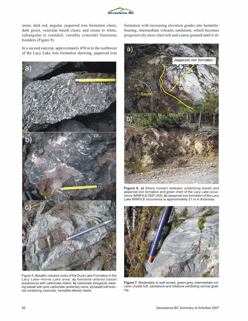
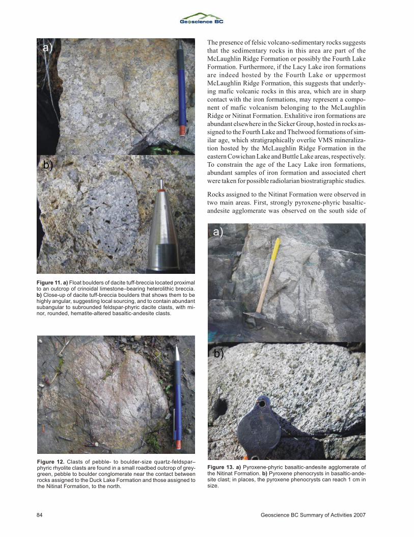
stone; dark red, an gu lar, jasperoid iron for ma tion clasts;dark green, ve sic u lar ba salt clasts; and cream to white,subangular to rounded, variably crinoidal limestoneboulders (Figure 8).
In a sec ond out crop, ap prox i mately 450 m to the north westof the Lacy Lake iron for ma tion show ing, jasperoid iron
for ma tion with in creas ing el e va tion grades into he ma tite-bear ing, in ter me di ate vol ca nic sand stone, which be comespro gres sively more clast rich and coarse grained un til it ul -
82 Geoscience BC Sum mary of Ac tiv i ties 2007
Fig ure 5. Ba saltic vol ca nic rocks of the Duck Lake For ma tion in theLacy Lake–Horne Lake area: a) he ma ti te-al tered ba saltautobreccia with car bon ate ma trix; b) car bon ate amyg dule–bear -ing ba salt with pink car bon ate (an ker ite) veins; c) ba salt tuff-brec -cia con tain ing ve sic u lar, he ma tite-al tered clasts.
Fig ure 6. a) Sharp con tact be tween un der ly ing ba salt andjasperoid iron for ma tion and green chert of the Lacy Lake oc cur -rence (MINFILE 092F 245). b) Jasperoid iron for ma tion of the LacyLake MINFILE oc cur rence is ap prox i mately 21 m in thick ness.
Fig ure 7. Mod er ately to well-sorted, green-grey, in ter me di ate vol -ca nic crys tal tuff, sand stone and siltstone ex hib it ing nor mal grad -ing.
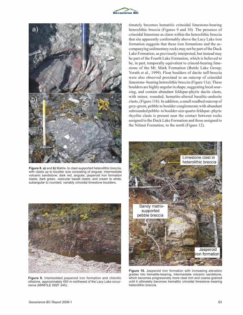
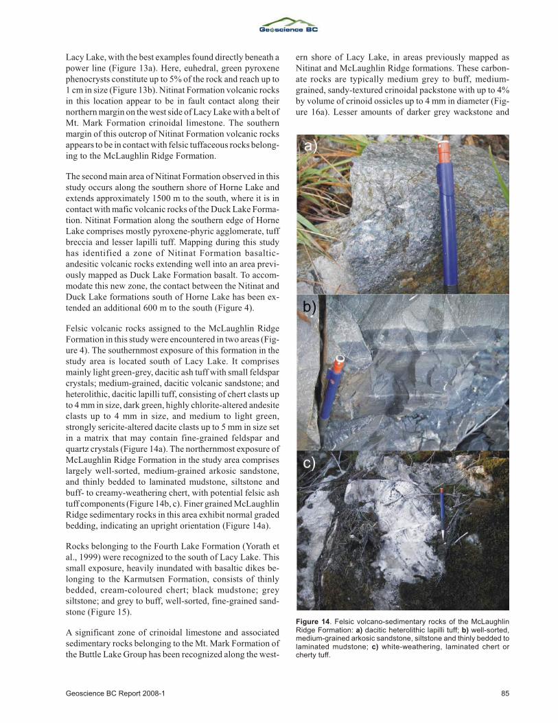
ti mately be comes hematitic crinoidal lime stone-bear ingheterolithic brec cia (Fig ures 9 and 10). The pres ence ofcrinoidal lime stone as clasts within the heterolithic brec ciathat sits ap par ently con form ably above the Lacy Lake ironfor ma tion sug gests that these iron for ma tions and the ac -com pa ny ing sed i men tary rocks may not be part of the Duck Lake For ma tion, as pre vi ously in ter preted, but in stead maybe part of the Fourth Lake For ma tion, which is be lieved tobe, in part, tem po rally equiv a lent to cri noid-bear ing lime -stone of the Mt. Mark For ma tion (Buttle Lake Group;Yorath et al., 1999). Float boul ders of dacite tuff-brec ciawere also ob served prox i mal to an out crop of crinoidallime stone–bear ing heterolithic brec cia (Fig ure 11a). Theseboul ders are highly an gu lar in shape, sug gest ing lo cal sour -cing, and con tain abun dant feld spar-phyric dacite clasts,with mi nor, rounded, he ma tite-al tered ba saltic-an de siteclasts, (Fig ure 11b). In ad di tion, a small road bed out crop ofgrey-green, peb ble to boul der con glom er ate with abun dantsubrounded peb ble- to boul der-size quartz-feld spar–phyric rhy o lite clasts is pres ent near the con tact be tween rocksassigned to the Duck Lake Formation and those assigned tothe Nitinat Formation, to the north (Figure 12).
Geoscience BC Re port 2008-1 83
Fig ure 8. a) and b) Ma trix- to clast-sup ported heterolithic brec cia,with clasts up to boul der size con sist ing of an gu lar, in ter me di atevol ca nic sand stone; dark red, an gu lar, jasperoid iron for ma tionclasts; dark green, ve sic u lar ba salt clasts; and cream to white,subangular to rounded, vari ably crinoidal lime stone boul ders.
Fig ure 9. Interbedded jasperoid iron for ma tion and chloriticsiltstone, ap prox i mately 450 m north west of the Lacy Lake oc cur -rence (MINFILE 092F 245).
Fig ure 10. Jasperoid iron for ma tion with in creas ing el e va tiongrades into he ma tite-bear ing, in ter me di ate vol ca nic sand stone,which be comes pro gres sively more clast rich and coarse grainedun til it ul ti mately be comes hematitic crinoidal lime stone–bear ingheterolithic brec cia.
The pres ence of fel sic vol cano-sed i men tary rocks sug geststhat the sed i men tary rocks in this area are part of theMcLaughlin Ridge For ma tion or pos si bly the Fourth LakeFor ma tion. Fur ther more, if the Lacy Lake iron for ma tionsare in deed hosted by the Fourth Lake or up per mostMcLaughlin Ridge For ma tion, this sug gests that un der ly -ing mafic vol ca nic rocks in this area, which are in sharpcon tact with the iron for ma tions, may rep re sent a com po -nent of mafic vol ca nism be long ing to the McLaughlinRidge or Nitinat For ma tion. Exhalitive iron for ma tions areabun dant else where in the Sicker Group, hosted in rocks as -signed to the Fourth Lake and Thelwood for ma tions of sim -i lar age, which stratigraphically over lie VMS min er al iza -tion hosted by the McLaughlin Ridge For ma tion in theeast ern Cowichan Lake and Buttle Lake ar eas, re spec tively. To con strain the age of the Lacy Lake iron for ma tions,abun dant sam ples of iron for ma tion and as so ci ated chertwere taken for possible radiolarian biostratigraphic studies.
Rocks as signed to the Nitinat For ma tion were ob served intwo main ar eas. First, strongly pyroxene-phyric ba saltic-an de site ag glom er ate was ob served on the south side of
84 Geoscience BC Sum mary of Ac tiv i ties 2007
Fig ure 11. a) Float boul ders of dacite tuff-brec cia lo cated prox i malto an out crop of crinoidal lime stone–bear ing heterolithic brec cia.b) Close-up of dacite tuff-brec cia boul ders that shows them to behighly an gu lar, sug gest ing lo cal sour cing, and to con tain abun dantsubangular to subrounded feld spar-phyric dacite clasts, with mi -nor, rounded, he ma tite-al tered ba saltic-an de site clasts.
Fig ure 12. Clasts of peb ble- to boul der-size quartz-feld spar–phyric rhy o lite clasts are found in a small road bed out crop of grey-green, peb ble to boul der con glom er ate near the con tact be tweenrocks as signed to the Duck Lake For ma tion and those as signed tothe Nitinat For ma tion, to the north.
Fig ure 13. a) Pyroxene-phyric ba saltic-an de site ag glom er ate ofthe Nitinat For ma tion. b) Pyroxene pheno crysts in ba saltic-an de -site clast; in places, the pyroxene pheno crysts can reach 1 cm insize.
Lacy Lake, with the best ex am ples found di rectly be neath apower line (Fig ure 13a). Here, euhedral, green pyroxenepheno crysts con sti tute up to 5% of the rock and reach up to1 cm in size (Fig ure 13b). Nitinat For ma tion vol ca nic rocksin this lo ca tion ap pear to be in fault con tact along theirnorth ern mar gin on the west side of Lacy Lake with a belt of Mt. Mark For ma tion crinoidal lime stone. The south ernmar gin of this out crop of Nitinat For ma tion vol ca nic rocksap pears to be in con tact with fel sic tuffaceous rocks be long -ing to the McLaughlin Ridge Formation.
The sec ond main area of Nitinat For ma tion ob served in thisstudy oc curs along the south ern shore of Horne Lake andex tends ap prox i mately 1500 m to the south, where it is incon tact with mafic vol ca nic rocks of the Duck Lake For ma -tion. Nitinat For ma tion along the south ern edge of HorneLake com prises mostly pyroxene-phyric ag glom er ate, tuffbrec cia and lesser lapilli tuff. Map ping dur ing this studyhas iden ti fied a zone of Nitinat For ma tion ba saltic-andesitic vol ca nic rocks ex tend ing well into an area pre vi -ously mapped as Duck Lake For ma tion ba salt. To ac com -mo date this new zone, the con tact be tween the Nitinat andDuck Lake for ma tions south of Horne Lake has been ex -tended an additional 600 m to the south (Figure 4).
Fel sic vol ca nic rocks as signed to the McLaughlin RidgeFor ma tion in this study were en coun tered in two ar eas (Fig -ure 4). The south ern most ex po sure of this for ma tion in thestudy area is lo cated south of Lacy Lake. It com prisesmainly light green-grey, dacitic ash tuff with small feld sparcrys tals; me dium-grained, dacitic vol ca nic sand stone; andheterolithic, dacitic lapilli tuff, con sist ing of chert clasts upto 4 mm in size, dark green, highly chlorite-al tered an de siteclasts up to 4 mm in size, and me dium to light green,strongly seri cite-al tered dacite clasts up to 5 mm in size setin a ma trix that may con tain fine-grained feld spar andquartz crys tals (Fig ure 14a). The north ern most ex po sure ofMcLaughlin Ridge For ma tion in the study area com priseslargely well-sorted, me dium-grained arkosic sand stone,and thinly bed ded to lam i nated mudstone, siltstone andbuff- to creamy-weath er ing chert, with po ten tial fel sic ashtuff com po nents (Fig ure 14b, c). Finer grained McLaughlin Ridge sed i men tary rocks in this area ex hibit nor mal gradedbedding, indicating an upright orientation (Figure 14a).
Rocks be long ing to the Fourth Lake For ma tion (Yorath etal., 1999) were rec og nized to the south of Lacy Lake. Thissmall ex po sure, heavily in un dated with ba saltic dikes be -long ing to the Karmutsen For ma tion, con sists of thinlybed ded, cream-col oured chert; black mudstone; greysiltstone; and grey to buff, well-sorted, fine-grained sand -stone (Figure 15).
A sig nif i cant zone of crinoidal lime stone and as so ci atedsed i men tary rocks be long ing to the Mt. Mark For ma tion ofthe Buttle Lake Group has been rec og nized along the west -
ern shore of Lacy Lake, in ar eas pre vi ously mapped asNitinat and McLaughlin Ridge for ma tions. These car bon -ate rocks are typ i cally me dium grey to buff, me dium-grained, sandy-tex tured crinoidal packstone with up to 4%by vol ume of cri noid os si cles up to 4 mm in di am e ter (Fig -ure 16a). Lesser amounts of darker grey wackstone and
Geoscience BC Re port 2008-1 85
Fig ure 14. Fel sic vol cano-sed i men tary rocks of the McLaughlinRidge For ma tion: a) dacitic heterolithic lapilli tuff; b) well-sorted,me dium-grained arkosic sand stone, siltstone and thinly bed ded tolam i nated mudstone; c) white-weath er ing, lam i nated chert orcherty tuff.
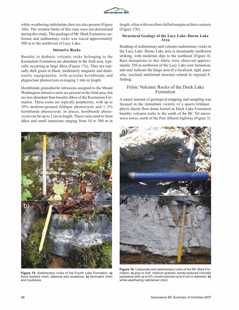
white-weath er ing radiolarian chert are also pres ent (Fig ure16b). The west ern lim its of this zone were not de ter mineddur ing this study. This pack age of Mt. Mark For ma tion car -bon ate and sed i men tary rocks was traced approximately500 m to the northwest of Lacy Lake.
Intrusive Rocks
Ba saltic to diabasic vol ca nic rocks be long ing to theKarmutsen For ma tion are abun dant in the field area, typ i -cally oc cur ring as large dikes (Fig ure 17a). They are typ i -cally dark green to black, mod er ately mag netic and dom i -nantly equigranular, with acicular hornblende andplagioclase pheno crysts av er ag ing 1 mm in length.
Hornblende granodiorite in tru sions as signed to the MountWash ing ton in tru sive suite are pres ent in the field area, butare less abun dant than ba saltic dikes of the Karmutsen For -ma tion. These rocks are typ i cally por phy ritic, with up to30% me dium-grained feld spar pheno crysts and 1–2%hornblende pheno crysts. In places, hornblende pheno -crysts can be up to 2 cm in length. These rocks tend to formdikes and small in tru sions rang ing from 10 to 500 m in
length, of ten with ex cel lent chilled mar gins at their contacts (Figure 17b).
Structural Geology of the Lacy Lake–Horne LakeArea
Bed ding of sed i men tary and vol cano-sed i men tary rocks inthe Lacy Lake–Horne Lake area is dom i nantly north weststrik ing, with mod er ate dips to the north east (Fig ure 4).Rare dis rup tions to this fab ric were ob served ap prox i -mately 350 m north west of the Lacy Lake iron for ma tion,and may in di cate the hinge area of a lo cal ized, tight, par a -sitic, iso cli nal antiformal struc ture re lated to re gional F1
folding.
Felsic Volcanic Rocks of the Duck LakeFormation
A mi nor amount of geo log i cal map ping and sam pling wasfo cused in the im me di ate vi cin ity of a quartz-feld spar–phyric dacite flow-dome hosted in Duck Lake For ma tionba saltic vol ca nic rocks to the south of the BC Tel mi cro -wave tower, north of the Port Alberni high way (Fig ure 3).
86 Geoscience BC Sum mary of Ac tiv i ties 2007
Fig ure 15. Sed i men tary rocks of the Fourth Lake For ma tion: a)thinly bed ded chert, siltstone and mudstone; b) lam i nated chertand mudstone.
Fig ure 16. Car bon ate and sed i men tary rocks of the Mt. Mark For -ma tion: a) grey to buff, me dium-grained, sandy-tex tured crinoidalpackstone with up to 4% cri noid os si cles up to 4 mm in di am e ter; b)white-weath er ing radiolarian chert.
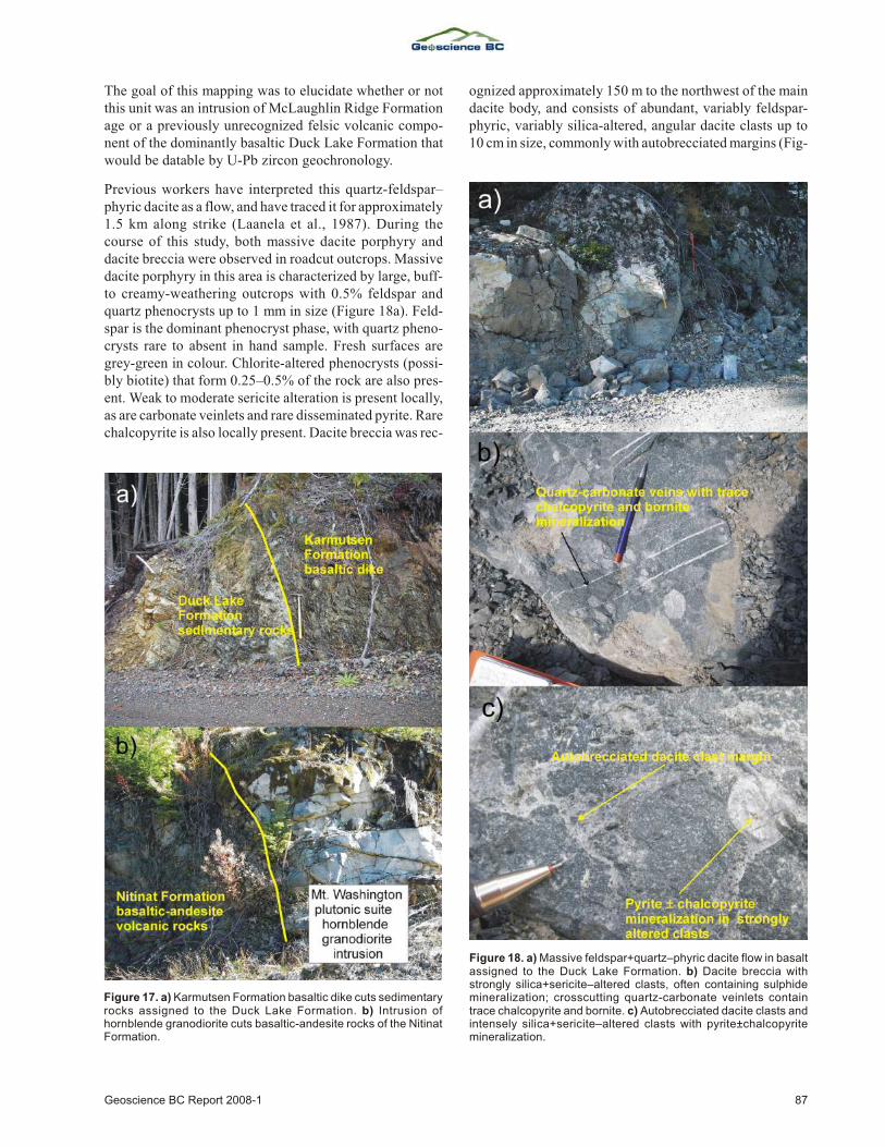
The goal of this map ping was to elu ci date whether or notthis unit was an in tru sion of McLaughlin Ridge For ma tionage or a pre vi ously un rec og nized fel sic vol ca nic com po -nent of the dom i nantly ba saltic Duck Lake For ma tion thatwould be datable by U-Pb zircon geochronology.
Pre vi ous work ers have in ter preted this quartz-feld spar–phyric dacite as a flow, and have traced it for ap prox i mately 1.5 km along strike (Laanela et al., 1987). Dur ing thecourse of this study, both mas sive dacite por phyry anddacite brec cia were ob served in roadcut out crops. Mas sivedacite por phyry in this area is char ac ter ized by large, buff-to creamy-weath er ing out crops with 0.5% feld spar andquartz pheno crysts up to 1 mm in size (Fig ure 18a). Feld -spar is the dom i nant phenocryst phase, with quartz pheno -crysts rare to ab sent in hand sam ple. Fresh sur faces aregrey-green in col our. Chlorite-al tered pheno crysts (pos si -bly bi o tite) that form 0.25–0.5% of the rock are also pres -ent. Weak to mod er ate seri cite al ter ation is pres ent lo cally,as are car bon ate veinlets and rare dis sem i nated py rite. Rarechal co py rite is also lo cally pres ent. Dacite brec cia was rec -
og nized ap prox i mately 150 m to the north west of the maindacite body, and con sists of abun dant, vari ably feld spar-phyric, vari ably sil ica-al tered, an gu lar dacite clasts up to10 cm in size, com monly with autobrecciated mar gins (Fig -
Geoscience BC Re port 2008-1 87
Fig ure 17. a) Karmutsen For ma tion ba saltic dike cuts sed i men taryrocks as signed to the Duck Lake For ma tion. b) In tru sion ofhornblende granodiorite cuts ba saltic-an de site rocks of the NitinatFor ma tion.
Fig ure 18. a) Mas sive feld spar+quartz–phyric dacite flow in ba saltas signed to the Duck Lake For ma tion. b) Dacite brec cia withstrongly sil ica+seri cite–al tered clasts, of ten con tain ing sul phidemin er al iza tion; cross cut ting quartz-car bon ate veinlets con taintrace chal co py rite and bornite. c) Autobrecciated dacite clasts andin tensely sil ica+seri cite–al tered clasts with py rite±chal co py ritemin er al iza tion.
ure 18b). The most in tensely sil ica-al tered clasts com monly con tain fine-grained dis sem i nated sul phide (py rite±chal -co py rite) min er al iza tion (Fig ure 18c). Sul phide blebs andpos si ble sul phide clasts up to 4 cm in size are also pres ent in the brec cia. The dacite brec cia is crosscut by quartz-carbonate veinlets, some of which contain tracechalcopyrite and bornite.
Debbie 3 Volcanogenic Massive SulphideOccurrence
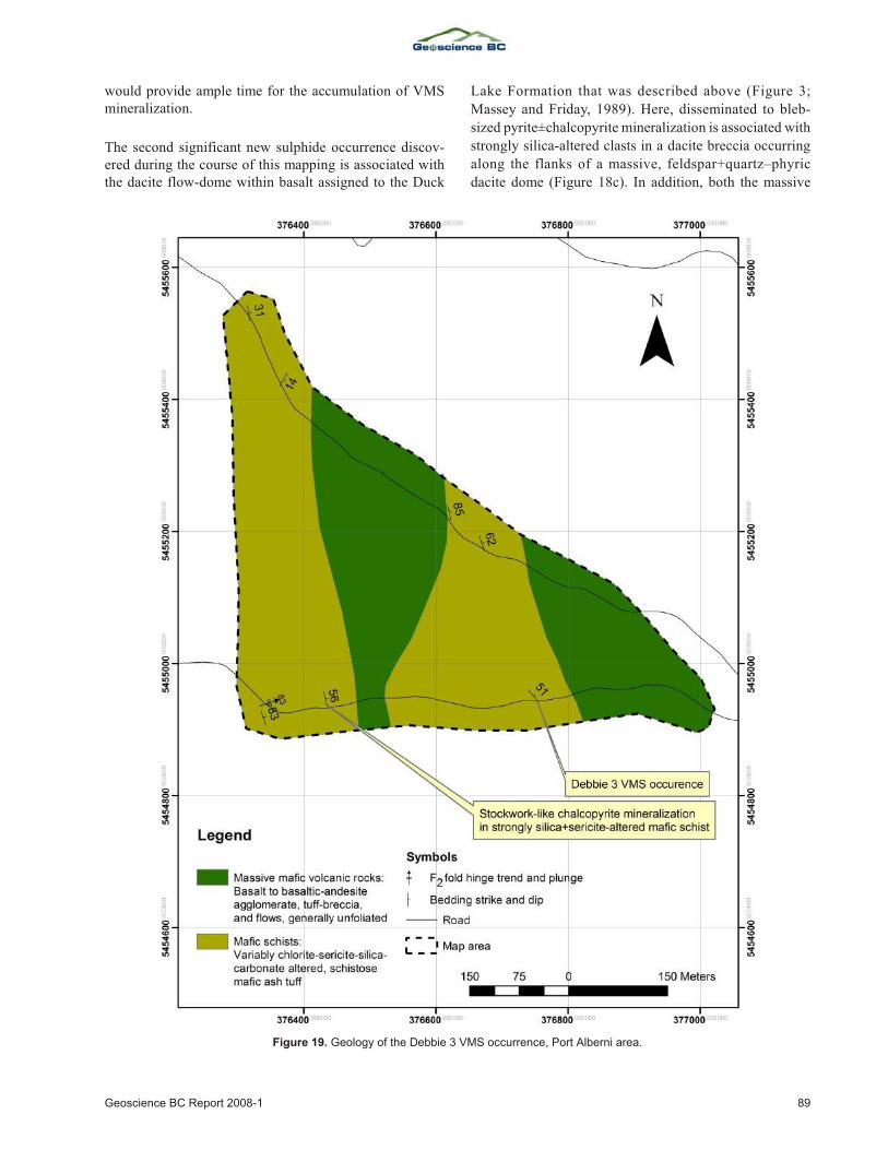
The Deb bie 3 volcanogenic mas sive sul phide oc cur -rence (MINFILE oc cur rence 092F 445), cur rently ownedby Bitterroot Re sources Ltd., oc curs in mafic vol ca nic andvol cano-sed i men tary rocks as signed to the Duck Lake andNitinat for ma tions, and is lo cated along the Cameron Mainlog ging road, close to the in ter sec tion with the Mt.Arrowsmith ski road. The show ing con sists of fourstratiform lenses of banded mas sive sphalerite, with mi norchal co py rite and ga lena, each band rang ing be tween 5 and20 cm in thick ness. The best grade ob tained from sam plingof this min er al iza tion by pre vi ous work ers in cludes 14.1%Zn, 0.87% Pb and 0.12% Cu over a 20 cm thick ness(MINFILE, 2007). The min er al iza tion is hosted in fine-grained chloritic schist with vari able carbonate, sericite and silica alteration.
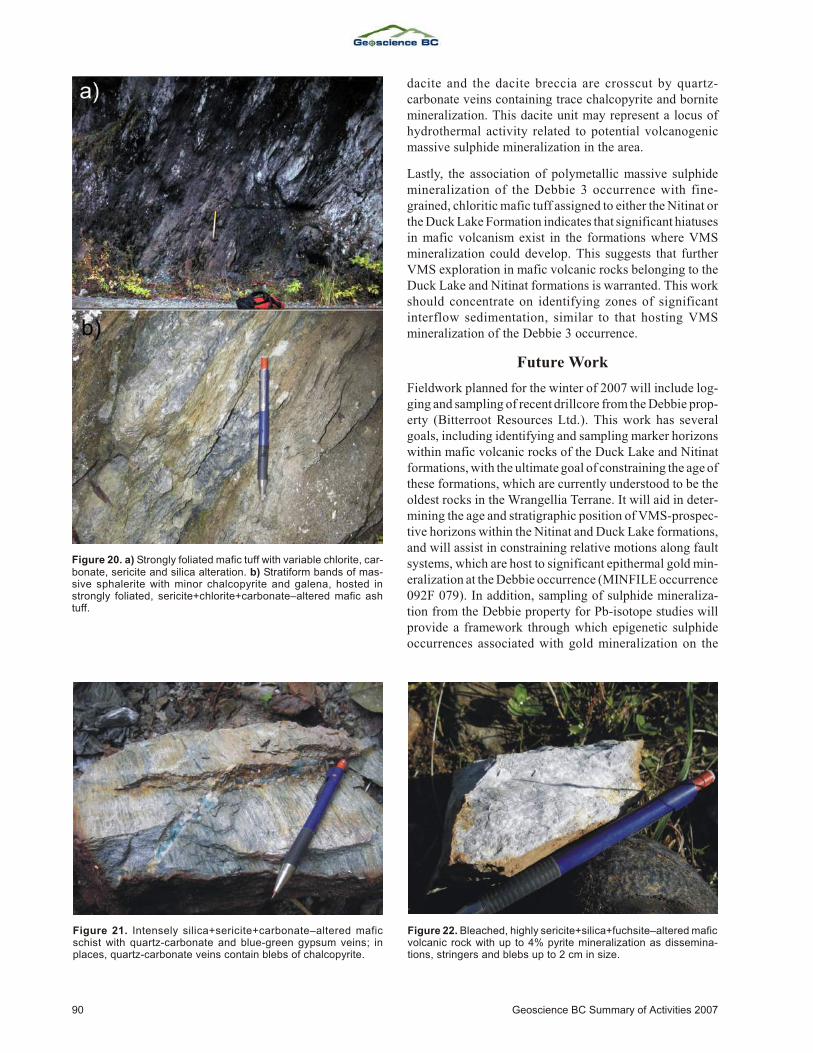
Map ping of the Deb bie 3 area has iden ti fied al ter nat ingzones of mas sive ba saltic and ba saltic-an de site vol ca nicrocks, with vari ably chlorite-, seri cite- and sil ica-al teredmafic schist (Fig ure 19). Mafic vol ca nic rocks in this areatend to oc cur as ro bust, mas sive out crops with lit tle to nofo li a tion. In the north ern por tion of the map area, these out -crops com prise dom i nantly mas sive, grey-green,pyroxene-phyric ba salt flows and ag glom er ate. Pyroxenepheno crysts can reach abun dances of 0.5–1.5% and sizesup to 3–4 mm. Feld spar-phyric ba salt flows with abun dantchlorite amygdules be come more abun dant to wards thewest. Here, vari ably epidote-al tered plagioclase pheno -crysts with dif fuse mar gins av er age 1.5 mm size, andchlorite amygdules reach abun dances up to 3.5% and sizesup to 1–2 mm. Epidote al ter ation patches up to 5–10 cm inwidth are also pres ent. In the south ern por tion of the maparea, mas sive, largely unfoliated mafic vol ca nic rocks com -prise mainly chlorite amyg dule–bear ing ba salt flows,pyroxene-phyric ba saltic-an de site ag glom er ate and maficlapilli tuff with abun dant flat tened, chlorite-al tered pum iceclasts. Mafic schist in both the north ern and south ern por -tions of the map area com prises strongly fo li ated, stronglychlorite-al tered mafic tuff with vari able car bon ate, seri citeand sil ica al ter ation (Fig ure 20a). Min er al iza tion is ob -served in this mafic schist only in the south ern part of thearea, and is pres ent as stratiform bands of mas sivesphalerite with mi nor chal co py rite and ga lena that reach upto 20 cm in thick ness (Fig ure 20b). Strong car bon ate andseri cite al ter ation of the mafic schist is pres ent in the im me -di ate vi cin ity of sul phide min er al iza tion. Ap prox i mately
320 m west of the show ing, a zone of in tensely sil ica+seri -cite+car bon ate–al tered mafic schist is as so ci ated withquartz-car bon ate and blue-green gyp sum veins (Fig -ure 21). In this zone, quartz-car bon ate veins carry blebs ofchal co py rite. The pres ence of this stockwork-style sul -phide min er al iza tion to the west of the stratiform sul phidemin er al iza tion of the Deb bie 3 VMS occurrence suggeststhat rocks to the west of the main showing may reflectdeeper stratigraphic levels, and the stratigraphic packagemay young to the east.
Debbie 3 Structural Geology
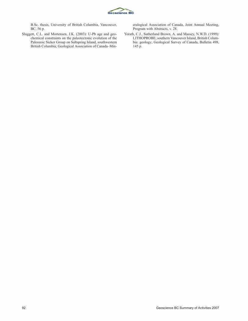
Struc tures in the area are best ob served in fine-grainedmafic vol ca nic rocks in the vi cin ity of the Deb bie 3 oc cur -rence (Fig ure 19). These rocks, typ i cally chloritic schist,dis play a prom i nent north west strike, with mod er ate tosteep dips to the north east. Fold ing of this fab ric was ob -served only in two ar eas. In the north west ern part of themap area, chloritic schist was ob served to strike north eastfor a lim ited ex tent, with weak dips to the south east. Thismay rep re sent F2 kink fold ing. Ad di tional kink fold ing wasob served in chloritic schist ap prox i mately 415 m west ofthe Deb bie 3 oc cur rence. Here, warp ing of the main fab ricis rep re sented by small, out crop-scale, F2 kink folds withhinges plunging steeply towards the northeast.
New Sulphide Mineralization and Implicationsfor VMS Exploration in the Alberni Area
Two new oc cur rences of sig nif i cant sul phide min er al iza -tion were dis cov ered dur ing the course of this map ping.The first, along the power line over look ing the south side of Lacy Lake (Fig ure 4), oc curs near the con tact be tweenpyroxene-phyric ba saltic-an de site ag glom er ate of theNitinat For ma tion and over ly ing fel sic tuffaceous rocks be -long ing to the McLaughlin Ridge For ma tion. Here, a 20 mlong float train con sists of bleached, highly seri cite-, sil ica-and fuch site-al tered subangular boul ders up to 40–50 cm insize that con tain up to 4% py rite, oc cur ring as dis sem i na -tions, string ers and blebs up to 2 cm in size (Fig ure 22). This float train was traced into a small ex po sure of he ma -tite+chlorite–al tered ba salt. Trench ing of this out crop ex -posed bleached, strongly seri cite+sil ica–al tered, py rite-min er al ized rock sim i lar to that ob served in the nearby min -er al ized float. This sul phide oc cur rence is sig nif i cant inthat it oc curs at the con tact be tween mafic to in ter me di atevol ca nic rocks of the Nitinat For ma tion and over ly ing fel -sic tuffaceous vol ca nic rocks of the McLaughlin Ridge For -ma tion. In the Buttle Lake up lift, this con tact is as so ci atedwith the gi ant HW de posit, which has a pre-min ing in ven -tory of 16.5 mil lion tonnes of ore with an av er age grade of2.2 g/t Au, 39.6 g/t Ag, 1.7% Cu, 0.4% Pb and 4.3% Zn(Rob in son, 1992). In the Port Alberni area, this con tact may be es pe cially sig nif i cant, as the lack of over ly ing fel sic vol -ca nic rocks in ti mately as so ci ated with high-en ergy erup -tive activity (i.e., rhyolite flows, felsic tuff-breccia, etc.)
88 Geoscience BC Sum mary of Ac tiv i ties 2007
would provide ample time for the accumulation of VMSmineralization.
The sec ond sig nif i cant new sul phide oc cur rence dis cov -ered dur ing the course of this map ping is as so ci ated withthe dacite flow-dome within ba salt as signed to the Duck
Lake For ma tion that was de scribed above (Fig ure 3;
Massey and Fri day, 1989). Here, dis sem i nated to bleb-
sized py rite±chal co py rite min er al iza tion is as so ci ated with
strongly sil ica-al tered clasts in a dacite brec cia oc cur ring
along the flanks of a mas sive, feld spar+quartz–phyric
dacite dome (Fig ure 18c). In ad di tion, both the mas sive
Geoscience BC Re port 2008-1 89
Fig ure 19. Ge ol ogy of the Deb bie 3 VMS oc cur rence, Port Alberni area.
dacite and the dacite brec cia are cross cut by quartz-car bon ate veins con tain ing trace chal co py rite and bornitemin er al iza tion. This dacite unit may rep re sent a lo cus ofhy dro ther mal ac tiv ity re lated to po ten tial volcanogenicmassive sulphide mineralization in the area.
Lastly, the as so ci a tion of polymetallic mas sive sul phidemin er al iza tion of the Deb bie 3 oc cur rence with fine-grained, chloritic mafic tuff as signed to ei ther the Nitinat orthe Duck Lake For ma tion in di cates that sig nif i cant hi a tuses in mafic vol ca nism ex ist in the for ma tions where VMSmin er al iza tion could de velop. This sug gests that fur therVMS ex plo ra tion in mafic vol ca nic rocks be long ing to theDuck Lake and Nitinat for ma tions is war ranted. This workshould con cen trate on iden ti fy ing zones of sig nif i cantinterflow sed i men ta tion, sim i lar to that hosting VMSmineralization of the Debbie 3 occurrence.
Future Work
Field work planned for the win ter of 2007 will in clude log -ging and sam pling of re cent drillcore from the Deb bie prop -erty (Bitterroot Re sources Ltd.). This work has sev eralgoals, in clud ing iden ti fy ing and sam pling marker ho ri zonswithin mafic vol ca nic rocks of the Duck Lake and Nitinatfor ma tions, with the ul ti mate goal of con strain ing the age of these for ma tions, which are cur rently un der stood to be theold est rocks in the Wrangellia Terrane. It will aid in de ter -min ing the age and strati graphic po si tion of VMS-pro spec -tive ho ri zons within the Nitinat and Duck Lake for ma tions,and will as sist in con strain ing rel a tive mo tions along faultsys tems, which are host to sig nif i cant epi ther mal gold min -er al iza tion at the Deb bie oc cur rence (MINFILE oc cur rence 092F 079). In ad di tion, sam pling of sul phide min er al iza -tion from the Deb bie prop erty for Pb-iso tope stud ies willpro vide a frame work through which epigenetic sul phideoc cur rences as so ci ated with gold min er al iza tion on the
90 Geoscience BC Sum mary of Ac tiv i ties 2007
Fig ure 20. a) Strongly fo li ated mafic tuff with vari able chlorite, car -bon ate, seri cite and sil ica al ter ation. b) Stratiform bands of mas -sive sphalerite with mi nor chal co py rite and ga lena, hosted instrongly fo li ated, seri cite+chlorite+car bon ate–al tered mafic ashtuff.
Fig ure 21. In tensely sil ica+seri cite+car bon ate–al tered maficschist with quartz-car bon ate and blue-green gyp sum veins; inplaces, quartz-car bon ate veins con tain blebs of chal co py rite.
Fig ure 22. Bleached, highly seri cite+sil ica+fuch site–al tered mafic vol ca nic rock with up to 4% py rite min er al iza tion as dis sem i na -tions, string ers and blebs up to 2 cm in size.
prop erty (e.g., the Deb bie oc cur rence) can be dis tin guishedfrom those associated with VMS mineralization (e.g., theDebbie 3 VMS occurrence).
Field work planned for 2008 will be con cen trated in theCowichan and Port Alberni ar eas, with ad di tional work inpo ten tial out crops of Sicker Group rocks in the Bedingfield Bay and Muchalat In let ar eas. In the Cowichan area, con -tin ued work will fo cus on un der stand ing the strati graphicand volcanological set ting of VMS oc cur rences hosted bythe Sicker Group, par tic u larly those of the Lara/Cor o na -tion, Randy and Anita zones, north and west of Big SickerMoun tain (MINFILE oc cur rences 092B 129, 128 and 037,re spec tively), and other po ten tial VMS oc cur rences in theim me di ate vi cin ity and west of Cowichan Lake. Ad di tionalre gional work in the Alberni area will fo cus on iden ti fy ingstrati graphic marker ho ri zons within the Sicker Group thatcan be used to con strain the age of lithological units in thearea, par tic u larly those belonging to the Duck Lake andNitinat formations.
In the Bedingfield Bay and Muchalat In let ar eas, sim i lar re -gional and fo cused out crop-scale map ping and sam plingwill be con ducted to un der stand the stra tig ra phy andvolcanological set ting of po ten tial Sicker Group rocks andVMS oc cur rences, most no ta bly in the vi cin ity of the RantPoint and Dragon (Paget Re sources Corp.) VMS oc cur -rences (MINFILE oc cur rences 092F 494 and 092E 072, re -spec tively). In par al lel with the geo log i cal map ping andsyn the sis work, the au thors will also carry out ad di tional U-Pb dat ing, lithogeochemical, and Nd, Hf and Pb iso to picstud ies in or der to con strain the age and mag matic evo lu -tion of Sicker Group vol ca nic rocks, and to de velop aframe work through which VMS oc cur rences hosted by theSicker Group can be dis tin guished from younger,epigenetic sulphide occurrences.
Acknowledgments
This pro ject is jointly funded by a Geoscience BC grant,Bitterroot Re sources Ltd., Paget Re sources Corp. and aNat u ral Sci ences and En gi neer ing Re search Coun cil ofCan ada (NSERC) Dis cov ery Grant to Mortensen. The au -thors thank N. Massey for dis cus sions and in sights into thege ol ogy of the Sicker Group, and K. Hickey for hav ing pro -vided a crit i cal re view of this manu script. They also thanksev eral pros pec tors, con sul tants and explorationists work -ing on Van cou ver Is land, es pe cially M. Becherer of Min -eral Creek Ven tures Inc., M. Carr of Bitterroot Re sourcesLtd., J. Brad ford of Paget Re sources Corp., E. Specogna ofSpecogna Min er als Corp., A. Fran cis, J. Houle, H.McMaster and S. Tresierra, for shar ing their time andknowl edge of Sicker Group geology and mineralization.
References
Barrett, T.J. and Sherlock, R.L. (1996): Vol ca nic stra tig ra phy,lithogeochemistry and seafloor set ting of the H-W mas sivesul fide de posit, Myra Falls, Van cou ver Is land, Brit ish Co -lum bia; Ex plo ra tion and Min ing Ge ol ogy, v. 5, p. 421–458.
Brandon, M.T., Or chard, M.J., Parrish, R.R., Suther land Brown,A. and Yorath, C.J. (1986): Fos sil ages and iso to pic datesfrom the Pa leo zoic Sicker Group and as so ci ated in tru siverocks, Van cou ver Is land, Brit ish Co lum bia; in Cur rent Re -search, Part A, Geo log i cal Sur vey of Can ada, Pa per 86-1A,p. 683–696.
Juras, S.J. (1987): Ge ol ogy of the polymetallic volcanogenicButtle Lake Camp, with em pha sis on the Price Hill side, cen -tral Van cou ver Is land, Brit ish Co lum bia, Can ada; Ph.D. the -sis, Uni ver sity of Brit ish Co lum bia, Van cou ver, BC, 279 p.
Katvala, E.C. (2006): Re ex am in ing the strati graphic andpaleontologic def i ni tion of Wrangellia; Geo log i cal So ci etyof Amer ica, Ab stracts with Pro gram, v. 38, p. 24.
Laanela, H. (1987): As sess ment re port on geo log i cal, geo chem i -cal, and geo phys i cal sur veys on the Lacy and Stokes claimgroups in the Alberni and Nanaimo min ing di vi sions, BC;BC Min is try of En ergy, Mines and Pe tro leum Re sources,As sess ment Re port 16138, 93 p.
Massey, N.W.D. (1995): Ge ol ogy and min eral re sources of theDuncan sheet, Van cou ver Is land, 92B/13; BC Min is try ofEn ergy, Mines and Pe tro leum Re sources, Pa per 1992-4.
Massey, N.W.D. and Fri day, S.J. (1987): Ge ol ogy of theChemainus River–Duncan area, Van cou ver Is land (92C/16;92B/13); BC Min is try of En ergy, Mines and Pe tro leum Re -sources, Pa per 1988-1, p. 81–91.
Massey, N.W.D. and Fri day, S.J. (1989): Ge ol ogy of the Alberni–Nanaimo Lakes area, Van cou ver Is land (92F/1W, 92F/2Eand part of 92F/7); BC Min is try of En ergy, Mines and Pe tro -leum Re sources, Open File 1987-2.
Massey, N.W.D., Mac In tyre, D.G., Desjardins, P.J., and Cooney,R.T., (2005): Dig i tal map of Brit ish Co lum bia: Tile NM10South west BC; BC Min is try of En ergy, Mines and Pe tro -leum Re sources, GeoFile 2005-3.
MINFILE (2007): MINFILE BC min eral de pos its da ta base; BCMin is try of En ergy, Mines and Pe tro leum Re sources, URL<http://www.em.gov.bc.ca/Min ing/Geolsurv/Minfile/>[No vem ber 2007].
Mortensen, J.K. (2005): Strati graphic and paleotectonic stud ies ofthe Mid dle Pa leo zoic Sicker Group and con tained VMS oc -cur rences, Van cou ver Is land, Brit ish Co lum bia; in Geo log i -cal Field work 2005, BC Min is try of En ergy, Mines andPe tro leum Re sources, Pa per 2006-1, p. 331–336.
Rob in son, M. (1992): Ge ol ogy, min er al iza tion and al ter ation ofthe Bat tle zone, Buttle Lake camp, cen tral Van cou ver Is land, south west ern Brit ish Co lum bia; M.Sc. the sis, Uni ver sity ofBrit ish Co lum bia, Van cou ver, BC, 268 pages.
Ruks, T.R. and Mortensen, J.K. (2006): Geo log i cal set ting ofvolcanogenic mas sive sul phide oc cur rences in the Mid dlePa leo zoic Sicker Group of the south east ern Cowichan Lakeup lift (NTS 092B/13), south ern Van cou ver Is land; in Geo -log i cal Field work 2006, BC Min is try of En ergy, Mines andPe tro leum Re sources, Paper 2007-1, p. 381–394.
Sluggett, C.L. (2003): Ura nium-lead age and geo chem i cal con -straints on Pa leo zoic and Early Me so zoic magmatism inWrangellia Terrane, Saltspring Is land, Brit ish Co lum bia;
Geoscience BC Re port 2008-1 91
B.Sc. the sis, Uni ver sity of Brit ish Co lum bia, Van cou ver,BC, 56 p.
Sluggett, C.L. and Mortensen, J.K. (2003): U-Pb age and geo -chem i cal con straints on the paleotectonic evo lu tion of thePa leo zoic Sicker Group on Saltspring Is land, south west ernBrit ish Co lum bia; Geo log i cal As so ci a tion of Can ada–Min -
er al og i cal As so ci a tion of Can ada, Joint An nual Meet ing,Pro gram with Ab stracts, v. 28.
Yorath, C.J., Suther land Brown, A. and Massey, N.W.D. (1999):LITHOPROBE, south ern Van cou ver Is land, Brit ish Co lum -bia: ge ol ogy; Geo log i cal Sur vey of Can ada, Bul le tin 498,145 p.
92 Geoscience BC Sum mary of Ac tiv i ties 2007


![Dataman-448Pro2 Version 3.25 Device List · Dataman-448Pro2 Version 3.25 Device List ABOV Semiconductor HMS81020TL [SKDIP24] ABOV Semiconductor HMS81020TL](https://img.pdfslide.us/doc/110x75/5e074738a80ea36ea53b99e0/dataman-448pro2-version-325-device-dataman-448pro2-version-325-device-list-abov.jpg)