Embed Size (px)
Citation preview

University of Southern Maine University of Southern Maine
USM Digital Commons USM Digital Commons
Maine Collection
3-14-1978
Geological and Botanical Features of Sand Beach Systems in Geological and Botanical Features of Sand Beach Systems in
Maine and Their Relevance to the Critical Areas Program of the Maine and Their Relevance to the Critical Areas Program of the
State Planning Office State Planning Office
Bruce W. Nelson
L. Kenneth Fink Jr.
Follow this and additional works at: https://digitalcommons.usm.maine.edu/me_collection
Part of the Botany Commons, Geomorphology Commons, Other Earth Sciences Commons, Other
Ecology and Evolutionary Biology Commons, and the Terrestrial and Aquatic Ecology Commons
Recommended Citation Recommended Citation Nelson, Bruce W. and Fink, L. Kenneth Jr., "Geological and Botanical Features of Sand Beach Systems in Maine and Their Relevance to the Critical Areas Program of the State Planning Office" (1978). Maine Collection. 83. https://digitalcommons.usm.maine.edu/me_collection/83
This Book is brought to you for free and open access by USM Digital Commons. It has been accepted for inclusion in Maine Collection by an authorized administrator of USM Digital Commons. For more information, please contact [email protected].


THE UNIVERSITY OF MAINE AT ORONO
GEOLOGICAL AND BOTANICAL FEATURES OF SAND BEACH SYSTEHS IN Iv!AINE A.._T\.j~ THEIR RELEVANCE TO THE
CRITICAL AREAS PROG~1 OF THE STATE PLANNING OFFICE
BY
Bruce W. Nelson and L. Kenneth Fink, Jr. Department of Oceanography
A Report Prepared for the Maine Critical Areas Program State Planning Office Augusta, Haine 04330
Planning Report Number 54
14 March, 1978
Ira C. Darling Center Contribution No. 113 Walpole, Maine 04573
~\ Critical Areas Program ~ _, ~ Natural Resource Planning Division
-=..-. Maine _State Planning Office

ABSTRA.CT
This report summarizes the results of geological and botanical
investigations over the last three years of Haine's sand beach systems.
The results have provided the basis for a Process-Response Model for the
swash-aligned beach systems in Maine~ Compilations of basic information
are presented and include the following, Geological and Botanical criteria
for significance, lists of coastal sand dune plant species and associations,
and a list of all sand beaches in Maine. From 29 beaches which met the
significance criteria twenty seven were field checked, described, and
recommended for evaluation by the Critical Areas Program.
i

FOREWORD
The following report on the sandy beaches is one of a series of reports being prepared for ~mine's Critical Areas Program. This program was established by an act of the Legislature in 1974 which directed the State Planning Office to develop an official Register of Critical Areas and to encourage and coordinate the conservation of such areas as part of its overall responsibility for comprehensive statewide planning and coordination of planning activities. The Act defines Critical Areas as natural features of statewide importance because of their unusual natural, scenic, scientific, or historical significance.
The Act also created the Critical Areas Advisory Board to advise and assist the State Planning Office in the establishment of the Register and the conservation of critical areas. The program established by the Act is not regulatory~ with the minor exception that notification of proposed alterations of critical areas is required of the landowners thereof. The program is primarily one of identifying critical areas and providing advice to and coordinating the voluntary activities of landowners, state and local government organizations, conservation groups and others to the end of encouraging the conservation of critical areas. The Critical Areas Program further provides a specific focus for the evaluation and coordination of programs relating to critical areas in Maine. The program also serves as a source of information on critical areas and their management.
The purpose of these reports is to present the results of thorough investigations of subject areas chosen for consideration in the Critical Areas Program. The reports are an intermediate phase in a systematic registration process which starts with the identification of subjects for consideration and concludes with the analysis of each potential critical: area individually and, if appropriate, inclusion of areas on the Register.
In addition to the specific task they are intended to fulfill in the registration process, it is my hope that these reports will be useful in a more general sense as a source of information on the various topics they cover. For more information on the sandy beaches contact me or other members of the staff at the State Planning Office.
R. Alec Giffen, Supervisor Natural Resource Planning Division State Planning Office
ii
ACKNOWLEDGEMENTS
The authors acknowledge the able assistance of Mr. Robert Nelson
and Ms. Benedicte Misner, who provided many hours of help both in the
field and in the preparation of baseline information for this report.
Many individuals at the State Planning Office provided help in all
phases of the effort and include, Mr. Scott Newton and Ms. Carol White
for drafting some of the maps, and Hr. Steve Roy and Anne Pendergast
for technical assistance in the field and laboratory.
We are grateful to Mr. David Lakari and Mr. Ken Rich, managers
of the land holdings on which some of the beaches are located, for
considerable aid in visiting their areas.
We thank Mr. Robert Foster, Ms. Susan Landes, Ms. Sherre Prince
and Ms. Linda Schick for three years of field work, data reduction,
and stimulating discussions about specific aspects of the. project.
They were called upon for field work at all times of the day, all seasons,
and certainly some of the most severe weather conditions, and always
responded with enthusiasm and came home still smiling. Without their
unfailing support, this project could never have been accomplished.
We are very grateful f.or the able assistance of Ms. Jennifer Nisbet
who performed all of the typing of this report. Her dedication to seeing
the project accomplished is much appreciated.
Our thanks to Mr. Hank Tyler of the Critical Areas Program, for
his support, patience, and efforts in the final stages of the preparation
of this report.
In addition to partial support from funds provided by the Water
Resources Planning Act of 1969, Grant from Title III (P.L. 89-80), this
iii

work is the result of research sponsored by NOAA, Office of Sea Grant,
Dept. of Commerce under Grant No. 04-7-158-44034. The U.S Government
is authorized to provide and distribute reprints for governmental
purposes, nothwithstanding any copyright notation that may appear
hereon.
iv

TABLE OF CONTENTS
ABSTRACT • i
FOREWORD ii
ACKNOWLEDGMENTS . • iii
GEOLOGY, DISTRIBUTION, AND GEOMORPHOLOGY OF MAINE'S COASTAL SANDY BEACHES &~ DUNE SYSTEMS
Introduction Beach Sand, Its Sources and Interaction With Natural
Physical Waves Winds • Tides • Storms Currents
Forces
Tidal Currents . River Currents, Estuarine Circulation, and Gulf of
Maine Gyre • • . • • . • • . . • . . • . • Longshore Currents • • • . . • • • • . . • • . •
Glacial Events and Sediment Characteristics • . • . • • Relative Rise of Sea Level • • • • • . • . Response Forms and Geomorphic Features of Maine's
Major Wave Depositional Forms (Beach Types in Plan View) • • • • Fringing Beaches Barrier Beaches • • • . • . • • . Tambalas • • • • Cuspate Forelands • Spits • . • • • • • •
Beaches .
Ephemeral and Minor Wave Depositional-Erosional Forms Erosional Beach Profile Type and Features • . . • Constructional Beach Profile Type and Features Constructional Features Formed During Storms • • • .
Major Wind Depositional Forms . . . . . ... Frontal Dune Ridge Aeolian Ramp . • • . Aeolian Flats . . . . . . • . • . Rear Dune Ridges • • • • Accretionary Ridge and Swale Topography . Parabolic Dunes and Slacks Onshore Oriented Blowouts . • ••
Sedimentary Structures .. • • • Swash Marks . . . . . . Ripple :Marks . . . . . • Groundwater Rill Marks Rhomboid Marks . . • . •
1
1
2 10 14 26 27 30 30
31 31 34 39
44 46 46 46 47
47 48 49 50 52 53 53 55 55 56 56 56 57 59 59 60 61 61 61 62
Current Crescent and V-Swash Marks •. Beach lamination . . . . . . . ... Wind deposited sedimentary structures • • • • 6 2
v
METHODS OF LOCATING SANDY BEACHES AND DUNES
GENERAL CONSIDERATION IN DEVELOPING CRITERIA FOR INCLUSION IN THE LIST OF SIGNIFICANT COASTAL SANDY BEACHES AND DUNES
GEOLOGICAL CRITERIA FOR SIGNIFICAJ.~CE .
BOTAi~ICAL CRITERIA FOR SIGNIFICANCE
GENERAL INFORMATION ON COASTAL SAl'IDY DUNE PLANT SPECIES AND ASSOCIATIONS . . • .
Foredune Community Dunegrass Community • . • • Dry Dune Slack Community Shrub Community • • • • . . . . Dune Forest Community • .
. .
64
76
77
80
90 92 92 92 93 94
PAP~TIAL LIST OF MAINE'S BERM AND DUNE P~~TS 95 Plants of the Berm or Dune Habitats of Maine's Beaches Which are not Characteristic of Other Coastal or Inland Ha b it a t s • • . . • . . • . • • . . . . • • . . • . • . 9 5 Plants of the Berm or Dune Habitats of Maine's Beaches Which are also Characteristic of Other Coastal or Inland Habitats . • . • • • • • • . . • . . • 96
DESCRIPTION OF SIGNIFICANT MAINE SANDY BEACHES • . 106 1. Ogunquit Beach, York County . 106 2. Laudholm Beach, York County . • • . . . 113 3. Crescent Surf Beach, York County • . . . . 121 4. Parsons Beacht York County • • . . • • . 125 5. Goose Rocks Spit End, York County 130 6. Western Beach, Cumberland County . . . . . . . • . 133 7. Scarborough Beach, Cumberland County . 138 8. Main Beach, Cumberland County • . • . 144 9. Strawberry Hill Beach, Cumberland County . . 149
10. Crescent Beach State Park, Cumberland County . . . 153 11. Bailey Beach, Sagadahoc County . . . . 158 12. Seawall Beach, Sagadahoc County . • . • 163 13. Popham Beach Area, Sagadahoc County •. 169 14. Reid Beach State Park, Sagadahoc County . . 196
. 15. Pemaquid Beach, Lincoln County . • • . • • ·' . 208 16. Louds Island Cuspate Foreland, Lincoln County ..•• 217 17. Pond Island, Hancock County • • . • . • . . • . . 222 18. Merchant Island, Pocket Beach Hancock County . 225
./ 19. Merchant Island Cuspate Foreland, Hancock County . 229 20. Marshall Island Sand Cove, Hancock County • . • . . . 232 21. Marshall Island Carbonate Beach, Hancock County 234 22. Swan's Island, Irish Cove Beach, Hancock County 235 23. Swan's Island, Fine Sand Beach- Hancock County 240 24. Sand Beacht Acadia National Park, Hancock County . 244 25. Sandy River Beach, Washington County • . . . . 24~ 26. Roque Island - Great South Beach, Washington County . 253 27. Roque Bluffs Beach, Washington County ..... 259
vi
vii
GENEP~~L EVP~UATION OF S~IDY BEACHES FOR INCLUSION ON THE REGISTER OF CRITICAL AREAS o 263
RECOMMENDATIONS • 0 0 26 7
BIBLIOGRAPHY • . • • • 0 268
TABLES
Table I. Particle Size 4
Table II. Sand Beaches of Maine . 66
Table III. Significant Coastal Sandy Beaches in Maine, Recommended Areas . . . . . . 0 . . . . . . . . 0 102

FIGURES
Figure 1. Hj uls trBm Curve • . • • • • • . 3
Figure 2. Illustrations of Transformation of Deep Water Swell Waves • 11
Figure 3. Tendency of Wave Crests and Beaches to Parallel One Another on Steep Indented Coasts . . . . . . 15
Figure 4. Refraction of Waves at Headlands and Embayment 16
Figure 5. The "lens effect" . . . . . . . . . . . . . . . . 16
Figure 6. Wave Rose Composed of Data Obtained by Three Years of Wind Records • • • • 17
Figure 7. ~.find Speed and Direction . . . . 19
Figure 8. Saltating Sand Grains . . . . . 20
Figure 9. Parabolic dunes . . . . . . . . . . . 21
Figure 10. Wind Flagging of Pinus strobus . . . . 25
Figure 11. Littoral Cell Circulation . . . . . . . 32
Figure 12. Surficial Glacial Deposits in the Coastal Zone 35
Figure 13. Portland Tide Gauge Record of Annual Mean Sea Level . . . . . . . . . . . . . . . . . . 40
Figure 14. Schematic View of Transgressive Facies of a Barrier Beach or Barrier Spit in a Regime of Slowly Rising Sea Level . . . . . 43
Figure 15. Beach Types in Plan View 45
Figure 16. Profile View, Beach and Dune Features 54
Figure 17. Oblique Schematic View of a Parabolic Dune 58
Figure 18. Schematic Cross-sectional view of a Beach . . 58
Figure 19. Location Map of Large Undeveloped Barrier Spit -Salt Marsh Complexes . . . . . . . . . . 83
Figure 20. Location Map of Signifcant Stands of Artemisia caudata Hormwood on Coastal Dunes . • . ~ 84
Figure 21. Location Map of Significant Stands of Beach Plum, Prunus maritima on or near Coastal Dunes • • • . 85
viii
Figure 22. Location Map of Significant Stands of Beach Heather, Hudsonia tomentosa on Coastal Dunes • 86
Figure 23. Location Map of Significant Stands of Jointweed -Polygonella articulata on Coastal Dunes . . . . • 87
Figure 24. Location Map of Significant Stands of Earthstar Puffball - Geaster hygrometricus on Coastal Dunes 88
Figure 25. Location Map of Significant Stands of Seaside Spurge - Euphorbia polygonifolia on Coastal Dunes 89
Figure 26. Index Map of Significant Maine Beaches • 104
Figure 27. Ogunquit Beach • 107
Figure 28. Laudholm Beach, Crescent Surf, Parsons Beach •. 114
Figure 29. Goose Rock Beach • 131
Figure 30. Western Beach, Scarborough Beach •• 134
Figure 31. Main Beach, Strawberry Hill Beach, Crescent Beach 145
Figure 32. Seawall Beach, Bailey. Beach • . 159
Figure 33. Popham Beach . 170
Figure 34. Reid State Park; Half-Mile Beach, Mile Beach . . 197
Figure 35. Pemaquid Beach . 209
Figure 36. Louds Island Beach • • 218
Figure 37. Pond Island Beach •• • • 223
Figure 38. Merchant Island Beach •• . . • 226
Figure 39. Marshall Island Beaches and Swan's Island Beaches236
Figure 40. Sand Beach - Acadia National Park • 245
Figure 41. Sandy River Beach . • 250
Figure 42. Roque Island, Great South Beach . 254
Figure 43. Roque Bluffs Beach • 260
ix
GEOLOGY, DISTRIBUTION AND GEOMORPHOLOGY
OF MAINE'S COASTAL SANDY BEACH AND DUNE SYSTEMS
Introduction
According to King (1972), "A beach is an accumulation of loose
material around the limit of wave action." Although succinct, this
definition limits the boundaries of a beach to that area between the
upper limit of wave action and that depth at which approaching waves
first cause appreciable movement of the bottom material. A more com
prehensive approach is taken in this report by extending the boundaries
to include the supratidal sand bodies and associated vegetational com
muni ties as well as the salt mar shes, thereby treating the beach area
as an ecosystem.
The discussion of physical features and processes for each beach
ecosystem will be restricted, primarily, to those of the intertidal
beachface and dune areas, although offshore and nearshore bars are con
sidered where they are readily visible as breaker zones. A further
constraint is that only sand beaches will be discussed.
Maine's sand beaches form one of the state's most valuable coastal
resources since they represent most of the public access, intensive
recreational use, open space, and s.::flt mars:h boundary portions of the
coastline. The lack of use and management policies, an absence of basic
data for Maine's unique beach systems, and limited expertise within the
state to formulate plans, have led, collectively, to general abuse of
beach ecosystems, expensive, and usually futile, erosion prevention
measures, and public controversy over causes of beach erosion and shore
property loss. Maine's specific and regional beach problems can be
attributed to development of a natural resource without an adequate
understanding of fundamental geological and botanical processes.
1

In an effort to increase the general understanding of the natural
processes active on beach systems and to document the significant
features of many Maine beach and dune ecosystems, this report presents
information on twenty seven beach areas. In par~ this compilation
is directed toward an identification of the natural dynamic processes
active in Maine's beach systems and an understanding of their relative
importance and interactions.
Beach Sand
Its Sources and Interaction with Natural Physical Forces
The term, sand, denotes a specific range of sizeB within a sediment
classification scheme based on particle diameter. According to the
Wentworth Scale (Table I) sand beaches consist of material between 1/16
mm and 2 mm. An alternative size scale, commonly used, is based on a
transformation of the millimeter scale and is shown in Table I as the
Phi Scale where Phi (or 6) = -log2 (particle diameter in mm).
Accumulation of sand on a beach is partially due to an interesting
interaction between sediment size and the velocity of moving water. This
phenomenon, first documented by Hjulstrom (1935, 1955), is illustrated in
Figure 1 which shows that the most easily eroded or suspended particles are
actually fine-medium sand sizes (0.1 mm- 0.5 mm) rather than silts or clays,
because silt and clay size materials form a smooth, compact, cohesive
surface which resists erosion. Pebbles and cobbles also require more
energy for erosion than sand simply because of their larger size. Once
eroded, however, silt and clay size particles will only settle out in a
calm, wave free environment.· They do not remain near the breaker zone
and thus cannot form beaches. For particles of sand size and larger,
the current velocity or wave energy at which a given size of particle
will settle is not much less than the current velocity or wave energy
2


at which that particle size will be suspended. Sand size grains are very
easily suspended in the breaker zone but settle out quickly in the slightly
lower energy environment of the swash zone immediately landward of the
breakers. The result of the Hjulstrom phenomenon is a preferential selection
of sand-sized particles while larger sediments are left behind and finer
silts and clays are carried away.
Accumulation of material on a beach slope is also related to the
permeability of the material. Settling is encouraged in the swash zone
by percolation of uprushing water down through the accumulating slope.
This reduces the volume of backwash relative to uprush and leads to
further accumulation. The greater the permeability of an unconsolidated
material, the greater the slope of the accumulated surface. Krumbein and
Monk (1942, cited in Pettijohn, 1957) have shown permeability to increase
as the square of particle diameter and as the log of sorting expressed as
standard deviation.
The Hjulstrom phenomenon acted first in glacial meltwater streams to
refine and accumulate sand into its various modern source forms, and acts
today in the wave environment to further refine sand from till sources
which include clay, silt, gravel, cobbles and boulders.· This leads to a
sand size, well sorted material available to beaches. 'lhe good sorting
in turn increases permeability in the swash zone so that finally the sand
is accumulated as a sandy beach.
Sand beaches, therefore, are depositional forms and, according to the
Hjulstrom phenomenon, are the result of a preferential size selection pro
cess. Before sand beaches can develop, a sediment source is required, and
for any long term persistence, a continuing sediment supply is necessary,
or at least, efficient recycling mechanisms. For beaches, four main
sediment sources are recognized generally, as follows:
1. Riverborne Sediment Load: This source of sand for beaches
5
is-known to be important for only two beach systems in Maine
- the Kennebec River has supplied sand to the Popham-Seawall
baymouth barrier systems and the Saco River has been the
primary source of sand for Maine's longest beach system at
Old Orchard Beach and Hills Beach. The source of much of the
sand-sized sediment in the Saco and Kennebec Rivers is erosion
of glacial drift deposits located along those rivers.
2. Reworking of Glacial Deposits by Waves: Since almost all of the
sand on Maine beaches was derived from some kind of glacial deposit,
this has been the dominant mechanism by which material was pro
vided and refers to
a. wave erosion of upland glacial till and ice-contact
stratified drift to form fringing beaches characterized
by small sand volumes and rocky low-tide terraces.
b. wave erosion and landward transport of submerged glacial
deposits, such as outwash and recessional delta deposits
or till and ice-contact drift units, to form barrier
beaches by extensive tidal flooding of low relief back
barrier upland areas through small tidal inlet streams.
This latter process has occurred in two phases related to sea level
rise rate; they are discussed in greater detail in the Glacial
His tory section.
3. Erosion of Local Bedrock: Rock fragments are eroded from head
lands a9-d then transported into adjacent embayments to form
pocket beaches with a low volume of poorly sorted sand. In
Maine this is a relatively inefficient mechanism and usually
6

can provide only minor amounts of sand size material to the
beaches. Sand Beach on Mount Desert Island is an exception.
It has a large sand volume per meter of beach length and 60 to
70 percent of this is apparently derived from local bedrock.
4. Onshore Transport of Biogenic Carbonate Sand: Sand can be
derived from adjacent shallow-water areas characterized by an
abundance of marine organisms with carbonate skeletal parts or
shells. This sand source is dominant for beaches in. tropical
areas where carbonate production is high, but in Maine this is
usually a minor sand source. There are, however, beaches on
which the carbonate shell hash constitutes a relatively high
percentage of the sand volume, e.g. Sand. Beach - Mt. Desert
Island, Merchant Island Cuspate Foreland, and Marshall Island
Carbonate Beach.
·As sand is derived from the various sediment sources, it is delivered
to the shore as waves move the particles along the seafloor. The limiting
depth for this shoreward transport by waves appears to be bet-ween 10 and
18 m, depending on prevailing wave dimensions. As the sand accurrrulates
around the limit of wave action, a dynamic equilibrium between the beach
material and natural physical forces acting on this material is established.
This equilibrium has been described by Krumbein (1963) and King (1972) in
7
terms of a process-response model. The process agents are the natural physical
forces (waves, tides, currents, and winds), the textural characteristics
of the beach material, and the periodic changes in sea level.
The process agents act in unison to establish the general morphology
and specific character!stics of the beach systems. The morphology and
specific characteristics of beaches constitute the response s.ide of
the model. Fundamental to understanding the process-response model
is recognizing the existance or absence of feedback mechanisms. Feed-

back mechanisms explain how some response characteristics influence or
alter process agents in such a way that the process becomes self-limiting.
An example of such a feedback mechanism is the response of a Maine beach
to Northeast storms which alter the beachface in such a way that wave
energies are increasingly dissipated on the lengthening beachface.
Implicit in the process-response model and its feedback mechanisms is
that time, in varying amounts, is required to establish an equilibrium
between the various process agents and the consequent beach form.
8
Beach ecosystems are among the most dynamic of geologic environments.
The form and position of beach and dune features respond to slight
changes in the process agents which control their development. It is
instructive to view beach and dune formation and change in Maine
as the result of an interactive process-response equilibrium.

There are certain, mutually independent, first order features
of the earthwhich ultimately cause the process agents that effect
beach processes and responses in Maine. These first order features
are,
1. Differential Heating of the Earth - causes all oceano
graphic andweather phenomena.
2. Astronomical Tides - cause daily and longer term varia
tions in the sea surface through interaction with basin
geometry.
3. Tectonic Phenomena - cause changes in the coastal free
board through crustal movements of the earth.
Interactions of these first order features have established
the important process agents which are involved in beach ecosystem
dynamics in Maine. The process agents are as follows:
1. Waves
2. Winds
3. Tides
4. Storms
5. Currents
6. Sediment Characteristics
7. Relative Sea Level Change
Each of these agents, the beach processes in which they are involved,
and the responses which are visible in the form and behavior of coastal
sandy beaches are discussed below.
9

Waves
A good general. discussion of waves and their effect on Haine's beaches
can be found in Timson and Kale (1977). Waves, as process agents, are
treated more briefly in this report.
Waves are the most important process agent since they not only
initiate shoreward transport of sand, but are involved subsequently in
most of the daily and long term beach processes. Waves are formed by
winds, either locally or at a great distance. Waves generated by local
winds are called seas and are characterized by discontinuous, confused
crests and a wide range of wavelengths.
If winds create seas at a great distance from a beach, the waves
become sorted out by wavelength as they travel toward the coast and
combine into long regular swells with parallel crests and a more re
stricted range of periods, usually 6 to 10 seconds. The three factors
which determine the heights and periods of waves are the wind velocity,
the duration of the wind, and the fetch or distance over which the wind
transfers its energy to the waves.
As waves, either locally derived or long-period swell, approach a
shore, they undergo a transformation when the water depth becomes about
one-half the wave length. The wave length and velocity decrease pro
gressively and the wave height increases. The steepness of the wave
increases also since its steepness is the ratio of wave height to wave
length. Eventually the wave attains an unstable steepness and the wave
falls forward and breaks. This transformation process for deep water
swell is schematically illustrated in Figure 2. After the wave breaks
the particle motion of the water changes dramatically from purely oscil
latory to translational. The translational water motion characterizes
10


.. '1
both the surf zone, which extends from the break point to the swash
zone, and the swash zone which is that part of the beachface covered and
uncovered by the uprush and backwash of the transformed waves. It is
primarily in the area between just seaward of the break point and the
upward swash limit that most of the sediment transport by waves occurs.
Sediment transport is enhanced in this zone because of the suspension of
sediment by the turbulence of the breaking wave and the Hjulstrom
transport capacity of the translational waves.
It is because of the sand transport that waves can either erode
beaches or build them up. Which they do depends on the relative amounts
of onshore-offshore movement of sand. Wave tank experiments by King
(1972) indicated that seaward of the break point, sand was almost always
moved landward, whereas inside the break point the direction of net sand
transport depended primarily on the wave steepness. Waves with a height
to length ratio greater than some critical steepness value always moved
sand seaward but less steep waves swept sand landward. These wave tank
experiments tend to verify observations on natural beaches where it is
known that steep waves erode beaches and flat waves cause beachface
accretion. King (1972) suggests that the explanation for this obser
vation lies in the difference in the relative velocities of the swash
and backwash for waves of varying steepness. For low waves the backwash
has a lower transport capacity and sand is deposited on the beachface.
As steepness increases for a constant wave length, the volume of water
in the wave increases which in turn increases the swash and backwash
velocities to maintain sand suspension, and a net seaward movement of
sand occurs because of the relatively longer backwash period. Even
though sand is transported offshore in the zone inside the break point
by steep, high energy waves, landward transport still occurs outside the
breakpoint. This means deposition of sand moving from two directions
12

must occur around the break point; the consequence is the formation of
break point submarine sand bars and shoreline recession during periods
of erosion by steep, high energy waves. Long, low swell conditions
result in a net landward sand transport or beachface accretion in a
seaward direction.
In Maine, the critical steepness ratio for the change from con
structional swell to destructive high energy waves depends on the grain
size of the beach. Larger grains can be accumulated by waves of greater
steepness, which also means greater energy, and still be moved landward.
13
This is because of the higher percolation capacity of large grains, which
reduces the erosive capacity of the backwash. Cobbles and boulders (Table I)
are moved landward by the highest energy waves encounteredoon Maine beaches
to form high ridges or storm berms. Because Maine's beaches are predominantly
fine to medium grain sands (Table I), waves less than 0.75 min height are
constructional and higher waves cause erosion. This is based on a critical
steepness (wave height ;wave length) value of 0. 012 and a wave period of 6
seconds.
Most erosion and accretion phases on Maine's small beaches are an
onshore-offshore pehnomenon rather than alongshore transport as is the
~ase when waves strike the beach at an angle and cause littoral cur
rents which erode sand from an updrift source and deposit it at a down
drift trap. Waves approaching Maine beaches almost never arrive at an
angle but usually strike the beaches parallel to the strand line. This
is because the limited sand supply has been reworked into an equilibrium
with the wave approach angle such that the strand line and break point
line are parallel.
As waves approach the shallow water of a coast they undergo re
fraction which refers to the bending of wave crests as the seafloor
begins to influence wave length and velocity in shoaling water. That
part of the wave in shallower water begins to slow down while that part

in deeper water continues to travel fast. This causes the waves to
bend around to become parallel to the bottom contours. Since Maine's
beach strandlines have adjusted their orientation to the approaching
wave crests, it follows that the gross orientation of Maine's beaches is
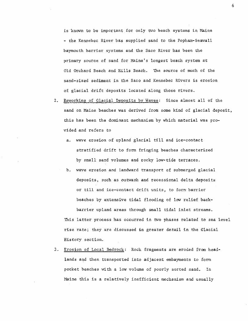
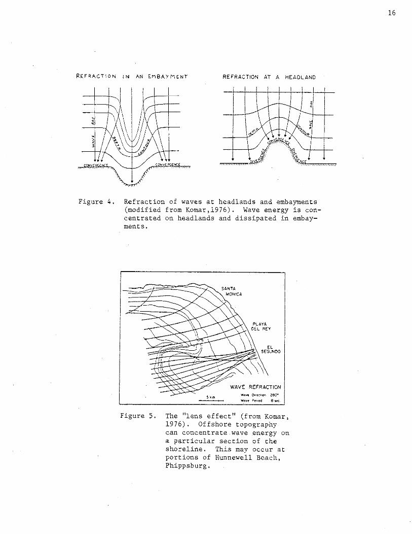
determined by the offshore relief through wave refraction (Figure 3).
Refraction also causes wave energy to be concentrated on headlands and
dispersed in embayments (Figure 4).
A special variation of wave refraction occurs in the case of a
nearshore shoal which acts as a wave energy lens, concentrating wave
energy on a particular part of the beach, under certain conditions
(Figure 5). This phenomenon appears to occur at Hunnewell Beach (Figure 33 )
where a sandy shoal between Wood and Fox Islands may focus wave energy
on specific portions of that shoreline during northeast storms.
Tidal and river currents also cause wave refraction. The tidal
current effect is constantly changing and may be responsible for the
highly dynamic nature of the shoreline and ebb-tidal delta features at
tidal reentrants (t.idal rivers leading to back-barrier marshes) ..
Wave roses compiled by the U.S. Army Corps of Engineers for New
England waters (U.S. Army Corps of Engrs., 1957) are presented in Figure
6. The wave roses show that waves over 1.22 m (4 feet) come predominantly
from the east and northeast. Waves over 3.66 m (12 feet) come only from
these directions and reflect the influence of northeast storm winds over
a long fetch in generating steep, high energy waves.
Winds
Winds are second only to waves in importance to the intertidal part
of beach systems, but are the dominant agent for the supratidal areas
14


which are primarily aeolian dune forms. Winds cause the development of
the frontal dune ridge, alongshore transport of sand, formation of
parabolic dunes, and the processes of barrier maintenance in a regime of
rising sea level. They also influence the height of waves striking the
beach and thereby the erosional or accretionary response of the beach.
Long term wind data for Maine are available from the Portland and
Rockland airports, Bruns~1ick Naval Air Station, Seguin Island Lighthouse,
and Maine Yankee Atomic Power Company in \.Jiscasset. A synoptic summary
of meterological observations is available for New England waters from
NOAA (U.S. Naval Weather Service Command, 1976). From the wind roses
(Figure 7)~aerial photographs, and direct observations from a recording
anemometer located at Popham Beach, it is clear that the prevailing
winds (those which occur more frequently) blot.; from the western half of
the compass. The dominant winds (those which blow less frequently but
at higher velocities) come from the northwest, southwest, southeast, and
northeast. Because the northwest and southwest winds are both dominant
and prevailing, they exert greater influence on those beach processes
effected by aeolian process agents.
Wind transport of sand occurs by three means:
1. Creep - a simple rolling of sand grains along the surface.
2. Saltation- a bouncing of individual sand grains (Figure 8),
the distance of each bounce being the same as the wave
length of any aeolian ripple marks that may be visible.
3. Suspension - a carrying of sand grains a long distance
through the air in the turbulent boundary layer just above
the sand surface. Sheets of blowing sand are visible.
Although all three mechanisms can operate at the same time, each
dominates at specific wind velocities. Creep is associated with low
18


wind speeds, saltation with intermediate, and suspension with high
velocities; the exact transition from one to another is a function of
grain size and density. The volume of sand transported by these aeolian
mechanisms increases with the cube of the wind velocity, making high
speed winds very important despite their short duration.
Because northwest, south to southwest, and northeast storm winds
are most important in their influence on beach and dune behavior and
morphology, the characteristics of each will be discussed below.
1. North~·..-est Winds: Northwest winds are associated with large
high pressure systems moving down the St. Lawrence River
Valley and are strongest in the fall and winter. Because north
west winds are dry, and of high velocity, they are capable of
transporting large volumes of sand in a seaward direction.
As a result northwest winds are important in development·
of backdune morphology, barrier maintenance processes, frontal
dune ridge post-storm recovery processes, and the redistribution
of sand within the system during non-storm conditions.
Northwest winds influence backdune morphology by both
removing sand as well as importing it to that area. The
winds form parabolic dunes (Figure 9) by deflating devegetated
backdune areas. Parabolic dunes are U-shaped, scooped out,
high relief dunes which migrate downwind or in a seaward
direction. Such morphology typifies backdune areas at
Ogunquit, Seawall, Popham, and Reid State Park beaches.
Sand is imported into the backdune area by northwest winds
from tidal reentrant shores behind the barrier. This occurs
during low tide and monthly neap tide cycles by removing
sand deposited during high tide and monthly spring tide phases.
22

Such an importation process may be important in allowing the
barrier to maintain its sand volume in a regime of rising sea
level. It is still not knotm whether the bulk of sand in
Maine's larger dune fields has been originally supplied by
winds transporting sand from the beach, berm, and tidal river
banks or by storm overwash deposits. Export from tidal river
shores has a low volume, annually, but it is a persistent,
frequent contribution.
Because northwest winds blow offshore, they flatten
incoming waves and enhance the onshore transport of sand.
Northwest winds blow seaward, usually over and at an
angle to frontal dune ridges, where the wirid flow lines
are deflected by the ridge shape. The winds then blow paral
lel to the long axis of the ridge. By this means the winds
transport sand in an easterly direction along the front of the
ridge and are important in the constructional growth of the
aeolian ramp. This process is particularly active when an
erosional scarp exists along the frontal dune ridge and serves
to heal the scarp quickly.
2. South to Southwest Winds: These onshore winds occur
throughout the year and are most important in equilibrium
processes related to frontal dune ridge development and post
storm recovery, barrier maintenance processes, sand redistri
bution, and onshore transport of sand. In Maine, the dune
fiel~of beaches are composed of sand originally derived from
the beachface or tidal reentrant shores. South to southwest
winds are responsible for the formation of local waves (seas)
of low height (and low energy) which transport sand onshore
23

and can cause wind-induced alongshore transport of sand also.
It is under the prevailing influence of southwest winds that
large accretionary ridge and runnel systems migrate onshore
during the sununer and early fall in Maine, to create wide
seasonal berms. The southwest winds then move sand from the
dry wave-deposited berm platform to the frontal dune ridge.
Again, similar to the northwest wind, the flow lines of the
wind are deflected and they become parallel to the frontal
dune ridge in the area directly adjacent to it. The deflec
tion of wind flow lines is most active when an erosional scarp
exists and the sand transported toward and along the frontal
dune ridge very rapidly builds the aeolian ramp.
Because most of Maine's beaches face south or southeast
these winds can transport sand to the east or northeast end of
the beach, thereby effecting a redistribution of sand within
the system. The redistribution takes place by both alongshore
wind-induced water currents and supratidal aeolian transport.
The height of the frontal dune ridge is influenced by the
southwest winds to varying degrees depending on exposure and
the geographic orientation of the beach, which is predeter
mined by wave refraction patterns.
The onshore winds along the Maine coast can also strongly
influence vegetational zonation and successional stages in the
dune fields because of the effects of salt spray and aerosol
nutrient supply rates. White Pines - Pinus strobus along the
coast, and several miles inland as well, often show a flagging
effect from the south to southwest winds, indicating how
frequently and constantly they blow (Figure 10).
24


3. Northeast Winds: The high velocity, moist northeast winds
are associated with northeast storms and create short wave
length, steep, high energy waves which erode Maine's beaches
and transport sand both offshore and alongshore (by wind
stress-induced littoral currents). Because of the accompanying
moisture, little sand is transported by aeolian mechanisms.
Therefore northeast storm winds are most important in estab
lishing erosional phases for Maine beaches. The frequency of
thesewinds establishes the rate at which barrier beaches
maintain the equilibrium with rising sea level and thereby the
rate of shoreline recession in Maine.
Tides
Tidal ranges around the world are placed into three cat~gories,
microtidal (diurnal or mixed tides with ranges <2m), mesotidal (2-
4m ranges), and macrotidal (semi-diurnal tides with spring ranges >4
m). Maine's beaches occur in the upper range of mesotidal environments.
The tidal range determines the vertical distance over which the swash
process is active and, consequently, causes a general increase in the
beach width and height. It also disperses the accretionary or erosional
effects of wave action over a broader zone of the beach. The change
from spring to neap range has several response effects on Maine beaches;
these include an overall smaller beach slope for the given sand grain
sizes comprising the beach face (Bagnold, 1940), the formation of mul
tiple berms, and a greater amount of sand is available for transport by
wind during low stages of the tide and monthly neap cycles.
26

Storms
Storms are process agents which occur for only brief periods
throughout annual cycles of beach processes, but are clearly the most
important control in cycles of erosion and accretion. Storms which pass
near the New England coast produce high energy, steep waves which effect
erosional processes whereas more distant storms provide energy for the
formation of constructional, low swell which causes accretion.
In Maine, the classical "northeaster" storm is more important than
tropical cyclones or hurricanes which, although larger and having higher
wind velocities, occur less frequently. The last significant hurricane
to hi~ the Maine coast was in 1954. The characteristics of northeast
storms which affect shoreline erosion are listed by Timson and Kale
(1977), as follows:
1. Northeast storms reach their greatest intensity while
passing New England.
2. The storms may affect Maine for 12 to 13 hours, through more
than one high tide. Slow-moving storms accompanied by
surges and coincident with spring high tides cause the most
erosion.
3. The storms are large and thus influence a single area for
a long time even if they travel rapidly.
4. Wind speeds attain 110 km per hour and may blow over a
fetch of 500-600 km, so that very large stonn waves are
generated.
s. Surges of up to 1.56 meters may occur. This is the
amount by which the expected high water is elevated. The
effect of large storm waves must be further compounded
onto the surge.
6. About 3-5 storms can be expected every year. Most
27
occur in the fall and winter. One or two, on the average,
are accompanied by surges of 60 em or more.
In a regime of rising sea level, storms are the process agent which
maintains the equilibrium between the strandline and sea level. The
rate of shoreline recession is largely controlled by the frequency and
intensity of northeast storms.
Storms which achieve a new high water level mean sea level of 1929
(called National Geodetic Vertical Datum, or NGVD, 1929) on NOAA tide
gauges are assigned the label of storm of record which establishes an
expected storm flooding level for the area where the tide gauge is
located. In south-central Maine, there have been four record storm
water levels since 1944. On November 30, 1944 and on November 20, 1945,
the National Ocean Survey's Portland tide gauge measured 8.7 feet
above NGVD, 1929. On Jan. 9, 1978, a level of 9.4 feet above NGVD, 1929
was recorded in Boothbay Harbor by Walter Welch of the 1:1a.ine Dept. of
Marine Resources. On Feb. 7, 1978, a record level of 9.6 feet above
NGVD, 1929 was recorded in Portland. Boothbay measured only 9.1 feet
above NGVD, 1929 on Feb. 7, 1978. These numbers are based on a
connection factor between modern mean low water (Feb., 1969) and NGVD,
1929. Modern mean low water is 4. 28 feet below NGVD, 1929 at both
Portland and Boothbay.
Storms of record cause significant frontal dune ridge erosion and
wave overwash deposits either by overtopping the ridge or transport
through storm breaches in the dune ridge. The two storms of record
in 1978 suggest an answer to the question of whether the bulk of sand
in Maine's larger dune fields was originally supplied by aeolian
transport from the beach, berm, and tidal river banks or by storm wave
overwash deposits. Overwash deposits ranging from several centimeters
28

to one meter thick and extending across the width of the backdune over
large areas indicates that one storm of record every SO to 100 years
will adequately match the volume of aeolian transport over the same
period and also can maintain a rate of backdune accretion commensurate
with the present rate of sea level rise. The amounts of shoreline
retreat measured after each of the 1978 storms verify the importance
of storm frequency in affecting erosional cycles since the storms
occurred only 29 days apart. It should be kept in mind that such
extreme storms do not cause a permanent shoreline and frontal dune
· ridge retreat. The retreat represent a short term equilibrium event
and during the next year or two the frontal dune ridge will be
reconstructed by natural processes, probably only slightly landward of
its pre-storm location.
Most of the area descriptions later in this report are based
on field checks prior to the major storms of 1978.
29

Currents
The types of currents which move sand in the vicinity of Maine's
beaches are as follows:
1. Tidal currents
2. River currents
3. Estuarine circulation
4. Gulf of Maine current gyre
5. Longshore currents created by:
a. Wave approach angle
b. Longshore differences in wave energy
c. Wind
d. Tide
Tidal Currents: The most important tidal currents occur at the
mouths of long embayments, major rivers and· tidal reentrants. Tidal • • 1 "
currents in these locations are all fast enough to move sand. Current
velocities commonly reach 100 em/sec. at the mouths of tidal reentrants l
draining back-barrier marshes. Bottom ebb and flood tidal currents at
the mouth of the Kennebec River commonly exceed 100 em/sec. (Francis et
al., 1953). Fine to medium size sand (l/16mm- 1/2 mm) shows some
movement at a current velocity as low as 20 em/sec. The volume of
sand moved by a current increases as the cube of the current velocity,
so these fast tidal currents are capable of moving large quantities of
sand.
Tidal currents at the mouths of reentrants are stronger on the
flood than on the ebb because the ocean has a greater head of pressure
than the water filled marsh or lagoon. This results in a net upstream
flow of sand (thus the name "reentrant"). The ebb and flood currents at
the mouths of reentrants form large ebb and flood deltas with complex
30

swash bars and channels. The currents, the large volumes of sand in
these delta features, and the net drift of sand toward reentrants all
have profound effects on the form and behavior of shoreline position and
beachface features. Shorelines of beach spits near the reentrants are
inherently very unstable.
River Currents, Estuarine Circulation, and Gulf of Maine Current Gyre:
The combination of river currents and estuarine circulation has a
significant influence on the form and sand budget of beaches at the
mouths of major estuaries. Net bottom flow of sand in Haine's large
estuaries can be either upstream or downstream depending on season,
basin geometry, and volume of fresh water discharge. The spring floods
of Maine's major rivers result in a strong net downstream surface flow
at their mouths. This surface flow turns right upon reaching the ocean
because of the Coriolis force and drives the Gulf of Maine counter
clockwise current gyre (Bumpus and Lauzier, 1965; Graham, 1970).
Nearshore bottom flow probably behaves similarly in the narrow~mouthed,
well mixed estuaries such as the Kennebec River during spring runoff.
Longshore Currents: When waves approach a straight coastline at an
oblique angle a longshore current is ·created which flows parallel to the
coastline landward of the breaker zone. This longshore current is
responsible for the net transport of sand parallel to the shore in the
littoral zone, especially on barrier beaches south of Maine where oblique
wave approach is common.
Another wave-induced current system is the cell circulation system
of rip currents and associated longshore currents (Figure 11). Rip
currents do not result in a net transport of sand in one longshore
31


direction. Transport of sand is convergent upon regularly spaced rip
current escape channels. Cell circulation depends upon two phenomena
for establishment.
1. Wave setup - the rise in water level above the still water
level due to the presence of waves. It provides the head of
water necessary to drive the feeder longshore currents of cell
circulation. These feeder currents converge at rips.
2. Longshore variations in wave height - this condition allows
the rip currents to break through the breaker zone at the
positions of lower amplitude waves. The longshore variation
in wave height is probably due to standing edge waves which
form a regular interference pattern with incoming swell of the
same period (Komar, 1976).
Cell circulation is usually associated with ridge and runnel beachface
topography. This enhances the effect of wave setup since the ridge
impounds water trapped in the runnel by swash runup. Escape of water
from the runnel is effected by formation of regularly spaced rip current
escape channels through the ridge at the points of lowest breakers in
the breaker zone. Ridge and runnel topography with rip current escape
channels is common on Haine's beaches in the summer.
Winds blowing in the longshore direction and tides draining from
the beach may also contribute to longshore currents. Local winds blowing
alongshore create longshore currents by both wind stress and by estab
lishment of short period, wind generated local waves which approach the
beach at an angle. When the tide ebbs it may enhance rip currents and
feeder longshore currents because water is trapped in runnels and cannot
escape over the associated ridge when the tide is out. The only escape
33

is to flow alongshore until a rip current escape channel is reached. The
effect may be enhanced also by waves which break over the ridge and
spill their water into the runnel behind (landward of) it. Large swash
bars at Popham Beach on either side of Fox Island tombolo have strong
longshore currents in the runnels behind them due to tide ebbing from
the upper beachfare and broad tombolo. This tide-induced longshore
current has no rip channels to escape through and seems to be partly
responsible for maintenance of the large ridge and runnel systems near
Fox Island year round. There is a noticeable scour of sand on the
upstream side of two seawalls which project into the runnel on the east
side of Fox Island Tombolo.
Tide-induced longshore currents are also associated with ebb-tidal
delta channels of Haine's baymouth barrier reentrants. As these chan
nels meander, the ebb currents move large volumes of sand from inter
tidal cut banks and deposit these large volumes elsewhere on the ebb
tidal delta •. This process was responsible for a major recession of the
shoreline at Pop~am Beach State Park in 1952. In contrast tidal channel
meandering was also the agent of major accretion at Popham Beach State
Park after 1940 and at Western Beach (Scarboro).
Glacial Events and Sediment Characteristics
Since almost all sediments which make up sandy beaches and dunes in
Maine have been derived from some sort of glacial deposit, it is in
structive to review the glacial events which gave rise to the present
distribution (Koons, 1974) of sediments (Figure 12). The last glacial
advance reached the edge of the continental shelf southeast of the Gulf

of Maine about 28,000 years ago and remained there until at least 18,000
years ago. Maine is ·an area of glacial scour more than deposition. The
advancing ice scoured unconsolidated sediment and bedrock from ter
restrial Maine and the Gulf of Maine and carried much of this sediment
to the continental shelf. Only bare bedrock or thin till deposits were
left beneath the ice mass.
}lost deposition which did take place was during glacial recession.
There are no large end moraines or drumlins in Maine and few large
preglacial deltas. When the ice margin retreated, the ocean which
butted against it reached a line about 70 km inland from the present
coastline. This occurred about 12,800 years ago. As the ice receded,
eskers and other ice-contact stratified drift were deposited by a
combination of ablation and meltwater stream transport beneath, within,
and alongside ice masses. The combination of depressed land and rising
sea level meant that these deposits were left under the ocean where
extensive, well sorted sandy glacial outwash plains could not form. The
upper Kennebec River Valley was filled with a series of sand deltas
which retreated northward along with the ice-ocean boundary. When
incursion of the ocean could no longer keep pace with retreat of the ice
margin over central and western Maine, large glacial outwash deposits
could form. The large meltwater streams followed the same valleys as
the glacial ice streams, e.g. the glacial Androscoggin, Kennebec and
Penobscot valleys. They carried vast quantities of sand from inland
glaciers and spread the sand in thick outwash plains via braided streams.
South of Portland the outwash deposits and receding delta deposits
of the early post-glacial Androscoggin were carried all the way to the
present coastline. In early post-glacial times the Androscoggin prob
ably drained south through Sebago Lake. Outwash and delta sands reached
36
the present coastline in southern Maine because the western mountains
come closer to the present coast there. " The large fan of early post
glacial Androscoggin sediments has supplied much of the sand which makes
up Maine's southern beaches.
Early post-glacial Kennebec River outwash and receding delta
deposits extend only as far downstream as Waterville and are generally
confined to the narrower, Kennebec glacial valley.
Relative sea level began dropping after the maximum incursion
12,800 years ago, due to crustal rebound and the marginal bulge effect
of ice still depressing northern Canada. This increased the erosional
capacity of our major rivers and enabled them to transport interior
deposits of outwash, delta, till and ice-contact stratified drift sands
downstream to form river-mouth sand flats.
Relative sea level rose again after 8,500 years ago due to sub
sidence of the marginal bulge and continued worldwide rise in true sea
level. As relative sea level rise slowed, river mouth sand deposits
could accumulate in one place rather than retreating upstream with the
river mouth. When the rise rate slowed sufficiently, Maine's baymouth
barriers, derived from outwash and delta plain sands and from river
borne sands of the Kennebec and Saco rivers, were established. Our
preliminary studies suggest that some barriers were established at least
6800 years ago. Vertical accretion of vegetated dune fields supplied by
windblown sand from the berm could keep pace with. the slowly rising sea
level even as upland areas behind the dune fields were flooded and
became marshes. This process has continued for the last 6000-7000 years
as sea level has risen at a long term rate of about 6 em/century (Myers,
1964; Snow, 1972; Nelson, unpublished data). The relative rise rate for
the present century is considerably higher, 23 em/century, and will be
discussed in the next section.
37

The sorting of minerals and sand on a beach can be an indication of
the distance to sand source or nature of the sand source~ Fine, well
sorted, quartz-rich beach sands are further from their source and have
been in a beach or river transport environment longer than poorly sorted
schist fragment and feldspar-rich sands. Beach sand derived from local
bedrock is poorly sorted and associated with boulders, cobbles, pebbles
and gravel of the local rock type. Beaches derived from nearby tills or
ice-contact stratified drift may be well-sorted on accretionary surfaces
but are often associated with b~ulders, cobbles, pebbles and gravel of
many rock types. These are usually visible on the lower beach face as a
lag surface. Carbonate sand beaches are easily distinguished since they
are found in coves exposed to heavy storm waves and face clean rocky
bottoms.
38
Relative Rise of Sea Level
Changes in sea level, both absolute and relative, are well established
in the geologic record. Absolute changes refer to long term variations
of the volume of water contained in the hydrosphere and are controlled,
primarily, by climatic changes which cause fluctuations in the polar
ice cap volumes. Relative changes in sea level refer to the net effect
of absolute sea level change, local changes in the height of the sea
surface and vertical movement of coastal land masses. Causes for the
relative changes span the spectrum between short and long term factors.
Relative changes of sea level for specific locations in the United
States have been monitored since the 19th Century by tide gauges. This
effort has produced historical records of relative sea level change and
affords the opportunity to discern various factors responsible for the
observed changes. The tide gauge record which shows mean sea level for
Portland Maine is reproduced in Figure 13. The factors which influence
sea level as recorded on a tide gauge are as follows:
1. Water temperature
2. Salinity variations
3. Local atmospheric pressure variations
4. Prevailing wind directions
5. Tidal variations (spring and neap, perigee-apogee, etc.)
6. Tidal Range amplification and decrease
7. River Runoff
*8. Glacio-Tectonic
*9. Polar ice cap melting and freezing
*10. Water loading of continental shelf
The factors noted with an asterisk are the most important in a
consideration of effect on Maine's beach systems since these factors
are the only ones which can produce persistent, long term sea level changes.
39


It is obvious from Figure 13 that such a trend is present, that is, there
is a historical relative rise of sea level in Maine at a rate of 23 em/century
(Hicks and Crosby, 1974). The factors primarily responsible for such
a change are those indicated with the asterisk. The polar ice caps are
still melting from the last glaciation (King, 1972), as described in the
previous section, and therefore are contributing to the world-wide volume
of sea water. From various investigations, the present world-wide, or
eustatic, rise of sea level is thought to be approximately 10-15 em/century
(Hicks, 1972; Fairbridge and Krebs, 1962). This leaves 8-13 em/century
of rise which must be explained by crustal subsidence caused by 1) relaxation
of deformation resulting from glacial retreat factors (or glacio-tectonic)
and 2) water loading of the continental shelf due to the eustatic rise
of sea level after the most recent retreat of the North American ice
sheet. Separation of these factors and assigning values to their effect
awaits further investigation. Just to complicate the issue, the relative
rise rate for Eastport, Maine, from tide gauge data, is 36 em/century
(Hicks and Crosby, 1972) and releveling data also indicate a current
subsidence rate of 60 em/century (Meade, 1971) near the Maine-Canadian
border.
- Another perspective on sea level rise in Maine is provided by the
record of the Holocene transgression along the coast. This refers to
the rise of sea level in postglacial time. This record is obtained
from radiocarbon dating (c14) of barrier beaches. Such dates give us
the time of formation of the barrier beaches as well as a record of the
rise of sea level between the time of formation and the present. Radio
carbon dating of basal peats from marshes at Popham Beach indicate that
barrier beaches probably formed in Maine around 6000 radiocarbon years
ago (Nelson, in preparation) and that since that time relative sea level
has risen at the rate of 6 em/century. It is important to realize that
41

the rate of 6 em/century is a long term average and the actual rise rate
may have been as high as that indicated by tide gauge records for brief
intervals during the last 6000 years. Alternatively, there is a very
real difference between the Holocene and modern rates of sea level rise
and the present rate is four times more rapid than the Holocene rate.
Whatever the ultimate causes or rates of relative sea level rise in
Maine are, the mere existence of this process agent has profound implica
tions for the dynamic equilibrium of beach systems in Maine. Long term
transgression of the sea over beach areas has several significant impacts
on beaches. These are listed below.
1. Erosion of the beach, and shoreline retreat, is the rule
rather than the exception.
2. Rates of process-response cycles become important in
determining whether beaches can maintain an equilibrium
with the rise of sea level.
3. The beachface, frontal dune ridge, and backdune area must
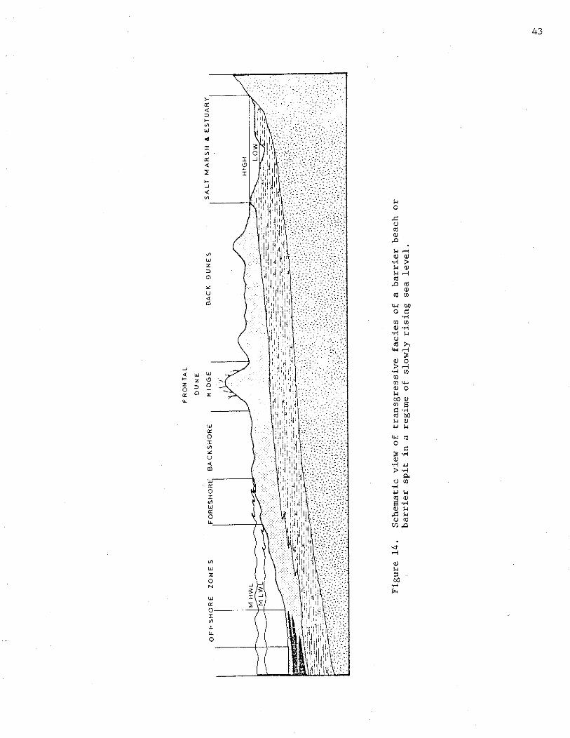
migrate upward and landward over marsh and upland (Figure 14).
4. Unless new sand deposits are being inundated and becoming
involved in the sediment selection process of waves and current,
the sand supply to beaches from submerged offshore deposits
of glacial outwash sediments are diminishing. MOst of Maine's
beaches are now sediment-starved which implies either a
diminishing supply or such relatively rapid retreat that the
present supply rate is inadequate.
5. Interferences by man which prevent landward migration of beaches
and their associated dune fields could have dire consequences
£or the future integrity of Maine's beach systems.
6. Instability of beaches is an inherent and necessary characteristic.
42

The inescapable conclusion is that a thorough understanding of the
behavior of beaches and dunes in response to a rising sea level regime
is essential to any short or long term management plan for 11aine's beach
systems.
Response Forms and Geomorphic Features of Maine's Beaches
This section discusses the response side of the dynamic equilibrium
model for Maine's beach systems. The response forms and features result
from various combinations of the process agents. The numerous response
forms ·Which occur in Maine can be organized into four main groups, as
follows:
1. Hajor Wave Depositional Forms (Beach Types in Plan View)
2. Ephemeral and Minor Wave Depositional-Erosional Forms
3. Major Wind Depositional Forms
4. Sedimentary Structures
Major Wave Depositional Forms
(Beach Types in Plan View)
The geologic fabric of bedrock units in Maine exerts a pronounced
control on its coast, whose highly irregular and deeply embayed outline
contrasts sharply with the rest of the coastline south of New Hampshire.
The limited sand supply and coastal geometry make Maine's highly evolved
beach forms unique along the east coast. The following classification
treats Maine's diverse, swash-aligned accumulation forms (Figure 15) and
has been modified after King's (1972) system.
Fringing Beaches: These are sandy strandlines, usually without
an extensive dune field (Figure 15). Although they usually abut
upland bedrock, soil, or unconsolidated sedimentary units with no
44


intermediate lagoon, there may be a swale with a fresh water bog
sandwiched between the upland and the beach ridge. Fringing beaches
are common on Maine's islands and mainland.
The great irregularity of the embayments and islands results in many
fringing pocket beaches which are crescentic in outline, parallel to
the breaking waves, and usually small.
The greater refraction of waves at the heads of bays (Figure 3)
causes bayhead pocket beaches to be more curved than midbay pocket
beaches. Most pocket beaches are seaward facing but a well-formed north
facing pocket beach exists on Seven Hundred Acre Island near Islesboro.
True fringing delta beaches do not exist in Maine, though Hunnewell
Point at Popham may be a combination of a fringing delta and cuspate
foreland.
Large fringing beaches are found only in southern Haine, e.g.,
parts of Old Orchard, Fortunes Rocks, and Crescent Beaches.
Barrier Beaches: In this outline barriers (Figure 15) are defined as
being attached to the mainland at both ends, with or without an inlet,
but containing a present or former marine lagoon. Reid State Park's
mile beach is a barrier of this type. There are many pocket barriers,
such as Sea Point (Kittery) and Pemaquid. Roque Bluffs is a pocket
barrier enclosing a former marine lagoon, now fresh. Such completely
sealed marine lagoons are uncommon on sandy beaches and usually require
a source of gravel or shingle which is thrown up into a storm berm
capable of blocking the tidal exchange inlet.
Cuspate barriers form where refracted wave trains meet in the lee
of an island or where two currents come together. Cuspate barriers
enclose a present or former marine lagoon.
Tombolos: These are attached at both ends to islands or at one end to an
island and the other end to the mainland (Figure 15). They may be
46

exposed at all tides or only at low tide. They are of two types:
1. Comet's tail- forming in the lee of an island, e.g., Fox
" Island and Wood Island at Popham.
2. Normal to wave approach - forming on the side of an island.
This type requires a shingle or boulder storm berm along its
full length to block the flo~v of sand toward the lee of the
island. They are normal to long swell but parallel to storm
waves. An excellent example exists near Presley Cove, northwest
Deer Isle, but it has little or no sand accumulation.
Cuspate Forelands: These are formed in the same manner as cuspate
barriers but do not enclose a present or former lagoon (Figure 19).
They may enclose a fresh water bog as on the northern tip of Louds
Island (Muscongus Bay). Cuspate forelands may form at both ends or one
end of an intertidal tombolo. The best examples are at Popham Beach in
the lee of Fox and Wood Islands.
Spits: These are attached to the mainland at one end and are free at
the other end (Figure 15). Included in this category are the well known
barrier spit beaches of southwestern Haine. This type of beach occurs
at the mouths of bays and is associated with large salt marshes which
have pervaded the tidal lagoon, e.g. Ogunquit and· Seawall Beaches.
These baymouth barrier-spit and salt marsh complexes are long, usually
straight, with extensive dune fields and salt marshes which are con
nected to the open sea through an inlet between the spit end and the
headland. The presence of the spit indicates some littoral drift toward
the spit end, though this i~ minimal relative to the barrier islands of
the Atlantic coast south of New Hampshire. The alongshore drift may
occur primarily during northeast storms when considerable volumes of
sand are placed into suspension and carried toward the spit by wind-
47

induced littoral currents. Maine's barrier spit beaches have a con
siderable sand supply and extensive offshore sand flats with parallel
contours which straighten long swells before they hit the beach.
Spits are of various types and sizes. All have potentially un
stable tips which are favored nesting sites for least tern and piping
plovers. They are further subdivided on the basis of form as follows:
1. Simple spits - are· straight from the headland to the end.
Aerial photographs show that this type of spit is uncommon
but one formed at Popham in the mouth of the Morse River in
the 1940's.
2. Recurved spits - are the most common and are usually associated
with the barrier spit beaches. These indicate wave refraction
into the inlet, as they are usually curved inward toward
3.
4.
the marsh.
Complex spits - form as a result of pulsed increases in sand
supply or shifts in the course of a tidal inlet. Maine's
best example formed in the mouth of the Horse River at Popham
between 1950 and 1972. A possible relict complex spit is
located in a small salt marsh near Fort Popham.
Double spits - face one another and border an inlet.
Examples exist at the mouth of the Morse River at Popham,
at the mouth of Wells Harbor, before jetty construction, and
at Laudholm and Crescent Surf Beaches.
Ephemeral and Minor Wave Depositional and Erosional Forms
Maine's beaches exhibit ephemeral and minor forms and features which
are controlled by erosional or depositional cycles. These features are
of value for scientific and educational purposes, recreation, bird
48

nesting habitat, and habitat for certain fishes and invertebrates. They
are by nature ephemeral, but some features rely on a sand supply which
can be influenced by human activities. The features present depend on
whether the beach is experiencing erosional or accumulation activity and
are best presented in profile view.
Erosional Beach Profile Type and Features: These are illustrated
in Figure 16 and include the following:
1. Frontal dune scarp - a cliff cut into the vegetated dun~s
by winter storm waves; it may persist through the summer.
2. Concave upward beachface - eroded beach profiles are flat
to slightly concave upward from the low water mark to the
frontal dune scarp. There are no sharp slope breaks. This
is the typical winter or post-storm profile.
3. Low-tide terrace with a coarse lag surface - this low tide
terrace may be found on accreting profiles as well, where it
is a remnant of the surface of maximum erosion. A lag surface
is a layer of coarse heavy material which forms a pavement at
the level of maximum erosion when finer material is removed by
winter storm waves. The lag surface is usually overlain by
graded bedding. A graded bed is a layer of increasingly fine
grain sizes from bottom to top and indicates deposition during
a phase of decreasing wave energy.
4. Offshore bars - sand removed from the intertidal beachface,
berm, and frontal dune ridge, is deposited in one or more bars
just seaward of the breaker line. This sand is the major source
for onshore transport when summer accretion resumes. Winter
offshore bars are larger than summer offshore bars because of
greater storm frequency.
49

5. Storm wave breaches of the frontal dune ridge - these cuts
occur primarily on those parts of the beaches where the frontal
ridge is low because of wave erosion or where pedestrian traffic
has created a pathway through the frontal dune ridge. Whether
they are natural or man-induced, breaches are one means by which
large sand volumes are transported into backdune areas. This
is an important process in barrier beach maintenance in a regime
of rising sea level.
Constructional Beach Profile Type and Features: These are also illustrated
in Figure 16, as follows:
1. Broad berm platform - this is the major feature of
a constructional profile. The platform accumulates
at the level of spring tide high water mark and extends
seaward from the toe of the frontal dune ridge for as much as
40 meters (seasonal berm at Ogunquit). Perennially accreting
berms may be even wider. The berm is the major recreational
area of the beach; it provides dry sand at high tide for
sunbathers. It also supplies enough sand to act as a buffer
against erosion of dunes when fall and winter northeast storms
strike.
2. Berm crest - this is the edge of the berm. It often
has cusps which are regularly spaced ridges with scalloped
embayments between; relief of cusps depends upon wave energy
and grain size. The cause of cusps is not clearly understood,
but may be related to standing edge waves and inter-
ference patterns (Russell .and Hcintire, 1965; Williams, 1973).
50

3. Steep berm slope - the foreset face of the berm forms
the steep upper beachface common on accreting profiles. The
base of the foreset face joins the low tide terrace, which may
have a lag surface covered with a thin veneer of fine sand or
may have a ridge and runnel system on it. The steep berm slope
is often coarser grained than other accretionary slopes,
especially on beaches with a wide range of grain sizes in
their total grain size population. Coarse sand can be ac
cumulated on a steeper slope because it is highly porous and
allows wave swash to settle down through it rather than sweep
seaward as a backwash. This holds true particularly on the
seaward face of a berm or ridge where backwash is an important
agent. On the non-accumulation surfaces, lag surfaces or low
tide terraces, the relationship does not hold. The grain
size-slope relationship also does not hold true on the flat or
slightly landward dipping top of the berm where backwash is
ineffective in removing sand seaward.
4. Ridge and runnel system on low tide terraces - The ridge
and runnel system (Figures 11 and 16) forms in summer and
migrates up the beach until the runnel is filled and the ridge
welds onto the berm. This is one of the main mechanisms for
transport of sand from the offshore bars to the berm and
steep berm slope.
5. Breakpoint bars - In Maine these are small bars with a
trough in front of them visible at low tide beneath the
breakers of low swell. They may migrate up the beach with
each tide to supply a significant amount of sand, over time,
to the steep berm slope.
51
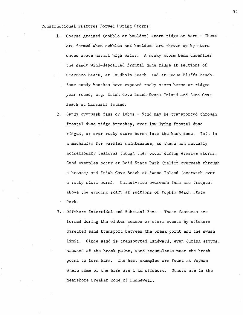
Constructional Features Formed During Storms:
1. Coarse grained (cobble or boulder) storm ridge or berm - These
are formed when cobbles and boulders are thrown up by storm
waves above normal high water. A rocky storm berm underlies
the sandy wind-deposited frontal dune ridge at sections of
Scarboro Beach, at Laudholm Beach, and at Roque Bluffs Beach.
Some sandy beaches have exposed rocky storm berms or ridges
year round, e.g. Irish Cove Beach•Swans Island and Sand Cove
Beach at Marshall Island.
2. Sandy overwash fans or lobes - Sand may be transported through
frontal dune ridge breaches, over low-lying frontal dune
ridges, or over rocky storm berms into the back dune. This is
a mechanism for barrier maintenance, so these are actually
accretionary features though they occur during erosive storms.
Good examples occur at Reid State Park (relict overwash through
a breach) and Irish Cove Beach at Swans Island (overwash over
a rocky storm berm). Garnet-rich overwash fans are frequent
above the eroding scarp at sections of Popham Beach State
Park.
3. Offshore Intertidal and Subtidal Bars - These features are
formed during the winter season or storm events by offshore
directed sand transport between the break point and the swash
limit. Since sand is transported landward, even during storms,
seaward of the break point, sand accumulates near the break
point to form bars. The best examples are found at Popham
where some of the bars are 1 km offshore. Others are in the
nearshore breaker zone of Hunnewell.
52

4. Ebb-Tidal Delta and Flood-Tidal Delta Features - These are
found at the inlets of baymouth barrier spits. Some have been
dredged and jettietl to prevent shoaling of harbor entrances,
e.g. Wells Harbor, and Saco Bay.
Major Wind Depositional Forms
Because Maine's Beach systems consist predominantly of fine to
medium size, quartz-rich sand, aeolian transport processes are important
in determining the various supratidal response forms. All aeolian
accumulation forms are fragile and susceptible to damage by fire, foot
traffic, and other human activities which disturb dune vegetation or·
affect natural sand transport by wind.
Frontal Dune Ridge: On Haine's beach systems; this feature (Figure 16)
is preeminent, not only in morphology but in function as well. Frontal
dune ridges are the result of a constructional upgrowth process which is
the natural interaction between sand blown landward from the berm and
beach vegetation, primarily American Beachgrass - Ammophila breviligulata.
The windblown sand is trapped by the beachgrass, which, when partially
covered or even buried by up to 1 meter, is stimulated to grow vigorously
both horizontally, by rhizome extension, and vertically upward through
the sand. The repetition of trapping and subsequent growth combines to
build a ridge limited in dimensions only by sand grain size, wind transport
velocity, and storm frequency. The functional roles of frontal dune
ridges are a) buffer against storm erosion of backdune and marsh areas
and b) storage compartment of sand for vital beachface replenishment
during storms (Figure 16).
53


Frontal dune ridges are present on almost all undeveloped beach
sections, but may be much reduced in height and width because of recent
erosional periods. Frontal dune ridges are conspicuously absent on
beaches with seawalls and intense~ unrestricted recreational use.
Aeolian Ram-o: This feature, although widespread in occurrence, is
described here for the first time and constitutes a contribution from
Maine to the nomenclature of beach geomorphology. The term, aeolian
ramp, refers to a feature which is secondary in origin and develops only
after erosion has formed a frontal dune scarp (Figure 16). Subsequent
to such an erosion event, sand is transported from the berm or backbone
field to form a wedge of sand which fills and heals the frontal dune
scarp. The initial sand accumulation occurs very quickly since sand
is blown both toward the frontal dune ridge and along the ridge by
winds from the western half of the compass. Once the scarp is healed,
the ramp provides an easier transport route for sand into the vegetated dunes.
Aeolian Flats: This term refers to sparsely vegetated sandy flats
behind the dune ridge. Aeolian flats are formed by several mechanisms,
as follows:
1. Overwash through blowouts or storm breaches.
2. Sand blown from back-barrier tidal rivers by offshore
(northwest) winds.
3. Extension of the back-slope of the frontal dune ridge
landward by moderate onshore winds acting for decades or
centuries.
4. Smoothing of high flank and lee slopes of parabolic dunes
originally formed by strong northwest winds.
55

Rear Dune Ridges: These are found at the border between the dune
field and tidal river of some of the barrier spit beaches. They are
not extensive features because the sand supply from the tidal river
is limited. Examples are found at Seawall Beach, Popham Beach, and
Ogunquit Beach.
Accretionary Ridge and Swale Topography: Relict berms and relict
frontal dune ridges alternate in parallel fashion. They indicate rapid
accretion which is not necessarily pulsed. Examples occur at many of
Maine's beaches and provide evidence that accretion can occur between
major erosional episodes.
Parabolic Dunes and Slacks: These are scooped out depressions in
vegetated dune sand carved by strong offshore winds in Maine. The
excavation migrates downwind and sand is deposited on the sides and
leading apex. The whole form resembles a parabola when viewed from
the air (Figures 9 and 17). Most of Maine's parabolic dunes and slacks
are now stabilized by a diversity of dune plant species due to control
of fires, grazing and foot traffic. The best examples of active and
stabilized parabolic dunes and their associated vegetation are found
at Seawall Beach (Phippsburg). Examples are also found at Popham,
Reid, Ogunquit, and Main Beach (Cape Elizabeth). Overlapping parabolic
dunes are responsible for the ultimate rolling topography of large
backdune areas. Vegetated embryo dunes sometimes form in the mouths
of parabolic dune slacks, preventing further migration of the apex by
stabilizing and cutting off the wind fetch. Good examples exist at
Ogunquit. Maine's parabolic dunes may be of national significance
because they are fonned by offshore rather than.onshore winds and are
only rarely obliterated by washover events during major storms.
56

Onshore Orie.nted Blowouts: These are parabolic dunes which are formed
as breaches in the frontal dune ridge (Figure 17). They are uncommon
in Maine and may only form when assisted by foot traffic erosion,
fires, storm breaching, or redirection of winds by local bedrock
topography. Examples of stabilized, high relief, onshore oriented
blowouts exist at Hunnewell Beach (Popham, Phippsburg).
57


High dunes which form at the upland forest
edge on the back of the aeolian flat. They are formed by onshore winds
which are weakened and drop their sand when they reach the forest barrier
(Figure 16). The best examples are at Main Beach (Cape Elizabeth) and
Bailey Beach (Phippsburg).
Sedimentary Structures
There are many ephemeral surface features which are of educational
value on beaches. These structures are produced by currents, wave swash
and wind. Many of these structures are used by geologists in identifying
ancient deposits because they are diagnostic of the beach environment.
When these structures are preserved beneath Haine's beaches and dunes,
59
they become valuable management information. Barrier maintenance mechanisms,
shoreline change histories, past sea level rise rates and past sand
supply changes all leave their record in the strata. Below are listed
some sedimentary structures, their mode of formation and geological
significance.
Swash marks: Wave swash sweeping up the beach carries sand and debris
at its leading edge. This is deposited at the swash limit as a thin
wavy line of coarser sand with a concentration of black mica flakes,
shell hash, seaweed and other debris. The falling tide leaves a series
of apparently bifurcating swash marks because the trace from any one
wave is truncated by a later swash. Swash marks form only on the upper
part of the beachface above the water table runout which obliterates
them on lower beachface. Swash marks are widely spaced on gentle beach
slopes and closely spaced on steep beach slopes.

The presence of swash marks in an ancient deposit is a sure sign of
wave deposition. Swash marks tend to be convex shoreward and this is a
criterion for determining the orientation of ancient beaches.
Ripple marks: There are two basic types of submarine ripple marks,
oscillatory and current ripples. Oscillatory ripples are usually
symmetrical and current ripple marks are asymmetrical, with their steep
faces downcurrent. Oscillatory ripples are formed by standing waves or
oscillations. They are common offshore beyond the breaker zone down to
the depth of the wave base which,in some parts of the.world, may be as
deep as 200 meters during intense winter storms (Komar, 1976).
There are intermediate ripple forms where both oscillations and the
current are in the same compass direction. In runnels, oscillation and
current ripples form at right angles to one another because the wave
oscillatory movement and longshore current act perpendicular to one
another. This results in the formation of ladder-back ripples. Ladder
back ripples can also be found on the exposed tidal flats associated
with ebb and flood tidal deltas, tombolos and perennially accreting
beachfaces.
On the foreshore (upper intertidal beachface) backwash ripples
(Tanner, 1965) may develop on fine sand beaches when the backwash of the
waves running for a long distance down the gently sloping beach sets up
a turbulent motion. These ripples have about a 50 em. wave length, are
straight, parallel to the beach, and have a very low amplitude. They
are easily recognized as black and white bands because of the separation
of quartz and dark colored mica minerals.
60

Strong currents and large waves may create current megaripples of
various types. \Vhile small ripples are almost always less than 39 em in
length, megaripples vary from 0.6 to 30 meters in length (Komar, 1976).
In sand with a grain size greater than 0.6 mm, no small ripples are
produced and only megaripples are formed. In Maine, megaripples are
associated mostly with tidal currents near major rivers and reentrants.
They indicate movement of large volumes of sand. Lunate or scour
megaripples (spoon shaped scours with planar crests) are common at the
mouth of the Kennebec on the Hood Island tombolo and in tidal reentrants
elsewhere. They may have a relief greater than 50 em.
Groundwater Rill Marks: Another beachface surface sedimentary structure
is the groundwater rill mark. These are formed by water seeping from the
lower beach face at low tide. They are small erosional dendritic gully
systems which join to form a small braided stream at their seaward
(downslope) end. They are good indicators of orientation of ancient
beaches and of lower beachface deposition.
Rhomboid Marks: Rhomboid marks are a diamond shaped or rhombohedral
pattern developed on the beachface by wave backwash. They resemble the
leaf scars of a Carboniferous Lepidodendron stem. They may be produced
by either currents deflected by objects or irregularities in the sand
surface, or by the interference of waves which propagate downcurrent
from such objects and irregularities.
Current Crescents and V-swash Marks: Current crescents and V-swash
marks are formed when a shell or pebble deflects a current or backwash.
Deflection of the current by the object causes a scour crescent on the
upstream side. The V-mark forms downstream in the shadow of the object.
Hhen they are preserved in the sediments, these features are indicators
of ancient beach orientation.
61

Beach laminations: Most useful of all sedimentary structures are
beach laminations. Trenches cut perpendicular to the beach show lamina
tions which tell the story of changing beachface profiles, erosional
limits, and the amount of perennial and seasonal accretion. Beach face
and dune sands can be distinguished in the trenches on the basis of
heavy mineral layers, bedding-plane slopes, type and orientation of
cross stratification, type and relationships of preserved sedimentary
structures, and bioturbation structures. Distinction between wave and
wind deposited sand is very valuable for management purposes since it
tells the story of long term shoreline changes.
Wind deposited sedimentary structures: Wind deposited sedimentary
structure includes wind ripple marks in wind deposits. Dune fields
dominated by parabolic dunes have a high incidence of steeply dipping
beds (dipping away from the dominant wind direction) and wind deposited
sand may be distinguished from wave deposited sand on that basis.
Aeolian flats behind the frontal dune ridge or on top of relict berms
are not so easily distinguished from wave deposited sand because their
laminae resemble those of the berm surface. Heavy minerals such as
garnet sands are left in layers beneath accreted beaches and are relicts
of the erosional position of the shoreline before accretion. They may
also mark the interface between wave deposited and wind deposited sand
in sediment cores through the backdune.
A schematic cross-sectional view of a beach with characteristic
laminations and cross laminations, heavy mineral layer, and coarse lag
surface at the past erosional limit is presented in Figure 18.
The value of sedimentary structures is that all of the above features
and their many variants are keys to the nature of present and past
62

depositional envirorunents. The Holocene history of Haine's beaches can
be interpreted from preserved sedimentary structures beneath the existing
beachface~ dunes, and marsh.
63
Methods of Locating Sandy Beaches and Dunes
Maine's sandy beaches and dunes have been located by an extensive
inventory effort, which included the elements and results listed below.
1. Three years of field studies, coastal overflights, and aerial
photo st~dies - these were part of an ongoing investigation of
Maine's beaches by L.K. Fink, Jr. and R.J. Foster of the Department
of Oceanography, University of Maine, Orono. Although this study
identified 44 principal Haine beaches with a cumulative length of
60 km, many small sandy beaches were excluded.
2. A high altitude overflight in June, 1977 - This flight produced
a photo atlas for sandy beaches north of Reid State Park.
3. Inspection of both the vertical aerial photo collection of the
Maine Bureau of Geology and the 112 Marine Geology Maps by Barry S.
Timson, Bureau of Geology.
It should be noted that many of the beaches identified as sandy on
the Marine Geology Maps are likely to be boulder, cobble, gravel or
mixed sand and gravel beaches due to resolution limitations of vertical
air photos available for Maine.
From the 112 Marine Geology Maps a complete list (Table II) of
all sandy beaches in Maine was made. From this list 29 beaches were
selected for field checking based on the geological and botanical criteria
outlined below. 27 beaches were visited in June, July and August of 1977
and a total of 37 proposed critical areas were delineated. The two
64
beaches not visited are on coastal islands (Andrews Beach, Long Island,
Casco Bay and a north facing pocket beach on Seven Hundred Acre Island,
Penobscot Bay). These two areas are recommended for future field checking.
The 27 beaches visited represented approximately 20 km of beach length.
This compares with a total of 121 km of sandy beach based on the Marine
Geology Maps and 60 km based on the list by Fink and Foster.
As a result of field checking and aerial overflights, a considerable
amount of data was compiled in various forms. For each beach, field data
forms were completed and sketch maps,delineating geological and vegetational
features, were drawn. A comprehensive slide file, which depicts
ground level, geological and botanical features and aerial views for
each beach, also was assembled and accompanies this report to provide
visual documentation of many aspects of the sandy beaches in Maine.
65
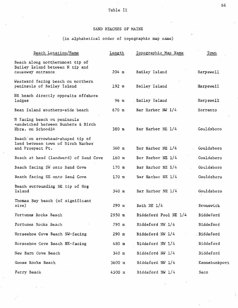
Table II
SAND BEACHES OF MAINE
· (in alphabetical order of topographic map name)
Beach Location/Name Length Topographic Map Name
Beach along northernmost tip of Bailey Island between N tip and causeway entrance
Westward facing beach on northern peninsula of Bailey Island
NE beach directly opposite offshore ledges
Bean Island southern-side beach
N facing beach on peninsula sandwiched between Bunhers & Birch Hbrs. on Schoodic
Beach.on arrowhead-shaped tip of land between town of Birch Harbor and Prospect Pt.
Beach at head (landward) of Sand Cove
Beach facing SW onto Sand Cove
Beach facing SE on.to Sand Cove
Beach surrounding SE tip of Hog Island
Thomas Bay beach (of significant size)
Fortunes Rocks Beach
Fortunes Rocks Beach
Horseshoe Cove Beach SW-facing
Horseshoe Cove Beach NE-facing
New Barn Cove Beach
Goose Rocks Beach
Ferry Beach
204 m
192 m
96 m
670 m
380 m
360 m
160 m
170 m
170 m
340 m
290 m
2950 m
790 m
290 m
480 m
340 m
3600 m
4500 m
Bailey Island
Bailey Island
Bailey Island
Bar Harbor NW 1/4
Bar Harbor NE 1/4
Bar Harbor NE 1/4
Bar Harbor NE 1/4
Bar Harbor NE 1/4
Bar Harbor NE 1/4
Bar Harbor NE 1/4
Bath NE 1/4
Biddeford Pool NE 1/4
Biddeford NW 1/4
Biddeford NW 1/4
Biddeford NW 1/4
Biddeford NW 1/4
Biddeford NW 1/4
Biddeford NW 1/4
66
Town
Harpswell
Harpswell
Harpswell
Sorrento
Gouldsboro
Gouldsboro
Gouldsboro
Gouldsboro
Gouldsboro
Gouldsboro
Brunswick
Biddeford
Biddeford
Biddeford
Biddeford
Biddeford
Kennebunkport
Sa co

Table II (Continued)
Beach Location/Name
Beginning of Old Orchard Beach -Camp Ellis
Hills Beach
Trafton Island Beaches facing NW, just south of northernmost peninsula, eastern
Trafton Island Beaches facing NW, just south of northernmost peninsula, western
NE side of Dyer Island, head of Watts Cove
Reid 1/2 mile beach
Reid mile beach
Beach midway down E side of r.apitol Island
Beach on northern tip of Squirrel Island
Pemaquid Restoration Beach
Sandy Pt. beach, Stockton Springs
Beach on W side of Beauchamp Pt.
Eastside beach of Deadman Pt.
Northernmost beach at mouth of Camden Harbor, slightly SW of Curtin Island
Beach on SW side of Camden Harbor
Beach at head of Camden Harbor, between Eaton Point and Northwest Point
Broad Cove Beach
V-shaped beach, following a Point jutting into Richmond Island Harbor
Length Topographic Map Name
410 m Biddeford
530 m Biddeford
120 m Boise Bubert
160 m Boise Bubert
180 m Boise Bubert
650 m Boothbay Harbor
1160 m Boothbay Harbor
260 m Boothbay Harbor
190 m Boothbay Harbor
528 m Bristol
1370 m Bucksport SE 1/4
220 m Camden
530 m Camden
240 m Camden
310 m Camden
430 m Camden
190 m Cape Elizabeth
790 m Cape Elizabeth
67
Town
Old Orchard Beach
Old Orchard Beach
Harrington
Harrir.gton
Harrington
Georgetown
Georgetown
Southport
Southport
Bristol
Stockton Springs
Rockport
Rockport
Camden
Camden
Camden
Cape Elizabeth
Cape Elizabeth

Table II (Continued)
Beach Location/Name
Crescent Beach
Marshall Cove Beach
John Cove Beach
Beach on NW part of Wilson Point
Morse Cove western side beach
Beach on NW of Cape Jellison
Beach on NE side of Cape Jellison
Beach on SW bend of Cape Rosier
Northwestern most tip of Pond Island
Beach most westerly of the two between the Cross Island mainland and
Length
1560 m
110 m
100 m
820 m
310 m
790 m
770 m
130 m
140 m
Northwest Head 160 m
More eastern of the 2 beaches between upper Northwest Head and Cross Island's main body 360 m
Westernmost of the two beaches separated by Grassy Pt. (Cross I.) 700 m
Easternmost of the two beaches separated by Grassy Pt. (Cross r.) 580 m
Beach on the western side of Northeast Harbor's mouth (Cross I.) 170m
Northernmost sandy beach of Cross I. peninsula containing Coast Guard Station 140 m
NE-facing beach on Cross Island Coast Guard peninsula 360 m
Westerly beach at head of Machias Bay (before Rte. 191 crosses estuaries) 220 m
Philbrook Cove Beach 700 m
Topographic Map
Cape Elizabeth
Cape Elizabeth
Cape Elizabeth
Castine NE
Castine NE
Castine NE
Castine NE
Castine SE
Castine SE
Cross Island
Cross Island
Cross Island
Cross Island
Cross Island
Cross Island
Cross Island
Cutler
Castine
68
Name Town
Cape Elizabeth
Cape Elizabeth
Cape Elizabeth
Castine
Castine
Stockton Springs
Stockton Springs
Brooksville
Deer Isle
Cutler
Cutler
Cutler
Cutler
Cutler
Cutler
Cutler
Cutler
Islesboro

Table II (Continued)
Beach Location/Name
Machias Bay head, eastern beach
Largest sandy beach midway up southern side of Little River
Beach on southern tip of peninsula framing northern side of Southeast Harbor
Beach north of Duck Harbor, Isle Au Haut
Beach on NW of Isle Au Haut, facing west to Flake Island
SE point of Merchant Island, V-shaped beach
Beach on southern half of Merchant Island, facing NE
Miller Pt. beaches, South
~ller Pt. beaches, North
Circumferential beach on Green Island
SE-facing.beach on eastern peninsula of Littlejohn Island
Peter Cove Beach
Stover Point Beach
Sizable beach on Southwest quadrant of Cranberry Island
Beach S of hook.on western side of Cranberry Island
Beach just N of southeast point of Friendship Island
Beach at head of Southern Cove of Morse Island
NE directed beach on northern end of \forse Island
Southern tip of Hungry Island beach
A series of 4 beaches along Deep Cove between Hooper & Howard Points
Length Topographic Map Name
620 m Cutler
120m Cutler
340 m Deer Isle NW 1/4
160 m Deer Isle SW 1/4
130 m Deer Isle SW 1/4
530 m Deer Isle SW 1/4
340 m Deer Isle SW 1/4
310 m Devils Head
170 m Devils Head
460 m Drisko Island
310 m Freeport
240 m Freeport
360 m Freeport
620 m Friendship
170 m Friendship
140 m Friendship
160 rri Friendship
310m Friendship
310 m Friendship
910 m Friendship
69
Town
Cutler
Cutler
Deer Isle
Isle Au Haut
Isle Au Haut
Isle Au Haut
Isle Au Haut
Calais
Calais
Addison
Yarmouth
Harpswell
Harpswell
Friendship
Friendship
Friendship
Friendship
Friendship
Friendship
St$ George

Table II (Continued)
Beach Location/Name
Martin Point, eastside beach
Beach at head of cove between Sproul Point and Fickett Point
Eastward-facing beach at northern end of Pleasant Island
One of two almost connective beaches; more eastern, toward Bar Island
One of two connecting beaches; more westerly toward Graffam Island
Beach at head of Hewett Islands mid-section cove
Beach along SE point at Hewett Island
Eastern beach of spit joining north & south parts of Pleasant Island
Popplestone Beach
Sandy River Beach
Roque Island's Shorey Cove (NW directed) beach
Roque Island Harbor beach
Series of 3 beaches at the head of Roque Island's Pratt Cove
Squire Point surrounding beaches
Series of beaches on eastern side of Great Head, Roque Island
Western side of Nepp Point beach
Cleaves Cove beach
Kennebunk Beach, west of Oak's Neck
Goochs Beach
Carrying Place Cove beach
Crescent Beach
Seapoint Beach
Length
220 m
460 m
220 m
140 m
180 m
110 m
100 m
120 m
500 m
790 m
1130 m
2060 m
770 m
2350 m
940 m
170 m
30 m
820 m
1300 m
620 m
625 m
550 m
Topographic Map Name
Friendship
Harrington
Hewett Island
Hewett Island
Hewett Island
Hewett Island
Hewett Island
Hewett Island
Jonesport
Jonesport
Jonesport
Jonesport
Jonesport
Jonesport
Jonesport
Jonesport
Kennebunkport sw 1/4
Kennebunkport sw 1/4
Kennebunkport sw 1/4
Lubec
Kittery
Kittery
70
Town
Friendship
Milbridge
Matinicus Island Plantation
Matinicus Islanu Plantation
Matinicus Islan1 Plantation
Matinicus Islan• Plantation
Matinicus Islan• Plantation
Matinicus Islan1 Plantation
Jonesport
Jonesport
Jonesport
Jonesport
Jonesport
Jonesport
Jonesport
Roque Bluffs
Kennebunkport
Kennebunkport
Kennebunkport
Lubec
Kittery
Kittery

Table II (Continued)
Beach Location/Name Length
Series of 3 beaches on northern side of causeway to West Quoddy Head 720 m
Beach stretching from West Quoddy Head northward to Woodward Point 1630 m
NW beach at head of Holmes Bay 410 m
Halls Cove beach 220 m
Southeastern Hadley Cove beach
Series of beaches between Salisbury Cove and Sand Point (Mt. Desert)
Lamoine Beach
Accreted-spit-beach up in northern Raccoon Cove
Greening Island SW quad. beach
1.d Orchard Beach (a continuation)
Two beaches (series) at Sebasticodegan Island mouth of cove, NE of East Cundy Point
Pemaquid Beach
Fish Point beach
Beach NW around the point from Hunnewell, at mouth of Atkins Bay
Kennebec River shore Popham Beach upper 1/2
Popham Village beach (N-facing)
Southern tip of Indian Point beach
Eastern side of Indian_Point beach
Beach on NE side of land neck connecting Indian Point peninsula to Georgetown
360 m
1080 m
2740 m
410 m
340 m
1850 m
290 m
430 m
100 m
310 m
430 m
360 m
100 m
240 m
1land 170 m
Series of 4 beaches framing Sagadahoc Bay's western arm 790 m
Topographic Map Name
Lubec
Lubec
Machias Bay
Matinicus
Mt. Desert NE 1/4
Mt. Desert NE 1/4
Mt. Desert NE 1/4
Mt. Desert NE 1/4
Mt. Desert SE 1/4
Old Orchard Beach sw 1/4
Orrs Island
Pemaquid Point
Pemaquid Point
Phippsburg
Phippsburg
Phippsburg
Phippsburg
Phippsburg
Phippsburg
Phippsburg
Town
Lubec
Lubec
Whiting
Matinicus Isle
Bar Harbor
Bar Harbor
Lamoine
Lamoine
Lamoine
Old Orchard Beach
Harpswell
Bristol
Bristol
Phippsburg
Phippsburg
Georgetown
Georgetown
Georgetown
Georgetown
Georgetown
71
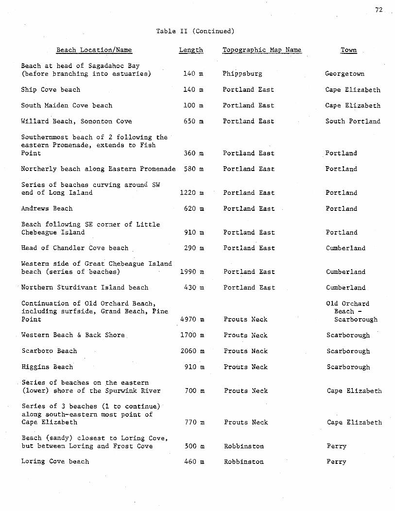
Table II (Continued)
Beach Location/Name Length
Beach at head of Sagadahoc Bay (before branching into estuaries) 140 m
Ship Cove beach 140 m
South Maiden Cove beach 100 m
Willard Beach, Sononton Cove 650 m
Southernmost beach of 2 following the eastern Promenade, extends to Fish Point 360 m
Northerly beach along Eastern Promenade 580 m
Series of beaches curving around SW end of Long Island 1220 m
Andrews Beach 620 m
Beach following SE corner of Little Chebeague Island 910 m
Head of Chandler Cove beach 290 m
Western side of Great Chebeague Island beach (series of beaches) 1990 m
Northern Sturdivant Island beach 43Q- m
Continuation of Old Orchard Beach, including surfside, Grand Beach, Pine Point 4970 m
Western Beach & Back Shore 1700 m
Scarboro Beach 2060 m
Higgins Beach 910 m
Series of beaches on the eastern (lower) shore of the Spurwink River 700 m
Series of 3 beaches (1 to continue) along south-eastern most point of Cape Elizabeth 770 m
Beach (sandy) closest to Loring Cove, but between Loring and Frost Cove 500 m
Loring Cove beach 460 m
Topographic Map Name
Phippsburg
Portland East
Portland East
Portland East
Portland East
Portland East
Portland East
Portland East
Portland East
Portland East
Portland East
Portland East
Prouts Neck
Prouts Neck
Prouts Neck
Prouts Neck
Prouts Neck
Prouts Neck
Robbinston
Robbinston
72
Georgetown
Cape Elizabeth
Cape Elizabeth
South Portland
Portland
Portland
Portland
Portland
Portland
Cumberland
Cumberland
Cumberland.
Old Orchard Beach ... Scarborough
Scarborough
Scarborough
Scarborough
Cape Elizabeth
Cape Elizabeth
Perry
Perry

Table II (Continued)
Beach Location/Name
Gin Cove beach (2)
·Beach north of Lewis Cove's mouth
Lucia Beach
East of Lucia Beach beach
Beach south of Crockett Point
Beach NW of Ginn Pt., head of cove
Crescent Beach
Holiday Beach (2-part)
Owls Head Harbor/Bay beaches
Beaches between Shag rock & Coast Guard Light
-directed beach at foo~ of Ingraham Hill, S-arm of Rockland Harbor
N westside of Shoppee Point beach
Great Cove SE side beach
Roque Bluffs beach
Mack Cove beach
Johnson Cove beach
Grays Beach
Small beach N of Grays Beach
Starboard Cove beach
Sand Beach, Tohman Cove
SW Hermit Island beaches (2)
Head Beach
· ead Cove beach
Bald Head Cove beaches (2)
Length
530 m
170 m
220 m
310 m
460 m
500 m
1100 m
650 m
740 m
380 m
310m
580 m
720 m
910 m
260 m
430 m
240 m
170 m
890 m
340 m
290 m
360 m
100 m
340 m
Topographic Map Name
Robbinston
Robbinston
Rockland
Rockland
Rockland
Rockland
Rockland
Rockland
Rockland
Rockland
Rockland
Roque Bluffs SW 1/4
Roque Bluffs SW 1/4
Roque Bluffs SW 1/4
Roque Bluffs SW 1/4
Roque Bluffs SW 1/4
Roque Bluffs SW 1/4
Roque Bluffs SW 1/4
Roque Bluffs SW 1/4
Small Point
Small Point
Small Point
Small Point
Small Point
73
Town
Perry
Perry
Owls Head
Owls Head
Matinicus Island Plantation
Matinicus Island Plantation
Owls Head
Owls Head
Owls Head
Owls Head
Owls Head
Roque Bluffs
Roque Bluffs
Roque Bluffs
Roque Bluffs
Roque Bluffs
Roque Bluffs
Roque Bluffs
Machiasport
Phippsburg
Phippsburg
Phippsburg
Phippsburg
Phippsburg

Table II (Continued)
Beach Location/Name Length
Seal eave's upper NE corner beach 100m
Southernmost of the 2 beaches on Cape Small's eastern side 260m
Northerly of the 2 beached on Cape Small's eastern side 650 m
Small Point beach (Seawall) 2450 m
Popham Beach (State Park and Hunnewell incl.) 4030 m
Beach between Coleman Cove and Johnson Cove area, Great Chebeague Island 790 m
North Waldo Point beach, Great Chebeague Island 500 m
Upper quadrant of Placentia Island, eastern side beach
NE tip of Placentia Island
Beach on western side of peninsula containing Hockamock Head
Head of Toothacher Cove beach
Series of Toothacher Cove beaches
Beach in cove NW of Irish Point
Lalrey's Island, NE tip beach
Western Robert's Harbor beach
SE-directed beach (towards Green Island) NE of Arey Cove - 2
Beach on southernmost of 700 Acre Island
Ogunquit & Moody Beaches
Crescent Surf
Crescent Surf, Parson Beach
Drakes Island & Laudholm Beach
410 m
360 m
170 m
30 m
310 m
260 m
190 m
120 m
190 m
1130 m
4370 m
1010 m
1220 m
940 m
Topographic Map Name
Small Point
Small Point
Small Point
Small Point
Small Point
South Harpswell
South Harpswell
Swans Island NE 1/4
Swans Island NE 1/4
Swans Island NW 1/4
Swans Island NW 1/4
Swans Island NW 1/4
Swans Island NW 1/4
Vinalhaven sw 1/4
Vinalhaven SE 1/4
Vinalhaven SE 1/4
Vinalhaven NW 1/4
Wells
Wells
Wells
Wells
74
Phippsburg
Phippsburg
Phippsburg
Phippsburg
Phippsburg
Cumberland
Cumberland
Long Island
Long Island
Swans Island
Swans Island
Swans Island
Swans Island
Vinalhaven
Vinalhaven
Vinalhaven
Isleboro
Wells
Wells
Wells
Wells

Table II (Continued)
Beach Location/Name Length
Beach along Baileys Mis~ake 960 m
Whiting Bay, southwestern shore beach 460 m
Wildwood Park beach 820 m
Lane's Island, Yarmouth 530 m
Long Beach & 2 smaller northern beaches 2180 m
Short Sands beach
N Wadleighs Head beach
Beach to east of York Harbor, between harbor and E Point
Cow Beach
410 m
530 m
430 m
240 m
Topographic Map Name
West Lubec
Whiting
Yarmouth
Yarmouth
York Beach
York Beach
York Beach
York Harbor
York Harbor
75
Town
Lubec
Trescott
Yarmouth
Yarmouth
York
York
York
York
York

General Considerations in Developing Criteria for Inclusion in the List of
Significant Coastal Sandy Beaches and Dunes
1. Only geological and botanical criteria are considered.
2. Beach and dune areas must be in a natural state. There must be few
or no houses, roads, parking lots, earthworks or planted vegetation.
76
More than 50% of Maine's limited coas.tal dune areas are heavily developed.
Often just the presence of an undeveloped sandy beach or dune area is a
criterion for significance because natural beach and dune fonns and dune
vegetation have been obliterated on most of Maine's coastal beaches.
Examples of such drastic human impact on the limited dune and dune plant
acreage of Maine are found at Long Sands, Ogunquit, Moody, Wells, Drakes
Island, Kennebunk, Goose Rocks, Fortunes Rocks, Hills, Saco, Old Orchard
and Higgins Beaches.
Beachfaces backed by extensive seawalls are not included as signi-
ficant natura1 areas. Such seawalls alter the shape of the beachface
profile by preventing normal responses to storm waves, constructional
waves and wind.
3. The geographic distribution of Maine's beaches is a factor in con-
sidering their significance. Beaches of different areas owe their
existence to various origins. In areas where beaches are rare, the
presence of even a small beach or dune area is significant.
4. Scientific and educational values are strong criteria for signi-
ficance. A beach or dune area may have excellent examples of certain
geomorphic features or geological processes. The same is true for
.botanical features and processes.

77
Geological Criteria for Significance
Two criteria were developed to determine the significance of a beach or dune area. One criterion was whether an area constituted a good example of the various geomorphic types and features. The second criterion was to include those examples which, either through their dune and beachface morphology or actual response behaviour, manifest the interaction between the physical elements of beach systems and various process agents. These criteria produced two lists, those geomorphic types and features which occur in Maine and those various process agents which leave their imprint on Maine beaches and dunes. These lists are as follows:
I. Beach and Dune Geomorphic Types and Features
A. Beach Types According to the Plan View
1. Fringing Beaches
a. Fringing pocket
b. Fringing delta
c. Fringing strandplain
d. Large fringing beaches
2. Barrier Beaches
a. Pocket barrier
b. Former marine lagoon or marsh
c. Cuspate barrier
3. Tombolos
a. Comet's tail
b. Normal to wave approach
4. Cuspate Forelands
5. Spits
a. Simple
b. Recurved - includes baymouth barrier-spit beaches
c. Complex
d. Double
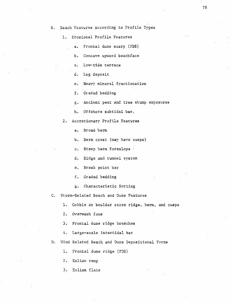
78
B. Beach Features According to Profile Types
1. Erosional Profile Features
a. Frontal dune scarp (FDS)
b. Concave upward beachface
c. Low-tide terrace
d. Lag deposit
e. Heavy minera~ fractionation
f. Graded bedding
g. Ancient peat and tree stump exposures
h. Offshore subtidal bar.
2. Accretionary Profile Features
a. Broad berm
b. Berm crest (may have cusps)
c. Steep berm foreslope
d. Ridge and runnel system
e. Break point bar
f. Graded bedding
g. Characteristic Sorting
C. Storm-Related Beach and Dune Features
1. Cobble or boulder storm ridge, berm, and cusps
2. Overwash fans
3. Frontal dune ridge breaches
4. Large-scale intertidal bar
D. Wind Related Beach and Dune Depositional Forms
1. Frontal dune ridge (FDR)
2. Eolian ramp
3. Eolian flats

4. Rear dune ridge
5. Accretionary ridge and swale topography
6. Parabolic dunes and slacks
7. Onshore oriented blowouts
8. Precipitation dunes
E. Sedimentary Structural Features
l. Swash marks
2. Ripple marks - many types
3. Groundwater rill marks
4. Rhomboid marks
5. Current crescents and V-swash marks
6. Beach laminations
7. Wind formed cross-bedding
F. Ebb Tidal Delta and Flood Tidal Delta Features
II. Process Agents Which Leave an Imprint on Beach and Dune Morphology and Which Influence Beach and Dune Response Behavior.
A. Relative Sea Level Rise
79
1. Maine's beaches provide evidence of sea level rise rates, knowledge of which is essential for coastal zone planning.
2. Transgressive facies (barrier and salt marsh formation), erosion and shoreline recession are results of sea level rise.
B. Prevailing and Dominant Winds
1. Northeast storm winds - onshore directed
2. South to southwest winds - onshore directed
3. Northwest winds - offshore directed.
C. Waves
1. Storm waves
2. Constructional swell
D. Northeast Storms and Hurricanes

E.
F.
Currents
1. Tidal
2. River
3. Estuarine circulation
4. Gulf of Maine gyre
5. Longshore
Sand Supply
1. Influence of distribution of glacial outwash sediments on beach type and occurrence
2. River sand sources
3. Onshore transport of submerged glacial deposits
4. Wave erosion of upland glacial deposits
5. Biogenic carbonate sources
6. Wave erosion of local bedrock
Botanical Criteria for Significance
All undisturbed coastal sand dune and berm plant habitats in Maine
are significant simply because of their limited extent. Of the approxi-
mately 6,400 km of coastline in Maine, the three beaches with large
undisturbed dune fields (Popham, Reid and Seawall Beaches) represent
only 8.7 km of coastline length. Almost two thirds of Maine's original
major dune fields are now heavily developed or altered by foot traffic
erosion and dike construction. These beaches with major dune fields
which are now disturbed represent 18 km of coastline (Ogunquit, Moody,
80
Wells, and Old Orchard Beaches). Smaller scale dune and berm plant habitats
which remain undisturbed are also significant because such habitats are rare
in Maine. This is particularly true north of Reid State Park where there
are no large dune fields or broad accre,tive berms. The attractiveness of

81
beach and dune areas for potentially damaging recreational and development
uses, coupled with the fact that these usage pressures are concentrated
on only one to two percent of Maine's coastline, make identification
and description of Haine's natural dune and berm plant habitats urgent.
Additional criteria for the determination of significant coastal
sandy dune and berm plant habitats are based on the following botanical
features.
A. Landward to seaward zonation caused by salt spray effects,
soil nutrient changes, and sand burial or deflation rates.
B. Mosaic floristic patterns in stabilized parabolic dune fields.
The distribution and abundance of plants in these habitats
are functions of depth to water table, successional age,
sand burial and deflation rates, and age since last eolian
activity.
C. Dune field successional stages subsequent to accretion, fire,
foot traffic, grazing, cutting or eolian activity.
D. Vegetation development in overwashes and breaches.
E. Vegetation patterns on perennially accreting berms and spits.
F. Good stands of species with limited acreage in the state; e.g.
American Beachgrass, Beach Heather, Wormwood, Jointweed.
G. Disjunct populations, especially stands of American Beachgrass
north of Reid State Park. These are of value for scientific
study of speciation as well as geographic trends in environ-
mentally and genetically controlled traits.
H. Geographic trends in abundance or ecotype which are of scientific
value. To discern and study these trends it is necessary to main-
.tain a continuum of natural habitats along the geographic axis in
question.

82
The presence or abundance of many species have been found to decrease
from south to north but these trends are already difficult to
study in detail because of excessive development on most of
Maine's southern beaches (Figure 19).
I. The known and possible range limits of coastal sandy dune and
berm plants in Maine, are as listed below:
1. Wormwood - Artemisia caudata The northern coastal range limit for the Atlantic coast of North American is at Crescent Beach State Park (Figure 20).
2. Beach Plum - Prunus maritima The northern coastal range limit for the Atlantic coast of North America appears to be Main Beach, Cape Elizabeth. There is one collection from Isle Au Haut which may have been introduced (Figure 21).
3. Beach Heather - Hudsonia tomentosa The northern coastal limit within Maine is Reid State Park. The plant reappears on Canadian beaches (Figure 22).
4. Earthstar Puffball - Geaster hygrometricus This dune mushroom reaches its northern coastal range limit at either Seawall or Popham. It may be found in sandy waste areas further north and in Canada (Figure 23).
5. Jointweed - Polygonella articulata The northern coastal limit within Maine is Reid State Park. This may also be the northern coastal limit for the Atlantic coast of North America (Figure 24) ·•
6. Pinweed - Lechea spp. Lechea maritima and L. intermedia are easily confused. The northern coastal range limit for L. maritima on the Atlantic coast of North America may be within Haine. Distinction between the two species during field checking for this report was not possible.
7. Seaside Spurge- Euphorbia polygonifolia This is a common berm annual on Hassachusetts beaches but has been found on only two small Maine beaches. There was one collection in 1880 on Wells Beach. Maine specimens are much smaller than Massachusetts specimens. The plant has also been collected in non-dune habitats in Maine (Figure 25).
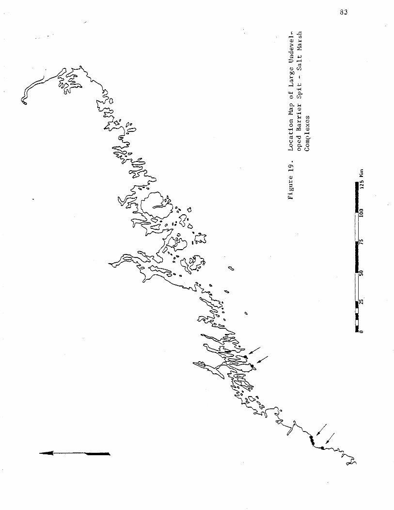


90
General Information on Coastal Sandy
Dune Plant Species and Associations
Coastal sandy dune plants of New England have peculiar physiologic
morphologic, and life cycle features which enable them to survive and
compete in a highly stressed environment. The major stresses which
these plants endure are:
1. Salt spray
2. Sand burial and sand removal
3. Extreme soil temperature changes
4. Extreme soil moisture changes
5. Extreme soil chemistry changes (including nutrients and salinity)
6. Extreme air moisture changes.
Dune plant community structure is a function of changes in the
above stress factors as well as the processes of overwash, erosion,
accretion, frontal dune ridge formation, wind deflation and parabolic
dune activity. The floristic patterns of coastal dunes are both zonal
(landward to seaward) and mosaic. Mosaic patterns are most evident in
recently active parabolic dune fields where the plant cover types reflect
mosaicism controlled by depth to water table, sand burial and deflation
rates, protection from salt spray, and age since last eolian activity.
Dune plants have interesting morphologic and physiologic features
which enable them to resist dessication and compete under stress. These
features are as follows:
1. Rapid growth after burial - American Beachgrass Ammophila breviligulata can survive up to 1 m of sand burial (14) and in fact is healthier when buried by a few em of sand each year. Beach Heather, Hudsonia tomentosa, also can tolerate burial, though only a few em.

2. Hairy leaves - this prevents evaporation. The best examples are Dusty Miller - Artemisia stelleriana and Beach Heather -Hudsonia tomentosa.
91
3. Thick cuticle - this reduces evaporation. Virtually all dune plants have this feature. Shrubs on the dunes have thicker cuticles than the same species inland.
4. Succulence - this decreases the surface to volume ratio and reduces evaporation loss. Succulence is illustrated by Sea Rocket, Cakile edentula; Seabeach Sandwort, Arenaria peploides; Saltwort, Salsola kali; and Orach, Atriplex patula, var. hastata or !:._. arenaria. Some plants have reduced leaves for the same reason, e.g. Jointweed, Polygonella articulata, and Saltv.7ort, Salsola kali. Upland shrubs on the dunes have more succulent leaves than the same species inland.
5. Sunken stomates - this permits gas exchange without loss of water. The best example is American Beachgrass.
6. Curled leaves - this also prevents loss of water from the gas exchange surface. Examples are American Beachgrass and Broom Crowberry, Corema conradii.
7. C -Photosynthesis- this is a physiologic adaptation common to pl~nts of stressed environments. Sea Beach Orach is an example.
The results of a major study of botanical ecology in Maine's
coastal dunes are contained in a report by Phillip Trudeau, University
of Massachusetts, e~titled, HBeach Vegetation and Oceanic Processes
Study of Popham State Park Beach, Reid State Park Beach and Small
Point Beach''. For a detailed discussion of the botany of Maine's.
three largest remaining natural dune fields, this report is available
from the Soil Conservation Service, USDA, in Waldoboro, Maine.
The area descriptions of Popham, Reid and Seawall (Small Point) Beaches
later in this report also contain a botanical overview of these areas.
Trudeau recognizes five basic plant communities which can be characterized
by dominant species and sub-associations, as follows:

I. Foredune Corrnnunity
This is the area seaward of the frontal dune ridge. and has two
zones:
A. Seasonal Berm - this zone is flooded by spring high tides or
winter storms. The plants are annuals which grow rapidly and
produce many seeds.
1. Sea Rocket - Cakile edentula
2. Saltwort - Salsola kali
92
B. Eolian Ramp or Perennial Berm - These are recently accreted
areas with wind deposited sand now above the reach of spring tides
and storms.
1. American Beachgrass - Ammophila breviligulata
2. Beach Pea- Lathyrus·japonicus
3. Dusty Miller - Artemisia stelleriana
II. Dunegrass Community
The dunegrass community, dominated by American Beachgrass, runs
from the frontal dune ridge inland to a heath or shrub community.
Species diversity is low, there is no soil, few nutrients, and salt
spray is heavy. Three subassociations occur in addition to the
monotypic beachgrass.
A. Monotypic - pure American Beachgrass
B. American Beachgrass and Beach Pea Lathyrus japonicus
C. American Beachgrass and Raspberry - Rubus idaeus
D. American Beachgrass and Gooseberry - Ribes sp.
III. Dry Dune Slack Community
This community is found on dry inland dunes when salt spray and
sand burial rates are lower than those for the Dunegrass Community.
The extreme variability of the dry dune slack community is of

93
interest to plant ecologists. Beach Heather, Hudsonia tomentosa
is the community dominant and its occurrence is significant since
there are probably fewer than 40 hectares of this plant in Maine, and
the bulk of this is found at Reid and Seawall. Associated plants
are:
Pinweed - Lechea maritima
Pinweed Aster - Aster linariifolius
Lichens - Cladonia spp.
Jointweed - Polygonella articulata
Greene's Rush- Juncus Greenei
Sandy Sedge - Carex silicea
Early Sedge - Carex pensylvanica
Some of the above plants will commonly be associated without Beach
Heather being present.
The presence of lichens in the backdune is peculiar to Haine and is
a result of the high incidence of coastal fog.
IV. Shrub Community.
This is a dense tangle of bushes .5 to 1.7 meter high. The dom
inants are:
Bayberry - Myrica pensylvanica
Virginian rose - Rosa virginiana
Meadow sweet - Spiraea latifolia
Raspberry - Rubus idaeus
Stands may be monotypic or in various mixtures. Poison Ivy - Rhus
toxicodendron and Gooseberry are common additions. Cherry - Prunus
spp. and Serviceberry - Amelanchier spp. are found at the edge of
this community.

94
V. Dune Forest Community
In the deficient soil of inactive parabolic dunes and under the
stress of salt spray, forests are dominated by Pitch Pine - Pinus
rigida. Three successional stages toward the edaphic (soil) climax
Pitch Pine forest are commonly observed:
1. Semi-open with Beach Heather and Cladonia lichens between
trees.
2. Widely spaced Pitch Pines with thick shrubs in between.
3. Hature Dune Forest with Pitch Pine, Red Maple - Acer rubrum,
Red Oak- Quercus rubra, White Birch - Betula papyrifera, Poplar
Populus sp, Serviceberry - Amelanchier sp. Dominant understory
species include many grasses, Canada Mayflower - Haianthemum
canadense, Star Flower - Trientalis borealis, Wild Sarsaparilla -
Aralia nudicaulis and Bunchberry - Cornus Canadensis.
An additional forest type community occurs in low, moist backdune
areas, where a low shrub~thicket forest is found. Dominants are
Alder- Alnus sp., Winterberry- Ilex verticillata, Serviceberry
and Poplar.
A partial listing of Haine's berm and dune plants follows. The
list was derived from collections and field studies by Nelson and
Trudeau.

Partial List of Maine's Berm and Dune Plants
I. Plants of the berm or dune habitats of Maine's beaches whi~h are not characteristic of other coastal or inland habitats.
A. Corrnnon.
1. American Beachgrass - Ammophila breviligulata Host -- the dominant plant of active and young dunes, especially the frontal dune ridge. It requires sand burial for vigor, . resists dessication and salt spray damage and is responsible for entrapment of sand in the frontal dune ridge.
95
2. Beach Pea - Lathyrus japonicus L. -- co-dominant with Ammophila in the frontal dune ridge and young nearshore dunes, it is a circumpolar annual which fixes nitrogen and resists salt spray and dessication.
3. Dusty Miller - Artemisia Stelleriana L. -- a perennial common on accreting berms, on the frontal dune ridge and on young dunes.
4. Sea Rocket - Cakile edentula Hill -- annual; dominant plant of the berm; found on most beaches, large or small, sandy or rocky. This plant is easily dispersed.
5. Saltwort - Salsola Kali 1. -- annual; minor plant of the berm; widespread occurrence; easily dispersed.
6. Sea Blite -- Suaeda maritima Forskel -- annual; minor plant of the berm; widespread occurrence; easily dispersed; more common on rocky berms.
B. Occasional or patchy (including geographical gradients in frequency).
1. Beach Heather - Hudsonia tomentosa L. -- occurs on stable sand surfaces and in stabilized parabolic dune slacks. This plant is locally abundant where foot traffic damage is m~nlmal. Its potential habitat is naturally limited. It is not highly tolerant of sand burial, invades new areas slowly, and is succeeded by other plants on long-stable sand. It may be allelopathic.
2. Seaside Pinweed - Lechea maritima Leggett -- occasional on stable sand surfaces ~ith Hudsonia tomentosa, Carex silicea and others; absent' or uncommon north of Sagadahoc County.
3. Seabeach Sandwort - Arenaria peploides 1. -- occasional on sandy berms.

96
4. Strand Wheat - Elymus arenarius L. -- occasional on stable, low sand volume beaches; more common on rocky beaches.
5. Sandy Sedge - Carex silicea Olney -- significant because it occasionally dominates stabilized parabolic dune slacks, an uncommon habitat in Maine.
6. Beach Plum - Prunus maritima Marsh -- associated with dunes though not always restricted to them, absent or very uncommon north of Portland.
7. Tall Wormwood- Artemisia caudata Mx. --characteristic of moderately stable back dunes; associated with Ammophila and Lathyrus; also reported from inland but not found on any beach north of Crescent Beach State Park.
C. Uncommon
1. Earthstar Puffball - Geaster hygrometricus -- this puffball is specifically adapted to the dune environment but has been found on only a few large baymouth barrier dune systems in Maine. The endemicity and habitat specificity of cryptogams of Maine's coastal dunes are not well known.
2. Seaside Spurge - Euphorbia polygonifolia 1. -- Common on the berm of Cape Cod but seldom seen on Maine's berms. This annual is locally abundant at Andrews Beach, Casco Bay and is reported from Hatinicus, Sagadahoc Co. and Brunswick. A few specimens were found on Lauds Island beach (Muscongus Bay).
II. Plants of the berm or dune habitats of Maine's beaches which are also characteristic of other coastal or inland habitats.
A. Xerophytes
1. Lichens - Cladonia spp. (rangifera, cristatella, unciabis, alpestris and others) -- may form pure lichen carpets in stabilized parabolic dry dune slacks, or in association with Hudsonia tomentosa. Lichen carpets on dunes are peculiar to Maine because of high fog incidence.
2. Haircap Moss - Polytrichum ~· (and other Bryophyta) -mixed with Lichens and Hudsonia tomentosa.
3. Broom Crowberry - Corema Conradii T. -- occurs on exposed rocky ledges, especially coastal granitic plutons with poor soil development, such as Mt. Desert. Locally abundant as ground cover in the pitch pine forest at Popham Beach.
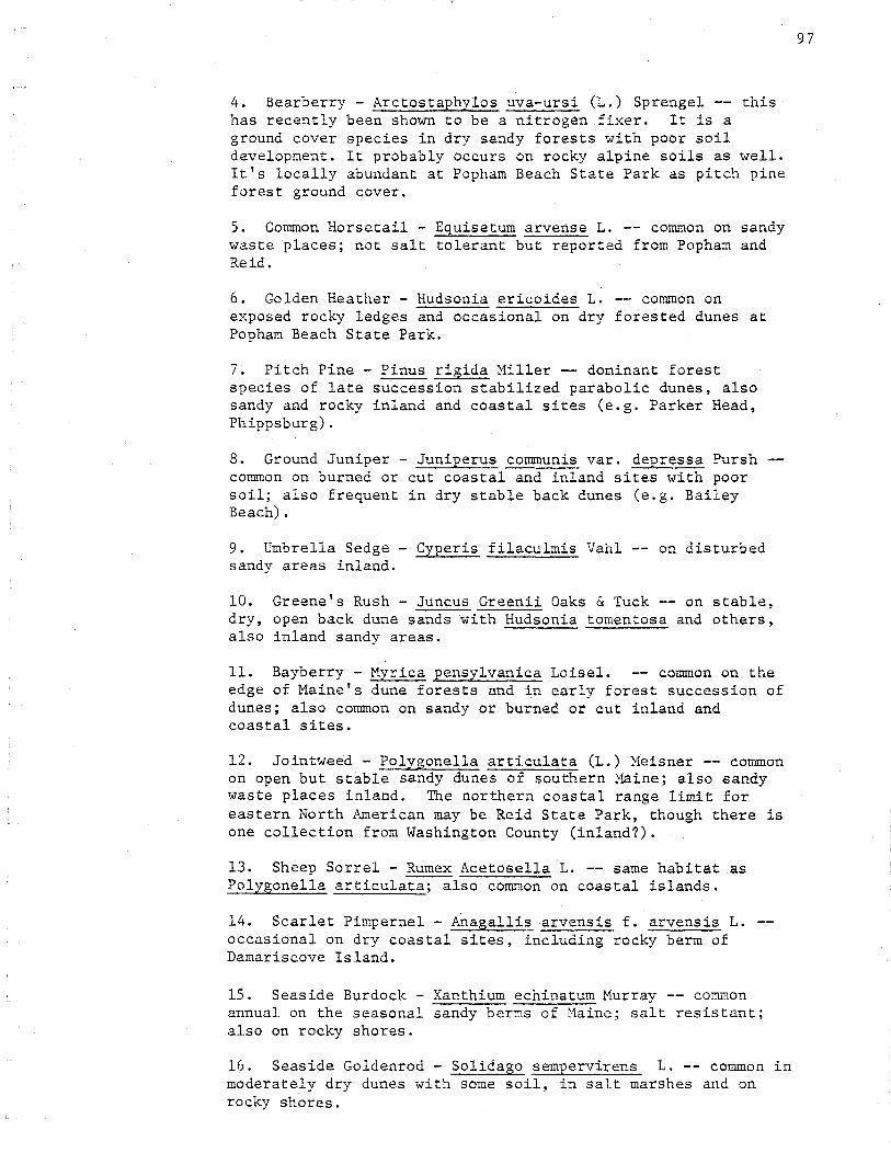
4. Bearberry- Arctostaphylos uva-ursi (L.) Sprengel -- this has recently been shown to be a nitrogen fixer. It is a ground cover species in dry sandy forests with poor soil development. It probably occurs on rocky alpine soils as well. It's locally abundant at Popham Beach State Park as pitch pine forest ground cover.
5. Common Horsetail - Equisetum arvense L. -- common on sandy waste places; not salt tolerant but reported from. Popham and Reid.
6. Golden Heather - Hudsonia ericoides L. -- common on exposed rocky ledges and occasional on dry forested dunes at Popham Beach State Park.
7. Pitch Pine- Pinus rigida Miller-- dominant forest species of late succession stabilized parabolic dunes, also sandy and rocky inland and coastal sites (e.g. Parker Head, Phippsburg).
8. Ground Juniper - Juniperus communis var. depressa Pursh common on burned or cut coastal and inland sites with poor soil; also frequent in dry stable back dunes (e.g. Bailey Beach).
9. Umbrella Sedge - Cyperis filaculmis Vahl -- on disturbed sandy areas inland.
10. Greene's Rush - Juncus Greenii Oaks & Tuck -- on stable, dry, open back dune sands with Hudsonia tomentosa and others, also inland sandy areas.
11. Bayberry - Myrica pensylvanica Loisel. -- common on the edge of Maine's dune forests and in early forest succession of dunes; also common on sandy or burned or cut inland and coastal sites.
12. Jointweed - Polygonella articulata (L.) Meisner -- common on open but stable sandy dunes of southern Maine; also sandy waste places inland. The northern coastal range limit for eastern North American may be Reid State Park, though there is one collection from Washington County (inland?).
13. Sheep Sorrel - Rumex Acetosella L. -- same habitat as Polygonella articulata; also common on coastal islands.
14. Scarlet Pimpernel - Allagallis arvensis f. arvensis L. occasional on dry coastal sites, including rocky berm of Damariscove Island.
15. Seaside Burdock- Xanthium echinatum Murray -- common annual on the seasonal sandy berms of Maine; salt resistant; also on rocky shores.
16. Seaside Goldenrod - Solidago sempervirens L. -- common in moderately dry dunes with some soil, in salt marshes and on rocky shores.
97

17. Pinweed Aster, Spruce Aster -Aster linariifolius L. -extensive occurrence with Hudsonia tomentosa in stabilized parabolic dune slacks at Seawall Beach; ·also in sandy waste places inland and as occasional ground cover in pitch pine dune forest.
18. Seaside Rose - Rosa rugosa Thurb. species; an important dune shrub.
ubiquitous coastal
19. Orach- Atriplex patula var. hastata (L.) G. -- connnon annual on the seasonal sandy berms of Maine; salt resistant; also in salt marshes.
20. Sand Orach - Atriplex arenaria Nutt. -- occasional ori sandy berms and other shores.
21. Coast Blite - Chenopodium rubrum L. -- occasional on sandy berms, salt marshes and other ocean shores.
B. Mesophytes and Hydrophytes (excluding salt marsh plants)
* -- indicates importance in open dunes or early dune succession
1. Shadbush· - Amelanchier laevis
*2. Strawberry - Fragaria sp.
"""3. Low Rose - Rosa virginiana L.
4. Pasture Rose - Rosa caroliniana L.
*5. Raspberry - Rubus idaeus L.
*6. Blackberry - Rubus sp. (subspecies eubatus)
*7. Meadow Sweet - Spiraea latifolia DuRoi
8. Black cherry - Prunus serotina Ehrh.
9. Choke Cherry- Prunus virginiana L.
10. Pin Cherry - Prunus pensylvanica L.
11. Black Chokeberry- Pyrus melanocarpa (Michx.) Wi1ld.
12. Hardhack - Spiraea tomentoss 1.
*13. Cinquefoil - Potentilla sp.
14. Hawthorn~ - Crataegus sp.
98

*15. Wrinkled Goldenrod - Solidago rugosa Aiton
*16. Goldenrod - Solidago spp.
*17. Ragweed- Ambrosia artemisifolia L.
99
*18. Pearly Everlasting- Anaphalus margaritacea (L.) B. & H.
*19. Pineapple weed- Matricaria matricarioides (Less.) Porter
*20. Fall Rattlesnake Root - Prenanthes trifoliata (Cass.) F.
*21. Toothed Hawkweed - Hieracium canadense Mx.
*22. Spiney Leaved Sow Thistle - Sonchus asper (L.) Hill
*23. Field Sow Thistle - Sonchus arvensis L.
'~<24. Flat-topped White Aster - Aster umbellatus Miller
*25. Common Yarrow - Achillea Millefolium L.
*26. Low Sweet Blueberry ~ Vaccinium angustifolium Aiton
27. Black Huckleberry- Gaylussacia baccata (Wang.) K. Koch
28. Sheep Laurel - Kalmia angustifolia L.
29. Bog .Cranberry - 0.xycoccus · macrocarpus (Aiton) Purs.
30. Maleberry- Lyonia ligustrina (L.) DC.
*31. Gooseberry - Ribas sp.
*32. Poison Ivy - Rhus toxicodendron L.
33. Staghorn Sumac - Rhus typhina L.
34. Winterberry - Ilex verticillata (L.) G.
*35. Common St. Johns ... wort - Hypericum perfoliatum
*36. Tufted Vetch - Vicia cracca L.
*37. Yellow Clover - Trifolium agrarium L.
38. Red Maple - Acer Rubrum L.
39. Striped Maple - Acer pensylvanicum L.
40. Fireweed - E:eilobium an~ustifolium L.
L.
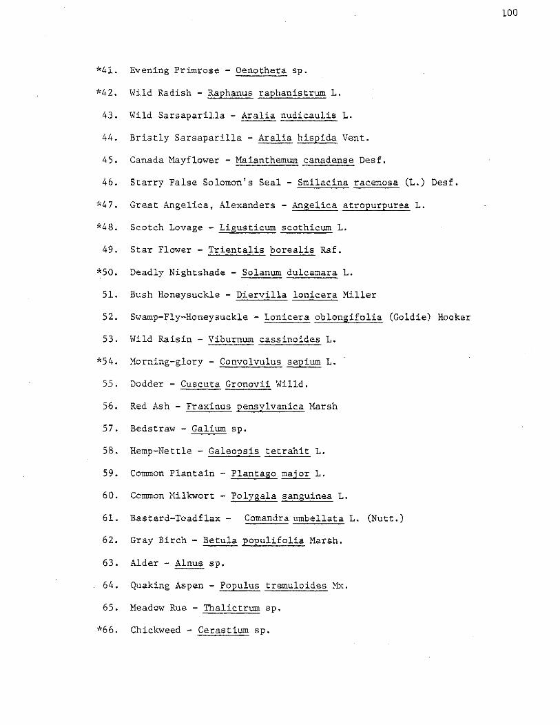
*41. Evening Primrose - Oenothera sp.
*42. Wild Radish - Raphanus raphanistrum L.
43. Wild Sarsaparilla - Aralia nudicaulis L.
44. Bristly Sarsaparilla - Aralia hispida Vent.
45. Canada Mayflower - Maianthemum canadense Desf.
46. Starry False Solomon's Seal- Smilacina racemosa (L.) Desf.
*47. Great Angelica, Alexanders- Angelica atropurpurea L.
*48. Scotch Lovage - Ligusticum scothicurn L.
49. Star Flower - Trientalis borealis Raf.
*50. Deadly Nightshade - Solanum dulcamara L.
51. Bush Honeysuckle - Diervilla lonicera Miller
52. Swamp-Fly-Honeysuckle ;... Lonicera oblongifolia (Goldie) Hooker
53. Wild Raisin ..,.. Viburnum cassinoides L.
*54. Morning-glory - Convolvulus sepium L.
55. Dodder - Cuscuta Gronovii Willd.
56. Red Ash - Fraxin~s pensylvanica Marsh
57. Bedstraw- Galium sp.
58. Hemp-Nettle - Galeopsis tetrahit L.
59. Common Plantain - Plantago major L.
60. Common Milkwort - Polygala sanguinea L.
61. Bastard-Toadflax - Comandra umbellata L. (Nutt.)
62. Gray Birch - Betula populifolia Marsh.
63. Alder - Alnus sp.
64. Quaking Aspen - Populus tremuloides Mx.
65. Meadow Rue - Thalictrurn sp.
*66. Chickweed - Cerastium sp.
100

101
*67. Campion- Lychnis sp. or Silene sp.
68. Red Oak - Quercus rubrum 1.
69. Bunchberry - Cornus canadensis L.
*70. Yellow Dock - Rumex crispus L.
71. Shore Knotweed - Polygonum prolificum (Small) Robinson
72. White Spruce - Picea glauca (Moench) Voss
73. Red Spruce - Picea rubens Sarg.
74. Balsam Fir - Abies balsamia (L.) Miller
75. Blue Flag - Iris versicolor L.
76. Toad Rush - Juncus (bufonius?) L.
*77. Terrell Grass, Wild Rye- Elymus virginicus L.
*78. Quack Grass - Agropyron repens (L.) Beaur.
*79. Blue-joint @rass - Calamagrostis canadensis (Mx.) Nutt
*80. Redtop Grass - Agrostis alba L.
"{81. Kentucky Bluegrass - Po a pratensis L.
*82. Love Hairgrass - Deschampsia flexuosa Beauv.
*83. Spike Grass- Distichlis spicata (L.) Greene
*84. Sheep's Fescue- Festuca ovina L.
1~85 $ Red Fescue - Festuca rubra L.
*86. Timothy - Phleum pratense L.


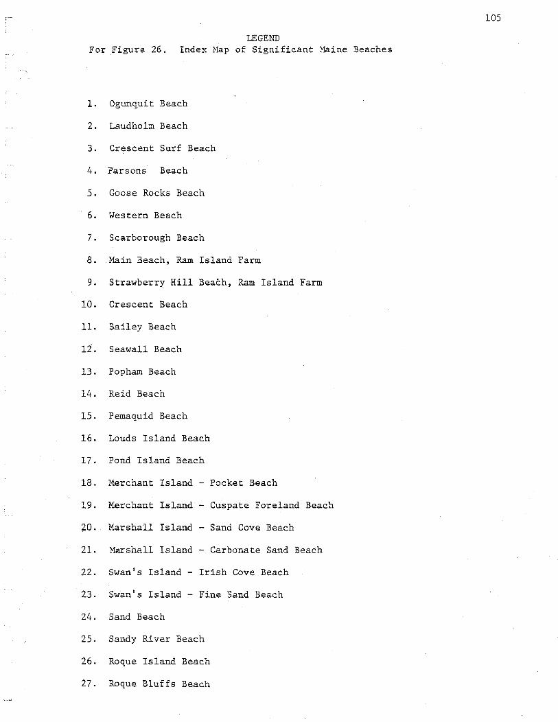
105
LEGEND For Figure 26. Index Map of Signifieant Maine Beaches
1. Ogunquit Beach
2. Laud holm Beach
3. Crescent Surf Beach
4. p·arsons Beach
5. Goose Rocks Beach
6. Western Beach
7. Scarborough Beach
8. Main Beach, Ram Island Farm
9. Strawberry Hill Beach, Ram Island Farm
10. Crescent Beach
11. Bailey Beach
lt. Seawall Beach
13. Popham Beach
14. Reid Beach
15. Pemaquid Beach
16. Lauds Island Beach
17. Pond Island Beach
18. Merchant Island - Pocket Beach
19. Merchant Island - Cuspate Foreland Beach
20. Marshall Island - Sand Cove Beach
21. Marshall Island - Carbonate Sand Beach
22. Swan's Island - Irish Cove Beach
23. Swan's Island Fine Sand Beach
24. Sand Beach
25. Sandy River Beach
26. Roque Island Beach
27. Roque Bluffs Beach

DESCRIPTIONS OF SIGNIFICANT MAINE SANDY BEACHES
Ogunquit Beach, York County
Description of Geological Features
Ogunquit and Moody Beaches together comprise the largest barrier
spit, tidal river, and marsh complex in Maine (Figure 2_7). The total
area of the beach-marsh ecosystem is 285 hectares. The only other such
complex of comparable size is Seawall Beach in Phippsburg. The surface
features (dunes and vegetation) of Moody have been obliterated, Ogunquit's
have been drastically altered, while Seawall's dunes and vegetation
remain in a largely natural state.
The Ogunquit - Hoody barrier spit has formed by transgression of
the sea over a lo~lying coastal plain glacial outwash sheet. Some of
the barrier sand is derived from alongshore and onshore transport of
submerged glacial outwash.
The portion of Ogunquit between the sewage treatment plant to the
north and the Norseman Motel to the south, retains significant natural
features in the beachface, dunes and dune vegetation. The large spit
end has been drastically altered by being stabilized with pavement.
Recently a 42 m wide dike (~4 m high with 5:1 side slopes) was
constructed for about an 1800 meter length behind the normal winter high
water line. The dike was constructed in two sections using different
borrow material for each. The southern section, 490 meters long was
built with sand from a flood tidal delta in the Ogunquit River directly
behind the beach. The second section, 1310 meters long, utilized glacial
outwash sediments from an inland borrow pit. The dike has been stabilized
with planted and fertilized American Beachgrass, Ammophila breviligulata.
106

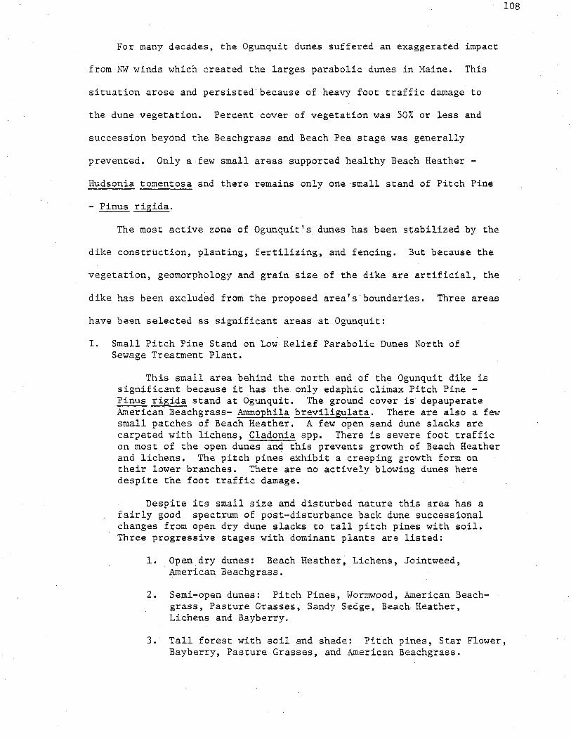
For many decades, the Ogunquit dunes suffered an exaggerated impact
from NW winds which created the larges parabolic dunes in Maine. This
situation arose and persisted because of heavy foot traffic damage to
the dune vegetation. Percent cover of vegetation was 50% or less and
succession beyond the Beachgrass and Beach Pea stage was generally
prevented. Only a few small areas supported healthy Beach Heather -
Hudsonia tomentosa and there remains only one small stand of Pitch Pine
- Pinus rigida.
The most active zone of Ogunquit's dunes has been stabilized by the
dike construction, planting, fertilizing, and fencing. But because the
vegetation, geomorphology and grain size of the dike are artificial, the
dike has been excluded from the proposed area's boundaries. Three areas
have been selected as significant areas at Ogunquit:
I. Small Pitch Pine Stand on Low Relief Parabolic Dunes North of Sewage Treatment Plant.
This small area behind the north end of the Ogunquit dike is significant because it has the only edaphic climax Pitch Pine -Pinus rigida stand at Ogunquit. The ground cover is depauperate American Beachgrass- Ammophila breviligulata. There are also a few small patches of Beach Heather. A few open sand dune slacks are carpeted with lichens, Cladonia spp. There is severe foot traffic on most of the open dunes and this prevents growth of Beach Heather and lichens. The pitch pines exhibita creeping growth form on their lower branches. There are no actively blowing dunes here despite the foot traffic damage.
Despite its small size and disturbed nature this area has a fairly good spectrum of post-disturbance back dune successional changes from open dry dune slacks to tall pitch pines with soil. Three progressive stages with dominant plants are listed:
1. Open.dry dunes: Beach Heather, Lichens, Jointweed, American Beachgrass.
2. Semi-open dunes: Pitch Pines, Wormwood, American Beachgrass, Pasture Grasses, Sandy Sedge, Beach Heather, Lichens and Bayberry.
108
3. Tall forest with soil and shade: Pitch pines, Star Flower, Bayberry, Pasture Grasses, and American Beachgrass.

There is a very striking difference in speciation and diversity between this area and the nearby dike (see slide). The area should be fenced off and foot traffic prevented. This will encourage growth of Beach Heather and lichens.
A partial species list follows:
1. Jointweed - Polygonella articulata 2. Wormwood - Artemisia caudata 3. Bayberry - Myrica pensylvanica 4. ? Sedge 5. Pinweed - Lechea maritima 6. Hawthorne - Crataegus sp. 7. Shadbush - Amelanchier sp. 8. Seaside Goldenrod - Solidago sempervirens 9. Beach Heather - Hudsonia tomentosa
10. American Beachgrass - Ammophila breviligulata 11. Lichens - Cladonia spp. 12. Star Flower - Trientalis borealis 13. Sandy Sedge - Carex silicea 14. Pasture grasses
There are several species on the disturbed edge of the area (paved roadside) which are not listed above.
II. Active High Relief Parabolic Dunes Between Sewage Treatment Plant and Norseman Motel and Behind Dike.
This second area can be divided into two sections. North of the footbridge the parabolic dunes are of lower relief and better stabilized with vegetation. These lower dunes receive less foot traffic because they are not part of the thorofare between the footbridge and. the beach and because two snowfences run across the area in an east-west direction. There are more plant species here than in the more active dunes to the south of the footbridge. Particularly notable are the Wormwood -Artemisia caudata and Beach Heather - Hudsonia tomentosa. The area between the footbridge and the sewage treatment plant (especially roadsides and disturbed gravelly areas) has the best stands of Worm-wood - Artemisia caudata yet seen in the state of Maine.
South of the footbridge is a zone of high relief, active and badly eroded parabolic dunes formed by strong northwest winds. This area between the dike and the Ogunquit River indicates what most of Ogunquit's dune area looked like before dike construction. The area behind the dike is still the largest, active, high relief parabolic dune area in Maine (thus a significant geological feature). Some of the active parabolic dunes are encroaching on the backside of the dike.
Before construction of the dike, Ogunquit's barrier spit was occasionally breached by winter storms which flowed through blowouts
109

created by offshore winds (i.e. northwest-wind-oriented parabolic dunes). These breaches accumulated seaweed and other flotsam which permitted colonization by ruderals such as Hawkweeds, Seaside Burdock and Mustards. Some of these weeds are still found behind the dike at the site of former breaches.
In general, species diversity is very low in the high, active parabolic dunes. There are no good stands of Beach Heather. Dominants are American Beachgrass, Beach Pea and Wormwood.
The western boundary of the second proposed critical area follows the dune/ march or dune/river shore boundary. In some places there is a rear berm-like habitat of sand flooded only during spring tide. There is a zonation here mirroring that usually found on the front of the
110
beach. Near the high water line are Seaside Burdock - Xanthium echinatum, Saltwort - Salsola kali, Sea Blite - Suaeda maritima, and Seabeach Orach -Atriplex patula var-:-hastata or !:_ arenaria all of which depend on flotsam for nutrients. In windblown sand above spring high water, but also dependent on flotsam from storm floods and surges, grow Dusty Miller - Artemisia Stelleriana and Seaside Goldenrod - Solidago sempervirens. Along snow fence edges and in the high flotsam of the back dune edge is Strand Wheat - Elymus arenarius. This mirror image occurrence of plant zonation can be attributed to the strong role played by the northwest winds at Ogunquit.
III. Beachface Between Sewage Treatment Plant and Norseman Motel.
When field checked, Ogunquit's beachface provided one of the best examples in "tA"..aine of a summer constructional profile, which consisted of a 40 m wide berm between the toe of the dike and high water, and, below the steep berm foreslope, a ridge and runnel system of exaggerated relief with rip current exit channels through the ridge at regular intervals.
The Ogunquit beachface is recognized as a significant area because it provides excellent examples of certain geomorphic features and expressions of beachface processes. Field studies over the last two years have shown that the distance from spring high water to spring low water has averaged about 250 m. This makes the beach width of Ogunquit larger than most of Maine's beaches. The unusual width may be due to a large available sand supply and the texture of the sand, which is fine grained, well sorted, and mineralogically pure (i.e. quartz rich).
In late summer of 1977, Ogunquit's beachface showed far more exaggerated constructional features than in two previous summers. There was a 30 to 40 meter wide berm and high relief ridge and runnel system. However, monthly profiles taken since 1975 show that the average beachface elevation has lowered slightly. This may be either a natural oscillation or the result of loss of sand formerly contributed to the beachface by offshore-directed wind transport of sand through the

northwest-wind-oriented parabolic dunes.
Air photos since 1952 indicate little or no historical perennial accretion or erosion of Ogunquit, but the storms of Jan. 9 and Feb. 7, 1978 caused major retreat of the erosional scarp into the artificial dike and recently unprecedented lowering of the upper beachface surface. Mid and lower beachface lowering was no greater than in the previous winter.
Tree stumps, probably embedded in peat, were exposed on the beachface after the storms of 1978. This is the only large barrier in Maine where stump exposures have been observed.
When field checked in the summer of 1977, the dike itself was responding to natural processes as follows:
1. There is an actively accreting embryonic frontal dune ridge behind the snowfence on the front of the dike, especially at the north end.
2. There was a winter scarp, partially healed, visible behind the snowfence at the front of the dike; it is particularly visible along the southern half of the dike where less windborne sand accretion has taken place. This scarp was greatly enlarged and the dike badly eroded by the storms of Jan. 9 and Feb 7, 1978.
3. There was a coarse wind-lag surface on the top and top rear of the dike with depauperate Ammophila and a deposited surface on the mid-front of the dike with healthy Ammophila. This sand shift has been caused by strong northwest winds and gives the dike a slight airfoil cross section.
Another notable feature outside the significant areas is the stand of Beach Plum - Prunus maritima near Beach Plum Lane and the footbridge parking lot.
Summary of Significant Features
A. Geological
1. Largest barrier spit - tidal river and marsh complex in Maine.
2. Low relief parabolic ·dunes stabilized with Pitch Pines.
3. Largest and most active parabolic dunes in Maine. Dunes are more severely influenced by winter northwest winds than any other Maine dunes.
4. Classical illustration of summer vs. winter beach face profile types due to onshore/offshore accr;tion and erosion.
111

Winter Beach Profile - long, flat or concave-upward beach face; dune scarp
Summer Beach Profile - Wide ( 40m) berm with steep foreslope, ex~ggerated-relief ridge and runnel system, and large accumulation of sand in berm and ridge
5. Absence of strong correlation between slope and mean grain size of sand (coarse sand sizes are absent)
6. Uniformly fine, nearly pure quartz sand, probably long removed from original source which suggests long distance onshore transport by winnowing from a larger submerged glacial outwash deposit or long term response to a dominant low energy wave regime which selects fine sand sizes.
7. No lag surface, but tree stumps were exposed on the beachface in March, 1978.
B. Botanical
1. Small example of edaphic climax Pitch Pine community
2. Best stands of Wormwood in Maine.
3. Some Hudsonia tomentosa
4. Presence of Beach Plum - Prunus maritima.
5. Three progressive stages of post-disturbance back-dune successional changes.
6. Seaside Spurge - Euphorbia polygonifolia was collected at Moody Beach in 1888. It possibly may be found at Ogunquit today but wasn't observed. This plant has only been found on two small Maine beaches but is a common berm plant of southern New England beaches.
C. Size
1. The total area of just the Ogunquit part of the ecosystem is 138 hectares, which includes 104 hectares of marsh and above high water sand, and 34 hectares of low-water to high water beach face.
112

Laudholm Beach
2 Drakes Island, Wells, York County
Description of Geologic Features
Laudholm Beach is the northeast end of the Drakes Island-Laudholm
barrier spit. Laudholm and Crescent Surf beaches, together, form double
spits which face one another in an overlapping fashion. The Little
River, a tidal reentrant with extensive back barrier salt marsh acreage,
drains out between the double spits. Long term drift of sand should be
toward the reentrant. The two spit ends are historically unstable since
relict frontal dune ridges are visible behind the present shorelines.
Laudholm, Crescent Surf, the Little River reentrant and the asso
ciated back barrier marshes form a single depositional sedimentary
system which is the best example in Maine of a sandy double barrier
spit-tidal river and marsh system remaining in a natural state. The
Wells Harbor entrance probably resembled this area before development,
dredging and jetty construction (Figure 28).
Laudholm Beach, as does Scarboro Beach, demonstrates a most in
teresting geological feature; the sundry ways in which diverse grain
size classes are separated into characteristical1ydefined layers and
features, such as aeolian ramp, berm foreslope, and low tide terrace.
Laudholm Beach consists of poorly sorted, coarse sand, pebbles, cobbles,
and boulders, which suggests recent transport from a local till source.
The size separation occurs in response to the energy levels and directions
of the transport agents. Most of the size contrasts and associations
with specific geomorphic features result from the relative ease with
which a particular size grade is mobilized by waves or winds and trans
ported to a specific location along the beach.
113

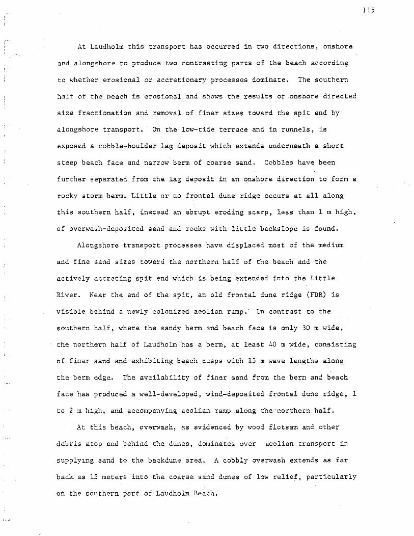
At Laudholm this transport has occurred in two directions, onshore
and alongshore to produce two contrasting parts of the beach according
to whether erosional or accretionary processes dominate. The southern
half of the beach is erosional and shows the results of onshore directed
size fractionation and removal of finer sizes toward the spit end by
alongshore transport. On the low-tide terrace and in runnels, is
exposed a, cobble-boulder lag deposit which extends underneath a short
steep beach face and narrow berm of coarse sand. Cobbles have been
further separated from the lag deposit in an onshore direction to form a
rocky storm berm. Little or no frontal dune ridge occurs at all along
this southern half, instead an abrupt eroding scarp, less than 1m high,
of overwash-deposited sand and rocks with little backslope is found.
Alongshore transport processes have displaced most of the medium
and fine sand sizes toward the northern half of the beach and the
actively accreting spit end which is being extended into the Little
River. Near the end of the spit, an old frontal dune ridge (FDR) is
visible behind a newly colonized aeolian ramp.: In contrast to the
southern half, where the sandy berm and beach face is only 30m wide,
the northern half of Laudholm has a berm, at least 40 m wide, consisting
of finer sand and exhibiting beach cusps with 15 m wave lengths along
the berm edge. The availability of finer sand from the berm and beach
face has produced a well-developed, wind-deposited frontal dune ridge, 1
to 2m high, and accompanying aeolian ramp along the northern half.
At this beach, overwash, as evidenced by wood flotsam and other
debris atop and behind the dunes, dominates over aeolian transport in
supplylng sand to the backdune area. A cobbly overwash extends as far
back as 15 meters into the coarse sand dunes of low relief, particularly
on the southern part of Laudholm Beacho
115

Parabolic dunes of low relief, less than 2 meters high, .are well
stabilized in the SW third of the backdune, but in central and northern
sections of the backdune, they become moderately high with active
interiors accompanied by much foot tr~ffic erosion.
Description of Botanical Features
The low relief parabolic dunes at the southwest end of the proposed
area, and behind the Laudholm Beach Road, are well vegetated with a
diverse dry dune slack vegetation, including: Earth Star Puffball -
Geaster hygrometricus, Pinweed - Lechea maritima, Pinweed Aster - Aster
linariifolius, Beach Heather - Hudsonia tomentosa, American Beachgrass -
Arnmophila breviligulata. There are also undisturbed, low relief dunes
with thick lichen- Cladonia spp., Beach Heather cover again, Beach
Pea - Lathyrus japonicus, Dusty Miller - Artemisia Stelleriana, and Toad
Flax - Comandra umbellata. Interspersed among the dune and slack
communities are scattered Beach Heather, Lichen, and sparse Beachgrass
plants.
The back dune area in the southern half of the beach, where little
onshore aeolian transport of sand is taking place, has floristic patterns
which are more mosaic than zonal. Wormwood - Artemisia caudata is dis
tributed generally throughout the backdune area in addition to Sandy
Sedge - Carex silicea which extends to the erosional scarp in most
places. At areas of overwash deposits, Dusty Miller - Artemisia
Stelleriana grows thickly to create yet another type of mosaic. There
116
are also shrub-covered low relief parabolic dunes, dominated by Bayberry -
Mvrica pensylvanica and restricted to the southern one-third of the
backdune area.

117
Unlike the poor zonation of the southern half of the backdune,
there is visible zonation at the accreting northern half of the beach where
aeolian sand supply is the greatest. The zonation is best expressed
just south of the spit end where more time for successional development
has occurred. There are five distinct zones which are arranged, pro-
ceeding landward, as follows:
1. Frontal Dune Ridge with Beach Pea - Lathyrus japonicus and American Beachgrass - Ammophila breviligulata
2. Sparse backdune grasses with Beach Heather - Hudsonia tomentosa and Lichens - Cladonia spp. associations.
3. Sparse backdune grasses with Beach Heather and Lichen associations with abundant Greene's Rush - Juncus Greenei. This occurs in a narrow band at the edge of the Bayberries of the next zone.
4. A backdune community with Bayberry - Myrica pensylvanica, Meadow Sweet- Spiraea latifolia, Cherry- Prunus sp., Shad bush- Amelanchier sp., and isolated Pitch Pine- Pinus rig ida.
5. A backdune forest community of Pitch Pine - Pinus rigida and tall hardwoods.
An interesting botanical feature occurs in the northern two-thirds
of the backdune area where a few Pitch Pine - Pinus rigida, located
behind the moderate relief parabolic dunes of this area, have attempted
to colonize the open dunes seaward of their present stand. These
colonizing Pitch Pines have an unusual growth habit which makes them
resemble small clumps of Wormwood - Artemisia caudata.
Along fre entiie backdune area, salt spray damage and southwest-wind
pruning is strongly evident at the shrub-tree line.
The absence of berm colonization by plants suggests that the broad
berm of the northern half of the beach may be a seasonal feature and not

a perennial accretionary event. This would preclude this area as a
least tern nesting habitat.
A partial list of species follows:
1. American Beachgrass - Ammophila breviligulata
2. Poison Ivy - Rhus toxicodendron
3. Beach Pea - Lathyrus japonicus
4. Pasture Grasses
5. Yarrow - Achillea miliefolium
6. Evening Primrose - Oenothera sp.
7. Seaside Rose- Rosa rugosa
8. Wormwood - Artemisia caudata
9. Dusty Miller - Artemisia Stelleriana
10. Beach Heather - Hudsonia tomentosa
11. Sandy Sedge - Carex silicea
12. Pinweed - Lecha maritima
13. Pinweed Aster - Aster 1inariifolius
14. Toad Flax - Comandra umbellata
15. Pitch Pine - Pinus rigida
16. Earth Stars - Geaster hygrometricus
17. Meadow Sweet- Spiraea 1atifolia
18. Bayberry - Myrica pensylvanica
19. Greene's Rush- Juncus Greenei
20. Star Flower - Trientalis borealis
21. Shad Bush - Ame1anchier sp.
22. Cherry - Prunus sp.
23. Hard Hack (hairy) - Spiraea tomentosa
24 .. Goldenrod- Solidago rugosa
25. Great Angelica - Angelica atropurpurea
118
Summary of Significant Features
A. Geological
1. Comprises, with Crescent Surf and the Little River, the best remaining natural example of double barrier spits.
2. Parabolic dunes of low relief; well stabilized in southwest third, but on the northeast two-thirds of back dune area they have active interiors and are of moderate relief.
3. Accreting spit at northern end spreading into the Little River with old frontal dune ridge visible behind a broad aeolian ramp.
4. Coarse sand in both beach face and dune.
5. Example of relative importance of overwash and unimportance of aeolian transport in supplying sand to back dune.
6. Wide range of grain size classes; segregated into various features on different parts of beach profile (e.g. cusps, low tide terrace, back dune, beach face).
7. A wind-deposited frontal dune ridge at mid~beaeh; 1 to 2 meters high with aeolian ramp.
8. Almost no frontal dune ridge on most of beach.
9. Eroding at southwest half, accreting at northeast half; sand finer at spit (NE) end.
10. Exceptionally wide berm at mid-beach. 40 meters and wider as compared to 30 m and less in south half.
· 11. Cusps with 15 meter wavelengths.
B. Botanical
1. Zonation not clearly visible in low relief areas of southern backdune, but visible at accreting center beach where supply of sand is greatest (aeolian).
2. Presence of Wormwood - Artemisia caudata, an unconnnon species in Maine which reaches its northern coastal range limit at Cape Elizabeth.
3. Good stands of semi-open Pitch Pine forest; illustrating creeping growth from foot traffic and salt spray damage which accentuate this unusual growth habit to the point
119

where the young pines resemble small clumps of wormwood. There is also a late succession pitch pine and hardwood forest growing between the open dunes and back barrier marsh.
4. Good stands of Beach Heather - Hudsonia tomentosa and associated species. There are probably less than 40 hectares of Beach Heather in the state of Maine. It is more sensitive to foot traffic damage than American Beachgrass because it is slow growing. It takes decades to naturally invade a parabolic dune slack or old backdune flat.
5. Presence of Earth Star Puffball - Geaster hygrometricus an uncommon species in Maine.
C. Size
The size of this area is 18 hectares.
120
121
Crescent Surf Beach
3 Kennebunk, York County
Description of Geological Features
Crescent Surf Beach is a small barrier spit with back-barrier tidal
river and salt marsh. Between the open dunes and marsh, there is a
large, late succession pitch pine and hardwood forest which grows on
wind deposited sand (Figure 28).
Crescent Surf, Laudholm Beach, the Little River tidal reentrant and
the associated back barrier marshes form a single depositional system,
which is the best remaining natural example in Maine of sandy double
barrier spits (see previous discussion of Laudholm Beach).
Crescent Surf is also unusual among Maine's beaches since the
entire beach is accretionary with a broad aeolian ramp, broad berm, steep
berm foreslope and broad convex-upward lower beachface. The berm was at
least 15 meters wide at all points when field checked (June 29, 1977).
The entire beach and dune field is medium to fine grained sand.
There are no cobbles or boulders visible, though a lag surface may exist
at depth. Relative contrasts in sand grain size exist among the various
compartments of the foreshore and backshore zone. The berm sand is
coarser than that of the beachface but the steep berm foreslope is
finer, and finally the low tide terrace's accretionary veneer is finer
still.
The spit end of Crescent Surf Beach has been accreting for several
years so that there is a large sparsely vegetated berm at the spit end f
which supports at least 16 nesting least terns and numerous nesting
piping plovers. Behind the actively growing frontal dune ridge of the
spit end is a thickly vegetateg portion which has accreted seaward
in past years. This is indicated by a relict double frontal dune ridge
several meters behind the active ridge.
There are no high relief or active parabolic dunes and only a few
very low relief parabolic dunes formed by northwest winds at Crescent
Surf.
Description of Botanical Features
Because of the long accretionary history of Crescent, specific plant
associations occur which are related to the variety of accretionary
features. The two extremes are the recently accreted spit end and the
stable far backdune. In the far backdune, there is a pitch pine and
hardwood forest, which contains many common upland forest species.
The last 1500 meters of the backdune edge at the spit end, how-
ever, is not forested. This suggests shoreline instability at the spit
end but may also be due to salt spray from the Little River or insuf
ficient depth of dune sand above the salt water table. There are a few
patches of Beach Heather - Hudsonia tomentosa at the southwest end of
the forest, as well as,a few patches of Cladonia lichens on the open
dunes with depauperate American Beachgrass - Arnmophila breviligulata.
Along the southern edge of the forest, among a semi-open pitch pine
122
canopy, are patches of Cladonia lichens, Greene's Rush - Juncus Greenei,
Sandy Sedge- Carex silicea and Earthstar Puffball - Geaster hygrometricus,
along with creeping pitch pine branches and mats. There are numerous
specimens of Wormwood - Artemisia caudata in the healthy Ammophila zone
between the frontal dune ridge and the forest edge, open dune associations.
There is an abundance of Seabeach Sandwort - Arenaria peploides on
the berm especially along the low seawall at the northeast end.

A partial species list follows:
1. Seabeach Sandwort - Arenaria peploides
2. American Beachgrass - Ammophila breviligulata
3. Dusty Miller -Artemisia Stelleriana
4. Seaside Rose - Rosa rugosa
5. Beach Pea - Lathyrus japonicus
6. Raspberry -Rubus idaeus
7. Bayberry- Myrica pensylvanica
8. Barberry - Berberis sp.
9. Yarrow - Achillea millefolium
10. Wormwood - Artemisia caudata
11. Evening Primrose - Oenothera sp.
12. Beach Heather - Hudsonia tomentosa
13. Morning Glory - Convolvulus sepium
14. Juniper- Juniperus communis var. _depressa
15. Pitch Pine - Pinus rigida
16. Sandy Sedge - Carex silicea
17. Pinweed Aster- Aster linariifolius
18. Lichens - Cladonia spp.
19. Earthstar Puffball - Geaster hygrometricus
20. Greene's Rush ~ Juncus Greenei
21. Pinweed - Lechea maritima
Summary of Significant Features
A. Geological 1. Comprises, with Laudholm Beach, the best remalnlng natural
example of a double barrier spit - reentrant ~ salt marsh system.
123

2. The entire proposed critical area is accretionary; the aeolian ramp, berm, and beachface are all wide ~nd welldeveloped.
3. The entire beachface and dune ridge area is sandy, no rocky storm.berm or visible rocky lag surface.
4. The spit end has accreted historically and is presently accreting very rapidly. There is a relict dune ridge behind the spit end.
5. A few very low relief parabolic dunes behind the spit end.
B. Botanical 1. Presence of Beach Heather - a fragile
backdune cover species which dominates a specialized habi-tat (intermediate succession on coastal backdunes between Ammophila stage and shrub stage, a pre-soil community species). Probably less than 40 hectares of Hudsonia cover exist in the state.
2. Presence of Wormwood - an occasional biennial plant on southern Maine beaches in among healthy Ammophila and in disturbed or gravelly areas of the backdune. This is not an "important cover species but it reaches its northern coastal range limit at Cape Elizabeth. All specimens on southern Maine beaches are important because they are near the northern range limit of the plant and provide an important geographic link.
3. Presence of Seabeach Sandwort -the largest stand of this berm plant yet observed on a sandy Maine beach is found at the north end of Crescent Surf.
4. Good examples of undisturbed open and semi-open dry dune association - Cladonia lichens, Beach Heather, Earthstar puffball, Pinweed, and a Pitch Pine mat growth.
5. Presence of Earthstar Puffball-found on only a few coastal dune areas of Maine.
C. Size
The size of this area is 17 hectares.
124
125
l?arsons Beach
4 Kennebunk, York County
Description of Geological Features
Parsons Beach is a small barrier spit and salt marsh complex (Fig. 29).
Such beaches are significant because of their role in protecting the
salt marsh behind them. Despite the relatively small size of the Parson's
Beach system (151 hectares) more than 100 hectares of salt marsh are
associated with Back Cr~~ek and the Housam River (Figure 28).
The spit end of Parson's Beach is to the northeast, where the
Mousam River drains out. The spit orientation suggests that the
net down drift end of the beach is to the northeast, but there are
three features which make this conclusion difficult.
1. Presence of a stratified glacial drift source, actively eroding, on the opposite side of the Mousam River mouth.
2. Increasing fineness of beach face material from distal to proximal end of spit, that is, away from the spit end.
3. Opposite orientation of Crescent Surf barrier spit (spit end is to the southwest).
Redistribution of the eroded sediments from Great Hill, the bluff
composed of drift deposit, has occurred in a southwesterly direction,
since sand on the beach face becomes increasingly coarse and the amount
of cobbles and boulders increases from southwest to northeast. The
apparent contradiction between down-drift direction and the location and
orientation of the spit ends of small barrier spit beaches may be evidence that
the presence of a flowing river is the determinant for the spit end
location. In all instances of beaches associated with rivers along the
coast of Maine, the spit end is oriented toward the river outlet, even
when it is located directly adjacent to a headland. This situation
contrasts with that of tidal reentrants, whose location is more ephemeral.
Because an eroding source of sand is directly adjacent and a low
seawall has been built to protect summer cottages, Parson's Beach has
variable beach profiles and grain size along its length. Also, the
summer home construction behind the seawall has obliterated any frontal
dune and backdune features at that site.
In front of the seawall, toward the southwestern and down-drift end
of the beach, the beach profile is 150 m wide, low angle, mature and of
the constructional type. Although accretion has occurred on the beach
face, the berm is narrow and there is no aeolian ramp. This is because
the seawall and house sit where these features would form. The sand
at this end of the beach is white, quartz-rich and fine-grained with
no rocks. The beachface profile 50 m to the northeast of the seawall
is less mature; it has a double ridge and ramp, frontal dune scarp,
and frontal dune ridge as high as 2 meters. Behind the aeolian ramp
and frontal dune ridge, in this section, are stabilized parabolic dunes
up to 2.6 meters high. Because sand transport by wind and sand supply
are low, there are only a few stabilized parabolic dunes in the Parson's
beach backdune area. Periodic erosion of the frontal dune ridge has
exposed a cobble-boulder storm berm which underlies the wind-derived
accumulation. Here and generally along the unaltered portion, garnet
layers are preserved beneath the aeolian ramp. Being further updrift,
the beach face is characterized by medium-coarse sand and dark minerals.
126
The general features described for the area north of the seawall
persist along the length of the beach toward the northeast. In addition,
there are gradational changes in some features in the northeast direction.
Pebbles occupy the lower parts of the berm and steep berm foreslope, but
are replaced by heavier cobble in the more northeastern end where
erosion exposes cobbles on the low-tide terrace. The low-tide terrace
is convex up and sandy at central regions, but becomes more cobbled,
still remaining convex up, toward the spit end. The beachface width
increases from 150 to 500 meters between the end of the seawall and
close to the spit end. Where the spit end of Parson's Beach extends into
the Mousam River the low tide terrace is 500 meters wide. The sand
becomes increasingly coarser from southwest to northeast and the amount
of cobbles and boulders increases toward the source of eroding glacial
drift.
Botanical Features
The low relief, stabilize~, open parabolic dunes, provide fo~
characteristic associations of Beach Heather - Hudsonia tomentosa,
Lichens- Cladonia sp., Low Sweet Blueberry- Vaccinium angustifolium,
Wormwood - Artemisia caudata, Sandy Sedge - Carex silicea, Beach Pea -
Lathyrus japonicus, American Beachgrass - Ammophila breviligulata, and
Seaside Rose- Rosa rugosa. The presence of Wormwood is noteworthy,for
it is an uncommon species in Maine which reaches its northern coast
limit at Cape Elizabeth.
The presence of Starry False Solomon's Seal - Smilacina stellata
in the open parabolic dune association is unusual.
A partial list of species follows:
1. Nightshade - Solanum dulcamara
2. American Beachgrass - Ammophila breviligulata
3. Dusty Miller - Artemisia Stelleriana
4. Seabeach Orach - Atriplex sp.
127
128
5. Sea Rocket - Cakile edentula
6. Saltwort - Salsola kali
7. Beach Pea- Lathyrus japonicus
8. Seaside Rose - Rosa rugosa
9. Quack Grass -Agropyron repens
10. Seabeach Sandwort - Arenaria peploides
11. Pitch Pine - Pinus rigida
12. Swamp Fly Honeysuckle - Lonicera oblongifolia
13. Poplar - Populus tremuloides
14. Juniper - Juniperus communus var. depressa
15. Great Angelica - Angelica atrcpurpurea
16. Evening Primrose - Oenothera sp.
17. Campion- Lychnis sp. or Silene sp.
18. Lichens - Cladonia spp.
19. Beach Heather - Hudsonia tomentosa
20. Low Sweet Blueberry - Vacc.inium angustifolium
21. Sandy Sedge - Carex silicea
22. Wormwood - Artemisia caudata
23. Yarrow - Achillea millefolium
24. British Soldiers - Cladonia cristatella
25. Chickweed - Cerastium arvense
26. Pinweed Aster - Aster linariifolius
27. Pinweed- Lec.hea maritima
28. Sheep Sorrell - Rumex Acetosella
29. Brown Foliose Lichen - Cetraria islandica
30. Goldenrod - Solidago rugosa
31. Starry False Solomon's Seal- Smilacina stellata
32. Bayberry - Myrica pensylvanica

Summary of Significant Features
A. Geological
1. The low-tide terrace width is accentuated from 150 meters to 500 meters moving northeast closer to the sandy spit end.
2. The presence of the seawalls, the frontal dune scarp along the entire beach, the garnet layers beneath the frontal dune scarp and the lag surface exposures all indicate a history of shoreline recession and beachface erosion. This contrasts with the accretionary state of Crescent Surf Beach nearby.
3. Garnet layers are preserved beneath the aeolian ramp.
4. Beach profiles and grain size are variable, including:
a. Double ridge and runnel. b. Flat convex upward beach face (with both seasonal
berm and steev upper beach face).
5. Northwest-oriented, stabilized parabolic dunes up to 2.5 meters high at the west end of the unaltered portion of beach.
6. Rocky storm berm beneath sandy frontal dune ridge at northeast end.
7. Rocky lag surface beneath berm and.beach face is exposed on the low tide terrace.
8. Beach as a whole is a small barrier spit and marsh complex, which protects a salt marsh behind it.
9. Spit end is to the northeast, where the Mousam River drains out. This would suggest that the down drift
129
end of the beach is to the northeast, but other evidence suggests the downdrift direction is to the southwest.
B. Botanical
1. Good examples of stabilized, parabolic dune associations.
2. Presence of Wormwood - Artemisia caudata which is an uncommon species in Maine and reaches its northern coastal range limit at Cape Elizabeth.
3. Presence of Starry False Solomon's Seal - Smilacina stellata in the parabolic dune association where it is not usually found.
C. Size
1. The entire beach system is 151 hectares, including 100 hectares of salt marsh. The beach area consists of 13 hectares.
130
Goose Rocks Spit End
5 Kennebunkport, York County
Description of Geological Features
Goose Rocks Beach (Figure 29), with an area of 202 hectares, is one
of the largest beach systems in Maine. The only undeveloped portion of
the 3.14 km long frontal dune- backdune area is the spit end (Figure 29).
The Goose Rocks Spit is one of the best examples in Haine of a broadly
and perennially accreting spit end. Long term accretion is indicated by
a relict erosional scarp and buried seawall line near the King's Highway.
Recent accretion is evidenced by the sparsely vegetated berm (Dusty
Miller - Artemisia Stelleriana, American Beachgrass - Ammophila
breviligulata, Sea Rocket - Cakile edentula, Saltwort - Salsola kali,
and others) which is a new ne~ting area for Least Terns and Piping
Plovers.
Some ebb-tidal delta features of the Batson River (a tidal reentrant)
are of significance and constitute good examples of the interaction between
tidal currents and the distribution of sand at the spit end of a beach.
The spit end is part of a barrier spit which includes a back-barrier tidal
river and salt marsh. Meandering of the ebb-tidal channels of the Batson
River is responsible for the instability of the spit end.
Sunnnary of Significant Features
A. Geological
1. One of best examples in Maine of a perenially accreting spit end.
2. Both longterm and recent accretion have occurred.
3. Perennial accretionary features form ideal nesting habitat for Least Terns and Piping Plovers.

132
B. Botanical
1. Good example of plant associations occurring on perennial accretionary area and plant succession in areas characterized by long term sand accumulation.
C. Size
1. The entire beach system is 202 hectares, which includes the 8.5 hectares of the spit end adjacent to the Batson River.

6
Western Beach
Scarborough, Cumberland County
Description of Geological Features
133
Western Beach, located at the mouth of the Scarboro River, (Figure30)
is of the fringing pocket type. The most striking geological feature of
Western Beach is its accretionary state. Local residents can recall the
time, a few decades ago, when the shoreline was about 70 meters landward
of its present position. The former location is indicated by the presence
of a relict erosional scarp which runs along the forest and lawn, just
seaward (south west) of a golf course clubhouse, for about 300 meters.
Immediately seaward or southwest of the frontal dune scarp is a succession
of three frontal dune ridges which include two relict frontal dune
ridges and the present, active ridge. The successional ridges are
separated by a few to tens of meters. Seaward of the active ridge is a
large perennially accreting berm and aeolian ramp actively being invaded
by American Beachgrass - Ammophila breviligulata.
Accretion has been and continues to be greatest along the southeast
half of Western Beach. The uneven nature of historical accretion can be
seen in the non-parallel configuration of the relict frontal dune ridges.
The truncation of the older relict frontal dune ridge by the younger
frontal dune ridge suggests an erosional interlude within the general
accretive history.
A possible source of sand for the exceptional accretion may be
the growth of Pine Point (Figure 30) which is directly across from


Western Beach on the other side of the Scarborough River. Pine Point
accreted northeastwa+d as a result of the natural closing of the Little
River's flood tidal delta bypassed this area and moved northeast by
littoral drift. Inlet closure took place between 1871 and 1875. By
1923 Pine Point had grown 550 meters closer to Fury Rock, constricting
the Scarboro River inlet. By 1953 significant accretion was taking
place at Western Beach on the opposite shore.
The northwest half of the rear boundary of Western Beach's dune
field is lined with parabolic dunes which were formed by northwest winds.
The parabolic dunes seem to have obliterated the erosional scarp which
is so evident on the southeast end of the landward boundary of the
accretionary area.
The sand of Western Beach is fine, well sorted, white (quartz-
rich), and appears to be finer at the southeast end. The gradational
change suggests that the net drift is southeast toward Prout's Neck.
The large low-tide terrace with its bars and ripple bedforms is part
of the complex ebb-tidal delta of the Scarborough River.
The moderate steepness of the beach face may be due to the long-
shore movement of the tidal currents through the Scarborough River
Inlet.
Description of Botanical Features
The effects of sand burial, accretion, dune age and blowout history
are all visible in the floristic patterns of Western Beach. Five areas
are distinguishable on the basis of botanical-geological interaction:
1. The seasonal berm is sparsely vegetated with annuals, e.g. Saltwort - Salsola ~ and Sea Rocket - Cakile edentula
2. The perennially accreting berm and broad aeolian ramp are rapidly being invaded by rhizomes and new shoots of American Beachgrass - Arnmophila breviligulata and by Dusty Miller -Artemisia Stelleriana.
135
3. The actively building frontal dune ridge is a good site for observing how American Beachgrass thrives when buried by windblown sand. The frontal dune ridge builds quickly because prevailing winds are from the western half of the compass.
4. Relict ridges and swales are vegetated by depauperate American Beachgrass, the result of lack of sand burial. In a few more decades Beach Heather - Hudsonia tomentosa may move into this environment. Some of the plants usually associated with Beach Heather are already here- Greene's Rush- Juncus greenei and Haircap Moss- Polytrichum sp., for example. A Bird's Nest Fungus - Nidularia sp. was found growing here on dead American Beachgrass culms and leaves.
136
5. Stabilized parabolic dunes and deflation slacks are vegetated by a healthy cover of Beach Heather - Hudsonia tomentosa. Healthy carpets of lichens-Cladonia spp. and Cetraria islandica grow here, as well as isolated Pitch Pines - Pinus rigida and Bayberry - Myrica pensylvanica. Pinweed - Lechea maritima, Wormwood - Artemisia caudata and Sandy Sedge - Carex silicea complete the assemblage in this floristic pattern.
A partial list of plant species follows:
1. American Beachgrass - Ammophila breviligulata
2. Dusty Miller -Artemisia Stelleriana
3. Beach Pea - Lathyrus japonicus
4. Sea Rocket - Cakile edentula
5. Saltwort - Salsola kali
6. Greene's Rush- Juncus Greenei
7. Beach Heather- Hudsonia tomentosa
8. Bayberry - Myrica pensylvanica
9. Pitch Pine - Pinus rigida
10. Sandy Sedge - Carex silicea
11. Wormwood - Artemisia caudata
12. Lichens - Cladonia sp.
13. Iceland Moss ~ Cetraria islandica
14. Bird's Nest Fungus - Nidularia sp.

Summary of Significant Features
A. Geological
1. Accretion of beach seaward from historical erosional scarp.
2. Accretionary ridge and swale topography.
3. Good northwest-wind-oriented, stabilized parabolic dunes behind the historical erosional limit.
4. Presently accreting berm over most of the length.
5. Process of frontal dune ridge formation is evident; ridge faces the prevailing wind.
6. Beach face variable in slope width and shape.
7. Finer grained white, quartz-rich sand at southeast end (suggesting downdrift direction).
137
8. Good illustration of various bedforms, ripples, and ebb tidal delta features.
9. Example of association between historical instability (accretion) and proximity to a tidal inlet.
10. A fringing beach; not associated with a salt marsh.
B. Botanical
1. Sharp delineation between historically stable and unstable areas (wave erosion). No Beach Heather- Hudsonia tomentosa plants occur seaward of the oldest historical erosional limit.
2. Good Beach Heather - Hudsonia tomentosa patches stabilizing old parabolic dunes and deflation slacks. Also good lichen cover - Cladonia spp. and Cetraria islandica.
3. Presence of Wormwood - Artemisia caudata, an uncommon plant in Maine which reaches its northern coastal range limit at Cape Elizabeth.
C. Size
1. The entire beach area is 11 hectares •. The area vegetated by dune plants is 9 hectares.

7
Scarborough Beach
Scarborough, Cumberland County
138
Description of Geological Features
While Scarborough Beach (Figure 30) appears to be of the closed
barrier type now, it may formerly have been an open barrier type,
protecting a back barrier lagoon and salt marsh. The extensive narrow
leaved cattail stands in freshwater Massacre Pond suggest that this area
was once a salt marsh and mud flat. Coring a few meters below the
cattails should reveal marine clay and silt or salt marsh peat if this
interpretation is correct. Whether the former inlet was located at the
southwest or the northeast end of Massacre Pond is problematical. Old
topographic maps indicate a man-made channel between the pond and the
sea at the southwest end where the separation is least. However, the
indicated down-drift direction would place the inlet at the northeast
end.
An interesting geological feature of the beach is its illustration
of the various ways in which grossly different grain size classes are
separated into distinct layers, zones, and morphological features by
wave, current, and wind transport processes. Both erosion and accretion
are occurring and serve to expose the size separations and emphasize the
seasonal effects of the transport mechanisms. Although the southwest
end is generally erosional and the northeast end, beginning at the
Pierce House, lot #38, is accretionary, seasonal differences in wave
energy and processes are apparent.
The seasonal nature of erosion along most of the length of the
beach is indicated by the association of an erosional scarp and a sandy
berm. This association suggests that where the scarp occurs, it is a

minor, seasonal recession. The erosion was drastic enough in 1977,
however, to fractionate out garnet sand which remains visible in a layer
below the eroded scarp along the central portion of the beach. Further
evidence of periodic higher energy conditions, probably during the storm
season; is seen where erosion has revealed a rocky storm berm beneath
the sandy erosional scarp, a boulder ramp underlying the sandy berm
topset beds, and relict rocky cusps partially buried by the seasonal
sandy berm. In many places, the low-tide terrace is eroded down to a
lag pavement of boulders, cobbles, and pebbles. This pavement repre
sents the limit of past erosion and is the level to which many large,
heavy stones have settled when erosion has removed sand around and
beneath them.
While the central and southwest parts of the beach are erosional
and more large grains occur here, including cobbles and boulders, the
northeast end is accretionary and is enriched in medium and fine-grained
sand. The contrast in grain size also indicates the short or long term
net drift of sediment toward the northeast due to uneven wave energy,
wave approach angle, or longshore currents established by onshore
southwest-wind stresses. Where the perennial accretion has occurred,
one can observe active frontal dune ridge formation, invasion of a
broad, aeolian ramp by American Beachgrass - Ammophila breviligulata,
and the perennially accreting berm.
Protruding from the low tide terrace near the base of the berm
foreslope about 480 meters northeast of the state-owned access road, is
139
an exposure of salt marsh peat. Leaves of Salt Marsh Cordgrass - Spartina
alterniflora are identifiable in this peat exposure. The occurrence of
peat indicates that:

1. Scarborough Beach was once an open barrier with a back barrier lagoon and salt marsh.
2. Sea level has risen since that time, which may be as long ago as 4000 years.
3. The dunes have retreated up and over the old salt marsh and the beachface has retreated as well.
The backdune and backside of the foredune at Scarborough show
little relief and no accretionary ridge and swale topography (relict
140
frontal dune ridges and berms). Between the state owned access road and
the Devens house (lot 113) are a few low relief parabolic dunes, formed
by northwest winds and located close to the shore where they receive
enough salt spray and windblown sand from the berm to be vegetated by
healthy, thick American Beachgrass - Ammophila breviligulata.
Dry, semi-open dune flats are found in a narrow band between the
tree line and the start of the broad backside of the foredune. A few
indistinct, low relief short-flanked parabolic dunes and slacks, with
good Beach Heather - Hudsonia tomentosa cover, occur in this zone.
Wave overwash may be a significant form of intermittent supply of
sand to the back dune area. Evidence for overwash is the 'presence of
some large logs which appear to have been thrown up over the backside of
the foredune in the center of the beach. The presence of a storm berm
beneath the sandy frontal dune ridge at the southwest end of the beach
means that waves have washed over the berm here in the past, before the
frontal dune ridge last formed. An old dune breach channel now full of
logs is located about 50 meters northeast of the Kasdy house near the
central part of the beach.

Description of Botanical Features
Scarborough Beach is remarkable for its high vegetational cover
even in sensitive backdune environments. The prolific lichen cover here
indicates little trampling. The zone of dry, semi-open dunes between
the backside of the foredune and the shrub-tree line is vegetated by
sparse American Beachgrass - Arnmophila breviligulata and frequent
141
patches of Beach Heather -Hudsonia tomentosa. Also in this transition
zone between healthy Beachgrass and shrubs are: Cladonia spp. (lichens),
Pinweed - Lechea maritima, Wormwood - Artemisia caudata, Sandy Sedge -
Carex silicea, Sheep Sorrel - Rumex Acetosella, Earth Star Puffball -
Geaster hygrometricus, and Greene's Rush- Juncus Greenei.
The Earth Star Puffball - Geaster hygrometricus is most abundant in
two patches of semi-open Pitch Pine - Pinus rigida forest edge with bare
sand, due to foot traffic. One patch is northwest of the Devens house
(lot lf3), the other more extensive patch is southwest of the state-owned
access road. The consistent association of Earth Stars and Pitch Pines
may be the result of a Mycorrhizal relationship. The latter Earth Star
site is noteworthy for its Pitch Pine on low relief hummocky (probably
parabolic) dunes. The Pitch Pines here show good examples of salt spray
induced growth form of creeping lower branches.
All along the shrub-tree line salt spray dieback is evident on the
southwest side of hardwoods. Isolated Prunus, Arnelanchier and Pinus
rigida are flagged by prevailing southwest winds which carry salt spray
into the backdune area.
Seaward to landward zonation is dominant over mosaic floristic
patterns at Scarboro Beach; this is due to the lack of high-relief
parabolic dunes. The zones in evidence, with their dominant plant
species, are:
142
1. Berm and aeolian ramp: annual berm,colonizers, American Beach
Grass - Ammophila breviligu1ata and Dusty Miller - Artemisia Stelleriana
2. Eroded foredune and its backslope: American Beachgrass -
Ammophila breviligulata, Beach Pea- Lathyrus japonicus,
Wormwood - Artemisia caudata.
3. Semi-ope~.1 aeolian flats: American Beachgrass - Ammophila
breviligulata, Beach Heather - Hudsonia tomentosa, Lichens -
Cladonia spp., Pinweed- Lechea maritima, Wormwood- Artemisia
caudata, Sandy Sedge - Carex silicea, Sheep sorrel - Rumex
Acetosella, Earth-Star Puffball - Geaster hygrometricus, and
Greene's Rush - Juncus Greenei.
4. Shrub-tree line: Bayberry - Myrica pensylvanica, Pitch Pine
- Pinus rigida and upland hardwoods.
A partial list of species follows:
1. American Beachgrass - Ammophila breviligulata 2. Beach Pea - Lathyrus japonicus 3. Dusty Miller - Artemisia Stelleriana 4. Wormwood - Artemisia caudata 5. Sheep Sorrel- Rumex Acetosella 6. Joint Weed - Polygonella articulata 7. Pinweed Aster- Aste~ linariifolius 8. Pinweed - Lechea maritima 9. Beach Heather - Hudsonia tomentosa
10. Goldenrod - Solidago rugosa 11. Seaside Rose - Rosa rugosa 12. Yarrow - Achillea millefolium 13. Saltwort - Salsola kali 14. Sea Rocket - Cakile edentula 15. Orach - Atriplex patula var. hastata or A. arenaria or Chenopodium
rub rum 16. Sea Blight - Suaeda maritima 17. Lichens- Cladonia spp. 18. Earth-Star Puffball - Geaster hygrometricus 19. Bayberry - Myrica pensylvanica 20. Pitch Pine - Pinus rigida 21. Shadbush - Amelanchier sp. 22. Cherry - Prunus sp. (not maritima) 23. Greene's Rush - Juncus Greenei

Summary of Significant Features
A. Geological 1. Stable or only slowly eroding, historically. 2~ Ridge and runnel beach profile. 3. Rocky storm berm overlain by sandy frontal dune ridge at
southwest end. 4. Rocky cusps. 5. Wide range of grain size classes segregated into various
features on different parts of beach profiles (e.g. lag surface, cusps, coarse berm foreslope).
6. Garnet fractionation by wave erosion.
7. Accreting berm and aeolian ramp at northeast end.
8. Finer grained at northeast end, probable down drift direction due to uneven wave energy along beach, wave approach angle or alongshore currents caused by onshore southwest-wind stress.
9. Rocky lag surface along most of low tide terrace.
10. Salt marsh peat exposure
11. Probable former marine lagoon or salt marsh (Massacre Pond)
12. Low-relief parabolic dunes.
13. Washover accretion and breach.
B. Botanical
1. Presence of Earth Star Puffball - Geaster hygrometricus an uncommon species in Maine.
2. Presence of Wormwood - Artemisia caudata, an uncommon species in Maine which reaches its northern coastal range limit at Cape Elizabeth.
143
3. Good stands of Beach Heather - Hudsonia tomentosa and associated species. There are probably less than 40 hectares of Beach Heather in the State. It is more sensitive to foot traffic damage than American Beachgrass because it is slow growing. It takes decades to naturally invade a parabolic dune slack or old backdune flat.
4. Exceptionally good percentage of cover of vegetation - little foot or vehicular damage.
5. Good stands of semi-open Pitch Pine forest on hu~~ocky dunes, illustrates creeping lower branches growth habit._
C. Size of Area: The entire beach system includes 55 hectares.
Main Beach
8 Ram Island Farm, Cape Elizabeth, Cumberland County
Description of Geological Features
Main beach is of the fringing pocket type with a relatively stable
shoreline position and large backdune area disproportionate to its
length. The shoreline is fairly straight with minor irregularities due
to wave refraction around nearshore bedrock outcrops. Both the seasonal
and perennial beach profiles are very variable (Figure 31).
The single frontal dune ridge, of moderate height (1-2 m above high
water), has a winter-storm erosional scarp which heals annually during
144
the summer sand buildup. Although the summer profile is definitely
constructional, no flat berm develops. The steep aeolian ramp below the
foredune is being colonized by American Beachgrass - Ammophila breviligulata.
Despite the fine grain size of the sand, the beach face is continuous
with the aeolian ramp and is variably steep throughout.
A hand of level backdune, about 110 meters wide, extends the length
of the beach and includes a large fresh-water marsh area which is
periodically filled with seawater during winter storms by dune washover
and exchange through an artifical channel cut in the frontal dune ridge.
Two other low areas, in the drainage from Japanese Pond, support a large
stand of Blue Flag - Iris versicolor and a mixed hardwood-softwood
forest.
The entire perimeter of the backdune acreage is ringed by preci
pitation and parabolic dunes, many of which are not stabilized, as well
as upland trees, shrubs and vines. The parabolic and precipitation
dunes may represent a period of denudation of the source aeolian flats


by grazing or fire. The highest parabolic dunes (up to 8 m high) are
found along the eastern boundary of the proposed critical area. Their
location and size are the result of the open wind fetch across the
backdune area and the dominance of winds out of the west, especially
winter northwest winds of high velocity.
The small precipitation dunes occur only along the northern peri
meter of the backdune area and were formed by onshore or alongshore
winds (south, southwest and west). The precipitation dunes owe their
presence in the back of the dunefield to protection from strong offshore
winds (northeast, north, and northwest) by the adjacent upland area and
forest.
The large parabolic dunes at the southeastern corner of the criti-
146
cal area are badly damaged by foot traffic erosion which enhances subsequent
wind excavation. Active deposition of the excavated sand is visible on
the leeward (eastern) apex ramps of these dunes.
Description of Botanical Features
Main Beach has good examples of undisturbed backdune plant
associations on both the backdune flat and the stable parabolic dunes.
Large patches of Beach Heather - Hudsonia tomentosa, Greene's Rush -
Juncus Greenei and Sandy Sedge- Carex.silicea are found here. Circular
patche·s of Meadow Sweet - Spiraea latifolia and Bayberry - Myrica pensylvanica
appear to be expanding and some of these shrub patches have exclusion
rings around them. A few Pitch Pines - Pinus rigida and White Spruce
Picea glauca grow singly on the open backdune flats and open parabolic
dunes. Some White Spruces at the northeast corner of the proposed
critical area have creeping lower branches, a result of wind and salt

spray damage.
This beach has three species which are uncommon on coastal dunes
north of Cape Elizabeth. They are Beach Plum - Prunus maritima, Worm-
wood -Artemisia caudata and Climbing Bittersweet - Celastrus scandens.
Successional zonation,proceeding landward, is well illustrated in
the backdune area. Five zones, which can be recognized, and their
dominants are listed below:
1. Foredune and back side of foredune are dominated by American
Beachgrass - Ammophila breviligulata and Beach Pea - Lathyrus
j aponicus.
2. Dry backdune flats and stable open parabolic dunes dominated
by Beach Heather - Hudsonia tomentosa, Sandy Sedge - Carex
silicea and Greene's Rush - Juncus Greenei.
3. Low shrubs in patches and fringing forest are dominated by Meadow
Sweet - Spiraea latifolia, Bayberry - Myrica pensylvanica
and Raspberry - Rubus sp.
4. Low trees of fringing forest are dominated by Cherry - Prunus sp.
and Shadbush- Amelanchier sp.; also some isolated Pitch
Pine - Pinus rigida and White Spruce - Picea glauca.
5. Mixed hardwood - softwood in low area of northern portion of
proposed critical area.
Summary of Significant Features
A. Geological
1. Good examples of precipitation dunes, found rarely on Haine beaches.
147

2. High parabolic dunes, both active ~nd stabilized.
3. Good example of influence of local upland topography on the effect of wind on dune behavior.
4. Good laboratory· for study of natural response of a pocket beach after an attempt to create a channel and harbor behind the frontal dune ridge.
5. Large backdune area for the length of the beach -suggests long term shoreline stability and abundant sediment supply.
6. Beachface disproportionately steep for the sand grain size.
B. Botanical
1. Possible northernmost stand of Beach Plum - Prunus maritima in coastal Maine.
2. Good examples of undisturbed backdune plant associations.
3. Large patches of Beach Heather - Hudsonia tomentosa
4. Presence of Wormwood - Artemisia caudata
5. Presence of Climbing Bittersweet - Celastrus scandens
6. Good example of seaward to landward zonation.
7. Exceptional stand of Blue Flag- Iris versicolor.
C. Size
The size of this area is 9~7 hectares.
148

Strawberry Hill Beach
9 Ram Island Farm, Cape Elizabeth, Cumberland County
Description of Geological Features
This beach is a natural cuspate foreland artificially enlarged by
construction of a breakwater(~. 1870) along a natural tombolo between
Richmond Island and the beach (Figure 31).
The importance of summer southwest winds in determining the height
of frontal dune ridges is well illustrated here. The southwest facing
leg of this beach (cuspate foreland) has a frontal dune ridge about 4 m
high but the east facing side has a frontal dune ridge only 1 to 2 m
high. The southwest facing side displays ridge and swale topography
with relict frontal dune ridges and storm scarps which indicate a phase
of accretion in the past. It is currently undergoing erosion as evidenced
by wave erosion, density fractionation layers of heavy garnet sand on
the upper beachface below the presently eroding scarp.
The east facing leg of the cuspate foreland is undergoing accretion.
It has a broad berm and sparsely vegetated aeolian ramp which, together,
extend 30 to 40 m seaward from the low, and only, frontal dune ridge.
Winter wave runup onto the low frontal dune ridge, however, is indicated
by the presence of seaweed and flotsam.
Strawberry Hill Beach is a good example of how erosion and ac
cretion may take place at different times at the same location and how,
at two adjacent locations, erosion and accretion occur simultaneously.
These perennial changes occur despite a general rise in relative sea
149

level in Maine and are a reminder of the cyclical nature of short term
beach processes even within a long term transgressive regime.
There are no parabolic dunes on Strawberry Hill Beach and only one
incipient deflation area (500m2) on the back side of the foredune of the
southwest leg. The dependence of American Beachgrass - Ammophila
breviligulata on sand burial is well illustrated at this incipient
deflation where all the grass has died.
A 1 hectare freshwater pond (Dune Pond) is included in the critical
area.
Description of Botanical Features
Strawberry Hill Beach provides an excellent example of 6 seaward to
landward vegetational zones. The six zones and their dominants are
listed below.
1. Berm Annuals; Sea Rocket - Cakile edentula, Saltwort - Salsola kali
2. Foredune and backside of foredune; American Beachgrass -Ammophila breviligulata, Beach Pea Lathyrus japonicus, Poison Ivy - Rhus toxicodendron
3. Dry backdune heath; Beach Heather - Hudsonia tomentosa Sandy Sedge - Carex silicea, American Beachgrass - Ammophila breviligulata
4. Shrub zone; Bayberry - Myrica pensylvanica, Meadow Sweet -Spiraea latifolia, Raspberry - Rubus sp.
5. Small trees; Cherry- Prunus spp., Shadbush- Amelanchier sp.
6. Mixed Hardwood - Softwood
Some of the species found at the beach are listed below. Few shrub or tree species are listed.
Greene's Rush - Juncus Greenei
Sandy Sedge - Carex silicea
150
American Beachgrass - Ammophila breviligulata
Gooseberry - Ribes sp.
Beach Pea - Lathyrus japonicus
Poison Ivy - Rhus toxicodendron
Chickweed - Cerastium arvense
Bayberry - Myrica pensylvanica
Yarrow - Achillea millefolium
Seaside Rose - Rosa rugosa
Low or Pasture Rose -~ virginiana or carolina
Goldenrod - Solidago rugosa
Beach Heather - Hudsonia tomentosa
Wormwood - Artemisia caudata
Dusty Miller - Artemisia Stelleriana
Wild Ginseng - Aralia nudicaulis
Saltwort - Salsola kali
Sea Rocket - Cakile edentula
Blue Flag - Iris versicolor
Of the species noted, the most significant are Beach Heather,
Hudsonia tomentosa and Wormwood - Artemisia caudata, many examples of
Artemisia caudata are located in the backdune and backside of the fore
dune. There is only one location further north on the coast where
Wormwood is found. In addition, there are several large patches of
Hudsonia, Carex, Juncus association relatively undisturbed by traffic.
A good stand of Blue Flag - Iris versicolor is growing on the south
shore of Dune Pond.
151

Summary of Significant Features
· A. Geological
1. A natural cuspate foreland - uncommon beach type; but has been enlarged by the construction of a breakwater.
2. The importance of southwest vs. northeast winds in influencing the height of the frontal dune ridge is well illustrated.
152
3. One side of cuspate foreland is presently eroding; other side is accreting.
4. Accretionary ridge and swale topography
5. Incipient wind deflation area in backdune.
B. Botanical
1. Presence of Wormwood - Artemisia cauda.ta, only found at one other coastal site further north.
2. Good stands of Beach Heather - Hudsonia tomentosa and associated dry dune slack species.
3. Good stand of Blue Flag - Iris versicolor.
4. Good example of landward to seaward vegetational zonation.
C. Size
The size of this area is 12 hectares.

Crescent Beach
10 Cape Elizabeth, Cumberland County
Description of Geological Features
Crescent Beach (Figure 31 ) is a fringing pocket beach type. Two
streams drain from small freshwater ponds through the dunes to the
beachface. They are not tidal streams and are sometimes sealed off by
summer berm accretion.
The frontal dune ridge at Crescent Beach State Park exhibits signi
ficant variations in height and cross-sectional area along its length.
There is no frontal dune ridge at the eastern end. The western end has
a moderately high ridge and the central portion has the highest ridge.
A broad seasonal berm forms only along the western three-quarters of the
beach, whereas at the eastern end, the beachface is sediment starved and
no berm accumulates.
The western half of Crescent Beach has the widest backdune and so
appears to be the down drift end of the system. Winter waves from the
153
east and northeast are probably responsible for the net transport direction
on this and many other Maine beaches (see wave rose, Figure 6 ).
Summer seabreezes blowing from the south to southwest set up small
waves which winnow finer grain sand from the western end and transport
it to the center of the beach. The winnowing effect which accompanies
this short term transport is visible as a change in sand grain size in
the berm from medium-coarse at the western end to fine near the center
of the beach. Though the eastern end is sediment starved in the long
term, it also accumulates on the summer beachface a veneer of fine sand
derived from the western end. Short term drift of sand from the western
toward the central portion of the beach is also indicated by the presence
there of a broad, fine-sand double berm. An open fetch to the sea permits

waves to form a broader berm here and also permits strong south to
southwest winds to pick up sand from the berm and create the highest
portion of the frontal dune ridge here.
Crescent Beach illustrates very well the relative importance of
two mechanisms of alongshore sand transport. The two mechanisms are; 1)
strictly aeolian transport; and 2) wind, storm and fetch induced wave
transport. Host of Haine's dry wind blows from the western half of
the compass rose. Waves must approach from the eastern half of the
compass and the southwest. The strongest waves approach from the
154
east and northeast. If dry aeolian transport were the principal
mechanism of alongshore sand movement, the eastern end of Crescent Beach
would be sediment rich with a broad back dune field. The sediment starved
state of the eastern end of the beach with no berm or dunes suggests that
wave approach direction is far more important than alongshore dry wind
transport in determining net drift direction on Haine's Beaches (Note:
Here, as on all Maine beaches, "drift direction" is used in an historical
sense. The plan view of Crescent Beach has long since adjusted itself
to the alongshore drift forces acting on it by accumulating sand at
the western end. There is no "river of sand" running from east to west.
If seasonal changes are ignored, Crescent Beach can be considered
swash aligned).
The sand of Crescent beach is derived from:
1. Onshore transport of poorly sorted ice contact stratified
drift deposits.
2. Local bedrock headland erosion and alongshore transport into
the embayment.
These sources are suggested by the low sand volume of the beach,
the pebbles on the lower half of the beachface, the pebble cusp ridges
exposed at the berm crest of the western end, the medium to coarse

155
moderately sorted sand, and the presence of soft minerals in the sand.
Overwash appears to be a relatively important form of sand transport
into the area immediately behind the frontal dune ridge. This is ·indicated
by the presence, behind the dune ridge, of Dusty Miller - Artemisia Stelleriana.
Description of Botanical Features
There are open dry dune plant associations (Hudsonia tomentosa,
Cladonia sp., Juncus Greenei, Artemisia caudata, Lechea, Aster linariifolius,
etc.) behind the main footpath of the western end of the beach.
The northern coastal range limit for Wormwood - Artemisia caudata
is at this beach. This plant is found on every undeveloped sandy beach
with dunes south of Crescent Beach, though it always represents a small
percentage of the biomass. This is the only range limit which has been
precisely located and is so abrupt. .This feature alone makes Crescent
Beach one of the most significant dune plant habitats in the state.
The only other notable features are two small Hudsonia tomentos.a
patches east of the concession stand area, Dusty Miller in old overwashes,
and Fresh-Water Cordgrass - Spartina pectinata along the stream southwest
of the parking lot.
A partial vegetational species list follows:
1. Fresh-Water Cord Grass - Spartina pectinata
*2 .. American Beachgrass - Ammophila breviligulata
*3. Wormwood - Artemisia caudata
*4. Beach Heather - Hudsonia tomentosa
5. Dusty Miller - Artemisia Stelleriana
6. Greene's Rush - Juncus Greenei
7. Sandy Sedge- Carex silicea
8. Pasture Grasses
9. Beach Pea - Lathyrus japonicus
10. Lichen - Cladonia spp.
11. Bayberry - Myrica pensylvanica
12. Pitch Pine - Pinus rigida
13. Pinweed Aster - Aster linal'iifolius
14. Evening Primrose - Oenothera sp.
15. Pinweed - Lechea maritima
16. Yarrow - Achillea millefolium
* indicates dominance in the area
c. Summary of the Significant Features
A. Geological
1. Fringing pocket beach with two central beach stream outlets (non-tidal).
2. Low sand budget with dramatic summer build up resulting in a wide berm.
3. Stable shoreline position.
4. The southwestern end is the long-term downdrift end. This
156
is indicated by the width of the back dune, but the beach has finer sand toward .the northeast, suggesting short-term downdrift toward the northeast.
5. Good illustration of seasonal accretionary profile.
6. Height of the frontal dune ridge is a function of width of the berm more than a function of the direction it faces.
7. There are no parabolic dunes, but there are good dry dune flats with associated dune plant species in the back dune.
B. Botanical
1. The northern coastal range limit of Wormwood - Artemisia caudata.
2. Good Beach Heather - Hudsonia tomentosa patches and associated plants.
3. The presence of Freshwater Cord Grass - Spartina pectinata.
4. No pitch pines or semi-open community. (Not a positive feature).
5. Good vegetation cover; no foot traffic damage; well managed.
C. Size
1. Crescent Beach State Park covers an area of 31 hectares and has a length of 1524 m.
157
Bailey Beach
11 Small Point, Phippsburg, Sagadahoc County
Description of Geological Features
Bailey Beach (Figure 32) is a small fringing pocket beach (2. 4
hectares) with a relatively wide backdune area for such a short beach.
A large volume of sand has been blown onshore to cover low-lying bedrock
upland. Exposure of a coarse cobble/boulder lag surface at the western
end of the beach and the rapid grading to coarse sand beneath the lower
beachface suggests that the shoreline has probably never been much
further back than today. The sand appears to be locally derived and is
not spillover from the Popham-Seawall system. This is indicated by the
presence of a lag surface and the rapid grading, i.e. poor sorting, and
high (feldspar + mica)/quartz ratio of the coarse grains. The source
is probably:
1. Onshore transport from a small till or ice-contact stratified
158
drift deposit, which was submerged by the Holocene rise of sea level.
2. Erosion .of local bedrock headlands and their covering of
glacial sand.
A marked variation in grain size is a significant feature of the
beach. The following grain size gradations are recognizable:
1. Vertically, from an underlying lag unit to beachface surface.
2. Laterally, from west to east, a change from coarse to fine,
suggesting some short term drift of sand to the east.
3. Along the profile: Coarse sand on lower beachface -+ less coarse
sand on upper beach face + medium sand berm + medium and
fine grain frontal dune ridge and seaward 1/2 of backdune
+ coarse grain wind-lag surface on landward 1/2 of backdune
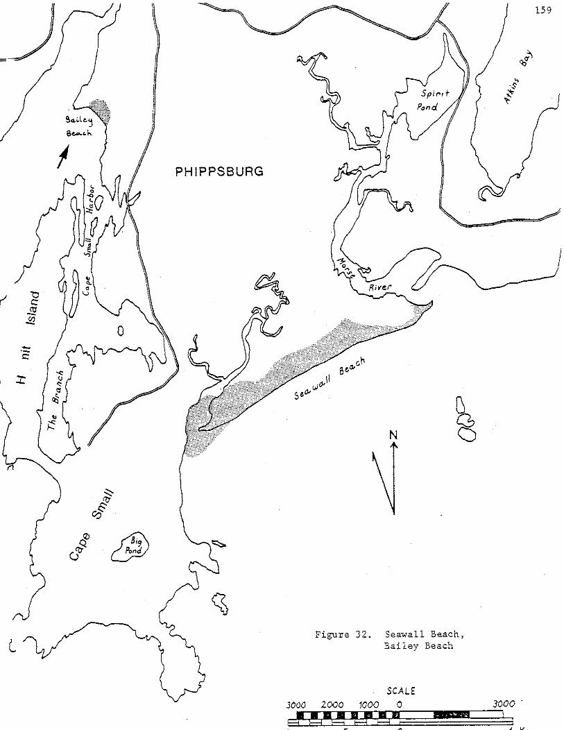

flat ~ medium and fine sand precipitation dunes
at forest edge.
The most significant geological feature of Bailey Beach is the
presence of large precipitation dunes at the forest edge. These are up
to 4 m high and rim the shrub-tree line along the northern edge of the
backdune area. Precipitation dunes are a rare geomorphic form in Maine
and only this beach and Main Beach at Cape Elizabeth have precipitation
dunes of any size. A lag surface has formed in the backdune area after
many years of removal of finer sand to the precipitation dunes behind.
The coarse grain wind-lag surface is unusual for a backdune area,
especially on such a small beach well up in an embayment away from
strong winds. The highest precipitation dunes are at the east end of
the shrub;..tree line where SW winds would deposit them after blowing
across Casco Bay, north of Hermit Island and diagonally across the
backdune.
The frontal dune ridge at Bailey Beach also has some unusual
features, which include relatively high relief (-2m), a stable position
and a very long backslope. These features indicate both a current sand
source and the importance of wind transport in supplying the frontal
dune ridge and backdune area with sand. An unhealed winter scarp
remained along the length of the frontal dune ridge at the time of field
checking, though recent, active building of the frontal dune ridge is
evident at one point where the aeolian ramp reaches the crest. The berm
is narrow (-8m) and the beach face is very steep. The reason for such
a steep beach face is unknown and worthy of study.
160
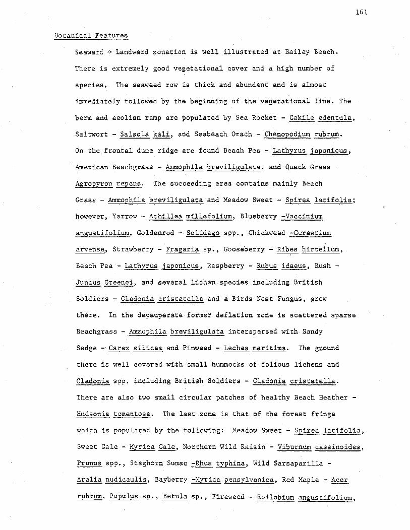
Botanical Features
Seaward -+ Landward zonation is well illustrated at Bailey Beach.
There is extremely good vegetational cover and a high number of
species. The seaweed row is thick and abundant and is almost
immediately followed by the beginning of the vegetational line. The
berm and aeolian ramp are populated by Sea Rocket - Cakile edentula,
Saltwort - Salsola kali, and Seabeach Orach - Chenopodium rubrum.
On the frontal dune ridge are found Beach Pea - Lathyrus japonicus,
American Beachgrass - Ammophila breviligulata, and Quack Grass -
Agropyron repens. The succeeding area contains mainly Beach
Grass - Ammophila breviligulata and Meadow Sweet - Spirea latifolia;
however, Yarrow - Achillea millefolium, Blueberry -Vaccinium
angustifolium, Goldenrod- Solidago spp., Chickweed -Cerastium
arvense, Strawberry- Fragaria sp., Gooseberry- Ribes hirtellum,
Beach Pea - Lathyrus japonicus, Raspberry - Rubus idaeus, Rush -
Juncus Greenei, and several lichen.species including British
Soldiers - Cladonia cristatella and a Birds Nest Fungus, grow
161
there. In the depauperate former deflation zone is scattered sparse
Beachgrass - Ammophila breviligulata interspersed with Sandy
Sedge - Carex silicea and Pinweed - Lechea maritima. The ground
there is well covered with small hummocks of folious lichens and
Cladonia spp. including British Soldiers - Cladonia cristatella.
There are also two small circular patches of healthy Beach Heather -
Hudsonia tomentosa. The last zone is that of the forest fringe
which is populated by the following: Meadow Sweet - Spirea latifolia,
Sweet Gale -Myrica Gale, Northern Wild Raisin - Viburnum cassinoides,
Prunus spp., Staghorn Sumac -Rhus typhina, Wild Sarsaparilla-
Aralia nudicaulis, Bayberry -Myrica pensylvanica, Red Maple - Acer
rubrum, Populus sp., Betula sp., Fireweed- Epilobium angustifolium,

Yarrow- Achillea millefolium, Juncus sp., and Raspberry- Rubus idaeus.
Summary of Significant Features
A. Geological
1. Presence of precipitation dunes - relationship with
southwest winds and fetch.
2. Coarse sand wind-lag surface.
162
3. Stable shoreline position with one frontal dune ridge, long
frontal dune ridge backslope, seasonal accretion and erosion,
and steep beachface.
4. Clear example of aeolian dominated mechanism of sand
supply to backdune (no recent overwashes).
B. Botanical
1. High percentage of plant cover, even in fragile areas;
little foot traffic damage.
2. Good site for the study of dune plant survival on a
deflating surface.
3. Undisturbed fragile association: Depauperate American
Beachgrass, Lichen species, Hosses, Fungi, Pinweed, and
Beach Heather.
C. Size
1. The total beach and backdune area is 2.4 hectares,
which include 0.8 hectares of intertidal area.

163
Seawall Beach
12 Small Point, Phippsburg, Sagadahoc County
Description of the Geological Features
Seawall Beach (Figure 32 ) assumes particular importance among
Maine's sandy beach systems since it is the only large, undeveloped or
unaltered barrier spit in Maine. The only other comparable system, the
Ogunquit-Moody barrier spit, has been heavily altered and developed.
Characteristic of barrier spit systems, Seawall Beach is connected to a
rocky headland, in this case, at the northeast end. The beach and
backdune areas extend over 2200 meters to the southwest and protect an
extensive salt marsh and tidal river complex behind. The beach,
backdune, and marsh areas cover 158 hectares.
The interaction between strong northwest winds and a broad (up to
400m) backdune area is very well illustrated at -Seawall Beach, which has ·''
the largest acreage of stabilized parabolic dunes in Maine. The entire
backdune area consists of northwest-oriented, stabilized, parabolic
dunes with·a few still active dunes toward the spit end at the Sprague·
River. One of these has the largest dimensions of any active parabolic
dune in Maine and, on the basis of measurements of aerial photographs,
has migrated 17 meters between 1940 and 1972.
The frontal dune ridge at Seawall provides an excellent example of
not only annual cycles of response processes but the interaction between
longer term changes and active backdune processes as well. The single
frontal dune ridge undergoes erosion during the winter and spring
followed by a late spring through fall rebuilding through aeolian sand
transport which fills in the frontal dune ridge erosional scarp by
establishing an aeolian ramp. The aeolian ramp is then invaded and
stabilized by successional vegetational colonization. Measurements from

vertical aerial photographs indicate frontal dune ridge retreat rates of
33-44 em/year, averaged over the period 1940-1972. During this same
period, average sea level in Casco Bay, according to tide gauge data,
rose a vertical distance of 15 em. On an average beach slope of 1° this
would correspond to an annual landward encroachment rate of approxi
mately 27 em/year. This correlation suggests that the gradual frontal
dune ridge retreat, despite significant annual regrowth, may be the
result of a response to the secular rise of sea level along the Maine
coast. Along some sections of the beach, a consequence of this frontal
dune ridge retreat through high relief parabolic dunes, formerly behind
the ridge in the backdune area, is that the frontal dune ridge attains
heights of 4 to 5 meters. Wherever parabolic dunes are not being
transgressed by the retreating perennial winter scarp, the frontal dune
ridge relief diminishes to an average of 1.5 meters. The lower sections
are subjected,annually, to storm overwashes and breaches.
The marsh-dune boundary follows broad curves which suggest the
shaping of the present boundary by, and the former presence of.,tidal
river channel meanders. As these ancient meanders moved landward, sand
on their seaward banks was colonized by dune vegetation. The rear edge
of the barrier could thereby migrate landward in a manner similar to the
growth of a point bar in a large meandering river. When stable, tidal
river channels along the rear boundary of the barrier dune field pro
vided a supply of sand for the formation of rear dune ridges by seaward
transport by northwest winds. Such rear dune ridges are present today
as relicts. The relict ridges are now bounded by salt marsh rather than
tidal river channels. Other geomorphic features, such as curvilinear
sand ridges suggest substantial late Holocene modifications of Seawall
Beach.
164

Coring transects (Trudeau, 1977) indicate that in some places
the backdune sand has transgressed over the marsh at least 18 meters.
In many places, however, the marsh appears to be transgressing sea
ward over the rear dunes in response to sea level rise. The failure
of the dunes to retreat over the marsh appears to be due to 1) the
stability and inactivity of the dunes, and 2) washover fans fail to
transgress the entire dune field. The result is that the barrier
dune field is being narrowed by a marsh encroachment from the rear
and slow frontal dune scarp recession in front, both due to rising
sea level. This narrowing process is very slow.
The sand at Seawall is probably derived originally from the
Kennebec River since, on a larger scale, Seawall is part of the
Popham-Seawall strand plain and barrier system which covers a total of
408 hectares, including 158 hectares at Seawall and 250 hectares at
Popham. The net long term drift is from the northeast to the southwest,
away from the Kennebec River, probably due to Northeast storm waves
and the counter-clockwise Gulf of Maine current gyre which is driven
by the Kennebec and other coastal rivers. Finer-grained sand on Seawall
than Popham supports the Kennebec River as a source.
The beach face has several interesting features, as follows:
1. A beach face which is always broad (~150m), even in winter,
165
and never steep. Summer profiles show a moderately constructional
aspect with berms around 25 m wide.
2. In summer the lower beach face has a ridge and runnel system
with a broad, convex upward, accretionary ridge.
3. The sand of both the beach face and the dune at Seawall is
significantly finer than at Popham, but no significant difference
in textural characteristics, including mean grain size, exists
between dune sands and the beach face.

Description of Botanical Features
There are high, northwest-wind oriented, parabolic dunes with
very interesting relationships between vegetation and the dune
morphology and behavior. The depositing leeward slopes of the
active parabolic dunes at Seawall Beach are good sites to study the
response of American Beachgrass - Ammophila breviligulata and Beach
Heather - Hudsonia tomentosa to sand deposition in the backdune
area, away from salt spray and seaweed. Both plants show increased
growth rates and more robust forms under these depositing conditions.
The vegetation pattern at Seawall is mosaic rather than
zonational because of hummocky parabolic dunes which dominate the
backdune field. This causes vegetation patterns which are related
to the depth to the water table, sand accretion and deflation
rates, successional age, and sand stability rather than distance
from the frontal dune ridge.
Most important is the area covered by Beach Heather - Hudsonia
tomentosa at Seawall. There is probably more acreage of Beach
Heather at Seawall and Reid State Park than in all other stands in
Maine combined.
Seawall appears to be the northernmost coastal dune habitat
for the Earthstar Puffball - Geaster hygrometricus in Maine.
There are a few relict overwash sites through the high frontal
dune ridge which are indicated by the presence of patches of Dusty
Miller -Artemisia Stelleriana and flotsam debris.
There is a young pitch pine forest with many upland forest
species in the backdune of Seawall. This forest is not as mature
as the one at Popham. Its youth and the generally mosaic floristic
166

patterns of the rest of the dune field suggest that fire or timber
cutting may have taken place here in the last century. v
A complete species list for Popham, Reid and Seawall Beaches
has been compiled by Trudeau (1977), thus only the dominant cover
species of the back dune are noted here. The dominant vegetation
species in their approximate order of importance are:
1. American Beachgrass - Ammophila breviligulata
2. Beach Heather - Hudsonia tomentosa
3. Bayberry - Myrica pensylvanica
4. Pitch Pine - Pinus rigida
5. Meadow Sweet - Spiraea latifolia
6. Beach Pea - Lathyrus japonicus
7. Raspberry- Rubus idaeus
Summary of Significant Features
A. Geological Features
1. The only large, undeveloped or unaltered, barrier
spit in Maine.
2. The largest parabolic dune field in Maine.
3. A few high relief, active, northwest-wind oriented,
parabolic dunes.
4. A measured shoreline retreat of 11-14 meters during
the period 1940-1972.
5. A good laboratory for the study of natural barrier
maintenance, sedimentary events of the Kennebec
River,and sea level rise effects; because of its
unaltered state.
6. Relict dune ridges exist because of northwest wind
transport of sand from ancient channel banks of the
Sprague River during neap tide periods.
167

168
B. Botanical
1. The highest percentage of cover of non-forest dune vegetation
in Maine's large backdune areas.
2. Extremely high diversity and large numbers of dune
species.
3. Full range of successional stages.
4. The mos~ mosaic floristic patterns in Maine's
backdune areas, due to sand accretion and deflation
processes, depth to water table, and successional age
of sites, i.e. controlled by the preponderance of
parabolic dunes rather than backdune aeolian flats.
5. Most importantly, a large share of Maine's BeachHeather
- Hudsonia tomentosa is located here.
6. Northernmost stand of Earthstar Puffball - Geaster
hygrometricus on coastal sand dunes within the state.
7. Immature or near edaphic climax pitch pine forest in the
center of the back dune area.
C. Peripheral Significant Features
1. Habitat for specially adapted spiders, insects and
small mammals.
2. Least tern and piping plover nesting site at spit
end.
3. Feeding habitat for other shore birds.
4. Solitude-Isolation. Seawall is cut off from shoreline
access by two tidal rivers. This improves management
and preservation potential.
5. Surfboard riding is a popular summer recreation
because of broad beachface and isolation.

I
Popham Beach Areas
13 Phippsburg, Sagadahoc County
Popham Beach (Figure 33 ) is one of the largest (250 hectares of
supratidal sand) and most complex systems in Maine. Because of the
complexity, Popham Beach has been divided into seven separate areas.
However, it is instructive to list all the significant features of
Popham in one list. Some of the features listed below are general or
more important to the Holocene history of Maine than to sandy beach and
dune processes.
Significant Geological Features of Popham Beach System
(Morse River to Fort Popham)
1. Complex spit in mouth of Morse River.
2. Two large cuspate forelands.
3. The only two large, sandy tombolos in Haine: the only
large tombolos which connect a public beach to an island.
4. Presence of accretionary ridge and swale topography
from a past accretionary period. Another area of
accretionary ridge and swale topography may form in
the next few years at the eastern end of Popham
Beach State Park.
5. Relict erosional scarps - especially at the seaward
edge of the pitch pine forest west of the State Park
parking lot.
6. Relict shorelines, possibly 2900 years old, behind Popham
village, in a small salt marsh.
7. Possible former marine lagoon which is now a freshwater
lake - Silver Lake.
8. Configuration and bathymetry illustrating river-derived
sand and influence of Coriolis force; one of the
few beaches in Maine with predominantly river derived sand.
169

9. Evidence that overwash is important in supplying sand
to some of the backdune areas.
10. Large stabilized parabolic dunes, created by northwest
winds, in Popham Beach State Park pitch pine forest
and some on Hunnewell Beach.
11. Presence of a dated relict intertidal sand flat
beneath Atkins Bay salt marsh; may indicate catastrophic
barrier formation about 6,800 years ago.
12. Potential key to catastrophic Holocene sedimentary
events in the Kennebec and Androscoggin Rivers.
13. Best illustration of very unstable natural geological
processes; major shoreline changes have occurred
which are due to: Kennebec River tidal current
effects on sand bodies, Kennebec River tidal
171
current effects on wave refraction, and migration of Morse
River tidal channel~
14. Relict garnet layer (former erosional shoreline) pre
served beneath dunes near Rockledge; active garnet
fractionation occurring where beach is being eroded
during storms.
15. Extremely variable beach profile types; both spatially
and temporally.
16. Accreting berm at Popham Beach State Park (on both sides of
Fox Island cuspate foreland) which has value for
recreation, as least tern nesting sites, and as an
illustration of a short term accretionary process
in a time of rising sea level.
17. Extensive variety of sandy bedforms, especially ripple
mark patterns of many types.

172
18. Eroding profiles; until recently Hunnewell Beach was
eroding at the fastest rate in Maine.
19. Obvious examples of wave refraction/wave energy/ erosion-
accretion relationships (especially obvious when selecting
a spot from which to launch a boat at Hunnewell Beach).
20. Natural laboratory for the study of the relative magnitude
of man-induced versus natural changes in beach profiles
and sand supply.
21. A good example of the influence of southwest wind on
the height of the frontal dune ridge (large southwest
facing frontal dune ridge south of State Park parking
lot).
22. Two very large nearshore sand bars, persistent and migrating . '
onshore, the only ones of this size in Maine.
23. Large sandy ebb-tidal delta features up to 2 miles off-
shore formed by the Kennebec River, includes Pond Island
Shoal with its surficial bars. Largest ebb-tidal delta
in Maine.
24. Example of poor relationship betw~en grain size, distance
from sand source, and beachface slope (unless Seawall
Beach is included in system).
25. High relief parabolic dunes behind Hunnewell Point
formed by onshore southwest winds.
26. High rear dune ridge (along access road to Morse River
from Route 209).
Significant Botanical Features of Popham Beach System
( Morse River to Kennebec River to Fort Popham)
Trudeau (1977) has mapped the complex floristic patterns of this
beach and dune area and has compiled an extensive species list for

Popham as well as Seawall and Reid Beaches. Consequently extensive
species lists have not been compiled for the Popham areas in this
report.
173
General dune plant habitat types which are of state wide significance
are listed below:
1. Parabolic dunes of various ages since last activity have many
successional stages from Beach Heather - Hudsonia tomentosa
association through edaphic climax Pitch Pine - Pinus rigida
forest.
2. Relict berm-and-ridge dune areas, as in the complex
spit at the mouth of the Morse River.
3. Sandy marsh flats, newly formed.
4. Overwash deposits in backdune and on perennially accreting berms.
5. Perennially accreting berms.
S~ecific botanical features which are of state wide significance
are listed below:
1. Absence of Wormwood - Artemisia caudata, which is present on
all major beaches south of Casco Bay, but none north of the
bay.
2. Presence of: Poverty Grass - Corema Conradii, Bearberry -
Arctostaphylos uva-ursi, Golden Heather - Hudsonia
ericoides.
3. Associations of BeachHeather- Hudsonia tomentosa, Sandy Sedge- Carex
Silicea, Pinweed Aster - Aster linariifolius, Pinweed - Lechea
maritima, Jointweed - Polygonella articulata, Greene's Rush
- Juncus Greenei, and lichens - Cladonia
spp."in stabilized parabolic dunes of the State Park
and behind portions of Hunnewell Beach.

4. The northernmost coastal dune stands in Maine of Earthstar
Puffball - Geaster hygrometricus are located either here at
Popham or at Seawall (never observed personally at Popham,
but have been seen at Seawall).
The seven divisions of the Popham Beach System are arranged in
geographic order from Fort Popham to the Morse River and are as follows:
1. Village Marsh Ancient Shoreline at Popham Village
2. West Bank of the Kennebec River, from Coast Guard Station
to Hunnewell Point
3. Wood Island Tombolo and Intertidal Cuspate Foreland at
Hunnewell Point
4. Pond Island Shoal's Offshore Bars
5. Hunnewell Point Backdune Area
6. Hunnewell Beach Backdune Area
7. Popham Beach State Park
174

Village Marsh Ancient Shorelines
Popham Village
Description of Geological Features
A single type of geological feature makes this a critical area of
state wide significance, i.e. the presence of two probable fonner shore
lines far back from the present shoreline in an historically stable
area. The shorelines occur as two curved sandy ridges in the Village
Marsh and are wind deposited features which outline underlying wave
shaped sandy shorelines. The wave deposited sand is now buried by the
encroaching salt marsh peat - a result of sea level rise since the
shorelines formed.
These former shorelines may be either a complex spit or accretionary
ridges of a swash aligned beach section. If they are part of a complex
spit, the waves which formed them approached from the north and the
relict shorelines have been followed by only 100-200 meters of beach
accretion. If they are swash aligned ridges the waves which formed them
approached from the east and 450 meters of accretion has since taken
place.
The Village Salt Marsh north of the ancient shorelines is underlain
by a coarse-sand flat at 1.5 meters below the present marsh surface.
This is strong evidence for ancient wave approach from the north.
Deposition of salt marsh peat first occurred when the sand flat was
sealed off either by the ancient ridges or by the present harbor shore
line to the north or by both. cl4 dating of the first marsh peat over
the coarse sand flat puts this event at about 2900 years ago. The
ancient shorelines are part of the longest lasting accretionary regime
known for any Maine beach in the late Holocene. They may represent a
catastrophic accretionary event at the mouth of the Kennebec River;
otherwise, normal beach processes in a regime of rising sea level would
have long since obliterated them as geomorphic features.
175

176
Description of Botanical Features
The two sandy ridges are vegetated by Bayberry - Myrica pensylvanica,
Gooseberry- Ribes sp., Raspberry- Rubus idaeus, Great Angelica
Angelica atropurpurea, Pasture Grasses, Seaside Rose - Rosa rugosa and a
few isolated trees. Proximity of the salt water table beneath these low
ridges prevents later succession despite the age of the ridges. Wind
whipped salt spray from the flooded salt marsh during spring high tides
probably has the same inhibiting effect on succession.
Summary of Significant Features
A. Geological
1. Two relict shorelines - oldest late Holocene
sandy beach shorelines with surficial expression known in
Maine - potential key to catastrophic sedimentary events
at Popham and in the Kennebec River.
2. Coarse grain wave deposited sand flat and basal salt marsh peat
contact - further key to sedimentary events of the area
and source of c14 date of shorelines. This is also a regressive
sedimentary sequence (peat over sand) in a rising sea
level regime where transgressive sequences (sand over
peat) are expected.
B. Botanical
1. Illustrates stagnated plant community succession on a relict
frontal dune ridge of great age - due to effects of salt
spray and proximity of salt water table.
C. Size - The size of the area is 2.4 hectares.

West Bank of the Kennebec River at Popham
Description of Geological Features
177
This area is significant because it has a perennially accreting
berm of at least five years age. The age is based on the presence near
the southern end of a relict erosional scarp, formed in 1972, behind the
vegetated overwash berm. The berm continues to accumulate sand by wave
overwash despite the fairly abundant vegetational cover.
The Kennebec River shore is one of the few beach areas in Maine
where wave overwash is the dominant means of sand transport into the
vegetated dunes normally above high water. Overwash is significant here
largely because the beach faces east, a direction from which wind seldom
blows. Thus, onshore aeolian transport is minimal and there is no
frontal dune ridge to block the flow of overwash sand. There is no
aeolian ramp. The dominance of overwash deposition has favored Dusty
Miller - Artemisia Stelleriana and berm colonizers over American Beachgrass.
It has also left abundant flotsam exposed, especially large logs and
driftwood.
The perennially accreting overwash berm is about 50 meters wide.
It might be a good piping plover and/or least tern nesting site if the
area were not so heavily used by beach strollers and sun bathers.
The overwash sands of the river shore are rich in garnet. This is
an important key to the mechanism of sand transport at Hunnewell Beach.
Only the extensive wave erosion of eastern Hunnewell (over the last few
years) could fractionate out the large volumes of garnet seen today on
the river shore. The garnet has acted as a tracer which indicates that
the initial path of sand eroded from eastern Hunnewell is eastward and
northward upriver around Hunnewell Point.
The beach face of the river shore area is fairly steep due to the
velocity of the longshore river tidal current. A swale of variable

dimension is located on the beach face today and can be seen in most old
photos of the area. Study of this swale and its history may indicate
the rates and directions of sand movement on the Kennebec and Hunnewell
Beach shores of Popham.
Description of Botanical Features
178
The species composition of an overwash dominated vegetated relict
berm is of interest because of the rarity of overwash dominated areas in
Maine. The most striking feature of the flora here is the abundance of
Dusty Miller - Artemisia Stelleriana. Berm colonizers extend well into
the relict berm because of overwash transport of their seeds and the
presence of a suitable nutrient-rich substrate such as seaweed. American
Beachgrass - Ammophila breviligulata is fairly healthy in this environment,
though it grows in isolated clumps rather than a thick carpet.
The common species are:
American Beachgrass - Ammophila breviligulata
Dusty Miller - Artemisia Stelleriana
Saltwort - Salsola kali
Sea Rocket - Cakile edentula
Seaside Burdock - Xanthium echinatum
Beach Pea - Lathyrus japonicus
Sunnnary of Significant Features
A. Geological
1. An accretionary area, accreting while Hunnewell's south
shore was eroding.
2. Extensive garnet in overwash indicates path of sand eroded
from Hunnewell.
3. Illustrates importance of overwash in supplying sand
to vegetated area. Relative importance of overwash
at this site may be greater than almost any other
sand beach in Haine (cf. Pemaquid Beach).
4. Presence of relict erosional scarp - educational
warning of instability of shoreline postion.
5. Examples of beach face features related to Kennebec
River - steep beach face slope, caused by river's
tidal current; persistent swale, perhaps related to
the path and rate of long shore sediment movement.
B. Botanical
1. Illustrates floral composition of an overwash site,
characterized by dominance of Dusty Miller.
C. Size - The size of the area is 5 hectares.
179

Wood Island Tombolo an·d Hunnewell Point Intertidal Cuspate Foreland
Popham Beach
Description of Geological Features
All significant features of the tombolo and cuspate foreland area
between Wood Island and Hunnewell Point are geological since the area is
entirely ~ntertidal with no vascular plants.
180
Wood Island Tombolo is one of only t-wo large, sandy tombolos in
Maine and provides public access to a wooded island of significant
geological, botanical, and wildlife value. The tombolo demonstrates
extreme seasonal and longer term variability in size and shape. The
variability is attributed to a response to changing wave refraction
patterns, changes in channel characteristics of the Kennebec River, and
man-induced removal of sand from the adjacent Kennebec River channel.
Because of the strong tidal potential across the tombolo created by the
Kennebec River flow, a transverse channel is cut across the tombolo
occasionally. Such breaching of the tombolo and subsequent current
velocity increases may trigger major-changes in the erosional-accretionary
status of Hunnewell Beach and Hunnewell Point by increasing current
scour along Hunnewell Beach and altering current influence on wave
refraction patterns. The effects of Kennebec River ebb-current and
onshore wave transport of sand can be seen in the occasional formation
of oppositely oriented spits on opposite ends of the tombolo breach
channel. Where transverse tidal currents are strongest in the low
portion of the Wood Island Tombolo, excellent examples of small and
large ripple bed forms are found.

The Hunnewell Point portion of the area is an excellent example of
a cuspate foreland formed by two processes: confluence of currents and
wave refraction in the lee of an island. Hunnewell Point cuspate
foreland is significant for its history of extremely rapid perennial
accretion with an associated formation of a band of ridge and swale dune
topography between 1910;...1930. The accretionary phase was eventually
followed by a period of equally rapid erosion beginning in 1965. Some
features observed during 1977-78 may presage a new perennial accretion
of Hunnewell Point. The features which suggest this are the present
filling of the breach channel of the Wood Island· Tombolo, the higher and
broader relief of the tombolo throughout its length, the accretionary
summer berm on the south shore of the Hunnewell Point cuspate foreland,
and the confluence of wave sets from the east and the west just to the
west of Hunnewell Point.
Hunnewell Point and the Pond Island Shoal may be the nearest
approximation to a river delta in Maine. The sands comprising these
features are almost certainly derived from the Kennebec River. On a
larger scale, the entire Popha.m-Seawall-Pond Island Shoal system is an
example of river derived beach and nearshore sand. The influence on
river-derived sand distribution by the counterclockwise Gulf of Maine
current gyre and the Coriolis Force is well illustrated in the large
scale features of this system.
Size: The size of the area is 20 hectares.
181

Pond Island Shoal's Offshore Bars
Description of Geological Features
These two offshore bars are surficial features of the large cusp
shaped Pond Island Shoal. Pond Island Shoal is a subtidal extension of
the Hunnewell Point cuspate foreland. The Shoal is a constructional,
delta-like feature formed at the equilibrium trap point of net onshore
and net downstream sediment movement. The surficial bars are variable
features which can be likened to the ebb tidal delta bars of a barrier
beach inlet. They are significant as features of the largest sandy ebb
tidal delta in Maine. They may, in fact, be features of a true river
delta. Their significance to the beach proper lies in their influence on
1) wave refraction patterns and wave energy striking the beach; 2) sand
supply to the beach from the bars. Changes in these bars may be the key
to explaining drastic erosion and accretion at Hunnewell Beach.
182

Hunnew·ell Point Backdune Area
Popham Beach
Description of Geological Features
The most significant geological features of this area are its
stabilized high relief parabolic dunes formed by winds blowing out of
the south or southwest. These are the only high relief parabolic dunes
10'l .l.U-'
with this orientation yet encountered in Haine. Most of Uaine's parabolic
dunes are for~ed by strong northwest winds. Here the orientation is
different because o~: 1) fetch restriction - Rockledge Ridge blocks
northwest winds; 2) wind direction changed by local topography -- west and
southwest winds take on a southerly wind direction as they blow around
the tip of Rockledge Ridge.
Description of Botanical Features
The stabilized parabolic dunes here are notable for their thick :
healthy cover of Beach Heather - Hudsonia tomentosa. There are probably
less than 40 hectares of Beach Heather in the State of Maine. This is a
fragile sand dune cover, more susceptible to foot and vehicle traffic
than American Beach Grass because it is slow growing, takes decades to
colonize new areas and grows in historically stable dunes where development
pressure is highest.
Summary of Significant Features
A. Geological
1. South wind oriented, stabilized, high relief parabolic
dunes - a rare or unique orientation in Maine.
2. Part of a cuspate foreland - one of the largest in Maine.
B. Botanical
1. Good Beach Heather - Hudsonia tomentosa cover.
C. Size
1. The size of the Hunnewell Point Backdune area is restricted
to 1.2 hectares.
Hunnewell Beach Backdune Area
Popham Beach
Description of Geological Features
184
This area has well vegetated, stabilized parabolic dunes with both
semi open dry dune slacks and thick Pitch Pine - Pinus rigida cover. The
orientation of these parabolic dunes is no longer obvious but they probably
formed under the influence of south and southwest winds, thus making
them unusual in Maine. The wind fetch is restricted on the northwest
side by Sabino Hill.
Just south of this area a boundary exists between an edaphic climax
community of Pitch Pines and a younger successional stage relict frontal
dune ridge. This boundary represents the approximate historical limit
of former beach erosion at Hunnewell Beach. The age of this erosion
limit is 1900 or earlier.
Description of Botanical Features
The area has a variety of cover types and species mixes. The
floristic pattern is mosaic due to the presence of parabolic dunes.
Cover type ranges from open Lichen carpet.s through thick Pitch Pine
cover. Species present include:
1. Pitch Pine - Pinus rigida
2. Beach Heather - Hudsonia tomentosa
3. Lichens - Cladonia spp.
4. Jointweed - Polygonella articulata
5. Early Sedge - Carex pensylvanica
The area includes part of a Cranberry - Sweet Gale bog which is
seasonally flooded. In the bog area are Cranberry - Vaccinium macrocarpon,
Sweet Gale - Myrica gale, Swamp Winterberry - Ilex verticillata and
numerous Rush, Sedge and Grass species.

Summary of Significant Features
A. Geological
1. Example of parabolic dunes created by south to south
west winds, now stabilized by various mixtures of Pitch
Pines - Pinus rigida and dry dune slack vegetation.
B. Botanical
185
1. Good example of vegetational variety of open dry dune slack
plants mixed with itch ines
2. Example of a seasonally flooded temporary bog dominated
by Cranberry and Sweet Gale.
C. Size
1. The Hunnewell Beach backdune area is 1.9 hectares.

Popham Beach State Park
Phippsburg
Description of Geological Features
The dune vegetation and oceanic processes of Popham Beach State
Park have been described in detail by Trudeau (i977). The emphasis of
his work has been on vegetation. He has compiled floristic maps and a
species list for the park. Because of his work a species list and
detailed floral description were not attempted during field checking of
the PopLam Beach System.
A detailed shoreline change map of Popham Beach has been compiled
by Nelson, 1977. It includes information from cores, old ground level
photos, a vertical air photo collection and three years of sequential
oblique and near vertical air photos. Trudeau's report and Nelson's
shoreline change map are available ~or reference from the Bureau of
Geology, Dept. of Conservation, Augusta, Maine.
The Popham Beach State Park area includes a barrier dune field,
associated salt marsh, and a complex spit and tidal inlet. The shore
line and intertidal features throughout the area are among the most
unstable in Maine. Drastic accretion and erosion have characterized
this area historically. This instability is the single most significant
geological feature of the area. The degree of instability is responsible
for the formation of a variety of geological and botanical features.
For ease of discussion, these various features are categorized into 13
subunits.
1. Fox Island Tombolo - This is one of only two large sandy
tombolos in Maine, the other being the Wood Island Tombolo. It is
a complex feature, flanked by two large nearshore sand bars when
field checked and sometimes traversed by a distributary channel of
the Morse River. Migration of these bars and sealing of the
186

distributary has sometimes left relict longitudinal and transverse
swales on the tombolo. Fox Island Tombolo (including the proximal
ends of the associated nearshore bars) is larger than Wood Island
Tombolo. Since the tombolo is uncovered throughout most of the
tidal cycle, it provides public access to Fox Island from Popham
Beach State Park. The Tombolo area is about 14 hectares (excluding
the nearshore bars or flanks).
2. Western Hunnewell Beach Large Nearshore Sand Bar
This feature has grown in size and moved shoreward over the last
three years. Before reaching the beachface it had a hook-shaped
down-drift or spit end in front of the seawalls of central Hunnewell
Beach. The bar has grown in a northeast direction toward the
eroding section of Hunnewell. It protects and supplies sand to all
the beachface behind it - causing appreciable perennial accretion.
Remnants of a beachface runnel were visible on the landward edge of
the large nearshore bar in August of 1977. The bar and runnel once
formed a ridge and runnel beachface profile type of exaggerated
proportions. The size of the nearshore bar in December 1976 was
about 16 hectares.
Though the direction of transport of sand in this bar is
onshore and toward the Kennebec River, the bar's formation and
growth have been contemporaneous with sand loss from central and
eastern Hunnewell, suggesting a paradox, i.e. the beach at the
downdrift end of the bar was the source area for the bar. What is
even more confusing is that in the late 1940's a similar nearshore
bar formed off western Hunnewell when no portion of Hunnewell was
eroding.
187

188
This nearshore bar may be one reservoir in a cyclical path of
sand which includes the Wood Island Tombolo, the Kennebec channel
and Pond Island Shoal. Rates of sediment flow from one reservoir
to another may be triggered by breaching of the Wood Island Tombolo,
changing Kennebec sand supply, dredging, spring runoff rates,
evolution of the Kennebec ebb-tidal delta bar configurations and
other factors. The cycle itself may exist since there are natural
and artificial tracers to document the cycle path. Behavior of the
cycle may be the major cause of drastic erosion and accretion at
Hunnewell Beach.
An alternative explanation for the development of the nearshore
bar would not require major and large-scale transfers of sand but
only a short term reversal, during a Northeast storm, of the usual
alongshore current direction toward the Kennebec River. Such a
reversal is possible because of the properly oriented wind stresses
during the passage of a Northeast storm, which also produces the
sand volume which can be rapidly transported to an equilibrium trap
position where the nearshore bar. then forms.
3. Large Perennially Accreting Berm of Western Hunnewell.
The berm here is 90-120 meters wide, the widest berm in Maine.
There is a broad aeolian ramp being invaded by American Beachgrass.
The berm itself is being invaded by American Beachgrass and Dusty
Miller. This is a good area for viewing frontal dune ridge formation;
however, the mature ridge will not be very high since the beach
faces southeast •. The perennial accretion of this area is note
worthy because only three years ago it was eroding perennially.
The accretion is also noteworthy because it is contemporary with
drastic erosion of eastern Hunnewell. Thus, general statements
about the erosional status of Popham Beach, the effect of Kennebec

dredging on Popham Beach or the effect of sea level rise on Popham
Beacn cannot be safely made. The area of the berm is 4 hectares.
4. Relict Ridge and Berm Province of Western Hunnewell (Accre
tionary Ridge and Swale Topography).
Prior to 1940 all of Hunnewell Beach was accreting. Some of
the relict frontal dune ridges and berms left by this accretion
are still visible at the Western end of Popham Beach State Park
between utility poles #825-164S and #169-87. The area is dominated
by American Beachgrass which is now depauperate because of the age
of these dunes and lack of sand burial. The landward-most ridge
189
may be more than 100 years old. Formerly disturbed areas have been
invaded by Beach Heather - Hudsonia tomentosa, Lichens - Cladonia
spp., Pinweed- Lechea maritima and Early Sedge- Carex pensylvanica.
There are no parabolic dunes in the area, which covers 2.8 hectares.
5. Morse River Ebb-Tidal Delta.
The complex bars, channels, and small bedforms of the Morse
River ebb-tidal delta are valuable features for the study of the
formation and preservation of barrier inlet sedimentary structures.
The characters of these features are very variable. The meanders
of the intertidal Morse River ebb channel are significant for their
effect on erosional/accretional status of the dunes between Morse
Mountain Headland and Fox Island Tombolo. The area of the ebb
tidal delta is about 32 hectares, (including the large nearshore
bar west of Fox Island tombolo.
6. Large Nearshore Sand Bar West of Fox Island Tombolo.
This bar is similar to the one off western Hunnewell in that
it formed in the last 3 years and is migrating onshore, protecting
and supplying sand to the berm and dunes landward of it. It does
not have an apparent down drift or spit end, but this may be because

the western end is truncated by a distributary of the Morse River
ebb channel. The runnel landward of this nearshore bar is also a
former ebb channel distributary which once traversed Fox Island
Tombolo, but now is sealed off. The large nearshore bar may,
therefore, be part of the Morse River ebb-tidal delta. Its eastern
end is welded to, and part of, the Fox Island Tombolo. A bar
similar to this one existed in the same area in 1964. Onshore
migration, of such large bars leads. to shoreline accretion. Sub
sequent meandering of Morse River ebb channel distrubutaries
removes sand seaward and leads to shoreline erosion. This cycle
does not have a regular periodicity. Boundaries are indistinct, but
the area of this bar is approximately 15 hectares.
7. Incipient, Perennially Accreting Berm Landward of Western Large
Nearshore Sand Bar
This is an indistinct area of accretion which has formed
only since the channel, or runnel, landward of the western large
nearshore bar became sealed and began filling. Prior to sealing of
the channel, which used to breach the Fox Island tombolo and
connected with the runnel la.ndward of Hunnewell's large nearshore
bar, tidal currents maintained a steep upper beach face below the
berm edge.
8. Overwashed, Perennially Accreting Berm West of Fox Island
Cuspate Foreland
This large area accreted subsequent to a channel shift in the
early 1970's. Frequent winter washover and ice damage inhibited
vegetation in most of the area until 1975. In the last 2 1/2 years
washover accretion has replaced \vashover damage. The area is now
sparsely vegetated by American Beachgrass and Dusty Miller as well
190

as berm colonizers. There is a very broad, actively growing,
incipient frontal dune ridge on the seaward edge of the area and
another actively growing frontal dune ridge near the rear of the
area (just seaward of the 1972 river channel bank position). The
second frontal dune ridge derives its sand from a deflation zone
seaward of it, but landward of the first frontal dune ridge ..
191
The area is unique in Maine in that it has two actively growing
frontal dune ridges, one behind the other. Overwash accretion has
played an important role in the supply of sand to this area but the
role of aeolian transport should become greater as the seaward
frontal dune ridge builds vertically.
The area is a significant nesting habitat for least terns and
piping plovers.
The western margin of the area is being eroded by a cut bank
of ·one of the Morse River ebb-tidal channels. The area size is 5.3
hectares
9. Thick Healthy Beachgrass Zone
This zone has the shape of an acute triangle, bounded on the
north by the approximate 1953 scarp line (caused by meander of the
Morse River at that time), on the southwest by the 1972 scarp line,
and on the south by the 1976 scarp line (from a now sealed off
minor distributary of the Morse River). The area has been vegetated
for about 20 years and now has some of the healthiest American
Beachgrass in Maine; certainly one of the largest stands of healthy
beachgrass on young dunes in the State. Sand is supplied to the
backdune here by wind transport more than by overwash. Not much
vertical sand accretion (sand burial) is taking place, however.
Dead culms and blades of Beachgrass form a dry straw carpet over

the sand. This is a good site for studying natural senescence
rates of Beachgrass on young dune flats without sand burial.
This area also has the highest frontal dune ridge at Popham
- 3 meters. This is because the ridge faces the prevailing,
onshore-directed southwest wind and because there has been an
abundant sand supply fl:'om the overwashed perennially accreting benn
described above. The area is 2.8 hectares.
10. Semi-open Parabolic Dunes and Old Overwash Area
This small dune area surrounds the north, east, and south
sides of the state park parking lot. The parabolic dunes are of
high relief and were fanned by winter northwest winds. The dunes
were active in the 1930's and 1940's. These are the highest relief
parabolic dunes at Popham. They are also significant for providing
most of the habitat for Beach Heather - Hudsonia tomentosa within
192
the park boundaries (Recall that there are less than 40 hectares of
Hudsonia tomentosa in Maine and that this plant is highly susceptible
to foot traffic damage).
About 30% of these high relief parabolic dunes with semi-open
pitch pine - Pinus rigida cover and Beach Heather - Hudsonia
tomentosa were leveled when the parking lot was constructed at
Popham Beach State Park. Further construction of parking lots or
large user-facilities should be discouraged in this area.
The area also includes what appear to be old overwashes with
thick beachgrass cover just south of the parking lot. These
overwashes would be about 25 years old, having formed subsequent to
an erosional event around 1953. Construction of a parking lot or
large user facilities in this area \vould be unwise since its
proximity to an historical erosional shoreline indicates a potential
for repeated erosion here. The area is 3.6 hectares.

11. Stabilized Parabolic Dunes with Climax Pitch Pine Forest.
This is the largest mature pitch pine forest on sandy dunes in
the state. It forms the bulk of the Popham Beach barrier. The
area is highly valuable for studying the edaphic climax of Maine's
coastal dunes. For this purpose it is more valuable than the
irrunature pitch pine forest of Seawall Beach (Phippsburg). There are
many upland forest species in the ground cover and understory.
Species diversity is higher than that for most dune communities.
The area is the least fragile of any of Popham's dune com
munities, especially since a soil layer has developed. It is,
therefore, the best choice within the dune system for placement of
picnic tables, parking lot expansion or large user facilities.
Nonetheless, encroachment of such facilities should be discouraged
because of the area's unique scientific value, particularly when
there is the viable option of placing such facilities on upland
bedrock.
There is a rear dune ridge to the northwest of the forested
area at the marsh/sand border. The size of the area is 20 hectares.
12. Complex Spit with Relict Frontal Dune Ridges.
This is the best example of a complex spit in Maine. Its
orientation is a key to the net westward drift of sand at Popham
(away from the Kennebec River). The spit formed as a result of a
major channel shift in the Morse River in the 1940's. An unusual
bar island, originally formed by waves and currents, remains
preserved in the complex spit with a vegetated wind-deposited
veneer. The spit reached an accretionary maximum in 1972 and has
193
since eroded dramatically as a result of the meanders of a distributary
channel of the Morse River. The eroding scarp has left behind

heavy garnet sand as a result of density fractionation. The eroding
shoreline is also notable for its considerable overwash deposits
which take place because there is no berm or frontal dune ridge to
stop them.
During the storms of January 9 and February 7, 1978, almost
all the grassy dune surface of the complex spit was overwashed.
Observations after the January 9 storm do not indicate any signi
ficant vertical accretion or landward migration of the dunes via
overwash sand deposition. The impact of the overwash on the vigor
of the next season's Beachgrass remains to be seen.
Because the dunes here are less than 30 years old they still
have a thick,healthy American Beachgrass cover. In the southeast
corner are some parabolic dunes formed prior to 1940. They are
stabilized with Early Sedge - Carex pensylvanica, Sandy Sedge -
Carex silicea, and Pasture Grasses. The eastern margin is of
greater age and provides an example of late succession on moist
back dune. Raspberry - Rubus idaeus and Fireweed - Epilobium ·
angustifolium are common here.
The complex spit is also significant in that it provides
protection for a newly formed salt marsh on a former sand flat
behind the spit. A geological cross section through the new marsh
and spit would indicate a regressive (lowering sea level) or
accretionary regime. This is unusual since sea level is rising in
Maine. The anomaly can be explained as the result of a locally
abundant sand supply caused by a shift in the Morse River channel.
The area is 7.7 hectares.
194

13. Former Sand Flat with New Salt Marsh Behind Complex Spit; Old
Shoreline Behind
In light of the significance criteria of this report, this
area is significant primarily for its geological indications of a
regressive regime as explained above. It is interesting to note
that more than a meter of pure salt marsh peat has accumulated
vertically over portions of the sand flat in just a few decades.
This verifies the need for using basal salt marsh peat for cl4
dating of sea level rise or sedimentary events. The area is thus
very instructive in a geological sense.
Of course the area is of state wide significance because it is
a large, newly created salt marsh of great ecological value.
There is an old shoreline and sand dune at the rear edge of
marsh. There has been no sand activity here since the salt marsh
formed, yet the vegetational composition (American Beachgrass,
Dusty Hiller and Beach Pea) resembles that of a young frontal dune
ridge or aeolian ramp. The vegetational assemblage.is due to salt
spray and the proximity of the water table. The influence of
either salt spray or sand blasting damage to backdune trees on the
Maine coast is dramatically illustrated on the utility poles of
this rear sand dune. Pitting of the poles is greatest on the
southwest side. The metallic letters on the poles are raised in
relief on wooden pedestals as all the wood around them has been
removed by windborn abrasive agents (sand or salt).
The rear dune and shoreline are valuable as:
1. Indicator of extreme variability of shoreline position.
2. Example of stagnant succession due to salt spray and salt
water table.
The area of the former sand flat with new salt marsh, including
the narrow dune at the rear is 12.1 hectares.
195

14
Reid Beach
Sagadahoc County
Description of the Geological Features
There are two significant areas at Reid State Park (Figure 34 ) .
They are 1040 meter long Hile Beach and adjacent 420 meter long Half
Mile Beach. Mile beach connects Todd's and Griffith's Heads and is a
long, straight closed barrier. It protects a salt marsh which drains to
the sea north of Griffith's Head. The straightness is due to the position
of the beach at the mouth of the underlying bedrock embayment and at the
mouth of Sheepscot Bay. Incoming waves are not refracted into a curve
before striking the beach. (Recall that baymouth beaches are straight
whereas bayhead beaches are curved).
Half Mile Beach is an open barrier spit with a tidal reentrant
(Little River) draining out of the southwestern end. Half Mile beach
also protects a substantial salt marsh. The diversity of habitats and
thus the diversity of species in the backdune is lower at Reid than in
the Popham-Seawall system, but Reid is the northernmost, large, backdune
habitat in Maine and thus may be the northern range limit in the state
for several species. It has the northernmost stands of Beach Heather -
Hudsonia tomentosa in Maine.
Mile and Half Mile Beaches have interesting features relevant to
the study of barrier formation, barrier maintenance, sea level rise,
drift versus swash aligrunents, sand source, and inlet migration.
The salt marsh behind Mile Beach is connected via a sill to the
ocean. This sill is about 1 meter below present mean high water. Thus
when sea level was about 1 meter lower than today (about 2,000 years
ago) the present inlet was too high to permit passage of salt water into
the marsh behind the barrier. Perhaps an inlet once existed through the
196


closed barrier of Hile Beach. Sealing of this former inlet may have
taken place when sea level became high enough to open the existing inlet
over the rocky sill north of Griffith's Head. Sealing of such an inlet
may be responsible for: (1) The historical shoreline stability of Reid
due to both an increased sand supply when sand was no longer lost upstream
into the tidal reentrant and the removal of the complicated effect of an
ebb-tidal delta on wave refraction, sand supply and drift direction.
(2) An end to breaching caused by cut banks of the meandering tidal
river channel. (3) An end to sand supply from the rear for barrier
maintenance and parabolic dune field broadening (The shore of the tidal
Little River provides abundant sand to the backside of Half Mile Beach's
dune field. The same process is active at Ogunquit, where parabolic
dunes are supplied by sand brought in by the Ogunquit River).
It is also possible that the marsh behind Mile Beach is only as old
as the present inlet over the sill north of Griffith's Head. Coring of
the marsh to determine thickness of marsh peats would indicate the age
of Reid as a barrier.
Because of contrasting characteristics, the two
sections of beach at Reid are discussed separately.
Mile Beach - Geological Features
The sand is coarse or medium in the entire beachface and berm. It
is young (i.e. not far from its source of eroded rock or glacial sand
deposit). Youth is indicated by the high percentage of feldspar and
schist fragments. Because of the relative coarseness of grain size
there is a steep upper beachface (coarse sand has higher permeability to
water and thus can be accumulated into a steeper slope by waves). The
sand of Half Hile Beach is finer in comparison, but also young. The
beachface slopes are moderate there.
198

In recent years, all of Mile Beach has experienced erosion. When
field checked, this trend had reversed along the northeast half of the
beach, wher.e the relict frontal dune scarp was healed by a perennially
accreting talus slope and aeolian ramp. This sand wedge was vegetated
predominantly by American Beachgrass - Ammophila breviligulata and Beach
Pea - Lathyrus japonicus.
The southwest half of Mile Beach has an unhealed frontal dune scarp
caused by winter erosion into the frontal dune ridge. The frontal dune
ridge of all of Mile Beach is, historically, fairly stable. There is no
accretionary ridge and swale topography and the single frontal dune
ridge is straight and uniformly high (3-5 meters). This suggests that
the dune ridge is stable or retreating very slowly in response to sea
level rise. The ridge has a long back slope extending through half or
more of the backdune. The height and extensive back slope are due to 1)
shoreline stability and 2) exposure near the tip of a peninsula where
south and southeast winds are stronger than might otherwise be. South
to southwest winds (the predominant onshore winds· in Maine) have a net
onshore component, thus making them important in frontal dune ridge
accretion at Reid despite the southeast exposure of the beach.
There is a rocky lag surface on the beachface at the southwest end
of Mile Beach indicating that the beachface is eroded to its past limit
at this point. In 1976, metal from Navy World War II landing operations
was exposed at this same spot indicating a precedent for beachface
erosion to the depth of 1976 within the last thirty-five years.
The contrasting erosional versus accretionary status of the south
west half versus the northeast half of Mile Beach has a parallel con
trast of beachface features. From southwest to northeast the seasonal
berm broadens and the low-tide terrace narrows. The southwest end of
199

Mile Beach has only a moderately constructional profile in summer with
a narrow berm and wide low-tide terrace.
There was a double berm at the northeast end when field checked in
1977. Both berm crests had high relief sandy cusps with approximately 20
meter wavelengths. High relief is due to the high permeability of
coarse sand. The coarsest sand is usually concentrated at the limit of
the last swash, that is, at the berm crest.
There is a large, high relief, parabolic dune on the backslope of
the frontal dune ridge about one third of the way up from the southwest
end of J1ile Beach. This dune, formed by northwest winds, is stabilized
by Bayberry - Myrica pensylvanica and other shrubs. The flank and
leeward slopes of the high parabolic dune are now truncated by the
frontal dune ridge, making the ridge appear higher at this point.
The dune field at Reid is narrow since transport of sand into the
backdune and onto the marsh has not kept pace, apparently, with gradual
recession of the frontal dune ridge and migration of salt marsh peat
onto the backdune field in response to sea level rise. The backslope of
the high frontal dune ridge extends halfway across the barrier. The
rear half of the backdune field is dominated by moderate relief para
bolic dunes, formed by northwest winds and stabilized with Beach Heather -
Hudsonia tomentosa, sparse American Beachgrass - Arrnnophila breviligulata
and xerophytic backdune plants.
A significant feature at Reid is the marked difference in grain
size of the aeolian ramp versus berm and beachface sand. At finer
grained beaches this difference would not be noticeable, but here the
medium and fine grained ramp sand is obviously different in grain size
from the predominantly medium and coarse sand of the berm and beachface
from which it was blown. The frontal dune ridge and backdune sands are
200

not markedly finer than beachface and berm sands, however. Perhaps
strong northwest winds remove finer sizes from the dune field, leaving a
coarse grained lag deposit.
Half Mile Beach - Geological Features
The most striking difference between this and Mile Beach is the
medium to fine grain size of the sand. This may be partially due to
lower wave energy, but is also due, probably, to this being the down
drift end for the entire system in the longer term. Finer sand is
carried further from the source than coarse sand, since storm waves from
the northeast are probably responsible for the net long term drift
direction alongshore at the Reid Beach system.
The beachface slope is moderate at Half Mile Beach due to the fine
grain size and lower wave energy. When field checked in 1977 there was
a double berm, a moderately steep, short, upper beachface and a broad,
fine grained low-tide terrace. There were no sharp slope breaks. The
berm and low tide terrace actually dipped seaward forming a smoother
profile without particularly steep sections.
There was a relict, erosional scarp along the entire length of Half
Hile Beach, which was being healed by perennial accretion. The peren
nial accretion took the form of an aeolian ramp or wedge, which was
vegetated with American Beachgrass and Beach Pea.
There are a few stabilized, moderate relief, parabolic dunes in the
backdune area of Half Mile Beach. The frontal dune ridge is lower here
than at Mile Beach, because of the recent erosion through the highest
part of the ridge. In 1977 it was about 2.5 to 3 meters high, but still
had a broad backslope like the frontal dune ridge at Mile Beach. The
201

sand is also mineralogically young with high concentrations of feldspar
and schist fragments.
An important barri~r dune field maintenance mechanism is well
illustrated at Half Hile Beach. The rear edge of the backdune field has
shifted landward as the Little River channel has shifted landward. Sand
blown from the south bank of the Little River by northwest winds formed
two relict rear dune ridges (f.ormer shorelines) now in the interior of
the dune field. This is an important mechanism for barrier maintenance
and retreat in a regime of rising sea level and frontal dune erosion.
The mechanism is active here, possibly at Ogunquit, and on the spit ends
of many barriers. The mechanism may have been active several thousand
years ago at Seawall Beach and at Reid's Hile Beach.
Description of the Botanical Features
The flora of Reid State Park have been studied by Trudeau (1977).
He has compiled a fairly complete species list for this dune area as
well as Popham and Seawall. A partial species list of the two areas was
made during field checking in 1977.
Partial Species List for Reid's Mile and Half Hile Beaches
August 22, 1977
A. Berm and Aeolian Ramp.
1. Sea Rocket - Cakile edentula
2. American Beachgrass - Ammophila breviligulata
3. Beach Pea - Lathyrus japonicus
4. Saltwort - Salsola kali
5. Sea Blite - Suaeda maritima
B. Broad Frontal Dune Ridge
1. American Beachgrass - Ammophila breviligulata
2. Beach Pea - Lathyrus japonicus
202

203
3. Poison Ivy - Rhus toxicodendron
4. Bayberry - Myrica pensylvanica (where the frontal dune ridge is
receding into the high stabilized parabolic dunes).
5. Numerous composites (no identification)
6. Chickweed - Cerastium arvense
7. Gooseberry - Ribes sp.
8. Raspberry - Rubus idaeus
9. Seaside Goldenrod - Solidago sempervirens
C. Stabilized Parabolic Dunes and Open, Dry Parabolic Dune Slacks
1. Beach Heather - Hudsonia tomentosa
2. Bayberry - Myrica pensylvanica
3. Large Composite (no identification)
4. Jointweed - Polygonella articulata
5. Yarrow - Achillea millefolium
6. Sandy Sedge - Carex silicea
7. British Soldiers Lichen- Cladonia cristatella
8. Other Cladonia species including~· rangifera
9. Virginian Rose -Rosa virginiana
10. Purple Stemmed Angelica - Angelica atropurpurea
11. Blackberry - Rubus sp.
12. Raspberry - Rubus idaeus
13. Poison Ivy - Rhus toxicodendron
14. Two Cherries - Prunus or Amelanchier species
15. Low Sweet Blueberry - Vaccinium angustifolium
16. Goldenrod - Solidago rugosa
17. Dodder - Cuscuta sp.

Notable general characteristics of the flora are:
1. Three general zones with increasing diversity:
a. Berm and aeolian ramp with lowest diversity - only
annual and perennial colonizers occur.
b. Backslope of the frontal dune ridge where diversity is
is low - dominated by American Beachgrass, Raspberry,
Gooseberry, and Beach Pea.
c. Stabilized, moderate-relief, parabolic dunes with good
stands of Beach Heather - Hudsonia tomentosa and associ
ated plants. The dominance of parabolic dunes in this
area causes a mosaic floristic pattern and higher diver
sity than on the broad frontal dune ridge. This is due
to variable depth to the water table, variable accretion
and deflation rates, and variable successional age since
the last aeolian activity. Such variable habitat para
meters are always associated with parabolic dunes.
2. No Pitch Pine forest: only one large stand of Bayberry and
Cherries in a large,. stabilized, parabolic dune. Salt spray
and narrowness of the dune field are the probable reasons.
Reid is a high energy beach so salt spray is probably greater
here than at Seawall Beach where Pitch Pines grow close to
the frontal dune ridge.
3. Northernmost, large dune field in Haine: Thus, the potential
for being the northern range limit within the state of several
204
of Haine's dune plant species exists. The northernmost Jointweed
Polygonella articulata stands on coastal dunes within the state
probably occur here. Non-dune stands do occur further north.

Canadian distribution was not researched. The northernmost
stands of Beach Heather - Hudsonia tomentosa and the com-
205
plete Hudsonia association occur at Reid's Mile Beach, though
Beach Heather reappears on Canadian dunes. Hudsonia associ
ation includes Jointweed - Polygonella articulata, Sandy Sedge
- Carex silicea, Pinweed - Lechea maritima, Pinweed Aster -
Aster linariifolius, Greene's Rush - Juncus Greenei, British
Soldiers Lichen - Cladonia cristatella, Alpine Reindeer
Lichen - Cladonia alpestris and Haircap Hess - Polytrichum sp.
Summary of Significant Features .
A. Geological
1. Strong contrast between aeolian ramp sand grain size
and beach sand grain size, but the coarsest of backdune
sand in Maine, suggesting very strong northwest winds.
2. Coarseness, poor sorting, and mineralogical youth of
Mile Beach's sand indicate source of sand is nearby
and is not the Kennebec River.
3. High, broad frontal dune ridge, historically stable, at
Mile Beach. It may transgress the entire dune field in
some places.
4. Numerous, moderate relief, stabilized parabolic dunes.
5. Narrow backdune field at Mile Beach -due to absence of
an important barrier maintenance mechanism. This
maintenance mechanism is active at Half Mile Beach.
6. Northernmost, large dune area in Maine.
7. Both erosion and accretion taking place simultaneously
at Mile Beach. The northeast end is accreting and the
southwest end is eroding.

8. Perennial: accretion along the entire length of Half Mile
Beach after several years of dramatic perennial erosion.
9. Good site for study of barrier beach maintenance in
response to sea level rise.
206
10. A very large beach considering that the sand is all locally
derived. There is very little sand offshore. The bottom
becomes rocky very quickly.
11. Unique among Maine's large, barrier-marsh systems in
that there is no tidal exit through the strandline.
The baymouth shoreline is straight and continuous from
one rocky headland to another rocky headland.
B. Botanical
1. There are three basic vegetational-geomorphological
zones:
a. Berm and aeolian ramp.
b. High, broad frontal dune ridge
c. Stabilized parabol~c dunes
2. Illustration of importance of sait spray effects on
vegetation, in this case it maintains succession at
the pre-pitch pine stage.
3. Northernmost parabolic dune field in Maine. May be the
northern limit for several species. Northernmost
stand of Beach Heather - Hudsonia tomentosa within Maine.
Northernmost dune stands of Jointweed - Polygonella
articulata in Maine.

C. Miscellaneous
1. The unstable spit end of Half Mile Beach is probably
the northernmost potential nesting habitat for least
207
terns and piping plovers on Maine beaches. There are none
there now because of the non-accretive state and heavy visitation.
2. Large, burrowing spiders with web-lined burrows and
burrow mouths were noted in the open dry dune slacks of
the backdune among sparse Beach Heather, Beachgrass,
and Jointweed.
D. Size
1. Reid One Mile Beach has a length o£ 1040 meters, a dune
area of 7.7 hectares and a beach area of 7 hectares.
2. Half Mile Beach has a length of 640 m, a dune area of
3.1 hectares, and a beach area of 7.2 hectares.

15
Pemaquid Beach
Bristol, Lincoln County
Description of Geological Features
Pemaquid (Figure 35) consists of a large main beach, 450 meters
long, and a smaller western beach, 125 meters long. The two are sep
arated by a bedrock outcrop. The beaches are of the pocket barrier
type, but the inlet to the back barrier salt marsh does not breach
the strandline; the inlet is situated at a rocky intertidal sill as at
Reid. The two beaches are only moderately curved in plan view because
they are located near the mouth's of their underlying bedrock embayments.
On a larger scale some curvature of wave trains is caused by passage
of the crests several km from the sea up Johns Bay before reaching
Pemaquid. This situation contrasts with Reicl Beach which receives
straight wave trains. The greatest curvature is found at the eastern
end of the main beach. Here the beach approaches the classical log
spiral shape of waves refracted into the lee of a jutting headland.
The smaller western beach section of Pemaquid Beach had three
distinct sets of pebbly cusps when field checked in July of 1977; the
first set located on the upper beachface was fonned by spring high
water; the second, located further down the beachface, was a result of
neap high water and the third marked the boundary between the eroded,
pebbly lower beach face and the accreted, more sandy, upper beach face.
The western beach was generally accretive but poorly sorted with
medium and coarse sand, granules, and pebbles. A lot of dark mineral
grains such as biotite are present. Seaweed is found on the entire berm
and beach face.
208
A sand-rich aeolian ramp guarded a very low relief frontal dune ridge.
The lower half of the be.ach face consisted of pebbles, granules, and
coarse sand.
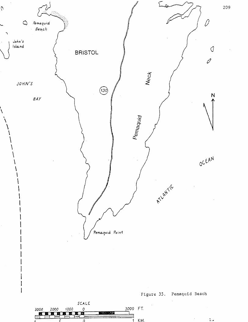

210
The western end of the main beach at Pemaquid had a constructional
profile throughout and evidence cr seasonal accretion. Profiling from
the backdune in a seaward direction, there was a flat backdune followed
by a low frontal dune ridge, approximately 1 meter high, a winter scarp,
still visible, protruding from the aeolian ramp, a 2 meter wide aeolian
ramp, a 3 meter wide berm, a convex-upwards beachface, a second slope
break at the upper beach face resembling a second berm (probably formed
by neap high water) and scattered pebbles on the lower beach face with
an abundance of biotite, which was visible on the beach face in swash
layers. The sand, generally fine grained on accretionary surfaces, was
finer than the smaller western beach section. The accretionary upper
berm and aeolian ramp were white, quartz rich, well sorted, fine sand.
In the winter there is a lag surface of cobbles and pebbles.
Pemaquid is probably derived from landward transport of submerged
glacial till or ice contact stratified drift. A small glacial unit of
fine-grained sand is exposed at the extreme eastern end of the beach.
Other significant features include: 1) Pemaquid, as a whole, is a
closed barrier with a salt marsh in the rear, 2) it has a low sand
budget with the lag surface exposed each winter, 3) salt marsh peat and
tree stumps are exposed on the beach face in the winter.
Over the very long term the small western beach and the western end
of the main beach are probably at the down-drift end of the whole
system, because the western backdune is broader with no trees, whereas
it is narrow with trees at the edge of the scarp on the eastern end of
the main beach. This suggests that the eastern end has eroded and the
western sections have accreted slightly. However, the beach is pre
dominantly swash aligned rather than drift aligned.

On January 9, 1978 a storm surge of 2. 7 feet (Boothbay Harbor tide
gauge) associated with high waves, a spring tide and strong southeast
winds fed to the following dramatic effects on Pemaquid:
1. About 4 meters of landward recession of the frontal dune
scarp, resulting in a lengthening of the beachface profile.
· 2. Toppling of spruce trees at the edge of the former scarp
position.
3. Lowering of the upper beachface by about one meter. This
sand was removed to offshore but returned within a month.
4. Most important -waves overwashed the entire dune field,
211
a depositing several em of poorly sorted medium and coarse sand on
the surface of the back dune. Small deltas or overwash fans formed
near the marsh/dune boundary depositing sand up to 15 em thick.
Thus the storm provided a mechanism for barrier retreat and ver
tical buildup (barrier maintenance) even as it caused erosion of
the frontal dune. These few em of vertical accretion throughout
the dune field are enough to compensate for many decades of sea
level rise.
A second storm, a northeaster, coincided with the spring high tide
of February 7, 1978. The storm surge of 3.4 feet (Portland tide gauge),
high waves and spring tide of this date also led to complete overwash of
the back dune field at Pemaquid. This storm deposited an even larger
volume of sand in the dune field. Sandy overwash fans transgressed the
entire dune field, extending the dune field landward over the marsh. The
height of still water on February 7, 1978 was measured 9.6 feet above NGVD,
1929 the Portland tide gauge. This is 0.9 feet higher than the previous
record of 8.7 feet above NGVD, 1929 reached on November 30, 1944 and
November 20, 1945.

212
Description of Botanical Features
Seaweed affects the speciation of the frontal dune ridge and
backdune by increasing the fertility of the sand, allowing Coast Blite -
Chenopodium rubrum to inhabit the frontal dune ridge along with three
other dominant grasses, Strand-Wheat - Elymus arenarius, Quackgrass -
Agropyron repens and American Beachgrass -Ammophila breviligulata, two.
of which (Strand-Wheat and Quackgrass) were more common than American
Beachgrass in the first few feet of the dune and backdune when field
checked. Their dominance was due to the seaweed that had been raked
from the beaches to the back dune by the summer maintenance staff. Sea
Rocket - Cakile edentula also expands its borders into the dunes because
of the seaweed's presence. The vigor of vegetation on the berm is also
dependent upon where the seaweed lies. This seaweed allows many non
beach plants to grow e.g., Mustard- Brassica sp., Nightshade- Solanum
dulcamara and Quack Grass - Ag.ropyron repens. Abundant seaweed, coupled
with the minimal wind transport of sand, make American Beachgrass less
important in the flora.
Areas of sandy, barren backdune of the main beach which were once
foot-traffic damaged are now covered with pasture grasses, Sandy Sedge -
Carex silica, Greene's Rush - Juncus Greenei, Beach Pea - Lathyrus
japonicus, Yarrow - Achillea millefolium and depauperate American
Beachgrass. Bayberry - Myrica pensylvanica is among the spruce trees.
A partial list of species follows:
1. American Beachgrass - Ammophila breviligulata
2. Saltwort Salsola kali
3. Sea Rocket - Cakile edentula
4. Mustard - Brassica sp.
5. Coast Blite - Chenopodium rubrum
6. Great Angelica - Angelica atropurpurea
7. Nightshade or Bittersweet- Solanum dulcamara
8. Bayberry - Myrica pensylvanica
9. Quack Grass -Agropyron repens
10. Evening Primrose - Oenothera sp.
11. Morning Glory - Convolvulus sepium
12. Raspberry - Rubus idaeus
13. Yellow Dock - Rumex crispus
14. Seaside Rose - Rosa rugosa
15. Rose - Rosa sp. (carolina or virginiana)
16. Yarrow - Achillea millefolium
17. Strand-Hheat- Elymus arenarius
18. Beach Pea - Lathyrus japonicus
19. Timothy Grass - Phleum pratense
20. Seaside Goldenrod - Solidago sempervirens
21. Sandy Sedge - Carex silicea
22. Shadbush - Amelanchier sp.
23. Toadflax - Comandra umbellata
24. Pinweed - Lechea maritima
25. Love Hairgrass - Deschampsia flexuosa
26. Greene's Rush - Juncus Greenei
27. Bristly Sarsaparilla - Aralia hispida
Su~~ary of Significant Features
A. Geological
213
1. Pemaquid,like Reid Beach, is a closed pocket barrier with a
salt marsh in the rear, the best example of this beach type.

2. There is a low sand budget and consequently the lag
surface is exposed each winter. Salt marsh peat and
tree stumps are also exposed on the beach face each
winter.
3. The main beach had a double berm (spring and neap) with
a pebbly, eroded lower beach face at the eastern and mid
dle sections. It's sand was finer and better sorted than
the western beach.
4. The western beach was accretive but poorly sorted with
medium and coarse sand, granules, and pebbles.
5. Many dark mineral grains, including biotite were present
on the eroded lower beachface. Sand of the accretionary
berm and aeolian ramp is fine, white, quartz rich. The
main beach is thus a good example of mineralogic sorting
as a function of erosion and deposition.
6. Three distinct sets of pebbly cusps were located on the
smaller western beach section of Pemaquid.
7. Over the very long term the western section is probably.
the down-drift end of the whole system.
8. The beach is predominantly stvash aligned rather than
drift aligned.
9. Foot traffic eroded areas of the back dune of the
main beach have been revegetated, however not without
the effects of such a pre-existing condition. (i.e.
incipient dry dune slack species exist here, such as
Sandy Sedge and Greene's Rush). The American Beachgrass
which has moved into these areas is depauperate (yellow
and spindly). Hhere seaweed has overwashed into these
areas and into the spruce trees near the pavilion, Strand
\meat - Elymus arenarius has moved in.
214
215
10. The only documented case in Maine of barrier dune main
tenance by complete washover of the dunefield associated
with vertical buildup and land-.;v-ard retreat.
B. Botanical
C. Size
1. Seaweed affects the speciation of the frontal dune ridge
and berm by increasing the fertility of. the sand, allowing
Coast Blite, Strand Wheat and Quack Grass to inhabit the
ridge in greater numbers than should be expected, thereby
reducing the numbers of the usually predominant American
Beachgrass.
2. The minimal wind transport of sand also makes American
Beachgra.ss less important in the flora.
3. The vigor of vegetation on the berm is dependent upon
where the seaweed lies. Seaweed also allows non-beach
plants to grow on the berm.
4. There are no dry dune slacks of parabolic dunes to
provide an encouraging habitat for Beach Heather -
Hudsonia tomentosa. There is no Beach Heather. (Pemaquid
and Sand Beach at Acadia are the only beaches north of
Reid which are ever likely to evolve suitable habitat for
Beach Heather in Haine).
1. The main beach at Pemaquid has a length of 450 m, a dune
area of 2.3 hectares, and a beach area of 1.4 hectares.
2. The western beach has a length of 125 m, a dune area
of 0.5 hectares and a beach area of 0.35 hectares.
NOTE: There are no highly noteworthy botanical features on any beaches
north of Reid Beach. There are no more range limits and the only plant
found on these northern beaches which is strictly a plant of the coastal
sand dune habitat is American Beachgrass - Ammcphila breviligulata.
Many beaches north of Reid have been selected as significant. areas
for the single reason that they provide stepping stones in this portion
of the range of American Beachgrass. They may be of scientific value
for studies of geographic variation in the growth form and genetic
composition of Beachgrass and for studies of disjunct populations.
The rarity of sand dune habitats north of Reid makes each habitat
disproportionately significant. Many of these areas would not have been
selected if they were located in southern Maine where extensive dune
fields are found nearby.
216

16
Lauds Island Cuspate Foreland
Bristol, Lincoln County
Significant Geological Features
217
Louds Island's (Figure 36 ) northern tip is a comet's tail type of
cuspate foreland. Cuspate forelands are a common beach type north of
Reid but this is one of the larger ones and therefore significant. The
area is also significant because there are few sandy beaches with dunes
north of Reid. The width of the cuspate foreland from the tip southward
to the forest edge is about 120 meters.
There is a possible former shoreline ridge, 1 meter high, about 50
meters seaward of the forest and 20-75 meters behind the western shore.
The ridge runs obliquely to the western shore.
There are two freshwater marshy areas in the backdune, both domi
nated by Cattail - Typha latifolia.
There are no active wind-blown dunes in the backdune area though a
slight, rolling topography suggests former activity.
Washover accretion is more significant than wind-blown accretion in
the foredune and backdune. Only a short stretch of the western shore
has an actively accreting frontal dune ridge. Because of the predomi
nance of washover accretion, the frontal dune ridge might more properly
be called a sandy storm berm. The frequent washovers have left a large
amount of seaweed in this sandy berm.
The beachface has a low sand volume and is poorly sorted. There
was a minor, constructional, medium-grained sandy berm when field
checked in 1977. Below the berm was a straight steeply sloping, coarse
grained sandy beachface with pebbles and cobbles. Below this is a silty
clay low tide terrace, which is vegetated below low water by Eel Grass -
Zostera marina.


The western leg of the cuspate foreland has a greater sand supply
than the northeastern leg. Aeolian activity is greater on the western
219
leg because of greater sand supply and because it faces the prevailing wind.
Vegetational zonation also is more marked on the western leg probably
because of stronger aeolian sand activity, wash-over, and salt spray.
The presence of the cuspate foreland on the northern tip of Loud's
Island suggests a net up-estuary flow of bed-load sediment in Muscongus
Bay. This contrasts with net downstream bed-load transport in the
Kennebec River as evidenced by a sandy sediment tail below Perkins
Island. This is partly conjecture, however, because the relative
effects of waves and currents at Louds Island is unknown.
Significant Botanical Features
Quack Grass -Agropyron repens, replaces American Beachgrass -
Ammophila breviligulata on the frontal dune ridge because of low aeolian
activity and high nutrient input from seaweed by washover and storm berm
accretion. As a consequence, there is no American beachgrass at Louds
Island. A narrow zone of annual berm colonizers grows innnediately
seaward of a winter scarp in the frontal dune ridge on seasonally
accreted sand of the berm. These include Sea Rocket - Cakile edentula,
Sea Beach Orach - Atriplex patula var. hastata or A. arenaria and Coast
Blite - Chenopodium rubrum. The foredune ridge is dominated by Quack
Grass and sparse patches of Strand Wheat - Elymus arenarius and Beach
Pea - Lathyrus japonicus. The grassy backdune area is dominated by
Greene's Rush - Juncus Greenei. A large patch of Seaside Rose ~ Rosa
rugosa, grows near the tip of the cusp with a small stand of Staghorn
Sumac - Rhus typhina. In trampled, open sandy areas grow Sandy Sedge -
Carex silicea, and Seaside Spurge - Euphorbia polygonifolia. This
latter species has only been encountered on one other beach in Maine,
Andrew's Beach, Long Island, Casco Bay. Though it is not strictly a
beach plant it grows in hot, open sand and is a xerophyte. It is
a common berm plant on Massachusetts beaches where it attains a much
larger size than the specimens collected in Haine.
A general species list follows:
1. Quack grass - Agrop;y:ron repens
2. Sea Rocket - Cakile edentula
3. Sea Beach Orach - Atriplex arenaria or A. patula var. hastata
4. Sandy Sedge - Carex silicea
5. Seaside Rose -Rosa rugosa
6. Hilkweed - Asclepias sp.
7. Seaside Spurge- Euphorbia polygonifolia
220
8. Greene's Rush and another rush species - Juncus Greenei and Juncus sp.
9. Raspberry - Rubus idaeus
10. Pasture Grasses
11. Bayberry - Myrica pensylvanica
12. Lichens - Cladonia spp.
13. Haircap Mosses - Polytrichum spp.
14. Gooseberry - Ribes sp.
15. Wooly Steeplebush (pink) - Spiraea tomentosa
16. Meadow sweet - Spiraea latifolia
17. Staghorn Sumac- Rhus typhina
18. Cattail - Typha latifolia
19. Strawberry - Fragaria sp.
20. Cranberry - Vaccinium macrocarpon
21. Yellow Hawkweed - Compositae
Summary of Significant Features
A. Geological Features
1. Beach type - large comet's tail type cuspate foreland
2. Possible former shoreline in backdune
3. Example of relative importance of overwash vs. aeolian
transport.
221
4. Fairly extensive backdune area, periodically wet, indicated
by presence of Rush.
B. Significant Botanical Features
C. Size
1. Quack Grass replaces Ammophila breviligulata on frontal
dune ridge.
2. Presence of Euphorbia polygonifolia - most significant of all
features.
3. Good example of vegetational zonation on tv-estern shore (berm
colonizers~ Quack Grass~ Greene's Rush).
1. The beach on Louds Island has a combined length of 335 m,
a dune area of 1.8 hectares and beach area of 1.4 hectares.

17
Pond Island
Unorganized Area, Hancock County
222
Description of Geological Features
The beaches of Pond Island (Figure 37 ) are predominantly gravel and
cobble, but there are two sandy dune ridges along the legs of a large
open cuspate barrier, which has an interior salt marsh, at the southeast
end of the island. The open cuspate barrier is the best example of this
geomorphic type in Maine. The position and orientation of the cuspate
barrier is of interest because it is not in the wave shadow of the
island. The ebb current of the Penobscot and the proximity of Hog Island
are as important as waves in determining the distribution of sediment·
around Pond Island.
There is one small sandy beach on the northwest end of the island.
A high eroding bluff of glacial till is located on the north side of the
island and is one of its most striking features. The gravel, pebble and
cobble dominated beach which forms the northeast leg of the cuspate
barrier has derived some of its sediment from wave erosion and mass
wasting of this high till bluff.
The northeast leg of the cuspate barrier had a remarkably straight
beachface profile with almost no berm when field checked in July of
1977. Cusps and swash ridges were of extremely low relief and the lower
beachface was cobbly. Above the beachface and narrow berm is a low
relief wind-deposited frontal dune of medium grained and coarse grained,
poorly sorted sand. The frontal dune is only a few meters wide and
backed by salt marsh. It supports a healthy stand of American Beach
grass -Ammophila breviligulata. A narrow, wind-deposited sand dune of
low relief also backs the cobble, boulder and shell hash dominated beach
on the southeast leg of the cuspate foreland.


224
Botanical Features
The presence of American Beachgrass on the two dune ridges of the
open cuspate barrier is a significant feature. Healthy stands of
Ammophila breviligulata are small and infrequent north of Reid State
Park. Northern stands are of value to phytogeography; they provide
stepping stones in the study of genotype and phenotype variation along a
geographic gradient. These northern stands are also interesting sites
for the study of disjunct populations and speciation. Healthy stands of
Beachgrass on Pond Island, Eagle Island and perhaps a few other Penobscot
Bay islands are, thus, of significant scientific value.
Other species include Raspberry - Rubus idaeus, Sea Rocket - Cakile
edentula, Pasture Grasses, Mullein - Verbascum thapsus, Purple Thistle -
Cirsium sp. and Mustard - Brassica sp.
Summary of Significant Features
A. Geologic
1. Best example of an open cuspate barrier in Maine
2. Low relief windblown dune ridges.
B. Botanical
1. Presence of American Beachgrass
C. Size
1. The northeast leg of the cuspate barrier is 600 meters
long. The southeast leg is 670 meters long.
D. Other Features of Note on Pond Island
A. Large glacial till bluff on north side of island - wave eroded
at base
B. At least two Indian shell heaps
c. Salt marsh with Sea Lavender, Salt Hay and Cordgrass.

Merchant Island Pocket Beach
18 Merchant Island, Isle Au Haut, Hancock County
Description of Geological Features
Merchant Island's beach type (Figure 38 ) is a fringing, pocket
beach. Behind the beach is an alder lowland which was probably never
marine. There is a drainage stream through the dunes at the center of
the beach, but this stream was blocked by berm accretion when field
checked in late July, 1977.
225
A relict frontal dune ridge with an erosional scarp lies 2 to 5
meters behind the limit of American Beachgrass - Ammophila breviligulata.
This indicates perennial accretion over the last few years along the
entire beach length, especially the central and western portions. A
frontal dune ridge had not yet formed in front of the old erosional
scarp.
The upper half of the beach face was sandy with scattered pebbles
and cobbles. It also had three pebble and cobble berms, when field
checked, all between spring and neap high water marks. All three berms
had low relief cusps along their crests. The lower half of the beach face
consisted of small boulders with gravel matrix.
The backdune and aeolian ramp are moderately sorted medium--grained
sand.
There is no downdrift end to the beach system. Sand accumulates at
the center more than at either end. The backdune is also widest in the
center.
Description of the Botanical Features
The following plants are strictly sandy or rocky beach and dune
plants: Strand Wheat - Elymus arenarius, American Beachgrass - Ammophila


brevi1igulata, Beach Pea - Lathyrus japonicus and Sea Rocket Cakile
edentu1a.
227
Non-beach plants in a·boggy area beneath spruce trees on the back
edge of the dune area at the eastern end of the beach are the following:
Bog Cranberry - Vaccinium macrocarpon, Sun Dew - Drosera comosa, Sphagnum
Moss, Hardhack - Spiraea tomentosa.
A partial species list follows:
1. Strand Wheat - E1~us arenarius
2. American Beachgrass - Ammophila breviligulata
3. Beach Pea - Lathyrus japonicus
4. Sea Rocket - Cakile edentula
5. Rough Cinquefoil - Potentilla norvegica
6. Common Skullcap - Scutellaria epilobiifolia
7. Bog Cranberry- Vaccinium macrocarpon
8. Sun Dew- Drosera comosa
9. Sphagnum Moss - Sphagnum sp.
10. Hardhack - Spiraea tomentosa
11. Alder - Alnus sp.
12. White Spruce - Picea glauca
13. Blue Flag Iris - Iris versicolor
14. Quack Grass - Agropyron repens
15. Saltwort - Salsola kali
16. Purple Thistle - not identified
Summary of Significant Features
A. Geological
1. The dune area is dominated by healthy American Beachgrass
suggesting abundant sand supply despite the gravelly and
pebbly nature of the beach face ..
2. Hoderate perennial accretion has occurred over the last
few years as evidenced by the relict frontal dune ridge.
3. The beach faces northeast, an unusual orientation for a
pocket beach in Haine, and is protected from heavy surf
by the islands of Merchant's Row.
228
4. A clas~ical pocket beach with the finest sand and broadest
backdune located at the apex of the pocket.
B. Botanical
1. Thick, healthy American Beachgrass stands (uncommon in
this part of Haine, therefore an important population
in this portion of its range).
2. Healthy American Beachgrass despite apparent low beach
face sand supply. One would expect Beach Pea and Strand
Wheat to be more dominant than they are.
3. American Beachgrass of the accreting aeolian ramp is
a darker green (healthier) than that of the back dune.
Sand deposition has stimulated some individuals to flower
on the aeolian ramp.

19
Merchant Island Cuspate Foreland
Merchant Island, Isle Au Haut, Hancock County
Description of the Geological Features
229
The beach type is a comet's tail cuspate foreland formed in the
wave shadow of Merchant's Island. Its form and genesis is similar to
that of Louds Island Cuspate Foreland in Muscongus Bay. The sand source
is submerged till or ice contact stratified drift with some biogenic
carbonate input. The bottom in this area is clean and rocky with large
numbers of sea urchins and periwinkles (similar to Sand Beach at Acadia).
The upper beach face, aeolian ramp and frontal dune ridge of the north
east leg are medium sand, moderately to well sorted, with a very high
carbonate content of shell hash and sea urchin spines. The northeast
leg of the foreland is accretionary and the southeastern leg is eroded.
The northeastern leg has a broad sand and gravel beach face, while the
southeastern leg has only a narrow, sand and shell, upper beach face
with boulders below.
When field checked, the beach face of the northeast leg had a
straight slope with three very small berm crests in the high tide zone
composed of pebbles and cobbles and periwinkle shells. There were also
gravel and pebble swash lines on the upper beach face below the high
tide mark. The lower beach face had shingle-shaped pebbles and cobbles
with a gravel matrix and very little sand.
There is a relict erosional scarp behind a 2-5 meter wide, peren
nially accreting aeolian ramp on the northeastern leg. What appears to
be a former shoreline runs parallel to and, as much as 15 meters behind,
the present shoreline.
Shell hash and periwinkle shells have accumulated into interesting
forms on the two beaches of the cuspate foreland. On the northeast
beach, periwinkle shells have been segregated into low relief cusps
evenly spaced on the fine gravel, upper beachface. Shell hash and
periwinkle shells have been segregated into thick ridges on the lower
beachface of the southeast beach.
Description of Botanical Features
A large, healthy stand of American Beachgrass is present (despite
the apparent lack of sand burial).
A partial list of species follows:
1. American Beachgrass - Ammophila breviligulata
2. Beach Pea - Lathyrus japonicus
3. Quack Grass -Agropyron repens
4. Sea Rocket - Cakile edentula
5. White Spruce - Picea glauca
6. Mullein- Verbascum Thapsus
7. Strand Wheat- Elymus arenarius
8. Purple Thistle - not identified
9. Evening Primrose - Oenothera sp.
10. Yarrow - Achillea millefolium
11. Common Skullcap - Scutellaria epilobiifolia
12. St. John's Wort -Hypericum perforatum
Summary of Significant Features
A. Geological
1. Unusual beach type - comet's tail cuspate foreland.
2. High carbonate content in sand of the upper beach face
and the dune.
3. A very old, relict shoreline
4. Recent relict scarp with perennial accretion in front of
it.
230
231
B. Botanical
1. A large, healthy stand of American Beachgrass, despite
the apparent lack of aeolian transport. The two beaches of
Herchant Island have most of the American Beachgrass in
the region between Deer Isle and Swan's Island.
C. Other Features of Note
1. There is a large Indian shell heap with chipped artifacts
behind the northwest corner of the cuspate foreland.

20
Marshall Island Sand Cove Beach
Marshall Island, Swan's Island, Hancock County
Description of the Geological Features
Marshall Island Sand Cove Beach (Figure 39 ) is a pocket beach with
a sandy, intertidal beachface and a cobble and boulder storm berm above
high water. The storm berm creates a barrier for a fresh water marsh
behind. There is no sand above high water, therefore there are no dunes
or dune vegetation. All significant features are geological, though
vegetation of the rocky storm berm is listed below.
The length of the beach increases as the tide goes out. At the
high water line the beach is about 120 meters long. At the mid tide
line the beach is about 170 meters long. The distance from the crest of
the rocky storm berm to the low water mark measures approximately 100
meters, a very wide beachface which faces southeast.
When field checked in late July, 1977 a steep upper beachface
covered the foreslope of the rocky storm berm, followed by a runnel with
ripple marks and then a convex upward beach face or ridge.
The fine surface sand and coarse subsurface sand has a high car
bonate content.
Botanical Features
Partial Species List of Plants on the rocky storm berm.
1. Beach Pea - Lathyrus japonicus
2. White Spruce - Picea glauca
3. Quack Grass -Agropyron repens
Summary of Significant Geological Features
A. Sand Cove Beach is the only fine sand beach on Marshall Island.
232
The unusual grain size with a large volume of fine sand contrasts
with all the other rocky beaches on Marshall Island. The sand source

may be more from local bedrock erosion and biogenic carbonate
than from submerged glacial deposits. This is suggested by the
numerous clean rocky beaches derived from local bedrock.
B. High carbonate content of fine surface sand and coarse sub
surface sand.
C. A very broad beachface occurs, despite the periodic
high energy environment which is indicated by the large
rocky storm berm. The grain size is bi-modal with extreme
contrast, i.e. boulder storm berm and fine sand beachface).
This suggests that the beach experiences construction by
weak refracted swell most of the time to bring in sand,
but occasionally experiences short, steep storm waves of
high energy, probably northeast storm waves coming out
of the east to build the rocky, storm berm.
233
D. A constructional beach face profile with the following features:
a. Steep, sandy upper beach face.
b. Broad ridge and runnel at northern end.
c. Smaller ridge and runnel with rip current escape
channels at southern end.
E. The fine sand surface layer is probably suspended or removed to
off-shore bars during winter northeast storms. This is suggested
by graded bedding observed on the mid-tide beach face. Fine sand
and shell hash on the surface grades to coarse sand and shell
hash within 20 em depth.
Marshall Island Carbonate Beach
21 Marshall Island, Town of Swan's Island, Hancock County
Description of Geological Features
The carbonate sand beach of Marshall Island (Figure 39 ) is the only
pure carbonate sand beach yet encountered in Maine by the authors.
There is almost no non-carbonate sand. The sand is a shell hash of
medium to coarse size. There is a shell hash and soil berm with an
eroded scarp in it. The beach extends down only to the mid-tide level.
There is Salt Marsh Cordgrass - Spartina alterniflora and Sea Milkwort -
Glaux maritima below the beach at the northern end. Cobbles and
boulders occupy the mid to low tide zone below the rest of the beach on
the southern and central portions. There is a small vegetated berm
below the eroded scarp.
Description of Botanical Features
Partial Species List
1. Strand Wheat - Elymus arenarius
2. Lungwort - Mertensia maritima
3. Beach Pea - Lathyrus japonicus
4. Sea Rocket - Cakile edentula
5. Sea Milkwort - Glaux maritima
6. Cordgrass - Spartina alterniflora
Summary of Significant Features
The single feature which makes this a significant natural area is
the mineralogy of the sand. Such carbonate beaches may exist on other
exposed offshore islands but discernment of these small areas is not
possible using the high altitude photos available.
234

Irish Cove Beach
22 Swan's Island, Hancock County
Description of the Geological Features
Irish Cove Beach (Figure 39 ) is an open pocket barrier beach type.
In plan view the beach is fairly straight because it is located near the
mouth of a rocky embayment where incoming waves are only slightly
refracted. The beach is about 275 meters long.
This beach protects a large back-barrier salt marsh which exchanges
water with the sea through a tidal inlet at the down drift or spit end
of the barrier. The supratidal barrier is a rocky storm berm with an
aeolian and washover sand veneer and matrix. It is a combination storm
berm/frontal-dune-ridge. The barrier was about 25 meters wide from the
rear marsh edge to the frontal dune scarp when field checked in July of
1977. The aeolian ramp and narrow summer berm, composed of medium and
medium to fine sand respectivelyf extended seven meters further seaward.
The steep beachface was straight with no accretionary ridges or convex
~pward surfaces. The upper beachface did, however, have a fine sand
veneer overlying a pebble, cobble, and boulder lag surface. This lag
surface was exposed on the lower beachface. Exposure of the lag surface
even in summer indicates that the beach has a low sand budget. The
beachface was 38 meters wide from the berm crest to the low water line.
235
Because of the orientation of the beach, the western end is downdrift
and receives more sand and finer sand than the eastern end.
Some of the sand on the beachface is transported over the storm
berm by storm overwash as indicated by sandy overwash fans on the backside
of the rocky storm berm. These fans extend over the marsh and are thick
enough to permit growth of healthy American Beachgrass - Ammophila
breviligulata.


Description of the Botanical Features
There is a large stand of American Beachgrass. This is significant
because suitable habitats are rare in this portion of its range. The
large, sandy washover fans are vegetated with American Beachgrass and
the upper half of the backside of the high storm-berm/frontal-dune-ridge
is vegetated almost exclusively with Beach Pea - Lathyrus japonicus and
Strand Wheat -Elymus arenarius.
A partial species list with habitat for each species follows:
1. Sea Rocket - Cakile edentula - berm
2. Beach Pea - Lathyrus japonicus - berm, aeolian ramp and
frontal-dune-ridge/storm-berm.
3. Seabeach Sandwort - Arenaria peploides -berm and aeolian ramp.
4. American Beachgrass - Ammophila breviligulata - aeolian ramp,
some on frontal-dune-ridge/berm and much more on lower backside
of ridge (sandy washover fans).
5. Freshwater Cord Grass - Spartina pectinata - frontal-dune
ridge/storm-berm.
6. Strand Wheat - Elymus arenarius - aeolian ramp and frontal
dune-ridge/storm-berm.
7. Ruderal composites- frontal dune ridge, where rocks or
seaweed show through sand.
8. Terrell Grass - Elymus virginicus - one plant at spit end.
9. Squirrel Tail Grass -Hordeum jubatum- one plant at spit end.
Sumary of Significant Features
A. Geological
1. Sandy washover fans on the backside of the storm-berm/
ridge vegetated with healthy American Beachgrass.
237
2. High, boulder storm berm with sandy matrix and veneer and
sandy aeolian ramp. Vegetated with Beach Pea, Strand Wheat,
Freshwater cordgrass and Quack Grass.
238
3. Open barrier -protects a substantial salt marsh behind it.
4. The beach face s~nd blocks the flow of the tidal inlet especially
on the neap tides. Thus, the vegetation of the salt marsh is
affected. Particularly notable is the presence of Squirrel
Tail Grass - Hordeum jubatum in and among the Salt Marsh
Hay - Spartina patens and Black Rush - Juncus gerardii
of the salt marsh.
5. The downdrift (spit) end has more sand and finer sand on
the beachface. This is the west end of the beach.
6. There is a low sand budget and a pebble, cobble, and boulder
lag surface is visible on the beachface even in the sunnner,
but there is a large stand of American Beachgrass on the
backside of the combination sandy frontal dune ridge and rocky
storm berm due to washover deposition. There is not much
berm accretion in the summer (less than at Fine Sand
Beach which is also located on Swan's Island).
B. · Botanical
1. Presence of Fresh Water Cord Grass - Spartina pectinata in
large quantities on the rocky and sandy storm-berm/ridge.
2. A few American Beachgrass plants with seed heads indicate
significant aeolian sand burial in some places. This occurs
despite the low sand budget, because of the southern
exposure.
3. Presence of a large stand of American Beachgrass in this
portion of its range where suitable habitats are rare.
Lush American Beachgrass on the lower half of the back of
the combination frontal~dune-ridge/rocky-storm-berm
probably is due to washover of sand. This is unusual
since American Beachgrass is usually healthiest on the
upper portion and top of the ridge.
239
4. Beach Pea dominates the ridge/storm-berm top, top foreside,
and bottom foreside.
5. Presence of Squirrel Tail Grass in the salt marsh (not
a beach feature, though one plant was growing on open
sand of the spit end).
C. Size
The beach is about 275 meters long.
240
Fine Sand Beach
23 Swan's Island, Hancock County
Description of Geological Features
Fine Sand Beach of Swan's Is land (Figure 39 ) is a very small
fringing pocket beach with no former or present marine lagoon or salt
marsh behind. It was formed by onshore transport of submerged till or
ice contact stratified drift. In summer the surface is composed of fine
sand which is well sorted and quartz-rich with some feldspar. There are
no boulders, cobbles, pebbles, gravel or coarse sand on the beachface
surface in summer, though there is a cobble lag surface located one foot
below the surface of the beach face near the low water mark. This is
probably exposed in winter. There is a remarkably simple example of
graded bedding from the beach face down to the lag surface grading from
fine sand to medium sand to coarse sand to gravel to pebbles and cob
bles.
There was a summer, accretionary profile when field checked in July
of 1977 although a lag surface was exposed on the lower beachface. The
flat berm was ten meters wide. There was moderately steep beachface,
30 meters wide from the berm crest to low water. Sandy cusps, with 4 meter
wave lengths, were located on the berm crest.
The lower beach face length is approximately 150 meters. The upper
beach face length, along the edge of vegetation, is approximately 80
meters, so the beach face area forms a trapezoid of sand within two
rocky headlands.
A small fresh water stream drains out of the upland through the
beachface, dune, and berm near the south1;vest end of the beach. There is
no apparent drift alignment for the beach system.
The dune ridge is formed largely by washover accretion. Seaweed
and logs are found throughout the backdune area. Seaweed nutrient
content of the berm, aeolian ramp and frontal dune ridge is high and
affects speciation. Aeolian accretion was minimal, with only a small
aeolian ramp in front of the healing winter scarp, when field checked.
Description of Botanical Features
The vegetation is zonational. The following zones make up the
vegetational species pattern: 1. Berm and aeolian ramp plants; 2.
241
Frontal dune ridge plants; 3. Backdune plants; 4. Shrub/tree edge. The
berm and aeolian ramp plants include the following, in order of importance:
1. Strand Wheat - Elymus arenarius
2. American Beachgrass - Ammophila breviligulata
3. Sea Rocket - Cakile edentula
4. Beach Pea - Lathyrus japonicus
5. Seabeach Sandwort - Arenaria peploides
6. Yellow Hawkweed - Hieracium vulgatum
7. Seabach Orach Atriplex patula var. hastata or A. arenaria
The frontal dune ridge plants include the following (again, in order of
importance):
1. American Beachgrass - Ammophila breviligulata
2. Strand Wheat - Elymus arenarius
3. Beach Pea - Lathyrus japonicus
4. Quack Grass - Agropyron repens
5. Yellow Dock, -Rumex crispus
The area between the frontal dune ridge and the shrub/tree edge is
approximately 10 meters by 80 meters, which makes the backdune area approximately
800 meters square. Its plants include the following in order of im-
portance:
1. Blackberry - Rubus sp.
2. Raspberry - Rubus idaeus

3. Bayberry - Myrica pensylvanica
4. Seaside Rose - Rosa rugosa - very large, healthy stand at
southwest end of dune area.
5. Blue Flag Iris - Iris versicolor
6. Pasture Grasses
The shrub/tree edge plants include the following in order of
importance:
1. Bayberry - Myrica pensylvanica
2. Pasture Grasses
Summary of Significant Features
A. Geological
1. The only fine-sand beach encountered on Swan's Island.
No others known within many miles.
2. Perennially stable with good seasonal accretionary
profile and a single berm; simple behavior because
of low sand budget.
3. Fringing pocket beach type with predictable seasonal
profiles - a good educational example of seasonal beach
face changes.
242
4. Good example of graded bedding to the lag surface. No reverse
grading and therefore a simple educational example of
change in grain size with change in wave energy.
B. Botanical
1. Habitat for one strictly sandy beach plant -- American
Beachgrass - Ammophila breviligulata
2. Simple zonation from the frontal dune ridge to the
shrub tree line.
3. Though there are no rocky accumulations, the vegetation
is a mixture of rocky beach and sandy beach plants.
This is due to low aeolian activity and high seaweed
content.
C. Size
1. Fine Sand Beach has an area of 1 hectare.
243
Sand Beach
24 Acadia National Park, Mt. Desert, Hancock County
Description of Geological Features
Sand Beach (Figure 40) is a sandy pocket barrier with a partially
closed inlet in summer, due to summer berm accretion and abundant sand
supply. There is probably a net upstream movement of sand into the
fresh/brackish back barrier marsh when spring tides or winter storms
open the inlet. The inlet is never open at mid to low tide because of a
boulder beach underlying the sandy berm/spit which seals the inlet.
There is a moderately large frontal dune ridge but a small backdune
aeolian flat. The aeolian flat is very stable and supports many non
beach plants. There are no parabolic dunes and no suitable Beach
Heather - Hudsonia tomentosa habitat at present.
The beach profile had the following features when field checked in
August, 1977:
1. Frontal dune ridge with winter scarp 1-2 meters high
2. 13 meter wide aeolian ramp
3. Wide berm (22 m)
4. Hoderately steep berm foreslope with cusp ridges (-25 m wide
foreslope or upper beachface).
244
5. - 18m wide low-tide terrace with rapidly grading bedding; a coarse
shell hash lag surface is located only a few em down.
Sand beach has a larger volume of sand per meter of beach length
than any other beach north of Pemaquid (except Roque Island Beach). It
is sand rich throughout the year and is in a healthy accretive state.
The sand is medium sized and moderately well sorted. There are no
boulders, cobbles, pebbles or gravel exposed on the beach face. Their
absence and the anomalously high sand volu."'Ile are partially due to the
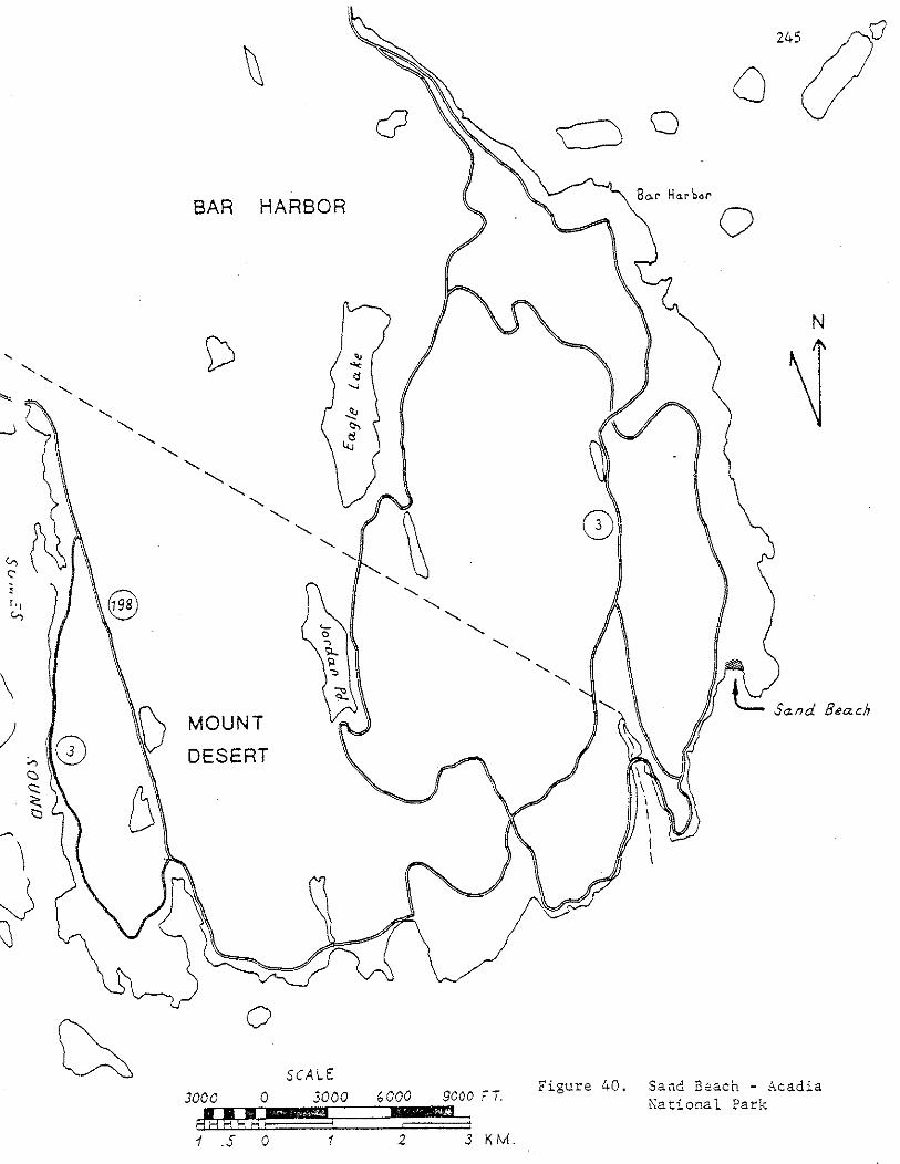

246

3. Evening Primrose - Oenothera sp.
4. Pasture grasses
5. Mullein - Verbascum thapsus
6. Quack grass - Agropyron repens
7. Freshwater Cord Grass- Spartina pectinata (on margin of
fresh/brackish water).
8. White spruce - Picea glauca
9. Bayberry- Myrica pensylvanica
10. Ground juniper - Juniperus communis var. depressa
11. Seaside Rose - Rosa rugosa
247
There are no berm colonizers despite the seasonally accretive state
of the berm and aeolian ramp. This is probably due to heavy recreational
use of this area. A snowfence designed to keep pedestrian traffic off the
dunes runs along the frontal dune ridge crest.
Summary of Significant Features
A. Geological
1. 30~40% (by weight) carbonate: by far. the best example
of a sandy carbonate beach in the state.
2. Sand-rich, high sand volume per meter of beach length.
This is due to the carbonate sand source. Glacial
sand sources north of Pemaquid are usually too small
or coarse to permit formation of a healthy, sand-rich
beach profile.
3. Moderately well sorted, an unusual feature for beaches
north of Pemaquid: also due to the carbonate sand source.
4. Marked difference in winter and summer profiles. Excellent
site for educational illustration of this feature of beaches.
5. Moderately steep berm foreslope - due to medium grain
size and moderately good sorting - increases permeability
of the sand.
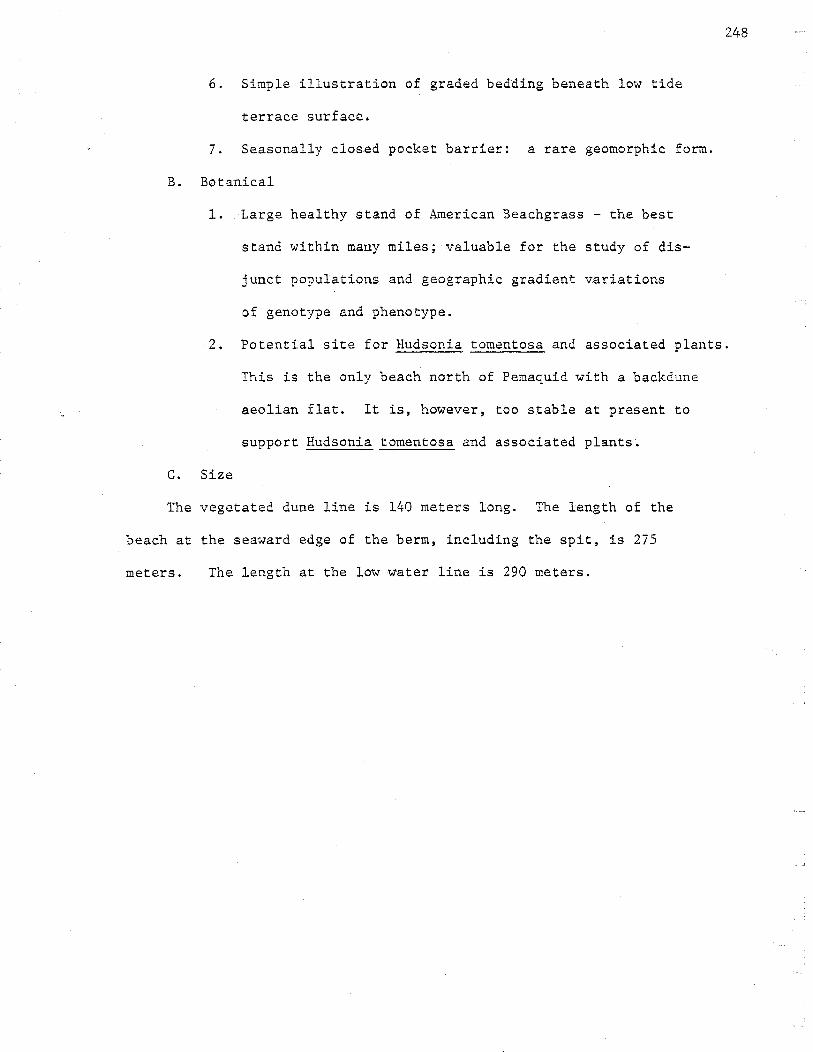
6. Simple illustration of graded bedding beneath low tide
terrace surface.
7. Seasonally closed pocket barrier: a rare geomorphic form.
B. Botanical
1. Large healthy stand of American Beachgrass - the best
stand within many miles; valuable for the study of dis
junct populations and geographic gradient variations
of genotype and phenotype.
248
2. Potential site for Hudsonia tomentosa and associated plants.
C. Size
This is the only beach north of Pemaquid with a backdune
aeolian flat. It is, however, too stable at present to
support Hudsonia tomentosa and associated plants.
The vegetated dune line is 140 meters long. The length of the
beach at the seaward edge of the berm, including the spit, is 275
meters. The length at the low water line is 290 meters.

25 Sandy River Beach
Jonesport, Washington County
Description of the Geological Features
249
Most of Sandy River Beach (Figure 41 ) is of the fringing pocket beach
type, but there is a barrier spit at the north end where a tidal river
drains out. The tidal river is small and drains a salt marsh of about 15
hectares. This is the northernmost sandy barrier-spit in the eastern
U.S.A., though a long gravel-cobble barrier is located in Lubec.
There is an open fetch to the south so that the north end is the
downdrift end. ~~en field checked in July of 1977, the north end had
more sand, a constructional ridge and runnel profile on the lower
beachface, and a broad berm on the upper beachface. The beachface sand
was fine, the berm sand was medium and a pebble and cobble lag surface
was on the lower half of the beach face along the entire length of the
beach.
There was an eroded winter scarp, about one meter high, along most
of the dune line with a zone of annual colonizers (dominated by Sea
Rocket - Cakile edentula) one to five meters wide in front of the scarp.
The scarp was of low relief since it faces east and therefore does not
receive prevailing winds of Maine .. At the south end,the annual colonizer
zone includedStrand Wheat- Elymus arenarius and American Beachgrass
Ammophila breviligulata, indicating short term perennial accretion of
the south end.
A possible relict frontal dune ridge is located about 35 meters
behind the frontal dune scarp near a stand of White Spruce - Picea
glauca at the northern end, but this possible relict ridge is not
associated with a change in vegetation and runs straight to the forest,
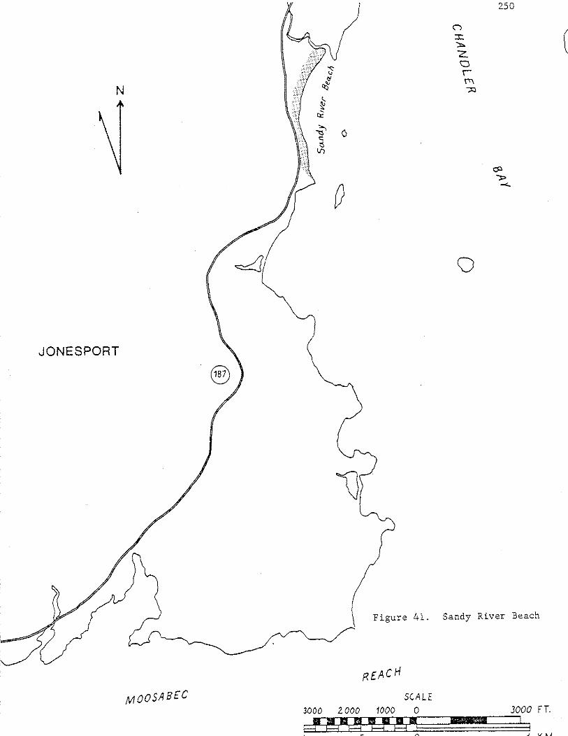

where it is truncated, suggesting that it is man made. There is a
definite relict frontal dune scarp in~front of the parking lot at the
northern end. This relict scarp is 4 meters behind the winter scarp of
1977.
Beachface sand volume is low with a possible rocky lag surface
beneath the sandy beachface and berm. The sand source is submerged
till or ice contact stratified drift. The sand resembles that of Roque
Island in that accretionary surfaces are white, quartz rich, well sorted
and not so mineralogically young as Reid Beach. There are 17 houses all
within 30 meters of the frontal dune scarp.
Description of Botanical Features
There are large stands of Seabeach Sandwort - Arenaria peploides on
the aeolian ramp where seaweed is mixed in the sand.
The following is a partial list of the vegetation:
1. Sea Rocket - Cakile edentula
2. Beach Pea - Lathyrus j aponicus
3. Strand Wheat - Elymus arenarius
4. American Beachgrass - Ammophila breviligulata
5. White Spruce - Picea glauca
6. Seabeach Sandwort - Arenaria peploides
7. Quack Grass- Agropyron repens
8. Yarrow - Achillea millefolium
9. Evening Primrose- Oenothera sp.
10. Fireweed - Epilobium angustifolium
11. Bayberry - Hyrica pensy1vanica
12. Seaside Rose - Rosa rugosa
13. Orach - At rip lex patula var hastata
251

Summary of Significant Features
A. Geological
1. Fine sandy beach,uncommon in this area of Maine.
It provides a stepping-stone habitat for dune plants
and beach macrofauna.
2. Possible accretionary ridge and swale topography (visible
on stereoscopic view of vertical air photo).
3. Definite relict frontal dune scarp 4 meters behind the
present scarp.
B. Botanical
C. Size
1. Healthy stand of American Beachgrass. This stand, ~nd
nearby Roque Island and Roque Bluffs beaches, contain
most of the American Beachgrass beDveen Mt. Desert and
Lubec.
252
The significant portion of the beach~ from a seawall at the southern
end to the north tip, is 500 meters long.

Great South Beach
26 Roque Island, Jonesport, Washington County
Description of Geological Features
Roque Island's Great South Beach (Figure 42 ) is of the fringing
pocket type. Unlike the sand and gravel beach on the north side of the
island, there is no wave eroded bluff behind the south beach. There is
a high sand volume per meter of beach length considering the paucity of
sand sources in this part of Maine. Accretionary portions of the beach
profile and the aeolian frontal dune ridge are white, quartz rich and
well sorted.
Presence of cobbles, boulders, gravel and rapidly graded bedding to
these coarser sizes below the fine lower beach face suggests a glacial
till or stratified drift source for the beach sand of Roque Island's
Great South Beach. This glacial source is now completely eroded or sub
merged and there are no wave-eroded bluffs visible. The sand has
probably been reworked by wind, waves and currents of the harbor for
thousands of years because its finer beds are well sorted by both
grain size and mineralogy. There are fewer feldspar grains and schist
fragments in the medium and fine layers than at a mineralogically
younger beach such as Reid State Park.
The southwest end of Great South Beach approaches the classical
log-spiral plan view shape of wave fronts refracted around a headland.
The southwest end of the beach is the spiral or downdrift end. The sand
here is fine and well sorted and the beach face slope is very gradual
(approximately 70 meters wide).
Because of the configuration of nearby islands, there is no open
253
fetch to the sea. Swell \vhich passes between these islands is substantially
weakened by both refraction and diffraction. Local wind waves can form

along a 4 km fetch to the southeast.
The log spiral end of the beach (towards the southwest) receives
only constructional, low energy, long swell (short wave length, steep
waves which are of high energy are not capable of major refraction).
This accounts for the finer grained sand and gradual slope at the
southwest end. Also, refraction causes a stretch of the wave front and
thus a reduction of wave energy leading to fine grain size, accumulation,
and gradual slope.
There are no dry dune slacks or parabolic dunes present. There is
no frontal dune ridge behind the southern third of the beach, only a
narrow sandy overwash area. The forest comes close to the winter scarp
in this narrow overwash area.
The aeolian frontal dune ridge begins south of mid-beach and a well
established steep frontal dune ridge of approximately two meters height
runs behind the mid third of the beach. In this area the ridge is
composed of medium sand with an aeolian ramp, including multicrystal
grains. There is apparent se.award accretion here because the -frontal
dune ridge has a deep swale behind it. There is, however, no former
wave cut shoreline visible behind the swale, only upland forest. There
is a Sweet Gale bog and pond behind the mid-beach frontal dune ridge in
the swale.
A cobble lag surface covers the beach face on the northernmost
third of the beach.
There is a strong correlation between grain size, slope and wave
energy at Great South Beach. The southwest end has fine sand, gradual
slope and receives only long refracted swells. The center and northeast
end are of medium grain size (with fine sand on lower beach face), more
poorly sorted, and can receive short, steep, storm waves.
255

Description of Botanical Features
There is more acreage of American Beachgrass here than at Roque
Bluffs. Roque Island, Sandy River Beach and Roque Bluffs have the only
large stands of American Beachgrass between Mt. Desert and Lubec.
There is much Strand \meat - Elymus arenarius along the frontal dune
scarp where aeolian activity is low, especially along the southwestern
third of the beach.
Quack Grass - Agropyron repens is common behind the scarp of the
southwest end of the beach, also in low aeolian activity areas. It is
healthy due to seaweed overwash input.
Blueberry - Vaccinium angustifolium and Cranberry - Vaccinium
macrocarpon are present, especially in eroding glacial and Indian shell
heap areas (Beach Field).
There is poor zonation and no salt spray pruning. There is no
distinct dry backdune area. The beachgrass of the frontal dune ridge
east of the Sweet Gale bog simply blends into pasture grasses and upland
forest or field species.
The following is a partial species list for Roque Island - Great
South Beach:
1. Strand Wheat - Elymus arenarius
2. Quack Grass - Agropyron repens
3. Beach Pea - Lathyrus japonicus
4. Yarrow- Achillea millefolium
5. Pasture Grasses
6. Saltwort - Salsola kali
7. Sea Rocket- Cakile edentula
8. Sea Chicbveed - Arenaria peploides (one plant)
9. Orach - Atriplex patula var. hastata
256

10. Raspberry - Rubus idaeus
11. Alder - Alnus sp.
12. Sweet Gale - Myrica gale
13. Cranberry - Vaccinium macrocarpon
14. Blueberry - Vaccinium an~ustifolium
15. American Beachgrass - Ammophila breviligulata
16. Mustard - Brassica sp.
Summary of Significant Features
A. Geological
1. The shape of the southwest end of the beach approaches
the classical log spiral shape of wave fronts
refracted around a headland.
257
2. There is a strong correlation between grain size, slope and
wave energy. The southwest end is fine and well sorted
with a gradually sloping beach face (70 meters wide). It
receives only long refracted swell. The central part
and northeast end of the beach have medium grain
size (though fine on the lower beach face), are more poorly
sorted and can receive short, steep, storm waves.
3. The sand source is a reworked submerged glacial till
or ice contact stratified drift.
4. Multiple ridge and runnel system and ground water (rip
channel?) escape channels at western end. The system
is of very low relief.
5. Neap high water berm edge at southwest beach end at
time of field checking. There was no marked spring
high water berm.

6. No aeolian ramp or frontal dune ridge at southwestern
end of beach (no on-shore wind). There was a short,
sometimes double,scarp. There is very little sand
in the vegetated portion of the southwest beach back
dune. The ridge here is probably formed by overwash.
B. Botanical
c.
1. There are no dry dune slacks or parabolic dunes to
provide habitat for Beach Heather - Hudsonia tomentosa
and associated plants.
2. The beachgrass of the frontal dune simply blends into
the pasture grasses and upland forest or field species.
There is poor zonation and no salt spray pruning.
3. Quack Grass is located behind the scarp at the south
west end of the beach where there is low aeolian activity.
It is healthy due to seaweed overwash input. Good
correspondence between dune grass speciation and exposure
to aeolian sand activity.
4. Strand Wheat - Elymus arenarius is present along the front
of the scarp wherever aeolian activity is low, especially
southwest of the beach field.
5. The most important botanical feature: along with Roque
Bluffs and Sandy River Beach in Jonesport these are the
largest stands of American Beachgrass between Mt. Desert
and Lubec.
The length of the beach is 1930 meters.
258

259
Roque Bluffs Beach
27 Roque Bluffs, Washington County
Description of the Geological Features
Roque Bluffs Beach (Figure 43) is a pocket barrier with a probable former
marine lagoon behind the beach and dunes. This former lagoon is now a
shallow fresh water lake.
The barrier has formed by a combination of overwash and aeolian
transport. The long flat backslope of the barrier between the road and
pond is sandy but probably underlain by rocky overwash fans. Perennial
accretion has left a veneer of sand over most of the barrier.
When field checked (August, 1977) the beachface was largely cobbles,
with double rocky berms on the beach face and a combination of a rocky
storm berm and a sandy frontal dune ridge above the limit of normal
winter high water. The two beachface rocky berms correspond approximately
to spring high water and neap high water. Each berm had rocky cusps.
There was an erosional scarp in the sandy dune in front of which
there had been perennial rocky berm accretion with vegetation on the
accreted area. The edge of vegetation in 1977 generally varied from one
to six meters from the relict erosional scarp in the sandy dune, but in
some places the scarp was actively eroding because of overwash of the
perennially accreted area. Host of the beach was experiencingaccretion
in front of the sandy scarp in the form of wave deposition of cobbles
with a sandy matrix. This sandy matrix allows American Beachgrass to
invade the accreting area.
A terrace-like profile in the central portion of the barrier suggests
another relict erosional scarp up to 15 meters from the 1977 vegetational
edge, which indicates a significant amount of perennial accretion on
such a small beach.

261
Description of the Botanical Features
The plant species are more like those of a rocky beach than a sandy
beach, but there is abundant American Beachgrass - Ammophila breviligulata.
The edge of vegetation generally varies from one to six meters from the
relict erosional scarp in the sandy dune.
The most marked characteristic of the vegetation of Roque Bluffs is
the abundance of Seabeach Sandwort - Arenaria peploides and Beach Pea -
Lathyrus japonicus.
Species seaward of the sandy erosional scarp include the following:
1. Seabeach Sandwort - Arenaria peploides
2. Sea Rocket - Cakile edentula
3. Coast Blite - Chenopodium rubrum
4. Orach - Atriplex patula var. hastata or A. arenaria
5. Lungwort - Hertensia maritima
6. Beach Pea - La thyrus j aponicus
7. American Beachgrass- Ammophila breviligulata
8. Quack Grass - Agropyron repens
Additional species which are in ·the backdune include Seaside Rose -
Rosa rugosa and Evening Primrose - Oenothera sp.
Su~~ary of Significant Features
A. Geological
1. The most significant feature is the presence of a
probable former marine lagoon behind the beach. c14
dating of the fresh water/salt water sediment interface
would provide interesting data related to sea level rise
and sediment supply.
2. A terrace-like profile in the central portion of the
barrier suggests a relict erosional scarp.

3. Two beachface rocky berms occurred, which corresponded
to spring high water and neap high water respectively.
Each berm had rocky cusps.
262
4. There was a recent erosional scarp in the sandy dune in front
of which there had been perennial rocky berm accretion
with vegetation on the accreted area. The beach was ex
periencing perennial accretion in front of the sandy
scarp by wave deposition of cobbles with a sandy matrix.
B. Botanical
1. The sandy matrix being deposited in front of the sandy
scarp allows American Beachgrass to invade the accreting
area in front of the sandy scarp. This may be the northern
most large stand of American Beachgrass in Maine.
2. The most marked characteristic of the vegetation of
Roque Bluffs is the abundance of Seabeach Sandwort
Arenaria peploides and Beach Pea Lathyrus japonicus.
C. Size
The length of the beach is 780 meters.

GENERAL EVALUATION OF SAl.~D BEACHES FOR INCLUSION ON THE REGISTER OF CRITICAL AREAS
1. Description Sand Beaches.
Sand Beaches occur along the coast of Maine and are concentrated in the southern part of the state, in York and Cumberland Counties. A variety of geomorphic forms and botanical associations are found along the coast. The features are the result of the interaction of several processes of the beach system and as a result are in a constant state of change.
2. Considerations in Registration
A. Values and qualities represented by feature (specifically including any unique or exemplary qualities of the feature).
Maine's sand beaches form one of the state·~ most valuable coastal resources since they represent most of the public access, intensive recreational use, open space and salt marsh portions of the coastline. Diverse scientific and educational values are numerous on the sand beaches in Maine and are strong criteria for significance. Many beaches display excellent examples of certain geomorphic features or geological processes. The same is true for botanical features and processes.
Beach systems are among the most dynamic of geologic environments. The form and position of beach and dune features respond to slight changes in the process agents which control their development. The geologic fabric of the bedrock units in Maine exerts a pronounced control on its coast,whose highly irregular and deeply embayed outline contrasts sharply with the rest of the coastline south of New Hampshire. The· limited sand supply and coastal geometry make Maine's beach forms unique a:long the east coast.
Maine's beaches provide evidence of sea level rise rates; knowledge of which is essential for coastal zone planning.
All undisturbed coastal sand dune and berm plant habitats in Maine are significant simply because of their limited extent. Almost two thirds of Maine's original dune fields are now heavily developed or altered. Of approximately 6,400 km of coastline in
263
Maine, the beaches with large undeveloped dune fields - Popham, Reid, and Seawall, represent only 8.7 km of coastline length. In contrast, beaches with major dune fields which are now disturbed represent 18 km of coastline. Smaller scale undisturbed dune and berm plant habitats are significant because such habitats are rare in Maine. Good stands of species with limited area in the state; e.g. Ameri-can Beachgrass, Beach Heather, Wormwood, Jointweed, are found on a few of the remaining undisturbed dune habitats. Also, a few coastal dune plants reach their coastal range limit in Maine. The presence or abundance of many species have been found to decrease from south to north but these trends are already difficult to study in detail because of extensive development on most of Maine's sand beaches.

264
B. Probable effects of uncontrolled use (specifically in relationship to its intrinsic fragility).
The attractiveness of beach and dune areas for potentially damaging recreational and development uses, coupled with the fact that these usage pressures are concentrated on only one to two percent of Maine's coastline, could result in the destruction of these unusual beach systems. The lack of use and management policies, and absence of basic data for Maine's unique beach systems have led to expensive and usually futile erosion prevention measures. This inevitably results in public controversy over causes of beach erosion and shore property loss. Continued development of Maine's beaches without a full understanding of fundamental beach system and dune ecosystem dynamics could result in the eventual disturbance of the remaining sand beaches in the state. The maintenance and conservation of these areas is especially significant since they display a variety of values including: scenic, zoological, geological, botanical, educational and scientific. Proper management of the remaining sand beaches is necessary in order that they be preserved for future uses.
C. Presence and Probable Future Use. (Specifically present and future threat of destruction).
Sand beaches on the coast of Maine have a variety of present uses. These uses range from State Parks and Conservation Easements to private ownership and highly developed areas. Beaches along the coast of Maine are subject to the increasing pressures of development and alteration. A large percentage of the coastline is in private ownership making probable future use uncertain.
D. Level of Significance.
Sand beaches in Maine are of regional significance because they represent a unique habitat on the Atlantic Coast of North America.
E. Probable effects of registration - positive and negative (Specifically .including the economic implications of inclusion of the feature on the Register).
The expected positive effect of registration will be to give official recognition of the importance of sand beaches by the State. Also, landowners will be informed of the importance of sand beaches in Haine. Registration will also aid in the monitoring of sand beach systems in the State and hopefully aid in their- conservation.
The expected negative effect of registration would be any publicity generated by the registration process. Publicity would attract visitors, which might result in the destruction of the fragile dune areas and their related plants. No substantial economic implications should result from the registration process.
F. Programs ~fuich Affect or are Relevant to the Feature.
1. Zoning by Land Use Regulation Commission. 2. Shoreland Zoning. 3. Wetlands Laws.
3. Conclusions
A. Conformance with Definition Contained in the Act.
The Act defines a critical area as meaning: "areas containing or potentially containing plant and animal life or geological features worthy of preservation in their natural condition, or other natural features of significant scenic, scientific~ or historical value."
Significant sand beach systems support rare and unusual geological, botanical and zoological features that are worthy of preservation in their natural condition. Thus, significant sand beach systems meet the legislated definition of critical areas.
B. Conformance with the Guidelines for the Registration of Critical Areas, adopted by the Critical Areas Advisory Board on September 11, 1975.
Section I. Knowledge of the Feature
The report Geological and Botanical Features of Sand Beach Systems in Haine and Their Relevance to the Critical Areas Program of the State Planning Office, was prepared for the Critical Areas Program in order to provide detailed information on Sand Beach Systems in Maine.
Section 2. Representation on the Register
Three sand beaches - Popham, Reid and Seawall, have been included on the Register of Critical Areas as significant bird nesting sites.
Section 3. Variety of Values
Sand beaches generally have a variety of values including: scenic, recreational, botanical, zoological, geological, scientific and educational.
Section 4. Scarcity
Sand beaches are rare in Maine. Out of 6,400 km of coastline sand beaches represent only 121 km of this length.
Section 5. Quality
Twenty-seven sand beaches, out of a total 200 have met the criteria outlined in the "Methods" section of this report.
265
Section 6.
Sand beaches are dynamic systems. They are subject to the influences of wind, waves, sand sources areas, storms and human activity. Their persistence is related to the interaction of all these processes and as a result beach systems are constantly changing.
Section 7. Geographic Distribution
The majority of the sand beaches are found south of Reid State Park on the Coast of Maine in York and Cumberland County. These beach systems are unique along the Atlantic Coast of the United States.
Section 8. Use
Sand beaches have potential scientific, educational and recreational uses.
Section 9. Manageability
266
Due to the many processes that influence sand beach development, management of the areas requires careful thorough investigation of the implication of any alteration to the system.
Section 10. Potential Economic Effects
Registration of sand beaches should have little economic implications for the land owners.
Section 11. Potential Effect on Conservation of Feature
Registration is expected to have a positive effect on the conservation of sand beaches in Maine.

RECO't<lMENDATIONS
The authors make the following recommendations to the Critical Areas Program for the beach systems discussed in this report:
1. Because Maine's beach systems have a unique value as a coastal resource and because development pressures are increasing, it is urgent that the 27 described beach systems be evaluated for inclusion on the Critical Areas Registry.
2. Andrews Beach on Long Island in Casco Bay and Lubec Spit in Lubec met the criteria for recommendation as criti.cal areas "but were not field checked. .-These should be visited and included in the final list8
267
3. Because of the fragile nature of the vegetational compartments of beach systems, it is important that these areas be monitored and management plans developed.
4. As additional information on other beach systems becomes available and this information indicates that a beach meets the geological and botanical significance criteria, developed in this report, that beach should be added to the Critical Areas Registrye

BIBLIOGRAPHY
Bagnold, R.A. (1940). Beach Formation by Haves: Some Hodel Experiments in a Wave Tank, J. Inst. Civ. Eng., v. 15, pp. 27-52.
Bird, E.C.F. (1969). Coasts, An Introduction to Systematic Geomorphology, Vol. 4, 246 pp.
Bumpus, D.E. and Lauzier, L.M. (1965). Serial Atlas of the Marine Environment -Folio F, Surface Circulation on the Continental Shelf off Eastern North America between Newfoundland and Florida, American Geographical Society.
Fairbridge, R.W. and Krebs, D.A., Jr. (1962). Sea Level and the Southern Oscillation, Geophys. Jour. Roy. Astron. Soc., 6, pp. 532-545.
Farrell, S.C. (1972). Coastal Processes, Historical Changes and the Post-Pleistocene Geologic Record of Saco Bay, Maine: Unpub. Ph.D. Diss., Coastal Research Center, Univ. of Mass., pp.
Francis, J.R., Stommel, H., Farmer, H.G., and Parson, D. (1953). Observations of Turbulent Mixing Processes in a Tidal Estuary, Ref. No. 53-22, Woods Hole Oceanographic Institute, 28 pp.
: 268
Graham, J .J. (1970). Coastal Currents of the ~vestern Gulf of Maine, Intl. Comm. NW Atlantic Fisheries Res. Bull. no 7, pp 19-31.
Hicks, S.D. (1972). Vertical Crustal Movements from Sea Level Measurements along the East Coast of the United States, Jour. of Geophys. Res., v. 77, pp. 5930-5934.
·Hicks, S.D. and Crosby, J.E. (1974). Trends and Variability of Yearly Mean Sea Level, NOAA Technical Memorandum NOS 13, 14 pp.
Hj ulstrom, F. (1935). The Morphological Activity of Rivers as Illustrated by River Fyris, Bull. Geol. Inst. Upsala, Vol. 25, pp. 221-527.
Hju1strom, F. (1955) Transportation of Detritus by Hoving Water, In Recent Marine Sediments, P.D. Trask, Editor, pp. 5-31, Dover Publications, Inc., N.Y.
King, C.A.M. (1972). Beaches and Coasts, 2nd Edition, Edw. Arnold, Ltd., London, 570 pp.
Koons, D.C. (1976). Geomorphology and Land-Use Decisions in Maine: Geol. Soc. Amer. Spec. Pap., No. 174 (Urban Geomorphology) pp. 149-157.
Krumbein, W. C. (1963). The Analysis of Observational Data from Natural Beaches. Beach Erosion Board Technical Hemorandum 130.
Mead, B.K. (1971). Report of the Sub-Commission on Recent Crustal Movements in North America, In Recent Crustal Movements, Symp. 15, Intl. Ass Geo.
Myers, A.C. (1965). The Damariscotta Oyster Shell Heaps: Some Further Considerations, Unpub. Senior Thesis, Dept. of Geology, Princeton Univ., 54 pp.
Nelson, B.W. (in prep.). Shoreline Changes at Popham Beach.
Pettijohn, F.J. (1957). Sedimentary Rocks. Harper and Brothers, N.Y. 718 pp.
Snow, D.R. (1972). Rising Sea Level and Prehistoric Cultural Ecology in Northern New England, American Antiquity, Vol. 37, no. 2, pp. 211-221.
Tanner, W.F. (1965). High Index Ripple Marks in the Swash Zone. J. Sediment. Petrol., v. 35, p. 968.
Timson, Barry S. (1977). A handbook of Coastal :Marine Geologic Environment of the Maine Coast. Draft Copy. Bureau of Geology. Maine Dept. of Conservation. 167 pp. 112 maps.
Trudeau, Phillip (1977). Beach Vegetation and Oceanic Processes Study of Popham State Park Beach, Reid State Park Beach, and Small Point Beach. Final Contract Report, Maine Department of Conservation and U.S. Dept. of Agriculture, 144 pp.
U.S. Army Corps of Engineers (1957). Saco, :Maine Beach Erosion Control Study, U.S. Army Corps of Engineers House Document 1!32, 85th Congress, 1st Session, 1957, 37 pp.
Williams, A. T. (1973). The Problem of Beach Cusp Development: Jour. Sed. Petrol., v. 43, pp. 857-866.
269