Embed Size (px)
Citation preview
DEPARTMENT OF THE INTERIOR
UNITED STATES GEOLOGICAL SURVEYGEORGE OTIS SMITH, DIRECTOR
346
STRUCTURE OF THE BEREA OIL SAND IN THE FLUSHING QUADRANGLE
HAKRISON, BELMONT, AND GUERNSEY COUNTIES, OHIO
BY
W. T. GRISWOLD
WASHINGTONGOVERNMENT 'PRINTING OFFICE
1908


CONTENTS.
Page. Introduction.............................................................. ' 5Location, drainage, and culture.........................'................... 6
1 Geology.............................................................:.... 7Rocks showing at the surface........................ '.................... 7
Monongahela formation............................................ 71 Pittsburg coal.................................................. 7
Rocks between Pittsburg coal and Meigs Creek coal.............. 7Meigs Creek coal............................................... 8Rocks between Meigs Creek coal and Uniontown coal............. 9Uniontown coal............................................... 9Rocks between Uniontown coal and Waynesburg coal............ 9Waynesburg coal............................................:.. 9
Washington formation............................................. 10Rocks between Waynesburg coal and Washington coal............ 10Washington coal................................................ 10Section from Washington coal to Upper Washington limestone..... 11Upper Washington limestone.. ................................... 11
Conemaugh formation. ............................................. 12Pittsburg limestone..............:.............................. 12Rocks between Pittsburg limestone and Ames limestone......... 12Ames limestone............................................... 12Rocks between Ames limestone and Cambridge limestone......... 13
Cambridge limestone........................................... 13Mahoning sandstone............................................ 13
Rocks wholly below the surface......................................... 13Results of the work........................................................ 16
; Object................................:.....................;........... 16Subsurface mapping.................................................... 16
General statement.................................................. 16Base map.......................................................... 16Measurement of intervals.......................................... 17Surface structure map.............................................. 17Structural features................................................. 18Convergence sheet. ....... v............................... ̂ .......:. 19Map of the Berea oil sand.......................................... 19
Factors governing the accumulation of oil and gas........................ 20Porosity.......................................................... 20Saturation..........:...................................!......... 20Structure........................................................... 21Places of accumulation................;........................... 21
Conditions in the Flushing quadrangle................................... 22Saturation of Berea sand........................................... 22Existing oil pools................................................... 22 \Territory favorable for new development............................. 23
Wells in the Flushing quadrangle............................................. 24Survey publications on petroleum and natural gas........................... 29
3

ILLUSTRATIONS.
PLATE I. Topographic map of Flushing quadrangle, Ohio, showing contours ofbase of Pittsburg coal (in pocket).
II. Contour map of top of Berea sand in Flushing quadrangle, Ohio (inpocket).
4'

STRUCTURE OF THE BEREA OIL SAND IN THE FLUSHING QUADRANGLE, HARRISON, BELMONT. AND GUERNSEY COUNTIES, OHIO,
By W. T. GRISWOLD.
INTRODUCTION.
The United States Geological Survey has undertaken detailed mapping of the geologic structure of the oil sands in certain parts of the Appalachian oil field in eastern Ohio and western Pennsylvania. The first report describing work of this kind is contained in Bulletin No. 198, which deals with the Cadiz quadrangle in Harrison County, Ohio. The second bulletin is No. 318, which describes the conditions existing in the Steubenville quadrangle in Ohio and West Virginia and in the Burgettstown and Claysville quadrangles in Pennsylvania. The present report,. which is the third of the series, treats of the Flushing quadrangle in Harrison, Belmont, and Guernsey counties, Ohio.
The object of this work is, to determine accurately the geologic structure of the surface rocks and of the Berea sand (which is the principal oil-bearing stratum of this part of the field), and from this structure to determine, if possible, where the conditions are favorable for. the accumulation of oil and gas. The first step in the work is to ascertain the structure or lay of the surface rocks. Then it is neces sary to determine what degree of parallelism exists between the rocks that outcrop at the surface and those that lie from 1,000 to 2,000 feet below the surface, and by means of this parallelism to construct a map of the oil.sand as if all the geologic formations above it had been removed and the upper surface of the sandstone were open to view.
Previous work of this kind has been carried on in areas in which a considerable amount of oil and gas territory had been developed prior to the survey. In such regions it was possible by means of wells already drilled to check the degree of exactness to which the oil sands could be plotted, and by a study of the conditions under which the oil and gas had accumulated to formulate general laws governing such accumulations.
In the Flushing quadrangle very little oil or gas has been found. It was for this reason that the area was selected for a practical test
5

6 BEREA OIL SAND IK FLUSHING QUADRANGLE, OHIO.
of the principles which had been determined in the previous surveys. The Berea sand, which is the principal oil sand of this part of Ohio, was known to be present in this quadrangle. The surface conditions were also known to be favorable for accurate geologic work. By selecting such an area and carefully plotting the structure it was hoped that the areas which are most favorable for the accumulation of oil and gas could be determined, and that thus the economic devel opment of the field would be assisted. The result of the work shows a regularity in the structure which is not favorable for large oil accu mulations. There are, however, minor structural features which doubtless have exercised an influence on the location of deposits of oil and gas, and which may be regarded as indicating favorable ter ritory.
The field work in the Flushing quadrangle was performed during the field season of 1906 by B. J. Green and F. M. Hutchinson under the supervision of the writer.
LOCATION, DRAINAGE, AND CULTURE.
The Flushing quadrangle is situated in eastern Ohio and includes parts of Harrison, Belmont, and Guernsey counties. It is limited by meridians 81° and 81° 15' and by parallels 40° and 40° 15'. The area of the quadrangle is about 227 square miles. It contains no large towns, but there are a number of small places, such as Flushing, Piedmont, Morristown, Belmont, and Bethesda, within it. The city of Barnesville is a little over 1 mile south of the' quadrangle, near the southwest corner.
The entire surface of the quadrangle is deeply dissected. The divide separating the waters of Muskingum River from those flowing directly into Ohio River enters the quadrangle in the northeast corner, and extends southward through the eastern third of the quadrangle, passing through the towns of Flushing, Morristown, and Bethesda. East of this divide the topographic features differ materially from those on the west. The streams flowing to the east have a gradual slope at a nearly uniform rate to the eastern edge of the quadrangle; the streams flowing to the west have cut deep canyons nearly to their heads, thus descending to the general valley levels within a very short distance from their sources. Once at those levels they flow westward with very little fall. Between the streams are oval-shaped hills with steep sides. Throughout most of the area the rocks underlying the region are exposed through a vertical section from 300 to 400 feet thick. The surface is in a high state of cultivation and is traversed by roads in all directions.
The Cleveland, Lorain and Wheeling Railway (of the Baltimore and Ohio system) crosses the area from the center of the eastern margin to the northwest corner, and the main Baltimore and Ohio Railroad line passes through the southeast corner.

BEREA OIL SAND IN FLUSHING QUADRANGLE, OHIO. 7
GEOLOGY.
ROCKS SHOWING AT THE SURFACE.
The rocks which outcrop at the surface of the Flushing quadrangle are included in the.Washington, Monongahela, and Conemaugh forma tions of the Carboniferous system. From the highest to the lowest strata exposed the vertical distance is 740 feet. The base of the Pitts- burg coal is accepted as a datum plane from which to commence descriptions and measure intervals. This well-known coal bed is constant over an area covering many square miles and therefore makes a desirable plane from which to reckon. The other members of the formations will be considered from this base, first the overlying and then tne underlying beds, the peculiarities of each member being described and the areal distribution of its outcrop given.
MONONGAHELA FORMATION.
The Monongahela formation includes the rocks from the base of the Pittshurg coal to the top of the Waynesburg coal. The principal strata are the Pittsburg, Meigs Creek, Uniontown, and Waynesburg coal beds.
Pittsburg coal. In this region the Pittsburg coal ranges in thickness from 40 to 62 inches, with an average of about 50 inches in the Flush ing quadrangle. The bed is usually divided into three or four benches by small partings of half an inch or less in thickness. One parting is from 14 to 21 inches above the bottom and another about 4 inches higher. The coal is of good quality and generally mined both at local banks and commercial mines. This coal bed is present in most of the. quadrangle. In Nottingham Township, Harrison County, it extends westward- along the ridge to Prospect Hill. In Moorefield Township the last outcrop to the west is close to the village of Moorefield. In Flushing Township the most westerly outcrops are found on the ridge between Boggs Fork and Stillwater Creek half a mile west of Compher, and to the west of Stillwater Creek in the hills south and east of Oakgrove. Northwest of these last-named outcrops the coal dips to the southeast. It outcrops along the hillsides above Stillwater Creek to a point within a mile of Badgertown. On Boggs Fork and Trail Run the coal remains above water level to a point within a mile of the town of Flushing. East of the main dividing ridge this coal does not come to the surface except for about 2 miles on Crabapple Creek in Wheeling Township, Belmont County. At Laferty, on Wheeling Creek, the coal is about 80 feet below the surface.
Rocks 'between Pittsburg coal and Meigs Creek coal. The lower por tion of the interval between the Pittsburg coal and the Meigs Creek coal differs greatly in different localities. Normally, the Pittsburg coal is overlain by a few feet of shale extending to a hard blue limestone usually about 1 foot in thickness. Above the limestone is

BEEEA OIL SAND IN FLUSHING QUADEANGLE, OHIO.
shale to the Pittsburg Rider coal, which is a small bed from 8 inches to 1 foot in thickness and from 24 to 30 feet above the base of the Pittsburg bed; it is, however, absent over the greater portion of the Flushing quadrangle. Above the Rider coal a second limestone stra tum about 1 foot thick is found in many places. Above this is shale for 25 feet or more to a bed of smooth, light cream-colored limestone, from 1 to 2 feet thick, which is especially prominent in the southwest corner of Union, the northwest corner of Goshen, and the eastern side of Warren townships in Belmont County. From this limestone up to the Meigs Creek coal is sandy shale, in places merging into flaggy sandstone.
In a large part of the Flushing quadrangle the lower part of this interval, from the Pittsburg coal to the top of the limestone overlying the Rider coal, is represented by a massive buff sandstone of medium coarseness known as the Pittsburg sandstone. This bed generally commences on top of the coal and in some localities has replaced part of the coal bed. The sandstone is present in the western part of Cadiz Township, through Nottingham Township, and in the eastern part of Moorefield Township, in Harrison County; in the western part of Flushing Township, in Kirkwood Township to the west of Hendrysburg, and through the western part of Warren Township, in Belmont County.
Meigs Creek coal. The Meigs Creek coal is equivalent to the Sewickley coal bed of Pennsylvania. Throughout a large part of the Flushing quadrangle this coal is of commercial importance, main taining a thickness of about 4 feet. As a rule the coal is overlain by clay which is flinty in places and ranges in thickness from 8 inches to 2 feet. The clay is locally overlain by a small coal from 6 to 8 inches thick. The Meigs Creek coal maintains a commercial thick ness through Athens Township, Harrison County; and in the eastern part of Flushing, the whole of Union, Goshen, Warren, and the south ern part of Kirkwood townships, Belmont County.
The interval between the base of the Pittsburg coal and the top of the Meigs Creek coal was measured in 55 different places in the quad rangle, with the results shown in the following table:
Distance between base of Pittsburg coal and top of Meigs Creek coal.
Township.
Harrison County:
Belmont County :
North half of Kirkwood. ............................
Number of measure
ments.
47
7814888
Minimum interval.
Feet. 8086
858595999594
101
Maximum interval.
Feet. 100106
9610195
101102113109
Average interval.
Feet. 9496
919495
100101103105

GEOLOGY. 9
Rocks between Meigs Creelc coal and Uniontown coal. The interval between the Meigs Creek and Uniontown coals is occupied by cal careous shale. In places the lower portion contains thin beds of a slabb'y white limestone which is the equivalent of that portion of the Benwood limestone known as the Dinsmore. Near the center of the interval is often found a bed of hard limestone about 1 foot thick. This bed is not. constant enough, however, to make a good reference stratum. The rocks in the upper portion of the interval consist of shale, with here and there a bed of limestone a short dis tance below the Uniontown coal. In the vicinity and to the east of the town of Flushing the separate limestone beds are better developed than in other parts of the quadrangle.
Uniontown coal. This coal, which is known as No. 11 of the Ohio series, has a thickness of- 8 to 30 inches. It is best developed on Bend Fork south of Bethesda, where it has been mined in a small way. It is here 30 inches thick, with a 2-inch parting of shale 10 inches from the bottom and 1 inch of clay 24 inches from the bot tom. The Uniontown coal appears in the high hills in the north part of Athens Township and thence south along the main dividing ridge. On the ridge south of Trail Run it extends westward to Rock Hill. It is generally present in Union, Goshen, Warren, and southern Kirkwood townships in Belmont County.
The distance from the Meigs Creek coal to the Uniontown ccal was measured in 19 different places in the quadrangle, with resultsas shown in the following table: . '
/Distance from top of Uniontown coal to top of Meigs Creelc coal and to base of
Pittsburg coal.
Township.
Harrison County i1
Belmont County:
Number of measure ments.
1 3
44 1 3 3
Meigs Creek coal.
Minimum interval.
Feet. 82
. 80
8998 96 90 91
Maximum interval.
Feet. 82
100
99108
' 96 105 105
Average interval.
Feet. 82 92
95103 96 97 98
Pitts burg
coal- average interval.
Feet. 176 188
( oi86 1 6 195
197 196 199 203
"East part. 6 West part.
Rocks between Uniontown coal and Waynesburg coal.-. The section between the Uniontown coal and the Waynesburg coal is composed mostly of shale, which is sandy in the upper portion. Below the Waynesburg coal in many places is a limestone, above which is fire clay extending to the bottom of the coal.
Waynesburg coal. The Waynesburg coal ranges from 20 to 40 inches in thickness and is best developed in the southeast corner of
37623 Bull. 346 08 2

10 BEREA OIL HAND IN FLUSHING QUADRANGLE, OHIO.
Union Township and in Goshen Township. This coal is mined in a small way northwest and south of Belmont, where it has a thickness of about 40 inches, with a half-inch parting of shale 19 inches from the bottom.
The distance from the Uniontown coal to the Waynesburg coal was measured in 27 different places in the quadrangle, as shown in the following table:
Distance from top of Waynesburg coal to top of Uniontown coal and to base ofPittsburg coal.
Township.
Harrison County:
Belmont County:
Number of measure ments.
2 4
7 9 1 4
Union town coal.
Minimum interval.
Feet.. 35
38
3637 38 47
Maximum interval.
Feet. 4051
61 56
63
Average interval .
Feet.37
43
49 .46
00 59
Pitts burg
coal average
interval.
Feet. 225
f «229 \ 6238
246 ' 242
245 262
a East part. West part. c Goshen average used.
WASHINGTON FORMATION.
The Washington formation includes the rocks from the "top of the Waynesburg coal to the top of the Upper Washington limestone. The well-marked strata which occupy this interval in Pennsylvania are not sufficiently developed in the Flushing quadrangle to be easily rec ognized. The only members positively identified are the Washington coal and the Upper Washington limestone.
Rocks between Waynesburg coal and Washington coal Overlying the Waynesburg coal is from 1 to 6 feet of shale, above which is the Waynesburg sandstone. This sandstone, which is of a light-brown color, occurs in layers from 6 inches to 2 feet thick, the combined lay ers having a total thickness of 15 to 20 feet. -Above this is a sandy shale which extends to a bed of easily disintegrated limestone, with 6 to 8 inches of dark-colored fire clay above. The average distance of this clay above the Waynesburg coal is about 52 feet. It probably represents the horizon of the Waynesburg B coal of Pennsylvania. From the clay to the Washington coal is shale, with no distinctive features. . -
Washington coal. The Washington coal is present in the southeast corner of the quadrangle, with a thickness of 1$ to 2 feet of solid coal underlain by 6 feet of very black shale. The northernmost outcrop in the quadrangle is in the hill at the crossroads H miles northeast of Morristown. From this place it is found in the. higher hills to the southeast and along the main dividing ridge as far west as Speidel,

GEOLOGY. 11
The distance between the Waynesburg and Washington coals was measured in seven different places in the quadrangle, with the results shown in the following table:
Distance from Washington coal to top of Waynesburg coal and to base of Pittsburg coal.
Township.
Belmont County:
Number of measure ments.
2 5
Waynesburg coal.
Minimum interval.
Feet. 99 89
Maximum interval.
Feet. 101 98
Average interval.
Feet. 100 92
Pitts burg coal-
average interval.
Feet. 345 334
Rocks between Washington coal and Upper Washington limestone. The rocks lying between the Washington coal and the Upper Washing ton limestone are present in the Flushing quadrangle only in the high ridges to the south of the Baltimore and Ohio Railroad. .They consist mostly of shale, with one or two limestone beds which could not be identified owing to their poor development and their small area of outcrop.
Upper Washington limestone. The Upper Washington limestone 'occurs in the tops of the high ridge in the southeast corner of the quad rangle. It is a double bed, each section of which is about 1 foot thick. Two measurements of the distance of this bed above the Washington coal were obtained, both of which show the interval to be 160 feet. This makes the Upper Washington limestone 494 feet above the base of the Pittsburg coal. This limestone is the highest reference stratum in the quadrangle. :
CONEMAUGH FORMATION.
The Conemaugh formation lies below the Pittsburg coal, extending from the base of that bed to the top of the Upper Freeport coal. It contains the Pittsburg, Ames, and Cambridge limestones, all of which are easily identified and can be used as reference strata. Besides these are some local coal and limestone beds, which are available as guides to the geology over small areas. In describing the members of the Conemaugh formation the order of considering the members is reversed, the highest or those nearest the Pittsburg coal being con sidered first. The distances are computed from the same datum plane (the base of the Pittsburg coal), being, however, down instead of up.
Pittsburg limestone. The Pittsburg limestone ranges from 1 to 4 feet in thickness. Where the greater thickness is present it is divided into two beds. Its position ranges from a few inches to 25 feet below the base of the Pittsburg coal. Normally there is a foot of fire clay under the coal, with the limestone next below: In many places, however, the limestone is next to the coal and the fire clay below the limestone.

12 BEREA OIL SAND IN FLUSHING QUADRANGLE, OHIO.
Where the interval between the coal and limestone is 20 feet or more, it is occupied by fire clay and shale.
The distance from the base of -the Pittsburg coal to the top of the Pittsburg limestone was measured in 12 different places in the quad rangle, with the results shown in the following table:
Distance from top of Pittsburg limestone to base of Pittsburg coal.
Township.
Harrison County:
Belmont County:
Number of measure ments.
3
16
. 2
Minimum interval.
Feet. 14
1600
Maximum interval.
Feet. 20
1629
1
Average interval.
Feet. 17
1614
1
Rocks between Pittsburg limestone and Ames limestone. The rocks between the Pittsburg limestone and the Ames limestone consist mostly of sandy shale and sandstone. In the vicinity of Cassville, in the western part of Cadiz Township, Harrison County, is a bed of hard limestone with a rough surface, showing on fracture a con glomerate of small particles of limestone, ranging in color from light, buff through brown to red. This rock carries a small percentage of iron, which gives a red color to the mud formed when the rock is disintegrated. By two measurements in Cadiz Township this rock was found to be 79 and 96 feet below the Pittsburg coal; two in Nottingham Township gave 72 and 74 feet below the coal; and two in the western part "of Flushing Township gave 44 and 58 feet below the coal. The average of all measurements is 70 feet, but the result is not satisfactory, owing to the great variation of the measurements in the different sections.
In Cadiz and Athens townships a coal or black shale 1 foot thick occurs in the interval of 145 feet below the Pittsburg coal. In Moorefield and western Flushing townships this interval is only 115 feet, as determined by the average of five measurements.
In the lower part of the interval between the Pittsburg limestone and the Ames limestone is a massive sandstone from 15 to 30 feet thick. Its base is usually from 10 to 12 feet above the Ames lime stone, but in many places the sandstone lies directly above the lime stone or has entirely replaced it.
Ames limestone. The Ames limestone is a bed of hard, green limestone from 1 to 3 feet thick. It contains many fossil crinoid stems and brachiopods, these fossils, being most plentiful in the upper portion of the bed. The distance from the base of the Pittsburg coal to the Ames limestone-was measured in 13 different places in Flushing, Moorefield, and Kirkwood townships. Eleven of these measurements show an interval ranging from 161 to 176

GEOLOGY. 13
feet, with an average of 171 feet. Two other measurements show distances of .1.85 and 147 feet. The average of all measurements is 1.68 feet.
Rocks between Ames limestone and Cambridge limestone.- The rocks between the Ames limestone and the Cambridge limestone are fully exposed only in the northwest corner of the quadrangle. In order to measure the distance between these two beds of limestone, levels were run a mile or so west of the quadrangle, where outcrops of both beds were crossed. The result of these measurements shows a distance of 74 feet between the two limestones, with a coal 18 feet above the. Cambridge. This coal is from a few inches to 2 feet in thickness, and it has been mined in a small way in the northwest quarter of the quadrangle.
Cambridge limestone. The Cambridge is a dark-gray limestone, weathering to a light yellow. It contains many fossil brachiopods and a few crinoid stems. The' distances from the Cambridge coal and the Cambridge limestone to the Pittsburg coal are accepted as 227 and 245 feet, .respectively.
MaJioning sandstone. The top 'of the Mahoning sandstone, a coarse, buff, massive rock, appears in the northwest corner of the quadrangle. It attains a thickness of about 40 feet just west of the quadrangle boundary. Directly under the Mahoning sandstone is the Upper Freeport coal, which is not exposed in this quadrangle, but is worked along Stillwater Valley just beyond the west side.
ROCKS WHOLLY BELOW THE SURFACE.
The subsurface rocks to be considered are those extending down to and including the Berea sandstone. Knowledge of these rocks is obtained only from the logs of wells. Only a few detailed records were obtained from the wells in the Flushing quadrangle, and these few do not agree with each other closely enough to furnish a descrip tion of the rocks. The following are some of the best records ob tained:
. Log of well'1 (No. 13) on the Margaret Dunlapfarm, in Moorefield Township, HarrisonCounty.
Shale. .......................'.... :\ ................................
Thickness.
Feet. Cl
1192
39560
140'.1235.;IST
24
Distance below
mouth of well.
Feet. 0
61180205600 fir.fi" 'T~ ~ 800
1,0351 *}Q9
Distance below
base of Pittsburg
coal.
Feet.
201320345740800940
1,1751,532
Mouth of well, 943 feet above sea. Base of Pittsburg coal at well, 1,083 feet above sea.

14 BEREA OIL SAND IN FLUSHING QUADRANGLE, OHIO.
Log of well® (No. 42) on the Abner Lodge farm in Union Township, Belmont County.
Shale ..............................................................
Sand.......:.......................................:..............:Shale...............................................................
Shale. .............................................................Coal...............................................................Shale .............................................................Sand ................................ : ..............................Shale. ..................'........................................ .
Shale ................:..........................................,..
Shale. .............................:...............................
Shale. .............................................................
Thickness.
Feet. 4
8755
11345
3756
6610
104505060252010
22559
240.351135
Distance below
mouth of well.
Feet. ' 25
29'117
112127240285660666726736840890940
1,0101,0351,0551 , 065
1,2901,3491,5891,6241,635
Distance below base
of Pitts burg coal.
Feet. 69769365
05
118163538444604614718768818888913933943
1,1681,2271,4671,502
"1,513
n Mouth of well, 1,106 feet above sea. Base of Pittsburg coal at well, 984 feet above sea. . 6 Above base of Pittsburg coal.
Log of wella (No. 53) on the Albert Romans farm in Londonderry Township, GuernseyCounty.
Coal ...............................................................
Coal .............................................. ; ................
Coal.............................................;.................
Shale. .............................................................
Shale, black. .......................................................
Thickness.
Feet. 3664
353
125
204066203720398937
Distance below
mouth of well.
Feet. 23
226320332336446458485490545654840860897917956
1,407
Distance below base
of Pitts burg coal.
Feet. 171374468480484
, 594606633638697802
. 9881,0081,0451,0651,1041,555
Mouth of well, 1,164 feet above sea. Base of Pittsburg coal at well, 1,312 feet above sea.

GEOLOGY. 15
Log of wella (JVb. 67) on the P. E. Calhoun farm in Londonderry Township, GuernseyCounty.
, Feet.Sand............................................................... 15Shale, red.......................................................... 10Shale, white....................................................... 15Shale, red.......................................................... 5Limestone, blue................................................... 41Coal..............................:................................ 2Limestone, white. ................................................. 27Shale, red....;..................................................... 20Limestone......................................................... 30Shale, black....................................................... 50Limestone, white. .......*>....................^................... 25Coal ............. A(. <S. .{. ........................................ 3Shale, white....................................................... 25Sand............................................................... 10Shale, black....................................................... 12Shale, white....................................................... 15Limestone, white.................................................. 30Sand, white........................................................ 25Shale, black....................................................... 15Limestone, black.................................................. 15Sand, white........................................................ 20Shale, black........................................................ 10Limestone.........'................................................ 50Shale, black........................................................ 15Sand, white.................................."...................... 45Shale, black......................................................... 47Limestone..........................:.............................. 53Sand, white, Kcener_.............................................. 90Shale..............V?.............................................. 30Sand, Big Injun.................................................. 200Shale.............................................................. 40Limestone........................................................ 65Shale.......................:...................:.................. 110Sand and shale .................................................... 37Shale, black....................................................... 33Sand, Berea....................................................... 19
Thickness.Distance
belowmouth of
well.
Feet.1025355055'
9698
125145175225250253278288300315345'370
385400420430
. 480495540587640730760900
1,0001,0651,2401,2771,310
Distance below baseof Pitts
burg coal.
Feet. 214 229 239 254 259 300 302 329 349 379 429 454 457 482 492 504 519 549 574 559 604 624 C34 684 699 744 791 844 934 964
1,164 1,204 . 1,269 1,444 1,481 1,514
a Mouth of well, 1,025 feet above sea. Base of Pittsburg coal at well, 1,229 feet above sea.
Log of well a (Aro. 98) on the F. M. Taggert farm in Union Township, Belmont County.
Thickness.Distance
belowmouth of
well.
Distance below base
of Pitts burg coal.
Shale...............................C9al, Meigs Creek...................Limestone and shale.......... '......Coal; Pittsburg.....................Limestone and red shale............Shale, white and black..............Shale, brown.......................Sand, gray, First Cow Run.........Shale...............................Sand, Second Cow Run.............Shale, black.........................Sand................................Limestone and shale................Sand, Keener (show of oil and gas). Shale, white........................Sand, Big Injun....................Shale.......:.......................Limestone and shale................Sand, Berea (salt water)...........
Feet.89
590
4430 60 40 55
112107
12 40 61 40
5237
GO272
28
Feet.21
110115205209639'
699739794906
1,0131,0251,0651,1261,1661/1711,4081,4681,740
Feet.6188
<>99i>9464
0430490530585097804816856917957962
1,1991,2591,531
» Mouth of well, 1,193 feet above sea. J> Above base of Pittsburg coal.
Base of Pittsburg coal at well, 984 feet above sea.

16 BEEEA OIL SAND IN FLUSHING QUADBANGLE, OHIO.
KESUT7TS OF THE WORK.
OBJECT.»
The object of the work in the Flushing quadrangle was to produce a map of the Berea oil sand with as great a degree of accuracy as was possible from the geologic conditions, and with sufficient detail to make it of value to the practical oil man in the location and develop ment of oil and gas territory.
In work of this character there are two conditions which govern the accuracy of the final result. These are (1) the degree of paral lelism that exists between the outcropping strata and the oil sand, and (2) the regularity of the variation in the distance between these beds.
SUBSURFACE MAPPING.
GENERAL STATEMENT.
The mapping of a subsurface stratum consists of three distinct steps:First, it is necessary to find the elevations of the outcrops of differ
ent known strata; then, having determined the average distance and the variations in this distance between these strata, by combining these data to prepare a contour map showing the geolbgic structure of some prominent stratum called a key rock.
Second, by means of the measured depth to the oil sand from the mouths of test wells already drilled, to determine by leveling to these wells the distances in different parts of the area between the key rock and the oil sand it is proposed to map.
Third, by means of a mechanical drawing called a convergence sheet to correct for the variations in distances between the key stratum and the oil sand in different parts of the area, and then toproject the elevations obtained upon the key horizon, thereby deter mining the correct elevation of the oil sand.
BASE MAP.
The first requisite in this work is a good topographic base map upon which to indicate the horizontal locations of the outcrops of different strata. The base map of the Flushing quadrangle' is the topographic atlas sheet surveyed in 1903 by the United States Geo logical Survey. On this map were located in horizontal position the outcrops of the different strata. The elevation of the outcrops at each of these points was obtained by a spirit level which was run from permanent bench marks established by the topographic engi neers. For this work the level lines were carried over all roads, up a great many streams, and along a number of ridges. In this way the elevations of the outcrops all over the quadrangle were obtained.

EESULTS OF THE WOKK. 17
MEASUREMENT OF INTERVALS.
The intervals between the different surface strata were obtained by comparing the elevation of outcrops of different strata where they are near together and where the elevation of the outcrop of one stratum could be compared with the elevation of two outcrops of another stratum on different sides of the first. In this way a great many comparisons were made, and the average distance between the beds in the different townships was obtained. The results of this work have been given under the heading "Geology." In considering these results with a view to determining what degree of accuracy can reason ably be expected in the structure map of the key horizon, it is found that out of 51 measurements of the distance between the Meigs Creek coal and the Pittsburg coal, when averaged by townships, the mini mum and maximum in each township are within 10 feet of the aver age, and that the range is usually nearly 20 feet when a number of measurements are taken. The same condition holds for the dis tances between the prominent beds above the Meigs Creek coal. The Pittsburg limestone, whose distance below the Pittsburg coal is from a few inches to 29 feet, has the same range of variation as the strata at distances of 200 or 300 feet from the Pittsburg coal. This indicates that there is a local divergence from parallelism between the different .strata of about 20 feet, that the average distance between strata over small areas will give results that are probably correct within 10 feet, and closer accuracy than this is not to be looked for.
The distance of 171 feet between the Pittsburg coal and the Ames limestone in the northwest quarter of the Flushing quadrangle is believed to be very nearly correct. This probably diminishes from the south and east toward the northwest. The measurements of this interval made in the central and western parts of the Cadiz quad rangle ranged from 205 to 230 feet. The determination of the dis tance from the limestone bed lying between the Pittsburg limestone and the Ames limestone to the Pittsburg coal is poor. All measure ments show this' interval to vary abruptly from east to west. The position of the Cambridge limestone and the coal above it with refer ence to- the Ames limestone was determined at only a few places, but the measurements so obtained are believed to be good.
SURFACE STRUCTURE MAP.
.As the Pittsburg coal is the most prominent outcropping stratum in the quadrangle, its base is accepted as the key horizon by which the structure of the surface rocks is represented. The elevation of the outcrops of this horizon were determined wherever possible directly with a spirit level. To the determined elevation of every

18 BEHEA OIL SAND Itf FLUSHING- QUADRANGLE, OHIO.
other outcropping horizon was added or subtracted the average dis tance of that particular horizon below or above the base of the Pitts burg coal in that township. This resulted in establishing the eleva tion of the Pittsburg coal at nearly 000 locations. The points of equal elevation were connected by lines, thus forming a contour map of the bottom surface of the Pittsburg coal (PI. I). Data for making the surface structural map are plentiful in all parts of the Flushing quadrangle, except in a portion of Moorefield and Freeport town ships, Harrison County. In the area to the north and west of the village of Piedmont the Ames limstone seems to be absent. It is probable that the sandstone whose base is normally from 10 to 12 feet above the Ames limestone has descended and cut out the lime stone. The absence of this important stratum leaves the limestone between the Pittsburg limestone and the Ames .limestone and a few outcrops of what is believed to be the Cambridge' coal as the only beds from which to determine the structure. The scarcity of infor mation has made it impossible to draw contours with any degree of accuracy in this area.
STRUCTURAL FEATURES.
The structural features represented on PI. I are not pronounced but rather monotonous. The dip of the rocks is to the southeast with but little irregularity. The most prominent feature is the - structural dome at Smyrna. Here the Pittsburg coal if it had not been eroded would lie at an elevation of about 1,300 feet, or 60 feet above the surface. Due east from this dome is a steep dip of about 160 feet. This is the steepest dip found for any considerable dis tance in the quadrangle. From the Smyrna dome an anticlinal ridge extends to the southeast, falling away at a steep angle into a synclinal trough on the south. A second dome of lesser magnitude exists just north of the town of Fairview.
A structural feature that is important, though not promirient, is the anticlinal ridge which commences in the northwest corner of the quadrangle, swings a little to the south and thence trends northeast, leaving the quadrangle a little east of the center of the northern boundary. The western portion, of this ridge shows a drop of about 60 feet to the northeast into a basin on the north edge of the quad rangle. The geologic evidence regarding the depth of this basin is not of the best, as nothing but outcrops of what is believed to be the Cambridge coal were found within the area. This coal is known to dip as represented by the contours. This dip, however, may not coincide with the dip of the adjacent rocks. The northern dip from the anticlinal ridge farther to the east is more positively established by elevations on the Ames limestone and the Pittsburg coal, some of which are north af the quadrangle. The dip is slight, however,

RESULTS OF THE WORK. 19
being in all not over 20 feet. In Athens Township, Harrison County, a secondary fold exists to the south of the main anticlinal ridge. The northward dip from this fold is very slight, being in places less than one contour interval.
The remaining noticeable feature of the quadrangle is a slight dome 2 miles northeast of Flushing, whose northwesterly dip is over 20 feet. The existence of this feature is established by elevation on both the Meigs Creek and the Uniontown coal.
CONVERGENCE SHEET.
With the surface structure defined by the elevations of the Pitts- burg coal as shown on PI. I, the next step was to determine the amount to be subtracted from each elevation to make it equivalent to an elevation on tiptop of the Berea sand. This information was gained from wells already drilled within the area. The quadrangle was care fully searched for any existing wells or previously drilled dry holes and it is believed that all the test wells drilled prior to the date of the survey are represented on the map of the Berea sand. The elevation of the mouth of each well was obtained by spirit level. With this information the position of the key horizon with reference to the mouth of the well is obtained from PI. I, and by a slight calcula tion the distance from the key horizon to the oil sand is obtained from the record of the well. The records of 28 wells on or adjacent to the quadrangle were obtained. From these records was built up the convergence sheet, which is constructed by connecting the posi tions of the different test wells by straight lines and then dividing these lines so that each subdivision represents the horizontal dis tance in which the vertical interval between the Pittsburg coal and the Berea sand decreases or increases 10 feet. The distance from the base of the Pittsburg coal to the top of the Berea sand was found to range from 1,464 feet to 1,613 feet, the lesser interval being along the north edge and the greater near the southwest corner of the quadrangle The interval does not increase regularly, however, but ranges from 1,464 to about 1,540 feet in the north third of the quadrangle, decreases to a little over 1,500 feet in the central part, and then increases at a uniform rate to the maximum distance at the south edge. A large area in the center of the quadrangle is devoid of any drilled well from which arecord could be obtained. The assumption of an even increase or decrease over distances as great as those between some of- the wells from which the convergence sheet of the Flushing quadrangle is made up is undesirable, but could not be avoided.
MAP OF THE BEREA OIL SAND.
With the previously described work performed, the construction of the map of the oil sand is very simple. The convergence sheet shows the amount to be subtracted from each elevation of the key horizon.

20 BEREA OIL SAND IK FLUSHING QUADBANGLE, OHIO.
This amount in the Flushing quadrangle was in all cases greater than the elevation' of the key horizon, showing the oil sand to be every where below-sea level. To avoid the use of the minus sign in number ing the contours of the oil sand, 2,000 feet were added to each elevation of the key horizon. This is equivalent to assuming a datum plane 2,000 feet below sea level for the map of the oil sand. After subtract ing the amount shown in the convergence sheet from each elevation of the key horizon, the points of equal elevation were connected by lines. The result is a contour map of the Berea oil sand as shown in PI. II, on which the upper surface of the limestone cap of the Berea sandstone is represented by contours printed in red. The elevations of these contours are shown by numbers figured from a datum plane
. 2,000 feet below sea level. All wells known to have been drilled prior to the date of survey are also shown in red with accepted symbols for dry holes, gas wells, and oil wells. Wells known to have been drilled only to some of the upper sands are marked with a cross to the left of the well symbol.
FACTORS GOVERNING. THE ACCUMULATION OF OIL AND GAS.
Previous work of this kind has demonstrated that there are three primary factors which govern the accumulation^ of oil in the rocks. These are (1) the condition of the rocks as to porosity, (2) the area of complete saturation by water of the oil-bearing stratum, and (3) the geologic structure of the rocks.
POROSITY.
The condition of many of the sands changes within short distances from loose and porous sands to closely cemented hard rocks entirely impervious to oil and water in large quantities. Some sandstone beds are of the same texture over large areas, both as to the size of the solid particles forming them and as to the matrix which com bines the separate grains. In others, although the size of the sepa rate grains remains relatively the same, the cementing material changes from place to place «and in tnis way the relative porosity of the rock is changed. Some sandstone beds contain lenses of con glomerate in which the separate particles are of considerable size, loosely held together, thus forming a condition of great porosity. A knowledge of the general characteristics of a particular sandstone bed is gained only by test wells. In the Appalachian oil field the peculiarities of the principal oil-bearing sands are pretty well known.
SATURATION.
The condition of saturation with water is not the same in different sands. Experience has shown that the older or lower beds in the Appalachian field contain a smaller area of completely saturated rock

EESULTS OF THE WOKK. 21
than the upper or younger sands. The lowest sands seem to be almost entirely dry, only the very lowest points in the center of a structural basin showing any considerable quantity of salt water. Above these lower rocks each succeeding stratum of sandstone has a larger area in which it is saturated with water. In regions where the sand rock is not entirely saturated there may be separate areas of saturated rock in each structural basin, the upper limits of which are at the same elevation in any one basin but at different elevations in different structural basins.
STRUCTURE.
The effect of geologic structure on the accumulation of oil depends on the condition of saturation of the oil-bearing stratum.
If small quantities of oil and gas are in. a dry, porous rock at different points the oil will move down as long as the slope is sufficient to over come, friction and capillary attraction. The gas will diffuse with the air or water vapor contained in the pores of the rock.
Oil and gas in a porous rock that is completely saturated with water will first be forced up to the top of the porous stratum by the difference in the specific gravity of the oil and the water. The oil and gas will accumulate in the upper part of the rock if the porous stratum is level, but if it dips sufficiently to overcome friction the particles of oil and gas will gradually be forced up the slope, the gas with its much lower specific gravity occupying the higher places.
In places where the porous rocks are only in part completely saturated a combination of these two actions will take* place. The oil above the line of complete saturation will run down to-that line and the oil below, will be forced up to the top of the completely saturated portion.
The sand spoken of as porous may-not be so at all points. If in some areas it is impervious, those areas will tend to limit the move ment of the oil and gas through the rock. Although a short distance away the-same stratum may be porous, it must from an oil standpoint be considered a separate and distinct porous body, unless the area of impervious roc'ks is so situated that the oil can readily move laterally around it.
PLACES OF ACCUMULATION.
. In dry, porous rocks the principal points of accumulation of oil are at the bottom or near the bottom of the synclines, at the lowest points of the porous medium, or at any points where the slope of the rock is not sufficient to overcome capillary attraction and friction, such as structural terraces or benches. In porous rocks that are completely saturated the accumulation of both oil and gas will be in the anticlines or along level portions of the structure. In com pletely saturated rocks of small area the accumulation should occur

22 BEREA OIL SAND IN FLUSHING QUADRANGLE, OHIO.
at the highest point of the porous medium, and where stops or dams of impervious rocks exist in a generally porous stratum the .accumu lation should occur below such impervious stop, which is really the top limit of the porous rock. In porous rocks that are only partly filled with water the oil accumulates at the top limit of the saturated area. This point may be anywhere with reference to the anticlines and synclines.
The condition most generally found is that the rocks are saturated only in a portion of their volume, in which case accumulations of oil may occur anywhere with reference to the geologic structure, though they are more likely to be on terraces or levels, as these points are favorable to accumulation in both dry and saturated rocks.
Under all conditions the most probable location for the accumula tion of gas is in an anticline, though small folds along the side of a syncline'may capture and hold a supply of gas, or the rocks may be so close-grained that gas can not travel to the anticline, but must remain in greatest volume close to the oil accumulation.
CONDITIONS IN THE FLUSHING QUADRANGLE.
SATURATION OF BEREA SAND.
In the Flushing quadrangle the Berea sand lies in the same struc tural basin as in the southeastern half of the Cadiz quadrangle. In that portion of the Cadiz quadrangle it was found to be completely saturated to an elevation of about 270 to 280 feet below sea level. This is equivalent to an elevation of 1,720 to 1,730 feet, as the contours on the Flushing quadrangle are numbered." This is higher than any portion of the sand in the Flushing quadrangle, except a very small area on top of the Smyrna anticline. The conditions, therefore, tobe considered in this, area are those of complete saturation.» Under these conditions the oil should accumulate just'below the gas on the crest of the anticlinal ridges and upon terraces at the top of steep breaks.
EXISTING OIL POOLS.
Only three oil pools have been discovered in the Flushing quadran gle. The Uniontown pool, in Wheeling Township, on the east edge of the quadrangle, extends eastward into the St. Clairsville quad rangle for a short distance. This pool is located on a large structural flat or terrace, only a small portion of which is covered by it. The pool appears to be well defined within the quadrangle by dry holes. To the southeast the structure shows a descent of about 40 feet. This is not favorable for the accumulation of oil unless a steep slope of some magnitude exists in the St. Clairsville quadrangle.
In the southwestern portion of the quadrangle is- the north end of the Barnesville pool. This accumulation is on a slope as shown by
EESULTS OF THE WORK. 23
the .contours. From the separate well records, however, a very narrow terrace can be recognized. The direction of the pool is along the strike of the rocks for 1 to 2 miles to the south and then to the west, the elevations of the sand differing by only a few feet in all wells where oil was found.
The third pool in the quadrangle is at Oakgrove. This is the only accumulation so far discovered in the quadrangle that could, have been foretold by a knowledge of the structure prior to the drilling of the wells. The location of the pool is upon a flat near the top of the Smyrna anticline. All wells so far developed are small, and a num ber of dry holes are close to the producing wells. The wells are not in the best theoretical location for large production. The eastern side of the anticline along the Guernsey-Belmont county line in sees. 32 and 33 appears to be the most favorable territory from a structural standpoint. From this point to the east is a strong dip of 160 feet. Near the top of this slope is the theoretical location for oil accumu lation. The flat on the structural nose in the southern part of sec. 31, Flushing Township, Belmont County, looks favorable and is certainly worthy of a test well.
TERRITORY FAVORABLE FOR NEW DEVELOPMENT.
North of the village of Fairview, in the northern part of sec. 2, Oxford Township, Guernsey County, is a structural dome in which there is probably' an accumulation of both oil and gas.
North of Morristown is a very low dome, including all of sec. 21, Union Township, Belmont County. The position of this dome is established by elevations on a number of the upper coal beds. It is probable that this feature extends down to the Berea sand. If the map is a true representation of the oil sand, this dome is a favorable point for both oil and gas. On its western side a number of wells have been drilled which produced gas from the upper sands. Wells Nos. 81 and 98 were drilled to the Berea sand and reported dry. They should not; however, condemn the entire area.
In the northern part of sec. 10 and southern part of sec. 11, Athens Township, Harrison County, is represented an anticlinal dome whose northern dip is 20 feet or more. This feature is established by levels on the Meigs Creek coal. The conditions as represented should be favorable for both oil and gas.
Along the north edge of the quadrangle, in sees. 1, 3, and 8 of Nottingham Township, Harrison County, is an anticline, and to the south of this ridge near Cassville is a second anticlinal fold. These features, are not prominent, but they are important owing to the slight .northward dip of the formation. This northward dip is well established by levels on the Pittsburg and Meigs Creek coals. The

24 BEEEA OIL SAND IN FLUSHING QUADKANGLE, OHIO.
main or northern anticline is a direct extension from the Moholland oil pool, which lies 1 mile to the northeast in the Scio quadrangle. This pool was discovered and partly developed during the summer of 1906. The crest of the anticline through the sections mentioned is favorable territory. The secondary anticline to the south is detri mental to the chances of oil on the main ridge,, as its own dome may have trapped the oil.
WELLS IN THE FLUSHING QUADRANGLE.
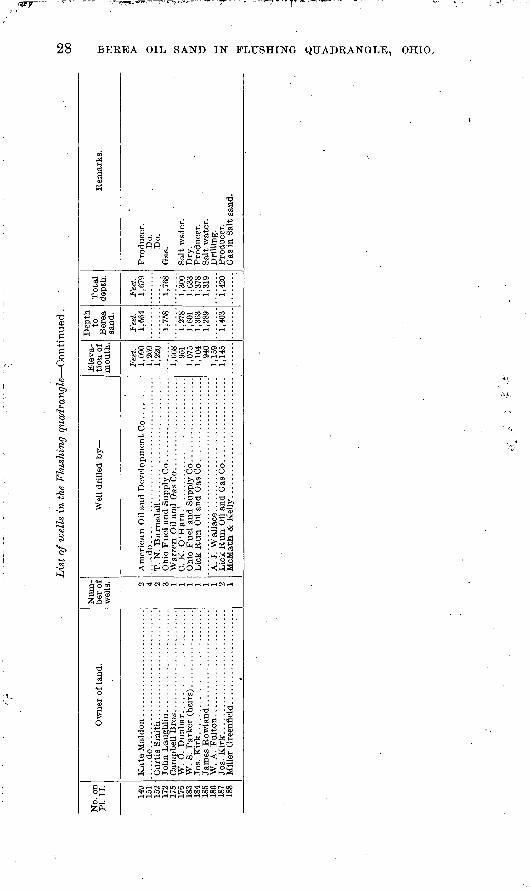
The following table sets forth such information as was procured about the wells drilled in the Flushing quadrangle. It states in con cise form the owner of the land on which the wells were drilled; the number of them; the person by whom they were drilled; the eleva tions of their mouths above sea level; the distance from their mouths to the top of the Berea sand, and their total depths. The reference numbers of the wells correspond to those given on the map (PI. II).

Lis
t ofw
gll
s in
the
Flu
shin
g q
uadr
angl
e:
No.
on
PI.
II. 1 . 2 3 4 5 6 7 8 9 10 11 12 13 15.
^Z?l& 19 20 22 oo 24 O
C 26 27.
00 29 on
01
00
00
07 42 43 44 45 46 48 49
Ow
ner
of l
and.
H.
S. B
arr
ick
low
....
....
....
....
....
.......d
o.................................
....
.do
....
....
....
....
....
....
....
....
.W
. K
. S
cott
...
....
....
....
....
....
....
W.
F. D
unla
p...... ...................
.....d
o..................................
.....d
o.................................
....
d
o..
...............................
.....d
o.................................
.....d
o.................................
.....d
o.................................
.....d
o... ..............................
Will
iam
Wal
ker.
...
....
....
....
....
...
B v
ron
Coc
hran
. s .
.....................
Num
be
r of
w
ells
. 1 1 1 2 1 1 1 3 2 1 9 4 0 8 3 6 1 1 1 1 1
Wel
l dr
ille
d by
.....d
o........................................
.....d
o........................................
....
.do
....
....
....
....
....
....
....
....
....
....
.....d
o........................................
.....d
o........................................
W.
D.
Bla
ck &
Co.
...
....
....
....
....
....
....
....
.do
. ..
....
....
....
....
....
....
....
....
....
......d
o........................................
.....d
o........................................
W.
D.
Bla
ck &
Co
....
....
....
....
. ..
....
....
.
.....d
o........................................
.....d
o........................................
....
.do
....
....
....
....
....
....
....
...
....
....
......d
o........................................
.....d
o.........................................
..... d
o ..
....
....
....
....
....
.:..
....
....
....
-,..
.....d
o........................................
....
.do
....
....
....
....
....
....
....
....
....
....
....
.do
....
....
....
....
....
....
....
....
....
....
....
.do
....
....
....
....
....
....
....
....
....
....
.....d
o........................................
.....d
o........................................
....
.do
....
....
....
....
....
....
....
....
....
....
......d
o........................................
.....d
o........................................
.....d
o........................................
....
.do
. ..
....
....
....
....
....
....
....
....
....
.R
. D
. G
ille
spie
....
....
...
....
....
....
....
....
Rus
sell
& B
ush.
...
....
....
....
....
....
....
..
Fre
ehol
d O
il an
d G
as C
o. ....................
Ele
va
tion o
f m
outh
.
Fee
t. 1,
015
1,03
51,
074
1,00
497
998
11,
020
971
1,09
61,
054
1,01
11,
062
943
1,06
81,
077
1,13
11,
200
1,21
61,
226
1,17
01,
145
1,18
11,
120
1,17
51,
129
1,15
7
1^3
51,
077
1,04
11,
060
1,00
61,
125
1,10
61,
223
1,12
51,
099
1,11
01,
123
.1.1
28
1:044
Dep
th
to
Ber
ea
san
d.
Fee
t. 1,
415
1,47
0
1,37
61,
372
1,41
61,
388
1,44
71,
432
1,48
81,
392
1,51
7
1,71
81,
728
1,73
81,
690
1,65
71,
691
1,63
71,
678
1,65
81,
670
1,59
81,
749
1,56
81,
589
1,53
01,
650
1,63
51,
742
1,65
3
1,66
01,
635
To
tal
dep
th.
Fee
t.
1,48
0
1,52
470
41,
417
1.47
7
1,49
91,
478
1,43
7
1,56
2
1,74
21,
758.
1,76
51,
712
1,68
01,
721
1,66
11,
706
1,67
21,
691
1,61
11,
795
1,59
01,
608
1,54
91,
677
1,70
01,
770
1,68
7
1,68
01,
699
Rem
arks.
Gas
and
sm
all
show
of
oil
in B
erea
san
d.
Dry
.
Gas
in
Ber
ea s
and.
Dry
(no
wat
er).
Dry
.L
ittl
e w
ater
.
Sal
t w
ater
.
Do.
Do.
Do.
Do.
Do.
Do.
Do.
Pro
du
cer.
Do.
Sal
t w
ater
.P
rodu
cer.
Do.
Do.
Do.
Do.
Do.
Sal
t w
ater
; sh
ow o
f oi
l.D
ry.
Sal
t w
ater
.
Do.
W bO Or

Lis
t o
f w
ells
in
the
Flu
shin
g q
ua
dra
ng
le C
onti
nued
.to
No
. on
P
L I
I. 50 51 52 53 54 55 56 57 58 59 60 61 62 63 64 65 66 67 68 69 70 71 72 73 75 76 77 80 81 82 83 84 85 86 87 88 89 90 91 92 93
Ow
ner
of l
and.
R.
W. S
cott
...........................
....
.do
....
..:.
.........................
O.B
.Hib
bs.
...........................
.....d
o.................................
....
.do
....
....
....
....
....
....
....
....
....
...d
o..
....
....
....
....
....
....
....
....
....
.do
....
....
....
....
....
....
....
....
..C
. J .
Hib
bs. .
...........................
....
.do
....
....
....
....
....
....
....
....
..W
illi
am K
irk. ..
....
....
....
....
....
...
Wil
liam
Kir
k. ...
....
....
....
....
....
..
L.
B. B
eth
el.
....
....
....
....
....
....
..
Ell
is F
ulto
n. ...........................
Eli
za W
ilso
n. ..........................
W.
W.
McK
ebbe
n. .....................
R.
K.
Dunla
p...... ....................
Reb
ecca
Whi
te. .
....
....
....
....
....
...
Wil
liam
She
ppar
d. ....................
....
.do.
...
....
....
....
....
....
....
....
..
.....d
o.................................
.....d
o.................................
.....d
o.................................
....
.do
....
....
....
....
....
....
....
....
.
....
.do
..:.
....
....
....
....
....
....
....
.A
rthu
r B
row
n. ........:
...............
Num
be
r of
w
ells
. 1 1 1 1 1 2 1 2 1 1 1 1 1 1 1 1 1 1 1 1 1 2 1 1 3 1'
2 1 2 1 2 3 1 1 1
Wel
l dr
illed
by
' Gil
bert
& C
o. ................................
.....d
o........................................
Elk
Cre
ek O
il an
d G
as C
o. ...................
.....d
o........................................
....
.do
....
....
....
....
....
....
....
....
....
....
....
.do
....
....
....
....
....
....
....
....
...:
....
J. S
. W
ilso
n. . ................................
New
York
Oil
and G
as C
o. ...................
W.
D .
Bla
ck &
Co ............................
Ric
h G
as C
o. .................................
.....d
o..
....
....
....
....
....
....
....
....
....
....
...d
o..
....
....
.. ..
....
....
....
....
....
....
......d
o..
....
....
....
....
....
....
....
....
....
....
...d
o..
....
....
....
....
'...
....
....
....
....
...
....
.do
.................... ....................
.....d
o........................................
....
.do
....
....
....
....
.:.-
.. ..
....
....
....
...
.....d
o........................................
.....d
o........................................
.....d
o........................................
....
;do
. .......................................
Ele
va
tion
of
mou
th.
Fee
t. 992
Q*V
?
896
1,16
4
1,01
8
1,08
51,
135
1,00
6
1,02
5Q
41'8
84
1,16
499
81,
020
993
1,08
2
i,i4
3
1,15
91,
100
Dep
th
to
Ber
ea
sand
.
Fee
t. 1,
370
1 H
W)
1,40
7
1,27
41,
391
1,38
5
1,41
0
1,31
01,
460
i 9^
10
1 C
O1
1,36
51,
427
1,33
8
'
Tota
l d
epth
.
Fee
t.
1,40
81,
400
1,44
4
1/29
6
1,35
21,
405
1,
436
1,28
2
1,26
4
1,41
41,
482
1,40
2
1,02
2
Rem
arks
.
Do.
Do.
Do.
Do.
Do.
'
Do.
Do.
Do.
Do.
Do.
Dry
.S
alt
wat
er.
Gas
in
Big
Inju
n s
and
(sha
llow
wel
l).
Sal
t w
ater
in
Ber
ea s
and.
Sal
t w
ater
in
Kee
ner
sand
.

94 QC 96 Q7 98 QQ
100
101
103
104
105
106
107
108
109
110
111 m 113
114
115
116
117
118
119
1?0
1?1
\V>
1?3
124
1?,=;
1?6
1?9
131
\X>.
133
134
135
136
137
138
139
140
141
14?
143
144
14,\
148
....
.do
....
....
....
....
....
....
....
....
.E
. P
ratt
. ..............................
I. N
. R
oby.
............................
Wil
lard
Hyd
e. .........................
L.
K.
Rus
sell
. . ........................
Ann
Tid
ball
...
....
....
....
....
....
....
.....d
o.................................
Wil
liam
H.
Whi
te. .
....
....
....
....
...
Cla
rk W
ells
. ...
....
....
....
....
....
....
Bra
dfie
ld B
ros.
...
....
....
....
....
....
.
F. S
. W
alt
on..........................
C. G
ill.
......
....
....
....
....
....
....
..
F.
S. W
alto
n. .........................
Kat
e M
aldo
n ..
....
....
....
....
....
....
Ann
Oil
Co
....
....
.. ...
..'...
....
....
....
....
.St
. C
lair
Oil
and
Gas
Co.
.....................
St.
Cla
ir O
il an
d G
as C
o. .....................
....
.do..
....
....
....
....
....
....
....
....
....
....I
. do............................... .........
.....d
o........................................
....
.do
....
....
....
....
....
....
....
....
....
....
....
.do
....
....
....
....
....
....
....
....
...i
....
Ann
Oil
Co..........'......................,..
....
.do
....
....
....
....
....
....
....
....
....
....
.....d
o........................................
P. E
. C
alh
ou
n..
....
....
....
. ..
....
....
....
...
N.
D.
Goe
. ...
....
....
....
....
....
....
....
....
P. E
. C
alhoun...... ....... I
......".
...
....
....
St.
Cla
ir O
il an
d G
as C
o. .....................
St.
Cla
ir O
il an
d G
as C
o. .....................
St.
Cla
ir O
il an
d G
as C
o..
... .................
....
.do
....
....
....
....
....
....
....
....
. ..
....
...
...d
o..
....
....
....
....
....
....
....
....
....
....
.. .d
o .........................................
.....d
o........................................
....
.do
....
....
....
....
....
....
....
....
....
....
.....d
o........................................
....
.do
....
....
....
....
....
....
....
....
....
....
.....d
o........................................
Am
eric
an O
il an
d D
evel
opm
ent
Co.
...
....
...
1,25
11,
215
1.08
71,
265
1,19
3
93
4
932
933
1,00
297
31,
010
1,14
21,
011
1,11
91,
231
1.23
7'9
48
1,08
9
952
943
1,20
11,
072
1,16
31,
089
1,08
51,
043
1,08
01,
067
1,05
4
997
1,06
4
1,19
21,
041
1,03
71,
175
1,08
21,
068
1,10
01,
052
1,08
91,
052
1,20
81,
160
1,20
3
1,74
0
1,58
2
1,70
21,
720
;::;;|:
1,75
0
1,61
31,
748
1,65
2
1,66
8
1 6
601,
624
1,78
11,
740
1,77
6
1,76
8
744
1,73
0
1 fQ
S 1 1
--/
1,24
8
1,76
31,
671
1,68
5
1,66
81,
638
1,79
81,
754
1,79
0
Do.
Do.
Do.
Shal
low
wel
Do.
Do.
Shal
low
wel
Do.
Do.
Do.
Do.
Do.
Do.
Do.
Do.
Do.
Pro
duce
r.
P e>
a > § > * P to
Lis
t of w
ells
in t
he F
lush
ing q
uadra
ngle
Co
nti
nu
ed.
No.
on
PI.
II.
149
151
152
172
175
176
183
184
185
186
187
188
Ow
ner
of l
and.
.....d
o.................................
W.
O. D
un
bar.
....
....
....
....
. ........
W.
A. F
ult
on..........................
Num
be
r of
w
ells
. 2 4 2 3 1 1 1 1 2 1
Wel
l dr
ille
d b
y
T.
N. B
arn
sd
all
....
....
....
....
....
....
....
..
C. K
. O
'Hara
.!............ ...................
A.
J. W
alla
ce. .
....
....
....
....
....
....
....
...
McM
atb.
& K
elly
. .............................
Ele
va
tion
of
mou
th.
Fee
t. 1,
090
1,26
91,
220
i,668 95
11,
075
1,10
494
01,
159
1,14
5
Dep
th
to
Ber
ea
sand
.
Fee
t. 1,
664
1,75
8
1,27
81,
601
1,36
31,
289
1,40
3
Tot
al
dept
h.
Fee
t. 1,
679
1,76
8
1,30
01,
633
1,37
81,
319
Rem
arks
.
Do.
Do.
Dry
.
00

SURVEY PUBLICATIONS ON PETROLEUM AND NATURAL -GAS.
The following list includes the more important papers relative to oil and gas published by the United States Geological Survey or by members of its staff:
ADAMS, G. I. Oil and gas fields of the western interior and northern Texas coal measures and of the Upper Cretaceous and Tertiary of the western Gulf coast. In Bulletin No. 184, pp. 1-64. 1901.
ADAMS, G. I., HAWORTH, E., and CRANE, W. R. Economic geology of the Tola quadrangle, Kansas. Bulletin No. 238. 83pp. 1904.
ANDBRSON, R. (See Arnold, R., and Anderson, R.)ARNOLD, R. The Salt Lake oil field, near Los Angeles, Cal. In Bulletin No. 285,
pp. 357-361. 1906. Geology and oil resources of the Summerland district, Santa Barbara
County, Cal. Bulletin No. 321. 67 pp. 1907. (See also Eldridge, G. H., and Arnold, R.)
. ARNOLD, R., and ANDERSON, R. Preliminary report on the Santa Maria oil district, Santa Barbara County, Cal. Bulletin No. 317. 69 pp. 1907. Geology and oil resources of the Santa Maria oil district, Santa
Barbara County, .Cal. Bulletin No. 322. 124pp. 1907.BOUTWELL, J. M. Oil and asphalt prospects in Salt Lake basin, Utah. In Bulletin
No. 260, pp. 468-479. 1905.CLAPP, F. G. 'The Nineveh and Gordon oil sands in western Greene Coxinty, Pa.
In Bulletin No. 285, pp. 362-366. 1906. (See also Stone; R: W., and Clapp, F. G.) CRANE, W. R. (See Adams, G. I., Haworth, E., and Crane, W. R.) ELDRIDGE, G. H. The Florence oil field, Colorado. In Trans. Am. Inst. Min. Eng.,
vol. 20, pp. 442-462. 1892. The petroleum fields of California. In Bulletin No. 213, pp. 306-321. __ I
1903. . ' 'ELDRIDGE, G. H., and ARNOLD, R. The Santa Clara Valley, Puente Hills, and
Los Angeles oil districts, southern California. Bulletin No. 309. 266 pp. 1907.FENNEMAN, N. M. The Boulder, Colo., oil field. In Bulletin No. 213, pp. 322-332.
1903. Structure of the Boulder oil field, Colorado, with records for the year 1903.
In Bulletin No. 225, pp. 383-391. 1904. The Florence, Colo., oil field. In Bulletin No. 260, pp. 436-440. 1905. Oil fields of the Texas-Louisiana Gulf coast. In Bulletin No. 260, pp. 459-
467. 1905. Oil fields of the Texas-Louisiana Gulf coastal plain. Bulletin No. 282. 146
pp. 1906.FULLER, M. L. The Gaines oil field in northern Pennsylvania. In Twenty-second
Ann. Rept., pt. 3, pp. 573-627. 1902. Asphalt, oil, and gas in southwestern Indiana. In Bulletin No. 213, pp.
333-335. 1903. - - The Hyner gas pool, Clinton County, Pa. In Bulletin No. 225, pp. 392-395.
1904. ^29 ^

30 BEEEA OIL SAND IN FLUSHING QUADEANGLE, OHIO.
GRISWOLD, W. T. The Berea grit oil sand in the Cadiz quadrangle, Ohio. Bulletin No. 198. 43pp. 1902. Structural work during 1901-2 in the eastern Ohio oil fields. In Bulletin
No. 213, pp; 336-344. 1903. Petroleum. In" Mineral Resources" U. S. for 1905, pp. 813-920. 1906.
Idem for 1906, pp. 827-896. 1907.GRISWOLD, W. T., and MUNN, M. J. Geology of oil and gas fields in Steubenville,
Burgettstown, and Claysville quadrangles, Ohio, West Virginia, and Pennsylvania. Bulletin No. 318. 196 pp. . 1907.
HAWORTH, E. (See Adams, G. I., Haworth, E., and Crane, W. R.; also Schrader, F. C., and Haworth, E.)
HAYES, C. W. Oil fields of the Texas-Louisiana Gulf coastal plain. In Bulletin No. 213, pp. 345-352. 1903.
HAYES, C. W., and KENNEDY, W. .Oil fields of the Texas-Louisiana Gulf coastal plain. Bulletin No. 212. 174 pp. 1903.
HILL, B. Natural gas. In Mineral Resources U. S. for 1906, pp. 811-826. 1907.KENNEDY, W. (See Hayes, C. W., and Kennedy, W.)KINDLE, E. M. Salt and other resources of the Watkins Glen quadrangle, New
York. In Bulletin No. 260, pp. 567-572. 1905.McGEE, W J. Origin, constitution, and distribution of rock gas and related bitu
mens. In Eleventh Ann.'Rept., pt. 1, pp. 589-616. 1891. . (See also Phinney, A. J.) _
MUNN, M. J.' (See Griswold, W. T., and Munn, M. J.)OLIPHANT, F. H. Petroleum. In Nineteenth Ann. Rept., pt. 6, pp. 1-166. 1898'. Petroleum. In Mineral Resources U. S. for 1903, pp. 635-718. 1904.
Idem for 1904, pp. 675-759. 1905. Natural gas. In Mineral Resources U. S. for 1903, pp. 719-743. 1904.
Idem for 1904, pp. 761-788. 1905.ORTON, E. The Trenton limestone as a source of petroleum and inflammable gas
in Ohio and Indiana. In Eighth Ann. Rept., pt. 2, pp. 475-662. 1889.PHINNEY, A. J. The natural gas field of Indiana, with an introduction by W J
McGee on rock gas and related bitumens. In Eleventh Ann. Rept., pt. 1, pp. 579-742. 1891.
KICHARDSON, G. B. Natural gas near Salt Lake City, Utah. In Bulletin No. 260.pp. 480-483. 1905. Salt, gypsum, and petroleum in trans-Pecos Texas. In Bulletin No. 260,
pp. 573-585. 1905.SCHRADER, F. C., and HAWORTH, E. Oil and gas of the Independence quadrangle,
Kansas. In Bulletin No. 260, pp. 442-458. 1905.SHALER, M. K. ' (See Taff, J. A., and Shaler, M. K.)STONE, R. W. Oil and gas fields of eastern Greene County, Pa. In Bulletin No.
225, pp. 396-412. 1904. Mineral resources of the Elders Ridge quadrangle, Pennsylvania. Bulletin
No. 256. 86 pp. 1905.STONE, R. W., and CLAPP, F. G. Oil and gas fields of Greene County, Pa. Bulletin
No. 304. 110 pp. 1907.TAFF, J. A., and SHALER, M. K. Notes on the geology of the Muscogee oilfields,
Indian Territory. In Bulletin No. 260, pp. 441-445. 1905. WEEKS, J. D. Natural gas in 1894. In Sixteenth Ann. Rept., pt. 4, pp. 405-429.
1895.WILLIS, BAILEY.. Oil of the northern Rocky Mountains. In Eng. and Min. Jou^.,
vol. 72, pp. 782-784. 1901.
o


![Citizen (Berea, Ky.). (Berea, KY) 1910-05-12 [p ]](https://img.pdfslide.us/doc/110x75/629c16c1f849cf47726518b3/citizen-berea-ky-berea-ky-1910-05-12-p-.jpg)