Embed Size (px)
Citation preview

Geologic Map of the Laguna
7.5-Minute Quadrangle, Cibola County, New
Mexico
By
Colin T. Cikoski1, Paul G. Drakos2, and James W. Riesterer2
1 New Mexico Bureau of Geology and Mineral Resources, 801 Leroy Place, Socorro, NM 87801
2Glorieta Geoscience, Inc., P.O. Box 5727, Santa Fe, NM 87502-5727
June, 2018
New Mexico Bureau of Geology and Mineral Resources
Open-file Digital Geologic Map OF-GM 272
Scale 1:24,000
This work was supported by the U.S. Geological Survey, National Cooperative Geologic
Mapping Program (STATEMAP) under USGS Cooperative Agreement 06HQPA0003
and the New Mexico Bureau of Geology and Mineral Resources.
New Mexico Bureau of Geology and Mineral Resources
801 Leroy Place, Socorro, New Mexico, 87801-4796
The views and conclusions contained in this document are those of the author and
should not be interpreted as necessarily representing the official policies,
either expressed or implied, of the U.S. Government or the State of New Mexico.

1
Contents 1. Introduction .......................................................................................................................... 3
1.1. Geologic and geographic setting ....................................................................................... 3
1.2. Previous work .................................................................................................................... 3
1.3. General terminology notes ............................................................................................... 4
1.4. Acknowledgements ........................................................................................................... 4
2. Middle-Late Cenozoic stratigraphy ....................................................................................... 5
2.1. Alluvial deposits ................................................................................................................ 5
2.1.1. Soils ............................................................................................................................. 6
2.2. Igneous Geology ................................................................................................................ 7
3. Cretaceous stratigraphy ...................................................................................................... 10
3.1. Mancos Shale .................................................................................................................. 10
3.2. Crevasse Canyon Formation ........................................................................................... 11
3.3. Gallup Sandstone ............................................................................................................ 11
3.4. Dakota Sandstone ........................................................................................................... 12
4. Jurassic stratigraphy ............................................................................................................ 14
4.1. Nomenclatural notes ...................................................................................................... 14
4.2. Morrison Formation ........................................................................................................ 14
4.3. Zuni Sandstone ................................................................................................................ 15
4.4. Bluff Sandstone ............................................................................................................... 16
4.5. Summerville Formation ................................................................................................... 16
5. Structure ............................................................................................................................. 17
5.1. Jurassic deformations ..................................................................................................... 17
5.2. Laramide deformations ................................................................................................... 18
5.3. Rio Grande rift deformations .......................................................................................... 18
6. References cited .................................................................................................................. 19
7. Tables .................................................................................................................................. 22
Table 2.1. Summary of geochronologic data ..................................................................... 23
8. Figures ................................................................................................................................. 24
Figure 2.1. Qf2 deposit overlying Kdt sandstone ............................................................... 25
Figure 2.2. Qf4 deposit overlying Kmr shale and Kdt sandstone ....................................... 26
Figure 2.3. Qt3sj channel cut into Jb sandstone ................................................................ 27

2
Figure 2.4. Cross-section of Qt4sj strath terrace cut on Qblp, overlain by Qes ................ 28
Figure 2.5. Rio San Jose valley fill stratigraphy near Old Laguna ....................................... 29
Figure 2.6. Photos of Qfoc along Rio Gypsum and Wild Celery Creek ............................... 30
Figure 2.7. Basalt flows beneath Silver Dollar Mesa .......................................................... 31
Figure 2.8. Alluvial gravels exposed at the southern dip of Clay Mesa ............................. 32
Figure 3.1. Section of Dakota Sandstone measured by Landis et al. (1973) ...................... 33
Figure 3.2. Exposure of map unit Kml ................................................................................ 34
Figure 3.3. Outcrops of the Semilla Sandstone .................................................................. 35
Figure 3.4. Features of the Juana Lopez Member of the Mancos Shale ............................ 36
Figure 3.5. Outcrop of relatively thick Kdec ....................................................................... 37
Figure 4.1. Exposure of the Jmw-Jzf contact...................................................................... 38
Figure 4.2. Outcrop of Jmj underlying Kdec ....................................................................... 39
Figure 4.3. Outcrops of map unit Jzf .................................................................................. 40
Figure 4.4. Outcrops of map unit Jb ................................................................................... 41
Figure 4.5. Typical outcrop of map unit Js ......................................................................... 42
Figure 5.1. Exposures of the pinchout of Jmw over the Spring No. 15 anticline ............... 43
9. Map Unit Descriptions ........................................................................................................ 44

3
1. Introduction
1.1. Geologic and geographic setting The Laguna quadrangle lies approximately 30 kilometers (km) east-southeast of the town of
Grants and 60 km west of the city of Albuquerque along I-40 in northwestern New Mexico. Nearly the
entire quadrangle lies on Pueblo of Laguna land, with small areas along the west margin of the
quadrangle lying within the Cubero Land Grant. The small towns of Laguna, Encinal, Casa Blanca, and
Paraje lie within the quadrangle extent. The Rio San Jose valley trends east-west across the southern
half of the quadrangle. North of the river valley, a set of high basalt-capped mesas including Silver Dollar
Mesa, Frog Mesa, and Clay Mesa extend southward from the Mount Taylor area as narrow topographic
prongs that form escarpments above deep river valleys. South of the Rio San Jose valley, much lower
sandstone-capped mesas such as Seama Mesa and Casa Blanca Mesa form local topographic highs
above broad alluvial valleys. Elevations range from about 2,195 meters (m) above mean sea level (amsl)
on Silver Dollar Mesa at the north-central edge of the quadrangle to 1,750 m amsl where the Rio San
Jose exists the quadrangle.
Geologically, the quadrangle lies in the Acoma Sag section of the Colorado Plateau, east of the
McCartys syncline and approximately 20 km west of the Lucero uplift and Rio Puerco fault zone, which
demarcates the edge of the Colorado Plateau where the Plateau abuts the Rio Grande rift (Woodward,
1982). The Jemez lineament trends east-northeast through or just north of the quadrangle, and in
Jurassic time the area was along the northern margin of the Mogollon Highland (Moench and Schlee,
1967). Volcanic fields lie to the north (Mount Taylor volcanic field), west (Zuni-Bandera volcanic field),
and northeast (Rio Puerco volcanic necks), while deformations, generally of low magnitude, from
Jurassic through at least middle Cenozoic time are evident. The majority of the quadrangle is underlain
by clastic sedimentary rocks of Mesozoic age often blanketed by a variable thickness of Quaternary
sediments. Plio-Pleistocene basalts locally uphold high mesas and crop out around the town of Laguna.
Structural relief is generally low.
1.2. Previous work The United States Geological Survey (USGS) engaged in a concerted geologic mapping and
stratigraphic study of the Laguna (sub)district of the Grants uranium mining district in the 1950’s and
1960’s, culminating in a thorough report by Moench and Schlee (1967). As a part of this effort, Moench
(1963) mapped the geology of the Laguna quadrangle, with particular focus on the Jurassic stratigraphy
and associated structural deformations, with interest in determining the controls on uranium
mineralization found hosted in some of the Jurassic rocks. Later USGS and affiliated researchers focused
on the Cretaceous stratigraphy of the region, with particular advances made by Landis et al. (1973),
Hook et al. (1983), and Molenaar (1983) in correlating Dakota Sandstone, Gallup Sandstone, and Mancos
Shale units throughout the Colorado Plateau.
Largely simplified in earlier geologic studies, the Cenozoic section received renewed interest in
the 1980’s and 1990’s as a part of larger-scale studies of the volcanic and landscape history of the
Mount Taylor and Zuni-Bandera areas (e.g., Drakos [Drake] et al., 1991; Laughlin et al., 1993).
Refinement of this chronology continues to the present (e.g., Cascadden et al., 1997; Channer et al.,
2015; Dunbar and Phillips, 2004; Goff et al., 2015; Laughlin and WoldeGabriel, 1997; Hallett et al., 1997).

4
More recent geologic mapping efforts by the New Mexico Bureau of Geology and Mineral
Resources (NMBGMR) concentrated on the Mount Taylor area (synthesized by Goff et al., 2015) and
subsequently proceeded down the Rio San Jose from Grants. This report synthesizes results from these
previous studies with original geologic mapping from the 2016-18 seasons to provide an up-to-date
geologic product for the Laguna quadrangle.
1.3. General terminology notes Geologic terms are after Compton (1985), soil terms after Birkeland (1999), carbonate horizon
stages after Gile et al. (1966) and Machette (1985), and color notation after Munsell Color (2009).
Coordinates are given in Universal Transverse Mercator (UTM) coordinates after the NAD83 Zone 13S
datum.
1.4. Acknowledgements We thank J. Michael Timmons, Geologic Mapping Program Manager at the NMBGMR, and the
USGS STATEMAP program for funding to conduct this study. We thank the Governor and Council of the
Pueblo of Laguna for permission to work on pueblo lands. Marlene Analla in particular shepherded us
through the trespass permit application process. Cartography was provided by the NMBGMR map
production group, coordinated by Phil Miller.

5
2. Middle-Late Cenozoic stratigraphy
2.1. Alluvial deposits Mapping of surficial deposits follows the style and terminology developed by Grimm (1983),
Drakos [Drake] et al. (1991), Osburn et al. (2009), and Cikoski et al. (2016). Quaternary sediments
include fluvial terrace, alluvial fan deposits, and valley floor alluvium. Quaternary deposits contain a
predominance of volcanic clasts of mixed lithologies, secondary Cretaceous sandstone and quartzite
clasts, and minor granite and limestone clasts, obsidian and chert pebbles. Fan units Qf1-Qf4, mapped
in the northeastern part of the Quadrangle and north of Rio San Jose, form the distal part of a fan
complex at the mouth of canyons draining the south side of Mt. Taylor, including Encinal Canyon on the
Laguna Quadrangle. Deposition of the Water Canyon fan west of the Laguna Quadrangle, which began
by early Pleistocene time (correlative fine-grained deposits exhibit reversed polarity; Drakos et al.
(1991)), record incision into the volcanic edifice, erosion of the amphitheater on Mt. Taylor and episodic
piedmont aggradation, incision, and stabilization (Drakos and Riesterer, 2013). The piedmont has been
extensively dissected since initial fan deposition, therefore Qf1 and Qf2 surfaces are preserved as
relatively small remnants. Qf1 deposits underlie eroded fan surface remnants 35 m above local base
level west of Encinal Creek and are a 1 to 4 m thick gravel lag with a basal contact on the Paguate
Tongue of the Dakota Sandstone. Qf2 deposits are approximately 4 m thick (FIGURE 2.1) and include a
partially stripped surficial soil with an A-Btk-Bk profile, buried soils and multiple depositional units
(based on exposures on adjacent quadrangles), indicating deposition over a relatively long time period.
Qf3 is preserved as several small surfaces located 1 to 5 m above the modern piedmont. Much of the
modern piedmont in the distal part of the fan complex is composed of Qf4 surfaces. Qf4 deposits
exhibit weakly developed soils with maximum Stage I+ carbonate stage indicating a likely early to middle
Holocene age for this deposit (FIGURE 2.2). Aggradation of the modern piedmont including Qf4 is likely a
result of aggradation along the Rio San Jose valley associated with eruption of Pleistocene (0.38 to 0.128
Ma; TABLE 2.1) basalts that flowed down the Rio San Jose drainage.
Deposits underlying terrace surfaces along Rio San Jose are preserved as isolated erosional
remnants along the modern Rio San Jose drainage. Qt1sj (not preserved as a mappable unit on the
Laguna Quadrangle) includes axial Rio San Jose gravel and tributary gravel facies approximately 7 m
thick, and overlies the Cubero Sandstone Tongue of the Dakota Sandstone on Woods Mesa south of the
Rio San Jose on the adjacent Cubero Quadrangle, where it is 70 to 75 m above Rio San Jose valley floor.
Qt2sj (not preserved as a mappable unit on the Laguna Quadrangle) is a strath terrace approximately 6.5
m thick with local channels up to 10 m thick comprising sandy gravel deposits overlying the Paguate
Tongue north of the Rio San Jose. Qt2sj is found approximately 50 m above Rio San Jose valley floor on
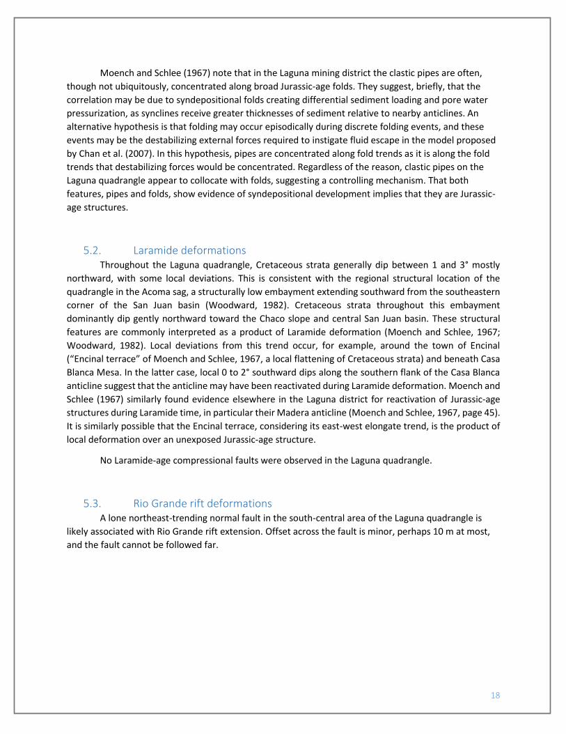
the Cubero Quadrangle. Qt3sj is a cobble-to-boulder with interbedded channel sand fill terrace located
12-20 m above Rio San Jose valley floor/local base level. This terrace deposit is 6 to 12 m thick, with
maximum thickness observed in channel filling deposits (FIGURE 2.3). The soil formed in the Qt3sj
deposit exhibits a Stage III carbonate horizon. Qt4sj is a strath terrace overlying the Laguna Pueblo flow
near Casa Blanca and the Bluff Sandstone near Bang Bang Hill. Qt4sj surfaces are located approximately
6 to 8 m above local base level. The deposit thickness ranges from 3 to 4 m, with a maximum Stage I+
carbonate horizon and is overlain in places by up to 4 m of eolian sand (FIGURE 2.4).
Valley floor alluvium in tributary drainages is composed primarily of fine-grained sand, silt and
clay with gravel lenses, weakly-developed surficial soils and buried soils distinguished primarily by A

6
horizon development. Thickness of various alluvial deposits, based on well log data (Risser and Lyford,
1984) and outcrop descriptions ranges from 5-20 m in tributary drainages to approximately 50 m under
the Rio San Jose valley floor. Rio San Jose alluvium includes coarse-grained sandy gravel sections and is
interbedded with the Laguna Pueblo flow in the western part of the Quadrangle (Risser and Lyford,
1984). Lake beds with gastropods and eolian beds with interbedded fluvial sands are observed in young
valley fill exposures along the axial drainage (FIGURE 2.5), indicating formation of shallow lakes following
eruption of the Laguna Pueblo flow.
Along Rio Gypsum and Wild Celery Creek, tributaries to the Rio San Jose extending southward
from around Old Laguna, a calcareous alluvial unit crops out from beneath younger valley floor alluvium
and eolian sand deposits that can be followed upstream (southward) to just south of the Quadrangle
boundary. Outcrops consist of interbedded muddy very fine sands, massive sands locally bearing
imbricated calcite spar, and laminated clays, typically capped by up to 6 m of sandy white tufa (FIGURE
2.6). Redoximorphic discoloration is common around the clayey beds, indicating episodic saturation,
while the common tufa and overall calcareous nature of the deposit suggest a spring-fed component to
the surface waters that deposited the alluvium and clays. No springs are recorded for these drainages on
the Laguna Quadrangle (cf., Risser and Lyford, 1984), but the gently folded interbedded sandstones and
mudstones in the Summerville Formation or the Summerville-Bluff Sandstone contact itself could
plausibly have diverted groundwater to a spring in the past.
The Pliocene and Quaternary deposits and associated geomorphic surfaces in the Mt. Taylor
area record a history of long-term incision interrupted by periods of deposition and formation of
geomorphic surfaces during times of base level stability. In contrast to the overall Pliocene-Quaternary
history, the late Quaternary has been characterized by alternating periods of erosion and deposition.
Approximately 200-300 m of incision into the Pliocene pediment surface has occurred between 2.5 m.y.
and the present time, likely in response to regional uplift. Periods of erosion and deposition during the
late Quaternary are likely in response to climatic fluctuations, continued regional uplift, and/or episodic
volcanism in the Zuni-Bandera volcanic field periodically blocking drainages (Drakos and Riesterer,
2013).
2.1.1. Soils The semiarid climate of the Grants-Laguna area and the regional carbonate dust influx has
favored the development of carbonate soils. Soils were described based on methods described in
Birkeland (1999). Carbonate morphology and Bt horizon development are the morphologic
characteristics which best distinguish soils in the Grants-Laguna area. Carbonate soils in the study area
and the adjacent Cubero Quadrangle (Cikoski et al., 2016) exhibit Stage I through III carbonate
morphology (terminology after Gile et al. (1966) and Machette (1985)). Colors range from 5YR to 2.5Y,
soil structure ranges from massive to strong subangular blocky or prismatic, and clay film morphology
ranges from absent to thin, with common coatings on ped faces.
7
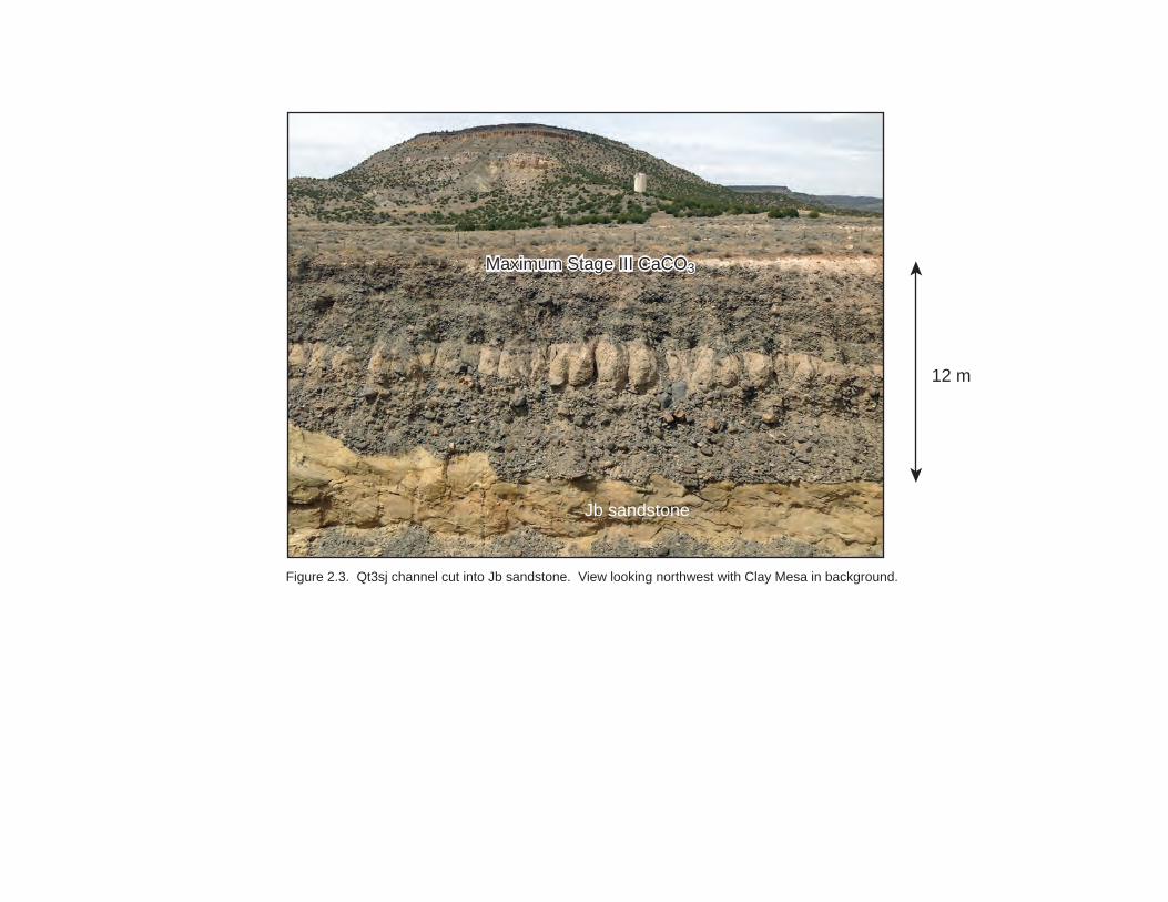
2.2. Igneous Geology Exposed within the Laguna quadrangle are Plio-Pleistocene basalts of the Mount Taylor and
Zuni-Bandera volcanic fields, a Pliocene intrusion affiliated with the Rio Puerco volcanic necks, and
numerous undated dikes.
The oldest dated igneous rock is the north-northwest-trending basaltic intrusion underlying
Picacho Peak in the extreme northwest corner of the quadrangle (map unit Tbip). Hallett et al. (1997), as
a part of a large study of the Rio Puerco volcanic necks, obtained a 40Ar/39Ar age estimate of 4.49 ± 0.08
Ma for this intrusion. This was the oldest such age they acquired during their study, and is older than
any age obtained by Goff et al. (2015) for the Mount Taylor volcanic field. Both sets of authors suggest
the Picacho Peak intrusion may reflect an early phase of igneous activity occurring peripheral to the
main Mount Taylor volcanic field. Any additional intrusions from this period may be buried by younger
Mount Taylor flows (Hallett et al., 1997). At the surface, the Picacho Peak plug intrudes Mancos Shale
units, and “baked” onto the side of the dike are large concretions typical of the Semilla Sandstone
Member, providing a useful stratigraphic control on the generally poorly exposed Mancos section.
Plio-Pleistocene basalts associated with the Mount Taylor volcanic field, located mainly to the
north of the quadrangle, cap Silver Dollar Mesa and narrow unnamed mesas to the east and west of
Wheat Mountain. Younger flows also cap Wheat Mountain, Clay Mesa, and Frog Mesa, flows that
overlap in age with the waning stages of the Mount Taylor volcanic field (Goff et al., in prep.) and are
generally considered a part of the Mount Taylor volcanic field. The Silver Dollar Mesa sequence exposed
on this quadrangle consists of three flows that are distinguished by significant differences in mineralogic
texture. The oldest (Tbcp) bears relatively common phenocrysts of plagioclase and lesser pyroxene that
are significantly more abundant and coarser in size than the younger two flows, with plagioclase
phenocrysts as large as 1 cm across. This flow correlates to map unit Tmpxb of Goff et al. (2015), for
which Goff et al. obtained a 40Ar/39Ar age estimate of 2.93 ± 0.12 Ma (TABLE 2.1). This distinctive flow
can be followed southeastward from Silver Dollar Mesa along a series of unnamed narrow mesas, and
may also cap an unnamed, narrow, east-west elongate mesa in the west-central part of the quadrangle,
where an isolated but texturally-similar basalt flow is found. A nearly-aphanitic flow (Tbfp) overlies and
is inset against the older porphyritic flow; several outcrops of the contact reveal a buttress separating
the two (FIGURE 2.7), although no alluvial deposits or buries soils were found along these contacts to
indicate a period of alluvial erosion. Waterlain deposits do overlie the two older basalts; pediment
gravels (QTpal) consisting of sands to cobbles and trace boulders of mostly basaltic lithologies overlie
the lower two basalts from Silver Dollar Mesa southeastward along the chain of narrow mesas, while
travertine (QTlo) is found capping the two older flows at the far southeastern tip of the chain of mesas,
at the east-central margin of the quadrangle. The travertine is fine-grained, with trace snail shells and
root casts. Overlying the alluvial deposits is the youngest Silver Dollar basalt (Qbmp), which is
porphyritic but with rare phenocrysts; the presence but scarcity of phenocrysts generally readily
distinguishes this flow from the older two. The youngest flow caps Silver Dollar Mesa and at least
partially caps the two narrow mesas along the southeastward trend, overlying unit QTpal or directly
lying on older basalts. The relationship between Qbmp and QTlo is not exposed in outcrop, but we
suggest QTlo is of similar age to QTpal and hence would underlie Qbmp. The youngest basalt likely
correlates to map unit Qpptb of Goff et al. (2015), for which Goff et al. determined a 40Ar/39Ar age
estimate of 2.49 ± 0.06 Ma (TABLE 2.1), just younger than the Pliocene-Pleistocene boundary.

8
The younger Wheat Mountain basalts are each dominantly fine-grained with only trace
macroscopic phenocrysts of plagioclase and, rarely, pyroxene. As such, although flow breaks indicate
that several flows are present they are difficult to distinguish based on texture alone. However,
observations at several locations and along some stratigraphic transects suggests that the maximum
plagioclase phenocryst size decreases with decreasing age (up-section), and this tentatively allows for
distinguishing three flows. Although this subdivision is tentative, we note that Moench (1963) similarly
chose to separate two flows beneath Wheat Mountain and along Clay and Frog Mesas; although our
mapping differs from his (particularly along the poorly-exposed tops of Clay and Frog Mesas), that two
groups of geologists would independently choose to subdivide the flows suggests the subtle differences
between flows are persistent and mappable. Unlike Moench, however, we do not interpret the older
flow(s) to have erupted from an inclined intrusion (his QTb12 sill) and saw no outcrop evidence along the
contact between the intrusion and the flow to suggest the flow emanated from the sill. Instead, we infer
that all three flows erupted from the Wheat Mountain cinder cone. At the southern tips of Frog and Clay
Mesas, the basalt flows poured over thin deposits of alluvial gravels. At the tip of Clay Mesa, these are
basaltic pediment pebble-gravels (Qpal; FIGURE 2.8) with pebble imbrications indicating south-
southwest paleocurrents, away from the Mount Taylor area. Given the elongate shape of Clay Mesa
(and Frog Mesa), it is likely the basalt flow erupted from Wheat Mountain then flowed southward down
paleocanyons carved by streams emanating from the Mount Taylor highland. In contrast, at the
southern tip of Frog Mesa, rounded quartzite, granite, chert, and reddish-brown sandstone (likely
Permian) pebbles and trace cobbles, mixed with gravels of felsic to intermediate volcanics and
Cretaceous sandstones, suggest a deposit associated with an ancestral Rio San Jose (Qsjo). This deposit
is very poorly exposed, and is potentially a thin strath terrace or local collection of lag gravels.
Channer et al. (2015) obtained a 40Ar/39Ar age estimate from a basalt at the south end of Frog
Mesa, most likely either Qwmp or Qwcp, of 2.114 ± 0.012 Ma (TABLE 2.1). In contract, Lipman and
Menhert (1979) reported a K-Ar age estimate for the youngest flow of Wheat Mountain (presumably our
unit Qwf) of 2.42 ± 0.18 Ma (TABLE 2.1); these age estimates are not within two standard deviations of
each other (uncertainties reported here are 2 standard deviations), and we suggest the younger 40Ar/39Ar age estimate is more representative of the Wheat Mountain volcano, and the K-Ar age is too
old.
One basalt of the younger Zuni-Bandera volcanic field crops out on the quadrangle around the
town of Laguna, the Laguna Pueblo flow (Qblp). Channer et al. (2015) obtained a 40Ar/39Ar age estimate
of the Laguna Pueblo flow from just east of the quadrangle boundary of 0.322 ± 0.011 Ma (TABLE 2.1).
Channer et al. also obtained 40Ar/39Ar age estimates for buried basalt flows occurring in a drill hole just
southeast of Grants, one of which returned an estimate of 0.325 ± 0.043 Ma, a flow that they suggested
was correlative to the Laguna Pueblo flow exposed at Laguna. If correct, the Laguna Pueblo flow may be
correlative with the basalt found in the subsurface intercalated with valley-floor alluvium all along the
Rio San Jose inner valley (cf., Risser and Lyford, 1984; Drakos et al., 1991) from at least Grants to Laguna,
and likely erupted from somewhere in the Zuni-Bandera volcanic field.
Finally, numerous thin basaltic intrusions traverse the Mesozoic strata throughout the study
area. Intrusions occur mainly as steep (~70-90° dip) dikes or as gently-dipping (~0-25°) sills, and in
several outcrops one can observe steeply-dipping intrusions bend sharply to become gently-dipping sills,
and vice versa. Gently-dipping intrusions are most commonly observed at or near the base of the Dakota
section at an elevation range of about 1,860 to 1,935 m amsl (6,100 to 6,340 ft amsl); additional sills
9
occur in the Jurassic section at elevations between about 1,820 to 1,825 m amsl (5,970 to 5,990 ft amsl).
For the Laguna mining district as a whole, Moench and Schlee (1967) describe gently-dipping intrusions
occurring in the elevation range of about 1,735 to 1,890 m amsl (5,700 to 6,200 ft amsl), a broad
elevation range that largely overlaps with the observed range here, though the maximum elevation of
sills observed here is somewhat higher. Moench and Schlee (1967) also observed dikes bending sharply
to become sills and vice versa. Where steeply-inclined, dikes on the Laguna quadrangle strike
dominantly north-south to northwest-southeast, with local north-northeast trends. Nowhere do these
intrusions cut any basalt flow, and in fact a thick intrusion along the east flank of Clay Mesa appears to
be truncated by the erosion surface underlying the basalt flow capping the mesa. Nevertheless, the ages
of these intrusions are poorly constrained, and they may relate to any of one or more episodes of
igneous activity.
10
3. Cretaceous stratigraphy We reviewed the history of the Cretaceous stratigraphy in this general region in our report on
the geology of the Cubero quadrangle (Cikoski et al., 2016), and more detail on the stratigraphy can be
found there. In a very broad sense, the Cretaceous system consists of interbedded sandstones, shales,
lesser mudstones-siltstones, and a few limestones (e.g., FIGURE 3.1) associated with the Western
Interior Seaway. The Cretaceous section is capped by a substantial unconformity, and no rocks younger
than the basal Crevasse Canyon Formation are preserved on this quadrangle.
3.1. Mancos Shale The Mancos Shale in this area consists of multiple tongues of poorly-exposed gypsiferous shales
with rare sandy shales and trace sandstones, limestones, and sparry gypsum beds. The Mancos
intertongues with all the other Cretaceous units. Nomenclature is based on stratigraphic location, and is
after Hunt (1936), Landis et al. (1973), and Hook et al. (1983).
Most tongues consist of gypsiferous shales with lesser siltstones and absent to rare sandy
shales, overlying a sharp basal contact with an underlying sandstone unit and grading upsection into an
overlying sandstone unit. Exceptions to this description are the Bridge Creek Limestone beds of the Rio
Salado Tongue (included in unit Kml), the Semilla Sandstone Member (Kms), and the Juana Lopez
Member (Kmj). The Bridge Creek Limestone beds (after Hook et al., 1983) consist of interbedded shales,
limy shales, and fine-grained carbonate grainstones and packstones (FIGURE 3.2), which weather to a
distinct pale yellowish brown color (2.5Y 7/1-7/3 and 8/2-8/3 measured) that can often be used to map
the unit through poorly-exposed slopes. Limestones and limy shales are thickly laminated to thinly
bedded, weathering to a platy residuum. As used on this quadrangle, the Bridge Creek Limestone map
unit (Kml) also includes all shales between the top of the Twowells Tongue of the Dakota Sandstone
(Kdt) and the uppermost Bridge Creek bed.
The Semilla Sandstone Member (after Dane et al., 1968) consists mainly of concretionary shales
with rare, thin sandstones (e.g., FIGURE 3.3). The sandstone beds are muddy, very fine- to fine-grained,
commonly internally planar- or cross-laminated. Sandstone bed thickness and abundance increases
upsection, with the top of the unit consisting of a 2-m-thick, laterally-extensive interval of thinly-bedded
sandstones. Underlying sandstone beds are typically lenticular, discontinuous, and often no more than a
few centimeters thick (FIGURE 3.3A). Shales associated with these sandstones bear roughly spherical
calcareous concretions up to 70 cm in diameter, in an abundance and size not seen in the remaining
Mancos Shale units. Similar concretions were described by Dane et al. (1968) and Fleming (1989), for
shales of the Semilla Sandstone Member in other locations, and this appears to be a common feature
regionally. In places of poor exposure, these unusually large concretions may crop out of cover, and
provide evidence that the Semilla Member is present; the Semilla Sandstone mapped in the northwest
corner of the quadrangle in a ridge to the south of Picacho Peak was identified solely based on the
presence of concretions. As a stratigraphic unit, the Semilla Sandstone Member extends from the lowest
sandstone bed to the highest sandstone bed between the top of the Twowells Tongue of the Dakota and
the base of the Juana Lopez Member of the Mancos (Kmj). The lowest sandstone bed is lenticular and
discontinuous in outcrop, and as a consequence the base of the unit is nearly always poorly constrained.
11
The Juana Lopez Member, as initially defined by Rankin (1944) and revised by Dane et al. (1966)
and Hook and Cobban (1980), consists of two distinctly fossiliferous, very thinly bedded calcarenite
intervals bracketing an interval of noncalcareous shales. The calcarenite intervals consist dominantly of
shell fragment debris (e.g., FIGURE 3.4A), including the sand-sized grains (Dane et al., 1966; Hook and
Cobban, 1980), and include diagnostic fossils such as Scaphites and Cameleolopha lugubris (FIGURE 3.4B,
C). The intervening noncalcareous shale interval is similar to other shales of the Mancos.
The remaining Mancos Shale units are principally recognized by their stratigraphic location. The
uppermost preserved member is the D-Cross Member (Kmd) of Dane et al. (1957), which overlies the
Semilla Sandstone and Juana Lopez Members and extends to the base of the Gallup Sandstone. Beneath
the Semilla Sandstone, and properly extending to the top of the Twowells Tongue of the Dakota is the
Rio Salado Tongue (Kmr) of Hook et al. (1983). As defined by Hook et al., the Bridge Creek Limestone
beds are beds within the Rio Salado Tongue, such that our map units Kml and Kmr are both “Rio Salado”;
we map the Bridge Creek beds and underlying shales as a distinct map unit (Kml) due to the
distinctiveness of the Bridge Creek beds.
Interbedding with the Dakota Sandstones are the Whitewater Arroyo (Kmw) and Clay Mesa
(Kmc) Tongues of the Mancos. The former lies below the Twowells Tongue and above the Paguate, while
the later underlies the Paguate and overlies the Cubero Tongue. Shales in the Oak Canyon Member of
the Dakota (Kdou, Kdol) are also tongues of the Mancos, but are stratigraphically treated as members of
the Dakota Sandstone.
3.2. Crevasse Canyon Formation The Crevasse Canyon Formation consists of the interval of dominantly non-marine sedimentary
rocks between the Gallup Sandstone and the Point Lookout Sandstone (Allen and Balk, 1954; the latter
unit does not occur on this quadrangle). It is subdivided here after Sears (1925), Sears et al. (1941), and
Allen and Balk (1954).
In a broad sense, the Crevasse Canyon Formation consists of interbedded sandstones,
mudstones, shales, and local coal seams that here constitute a transgressive-regressive sequence. On
this quadrangle, only the basal member of the Crevasse Canyon, the Dilco (Coal) Member (Kcdi), is
preserved. This member is heterolithic, consisting of siltstones, sandstones, shales, and local coal seams.
Poorly-exposed, fissile, gypsiferous mudstones dominate. Sandstones are dominantly of siliceous grains,
but with notable feldspars (as much as 15% of hand specimens was observed). The abundance of
mudstones and feldspars was used to identify the Dilco as overlying the Gallup beneath Silver Dollar
Mesa. The unit is incompletely preserved on this quadrangle. The basal contact with the underlying C
tongue of the Gallup Sandstone is sharp.
3.3. Gallup Sandstone The Gallup Sandstone regionally consists of multiple tongues of dominantly marine sandstone
that intertongues with the Mancos Shale. Molenaar et al. (1996) measured numerous sections
throughout the San Juan basin, and based on this work has determined a set of regional correlations
that distinguish six sandstone tongues, referred to by letters A through F, with A as the youngest and F

12
as the oldest. Based on sections presented from the vicinity of this quadrangle, we infer that their
tongue C is present on this quadrangle; we did not observe any other tongues.
The C tongue (Kgc) consists of an interval of upsection-coarsening, very fine- to medium-
grained, quartz-rich sandstone. Beds grade upsection from muddy, indistinctly-bedded, and locally
bioturbated to clean, well-bedded, and commonly cross-stratified. The basal contact with the underlying
D-Cross Member of the Mancos Shale is gradational, while the top contact with the overlying Dilco
Member of the Crevasse Canyon Formation is sharp.
3.4. Dakota Sandstone The Dakota Sandstone in this area consists of multiple tongues of dominantly marine sandstone
that intertongues with the Mancos Shale in the lower portion of the Cretaceous section (FIGURE 3.1).
Nomenclature is after Pike (1947), Owen (1966), Landis et al. (1973), and Aubrey (1988).
The upper three sandstone tongues (Cubero (Kdc), Paguate (Kdp), and Twowells (Kdt)) each
consist of upwards-coarsening sequences of very fine- to fine- and locally medium-grained quartz-rich
sandstone. Beds tend to grade upsection from muddy and massive to clean and well-bedded and
commonly cross-stratified. Basal contacts are gradational, and upper contacts are sharp. Sandstones are
locally fossiliferous, and locally bear burrows. The Cubero Tongue locally consists of two coarsening
upwards sequences; where the upper sequence is mappable, it is mapped as Kdc2.
The lowermost member of the Dakota Sandstone, the Oak Canyon Member, consists of
interbedded shales and sandstones. It is commonly subdivided into upper (Kdou) and lower (Kdol) map
units, with the lower unit including all the sandstone intervals and intervening shales, and the upper unit
including all the shales above the uppermost sandstone interval and below the Cubero Tongue. Shales
are similar in description to the Mancos Shale. Sandstones are very fine- to medium-grained, quartz-rich,
planar or lenticular-bedded with common cross-stratification.
At the base of the Dakota section there is commonly a variable-thickness interval of fluvial
sandstones with trace pebble conglomerates overlying the Jurassic section (FIGURE 3.5), referred to as
the Encinal Canyon Member of the Dakota Sandstone (Kdec). Over much of the study area, the Encinal
Canyon Member is little more than 1 or 2 beds, and in some outcrops it is absent entirely. Locally,
however, the Member thickens to as much as about 10 m. The unit consists dominantly of white to pink,
poorly-sorted, fine- to coarse-grained sandstones that consist mainly of angular to subrounded quartz
grains and lesser siliceous lithic grains that are mainly white, gray, or brown to black cherts. Beds are
thin to thick, lenticular, trough cross-stratified, and commonly fine-upsection. Pebbles are angular to
rounded clasts up to 1 cm across of gray quartzite, chalky white chert, and lesser brown to black chert,
and are typically found concentrated at the bases of fining-upwards beds. Chalky, white, disseminated
clays are common between sand grains. The base of the unit is scoured, irregular or wavy in topography,
and locally marked by abundant clayey mudstones and discoloration that possibly reflect a period of
weathering of the underlying Morrison Formation strata.
Throughout the southeastern Colorado Plateau, the base of the Dakota is a profound
unconformity. Within the Laguna quadrangle, this unconformity is apparent in the erosional thinning of
the Jackpile Member of the Morrison Formation, which is the youngest of the Morrison Formation

13
members present. The Jackpile Member thins southward from about 30 to 0 m, and is not found south
of the Rio San Jose valley. South of the Rio San Jose, the Dakota rests upon the Brushy Basin Member of
the Morrison.

14
4. Jurassic stratigraphy
4.1. Nomenclatural notes We reviewed the history of the Jurassic stratigraphy in this general region in our report on the
geology of the Cubero quadrangle (Cikoski et al., 2016), with particular discussion of two competing
stratigraphies in common use for the area. To briefly review that discussion, on the Cubero quadrangle,
located immediately west of the Laguna quadrangle, we observed evidence for an unconformity
between the top of the fluvial facies of the Zuni Sandstone (our Jzf) and the base of the Westwater
Canyon Member of the Morrison Formation (Jmw), in agreement with the assertions of Maxwell (1990)
and Anderson and Lucas (1995, 1996). We therefore chose to generally adopt the stratigraphy proposed
by Anderson and Lucas (1995, 1996), with the exception that we did not adopt their term “Recapture
Member of the Bluff Sandstone” for our fluvial facies of the Zuni Sandstone. Over the course of this
work, we continued to observe evidence of weathering of the top of unit Jzf at the contact with Jmw
(e.g., FIGURE 4.1), including clay enrichment and discoloration of the top of Jzf, that is potentially the
result of an unconformity. We also did not observe eolian sandstones in any of our Morrison Formation
Members, supporting the suggestion that the base of the Westwater Canyon Member of the Morrison
represents a significant change in depositional styles.
Below the fluvial facies of the Zuni Sandstone lies an interval of thickly-very thickly bedded,
prominently cross-stratified eolian sandstones, the main facies of the Zuni Sandstone (Jz). This interval
transitions down-section into an interval of sandstones of similar composition, but consisting of medium
to thick beds with variable internal structure (massive, low- and high-angle cross-stratification, or
internally planar-laminated). This transition has been widely documented by a variety of authors (e.g.,
Moench and Schlee, 1967; Maxwell, 1982; Condon, 1989; Anderson and Lucas, 1992; Anderson, 1993),
but assigned varying levels of significance in terms of the stratigraphy. Our observations are not
particularly diagnostic, except to support that the transition is conformable, with no apparent breaks
between the different bedforms. Indeed, the similarity between the two sandstone intervals is so much
so that the contact between the intervals is often not precisely locatable. Having observed no evidence
to the contrary, we choose to continue with the stratigraphy proposed by Anderson and Lucas (1995,
1996), and refer the lower, less thickly-bedded, more variably structured sandstones to the Bluff
Sandstone (Jb). We further refer the underlying, thinly bedded sandstones and mudstones to the
Summerville Formation (Js). The terms Wanakah Formation and the associated Horse Mesa and
Beclabito Members (Condon, 1989) are not utilized in this report.
4.2. Morrison Formation As used here, the Morrison Formation consists of three members, in ascending order: the
Westwater Canyon Member (Jmw), the Brushy Basin Member (Jmb), and the Jackpile Sandstone (Jmj).
The Westwater Canyon Member consist of white, well trough cross-stratified, variably pebbly, coarse-
grained sandstones. Sand grains and trace granule-to-pebble gravels consist dominantly of siliceous
material; sands are dominantly quartz and siliceous lithics (varicolored cherts and quartzites), with trace
granites and volcanic lithics, while granules and pebbles are all siliceous lithics (brown, gray, black, and
white cherts and quartzites). Pebbles and granules constitute up to about 10% beds. Sands and pebbles
are poorly sorted and generally rounded, in thin to medium lenticular beds with commonly scoured bases.

15
The basal contact appears to be unconformable on the fluvial facies of the Zuni Sandstone. This member
is locally absent from the area over Jurassic-age anticlinal folds, as discussed below.
The Brushy Basin Member consists of varicolored clayey mudstones with rare sandstones.
Outcrops typically display “popcorn” weathering textures and are poorly exposed. Sandstones are pale
yellow, discontinuous, and locally pebbly, consisting of poorly sorted very fine to fine grains of mainly
quartz and siliceous lithics with minor feldspars, in thin to medium, lenticular, cross-stratified beds.
Where these sandstone intervals are thick enough and laterally continuous enough to be mappable,
they are mapped as unit Jmbs. Basal contact with the Westwater Canyon Member is conformable.
The Jackpile Sandstone consists of white, kaolinitic, fine- to coarse-grained sandstones (FIGURE
4.2). Sand grains are dominantly quartz and siliceous lithics, and beds are medium to thick, tabular, and
commonly bearing indistinct cross-stratification. Under a hand lens, chalky white kaolinitic clays bridge
and envelop sand grains, collecting in concentrated aggregates that often imparts a white-spotted
texture to outcrops. Trace mudstone beds intercalate with the sandstones, and similar mudstones are
found as rip-up clasts. The Jackpile thins from about 30 m thick at the northern end of the quadrangle to
0 m thick at the Rio San Jose valley. Basal contact with the underlying Brushy Basin is conformable and,
very locally, interfingering.
4.3. Zuni Sandstone As used in this report, the Zuni Sandstone consists of an upper fluvial facies (Jzf) and a lower
“main body” eolian facies (Jz). These units correlate to the “Recapture Member of the Morrison
Formation” and “upper Bluff Sandstone” of Moench and Schlee (1967); to the “fossil soil zone” and Zuni
Sandstone of Maxwell (1990); to the “main” facies and eolian facies of the Recapture Member of the
Morrison Formation of Condon (1989); and to the “Recapture Member of the Bluff Sandstone” and the
Zuni Sandstone of Anderson and Lucas (1995, 1996). The lower eolian facies consists of fine- to medium-
grained siliceous sandstones in thick to very thick beds with prominent, large-scale eolian cross-
stratification. These are pale yellow to light brown in color (colors of 2.5Y-5Y 8/2-8/3 and 7.5YR 6/4
measured), and often form low, broad, rounded outcrops along the bases of several mesas.
The overlying fluvial facies consists of interbedded sandstones, mudstones, and limestones. Pale
yellow to light gray (5Y 7/3 and 2.5Y 7/2 measured) very fine- to fine-grained sandstones dominate
(FIGURE 4.3A), which are variously thin to thick bedded, planar tabular to lenticular bedded, and cross-
stratified to massive. Cross-stratified sandstones may be either fluvial or eolian. In many locations, the
sandstones are mottled reddish brown to weak red (5YR 6/4 and 5R 5/2 measured; FIGURE 4.3B).
Mottled, irregularly laminated, often clayey mudstones interbed with the sandstones throughout. Not
uncommonly, clays from the mudstones have been washed down outcrops of the unit, creating a
reddish clayey surface coating on the sandstone beds, making outcrops appear more clayey and redder
than is actually the case. Trace lenticular gray limestones also occur in the fluvial facies, typically
concentrated higher in the section. The basal contact with the underlying “main body” eolian facies is
gradational.

16
4.4. Bluff Sandstone As used in this report, the Bluff Sandstone consists of medium- to thick-bedded, variably
internally structured, very fine- to fine-grained sandstones (FIGURE 4.4). Bluff Sandstone beds are
principally light brown to pink in color (2.5YR-5YR 5/4-6/4 measured; FIGURE 4.4A, B), but in the
southeastern corner of the quadrangle redder hues are found; local reddish brown-light brown mottling
(FIGURE 4.4C) suggests the color transition is gradational. Moench and Schlee (1967) indicate that
reddish brown colors are more common to the east of the quadrangle, and suggest that the paler colors
found in the Laguna area are related to the basaltic intrusions common to the area. Sandstone beds may
be internally low-angle cross-stratified, massive, planar-laminated, or high-angle cross-stratified, and
may have been deposited by either eolian or fluvial processes. Interbedded with the clean sandstones
are lesser muddy sandstones. The contact with the underlying Summerville Formation is gradational.
4.5. Summerville Formation The oldest exposed strata in the Laguna quadrangle belong to the Summerville Formation. Here,
the Summerville consists of interbedded muddy very fine-grained sandstones, sandy mudstones, and
rare clean fine-grained sandstones (FIGURE 4.5). Beds are dominantly reddish brown (2.5YR 5/4-6/4 and
5YR 5/4 measured), with clean sandstones showing lighter pink colors (7.5YR 7/4 and 5YR 7/2
measured). Beds are typically thin and planar tabular and massive or internally planar- or cross-
laminated. The base of the unit is not exposed on this quadrangle; Moench (1964) reports a thickness of
40 to 55 m on the quadrangle to the south.

17
5. Structure Structural deformations in the exposed rocks on the Laguna quadrangle are all low-magnitude.
Three ages of deformation appear to have impacted the rocks of this area: 1) Jurassic-age,
syndepositional folding and associated “clastic pipe” formation; 2) Laramide-age folding; and 3) Rio
Grande rift-age faulting.
5.1. Jurassic deformations Several broad folds deform Jurassic strata. The most continuous folds, such as the Seama Mesa
and Casa Blanca anticlines along the southern edge of the quadrangle, trend dominantly east-west to
east-northeast-west-southwest. A secondary north-northwest trend is evident along the east margin of
the quadrangle, most notably the Spring No. 15 anticline on the east-central margin of the quadrangle.
Both trends show evidence of syndepositional deformation, particularly thinning of the Westwater
Canyon Member of the Morrison Formation, which pinches out over the axes of the Spring No. 15
(FIGURE 5.1), the Casa Blanca Mesa, and the Seama Mesa anticlines. Moench and Schlee (1967) similarly
described thinning and thickening of particularly Morrison Formation strata over folds of similar
orientation throughout the Laguna mining district, and inferred that folding was syndepositional.
Moench and Schlee (1967) suggest the folding may be associated with relative movements of the
presumably rising Mogollon Highland to the south and the subsiding depositional basin.
Numerous clastic pipes (referred to as “sandstone pipes” by Moench and Schlee, 1967) have
been mapped cross-cutting Jurassic clastic strata throughout the Laguna mining district (Moench and
Schlee, 1967). These pipes most commonly consist of massive sandstone that cross-cuts bedding planes
in surrounding sandstones. Only a few examples are present on the Laguna quadrangle, where they are
found in the Bluff Sandstone along the trend of the Seama Mesa and Casa Blanca anticlines. Here, they
typically manifest as roughly cylindrical columns of massive sandstone that resist weathering better than
the surrounding bedded sandstones, such that the pipe often occurs as a rounded topographic “nose” or
protrusion along an outcrop band, or as an isolated column of sandstone. In some instances, however,
the top of the pipe has a broad, rounded funnel shape, and in these cases the pipe may manifest as a
depression in an outcrop band. The sands found within the clastic pipe are, in hand specimen at least,
identical to those of the surrounding sandstones. Moench and Schlee (1967) describe the characteristics
of pipes occurring regionally. Notably, they describe finding small pipes overlain by typical bedded
strata, with the beds showing slight sag over the pipe, indicating the pipes are syndepositional
phenomena. They also describe locally finding ring fractures in the host sandstones concentric about
some pipes, and in some locations the strata surrounding the pipe dips radially inward toward the pipe.
Chan et al. (2007) reviewed the features of pipes found in Jurassic eolian deposits throughout the
Colorado Plateau, and suggested the most common scenario of formation was: 1) eolian sands prograde
over and load saturated sediments, pressurizing the pore water contained therein; 2) an external force
instigates upward injection of the overpressured pore water into the overlying eolian sands, fluidizing
the sands and destroying any sedimentary structures along a subvertical columnar trend; 3) sands along
the injection trend subsequently settle and compact; and 4) subsequent loss of fluids and dissipation of
fluid pressure may allow further subsidence of the sands along the pipe, possibly with drag on the sands
surrounding the pipe (Chan et al., 2007, Figure 16). The characteristics of the limited examples of clastic
pipes present on the Laguna quadrangle are all consistent with this model.
18
Moench and Schlee (1967) note that in the Laguna mining district the clastic pipes are often,
though not ubiquitously, concentrated along broad Jurassic-age folds. They suggest, briefly, that the
correlation may be due to syndepositional folds creating differential sediment loading and pore water
pressurization, as synclines receive greater thicknesses of sediment relative to nearby anticlines. An
alternative hypothesis is that folding may occur episodically during discrete folding events, and these
events may be the destabilizing external forces required to instigate fluid escape in the model proposed
by Chan et al. (2007). In this hypothesis, pipes are concentrated along fold trends as it is along the fold
trends that destabilizing forces would be concentrated. Regardless of the reason, clastic pipes on the
Laguna quadrangle appear to collocate with folds, suggesting a controlling mechanism. That both
features, pipes and folds, show evidence of syndepositional development implies that they are Jurassic-
age structures.
5.2. Laramide deformations Throughout the Laguna quadrangle, Cretaceous strata generally dip between 1 and 3° mostly
northward, with some local deviations. This is consistent with the regional structural location of the
quadrangle in the Acoma sag, a structurally low embayment extending southward from the southeastern
corner of the San Juan basin (Woodward, 1982). Cretaceous strata throughout this embayment
dominantly dip gently northward toward the Chaco slope and central San Juan basin. These structural
features are commonly interpreted as a product of Laramide deformation (Moench and Schlee, 1967;
Woodward, 1982). Local deviations from this trend occur, for example, around the town of Encinal
(“Encinal terrace” of Moench and Schlee, 1967, a local flattening of Cretaceous strata) and beneath Casa
Blanca Mesa. In the latter case, local 0 to 2° southward dips along the southern flank of the Casa Blanca
anticline suggest that the anticline may have been reactivated during Laramide deformation. Moench and
Schlee (1967) similarly found evidence elsewhere in the Laguna district for reactivation of Jurassic-age
structures during Laramide time, in particular their Madera anticline (Moench and Schlee, 1967, page 45).
It is similarly possible that the Encinal terrace, considering its east-west elongate trend, is the product of
local deformation over an unexposed Jurassic-age structure.
No Laramide-age compressional faults were observed in the Laguna quadrangle.
5.3. Rio Grande rift deformations A lone northeast-trending normal fault in the south-central area of the Laguna quadrangle is
likely associated with Rio Grande rift extension. Offset across the fault is minor, perhaps 10 m at most,
and the fault cannot be followed far.
19
6. References citedAllen, J. E., and Balk, R., 1954, Mineral resources of Fort Defiance and Tohatchi quadrangles, Arizona and
New Mexico: New Mexico Bureua of Mines and Mineral Resources, Bulletin 36, 192 p. Anderson, O. J., 1993, Zuni Sandstone and Acoma Tongue defined: New Mexico Geology, v. 15, no. 2, p.
38-39. Anderson, O. J., and Lucas, S. G., 1992, The Middle Jurassic Summerville Formation, northern New Mexico:
New Mexico Geology, v. 14, no. 4, p. 79-92. -, 1995, Base of the Morrison Formation, Jurassic, of northwestern New Mexico and adjacent areas: New
Mexico Geology, v. 17, no. 3, p. 44-53. -, 1996, Stratigraphy and depositional environments of middle and upper Jurassic rocks, southeastern San
Juan basin, New Mexico, in Goff, F., Kues, B. S., Rogers, M. A., McFadden, L. S., and Gardner, J. N., eds., "Jemez Mountains Region": New Mexico Geological Society, Fall Field Conference Guidebook 47, p. 205-210.
Aubrey, W. M., 1988, The Encinal Canyon Member, a new member of the Upper Cretaceous Dakota Sandstone in the southern and eastern San Juan basin, New Mexico, in, "Revisions to Stratigraphic Nomenclature of Jurassic and Cretaceous Rocks of the Colorado Plateau": U.S. Geological Survey, Bulletin 1633 A-C, p. 57-69.
Birkeland, P. W., 1999, Soils and Geomorphology, Third Edition, Oxford, Oxford University Press, 430 p. Cascadden, T. E., Geissman, J. W., Kudo, A. M., and Laughlin, A. W., 1997, El Calderon cinder cone and
associated basalt flows, in Maberry, K., ed., "Natural History of El Malpais National Monument": New Mexico Bureau of Geology and Mineral Resources, Bulletin 156, p. 41-51.
Chan, M., Netoff, D., Blakey, R., Kocurek, G., and Alvarez, W., 2007, Clastic-injection pipes and syndepositional deformation structures in Jurassic eolian deposits: Examples from the Colorado Plateau, in Hurst, A., and Cartwright, J., eds., "Sand injectites: Implications for hydrocarbon exploration and production": AAPG, Memoir 87, p. 233-244.
Channer, M. A., Ricketts, J. W., Zimmerer, M. J., Heizler, M. T., and Karlstrom, K. E., 2015, Surface uplift above the Jemez mantle anomaly in the past 4 Ma based on 40Ar/39Ar dated paleoprofiles of the Rio San Jose, New Mexico, USA: Geosphere, v. 11, no. 5, p. 1384-1400.
Cikoski, C. T., Drakos, P. G., and Riesterer, J. W., 2016, Geologic map of the Cubero 7.5-minute quadrangle, Cibola County, New Mexico: New Mexico Bureau of Geology and Mineral Resources, Open-File Geologic Map OF-GM-256, scale 1:24,000.
Compton, R. R., 1985, Geology in the Field, John Wiley & Sons, Inc., 398 p. Condon, S. M., 1989, Revisions of Middle Jurassic nomenclature in the southeastern San Juan basin, New
Mexico: U.S. Geological Survey, Bulletin 1808-E, 21 p. Dane, C. H., Cobban, W. A., and Kauffman, E. G., 1966, Stratigraphy and regional relationships of a
reference section for the Juana Lopez Member, Mancos Shale, in the San Juan basin, New Mexico: U.S. Geological Survey, Bulletin 1224-H, 15 p.
Dane, C. H., Kauffman, E. G., and Cobban, W. A., 1968, Semilla Sandstone, a new member of the Mancos Shale in the southeastern part of the San Juan basin, New Mexico: U.S. Geological Survey, Bulletin 1254-F, 21 p.
Dane, C. H., Wanek, A. A., and Reeside, J. B., Jr., 1957, Reinterpretation of section of Cretaceous rocks in Alamosa Creek valley area, Catron and Socorro Counties, New Mexico: American Association of Petroleum Geologists Bulletin, v. 41, p. 181-196.
Drakos [Drake], P. G., Harrington, C. D., Wells, S. G., Perry, F. V., and Laughlin, A. W., 1991, Late Cenozoic geomorphic and tectonic evolution of the Rio San Jose and tributary drainages within the Basin and Range/Colorado Plateau transition zone in west-central New Mexico, in Julian, B., and Zidek,

20
J., eds., "Field guide to geologic excursions in New Mexico and adjacent areas of Texas and Colorado": New Mexico Bureau of Mines and Mineral Resources, Bulletin 137, p. 149-157.
Drakos, P. G., and Riesterer, J. W., 2013, Water Canyon/Timber Canyon fan complex on the southeast flank of Mount Taylor, New Mexico, in Zeigler, K. E., Timmons, J. M., Timmons, S., and Semken, S. C., eds., "Geology of the Route 66 Region: Flagstaff to Grants": New Mexico Geological Society, Fall Field Conference Guidebook, p. 175-179.
Dunbar, N. W., and Phillips, F. M., 2004, Cosmogenic 36Cl ages of lava flows in the Zuni-Bandera volcanic field, north-central New Mexico, U.S.A., in Cather, S. M., McIntosh, W. C., and Kelley, S. A., eds., "Tectonics, Geochronology, and Volcanism in the Southern Rocky Mountains and Rio Grande Rift": New Mexico Bureau of Geology and Mineral Resources, Bulletin 160, p. 309-317.
Fleming, T. F., 1989, New reference sections for the Semilla Sandstone Member of the Mancos Shale and their genetic implications: New Mexico Geology, v. 11, p. 1-7.
Gile, L., Peterson, F. F., and Grossman, R. B., 1966, Morphologic and genetic sequences of carbonate accumulation in desert soils: Soil Science, v. 101, p. 347-360.
Goff, F., Kelley, S. A., Goff, C. J., McCraw, D. J., Osburn, G. R., Lawrence, J. R., Drakos, P. G., and Skotnicki, S. J., 2015, Geologic map of Mount Taylor, Cibola and McKinley Counties, New Mexico: New Mexico Bureau of Geology and Mineral Resources, Open-File Report OFR-571, scale 1:36,000.
Grimm, J. P., 1983, The late Cenozoic history of the Lobo Canyon drainage basin, Mount Taylor volcanic field, New Mexico, in Wells, S. G., Love, D. W., and Gardner, T. W., eds., "Chaco Canyon Country": American Geomorphological Field Group, Field Trip Guidebook, p. 45-50.
Hallett, R. B., Kyle, P. R., and McIntosh, W. C., 1997, Paleomagnetic and 40Ar/39Ar age constraints on the chronologic evolution of the Rio Puerco volcanic necks and Mesa Prieta, west-central New Mexico: Implications for transition zone magmatism: Geological Society of America Bulletin, v. 109, no. 1, p. 95-106.
Hook, S. C., and Cobban, W. A., 1980, Reinterpretation of type section of Juana Lopez Member of Mancos Shale: New Mexico Geology, v. 2, no. 2, p. 17-22.
Hook, S. C., Molenaar, C. M., and Cobban, W. A., 1983, Stratigraphy and revision of nomenclature of Upper Cenomanian to Turonian (Upper Cetaceous) rocks of west-central New Mexico, in Hook, S. C., ed., "Contributions to Mid-Cretaceous Paleontology and Stratigraphy of New Mexico, Part II": New Mexico Bureau of Mines and Mineral Resources, Circular 185, p. 7-28.
Hunt, C. B., 1936, The Mount Taylor coal field, Part 2, in Sears, J. D., Hunt, C. B., and Dane, C. H., eds., "Geology and Fuel Resources of the Southern Part of the San Juan Basin, New Mexico": U.S. Geological Survey, Bulletin 860-B, p. 31-80.
Landis, E. R., Dane, C. H., and Cobban, W. A., 1973, Stratigraphic terminology of the Dakota Sandstone and Mancos Shale, west-central New Mexico: U.S. Geological Survey, Bulletin 1372-J, 44 p.
Laughlin, A. W., Perry, F. V., Damon, P. E., Shafiqullah, M., McIntosh, W. C., Harrington, C. D., Wells, S. G., and Drakos, P. G., 1993, Geochronology of Mount Taylor, Cebollita Mesa, and Zuni-Bandera volcanic fields, Cibola County, New Mexico: New Mexico Geology, v. 15, no. 4, p. 81-92.
Laughlin, A. W., and WoldeGabriel, G., 1997, Dating the Zuni-Bandera volcanic field, in Maberry, K., ed., "Natural History of El Malpais National Monument": New Mexico Bureau of Mines and Mineral Resources, Bulletin 156, p. 25-30.
Lipman, P. W., and Menhert, H. H., 1979, Potassium-argon ages from the Mount Taylor volcanic field, New Mexico: U.S. Geological Survey, Professional Paper 1124-B, 8 p.
Lucas, S. G., and Heckert, A. B., 2003, Jurassic stratigraphy in west-central New Mexico, in Lucas, S. G., Semken, S. C., Berglof, W., and Ulmer-Scholle, D., eds., "Geology of the Zuni Plateau": New Mexico Geological Society, Fall Field Conference 54, p. 289-301.

21
Machette, M. N., 1985, Calcic soils of the southwestern United States, in Weide, D. L., ed., "Soils and Quaternary Geology of the Southwestern United States": Geological Society of America, Special Paper 203, p. 1-22.
Maxwell, C. H., 1982, Mesozoic stratigraphy of the Laguna-Grants region, in Wells, S. G., Grambling, J. A., and Callender, J. F., eds., "Albuquerque Country II": New Mexico Geological Society, Fall Field Conference Guidebook 33, p. 261-265.
-, 1990, Geologic map of the Cubero quadrangle, Cibola County, New Mexico: U.S. Geological Survey, Geologic Quadrangle Map GQ-1657, scale 1:24,000.
Moench, R. H., 1963, Geologic map of the Laguna quadrangle, New Mexico: U.S. Geological Survey, Geologic Quadrangle Map GQ-208, scale 1:24,000.
-, 1964, Geology of the South Butte quadrangle, New Mexico-Valencia County: U.S. Geological Survey, Geologic Quadrangle Map GQ-355, scale 1:24,000.
Moench, R. H., and Schlee, J. S., 1967, Geology and uranium deposits of the Laguna district, New Mexico: U.S. Geological Survey, Professional Paper 519, 117 p.
Molenaar, C. M., 1983, Principal reference section and correlation of Gallup Sandstone, northwestern New Mexico, in Hook, S. C., ed., "Contributions to Mid-Cretaceous Paleontology and Stratigraphy of New Mexico, Part II": New Mexico Bureau of Mines and Mineral Resources, Circular 185, p. 29-40.
Molenaar, C. M., Nummedal, D., and Cobban, W. A., 1996, Regional stratigraphic cross sections of the Gallup Sandstone and associated strata around the San Juan basin, New Mexico, and parts of adjoining Arizona and Colorado: U.S. Geological Survey, Oil and Gas Investigations Chart OC-143.
Munsell Color, 2009, Munsell Soil-Color Charts: Grand Rapids, MI. Osburn, G. R., Kelley, S. A., Goff, F., Drakos, P. G., and Ferguson, C. A., 2009, Geologic map of the Mount
Taylor 7.5-minute quadrangle, Cibola County, New Mexico: New Mexico Bureau of Geology and Mineral Resources, Open-File Geologic Map OF-GM-186, scale 1:24,000.
Owen, D. E., 1966, Nomenclature of Dakota Sandstone (Cretaceous) in San Juan basin, New Mexico and Colorado: American Association of Petroleum Geologists Bulletin, v. 50, p. 1023-1028.
Pike, W. S., 1947, Intertonguing marine and nonmarine Upper Cretaceous deposits of New Mexico, Arizona, and southwestern Colorado: Geological Society of America, Memoir 24, 103 p.
Rankin, C. H., 1944, Stratigraphy of the Colorado Group, Upper Cretaceous, in northern New Mexico: New Mexico Bureau of Mines and Mineral Resources, Bulletin 20, 30 p.
Risser, D. W., and Lyford, F. P., 1983, Water resources on the Pueblo of Laguna, west-central New Mexico: U.S. Geological Survey, Water-Resources Investigations Report 83-4038, 308 p.
-, 1984, Water resources on the Pueblo of Acoma, Cibola County, New Mexico: U.S. Geological Survey, Administrative Report (unpublished), 199 p.
Sears, J. D., 1925, Geology and coal resources of the Gallup-Zuni basin, New Mexico: U.S. Geological Survey, Bulletin 767, 53 p.
Sears, J. D., Hunt, C. B., and Hendricks, T. A., 1941, Transgressive and regressive Cretaceous deposits in southern San Juan Basin, New Mexico, in: U.S. Geological Survey, Professional Paper 193, p. 101-121.
Woodward, L. A., 1982, Tectonic framework of Albuquerque country, in Wells, S. G., Grambling, J. A., and Callender, J. F., eds., "Albuquerque Country II": New Mexico Geological Society, Fall Field Conference Guidebook 33, p. 141-145.

22
7. Tables

Table 2.1: Summary of geochronologic data for the Laguna 7.5' quadrangle
Area Unit Age1 (Ma) ±2σ2 Type Ref.3 CommentsPicacho Peak Tbip 4.49 0.16 Ar/Ar H97Mount Taylor VF4 Tbae 3.72 0.02 Ar/Ar G15 Not exposed on quadrangle; mapping by G15 and MS67 indicate Tbae underlies Tbcp and Tbfp(Silver Dollar Mesa) Tbcp 2.93 0.12 K‐Ar L93 Assignment of published age to map unit Tbcp based on description of sample location in reference
Qbmp 2.49 0.06 Ar/Ar G15 Correlates to unit Qpptb of G15Wheat Mountain Qwcp 2.114 0.012 Ar/Ar C15
Qwf 2.42 0.18 K‐Ar LM79 Likely too old, as compared to Ar/Ar agesValley floor Qblp 0.11 0.152 K‐Ar L93
0.12 0.146 K‐Ar L93 Re‐analysis of above0.38 0.25* K‐Ar LM79 *Uncertain if published error is 1 or 2 standard deviations0.322 0.011 Ar/Ar C15
Notes:
1: Age as published.
2: Uncertainty as published; converted to ±2σ as needed.
3: C15 ‐ Channer et al., 2015; G15 ‐ Goff et al., 2015; L93 – Laughlin et al., 1993; LM79 ‐ Lipman and Mehnert, 1979; H97 ‐ Hallett et al., 1997; MS67 ‐ Moench and Schlee, 1967.
4: VF ‐ volcanic field

24
8. Figures

~4 m~4 m
Kdt sandstoneKdt sandstone
Figure 2.1. Qf2 deposit overlying Kdt sandstone east of Picacho Peak. View looking east.
Contact (covered) exposed
in saddle south of photograph

2 m
Kmr shale bed (overlies Kdt sandstone)Kmr shale bed (overlies Kdt sandstone)
Stage I+ CaCO3 Stage I+ CaCO3
Figure 2.2. Qf4 deposit overlying Kmr shale and Kdt sandstone north of Encinal. View looking east.
12 m
Jb sandstone
Maximum Stage III CaCO3 Maximum Stage III CaCO3
Figure 2.3. Qt3sj channel cut into Jb sandstone. View looking northwest with Clay Mesa in background.

Figure 2.4. Schematic cross section of Qt4sj strath terrace cut on “Laguna flow” (Qblp, flow of
Laguna Pueblo), locally overlain by Qes, east of Casa Blanca and south of Rio San Jose.
SouthNorth
Qes
Qt4sj
Qal
Qblp
2.9 m
3.4 m
4.0 m

0-0.3 m: Laminated clay with gastropods
0.3-0.6 m: Clayey sand with gastropods
0.6-1.1 m: Sandy clay with abundant gastropods
1.1-1.8 m: Eolian sand, no gastropods
3.3-4.0 m: Eolian sand, no gastropods
4.2-4.4 m: Eolian sand, no gastropods
1.8-2.5 m: Laminated sand, fines upward from 2.5 to 2.2 m and from 2.2 to 1.8 m, laminated clay at upper portion of fining upward sequence
2.5-3.3 m: Alternating laminated clay (lake beds) and eolian sand, minor gastropods
4.0-4.2 m: Sandy clay with gastropods
4.4-6.1 m: Clay, laminated in lower half,massive in upper half, no gastropods
6.1-6.3 m: Low angle cross-bedded fluvial sand
6.3-6.9 m: Sandy clay
6.9-7.6 m: Sand
Covered (~2.5 m)
0
1
2
3
4
5
6
7
Dept
h be
low
val
ley
floor
(m)
Qal near Laguna (NMG-89-170)
Rio San Jose ~9.5-10 m
Figure 2.5. Rio San Jose valley fill stratigraphy exposed in arroyo wall near Old Laguna.

(a)
(b)
(c)
Figure 2.6. Photos of calcareous alluvium and tufa (map unit Qfoc) along Rio Gypsum and Wild Celery Creek. (a) Muddy sands, sands, and muds capped by tufa. (b) Close-up of muddy sands (pale yellowish colors) and clays (pale gray colors). Note redoximorphic discolorations. (c) Close-up of tufa.
tufa
muddy sands
clays
muddysands

Qbmp
Tbfp
Tbcp
Figure 2.7. Basalt �ows beneath Silver Dollar Mesa. Photo is of southeastern corner of Silver Dollar Mesa, taken looking northwest. Qbmp forms a broad cap to the mesa, overlying Tbfp and Tbcp, which in many places are laterally juxtaposed.

Figure 2.8. Alluvial gravels exposed at the southern tip of Clay Mesa. Pale brown sediments beneath the gravels are weathered shales of the Clay Mesa Tongue of the Mancos Shale. Overlying basalt is a �ow from the Wheat Mountain vent.

Figure 3.1. Section of Dakota Sandstone measured by Landis et al. (1973). The interbedded sandstone ledges with intervening poorly-exposed shales is typical of the Cretaceous section on the Laguna quadrangle. Tongues of the Dakota and Mancos apparent in the section are labeled.
KmlKdt
Kmw
KdpKmc Kdc
Kdou
Kdol
Jmj

Figure 3.2. Exposure of map unit Kml. Thin pale brown ledges are Bridge Creek Limestone beds, gray intervening slopes are Mancos shales.

Figure 3.3. Outcrops of the Semilla Sandstone. (a) Outcrop of lower, thin, discontinuous sandstone beds interbedded with shales. (b) Outcrop of a higher, thicker, more continuous sandstone bed.
(a) (b)

Figure 3.4. Features of the Juana Lopez Member of the Mancos Shale on the Laguna quadrangle. (a) Abundant shell debris exposed on a bedding plane face. (b) Scaphites. (b) Cameleolopha lugubris.
(a)
(b) (c)

Figure 3.5. Outcrop of relatively thick (circa 3 m thick at its thickest) Encinal Canyon Member of the Dakota Sandstone.
Jmj
Kdec
Kdol
Kdc

Figure 4.1. Exposure of the Jmw-Jzf contact. Contact passes behind the hammer handle. Note weathering of the Jzf sandstones directly below the contact.
Jzf
Jmw

Figure 4.2. Outcrop of the Jackpile Member of the Morrison Formation (Jmj) underneath the Encinal Canyon Member of the Dakota Sandstone (Kdec).
Kdec
Jmj

Figure 4.3. Outcrops of unit Jzf. (a) Typical pale yellowish sandstones. (b) Mottled reddish brown-pale yellowish sandstones and interbedded mudstones.
Jzf
JmwJmb
(a)
(b)

Figure 4.4. Outcrops of map unit Jb. (a,b) Typical medium-thick, planar bedded, variously structured, light brown sandstones. (c) Mottled light reddish brown-pale brown sandstone from the southeastern corner of the quadrangle.
(a)
(b)
(c)

Figure 4.5. Typical outcrop of map unit Js.

Figure 5.1. Exposures of the pinchout of the Westwater Canyon Member of the Morrison Formation over the Spring No. 15 anticline. (a) Close up of the pinchout over the western limb of the anticline. Image is of the pinchout on the left side of (b). (b) Broad view of the anticline with pinchouts on either limb marked (in pink). Both photographs are looking north-northeast.
Jmw
Jmb
Jzf
pinchout
Spring No. 15 anticline hinge

44
9. Map Unit Descriptions Map Unit
Name Age Description
Cenozoic Erathem
Anthropogenic units
af Artificial fill Historic
Gravel, sand, and mud deposits associated with anthropogenic activities. Map unit includes compacted fill beneath roads and dams, as well as variably compacted piles associated with the Jackpile mine. Mapped only where a deposit obscures the underlying geology or is particularly thick. Deposits mainly 0 to 5 m thick, but up to 65 m thick in the Jackpile mine.
Eolian units
Qes Eolian deposits Holocene
3 to 8 m thick deposits of well-sorted, rounded-subrounded, fine-grained quartz sand with 7.5YR to 10YR color. Upper 3 m includes loose, unconsolidated sand with weakly developed soil (A-Bw-C profile). Thicker sand deposits include buried soil with Stage II CaCO3 horizon 3 m or more below ground surface. Coppice dunes are common surface feature.
Qed Eolian dune sands Holocene
Very fine- to fine-grained sands transported mainly be eolian processes and accumulated into parabolic and longitudinal dune forms. Sands are well sorted, rounded to subrounded, and dominantly of quartz. Surface soils are absent to weakly developed. Map unit includes interdunal slopewash deposits. Deposits are poorly exposed; thicknesses 0 to at least 10 m.
Mass-wasting units
Qc Colluvium Upper Pleistocene to Holocene
Poorly sorted slope wash and mass wasting deposits from local sources with common fine grained eolian sand matrix at surface; mapped only where extensive or where covering critical relations; thickness can locally exceed 15 m.
Qcy Younger colluvium Holocene
Unsorted, unvegetated or poorly vegetated bouldery gravels mantling slopes beneath bluffs of basalt. Deposits typically consist of gravels with little matrix sands or muds; gravels are angular and principally of basalts with trace sandstone. Deposit thicknesses 0 to perhaps 10 m.
Qcf Colluvial fans Upper Pleistocene to Holocene
Fan- or cone-shaped deposits of poorly sorted bouldery gravels and sands. Gravels are dominantly basalts with lesser sandstones in massive beds. Slope-parallel bar-and-swale topography is commonly apparent in aerial imagery and on the ground that is at least in part constructed of debris flow levees. Deposits are poorly exposed; thicknesses 0 to perhaps 10 m.

45
Qls Landslides Lower Pleistocene to Holocene
Poorly sorted debris that has moved chaotically down steep slopes; slumps or block slides (toreva blocks) partially to completely intact, that have moved down slope; slumps and block slides usually display some rotation relative to their failure plane; thickness varies considerably depending on the size and nature of the landslide. Blocky basalt underlain by and/or jumbled chaotically with Cretaceous sandstone blocks and minor gravel from unit QTpal form local caprock over more erodible shale or sandstone units.
Alluvial units
Qasjr Recent alluvium of the Rio San Jose
Historic
Loose sands, muds, and gravels along the modern Rio San Jose channel. Alluvium is mainly sand and silt, with rare gravel lenses. No appreciable surface soil development. Deposits are poorly exposed; thicknesses 0 to likely over 2 m.
Qasw Slopewash alluvium Upper Pleistocene(?) to Holocene
Slopewash deposits on hillslopes and alluvial, colluvial, and eolian deposits mantling slopes below mesas and deposited behind large landslide blocks, forming distinctive benches.
Qal Valley-floor alluvium Middle Pleistocene to Holocene
Deposits of sand, silt, and gravel in valley bottoms; upper 5-10 m of Qal deposits are Middle to Late Holocene in age; older buried alluvial deposits in Rio San Jose valley are Pleistocene in age. Thickness of various alluvial deposits, based on well log data (Risser and Lyford, 1983) and outcrop descriptions ranges from 5-20 m in tributary drainages to approximately 50 m under the Rio San Jose valley floor near the confluence with Encinal Canyon. Alluvium is typically silt and fine-grained sand with interbedded pebble to cobble-gravel lenses, eolian sand and thin lacustrine interbeds along the Rio San Jose, and colluvial interbeds in tributary drainages. Deposits are characterized by weakly-developed soils with 10YR-7.5YR color (reflecting varying parent material), none to Stage I carbonate morphology, and lack of Bt horizon development. Rio San Jose alluvium includes coarse-grained sandy gravel sections and is interbedded with one or more 3 to 5 m thick basalt flows ({Risser,1983).
Terrace alluvium
Qty Younger terrace deposits, undivided
Holocene
Gravels and sands underlying terrace treads up to 6 m above nearby tributary drainage channels. Deposits consist of uncemented, poorly sorted sands to cobbles and rare boulders of compositions reflecting upstream source areas. Deposits are poorly exposed; thicknesses 0 to at least 6 m thick.
Qt4 Alluvium underlying Qt4 terrace surfaces
Late Holocene
Deposits of sandy pebble to boulder size gravel underlying terrace surfaces located approximately 3 to 5 m above local base level. Deposit thickness ranges from 2 to greater than 6 m. Soils developed in deposits underlying Qt4 surfaces are weakly developed, with 10YR color, minimal horizon development, none to minimal carbonate accumulation, and lack of Bt horizon development.

46
Qts4sj Alluvium underlying Ancestral Rio San Jose Qt4 terrace surfaces
Late Pleistocene(?)
Deposits of sandy pebble to cobble size gravel comprising subrounded to rounded quartzite, limestone, basalt, sandstone, chert, granite and rare metamorphic clasts underlying terrace surfaces located approximately 6 to 8 m above local base level in western part of Quadrangle. Deposit thickness ranges from 3 to 4 m, locally observed as strath terrace cut on Laguna Pueblo flow near Casa Blanca or strath terraces cut on Bluff Sandstone near Bang Bang Hill. Maximum Stage I+ carbonate, soils typically eroded. Overlain in places by up to 4 m of eolian sand.
Qt3sj Alluvium underlying Ancestral Rio San Jose Qt3 terrace surfaces
Middle(?) Pleistocene
Deposits of sandy pebble to boulder size gravel composed of basalt, quartzite, chert sandstone, andesite, dacite, granite, minor rhyolite, limestone and obsidian clasts underlying terrace surfaces located approximately 12-20 m above Rio San Jose valley floor/local base level. Deposits include interbedded trough cross bedded to low angle cross bedded quartz lithic sands. Deposit is 6 to 12 m thick, with maximum thickness observed in channel filling deposits. Boulder-size fraction of deposit is primarily basalt in composition. Pebble-cobble-size gravel is rounded-subrounded. Maximum Stage III carbonate.
Fan alluvium
Qfy Young fan alluvium Late Holocene
Typically fan-shaped deposits of sand, silt, clay, and gravel up to boulder size emanating from tributary drainages. Deposits are characterized by weakly-developed soils with 10YR-7.5YR color (reflecting varying parent material), none to Stage I carbonate morphology, and lack of Bt horizon development. Deposit thickness <5 m to 10 m or more. Grades into alluvial deposits of major drainages down-slope.
Qf4 Deposits underlying Qf4 surfaces
Holocene
Part of fan complex at the mouth of Water, Timber, Castillo and Encinal Canyons; Qf4 surfaces form part of the modern piedmont. Deposits of fine sand to coarse gravel; typically interbedded fine to medium sand and locally imbricated cobble-to-boulder-size gravel with individual gravel beds 0.25 to 3 m thick. Qf4 deposits described on adjacent quadrangles typically include buried soils. Base of deposit poorly exposed, but locally observe Qf4 gravel overlying Cretaceous bedrock units; total thickness 2 to 10 m or more. Qf4 soils are characterized by cambic (Bw) or weakly-developed carbonate (Bk) horizons, with maximum Stage I+ carbonate morphology, locally include buried Bw or Bk horizons.

47
Qf3 Deposits underlying Qf3 surfaces
Middle Pleistocene
Part of fan complex at the mouth of Water, Timber, Castillo, and Encinal Canyons; Qf3 surfaces form part of the modern piedmont. Deposits of sandy pebble to boulder gravel of mixed volcanic lithologies and subordinate sandstone clasts greater than 3 m thick; base of deposit poorly exposed. Qf3 surfaces are generally 1-2 m higher in elevation than adjacent Qf4 surfaces, but may merge with Qf4. Soils are partially eroded, but exhibit Stage II to III carbonate morphology, Bt horizon with 5YR to 7.5YR color.
Qf2 Deposits underlying Qf2 surfaces
Middle Pleistocene
Deposits of sandy rounded to subrounded basalt boulders with subordinate pebbles and cobbles of rounded andesite and subrounded dacite, with rare quartzite and sandstone clasts underlying remnant fan surfaces west of Encinal Creek in the northwest corner of the Quadrangle near Picacho Peak. Deposit is approximately 4 m thick. Qf2 fan surfaces are 12 to 15 m above local base level. Soils are partially stripped; thin, discontinuous CaCO3 coatings are observed on some clasts.
Qf1 Deposits underlying Qf1 surfaces
Early(?) Pleistocene
Deposits of rounded to subangular sandy pebble to boulder gravel underlying small remnant fan surfaces west of Encinal Creek. Deposit is extensively eroded; remnants are 1 to 4 m thick gravel lag overlying Paguate Tongue of Dakota Sandstone mesas. Clast composition is predominantly subangular basalt boulders up to 70 cm diameter, with common angular quartz and quartzite pebbles and cobbles, plus rounded chert pebbles, minor granite, rare sandstone, limestone, andesite, rhyolite, obsidian, and petrified wood. Deposit may include young colluvium from adjacent tributary drainages. Qf1 fan surfaces are approximately 35 m above local base level. Soils are stripped.
Qfo Older fan alluvium, undivided Middle Pleistocene
Deposits of gravels, sands, and muds underlying dissected remnant fan surfaces lying above adjacent Holocene Qfy surfaces. Deposit compositions are reflective of upstream source areas, but deposits are poorly exposed. Fan surfaces are as much as 20 m above nearby channels. Deposit thicknesses 0 to perhaps 5 m.
48
Qfoc Older calcareous alluvium and tufa
Middle(?) Pleistocene
Light brown to gray calcareous alluvium overlain by pinkish white tufa. Calcareous alluvium consists of light brown (10YR 6/4 measured), massive, calcite spar-bearing sands; light gray to yellow (10YR 7/2-7/6), laminated, muddy fine sands; and light gray (10YR 7/1), undulatory-tabular to irregular-bedded thin beds of sandy clays. Spar-bearing sands are mainly poorly sorted very fine siliceous grains and fine to coarse angular carbonate grains (calcite spar) in loose, grain-supported, massive, very thick beds, with local imbrication of spar grains indicating alluvial transport and not in situ growth. Laminated muddy sands are mainly poorly sorted very fine grains of quartz with trace feldspars, siliceous lithics, and carbonate nodules in planar laminated thin to medium undulatory tabular beds. Redoximorphic textures (irregular bands of pale brown to orange Fe-oxides) are locally abundant in sandy beds. Tufa consists of very fine-sand-sized grains coated and bridged by carbonate mud that locally forms cemented aggregates. Beds are massive, very thick, and low-density. Colors 10YR 8.5/2-9.5/2 measured. Base of tufa marked by very thin bands of Mn-oxides. Unit thins southward to a pinch-out south of the quadrangle boundary. Base unexposed on quadrangle, unit thickness at least 8 m.
Volcanic rocks and associated high-level alluvium
Valley-floor basalts Suggested by Channer et al. (2015) to be derived from the Zuni-Bandera volcanic field to the west.
Qblp Basalt of Laguna Pueblo Middle Pleistocene
Dark gray, mainly fine-grained basalt. Trace fine phenocrysts of pyroxene, plagioclase, and olivine. Age estimates range from 0.11 (± 0.15) to 0.38 (± 0.25) Ma; most recent and most precise age estimate is 0.322 ± 0.011 Ma (Table 2.1). Intercalates with valley-floor alluvium. 4 to 12 m thick.
Wheat Mountain basalts and alluvium
Qwc Cinder and pyroclastics Gelasian (Lower Pleistocene)
Dark reddish brown to black, abundantly vesicular, basaltic lapilli, bombs, and lesser solid basalt. Lapilli and bombs bear absent to rare (up to 2% of faces) phenocrysts of plagioclase and lesser pyroxene, generally <0.5 mm across, locally up to 4 mm across. Base unexposed; 0 to at least 80 m thick.
Qwf Fine-grained basalt Gelasian (Lower Pleistocene)
Medium-dark gray (weathering medium-dark brown), fine- to medium-grained, generally non-porphyritic basalt. Matrix consists dominantly of subequal plagioclase and pyroxene with trace fine olivine (variably weathered to iddingsite) and light brown to greenish gray clay aggregates, with very sparse phenocrysts of degraded pyroxene up to 4 mm across and lesser plagioclase up to 1 mm across. Trace crystalline xenoliths.

49
Reported K-Ar age of 2.42 ± 0.18 Ma (Table 2.1) is likely too old. 0 to 12 m thick.
Qwmp Medium plagioclase porphyry basalt
Gelasian (Lower Pleistocene)
Medium gray (weathering brownish gray to dark brown), fine- to medium-grained, slightly porphyritic basalt bearing medium-size phenocrysts of plagioclase. Matrix consists of abundant plagioclase with lesser pyroxene, with the abundant plagioclase crystal faces imparting a glistening appearance to fresh faces in bright sunlight. Trace phenocrysts of plagioclase up to 3 mm across and lesser pyroxene up to 0.5 mm across. Trace crystalline xenoliths. 0 to 6 m thick.
Qwcp Coarse plagioclase porphyry basalt
Gelasian (Lower Pleistocene)
Medium gray (weathering dark brownish gray to black), fine- to medium-grained, slightly porphyritic basalt bearing coarse phenocrysts of plagioclase. Matrix consists of plagioclase and lesser to subequal pyroxene, with trace very fine olivine. Trace phenocrysts of plagioclase as much as 8 mm across and lesser pyroxene up to 1 mm across. Age estimate of 2.114 ± 0.012 Ma (Table 2.1). 0 to 6 m thick.
Qpal High-level pediment gravels Gelasian (Lower Pleistocene)
Strong brown clayey sands with lesser basalt-rich pebble-gravels underlying basalts at the southern tip of Clay Mesa. Sands are poorly sorted, very fine- to very coarse-grained, subrounded, and consisting dominantly of basaltic lithics with lesser but common plagioclase crystals. Clay occurs as bridges between and envelopes around sand grains. Color of 7.5YR 5/6 measured. Gravel beds are lenticular (0 to 80 cm thick), trough cross-stratified channel-fills consisting of poorly-sorted, clast-supported, subrounded-rounded pebbles with rare cobbles of aphanitic basalts, coarse porphyry basalts, lesser fine porphyry basalts, and trace quartz sandstones, with a clayey sand matrix. 0 to 2.5 m thick.
Qsjo High-level ancestral Rio San Jose gravels
Gelasian (Lower Pleistocene)
Siliceous-lithology-rich sandy gravels underlying basalts at the southern tip of Frog Mesa. Gravels are poorly sorted, subrounded-rounded pebbles with trace cobbles of quartzites, granites, cherts, porphyritic rhyolites, fine-grained mafic-intermediate volcanics, pale brown quartz sandstones, and reddish brown fine-grained sandstones. Sands are pink to reddish-yellow (7.5YR 8/4-8/6 measured), poorly sorted, subrounded-rounded, very fine to fine grains of mainly quartz and siliceous lithics, weakly cemented by calcium carbonate. Poorly exposed; 0 to no more than 2 m thick.
Mount Taylor volcanic field basalts and alluvium
Flows erupted from vents to the north.

50
Qbmp Medium pyroxene porphyry basalt
Gelasian (Lower Pleistocene)
Medium gray (weathering grayish brown to black), fine- to medium-grained, porphyritic basalt. Matrix is mainly plagioclase with lesser pyroxene. Phenocrysts are rare (up to 5% of faces) and consist of rounded pyroxene and plagioclase up to 1 cm across. Likely correlates to unit Qpptb of Goff et al. (2015), which has an age estimate of 2.49 ± 0.06 Ma (Table 2.1). 3 to 15 m thick.
QTlo High-level travertine Pliocene-Lower Pleistocene
Pale yellowish pink to white, fossiliferous, fine-grained limestones overlying the Tbcp basalt. Coarsens up-section from thickly-laminated carbonate mudstones to medium-thick bedded, very fine-grained packstones; thinner beds are planar-tabular, thicker beds commonly wavy-tabular. Trace fossils consist of conical coiled snail shells and narrow tubular root casts. Colors of 7.5YR 9.5/2 to N measured. 0 to 5 m thick.
QTpal High-level pediment gravels Pliocene-Lower Pleistocene
Pale gray to pink cobbly pebble gravel and pebbly sands. Gravel are poorly sorted, subrounded-rounded, pebbles with lesser (30-40%) cobbles and trace boulders of aphanitic basalt, lesser coarse basalt porphyry, and trace phaneritic mafic and felsic lithologies, with local trace well-rounded siliceous pebbles. Sands are poorly sorted fine to very coarse grains of mainly basaltic lithics with minor (10-20%) plagioclase, weakly cemented by carbonates. Color of 7.5YR 8/3 measured. Local thin ash beds up to 6 cm thick. Poorly exposed. 0 to perhaps 6 m thick.
Tbfp Largely fine-grained basalt Pliocene
Light to medium gray (weathering brownish gray to black), fine-grained, slightly porphyritic basalt. Matrix is mainly fine-grained, with minor visible plagioclase and trace pyroxene, and very sparse olivine or iddingsite. Trace phenocrysts of plagioclase up to 1 cm across and lesser pyroxene up to 1 mm across. Irregular basal contact with underlying Tbcp; outcrops of Tbfp are often inset against those of Tbcp. 0 to 8 m thick.
Tbcp Coarse plagioclase porphyry basalt
Pliocene
Light gray (weathering brownish gray and black), medium-grained, plagioclase-pyroxene porphyritic basalt. Phenocrysts are relatively common (8-15% of faces), of mainly euhedral-subhedral plagioclase up to 1 cm across and trace anhedral pyroxene up to 1 mm across. Matrix consists of plagioclase, pyroxene, and glass. Likely correlates to unit Tmpxb of Goff et al. (2015), which has a K-Ar age estimate of 2.93 ± 0.12 Ma (Table 2.1). 0 to 16 m thick.
Tbcp2 Crystal-rich plagioclase porphyry basalt
Pliocene
Dark gray (weathering brown to black) medium-grained, phenocryst-rich, plagioclase-pyroxene porphyry basalt. Phenocrysts are common (25-40% of faces), of mainly subhedral-anhedral plagioclase lathes and plates as much as 1 cm across, with rare anhedral pyroxene up to 2 mm across and sparse anhedral olivine <<1 mm across. Matrix consists of plagioclase, pyroxene, olivine, and glass. Possibly correlates to unit Tbcp. 4 to 12 m thick.
Intrusive Rocks
Qwi Wheat Mountain feeder dike Gelasian (Lower Pleistocene)
Cross-section only. Inferred basaltic intrusion underlying the Wheat Mountain vent.

51
Tbip Picacho Peak basaltic intrusion
Pliocene
Well-jointed olivine basalt intrusion. Dark gray, weathering brownish dark gray to brown, fine porphyry basalt with phenocrysts all <1 mm across but common, roughly 10-15% of fresh faces, and consisting of olivine, plagioclase, and pyroxene that are often concentrated in aggregates up to 1 cm across that result in pale gray or very dark gray "spots" or "clots" on weathered faces. Olivine is commonly reduced to reddish brown iddingsite. Ubiquitous, commonly subhorizontal columnar jointing. Ar/Ar age estimate of 4.49 ± 0.16 Ma (Table 2.1). As much as 60 m wide.
QTbi Thin basaltic intrusions Plio-Pleistocene
Very dark gray to brownish gray (locally greenish, and weathering to light or dark brown), fine- to medium-grained, slightly porphyritic, thin basaltic intrusions. Matrices are dominantly plagioclase and pyroxene. Phenocrysts are absent to trace, most commonly pyroxene but locally plagioclase, generally <2 mm across. Often weather to rounded, granular outcrops. Intrusions of all attitudes (dikes, sills, and inclined) are found, with individual intrusions not uncommonly changing attitude laterally. Generally 0 to 4 m thick, locally as much as 20 m thick.
Mesozoic Erathem
Cretaceous System
Km Mancos Shale
Gray to brownish gray, gypsiferous, thinly laminated shales, lesser siltstones, local sandy shales, and trace sparry gypsum beds, with trace calcarenites and fine sandstones at distinct stratigraphic levels. Generally poorly exposed. Interfingers with the Crevasse Canyon Formation, Gallup Sandstone, and Dakota Sandstone, and is commonly subdivided based on stratigraphic location following Hunt (1936), Landis et al. (1973), and Hook et al. (1983).
Kmd D-Cross Member Turonian (Upper Cretaceous)
Gray to brownish gray, gypsiferous, thinly laminated shales, lesser siltstones, local sandy shales, and trace sparry gypsum beds overlying Kmj and underlying Kgc. Poorly exposed. Unit thickness about 25-30 m.
Kmj Juana Lopez Member Turonian (Upper Cretaceous)
Two light brown to light yellowish brown, fossiliferous, calcarenite intervals bracketing an interval of noncalcareous shale. Calcarenites consist of moderately to poorly sorted, subrounded to rounded, very fine- to fine-sand-sized, vitreous light gray grains that Dane et al. (1966) determined to be principally bioclastic debris, in grain-supported, very thin (1-3 cm thick) planar tabular beds with absent to vague internal planar laminations. Calcarenite intervals are each 1-2 m thick. Colors 7.5YR 6/3 and 10YR 6/4 measured. Fossils include Cameleolopha lugubris, Inoceramus dimidius, and Scaphites. Intervening shales, which dominate the section, resemble typical Mancos shales. Unit thickness about 10-15 m.

52
Kms Semilla Sandstone Member Turonian (Upper Cretaceous)
Interval of interbedded light gray to light yellowish brown sandstones and concretionary shales. Sandstones consist of moderately to poorly sorted, variably muddy, subrounded-rounded, very fine to fine grains of dominantly quartz, in very thin to thin, lenticular to planar tabular, typically cross-stratified (planar, tangential, or trough) beds. Colors 10YR 7/2, 2.5Y 7/1 and 6/3 measured. Bed thickness, lateral continuity, and abundance as well as grain size of sandstone beds increase upsection; sandstones are subordinate to shales throughout, however. Shales resemble typical Mancos shales, with the exception of local concretions up to 1 m across throughout the interval. Unit thickness about 20 m.
Kmr Rio Salado Tongue Turonian (Upper Cretaceous)
Gray to brownish gray, gypsiferous, thinly laminated shales, lesser siltstones, local sandy shales, and trace sparry gypsum beds underlying Kms. As a stratigraphic unit, the Rio Salado includes the Bridge Creek beds and continues down to the top of Kdt; as a map unit, as used here, Kmr only extends down to the top of the Bridge Creek beds. Poorly exposed. Unit thickness about 90-100 m.
Kml Bridge Creek beds and underlying shales of the Rio Salado Tongue
Cenomanian to Turonian (Upper Cretaceous)
Interbedded light to dark gray shales, gray limey shales, and white limestones. Shales (colors N 5/1-4/1 measured) are similar to typical Mancos shales. Limey shales (color 2.5Y 5/1 measured) are fine-grained, very thin to thin (2-5 cm thick) planar tabular bedded, with common cross-laminae. Limestones (colors 10YR-2.5Y 8/1 measured) are fine-grained with trace very fine-sand-sized grains, massive, locally fossiliferous, and thinly (7-10 cm thick) planar or undulatory tabular bedded. Limy shales and limestones weather to pale brown colors (2.5Y 7/3-8/3) and may form distinctive plates on residuum slopes. Map unit as used here includes all Rio Salado shales below the Bridge Creek beds down to the top of Kdt. Unit thickness about 12 to 17 m.
Kmw Whitewater Arroyo Tongue Cenomanian (Upper Cretaceous)
Gray to brownish gray, gypsiferous, thinly laminated shales, lesser siltstones, local sandy shales, and trace sparry gypsum beds overlying Kdp and underlying Kdt. Poorly exposed. Unit thickness about 26 to 40 m, thickening westward.
Kmc Clay Mesa Tongue Cenomanian (Upper Cretaceous)
Gray to brownish gray, gypsiferous, thinly laminated shales, lesser siltstones, local sandy shales, and trace sparry gypsum beds overlying Kdc and underlying Kdp. Poorly exposed. Unit thickness about 20 to 26 m.
Kc Crevasse Canyon Formation Clastic sedimentary interval lying between the tongues of the Gallup Sandstone and the Point Lookout Sandstone (Allen and Balk, 1954). Incompletely preserved on this quadrangle.
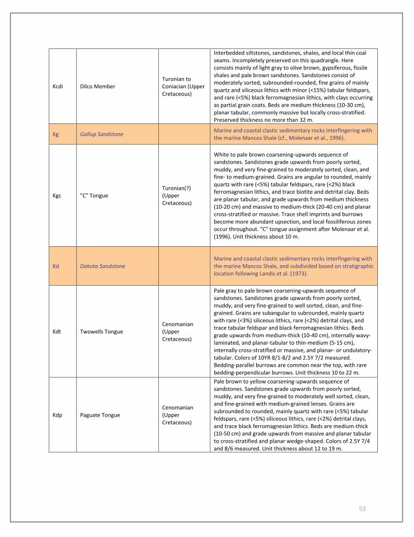
53
Kcdi Dilco Member Turonian to Coniacian (Upper Cretaceous)
Interbedded siltstones, sandstones, shales, and local thin coal seams. Incompletely preserved on this quadrangle. Here consists mainly of light gray to olive brown, gypsiferous, fissile shales and pale brown sandstones. Sandstones consist of moderately sorted, subrounded-rounded, fine grains of mainly quartz and siliceous lithics with minor (<15%) tabular feldspars, and rare (<5%) black ferromagnesian lithics, with clays occurring as partial grain coats. Beds are medium thickness (10-30 cm), planar tabular, commonly massive but locally cross-stratified. Preserved thickness no more than 32 m.
Kg Gallup Sandstone Marine and coastal clastic sedimentary rocks interfingering with the marine Mancos Shale (cf., Molenaar et al., 1996).
Kgc "C" Tongue Turonian(?) (Upper Cretaceous)
White to pale brown coarsening-upwards sequence of sandstones. Sandstones grade upwards from poorly sorted, muddy, and very fine-grained to moderately sorted, clean, and fine- to medium-grained. Grains are angular to rounded, mainly quartz with rare (<5%) tabular feldspars, rare (<2%) black ferromagnesian lithics, and trace biotite and detrital clay. Beds are planar tabular, and grade upwards from medium thickness (10-20 cm) and massive to medium-thick (20-40 cm) and planar cross-stratified or massive. Trace shell imprints and burrows become more abundant upsection, and local fossiliferous zones occur throughout. "C" tongue assignment after Molenaar et al. (1996). Unit thickness about 10 m.
Kd Dakota Sandstone Marine and coastal clastic sedimentary rocks interfingering with the marine Mancos Shale, and subdivided based on stratigraphic location following Landis et al. (1973).
Kdt Twowells Tongue Cenomanian (Upper Cretaceous)
Pale gray to pale brown coarsening-upwards sequence of sandstones. Sandstones grade upwards from poorly sorted, muddy, and very fine-grained to well sorted, clean, and fine-grained. Grains are subangular to subrounded, mainly quartz with rare (<3%) siliceous lithics, rare (<2%) detrital clays, and trace tabular feldspar and black ferromagnesian lithics. Beds grade upwards from medium-thick (10-40 cm), internally wavy-laminated, and planar-tabular to thin-medium (5-15 cm), internally cross-stratified or massive, and planar- or undulatory-tabular. Colors of 10YR 8/1-8/2 and 2.5Y 7/2 measured. Bedding-parallel burrows are common near the top, with rare bedding-perpendicular burrows. Unit thickness 10 to 22 m.
Kdp Paguate Tongue Cenomanian (Upper Cretaceous)
Pale brown to yellow coarsening-upwards sequence of sandstones. Sandstones grade upwards from poorly sorted, muddy, and very fine-grained to moderately well sorted, clean, and fine-grained with medium-grained lenses. Grains are subrounded to rounded, mainly quartz with rare (<5%) tabular feldspars, rare (<5%) siliceous lithics, rare (<2%) detrital clays, and trace black ferromagnesian lithics. Beds are medium-thick (10-50 cm) and grade upwards from massive and planar tabular to cross-stratified and planar wedge-shaped. Colors of 2.5Y 7/4 and 8/6 measured. Unit thickness about 12 to 19 m.

54
Kdc Cubero Tongue Cenomanian (Upper Cretaceous)
Pale gray to very pale brown coarsening-upwards sequence of sandstones. Sandstones grade upwards from poorly sorted, muddy, and very fine-grained to well sorted, clean, and fine-grained. Grains are subrounded to rounded, mainly quartz with rare (<5%) tabular feldspars, rare (<2%) siliceous lithics, and trace black ferromagnesian lithics. Beds grade upwards from massive or internally planar-laminated, medium-thick (10-50 cm), and planar-tabular to cross-stratified, medium thickness, and planar-wedge-shaped. Colors 2.5Y 8/2-9/2 and 7.5YR 4/6 measured. Bedding-parallel and bedding-perpendicular burrows throughout, increasing in abundance upsection. Locally fossiliferous. Unit thickness 10 to 15 m.
Kdc2 Discontinuous upper Cubero Tongue
Cenomanian (Upper Cretaceous)
Local pale brown to very pale brown coarsening-upwards sequence of sandstones overlying the main Kdc tongue. Sandstones grade upwards from moderately sorted, muddy, and very fine-grained to well sorted, clean, and fine-grained. Grains are subrounded-rounded, mainly quartz with trace tabular feldspars and siliceous lithics. Beds grade upwards from massive, thick, and planar-tabular to planar cross-stratified, medium, and planar- or undulatory-tabular. Colors of 10YR 7/4 and 7.5YR 7/2 measured. Unit is 0 to 4 m thick.
Kdo Oak Canyon Member Cenomanian (Upper Cretaceous)
Interbedded sandstones and shales. Abundance and thickness of sandstone intervals vary regionally (cf., Landis et al., 1973) and within the quadrangle. Generally divided into an upper, shale-dominated subunit and a lower, sandstone-dominated subunit, with the contact placed at the top of the highest sandstone interval.
Kdou Upper Oak Canyon Member Cenomanian (Upper Cretaceous)
Gray to locally pale yellowish brown, thinly laminated, fissile shales. Colors of 10YR 6/1-5/1 and 7/6 measured. Poorly exposed. Unit thickness about 12 to 15 m thick.
Kdol Lower Oak Canyon Member Cenomanian (Upper Cretaceous)
Interbedded pale gray sandstones and gray shales. Sandstones consist of moderately-well sorted, subangular to rounded, very fine to medium grains of dominantly quartz, rare (<3%) tabular feldspars, and trace gray siliceous lithics and black ferromagnesian lithics, in 0.5- to 5-m-thick intervals of medium to thick (10-60 cm), planar-tabular, planar-wedge-shaped, and lenticular beds with common planar or trough cross-stratification. Sandstone occurrence varies throughout the quadrangle, from 4 thin intervals to 2 thick intervals, each separated by shales. Colors of 2.5Y 8/1, 10YR 8/3, and locally 5YR 8/3 measured. Intervening shale intervals resemble those of Kdou. Unit thickness about 10 to 22 m.
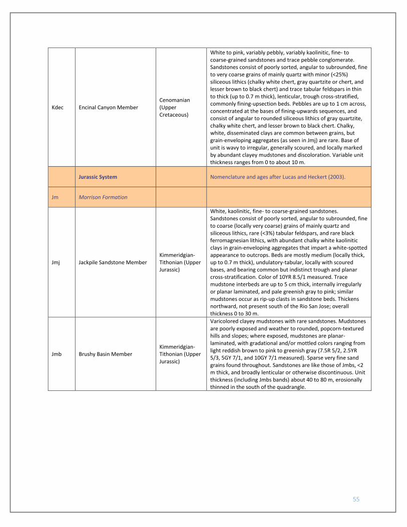
55
Kdec Encinal Canyon Member Cenomanian (Upper Cretaceous)
White to pink, variably pebbly, variably kaolinitic, fine- to coarse-grained sandstones and trace pebble conglomerate. Sandstones consist of poorly sorted, angular to subrounded, fine to very coarse grains of mainly quartz with minor (<25%) siliceous lithics (chalky white chert, gray quartzite or chert, and lesser brown to black chert) and trace tabular feldspars in thin to thick (up to 0.7 m thick), lenticular, trough cross-stratified, commonly fining-upsection beds. Pebbles are up to 1 cm across, concentrated at the bases of fining-upwards sequences, and consist of angular to rounded siliceous lithics of gray quartzite, chalky white chert, and lesser brown to black chert. Chalky, white, disseminated clays are common between grains, but grain-enveloping aggregates (as seen in Jmj) are rare. Base of unit is wavy to irregular, generally scoured, and locally marked by abundant clayey mudstones and discoloration. Variable unit thickness ranges from 0 to about 10 m.
Jurassic System Nomenclature and ages after Lucas and Heckert (2003).
Jm Morrison Formation
Jmj Jackpile Sandstone Member Kimmeridgian-Tithonian (Upper Jurassic)
White, kaolinitic, fine- to coarse-grained sandstones. Sandstones consist of poorly sorted, angular to subrounded, fine to coarse (locally very coarse) grains of mainly quartz and siliceous lithics, rare (<3%) tabular feldspars, and rare black ferromagnesian lithics, with abundant chalky white kaolinitic clays in grain-enveloping aggregates that impart a white-spotted appearance to outcrops. Beds are mostly medium (locally thick, up to 0.7 m thick), undulatory-tabular, locally with scoured bases, and bearing common but indistinct trough and planar cross-stratification. Color of 10YR 8.5/1 measured. Trace mudstone interbeds are up to 5 cm thick, internally irregularly or planar laminated, and pale greenish gray to pink; similar mudstones occur as rip-up clasts in sandstone beds. Thickens northward, not present south of the Rio San Jose; overall thickness 0 to 30 m.
Jmb Brushy Basin Member Kimmeridgian-Tithonian (Upper Jurassic)
Varicolored clayey mudstones with rare sandstones. Mudstones are poorly exposed and weather to rounded, popcorn-textured hills and slopes; where exposed, mudstones are planar-laminated, with gradational and/or mottled colors ranging from light reddish brown to pink to greenish gray (7.5R 5/2, 2.5YR 5/3, 5GY 7/1, and 10GY 7/1 measured). Sparse very fine sand grains found throughout. Sandstones are like those of Jmbs, <2 m thick, and broadly lenticular or otherwise discontinuous. Unit thickness (including Jmbs bands) about 40 to 80 m, erosionally thinned in the south of the quadrangle.

56
Jmbs Mappable sandstone bodies in the Brushy Basin Member
Kimmeridgian-Tithonian (Upper Jurassic)
Pale yellow, discontinuous, locally pebbly sandstone bands intercalated into Jmb clayey mudstones. Sandstones consist of poorly sorted, angular to subrounded, fine to very fine grains of mainly quartz with minor (10-15%) tabular feldspars, minor (10-15%) pink to brown to gray siliceous lithics, and trace black ferromagnesian lithics with rare white chalky clay or carbonate nodules up to 4 mm across, in mainly thin to medium (0-40 cm thick), lenticular, trough-cross-stratified beds. Pebbles up to 2 cm across are trace overall but up to 15% of beds, and consist of subangular to rounded gray to brown siliceous lithics, rare granites, trace black chert, and trace mafic-intermediate volcanics. Individual bands are up to 10 m thick, but commonly <2 m thick.
Jmw Westwater Canyon Member Kimmeridgian-Tithonian (Upper Jurassic)
White, cross-stratified, variably pebbly, coarse-grained sandstones. Sandstones consist dominantly of poorly sorted, angular to rounded, fine to very coarse grains of dominantly quartz and siliceous lithics (mostly brown to gray cherts or quartzites, trace black and chalky white cherts and white quartzites) with trace granitic and volcanic lithics in thin to medium (up to 20 cm thick), lenticular or undulatory, commonly trough cross-stratified beds with scoured bases. Colors of 2.5Y 8/1-9.5/1 measured. Gravel are pebbles and granules of siliceous lithologies. Generally about 5 m thick; thins to 0 m over some anticlinal folds.
Jz Zuni Sandstone Dominantly eolian sandstones with an upper fluvial interval. Use of the term "Zuni Sandstone" is after the definition of Anderson (1993).
Jzf Fluvial facies Oxfordian (Upper Jurassic)
Interbedded light gray to weak red and red-gray mottled sandstones; weak red to greenish gray, variably sandy, commonly clayey mudstones; and local lenticular gray limestones. Proportions of components, as well as component colors, are variable across the quadrangle; typically, varicolored sandstones dominate. Sandstones are composed of moderately sorted, subangular to rounded, fine to very fine grains of dominantly quartz, variable (typically rare) siliceous lithics, rare (<2%) tabular feldspars, and trace black ferromagnesian lithics in thin to thick (max 1 m thick) beds that can be planar-tabular, undulatory-tabular, or lenticular. Thinner beds are typically cross-stratified, thicker beds typically massive. Colors of 2.5Y 7/2, 5Y 7/3, 5YR 6/4, and 5R 5/2 measured; individual beds may be mottled or laterally change color rapidly. Mudstones are clayey, bear variable very fine sand grains, are irregularly laminated, and are mottled, with colors 10Y 8/1, 5R 6/1, 7.5R 5/3 measured. Mudstone intervals are laterally discontinuous, but up to 2 m thick. Lenticular limestones are absent to locally common (concentrated near the upper contact) thin to medium beds of white to light brown (8/N and 7.5YR 6/3 measured), fine-grained limestones with trace very fine sand grains. Unit is 8 to 13 m thick.
Jz Eolian (principal) facies Oxfordian (Upper Jurassic)
Pale yellow to light brown, thickly- to very thickly-bedded, prominently cross-stratified fine- to medium-grained sandstones. Sandstones consist of clean, moderately-well sorted, subrounded-rounded, fine to medium grains of dominantly quartz, rare (<3%) siliceous lithics, and rare (<3%) tabular feldspars with trace clays and fine carbonate nodules, in very thick (1 to 2 m thick) tabular or undulatory planar beds that are commonly prominently high-angle cross-stratified (locally vaguely cross-stratified or massive). Colors of 2.5Y-5Y 8/2-8/3

57
and 7.5YR 6/4 measured. Variably calcite-cemented. About 30 to 40 m thick.
Pre-Zuni units
Jb Bluff Sandstone Oxfordian (Upper Jurassic)
Mainly light brown to pink, medium-thick bedded, variably structured fine sandstones with minor muddy sandstones and reddish brown sandstones. Most sandstones are clean and consist of moderately sorted, subrounded-rounded, fine to very fine grains of dominantly quartz, rare brown siliceous lithics, and trace tabular feldspars with trace fine carbonate nodules in medium to thick (0.1 to 1 m thick) planar tabular beds. Beds are variably low-angle cross-stratified, massive, internally planar-laminated, or high-angle cross-stratified. Colors commonly 7.5YR 6/3-7/4 to 5YR 5/4-6/4, and less commonly 5YR 8/3 and 2.5YR 8/3; redder hues are more common in the southeastern corner of the quadrangle. Muddy sandstones are very fine- to fine-grained and occur in medium-thick (0.3-0.5 m thick) intervals that are internally very thinly planar bedded (1-4 cm thick), and are otherwise like the clean sandstones. About 60 to 70 m thick.
Js Summerville Formation
Callovian-Oxfordian (Middle-Upper Jurassic)
Interbedded muddy very fine sandstones, sandy mudstones, and rare clean fine sandstones. Muddy sandstones and sandy mudstones are dominantly reddish brown colors (2.5YR 5/4-6/4, 5YR 5/4 measured), with moderately-poorly sorted, subangular to rounded, very fine to fine sand grains of mainly quartz with rare (<4%) tabular feldspars, rare (<2%) medium gray and black lithics, and rare fine carbonate nodules. These occur in 1-3 m thick intervals that are massive to thinly bedded, with commonly vague internal planar- or cross-laminations. Clean sandstones are pink (7.5YR 7/4 and 5YR 7/2 measured) and occur in massive to cross-stratified 0.5-1 m thick planar beds. Sands are moderately sorted, mainly fine-grained, and dominantly of quartz with rare (<2%) tabular feldspars and trace black lithics. Base unexposed. Thickness 40 m to 55 m on the South Butte quadrangle to the south (Moench, 1964).
Jet Entrada and Todilto Formations
Callovian (Middle Jurassic)
Cross-section only. Gypsum, limestones, sandstones, and siltstones underlying the Summerville Formation and exposed on the South Butte quadrangle to the south.