Embed Size (px)
Citation preview
Geologic Mapof the Bellingham
1:100,000 Quadrangle,Washington
by Thomas J. Lapen
WASHINGTON
DIVISION OF GEOLOGY
AND EARTH RESOURCES
Open File Report 2000-5December 2000
NA
TU
RA
LR
ES
OU
RC
ES
Location ofquadrangle

Geologic Mapof the Bellingham
1:100,000 Quadrangle,Washington
by Thomas J. Lapen
WASHINGTON
DIVISION OF GEOLOGY
AND EARTH RESOURCES
Open File Report 2000-5December 2000
ii
DISCLAIMER
Neither the State of Washington, nor any agency thereof, nor any oftheir employees, makes any warranty, express or implied, or assumesany legal liability or responsibility for the accuracy, completeness, orusefulness of any information, apparatus, product, or process dis-closed, or represents that its use would not infringe privately ownedrights. Reference herein to any specific commercial product, process,or service by trade name, trademark, manufacturer, or otherwise, doesnot necessarily constitute or imply its endorsement, recommendation,or favoring by the State of Washington or any agency thereof. Theviews and opinions of authors expressed herein do not necessarily stateor reflect those of the State of Washington or any agency thereof.
WASHINGTON DEPARTMENT OF NATURAL RESOURCES
Jennifer M. Belcher—Commissioner of Public Lands
DIVISION OF GEOLOGY AND EARTH RESOURCES
Raymond Lasmanis—State GeologistJ. Eric Schuster—Assistant State GeologistRon Teissere—Assistant State Geologist
This report is available from:
PublicationsWashington Department of Natural ResourcesDivision of Geology and Earth ResourcesP.O. Box 47007Olympia, WA 98504-7007Phone: 360-902-1450Fax: 360-902-1785E-mail: [email protected]: http://www.wa.gov/dnr/htdocs/ger/ger.html
Printed on recycled paperPrinted in the United States of America
Contents
Introduction . . . . . . . . . . . . . . . . . . . . . . . . . . . . . . . . . . . . . . . . . . . . 1
Method of age assignment . . . . . . . . . . . . . . . . . . . . . . . . . . . . . . . . . . . 2
Sources of map data . . . . . . . . . . . . . . . . . . . . . . . . . . . . . . . . . . . . . . 2
Geologic setting . . . . . . . . . . . . . . . . . . . . . . . . . . . . . . . . . . . . . . . . . . 2
Descriptions of map units . . . . . . . . . . . . . . . . . . . . . . . . . . . . . . . . . . . . . 3
Quaternary deposits . . . . . . . . . . . . . . . . . . . . . . . . . . . . . . . . . . . . . . . 3
Post-glacial deposits . . . . . . . . . . . . . . . . . . . . . . . . . . . . . . . . . . . . . 3
Glacial deposits . . . . . . . . . . . . . . . . . . . . . . . . . . . . . . . . . . . . . . . 6
Fraser Glaciation, undivided . . . . . . . . . . . . . . . . . . . . . . . . . . . . . . . 6
Fraser Glaciation, Sumas Stade . . . . . . . . . . . . . . . . . . . . . . . . . . . . . 6
Fraser Glaciation, Everson Interstade . . . . . . . . . . . . . . . . . . . . . . . . . . 7
Fraser Glaciation, Vashon Stade . . . . . . . . . . . . . . . . . . . . . . . . . . . . . 8
Fraser Glaciation, Evans Creek Stade . . . . . . . . . . . . . . . . . . . . . . . . . . 9
Pre-Fraser Glaciation . . . . . . . . . . . . . . . . . . . . . . . . . . . . . . . . . . . 9
Tertiary rocks . . . . . . . . . . . . . . . . . . . . . . . . . . . . . . . . . . . . . . . . . . 9
Huntingdon Formation . . . . . . . . . . . . . . . . . . . . . . . . . . . . . . . . . . . . 9
Chuckanut Formation. . . . . . . . . . . . . . . . . . . . . . . . . . . . . . . . . . . . 10
Pre-Tertiary rocks . . . . . . . . . . . . . . . . . . . . . . . . . . . . . . . . . . . . . . . 11
Nanaimo Group . . . . . . . . . . . . . . . . . . . . . . . . . . . . . . . . . . . . . . . 11
Northwest Cascades system: Rocks of the northwest Cascade Range . . . . . . . . . 13
Heterogeneous metamorphic rocks of the Butler Hill area . . . . . . . . . . . . . . 13
Easton Metamorphic Suite of Tabor and others (1994) . . . . . . . . . . . . . . . . 13
Rocks of the Bell Pass mélange . . . . . . . . . . . . . . . . . . . . . . . . . . . . . 14
Chilliwack Group of Cairnes (1944) . . . . . . . . . . . . . . . . . . . . . . . . . . 17
Northwest Cascades system: Rocks of the San Juan Islands . . . . . . . . . . . . . . 18
Fidalgo ophiolite of Brown and others (1979) . . . . . . . . . . . . . . . . . . . . . 18
Lummi Formation . . . . . . . . . . . . . . . . . . . . . . . . . . . . . . . . . . . . 19
Other rocks of the San Juan Islands . . . . . . . . . . . . . . . . . . . . . . . . . . 20
Acknowledgments . . . . . . . . . . . . . . . . . . . . . . . . . . . . . . . . . . . . . . . . 22
References cited . . . . . . . . . . . . . . . . . . . . . . . . . . . . . . . . . . . . . . . . . 22
Appendix: Radiometric and fossil age data keyed to reference numbers on Plate 1 . . . . 28
FIGURES
Figure 1. Map showing 1:100,000-scale quadrangles in thenorthwest quadrant of Washington State . . . . . . . . . . . . . . . . . . . . . . 1
Figure 2. Flow chart for age assignment of geologic units . . . . . . . . . . . . . . . . . . 2
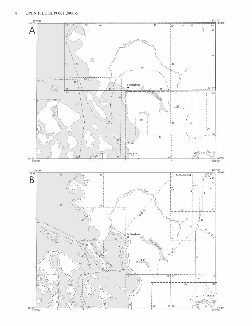
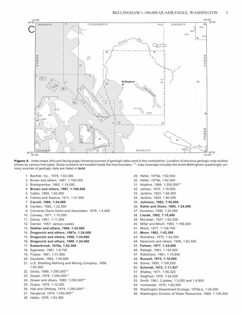
Figure 3. Index map showing sources of geologic dataused in this compilation (3 maps) . . . . . . . . . . . . . . . . . . . . . . . . . . 4
TABLES
Table 1. U/Pb in zircon analytical and age data. . . . . . . . . . . . . . . . . . . . . . . . 28
Table 2. U/Pb in zircon analytical and age data. . . . . . . . . . . . . . . . . . . . . . . . 29
Table 3. Rb/Sr analytical data . . . . . . . . . . . . . . . . . . . . . . . . . . . . . . . . . 30
Table 4. K/Ar age and analytical data . . . . . . . . . . . . . . . . . . . . . . . . . . . . . 31
Table 5. Fission-track age data . . . . . . . . . . . . . . . . . . . . . . . . . . . . . . . . . 32
Table 6. Fossil age data . . . . . . . . . . . . . . . . . . . . . . . . . . . . . . . . . . . . . 33
PLATES
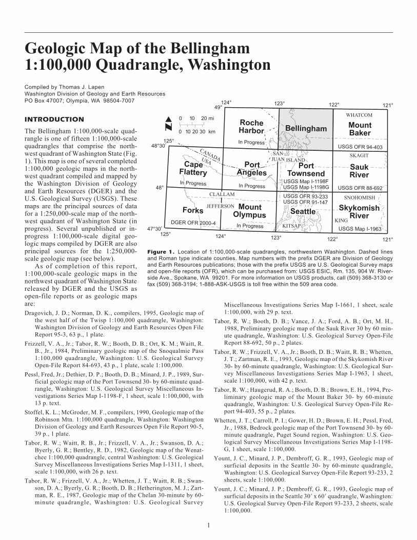
Plate 1. Geologic map of the Bellingham 1:100,000 quadrangle
Plate 2. Correlation of geologic units
iii

iv
Geologic Map of the Bellingham1:100,000 Quadrangle, Washington
Compiled by Thomas J. Lapen
Washington Division of Geology and Earth Resources
PO Box 47007; Olympia, WA 98504-7007
INTRODUCTION
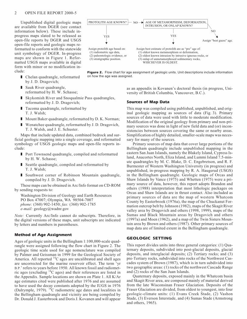
The Bellingham 1:100,000-scale quad-rangle is one of fifteen 1:100,000-scalequadrangles that comprise the north-west quadrant of Washington State (Fig.1). This map is one of several completed1:100,000 geologic maps in the north-west quadrant compiled and mapped bythe Washington Division of Geologyand Earth Resources (DGER) and theU.S. Geological Survey (USGS). Thesemaps are the principal sources of datafor a 1:250,000-scale map of the north-west quadrant of Washington State (inprogress). Several unpublished or in-progress 1:100,000-scale digital geo-logic maps compiled by DGER are alsoprincipal sources for the 1:250,000-scale geologic map (see below).
As of completion of this report,1:100,000-scale geologic maps in thenorthwest quadrant of Washington Statereleased by DGER and the USGS asopen-file reports or as geologic mapsare:
Dragovich, J. D.; Norman, D. K., compilers, 1995, Geologic map of
the west half of the Twisp 1:100,000 quadrangle, Washington:
Washington Division of Geology and Earth Resources Open File
Report 95-3, 63 p., 1 plate.
Frizzell, V. A., Jr.; Tabor, R. W.; Booth, D. B.; Ort, K. M.; Waitt, R.
B., Jr., 1984, Preliminary geologic map of the Snoqualmie Pass
1:100,000 quadrangle, Washington: U.S. Geological Survey
Open-File Report 84-693, 43 p., 1 plate, scale 1:100,000.
Pessl, Fred, Jr.; Dethier, D. P.; Booth, D. B.; Minard, J. P., 1989, Sur-
ficial geologic map of the Port Townsend 30- by 60-minute quad-
rangle, Washington: U.S. Geological Survey Miscellaneous In-
vestigations Series Map I-1198-F, 1 sheet, scale 1:100,000, with
13 p. text.
Stoffel, K. L.; McGroder, M. F., compilers, 1990, Geologic map of the
Robinson Mtn. 1:100,000 quadrangle, Washington: Washington
Division of Geology and Earth Resources Open File Report 90-5,
39 p., 1 plate.
Tabor, R. W.; Waitt, R. B., Jr.; Frizzell, V. A., Jr.; Swanson, D. A.;
Byerly, G. R.; Bentley, R. D., 1982, Geologic map of the Wenat-
chee 1:100,000 quadrangle, central Washington: U.S. Geological
Survey Miscellaneous Investigations Series Map I-1311, 1 sheet,
scale 1:100,000, with 26 p. text.
Tabor, R. W.; Frizzell, V. A., Jr.; Whetten, J. T.; Waitt, R. B.; Swan-
son, D. A.; Byerly, G. R.; Booth, D. B.; Hetherington, M. J.; Zart-
man, R. E., 1987, Geologic map of the Chelan 30-minute by 60-
minute quadrangle, Washington: U.S. Geological Survey
Miscellaneous Investigations Series Map I-1661, 1 sheet, scale
1:100,000, with 29 p. text.
Tabor, R. W.; Booth, D. B.; Vance, J. A.; Ford, A. B.; Ort, M. H.,
1988, Preliminary geologic map of the Sauk River 30 by 60 min-
ute quadrangle, Washington: U.S. Geological Survey Open-File
Report 88-692, 50 p., 2 plates.
Tabor, R. W.; Frizzell, V. A., Jr.; Booth, D. B.; Waitt, R. B.; Whetten,
J. T.; Zartman, R. E., 1993, Geologic map of the Skykomish River
30- by 60-minute quadrangle, Washington: U.S. Geological Sur-
vey Miscellaneous Investigations Series Map I-1963, 1 sheet,
scale 1:100,000, with 42 p. text.
Tabor, R. W.; Haugerud, R. A.; Booth, D. B.; Brown, E. H., 1994, Pre-
liminary geologic map of the Mount Baker 30- by 60-minute
quadrangle, Washington: U.S. Geological Survey Open-File Re-
port 94-403, 55 p., 2 plates.
Whetten, J. T.; Carroll, P. I.; Gower, H. D.; Brown, E. H.; Pessl, Fred,
Jr., 1988, Bedrock geologic map of the Port Townsend 30- by 60-
minute quadrangle, Puget Sound region, Washington: U.S. Geo-
logical Survey Miscellaneous Investigations Series Map I-1198-
G, 1 sheet, scale 1:100,000.
Yount, J. C., Minard, J. P., Dembroff, G. R., 1993, Geologic map of
surficial deposits in the Seattle 30- by 60-minute quadrangle,
Washington: U.S. Geological Survey Open-File Report 93-233, 2
sheets, scale 1:100,000.
Yount, J. C.; Minard, J. P.; Dembroff, G. R., 1993, Geologic map of
surficial deposits in the Seattle 30� x 60� quadrangle, Washington:
U.S. Geological Survey Open-File Report 93-233, 2 sheets, scale
1:100,000.
RocheHarbor
PortAngeles
MountOlympus
In Progress
In Progress
124° 123° 122° 121°
DGER OFR 2000-4
49°
125°
124°125°
48°30¢
48°
47°30¢
123° 122° 121°
CapeFlattery
SkykomishRiver
USGS OFR 94-403
MountBaker
CANADAUSA
KING
SNOHOMISH
WHATCOM
Forks
PortTownsend
USGS Map I-1198FUSGS Map I-1198G
SKAGITISLAND
SANJUAN
JEFFERSON
CLALLAM
In Progress
USGS OFR 93-233USGS OFR 91-147
KITSAPUSGS Map I-1963
USGS OFR 88-692In Progress
0 20
0 30
10
10 20
mi
km
SaukRiver
Seattle
Bellingham
Figure 1. Location of 1:100,000-scale quadrangles, northwestern Washington. Dashed lines
and Roman type indicate counties. Map numbers with the prefix DGER are Division of Geology
and Earth Resources publications; those with the prefix USGS are U.S. Geological Survey maps
and open-file reports (OFR), which can be purchased from: USGS ESIC, Rm. 135, 904 W. River-
side Ave., Spokane, WA 99201. For more information on USGS products, call (509) 368-3130 or
fax (509) 368-3194; 1-888-ASK-USGS is toll free within the 509 area code.
1
Unpublished digital geologic mapsare available from DGER (see contactinformation below). These include in-progress maps slated to be released asopen-file reports by DGER and USGSopen-file reports and geologic maps re-formatted to conform with the statewideunit symbology of DGER. In-progressmaps are shown in Figure 1. Refor-matted USGS maps available in digitalform with minor or no modification in-clude:
� Chelan quadrangle, reformatted
by J. D. Dragovich;
� Sauk River quadrangle,
reformatted by H. W. Schasse;
� Skykomish River and Snoqualmie Pass quadrangles,
reformatted by J. D. Dragovich;
� Tacoma quadrangle, reformatted by
T. J. Walsh;
� Mount Baker quadrangle, reformatted by D. K. Norman;
� Wenatchee quadrangle, reformatted by J. D. Dragovich,
T. J. Walsh, and J. E. Schuster.
Maps that include updated data, combined bedrock and sur-ficial geologic mapping into a single coverage, and reformattedsymbology of USGS geologic maps and open-file reports in-clude:
� Port Townsend quadrangle, compiled and reformatted
by H. W. Schasse;
� Seattle quadrangle, compiled and reformatted by
T. J. Walsh;
� Southwest corner of Robinson Mountain quadrangle,
compiled by J. D. Dragovich.
These maps can be obtained in Arc/Info format on CD-ROMby sending requests to:
Washington Division of Geology and Earth ResourcesPO Box 47007; Olympia, WA 98504-7007phone: (360) 902-1450; fax: (360) 902-1785e-mail: [email protected]
Note: Currently Arc/Info cannot do subscripts. Therefore, inthe digital versions of these maps, unit subscripts are indicatedby letters and numbers in parentheses.
Method of Age Assignment
Ages of geologic units in the Bellingham 1:100,000-scale quad-rangle were assigned following the flow chart in Figure 2. Thegeologic time scale used for age nomenclature was compiledby Palmer and Geissman in 1999 for the Geological Society ofAmerica. All reported 14C ages are uncalibrated and shell agesare uncorrected for the marine reservoir effect. The term ‘yrB.P.’ refers to years before 1950. All known fossil and radiomet-ric ages (excluding 14C ages) and their references are listed inthe Appendix. Sample locations are shown on Plate 1. All K/Arage estimates cited were published after 1976 and are assumedto have used the decay constants adopted by the IUGS in 1976(Dalrymple, 1979). 14C radiometric age dates and localities inthe Bellingham quadrangle and vicinity are being compiled byDr. Donald J. Easterbrook and Doris J. Kovanen and will appear
as an appendix in Kovanen’s doctoral thesis (in progress, Uni-versity of British Columbia, Vancouver, B.C.).
Sources of Map Data
This map was compiled using published, unpublished, and orig-inal geologic mapping as sources of data (Fig. 3). Primarysources of data were used with little to moderate modification.Modification of the original geology from primary and non-pri-mary sources was done in light of new field data and (or) incon-sistencies between sources covering the same or nearby areas.Simplification of highly detailed, smaller-scale maps was neces-sary for many of the sources.
Primary sources of map data that cover large portions of theBellingham quadrangle include unpublished mapping in theeastern San Juan Islands, namely the Blakely Island, Cypress Is-land, Anacortes North, Eliza Island, and Lummi Island 7.5-min-ute quadrangles by M. C. Blake, D. C. Engebretson, and R. F.Burmester of Western Washington University (in progress) andunpublished, in-progress mapping by R. A. Haugerud (USGS)in the Bellingham quadrangle. Geologic maps of Orcas andShaw Islands by Vance (1975) and Whetten (1975) were a pri-mary source of data, however, this report adopts Brandon andothers (1988) interpretation that most lithologic packages onOrcas and Shaw Islands are in thrust contact. Also included asprimary sources of data are the map of western WhatcomCounty by Easterbrook (1976a), the map of the Chuckanut For-mation outcrop belt by Johnson (1982), maps of the Skagit Rivervalley area by Dragovich and others (1998, 1999), maps of theSumas and Black Mountain areas by Dragovich and others(1997a) and Moen (1962), and a map of the Twin Sisters Moun-tain area by Brown and others (1987). Other primary sources ofmap data are of limited extent in the Bellingham quadrangle.
GEOLOGIC SETTING
This report divides units into three general categories: (1) Qua-ternary deposits, subdivided into post-glacial deposits, glacialdeposits, and interglacial deposits; (2) Tertiary rocks; and (3)pre-Tertiary rocks, subdivided into rocks of the Northwest Cas-cades system of Brown (1987), which is in turn subdivided intotwo geographic areas: (1) rocks of the northwest Cascade Rangeand (2) rocks of the San Juan Islands.
Quaternary deposits, exposed mainly in the Whatcom basinand Skagit River area, are composed mainly of material derivedfrom the late Wisconsinan Fraser Glaciation. Deposits of theFraser Glaciation are divided, from oldest to youngest, into fourgeologic-climate units: (1) Evans Creek Stade, (2) VashonStade, (3) Everson Interstade, and (4) Sumas Stade (Armstrongand others, 1965).
2 OPEN FILE REPORT 2000-5
PROTOLITH AGE KNOWN? AGE OF METAMORPHISM, DEFORMATION,INTRUSION, OR ONLAP KNOWN?
Assign protolith age based on:(1) radiometric age data,(2) paleontologic evidence, or(3) stratigraphic position.
Assign best estimate of protolith are as “pre” age of:(1) oldest known metamorphism or deformation,(2) oldest known intrusion by intrusive igneous rocks, or(3) onlap of unmetamorphosed sedimentary rocks,
WHICHEVER IS OLDEST.
YES YES
Assign “best guess” age.
NO
NO
Figure 2. Flow chart for age assignment of geologic units. Unit descriptions include information
on how the age was assigned.
Tertiary rocks are extensive in the map area and consist ofthe Chuckanut and Huntingdon Formations. Deposition of theseunits was controlled by local uplifts and basins produced in abroad zone of strike-slip deformation (Johnson, 1982, 1985).Though the use of different formation names for these units im-plies they are unrelated, Mustard and Rouse (1994) concludethat the Huntingdon Formation is correlative to younger strataof the Chuckanut Formation. In this report, the term‘Huntingdon Formation’ is used for sedimentary rocks on west-ern Sumas Mountain, in agreement with Mustard and Rouse(1994), because most literature to date refers to these rocks assuch (for example, Miller and Misch, 1963, and Dragovich andothers, 1997a).
Pre-Tertiary rocks (excluding the Upper Cretaceous Nanai-mo Group) constitute a structural system referred to as theNorthwest Cascades system (NWCS) (Misch, 1966; Brown,1987). This structural system is a thrust stack of mainly oceaniclithologic packages (or terranes) of varying age, structure, andmetamorphic history (Brown and others, 1981; Brown, 1987).These packages were largely assembled in the mid-Cretaceous(Misch, 1966; Brown, 1987; Brandon and others, 1988; Taborand others, 1994) and possibly also in the Late Jurassic(Haugerud and others, 1992, 1994). Eocene and later(?) defor-mation also disrupted and possibly juxtaposed many lithologicunits of the NWCS (Haugerud and others, 1992; Dragovich andothers 1997a; Haugerud, 1998).
The NWCS is divided into two geographic areas, the north-west Cascade Range and the San Juan Islands, because manyprevious studies refer to these areas when describing lithologicpackages and tectonics. Similar geologic units in the two areasare likely correlative (for example, the Vedder Complex and theGarrison Schist, the Yellow Aster Complex and the TurtlebackComplex, the Chilliwack Group and the East Sound Group, andthe Elbow Lake Formation and the Orcas Chert) (Brown andVance, 1987; Brandon, 1989; Ralph Haugerud, USGS, oralcommun., 1999). Structural and kinematic connections betweenthe two areas are proposed by Brandon and Cowan (1985) andBrown (1987), however, at present, the tectonic evolution of theNWCS remains an unsolved problem.
DESCRIPTIONS OF MAP UNITS
Quaternary Deposits
POST-GLACIAL DEPOSITS
Qf Artificial fill (Holocene)—Composed of earth debris,demolition debris, and, locally, refuse disposed of assolid waste. Thickness is generally more than 2 m.Many wharves and structures, including industrialbuildings, are built on unit Qf in Bellingham Bay.Smaller occurrences of unit Qf are near the city ofBlaine and in Chuckanut Bay. (Description compiledfrom Washington Department of Ecology, 1977, 1978,and Dethier and others, 1996.)
Qa Alluvium (Holocene)—Well-sorted and stratifiedcobbly gravel, gravel, sandy gravel, gravelly sand,sand, silty sand, silt, clay, and peat (see unit Qp).Clasts are rounded to subrounded and consist of meta-morphic, sedimentary, and igneous rocks derived fromsources in the drainage basin of a particular river orstream and foreign material derived from reworkedglacial deposits. Color is dependent on lithology andoxidation state but is generally some combination ofgray and brown. Thicknesses range from a few meters
to locally over 85 m. Deposits generally occur instream and river channels, modern deltas, and modernflood plains. Unit Qa may locally include alluvial fans(unit Qaf) and older alluvium (unit Qoa). (Descriptioncompiled from Newcomb and others, 1949; Sceva,1950; Washington Division of Water Resources,1960; Easterbrook, 1971, 1976a; Dragovich and Gris-amer, 1998; and Dragovich and others, 1998, 1999.)
Qb Beach deposits (Holocene)—Moderately to well-sorted coarse sand and gravel and, locally, sand, silt,and clay in tidal-flat deposits. Bedding is planar andchannel cross-stratified and locally massive; locallyincludes very well sorted eolian back-beach sanddunes. Clasts are generally well rounded and some-times crudely polished by wave action and mostly de-rived from reworked glacial deposits. Color is depend-ent upon dominant clast lithology. Thickness is highlyvariable but generally greater than 2.5 m. Unit Qb
forms elongate spits near Drayton Harbor and LummiBay in the northwest part of the Bellingham quadran-gle. (Description compiled from Easterbrook, 1971;Dethier and others, 1996; Dragovich and others, 1998;and Washington Department of Ecology, 1977, 1978.)
Qoa Older alluvium (Holocene)—Well-sorted and strati-fied cobbles, sand, silt, and lesser clay. Clasts are gen-erally rounded to subrounded and consist of metamor-phic, sedimentary, and igneous rocks derived from lo-cal sources such as bedrock and reworking of glacialdeposits. Color is brown to gray, depending on oxida-tion state and composition. Thickness of the depositsis poorly constrained, however some exposures are atleast 15 m thick, based on the height of erosional riverterraces. Exposures of unit Qoa in the Bellinghamquadrangle generally flank modern alluvial floodplains of the Skagit River and the south, middle, andnorth forks of the Nooksack River. Unit Qoa may lo-cally contain primary and (or) reworked laharic mate-rial (units Qvlk and Qvlm) derived from Mount Bakerand (or) Glacier Peak volcanoes. (Description com-piled from Moen, 1962; Easterbrook, 1976a; Drago-vich and Grisamer, 1998; and Dragovich and others,1998, 1999.)
Qvlm Lahar of the Middle Fork Nooksack River (Holo-cene)—Diamicton containing rounded to mostly an-gular boulders, gravel, sand, silt, clay, and woody de-bris, including logs. Mount Baker andesite is the pre-dominant clast lithology; other clast types are likelyderived from river alluvium and glacial deposits.Color in outcrop may be variations of red/brown (Fe-oxide), yellow/orange (sulfur staining), and gray/brown. Thickness may be greater than 13 m as deter-mined from river bank exposures and subsurface (welldata) interpretation. Exposures of unit Qvlm occur nearthe north end of Van Zandt Dike but smaller exposures(too small to be mapped at this scale) occur in the Mid-dle Fork Nooksack River valley in the vicinity ofClearwater Creek. 14C ages obtained from wood in thedeposit are 5,650 ±110 yr B.P., 5,710 ±110 yr B.P.(Kovanen, 1996), and 6000 yr B.P. (Hyde andCrandell, 1978). (Description compiled fromKovanen, 1996, and Dragovich and others, 1997a.)
BELLINGHAM 1:100,000 QUADRANGLE, WASHINGTON 3
4 OPEN FILE REPORT 2000-5
56
6
6
6
48
49
4825
39
1
5249
39
56
4839
56
1
50
49
56
1
56
20
56
1 20
56
44
44 44
37
44
37
44 44 44 37
37
44 37
44
3744
37
123°00¢
48°30¢
123°00¢
49°00¢
48°30¢
122°00¢
49°00¢
122°00¢
Lake Whatcom
SkagitRiver
NooksackRiver
A
Bellingham
13
55
55
13
55
13
55
55
55
35
5555
5555 15 41 15 16
55
55
55
55
55
55
55
55
55
55
5555
45
35
45
55
45
45
35
45
45
55
4035
15
55
41
1615
54
54
4035
14
16
28,29,30
41
4
41
47
16
35
4
14 4
41
5440
14,35,40,42,5445
45
55 45
55
55
45
45
5440
35
4214
4,35,40,42,54
42
14
53
4
42
53
42
41
123°00¢
48°30¢
123°00¢
49°00¢
48°30¢
122°00¢
49°00¢
122°00¢
Lake Whatcom
Skagit River
NooksackRiver
B
Bellingham
BELLINGHAM 1:100,000 QUADRANGLE, WASHINGTON 5
1. Bechtel, Inc., 1979, 1:63,360
2. Brown and others, 1987, 1:100,000
3. Breitsprecher, 1962, 1:19,000
4. Brown and others, 1987, 1:100,000
5. Calkin, 1959, 1:63,000
6. Canton and Swarva, 1911, 1:31,680
7. Carroll, 1980, 1:24,000
8. Carsten, 1982, 1:22,000
9. Converse Davis Dixon and Associates, 1976, 1:4,800
10. Conway, 1971, 1:10,500
11. Dainty, 1981, 1:11,000
12. Danner, 1957, various scales
13. Dethier and others, 1996, 1:24,000
14. Dragovich and others, 1997a, 1:24,000
15. Dragovich and others, 1998, 1:24,000
16. Dragovich and others, 1999, 1:24,000
17. Easterbrook, 1976a, 1:62,500
18. Egemeier, 1981, 1:9,700
19. Frasse, 1981, 1:31,680
20. Gaudette, 1963, 1:50,688
21. U.S. Smelting Refining and Mining Company, 1958,
1:62,500
22. Gordy, 1988, 1:250,000**
23. Gower, 1978, 1:250,000**
24. Gower and others, 1985, 1:250,000**
25. Gusey, 1978, 1:12,000
26. Hall and Othberg, 1974, 1:250,000**
27. Haugerud, 1979, 1:250,000**
28. Heller, 1978, 1:63,360
29. Heller, 1979a, 1:62,500
30. Heller, 1979b, 1:62,500
31. Hopkins, 1966, 1:250,000**
32. Janbaz, 1972, 1:19,000
33. Jenkins, 1923, 1:84,000
34. Jenkins, 1924, 1:90,000
35. Johnson, 1982, 1:50,000
36. Kahle and Olsen, 1995, 1:24,000
37. Kovanen, 1996, 1:24,000
38. Liszak, 1982, 1:15,000
39. McLellan, 1927, 1:62,500
40. Miller and Misch, 1963, 1:169,000
41. Misch, 1977, 1:126,700
42. Moen, 1962, 1:62,500
43. Mulcahey, 1975, 1:42,000
44. Newcomb and others, 1949, 1:62,500
45. Palmer, 1977, 1:24,000
46. Raleigh, 1963, 1:144,820
47. Robertson, 1981, 1:15,840
48. Russell, 1975, 1:70,000
49. Sceva, 1950, 1:100,000
50. Schmidt, 1972, 1:11,927
51. Shelley, 1971, 1:56,320
52. Siegfried, 1978, 1:24,000
53. Smith, 1961, 2 plates, 1:3,000 and 1:4,800
54. Vonheeder, 1975, 1:62,500
55. Washington Department Ecology, 1978a,b, 1:24,000
56. Washington Division of Water Resources, 1960, 1:135,000
23,24,26,27,31
1711
18
51
51
23,24,26,27,31
51
12
12
1212
12
12
8
32
3
7
46
46
10
10
432
36
2
1718 21
17
75
5
2
33
23,24,26,27,31
33 33
17,21
21
24
312726
2
23
23,24,26,27,31
2
21
33
17,21,23,24,26,27,3117
9
33
17,21
34
34
2731
262423
19
19
38
24
312726
23
12
1212
12
38
123°00¢
48°30¢
123°00¢
49°00¢
48°30¢
122°00¢
49°00¢
122°00¢
Bellingham
Lake Whatcom
Skagit
River
NooksackRiver
C
Figure 3. Index maps (this and facing page) showing sources of geologic data used in this compilation. Location of previous geologic map studies
shown by various line types. Study numbers are located inside the line boundary. **, map coverage includes the entire Bellingham quadrangle; pri-
mary sources of geologic data are listed in bold.
Qvlk Lahar (Kennedy Creek assemblage) (Holocene)—Moderately to poorly sorted and locally poorly to non-stratified volcanic sand and gravel with local cobblegravel, silt, and clay. Consists of rounded pumiceousand (or) vesicular dacite clasts and crystal-lithic anddacite-rich sand; also contains lesser clasts from bed-rock and glacial deposits to the east. Color, which ishighly dependent on oxidation state and composition,is generally pale to dark yellowish brown, olive gray,or light to dark gray. Thickness is generally 10 to 20 m,based on well data. Chemical, age, and provenancedata indicate that this unit was deposited by one ormore large hyperconcentrated floods from the GlacierPeak volcano at about 5,100 to 5,500 yr B.P. and possi-bly again at ~1,800 yr B.P.
Outcrops of unit Qvlk are common in the SkagitRiver valley and occur as flat terraces 10 to 20 m abovethe present river channel and flood plain. See Drago-vich and others (1999, 2000) for a detailed discussionof unit Qvlk. (Description compiled from Dethier andWhetten, 1981; Beget, 1982; David Dethier, writtencommun. to Dragovich, 1999; Dragovich and others,1998, 1999; and Dragovich, oral commun., 2000.)
Qaf Alluvial fan deposits (Holocene to latest Pleisto-cene)—Poorly sorted, massive to poorly stratified dia-micton consisting of clayey silty sandy gravel andgravelly sandy silt. Clasts are generally angular torounded and consist of detritus derived from localsources and reworked glacial deposits. Deposits gen-erally coarsen upslope along the fan surface. Color isdependent on lithology and oxidation state but is gen-erally some combination of gray, brown, and olive-green. Thickness is variable but deposits generallythicken toward the head of the fan. Alluvial fans occurat the mouths of streams and disconformably overlieglacial deposits, but conformably overlie and interfin-ger with alluvium (unit Qa). Most alluvial fans are ofdebris-flow or debris-torrent origin and are locallymodified by stream processes. (Description compiledfrom Easterbrook, 1976a; Dragovich and Grisamer,1998; and Dragovich and others, 1998, 1999.)
Qls Landslide deposits (Holocene to late Pleistocene)—Poorly sorted to unsorted and unstratified diamictonconsisting of angular to rounded boulders, cobbles,and gravel in a matrix of sand, silt, and (or) clay. Clastcomposition reflects source area. Deposits generallyoriginated from deep-seated (bedrock) failures andshallow slumps and slides in Quaternary deposits. De-posits unconformably overlie bedrock and overlie and(or) interfinger with Quaternary geologic units. Land-slide polygons include material transported down-slope. The unstable scarp area may be included in thelandslide polygon if smaller slumps and slides arepresent. No distinction is made between differentmass-wasting processes and features on this map. (De-scription compiled from Washington Division of Wa-ter Resources, 1960; Moen, 1962; Easterbrook,1976b; Heller, 1981; Carpenter, 1993; Schmidt, 1994;Engebretson and others, 1995, 1996; Kovanen, 1996;and Dragovich and others, 1998, 1999.)
Qp Peat (Holocene to late Pleistocene)—Poorly sorted,massive to poorly stratified silt and organic material
ranging from leaf and plant litter and dark ooze torooted stumps and logs. Color is usually brown toblack. Thicknesses are variable but are generally lessthan 15 m. Material generally originated in abandonedchannels, oxbow lakes, former river or stream chan-nels, bogs associated with stagnant ice features (ket-tles), and depressions in glacial drift. Most peat depos-its in the Bellingham quadrangle occur in the lowlandareas of northwestern Whatcom County where theycover an estimated 10 percent of the land surface, themost of any county in the state. (Description compiledfrom Rigg, 1958; Easterbrook, 1976a; Cameron, 1989;and Dragovich and others, 1998, 1999.)
GLACIAL DEPOSITS
Fraser Glaciation, undivided
Qgd Glacial deposits, undifferentiated (Pleistocene)—May include any and all glacial deposits described be-low. Unit symbol Qgd is used where detailed field andmap data are lacking and (or) differing interpretationsof Quaternary glacial deposits are unreconcilable.
Qgoes Glacial outwash, Sumas Stade and (or) EversonInterstade (Pleistocene)—Glacial outwash depositsof either Sumas Stade and (or) Everson Interstade(units Qgos and Qgoe respectively). This symbol isused where no distinction can be made between theseunits. See the descriptions of units Qgos and Qgoe be-low for details of the deposits.
Fraser Glaciation, Sumas Stade
Qgos Glacial outwash, Sumas Stade (Pleistocene)—Loose, moderately to well-sorted gravel with localboulders, sandy gravel, minor gravelly medium tocoarse sand, and rare sand to silt. Clasts are generallysubrounded to rounded and derived from the CoastPlutonic Complex in British Columbia and nearbysources. Bedding is massive to well-stratified; strati-fied sections are generally planar with bedding thick-ness ranging from a few centimeters to a few meters,depending on clast size; beds are rarely cross-strati-fied. Color is brown to gray, depending on oxidationstate. Thickness is highly variable across the Belling-ham quadrangle, ranging from 3 to 280 m, and is thick-est in the Columbia Valley near Sumas Mountain. (SeeDragovich and others, 1997b, for cross sections of theColumbia Valley area; Cameron, 1989, and Kahle,1990, for subsurface data in the Sumas River area; andSceva, 1950, and Dragovich and Grisamer, 1998, forsubsurface data for the Samish River area.)
Age of unit Qgos, as determined by 14C, is olderthan 10,000 yr B.P., the age of basal peat in abandonedSumas outwash channels and kettles associated withSumas ice (Easterbrook, 1962, 1969, 1976a, 1979;Easterbrook and Kovanen, 1998). Wood from Sumasdrift in southwest British Columbia, inferred to beroughly coeval with Sumas outwash in northern What-com County, yielded 14C ages of 11,700 to 10,950 yrB.P. (Armstrong and others, 1965; Clague, 1980; Arm-strong, 1981). Outcrops of Sumas outwash are perva-sive in the Columbia Valley and common in the What-com basin and Sumas River area. Sumas outwash isalso common in the Bow and Alger 7.5-minute quad-
6 OPEN FILE REPORT 2000-5
rangles in the Samish River area (Easterbrook, 1979;Dragovich and others, 1998) where a Sumas-age out-wash channel is incised into glaciomarine drift ofEverson age. (Description compiled from Moen, 1962;Easterbrook, 1976a; Cameron, 1989; Kahle, 1990;Dragovich and Grisamer, 1998; and Dragovich andothers, 1997a,b, 1998, 1999.)
Qgoms Marine deltaic outwash, Sumas Stade (Pleisto-cene)—Loose, moderately to well-sorted cobbly grav-el with local boulders and mixtures of sand and gravelwith lesser silt and clay layers. Clasts are generallysubrounded to rounded and derived from the CoastPlutonic Complex of British Columbia and localsources, including, but not limited to, andesite fromMount Baker, dunite of probable Twin Sisters origin,and phyllite and vein quartz from the Easton Metamor-phic Suite and older glacial deposits. Color is somecombination of brown and gray, depending on oxida-tion state. Thickness is 7 to 25 m. The unit is com-monly thickly to thinly bedded and rarely nonbedded;large foreset beds (3–18 m high) are common and typi-cally dip 15 to 35 degrees southeast to southwest anddisplay numerous truncation surfaces. Topset beds aregenerally subhorizontal and consist of gravels with in-terbeds of sand and rarely silty sand and silt.Bottomset beds are composed of massive to laminatedsilty clay and clay and are overlain by foreset graveland sand suggestive of southerly progradation of thedelta front into the Skagit River valley.
Unit Qgoms has poor direct age control, however itcan be inferred from 14C dates of Sumas Stade depositselsewhere (see the description of unit Qgos above). Anoutwash channel of the Sumas Stade is incised into up-lifted marine terraces near Butler Hill (Easterbrook,1979, 1992). These terraces are similar to the nearbymarine terraces of Bay View Ridge, which emergedabove sea level at 11,700 ±110 yr B.P. (14C ages in ba-sal peat, Siegfried, 1978). Therefore, incision oc-curred after 11,700 ±110 yr B.P. and deposition of del-taic outwash continued until Sumas outwash channelsto the north were abandoned at about 10,000 yr B.P.
(Easterbrook, 1962, 1969, 1976a, 1979; Easterbrookand Kovanen, 1998). See Easterbrook (1979, 1992)for a discussion of sea level during the Everson Inter-stade and Sumas Stade of the Fraser Glaciation.
Exposures of unit Qgoms, important sources ofgravel, are present only in the Butler Hill and ButlerFlat areas in the southern part of the Bellingham quad-rangle. Unit Qgoms may locally include terrestrial Su-mas Stade outwash deposits (unit Qgos), since sealevel dropped during this time interval. (Descriptioncompiled from Easterbrook, 1979, 1992; Dragovichand others, 1998; and Dragovich and Grisamer, 1998.)
Qgts Glacial till, Sumas Stade (Pleistocene)—Dense, un-stratified diamicton consisting of gravel and sand withsome silt and clay with rare boulders and cobbles.Clast composition indicates a north derivation fromthe Coast Plutonic Complex and associated rocks inBritish Columbia. Color is brown; thickness is lessthan 13 m. 14C ages between 11,800 and 11,300 yr B.P.
were determined from wood in Sumas drift in south-ern British Columbia (Armstrong and others, 1965;Clague, 1980; Armstrong, 1981; Clague and others,
1997). 14C ages from basal peat in abandoned Sumasoutwash channels and kettles give a minimum agelimit of about 10,000 yr B.P. (Easterbrook, 1962, 1969,1976a, 1979; Easterbrook and Kovanen, 1998). Out-crops of unit Qgts are limited to the north-central partof the Bellingham quadrangle. (See Easterbrook,1976a; Clague and others, 1997; and Easterbrook andKovanen, 1998, for a discussion of the complex natureof the Sumas ice advance.) (Description compiledfrom Easterbrook, 1976a; Kahle, 1990; Clague andothers, 1997; and Dragovich and others, 1997a.)
Fraser Glaciation, Everson Interstade
Qgoe Glacial outwash, Everson Interstade (Pleistocene)—Loose, moderately to well-sorted cobbly gravel, grav-elly sand, sandy gravel, sand, and rare silt. Clasts areangular to subrounded. Bedding is planar in fine-grained sediments and commonly trough cross-beddedin coarser deposits. Foreset beds are locally presentand are probably the result of scour filling. Subhori-zontal bedding is commonly crudely developed anddefined by meter-thick, laterally extensive, verticalvariations in clast size. Pebble imbrication is common.The unit is terrestrial in origin. Clasts were mostly de-rived from local and distant sources to the north andeast of the Bellingham quadrangle. Granitic and yel-low quartzite clasts are the strongest evidence for aBritish Columbia source. Color is typically some com-bination of olive-gray, gray, and brown, depending onlithologic content and oxidation state. Thicknessranges from less than a meter to perhaps as much as100 m.
The age of unit Qgoe is presumed to be between13,600 to 11,300 yr B.P. (dates from marine shells, notcorrected for marine reservoir effect; Dethier and oth-ers, 1995), the duration of the Everson Interstade.However, some deposits may be late Vashon. The unitis interpreted to be generally coeval with Everson gla-ciomarine drift (unit Qgdme) and Everson marine del-taic outwash (unit Qgome). Younger 14C dates fromwood in Everson Interstade deposits are 10,370 ±300yr B.P. (Easterbrook, 1963) near the city of Bellinghamand 10,950 ±200 yrs B.P. (Armstrong and others, 1965;Clague, 1980) in southern British Columbia. Thesedates temporally overlap, within error estimates, 14Cwood ages in Sumas Stade deposits in British Colum-bia (Armstrong, 1981).
Outcrops are common throughout the Bellinghamquadrangle from 125 m to more than 200 m elevation,the altitude of the marine limit in the study area duringEverson time (Easterbrook, 1963, 1992; Dethier andothers, 1995). Most smaller exposures flank the sidesof mountains—the result of subglacial meltwater.Large deposits are present in the Lyman 7.5-minutequadrangle as terraces flanking major drainages. Thisunit may locally include outwash of the Sumas Stadeand deltaic outwash of the Everson Interstade. (De-scription compiled from Dethier and others, 1995,1996, and Dragovich and others, 1999.)
Qgome Marine outwash, Everson Interstade (Pleistocene)—Loose, moderately to well-sorted, subangular to sub-rounded gravelly sand, sandy gravel, and sand withminor interbeds of silt and silty sand. Clasts are suban-
BELLINGHAM 1:100,000 QUADRANGLE, WASHINGTON 7
gular to rounded and locally angular. Bedding is welldeveloped on a scale of centimeters to meters and israrely massive. Unit Qgome commonly forms high-amplitude foreset beds and trough cross-bedding,which are indicative of deltaic deposition. These bedsare usually tens of meters high, dip 15 to 40 degrees,and are overlain by 1 to 2 m thick subhorizontal topsetbeds. Distal marine outwash deposits are generallythinly plane-laminated and rarely rhythmically bed-ded. Clasts were derived from local and distantsources, and clasts and sand are locally phyllite andvein-quartz rich. Color is brown to gray, depending onoxidation state and lithologic content. Thickness isfrom less than 1 m to 70 m.
The age of unit Qgome is between 12,900 and12,500 yr B.P. in the western San Juan Islands (Dethierand others, 1996) and possibly as young as 11,990±110 yr B.P., a 14C date from wood near the top of theunit in the Alger 7.5-minute quadrangle (Dragovichand others, 1998). This unit interfingers with unitQgdme and therefore may locally include it. Outcropsare common within the Bow, Alger, Sedro-WoolleyNorth, and Lyman 7.5-minute quadrangles, especiallyflanking the Skagit River valley. All exposures occurbelow the lowering marine limit during Everson time.(See Easterbrook, 1979, 1992, and Dethier and others,1995, for discussions on changing sea level duringEverson time.) (Description compiled from Easter-brook, 1968; Dethier and others, 1995, 1996; Drago-vich and Grisamer, 1998; and Dragovich and others,1998, 1999.)
Qgomee Emergence (beach) deposits, Everson Interstade(Pleistocene)—Loose, moderately to well-sortedgravel and sand and local boulders and fine to mediumsand. Clasts are subrounded to rounded. Bedding ismassive, laminated, or cross-stratified and locally fillschannels cut into underlying deposits. Deposits aretypically reworked Everson glaciomarine drift (unitQgdme). The unit unconformably overlies older de-posits and usually lies beneath or grades upward intoeolian deposits rich in organic material. It also occursas topographic benches interpreted as wave-cut ter-races (strandlines). Color is variable and depends onlithologic content and local iron-oxide staining.Thickness is from less than 1 to 7.5 m.
The inferred age of unit Qgomee in the western SanJuan Islands is between 12,800 and 12,300 yr B.P.
(Dethier and others, 1996). Siegfried (1978) reports a14C age of 11,700 ±110 yr B.P. for peat in an upliftedmarine terrace (Bay View Ridge), which is a minimumage for these deposits. Outcrops are common belowabout 200 m elevation and occur near Blaine, Fern-dale, and Lake Terrell, on Lummi Island and Bay ViewRidge, and in the Butler Hill area (Easterbrook,1976a). These deposits were formed by wave action asglaciomarine deposits emerged above sea level inEverson time. (See Siegfried, 1978, for a detailed dis-cussion of uplifted marine terraces on Bay ViewRidge; also see Palmer, 1977; Easterbrook, 1979,1992; and Dethier and others, 1996, for discussions ofmarine terrace and strandline distributions and rela-tionships.) (Description compiled from Easterbrook,1976a; Siegfried, 1978; Armstrong, 1981; Dethier and
others, 1996; Dragovich and Grisamer, 1998; andDragovich and others, 1998.)
Qgdme Glaciomarine drift, Everson Interstade (Pleisto-cene)—Moderately to poorly indurated, moderately tounsorted diamicton with lenses and discontinuousbeds of moderately to well-sorted gravel, sand, silt,and clay. Dropstone content is variable, and they arecommonly polished, striated, and (or) faceted. A flu-vial interbed occurs in the Deming area and withinbluffs near Bellingham Bay (Easterbrook, 1963, 1992;Easterbrook, oral commun., 2000; Weber andKovanen, 2000). (See Easterbrook, 1963, 1976a, fordetails on the Deming Sand.) Bedding is massive topoorly stratified (planar beds) in marine sediments andlocally cross-bedded in sandy interbeds. In the SkagitRiver valley area, Dragovich and others (1998, 1999,2000) observed an overall upward-fining sequence inglaciomarine drift. The unit varies from nonfossilif-erous to highly fossiliferous and is locally phylliteand vein-quartz rich. Provenance data indicates localsources as well as the Coast Plutonic Complex of Brit-ish Columbia. Color is gray to blue-gray to olive-grayto brown, depending upon oxidation state. Thicknessranges from a few meters to as much as 90 m.
The age of unit Qgdme is roughly 11,300 to 13,500yr B.P. (Siegfried, 1978; Easterbrook, 1992; Dethierand others, 1995) based on radiocarbon dates of ma-rine shells and woody debris. (Shell ages are not cor-rected for the marine reservoir effect and uncorrectedages may therefore be ~600 years older than thosefrom wood that grew at the same time; see Dethier andothers, 1995, 1996.)
Exposures are pervasive, especially in Whatcombasin and the Skagit River area, and only occur at orbelow about 200 to 240 m elevation, the marine limitduring Everson time (Easterbrook, 1963, 1992; Deth-ier and others, 1995). Unit Qgome locally interfingerswith this unit in the lower Skagit River area (Drago-vich and others, 1998, 1999). Complex facies relation-ships exist in this unit, and there is still considerabledebate related to the mode of deposition (for example,ice calving at a retreating ice terminus vs. depositionfrom floating berg or shelf ice). (See Easterbrook,1963; Domack, 1982; Pessl and others, 1989; Easter-brook, 1992; Dethier and others, 1995, 1996; andDragovich and others, 1998.) Unit Qgdme may locallyinclude units Qgt, Qgomee, and Qgome. (Descriptioncompiled from Easterbrook, 1962, 1963, 1976a, 1992;Domack, 1982; Pessl and others, 1989; Dethier andothers, 1995, 1996; Dragovich and Grisamer, 1998;and Dragovich and others, 1998, 1999.)
Fraser Glaciation, Vashon Stade
Qgt Glacial till, Vashon Stade (Pleistocene)—Dense, un-sorted diamicton consisting of boulders to clay; locallycontains interbeds of laminated silt and fine sand andrarely interbedded gravel. Clasts are subangular torounded, and boulders are commonly faceted, striated,and polished. This unit unconformably overlies unitQga or older bedrock units and locally overlies otherolder Quaternary deposits. Clasts were derived fromthe Coast Plutonic Complex of British Columbiaand local sources, commonly the Darrington Phyllite.
8 OPEN FILE REPORT 2000-5
Color is some mixture of gray, olive-gray, brown, andyellowish brown, depending on lithologic content andoxidation state. Unit thickness is from less than 1 to25 m.
Age is older than about 13 ka and younger than18 ka. Direct dates in the study area are unknown. (SeeEasterbrook, 1969, 1986, for discussions of the age ofthis unit.) Outcrops are ubiquitous and form thin ve-neers over bedrock. This unit may locally include iso-lated deposits of unit Qgoe and Qga. (Descriptioncompiled from Easterbrook, 1962, 1969; Dethier andothers, 1996; and Dragovich and others, 1997a,b,1998, 1999.)
Qga Advance outwash, Vashon Stade (Pleistocene)—Moderately indurated, moderately to well-sorted sandygravel, pebbly sand, medium to coarse sand, silt, andclay. This unit forms an overall upward-coarsening se-quence from silts and clays at the base to coarse sandand gravel near the top (as determined from well logs;Dragovich and Grisamer, 1998). It is generally thicklyto thinly bedded with subhorizontal stratification;trough cross-bedding and cut-and-fill structures arecommon. Silt and clay layers are commonly planar-bedded and locally contain dropstones and soft-sedi-ment deformational features. Local foreset bedding insand and gravel suggests deposition into standing wa-ter (proglacial lakes?) (Dragovich and others, 1998,1999, and this study). Color is gray to pale yellowishbrown, depending on lithologic content and oxidationstate. Thickness is variable from a few meters to possi-bly as much as 80 m.
Unit Qgav is time-transgressive to the south, andits age is roughly in the range of 14 to 18 ka. (See Thor-son, 1980, and Easterbrook, 1992, for discussions ofthe chronology of the Vashon Stade of the Fraser Gla-ciation.) Exposures are uncommon in the Bellinghamquadrangle, though many outcrops are present in theSouth Fork Nooksack River and Skagit River valleys.Unit Qgav may locally include isolated deposits of unitQgtv. (Description compiled from Pessl and others,1989; Easterbrook, 1992; Dethier and others, 1996;Dragovich and Grisamer, 1998; and Dragovich andothers, 1998, 1999.)
Fraser Glaciation, Evans Creek Stade
Qate Alpine till, Evans Creek Stade (Pleistocene)—Dense, unsorted diamicton consisting of boulders toclay. Clasts are generally subangular to subrounded.Dunite, pyroxenite, slate, phyllite, volcanic, and meta-volcanic clasts indicate a source upvalley of the SouthFork Nooksack River. Color is gray to reddish brown,depending upon oxidation state. Thickness is un-known. This unit is locally overlain by unit Qga. Ageis roughly 19 to 23 ka (Armstrong, 1981) or 15 to 25 ka(Armstrong and others, 1965). Outcrops are only rec-ognized in the South Fork Nooksack River valley nearor below river level in the Lyman 7.5-minute quadran-gle. Tills of similar composition on the south-facingflank of Miner Mountain (unit Qgt) may correlate withunit Qate, however poor stratigraphic and age controlmake this correlation speculative. (Description com-piled from Heller, 1978, and Dragovich and others,1999.)
pre-Fraser Glaciation
Qcw Continental sediments, Whidbey Formation (Pleis-tocene)—Moderately to well-sorted sand, silt, andclay with local lenses and layers of gravel or peat.Bedding is commonly planar in silt, clay, and peat lay-ers and cross-stratified in sandy layers. Sediments areinterpreted to have accumulated in a low-energyflood-plain environment. Color is buff-gray to grayand dark brown to black in organic-rich layers. Thick-ness is more than 60 m at its type locality near DoubleBluff on Whidbey Island. The age of unit Qcw, as de-termined from amino acid ratios in peat and thermo-luminescense in clay, is between 100 and 150 ka(Easterbrook and others, 1982; Berger and Easter-brook, 1993). Recent work by Dragovich and others(in progress) indicates that outcrops mapped as Whid-bey Formation may in fact be Olympia nonglacial sedi-ments. More dating in the Bellingham quadrangle isrequired to solve this problem. On Guemes Island, unitQcw is a confining unit above the Double Bluff aquifer(Kahle and Olsen, 1995). (Description compiled fromEasterbrook and others, 1967, 1982; Pessl and others,1989; and Kahle and Olsen, 1995.)
Tertiary Rocks
Eir Rhyolite dikes (Eocene?)—Two small dikes consist-ing of subhedral to euhedral (locally fragmented)quartz, sanidine, and plagioclase phenocrysts in ahypocrystalline groundmass containing small micro-litic quartz and feldspar crystals. Accessory mineralsare rare but include epidote and chlorite. Locally, por-phyroclasts have trachitic textures in small (1–2 mmwide) shears, possibly related to intrusion into the Pad-den(?) Member of the Chuckanut Formation. Color islight gray. Dikes strike about N18E and occur as a tab-ular bodies (~.25 m thick) in a very small area on thenortheast side of Lummi Island. Dike faces are slick-ensided. Poor exposure and a required minus tidemake this outcrop difficult to find (this study; M. C.Blake, Western Wash. Univ., oral commun., 2000).
HUNTINGDON FORMATION
OEch Huntingdon Formation of Daly (1912) (Oligoceneto Eocene)—Moderately to well-sorted conglomerate,sandstone, siltstone, shale, and clay that is locally un-sorted. Bedding is massive to well developed andlocally planar to cross-stratified; conglomerate is com-monly massive to poorly bedded. Conglomerate con-tains rounded to angular volcanic, plutonic, gneissic,chert, argillite, serpentinite, and quartz clasts thatrange in size from 1 to 7 cm, locally as large as 40 cm.Matrix is commonly coarse sand to locally silt and clay(diamict). Sandstone, commonly grading into or inter-bedded with conglomerate, ranges from coarse to finegrained (locally arkosic) and is commonly planar orcross-bedded. Sandstone is composed predominantlyof quartz, feldspar, and lithic grains in variable propor-tions, with local volcanic-rich interbeds (Moen, 1962;Mustard and Rouse, 1994; Dragovich and others,1997a). Shale and clay are commonly thinly plane-bedded and locally contain coalified debris on beddingsurfaces. Shale is locally highly ferruginous. Scourfeatures are common at the basal contacts of conglom-
BELLINGHAM 1:100,000 QUADRANGLE, WASHINGTON 9
erate beds. Sandstone and conglomerate are poorly ce-mented by calcite or hematite. Color is yellowishbrown for ferruginous cemented rock; sandstonescommonly weather buff to light-brown and are green-ish-gray on unweathered surfaces; shale and clay varyfrom blue to yellow. Thickness ranges from very thin(<1 m) to possibly 500 m along western Sumas Moun-tain. Provenance data suggest local and distant sourcesof detritus (Moen, 1962; Mustard and Rouse, 1994;Dragovich and others, 1997a). Dragovich and others(1997a) suggest angular discordance between theHuntingdon and Chuckanut Formations on SumasMountain, as did Miller and Misch (1963).
The age of the Huntingdon Formation in the Bel-lingham quadrangle is Late Eocene to possibly EarlyOligocene as determined from a single pollen analysis(Mustard and Rouse, 1994). Based on age and strati-graphic control in southern British Columbia, Mustardand Rouse (1994) conclude that this unit (exposuresin Washington State) is correlative with strata of theChuckanut Formation. Outcrops are present on Sumasand Vedder Mountains. Clay from this unit has beenmined for refractory purposes (Moen, 1962). (De-scription compiled from Moen, 1962; Miller andMisch, 1963; Mustard and Rouse, 1994; and Drago-vich and others, 1997a.)
CHUCKANUT FORMATION
The Chuckanut Formation was first named by McLellan (1927)and later refined by Glover (1935) and Weaver (1937), whodefined representative sections. Johnson (1982) divided theChuckanut Formation into seven members, six of which are ex-posed in the Bellingham quadrangle. These six members consistof arkosic sandstone, siltstone, conglomerate, and coal, mostlydeposited in the Eocene and possibly the Late Paleocene toEarly Oligocene (Johnson, 1982, 1984, 1991; Mustard andRouse, 1994; Mustoe and Gannaway, 1997). Johnson (1985) in-terpreted the tectonic environment of deposition as a strike-slippull-apart basin that received detritus from local uplifts and dis-tant sources. Syndeposition faulting may account for rapid sedi-mentation (subsidence) and abrupt facies and thickness changesacross the Chuckanut Formation outcrop belt (Plate 1) (Johnson,1985, 1991; Haugerud, 1998). Post-deposition (Eocene–Olig-ocene?) deformation produced broad to tight, northwest- andeast–west-trending folds across the entire outcrop belt.
Members of the Chuckanut Formation exposed in the Bel-lingham quadrangle are the Bellingham Bay, Governors Point,Padden, Slide, Maple Falls, and Warnick Members. The geolog-ic significance of this member scheme and their stratigraphic re-lationship is in a state of flux, given new paleoclimate data dis-cussed in Mustoe and Gannaway (1997), field observations byDragovich and others (1997a), and unpublished mapping by R.A. Haugerud (in progress). Therefore, this report describes themembers as lithologic units with little inference of any strati-graphic relationships. (Compare Mustoe and Gannaway, 1997,with Johnson, 1982, 1984, 1985, and 1991.) The principalsource of map data (Plate 1) for the Chuckanut Formation, how-ever, was Johnson (1982).
Eccb Bellingham Bay Member (Eocene)—Well-sortedsandstone, conglomerate, and mudstone, with lessercoal. Sandstone is commonly coarse-grained arkosewith lesser medium- to fine-grained sandstone com-posed predominantly of quartz and feldspar (K-feld-
spar and plagioclase). (See Johnson, 1982 and 1984,for point-count data.) This member is commonlytrough cross-bedded and ripple or flat-laminated. Con-glomerate, occurring most notably at the base of thesection, contains clasts derived from underlying units(phyllite and vein quartz) as well as clasts from moredistant sources. Bedding is generally massive tocrudely stratified. Mudstone is commonly massive orlaminated and contains plant fossils (for example,palm fronds) and local coal layers. Coarse- to fine-grained lithologies are often interbedded and form up-ward-fining sequences averaging 29 m thick near Bel-lingham Bay. Color is yellowish gray to gray with asalt and pepper appearance for sandstones; color ofconglomerates varies with lithologic content. Mud-stone ranges from bluish gray to dark gray, and coal isgenerally black. Thickness is estimated to be 2,700 m,based on a measured section along Bellingham Bay.
An Eocene to possibly Late Paleocene age is deter-mined from a 49.9 ±1.2 Ma fission-track age of zirconfrom a dacitic tuff near the top of the Bellingham BayMember (Appendix, Table 5, map no. 59) and 55 to 58Ma fission-track ages of the youngest detrital zirconsfrom the base of the section (Johnson, 1982, 1984).These ages are consistent with, though slightly olderthan, Early to Middle Eocene ages from pollen analy-ses of nearby strata (Appendix, Table 6, map no. 109)(Reiswig, 1982). The base of the unit unconformablyoverlies pre-Tertiary bedrock. Honeycomb weather-ing patterns are common on exposures near sea water(Mustoe, 1982). Exposures are widespread in the maparea. (Description compiled from Johnson, 1982,1984, 1985, 1991; Mustard and Rouse, 1994; Mustoeand Gannaway, 1997; and Dragovich and others,1997a.)
Eccg Governors Point Member (Eocene)—Moderatelyto well-sorted sandstone, conglomeratic sandstone,and conglomerate. Sandstone is generally arkosic,medium to coarse grained, and of similar lithology tosandstones in the Bellingham Bay Member. Troughcross-bedding and flat-bedded to flat-laminated andripple-laminated bedding characteristics are common;beds generally form upward-fining couplets. Con-glomerate is massive to crudely stratified and consistsmainly of well-rounded metagraywacke, chert, andgreenstone clasts. Clasts range up to 20 cm in the lon-gest dimension; matrix material is generally coarse-grained sandstone. Conglomerate layers grade upwardinto conglomeratic sandstone and sandstone. Erosion-al surfaces are common at the base of conglomeraticlayers. Color ranges from brown to gray. Thickness isestimated to be 375 m near Governors Point. There areno direct estimates of the age; however, this memberstratigraphically overlies the Bellingham Bay Membernear and just above the 49.9 ±1.2 Ma dacitic tuff (seeUnit Eccb). A Middle Eocene age is inferred. Outcropsare present at Governors Point (type locality) justsouth of Chuckanut Bay. (Description compiled fromJohnson 1982, 1984.)
Eccs Slide Member (Eocene)—Well-sorted, fine- to me-dium-grained sandstone, siltstone, and mudstone withminor coal; conglomerate is largely absent. Sandstoneis generally arkosic and compositionally indistin-
10 OPEN FILE REPORT 2000-5
guishable from sandstones of the Bellingham BayMember, though finer grained (Johnson, 1982, 1984).Bedding is typically ripple-laminated, trough cross-bedded, or flat-laminated. Sandstone grades upwardinto siltstone and mudstone; siltstone and mudstoneare often massive to laminated and locally containmassive and ripple-laminated beds of sandstone (<50cm thick) that have sharp upper and lower contacts.Coal and other organic matter is locally abundant; leafimprints (for example, palm fronds) and animal tracksare locally present on bedding surfaces (Mustoe andGannaway, 1997). Color is yellowish gray to dark graywith a salt and pepper appearance. Thickness is esti-mated at about 1,960 m near Slide Mountain (type lo-cality). There is no direct estimate of age; however,Johnson (1982, 1984) infers an Eocene age. Outcropsare present in the eastern outcrop belt of the ChuckanutFormation on Sumas and Slide Mountains. (Descrip-tion compiled from Johnson, 1982, 1984; Mustoe andGannaway, 1997; and Dragovich and others, 1997a.)
Eccw Warnick Member (Eocene)—Well-sorted conglom-erate, sandstone, siltstone, and mudstone; coarse-grained strata alternate with fine-grained strata. Con-glomerates beds (�11 m thick) are massive to crudelystratified and are composed of well-rounded chert withlesser greenstone and sedimentary clasts up to 25 cm indiameter; matrix material is commonly coarse sand-stone. Sandstone ranges from coarse to fine and iscommonly trough cross-bedded and compositionallysimilar to sandstones of the Bellingham Bay Member(Johnson, 1982, 1984). Siltstone and mudstone aredominantly massive to laminated and locally containthin (<50 cm thick) lenticular beds of conglomeraticsandstone. Color ranges from yellowish brown to grayand dark gray. Thickness is possibly as much as1000 m (Johnson, 1984). Johnson (1982, 1984) infersa Middle to Late Eocene age based on stratigraphic re-lationships. Outcrops are present on the southeastflank of Black Mountain (Plate 1). (Description com-piled from Moen, 1962, and Johnson, 1982, 1984.)
Eccm Maple Falls Member (Eocene)—Moderately topoorly sorted conglomerate, sandstone, and siltstonewith minor coal. Coarse-grained strata alternate withfine-grained strata. Conglomerate ranges from 12-m-thick, poorly sorted, locally diamictic, massive bedscontaining well-rounded clasts as much as 70 cm in di-ameter to thinner, well-sorted, poorly stratified, finer-grained beds. Clasts are mainly composed of chert andgreenstone. Sandstone associated with conglomerateis commonly massive to trough cross-bedded. Sand-stone associated with finer-grained sediments is oftenmassive and fine grained to conglomeratic. Sand-stones in general are mainly composed of polycrys-talline quartz, chert, and lithic fragments; monocrys-talline quartz is conspicuously less abundant than inthe Bellingham Bay, Slide, and Warnick Members.Siltstone is commonly laminated and is associatedwith abundant lenticular beds of fine-grained to con-glomeratic sandstone. (See Johnson, 1982, for a depo-sitional model.) Color is light olive-gray, dark yellow-ish brown, or dark greenish gray. Thickness is possi-bly as much as 800 m (Johnson, 1984). Johnson (1982,1984) infers a Middle to Late Eocene age based on
stratigraphic relationships. Outcrops are restricted toSumas Mountain near the town of Maple Falls (typelocality). (Description compiled from Johnson, 1982,1984, and Dragovich and others, 1997a.)
Eccp Padden Member (Eocene)—Moderately to well-sorted sandstone and conglomerate alternating withmudstone and minor coal. Sandstone ranges from fineto coarse grained, with pebbly to conglomeratic sand-stone layers common. Planar cross-bedding (�2 mhigh), flat-bedding, trough cross-bedding, and ripple-lamination are common bedding features. Sandstone isrich in chert and volcanic lithic clasts. (See Johnson,1982, for point-count data.) Conglomerate is com-monly massive to poorly stratified or cross-beddedand composed primarily of rounded chert, volcanic,and plutonic clasts as much as 16 cm in diameter. Thematrix is commonly medium- to coarse-grained sand-stone. Mudstone is commonly massive to thinly lami-nated and usually associated with coal; sandstone andconglomerate layers as much as 50 m thick alternatewith mudstone. Color is light olive-gray to pale yel-lowish brown. Thickness is possibly more than 3000 m(Johnson, 1984). Age is younger than the underlying49.9 ±1.2 Ma dacitic tuff in the upper Bellingham BayMember (Johnson, 1982) and as young as Late Eocene(Reiswig, 1982; Appendix, Table 6, map nos. 110–114). Honeycomb weathering patterns are common onexposures near sea water (Mustoe, 1982). Outcropsare widespread on the mainland and occur on Lummi,Matia, Sucia, and Patos Islands. The Padden Memberhas been the source of substantial amounts of coal inthe vicinity of the city of Bellingham. The type localityis exposed near Lake Padden south of Bellingham.(Description compiled from Johnson, 1982, 1984;Reiswig, 1982; Mustoe and Gannaway, 1997; andDragovich and others, 1997a.)
Pre-Tertiary Rocks
NANAIMO GROUP
The Nanaimo Group (Clapp, 1912) consists of Upper Creta-ceous sandstone, conglomerate, shale, and minor coal exposedin Canada as patches along eastern Vancouver Island and in theU.S. as somewhat isolated exposures in the northern San JuanIslands. Clastic units in the Nanaimo Group contain detritus de-rived from flanking tectonic provinces that include the North-west Cascades system of Misch (1966) and Brown (1987), theWrangellia terrane, and the Coast Plutonic Complex. The LateCretaceous Nanaimo and Comox basins, paleo-depressions inwhich the Nanaimo Group was deposited, likely formed as fault-bounded grabens or pull-apart basins (Pacht, 1984). Clast typesand sedimentation rates were strongly controlled by local upliftsand depressions resulting from basin development (Pacht,1984). Sediments were interpreted by Muller and Jeletzky(1970) to have been deposited as four complete, and one incom-plete, transgressive cycles with a typical succession from fluvialto deltaic and (or) lagoonal to nearshore marine and offshoremarine depositional environments. After deposition, the Nanai-mo Group experienced northeast–southwest (Eocene?) contrac-tion resulting in northwest-trending folds and associated south-west-vergent thrust faults. (See England and Calon, 1991, for anin-depth discussion of structures in the Nanaimo Group.)
BELLINGHAM 1:100,000 QUADRANGLE, WASHINGTON 11
In this report, subdivisions of the Nanaimo Group are basedon Ward’s (1978) revision of Muller and Jeletzky’s (1970) for-mational scheme. Of the eleven formations of the NanaimoGroup, only five are exposed in the Bellingham quadrangle andthey are restricted to the west-central part of the map area.
Kmnc Cedar District Formation (Upper Cretaceous)—Well-sorted and stratified fossiliferous silty shale; lo-cally massive and poorly bedded; commonly containsthin (2–3 cm thick) siltstone and sandstone bands at in-tervals of a few centimeters to a meter or more andconcretionary layers and lenses of micritic limestonenear the top and bottom of the formation. Color is lightto dark gray. Thickness at the type section at DoddsNarrows near the city of Nanaimo, B.C., is 330 m.Deposition of this unit likely occurred in an offshoremarine environment below the wave base. In the Bel-lingham quadrangle, unit Kmnc is exposed on thesouthwest side of Sucia Island and on the northern endof Orcas Island, where exposures are lithologicallyvery similar to its type section. On Sucia Island, thebase of unit Kmnc is characterized by a downward gra-dation from shale to marine sandstone to conglomer-ate. The sandstone/conglomerate contact marks thebase of unit Kmnc and the top of unit Kmnp. Elsewhere,unit Kmnc contains proximal and distal turbidites andmassive sandstone layers. The late Campanian age ofunit Kmnc is determined by abundant fossils present onSucia Island (Appendix, Table 6). (Description com-piled from Breitsprecher, 1962; Muller and Jeletzky,1970; Janbaz, 1972; Ward, 1973, 1978; and Pacht,1984.)
Kmnp Protection Formation (Upper Cretaceous)—Well-sorted massive to poorly stratified and cross-stratifiedconglomerate, medium- to fine-grained sandstone, andlocal argillaceous and fossiliferous sandstone, silt-stone, and coal. Conglomerate layers contain angularto subangular boulder- to pebble-sized clasts consist-ing of vein quartz, chert, quartzite, and volcanics withlesser amounts of schistose, phyllitic, and plutonicmaterial. The conglomeratic matrix is generally blackcarbonaceous phyllite, and sandstone layers containmostly quartz, phyllitic, and schistose material. Coloris light to dark gray and gray-green and is rarely ironoxide stained. Thickness ranges from about 200 mnear Nanaimo to about 400 m in the southern CanadianGulf Islands. Outcrops of unit Kmnp are sparse in theBellingham quadrangle and occur only at the southeastend of Sucia Island. The late Campanian age of unitKmnp was determined by abundant fossils on Sucia Is-land. (Description compiled from Breitsprecher, 1962;Muller and Jeletzky, 1970; Janbaz, 1972; Ward, 1973,1978; and Pacht, 1984.)
Knne Extension Formation (Upper Cretaceous)—Well-sorted, massive to stratified and cross-stratified con-glomerate, coarse- to fine-grained sandstone, fossilif-erous sandstone, shale, and coal (near Nanaimo, B.C.).Conglomerate layers present at the base of this unitcontain subrounded to rounded chert, jasper, argillite,plutonic, gneissic, and volcanic clasts from 6 to 20 cmin diameter. Matrix is generally coarse sand of similarcomposition though richer in quartz and jasper. Sand-stones are generally composed of (in decreasing order
of abundance): argillite, chert, volcanic lithic, plu-tonic, and metamorphic clasts. Lithic arenites andwackes, pebble conglomerates, siltstones, argillites,and shales dominate the upper portion of the section.Sparry calcite is the main cementing agent. Color isgenerally light gray to gray with a reddish weatheringsurface for sandstones and variable weathering surfacefor conglomerates though the weathered matrix mate-rial has a reddish or greenish hue. Thickness rangesfrom about 230 m on Orcas Island to 300 to 400 m inthe southern Canadian Gulf Islands. Exposures of unitKnne in the Bellingham quadrangle occur only on thenorth end of Orcas Island where unit Knne unconform-ably overlies the Haslam Formation (unit Kmnh) and onClark and Barnes Islands and nearby islets. A lateCampanian age for the unfossiliferous Extension For-mation was determined by fossil ages in overlying andunderlying formations (Pender and Haslam Forma-tions, respectively). (Description compiled from Mul-ler and Jeletzky, 1970; Ward, 1973, 1978; Carsten,1982; and Bickford and Kenyon, 1988.)
Kmnh Haslam Formation (Upper Cretaceous)—Well-sorted, massive to stratified and cross-stratified shale,siltstone, sandy shale, and fine- to coarse-grainedsandstone. Thinly bedded fossiliferous shale and silt-stone and calcareous concretionary shale beds, usually5 to 45 cm thick, dominate most of the section. Mas-sive to cross-stratified or graded sandy shale and sand-stone beds occur throughout the section but becomemore common toward the top where massive feld-spathic litharenites dominate. Sandstones are gener-ally composed of quartz, feldspar, argillite, chert,metamorphic, and volcanic clasts (in decreasing orderof abundance). Rip-up clasts of siltstone and shale,slumps, interference ripple marks, plant fossils, andoccasional flow rolls are common in medium- tocoarse-grained sandstones. Occasionally, sandstonedikes intrude shale and siltstone layers. Color is gener-ally buff to bluish gray for shale and siltstone layersand light to dark gray for sandstones. Thickness isabout 380 m on Orcas Island and generally about 150to 200 m elsewhere. Exposures of unit Kmnh in the Bel-lingham quadrangle occur only on the north end ofOrcas Island, where it is unconformably overlain bybasal conglomerates of unit Knne and conformablyoverlies sandstones of unit Knnc. The late Santonian toearly Campanian age of unit Kmnh was determinedfrom abundant fossils on Orcas Island (Appendix, Ta-ble 6) and elsewhere. (Description compiled fromMuller and Jeletzky, 1970; Ward, 1973, 1978; andCarsten, 1982.)
Knnc Comox Formation (Upper Cretaceous)—Well- topoorly sorted, massive to moderately stratified con-glomerate and sandstone. Conglomerate layers, com-mon toward the base of the section, contain subangularto rounded, silicified volcanic clasts from 1 to 3 cm indiameter, with lesser plutonic, quartz, and metasedi-ment clasts. The conglomerate matrix is generally lith-ic graywacke. Sandstone layers, more common towardthe top of the exposed section, are generally massivelitharenites to lithic subarkoses and composed of ap-proximately 90 percent rock fragments that consist ofargillite, diorite, chert, and volcanic grains. Occa-
12 OPEN FILE REPORT 2000-5
sional plant fossils are present along bedding planes insandstone. Color is gray to buff for sandstones and ol-ive-gray to gray for conglomerates. Thickness rangesfrom about 230 to 530 m, based on boreholes in BritishColumbia, however, only about 23 m of strata are ex-posed in the Bellingham quadrangle. Exposures of unitKnnc in the Bellingham quadrangle occur only at thenorth end of Orcas Island, where it is overlain by Has-lam Formation shales. The Comox Formation is thelowest formation of the Nanaimo Group, though thebasal contact with pre-Nanaimo rocks is not exposedin the Bellingham quadrangle. The late Santonian ageof unit Knnc was determined by fossils collected fromequivalent strata on Vancouver Island. (Compiledfrom Muller and Jeletzky, 1970; Ward, 1973, 1978;and Carsten, 1982.)
NORTHWEST CASCADES SYSTEM:
ROCKS OF THE NORTHWEST CASCADE RANGE
Heterogeneous metamorphic rocks
of the Butler Hill area
The area north of the city of Sedro-Woolley contains low-grademetasedimentary and metavolcanic rocks of unknown affinity.Possible correlatives are the Easton Metamorphic Suite of Taborand others (1993), the Haystack unit of Cruver (1983), the DeerPeak unit of Reller (1986), or the Helena–Haystack mélange ofTabor (1994). Early studies (for example. Misch, 1966, 1977;Bechtel, Inc., 1979; Miller, 1979) have correlated these rockswith the Chilliwack Group. Brown and others (1981), however,report differences in metamorphic grade and age, thus preclud-ing these early correlations. Dragovich and others (1998, 1999,2000) correlate these rocks with the Haystack terrane of Whet-ten and others (1980, 1988) or the Helena–Haystack mélange ofTabor (1994).
Jhmc,
Jmv
Heterogeneous metamorphic rocks and metavol-canic rocks (Jurassic)—Metabasalt, meta-argillite,and metasandstone with lesser metachert, metatuff,and serpentinite. Metabasalt (unit Jmv) is commonlymassive to well foliated (locally phyllitic) and brec-ciated, generally aphanitic, and locally amygdaloidal.Pillow structures (commonly stretched) and pillowbreccia are common relict igneous textures. Commonmetamorphic minerals include albite, chlorite, actino-lite, epidote (locally abundant, >15%), pumpellyite,stilpnomelane, and calcite/aragonite. Relict igneousphases include pyroxene and local hornblende. Meta-argillite and metasandstone (unit Jhmc) commonlyhave a slaty to phyllitic foliation that is locally at an an-gle to bedding; kink-folds commonly deform theprominent foliation. Relict sedimentary structures in-clude graded bedding and ripple cross-lamination.Metasandstone commonly contains angular to suban-gular quartz, feldspar, and meta-argillite grains from0.1 to 0.4 mm in diameter. (See Dragovich and others,1998, for point-count data.) Common metamorphicminerals in metasandstone include quartz, albite,white mica, chlorite, and graphite, with lesser lawson-ite, pumpellyite, and calcite. Metachert and metachertbreccia is commonly contorted and fractured with noobservable foliation; metamorphic minerals includequartz and stilpnomelane. Chert breccia consists of an-gular (commonly flattened) chert clasts set in a matrix
of meta-argillite or metatuff and is usually associatedwith pillow basalt. Metatuff is commonly well foliatedwith abundant albite and quartz veins; relict texturessuggest a crystal-vitric to vitric tuff protolith. Meta-morphic minerals are generally the same as for meta-basalt. Serpentinite is commonly sheared and is usu-ally present in high-strain zones. Serpentine mineralsand magnetite are common; tremolite and Mg-chloriteschists are locally associated with serpentinite bodies.Metabasalt is commonly light olive-green to darkgreen on fresh surfaces and light brownish gray-greenon weathered surfaces. Meta-argillite and metasand-stone are commonly dark to medium gray, chert variesfrom reddish orange to green or black, tuff is palegreen to orangish yellow, and serpentinite is darkgreen to black.
Age is tentatively considered to be Jurassic, basedon the age of possible correlative rocks and the Meso-zoic, and possibly Jurassic, radiolarian extracted fromchert on Butler Hill (Dragovich and others, 1998).Outcrops occur on Butler and Sterling Hills andsmaller hillocks in the nearby area. (Description com-piled from Cruver, 1983, and Dragovich and others,1998, 1999.)
Easton Metamorphic Suite of Tabor and others (1994)
The Easton Metamorphic Suite of Tabor and others (1993) con-sists of pelitic and quartzose metasediments of the DarringtonPhyllite (unit Jphd) (Misch, 1966), metagraywacke and meta-conglomerate (semischist) of Mount Josephine (unit Jphj) (Ta-bor and others, 1994), and green/blueschist and greenstone ofthe Shuksan Greenschist (units Jshs and Jmvs/Jigbs, respec-tively) of Misch (1966). Other lithologies, occurring either asrare or scattered outcrops in the Easton Metamorphic Suite, arearc- and mid-oceanic-ridge-related metaplutonic rocks, meta-tuff, magnesian schists, Fe-Mn quartzose metasediments, talc±tremolite schists, serpentinite, and metachert (Haugerud andothers, 1981; Frasse, 1981; Brown, 1986; Gallagher and others,1988). In the Bellingham quadrangle, the Darrington Phylliteand semischist of Mount Josephine are the dominant exposedunits of the Easton Metamorphic Suite. Metaplutonic and meta-volcanic rocks in scattered occurrences on Lyman Hill andBowman, south Chuckanut, Eddys, and Colony mountains arehere included with the Easton Suite. These rocks are commonlyassociated with serpentinite and talc±tremolite schist (Schmidt,1972; Bechtel, Inc., 1979; Frasse, 1981; Brown, 1986; Galla-gher, 1986; Gallagher and others, 1988; Dragovich and others,1998, 1999, 2000). Misch (1966, 1977), Miller (1979), andBechtel, Inc., (1979) saw these rocks as part of the ChilliwackGroup. Gallagher and others (1988) included these rocks in theEaston Suite, whereas Whetten and others (1980) and Drago-vich and others (1998, 1999, 2000) interpreted weakly foliatedmetavolcanic and metaplutonic rocks north of the Skagit Rivervalley as klippe of the Haystack terrane of Whetten and others(1980) or the Helena–Haystack mélange of Tabor (1994).
Jphd,
Jphj
Darrington Phyllite and semischist of Mount Joseph-ine (Jurassic)—Graphitic phyllite and quartzose gra-phitic phyllite with lesser calcareous phyllite and raremica schist and metachert (unit Jphd), and semi-schistose metasandstone and metaconglomerate (unitJphj). Phyllite and semischist are commonly interlay-ered on a scale of centimeters to hundreds of meters.Phyllite and mica schist usually contain at least two
BELLINGHAM 1:100,000 QUADRANGLE, WASHINGTON 13
foliations and mul ti ple lin e a tions (stretch ing and cren -u la tion). Semischistose meta sand stone and meta con -glom er ate gen er ally ex hibit a sin gle, well-de vel opedfo li a tion par al lel to lith o log ic lay er ing and an associated stretch ing lin e a tion. Broad to tight folds ofthat fo li a tion are also pres ent.
Proto lith li thol o gies are vari able, rang ing fromchert and mud stone to coarse con glom er ate with de -formed clasts as long as 60 cm. Mud stone and quartz -ose mud stone were the pre dom i nant phyl lite proto -liths. Semi schist proto liths are thin- to me dium-bed -ded lith ic-vol can ic subquartzose sand stones with clas tli thol o gies in clud ing gab bro/di o rite, ba sic to fel sicvol can ic rock, shale, and de tri tal min er al spe cies in -clud ing quartz, feld spar, epi dote, chro mite, mica, andhorn blende. De tri tal grains are com monly oblit er atedin the highly de formed phyl lites; rare relict ra di o lar i -ans oc cur in chert, and at one lo cal ity on BlanchardMoun tain, quartz and stilpnomelane veins are abun -dant (Mustoe, 1998). Meta mor phic min er als in cludequartz, al bite, mica, ac tin o lite, graph ite, chlorite, epidote, car bon ate, and stilpnomelane and mi nor torare law son ite, pum pel ly ite, margarite, and spessar tine gar net. Phyl lite is dark to sil very gray; semi schist islight to me dium gray, gray-green, and light ol ive-green; and meta chert is ol ive-green.
Units Jphd and Jphj lo cally in clude units Jshs,Jmvs, and Jigbs and lay ers of ultra basic rock. South ofthe map area, a quartz-ar agon ite-tal c schist is pres entas a thin (1–3 cm wide) layer in phyl lite (Ev ans andMisch, 1976). There is no di rec t de ter mi na tion of theproto lith age, how ever, Frasse (1981) re ports thatmeta di o rite and metatrondhjemite con sist ing of ir reg -u lar dikes flanked by semi schist in the Bow man Moun -tain area were dated by U/Pb in zir con at 163 ±2 Ma(Gallagher and oth ers, 1988). These dikes were prob a -bly a vol can ic cen ter that shed di o rite and da cite clastsinto nearby sed i ments. If the clasts are re lated to the in -tru sions, then the semi schist in that area is Mid dle Ju -ras sic. If the metaplutonic rock s are olistoliths or werefaulted in dur ing meta mor phism, then 163 ±2 Ma isonly a max i mum age (Frasse, 1981; Gallagher and oth -ers, 1988). Out crops of phyl lite and semi schist arecom mon and ex ten sive. (De scrip tion com piled fromHaugerud, 1980; Frasse, 1981; Brown, 1986; Galla -gher, 1986; Brown and oth ers, 1987; Gallagher andoth ers, 1988; Ta bor and oth ers, 1994; Drag o vich andoth ers, 1997a, 1998, 1999; and this study.)
Jshs,Jmvs,Jigbs
Shuk san Green schist (Ju ras sic)—Meta ba salt icgreen schist, lo cal blue schist, and meta tuff (unit Jshs);meta ba salt ic green stone (unit Jmvs); meta gab bro andmeta di o rite/quartz di o rite (unit Jigbs); and in ter me di -ate ar c-re lated meta vol can ic rock s (unit Jmvs) that oc -cur lo cally. Green schist is mod er ately to well fo li atedand gen er ally fine to me dium grained and lo cally phyl -litic. Green stone is non fo li at ed to very weakly fo li ated and gen er ally fine to me dium grained. Meta-in tru siverock s are non fo li at ed to very weakly fo li ated and aregen er ally me dium to coarse grained. Relict ig ne ousfea tures found lo cally in clude pil lows (in var i ousstages of flat ten ing), pil low brec cia, ves i cles, andpheno crysts. Dom i nant meta mor phic min er al as sem -blages pres ent in most meta-ig ne ous li thol o gies in -
clude ac tin o lite, epi dote, al bite, pum pel ly ite, chlorite,white mica, stilpnom elane, cal cite/ar agon ite, quartz,and sphene. Rare meta-ig ne ous li thol o gies with blueam phi bole gen er ally con tain cross ite, epi dote, al bite,chlorite, white mica, cli no py rox ene, stilpnom elane,mag ne tite/he ma tite, and cal cite/ar agon ite. Relict ig ne -ous phases in clude horn blende and cli no py rox ene.Color on a fresh sur face is al ways some shade of greenand ranges from sil very green ish gray to dark ol ive-green and rarely blue-green. Weathered sur faces gen -er ally have a brown to light gray or creamy color.
The proto lith age of three meta-ig ne ous rock s, de -ter mined by U/Pb in zir con (Ap pen dix, Ta bles 1 and 2, map nos. 8–10), is about 163 Ma (Brown, 1986;Gallagher and oth ers, 1988; Drag o vich and oth ers,1998). Peak meta mor phic con di tions of 7 to 9 kb and330 to 400°C (Brown, 1986) are dated by K/Ar andRb/Sr at 120 to 130 Ma (Bechtel, Inc., 1979; Haug -erud, 1980; Brown and oth ers, 1982; Armstrong andMisch, 1987) (Ap pen dix, Ta ble 4, map nos. 34–38).Chem i cal com po si tion in di cates mid-oce anic ridge ba -salt (MORB) and arc proto liths (Street-Mar tin, 1981;Dungan and oth ers, 1983; Gallagher, 1986; Gallagherand oth ers, 1988; Drag o vich and oth ers, 1998, 2000).Out crops of Shuk san Green schist oc cur through outthe quad ran gle as iso lated lenses or pods and lo cally as co her ent lay ers in units Jphd and Jphj. Most mappedout crops are in the Acme, Bow, Alger, Sedro-WoolleyNorth, and Lyman 7.5-min ute quad ran gles. (De scrip -tion com piled from Haugerud, 1980; Frasse, 1981;Brown, 1986; Gallagher, 1986; Gallagher and oth ers,1988; Ta bor and oth ers, 1994; Drag o vich and oth ers,1998, 1999; and this study.)
Rocks of the Bell Pass mélange
pThmcb Bell Pass mé lange of Ta bor and oth ers (1994) ( pre-Tertiary)—Mé lange con sist ing chiefly of dis ruptedEl bow Lake For ma tion (unit JPhmce) with lesser tec -ton ic clasts of ultra maf ic ma te rial (units pTuts andpTu), Vedder Com plex (unit pPhmv), and Yel low As -ter Com plex (unit pDgny). The con glom er ate of BaldMoun tain (unit pTmsb) is in cluded within the Bell Pass mé lange on the ba sis of its sim i lar ity to clas tic rock s ofthe El bow Lake For ma tion, its tec ton ic con tact withsur round ing units within the mé lange (see the Su masMoun tain area, Plate 1), and its struc tural po si tion(within the Welker Peak nappe of Ta bor and oth ers,1994). The age of mé lange for ma tion and tec ton ic dis -rup tion is in ferred by Ta bor and oth ers (1994) to beLate to Mid dle Ju ras sic and (or) mid dle Cre ta ceous(see also Brown, 1987). Locally mapped as:
pTu Ultra mafic rocks (pre-Ter tiary)—Ser pen tin iteand par tially serpentinized du nite and peridotitewith mi nor lenses and thin bands (2–10 cm thick)of chro mite. Out crops are com monly cut by well-de vel oped joints and mi nor faults and are lo callyhighly sheared. Ser pen tin ite and par tially serpen -tinized du nite gen er ally con tain ol iv ine, antigo -rite, serpophite, chryso tile, and mi nor subhe -dral to anhedral en sta tite with trace amounts of chromite, mag ne tite, and di op side. Serpentinizedperidotite has the same ba sic min er al ogy as ser -pen tin ite and par tially serpentinized du nite but
14 OPEN FILE RE PORT 2000-5
has greater amounts of pyroxene (£20%). Ol iv -ine grains are gen er ally 0.15 to 0.20 mm in di am -e ter and more than 50 per cent al tered to ser pen -tine min er als. En sta tite grains are gen er ally freshand 3 to 10 mm in di am e ter; and chro mite grainsare gen er ally euhedral to subhedral and less than0.5 mm in di am e ter. The size and re sis tance of en -sta tite rel a tive to ser pen tine lo cally gives out -crops a ‘punky’ ap pear ance. Color ranges frombrown to yel low ish or ange on weath ered sur faces and dark green ish black to pale green on freshsur faces. There are no di rect age con straints onthis unit. How ever, be cause these rocks par tic i -pated in mid-Cre ta ceous orog eny, a pre-Ter tiaryage is as signed to the unit. Out crops are com monon the north ern end of Sumas Moun tain, and theunit is lo cally re ferred to as the Sumas Moun tainser pen tin ite (Moen, 1962). (De scrip tion com piledfrom Moen, 1962; Brown and oth ers, 1987; andDragovich and oth ers, 1997a.)
pTuts Twin Sis ters Dun ite of Ragan (1961) (pre-Ter -tiary)—Dun ite (80–90%) with lesser ser pen ti -nite and harzburgite. Dun ite and harzburgite arecom posed chiefly of forsteritic ol iv ine with lesser (usu ally <15%) en sta tite (or tho py rox ene [OPX])and chro mite and trace amounts of chromian di -op side (cli no py rox ene [CPX]). Ol iv ine grains indun ite and harzburgite are gen er ally 0.1 to 8 mmin di am e ter, an he dral, com monly frac tured, andex hibit ev i dence for high-tem per a ture tec ton icde for ma tion (prob a ble man tle or i gin). Py rox enegrains are gen er ally sub he dral (OPX) or an he dral(CPX). Chro mite is eu hed ral, 0.1 to 3 mm in di -am e ter, and com monly en closed by ol iv ine or py -rox ene. Ser pen ti nite, oc cur ring mar ginal to andtran si tional with un al tered dun ite, con sists of ser -pen tine-group min er als (chiefly an tig o rite withlesser chryso tile), relict chro mite and py rox ene,and other opaque min er als (likely mag ne tite).An tig o rite is gen er ally mas sive, but well fo li atedwithin and near fault zones; chryso tile is gen er -ally pres ent as syntaxial vein fill ings. Dun ite isgreen to light olive-green on un weath ered sur -faces and dun to or ange-brown on weath ered sur -faces; ser pen ti nites are usu ally dark green toblack. The Twin Sis ters Dun ite is a large (6 kmwide, 16 km long) al pine-type ultra maf ic bodyrep re sent ing up per-man tle ma te rial and is ex -posed across the bound ary be tween the Bel ling -ham quad ran gle and the Mount Baker 1:100,000-scale quad ran gle to the east. Grav ity and mag -netic in ves ti ga tions in di cate that this body is aflat pod about 2 km thick (Thomp son and Rob in -son, 1975). The Twin Sis ters Dun ite is in cludedas a ‘mega-clast’ in the Bell Pass mé lange of Ta -bor and oth ers (1994). Dun ite from the Twin Sis -ters is mined for re frac tory pur poses. (De scrip -tion com piled from Ragan, 1961; Gaudette, 1963; Christensen, 1971; Thomp son and Rob in son,1975; Onyeagocha, 1978; Frasse, 1981; and Ta -bor and oth ers, 1994.)
pTmsb Con glom er ate of Bald Moun tain of Misch(1966) and Ta bor and oth ers (1994) (pre-Ter -
tiary)—Highly in du rat ed and plas tic ally de -formed poly mic tic con glom er ate and peb ble con -glom er ate, with lesser highly in du rat ed, poorlysorted, coarse- to me dium-grained lith o feld -spath ic sand stone and ar gil lite. The con glom er -ate is mas sive to crudely bed ded and com monlyclas t sup ported. The sand stone is mas sive or hasthin to me dium flat- and cross-beds. Beds in thesand stone are gen er ally highly dis rupted. Thecon glom er ate and sand stone con tain rounded towell-rounded clasts of chert with lesser ar gil lite,meta to nal ite, and da cite clasts. De tri tal min er alspe cies in clude quartz, pla gi o clase, and K-feld -spar. Clasts are com monly flat tened and bou din -aged and are typ i cally 3 cm in di am e ter and asmuch as 30 cm in length. Meta mor phic min er alsin clude law son ite (de tri tal?), white mica,stilpnomelane, pum pel ly ite, epi dote, chlorite,and car bon ate. L-S tec ton ites are pres ent nearmapped faults. Color is light gray on weath eredsur faces and me dium to dark green ish gray onfresh sur faces. Max i mum thick ness is about550 m based on map pat terns.
The age of unit pTmsb is poorly con strained,how ever a max i mum age was de ter mined fromtwo chert clasts that yielded pos si ble Tri as sicand Late Tri as sic ra di o lar i ans (Ta bor and oth ers,1994). John son (1982, 1984) in cluded parts ofthis unit near Bald Moun tain within the largelyEocene Chuck a nut For ma tion. The plas tic de for -ma tion and meta mor phism re corded in this unit,how ever, make a pre-Ter tiary min i mum agelikely. Out crops are pres ent on Black and Su masMoun tains. On Su mas Moun tain, this unit formsklippen over the Chil li wack Group and ser pen ti -nite of the Bell Pass mé lange; on Black Moun -tain, how ever, its con tact re la tions are un clear.The type lo cal ity is on Bald Moun tain just east ofBlack Moun tain in the Mount Baker quad ran gle.(De scrip tion com piled from Moen, 1962; Misch,1966; John son, 1982; Ta bor and oth ers, 1994;Drag o vich and oth ers, 1997a; and this study.)
JPhmce El bow Lake For ma tion of Blackwell (1983)and Brown and oth ers (1987) (Ju ras sic to Per -mian)—Meta mor phosed rib bon chert with lesser high-Ti green stone, ma fic meta tuff, meta sand -stone, and ar gil lite and rare meta con glom er ateand lime stone. Li thol o gies are com monly highlydis rupted. Chert is re crys tal lized to a veined andsug ary tex ture and the in ter bed ded pelitic lay ersare phyl lite. Green stone is aph a nit ic to por phy rit -ic, typ i cally pil lowed, and com monly amyg da -loidal. It gen er ally con tains the meta mor phic as -sem blage: ac tin o lite, pum pel ly ite, epi dote, al bite, chlorite, law son ite, and cal cite/ar agon ite and rare Na-am phi bole. Titaniferous au gite and pla gi o -clase pheno crysts are com mon relict ig ne ousphases. (See Sevigny and Brown, 1989, for de -tails of the geo chem is try of meta-ig ne ous rocks.)Meta sand stone (pos si bly equiv a lent to unitpTmsb) is com monly lith ic sub quartz ose, ei thervol can ic- or chert-rich, and both it and as so ci atedmeta con glom er ate con tain a well-de vel oped
BEL LING HAM 1:100,000 QUAD RAN GLE, WASH ING TON 15
foliation and (or) my lo nit ic fab ric. Relict bed ding is 1 to 6 cm in thick ness. Ar gil lite is typ i callyscaly and lo cally grades into phyl lite. Meta sedi -ments gen er ally con tain the meta mor phic as sem -blage: pum pel ly ite, chlorite, white mica, and law -son ite. Color is dark gray to me dium light grayfor chert and meta sedi ments and dark ol ive-green to me dium gray-green to some times red dishgreen for meta-ig ne ous rock s.
A Ju ras sic to Per mian age for the unit is basedon ra di o lar i ans in chert (Brown and oth ers, 1987;Ta bor and oth ers, 1994; Drag o vich and oth ers,1997a). The age of the meta-ig ne ous rock s is un -known. Unit JPhmce may lo cally in clude unitspTu, pDgny, and pPhmv. Out crops oc cur on Su -mas Moun tain and the west side of Twin Sis tersMoun tain, how ever many out crops oc cur withinunit pThmcb. Based on sim i lar ages and li thol o -gies, this unit may be equiv a lent to the OrcasChert and Deadman Bay Vol can ics in the SanJuan Is lands (Brown and Vance, 1987). (De scrip -tion com piled from Black well, 1983; Ziegler,1985; Brown and oth ers, 1987; Ta bor and oth ers,1994; and Drag o vich and oth ers, 1997a.)
pPhmv Vedder Com plex of Armstrong and oth ers(1983) (pre-Per mian)—Am phib o lite, green schist,blue schist, and quartz ose pelitic schist. Grainsize is gen er ally me dium (0.5–2 mm) and fo li a -tion is well de vel oped in all li thol o gies. Ma ficschists (meta ba salts) gen er ally con tain the am -phi boles horn blende, barroisite, cross ite, or ac -tin o lite; quartz ose pelitic schists (meta chert andsi li ceous shale) are gen er ally mi ca ceous withsome gar net por phy ro blasts. Min erals pres ent inall li thol o gies in clude al bite, quartz, white mica,an epi dote min er al, chlorite, sphene, and rutile(spo radic). Color is gen er ally dark green/dark ol -ive green to green for am phib o lites and ma ficschists and gray to light gray for quartz ose peliticschists. Out crops of unit pPhmv are rare in theBel ling ham quad ran gle but oc cur on the south-fac ing flank of Black Moun tain and near the edgeof the quad ran gle on the south side of the Mid dleFork Nook sack River val ley near Twin Sis tersMoun tain. Out crops gen er ally oc cur as tec ton icsliv ers or pods within the Bell Pass mé lange ofTa bor (1994). K/Ar and Rb/Sr min er al andwhole-rock anal y ses in di cate Per mian to ear li estTri as sic meta mor phic ages, dem on strat ing a pre-Per mian proto lith age for the Vedder Com plex.(See Armstrong and oth ers, 1983, for age dataand de tails.) On the ba sis of K/Ar dates, petro log -ic sim i lar i ties, and struc tural po si tion in theNorth west Cas cades sys tem, Brown and Vance(1987) in ter pret unit pPhmv as equiv a lent to theGar ri son Schist in the San Juan Is lands. (De scrip -tion com piled from Bernardi, 1977; Rady, 1980;Armstrong and oth ers, 1983; Brown and oth ers,1981; Brown and Vance, 1987; and Ta bor andoth ers, 1994.)
pDgny Yel low As ter Com plex of Misch (1966) (pre-De vo ni an)—Quartz ose py rox ene gneiss, gab -broic to gra nit ic or tho gneiss, rare mas sive meta -
gab bro, meta quartz di o rite, and py rox e nite, andmeta ba salt and meta-an de site. These rock s areex posed as fault-bound frag ments a few me ters to 2 to 3 km in breadth. Grain size ranges from fineto coarse for both relict ig ne ous and meta mor phic min er als. Gneissic fab rics are com monly my lo -nit ic. Meta mor phosed in tru sive and vol can icrock s lo cally in trude quartz ose gneiss, how everthis re la tion ship was not ob served in the Bel ling -ham quad ran gle. Quartz ose gneiss con tains al ter -nat ing fel sic and ma fic lay ers (0.1–1 cm thick)con sist ing of quartz or quartz and pla gi o clase(fel sic) and ac tin o lite, epi dote, ±cli no py rox ene,±gar net (ma fic) with sec ond ary min er als in clud -ing chlorite, al bite, epi dote, pum pel ly ite, and rare law son ite. Gneissic and mas sive in tru sive rock shave vari able min er a log i cal com po si tions basedon proto lith li thol o gies, how ever, in the Bel ling -ham quad ran gle, most con tain mineralogies as so -ci ated with two stages of meta mor phism: 1) anup per green schist to am phib o lite facies event that was co eval with de for ma tion, and 2) a lowergreen schist to sub green schist facies (stat ic?)over print. (See Moen, 1962; Blackwell, 1983;Sevigny, 1983; and Sevigny and Brown, 1989,for petro log ic, petro graph ic, and geo chem i caldata.) Color is highly vari able from light green ish gray for fel sic rock s to dark ol ive-green for ma ficva ri et ies. Meta-in tru sive rock s not as so ci atedwith quartz ose gneiss are of un cer tain cor re la tion with the Yel low As ter Com plex. These rock s may lo cally cor re late with meta-in tru sive rock s as so -ci ated with the Chil li wack Group re ported by Ta -bor and oth ers (1994).
Proto lith age es ti mates are dif fi cult to de ducegiven dis cor dant U/Pb ages in meta-ig ne ousrock s and ques tions con cern ing an ig ne ous vs.de tri tal or i gin of zir cons in quartz ose gneiss.Mat tinson (1972) re ports a Pb/Pb age for zir conin quartz ose gneiss of 1,452 to 2,000 Ma, the for -mer be ing in ter preted as the min i mum proto lithage. A meta mor phic age of 415 Ma is based on U/Pb in meta mor phic sphene. A pre-De vo ni an ageis in ferred for quartz ose gneiss based on thissphene (Mattinson, 1972). (See Mattinson, 1972,and Whetten and oth ers, 1980, for more in for ma -tion and ages of the Yel low As ter Com plex.)Based on sim i lar ages, com po si tion, and meta -mor phic his tory, many work ers con sider this unitequiv a lent to the Turtleback Com plex (unit pDit)(for ex am ple, Brown and Vance, 1987). Out crops oc cur on Bow man, Su mas, and Black Moun tainsand along the west side of Twin Sis ters Moun tain. The type lo cal ity is in Yel low As ter mead ows inthe Mount Baker quad ran gle to the east. (De -scrip tion com piled from Moen, 1962; Misch,1966; Mattinson, 1972; Blackwell, 1983;Sevigny, 1983; Brown and oth ers, 1987; Ta borand oth ers, 1994; and Drag o vich and oth ers,1997a.)
Chilliwack Group of Cairnes (1944)
The Chil li wack Group of Cairnes (1944) is com posed of De vo -ni an to Per mian vol can ic and sed i men tary rock s de pos ited in
16 OPEN FILE RE PORT 2000-5
an is land-ar c en vi ron ment (Christenson, 1981; Liszak, 1982;Sevigny and Brown, 1989; Drag o vich and oth ers, 1997a; Liszak and Ross, 1997). In the NWCS thrust as sem blage, the Chil li -wack Group struc tur ally over lies the Nook sack Group and un -der lies the Bell Pass mé lange (Brown and oth ers, 1987). De for -ma tion re corded in the Chil li wack Group is char ac ter ized by aper va sive, poorly to well-de vel oped slaty to phyl litic cleav agecom monly as so ci ated with high-pres sure/low-tem per a ture meta-morphism (Christenson, 1981; Brown and oth ers, 1981; Smith,1988). Over turned and re cum bent folds in bed ding are also as -so ci ated with this de for ma tion (Mon ger, 1966, 1977; Drag o vich and oth ers, 1997a). Though the unit is com monly highly dis -rupted, a co her ent Mis sis sip pi an to Per mian strati graphic sec -tion (~1,200 m thick) ex ists on Black Moun tain (Liszak, 1982).Lo cal high-an gle fault ing places it in con tact with the Bell Passmé lange, the Easton Meta mor phic Suite, and the Chuck a nutFor ma tion in the Bel ling ham quad ran gle (Frasse, 1981; Brownand oth ers, 1987; Drag o vich and oth ers, 1997a). Based on age,fos sil, and lith o log ic sim i lar i ties, Brown and Vance (1987) andBrandon and oth ers (1988) con sider the Chil li wack Group andEast Sound Group in the San Juan Is lands to be equiv a lent.
The Chil li wack Group is di vided, where fea si ble, into threelith o log ic pack ages: meta sed i ment ary rock s (unit PDmsc),meta vol can ic rock s (unit PDmvc), and mar ble (unit PDmbc).
PDhmc Chil li wack Group, un di vided (Per mian to De vo ni -an)—In cludes lith o log ic pack ages de scribed be lowin un known pro por tions. Where pos si ble, lith o log icdis tinc tions were made. Locally di vided into:
PDmvc Meta vol can ic rock s (Per mian to De vo ni an)—Meta mor phosed ba sic to fel sic flows, tuffs, andvol ca ni clas tic rock. Flows are com monly mas -sive to weakly fo li ated; tuffs and vol ca ni clas ticrock s are vari ably fo li ated and lin e a ted. Vol can icrock s are com monly in ter bed ded with unitPDmsc. Grain size in flows ranges from fine(aph a nit ic) to me dium grained and lo cally por -phy rit ic. Relict ig ne ous fea tures in clude pil lowstruc ture, pil low brec cia, and amyg dules. Vol ca -ni clas tic rock, pre dom i nantly vol can ic brec cia, isgen er ally mas sive and con sists of an gu lar to sub -round ed vol can ic clasts (<1–40 cm in di am e ter)in a finer-grained ma trix of sim i lar ma te rial. Tuffis typ i cally fine grained and com monly con tainsvari able amounts of lith ic and crys tal line ma te rial set in a ma trix of chlorite and other min er als (inout crop, tuff ap pears sim i lar to mas sive flows).Tuff and vol ca ni clas tic rock are com monly as so -ci ated with pil low lava and pil low brec cia. Com -po si tion of vol can ic ma te rial ranges from ba saltto rhyo lite, ba salt and ba saltic an de site be ing themost com mon li thol o gies. Color ranges fromlight gray-green (fel sic) to dark green (ma fic) onfresh sur faces and com monly weath ers to gray,tannish gray, and brown. Meta mor phic min er alsin clude al bite, quartz, chlorite, white mica, pum -pel ly ite, epi dote, cal cite/ar agon ite, and rare ac -tin o lite. Actinolite, how ever, is not at trib uted tore gional meta mor phism. Unit PDmvc may lo cally in clude units PDmbc and PDmsc.
Age ranges from Late De vo ni an to Per mianbased on fos sils in in ter bed ded lime stone, mainlyin unit PDmsc, and U/Pb ages of de tri tal zir cons(McClelland and Mattinson, 1993). Drag o vich
and oth ers (1997a) re port highly dis cor dant U/Pbzir con ages of ba saltic an de site (Ap pen dix, Ta ble 2, map nos. 17–21). Out crops oc cur mostly onRed and Black Moun tains. (De scrip tion com piledfrom Moen, 1962; Christenson, 1981; Liszak,1982; Black well, 1983; Brown and oth ers, 1987;Ta bor and oth ers, 1994; and Drag o vich and oth -ers, 1997a.)
PDmsc Meta sed i ment ary rock s (Per mian to De vo ni -an)—Meta mor phosed, vari ably sorted vol can icsand stone, sand stone, silt stone, ar gil lite, and tuffwith lesser con glom er ate and chert. Bedding inclas tic rock s ranges from mas sive to well-de vel -oped rhyth mic beds (com monly 1–10 cm and lo -cally thick-bed ded). Graded beds, scour struc -tures, pla nar lam i na tions, and rip ple struc turesare typ i cal. Chert is mas sive to thinly in ter bed ded with ar gil lite (rib bon chert) and com monly shows vary ing de grees of con tor tion. Vari ably de vel -oped fo li a tion is com monly sub par al lel to bed -ding. Most clas tic rock s are rich in vol can ic lith icand feld spar grains with lesser chert, lime stone,and ar gil lite clasts (Christenson, 1981; Liszak,1982; Drag o vich and oth ers, 1997a). Pri mary ma -trix and pseudomatrix oc cur in vari able, thoughap pre cia ble, amounts in sand stone and con glom -er ate. Clasts are an gu lar to rounded. De tri tal min -er al grains (quartz, feld spar, py rox ene, and horn -blende) are com monly sub round ed to an gu lar.Ar gil lite is lo cally si li ceous. Tuff com monly var -ies from crys tal lith ic to lith ic tuff and is dif fi cultto dis tin guish from vol can ic sand stone in thefield. The color of vol can ic-rich li thol o gies (tuffand vol can ic sand stones) is light to dark green-gray on fresh sur faces and brown to gray ish tanon weath ered sur faces, ar gil lite is dark green ishgray to black, con glom er ates are me dium to darkgray, and chert is green ish white to black. Meta -mor phic min er als in clude al bite, quartz, chlorite,white mica, law son ite, pum pel ly ite, epi dote, andcal cite/ar agon ite. The unit may lo cally in cludeunits PDmbc and PDmvc.
The age of unit PDmsc ranges from Late De -vo ni an to Per mian based on fos sils in in ter bed ded lime stone and fine-grained sed i men tary rock s(see unit PDmbc) and sin gle-crys tal U/Pb agesof de tri tal zir cons (McClelland and Mattinson,1993). Out crops oc cur on Su mas, Red, and BlackMoun tains and just west of Twin Sis ters Moun -tain. (De scrip tion com piled from Smith, 1961;Moen, 1962; Mon ger, 1966; Christ enson, 1981;Liszak, 1982; Blackwell, 1983; Brown and oth -ers, 1987; Ta bor and oth ers, 1994; and Drag o vich and oth ers, 1997a.)
PDmbc Lime stone and mar ble (Per mian to De vo ni -an)—Fos sil if er ous lime stone and mar ble withrare chert. Lith o fa cies dis tinc tions are com plexand are not made here. (See Smith, 1961; Danner, 1966; and Liszak, 1982, for de tailed lith o log icde scrip tions.) Bedding is com monly mas sive butlo cally poorly de vel oped, av er ag ing 20 to 30 cmthick. Lime stone and mar ble are tex tural dis tinc -tions and do not in di cate dif fer ing li thol o gies.
BEL LING HAM 1:100,000 QUAD RAN GLE, WASH ING TON 17
Grain size ranges from mi cro scopic to a few cen -ti me ters, and fos sils are com monly large with re -spect to the sur round ing ma trix lime stone. Out -crops oc cur as small (few me ters thick) pods tolarge, cliff-form ing ex po sures (~100 m thick),though most are dis con tin u ous along strike. Theunit is com monly in ter bed ded with clas tic andvol can ic rock. Dolomitization and sil i ci fi ca tionof lime stone oc curs lo cally, chert oc curs lo callyas small nod ules and dis con tin u ous beds, andlime stone and mar ble are lo cally aragonitic andcom monly con tain mi nor graph ite. Color rangesfrom light to dark gray, light to dark blu ish gray,and light to dark brown ish gray.
The Late De vo ni an to Per mian age of lime -stones is based on fos sil iden ti fi ca tion and hasbeen the pri mary means of dat ing the Chil li wackGroup. Danner (1957, 1966), Smith (1961), Lis -zak (1982), and Liszak and Ross (1997) providede tailed de scrip tions of the fos sil con tent, paleo -ecol ogy, and ages of var i ous lime stone bod ies. Of note, Lower Car bon if er ous (Visean) limestoneson Red and Black Moun tains con tain Asiatic-type trop i cal (PaleoTethys) cos mo pol i tan faun a(Danner, 1957, 1966; Liszak, 1982). Out cropsoc cur on Su mas, Red, and Black Moun tains. (De -scrip tion com piled from Danner, 1957, 1966;Smith, 1961; Moen, 1962; Mon ger, 1966; Liszak, 1982; Liszak and Ross, 1997; and Drag o vich andoth ers, 1997a.)
NORTHWEST CASCADES SYSTEM: ROCKS OF THE SAN JUAN ISLANDS
KJmc Con sti tu tion For ma tion of Vance (1975) (Cre ta -ceous to Ju ras sic)—Poorly to mod er ately sorted vol -ca ni clas tic sand stone, cherty sand stone, mud stone,and con glom er ate with lesser rib bon chert, green tuff,and pil low lava and rare lime stone. Clas tic li thol o giesare com monly mas sive and lo cally graded at a scale ofa few mil li me ters to a few cen ti me ters; lo cal cata clas -tic de for ma tion is es pe cially ap par ent to ward the baseof the sec tion where many un der ly ing li thol o gies aretec ton ic ally in ter leaved within the Con sti tu tion For -ma tion. Sand stone is com monly turbiditic and largelycon tains vol can ic de tri tus with lesser chert, non -volcanic quartz, and epi dote grains; mud stone is com -monly mas sive and con sists mainly of clay- and silt-sized grains with mi nor sand-sized grains and lo calolistolithic lime stone and meta vol can ic boul ders 1 to2 m in di am e ter. Con glom er ate con tains rounded to angular vol can ic, chert, meta plutonic, and schis toseclasts in silt stone ma trix. Clasts are thought to be de -rived from un der ly ing units (Orcas Chert, TurtlebackCom plex, and Gar ri son Schist; Vance, 1975, 1977).Clasts av er age 5 cm in di am e ter. Rib bon chert, rhyth -mi cally bed ded ev ery 3 to 4 cm, is in ter bed ded withclas tic rock s through out the en tire sec tion but is moreabun dant near the base. Green tuff oc curs near the base of the sec tion and is com monly fine grained and in du -rat ed; in ter ca lated mud stone and chert in tuff give it alay ered ap pear ance. Pil low lava ranges in com po si tion from ocean-floor ba salt to pos si bly ar c-de rived da cite(Brandon and oth ers, 1988) and is in ter lay er ed with
clas tic rock s. Whether the pil low lava is olistolithicblocks, in place, or both is un clear. Lime stone oc cursnear the base of the unit as iso lated pods. Meta mor phic min er als in clas tic rock s in clude al bite + quartz +chlorite + cal cite/ar agon ite + white mica ± law son ite ±prehn ite. (See Bran don, 1980, and Bran don and oth -ers, 1988, for more de tails.) Clas tic rock is gen er allytan to gray on weath ered sur faces and gray to dark gray on fresh sur faces, pil low lavas range from light to darkgreen and lo cally red-green, tuff is light green, chert isgray ish green to pale black, and lime stone is light gray. Unit KJmc may lo cally in clude units pDit, JTRmcto, andpPhmv.
The age of unit KJmc is poorly con strained, but ra -di o lar i ans from chert give Late Ju ras sic or Early Cre ta -ceous ages (Brandon and oth ers, 1988). Out crops oc -cur on Orcas, Shaw, and San Juan Is lands. The type locality is Mount Con sti tu tion on Orcas Is land. (De -scrip tion com piled from Shel ley, 1971; Vance, 1975,1977; Bran don, 1980; Bran don and oth ers, 1988; andthis study.)
Fidalgo ophiolite of Brown and others (1979)
The Ju ras sic to Lower Cre ta ceous Fi dal go ophi o lite is a dis -mem bered sec tion of oce anic litho sphere lo cated in the east ernSan Juan Is lands. The tec ton ic en vi ron ment in which these rock s formed was likely an is land arc, based on chem i cal anal y ses ofig ne ous rock s and their as so ci a tion with pe lagic oce anic sed i -ments (Brown, 1977; Gusey, 1978; Brandon and oth ers, 1988).
From the base up ward, the sec tion con sists of ser pen ti nizedultramafics (harzburgite and dun ite) (unit Juf), lay ered gab bro(unit Jif), ker a to phyre, plagio granite, and as so ci ated in tru siverock s (unit Jif), spilite and lava flows (rare in the map area, in -cluded in unit Jif), and sed i men tary brec cia, pe lagic ar gil lite,silt stone, and gray wacke (unit KJmf) (Brown, 1977; Brown andoth ers, 1979). Early stud ies (for ex am ple, Whetten and oth ers,1978; Brandon and oth ers, 1988) grouped the Fi dal go ophi o litewith the Lum mi For ma tion as part of the Decatur ter rane. Blakeand oth ers (2000) re as signed these units and con sid ered the Fi -dal go ophi o lite and Lum mi For ma tion sep a rate ter ranes basedon dif fer ences in meta mor phic grade, stra tig raphy, and struc -ture. This map adopts Blake and oth ers’ re as sign ment of theserock s.
KJmf Ma rine sed i men tary rock s (Lower Cre ta ceous toUp per Ju ras sic)—Well- to poorly sorted sed i men tary brec cia, ar gil lite, si li ceous ar gil lite, tuff a ceous chert,silt stone, turbiditic sand stone, peb ble to boul der con -glom er ate, and mi nor coal and tuff. Bedding is poorlyto well de vel oped and lo cally dis rupted by tec ton ic de -for ma tion. Turbiditic rock s com monly dis play nor -mally graded bed ding with rare tab u lar cross-strat i fi -ca tion. Ar gil lite is lo cally thinly bed ded and con tainslaminae of ra di o lar ite, silt stone, fine sand stone, andthin-bed ded tur bid ites. Sed i men tary brec cia con tainsno sed i men tary struc tures and un con form a bly over lies ig ne ous rock s of the Fi dal go ophi o lite. It gen er allycon tains sub round ed to sub an gu lar clasts of ser pen ti -nized perid o tite, py rox e nite, lay ered gab bro, plagio -granite, and ker a to phyre from 1 to 30 cm in di am e ter,all of which cor re spond to un der ly ing rock units.Turbiditic sand stones and con glom er ates gen er allycon tain an ap pre cia ble amount of ar gil la ceous ma trixma te rial (20–25%) and vol can ic, gab bro, py rox e nite,
18 OPEN FILE RE PORT 2000-5
ser pen ti nite, chert, and ar gil la ceous (rip-up) clasts and eu hed ral to sub he dral pla gi o clase and au gite crys tals.Fos sil twigs and branches oc cur in sand stones andcon glom er ates and lo cally in high enough con cen tra -tions to make thin coal seams (for ex am ple, Decatur Is -land; Whetten, 1975). Si li ceous ar gil lite is en riched inBa, Cu, Ni, Co, and Mn (sim i lar to pres ent-day pe lagicsed i ments) and con tains abun dant ra di o lar i ans andlesser tuff a ceous de bris. It is dark brown to green incolor. Turbiditic rock s are com monly gray to tan andare gray to light green on fresh sur faces. The color ofother rock types is highly vari able. Thick ness is poorly con strained due to fold ing and fault ing and spotty out -crops, how ever, an es ti mated thick ness is more than500 m. Prehn ite-pum pel ly ite facies meta mor phism ischar ac ter ized by the as sem blage prehn ite, pum pel ly -ite, cal cite, chlorite, epi dote, quartz, and al bite. Veinfill ings, of ten as so ci ated with de for ma tion al fea tures(for ex am ple, ten sion gashes), com monly con tainprehn ite, cal cite, and quartz.
The age of the ar gil lite and tuff a ceous chert ofthe Fi dal go ophi o lite, based on ra di o lar i ans, rangesfrom Cal lo vian to Tithonian (see ta ble A-10, sam plesDF15–DF18 in Brandon and oth ers, 1988). A sin gleclam from over ly ing clas tic sed i ments is of lat est Ju -ras sic or ear li est Cre ta ceous age (Mulcahey, 1975)Cor re la tive sand stones on Jame s Is land have yieldedlat est Ju ras sic fos sils (Garver, 1988). Out crops oc curmainly on Lo pez, Decatur, and Fi dal go Is lands, andthe best ex posed sec tions oc cur on Fi dal go Is land inthe Port Towns end quad ran gle. (De scrip tion com piled from Mul cahey, 1975; Whetten, 1975; Brown, 1977;Vance, 1977; Gusey, 1978; Brown and oth ers, 1979;Garver, 1988; Brandon and oth ers, 1988; and Blakeand oth ers, in prep.)
Jif In tru sive ig ne ous rock s of the Fi dal go ophi o lite(Ju ras sic)—Meta mor phosed lay ered gab bro,gabbroic peg ma tite, horn blende gab bro, di o rite, trond -hjem ite, al bite gran ite, ker a to phyre, dia base, and ba -salt. Grain size is highly vari able and of ten gra da tion al from coarsely crys tal line to fine grained. The pri marymin er al ogy of these rock s and their gen e sis is com plex (Brown and oth ers, 1979). Ig ne ous fo li a tion is well de -vel oped within some in tru sive dikes, namely horn -blende gab bro (Brown and oth ers, 1979; Carroll,1980). Green schist facies meta mor phism, pos si blydue to dike em place ment, is pres ent in most of the li -thol o gies listed above and is char ac ter ized by the pres -ence of ac tin o lite, al bite, chlorite, and epi dote. Alower grade prehn ite-pum pel ly ite facies as sem blage is pres ent in some dike rock s and is likely re lated to re -gional meta mor phism of the Fi dal go ophi o lite as re -corded in the sed i men tary sec tion (unit KJmf above).Color var ies from dark to light ol ive-gray, and some li -thol o gies have a ‘salt and pep per’ tex ture. This unitmay lo cally in clude lava flows.
Crys tal li za tion ages of in tru sive rock s, as de ter -mined from three U/Pb in zir con dates, range from 170±3 Ma to 160 ±4 Ma (Ap pen dix, Ta bles 1 and 2). Min i -mum age con straints are ra di o lar ian ages in the over ly -ing sed i men tary sec tion, the old est of which are Cal lo -vian. Out crops in the Bel ling ham quad ran gle are inthe east ern San Juan Is lands, spe cif i cally Fi dal go,
Guemes, Lum mi, Decatur, and Blakely Is lands andnearby smaller is lands. (De scrip tion com piled fromCalkin, 1959; Mulcahey, 1975; Brown, 1977; Gusey,1978; Brown and oth ers, 1979; Carroll, 1980; Brownand oth ers, 1981; and Brandon and oth ers, 1988.)
Juf Ultra maf ic rock s of the Fi dal go ophi o lite (Ju ras -sic)—Ser pen ti nite and harzburgite with lesser dun iteand ol iv ine chro mit ite lay ers. Cross-cut ting veins ofpy rox e nite oc cur through out the ultra maf ic body.Harzburgite con tains 80 to 90 per cent ol iv ine and ser -pen tine and 10 to 20 per cent en sta tite with trace di op -side and chro mite. Dun ite is com posed of ol iv ine andmi nor chro mite. Ol iv ine in harzburgite and dun ite iscom monly re placed by ser pen tine min er als and mag -ne tite. Py rox e nite veins are chiefly en sta tite withlesser di op side (chromian di op side?). Ol iv ine grainsare com monly an he dral and are re ported to reach asmuch as 8 cm in di am e ter, how ever most are muchsmaller. Ol iv ine also ex hib its a high-tem per a ture de -for ma tion al fab ric (Ra leigh, 1965). En sta tite grainsare com monly an he dral and av er age 3 to 4 mm in di -am e ter; exsolution lamellae are com mon. Chro mitegrains are com monly eu hed ral as in clu sions and an he -dral else where and range in size from 0.5 to 1 mm andrarely up to 5 mm in di am e ter. Color ranges from nearblack in ser pen ti nized ar eas to a gol den dun color inser pen ti nized harzburgite; py rox e nite veins are gol den brown with em er ald green spots (di op side). Grav itystud ies in di cate this unit is a nearly hor i zon tal slab-like body pos si bly 1 km thick (Carlson, 1972).
Age is un clear but in ferred to be Ju ras sic based onU/Pb zir con ages of meta-in tru sive rock s higher in thesec tion (Brown, 1977; Brown and oth ers, 1979). Out -crops oc cur on Cy press, Blakely, Fi dal go, Hat, andSaddlebag Is lands. (De scrip tion com piled from Ra -leigh, 1963, 1965; Carlson, 1972; Gusey, 1978; andBrown and oth ers, 1979.)
Lummi Formation
The Lum mi For ma tion is a pack age of oce anic rock s ex posed inthe east ern San Juan Is lands. The gen eral stra tig raphy of thisunit, as de scribed by Blake and oth ers (2000), is MORB-like pil -low ba salt over lain by and in ter bed ded with ra di o lar ian chert.Ba salt and chert are lo cally in truded by al ka lic gab bro and dia -base. Chert grades up ward into si li ceous mud stone which in turn grades into turbiditic sand stone and wacke. Meta mor phism ischar ac ter ized by a vari ably de vel oped ax ial-pla nar cleav age inclas tic rock s and high-pres sure meta mor phic min er als (ar agon -ite and law son ite) that com monly oc cur in veins (Carroll, 1980;Blake and oth ers, 2000).
Garver (1988) and Brandon and oth ers (1988) con sid eredthe clas tic rock s of the Lum mi For ma tion to be de pos ited on theFi dal go ophi o lite (their Fi dal go Com plex), both units con sti tut -ing the Decatur ter rane. Dif fer ences in meta mor phic grade,struc ture, and stra tig raphy be tween the two units, how ever, pre -clude a dep o si tion al link, and there fore they can not be long tothe same ter rane (Blake and oth ers, 2000).
KJmml Lummi For ma tion of Vance (1975) (Cre ta ceous toJu ras sic)—Meta mor phosed, vari ably sorted peb blecon glom er ate, sand stone, and mudstone. Bed dingranges from mas sive to well bed ded; bed ding struc -tures in clude graded beds, par al lel lam i na tion, climb -ing rip ples, sole marks, and lo cal flame struc tures.
BEL LING HAM 1:100,000 QUAD RAN GLE, WASH ING TON 19

Meta mor phic fo li a tion, de fined by aligned min er alsand flat tened clasts, is vari ably de vel oped and com -monly subparallel to bed ding (Carroll, 1980).Lithologies are com monly highly indurated and lo -cally veined. Peb ble con glom er ate and coarse sand -stone are lo cally polymictic and gen er ally con tainsabun dant rounded to subrounded chert and vol ca niclithic clasts in the Ob struc tion Pass area andsubrounded to an gu lar vol ca nic lithic and lessermudstone rip-up clasts in the Lummi Is land area.Other abun dant de tri tal grains in clude plagioclasefeld spar (al bite) and lesser sed i men tary lithic clasts;ma trix (in clud ing pseudo matrix) con tent var ies from 5 per cent to about 20 per cent. (See Calkin, 1959;Carroll, 1980; and Garver, 1988, for point-count data.) Sand stone and mudstone are com monly interbeddedor gradational into each other. Sand stone is com monlythin bed ded (<7 cm) or mas sive and mod er ately to well sorted. Com po si tion of the sand stone is sim i lar to con -glom er ates, though pos si bly richer in quartz. Coalified woody de bris on bed ding sur faces is com mon. Coloron fresh sur faces ranges from light to dark green ishgray for sand stones to dark gray to black for mudstone, and weath ered sur faces are com monly light brown.Meta mor phism is char ac ter ized by the as sem blagelawsonite + pumpellyite + al bite + cal cite/ar agon ite +chlorite + white mica. Lo cal actinolite is pres ent onEliza and Jack Is lands (pos si bly equiv a lent to unitJphd). Prehnite oc curs rarely (one sam ple in Carroll,1980). Unit KJmml in cludes parts of the Ob struc tionFor ma tion of Garver (1988) (M. C. Blake, West ernWash. Univ., oral commun., 1999).
An Early Cre ta ceous to Late Ju ras sic age is de ter -mined from ra di o lar i ans in chert near the base of theex posed clas tic sec tion (unit KJmml) (Carroll, 1980).Blake and oth ers (2000) re port Toarcian to Tithonianages for chert over ly ing and in ter bed ded with meta ba -salt of unit Jmtl. Ar/Ar ages of white mica from Jackand Eliza Is lands in di cate a Mis sis sip pi an de tri talcomponent with a meta mor phic event of pos si ble lat -est Ju ras sic and (or) Early Cre ta ceous age (R. Lamb, in press; E. R. Schermer, West ern Wash. Univ., writ tencom mun., 2000). The unit oc curs on Lum mi, Eliza,Jack, Cy press, Blakely, Orcas, Ob struc tion, Peapod,and Fi dal go Is lands. (De scrip tion com piled fromCalkin, 1959; Whetten, 1975; Carroll, 1980; Garver,1988; Brandon and oth ers, 1988; and Blake and oth ers, 2000.)
Jmtl Lum mi For ma tion of Vance (1975) (Ju ras sic)—Meta ba salt (spilite), meta gab bro, and meta chert withmi nor lime stone, meta di a base, ar gil lite, and ser pen ti -nite. Meta ba salt, meta di a base, and meta gab bro arenon fo li at ed and fine to coarse grained. Meta ba saltcom monly ex hib its pil low struc tures, in clud ing pil low brec cia, and lo cally con tains py rox ene and (or) relictpla gi o clase pheno crysts and ves i cles. Meta chert iscom monly well bed ded. The thin (~7 cm thick) bedshave a rib bon ap pear ance in out crop and are usu allyhighly con torted. Ra di o lar ian tests are pres ent in themeta chert and have been dated (see be low and Ap pen -dix, Ta ble 6, map nos. 80–83). Re crys tal lized im purelime stone pods oc cur in ter bed ded with some pil lowba salts and range from a few cen ti me ters to about a
me ter in di am e ter. Ser pen ti nite and ar gil lite oc cur assmall, lo cal ized out crops as so ci ated with meta-ig ne -ous rock s. Meta mor phic min er als in meta-ig ne ousrock s and as so ci ated veins in clude pum pel ly ite, al bite, chlorite, cal cite/ar agon ite, white mica, epi dote, quartz, stilpnomelane, and, less com monly, datolite (veins),law son ite, and prehn ite. Dom i nant meta mor phic minerals in meta chert and im pure lime stone in cludequartz, car bon ate, graph ite, chlorite, stilpnomelane,and a higher per cent age of prehn ite. Color is gen er allylight green to dark ol ive-green on fresh sur faces formeta-ig ne ous rock s; red, green, and (or) black formeta chert; and gray to pink ish gray for lime stone.
A protolith age of Early to Late Ju ras sic was de ter -mined from pre served radiolarian tests in metachertover ly ing and interbedded with meta-ig ne ous andmetasedimentary rock (Whetten and oth ers, 1978;Carroll, 1980; Blake and oth ers, 2000). The age ofmeta mor phism is dis cussed in the de scrip tion of unitKJmml. Out crops are re stricted to Lummi, Cy press,Vendovi, Blakely, and Trump Is lands. Some out cropsof ba salt/gab bro on Cy press Is land and Cone Is landsare alkalic and thus dif fer from most other Lummi vol -ca nic rocks, which are gen er ally of MORB char ac ter(McLellan, 1927; M. C. Blake, West ern Wash. U., oral commun., 2000). (De scrip tion com piled from McLel-lan, 1927; Calkin, 1959; Ra leigh, 1963; Whetten, 1975;Carroll, 1980; Brandon and oth ers, 1988; and M. C.Blake, West ern Wash. Univ., unpub. data, 2000.)
Other Rocks of the San Juan Islands
JTRmcto Orcas Chert of Vance (1975) (Ju ras sic to Tri as -sic)—Rib bon chert with lesser pil low ba salt, ma fictuff, lime stone, and mud stone. Bedding, where pre -served, is com monly con torted. Rib bon chert, which is com monly veined and frac tured, is well bed ded withshaly in ter beds ev ery few cen ti me ters. In tra for ma tion -al chert brec cia and coarse chert-lith ic sand stone oc cur lo cally. Pil low ba salt and ma fic tuff are in ter bed dedwith chert and are vir tu ally iden ti cal to rock s of theDeadman Bay Vol can ics (unit TRPvd; Brandon and oth -ers, 1988), how ever, they oc cur much less abun dantly.Lime stone is re crys tal lized into ar agon ite mar ble(Vance, 1968) and oc curs as in ter beds in chert and asolistolithic blocks. In ter bed ded mud stone and ma fictuff are lo cally abun dant. Chert is light blue-gray toblack (lo cally red), ba salt and tuffs are green, lime -stone is gray to light pink ish gray, and mud stone iscom monly black.
Tri as sic to Early Ju ras sic ages were de ter minedfrom ra di o lar i ans in chert. Re cent col lec tions by Blake and oth ers (in prep.) have iden ti fied only Late Tri as sic(Nor ian) ra di o lar i ans. Lime stone as so ci ated with chert yields Late Tri as sic co no donts (Brandon and oth ers,1988). Brown and Vance (1987) con sider this unit andthe Deadman Bay Vol can ics to be equiv a lent to the El -bow Lake For ma tion. Unit JTRmcto may lo cally in clude units pDit and KJmc. Out crops oc cur mainly on Orcasand Shaw Is lands. (De scrip tion com piled fromMcLellan, 1927; Vance, 1968, 1975, 1977; Shel ley,1971; and Brandon and oth ers, 1988.)
TRPvd Deadman Bay Vol can ics of Brandon and oth ers(1988) (Tri as sic to Per mian)—Pil low ba salt, pil low
20 OPEN FILE RE PORT 2000-5
brec cia, and ma fic tuff with lesser lime stone and chert. Bedding, where pre served, is com monly con torted.Ba salt (ba saltic an de site) is lo cally por phy rit ic and ve -sic u lar and is spilitic. Geo chem is try of the ba salt in di -cates that it is likely of ocean-is land af fin ity (seeBrandon and oth ers, 1988, for de tails). The pil lowbrec cia con tains blocks as much as 30 cm in di am e terand lo cally grades into finer grained ma fic tuff-brec -cias and ma fic tuff. Lime stone and chert are in ter bed -ded with and over lie vol can ic rock s and lo cally fillvoids be tween ad ja cent ba saltic pil lows. Ma fic tuff islo cally in ter bed ded with lime stone. Some mix ing ofrock types oc curred dur ing sub ma rine slump ing.Lime stone is re crys tal lized to ar agon ite mar ble(Vance, 1968), how ever it lo cally pre serves Tethyanfu su lin ids. The ba salt is com monly red and (or) green,lime stone is pink to gray, and chert is com monly red.
The Late Tri as sic to Early Per mian age was de ter -mined from fu su lin ids in lime stone and ra di o lar i ans inchert. (See Brandon and oth ers, 1988, for age de tails.)Brown and Vance (1987) con sider this unit and theOrcas Chert to be equiv a lent to the El bow Lake For -ma tion. (See Brandon and oth ers, 1988, for de tails onre gional cor re la tions.) Out crops oc cur near Judd Bayat the north end of East Sound on Orcas Is land. Thetype-lo cal ity is Deadman Bay on the west side of SanJuan Is land (Roche Har bor quad ran gle). (De scrip tioncom piled from Shel ley, 1971; Vance, 1975, 1977; andBrandon and oth ers, 1988.)
PDvse East Sound Group of Brandon and oth ers (1988)(Perm ian to De vo nian)—Vol ca nic brec cia, vol ca nicsand stone and siltstone, peb ble and cob ble conglom-erate, tuff, and mi nor ba saltic to dacitic flows and hypabyssal rocks with lesser fossiliferous lime stone.Bed ding in clastic rocks ranges from mas sive (typ i -cally vol ca nic brec cia) to very well bed ded. Gradedand lam i nar beds are com mon. Sort ing is highly vari -able. Mas sive vol ca nic brec cia (com monly andesitic to dacitic) con sists of an gu lar vol ca nic clasts (£30 cm indi am e ter) set in a ma trix of finer grained vol ca nic ma -te rial of sim i lar com po si tion. Bed ded vol ca nic-richsand stone and siltstone are as so ci ated with, and arelikely de rived from, this vol ca nic ma te rial. Quartz-rich siltstone oc curs lo cally. Peb ble and cob ble con -glom er ate con sists of vol ca nic as well as plutonicclasts that are lithologically sim i lar to plutonic andhypa bys sal rocks of the Turtleback Com plex. Tuff iscom monly fine to me dium grained and mas sive to well bed ded. It ranges from crys tal- to lithic-rich and is usu -ally interbedded with vol ca nic brec cia and vol ca nicsand stone and siltstone. Si li ceous fine-grained tuff islo cally abun dant. Lava flows are com monly mas siveand lo cally pil lowed; hypa bys sal rocks are finegrained and in trude clastic vol ca nic rocks. Hypa bys sal rocks and lava flows are lithologically sim i lar to vol -ca nic dikes that in trude the Turtleback Com plex.Lime stone, lo cally aragonitic mar ble, oc curs as len tic -u lar bod ies interbedded with vol ca nic and sed i men tary rocks and is com monly as so ci ated with black shale and argillite (Danner, 1966, 1977). The color of the vol ca -nic rock ranges from var i ous shades of green to lesscom monly gray, tan, and red; fine-grained si li ceoustuff and argillite are com monly dark gray to black; and
lime stone is com monly some shade of gray. Meta mor -phic min er als in clude prehnite and cal cite/ar agon ite.
The Per mian to De vo ni an age is de ter mined fromfos sils in lime stone (Danner, 1966, 1977). Pre lim i nary U/Pb ages of de tri tal zir cons near the base(?) of theunit yielded ages that range from 342 to 426 Ma (W. C. McClelland, Univ. of Idaho, writ ten com mun., 2000).Based on sim i lar age, li thol ogy, and fos sil con tent,many work ers con sider this unit to be equiv a lent to theChil li wack Group in the north ern Cas cade Range(Brown and Vance, 1987; Brandon and oth ers, 1988).Unit PDvse may lo cally in clude unit pDit. Out crops oc -cur on Orcas Is land, and the type lo cal ity is on EastSound of said is land. (De scrip tion com piled fromMcLellan, 1927; Danner, 1966; Vance, 1975, 1977;and Brandon and oth ers, 1988.)
pPscg Gar ri son Schist of Danner (1966) and Vance (1975)(pre-Per mian)—Am phib o lite and green schist withmi nor quartz-mi ca schist and rare mar ble. Grain size is gen er ally fine in both schist and am phib o lite, and allli thol o gies ex cept mar ble are well fo li ated. Am phib o -lite and green schist gen er ally con tain al bite + epi dote+ chlorite ± ac tin o lite ± barroisite (in am phib o litesonly) ± cal cite/ar agon ite. Trace el e ment geo chem is trysug gests an ocean-floor ba salt proto lith (Brandon andoth ers, 1988). Quartz-mi ca schists (meta chert and si li -ceous shale) are gra phitic and gen er ally con tain quartzand sub or di nate white mica ± chlorite ± gar net (rare).Am phib o lite and green schist are gen er ally green torarely black, and quartz-mi ca schist and mar ble arelight gray to gray.
In the map area, K/Ar meta mor phic age de ter mi na -tions (Ap pen dix, Ta ble 4) are 286 ±20 Ma and 167 ±12 Ma for am phib o lite and green schist, re spec tively.Brandon and oth ers (1988) pos tu late that the Mid dleJu ras sic age for green schist is the re sult of ar gon loss.A pre-Per mian/early Tri as sic proto lith age is sup -ported by an other K/Ar age of 242 ±14 Ma for unitpPscg out side the map area. In the Bel ling ham quad -ran gle, out crops oc cur as dis con tin u ous tec ton ic slices1 to 4 m thick within unit JTRmcto and are ex posed onlyon west ern Shaw Is land and cen tral Orcas Is land. Onthe ba sis of K/Ar dates, petro log ic sim i lar i ties, andstruc tural po si tion in the North west Cas cades sys tem(Brown and Vance, 1987), unit pPscg is in ter preted tobe equiv a lent to the Vedder Com plex (unit pPhmv) inthe north west Cas cades. (De scrip tion com piled fromVance, 1975, 1977; Armstrong and oth ers, 1983;Brown and Vance, 1987; and Brandon and oth ers,1988.)
pDit Turtleback Com plex of McLellan (1927) (pre-De -vo ni an)—Meta gab bro and rare py rox e nite, meta-quartz di o rite, meta to nal ite, metatrondhjemite, lo calor tho gneiss, and meta mor phosed ba saltic to sil i ci cdikes. Grain size ranges from fine to coarse. Meta gab -bro lo cally dis plays cu mu late lay er ing and peg ma titictex tures. Meta-in tru sive rock s are com monly stat ically re crys tal lized, how ever, Vance (1977) re ports or tho -gneiss at one lo cal ity on the north west ern slope ofMount Con sti tu tion. Meta gab bro is com monly thehost rock for more sil i ci c plu ton ic in tru sives. Allmetaplutonic rock s are cut by vari ably meta mor -phosed ba saltic to sil i ci c dikes and are ex ten sively
BEL LING HAM 1:100,000 QUAD RAN GLE, WASH ING TON 21
recrystallized at green schist to al bite-epi dote am phib -o lite facies. They typ i cally con tain horn blende or ac -tin o lite, al bite, epi dote, chlorite, and quartz with other, vari able ac ces sory min er als. Late veins of prehn ite and cal cite/ar agon ite are com mon. Meta mor phosed ba -saltic to sil i ci c dikes typ i cally con tain green schistfacies min er al ogy and late veins of prehn ite and cal -cite/ar agon ite. Brandon and oth ers (1988; p. 13), how -ever, re port some dikes lack a green schist facies over -print. Color is highly vari able from light green ish grayfor fel sic rock s to dark ol ive-green for ma fic va ri et ies.
The proto lith ages of the metaplutonic rocks are554 ±16 Ma (K/Ar in horn blende) for meta gab bro(Whetten and oth ers, 1978) and 507 +60/–46 Ma (U/Pb in zir con) for to nal ite (Brandon and oth ers, 1988).Mattinson (1972) and Whetten and oth ers (1978) sug -gest in tru sive ages of 460 Ma and 471 Ma, re spec -tively. Pb/Pb in zir con in di cates a min i mum age ofEarly De vo ni an (Whetten and oth ers, 1978; Bran donand oth ers, 1988) (Ap pen dix, Ta ble 1, map nos. 1–4).Based on sim i lar ages, com po si tion (ex clud ing quartz -ose gneiss), and meta mor phic his tory, many work erscon sider this unit equiv a lent to the Yel low As ter Com -plex (unit pDgny). Out crops oc cur on Orcas Is land asslices in fault zones and moun tain-scale blocks. Thetype lo cal ity is Turtle back Moun tain on the west sideof Orcas Is land. (De scrip tion com piled from McLel -lan, 1927; Shel ley, 1971; Mattinson, 1972; Vance,1975, 1977; Whetten and oth ers, 1978; Brown andVance, 1987; and Brandon and oth ers, 1988.)
tz Tec ton ic zone—Zone de for ma tion pro duced dur ingtec ton ic ac tiv ity. In cludes fault brec cia, cataclasite,and (or) my lo nite. Ser pen ti nite lo cally oc curs in thesezones (Rus sell, 1975). Ad ja cent rock types are typ i -cally struc tur ally in ter leaved within the zone. Ex po -sures oc cur on Lum mi, Blakely, and Guemes Is lands.
tzo Tec ton ic zone on Orcas Is land—Tec ton ic zonewhere im bri cate slices of units JTRmcto (Orcas Chert),TRPvd (Deadman Bay Vol can ics), and pDit (Turtle backCom plex) are too small to show at 1:100.000-scale.See map ping in Rus sell (1975) and au thors con tainedwithin and Brandon and oth ers (1988).
ACKNOWLEDGMENTS
Re views by D. J. Easterbrook and E. H. Brown (West ern Wash.Univ.), J. D. Drag o vich (DGER), and M. C. Blake (USGS,emer i tus) greatly im proved this re port. Re views of the pre lim i -nary text by R. L. Lo gan, J. E. Schuster, and T. J. Walsh ofDGER are also ap pre ci ated. En lightening con ver sa tions with R.A. Haugerud (USGS), E. H. Brown, M. C. Blake, J. D. Drag o -vich, D. J. Easterbrook, D. J. Kovanen (Univ. of Brit ish Co lum -bia), R. F. Burmester and George Mustoe (West ern Wash.Univ.), H. W. Schasse and P. T. Pringle (DGER), Dan McShane(Stra tum Group), and Jon Einarsen (BEK Purnell En gi neeringInc.) are greatly val ued. Dan McShane also pro vided some un -pub lished map ping in the quad ran gle. Ex cel lent car to graph i csup port was pro vided by DGER staff mem bers J. E. Schuster,Anne Heinitz, Keith Ikerd, and Charles Caruthers; Jari Roloffand Ka ren Meyers pro vided ex cel lent text ed it ing, fig ure prep a -ra tion, and text lay out. R. A. Haugerud, E. H. Brown, J. D. Drag -o vich, R. F. Burmester, and Aimee E. D’Andrea ac com pa niedme on many field ex cur sions. Es sen tial li brary and ref er ence
sup port was pro vided by Con nie Man son and Lee Walk ling;com puter sup port was pro vided by Renee Chris tensen; cler i calsup port was pro vided by Jennifer Southard, Josh Brown, andJan Al len, all of DGER.
REFERENCES CITED
Armstrong, J. E., 1981, Post-Vashon Wis con sin gla ci a tion, Fra serLow land, Brit ish Co lum bia: Geo log i cal Sur vey of Can ada Bul le -tin 322, p. 33.
Armstrong, J. E.; Crandell, D. R.; Easterbrook, D. J.; No ble, J. B.,1965, Late Pleis to cene strati graphic chro nol ogy in south west ernBrit ish Co lum bia and north west ern Wash ing ton [ab stract]: Geo -log i cal So ci ety of Amer ica Spe cial Pa per 82, p. 237.
Armstrong, R. L.; Harakal, J. E.; Brown, E. H.; Bernardi, M. L.; Rady, P. M., 1983, Late Pa leo zoic high-pres sure meta mor phic rock s innorth west ern Wash ing ton and south west ern Brit ish Co lum bia—The Vedder Com plex: Geo log i cal So ci ety of Amer ica Bul le tin,v. 94, no. 4, p. 451-458.
Armstrong, R. L.; Misch, Pe ter, 1987, Rb-Sr and K-Ar dat ing of mid-Me so zoic blue schist and late Pa leo zoic al bite-epi dote-am phib o -lite and blue schist meta mor phism in the North Cas cades, Wash -ing ton and Brit ish Co lum bia, and Sr-iso tope fin ger print ing of eu -geo syn clin al rock as sem blages. In Schuster, J. E., ed i tor, Se lected pa pers on the ge ol ogy of Wash ing ton: Wash ing ton Di vi sion ofGe ol ogy and Earth Re sources Bul le tin 77, p. 85-105
Bechtel, Inc., 1979, Re port of geo log i c in ves ti ga tions in 1978–1979;Ska git Nu clear Power Pro ject: Puget Sound Power and LightCom pany, 3 v., 3 plates.
Be get, J. E., 1982, Post gla cial vol can ic de pos its at Gla cier Peak,Wash ing ton, and po ten tial haz ards from fu ture erup tions: U.S.Geo log i cal Sur vey Open-File Re port 82-830, 77 p.
Berger, G. W.; Easterbrook, D. J., 1993, Thermo lu mi nes cence dat ingtests for la cus trine, gla ci o ma rine, and floodplain sed i ments fromwest ern Wash ing ton and Brit ish Co lum bia: Ca na dian Jour nal ofEarth Sci ences, v. 30, no. 9, p. 1815-1828.
Bernardi, M. L., 1977, Pe trol ogy of the crys tal line rock s of VedderMoun tain, Brit ish Co lum bia: West ern Wash ing ton State Col legeMas ter of Sci ence the sis, 137 p.
Bickford, C. G. C.; Kenyon, Candace, 1988, Coal field ge ol ogy ofeast ern Van cou ver Is land (92F). In Geo log i cal Field work 1987,Brit ish Co lum bia Min is try of En ergy, Mines and Pe tro leum Re -sources Pa per 1988-I, p. 441-450.
Blackwell, D. L., 1983, Ge ol ogy of the Park Butte–Loomis Moun tainarea, Wash ing ton (east ern mar gin of the Twin Sis ters Dun ite):West ern Wash ing ton Uni ver sity Mas ter of Sci ence the sis, 253 p.,4 plates.
Blake, M. C., Jr.; Burmester, R. F.; Engebretson, D. C.; Aitchison,Jon a than, 2000, Ac creted ter ranes of the east ern San Juan Is lands,Wash ing ton [ab stract]: Geo log i cal So ci ety of Amer ica Ab stractswith Pro grams, v. 32, no. 6, p. A-4.
Brandon, M. T., 1980, Struc tural ge ol ogy of mid dle Cre ta ceous thrustfault ing on south ern San Juan Is land, Wash ing ton: Uni ver sity ofWash ing ton Mas ter of Sci ence the sis, 130 p., 1 plate.
Brandon, M. T., 1989, Ge ol ogy of the San Juan–Cas cade nappes,north west ern Cas cade Range and San Juan Is lands. In Jo seph, N.L.; and oth ers, ed i tors, Geo log i c guide book for Wash ing ton andad ja cent ar eas: Wash ing ton Di vi sion of Ge ol ogy and Earth Re -sources In for ma tion Cir cu lar 86, p. 137-162.
Brandon, M. T.; Cow an, D. S., 1985, The Late Cre ta ceous San Juan Is -lands—North west ern Cas cades thrust sys tem [ab stract]: Geo log i -cal So ci ety of Amer ica Ab stracts with Pro grams, v. 17, no. 6,p. 343.
22 OPEN FILE RE PORT 2000-5
Brandon, M. T.; Cow an, D. S.; Vance, J. A., 1988, The Late Cre ta -ceous San Juan thrust sys tem, San Juan Is lands, Wash ing ton:Geo log i cal So ci ety of Amer ica Spe cial Pa per 221, 81 p., 1 plate.
Breitsprecher, C. H., 1962, Cor re la tion of fo ram i nif era and mega fos -sils from the Up per Cre ta ceous, Sucia Is land, Wash ing ton: Uni -ver sity of Wash ing ton Mas ter of Sci ence the sis, 82 p., 1 plate.
Brown, E. H., 1977, Ophi o lite on Fi dal go Is land, Wash ing ton. InColeman, R. G.; Irwin, W. P., ed i tors, North Amer i can ophi o lites:Or e gon De part ment of Ge ol ogy and Min er al In dus tries Bul le tin95, p. 67-73.
Brown, E. H., 1986, Ge ol ogy of the Shuk san Suite, North Cas cades,Wash ing ton, U.S.A. In Ev ans, B. W.; Brown, E. H., ed i tors, Blue -schists and ec lo gites: Geo log i cal So ci ety of Amer ica Mem oir164, p. 143-154.
Brown, E. H., 1987, Struc tural ge ol ogy and ac cre tion ary his tory ofthe North west Cas cades sys tem, Wash ing ton and Brit ish Co lum -bia: Geo log i cal So ci ety of Amer ica Bul le tin, v. 99, no. 2, p. 201-214.
Brown, E. H.; Bernardi, M. L.; Christenson, B. W.; Cruver, J. R.;Haugerud, R. A.; Rady, P. M.; Sondergaard, J. N., 1981, Meta -mor phic facies and tec ton ics in part of the Cas cade Range andPuget Low land of north west ern Wash ing ton: Geo log i cal So ci etyof Amer ica Bul le tin, v. 92, no. 4, Part I, p. 170-178.
Brown, E. H.; Blackwell, D. L.; Christenson, B. W.; Frasse, F. I.; Hau -gerud, R. A.; Jones, J. T.; Leiggi, P. A.; Mor ri son, M. L.; Rady, P.M.; and oth ers, 1987, Geo log i c map of the north west Cas cades,Wash ing ton: Geo log i cal So ci ety of Amer ica Map and Chart Se -ries MC-61, 1 sheet, scale 1:100,000, with 10 p. text.
Brown, E. H.; Bradshaw, J. Y.; Mustoe, G. E., 1979, Plagiogranite and ker a to phyre in ophi o lite on Fi dal go Is land, Wash ing ton: Geo log i -cal So ci ety of Amer ica Bul le tin, v. 90, no. 5, p. I 493-I 507.
Brown, E. H.; Vance, J. A., 1987, Cor re la tion of pre-Ter tiary thruststruc tures be tween the San Juan Is lands and north west Cas cades,Wash ing ton [ab stract]: Geo log i cal So ci ety of Amer ica Ab stractswith Pro grams, v. 19, no. 6, p. 362.
Brown, E. H.; Wil son, D. L.; Armstrong, R. L.; Harakal, J. E., 1982,Petro log ic, struc tural, and age re la tions of ser pen ti nite, am phib o -lite, and blue schist in the Shuk san suite of the Iron Moun tain–GeePoint area, North Cas cades, Wash ing ton: Geo log i cal So ci ety ofAmer ica Bul le tin, v. 93, no. 11, p. 1087-1098.
Cairnes, C. E., com piler, 1944, Hope, Yale, and New West min sterdis tricts, Brit ish Co lum bia: Geo log i cal Sur vey of Can ada Map737A, 1 sheet, scale 1:253,400.
Calkin, P. E., 1959, The ge ol ogy of Lum mi and Eliza Is lands, What -com County, Wash ing ton: Uni ver sity of Brit ish Co lum bia Mas terof Sci ence the sis, 140 p., 1 plate.
Cameron, V. J., 1989, The late Qua ter nary geo mor phic his tory of theSu mas Val ley: Si mon Fra ser Uni ver sity Mas ter of Arts the sis,154 p.
Can ton, W. R.; Swarva, G. L., 1911, Ge ol ogy of the south west ern por -tion of the west ern half of Orcas Is land, San Juan County, Wash -ing ton: Uni ver sity of Wash ing ton Bach e lor of Sci ence the sis,36 p., 1 plate.
Carlson, R. L., 1972, A grav ity study of the Cy press Is land perid o tite,Wash ing ton: Uni ver sity of Wash ing ton Mas ter of Sci ence the sis,39 p., 2 plates.
Car pen ter, M. R., 1993, The Church Moun tain sturzstrom (mega-land slide) near Gla cier, Wash ing ton: West ern Wash ing ton Uni -ver sity Mas ter of Sci ence the sis, 71 p., 1 plate.
Carroll, P. R., 1980, Pe trol ogy and struc ture of the pre-Ter tiary rocksof Lummi and Eliza Is lands, Wash ing ton: Uni ver sity of Wash ing -ton Mas ter of Sci ence the sis, 78 p., 1 plate.
Carsten, F. P., 1982, Pe trol ogy of the Up per Cre ta ceous strata ofOrcas Is land, San Juan County, Wash ing ton: Wash ing ton StateUni ver sity Mas ter of Sci ence the sis, 120 p.
Christensen, N. I., 1971, Fab ric, seis mic ani so tropy, and tec tonic his -tory of the Twin Sis ters Du nite, Wash ing ton: Geo log i cal So ci etyof Amer ica Bul le tin, v. 82, no. 6, p. 1681-1694.
Christenson, B. W., 1981, Struc ture, pe trol ogy and geo chem is try ofthe Chilliwack group near Sauk Moun tain, Wash ing ton: West ernWash ing ton Uni ver sity Mas ter of Sci ence the sis, 181 p.
Clague, J. J., 1980, Late Qua ter nary ge ol ogy and geo chron ol ogy ofBrit ish Co lum bia; Part 1, Ra dio car bon dates: Geo log i cal Sur veyof Can ada Pa per 80-13, 28 p.
Clague, J. J.; Mathewes, R. W.; Guilbault, J. P.; Hutch in son, I.;Ricketts, B. D., 1997, Pre-Youn ger Dryas re sur gence of the south -west ern mar gin of the Cordilleran ice sheet, Brit ish Co lum bia,Can ada: Boreas, v. 26, p. 261-278.
Clapp, C. H., 1912, Ge ol ogy of the Nanaimo sheet, Nanaimo coalfield, Van cou ver Is land, Brit ish Co lum bia: Geo log i cal Sur vey ofCan ada Sum mary Re port 1911, p. 91-105.
Con verse Da vis Dixon As so ci ates, 1976, Swift Creek trib u tar ies,Sumas River wa ter shed, Whatcom County, Wash ing ton: Con -verse Da vis Dixon As so ci ates [Se at tle, Wash., un der con tract to]U.S. Soil Con ser va tion Ser vice, 1 v.
Conway, R. D., 1971, Geo chem is try of the Cy press Is land ultra maficbody, Wash ing ton: Uni ver sity of Wash ing ton Doc tor of Phi los o -phy the sis, 108 p., 1 plate.
Cruver, J. R., 1983, Pe trol ogy and geo chem is try of the Hay stackMoun tain unit, lower Skagit val ley, Wash ing ton: West ern Wash -ing ton Uni ver sity Mas ter of Sci ence the sis, 149 p., 1 plate.
Dainty, N. D., 1981, Pe trol ogy of the strata of Patos Is land, San JuanCounty, Wash ing ton: Wash ing ton State Uni ver sity Mas ter of Sci -ence the sis, 107 p.
Dal rym ple, G. B., 1979, Crit i cal ta bles for the con ver sion of K-Arages from old to new con stants: Ge ol ogy, v. 7, no. 11, p. 558-560.
Daly, R. A., 1912, Ge ol ogy of the North Amer i can Cor dil lera at theforty-ninth par al lel: Can ada Geo log i cal Sur vey Mem oir 38, 3 v.
Danner, W. R., 1957, A strati graphic re con nais sance in the north west -ern Cas cade moun tains and San Juan Is lands of Wash ing ton State: Uni ver sity of Wash ing ton Doc tor of Phi los o phy the sis, 3 vol.[562 p.], 7 plates.
Danner, W. R., 1966, Lime stone re sources of west ern Wash ing ton;with a sec tion on the Lime Moun tain de posit, by G. W. Thorsen:Wash ing ton Di vi sion of Mines and Ge ol ogy Bul le tin 52, 474 p.
Danner, W. R., 1977, Pa leo zoic rocks of north west Wash ing ton andad ja cent parts of Brit ish Co lum bia. In Stew art, J. H.; Stevens, C.H.; Fritsche, A. E., ed i tors, Pa leo zoic paleogeography of the west -ern United States: So ci ety of Eco nomic Pa le on tol o gists and Min -er al o gists Pa cific Sec tion, Pa cific Coast Paleogeography Sym po -sium 1, p. 481-502.
Dethier, D. P.; Pessl, Fred, Jr.; Keuler, R. F.; Balzarini, M. A.; Pevear, D. R., 1995, Late Wisconsinan glaciomarine de po si tion and iso -static re bound, north ern Puget Low land, Wash ing ton: Geo log i calSo ci ety of Amer ica Bul le tin, v. 107, no. 11, p. 1288-1303.
Dethier, D. P.; Whetten, J. T., 1981, Pre lim i nary geo logic map of theMount Vernon 7½-min ute quad ran gle, Skagit County, Wash ing -ton: U.S. Geo log i cal Sur vey Open-File Re port 81-105, 9 p., 1sheet, scale 1:24,000.
Dethier, D. P.; White, D. P.; Brookfield, C. M., 1996, Maps of the sur -fi cial ge ol ogy and depth to bed rock of False Bay, Fri day Har bor,Rich ard son, and Shaw Is land 7.5-min ute quad ran gles, San JuanCounty, Wash ing ton: Wash ing ton Di vi sion of Ge ol ogy and EarthRe sources Open File Re port 96-7, 7 p., 2 plates.
BEL LING HAM 1:100,000 QUAD RAN GLE, WASH ING TON 23
Domack, E. W., 1982, Facies of late Pleis to cene gla cial ma rine sed i -ments on Whid bey Is land, Wash ing ton: Rice Uni ver sity Doc tor of Phi los o phy the sis, 312 p., 11 plates.
Drag o vich, J. D.; Dunn, An drew; Par kin son, K. T.; Kahle, S. C.;Pringle, P. T., 1997a, Qua ter nary stra tig raphy and cross sec tions,Nook sack, Co lum bia, and Saar Creek Val leys, Kend all and Dem -ing 7.5-min ute quad ran gles, west ern What com County, Wash ing -ton: Wash ing ton Di vi sion of Ge ol ogy and Earth Re sources OpenFile Re port 97-4, 13 p., 8 plates.
Drag o vich, J. D.; Grisamer, C. L., 1998, Qua ter nary stra tig raphy,cross sec tions, and gen eral geo hydro logic po ten tial of the Bowand Alger 7.5-min ute quad ran gles, west ern Ska git County, Wash -ing ton: Wash ing ton Di vi sion of Ge ol ogy and Earth Re sourcesOpen File Re port 98-8, 29 p., 6 plates.
Drag o vich, J. D.; Nor man, D. K.; An der son, Garth, 2000, In ter pretedgeo log i c his tory of the Sedro-Woolley North and Lyman 7.5-min -ute quad ran gles, west ern Ska git County, Wash ing ton: Wash ing -ton Di vi sion of Ge ol ogy and Earth Re sources Open File Re port2000-1, 71 p., 1 plate.
Drag o vich, J. D.; Nor man, D. K.; Grisamer, C. L.; Lo gan, R. L.; An -der son, Garth, 1998, Geo log i c map and in ter preted geo log i c his -tory of the Bow and Alger 7.5-min ute quad ran gles, west ern Ska -git County, Wash ing ton: Wash ing ton Di vi sion of Ge ol ogy andEarth Re sources Open File Re port 98-5, 80 p., 3 plates.
Drag o vich, J. D.; Nor man, D. K.; Haugerud, R. A.; Pringle, P. T.,1997b, Geo log i c map and in ter preted geo log i c his tory of theKend all and Dem ing 7.5-min ute quad ran gles, west ern What comCounty, Wash ing ton: Wash ing ton Di vi sion of Ge ol ogy and EarthRe sources Open File Re port 97-2, 39 p., 3 plates.
Drag o vich, J. D.; Nor man, D. K.; Lapen, T. J.; An der son, Garth, 1999, Geo log i c map of the Sedro-Woolley North and Lyman 7.5-min ute quad ran gles, west ern Ska git County, Wash ing ton: Wash ing tonDi vi sion of Ge ol ogy and Earth Re sources Open File Re port 99-3,37 p., 4 plates.
Dungan, M. A.; Vance, J. A.; Blanchard, D. P., 1983, Geo chem is try of the Shuk san green schists and blue schists, North Cas cades, Wash -ing ton—Vari ably frac tion ated and al tered meta ba salts of oce anicaf fin ity: Con tri bu tions to Min er al ogy and Pe trol ogy, v. 82, no. 2-3, p. 131-146.
Easterbrook, D. J., 1962, Pleis to cene ge ol ogy of the north ern part ofthe Puget Low land, Wash ing ton: Uni ver sity of Wash ing ton Doc -tor of Phi los o phy the sis, 160 p.
Easterbrook, D. J., 1963, Late Pleis to cene gla cial events and rel a tivesea-level changes in the north ern Puget Low land, Wash ing ton:Geo log i cal So ci ety of Amer ica Bul le tin, v. 74, no. 12, p. 1465-1483.
Easterbrook, D. J., 1968, Pleis to cene stra tig raphy of Is land County:Wash ing ton De part ment of Wa ter Re sources Wa ter-Sup ply Bul -le tin 25, part 1, 34 p., 1 plate (in 4 parts).
Easterbrook, D. J., 1969, Pleis to cene chro nol ogy of the Puget Low -land and San Juan Is lands, Wash ing ton: Geo log i cal So ci ety ofAmer ica Bul le tin, v. 80, no. 11, p. 2273-2286.
Easterbrook, D. J., 1971, Ge ol ogy and geo mor phol ogy of west ernWhat com County: West ern Wash ing ton State Col lege De part -ment of Ge ol ogy, 68 p.
Easterbrook, D. J., 1976a, Geo log i c map of west ern What comCounty, Wash ing ton: U.S. Geo log i cal Sur vey Mis cel la neous In -ves ti ga tions Se ries Map I-854-B, 1 sheet, scale 1:62,500.
Easterbrook, D. J., 1976b, Map show ing slope sta bil ity in west ernWhat com County, Wash ing ton: U.S. Geo log i cal Sur vey Mis cel -la neous In ves ti ga tions Se ries Map I-854-C, 1 sheet, scale1:62,500.
Easterbrook, D. J., 1979, The last gla ci a tion of north west Wash ing -ton. In Armentrout, J. M.; Cole, M. R.; Ter Best, Harry, Jr., ed i -tors, Ce no zoic paleo geo graphy of the west ern United States: So -ci ety of Eco nomic Pa le on tol o gists and Min er al o gists Pa cific Sec -tion, Pa cific Coast Paleo geo graphy Sym po sium 3, p. 177-189.
Easterbrook, D. J., 1986, Stra tig raphy and chro nol ogy of Qua ter naryde pos its of the Puget Low land and Olym pic Moun tains of Wash -ing ton and the Cas cade Moun tains of Wash ing ton and Or e gon:Qua ter nary Sci ence Re views, v. 5, p. 145-159.
Easterbrook, D. J., 1992, Ad vance and re treat of Cor dil le ran icesheets in Wash ing ton, U.S.A.: Ge og ra phie phy sique et quater -naire, v. 46, no. 1, p. 51-68.
Easterbrook, D. J.; Blunt, D. J.; Rutter, N. W., 1982, Pleis to cene glacial and in ter gla cial chro nol ogy in west ern Wash ing ton [ab -stract]: Geo log i cal So ci ety of Amer ica Ab stract with Pro grams,v. 14, no. 4, p. 161.
Easterbrook, D. J.; Crandell, D. R.; Leopold, E. B., 1967, Pre-Olym -pia Pleis to cene stra tig raphy and chro nol ogy in the cen tral PugetLow land, Wash ing ton: Geo log i cal So ci ety of Amer ica Bul le tin,v. 78, no. 1, p. 13-20.
Easterbrook, D. J.; Kovanen, D. J., 1998, New ra dio car bon ev i dencefor the ages of two Su mas mo raines of the Cor dil le ran ice sheetbe tween 10,000 and 11,300 14C-yrs b.p. [ab stract]: Geo log i calSo ci ety of Amer ica Ab stracts with Pro grams, v. 30, no. 7, p. A-165.
Egemeier, R. J., 1981, Up per Cre ta ceous stra tig raphy of Matia, Clark, and Barnes Is lands, San Juan County, Wash ing ton: Wash ing tonState Uni ver sity Mas ter of Sci ence the sis, 149 p.
Engebretson, D. C.; Easterbrook, D. J.; Kovanen, D. J., 1995, Re la -tion ships of very large, deep-seated, bed rock land slides and con -cen trated, shal low earth quakes [ab stract]: Geo log i cal So ci ety ofAmer ica Ab stracts with Pro grams, v. 27, no. 6, p. A-377.
Engebretson, D. C.; Easterbrook, D. J.; Kovanen, D. J., 1996, Trig -gering of very large, deep-seated, bed rock land slides by con cen -trated, shal low earth quakes in the North Cas cades, WA [ab stract]: Geo log i cal So ci ety of Amer ica Ab stracts with Pro grams, v. 28,no. 5, p. 64.
Eng land, T. D. J.; Calon, T. J., 1991, The Co wich an fold and thrustsys tem, Van cou ver Is land, south west ern Brit ish Co lum bia: Geo -log i cal So ci ety of Amer ica Bul le tin, v. 103, no. 3, p. 336-362.
Ev ans, B. W.; Misch, Pe ter, 1976, A quartz-ar agon ite-tal c schist fromthe lower Ska git Val ley, Wash ing ton: Amer i can Min er al o gist,v. 61, no. 9-10, p. 1005-1008.
Frasse, F. I., 1981, Ge ol ogy and struc ture of the west ern and south ernmar gins of Twin Sis ters Moun tain, North Cas cades, Wash ing ton:West ern Wash ing ton Uni ver sity Mas ter of Sci ence the sis, 87 p., 2plates.
Gallagher, M. P., 1986, Struc ture and pe trol ogy of meta-ig ne ous rocks in the west ern part of the Shuk san Meta mor phic Suite,north west ern Wash ing ton, U.S.A.: West ern Wash ing ton Uni ver -sity Mas ter of Sci ence the sis, 59 p., 3 plates.
Gallagher, M. P.; Brown, E. H.; Walker, N. W., 1988, A new struc -tural and tec ton ic in ter pre ta tion of the west ern part of the Shuk san blue schist ter rane, north west ern Wash ing ton: Geo log i cal So ci etyof Amer ica Bul le tin, v. 100, no. 9, p. 1415-1422.
Garver, J. I., 1988, Stra tig raphy, dep o si tion al set ting, and tec ton ic significance of the clas tic cover to the Fi dal go Ophi o lite, San Juan Is lands, Wash ing ton: Ca na dian Jour nal of Earth Sci ences, v. 25,no. 3, p. 417-432.
Gaudette, H. E., 1963, Geo chem is try of the Twin Sis ters ultra maf icbody, Wash ing ton: Uni ver sity of Il li nois (Ur bana) Doc tor of Phi -los o phy the sis, 104 p.
24 OPEN FILE RE PORT 2000-5
Glover, S. L., 1935, Oil and gas pos si bil i ties of west ern What comCounty: Wash ing ton Di vi sion of Ge ol ogy Re port of In ves ti ga -tions (Ge ol ogy) 2, 69 p., 1 plate.
Gordy, P. L., 1988, Eval u a tion of the hy dro car bon po ten tial of theGeor gia de pres sion: Brit ish Co lum bia Min is try of En ergy, Minesand Pe tro leum Re sources, 1 v., 10 plates.
Gower, H. D., 1978, Tec ton ic map of the Puget Sound re gion, Wash -ing ton, show ing lo ca tions of faults, prin ci pal folds, and large-scale Qua ter nary de for ma tion: U.S. Geo log i cal Sur vey Open-File Re port 78-426, 22 p., 1 plate, scale 1:250,000.
Gower, H. D.; Yount, J. C.; Crosson, R. S., 1985, Seis mo tec ton ic mapof the Puget Sound re gion, Wash ing ton: U.S. Geo log i cal Sur veyMis cel la neous In ves ti ga tions Se ries Map I-1613, 1 sheet, scale1:250,000, with 15 p. text.
Gusey, D. L., 1978, The ge ol ogy of south west ern Fi dal go Is land:West ern Wash ing ton Uni ver sity Mas ter of Sci ence the sis, 85 p., 1plate.
Hall, J. B.; Othberg, K. L., 1974, Thick ness of un con sol i dat ed sed i -ments, Puget Low land, Wash ing ton: Wash ing ton Di vi sion of Ge -ol ogy and Earth Re sources Geo log i c Map GM-12, 1 sheet, scale1:250,000, with 3 p. text.
Haugerud, R. A., 1979, Map of the bed rock ge ol ogy of the North Cas -cades and sur round ing ar eas: West ern Wash ing ton Uni ver sity De -part ment of Ge ol ogy, 2 sheets, scale 1:250,000.
Haugerud, R. A., 1980, The Shuk san Meta mor phic Suite and Shuk santhrust, Mt. Wat son area, North Cas cades, Wash ing ton: West ernWash ing ton Uni ver sity Mas ter of Sci ence the sis, 125 p., 2 plates.
Haugerud, R. A., 1998, Pre lim i nary re port on sig nif i cant thrust ingand ex ten sion of the early Ter tiary Chuck a nut For ma tion, NWWash ing ton [ab stract]. In Cook, F. A.; Erdmer, Philippe, com pil -ers, Slave–NORthern Cor dil le ra Lith o spher ic Evo lu tion(SNORCLE) and Cor dil le ran tec ton ics work shop: Si mon Fra serUni ver sity Litho probe Re port 64, p. 203.
Haugerud, R. A.; Mor ri son, M. L.; Brown, E. H., 1981, Struc tural andmeta mor phic his tory of the Shuk san Meta mor phic Suite in theMount Wat son and Gee Point ar eas, North Cas cades, Wash ing ton: Geo log i cal So ci ety of Amer ica Bul le tin, v. 92, no. 6, Part I,p. 374-383.
Haugerud, R. A.; Brown, E. H.; Ta bor, R. W.; Kriens, B. J.;McGroder, M. F., 1994, Late Cre ta ceous and early Ter tiary orog -eny in the North Cas cades. In Swanson, D. A.; Haugerud, R. A.,ed i tors, Geo log i c field trips in the Pa cific North west: Uni ver sityof Wash ing ton De part ment of Geo log i cal Sci ences, v. 2, p. 2E 1 –2E 53.
Haugerud, R. A.; Ta bor, R. W.; Blome, C. D., 1992, Pre-Ter tiary stra -tig raphy and mul ti ple orog eny in the west ern North Cas cades,Wash ing ton [ab stract]: Geo log i cal So ci ety of Amer ica Ab stractswith Pro grams, v. 24, no. 5, p. 32.
Heller, P. L., 1978, Pleis to cene ge ol ogy and re lated land slides in thelower Ska git and Baker val leys, North Cas cades, Wash ing ton:West ern Wash ing ton Uni ver sity Mas ter of Sci ence the sis, 154 p.,5 plates.
Heller, P. L., 1979a, Map show ing land slides and rel a tive slope sta bil -ity of Qua ter nary de pos its of the lower Ska git and Baker Val leys,North Cas cades, Wash ing ton: U.S. Geo log i cal Sur vey Open-FileRe port 79-963, 30 p., 2 plates, scale 1:62,500.
Heller, P. L., 1979b, Map show ing sur fi cial ge ol ogy of parts of thelower Ska git and Baker Val leys, North Cas cades, Wash ing ton:U.S. Geo log i cal Sur vey Open-File Re port 79-964, 16 p., 1 plate,scale 1:62,500.
Heller, P. L., 1981, Small land slide types and con trols in gla cial de -pos its—Lower Ska git River drain age, north ern Cas cade Range,Wash ing ton: En vi ron ment al Ge ol ogy, v. 3, no. 4, p. 221-228.
Hopkins, W. S., Jr., 1966, Pal y nol ogy of Ter tiary rock s of the What -com ba sin, south west ern Brit ish Co lum bia and north west ernWash ing ton: Uni ver sity of Brit ish Co lum bia Doc tor of Phi los o -phy the sis, 184 p., 4 plates.
Hyde, J. H.; Crandell, D. R., 1978, Post gla cial vol can ic de pos its atMount Baker, Wash ing ton, and po ten tial haz ards from fu tureerup tions: U.S. Geo log i cal Sur vey Pro fes sional Pa per 1022-C,17 p., 1 plate.
Igo, Hisayoshi; Koike, Toshio; Igo, Hisaharu; Sashida, Katsuo;Hisada, Kenichiro; Isozaki, Yukio, 1984, On the oc cur rence ofco no donts and ra di o lar i ans from the San Juan Is lands, Wash ing -ton and Van cou ver Is land, Brit ish Co lum bia: Uni ver sity ofTsukuba In sti tute of Geo science An nual Re port 10, p. 86-91.
Janbaz, J. E., Jr., 1972, Pe trol ogy of the Up per Cre ta ceous strata ofSucia Is land, San Juan County, Wash ing ton: Wash ing ton StateUni ver sity Mas ter of Sci ence the sis, 104 p.
Jenkins, O. P., 1923, Geo log i cal in ves ti ga tion of the coal fields ofwest ern What com County, Wash ing ton: Wash ing ton Di vi sion ofGe ol ogy Bul le tin 28, 135 p., 2 plates.
Jenkins, O. P., 1924, Geo log i cal in ves ti ga tion of the coal fields ofSka git County, Wash ing ton: Wash ing ton Di vi sion of Ge ol ogyBul le tin 29, 63 p., 2 plates.
John son, S. Y., 1982, Stra tig raphy, sed i men tol ogy, and tec ton ic set -ting of the Eocene Chuck a nut For ma tion, north west Wash ing ton:Uni ver sity of Wash ing ton Doc tor of Phi los o phy the sis, 221 p., 4plates.
John son, S. Y., 1984, Stra tig raphy, age, and paleo geo graphy of theEocene Chuck a nut For ma tion, north west Wash ing ton: Ca na dianJour nal of Earth Sci ences, v. 21, no. 1, p. 92-106.
John son, S. Y., 1985, Eocene strike-slip fault ing and non ma rine ba sinfor ma tion in Wash ing ton. In Biddle, K. T.; Chris tie-Blick, Nich o -las, ed i tors, Strike-slip de for ma tion, ba sin for ma tion, and sed i -men ta tion: So ci ety of Eco nomic Pa le on tol o gists and Min er al o -gists Spe cial Pub li ca tion 37, p. 283-302.
John son, S. Y., 1991, Sed i men ta tion and tec ton ic set ting of theChuck a nut For ma tion, north west Wash ing ton: Wash ing ton Ge ol -ogy, v. 19, no. 4, p. 12-13.
John son, S. Y.; Zim mer mann, R. A.; Naeser, C. W., 1986, Fis sion-track dat ing of the tec ton ic de vel op ment of the San Juan Is lands,Wash ing ton: Ca na dian Jour nal of Earth Sci ences, v. 23, no. 9,p. 1318-1330.
Kahle, S. C., 1990, Hy dro stra tig ra phy and ground wa ter flow in theSu mas area, What com County, Wash ing ton: West ern Wash ing ton Uni ver sity Mas ter of Sci ence the sis, 92 p.
Kahle, S. C.; Olsen, T. D., 1995, Hy dro ge ol ogy and qual ity of groundwa ter on Guemes Is land, Ska git County, Wash ing ton: U.S. Geo -log i cal Sur vey Wa ter-Re sources In ves ti ga tions Re port 94-4236,83 p., 1 plate.
Kovanen, D. J., 1996, Ex ten sive lat e-Pleis to cene al pine gla ci a tion inthe Nook sack River val ley, North Cas cades, Wash ing ton: West -ern Wash ing ton Uni ver sity Mas ter of Sci ence the sis, 186 p.
Lamb, Rynn, in press, Struc tural and tec ton ic his tory of the east ernSan Juan Is lands, Wash ing ton: West ern Wash ing ton Uni ver sityMas ter of Sci ence the sis.
Laursen, J. M.; Hammond, P. E., 1979, Sum mary of ra dio met ric agesof Wash ing ton rock s; Sup ple ment, July, 1972 through De cem ber,1976: Iso chron/West, no. 24, p. 3-24.
Liszak, J. L., 1982, The Chil li wack Group on Black Moun tain, Wash -ing ton: West ern Wash ing ton Uni ver sity Mas ter of Sci ence the sis,104 p.
BEL LING HAM 1:100,000 QUAD RAN GLE, WASH ING TON 25
Liszak, J. L.; Ross, C. A., 1997, Foraminifera and as so ci ated fau nas,Lower Car bon if er ous–Lower Perm ian Chilliwack Group, BlackMoun tain, north west Wash ing ton. In Ross, C. A.; Ross, J. R. P.;Brenckle, P. L., ed i tors, Late Pa leo zoic foraminifera—Theirbiostratigraphy, evo lu tion, and paleoecology and the Mid-Car -bon if er ous bound ary: Cushman Foun da tion for Foraminifera Re -search Spe cial Pub li ca tion 36, p. 89-93.
Mattinson, J. M., 1972, Ages of zir cons from the north ern Cas cademoun tains, Wash ing ton: Geo log i cal So ci ety of Amer ica Bul le tin,v. 83, no. 12, p. 3769-3783.
McLellan, R. D., 1927, The ge ol ogy of the San Juan Is lands: Uni ver -sity of Wash ing ton Pub li ca tions in Ge ol ogy, v. 2, 185 p., 1 plate.
McClelland, W. C.; Mattinson, J. M., 1993, De vo ni an sin gle de tri talzir con ages from the Chil li wack ter rane, Wash ing ton [ab stract]:Geo log i cal So ci ety of Amer ica Ab stracts with Pro grams, v. 25,no. 6, p. A-173.
Mil ler, G. M., 1979, West ern ex tent of the Shuk san and Church Moun -tain thrust plates in What com, Ska git, and Sno ho mish Counties,Wash ing ton: North west Sci ence, v. 53, no. 4, p. 229-241.
Mil ler, G. M.; Misch, Pe ter, 1963, Early Eocene an gu lar un con form i -ty at west ern front of north ern Cas cades, What com County,Wash ing ton: Amer i can As so ci a tion of Pe tro leum Ge ol o gists Bul -le tin, v. 47, no. 1, p. 163-174.
Misch, Pe ter, 1966, Tec ton ic evo lu tion of the north ern Cas cades ofWash ing ton—A west-Cor dil le ran case his tory. In Ca na dian In sti -tute of Mining and Met al lurgy; and oth ers, A sym po sium on thetec ton ic his tory and min er al de pos its of the west ern Cor dil le ra inBrit ish Co lum bia and neigh bour ing parts of the United States,Van cou ver, 1964: Ca na dian In sti tute of Mining and Met al lurgySpe cial Vol ume 8, p. 101-148, 1 plate.
Misch, Pe ter, 1977, Bed rock ge ol ogy of the North Cas cades. InBrown, E. H.; Ellis, R. C., ed i tors, Geo log i cal ex cur sions in thePa cific North west: West ern Wash ing ton Uni ver sity, p. 1-62.
Moen, W. S., 1962, Ge ol ogy and min er al de pos its of the north half ofthe Van Zandt quad ran gle, What com County, Wash ing ton: Wash -ing ton Di vi sion of Mines and Ge ol ogy Bul le tin 50, 129 p., 4plates.
Mon ger, J. W. H., 1966, The stra tig raphy and struc ture of the type-area of the Chil li wack Group, south west ern Brit ish Co lum bia:Uni ver sity of Brit ish Co lum bia Doc tor of Phi los o phy the sis,173 p., 3 plates.
Mon ger, J. W. H., 1977, Up per Pa leo zoic rock s of the Ca na dian Cor -dil le ra and their bear ing on Cor dil le ran evo lu tion: Ca na dian Jour -nal of Earth Sci ences, v. 14, no. 8, p. 1832-1859.
Mulcahey, M. T., 1975, The ge ol ogy of Fi dal go Is land and vi cin ity,Ska git County, Wash ing ton: Uni ver sity of Wash ing ton Mas ter ofSci ence the sis, 49 p., 1 plate.
Mul ler, J. E.; Jeletzky, J. A., 1970, Ge ol ogy of the Up per Cre ta ceousNa nai mo Group, Van cou ver Is land and Gulf Is lands, Brit ish Co -lum bia: Geo log i cal Sur vey of Can ada Pa per 69-25, 77 p., 1 plate.
Mus tard, P. S.; Rouse, G. E., 1994, Stra tig raphy and evo lu tion of Ter -tiary Geor gia Ba sin and subjacent Up per Cre ta ceous sed i men taryrock s, south west ern Brit ish Co lum bia and north west ern Wash ing -ton. In Mon ger, J. W. H., ed i tor, Ge ol ogy and geo log i cal haz ardsof the Van cou ver re gion, south west ern Brit ish Co lum bia: Geo -log i cal Sur vey of Can ada Bul le tin 481, p. 97-169.
Mustoe, G. E., 1982, The or i gin of hon ey comb weath er ing: Geo log i -cal So ci ety of Amer ica Bul le tin, v. 93, no. 2, p. 108-115.
Mustoe, G. E., 1998, Stilpnomelane at Blanchard Moun tain, west ernSka git County, Wash ing ton: Wash ing ton Ge ol ogy, v. 26, no. 4,p. 3-8.
Mustoe, G. E.; Gannaway, W. L., 1997, Paleo geo graphy and pa le on -tol ogy of the early Ter tiary Chuck a nut For ma tion, north westWash ing ton: Wash ing ton Ge ol ogy, v. 25, no. 3, p. 3-18.
New comb, R. C.; Sceva, J. E.; Stromme, Olaf, 1949, Ground-wa ter re -sources of west ern What com County, Wash ing ton: U.S. Geo log i -cal Sur vey Open-File Re port 50-7, 134 p., 2 plates.
Onyeagocha, A. C., 1978, Twin Sis ters Dun ite—Pe trol ogy and min er -al chem is try: Geo log i cal So ci ety of Amer ica Bul le tin, v. 89,no. 10, p. 1459-1474.
Pacht, J. A., 1984, Petro log ic evo lu tion and paleo geo graphy of theLate Cre ta ceous Na nai mo Ba sin, Wash ing ton and Brit ish Co lum -bia—Im pli ca tions for Cre ta ceous tec ton ics: Geo log i cal So ci etyof Amer ica Bul le tin, v. 95, no. 7, p. 766-778.
Palmer, Pamela, 1977, In ves ti ga tion of tec ton ic de for ma tion in thePuget Low land, Wash ing ton: Wash ing ton Di vi sion of Ge ol ogyand Earth Re sources Open-File Re port 77-6, 36 p., 3 plates, scale1:24,000.
Pessl, Fred, Jr.; Dethier, D. P.; Booth, D. B.; Minard, J. P., 1989, Sur -fi cial geo log i c map of the Port Towns end 30- by 60-min ute quad -ran gle, Puget Sound re gion, Wash ing ton: U.S. Geo log i cal Sur veyMis cel la neous In ves ti ga tions Se ries Map I-1198-F, 1 sheet, scale1:100,000, with 13 p. text.
Rady, P. M., 1980, Struc ture and pe trol ogy of the Groat Moun tainarea, North Cas cades, Wash ing ton: West ern Wash ing ton Uni ver -sity Mas ter of Sci ence the sis, 132 p., 1 plate.
Ragan, D. M., 1961, The ge ol ogy of the Twin Sis ters Dun ite in thenorth ern Cas cades, Wash ing ton: Uni ver sity of Wash ing ton Doc -tor of Phi los o phy the sis, 88 p., 1 plate.
Ra leigh, C. B., 1963, Fab rics of nat u rally and ex per i men tally de -formed ol iv ine: Uni ver sity of Cal i for nia, Los An geles Doc tor ofPhi los o phy the sis, 215 p.
Ra leigh, C. B., 1965, Struc ture and pe trol ogy of an al pine perid o titeon Cy press Is land, Wash ing ton, U.S.A.: Con tri bu tions to Min er -al ogy and Pe trol ogy–Beitraege zur Mineralogie und Petrologie,v. 11, no. 7, p. 719-741.
Reiswig, K. N., 1982, Pal y no log ical dif fer ences be tween the Chuck a -nut and Hunt ing don For ma tions, north west ern Wash ing ton:West ern Wash ing ton Uni ver sity Mas ter of Sci ence the sis, 61 p.
Reller, G. J., 1986, Struc ture and pe trol ogy of the Deer Peaks area,west ern North Cas cades, Wash ing ton: West ern Wash ing ton Uni -ver sity Mas ter of Sci ence the sis, 106 p., 2 plates.
Rigg, G. B., 1958, Peat re sources of Wash ing ton: Wash ing ton Di vi -sion of Mines and Ge ol ogy Bul le tin 44, 272 p.
Rob ert son, C. A., 1981, Pe trol ogy, sed i men tol ogy, and struc ture ofthe Chuck a nut For ma tion, Coal Moun tain, Ska git County, Wash -ing ton: Uni ver sity of Wash ing ton Mas ter of Sci ence the sis, 41 p.,2 plates.
Rus sell, R. H., ed i tor, 1975, Ge ol ogy and wa ter re sources of the SanJuan Is lands, San Juan County, Wash ing ton: Wash ing ton De part -ment of Ecol ogy Wa ter-Sup ply Bul le tin 46, 171 p., 3 plates.
Sav age, N. M., 1983, Late Tri as sic (Kar nian to Nor ian) co no dontsfrom Orcas Is land, north west Wash ing ton: Jour nal of Pa le on tol -ogy, v. 57, no. 4, p. 870-871.
Sceva, J. E., 1950, Pre lim i nary re port on the ground-wa ter re sourcesof south west ern Ska git County, Wash ing ton: U.S. Geo log i calSur vey Ground-Wa ter Re port 1, 40 p., 2 plates.
Schmidt, K. M., 1994, Moun tain scale strength prop er ties, deep-seated land slid ing, and re lief lim its: Uni ver sity of Wash ing tonMas ter of Sci ence the sis, 166 p.
Schmidt, S. L., 1972, Ge ol ogy of the south part of Chuck a nut Mnt., astruc tural and petro log ical study: West ern Wash ing ton State Col -lege Mas ter of Sci ence the sis, 51 p., 1 plate.
26 OPEN FILE RE PORT 2000-5
Sevigny, J. H., 1983, Struc ture and pe trol ogy of the Tomyhoi Peakarea, north Cas cade Range, Wash ing ton: West ern Wash ing tonUni ver sity Mas ter of Sci ence the sis, 203 p., 3 plates.
Sevigny, J. H.; Brown, E. H., 1989, Geo chem is try and tec ton ic in ter -pre ta tion of some meta vol can ic rock units of the west ern NorthCas cades, Wash ing ton: Geo log i cal So ci ety of Amer ica Bul le tin,v. 101, no. 3, p. 391-400.
Shel ley, J. R., 1971, Ge ol ogy of the west ern San Juan Is lands, Wash -ing ton State: Uni ver sity of Wash ing ton Mas ter of Sci ence the sis,64 p., 1 plate.
Siegfried, R. T., 1978, Stra tig raphy and chro nol ogy of raised ma rineter races, Bay View Ridge, Ska git County, Wash ing ton: West ernWash ing ton Uni ver sity Mas ter of Sci ence the sis, 52 p., 1 plate.
Smith, C. L., 1961, Stra tig raphy of the Red Moun tain For ma tion(Lower Penn syl va nia) of north west ern Wash ing ton: Uni ver sity of Brit ish Co lum bia Mas ter of Sci ence the sis, 96 p., 5 plates.
Smith, Moira, 1988, De for ma tion al ge om e try and tec ton ic sig nif i -cance of a por tion of the Chil li wack Group, north west ern Cas -cades, Wash ing ton: Ca na dian Jour nal of Earth Sci ences, v. 25,p. 433-441.
Street-Mar tin, L. V., 1981, The chem i cal com po si tion of the Shuk sanMeta mor phic Suite in the Gee Point–Finney Creek area, NorthCas cades, Wash ing ton: West ern Wash ing ton Uni ver sity Mas terof Sci ence the sis, 76 p., 1 plate.
Ta bor, R. W., 1994, Late Me so zoic and pos si ble early Ter tiary ac cre -tion in west ern Wash ing ton State—The Hel ena–Hay stack mé -lange and the Dar ring ton–Devils Moun tain fault zone: Geo log i cal So ci ety of Amer ica Bul le tin, v. 106, no. 2, p. 217-232, 1 plate.
Ta bor, R. W.; Booth, D. B.; Vance, J. A.; Ford, A. B.; Ort, M. H.,1988, Pre lim i nary geo log i c map of the Sauk River 30 by 60 min -ute quad ran gle, Wash ing ton: U.S. Geo log i cal Sur vey Open-FileRe port 88-692, 50 p., 2 plates.
Ta bor, R. W.; Frizzell, V. A., Jr.; Booth, D. B.; Waitt, R. B.; Whetten,J. T.; Zartman, R. E., 1993, Geo log i c map of the Sky ko mish River30- by 60-min ute quad ran gle, Wash ing ton: U.S. Geo log i cal Sur -vey Mis cel la neous In ves ti ga tions Se ries Map I-1963, 1 sheet,scale 1:100,000, with 42 p. text.
Ta bor, R. W.; Haugerud, R. A.; Booth, D. B.; Brown, E. H., 1994, Pre -lim i nary geo log i c map of the Mount Baker 30- by 60-min utequad ran gle, Wash ing ton: U.S. Geo log i cal Sur vey Open-File Re -port 94-403, 55 p., 2 plates.
Thomp son, G. A.; Rob in son, Rus sell, 1975, Grav ity and mag netic in -ves ti ga tion of the Twin Sis ters Dun ite, north ern Wash ing ton:Geo log i cal So ci ety of Amer ica Bul le tin, v. 86, no. 10, p. 1413-1422.
Thorson, R. M., 1980, Ice-sheet gla ci a tion of the Puget Low land,Wash ing ton, dur ing the Vashon Stade (late Pleis to cene): Qua ter -nary Re search, v. 13, no. 3, p. 303-321.
U.S. Smelting Re fining and Mining Com pany, 1958, Geo log i cal sur -vey of coal de pos its in west ern What com, Ska git, and KingCounties, Wash ing ton: Puget Sound Power and Light Com pany,141 p., 7 plates.
Vance, J. A., 1968, Meta mor phic ar agon ite in the prehn ite-pum pel ly -ite facies, north west Wash ing ton: Amer i can Jour nal of Sci ence,v. 266, no. 4, p. 299-315.
Vance, J. A., 1975, Bed rock ge ol ogy of San Juan County. In Rus sell,R. H., ed i tor, Ge ol ogy and wa ter re sources of the San Juan Is -lands, San Juan County, Wash ing ton: Wash ing ton De part ment ofEcol ogy Wa ter-Sup ply Bul le tin 46, p. 3-19.
Vance, J. A., 1977, The stra tig raphy and struc ture of Orcas Is land,San Juan Is lands. In Brown, E. H.; Ellis, R. C., ed i tors, Geo log i cal
ex cur sions in the Pa cific North west: West ern Wash ing ton Uni -ver sity, p. 170-203.
Vonheeder, E. R., 1975, Coal re serves of What com County, Wash ing -ton: Wash ing ton Di vi sion of Ge ol ogy and Earth Re sources Open-File Re port 75-9, 90 p., 2 plates.
Ward, P. D., 1973, Stra tig raphy of Up per Cre ta ceous rock s on Orcas,Waldron, and Sucia Is lands: Uni ver sity of Wash ing ton Mas ter ofSci ence the sis, 44 p.
Ward, P. D., 1978, Re vi sions to the stra tig raphy and biochronology of the Up per Cre ta ceous Na nai mo Group, Brit ish Co lum bia andWash ing ton State: Ca na dian Jour nal of Earth Sci ences, v. 15,p. 405-423.
Wash ing ton De part ment of Ecol ogy, 1977, Coastal zone at las ofWash ing ton; Vol ume 1, What com County: Wash ing ton De part -ment of Ecol ogy, 1 v., maps, scale 1:24,000.
Wash ing ton De part ment of Ecol ogy, 1978a, Coastal zone at las ofWash ing ton; Vol ume 2, Ska git County: Wash ing ton De part mentof Ecol ogy, 1 v., maps, scale 1:24,000.
Wash ing ton De part ment of Ecol ogy, 1978b, Coastal zone at las ofWash ing ton; Vol ume 3, San Juan County: Wash ing ton De part -ment of Ecol ogy, 1 v., maps, scale 1:24,000.
Wash ing ton Di vi sion of Wa ter Re sources, 1960, Wa ter re sources ofthe Nook sack River Ba sin and cer tain ad ja cent stream s: Wash ing -ton Di vi sion of Wa ter Re sources Wa ter Sup ply Bul le tin 12,187 p., 9 plates.
Weaver, Charles E., 1937, Ter tiary stra tig raphy of west ern Wash ing -ton and north west ern Or e gon: Uni ver sity of Wash ing ton Pub li ca -tions in Ge ol ogy, v. 4, 266 p.
Weber, S. J.; Kovanen, D. J., 2000, Ev i dence for beach de pos its in theDem ing sand at Bel ling ham Bay, WA, and their im pli ca tions forlate Pleis to cene rel a tive sea level changes [ab stract]: Geo log i calSo ci ety of Amer ica Ab stracts with Pro grams, v. 32, no. 6, p. A-74–A-75.
Whetten, J. T., 1975, The ge ol ogy of the south east ern San Juan Is -lands. In Rus sell, R. H., ed i tor, Ge ol ogy and wa ter re sources ofthe San Juan Is lands, San Juan County, Wash ing ton: Wash ing tonDe part ment of Ecol ogy Wa ter-Sup ply Bul le tin 46, p. 41-57.
Whetten, J. T.; Jones, D. L.; Cow an, D. S.; Zartman, R. E., 1978, Ages of Me so zoic ter ranes in the San Juan Is lands, Wash ing ton. InHowell, D. G.; McDougall, K. A., ed i tors, Me so zoic paleo geo -graphy of the west ern United States: So ci ety of Eco nomic Pa le on -tol o gists and Min er al o gists, Pa cific Sec tion, Pa cific Coast Paleo -geo graphy Sym po sium 2, p. 117-132.
Whetten, J. T.; Carroll, P. I.; Gower, H. D.; Brown, E. H.; Pessl, Fred,Jr., 1988, Bed rock geo log i c map of the Port Towns end 30- by 60-min ute quad ran gle, Puget Sound re gion, Wash ing ton: U.S. Geo -log i cal Sur vey Mis cel la neous In ves ti ga tions Se ries Map I-1198-G, 1 sheet, scale 1:100,000.
Whetten, J. T.; Zartman, R. E.; Blakely, R. J.; Jones, D. L., 1980, Al -loch tho nous Ju ras sic ophi o lite in north west Wash ing ton: Geo log -i cal So ci ety of Amer ica Bul le tin, v. 91, no. 6, p. I 359-I 368.
Ziegler, C. B., 1985, The struc ture and pe trol ogy of the Swift Creekarea, west ern North Cas cades, Wash ing ton: West ern Wash ing tonUni ver sity Mas ter of Sci ence the sis, 191 p., 5 plates. n
BEL LING HAM 1:100,000 QUAD RAN GLE, WASH ING TON 27
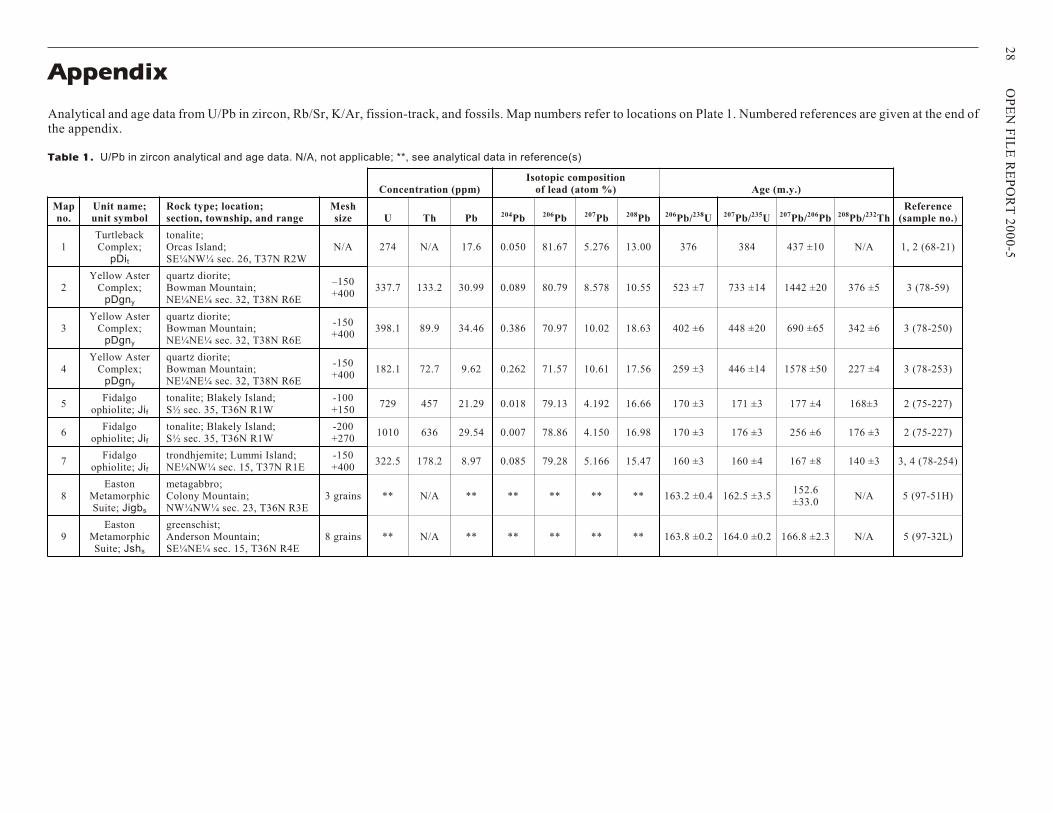
Concentration (ppm)Isotopic composition
of lead (atom %) Age (m.y.)
Mapno.
Unit name;unit symbol
Rock type; location; section, township, and range
Meshsize U Th Pb 204Pb 206Pb 207Pb 208Pb 206Pb/238U 207Pb/235U 207Pb/206Pb 208Pb/232Th
Reference(sample no.)
1TurtlebackComplex;
pDit
tonalite; Orcas Island; SE¼NW¼ sec. 26, T37N R2W
N/A 274 N/A 17.6 0.050 81.67 5.276 13.00 376 384 437 ±10 N/A 1, 2 (68-21)
2Yellow Aster
Complex;pDgny
quartz diorite; Bowman Mountain; NE¼NE¼ sec. 32, T38N R6E
–150+400
337.7 133.2 30.99 0.089 80.79 8.578 10.55 523 ±7 733 ±14 1442 ±20 376 ±5 3 (78-59)
3Yellow Aster
Complex;pDgny
quartz diorite; Bowman Mountain; NE¼NE¼ sec. 32, T38N R6E
-150+400
398.1 89.9 34.46 0.386 70.97 10.02 18.63 402 ±6 448 ±20 690 ±65 342 ±6 3 (78-250)
4Yellow Aster
Complex;pDgny
quartz diorite; Bowman Mountain; NE¼NE¼ sec. 32, T38N R6E
-150+400
182.1 72.7 9.62 0.262 71.57 10.61 17.56 259 ±3 446 ±14 1578 ±50 227 ±4 3 (78-253)
5Fidalgo
ophiolite; Jif
tonalite; Blakely Island; S½ sec. 35, T36N R1W
-100+150
729 457 21.29 0.018 79.13 4.192 16.66 170 ±3 171 ±3 177 ±4 168±3 2 (75-227)
6Fidalgo
ophiolite; Jif
tonalite; Blakely Island; S½ sec. 35, T36N R1W
-200+270
1010 636 29.54 0.007 78.86 4.150 16.98 170 ±3 176 ±3 256 ±6 176 ±3 2 (75-227)
7Fidalgo
ophiolite; Jif
trondhjemite; Lummi Island;NE¼NW¼ sec. 15, T37N R1E
-150+400
322.5 178.2 8.97 0.085 79.28 5.166 15.47 160 ±3 160 ±4 167 ±8 140 ±3 3, 4 (78-254)
8Easton
MetamorphicSuite; Jigbs
metagabbro; Colony Mountain;NW¼NW¼ sec. 23, T36N R3E
3 grains ** N/A ** ** ** ** ** 163.2 ±0.4 162.5 ±3.5152.6±33.0
N/A 5 (97-51H)
9Easton
MetamorphicSuite; Jshs
greenschist; Anderson Mountain;SE¼NE¼ sec. 15, T36N R4E
8 grains ** N/A ** ** ** ** ** 163.8 ±0.2 164.0 ±0.2 166.8 ±2.3 N/A 5 (97-32L)
Appendix
An a lyt i cal and age data from U/Pb in zir con, Rb/Sr, K/Ar, fis sion-track, and fos sils. Map num bers re fer to lo ca tions on Plate 1. Num bered ref er ences are given at the end ofthe ap pen dix.
Ta ble 1. U/Pb in zir con an a lyt i cal and age data. N/A, not ap pli ca ble; **, see an a lyt i cal data in ref er ence(s)
28
OP
EN
FIL
E R
E P
OR
T 2
00
0-5
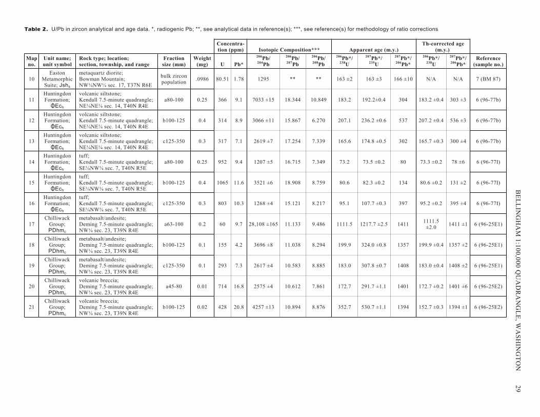
Concentra-tion (ppm) Isotopic Composition*** Apparent age (m.y.)
Th-corrected age(m.y.)
Map no.
Unit name;unit symbol
Rock type; location; section, township, and range
Fractionsize (mm)
Weight(mg) U Pb*
206Pb/204Pb
206Pb/207Pb
206Pb/208Pb
206Pb*/238U
207Pb*/235U
207Pb*/206Pb*
206Pb*/238U
207Pb*/206Pb*
Reference(sample no.)
10Easton
MetamorphicSuite; Jshs
metaquartz diorite; Bowman Mountain; NW¼NW¼ sec. 17, T37N R6E
bulk zirconpopulation
.0986 80.51 1.78 1295 ** ** 163 ±2 163 ±3 166 ±10 N/A N/A 7 (BM 87)
11HuntingdonFormation;
OEch
volcanic siltstone; Kendall 7.5-minute quadrangle;NE¼NE¼ sec. 14, T40N R4E
a80-100 0.25 366 9.1 7033 ±15 18.344 10.849 183.2 192.2±0.4 304 183.2 ±0.4 303 ±3 6 (96-77b)
12HuntingdonFormation;
OEch
volcanic siltstone; Kendall 7.5-minute quadrangle;NE¼NE¼ sec. 14, T40N R4E
b100-125 0.4 314 8.9 3066 ±11 15.867 6.270 207.1 236.2 ±0.6 537 207.2 ±0.4 536 ±3 6 (96-77b)
13HuntingdonFormation;
OEch
volcanic siltstone; Kendall 7.5-minute quadrangle;NE¼NE¼ sec. 14, T40N R4E
c125-350 0.3 317 7.1 2619 ±7 17.254 7.339 165.6 174.8 ±0.5 302 165.7 ±0.3 300 ±4 6 (96-77b)
14HuntingdonFormation;
OEch
tuff; Kendall 7.5-minute quadrangle; SE¼NW¼ sec. 7, T40N R5E
a80-100 0.25 952 9.4 1207 ±5 16.715 7.349 73.2 73.5 ±0.2 80 73.3 ±0.2 78 ±6 6 (96-77I)
15HuntingdonFormation;
OEch
tuff; Kendall 7.5-minute quadrangle; SE¼NW¼ sec. 7, T40N R5E
b100-125 0.4 1065 11.6 3521 ±6 18.908 8.759 80.6 82.3 ±0.2 134 80.6 ±0.2 131 ±2 6 (96-77I)
16HuntingdonFormation;
OEch
tuff; Kendall 7.5-minute quadrangle; SE¼NW¼ sec. 7, T40N R5E
c125-350 0.3 803 10.3 1268 ±4 15.121 8.217 95.1 107.7 ±0.3 397 95.2 ±0.2 395 ±4 6 (96-77I)
17Chilliwack
Group;PDhmc
metabasalt/andesite; Deming 7.5-minute quadrangle; NW¼ sec. 23, T39N R4E
a63-100 0.2 60 9.7 28,108 ±165 11.133 9.486 1111.5 1217.7 ±2.5 14111111.5
±2.01411 ±1 6 (96-25E1)
18Chilliwack
Group;PDhmc
metabasalt/andesite; Deming 7.5-minute quadrangle; NW¼ sec. 23, T39N R4E
b100-125 0.1 155 4.2 3696 ±8 11.038 8.294 199.9 324.0 ±0.8 1357 199.9 ±0.4 1357 ±2 6 (96-25E1)
19Chilliwack
Group;PDhmc
metabasalt/andesite; Deming 7.5-minute quadrangle; NW¼ sec. 23, T39N R4E
c125-350 0.1 293 7.3 2617 ±4 10.583 8.885 183.0 307.8 ±0.7 1408 183.0 ±0.4 1408 ±2 6 (96-25E1)
20Chilliwack
Group;PDhmc
volcanic breccia; Deming 7.5-minute quadrangle; NW¼ sec. 23, T39N R4E
a45-80 0.01 714 16.8 2575 ±4 10.612 7.861 172.7 291.7 ±1.1 1401 172.7 ±0.2 1401 ±6 6 (96-25E2)
21Chilliwack
Group;PDhmc
volcanic breccia; Deming 7.5-minute quadrangle; NW¼ sec. 23, T39N R4E
b100-125 0.02 428 20.8 4257 ±13 10.894 8.876 352.7 530.7 ±1.1 1394 152.7 ±0.3 1394 ±1 6 (96-25E2)
Ta ble 2. U/Pb in zir con an a lyt i cal and age data. *, ra dio genic Pb; **, see an a lyt i cal data in ref er ence(s); ***, see ref er ence(s) for meth od ol ogy of ra tio corrections
BE
L L
ING
HA
M 1
:10
0,0
00
QU
AD
RA
N G
LE
, WA
SH
ING
TO
N
2
9
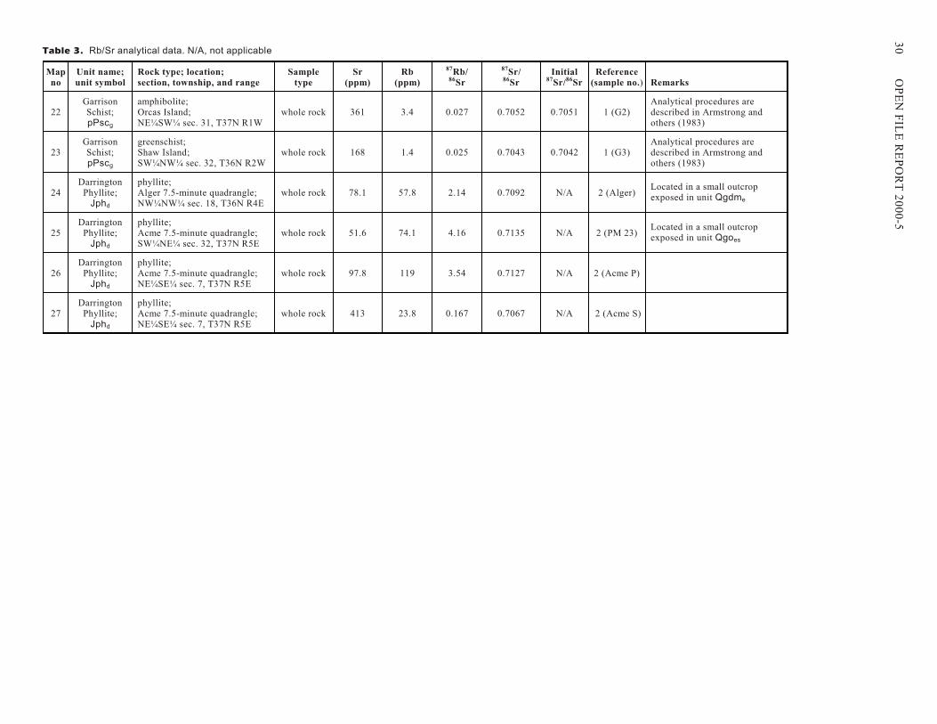
Mapno
Unit name;unit symbol
Rock type; location; section, township, and range
Sampletype
Sr(ppm)
Rb(ppm)
87Rb/86Sr
87Sr/86Sr
Initial87Sr/86Sr
Reference(sample no.) Remarks
22GarrisonSchist;pPscg
amphibolite; Orcas Island;NE¼SW¼ sec. 31, T37N R1W
whole rock 361 3.4 0.027 0.7052 0.7051 1 (G2)Analytical procedures aredescribed in Armstrong andothers (1983)
23GarrisonSchist;pPscg
greenschist; Shaw Island;SW¼NW¼ sec. 32, T36N R2W
whole rock 168 1.4 0.025 0.7043 0.7042 1 (G3)Analytical procedures aredescribed in Armstrong andothers (1983)
24Darrington
Phyllite;Jphd
phyllite; Alger 7.5-minute quadrangle;NW¼NW¼ sec. 18, T36N R4E
whole rock 78.1 57.8 2.14 0.7092 N/A 2 (Alger)Located in a small outcropexposed in unit Qgdme
25Darrington
Phyllite;Jphd
phyllite; Acme 7.5-minute quadrangle;SW¼NE¼ sec. 32, T37N R5E
whole rock 51.6 74.1 4.16 0.7135 N/A 2 (PM 23)Located in a small outcropexposed in unit Qgoes
26Darrington
Phyllite;Jphd
phyllite; Acme 7.5-minute quadrangle;NE¼SE¼ sec. 7, T37N R5E
whole rock 97.8 119 3.54 0.7127 N/A 2 (Acme P)
27Darrington
Phyllite;Jphd
phyllite; Acme 7.5-minute quadrangle;NE¼SE¼ sec. 7, T37N R5E
whole rock 413 23.8 0.167 0.7067 N/A 2 (Acme S)
Ta ble 3. Rb/Sr an a lyt i cal data. N/A, not ap pli ca ble
30
OP
EN
FIL
E R
E P
OR
T 2
00
0-5
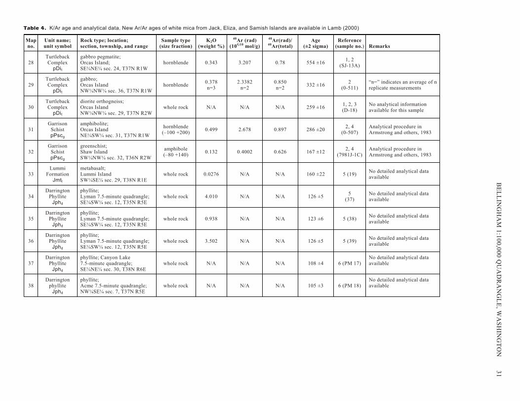
Map no.
Unit name;unit symbol
Rock type; location; section, township, and range
Sample type(size fraction)
K2O(weight %)
40Ar (rad)(10G10 mol/g)
40Ar(rad)/40Ar(total)
Age(±2 sigma)
Reference(sample no.) Remarks
28TurtlebackComplex
pDit
gabbro pegmatite;Orcas Island;SE¼NE¼ sec. 24, T37N R1W
hornblende 0.343 3.207 0.78 554 ±161, 2
(SJ-13A)
29TurtlebackComplex
pDit
gabbro;Orcas IslandNW¼NW¼ sec. 36, T37N R1W
hornblende0.378n=3
2.3382n=2
0.850n=2
332 ±162
(0-511)“n=” indicates an average of nreplicate measurements
30TurtlebackComplex
pDit
diorite orthogneiss; Orcas IslandNW¼NW¼ sec. 29, T37N R2W
whole rock N/A N/A N/A 259 ±161, 2, 3(D-18)
No analytical informationavailable for this sample
31Garrison
SchistpPscg
amphibolite; Orcas IslandNE¼SW¼ sec. 31, T37N R1W
hornblende(–100 +200)
0.499 2.678 0.897 286 ±202, 4
(0-507)Analytical procedure inArmstrong and others, 1983
32Garrison
SchistpPscg
greenschist; Shaw IslandSW¼NW¼ sec. 32, T36N R2W
amphibole(–80 +140)
0.132 0.4002 0.626 167 ±122, 4
(7981J-1C)Analytical procedure inArmstrong and others, 1983
33Lummi
FormationJmtl
metabasalt; Lummi IslandSW¼SE¼ sec. 29, T38N R1E
whole rock 0.0276 N/A N/A 160 ±22 5 (19)No detailed analytical dataavailable
34Darrington
PhylliteJphd
phyllite; Lyman 7.5-minute quadrangle; SE¼SW¼ sec. 12, T35N R5E
whole rock 4.010 N/A N/A 126 ±55
(37)No detailed analytical dataavailable
35Darrington
PhylliteJphd
phyllite; Lyman 7.5-minute quadrangle; SE¼SW¼ sec. 12, T35N R5E
whole rock 0.938 N/A N/A 123 ±6 5 (38)No detailed analytical dataavailable
36Darrington
PhylliteJphd
phyllite; Lyman 7.5-minute quadrangle; SE¼SW¼ sec. 12, T35N R5E
whole rock 3.502 N/A N/A 126 ±5 5 (39)No detailed analytical dataavailable
37Darrington
PhylliteJphd
phyllite; Canyon Lake 7.5-minute quadrangle; SE¼NE¼ sec. 30, T38N R6E
whole rock N/A N/A N/A 108 ±4 6 (PM 17)No detailed analytical dataavailable
38Darrington
phylliteJphd
phyllite; Acme 7.5-minute quadrangle;NW¼SE¼ sec. 7, T37N R5E
whole rock N/A N/A N/A 105 ±3 6 (PM 18)No detailed analytical dataavailable
Ta ble 4. K/Ar age and an a lyt i cal data. New Ar/Ar ages of white mica from Jack, Eliza, and Samish Is lands are avail able in Lamb (2000)
BE
L L
ING
HA
M 1
:10
0,0
00
QU
AD
RA
N G
LE
, WA
SH
ING
TO
N
3
1
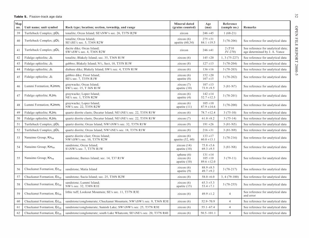
Map no. Unit name; unit symbol Rock type; location; section, township, and range
Mineral dated(grains counted)
Age(ma)
Reference(sample no.) Remarks
39 Turtleback Complex; pDit tonalite; Orcas Island; SE¼NW¼ sec. 26, T37N R2W zircon 246 ±45 1 (68-21)
40 Turtleback Complex; pDittonalite; Orcas Island; SE¼SE¼ sec. 5, T36N R2W
zircon (6)apatite (60,34)
275 ±3184.1 ±19.5
3 (78-206) See reference for analytical data
41 Turtleback Complex; pDitdacite dike; Orcas Island; SW¼SW¼ sec. 4, T36N R2W
zircon 246 ±412 (T10
JV-270)See reference for analytical data; age determined by J. A. Vance
42 Fidalgo ophiolite; Jif tonalite; Blakely Island; sec. 35, T36N R1W zircon (6) 145 ±20 1, 3 (75-227) See reference for analytical data
43 Fidalgo ophiolite; Jif gabbro; Blakely Island; N½, Sect, 10, T35N R1W zircon (8) 127 ±13 3 (78-204) See reference for analytical data
44 Fidalgo ophiolite; Jif diabase dike; Blakely Island; SW¼ sec. 4, T35N R1W zircon (6) 136 ±16 3 (78-203) See reference for analytical data
45 Fidalgo ophiolite; Jifgabbro dike; Frost Island; SE¼ sec. 7, T35N R1W
zircon (6)apatite (8)
152 ±20107 ±15
3 (78-202) See reference for analytical data
46 Lummi Formation; KJmmlgraywacke; Orcas Island; SW½ sec. 15, T 36N R1W
zircon (7)apatite (10)
107 ±1373.9 ±9.5
3 (81-N7) See reference for analytical data
47 Fidalgo ophiolite; KJmfgraywacke; Lopez Island; NE¼ sec. 1, T35N R2W
zircon (6)apatite (4)
142 ±1452.7 ±12.3
3 (78-201) See reference for analytical data
48 Lummi Formation; KJmmlgraywacke; Lopez Island; NW¼ sec. 22, T35N R2W
zircon (6)apatite (11)
105 ±1087.9 ±14.6
3 (78-200) See reference for analytical data
49 Fidalgo ophiolite; KJmf quartz diorite clasts; Decatur Island; NE¼NE¼ sec. 22, T35N R1W zircon (6) 78.7 ±12.4 3 (75-10) See reference for analytical data
50 Fidalgo ophiolite; KJmf quartz diorite clasts; Decatur Island; NE¼NE¼ sec. 22, T35N R1W zircon (7) 61.0 ±8.2 3 (75-14) See reference for analytical data
51 Turtleback Complex; pDit quartz diorite; Orcas Island; NW¼NW¼ sec. 32, T37N R1W zircon (9) 191 ±26 3 (81-N5) See reference for analytical data
52 Turtleback Complex; pDit quartz diorite; Orcas Island; NW¼NE¼ sec. 18, T37N R1W zircon (8) 216 ±31 3 (81-N9) See reference for analytical data
53 Nanaimo Group; Knnequartz diorite clast; Orcas Island; NW¼SW¼ sec. 10, T37N R2W
zircon (6)apatite (52, 60)
133 ±1760.0 ±13.1
3 (78-216) See reference for analytical data
54 Nanaimo Group; Kmnhsandstone; Orcas Island; S½NW¼ sec. 7, T37N R1W
zircon (14)apatite (10)
75.8 ±5.669.3 ±9.5
3 (81-N8) See reference for analytical data
55 Nanaimo Group; Knne sandstone; Barnes Island; sec. 14, T37 R1Wsphene (6)zircon (6)
apatite (10)
131 ±14105 ±10
89.6 ±12.03 (79-11) See reference for analytical data
56 Chuckanut Formation; Eccp sandstone; Matia Islandzircon (6)apatite (9)
88.9 ±8.549.7 ±9.2
3 (78-217) See reference for analytical data
57 Chuckanut Formation; Eccp sandstone; Sucia Island; sec. 25, T38N R2W zircon (8) 58.0 ±6.0 3, 4 (79-100) See reference for analytical data
58 Chuckanut Formation; Eccpsandstone; Lummi Island; NW¼ sec. 32, T38N R1E
zircon (6)apatite (15)
65.3 ±5.353.4 ±7.1
3 (78-255) See reference for analytical data
59 Chuckanut Formation; Eccblithic tuff; Lookout Mountain; SE¼ sec. 11, T37N R3E
zircon (6) 49.9 ±1.2 4See reference for analytical dataand error
60 Chuckanut Formation; Eccb sandstone/conglomerate; Chuckanut Mountain; NW¼SW¼ sec. 9, T36N R3E zircon (6) 52.9–70.9 4 See reference for analytical data
61 Chuckanut Formation; Eccb sandstone/conglomerate; Samish Lake; SW¼NW¼ sec. 25, T37N R3E zircon (6) 55.1–67.4 4 See reference for analytical data
62 Chuckanut Formation; Eccb sandstone/conglomerate; south Lake Whatcom; SE¼NE¼ sec. 20, T37N R4E zircon (6) 50.5–101.1 4 See reference for analytical data
Ta ble 5. Fission-track age data
32
OP
EN
FIL
E R
E P
OR
T 2
00
0-5
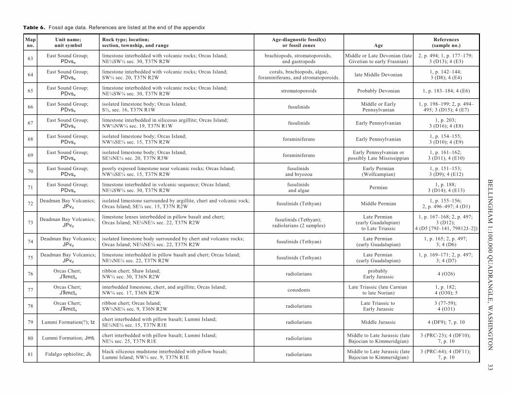
Map no.
Unit name;unit symbol
Rock type; location; section, township, and range
Age-diagnostic fossil(s)or fossil zones Age
References(sample no.)
63East Sound Group;
PDvse
limestone interbedded with volcanic rocks; Orcas Island; NE¼SW¼ sec. 30, T37N R2W
brachiopods, stromatoporoids, and gastropods
Middle or Late Devonian (late Givetian to early Frasnian)
2, p. 494; 1, p. 177–179; 3 (D13); 4 (E3)
64East Sound Group;
PDvse
limestone interbedded with volcanic rocks; Orcas Island; SW¼ sec. 20, T37N R2W
corals, brachiopods, algae,foraminiferans, and stromatoporoids.
late Middle Devonian1, p. 142–144; 3 (D8); 4 (E4)
65East Sound Group;
PDvse
limestone interbedded with volcanic rocks; Orcas Island; NE¼SW¼ sec. 30, T37N R2W
stromatoporoids Probably Devonian 1, p. 183–184; 4 (E6)
66East Sound Group;
PDvse
isolated limestone body; Orcas Island; S½, sec. 16, T37N R1W
fusulinidsMiddle or EarlyPennsylvanian
1, p. 198–199; 2, p. 494–495; 3 (D15); 4 (E7)
67East Sound Group;
PDvse
limestone interbedded in siliceous argillite; Orcas Island;NW¼NW¼ sec. 19, T37N R1W
fusulinids Early Pennsylvanian1, p. 203;
3 (D16); 4 (E8)
68East Sound Group;
PDvse
isolated limestone body; Orcas Island; NW¼SE¼ sec. 15, T37N R2W
foraminiferans Early Pennsylvanian1, p. 154–155; 3 (D10); 4 (E9)
69East Sound Group;
PDvse
isolated limestone body; Orcas Island; SE¼NE¼ sec. 20, T37N R3W
foraminiferansEarly Pennsylvanian or
possibly Late Mississippian1, p. 161–162;
3 (D11), 4 (E10)
70East Sound Group;
PDvse
poorly exposed limestone near volcanic rocks; Orcas Island;NW¼SE¼ sec. 15, T37N R2W
fusulinids and bryozoa
Early Permian(Wolfcampian)
1, p. 151–153; 3 (D9); 4 (E12)
71East Sound Group;
PDvse
limestone interbedded in volcanic sequence; Orcas Island;NE¼SW¼ sec. 30, T37N R2W
fusulinids and algae
Permian1, p. 188;
3 (D14); 4 (E13)
72Deadman Bay Volcanics;
JPvd
isolated limestone surrounded by argillite, chert and volcanic rock;Orcas Island; SE¼ sec. 15, T37N R2W
fusulinids (Tethyan) Middle Permian1, p. 155–156;
2, p. 496–497; 4 (D1)
73Deadman Bay Volcanics;
JPvd
limestone lenses interbedded in pillow basalt and chert; Orcas Island; NE¼NE¼ sec. 22, T37N R2W
fusulinids (Tethyan); radiolarians (2 samples)
Late Permian (early Guadalupian)
to Late Triassic
1, p. 167–168; 2, p. 497; 3 (D12);
4 (D5 [79J–141, 79812J–2])
74Deadman Bay Volcanics;
JPvd
isolated limestone body surrounded by chert and volcanic rocks;Orcas Island; NE¼NE¼ sec. 22, T37N R2W
fusulinids (Tethyan)Late Permian
(early Guadalupian)1, p. 165; 2, p. 497;
3; 4 (D6)
75Deadman Bay Volcanics;
JPvd
limestone interbedded in pillow basalt and chert; Orcas Island;NE¼NE¼ sec. 22, T37N R2W
fusulinids (Tethyan)Late Permian
(early Guadalupian)1, p. 169–171; 2, p. 497;
3; 4 (D7)
76Orcas Chert;
JTRmcto
ribbon chert; Shaw Island; NW¼ sec. 30, T36N R2W
radiolariansprobably
Early Jurassic4 (O26)
77Orcas Chert;
JTRmcto
interbedded limestone, chert, and argillite; Orcas Island; NW¼ sec. 17, T36N R2W
conodontsLate Triassic (late Carnian
to late Norian)1, p. 182; 4 (O30); 5
78Orcas Chert;
JTRmcto
ribbon chert; Orcas Island; SW¼NE¼ sec. 9, T36N R2W
radiolariansLate Triassic to Early Jurassic
3 (77-59); 4 (O31)
79 Lummi Formation(?); tzchert interbedded with pillow basalt; Lummi Island; SE¼NE¼ sec. 15, T37N R1E
radiolarians Middle Jurassic 4 (DF9); 7, p. 10
80 Lummi Formation; Jmtlchert interbedded with pillow basalt; Lummi Island;NE¼ sec. 25, T37N R1E
radiolariansMiddle to Late Jurassic (lateBajocian to Kimmeridgian)
3 (PRC-23); 4 (DF10); 7, p. 10
81 Fidalgo ophiolite; Jifblack siliceous mudstone interbedded with pillow basalt; Lummi Island; NW¼ sec. 9, T37N R1E
radiolariansMiddle to Late Jurassic (lateBajocian to Kimmeridgian)
3 (PRC-64); 4 (DF11); 7, p. 10
Ta ble 6. Fos sil age data. Ref er ences are listed at the end of the ap pen dix
BE
L L
ING
HA
M 1
:10
0,0
00
QU
AD
RA
N G
LE
, WA
SH
ING
TO
N
3
3
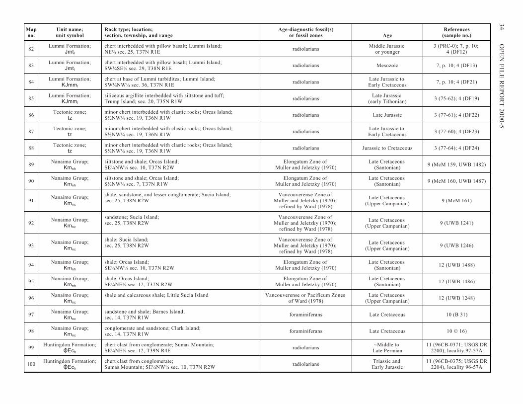
Map no.
Unit name;unit symbol
Rock type; location; section, township, and range
Age-diagnostic fossil(s)or fossil zones Age
References(sample no.)
82Lummi Formation;
Jmtl
chert interbedded with pillow basalt; Lummi Island; NE¼ sec. 25, T37N R1E
radiolariansMiddle Jurassic
or younger3 (PRC-0); 7, p. 10;
4 (DF12)
83Lummi Formation;
Jmtl
chert interbedded with pillow basalt; Lummi Island; SW¼SE¼ sec. 29, T38N R1E
radiolarians Mesozoic 7, p. 10; 4 (DF13)
84Lummi Formation;
KJmml
chert at base of Lummi turbidites; Lummi Island; SW¼NW¼ sec. 36, T37N R1E
radiolariansLate Jurassic to Early Cretaceous
7, p. 10; 4 (DF21)
85Lummi Formation;
KJmml
siliceous argillite interbedded with siltstone and tuff; Trump Island; sec. 20, T35N R1W
radiolariansLate Jurassic
(early Tithonian)3 (75-62); 4 (DF19)
86Tectonic zone;
tzminor chert interbedded with clastic rocks; Orcas Island; S½NW¼ sec. 19, T36N R1W
radiolarians Late Jurassic 3 (77-61); 4 (DF22)
87Tectonic zone;
tzminor chert interbedded with clastic rocks; Orcas Island; S½NW¼ sec. 19, T36N R1W
radiolariansLate Jurassic to Early Cretaceous
3 (77-60); 4 (DF23)
88Tectonic zone;
tzminor chert interbedded with clastic rocks; Orcas Island; S½NW¼ sec. 19, T36N R1W
radiolarians Jurassic to Cretaceous 3 (77-64); 4 (DF24)
89Nanaimo Group;
Kmnh
siltstone and shale; Orcas Island; SE¼NW¼ sec. 10, T37N R2W
Elongatum Zone of Muller and Jeletzky (1970)
Late Cretaceous (Santonian)
9 (McM 159, UWB 1482)
90Nanaimo Group;
Kmnh
siltstone and shale; Orcas Island;S½NW¼ sec. 7, T37N R1W
Elongatum Zone of Muller and Jeletzky (1970)
Late Cretaceous (Santonian)
9 (McM 160, UWB 1487)
91Nanaimo Group;
Kmnc
shale, sandstone, and lesser conglomerate; Sucia Island; sec. 25, T38N R2W
Vancouverense Zone of Muller and Jeletzky (1970);
refined by Ward (1978)
Late Cretaceous (Upper Campanian)
9 (McM 161)
92Nanaimo Group;
Kmnc
sandstone; Sucia Island; sec. 25, T38N R2W
Vancouverense Zone of Muller and Jeletzky (1970);
refined by Ward (1978)
Late Cretaceous (Upper Campanian)
9 (UWB 1241)
93Nanaimo Group;
Kmnc
shale; Sucia Island; sec. 25, T38N R2W
Vancouverense Zone of Muller and Jeletzky (1970);
refined by Ward (1978)
Late Cretaceous (Upper Campanian)
9 (UWB 1246)
94Nanaimo Group;
Kmnh
shale; Orcas Island; SE¼NW¼ sec. 10, T37N R2W
Elongatum Zone of Muller and Jeletzky (1970)
Late Cretaceous (Santonian)
12 (UWB 1488)
95Nanaimo Group;
Kmnh
shale; Orcas Island; SE¼NE¼ sec. 12, T37N R2W
Elongatum Zone of Muller and Jeletzky (1970)
Late Cretaceous (Santonian)
12 (UWB 1486)
96Nanaimo Group;
Kmnc
shale and calcareous shale; Little Sucia Island Vancouverense or Pacificum Zones of Ward (1978)
Late Cretaceous (Upper Campanian)
12 (UWB 1248)
97Nanaimo Group;
Kmnc
sandstone and shale; Barnes Island; sec. 14, T37N R1W
foraminiferans Late Cretaceous 10 (B 31)
98Nanaimo Group;
Kmnc
conglomerate and sandstone; Clark Island; sec. 14, T37N R1W
foraminiferans Late Cretaceous 10 © 16)
99Huntingdon Formation;
OEch
chert clast from conglomerate; Sumas Mountain; SE¼NE¼ sec. 12, T39N R4E
radiolarians~Middle to
Late Permian11 (96CB-0371; USGS DR
2200), locality 97-57A
100Huntingdon Formation;
OEch
chert clast from conglomerate;Sumas Mountain; SE¼NW¼ sec. 10, T37N R2W
radiolariansTriassic and Early Jurassic
11 (96CB-0375; USGS DR2204), locality 96-57A
34
OP
EN
FIL
E R
E P
OR
T 2
00
0-5
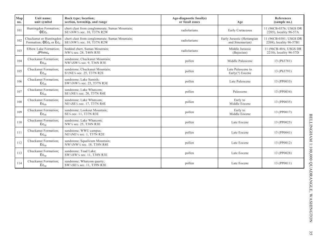
Map no.
Unit name;unit symbol
Rock type; location; section, township, and range
Age-diagnostic fossil(s)or fossil zones Age
References(sample no.)
101Huntingdon Formation;
OEch
chert clast from conglomerate; Sumas Mountain; SE¼NW¼ sec. 10, T37N R2W
radiolarians Early Cretaceous11 (96CB-0376; USGS DR
2205), locality 96-57A
102Chuckanut or HuntingdonFormation; OEch or Ecc
chert clast from conglomerate; Sumas Mountain; SE¼NW¼ sec. 10, T37N R2W
radiolariansEarly Jurassic (Hettangian
and Sinemurian)11 (96CB-0381; USGS DR
2208), locality 96-57B1
103Elbow Lake Formation;
JPhmce
bedded chert, Sumas Mountain; NW¼ sec. 28, T40N R5E
radiolariansMiddle Jurassic
(Bajocian)11 (96CB-40A; USGS DR
2210), locality 96-57D
104Chuckanut Formation;
Eccb
sandstone; Chuckanut Mountain; NW¼SW¼ sec. 9, T36N R3E
pollen Middle Paleocene 13 (Pb3781)
105Chuckanut Formation;
Eccp
sandstone; Chuckanut Mountain; S½NE¼ sec. 25, T37N R2E
pollenLate Paleocene to Early(?) Eocene
13 (Pb3791)
106Chuckanut Formation;
Eccb
sandstone; Lake Samish; SW¼NW¼ sec. 25, T37N R3E
pollen Late Paleocene 13 (PP0033)
107Chuckanut Formation;
Eccb
sandstone; Lake Whatcom; SE¼NE¼ sec. 20, T37N R4E
pollen Paleocene 13 (PP0034)
108Chuckanut Formation;
Eccb
sandstone; Lake Whatcom; NE¼SE¼ sec. 17, T37N R4E
pollenEarly to
Middle Eocene13 (PP0035)
109Chuckanut Formation;
Eccb
sandstone; Lookout Mountain; SE¼ sec. 11, T37N R3E
pollenEarly to
Middle Eocene13 (PP0017)
110Chuckanut Formation;
Eccp
sandstone; Lake Whatcom; NW¼ sec. 25, T38N R3E
pollen Late Eocene 13 (PP0025)
111Chuckanut Formation;
Eccp
sandstone; WWU campus; NE¼NE¼ sec. 1, T37N R2E
pollen Late Eocene 13 (PP0041)
112Chuckanut Formation;
Eccp
sandstone; Squalicum Mountain; NW¼NW¼ sec. 18, T38N R4E
pollen Late Eocene 13 (PP0012)
113Chuckanut Formation;
Eccp
sandstone; Toad Lake; SW¼SW¼ sec. 11, T38N R3E
pollen Late Eocene 13 (PP0028)
114Chuckanut Formation;
Eccp
sandstone; Whatcom quarry; SW¼SE¼ sec. 11, T39N R3E
pollen Late Eocene 13 (PP0011)
BE
L L
ING
HA
M 1
:10
0,0
00
QU
AD
RA
N G
LE
, WA
SH
ING
TO
N
3
5
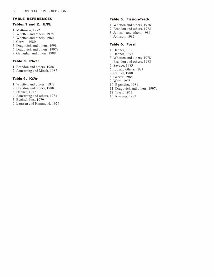
36 OPEN FILE RE PORT 2000-5
TABLE REFERENCES
Tables 1 and 2. U/Pb
1. Mattinson, 19722. Whetten and oth ers, 19783. Whetten and oth ers, 19804. Carroll, 19805. Drag o vich and oth ers, 19986. Drag o vich and oth ers, 1997a7. Gallagher and oth ers, 1988
Table 3. Rb/Sr
1. Brandon and oth ers, 19882. Armstrong and Misch, 1987
Table 4. K/Ar
1. Whetten and oth ers , 19782. Brandon and oth ers, 19883. Danner, 19774. Armstrong and oth ers, 19835. Bechtel, Inc., 19796. Laursen and Hammond, 1979
Table 5. Fission-Track
1. Whetten and oth ers, 19782. Brandon and oth ers, 19883. John son and oth ers, 19864. John son, 1982
Table 6. Fossil
1. Danner, 19662. Danner, 19773. Whetten and oth ers, 19784. Brandon and oth ers, 19885. Sav age, 19836. Igo and oth ers, 19847. Carroll, 19808. Garver, 19889. Ward, 197810. Egemeier, 198111. Drag o vich and oth ers, 1997a12. Ward, 197313. Reiswig, 1982