Embed Size (px)
Citation preview

ERRATA (Nov. 26, 2002) [A work in progress]
Geology of Central (Interior) Alaska U.S. Geological Survey Open-File Reports 98-133, 98-133a
Text The unit description and map label for unit PzZym, Mafic schist, was inadvertently garbled. On sheet 3 and in
the text, the unit is correctly labeled PzZym, on the map (sheet 1, in the Circle quadrangle) the unit label is PzZms, which is incorrect. The corrected unit description for this unit is as below:
PzZym Mafic schist (Paleozoic and(or) Late? Proterozoic)-- Green, quartz-chlorite-carbonate schist, commonly having abundant plagioclase porphyroblasts. Associated with amphibolitic schist and minor marble, quartzite, and pelitic schist. Thought to represent metamorphosed mafic pyroclastic rocks interbedded with schists of unit PzZyqs. Outside of the map extent shown, these rocks also occur as interbeds in unit PzZyqs in the Circle quadrangle. Includes unit PzpCm of Foster and others (1983) and unit Pzcl of Wiltse and others (1995)
The unit description for unit Kmum indicates this unit appears in the Kantishna River and Tanana quadrangles; this is incorrect as the rocks shown on one source map (Chapman and others, 1982) in these quadrangles were placed in another unit (MzZum) on the published map.
The unit description for unit MzPzi indicates that this unit occurs in the Nulato quadrangle based on a written communication from W.W. Patton, Jr. in 1997. This is in error and Patton's communication eliminated this unit from the Nulato map and the rocks would have been assigned to this unit (unit vr, Cass, 1959) were shown to be either of Cretaceous (unit Kv) or Tertiary age (units Tr and Ta) and were assigned to units Kve and Tvu on the published map.
On page 57 of the text, in the listing of sources for the map, the first source shown as LH2 should actually be LH3.
The correct date for the unpublished compilation of the Nulato quadrangle on page 59 should be 1997 and not 1994.
Map
Big Delta quadrangle
In the Big Delta quadrangle, the printed text shows unit PzpCsq from the source map was assigned to unit PzZyqs, that is not entirely correct, part was also assigned to unit PzZysa on the published map. In the hidden text (apparent only on the CD-ROM Word document where hidden text is revealed) associated with unit Pze, Eclogite-bearing schist, unit Pzs from the Big Delta quadrangle is shown to part of this unit. That is also incorrect, unit Pzs from the Big Delta quadrangle was assigned to unit PzZysa on the published map.
Circle quadrangle
As noted above the map label for unit PzZym, Mafic schist, was inadvertently garbled. On sheet 1, in the Circle quadrangle, the unit label is incorrectly PzZms.
There are a number of other coding and labeling errors in the northwest portion of the Circle quadrangle. In the extreme northwest, the area labeled MzZum, Ultramafic and mafic rocks, undivided and colored purple, should have been labeled Oc, Chert. Immediately north of the pluton at Victoria Mountain, there is a polygon colored as unit CZw, Wickersham Grit, undivided that should have been labeled MzZum and colored purple, to match the adjoining Livengood quadrangle. The polygons labeled KJwc, Wilber Creek flysch and Wolverine Quartzite, undivided should have been labeled and colored as Kwcf, Wilber Creek flysch, only.

The unit description for unit KJwc, Wilber Creek flysch and Wolverine Quartzite, undivided indicates that this unit appears only in the Tanana quadrangle, in fact the unit also is found in the westernmost part of the Circle quadrangle, in the vicinity of Victoria Mountain.
The unit description for JPzsgs in incorrect in indicating that unit Pzg from the Circle quadrangle is included. This unit was inadvertently removed from the Circle area during the compilation process. The unit should appear as two very small polygons on Preacher Creek just south of the southernmost strand of the Tintina Fault system.
Gulkana quadrangle
In the Gulkana quadrangle, a number of Quaternary volcanic rock units were improperly labeled. Units labeled Qw, Qdf, Qva, Qmsv, Qshc, and Qcs are all shown properly colored but should have been uniformly labeled Qv. However, each of these units is individually described in the digital database on the CD-ROM. A similar error was made for Quaternary intrusive rock units on the Gulkana part of the map, where units labeled Qi, Qvd, Qds, and Qtva should have all been labeled QTi to match the text. Each of these units is individually described in the digital database on the CD-ROM also. For digital use, these labeling errors can be corrected in the Arc "lookup table" included on the CD-ROM as an Arc export file named "nsakey.lut.e00".
Healy quadrangle
In the Healy quadrangle, the unit labeled "TRk" in the southwest corner of the quadrangle should have been labeled "TRlb." Also, for CD-ROM users, this unit is mis-coded in the coverage for the Healy quadrangle. As released it had an NSACLASS of 4020 and a CLASS of 4021, both should have been set equal to 4021.
Kateel River quadrangle
In the eastern Kateel River quadrangle, the two large and southernmost polygons labeled and colored as Tvb should instead be shown as unit Kve (NSACLASS should be 2330 rather than 1081).
Lime Hills quadrangle
The north central portion of the Lime Hills quadrangle (approximately D-3 and D-4 1:63,360-scale quadrangles) has a number of digitizing errors where the two source maps for the quadrangle (Gamble and Reed, unpublished mapping, 1988, Bundtzen, unpublished mapping, 1998) were joined. These errors affect the distribution of a number of geologic units in a manner difficult to describe; a means to provide the corrections is being developed.
In the west central part of the map, the polygon labeled "PMl" should have been labeled Jdm and no overprint pattern should have been shown. The polygon to the north of this, north of the Swift River that is partially shown in the color of unit "JDm", should have been labeled "PMl" and shown with an overprint pattern.
A number (6) of very small polygons in the digital coverage were also not attributed.
Mount Hayes quadrangle A number of corrections were made to the Mount Hayes digital files, some of which show up on the printed
map. In various parts of the map, glacial boundaries accidentally coded as ARC-CODE = 2 were recoded to ARC-CODE = 15. Also, directions of a number of arcs (lines) representing thrust faults were flipped so that the teeth will point in the correct direction when plotted. Additionally, arc-codes throughout the map were changed from ARC-CODE = 2 to ARC-CODE = 1 and normal and thrust fault coding was changed from codes indicating approximate to certain locations to reflect the source map. Unnecessary dangling arcs and pseudo nodes were removed. Concealed contacts, including faults, not previously digitized were added and minor changes to polygon attributes were made where inclusion of concealed contacts indicated mistaken coding.
Changes have been significant enough, that a revised coverage for the quadrangle should be obtained from the authors.
2
McGrath quadrangle
On the northern edge of the quadrangle (about 1/4 of the way from the west edge of the quadrangle), all polygons labeled and colored as unit Dml should have been colored and labeled as unit DSwc, the Whirlwind Creek Formation and correlative units.
In the west central part of the quadrangle, most of the units labeled and colored as unit Ont should instead have been labeled and colored as unit SCpl, the Post River Sandstone and Lyman Hills Formation and correlative units.
Ophir quadrangle
In the northeast part of the Ophir quadrangle, a number of polygons were mis-coded, using units that either should not have been shown in this quadrangle or were simply in error. All polygons colored and shown as unit Mzsa, should have been colored and shown as unit TrMica. In the same general vicinity, polygons colored and shown as unit Kme, should have been colored and shown as unit TrMis. In addition, the boundary between these mis-coded TrMis polygons and the adjacent unit, TrMica, should have been a thrust fault, with the TrMica rocks comprising the lower plate. Also in the northeast part of the quadrangle, approximately located faults should have been shown as concealed where they cross the Quaternary unit (Qs).
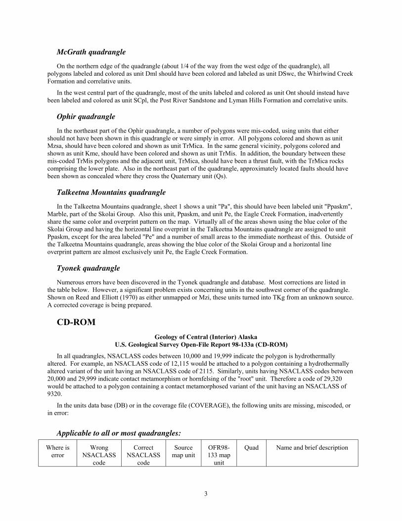
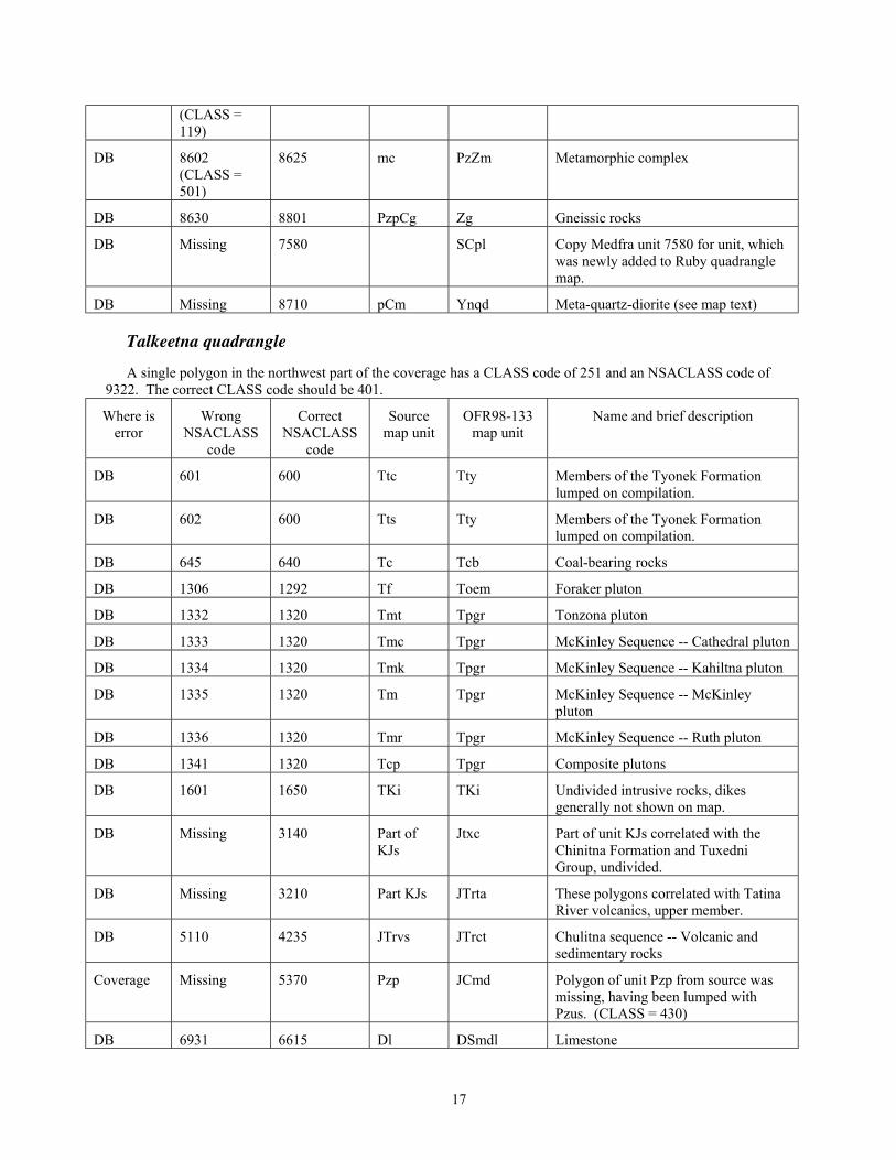
Talkeetna Mountains quadrangle
In the Talkeetna Mountains quadrangle, sheet 1 shows a unit "Pa", this should have been labeled unit "Ppaskm", Marble, part of the Skolai Group. Also this unit, Ppaskm, and unit Pe, the Eagle Creek Formation, inadvertently share the same color and overprint pattern on the map. Virtually all of the areas shown using the blue color of the Skolai Group and having the horizontal line overprint in the Talkeetna Mountains quadrangle are assigned to unit Ppaskm, except for the area labeled "Pe" and a number of small areas to the immediate northeast of this. Outside of the Talkeetna Mountains quadrangle, areas showing the blue color of the Skolai Group and a horizontal line overprint pattern are almost exclusively unit Pe, the Eagle Creek Formation.
Tyonek quadrangle
Numerous errors have been discovered in the Tyonek quadrangle and database. Most corrections are listed in the table below. However, a significant problem exists concerning units in the southwest corner of the quadrangle. Shown on Reed and Elliott (1970) as either unmapped or Mzi, these units turned into TKg from an unknown source. A corrected coverage is being prepared.
CD-ROM Geology of Central (Interior) Alaska
U.S. Geological Survey Open-File Report 98-133a (CD-ROM)
In all quadrangles, NSACLASS codes between 10,000 and 19,999 indicate the polygon is hydrothermally altered. For example, an NSACLASS code of 12,115 would be attached to a polygon containing a hydrothermally altered variant of the unit having an NSACLASS code of 2115. Similarly, units having NSACLASS codes between 20,000 and 29,999 indicate contact metamorphism or hornfelsing of the "root" unit. Therefore a code of 29,320 would be attached to a polygon containing a contact metamorphosed variant of the unit having an NSACLASS of 9320.
In the units data base (DB) or in the coverage file (COVERAGE), the following units are missing, miscoded, or in error:
Applicable to all or most quadrangles:
Where is error
Wrong NSACLASS
code
Correct NSACLASS
code
Source map unit
OFR98-133 map
unit
Quad Name and brief description
3

DB 102 Water Water All Never in data-base
DB 101 Glaciers Glaciers Most Almost never in data-base
DB 105-299 100 Various Qs Most Quaternary units were lumped for publication.
Anchorage quadrangle:
Where is error
Wrong NSACLASS
code
Correct NSACLASS
code
Source map unit
OFR98-133 map unit
Name and brief description
DB 3633 5550 Jma PPast Amphibolite and quartz diorite
Coverage 100 1012 TJds Thm Single mislabeled polygon. Polygon -ID is 1408
DB and Coverage
3491 3490 Jgs Jmu Recoded to lump with similar unit
Big Delta quadrangle:
Where is error
Wrong NSACLASS
code
Correct NSACLASS
code
Source map unit
OFR98-133 map unit
Name and brief description
DB 5510 8630 Pzs PzZysa Schist
Coverage 9320 9327 PzpCsq PzZyqs Schist and quartzite, however, unit is displayed correctly on printed map.
DB 9327 (CLASS 451)
8630 PzpCsq PzZysa Part of unit from source map assigned to this unit and part to above unit.
Circle quadrangle:
Where is error
Wrong NSACLASS
code
Correct NSACLASS
code
Source map unit
OFR98-133 map unit
Name and brief description
Coverage 1620 1602 TKf TKgp Felsic igneous rocks
Coverage 2812 2115 Kwcf Kwcf Wilber Creek flysch
DB Missing 2115 (CLASS = 5500)
Kwcf Kwcf Wilber Creek flysch
Coverage 5130 (CLASS = 105)
100 Qsu Qs Undifferentiated silt, single polygon miscoded.
DB 5600 5020 PaMc TRMts Tozitna sequence sedimentary rocks.
DB 5470 8250 Pzug MzZum Ultramafic and mafic rocks and greenstone.
DB 5690 5980 Pzp Jpsu Serpentinized periodotite
Coverage 8450 (CLASS =
7710 CLASS should be 900
Old? Oc Livengood Dome Chert(?) (Unit is correct in DB)
4

5000)
DB Missing (see NSACLASS = 8300)
8310 PzpCa Czwa Argillite, grit, and quartzite in western part of quadrangle.
Coverage 8310 CLASS = 6500)
8450 (CLASS = 6500)
PzZm MzZum Gabbro and diorite (Unit missing from DB)
DB 8330 8000 ls CZwl Limestone, reassigned to Wickersham
DB 8330 8430 ls ls Limestone, unassigned
DB 8331 5020 ch TRMts Chert
DB 8331 6940 ch Chert
DB Missing 9320 PzpCq PzZyqs Quartzite and quartzitic schists
Coverage Lumped in 9320
9324 PzpCq PzZyqs Calc-silicate and marble subunit of quartzite and quartzitic schist
DB 6966 6945 DSl Ds Limestone, dolomite, and shale
Coverage, polygon# 441
5980 9380 PzpCq PzZyqs Class should be 1600, source should be CI002
Coverage, polygon# 418
100 8630 PzpCs PzZysa Class should be 1300, source should be CI002
Coverage polygon# 56
5130 122 Qsu Qsu Class should be 105, source CI002
Coverage, polygon# 237
5130 121 Ql Qfl Class should be 107, source should be CI002
Fairbanks quadrangle:
Where is error
Wrong NSACLASS
code
Correct NSACLASS
code
Source map unit
OFR98-133 map unit
Name and brief description
DB CLASS = 600
5660 bc Pzk Unit subdivided, see entry for FB-9327 and BD-5660
DB CLASS = 600
5662 bc Pzkcp Unit subdivided, see entry for FB-9327 and BD-5662
DB CLASS = 600
8630 bc PzZysa Unit subdivided, see entry for FB-9327 and CI-8630
DB CLASS = 600
6511 bc MDt? Unit subdivided, see entry for FB-9327 and CI-6511
DB CLASS = 600
5666 bc Pzsc Unit subdivided, see entry for FB-9327 and MM-5666
DB CLASS = 600
9322 bc PzZaqs Unit subdivided, see entry for FB-9327 and HE-9322
5

Gulkana quadrangle
Where is error
Wrong NSACLASS
code
Correct NSACLASS
code
Source map unit
OFR98-133 map unit
Name and brief description
DB 3633 5245 sqm Jpaur Schistose quartz monzonite; Metamorphic Complex of Gulkana
River
DB 3633 5245 sqd Jpaur Schistose quartz diorite; Metamorphic Complex of Gulkana River
DB 3633 5245 sgd Jpaur Schistose granodiorite; Metamorphic Complex of Gulkana River
DB 3633 5245 shd Jpaur Schistose hornblende diorite; Metamorphic Complex of Gulkana
River
DB 3633 5245 ag Jpaur Amphibolite gneiss; Metamorphic Complex of Gulkana River
DB and coverage
315 118 Qms Qs Mineral spring and mud volcano deposits
DB and coverage
112 124 Ql -- Newly defined Glaciolacustrine deposits unit
DB and Coverage
5209 5920 mmp PPast Revised assignment
DB and coverage
5870 5871 PPf, PPp, PPg
Pmgi Revised assignment
Healy quadrangle
Where is error
Wrong NSACLASS
code
Correct NSACLASS
code
Source map unit
OFR98-133 map unit
Name and brief description
DB 1008 1012 Tvim Thm Mafic subvolcanic intrusive rocks
DB 1007 1011 Tvif Thf Felsic subvolcanic intrusive rocks
DB 1321 1300 Tgr Tegr Granitic rocks of Oligocene to Paleocene age
DB 4020 4021
Map -- 7290, 7291 DSu, DSu?
Pzsc Label should be Dms
DB 7243 7240 Dmf Dyv Felsic metavolcanic rocks
DB 7240 7242 Dy Dy Yanert Fork sequence (has a CLASS code of 7242)
DB 2410 2410, 2460, 2470
Kg Kg Granitic rocks; ages less than 85 Ma = 2460, ages 85-110 Ma = 2470, all others = 2410
DB 2820 2810 Kja KJs Argillite, chert, sandstone, and limestone of Csejtey and others (1992)
6

Coverage 4423 4420 Trbd Trn Basalt, diabase, and subordinate sedimentary rocks (CLASS = 4423)
Iditarod quadrangle
Where is error
Wrong NSACLASS
code
Correct NSACLASS
code
Source map unit
OFR98-133 map unit
Name and brief description
DB 1307 1300 Tp Tegr Porphyritic granodiorite
DB 1970 1985 Kkq Kkn Kuskokwim Group -- quartzose sandstone and siltstone
DB 2101 2020 Ks Kme Sandstone and siltstone
DB 2260 2270 Kit Kvl Iditarod Volcanics -- Tuff, volcanic breccia, altered andesitic to dacitic flows and volcaniclastic sandstone
DB 2260 2261 Kka Kvl Kuskokwim Group -- altered andesite flows, tuffs, and sills?
DB 2260 2261 Kkv Kvl Kuskokwim Group -- volcanic flow(s) and tuff
Coverage 11970 (CLASS = 1401)
21985 Kkq -hornfels
Kkn- hornfels Kuskokwim Group -- quartzose sandstone and siltstone - hornfels
Coverage 11605 21605 Tkil - hornfels
Tkvi - hornfels
Iditarod Volcanics -- Andesitic to basaltic subaerial lava flows and mafic volcanic breccia - hornfels
Coverage 11970 (CLASS = 1402)
21970 Kks - hornfels
Kk - hornfels Kuskokwim Group -- sandstone, siltstone, shale, and conglomerate - hornfels
Coverage 12260 22260 Kkt - hornfels
Kvl - hornfels Kuskokwim Group -- volcanic tuff and agglomerate - hornfels
Kantishna River quadrangle
Where is error
Wrong NSACLASS
code
Correct NSACLASS
code
Source map unit
OFR98-133 map unit
Name and brief description
DB 1600 1603 TKf TKvr Felsic extrusive rocks and tuff
DB 2820 2115 KJcs, KJgs
Kwcf Sandstone, quartzite, conglomerate, siltstone, and slaty shale
DB 5665 6956 Pzsl DSls? Schist, phyllite, limestone, and greenstone
DB 6956 8601 Pzl PzZrqs Limestone, dolomite, basaltic greenstone and chloritic schist
DB CLASS = 7510
7710 Oc Och Chert and slaty shale
DB 7210 7710 or 8300 Dps Och or CZw Phyllite,slate, silicious siltstone, and
7

argillite or Wickersham
DB 8410, 8420 8300 Cal CZw Argillite and slate or Quartzite, metasiltstone, slate and grit
Coverage 8400 8300 Cqs? or Ocsl?
CZw Argillite and slate or Quartzite, metasiltstone, slate and grit
DB 6511 6511 MDt? Unit missing, see CI-6511 or MM-6510
DB 7710 6902 Dos Dp Shaly rocks, shown as CLASSes = 303 or 7210 (in part)
Kateel River quadrangle
Where is error
Wrong NSACLASS
code
Correct NSACLASS
code
Source map unit
OFR98-133 map unit
Name and brief description
New data 1943 2021 Kn Kme (Ks) A new correlation by W.W. Patton, Jr. (1999) suggests this unit should receive a NSACLASS value of 2021.
DB 2181 2181 Kgs Kvm Graywacke sandstone and mudstone -- massive volcanic conglomerate (wrong CLASS, was 200, should be 202)
DB Missing 2117 Kgs Kgw Graywacke sandstone and mudstone (CLASS = 200). NOTE: Work post-dating publication of map shows that this unit should receive a NSACLASS value of 2152.
DB Missing/ 2330 (CLASS = 801)
1081 KJv Tvb Roundabout Mountain volcanic field
Coverage 1081 2330 KJv Kve Two southernmost Tvb polygons should be coded as Kve.
New data 2152 2180 Kgm Kmm A new correlation by W.W. Patton, Jr. (1999) suggests this unit should receive a NSACLASS value of 2180.
DB Missing 2105 Knm Kvgm Undifferentiated sedimentary rocks (eastern exposures). NOTE: Work post-dating publication of map shows that this unit should receive a NSACLASS value of 2180.
Lime Hills quadrangle Note: All polygons that should have shown a source of LH003 (Reed and Gamble, 1988) or LH004 (Bundtzen, unpublished data, 1998) have blanks in the source field. For the most part, LH004 can be considered the source for these polygons as virtually all LH003 sourced polygons were revised based on LH004.
Where is error
Wrong NSACLASS
code
Correct NSACLASS
code
Source map unit
OFR98-133 map unit
Name and brief description
Coverage 0 7580 ? SCpl Polygon-ID = 40, CLASS = 7582.
8

DB Missing 640 Tcb Tcb Tertiary coal-bearing sedimentary rocks
DB 0 1290 Tmpb Toegr
Coverage Missing 1004 Tb Tb Basalt flows in LH C-5 1:63,360 quadrangle.
DB 1300 None Tiu Tegr Unit does not appear on map.
DB 1320 (CLASS = 133)
None -- Tpgr Unit does not appear on map.
DB 2825 2850 JKw KJs Unit does not appear on map.
DB 4210 4215 Trb JTrtv Unit description revised from later source
DB 4910, 4920 5220 Mzv, Mzu JPzk Unit description revised from better source
DB 5120 5180 MzPzi MzPzi Unit description revised from later and better source
DB 6630, 6640 None Sa, Ss -- Later source removes units.
DB 6932 6931 Udl DSml Unit description revised from later and better source
DB 6951 7580 Sols SCpl Unit description revised from later and better source
DB Missing 7580 Ocls SCpl Lime-rich part of Lyman Hills Formation
Livengood quadrangle
Where is error
Wrong NSACLASS
code
Correct NSACLASS
code
Source map unit
OFR98-133 map unit
Name and brief description
DB 1330 1320 Tgp Tpgr Peraluminous granite of Cache Mtn. pluton
DB 1360 1350 Tm Thgd Tertiary monzonite(?) or monzodiorite(?), CLASS = 255
DB 6521 6521 Mog Mdyao Augen gneiss and schist, description was missing from data-base
DB 6910 6910 Dt Dtr Troublesome unit, description was missing from data-base
DB 9310 8410 Zwg Zwg Late Proterozoic Wickersham grit
McGrath quadrangle
Where is error
Wrong NSACLASS
code
Correct NSACLASS
code
Source map unit
OFR98-133 map unit
Name and brief description
Coverage 840 (CLASS 500 Tcl Tsu Limestone conglomerate
9

= 215)
Coverage 620 (CLASS = 200)
500 Tcf Tsu Felsite Conglomerate
Coverage 840 (CLASS = 210)
500 Ts Tsu Sandstone and shale
Coverage 840 (CLASS = 606)
500 Tclg Tsu Nonmarine sedimentary rocks
DB 1000 1081 Tva Tvb Andesite flows and lapilli tuff
DB 1000 1081 Tvvd Tvb Vent facies dacite
DB 1000 1081 Tvlr Tvb Lapilli rhyodacite
DB 1000 1081 Tvgt Tvb Green tuff
DB 1000 1081 Tvl Tvb Lahar deposits
DB 1000 1081 Tvf Tvb Felsic tuff and flows
DB 1000 1081 Tvm Tvb Basalt and basaltic andesite
DB 1070 1081 Tvld Tvb Lapilli tuff
DB 1100 1081 Tvt Tvb Intermediate to felsic air-fall tuff
DB 1100 1081 Tvab Tvb Andesite breccia
DB 5600 5545 uPzc PMpc Phyllitic chert and siliceous phyllite
Coverage Missing (CLASS = 385)
6660 mSvs Stc Terra Cotta Mountains Sandstone; phyllite, volcaniclastic sandstone and chert. Single outcrop was lumped with unit uSsl (shown as Stc also).
Coverage 6660 7580 lSl SCpl Post River Sandstone; boundary limestone
DB 6960 (CLASS = 619)
6931 mDl Dml Cheeneetnuk limestone
Coverage 6931 (CLASS = 620 and 6960)
6960 SDlw DSwc Whirlwind Creek Formation (limestone and dolomite)
Coverage 7520 (CLASS = 639)
7580 Ocls SCpl Lyman Hills Formation, Silty limestone and shale
DB 7910 (CLASS = 631)
7520 Ocm Ont Banded mudstone
DB 7910 (CLASS = 634)
7580 Clm SCpl Limey, striped mudstone and siltstone
DB Missing 7520 (CLASS = 630)
Ocl Ont Unit not described, consists of single polygon in coverage northwest of Tertiary coal-bearing sedimentary
10

rocks.
Coverage, polygon# 938
99 99 bu bu Class should be 1, source should be MG003
Coverage, polygon# 1013
99 99 bu bu Class should be 1, source should be MG003
Coverage, polygon#
100 99 bu bu Class should be 1, source should be MG003
Coverage, polygon#
100 99 bu bu Class should be 1, source should be MG003
Medfra quadrangle Note, virtually all class codes are missing or incorrect in the data base for Medfra.
Where is error
Wrong NSACLASS
code
Correct NSACLASS
code
Source map unit
OFR98-133 map unit
Name and brief description
DB 6080 6080 PMc TrMica Mislabeled in DB as TPMc
DB 6320 6320 PMcl MDl Mislabeled in DB as TPMcl
Coverage 1600 (CLASS = 209)
1510 TKsc TKcg Conglomerate, sandstone, and lignite
DB Missing 1660 (CLASS = 1660)
TKm TKm Diorite, monzonite, and quartz syenite (Bundtzen and others, 1997)
DB 1941 1985 Ksc Kkn Sandstone and conglomerate
DB 1985 (CLASS = 303)
1940 Kss Kk Fine sandstone, siltstone, and shale
DB Missing (CLASS = 2180)
2180 Kcvs /Kcs Kvm Coarse-grained volcaniclastic sandstone and conglomerate (Bundtzen and others, 1997)
DB Missing (CLASS = 3851)
3851 JTrt; JTrma
JTrta Siliceous tuff, crystal and lithic tuffs, and metasiltstone and Mafic volcanic breccia, tuff, siltstone, chert, and agglomerate (Bundtzen and others, 1997)
DB Missing (CLASS = 5021)
5021 TrMv; TrMcs
TrMis Mafic tuff, volcaniclastic sandstone, and minor mafic flows and Calcareous, lithic pebble sandstone (Bundtzen and others, 1997)
DB Missing (CLASS = 6080)
6080 TrMc TrMica Banded chert and argillite (Bundtzen and others, 1997)
DB Missing (CLASS = 8601)
8601 PzpCs PzZrqs Greenschist and quartz mica schist (Bundtzen and others, 1997)
11

DB 8630 8640 PzpCp Yzns Pelitic schist
DB 8640 (CLASS = 601)
8300 PzpCq CZw Quartzite, grit, and argillite
Melozitna quadrangle
Where is error
Wrong NSACLASS
code
Correct NSACLASS
code
Source map unit
OFR98-133 map unit
Name and brief description
DB 9325 8801 PzpCn PzZrpg Gneiss and quartzite
DB 8640 8803 PzpCq PzZrpg Quartzite
DB Missing 6522 Km MDrao Part of Melozitna pluton now recognized as augen orthogneiss on basis of Roeske and others (1995)
Mount Hayes quadrangle
Where is error
Wrong NSACLASS
code
Correct NSACLASS
code
Source map unit
OFR98-133 map unit
Name and brief description
DB 510 500 Tsc Tsu Sandstone and conglomerate
DB 911 910 Tsju Tjc Sedimentary rocks of Jarvis Creek coal field -- Upper member
DB 912 910 Tsjm Tjc Sedimentary rocks of Jarvis Creek coal field -- Middle member
DB 913 910 Tsjl Tjc Sedimentary rocks of Jarvis Creek coal field -- Lower member
DB 1100 1140 Tv Tcv Volcanic rocks
Coverage 1270 1290 grsg Toegr Granite of Susitna Glacier. CLASS should = 1276 and NSACLASS = 1290
DB 1332 1320 grgr Tpgr Granite of Gerstle River
DB 1660 1660 md TKm Monzonite and diorite. CLASS should = 1661
DB 1660 1660 grn2 TKm Granitic unit 2. CLASS should = 1660
DB 2480 2440 gbm Kmum Gabbro of Mount Moffit
DB 2815 2600 ag Kmi Metamorphosed granitic rocks
DB CLASS = 2900
2900 grs1 KJg Granitic unit 1
DB CLASS = 2905
2900 grs2 KJg Granitic unit 2
DB CLASS = 2910
2900 grs3 KJg Granitic unit 3
DB 5660 7320 jcv Pzsc Fine-grained schistose metavolcanic
12

rocks and metasedimentary rocks
Coverage 6520 6521 lga MDyao Augen gneiss and schist
DB 7400 (CLASS = 7403)
8630 lgs PzZysa Pelitic schist and quartzite
DB 7400 (CLASS = 7401)
9322 jcs PzZaqs Fine-grained metasedimentary rocks
DB 9322 (CLASS = 7400)
8630 ms PzZysa Metamorphosed pelitic, calcareous, and quartz-feldspar sedimentary rocks
Mount McKinley quadrangle
Where is error
Wrong NSACLASS
code
Correct NSACLASS
code
Source map unit
OFR98-133 map unit
Name and brief description
DB 1300 (CLASS = 1305, 1306, 1307, 1308, 1309)
1292 Tgr Toem Tertiary granitic rocks
Coverage 1650 1650 gr Tki Granitic rocks of uncertain composition and age (CLASS should = 1599, not 1650)
Coverage 4020 4021 Trlb Trlb Limestone and basalt sequence
DB 5370 5310 Pzc DCd Chert and phyllite
DB 6931 (CLASS = 6971)
6615 DOls DSmdl Sedimentary sequence, limestone interbeds
Coverage 7290 7290 DSu Pzsc Sedimentary rocks, undifferentiated (CLASS should = 7290, not 7300)
Coverage 7291 7291 Dsu? Pzsc? Sedimentary rocks, undifferentiated(?) (CLASS should = 7291, not 7301)
Coverage 7710 7710 DOc Oc Chert and slate (CLASS should = 7550 not 7210)
DB 8640 8300 PzpCq CZw Quartzite, grit, and argillite
DB 8641 8300 PzpCs CZw Sheared grit, quartzite, and quartz-mica schist
DB 9322 (CLASS should = 8633)
8633 PzpCp PzZaqs Pelitic and quartzose schist sequence (Was shown in coverage CLASS = 8631)
DB Missing (CLASS = 8631)
8300 PzpCp? CZw Pelitic and quartzose schist sequence on northern part of map.
13

DB Missing (CLASS = 8630)
8300 PzpCp CZw Pelitic and quartzose schist sequence, single polygon on northeast part of map.
Coverage, polygon# 1169
6615 Class should be 6972, source should MM002. Bounding arc should be coded ARC-CODE = 1
Nulato quadrangle
Where is error
Wrong NSACLASS
code
Correct NSACLASS
code
Source map unit
OFR98-133 map unit
Name and brief description
DB 1101 1000 Tr Tvu Rhyolite and dacite flows and shallow intrusive bodies.
DB 1103 1000 Ta Tvu Andesite and basalt flows.
DB 1650 1655 TKi TKg Intrusive rocks (CLASS shown as 201 in DB, should be 1650).
DB 1655 1655 TKh TKg Small intrusive bodies of silicic and intermediate composition (CLASS shown as 202 in DB, should be 1655)
DB 1740 -- TKhs Small intrusive bodies and thermally altered sedimentary rocks. Shown as hornfels host rock unit and TKg as appropriate.
DB 1940 1805 Ksu Knb Undifferentiated sedimentary rocks in northwest part of quadrangle. NOTE: Work post-dating publication of map shows that this unit should receive a NSACLASS value of 2021.
DB 1940 2020 Ksu Kme Undifferentiated sedimentary rocks in northwest part of quadrangle.
DB 2101 2101 Km Ksse Marine sedimentary rocks. Part of unit north of Kaltag fault assigned to unit Kvgm, NSACLASS = 2105. (CLASS shown as 302, should be 2101).
DB 2115 2105 Kg Kvgm Graywacke and mudstone turbidite deposits. (CLASS shown as 304, should be 2105). NOTE: Work post-dating publication of map shows that this unit should receive a NSACLASS value of 2180.
DB Missing (CLASS = 2115)
2117 Kg Kgw Part of unit Kg in extreme northwest corner of quadrangle reassigned to unit Kgw. NOTE: Work post-dating publication of map shows that this unit should receive a NSACLASS value of 2180.
DB 2330 2330 Kv Kve Andesite volcanic rocks. Also includes
14

one polygon having CLASS = 1940, having been reassigned from source map. (CLASS shown as 305, should be 2220)
DB 5133 5130 TrMb JTrtmu Basalt, gabbro, diabase, tuff, and chert. (CLASS shown as 500, should be 5133).
DB Missing (CLASS = 5130)
5140 TrMb (part)
Jmab Basalt, gabbro, diabase, tuff, and chert. Part of unit reassigned in southwest part of quadrangle.
Ophir quadrangle
In the northeast part of the Ophir quadrangle, a number of polygons were mis-coded, using units that either should not have been shown in this quadrangle or where simply in error. All polygons colored and shown as unit Mzsa, should have been colored and shown as unit TrMica. In the same general vicinity, polygons colored and shown as unit Kme, should have been colored and shown as unit TrMis. In addition, the boundary between these mis-coded TrMis polygons and the adjacent unit, TrMica, should have been a thrust fault, with the TrMica rocks comprising the lower plate. Also in the northeast part of the quadrangle, approximately located faults should have been shown as concealed where they cross the Quaternary unit (Qs).
Where is error
Wrong NSACLASS
code
Correct NSACLASS
code
Source map unit
OFR98-133 map unit
Name and brief description
DB Missing 1600 TKva TKv Basaltic andesite, basalt, and lapilli tuff (SOURCE = OP003, CLASS = 1600).
DB 1632 1630 TKc Tkiv Mafic to intermediate volcano-plutonic complexes
DB 1908 CLASS = 510
2180 Kvg Kvm Volcanic graywacke and conglomerate.
DB 1940 CLASS = 502
1970 Ku Kk Undifferentiated clastic rocks.
DB 1941 CLASS = 503
1985 Ksc Kkn Sandstone and conglomerate.
DB 1985 CLASS = 504
1970 Kss Kk Fine sandstone, siltstone, and shale.
DB 2010 CLASS = 501
2020 Ks Kme Sandstone, shale, and conglomerate.
DB Missing 2180 Kcvs /Kcs Kvm Coarse-grained volcaniclastic sandstone and conglomerate (SOURCE = OP003, CLASS = 2180).
DB 3395 3498 Ju Jtu Ultramafic rocks.
DB Missing 3851 JTrt; Jtrma
Jtrta Siliceous tuff, crystal and lithic tuffs, and metasiltstone and Mafic volcanic breccia, tuff, siltstone, chert, and agglomerate (SOURCE = OP003, CLASS = 3851).
DB Missing 5021 TrMv; TrMcs
TrMis Mafic tuff, volcaniclastic sandstone, and minor mafic flows and Calcareous,
15

lithic pebble sandstone (SOURCE = OP003, CLASS = 5021).
Coverage 2021 5021 TrMcs TrMis Calcareous, lithic pebble sandstone (CLASS = 2021).
Coverage 6080 5112 TrMc TrMica Chert, argillite, and volcaniclastic rocks (CLASS should be = 602, SOURCE = OP002).
Coverage 6080 5112 TrMc TrMica Banded chert and argillite (CLASS should be = 6080, SOURCE = OP003).
Coverage 5205 5112 TrMc TrMica Banded chert and argillite (CLASS should be = 6080, SOURCE = OP003).
DB Missing 5542 PzpCs TrMtqp Polygons at north edge of map were recorrelated based on information from W.W. Patton, Jr. (written commun., 1998).
DB 8625 8601 PzpCs PzZrqs Schistose metamorphic rocks.
DB 99 8601 PzpCs or TrMc
PzZrqs Uncertain assignment on source map
Ruby quadrangle
Where is error
Wrong NSACLASS
code
Correct NSACLASS
code
Source map unit
OFR98-133 map unit
Name and brief description
DB 1600 1603 Tke TKvr Extrusive rocks
Coverage 1605 1605 TKv Tkvi CLASS should equal 120
Coverage 1650 1655 TKg TKg Granite
DB 1810 5745 or 6390 Kc -- Chert and argillite
DB 2410 CLASS = 2410
1655 Kg TKg Granitic rocks (1 pluton on northwestern edge of quadrangle), age reassigned based on newer adjoining Nulato map data
DB Missing 2460 Kg Kg Missing from DB as well as legend of source map. Age is inferred.
DB Missing 2530 Kg Kg Quartz monzonite in Kokrines Hills, part of the Melozitna pluton, apparent age 111 Ma.
DB (missing) or Coverage ?
4210 Trn Small polygon in southeast part of map. So far we have not been able to determine where this came from and if it is correct. It is not in the data base for this quadrangle at all.
DB 5255 9325 ira PzZrqs Metamorphosed intrusive rocks
DB 6225 5133 mi Jmtu Metamorphic igneous rock
DB 8601 8801 PzpCsg Zg Pelitic schist and gneiss
16
(CLASS = 119)
DB 8602 (CLASS = 501)
8625 mc PzZm Metamorphic complex
DB 8630 8801 PzpCg Zg Gneissic rocks
DB Missing 7580 SCpl Copy Medfra unit 7580 for unit, which was newly added to Ruby quadrangle map.
DB Missing 8710 pCm Ynqd Meta-quartz-diorite (see map text)
Talkeetna quadrangle
A single polygon in the northwest part of the coverage has a CLASS code of 251 and an NSACLASS code of 9322. The correct CLASS code should be 401.
Where is error
Wrong NSACLASS
code
Correct NSACLASS
code
Source map unit
OFR98-133 map unit
Name and brief description
DB 601 600 Ttc Tty Members of the Tyonek Formation lumped on compilation.
DB 602 600 Tts Tty Members of the Tyonek Formation lumped on compilation.
DB 645 640 Tc Tcb Coal-bearing rocks
DB 1306 1292 Tf Toem Foraker pluton
DB 1332 1320 Tmt Tpgr Tonzona pluton
DB 1333 1320 Tmc Tpgr McKinley Sequence -- Cathedral pluton
DB 1334 1320 Tmk Tpgr McKinley Sequence -- Kahiltna pluton
DB 1335 1320 Tm Tpgr McKinley Sequence -- McKinley pluton
DB 1336 1320 Tmr Tpgr McKinley Sequence -- Ruth pluton
DB 1341 1320 Tcp Tpgr Composite plutons
DB 1601 1650 TKi TKi Undivided intrusive rocks, dikes generally not shown on map.
DB Missing 3140 Part of KJs
Jtxc Part of unit KJs correlated with the Chinitna Formation and Tuxedni Group, undivided.
DB Missing 3210 Part KJs JTrta These polygons correlated with Tatina River volcanics, upper member.
DB 5110 4235 JTrvs JTrct Chulitna sequence -- Volcanic and sedimentary rocks
Coverage Missing 5370 Pzp JCmd Polygon of unit Pzp from source was missing, having been lumped with Pzus. (CLASS = 430)
DB 6931 6615 Dl DSmdl Limestone
17
DB 7550 7580 Oc SCpl Chert and shale
DB 8633 9322 Pzsv PzZaqs Quartzite, semischist, and metavolcanic rocks
Talkeetna Mountains quadrangle
Where is error
Wrong NSACLASS
code
Correct NSACLASS
code
Source map unit
OFR98-133 map unit
Name and brief description
DB 1007 1011 Tif Thf Hyabyssal Felsic Intrusives
DB 1008 1012 Tim Thm Hyabyssal Mafic Intrusives
DB 1306 1300 Tgd Tegr Granodiorite
DB 1345 1320 Tbgd Tpgr Biotite Granodiorite
DB 1350 1320 Thgd Tpgr Biotite-Hornblende Granodiorite
DB 1650 (CLASS = 112)
1655 TKif TKg Felsite and fine grained granite plugs
DB 1650 (CLASS = 113)
1655 TKir TKg This unit is though to be a typographical error on the source map.
DB 1655 (CLASS 300)
1660 TKgr TKm Granititic rocks undivided
Coverage 1655 1660 TKt TKm Tonalite
DB and Coverage
NSA = 2115 in DB, CLASS 510 in Coverage
5210 Kag Mzpca Argillite and lithic graywacke
DB 2470 2540 Kgd-f Kg Thought to be Early Cretaceous, rather Late Cretaceous
DB 2900 3402 KJgd, KJgn
Granodiorite
DB 3622, 3631 5955 Jmrb, Jmb PPaskm Marble
DB 3632 5641 Jgs PPast Greenstone
DB 3633 5550 Jam PPast Amphibolite
DB 5203 5920 uPzas PPast Pelitic and mafic metavolcanic schist and amphibolite
DB 5209 5950 uPzsl Pe Metapelites, mainly dark slate and phyllites
DB 5630 6120 lPzmsv Pat Sheared mafic volcanic rocks
DB 5641 5550 uPzsv PPast Mafic metabasalts, metaandesites, agglomerates, minor impure carbonates and pelitic semischists
18

DB 5735 5955 ulPla PPaskm Impure somewhat recrystallized siliceous bioclastic limestone, chert and minor quartzite
DB 5735 5955 lPls PPaskm Silicious bioclastic limestone and argillite
DB 5860 5245 Mzms JPaur Diorite, gabbro, picrite, and pyroxenite sill and dike swarm complex
DB 6120 5630 Pzv PPasc Basaltic to andesitic metavolcanic rocks
DB 6120 5630 Pvt PPasc Meta-andesite flows, tuff, and metasandstone
DB 25209 25550 uPzsvh PPast Hornfelsed mafic metabasalts, metaandesites, agglomerates, minor impure carbonates and pelitic semischists
DB 25735 4030 Tsk JTrlm Skarn formed adjacent to Tkif
Tanana quadrangle
Where is error
Wrong NSACLASS
code
Correct NSACLASS
code
Source map unit
OFR98-133 map unit
Name and brief description
DB 2815 2105, CLASS should be 2105 in DB
KJcs Kvgm Clastic sedimentary rocks (source: Chapman and others, 1982)
DB 2475 2410 Kg Kg Ray Mountains pluton and part of another large pluton at north central edge of quadrangle.
DB 2480 2460 TKg Kg Granitic rocks of uncertain composition, texture, and age
DB 2475 2470 Kg Kg Granitic rocks, not including Ray Mtns.
DB 2475 2530 Kg Kg Melozitna pluton (CLASS = 2471
DB 5132 5020 JMr TrMts Rampart Group volcanic and sedimentary rock sequence
DB 5131 5130 JMr JTrtmu Rampart Group mafic rocks unit, description missing in data-base CLASS = 5133
DB 3495 5190 Jsc MzZum Serpentinite of unit Jsc
DB 3495 4340 Jsc Trc Carbonatite of unit Jsc
Coverage 7712 7710 Pzlc Och Livengood Dome chert
DB 8800 8801 PzpCqg? Zg Quartzofeldspathic orthogneiss
19

DB 8640 9325 Pzq PzZrqs Quartzite
Tyonek quadrangle
Where is error
Wrong NSACLASS
code
Correct NSACLASS
code
Source map unit
OFR98-133 map unit
Name and brief description
DB missing 305 Hv Hv Holocene volcanic rocks
DB missing 310 Qpd Qpd Pyroclastic (ash and debris flow) deposits
DB missing 312 Qdf Qdf Debris flow deposits
DB missing 401 Hvcp Qvd Dacitic to rhyolitic domes
DB 540 Not in quadrangle
-- -- Sterling Formation
DB 560 600 Tk Tkt Class 163, source TK004, unit assigned to Tyonek Formation on map
Coverage 600 600 Tkt Tkt The 2 northeasternmost polygons should have class codes of 106 and source codes of TY002
DB 630 Not in quadrangle
-- -- Tyonek Formation and Hemlock Conglomerate (undivided)
DB 670 Not in quadrangle
-- -- Tsadaka Formation
DB 850 Not in quadrangle
-- -- Conglomerate, sandstone, and siltstone near Copper Lake (Copper Lake Formation)
DB 870 Not in quadrangle
-- -- Wishbone Formation
DB 890 Not in quadrangle
-- -- Arkose Ridge Formation
DB 900 Not in quadrangle
-- -- Chickaloon Formation
DB 1000 1000 Tvs, Thi Tvu Tertiary volcanic rocks. Missing in DB
DB 1200 Not in quadrangle
-- -- Dikes, sills, and stock-like masses of felsic to mafic composition
DB 1650 1300 TKi Tegr Class 139, source TY003
DB 1300 1320 Tg Tpgr Class 160, source TY004
Coverage 1650 1655 TKil TKg Class 141, source TY003
DB missing 1665 TKqd, TKqd1, TKqd2
TKqd Class 183-185, source TY005
DB Missing 1670 TKm TKgb Class 153, source TY005
DB 1800 2850 Ks KJf Class 161, source TY004
20

DB 1955 Not in quadrangle
-- -- Kaguyak Formation
DB 2010 Not in quadrangle
-- -- Matanuska Formation
DB 2150 Not in quadrangle
-- -- Clastic sedimentary rocks (Herendeen Formation)
DB 2190 Not in quadrangle
-- -- McHugh Complex
Coverage 1650, 4920 2530 Kg eKg Polygons mis-labelled in area north of Chakachamma Lake as shown on Magoon and others (1976, source TY002). Correct class code is 116
DB 2700 Not in quadrangle
-- -- Valdez Group
DB 2825 2850 Kw KJf Class 135
Coverage 2850 2850 Km KJf Class 136, source TY003. Polygons mis-coded as class 161 although source is correct for all but 1 polygon.
DB 3010 Not in quadrangle
-- -- Naknek Formation
DB 3030 Not in quadrangle
-- -- Chinitna Formation
DB 3180 Not in quadrangle
-- -- Tuxedni Formation
DB 3401, 3402 Not in quadrangle
-- -- Alaska-Aleutian Range batholith
DB 3495 Not in quadrangle
-- -- Ultramafic and mafic rocks
DB 3700 Not in quadrangle
-- -- Schist at Willow Creek
DB 4020 Not in quadrangle
-- -- Kamishak Formation
DB 4025 Not in quadrangle
-- -- Limestone and fine-grained tuff
DB 4035 Not in quadrangle
-- -- Chert and some greenstone
DB 4040 Not in quadrangle
-- -- Limestone of Briun Bay
DB 4425 Not in quadrangle
-- -- Mafic rocks
Coverage 1655 4800, 4880 Unassigned intrusive rocks in southwest part of quadrangle.
DB 5180 Not in quadrangle
-- -- Gabbroic rocks
21

DB 5190 Not in quadrangle
-- -- Ultramafic rocks
DB 5220 Not in quadrangle
-- -- Metamorphic rocks (undivided)
Valdez quadrangle
Where is error
Wrong NSACLASS
code
Correct NSACLASS
code
Source map unit
OFR98-133 map unit
Name and brief description
Coverage 950 952 Toc Toc Class code 952, Conglomerate of the Orca Group.
DB 1007 1011 Tif Thf Felsic to intermediate hypabyssal intrusive rocks
DB 1012 None -- -- Unit listed in error.
Coverage 1710 1790 TKm TKmx Orca Group melange
DB 2600 5245 Kag JPaur Class code 2601 deleted and changed to 5245. Uranatina Metaplutonic Complex
DB 2600 2700 Khc Kvs Haley Creek terrane deleted and lumped with Valdez Group.
DB 3120 2110 Js Kbc
Coverage 2110 2110 Js Kbc Class code should be 3120 for 4 polygons in northeast part of quadrangle.
Coverage 3346 3340 Jlg Jmu Layered quartz gabbro
DB and Coverage
3345 3340 Ju Jmu Ultramafic rocks
DB 3405 3480 Jmp Jmu Mafic plutonic complex
DB 3545 3340 Jum Jmu Ultramafic rocks
DB 3821 3820 JTrm JTrmc McCarthy Formation
Coverage 5245 3340 Jlg Jmu Layered quartz gabbro, class code 3340
Coverage 5630 6220 Pzs Pzskg Skolai Group -- greenstone unit
Coverage 5920 5920 Ja PPast Westernmost polygons of this unit should have class code 5921
DB 5920 5920 Psm PPast Class code should be 5920
Cited or new references:
LG003: Newberry, R.J., Bundtzen, T.K, Clautice, K.H., Combellick, R.A., Douglas, T., Laird, G.M., Liss, S.A., Pinney, D.S., Reifenstuhl, R.R., and Solie, D.N., 1996, Preliminary geologic map of the Fairbanks Mining District, Alaska: Alaska Division of Geological and Geophysical Surveys Public Data File 96-16, scale 1:63,360.
22

23
LH002: Gamble, B.M., and Reed, B.L., 1996, Preliminary geologic map of the eastern half of the Lime Hills quadrangle, Alaska: unpublished U.S. Geological Survey map compilation, scale 1:250,000.
LH003: Reed, B.L., and Gamble, B.M., 1988, Preliminary geologic map of the Lime Hills quadrangle, Alaska, in Gamble, B.M., Allen, M.S., McCammon, R.B., Root, D.H., Scott, W.A., Griscom, Andrew, Krohn, M.D., Ehmann, W.J., and Southworth, S.C., Lime Hills quadrangle, Alaska -- An AMRAP planning document: U.S. Geological Survey Administrative report, 167 p., 22 plates.
LH004: Bundtzen, T.K., West half of the Lime Hills quadrangle, Alaska: Unpublished mapping, 1997.
MD003: Bundtzen, T.K., Pinney, D.S., and Laird, G.M., 1997b, Preliminary geologic map and data table from the Ophir C-1 and western Medfra C-6 quadrangles, Alaska: Alaska Division Geological and Geophysical Surveys Public Data File 97-46, scale 1:63,360, 10 p.
MZ003: Roeske, S.M., Dusel-Bacon , C., Aleinikoff, J.N., Snee, L.W., and Lanphere, M.A., 1995, Metamorphic and structural history of continental crust at a Mesozoic collisional margin, the Ruby terrane, central Alaska: Journal of Metamorphic Geology v. 13, p. 25-40.
NL002: Cass, J.T., 1959, Reconnaissance geologic map of the Nulato quadrangle, Alaska: U.S. Geological Survey Miscellaneous Investigation Map I-291, 1 sheet, scale 1:250:000.
TY003: Reed, B.L, and Elliott, R.L., 1970, Reconnaissance geologic map, analyses of bedrock and stream sediment samples, and an aeromagnetic map of parts of the southern Alaska Range: U.S. Geological Survey Open File Report 70-271, scale 1:250,000, 24 p.