Embed Size (px)
Citation preview

Geologic Map of Baranof Island, Southeastern Alaska
By Susan M. Karl, Peter J. Haeussler, Glen R. Himmelberg, Cathy L. Zumsteg, Paul W. Layer, Richard M. Friedman, Sarah M. Roeske, and Lawrence W. Snee
Pamphlet to accompany
Scientific Investigations Map 3335
2015
U.S. Department of the Interior U.S. Geological Survey

ii
U.S. Department of the Interior SALLY JEWELL, Secretary
U.S. Geological Survey Suzette M. Kimball, Acting Director
U.S. Geological Survey, Reston, Virginia: 2015
For more information on the USGS—the Federal source for science about the Earth, its natural and living resources, natural hazards, and the environment—visit http://www.usgs.gov/ or call 1–888–ASK–USGS (1–888–275–8747).
For an overview of USGS information products, including maps, imagery, and publications, visit http://www.usgs.gov/pubprod/.
To order USGS information products, visit http://store.usgs.gov/.
Any use of trade, firm, or product names is for descriptive purposes only and does not imply endorsement by the U.S. Government.
Although this information product, for the most part, is in the public domain, it also may contain copyrighted materials as noted in the text. Permission to reproduce copyrighted items must be secured from the copyright owner.
Suggested citation: Karl, S.M., Haeussler, P.J., Himmelberg, G.R., Zumsteg, C.L., Layer, P.W., Friedman, R.M., Roeske, S.M., and Snee, L.W., 2015, Geologic map of Baranof Island, southeastern Alaska: U.S. Geological Survey Scientific Investigations Map 3335, 82 p., 1 sheet, http://dx.doi.org/10.3133/sim3335.
ISSN 2329-132X (online)

iii
Contents Abstract .......................................................................................................................................................................... 1 Introduction ..................................................................................................................................................................... 2 Previous Investigations ................................................................................................................................................... 3 Geology of Baranof Island .............................................................................................................................................. 4
Paleozoic Rocks ......................................................................................................................................................... 5 Mesozoic Rocks .......................................................................................................................................................... 8 Cenozoic Rocks ........................................................................................................................................................ 14
Deformation and Metamorphism .................................................................................................................................. 17 M1: Pre-Late Triassic Regional Deformation and Amphibolite to Greenschist Facies Metamorphism ...................... 18 M2: Early Jurassic Thermal Metamorphism Related to Pluton Emplacement (~192 Ma) ......................................... 18 M3: Middle to Late Jurassic Metamorphism Related to Pluton Emplacement (~173–155 Ma) ................................. 18 M4: Early Late Jurassic Deformation and Greenschist Facies Metamorphism (≥155 Ma) ........................................ 19 M5: Late Jurassic-Early Cretaceous Deformation and Metamorphism (144 Ma) ...................................................... 19 M6: Middle Cretaceous Deformation and Blueschist-Greenschist Facies Metamorphism (91–109 Ma) ................... 20 M7: Late Cretaceous Prehnite-Pumpellyite Facies Metamorphism (≥74 Ma) ........................................................... 21 M8: Early Eocene Deformation and Amphibolite Facies Metamorphism................................................................... 21 M9: Late Early Eocene Thermal Metamorphism (~50 Ma) ........................................................................................ 22 M10: Middle Eocene to Early Oligocene Thermal Metamorphism (~43 Ma) ............................................................. 23 M11: Late Oligocene Thermal Metamorphism Related To Pluton Emplacement (~26 Ma) ...................................... 24
Faults ............................................................................................................................................................................ 25 Border Ranges Fault ................................................................................................................................................. 25 Peril Strait Fault ........................................................................................................................................................ 26 Chatham Strait Fault ................................................................................................................................................. 27 Fairweather-Queen Charlotte Fault ........................................................................................................................... 27 Patterson Bay Fault .................................................................................................................................................. 28 Neva Strait-Silver Bay Fault ...................................................................................................................................... 29
Hot Springs ................................................................................................................................................................... 29 Summary and Discussion ............................................................................................................................................. 29 Acknowledgments ........................................................................................................................................................ 33 Description of Map Units............................................................................................................................................... 34
Stratigraphic Map Units ............................................................................................................................................. 34 Baranof Accretionary Complex .............................................................................................................................. 38 Wrangellia Terrane ................................................................................................................................................ 51
Intrusive Rock Units .................................................................................................................................................. 57 Alexander Terrane................................................................................................................................................. 63 Wrangellia Terrane ................................................................................................................................................ 64
References Cited .......................................................................................................................................................... 67
Figures Figure 1. Map showing generalized tectonostratigraphic terranes of Alaska .............................................................. 5 Figure 2. Generalized tectonostratigraphic terrane map of southeastern Alaska showing faults that bound the
Baranof-Chichagof block. ............................................................................................................................ 6

iv
Figure 3. Trace-element geochemical diagrams comparing the chemistry of the Triassic greenstone on Baranof Island to the chemistry of the Goon Dip Greenstone on Chichagof Island, the Nikolai Greenstone in the Wrangell Mountains, and the Karmutsen Formation on Vancouver Island .................... 9
Tables Table 1. Geochronologic data ......................................................................................................................... web only Table 2. Geochronologic data for detrital zircon samples. Data from Haeussler and others (2006) ......................... 80 Table 3. Paleontologic data ...................................................................................................................................... 82 Table 4. Geochemical data ............................................................................................................................. web only

1
Geologic Map of Baranof Island, Southeastern Alaska
By Susan M. Karl, Peter J. Haeussler, Glen R. Himmelberg, Cathy L. Zumsteg, Paul W. Layer, Richard M. Friedman, Sarah M. Roeske, and Lawrence W. Snee
Abstract This map updates the geology of Baranof Island based on fieldwork, petrographic analyses,
paleontologic ages, and isotopic ages. These new data provide constraints on depositional and metamorphic ages of lithostratigraphic rock units and the timing of structures that separate them. Kinematic analyses and thermobarometric calculations provide insights on the regional tectonic processes that affected the rocks on Baranof Island. The rocks on Baranof Island consist of Paleozoic to Cenozoic volcanic, sedimentary, and intrusive igneous rocks that are part of a volcanic island arc. Detailed mapping, petrologic investigations, and new ages for igneous and metamorphic minerals provide evidence for the following updates to the geologic history of Baranof Island: (1) pre-Late Triassic greenschist to amphibolite facies metamorphism of rocks that underlie low-grade Triassic greenstone and limestone of the arc, which have been assigned to the Wrangellia terrane, (2) previously undocumented Early Jurassic (~192 Ma) emplacement of plutons into the Paleozoic and Triassic rocks that are correlated with plutons in the Wrangellia terrane on Vancouver Island, (3) Middle to Late Jurassic (175–155 Ma) emplacement of plutons in the rocks correlated with rocks of Wrangellia, (4) a Late Jurassic (~155 Ma) minimum age for greenschist facies metamorphism of volcanic and sedimentary rocks that formed an accretionary complex beneath the west margin of Wrangellia, (5) an earliest Cretaceous (~144 Ma) age for activity on the Border Ranges Fault, which defines the contact between the arc and accretionary complex, (6) middle Cretaceous (~90–110 Ma) cooling ages for metamorphism of structural panels outboard of the Late Jurassic metamorphic rocks in the accretionary complex, (7) middle Cretaceous, latest Cretaceous, and Paleocene depositional ages for trenchward-younging structural panels in the accretionary complex, (8) Early Eocene regional greenschist to amphibolite facies metamorphism of part of the accretionary complex, (9) intrusion of Early Eocene metamorphic fabrics by Early Eocene (~50 Ma ) plutons, and (10) local thermal metamorphism of host rocks by Late Eocene to Oligocene (~40 Ma to ~25 Ma) plutons. The most significant implication of these ages is that they define discrete pulses of subduction, accretion, and magmatic activity in the accretionary complex on Baranof Island during Jurassic to Oligocene time.
The rocks on Baranof Island are components of a Paleozoic to Early Tertiary oceanic volcanic arc complex, including sedimentary and volcanic rocks that were deposited on and adjacent to the arc complex, deformed, and accreted. The arc complex consists of greenschist to amphibolite facies Paleozoic metavolcanic and metasedimentary rocks overlain by lower-grade Triassic metasedimentary and metavolcanic rocks and intruded by Jurassic calc-alkaline plutons. The Paleozoic rocks correlate well in age and lithology with rocks of the Sicker and Buttle Lake Groups of the Wrangellia terrane on Vancouver Island and differ from rocks of the Skolai Group that constitute basement to type-Wrangellia in the Wrangell Mountains. The Jurassic intrusive rocks are correlative with plutons that intruded the Wrangellia terrane on Vancouver Island, but they are not

2
known in the Wrangell Mountains. The rocks accreted beneath the arc complex are referred to as the Baranof Accretionary Complex in this report and are correlated with other components of the over-arching Chugach Accretionary Complex of southern and southeastern Alaska, and with the Pacific Rim Complex on Vancouver Island. Stratigraphic correlations between upper- and lower-plate rocks on Baranof Island and western Chichagof Island with rocks on the Haida Gwaii (Queen Charlotte Islands) and Vancouver Island, in addition to correlative ages of intrusive rocks and restorations of the Fairweather-Queen Charlotte, Chatham Strait, and Peril Strait Faults that define the Baranof-Chichagof block, suggest Baranof Island was near Vancouver Island at the time of initiation of arc magmatism in the Early Jurassic.
The tectonic contact between the Chugach Accretionary Complex and rocks of the Wrangellia terrane is referred to as the Border Ranges Fault in southern and southeastern Alaska. The Border Ranges Fault was active as an oblique fault system in the Baranof-Chichagof area from at least the Late Jurassic (~155 Ma) to the early Tertiary. The minimum age of Border Ranges Fault activity on Baranof and Chichagof Islands is constrained by intrusion of the fault by a 50-Ma pluton at Lake Elfendahl on Chichagof Island. The pluton at Lake Elfendahl, and similar ~50 Ma plutons on Kruzof Island, Crawfish Inlet, and Redfish Bay, intruded the accretionary complex outboard of the arc on Baranof Island and are attributed to anatectic melting of trench sediments resulting from subduction of a spreading center during the Early Eocene. Middle Eocene to Oligocene plutons intruded Early Eocene plutons and amphibolite-facies metamorphic rocks of the Baranof Accretionary Complex and are truncated by the Chatham Strait Fault. Oligocene intrusive rocks on Baranof Island correlate with intrusive rocks in the Kano Plutonic Suite on the Haida Gwaii, and restoration geometries of the Peril Strait and Chatham Strait Faults allow proximity of Baranof Island to the Haida Gwaii in the Oligocene. Similar compositions of Oligocene and Eocene plutons support similar magmatic sources for the plutons. Oligocene intrusions and thermal overprints of Eocene metamorphic rocks are compatible with the hypothesis of episodic subduction of spreading-center segments between the Explorer and Pacific plates in the vicinity of Queen Charlotte Sound. The trace of the Border Ranges Fault is disrupted by steep dextral faults that postdate emplacement of the Oligocene plutons. Some of these dextral faults, including the Peril Strait and Chatham Strait Faults, accommodated large-scale post-Oligocene northward transport of the Baranof-Chichagof block. Subsequently, translation shifted to the dextral transform Fairweather-Queen Charlotte Fault and carried the Yakutat block northward outboard of the Baranof-Chichagof block. Transpression along the Fairweather-Queen Charlotte Fault resulted in volcanic activity on the Baranof-Chichagof block at Mount Edgecumbe as recently as 5,000 years ago, and modern seismicity on the fault indicates it remains active.
Introduction Baranof Island has drawn attention for its gold deposits starting in the early 20th century, for
chrome and nickel deposits in the middle 20th century, for a substantial timber industry in the late 20th century, for potential activity of the dormant Mount Edgecumbe volcano on nearby Kruzof Island, and for numerous hot springs that have locally been commercially developed. In addition, Baranof Island is known for its outstanding scenic fjords, pristine rainforests, and prolific fishing grounds. The southern part of Baranof Island is designated as a Wilderness Area in the Tongass National Forest.
This geologic map of Baranof Island is an update of previous work, derived from mapping initiated during Karl’s dissertation project (Karl, 1982) and from continuing topical studies. Shorelines, logging roads, and ridges have locally been studied in detail, but the island has not been systematically traversed since fieldwork for the previously published map (Loney and others, 1975).

3
Investigations of the kinematics of unit boundaries and improved age control of units and structures, including the sources, structures, and tectonic setting of gold deposits in the Sitka mining district (Haeussler and others, 1995), have been a focus of our work. This report provides a geologic overview of the results of our studies, followed by detailed unit descriptions to complement the map.
Fault zones have been simplified for representation on this map. The thrust faults shown between components of the Kelp Bay Group on northern Baranof Island represent complicated fault zones where rocks are truncated, offset, and imbricated in greater detail than can be shown at the scale of this map. Several generations of quartz veins record extension that accompanied compression, extension, and oblique transpression of the rocks on Baranof Island. Rocks that are interleaved by multiple generations of oblique transpressional faults are duplicated by late dextral transtensional faults, resulting in complicated map patterns that do not begin to show the true complexity of these rocks at every scale.
Previous Investigations The earliest geologic studies on Baranof Island were of the Sitka and Silver Bay areas,
reported in Becker (1898). The Harriman Alaska Expedition investigated the same general area (Emerson and others, 1910). Wright and Wright (1906) reported the discovery of gold on Chichagof Island, and Wright (1907) described the general geology and gold prospects on Chichagof and Baranof Islands. Knopf (1912) reported on investigations of the Chichagof and Sitka mining districts. Buddington (1925) described the copper-nickel deposit in Snipe Bay, and additional studies on the deposit were reported by Reed and Gates (1942), Kennedy and Walton (1946a), and Sainsbury (1957). The Red Bluff Bay ultramafic body was mapped by Guild and Balsely (1942) and Kennedy and Walton (1946b) and was examined in detail by Himmelberg and Loney (1995). Berg and Hinckley (1963) and Loney and others (1963) mapped the shorelines of northern Baranof Island. A comprehensive compilation of the geology of Baranof and Chichagof Islands published by Loney and others (1975) provided an enduring framework for stratigraphic analysis, as well as the first regional synthesis of the geology of Chichagof and Baranof Islands. Regional tectonic correlations with other parts of Alaska (Plafker and others, 1977; Jones and others, 1977) and detailed investigations on Chichagof Island (Decker, 1980a,b; Johnson and Karl, 1985) resulted in significant stratigraphic revisions of the Kelp Bay Group, most importantly removing the rocks correlated with the Wrangellia terrane from the Kelp Bay Group and restricting the Kelp Bay Group to rocks correlated with the Chugach Accretionary Complex of Plafker and others (1977). Rocks on the shorelines of Kelp Bay were studied in detail by Karl during dissertation studies (Karl, 1982). New ages for intrusive rocks on Chichagof and Baranof Islands (Karl and others, 1988) showed that the Peril Strait Fault separates intrusive rocks that have profoundly different ages, and mapping on northern Baranof and eastern Chichagof Islands in 1994–1997 (Karl) documented significant stratigraphic differences across the Peril Strait Fault. Mineral resource investigations in the map area were conducted by the U.S. Geological Survey (Haeussler and others, 1995) and the Bureau of Land Management (Bittenbender and Still, 1997; Bittenbender and others, 1999), and compiled in Brew and others (1991a). Analytical investigations of metamorphic minerals from southern Baranof Island were reported by Zumsteg and others (2003).
The Mount Edgecumbe Volcanic Field was named by Berg and Hinckley (1963), and Brew and others (1969) contributed petrographic descriptions of the volcanic rocks. Geochemical, isotopic, and petrologic analyses supported dissertations and related publications on the petrogenesis of the Mount Edgecumbe Volcanic Field (Myers, 1979; Myers and Marsh, 1981; Kosco, 1981a). Riehle and others (1989) produced a detailed geologic map of the Mount Edgecumbe Volcanic Field. Additional

4
geochemical, geochronologic, and petrogenetic investigations were published in Riehle and Brew (1984), and Riehle and others (1989; 1992a,b; 1994).
Hydropower generation has been considered for Baranof and Carbon Lakes (Soward, 1961), Deer and Kasnyku Lakes (Wanek and Callahan, 1969), and Takatz Creek (Callahan, 1970). A potential power site was evaluated at Blue Lake by Twenhofel (1951) and in unpublished reports to the City and Borough of Sitka in 2009–2012. Fish Bay, Baranof, and Goddard Hot Springs were investigated by Waring (1917), West and Benson (1955), Reifenstuhl (1986), and Motyka and Moorman (1987).
Geology of Baranof Island Baranof and western Chichagof Islands are part of a geologically coherent tectonic block that
is bounded by Cenozoic faults. To the west, the Fairweather Fault is an active plate-boundary transform fault with approximately 600 km of dextral offset that separates the Baranof-Chichagof block from volcanic rocks of the Pacific oceanic plate and accretionary complex rocks of the Yakutat block (figs. 1, 2; Plafker and Berg, 1994). To the east, the Chatham Strait Fault is likely an Oligocene and younger fault with at least 180 km of dextral offset (Ovenshine and Brew, 1972; Hudson and others, 1981; Plafker and Berg, 1994). To the northeast, a minimum 120 km of post-Early Cretaceous offset on the Peril Strait Fault is required by truncation of an Early Cretaceous batholith and its host rocks and their absence southwest of the fault. The Chatham Strait and Peril Strait Faults separate the Baranof-Chichagof block from rocks of southeast Alaska that have entirely different stratigraphic sequences and suites of intrusive rocks. Berg and others (1978) recognized these regional differences in stratigraphy and divided southeast Alaska into fault-bounded tectonostratigraphic terranes (fig. 2). The Baranof-Chichagof block includes rocks assigned to the Wrangellia and Chugach terranes, and the rocks north and east of the Peril Strait and Chatham Strait Faults are assigned to the Alexander terrane (Berg and others, 1978).
In the map area, rocks of the Alexander terrane consist only of late Early Cretaceous tonalite and diorite that intruded metavolcanic rocks exposed in small outcrops on Catherine and Dead Tree Islands northeast of the Peril Strait Fault. Hornblende from two samples of tonalite yielded K-Ar ages of 107.9±1.6 Ma and 112.0±1.6 Ma (map locality no. 7, table 1; Loney and others, 1967). This tonalite was mapped with tonalite of the Early Cretaceous batholith on eastern Chichagof Island that yielded similar ages by Loney and others (1975); no plutons of similar age intruded rocks southwest of the Peril Strait Fault on Baranof and western Chichagof Islands.
In the map area, the Wrangellia terrane consists of volcaniclastic rocks, marble, and greenstone of Triassic age that unconformably overlie banded amphibolite, marble, calc-silicate gneiss, centimeter-banded aphanitic siliceous, calcareous, and felsic semischist, and quartzite of late Paleozoic age. The Chugach terrane consists of sedimentary and volcanic rocks derived from a subducting oceanic plate that are imbricated with forearc sedimentary and volcanic rocks and faulted beneath arcs that were built on the Wrangellia and Peninsular terranes in the late Mesozoic (Plafker and Berg, 1994). The protolith ages of these rocks are constrained by intrusive igneous and metamorphic ages (table 1), detrital zircon ages (table 2; Rick, 2014), and fossil ages (table 3). The Paleozoic, Mesozoic, and Early Tertiary rocks on Baranof Island have sustained multiple episodes of deformation and metamorphism and are intruded by Mesozoic and Cenozoic plutons. These rocks are overlain by Quaternary glacial and fluvial deposits that are intercalated with pyroclastic deposits derived from Pleistocene to Recent eruptions of Mount Edgecumbe on Kruzof Island.

5
Figure 1. Map showing generalized tectonostratigraphic terranes of Alaska. NAM, North American craton margin. Terrane abbreviations: AA, Arctic Alaska; AG, Angayucham; AX, Alexander; BA, Baker; CC, Cache Creek; CD, Cadwallader; CG, Chugach; CK, Chilliwack River; CO, Coldfoot; GD, Goodnews; GS, Grindstone; HO, Hoh; IZ, Izee; KI, Kilbuck; KO, Kootenay; KY, Koyukuk; MO, Monashee; MT, Methow;; NX, Nixon Fork; NY, Nyak; OC, Olympic core; OF, Olds Ferry; PC, Porcupine; PE, Peninsular; PR, Pacific rim; PW, Prince William; QN, Quesnellia; RB, Ruby; SD, Seward; SM, Slide Mountain; St, Stikine; SZ, Siletzia; TG, Togiak; WA, Wallowa; WR, Wrangellia; WS, Wickersham; YA, Yakutat; YO, York; YT, Yukon Tanana. Figure modified from Nokleberg and others (2000), with permission.

6
Figure 2. Generalized tectonostratigraphic terrane map of southeastern Alaska, after Berg and others (1978), showing faults that bound the Baranof-Chichagof block.
Paleozoic Rocks The oldest rocks on Baranof Island are banded hornblende-plagioclase gneiss (unit a) and
metasedimentary and metavolcanic rocks (unit sv). Late Paleozoic (Middle Devonian to Permian) conodont elements (map locality no. F3, table 3) were recovered from marble in unit sv, which contains protoliths that include limestone, thin-bedded calcareous sedimentary rocks, quartz arenite, flow-banded rhyolite, and mafic volcanic and volcaniclastic rocks. We infer that these rocks have pre-Triassic protolith and metamorphic ages, because they are unconformably overlain by Triassic rocks that have a lower metamorphic grade. The Paleozoic rocks on northern Baranof Island extend across Sergius Narrows to western Chichagof Island, where they are contiguous with rocks that underlie the Triassic Goon Dip Greenstone and Whitestripe Marble. The Goon Dip Greenstone has been correlated with the Nikolai Greenstone, which overlies the Skolai Group in the southern Wrangell Mountains, and with the Karmutsen Formation, which overlies the Sicker and Buttle Lake

7
Groups on Vancouver Island, and has been assigned to the Wrangellia terrane (Jones and others, 1977). The Paleozoic metamorphic rocks on northern Baranof Island thus occupy the same stratigraphic position as rocks of the Skolai Group and Sicker and Buttle Lake Groups that are basement to Wrangellia.
Unconformably beneath the Middle and Late Triassic Nikolai Greenstone in the Wrangell Mountains, the Skolai Group includes Early Pennsylvanian (and older?) to Permian basaltic to andesitic flows, pillow flows, breccia, and volcaniclastic rocks of the Station Creek Formation and Early Permian basal chert and shale grading to a thick section of fossiliferous limestone that contains corals, crinoids, brachiopods, bryozoans, and fusulinids of the Permian Hasen Creek Formation (MacKevett, 1978). The Paleozoic metasedimentary and metavolcanic rocks on Baranof Island are higher in metamorphic grade than the Station Creek and Hasen Creek Formations, and protoliths include thinly interlaminated calcareous clastic rocks, limestone, quartz arenite, chert, and felsic to mafic volcanic and volcaniclastic rocks, in contrast to the components of the Skolai Group. Unit sv on Baranof Island is similar in metamorphic grade but differs in composition from the Strelna Metamorphics of the Haley Creek metamorphic assemblage in the Wrangell Mountains, which includes greenschist, marble, schistose marble, quartzofeldspathic mica schist, and micaceous quartz schist and is considered the metamorphic equivalent of the Skolai Group (Plafker and others, 1989).
Unconformably beneath the Late Triassic Karmutsen Formation on Vancouver Island, the Sicker Group consists of pre-Middle Devonian calc-alkaline volcanic and volcaniclastic rocks of the Duck Lake, Nitinat, and Price Formations and Devonian to mid-Permian chert, tuff, rhyolite, and basalt breccia of the Myra, Thelwood, Flower Ridge, and McLaughlin Ridge Formations, which are interpreted to represent island arc magmatism (Andrew and Godwin, 1989; Muller, 1980; Jones and others, 2006; Ruks and others, 2010). The siliceous metasedimentary and metavolcanic rocks in this sequence are thinly banded and resemble the thinly banded siliceous lithologies in unit sv on Baranof Island. The Sicker Group is stratigraphically overlain by Mississippian to Permian tuff, chert, siltstone, and sandstone of the Fourth Lake Formation, Late Pennsylvanian to Early Permian crinoidal limestone with argillite and chert interbeds of the Mount Mark Formation, Early Permian volcaniclastic rocks of the St. Mary Lake Formation (Katvala and Henderson, 2002), and Late Permian limestone of the Buttle Lake Formation of the Buttle Lake Group (Ruks and others, 2010). The variety of rock types in the Buttle Lake Group are comparable to rocks on Baranof and western Chichagof Islands, however the rocks of the Paleozoic metasedimentary and metavolcanic rocks (unit sv) on Baranof Island are most similar to rocks in the Sicker Group, particularly with respect to the siliceous metasedimentary rocks and metarhyolites of the Myra, Thelwood, Flower Ridge, and McLaughlin Ridge Formations.
Paleozoic metamorphic rocks (units a and sv) on Baranof Island are intruded by Early Jurassic (~192 Ma) diorite (unit Jd) and Middle Jurassic (172 Ma to 154 Ma) quartz diorite and tonalite (units Jqd and Jt) that are similar in age to the Island Intrusions on Vancouver Island (Anderson and Reichenbach, 1991; DeBari and others, 1999). Amphibolite facies rocks of the Westcoast Crystalline Complex of Muller (1977) are analogous to the amphibolite facies rocks of units a and sv on northern Baranof Island and western Chichagof Island. The amphibolite that hosts the Westcoast Crystalline Complex is correlated with the Sicker Group (DeBari and others, 1999). In contrast to the 190 Ma to 165 Ma, Early to Middle Jurassic ages of the Westcoast Crystalline Complex (DeBari and others, 1999), plutons in the Wrangell Mountains have Late Jurassic K-Ar ages that range from 138 to 157 Ma (MacKevett, 1978; Richter and others, 2006); Early Jurassic plutons have not been identified in Wrangellia in southern Alaska. Similar lithologies and ages suggest that basement rocks assigned to Wrangellia on Baranof and Chichagof Islands have closer ties to basement rocks of Wrangellia on Vancouver Island than they do to basement rocks of

8
Wrangellia in the Wrangell Mountains. This interpretation is supported by documented dextral translation on the faults that bound the Baranof-Chichagof block and restore the block to a position near Vancouver Island (Cowan, 1982a).
Mesozoic Rocks The Mesozoic rocks on Baranof Island were divided into rocks assigned to Wrangellia and
rocks assigned to the Chugach terrane (Berg and others, 1978). The primary structure between these terranes is the Border Ranges Fault, defined as the boundary between upper-plate rocks of Wrangellia and lower-plate rocks of the Chugach terrane, accreted beneath Wrangellia (MacKevett and Plafker, 1974). This structure has been dismembered by younger faults, and rocks of Wrangellia and rocks of the Chugach terrane have been tectonically mixed on Baranof Island.
The Mesozoic rocks assigned to Wrangellia on Baranof Island include metabasalt (unit g) that contains lenses of Late Triassic metalimestone (unit m) and is associated with argillite, chert, limestone, and volcaniclastic rocks (unit sv). Conodonts from metalimestone in unit m in Nakwasina Sound are Carnian (Late Triassic; map locality no. F4, table 3; Karl and others, 1990). The basalt and limestone in Nakwasina Sound occur mainly as meter-scale exposures, bounded by faults or intrusive contacts with diorite, and do not have the great thicknesses typical of basalt and limestone of Wrangellia, which include (1) 3,000 m of Nikolai basalt overlain by 1,100 m of Late Triassic to Early Jurassic Chitistone and Nizina Limestones and 600 m of impure limestone, calcareous carbonaceous shale, and impure chert of the McCarthy Formation in the Wrangell Mountains (MacKevett, 1978), (2) 6,000 m of Karmutsen basalt overlain by 800 m of the Late Triassic to Jurassic Quatsino Limestone, Parson Bay, and Harbledown Formations on Vancouver Island (Carlisle and Suzuki, 1974) and 100 m of Late Triassic to Jurassic Kunga Group carbonates on the Haida Gwaii (Queen Charlotte Islands) (Desrochers and Orchard, 1991), and (3) 4,800 m of Goon Dip Greenstone and 500 m of inferred Late Triassic Whitestripe Marble on Chichagof Island (Reed and Coats, 1941; Loney and others, 1975; Johnson and Karl, 1985). Triassic greenstone and metalimestone on Baranof Island lie along strike with the Goon Dip Greenstone and Whitestripe Marble on Chichagof Island and may be extensions of those units that are diminished in size and thickness by faulting. The voluminous basalts of Wrangellia define a large igneous province (LIP), and isotopic analyses support a mantle-plume source for the Wrangellia LIP (Samson and others, 1990; Lassiter and others, 1995; Greene and others, 2009). Trace-element ratios of the basalts indicate the Triassic greenstone (unit g) on Baranof Island is tholeiitic and falls in mid-ocean-ridge-basalt (MORB) and enriched-MORB fields on element discriminant diagrams of Pearce (1982), Wood (1980), and Mullen (1982) (figs. 3A–C; table 4). However, in contrast to MORB basalts, the Triassic basalts on Baranof Island have slightly enriched light Rare-Earth-Element/chondrite patterns similar to those of the Goon Dip Greenstone on Chichagof Island, the Nikolai Greenstone in the Wrangell Mountains (Davis and Plafker, 1985), and basalts of the Karmutsen Formation on Vancouver Island and the Haida Gwaii (figs. 3D–E; Barker and others, 1989; Lassiter and others, 1995; Greene and others, 2009). In addition, Triassic greenstone and limestone on Baranof Island are intruded by foliated Early Jurassic diorite similar to the sheared diorites that intruded the Goon Dip Greenstone and Whitestripe Marble on Chichagof Island, the Karmutsen basalt and the Quatsino Limestone on Vancouver Island (Muller, 1977; Anderson and Reichenbach, 1991; DeBari and others, 1999), and greenstone and marble on the Yakutat block in Russell Fiord (Hudson and others, 1977). It is possible that the large blocks of greenstone, marble, and volcaniclastic rocks in Nakwasina Sound were derived from an oceanic plate and tectonically incorporated into the accretionary complex on Baranof Island.

9
Figure 3. Trace-element geochemical diagrams comparing the chemistry of the Triassic greenstone on Baranof Island to the chemistry of the Goon Dip Greenstone on Chichagof Island, the Nikolai Greenstone in the Wrangell Mountains, and the Karmutsen Formation on Vancouver Island (see table 4 geochemical data). A. Abbreviations: A, normal mid-ocean ridge basalt (N-MORB); B, enriched mid-ocean ridge basalt (E-MORB); C, ocean island basalts (OIB, Rift); D, arc basalts. Diagram after Wood (1980). B. Abbreviations: CAB, calcalkaline basalts; IAT, island arc tholeiites; MORB, mid-ocean ridge and marginal basin basalts; OIA, oceanic island alkalic basalts; OIT, oceanic island tholeiites. Diagram after Mullen (1982). C. Abbreviations: Alk, alkaline basalts; Calc-Alk, calc-alkaline basalt; MORB, mid-ocean-ridge basalt; Sho, Shoshonitic basalts; Thol, tholeiitic basalts; Trans,Transitional basalts; VAB, volcanic-arc basalts; WPB, within-plate basalts. Diagram after Pearce (1982). D and E. Rare earth elements normalized to chondrites, using values of Sun and McDonough (1989).

10
However, because the Early Jurassic diorites don’t intrude the accretionary complex, the Triassic greenstone and limestone that are intruded by Jurassic plutons on Baranof Island are inferred to be upper-plate rocks. Because the accretionary-complex rocks are coextensive on Baranof and Chichagof Islands (Loney and others, 1975) and the Jurassic plutons intruded the upper plate rocks of both islands (Karl and others, 1988), it is likely that the host rocks to the plutons are also coextensive and represent Wrangellia, as do the upper plate rocks on Chichagof Island. Based on similar stratigraphic position and similar chemistry, we herein assign the massive greenstone of unit g on Baranof Island to the Goon Dip Greenstone. Faulted slivers of greenstone and metalimestone in the Nakwasina Sound area were previously correlated with Wrangellia by Plafker and others (1976, 1977) and Karl and others (1990). We infer that Triassic marble and greenstone and Jurassic diorite, which are interleaved with accretionary-complex rocks on Baranof Island, are fault slivers of Wrangellia that are tectonically incorporated into the accretionary complex.
The Triassic sedimentary and volcanic rocks (unit sv) associated with the greenstone and marble on Baranof Island do not have direct counterparts in the Wrangell Mountains or on Vancouver Island, and they are similar in age and lithology to the Shuyak Formation (Connelly, 1978), which is assigned to the Peninsular terrane that overlies the Border Ranges Fault and rocks of the Chugach accretionary terrane on Kodiak Island (fig. 1). The Peninsular terrane is distinguished from Wrangellia because it lacks basement older than Permian (Plafker and others, 1989, 1994b). The Afognak quartz diorite that intruded the Shuyak Formation is 212 Ma (Roeske and others, 1989; Farris, 2009; Rioux and others, 2010) and is both older and more leucocratic than the Jurassic diorites on Baranof and Vancouver Islands. Because basement rocks on Baranof Island are older than Permian and similar in age to rocks that underlie Wrangellia on Vancouver Island and because the calc-alkaline diorites and quartz diorites on Baranof Island represent an Early Jurassic arc similar in age and composition to the Early Jurassic arc rocks that intruded Wrangellia on Haida Gwaii and Vancouver Island (DeBari and others, 1999), we favor a correlation between map units g, m, and sv with Triassic rocks of Wrangellia rather than a correlation with rocks of the Peninsular terrane.
The oldest dated intrusive rocks on Baranof Island range in age from 192 Ma to 154 Ma (map locality nos. 1, 3, 4, 5, 8, 11, and 15, table 1) and correlate with ages of the Island Intrusions on Vancouver Island that range in age from 192 Ma to 165 Ma (DeBari and others, 1999). The diorite on northern Baranof Island that yielded hornblende 40Ar/39Ar and zircon U-Pb ages of 190–193 Ma (map locality nos. 11 and 15, table 1) also corresponds in age and composition to the oldest Jurassic intrusions on the Haida Gwaii, which range from 192 Ma to 144 Ma (Anderson and Reichenbach, 1991). The Island Intrusions are comagmatic with the Bonanza arc on Wrangellia on Vancouver Island and have calc-alkaline, high-field-strength-element-depleted (HFSE-depleted) geochemistry typical of island arcs (DeBari and others, 1999), leading us to infer that intrusive rocks on Baranof Island similarly represent the roots of an arc built on Wrangellia.
On Baranof and western Chichagof Islands, an accretionary complex that structurally underlies Wrangellia is represented by the Kelp Bay Group (units gn, sc, p, KJkv, KJks, and KJkk), the Sitka Graywacke (units Ks, Ksv, Kss), argillite of Necker Bay (unit TKa), volcanic rocks of Port Alexander (unit TKv), and sandstone of Whale Bay (unit Ts). The Kelp Bay Group includes the Pinnacle Peak Phyllite (unit p), the Waterfall Greenstone (on Chichagof Island, Johnson and Karl, 1985), volcanic rocks and chert (unit KJkv), the Freeburn assemblage (on Chichagof Island, Johnson and Karl, 1985), the Khaz Complex (unit KJkk, renamed here), and volcaniclastic turbidites (unit KJks). On Baranof Island, the accretionary complex consists of (1) an inboard (arcward) structural panel consisting of fault-bounded kilometer-scale sections of metamorphic rocks of the Pinnacle Peak Phylite (unit p), which has a Late Jurassic minimum metamorphic age of 155 Ma, and units gn and sc of uncertain protolith and metamorphic history, (2) next outboard

11
(trenchward) structural panels of volcanic rocks and chert (unit KJkv), volcaniclastic turbidites (unit KJks), and argillite-matrix mélange (unit KJkk), which contains fossils as old as Tithonian (Late Jurassic) in the matrix (Brew and others, 1988), as well as tectonic blocks that include phyllite dated by white mica that yielded K-Ar ages ranging from 91 Ma to 106 Ma (Decker and others, 1980; Johnson and Karl, 1985), (3) next outboard structural panels of flysch, represented by the Sitka Graywacke (unit Ks), which contains detrital zircons that have age peaks as young as 72 Ma (Haeussler and others, 2006) and is intruded by 50 Ma and younger plutons, (4) next outboard structural panels of argillite-matrix tectonic mélange (unit TKa), and (5) farthest outboard structural panels of flysch (unit Ts), which contains detrital zircons with age peaks as young as 63 Ma (Rick, 2014).
Greenschist facies carbonaceous, calcareous, and chloritic phyllites; pillowed greenstones; graywacke semischist; and marble of the Pinnacle Peak Phyllite (unit p) have fault contacts with Jurassic intrusive rocks (units Jt, Jqd) and their host rocks (units a, sv, g, m, and sv) on Baranof Island. The protoliths of the phyllite include interlayered sedimentary and volcanic rocks and are not dated; white mica from a folded quartz vein that cuts the fabric in the phyllite yielded an 40Ar/39Ar age of 155 Ma (map locality no. 2, table 1; Zumsteg and others, 2003), which serves as a minimum cooling age for metamorphism. Although the 155 Ma white-mica age falls within the age range of the youngest quartz diorites on northern Baranof Island, the contacts between the plutons and the phyllite are faults, and the amphibolite grade of the host rocks to the Late Jurassic plutons contrasts with the lower metamorphic grade of the Pinnacle Peak Phyllite. The phyllites on Baranof Island west of Rodman Bay contain chlorite pseudomorphs of garnet and amphibole, which may represent peak metamorphism or an earlier metamorphic event. Other metamorphic minerals include albite, white mica, epidote, and prehnite. On Chichagof Island, rocks assigned to the Pinnacle Peak Phyllite locally contain blue amphibole (Reed and Coats, 1941; Loney and others, 1975; Decker, 1980a), interpreted to represent subduction-zone metamorphism (Decker, 1980a). The Late Jurassic age of the quartz vein in the phyllite on Baranof Island also provides a minimum age for the phyllite protoliths. A Triassic protolith age was assigned to the Pinnacle Peak Phyllite on Chichagof Island based on its location adjacent to the Goon Dip Greenstone (Loney and others, 1975), however their mutual contact on Chichagof Island is the Border Ranges Fault. The phyllites of unit p on Baranof Island are dominantly fine grained and thinly laminated, suggesting a low-energy or deep-water depositional environment. Sooty black carbonaceous phyllite in the Pinnacle Peak Phyllite is as much as tens of meters in thickness and is inferred to represent a low oxygen depositional environment. Locally, the black and green phyllites retain primary sedimentary and volcanic structures. The phyllite (unit p) is similar in fabric, metamorphic grade, and structural position (below the Border Ranges Fault) to the Raspberry Schist of Roeske (1986) on Kodiak Island and the Seldovia Schist terrrane of Carden and others (1977), also referred to as the Seldovia metamorphic complex by Bradley and others (1999) on the Kenai Peninsula, although these schists structurally underlie the Peninsular terrane and the Baranof phyllite underlies the Wrangellia terrane, and in south central Alaska these terranes were not amalgamated until the Late Jurassic (Rioux and others, 2010; Hacker and others, 2011). The Baranof phyllite also contains a higher percentage of graphitic rocks than the Raspberry and Seldovia Schists. The Raspberry and Seldovia Schists have yielded K-Ar, Rb-Sr, and Ar-Ar metamorphic mineral cooling ages ranging from 191 to 204 Ma (Carden and others, 1977; Roeske and others, 1989; Bradley and others, 1999). If the Pinnacle Peak Phyllite is structurally and stratigraphically correlative with the Raspberry Schist and Seldovia metamorphic complex, it could include pre-Jurassic protoliths, and the Late Jurassic cooling age of the mica in the quartz veins could represent late-stage cooling of a long-lived metamorphic event or overprint an earlier event. Although protolith ages and correlations are uncertain, rocks of the Pinnacle Peak Phyllite represent the earliest

12
and most inboard phase of accretion and metamorphism beneath the arc that developed on Wrangellia in the map area. The Early to Late Jurassic calc-alkaline intrusive rocks on the upper plate and the metamorphic age of the quartz vein in the Pinnacle Peak Phyllite on the lower plate may bracket the timing of an episode of Jurassic arc activity and subduction, or they may represent the initiation of a long-lived arc. The Pinnacle Peak Phyllite is included in the accretionary complex on Baranof Island, which we refer to as the Baranof Accretionary Complex because, for reasons discussed above, it is likely a component of the accretionary complex on Vancouver Island and was spatially distinct from the Chugach terrane of southern Alaska during deposition and accretion. The rocks on Vancouver Island have not previously been included in the Chugach terrane or the Southern Margin composite terrane of Plafker and Berg (1994).
Volcanic rocks, chert, sandstone, and tectonic mélange structurally underlie the Pinnacle Peak Phyllite. Volcanic rocks and chert on Baranof Island correspond in lithology to the Waterfall Greenstone on Chichagof Island, but the cherts on Baranof Island have older ages than cherts of the Waterfall Greenstone (Loney and others, 1975; Johnson and Karl, 1985). Chert in the Waterfall Greenstone yielded Early Cretaceous radiolarian ages (Johnson and Karl, 1985); the chert on Baranof Island (unit KJkv) yielded Middle or Late Jurassic radiolarians (map locality no. F1, table 3). These volcanic rocks may represent an oceanic spreading center, seamounts detached from the subducting oceanic plate, and (or) volcanism in a sediment-starved forearc, similar to volcanic rocks and chert in the McHugh Complex, which is part of Chugach Accretionary Complex in southern Alaska (Bradley and others, 1999; Karl and others, 2011). Structural panels of volcaniclastic turbidites (unit KJks) in the accretionary complex on Baranof Island may represent both trench deposits and slope-basin deposits in the forearc. The Khaz Complex (unit KJkk) includes argillite- and graywacke-matrix-supported mélange and contains kilometer-scale blocks of pillow basalt, chert, sandstone, and limestone, inferred to represent tectonically mixed oceanic and forearc volcanic and sedimentary rocks (Decker, 1980a; Karl, 1982), and is here renamed from the Khaz Formation of Loney and others (1975) in conformity with Article 37 of the North American Stratigraphic Code (North American Commission on Stratigraphic Nomenclature, 2005) because it is a structural mixture of rocks of diverse ages and compositions, and lacks internal stratigraphy. The Khaz Complex also contains tectonic blocks of metamorphic rock and some blocks that resemble rocks of the upper plate, which may be recycled from the upper plate by accretionary processes in the Mesozoic or by strike-slip faulting in the Cenozoic. Trace-element chemistry of volcanic blocks in the Khaz Complex indicate a mixture of volcanic rocks that have MORB, ocean island, and volcanic arc sources (Karl, 1982). A similar variety of geochemical compositions was recognized in volcanic rocks in the McHugh Complex, a component of the Chugach Accretionary Complex in southern Alaska (Karl and others, 2011). The argillaceous matrix of the Khaz Complex contains late Tithonian (Late Jurassic) fossils (map locality nos. F2, F5, table 3; Brew and others, 1988; E.A. Pessagno, Jr., written commun., 2003) and Early Cretaceous fossils. Tectonic blocks of chert in the Khaz Complex contain Late Jurassic and Early Cretaceous radiolarians (map locality no. F6, table 3), which postdate the youngest of the Jurassic plutons in the upper plate, as well as metamorphism of the Pinnacle Peak Phyllite in the lower plate. The Jurassic metamorphic age of the Pinnacle Peak Phyllite is, therefore, inferred to represent early accretion within a long-lived accretionary complex. Sericite and actinolite from the Kelp Bay Group on Chichagof Island yielded K-Ar ages of 91–109 Ma (Decker and others, 1980), and schist mapped as Pinnacle Peak Phyllite on Chichagof Island yielded K-Ar white-mica cooling ages of 95–98 Ma (Decker, 1980a). We infer that these metamorphic ages indicate cooling after a middle Cretaceous pulse of accretion. The relation of outboard (seaward) younging structural panels in the accretionary complex is better preserved on Chichagof Island (Loney and others, 1975;

13
Decker, 1980a,b; Johnson and Karl, 1985); whereas relations are complicated by Tertiary strike-slip faults on Baranof Island.
The Sitka Graywacke was named the Sitka Group by Berg and Hinckley (1963) to allow for differences, such as thin-bedded and massive sandstones, but was mapped without subdivision as the Sitka Graywacke by Loney and others, (1963, 1975). Decker (1980a,b) suggested subdividing the Sitka Graywacke into a Sitka Graywacke unit, composed dominantly of inner-fan-facies, massive sandstones, and a separate Ford Arm Formation, composed dominantly of mid-fan-facies, medium- to thin-bedded sandstone, siltstone, and mudstone (turbidite classification of Mutti and Ricci Lucchi, 1972). In the map area, the Sitka Graywacke locally includes sections of thin-bedded turbidites, but the Ford Arm Formation has not been recognized on Baranof Island. On Baranof Island, the Sitka Graywacke is dominantly thick-bedded to massive sandstone and conglomeratic sandstone, indicative of inner fan depositional facies.
Analyses of detrital zircons from a transect across Sitka Sound indicate the presence of at least two structural panels of the Sitka Graywacke in that area. The youngest age peaks of detrital zircon populations provide maximum depositional ages for the graywacke. Youngest detrital zircon U-Pb peak ages on relative probability plots at 105, 103, and 97 m.y. (map locality nos. dz66, dz67, and dz69, table 2) define an older, inboard panel of graywacke with an earliest Late Cretaceous maximum depositional age; youngest detrital zircon U-Pb peak ages at 74, 72, 74, and 74 m.y. (map locality nos. dz62, dz63, dz64, and dz65, table 2) define a younger, outboard structural panel of graywacke with a late Late Cretaceous maximum depostional age (Haeussler and others, 2006). Additional detrital-zircon-age peaks for all seven Sitka Graywacke samples at 100–110 Ma and 145–165 Ma are consistent with sources over a broad area of southern Alaska and British Columbia, and samples from the younger, outboard panel contain zircons older than 1 billion years, consistent with possible sources in the Cordilleran miogeocline or the Yukon Tanana terrane on the North American continental margin (Haeussler and others, 2006). The ages of detrital zircons in the Sitka Graywacke correspond closely to detrital zircon ages of 105–120, 140–165, 310–380, 400–450, 520–560, 920–1,310, and 1,755–1,955 Ma in the Late Jurassic to Cretaceous Gravina belt, which have been tied to sources in the North American Cordillera (Kapp and Gehrels, 1998). Minimum ages for deposition of both graywacke panels are constrained by the ages of the late Early Eocene (~50 Ma) plutons that intruded them.
The Sitka Graywacke (unit Ks) is correlated with other flysch facies components of the Chugach terrane (Winkler, 1976; Plafker and others, 1977; Decker, 1980a). Point-count data indicate source terranes of the graywackes are volcano-plutonic (Decker, 1980a; Zuffa and others, 1980). The Sitka Graywacke is very similar to sandstones of the Kodiak and Ghost Rocks Formations and Valdez and Orca Groups in composition (Zuffa and others, 1980), containing mainly volcanic lithic fragments. The Late Jurassic to Late Cretaceous Yakutat Group sandstone is unique in that it contains a significantly greater component of K-feldspar and plutonic lithic fragments than all other flysch in the Chugach Accretionary Complex (Zuffa and others, 1980). The Yakutat Group sandstones lie west of the dextral Fairweather-Queen Charlotte Fault; restoration of approximately 600 km of post-Eocene offset on the fault would place the Yakutat Group south of Baranof Island at the time of deposition (Plafker, 1987; Plafker and others, 1994a; Plafker and Berg, 1994), where deposits apparently had more plutonic sources than the Sitka Graywacke.
Other Mesozoic rocks on Baranof Island include gneiss and schist units (gn and sc, respectively) that have metamorphic mineral assemblages as well as protoliths that differ from the Paleozoic gneiss (unit a) and semischist (unit sv) (Zumsteg and others, 2003). Quartzofeldspathic-biotite gneiss (unit gn) near Warm Springs has sedimentary and volcanic protoliths and contains zircons that have discordant Cretaceous to early Tertiary U-Pb thermal

14
ionization mass spectrometry (TIMS) ages (map locality no. 20, table 1), which may in part reflect metamorphic processes discussed by Gasser and others (2012) for correlative rocks in the Chugach metamorphic complex. Potential protoliths that are consistent with the zircon ages in the map area include rocks in the Kelp Bay Group and Sitka Graywacke, as inferred by Loney and others (1975), and the sandstone of Whale Bay (unit Ts). A sharp contact between the gneiss and low-grade hornfels that retains primary structures of the mélange of the Khaz Complex is located within a large screen in the Kasnyku Lake Pluton in Takatz Bay and indicates that rocks having different metamorphic histories were structually juxtaposed prior to emplacement of the Late Eocene and Early Oligocene intrusive rocks in the Takatz Bay-Warm Springs Bay area.
A 3 km × 6 km body of dunite-wherlite (unit um) of unknown age has fault contacts with Triassic metasedimentary and metavolcanic rocks at Red Bluff Bay. The dunite-wherlite body is recrystallized, but primary cumulus textures are preserved. Clinopyroxenite that contains little or no olivine occurs as irregular masses and veins with sharp contacts cutting the dunite-wherlite or as cumulus layers 2–50 cm thick (Himmelberg and Loney, 1995). Chromian spinel layers and lenses occur in concentrations that have been prospected, but the chromite is rich in Fe and subeconomic (Guild and Balsley, 1942). All observed contacts of the Red Bluff Bay ultramafic body are faults, and no thermal aureole has been observed in adjacent rocks. The presence of chromite deposits, the lack of primary magnetite and hornblende, and significantly higher Mg contents and lower Fe contents distinguish Red Bluff Bay ultramafic rocks from Alaskan zoned ultramafic complexes, which are interpreted to be the roots of a middle Cretaceous volcanic arc (Himmelberg and Loney, 1995). The lack of orthopyroxene-bearing residual harzburgite suggests the Red Bluff Bay dunite-wherlite did not originate within an ophiolite complex, so the Red Bluff Bay body is not thought to represent a piece of oceanic crust faulted into the subduction complex (Himmelberg and Loney, 1995). Similar enigmatic chemistry for fault-bounded pyroxenite and gabbro on the east magin of the Yakutat block is transitional between arc tholeiite and MORB, indicating neither island-arc nor within-plate magmatic sources, and is interpreted to reflect heterogenous sub-spreading-ridge mantle sources (Sisson and others, 2003). Alternatively, the Red Bluff Bay body may be analogous to blocks of the Border Ranges Ultramafic-Mafic Complex, inferred to represent roots of a Jurassic arc above the Chugach Accretionary Complex in the hanging wall of the Border Ranges Fault (Burns, 1985; Debari and Coleman, 1989; Hacker and others, 2011). As such, the ultramafic body at Red Bluff Bay could be related to the roots of the arc represented by the Early Jurassic diorites that intruded the rocks correlated with Wrangellia on northern Baranof Island. The high chromite content of the body at Red Bluff Bay is similar to high chromite contents of the Border Ranges Ultramafic-Mafic Complex, in which the high Cr contents are inferred to indicate sources in the mantle wedge rather than the subducting slab (Debari and Sleep, 1991). Because the ultramafic rocks at Red Bluff Bay are faulted against inferred upper-plate rocks of unit sv, another possible magmatic source could be roots of the Wrangellia LIP that were later juxtaposed against upper crustal rocks by tectonic erosion processes at the base of the forearc wedge, as described by Clift and Vannuchi (2004) or by later strike-slip and thrust faults. Low-Ti chromite analyses from the Border Ranges Ultramafic-Mafic Complex (Kusky and others, 2007) contrast with high-Ti chromite analyzed for ultramafic rocks associated with Wrangellia LIP basalts (Hulbert, 1997). No Ti analyses of chromite from Red Bluff Bay are available.
Cenozoic Rocks Cenozoic rocks on Baranof Island include sedimentary and volcanic rocks of the Baranof
Accretionary Complex, intrusive rocks, the Pleistocene to Recent Mount Edgecumbe Volcanic Field, and unconsolidated Quaternary deposits. The intrusive rocks are important because they are

15
associated with a thermal event that produced gold-bearing quartz veins (Haeussler and others, 1995, 2003), which have been described in host rocks to all of the Tertiary plutons from Kruzof Island to Port Conclusion (Wright and Wright, 1906; Wright, 1907; Bittenbender and Still, 1997; Bittenbender and others, 1999). Copper, molybdenum, chrome, nickel, and gold deposits have also been reported from shear zones that cut the Tertiary plutons and their host rocks on western Baranof Island (Guild and Balsley, 1942; Himmelberg and Loney, 1995; Bittenbender and Still, 1997; Bittenbender and others, 1999). The Mount Edgecumbe Volcanic Field is important because it is considered to be a dormant volcanic field, and it is associated with the active Fairweather-Queen Charlotte Fault (Riehle and others, 1989).
Cenozoic rocks in the Baranof Accretionary Complex include argillite and argillite matrix mélange (unit TKa), volcanic rocks (unit TKv), and sandstone and argillite flysch (unit Ts). The flysch contains detrital zircons that have ages indicating a Paleocene maximum depositional age (Rick, 2014), and the argillite, mélange, and volcanic rocks (units Tka and Tkv) occupy a structural position between Late Cretaceous rocks of the Sitka Graywacke (units Ks, Ksv, and Kss) and the Paleocene sandstone (unit Ts). The argillite unit indicates low sedimentation rates probably resulting from changes in plate trajectory from a convergence-dominated to a translation-dominated tectonic setting (Engebretson and others, 1985; Davis and others, 1998), which interrupted deposition of the Sitka Graywacke. Uplift that produced voluminous sedimentation in the Paleocene, indicated by a shift back to sandstone-dominant deposition, immediately preceded intrusion of the early Eocene anatectic plutons that are attributed to spreading-center subduction (Haeussler and others, 1995, 2000, 2003; Zumsteg and others, 2003). Higher rates of exhumation and erosion of the arc and accretionary complex that led to increased clastic deposition may have resulted from subduction of young buoyant crust adjacent to the approaching spreading center.
Regionally, the accretionary complex on the Baranof-Chichagof block has variable prehnite-pumpellyite to greenschist-facies metamorphism, recorded by unaltered primary feldspar and secondary prehnite in some rocks (Loney and others, 1975) and white mica, chlorite, albite, and actinolite in others (Decker and others, 1980). On southern Baranof Island, the accretionary complex is metamorphosed to greenschist and amphibolite grade, represented by quartz, plagioclase, muscovite, biotite, and garnet±staurolite±sillimanite mineral assemblages (Zumsteg and others, 2003) and has a pervasive northwest-trending fabric that includes lineated minerals. Syndeformational quartz veins that strike parallel to the foliation in these rocks have boudin orientations indicating down-dip shear and thrust faulting.
Tertiary plutons on Baranof Island have yielded K-Ar, 40Ar/39Ar, and U-Pb ages that range from 50 Ma to 26 Ma. They intrude the Baranof Accretionary Complex, and these unusual near-trench plutons are interpreted to result from anatectic melting above a subducted oceanic spreading center (Bradley and others, 1993; Haeussler and others, 1995, 2003; Madsen and others, 2006; Thorkelson and others, 2011). The Tertiary plutons locally have narrow thermal aureoles defined by metamorphic biotite that overprint the regional metamorphic minerals and fabrics (Loney and others, 1975; Zumsteg and others, 2003). Gold-bearing quartz veins that cut the regional fabric in the Sitka Graywacke yielded a sericite 40Ar/39Ar age of 49.4 Ma (map locality no. 46, table 1) and are interpreted to represent the same regional Eocene thermal event that produced the 50 Ma plutons (Haeussler and others, 1995). On southern Baranof Island, metamorphic minerals that define a zoned thermal overprint on the high-temperature-metamorphic fabric include sillimanite, andalusite, staurolite, garnet, and biotite (Loney and others, 1975; Loney and Brew, 1987; Zumsteg and others, 2003). Biotite in the thermal aureole that overprints early sillimanite-grade rocks at Patterson Bay is randomly oriented, but in other places horizontal strain shadows on late andalusite and biotite are parallel to late quartz veins, which are at a high angle to the foliation, indicating post-emplacement
16
strike-parallel extension. The Eocene plutons locally have weak high-temperature magmatic fabrics, defined by aligned hornblende phenocrysts and schleiren. Near the Crawfish Inlet Pluton margins, thin granodiorite sills are boudinaged with down-dip plunges, suggesting strike-parallel extension during emplacement of the granodiorite.
Late-stage quartz veins, including gold-bearing quartz veins on Kruzof Island and in the Silver Bay area, consistently show strike-parallel extension (Haeussler and others, 2003). The early Eocene Kruzof and Crawfish Inlet Plutons are oriented oblique to the regional strike, which together with subparallel mineral lineations suggest the plutons may be filling tensional features. Late Eocene intrusions include the Kasnyku Lake Pluton, a boudinaged sill in Nelson Bay, and possibly an altered gabbro body at Snipe Bay, which have submagmatic fabrics that indicate high strain during emplacement. The body at Snipe Bay has copper and nickel sulfide mineralization similar to gabbronorite at Bohemia Basin on Yakobi Island, which is 40 to 43 Ma (Reed and Gates, 1942; Himmelberg and others, 1987). If the body at Snipe Bay has a similar age, it may be related to a nearby 40Ar/39Ar biotite cooling age of 43.9±0.3 Ma (map locality no. 67, table 1) and similar (±3 m.y.) biotite ages (map locality nos. 64, 65, 66, 68, 69, and 73, table 1) in the area. These biotite ages are significantly younger than the 50 to 52 Ma U-Pb zircon ages (map locality nos. 70, 71, and 72, table 1) for the Redfish Bay Pluton and may indicate a prolonged period at elevated temperatures that extended beyond emplacement of the plutons for the rocks on southern Baranof Island. Alternatively, they may record pluton emplacement at relatively discrete intervals: 50–51 Ma, 42–46 Ma, and 27–29 Ma. The latest Eocene and Oligocene Kasnyku Lake intrusions and the Gut Bay Pluton have well-developed high-temperature fabrics defined by aligned minerals and mafic enclaves. Regionally high and low temperature fabrics suggest the Early Eocene plutons are late tectonic, and the Late Eocene and Oligocene plutons are syntectonic. The metamorphic fabrics and mineral ages may record discrete intrusive and deformation events within a prolonged high-temperature tectonic environment that lasted for 25 m.y.
Serpentinite bodies are emplaced along Tertiary faults that cut Eocene and Oligocene plutons, suggesting the serpentinites may be Oligocene or younger in age. Some serpentinites show evidence of contact metamorphism near contacts of the Eocene plutons (Himmelberg and Loney, 1995), suggesting that they may be older than Eocene. All of the serpentinite bodies have strong pervasive foliations that are parallel to their contacts and are interpreted to be syntectonic intrusions by Loney and others (1975). Chlorite-filled shear zones mark the contacts of the serpentinites and also cut both the country rocks and the serpentinite bodies, leading Loney and others (1975) to infer that the talc-tremolite rocks formed at higher temperatures and deeper levels and were displaced upward along shear zones. The age of the serpentinite protoliths could be related to (1) remobilization of ultramafic rocks initially emplaced during early deformation of the Sitka Graywacke or Kelp Bay Group along deep-seated structures, (2) magmatic processes related to Eocene anatectic plutons, and (or) (3) post-Eocene transform-related dextral faults serving as conduits for mantle-derived magma. The serpentinite protoliths are inferred by Himmelberg and Loney (1995) to be clinopyroxene-bearing olivine-rich ultramafic rocks similar to the ultramafic rocks at Red Bluff Bay, which implies the potential for a variety of magmatic sources.
Lava flows and tephra deposits from the Mount Edgecumbe Volcanic Field (MEVF) are locally interleaved with Quaternary fluvial, alluvial, and glacial deposits that overlie bedrock. Basalt erupted throughout the lifetime of the MEVF, but flow units of a variety of compositions provide a general stratigraphy for the volcanic field (Riehle and others, 1989, 1992a). The general stratigraphy consists of (1) basal basalt pahoehoe flows and breccia that range in age from 611 ka to 140 ka, overlain by (2) massive andesite flows as much as 50 m thick that alternate with block and ash deposits and range in age from 100 ka to 20 ka, and capped by (3) rhyolite and dacite domes

17
interlayered with air-fall and pyroclastic deposits as young as 5 ka. The lowest exposed basalts yielded whole-rock K/Ar ages as old as 611±74 ka (map locality no. 21, table 1). Basalt flows that engulf glacial erratics near the mouth of Freds Creek on Kruzof Island yielded unreliable whole-rock K-Ar ages of 137±42 ka and 45±63 ka (map localities 31 and 33, table 1; Riehle and others, 1989), which were interpreted broadly to indicate glacial activity on Kruzof Island in the Pleistocene (Riehle and others, 1994). Rhyolite from the top of the volcanic section on Mount Edgecumbe yielded a whole-rock K/Ar age of 16±5 ka (map locality no. 32, table 1). Outside of the volcanic field, rhyolite tephra layers cannot be easily correlated with eruption events at Mount Edgecumbe, but there is only one dacitic tephra layer, which is the dated late Pleistocene tephra (Riehle and others, 1992a). Dacite tephra deposits from as far away as Juneau and Lituya Bay are correlated with Mount Edgecumbe and have an age range of 10,600 to 11,400 yrs B.P., based on interpretation of eighteen radiocarbon ages (Riehle, and others, 1992b). The volume of the dacitic tephra, estimated from thicknesses of regional deposits and mapped at 1-cm isopachs, indicates the dacitic eruption produced as much as 1.3 km3 of ash, comparable in size to the May 18, 1980, eruption of Mount St. Helens (Riehle and others, 1992a). Tephra deposits and some flows on Mount Edgecumbe postdate glacial landforms and have been bracketed by (conventional) radiocarbon ages, including 8,570±300 yr B.P. for wood lying on an ash layer at Sitka (map locality no. 35, table 1; Ives and others, 1967) and 4,030±90 and 4,310±140 yr B.P. for wood fragments in peats above and below rhyolite tephra, respectively, on Kruzof Island (map locality no. 34, table 1; Riehle and Brew, 1984), recalculated to approximately 5 ka by Addison and others (2010). Undisturbed ash layers on Mount Edgecumbe may have been deposited more recently but are undated (Meyers, 1979). The domes and ash vents are aligned along an inferred northeast-trending fracture at a 50º angle to the Fairweather-Queen Charlotte transform fault and are contemporaneous; they lack evidence for age migration along the fracture (Riehle and others, 1989, 1994). The fracture is inferred to be causally related to the Fairweather transform fault (Myers, 1979; Riehle and others, 1994).
An interpretation of glacial landforms and deposits by Carrera and others (2003) suggests that much of Baranof and Kruzof Islands was covered by ice during the last glacial maximum (LGM). Mount Edgecumbe, as well as west-facing mountain flanks south of Whale Bay, may have been unglaciated. Areas as deep as 125 m below present sea level may have been exposed west of Baranof Island due to lower sea level and (or) a glacial forebulge similar to the forebulge documented on the Haida Gwaii during the LGM (Hetherington and others, 2004), but tectonic uplift related to the Fairweather Fault has not been evaluated relative to post-glacial isostatic readjustment for Baranof and Kruzof Islands. Wavecut terraces about a meter above high tide on the east and west coastlines of Baranof and Chichagof Islands and GPS measurements at the Sitka airport both indicate neotectonic exhumation of the Baranof-Chichagof block that postdates isostatic rebound, possibly related to activity on the Fairweather Fault (Freymueller and others, 2008; McAleer and others, 2009).
Deformation and Metamorphism Baranof Island is underlain by a succession of Paleozoic and Mesozoic volcanic arcs and a
Mesozoic to Cenozoic accretionary complex that collectively have a complicated metamorphic history. Our dating of samples from the different igneous and metamorphic units is beginning to unravel this history. Tectonic and thermal overprinting obscures early metamorphic and deformation events. Paleozoic metamorphic rocks are unconformably overlain by Triassic sedimentary and volcanic rocks, intruded by Jurassic plutons, and intersected by Mesozoic and younger faults. These rocks structurally overlie a pervasively deformed Mesozoic and Cenozoic accretionary complex. A strong northwest-trending fabric dominates bedding, tectonic foliations, and magmatic foliations in

18
rocks of the accretionary complex. At least two deformation events recorded in the accretionary complex predate intrusion of the Early Eocene plutons. A post-Eocene deformation is indicated by a high-temperature fabric in syndeformational Late Oligocene plutons on the east side of the island. The metamorphic and deformation histories of the map area are summarized in eleven events, which are constrained by new geochronologic data and described below. Events M1 to M3 affected the upper plate rocks assigned to the Wrangellia terrane. Events M4 to M11 affected the accretionary complex that formed beneath Wrangellia.
M1: Pre-Late Triassic Regional Deformation and Amphibolite to Greenschist Facies Metamorphism
Rocks that contain quartz-andesine-biotite-hornblende±almandine garnet and have banded gneissic fabrics record amphibolite facies metamorphism in unit a in the upper plate to the accretionary complex. Basement to the upper plate also includes rocks that contain bytownite-diopside-clinozoisite and quartz-calcite-diopside-grossularite and record greenschist facies metamorphism. These rocks include a marble layer that contains Paleozoic conodonts (map locality no. F3, table 3). These rocks are unconformably overlain by low-greenschist-facies rocks that retain depositional structures and contain Late Triassic conodonts, which provide a minimum age for metamorphism of basement of the upper plate. The Triassic rocks have a low metamorphic grade and lack a penetrative fabric, in contrast to the metamorphosed Paleozoic rocks, supporting the interpretation that penetrative deformation in the Paleozoic rocks formed by regional metamorphism prior to deposition of the Triassic rocks.
M2: Early Jurassic Thermal Metamorphism Related to Pluton Emplacement (~192 Ma) Triassic basalt and limestone adjacent to Early Jurassic intrusive bodies are recrystallized to
greenstone and marble but retain primary structures. Secondary minerals in the greenstone include chlorite, epidote, and pyrite. Magmatic foliations defined by amphibole lineations in the diorite are subparallel to host-rock layering, however primary contact relations are commonly obscured by late shear zones. The diorite bodies, dated by hornblende 40Ar/39Ar ages of 185.4±3.8 Ma and 191.9±1.2 Ma and a concordant U-Pb zircon age of 192.8±2.4 Ma (map locality nos. 11 and 15, table 1), have high-temperature fabrics defined by aligned minerals that indicate syntectonic emplacement in the Early Jurassic. Discrete epidote-filled shear zones cut the high-temperature fabric in the diorite, and the age of these shear zones is unknown. These shear zones are cut by younger quartz-filled dextral faults.
M3: Middle to Late Jurassic Metamorphism Related to Pluton Emplacement (~173–155 Ma) Host rocks to the Middle and Late Jurassic plutons in the Fish Bay-Duffield Peninsula area on
northern Baranof Island are banded plagioclase-hornblende gneisses, marble, and siliceous semischists. Along Deadman Reach, screens of amphibolite gneiss and banded calc-silicate rocks have a fabric parallel to schleiren and a magmatic foliation in the Middle Jurassic tonalite. Both the gneiss and tonalite contain dark-red almandine garnets. The amphibolite facies metamorphic minerals in the host rocks indicate a deeper level of emplacement for these plutons than is indicated by the host rocks of the Early Jurassic diorite. The magmatic fabrics in the tonalite and quartz diorite, which yielded a 40Ar/39Ar hornblende plateau age of 161.4±0.3 Ma, a 40Ar/39Ar biotite plateau age of 172.7±1.9 Ma, a 40Ar/39Ar white mica plateau age of 159.4±1.4 Ma (map locality nos. 1, 3, and 4, table 1), and K-Ar ages of 155.8±4 Ma for biotite and 154.1±5 Ma for hornblende from the same

19
locality (map locality no. 5, table 1), support syntectonic emplacement of these Middle to Late Jurassic plutons in the upper plate to the Baranof Accretionary Complex.
M4: Early Late Jurassic Deformation and Greenschist Facies Metamorphism (≥155 Ma) A minimum age for Jurassic deformation of the Baranof Accretionary Complex is recorded by
a white mica age from a quartz vein that cuts the fabric of the Pinnacle Peak Phyllite. Secondary minerals in the phyllite include quartz, albite, calcite, chlorite, muscovite, actinolite, clinozoisite, graphite, and pyrite, representing a greenschist facies mineral assemblage. The phyllite locally contains chlorite pseudomorphs of garnet and amphibole that suggest retrograde metamorphism. Similar phyllite on Chichagof Island contains glaucophane, but no blue amphibole has been identified from the phyllites on Baranof Island. Foliation surfaces are lineated and locally contain white mica. The phyllite fabric is parallel to the axial planes of isoclinal folds in the laminations. In some places, well-developed quartz segregation layers in the phyllites are crenulated and boudinaged. White mica from a folded quartz vein that cuts the phyllite yielded a 40Ar/39Ar age of 155 Ma (map locality no. 2, table 1), which is considered to be a minimum metamorphic age for the phyllite. We infer that the 155 Ma mica-quartz-vein age reflects metamorphism in the Baranof Accretionary Complex and records Jurassic subduction beneath Wrangellia. Although this age overlaps with the youngest cooling ages for some Jurassic plutons (map locality no. 5, table 1), there are no intrusive contacts, dikes, or sills observed between the Jurassic plutons and the phyllite. At the contact on the Duffield Peninsula, there is a sharp change in metamorphic grade between the tonalite and its screens of amphibolite gneiss and the structurally lower sericitic phyllite. The contact is straight, sharp, and truncates the fabric in both the tonalite and the phyllite. The fabric in the phyllite near the contact trends northeastward, parallel to the contact, and dips moderately to the northwest. Phyllites in Rodman Bay have fold axes and intersection lineations that plunge shallowly to the northeast or southwest and F2 fold axes that plunge steeply to the northwest. The contact on the Duffield Peninsula between the tonalite and the phyllite has been mapped as the Border Ranges Fault (Plafker and others, 1976, 1977). The Border Ranges Fault may be as old as Early Jurassic on Kodiak Island (Roeske, 1986) and near Seldovia (Bradley and others, 1999). The folded quartz vein and the retrograde metamorphic minerals dated by the white mica on Baranof Island suggest a previous metamorphic event that may correspond to earlier activity on the Border Ranges Fault and cooling in the Late Jurassic, or discrete deformation events that appear to be related to activity on the Border Ranges Fault at this locality.
M5: Late Jurassic-Early Cretaceous Deformation and Metamorphism (144 Ma) Regionally, the Border Ranges Fault system marks the contact between the upper-plate rocks
of the Wrangellia terrane and the lower-plate rocks of the Chugach Accretionary Complex (Plafker and others, 1976, 1977). On Baranof Island, a segment of the Border Ranges Fault is mapped in Kakul Narrows between the Khaz Complex and Jurassic tonalite on Chichagof Island to the north (Johnson and Karl, 1985) but is disrupted by Tertiary faults on Baranof Island. Host rocks to the tonalite east of the Border Ranges Fault are amphibolite-grade gneiss and calc-silicate semischist, in sharp contrast with low-grade argillite, chert, and volcanic and volcaniclastic rocks of the Khaz Complex. The Khaz Complex locally contains prehnite-bearing quartz-calcite veins. White mica from a quartz vein in a steep strike-slip fault at the contact between the argillite and the tonalite yielded a 40Ar/39Ar plateau age of 144.3±1.3 Ma (map locality no. 6, table 1) and provides an age for activity on the Border Ranges Fault system at this locality. This age represents a younger phase of deformation than is represented by the Pinnacle Peak Phyllite in the Rodman Bay area. Kinematic

20
analyses indicate the Border Ranges Fault system was characterized by dextral tranpression in the vicinity of Baranof and Chichagof Islands during accretion of the Kelp Bay Group (Haeussler and others, 1994). This earliest Cretaceous age represents local cooling during accretion on a long-ranging plate boundary beneath the Wrangellia terrane.
M6: Middle Cretaceous Deformation and Blueschist-Greenschist Facies Metamorphism (91–109 Ma)
Loney and others (1975) identified two generations of folding and deformation in the accretionary complex: the earlier generation consists of subisoclinal folds, which have thick hinges and long, thin, locally sheared-off limbs; the later generation of folding and deformation includes a spaced fracture cleavage, slatey cleavage, and a cataclastic fabric in thin section. Quartz veins and metamorphic fabrics are folded, boudinaged, and sheared by a late pervasive high-strain phyllonitic to protomylonitic fabric in rocks of the Kelp Bay Group. The fine-grained sedimentary matrix of the mélange, the tectonic recycling of inclusions of different composition and metamorphic grade in the mélange, and the pervasive shear fabric that overprints previous metamorphic fabrics of blocks and matrix in the mélange of the Khaz Complex are typical of subduction-erosion processes in collision zones that have low sediment supply and (or) high convergence rates (Shreve and Cloos, 1986; Clift and Vannucchi, 2004). These pervasive ductile-folding and high-strain fabrics are not observed in the Sitka Graywacke.
On Chichagof Island, the Khaz Complex contains blocks of greenschist that yielded white mica and actinolite K-Ar ages ranging from 91 to 109 Ma (Decker and others, 1980), and rocks that contain glaucophane at Sister Lake yielded white mica K-Ar ages of 95–98 Ma (Decker, 1980a). The glaucophane-bearing greenschist blocks in the Khaz Complex closely resemble rocks, mapped as Pinnacle Peak Phyllite on Chichagof Island and in Rodman Bay on Baranof Island, and may be fault slivers of the Pinnacle Peak Phylllite (Loney and others, 1975; Decker, 1980a; Johnson and Karl, 1985) that were tectonically recycled into the Khaz Complex. The middle Cretaceous metamorphic mineral ages may be reset from a previous (Jurassic) metamorphic event, they may represent a discrete pulse of accretion, or they may indicate a culmination of metamorphism of the mélange facies of the accretionary complex.
Middle Cretaceous metamorphic mineral ages in the mélange facies are similar to middle Cretaceous peaks at ~105 Ma for detrital zircons in the most inboard panel of Sitka Graywacke on Baranof Island (Haeussler and others, 2006). The older, inboard panels of Sitka Graywacke mark a transition from a sediment-starved, possible subduction-erosion tectonic environment represented by the Kelp Bay Group to a sediment-rich subduction-accretion tectonic environment represented by the Sitka Graywacke. This transition is coincident with increased shortening between the southern Wrangellia-Alexander composite terrane and North America in the middle Cretaceous (Monger and others, 1982; Crawford and others, 1987) following initial oblique Jurassic juxtaposition and Early Cretaceous strike-slip migration (Monger and others, 1994; Gehrels and others, 2009). Ages of detrital zircons from the Sitka Graywacke match ages of magmatic belts in the Coast Mountains of British Columbia and southeast Alaska (Haeussler and others, 2006), suggesting that increased sedimentation in the accretionary complex reflects exhumation of continental margin sources in the middle Cretaceous. The transition from oblique transpression in the Early Cretaceous (Haeussler and others, 1994; Monger and others, 1994) to more orthogonal compression at the arc margin in the middle Cretaceous may be manifested by uplift in the Coast Mountains and higher sedimentation rates indicated by deposition of voluminous siliciclastic material in the Sitka Graywacke.

21
M7: Late Cretaceous Prehnite-Pumpellyite Facies Metamorphism (≥74 Ma) The age and degree of deformation of the Baranof Accretionary Complex decreases
westward. Inboard panels of the Sitka Graywacke that have middle Cretaceous maximum depositional ages (Haeussler and others, 2006) are intruded by quartz veins that contain prehnite. Sitka Graywacke in the outboard panel that has latest Cretaceous maximum depositional ages (Haeussler and others, 2006) does not contain quartz-prehnite veins. The quartz-prehnite veins indicate deeper burial of the older graywacke. The maximum ages for deposition of the older, arcward structural panels are defined by the youngest peak ages for the samples on relative probability plots at 97 Ma, 103 Ma, and 105 Ma (Haeussler and others, 2006). The maximum ages for deposition of the lower-grade outboard (trenchward) structural panels of the Sitka Graywacke are defined by the youngest peak ages of the samples on relative probability plots at 72 Ma, 74 Ma, 74 Ma, and 74 Ma (Haeussler and others, 2006). The maximum depositional age of the younger group of panels implies a minimum age for recrystallization of the older group of panels, but the age of the youngest detrital zircons is probably a better approximation of the timing of deformation for each structural panel. The ~30 m.y. difference in the youngest detrital zircon age peaks for the two groups of structural panels of Sitka Graywacke, and the ~10 m.y. difference between youngest detrital zircon age peaks of the Sitka Graywacke and the sandstone of Whale Bay, at 64 Ma and 63 Ma (Rick, 2014), appear to indicate discrete intervals of accretionary deformation, uplift, erosion, and deposition in the Late Cretaceous and Early Tertiary (Haeussler and others, 2006).
M8: Early Eocene Deformation and Amphibolite Facies Metamorphism On southern Baranof Island, amphibolite-grade regional metamorphism in the Sitka
Graywacke is represented by mineral assemblages that include quartz, plagioclase, muscovite, biotite, garnet, staurolite, and sillimanite (Zumsteg and others, 2003). The semischist and phyllite in units Kss, TKa, and Ts show evidence for two generations of folding and have a strong lineation that predates static high-temperature metamorphism. The early metamorphic fabric is northwest striking and is truncated by the Eocene Redfish Bay and Crawfish Inlet Pluton margins. Early metamorphism of the Sitka Graywacke, calculated from metamorphic mineral compositions, records pressures of 5.5 to 6.6 kbar and temperatures of 620 ºC to 780 ºC (Zumsteg and others, 2003). An Early Tertiary age is constrained by latest Cretaceous and Paleocene detrital zircons in the Sitka Graywacke and the sandstone of Whale Bay, respectively, and by truncation of the metamorphic fabric by late Early Eocene (~50 Ma) plutons. Loney and Brew (1987) noted that metamorphism occurred during F2 folding and preceded intrusion of the plutons. They also noted that recrystallization of cataclastic S1 foliations are synchronous with growth of mica along the S2 foliations, suggesting that pluton emplacement was synchronous with the final phase of F2 folding. Simultaneous temperature and pressure calculations suggest conditions ranging from 575 to 640 ºC at 3.4 to 5.5 kb for the andalusite-bearing samples in the thermal aureole south of the pluton, and 675 to 760 ºC at 4.8 to 6.9 kb for sillimanite bearing samples (Zumsteg and others, 2003). The high-pressure results for the andalusite may reflect non-reequilibration upon rapid uplift from deeper sillimanite zone conditions to shallow andalusite zone conditions. Conversely, temperature calculations at the 3 kb value derived from Al in plutonic hornblende (Brew and others, 1991b) range from 575 to 630 ºC for the andalusite-bearing samples and 665 to 740 ºC for the sillimanite-bearing samples (Zumsteg and others, 2003). Zumsteg and others (2003) concluded that a heat source other than the plutons may have caused the regional metamorphism, because the garnet isograd is located 6 km from the southern contact of the Crawfish Inlet Pluton and 12 km north of the Redfish Bay Pluton, and the biotite zone extends over a region 25 km in width between the plutons. An external heat source

22
capable of causing regional amphibolite-grade metamorphism in a subduction complex is inferred to be compatible in magnitude to a thermal source capable of sufficient anatectic melting to produce plutons the size of the Crawfish Inlet Pluton. Zumsteg and others (2003) concluded that the Early Tertiary regional metamorphism is related to the same thermal source as the Eocene plutons on Baranof Island, and a subducted spreading center is a possible heat source. The time from initiation of subduction of a spreading center to the development of anatectic plutons above a slab window is undetermined but is inferred to be less than 3 m.y. at Resurrection Bay in south-central Alaska, where subducted ridge ophiolite dated at 57±1 Ma is depositionally overlain by sediments intruded by a near-trench granodiorite dated at 53.4±0.9 Ma (Kusky and Young, 1999). It is possible that, analogous to processes in Resurrection Bay, the age of fabric development and high-temperature minerals in the metamorphic rocks on southern Baranof Island is not significantly older than the 50 Ma plutons that intruded them. Locally high-strain fabrics indicate low-temperature shear of the amphibolite facies minerals and fabric; this shear fabric predates biotite and garnet mineral growth attributed to emplacement of the 50 Ma plutons (M9).
M9: Late Early Eocene Thermal Metamorphism (~50 Ma) Thermal aureoles defined by sillimanite, andalusite, garnet, and biotite isograds are
documented on southern Baranof Island (Loney and Brew, 1987; Zumsteg and others, 2003) adjacent to Tertiary plutons that yield U-Pb zircon ages ranging from 51 Ma to 50 Ma and biotite and hornblende K-Ar cooling ages ranging from 48 Ma to 44 Ma. Sillimanite, andalusite, and garnet isograds in the semischist are parallel to pluton margins and crosscut the regional metamorphic fabric. The thermal aureoles are not symmetrical with respect to the plutons: north of the Crawfish Inlet Pluton and on Kruzof Island, kilometer-thick aureoles of biotite to sericite hornfels overprint the Sitka Graywacke; and south of the Crawfish Inlet Pluton, the thermal overprint subparallel to the pluton margin, which is defined by sillimanite, andalusite, and garnet isograds, extends as much as 15 km from the pluton margin. At Mount Muravief, 13 km south of the Eocene Crawfish Inlet Pluton and 17 km north of the Redfish Bay Pluton, hornblende needles as much as 7 mm in length postdate the regional metamorphic fabric in the host rocks. In the back of Gut Bay, west of the Patterson Bay Fault, the Crawfish Inlet Pluton does not have high-temperature magmatic foliations and cuts lower grade, biotite-hornfels-facies argillite-matrix mélange of the Kelp Bay Group, indicating that the pluton intruded the contact between sillimanite-grade schist and low-grade mélange in the Patterson Bay-Gut Bay area. The asymmetric thermal overprint around the Crawfish Inlet Pluton led previous workers to postulate tilting of the pluton (Loney and others, 1975; Loney and Brew, 1987; Brew and others, 1991b) or a connection at depth between the Crawfish Inlet and Redfish Bay Plutons (Loney and others, 1975; Loney and Brew, 1987). Based on the size of the zone of thermal overprinting, the lack of dikes and plugs, and the lack of perturbations of the isograds, Zumsteg and others (2003) inferred a more regional heat source, such as a subducted spreading center, to achieve the broad zone of thermal metamorphism at biotite and garnet grade on Baranof Island. The late-stage high-temperature minerals replace previous sillimanite-grade metamorphic minerals and overgrow metamorphic fabrics in metasedimentary and metavolcanic rocks. Calculated pressures and temperatures for garnet and biotite in andalusite- and sillimanite-bearing semischists yield pressure-temperature (P-T) values that fall in the sillimanite stability field, mostly at pressures higher than the maximum stability of andalusite (Zumsteg and others, 2003). Thermobarometric calculations for andalusite-sillimanite-bearing samples and chemistry of garnet, biotite, and plagioclase suggest temperatures of 575–755 ºC and pressures of 3.4–6.9 kbar (Zumsteg and others, 2003). Calculations for aluminum in hornblende from the Crawfish Inlet Pluton suggest emplacement of the pluton at 1.5–3 kbar (J. Hammarstrom, unpub. data, noted in Brew and others, 1991b), although these results

23
may reflect post-magmatic reequilibration. A sillimanite core in andalusite in the andalusite zone suggests lack of pressure reequilibration in the andalusite zone. Observed aluminosilicate textures combined with calculated P-T results from andalusite samples indicate a clockwise P-T path with peak metamorphism adjacent to the plutons, emplaced at a depth of 15–20 km, followed by rapid uplift into the andalusite stability field without complete reequilibration of the aluminosilicate-garnet-plagioclase-quartz net transfer reaction (Zumsteg and others, 2003).
Minor deformation associated with thermal metamorphism is recorded at Eocene pluton margins. The Crawfish Inlet and Kasnyku Lake Plutons cut fault contacts between rocks that have primary depositional structures and amphibolite-grade gneiss, indicating postdeformational emplacement, but mineral fabrics in some places indicate the plutons are weakly syndeformational. At the margins of the Crawfish Inlet Pluton in Whale Bay, some granodiorite sills are parallel to the foliation in country rock but do not disrupt it, and they are unaccompanied by migmatite or evidence of local anatectic melting. This suggests they formed during late deformation or after deformation. Pinch-and-swell dikes and granodiorite sills that are ptygmatically folded indicate flattening and suggest shortening during pluton emplacement. At Whale Bay, quartz veins precede and postdate emplacement of the Crawfish Inlet Pluton. Quartz veins that predate the pluton form networks and have arbitrary orientations. Quartz veins that cut boudinaged metasedimentary and metavolcanic rocks include (1) northeast-dipping millimeter-thick segregation layers of quartz that show strike-parallel extension, (2) ptygmatically folded quartz veins, and (3) late planar crosscutting veins (Haeussler). The syndeformational northeast-dipping quartz veins are considered to be related to thrust faulting in the accretionary complex. The ptygmatically folded and flattened quartz veins form boudins or strings of boudins that extend for a meter or more across strike, similar to deformation of adjacent granodiorite sills during emplacement. The postdeformational quartz veins are planar and perpendicular to bedding and fabric. The orientation of these postdeformational quartz veins is parallel to east-trending contacts of the Crawfish Inlet Pluton and indicates the orientation of regional extension. Local late-stage strain in the postdeformational quartz veins may be related to uplift of the pluton.
M10: Middle Eocene to Early Oligocene Thermal Metamorphism (~43 Ma) Amphibolite-facies quartzofeldspathic gneiss near Takatz Bay (unit gn) has a metamorphic
mineral assemblage including sillimanite, staurolite, garnet, hornblende, and biotite. Thermobarometric calculations for this mineral assemblage and chemical compositions of garnet, biotite, and plagioclase yield temperatures of 620–780 ºC and pressures of 5.5–6.6 kbar (Zumsteg and others, 2003). Annealed garnet porphyroblasts in gneiss near Takatz Bay indicate they predate pluton emplacement. The timing of amphibolite-grade metamorphism for the Takatz gneiss is constrained to predate a crosscutting dike that yielded a U-Pb zircon age of 42.3±1.0 Ma (map locality no. 16, table 1) in Takatz Bay. The Kasnyku Pluton intrudes a contact between amphibolite-facies gneiss and biotite-hornfels-facies argillite-matrix mélange of the Khaz Complex in Takatz Bay, indicating tectonic uplift of the gneiss and juxtaposition with low-grade Khaz Complex prior to development of pluton-associated migmatite and pluton emplacement. Biotite and garnet porphyroblasts overprint the high-strain fabric in the Khaz Complex as far north as Kelp Bay and are inferred to represent thermal metamorphism associated with emplacement of the Kasnyku Pluton. Middle Eocene to Early Oligocene thermal metamorphism is recorded by biotite K-Ar and 40Ar/39Ar ages from metamorphic rocks on eastern Baranof Island (map locality nos. 20, 45, 48, and 49, table 1). The range of biotite cooling ages suggests a prolonged period of elevated temperatures, possibly influenced by younger, locally unexposed igneous intrusions. The combination of a concordant U-Pb zircon age of 44 Ma for a boudinaged tonalite sill and a 40Ar/39Ar plateau age of 31.6 Ma for biotite from the host gneiss near

24
Nelson Bay (map locality nos. 47 and 48, table 1) suggests slow cooling of the rocks on eastern Baranof Island. The tonalite sill near Nelson Bay postdates the fabric in the gneiss, but flattening of metamorphic segregations in the gneiss, boudinage of the sill, and ptygmatic folding of migmatitic veins that cut the sill indicate strain and flattening during elevated thermal conditions following injection of the sill. In the area south of Nelson Bay, intrusive rocks have submagmatic foliations, and the gneiss has attenuated layering, isolated fold hinges, and stretched garnets, indicating high strain coincident with emplacement of granitic rocks. Concordant U-Pb zircon ages for the boudinaged sill near Nelson Bay at 44 Ma (map locality no. 47, table 1) and the granodiorite dike in Takatz Bay at 42 Ma (map locality no. 16, table 1) indicate deformation and magmatic injection continued following emplacement of the Early Eocene 50 Ma plutons. Also near Nelson Bay, a northwest-trending dextral shear zone 20 m in width consists of black mylonite and boudins and lenses of gneiss that contain garnets stretched 3:1. Similar structures in retrograded phyllonitic gneiss on eastern Baranof Island indicate northwest-trending dextral shear in the late Middle Eocene, and biotite cooling ages provide a maximum Early Oligocene age for low-temperature deformation along the Chatham Strait Fault.
The belt of Middle Eocene intrusions extends from eastern Baranof Island to the north end of the Baranof-Chichagof block. On Yakobi Island (see fig. 2), tonalite yielded biotite K/Ar ages of 41.7±1.3 Ma, 43.1±0.6 Ma, and 34±1 Ma paired with hornblende at 39.6±1.2 Ma (Himmelberg and others, 1987) and also 40Ar/39Ar biotite ages of 31.6 Ma and 45.6 Ma (Snee).
M11: Late Oligocene Thermal Metamorphism Related To Pluton Emplacement (~26 Ma) A late phase of tonalitic intrusions is represented by a body that intrudes the Kasnyku Lake
Pluton in Warm Springs, which yielded a K-Ar biotite age at 28.7 Ma and a 40Ar/39Ar biotite plateau age at 28.9±0.2 Ma (map locality nos. 30 and 27, table 1), and by the Gut Bay Pluton, which yielded a concordant U-Pb zircon age of 26.7±0.3 Ma (map locality no. 59, table 1). The Kasnyku Lake Pluton cuts a previous regional metamorphic fabric in gneiss, a mylonitic fabric in greenstone, and quartz segregations in metagraywacke. Low-grade rocks of unit sv are recrystallized to biotite hornfels facies adjacent to the Gut Bay Pluton. A high-temperature magmatic foliation in the Gut Bay Pluton indicates syndeformational emplacement. The zircon age for the Gut Bay Pluton also provides a maximum age for the Patterson Bay and Chatham Strait Faults that cut the pluton.
The Gut Bay Pluton at 26.7 Ma is the youngest dated intrusion in the map area. The range of Tertiary intrusive ages east of the Patterson Bay Fault suggests that there were multiple intrusions over a span of 23 m.y., from ~50 Ma to ~27 Ma, on eastern Baranof Island. These Eocene-Oligocene plutons have similar host rocks to, and correlate in age with, the Kano Plutonic Suite of intrusions on the Haida Gwaii. The Kano Plutonic Suite includes plutons with ages of 46–39 Ma, 36–32 Ma, and 28–27 Ma (Anderson and Reichenbach, 1991). Volcanism and plutonism on the Haida Gwaii between 43 Ma and 20 Ma intruded the Karmutsen Formation and other upper-plate rocks. These Tertiary intrusive rocks are correlated with periods of oblique extension by Hyndman and Hamilton (1991, 1993) and are attributed to anatexis above slab windows derived from intervals of subduction of segments of the Pacific-Farallon spreading center along an oblique transpressional continental margin (Thorkelson, 1995; Hamilton and Dostal, 2001; Madsen and others, 2006; Thorkelson and others, 2011). The belt of Early Eocene to Oligocene intrusions in the accretionary complex on the Baranof-Chichagof block correlates in age with the time of extension and (or) anatexis in the Queen Charlotte Basin area, and this tectonic setting may apply to the Baranof-Chichagof block prior to translation on the Peril Strait and Chatham Strait Faults.

25
Faults The main faults that define the triangular Baranof-Chichagof block are the Peril Strait Fault to
the northeast, the Chatham Strait Fault to the east, and the Fairweather-Queen Charlotte Fault to the west (map). The Peril Strait Fault is post-middle Cretaceous, because it offsets a middle Cretaceous batholith by a minimum of 120 km. The Peril Strait Fault is truncated by the Fairweather Fault at its northwest end and by the Chatham Strait Fault at its southeast end. The Chatham Strait Fault cuts Late Oligocene intrusive rocks on Baranof Island and Late Oligocene volcanic rocks on Admiralty Island. Paleozoic stratigraphic tie points indicate approximately 180 km of dextral offset (Ovenshine and Brew, 1972; Plafker and others, 1994a) since the Late Oligocene. The Fairweather-Queen Charlotte Fault is a dextral transform fault that marks the boundary between the Pacific and the North American plates. The Fairweather-Queen Charlotte Fault cuts the south end of the Chatham Strait Fault and is inferred to have 600 km of dextral offset (Plafker and others, 1978, 1994a). Current slip rates on the Fairweather-Queen Charlotte Fault are approximately 43 mm/yr (Freymueller and others, 2008; Elliott and others, 2010).
Important faults that cross Baranof Island include the Patterson Bay, Neva Strait, and Silver Bay Faults. The Patterson Bay Fault truncates the Eocene Crawfish Inlet Pluton in Patterson Bay and fans out to an array of dextral faults between the Fairweather, Chatham Strait, and Peril Strait Faults. Total displacement on the Patterson Bay Fault system is uncertain. The Neva Strait and Silver Bay Faults are steep dextral faults that appear to be contemporary with the Patterson Bay Fault. Together these faults provide a maximum Middle Eocene age for the transition from dextral-oblique convergent faults in the Mesozoic to Early Tertiary to dextral translation (Davis and others, 1998). These strike-slip faults disrupt the Mesozoic Border Ranges Fault, which marks the boundary between the arc that was built on the Wrangellia terrane and the underlying accretionary complex (MacKevett and Plafker, 1974; Plafker and others, 1994a).
Late northeast-trending faults form weak shear zones that host fiords and commonly show sinistral offsets of the Eocene and Oligocene plutons, and also offset the northwest-trending dextral faults. The northeast-trending faults may represent conjugate structures to the Chatham Strait and Fairweather-Queen Charlotte Faults or may accommodate block rotation between the major dextral faults.
Border Ranges Fault The Border Ranges Fault marks the contact between the Chugach Accretionary Complex and
the overlying Mesozoic arc on Wrangellia; segments of the fault are mapped over a distance of approximately 2,100 km in southern and southeastern Alaska, from Sanak Island to Baranof Island (MacKevett and Plafker, 1974; Plafker and others, 1976, 1989, 1994b). On Baranof Island, metamorphic mineral ages from the lower plate and from syndeformational intrusive rocks in the upper plate suggest the Border Ranges Fault system was active at least since the Early Jurassic in the map area. Aligned minerals indicate syndeformational emplacement of Early Jurassic (192 Ma) diorite (unit Jd, map locality nos. 11 and 15, table 1) on northern Baranof Island and provide a minimum age for initial deformation between Wrangellia and the subjacent Baranof Accretionary Complex. White mica in a quartz vein cutting the oldest, most inboard panel of the Baranof Accretionary Complex yielded a 40Ar/39Ar age of 155 Ma (map locality no. 2, table 1), which represents a minimum age for early deformation because it cuts the metamorphic fabric in this accreted structural panel. A quartz vein in a strand of the Border Ranges Fault that separates mélange facies rocks of the accretionary complex from Middle Jurassic tonalite that intrudes Wrangellia arc basement contains white mica that yielded a 40Ar/39Ar age of 144 Ma (map locality no. 6, table 1).

26
The minimum age of activity on the Border Ranges Fault in the eastern Chugach Mountains and Glacier Bay is bracketed between 120 and 58 Ma (Roeske and others, 1992). In the Glacier Bay area, as much as 700 km of dextral offset is proposed for the Border Ranges Fault system between the latest Cretaceous and 50 Ma (Smart and others, 1996). The minimum age of Border Ranges Fault activity on Baranof and Chichagof Islands is constrained by a 50-Ma pluton that intrudes the fault at Lake Elfendahl on Chichagof Island (Johnson and Karl, 1985). These ages imply long-ranging tectonic activity integral to the evolution of the Baranof Accretionary Complex. Kinematics of ductile shear zones in the Late Cretaceous flysch of the Baranof Accretionary Complex are interpreted to indicate dextral transtension in an oblique convergent subduction zone (Haeussler and others, 1994, 1996; Davis and others, 1998).
On Vancouver Island, the West Coast, San Juan, and Survey Mountain Faults occupy the same structural position as the Border Ranges Fault in Alaska. Early Eocene plutons that correlate with the 50 Ma plutons on the Baranof-Chichagof block intrude the accretionary complex that underlies Vancouver Island (Groome and others, 2003). Regional stratigraphic correlations, metamorphic ages, and intrusive ages of upper- and lower-plate rocks provide strong correlations between rocks on the Baranof-Chichagof block and rocks on Vancouver Island and the Haida Gwaii. Much of the upper Mesozoic accretionary wedge is missing from Vancouver Island and the Haida Gwaii and may be represented by the Baranof Accretionary Complex (Cowan, 1982a, 2003). Following Early Eocene subduction of the Resurrection-Kula-Farallon triple junction along the continental margin in the vicinity of Oregon, Washington, and southern British Columbia (Wells and others, 1984; Davis and Plafker, 1986; Babcock and others, 1992; Hyndman and Hamilton, 1993; Thorkelson, 1995; Hamilton and Dostal, 2001; Haeussler and others, 2003; Madsen and others, 2006), we infer that fragments of the accretionary wedge, the upper plate, and the fault boundary (BRF) between them were translated northward and are located on the Baranof-Chichagof block.
Peril Strait Fault The Peril Strait Fault (fig. 2) is a northwest-striking fault that separates rocks that are not
intruded by middle Cretaceous plutons on the Baranof-Chichagof block and the middle Cretaceous batholith on eastern Chichagof and Catherine Islands. A maximum age for the fault is provided by (1) ages for the batholith (Loney and others, 1975), including paired K-Ar hornblende-biotite ages of 108 Ma and 112 Ma, respectively (map locality no. 7, table 1) and (2) metamorphic ages as young as 91 Ma for the Baranof Accretionary Complex (Decker and others, 1980), which the fault cuts on Yakobi Island (see fig. 2). The Peril Strait Fault is truncated by the Chatham Strait Fault, which has a probable maximum age of Late Oligocene that serves as a minimum age for the Peril Strait Fault. Structures on Dead Tree Island and in Portage Arm of Kelp Bay indicate strike-slip kinematics for the Peril Strait Fault (Karl, Haeussler). The amount of displacement on the Peril Strait Fault is unknown, but the middle Cretaceous batholith and its Paleozoic host rocks are not found west of the fault, indicating a minimum of 120 km of offset. The Jurassic and Tertiary plutons on the Baranof-Chichagof block do not have counterparts east of the fault on Chichagof Island. The Eocene plutons that have late- or post-deformation fabrics, indicating emplacement during shortening (see discussion of M9 deformation and metamorphism), suggest a maximum age for the transition from a convergent to translational tectonic setting for the Baranof Accretionary Complex and, therefore, imply a maximum Eocene age for the Peril Strait Fault. Changes in the orientation of Pacific-Farallon spreading-ridge segments at the convergent plate boundary with North America in the Eocene to Miocene (Madsen and others, 2006) could affect the orientation of transform faults at the continental margin. Variation in ridge-segment orientation or passage of a triple junction may have resulted in a

27
shift from the more northwesterly orientation of the Peril Strait Fault to the more northerly orientations of the Chatham Strait and Fairweather-Queen Charlotte Faults.
Chatham Strait Fault The Chatham Strait Fault (fig. 2) is a major north-northwest-trending dextral strike-slip fault
that separates Baranof and Chichagof Islands from eastern southeast Alaska. The south end of the fault is truncated by the Fairweather-Queen Charlotte Fault; the north end of the Chatham Strait Fault merges with the Denali Fault. Stratigraphic correlations between Paleozoic rocks across the fault suggest 180–200 km of dextral offset on the Chatham Strait Fault (Ovenshine and Brew, 1972; Hudson and others, 1981; Plafker and others, 1994a). The Chatham Strait Fault truncates the 27 Ma Gut Bay Pluton, Late Oligocene volcanic rocks in Icy Strait and on Admiralty Island, and fluvial deposits of the Paleocene to Early Miocene Kootznahoo Formation, suggesting a maximum Late Oligocene age for fault activity. A minimum age for activity on the fault is undetermined.
There is no tie point for the Gut Bay Pluton on Baranof Island to the east side of the Chatham Strait Fault, but restoration of ~180 km of dextral displacement on the Chatham Strait Fault would place Eocene to Oligocene intrusive rocks on eastern Baranof Island near the Eocene-Oligocene Kano Plutonic Suite on the Haida Gwaii (fig. 1). Ages of Middle Eocene to Oligocene plutons exposed on the east coast of Baranof Island correlate well with ages of plutons in the Kano Plutonic Suite that are exposed along the west coast of the Haida Gwaii (Anderson and Reichenbach, 1991). Northward younging of the Middle Eocene to Late Oligocene Kano Plutonic Suite and graben-filling extensional volcanic rocks of the Eocene to Late Miocene Masset Formation on the Haida Gwaii is attributed to a plate reorganization starting about 43 Ma, oblique extension from 43 Ma to 20 Ma, oblique convergence from 20 Ma to 4 Ma, and another plate reorganization expressed in oblique convergence from 4 Ma to the present (Hyndman and Hamilton, 1991, 1993). These plate boundary reorganizations correspond to interactions of spreading-center segments with the plate margin southwest of the Haida Gwaii (Thorkelson, 1995; Hamilton and Dostal, 2001; Madsen and others, 2006; Thorkelson and others, 2011). Similarly, orientations of different transform faults may have influenced the different trajectories of the Peril Strait, Chatham Strait, and Fairweather-Queen Charlotte Faults. Slab window-related magma genesis derived from heat from subducted segments of the Pacific-Farallon ridge is postulated for the Haida Gwaii area in Eocene through Miocene time (Thorkelson, 1995; Hamilton and Dostal, 2001). Changes in transform fault orientation may have accommodated subduction of discrete spreading center segments. Additional plate reorganization in the Late Miocene was marked by the formation of the Explorer microplate west of northern Vancouver Island at 4 Ma (Thorkelson and others, 2011).
Fairweather-Queen Charlotte Fault The Fairweather-Queen Charlotte Fault system defines the west margin of the Baranof-
Chichagof block and marks the boundary between the accreted terranes at the west margin of North America and the Pacific oceanic plate (fig. 1). The Fairweather Fault extends from the northeast corner of the Yakutat block to the intersection with the Chatham Strait Fault, and the Queen Charlotte Fault extends from Chatham Strait to the Explorer spreading center at Queen Charlotte Sound (Plafker and others, 1994a). The Fairweather-Queen Charlotte Fault has approximately 600 km of total inferred dextral offset (Plafker and others, 1994a), based on displacement of the Yakutat block, which was translated northward along the fault on the west side of the Baranof-Chichagof block (Plafker and others, 1994b). The age of the transition from oblique accretion to translation on this transform fault is undetermined, but the transition likely postdated inferred early Eocene subduction

28
of the Resurrection-Farallon spreading center beneath southern British Columbia (Thorkelson and Taylor, 1989; Haeussler and others, 2000, 2003). A complicated history of triple junctions, segments of spreading centers, and transform faults evolved at the plate margin until the Fairweather-Queen Charlotte transform fault became dominant, as depicted by Madsen and others (2006), and may have contributed to the array of dextral faults across Baranof Island. Northeast-trending structures, marked by fiords and lakes on southern Baranof Island, may reflect extension related to the Fairweather-Queen Charlotte, Patterson Bay, and Chatham Strait Faults, although we do not have kinematic data on any of these features.
Current GPS data indicate average dextral slip is 42.9±0.9 mm/yr on the Fairweather component of the fault, and 43.8±0.6 mm/yr on the Queen Charlotte component of the fault (Elliott and others, 2010). Geophysical evidence indicates a small component of steep, oblique underthrusting of oceanic crust beneath the Haida Gwaii was initiated on the Queen Charlotte Fault about 5 Ma (Hyndman and others, 2005). Riehle and others (1989) suggest the combination of tholeiitic and calc-alkaline lavas in the Mount Edgecumbe volcanic field on Kruzof Island (see fig. 2) is a product of oblique subduction along the Fairweather Fault. The most recent activity of the Mount Edgecumbe field is represented by a dacite flow that postdates ash dated at ~5 ka (Riehle and others, 1989; Addison and others, 2010). A rupture on this section of the Fairweather Fault in 1949 was recorded as a M 8.1 earthquake, and the most recent recorded seismic activity on the fault was a M 7.5 earthquake on January 5, 2013.
Patterson Bay Fault The Patterson Bay Fault extends from Patterson Bay northward to Sergius Narrows. The fault
appears to diverge from a discrete structure in Patterson Bay into splays distributed over a zone between Neva Strait and Povorotni Point. Distributed dextral offset of Eocene and Oligocene plutons in the fault zone indicate a maximum Oligocene age for the fault system, but total offset is undetermined.
The Patterson Bay Fault separates the Eocene Crawfish Inlet Pluton and sillimanite-grade schist on the west side of Patterson Bay from low-greenschist-facies greenstone (unitg) and tonalite (unit Tet) on the east side of Patterson Bay. The tonalite east of the fault is not dated, but Loney and others (1975) suggested it could be part of the Crawfish Inlet Pluton. Loney and others (1975) inferred 4 km of uplift on the west side of the fault to accommodate the contrast in metamorphic grade across the fault and 8 km of dextral offset of the Crawfish Inlet Pluton at Patterson Bay. Alternatively, the Crawfish Inlet Pluton may have intruded a pre-existing fault between the high-grade and low-grade rocks, or the tonalite east of the fault may not be part of the Crawfish Inlet Pluton and could be as old as Jurassic or as young as Oligocene. The pluton contacts are cut by a northwest-striking fault within the Patterson Bay Fault zone that has horizontal slickensides and no metamorphic overprint, indicating that the northwest-striking faults postdate the metamorphic contact and the Crawfish Inlet Pluton.
Fractures along the trace of the Patterson Bay Fault in Gut Bay cut high-temperature magmatic foliations in the Gut Bay tonalite and also cut the hornfels fabric of its host rocks, indicating that the Patterson Bay Fault postdates emplacement of the Late Oligocene (~27 Ma) Gut Bay Pluton. The mineral foliation in the tonalite is rotated clockwise between two fractures, indicating dextral motion on the fractures. There are no fragments of the Gut Bay Pluton identified west of the Patterson Bay Fault and greenstone in Nakwasina Sound that resembles the greenstone east of Patterson Bay does not provide a discrete tie point. Serpentinite bodies are common along steep faults related to the Patterson Bay Fault and suggest the faults served as conduits for deep-seated melts (Loney and others, 1975).

29
Neva Strait-Silver Bay Fault The Neva Strait-Silver Bay Fault is one segment of the Sitka Fault zone of Loney and others
(1975) that includes the Neva Strait-Silver Bay Fault, the Patterson Bay Fault, and the Slocum Arm Fault on Chichagof Island. These faults form an array that is located between the Chatham Strait and Fairweather-Queen Charlotte Fault systems. The Neva Strait-Silver Bay Fault is a steep fault that has dextral kinematics, truncates the Border Ranges Fault (Karl and others, 1990), and postdates ductile deformation of the Sitka Graywacke (Davis and others, 1998). Although this fault is not clearly linked with Patterson Bay Fault traces, it is marked by similar serpentinite bodies, and because it postdates ductile deformation of the latest Cretaceous Sitka Graywacke, we agree with Loney and others (1975) that it is contemporaneous with the Patterson Bay Fault. West of the Patterson Bay and Neva Strait-Silver Bay Faults, steep dextral faults at Mount Muravief also postdate greenschist- and hornfels-facies fabrics. Cataclastic northwest-trending shear zones, similar in orientation to the Neva Strait, Silver Bay, and Patterson Bay Faults, that cut Late Eocene to Early Oligocene dikes and plutons across Baranof Island support the possibility of a broad shear zone that bridges the Chatham Strait and Fairweather-Queen Charlotte Fault systems.
Hot Springs There are three springs on Baranof Island with reservoir temperatures in excess of 90 ºC
(Motyka and Moorman, 1987). The Fish Bay locality consists of 22 springs 4.8 km east of the head of Fish Bay, with a mean reservoir temperature of 110 ºC and a combined discharge rate of more than 100 liter per minute (lpm) (Motyka and Moorman, 1987). The springs, seeps, and pools are found in Quaternary sedimentary deposits along linear features associated with the Patterson Bay Fault system. Baranof Warm Springs, at the head of Warm Springs Bay on the east side of the island, consists of eight thermal springs with a mean reservoir temperature of 91 ºC and a combined discharge rate of 292 lpm (Motyka and Moorman, 1987). These springs issue from northeast- and northwest-trending fractures in Oligocene granodiorite. Goddard Hot Springs, on the southeast margin of Sitka Sound, consists of four springs in Eocene granodiorite that have a mean reservoir temperature of 137 ºC and a combined discharge rate of 98 lpm (Waring, 1917; Reifenstuhl, 1986; Motyka and Moorman, 1987). The Goddard Hot Springs contain high Na relative to adjacent streams, and oxygen and deuterium isotope ratios support a mixture of magmatic water, meteoric water, and sea water (Reifenstuhl, 1986). The Goddard Hot Springs are located at a junction of northwest-striking faults and a prominent northeast-striking fault that extends across the island to Baranof Warm Springs and have an orthogonal orientation to the Fairweather Fault system. The northeast-striking faults may accommodate extension. These springs and many others distributed thoughout southeast Alaska (Motyka and Moorman, 1987) exploit major structures and intersections of structures that act as conduits and indicate a regionally elevated geothermal gradient.
Summary and Discussion The rocks in the map area have been assigned to the Alexander, Wrangellia, and Chugach
tectonostratigraphic terranes, because they have stratigraphic ties to those terranes and lack stratigraphic affinities with North America (fig. 2; Berg and others, 1978). The Alexander terrane is underlain by Proterozoic to Cretaceous volcanic island arcs and Wrangellia is underlain by mid-Paleozoic to Cretaceous volcanic arcs. The Chugach terrane is a Mesozoic accretionary complex. The contacts between these terranes are faults. Stratigraphic correlations indicate the amalgamation of parts of the Alexander and Wrangellia terranes occurred incrementally over time (Karl and others,

30
1999a). Although pre-Pennsylvanian amalgamation of Wrangellia and the Alexander terrane in east-central Alaska is inferred based on a 309 Ma pluton that intrudes their boundary near the Barnard Glacier in the Wrangell Mountains (Gardner and others, 1988), faunal or stratigraphic correlations between rocks assigned to the Alexander terrane in the Wrangell Mountains and those of the Alexander terrane in southeast Alaska are lacking. Paleontologic data suggest instead that coeval Middle and Late Triassic rocks of Wrangellia and the Alexander terrane in southeast Alaska were not in faunal communication at the time of deposition (Blodgett and Frýda, 2001; Frýda and Blodgett, 2001; Caruthers and Stanley, 2008) and suggest post-Triassic juxtaposition of the terranes in southeast Alaska.
Paleozoic and Mesozoic rocks on the Baranof-Chichagof block have strong stratigraphic ties to rocks assigned to Wrangellia. Paleozoic metavolcanic and metasedimentary rocks on Baranof and western Chichagof Islands are very similar in age and composition to basement rocks of Wrangellia represented by the Sicker and Buttle Lake Groups on Vancouver Island. Mafic metavolcanic rocks associated with metalimestone that contains Late Triassic conodonts on Baranof Island are inferred to be Late Triassic in age as well, and they have similar chemistry to Triassic volcanic rocks assigned to Wrangellia, including the Karmutsen Formation on Vancouver Island and the Haida Gwaii. Rocks of Wrangellia on the Baranof-Chichagof block are separated from rocks of the Alexander terrane by Cenozoic faults that have large documented dextral strike-slip displacement, and the location of this block relative to the Alexander terrane in the Mesozoic is unknown.
Stratigraphic differences preclude clear post-Triassic correlations between different components of Wrangellia. In the Wrangell Mountains, Triassic limestone is stratigraphically overlain by Late Triassic to Jurassic argillite, chert, and limestone of the McCarthy Formation and graywacke turbidites of the Nutzotin sequence (Berg and others, 1972; Trop and others, 2002). On Vancouver Island and the Haida Gwaii, Triassic limestone of the Wrangellia terrane is stratigraphically overlain by volcaniclastic rocks, conglomerate, graywacke, and argillite. On the Baranof-Chichagof block, rocks assigned to Wrangellia are overlain by Early Cretaceous argillite (not found on Baranof Island).
Jurassic intrusive rocks on Baranof Island also have strong correlations with rocks that intrude Wrangellia on Vancouver Island and the Haida Gwaii. The Island Intrusions on Vancouver Island, including the 177–190 Ma Westcoast Crystalline Complex (Isachsen and others, 1985; Armstrong, 1988; DeBari and others, 1999), are similar in age and composition to the diorites on Baranof Island. Middle and Late Jurassic ages for quartz diorites on Baranof Island that intrude Wrangellia yielded ages of 172 Ma–154 Ma, which are correlative with ages of Middle and Late Jurassic plutons that intrude Wrangellia on western Chichagof Island (Karl and others, 1988), the Haida Gwaii, and Vancouver Island, including 172 Ma to 144 Ma ages of the San Christoval and Burnaby Island Plutonic Suites on the Haida Gwaii (Anderson and Reichenbach, 1991) and 171 Ma to 165 Ma ages of the Island Intrusions on Vancouver Island (DeBari and others, 1999). Early Jurassic diorite on Baranof Island is significantly older than the Late Jurassic plutons that intrude Wrangellia in southern Alaska (Plafker and others, 1989, 1994b) and supports instead an Early Jurassic link between fragments of Wrangellia on Baranof Island, Vancouver Island, and the Haida Gwaii.
Triassic rocks assigned to Wrangellia form the “backstop,” or upper plate, to the Chugach Accretionary Complex. The association of Jurassic slope-facies argillite with rocks possibly derived from the upper plate may reflect low sediment supply and tectonic mixing of components of the upper and lower plates in the subduction complex that developed beneath Wrangellia. Uplift and juxtaposition of the deeper parts of the accretionary complex represented by the Pinnacle Peak Phyllite, which contains relict garnet and amphibole, with low-grade argillite-matrix mélange in the accresionary prism and incorporation into the mélange of fault blocks of different metamorphic grade

31
including blocks with greenschist, blueschist, and prehnite-pumpellyite-facies mineral assemblages, suggests the mélange incorporated deeper components of the accretionary prism by return-flow fault processes described by Shreve and Cloos (1986) and Clift and Vannucchi (2004).
High-sediment volume would not be expected for an intra-oceanic arc terrane, and low rates of sedimentation represented by the dominance of cherty argillite in the Kelp Bay Group may reflect low topographic relief, slow convergence rates, and (or) subduction-erosion in the Jurassic and Early Cretaceous. A middle Cretaceous change from argillite-dominant mélange with recycled tectonic blocks from deeper in the accretionary prism to sandstone-dominant deposition as manifested by the Sitka Graywacke, reflects involvement of multiple factors, including new sediment sources, uplift of sediment sources and increased sediment supply, changes in plate motion vector orientations, and increased convergence rates. The Baranof Accretionary Complex has a range of magmatic and metamorphic mineral ages that indicate multiple episodes of deformation, recrystallization, and magmatic activity and that bracket episodes in the evolution of subduction and accretion from the Early Jurassic through the Cenozoic. Similar pulses of deformation and magmatic activity have been recognized in the Chugach Accretionary Complex in south-central Alaska, where analogous lithologic compositions and structures are also inferred that reflect changes in parameters such as plate orientation, angle and rate of plate convergence, offscraping and subduction processes, rates of exhumation, and sediment delivery (Pavlis and Roeske, 2007; Hacker and others, 2011; Karl and others, 2011). On Baranof Island, the accretionary prism has been disrupted by Cenozoic dextral faults (Karl and others, 1990; Davis and others, 1998) that interweave kilometer-scale fragments of Wrangellia with wedges of the Baranof Accretionary Complex, complicating the evidence for earlier subduction and accretion processes.
The youngest fossils in the Kelp Bay Group are Early Cretaceous (Johnson and Karl, 1985) and tectonic blocks of phyllite in the Khaz Complex yielded middle Cretaceous metamorphic mineral ages of 91 Ma to 109 Ma (Decker and others, 1980; Decker, 1980a), which represent a middle Cretaceous phase of metamorphism and accretion. Middle Cretaceous subduction-accretion in the Chugach terrane is time-correlative with accretion of the southeast Alaska and British Columbia parts of the Alexander-Wrangellia composite terrane to North America (Monger and others, 1982, 1994; Gehrels and others, 2009). Kinematics of terrane accretion may be affected by changes in rates or trajectories of subduction of the oceanic plate west of the Alexander-Wrangellia terrane after docking with North America.
Deposition of the Sitka Graywacke is also time-correlative with accretion of the Baranof portion of Wrangellia with the North American craton. The Sitka Graywacke has not yielded diagnostic fossils but contains detrital zircons that decrease in age outboard, or oceanward, and have age peaks that resemble magmatic ages in the Coast Mountains of the North American margin at the the latitude of southern British Columbia (Haeussler and others, 2006). Youngest detrital-zircon-age peaks of ~102 Ma for inboard panels of the Sitka Graywacke suggest a maximum depositional age, as well as the timing of exhumation in source terranes, that correlates with the timing of accretion of the southwestern part of the Wrangellia-Alexander composite terrane with North America (Monger and others, 1994; Gehrels and others, 2009). Sandstones of the Jurassic to Early Cretaceous Kelp Bay Group are volcaniclastic, and the transition to quartzofeldspathic graywacke of the Late Cretaceous Sitka Graywacke is consistent with the middle Cretaceous initiation of uplift of the Coast Mountains (Gehrels and others, 2009). There are no apparent sources for middle Cretaceous zircons in the Wrangellian rocks that structurally overlie the Sitka Graywacke. Age correlations suggest instead that zircons in the Sitka Graywacke have sources in the Alexander terrane and the North American margin (Haeussler and others, 2006). The youngest detrital zircon grains analyzed in the Leech River Complex on Vancouver Island are 103 Ma (Groome and others, 2003), which is very simlar to the

32
youngest detrital zircon age peaks for the inboard structural panels of the Sitka Graywacke at 97 Ma to 105 Ma (Haeussler and others, 2006). Cowan (2003) restores the Baranof-Chichagof block to a position near Vancouver Island.
Parts of the Sitka Graywacke are metamorphosed to amphibolite grade, consisting of quartzofeldspathic gneiss that contains sillimanite, staurolite, and garnet, which are high-temperature minerals that are unusual to find in accretionary complexes, and metamorphic fabrics in these rocks predate intrusion of anatectic granitic rocks at ~50 Ma (Zumsteg and others, 2003). Protoliths of the high-grade gneisses are inferred to include components of the Baranof Accretionary Complex. The Sitka Graywacke, sandstone of Whale Bay, and correlative trench turbidites of the Chugach terrane in southern Alaska are intruded by Eocene plutons that are attributed to anatectic melting above an anomalous heat source beneath the trench (Hudson and others, 1979; Marshak and Karig, 1977; Bradley and others, 2003). The presence of high-temperature metamorphism and near-trench anatectic plutons that intrude the Sitka Graywacke are interpreted to represent subduction of a spreading center in the Early Eocene (Bradley and others, 1993, 2003; Haeussler and others, 2000, 2003). A similar interpretation is invoked for the Leech River Complex on Vancouver Island (Groome and others, 2003), supporting a correlation with the metamorphosed trench and slope deposits on Baranof Island.
Correlations between the upper- and lower-plate rocks on Baranof and Vancouver Islands imply that the West Coast, San Juan, and Survey Mountain Faults are analogous to the Border Ranges Fault in Alaska. Cowan (1982a, 2003) correlated the Pacific Rim Complex on Vancouver Island with the Kelp Bay Group and suggested the metamorphic rocks in the Leech River Complex correspond to the metamorphosed Sitka Graywacke on southern Baranof Island. A Jurassic to Early Tertiary location of Baranof Island near northwestern Vancouver Island is consistent with the following correlations: (1) the Early Jurassic diorite on Baranof Island has counterparts on Vancouver Island, (2) the Kelp Bay Group is similar in composition and structure to the Pacific Rim Complex, (3) the anomalous amphibolite-grade metamorphism of the Sitka Graywacke on southern Baranof Island matches the metamorphic grade of the Leech River Complex on Vancouver Island, (4) the Leech River schist is intruded by 50-Ma tonalite similar to the age of tonalite on Baranof Island, and (5) the restoration is compatible with documented amounts of dextral offset on the Chatham Strait Fault, inferred dextral offset on the Peril Strait Fault, and unknown dextral offset on the Patterson Bay Fault. Alternatively, the Baranof-Chichagof block may have been located near or north of the Haida Gwaii, with an analogous but independent magmatic and metamorphic history. Dextral oblique kinematics affected Late Jurassic and Early Cretaceous deposition and accretion of the Kelp Bay Group and Sitka Graywacke and were followed by Tertiary dextral translation (Davis and others, 1998).
An episode of argillite-matrix mélange formation oceanward of the Sitka Graywacke in the latest Cretaceous to Early Paleocene is coincident with a translation-dominant tectonic environment and corresponding changes in rates and vectors of subduction of the oceanic plate west of the Alexander-Wrangellia terrane after juxtaposition with North America. Subsequent renewed sandstone-dominant deposition in the Paleocene implies increased rates of exhumation, possibly due to subduction of young buoyant crust adjacent to a spreading center, prior to the early Eocene subduction of a spreading center (Haeussler and others, 2003) that caused high-T metamorphism and anatectic melting of the accretionary complex (Zumsteg and others, 2003) to form bodies of magma that intruded the accretionary complex.
The metamorphic rocks and early Eocene plutons on Baranof Island are cut by northwest-trending dextral faults that contain lenses of undated serpentinite attributed to deep-seated sources (Guild and Balsely, 1942; Loney and others, 1975). These dextral faults have a range of

33
northwesterly orientations that bridge the Chatham Strait and Fairweather-Queen Charlotte transform systems and have similar post-Eocene ages. On the Haida Gwaii, the Kano Plutonic Suite (46 Ma–20 Ma) is interpreted to reflect a change from dominantly orthogonal convergence to oblique extension related to the opening of the Queen Charlotte Basin (Hyndman and Hamilton, 1991; Anderson and Reichenbach, 1991). The Kano Plutonic Suite is divided into three segments that are geographically and chronologically discrete. The southern group is 46 Ma to 39 Ma, the middle group is 36 Ma to 32 Ma, and the northern group is 28 Ma to 27 Ma (Anderson and Reichenbach, 1991). The northern group matches the Warm Springs and Gut Bay Plutons on Baranof Island in age and suggests magmatic ties between Baranof Island and the Haida Gwaii. Oblique subduction of spreading-center segments between transform faults during the transition from convergence to oblique extension on the Peril Strait and Chatham Strait Faults, and later on the Fairweather-Queen Charlotte transform fault, may have contributed heat for generation of the Oligocene plutons and extrusive rocks. The Baranof-Chichagof block was translated northward a minimum of 120 km on the Peril Strait Fault and approximately 180 km northward on the Chatham Strait Fault (Hudson and others, 1982; Plafker and others, 1994a), which truncates the Peril Strait Fault and postdates Oligocene plutonic rocks on Baranof Island. If the Gut Bay and Warm Springs Plutons were initially contiguous with the correlative northern Kano Plutonic Suite, as much as 250 km of post-Early Oligocene offset could be accommodated by the Peril Strait Fault, complementary to the 180 km of dextral offset on the Chatham Strait Fault. The Fairweather-Queen Charlotte Fault cuts the Chatham Strait Fault and has an inferred offset of 600 km post-Early Oligocene (Plafker and others, 1994a).
The Mount Edgecumbe Volcanic Field contains basalts that fall in tholeiitic, calc-alkaline, and MORB fields on trace-element plots (Riehle and others, 1994). The basalts are not depleted in Ta and high-field-strength elements as is typical of most subduction-related magmas, and Rare Earth Elements are flat or only slightly enriched relative to chondrite (Riehle and others, 1994). Primitive and slightly radiogenic 87Sr/86Sr ratios, trace-element ratios, and complex zoning in plagioclase suggest mixing of fertile suboceanic garnet lherzolite and fertile continental plagioclase-spinel lherzolite is interpreted to represent a small component of steep, oblique subduction on the Fairweather transform fault (Myers and Marsh, 1981; Riehle and others, 1989, 1994). The most recent activity of the Mount Edgecumbe Volcanic Field is represented by a dacite flow that postdates ash dated at ~5 ka (Riehle and others, 1989; Addison and others, 2010). The Fairweather-Queen Charlotte Fault is currently active and monitored on seismometers and GPS stations in southeast Alaska (Elliott and others, 2010).
Acknowledgments We would like to thank David Brew for support of Karl’s dissertation work and collaboration
in geologic mapping in the 1980s. We thank the U.S. Forest Service for the use of cabins at False Point, Kelp Bay, and Hanus Bay. Frank Churchill and Linda Fabrello of Alaska Tugboat Tours provided outstanding logistical support and field cuisine; also, the crew of the Ravensfire provided logistical support during field investigations in 1999. We thank Deepti Vijayan, Keith Labay, and Evan Thoms for GIS assistance in map production. Technical reviewers Dwight Bradley and JoAnne Nelson provided insightful and constructive comments that improved the manuscript and the map.

34
DESCRIPTION OF MAP UNITS
STRATIFIED ROCKS Qu Unconsolidated deposits, undivided (Quaternary)—Poorly sorted to well-
sorted, massive, lenticular, and laminated clay, silt, sand, gravel, and boulders locally cover bedrock, sometimes to depths of many meters. Sediments include tidal mudflat, alluvial, colluvial, and glacial deposits, undivided. Glacial outwash deposits, peat, and unsorted till locally include thin layers of volcanic ash and lapilli tuff.
Age and Correlation: Basalt flows that engulf glacial boulders near the mouth of Freds Creek on Kruzof Island yielded unreliable whole-rock K-Ar ages of 137±42 ka and 45±63 ka (map locality nos. 31 and 33, table 1; Riehle and others, 1989), which were interpreted broadly to represent Pleistocene volcanic activity and to infer local glacial activity in the Pleistocene (Riehle and others, 1994). Tephra and flows that overlie glacial landforms include an ash layer near Sitka that is overlain by wood that yielded a 14C age of 8,570±300 yr B.P. (map locality no. 35, table 1) and may overlie glacial deposits from the Last Glacial Maximum (LGM). Mann and Hamilton (1995) determined the following glacial history for southeastern Alaska: (1) maximum Wisconsin Stage glaciation at 22,000–17,000 yr B.P., (2) rapid ice retreat at 14,000–13,000 yr B.P., (3) Neoglaciation at 3,000–100 yr B.P.
Qda Dacite flows of Crater Ridge (Holocene)—Dark-brownish-gray, vesicular, plagioclase-phyric dacite. Massive dacite has local subtle flow foliation on the floor of a crater on Crater Ridge, Kruzof Island. Dacite has subseriate to porphyritic texture; phenocrysts include 10–12% plagioclase, 1–2% orthopyroxene, 1–2% clinopyroxene, and traces of opaque minerals (Riehle and others, 1989).
Age and Correlation: No air-fall units overlie the dacite lava flow on Crater Ridge, so the dacite flow is inferred to represent the youngest eruptive event in the Mount Edgecumbe Volcanic Field (Riehle and others, 1989). The youngest date recorded for tephra attributed to Mount Edgecumbe is ~5,000 yr B.P. (Riehle and Brew, 1984; Riehle and others, 1992a; Addison and others, 2010)
Qafr Pyroclastic flow deposits of Crater Ridge (Holocene)—Massive deposits of poorly sorted ash, tuff, pumiceous lapilli, and blocks of dark-gray vitrophyre. Pumiceous lapilli are low-silica rhyolite (Riehle and others, 1989). Pyroclastic flows contain as much as 50% by volume lithic clasts composed of aphyric to sparsely porphyritic vitrophyre similar in major-element composition to the rhyolite domes (>70% SiO2) of Crater Ridge (Riehle and others, 1992a). Vitrophyric clasts range up to 1 m in size. The deposit at the vent on Crater Ridge is >80 m thick and includes five main depositional units (Riehle and others, 1989). Three different pyroclastic flow deposits have been identified on Mount Edgecumbe based on coherent directions of magnetization of vitrophyre clasts (Riehle and others, 1992a).

35
Age and Correlation: Pyroclastic deposits overlie all but the dacite flow unit of the Mount Edgecumbe Volcanic Field. Rhyolite tephra comprise the upper part of the pyroclastic sequence. The lowermost rhyolitic ash beds are mixed with andesitic ash; dacitic air-fall tuff occurs between layers of rhyolite tephra. Ages of rhyolitic tephra deposits are bracketed by radiocarbon ages from wood in underlying and overlying peat layers. A tree stump buried by a pyroclastic flow deposit on Kruzof Island yielded conventional 14C ages of 9,180±150 yr B.P. and 9,150±150 yr B.P. (Riehle and Brew, 1984). Wood from a peat layer that contains rhyolite tephra yielded a 14C age of 5,760±70 yr B.P., and wood from above and below a rhyolite tephra yielded conventional 14C ages of 4,030±90 yr B.P. and 4,310±140 yr B.P., respectively (Riehle and Brew, 1984), corrected to 4,800–5,300 cal yr B.P. (Addison and others, 2010)
Qafd Dacite air-fall tuffs of Mount Edgecumbe (Pleistocene)—Red-brown and dark-gray scoriaceous lapilli, pumice, breccia, and foliated vitrophyre. Lapilli are more than 75% glass by volume; the glass is yellow, pale orange, or pale brown when dry. On the rim of Mount Edgecumbe, the deposit is >50 m thick, compacted, and agglutinated into dense gray and red bands of dacitic vitrophyre (66–70% SiO2) (Riehle and others, 1989). Phenocrysts in the tuff are dominantly plagioclase, with subordinate clinopyroxene and orthopyroxene, and lesser opaque minerals and apatite.
Age and Correlation: The dacite tephra underlies pyroclastic deposits on Crater Ridge. Rhyolite tephra layers cannot be easily distinguished from one another, but there is only one dacitic tephra layer (Riehle and others, 1989). In a 5- to 15-m-thick deposit of the dacite tephra on the west flank of Mount Edgecumbe, two fragments of burned wood yielded 14C accelerator mass spectrometry (AMS) ages of 11,040±80 yr B.P. and 11,340±170 yr B.P., and charcoal yielded a 14C (AMS) date of 11,310 yr B.P. (Begét and Motyka, 1998). Two similar ages for dacite tephra on southern Yakobi Island led Begét and Motyka (1998) to settle on an average 14C (AMS) age of 11,250±50 yr B.P. for the Mount Edgecumbe dacite tephra. Tephra deposits identified >30 km from the vents at Mount Edgecumbe are solely dacite and rhyolite, and yielded 14C (AMS) ages from 10,600 to 11,400 yr B.P., based on 18 radiocarbon ages from tephra localities near Sitka, Juneau, Glacier Bay, and Lituya Bay, summarized in Riehle and others (1992b). Volumes of dacitic tephra estimated from thickness in areas between 1-cm isopachs, controlled by localities near Juneau, Glacier Bay, and Lituya Bay, indicate the dacitic eruption produced as much as 1.3 km3 of ash, comparable in size to the May 18, 1980, eruption of Mount St. Helens (Riehle and others, 1992a)
Qafa Andesitic air-fall tuffs of Mount Edgecumbe (Pleistocene)—Red-brown and dark-gray scoriaceous andesitic (57–63% SiO2) lapilli, breccia, and foliated vitrophyre, inferred to be compacted and agglutinated air-fall deposits (Riehle and others, 1989). Tuff includes 15–20% phenocrysts of plagioclase, 2–3% orthopyroene, 1–2% clinopyroxene, and trace opaque minerals. Plagioclase phenocrysts commonly contain glassy inclusions and granitic inclusions. Andesitic tephra deposits are found as far as 30 km

36
from the vents of the Mount Edgecumbe Volcanic Field (Riehle and others, 1992b).
Age and Correlation: Andesite air-fall tuffs that are intruded by the andesite dome on Mount Edgecumbe, which yielded whole-rock K-Ar ages of 21±13 ka and 58±17 ka, are inferred to be contemporaneous with the dome (Riehle and others, 1989). Andesitic tephra deposits overlie glacial till (Riehle and others, 1992b)
Qafb Basaltic air-fall tuffs of Mount Edgecumbe (Pleistocene)—Orange-weathering basaltic scoriaceous lapilli, mapped near vents where unit is >50 m thick (Riehle and others, 1989). Basaltic tephra deposits are found as far as 30 km from the vents of the Mount Edgecumbe Volcanic Field (Riehle and others, 1992b).
Age and Correlation: Basaltic and basaltic andesite tephra deposits overlie till and are the oldest post-glacial pyroclastic deposits on Mount Edgecumbe (Riehle and others, 1989, 1992b)
Qafu Undifferentiated pyroclastic deposits of Mount Edgecumbe (Pleistocene)— Compositionally undifferentiated reddish to yellowish-brown lapilli and ash.
Age and Correlation: Published conventional radiocarbon ages include 8,570±300 yr B.P. for a tree root at Sitka (Yehle, 1974); 9,150±150 yr B.P. and 9,180±150 yr B.P. for a tree buried by one of the topmost pyroclastic flow deposits on the west coast of Kruzof Island (Riehle and Brew, 1984); a conventional radiocarbon age of 10,300±400 yr B.P. for peat beneath a tephra bed near Juneau (Heusser, 1960); 11,200 yr B.P. (T. Ager, unpub. data, noted in Karl and others, 2001) for a pollen sample from fluvial silt beneath ash from Mount Edgecumbe on Montana Creek in the Juneau area; and a composite age of 11,000 yr B.P. based on correlation of a tephra layer at sites near Glacier Bay (McKenzie, 1970, in Riehle and others, 1992b). These ages date air-fall deposits that differ in composition, and perhaps erupted from different vents, and that are not as widespread but are broadly contemporaneous with the regionally distinctive dacite deposit (Riehle and others, 1989)
Qr Rhyolite dome of Crater Ridge (Pleistocene)—Dark-gray, sparsely plagioclase and pyroxene porphyritic, pilotaxitic, low-silica rhyolite with scattered vesicles and near-vertical foliation contains 3–10% phenocrysts of plagioclase, <1% orthopyroxene and clinopyroxene, and trace opaque minerals (Riehle and others, 1989).
Age and Correlation: Underlies andesitic air-fall tuffs. Whole-rock K-Ar ages are 16±5 ka and 28±8 ka (Riehle and others, 1989)
Qa Andesite and basaltic andesite flows of Mount Edgecumbe (Pleistocene)—Andesite dome on top of Mount Edgecumbe is holocrystalline, porphyritic, vesicular, and contains 10–15% subhedral plagioclase phenocrysts, 3–5% orthopyoxene phenocrysts, 2–4% clinopyroxene phenocrysts, and trace opaque minerals; plagioclase phenocrysts commonly contain glassy inclusions (Riehle and others, 1989). Andesite domes are unglaciated. Andesitic flows are dark gray, banded to thinly plated with variably

37
oriented flow foliation, and contain <2% plagioclase and pyroxene phenocrysts in a pilotaxitic, or sometimes hyalopilitic, groundmass (Riehle and others, 1989). Massive flows 15–30 m thick form seacliffs as much as 60 m high at Cape Edgecumbe. High-silica basaltic andesite flows are subseriate porphyritic, trachytic, or glomeroporphyritic, holocrystalline, and contain as much as 15% plagioclase, 3% clinopyroxene, 2% olivine, 1% orthopyroxene, and 2% opaque minerals (Riehle and others, 1989). Basaltic andesite 2 km west of Shoals Point contains plastically deformed xenoliths of graywacke and tonalite. This composite unit includes multiple andesite units described individually in Riehle and others (1989) that are collectively underlain by basalt flows and overlain by the dacite pyroclastic unit.
Age and Correlation: Andesite dome on top of Mount Edgecumbe yielded whole-rock K-Ar ages of 21±13 ka and 58±17 ka. Andesite flows on the southwest flank of Mount Edgecumbe yielded K-Ar whole-rock ages ranging from 36±7 ka to 438±18 ka (Riehle and others, 1989)
Qb Basalt flows of Mount Edgecumbe (Pleistocene)—Massive, dark-gray, vesicular plagioclase, olivine, and clinopyroxene porphyritic basalt flows with intercalated breccia and aquagene tuff. A tuff intercalated with flows on the east coast of Kruzof Island contains marine macrofossils and benthic foraminifers that imply Pleistocene deposition in water 50–100 m deep (William Sliter, written commun., in Riehle and others, 1989). Flows appear to cluster in two groups: (1) a glomeroporphyritic, holocrystalline to vitrophyric plagioclase basalt that contains as much as 35% plagioclase, 3% olivine, and 1% clinopyroxene and (2) vesicular, diktytaxitic, diabasic, or equigranular to porphyritic olivine basalt that contains as much as 50–60% plagioclase, 15–25% olivine, and 15–25% subophitic clinopyroxene (Riehle and others, 1989, 1994). The plagioclase basalt has trace-element ratios similar to mid-ocean-ridge basalt and is located closer to the Fairweather Fault. The olivine basalt is mapped farther inboard (east) of the Fairweather Fault, has trace-element ratios that suggest continental affinity, and has higher 87Sr/86Sr ratios than the plagioclase basalt (Riehle and others, 1994). Hornblende diabase and olivine diabase also intrude the Crawfish Inlet Pluton in dikes as much as 5 m thick. Loney and others (1975, p. 54) suggested that the olivine diabase dikes may be cogenetic with the Edgecumbe volcanics and noted that the olivine diabase dikes are glaciated. Most Edgecumbe basalts predate the LGM; the timing of Pleistocene glaciations on Mount Edgecumbe is poorly constrained.
Age and Correlation: Basalt flows predate dacite flows and tephra but span most of the Mount Edgecumbe Volcanic Field section. Some basalt flows underlie glacial till and others overlie post-glacial tephra deposits. Whole-rock K-Ar ages range from 45±63 ka to 611±74 ka. The flow that yielded the poor 45 ka age includes glacial erratics, is a plagioclase basalt, and is inferred to be Pleistocene in age (Riehle and others, 1989, 1994). The plagioclase basalts may be as old as 313 ka, and the olivine basalts range in age from 137 ka to 611 ka (Riehle and others, 1989)

38
BARANOF ACCRETIONARY COMPLEX Rocks of the Baranof Accretionary Complex consist of sedimentary and volcanic
rocks that were derived from oceanic crust that was subducting beneath an arc, mixed with debris from the arc, and accreted beneath the arc. In the map area, the Baranof Accretionary Complex includes the Kelp Bay Group, the Sitka Graywacke, the argillite of Necker Bay, the volcanic rocks of Port Alexander, and the sandstone of Whale Bay. Rocks of the Baranof Accretionary Complex were previously assigned to the Chugach terrane, which was named by Plafker and others (1977) for rocks that accumulated in the forearc of Mesozoic volcanic arcs on the Wrangellia and Peninsular terranes in Alaska. Based on the correlations presented in this report, rocks on Baranof Island have stronger ties to Vancouver Island than to southern Alaska. Rocks on Vancouver Island have not been included in the Chugach terrane. Because of the strong correlations between Baranof Island and Vancouver Island, it seems reasonable to extend the Chugach terrane to include the Pacific Rim Complex on Vancouver Island, which was tentatively suggested in figure 5G of Plafker and Berg (1994), although in that figure, the rocks of the Pacific Rim Complex are depicted as possibly contiguous with rocks of the Yakutat block. Extending the Chugach terrane to include southern Vancouver Island would accommodate dislocation and translation of both the Yakutat block and the Baranof-Chichagof block. Ts Sandstone of Whale Bay (Paleocene)—Gray, thin-bedded to massive, medium-
to fine-grained, siliciclastic sandstone, siltstone, and mudstone turbidites, alternating with meter-scale sections of argillite that contain thin layers and lenses of sandstone and subordinate, polymictic, matrix-supported conglomerate. Sand/shale ratios are mostly >1 and commonly >20:1. Turbidite bedding structures, including grading and ripple lamination, and centimeter to meter thickness indicate mainly inner fan facies deposition according to the model of Mutti and Ricci-Luchi (1972). Graded beds, flame structures, and thinning-upward cycles indicate beds are mostly upright with tops to east and northeast, suggesting that structural imbrication is dominant over isoclinal folding. Fold axes have shallow northwest plunges. Although primary depositional features are commonly preserved, primary detrital minerals are altered and recrystallized. These rocks contain metamorphic biotite, garnet, and andalusite indicating they are metamorphosed to greenschist facies. The rocks have a pervasive fabric that ranges from slatey cleavage to semischist and is truncated by Eocene intrusive rocks. The rocks contain pre-deformation boudinaged quartz veins, folded muscovite- and biotite-bearing quartz veins, and late, crosscutting, planar, post-deformation quartz veins that are perpendicular to bedding and fabric.
Age and Correlation: The maximum depositional age of the sandstone is constrained by youngest detrital zircon age peaks of 63 and 64 Ma (Rick, 2014). The minimum depositional age is constrained by intrusion of the Crawfish Inlet and Redfish Bay Plutons, which have ~ 50 Ma U-Pb zircon ages (map locality numbers 52, 56, and 71, table 1). The unit Ts correlates in age and composition with sandstone turbidites of the Orca Group of Prince William Sound, which contains foraminifers of middle or Late Paleocene age, crabs of probable late Paleocene age, and silicoflagellates of late Paleocene or early Eocene age (Nelson and others, 1985)

39
TKa Argillite of Necker Bay (Tertiary and Cretaceous )—Dark-gray semischistose mudstone, argillite, pelitic phyllite, and muscovite schist that locally contain secondary biotite, almandine garnet, andalusite, sillimanite, and pyrite. The protolith is dominantly mudstone; subordinate thin beds of graywacke sandstone and limestone layers are locally preserved. In Necker Bay, phyllitic argillite contains lenses of limestone as much as 2 m thick. Sandstones locally have flaser bedding, turbidite bedding structures, slump structures, and soft-sediment deformational features. At Mount Muravief, the mudstone is matrix to a mélange that contains blocks of greenstone, volcanic wacke, and chert. The dark gray color and fine-grained sediments are inferred to indicate slow deposition in an oxygen-poor depositional environment such as a forearc slope. Metamorphic fabric and degree of recrystallization is variable in this unit. The pelitic semischist is tightly folded, locally rodded, and highly strained, and intercalated sandstone and chert beds are extended into strings of boudins. Early quartz veins that cut the unit are folded and boudinaged; late quartz veins fill tension gashes and are locally offset on steep sinistral faults. At Mount Muravief, the argillite unit has a pervasive fabric and a sharp, steep fault contact with the graywacke semischist unit (Kss).
Age and Correlation: No protolith ages or metamorphic ages are available for this unit. Because the unit is sandwiched between sandstone units Ts and Kss, it may be a metamorphosed olistostromal facies of the Sitka Graywacke (unit Ks). Alternatively, it may represent an interval of low sedimentation between deposition of the Sitka Graywacke (unit Ks) and the sandstone of Whale Bay (unit Ts) or an out-of-sequence fault panel of the Khaz Complex (unit KJkk). The minimum depositional age for the unit is constrained by Eocene plutons that intrude it. The metamorphic age is inferred to be coeval with the metamorphic age of semischist units Kss and Ts that flank the unit. Similar turbidites, argillite, mélange, and volcanic rocks of the Ghost Rocks Formation on Kodiak Island are considered to be Paleocene (Moore and others, 1983) and inferred to correlate with unit TKa. Unit TKa is also similar in age, lithology, metamorphic grade, and structural position with the Leech River Complex on Vancouver Island (Fairchild and Cowan, 1982). Pelitic schist in the Leech River Complex contains andalusite and staurolite±cordierite±garnet, and hornblende and biotite that yielded K-Ar ages ranging from 36.7±2.6 to 41.2±2.2 Ma (Wanless and others, 1978). The Leech River schist is intruded by 51 Ma tonalitic dikes (Groome and others, 2003) that are similar in age to the Crawfish Inlet and Redfish Bay Plutons.
TKv Volcanic rocks of Port Alexander (Tertiary and Cretaceous)—Dark-green actinolite semischist interlayered with semischistose sandstone turbidites and pelitic phyllite. Protliths are inferred to be mafic sills and flows. The greenstone semischist has a penetrative fabric. Metamorphic mineral assemblages include blue-green hornblende/actinolite+biotite+epidote ±garnet and actinolite+chlorite+calcite, indicating greenschist to epidote-amphibolite facies metamorphism. Greenstone semischists are mapped at Port Alexander, Port Conclusion, and Snipe Bay.

40
Age and Correlation: No protolith or metamorphic ages are available for the greenstone semischist on Baranof Island. The greenstone is interlayered with siliciclastic semischist and inferred to be contemporaneous because it predates regional metamorphism. Protolith ages for the semischist are inferred to be latest Cretaceous and Early Tertiary. Metamorphism of the greenstone unit is inferred to be coeval with regional deformation and metamorphism of associated argillite and sandstone semischist of units Kss, TKa, and Ts. Metamorphic fabrics are overprinted by subsequent thermal metamorphism during emplacement of Eocene plutons (Zumsteg and others, 2003)
Ks Sitka Graywacke (Cretaceous)—Tan-weathering, light- to dark-gray, massive to thin-bedded, medium- to fine-grained graywacke, named the Sitka Group by Berg and Hinckley (1963) and the Sitka Graywacke by Loney and others (1963). Unit includes massive graywacke sandstone in beds as much as 10 m thick, amalgamated beds with rafts of sandstone and mudstone, medium- to thick-bedded sandstone, graded beds, laminated beds, slumped beds, thin rhythmic beds of sandstone and mudstone, full Bouma sequence turbidites, argillite with slump structures and soft-sediment deformational features, and massive polymictic conglomerate. Sandstone locally contains web structures that indicate deformation during a semilithified state (Cowan, 1982b). Sandstone and siltstone turbidites are dominant, with subordinate meter-scale lenses of argillite and conglomerate. Intercalated basalt flows, sills, and dikes are mapped as unit Ksv when they have mappable thicknesses. Conglomerate is massive, mainly matrix-supported but locally clast-supported. Typical proportions of conglomerate clast types are 50% argillite, 25% mafic to felsic volcanic rocks, 20% graywacke; a few percent granite, diorite, chert, and vein quartz, and rare limestone and greenstone. Clasts are rounded to angular and very poorly sorted. Bases of beds are indistinct; scour or lag deposits have not been observed. Massive conglomerate is inferred to represent mass flows, corresponding to inner trench or canyon facies in the model of Mutti and Ricci-Luchi (1972). Massive, amalgamated sandstone beds and turbidites are interpreted to represent proximal fan, inner trench, canyon fill, and overbank deposits (Decker and others, 1979; Decker, 1980a). The lack of distal fan facies, defined in models of Mutti and Ricci-Luchi (1972), supports the interpretation that the Sitka Graywacke represents longitudinal trench deposits (Decker, 1980a). Sandstone mineralogy includes monocrystalline quartz, polycrystalline quartz, potassium feldspar, plagioclase, detrital biotite, muscovite, and chlorite, epidote, amphibole, argillite, phyllite, quartz mica schist, quartzite, carbonate, calc schist, greenschist, greenstone, mafic and felsic volcanic rock fragments, radiolarian chert, foliated chert, and coal. The average sandstone composition in the Sitka Sound area consists of 25% quartz, 20% plagioclase, 8% K-feldspar 12% shale, slate, or phyllite, 25% volcanic rock fragments, 3% hornblende, 3% biotite, and traces of white mica, myrmekite, and chert, interpreted to have volcano-plutonic provenance (Reifenstuhl, 1986). Decker (1980a) suggested subdividing the Sitka Graywacke of Loney and others (1963)

41
into a thinner-bedded sandstone-siltstone-mudstone unit (Ford Arm Formation, newly named therein) and a more massive sandstone unit (Sitka Graywacke). The units cannot be distinguished by age or sandstone mineralogy, and the distinction is difficult to apply on Baranof Island, where thick sections of medium- to thin-bedded sandstone and mudstone alternate with massive sandstone. Both units of Decker (1980a) contain felsic and mafic volcanic and plutonic minerals and lithic fragments; both units contain roughly equivalent amounts of potassium feldspar (although potassium feldspar is more altered in the Ford Arm Formation); and both units contain metamorphic rock fragments such as quartz-sericite schist, marble, and greenstone. Decker (1980a, p. 71) also noted that his Ford Arm Formation carried a stronger metamorphic overprint than the Sitka Graywacke. Differences in detrital zircon age populations in samples from a transect across Sitka Sound indicate potential for mapping structural panels of different age in the Sitka Graywacke. Samples from the western end of the transect contain younger zircons than the eastern samples, suggesting incremental, time-transgressive, seaward-propagating accretion of panels of Sitka Graywacke turbidites. Thin sections from the western, farther seaward, younger samples from the transect do not contain veinlets of quartz, calcite, or prehnite. Quartz-prehnite veins and clots are common in the eastern, more arcward, older set of samples, suggesting that the eastern set of samples is an older, more recrystallized structural package, possibly analogous to Decker’s Ford Arm Formation, but a thin-bedded unit corresponding to the Ford Arm Formation was not identified on Baranof Island. The Sitka Graywacke is folded, but beds are dominantly upright with tops facing northeast. Stratigraphic thickness is unknown. Increasing age of the zircons to the northeast together with facing direction suggests imbrication of thrust panels of graywacke and westward time-transgressive deposition and structural thickening of the unit. The Sitka Graywacke has been thermally metamorphosed to hornblende-hornfels facies at pluton contacts and albite-epidote hornfels within a kilometer of the contacts, which together are indicated by a stipple pattern on the map. Aphanitic to fine-grained hornfels contains randomly oriented metamorphic biotite in narrow aureoles adjacent to most Tertiary plutons. Hornfels locally contains hornblende, garnet, and pyrite near pluton contacts. Near the contact with the Crawfish Inlet Pluton on the northwest side of Redoubt Lake, hornfels contains hornblende-cordierite-garnet (Reifenstuhl, 1986), interpreted to represent emplacement conditions of <2 kb, corresponding to metamorphism at a depth of <6.5 km (Brew and others, 1991b) for rocks on the north side of the pluton. South of the Crawfish Inlet Pluton, where the graywacke is regionally metamorphosed to greenschist and amphibolite facies, it is mapped separately as unit Kss (see below). On southern Baranof Island, thermal aureole mineral assemblages that include sillimanite overprint regional amphibolite facies metamorphic minerals in the graywacke semischist units Kss and Ts.

42
Age and Correlation: Riefenstuhl (1986) reported a “gastropod”, Terebellina palachei, from sandstone in Mielkoi Cove (map locality no. F8, table 3), however Terebellina, sp. is instead a trace fossil that has been identified in Mesozoic fossil collections from Port Moller, Stepovak Bay, Anchorage, and Yakutat. Terebellina palachei was found in association with (Aucella) Buchia crassicolus of Early Cretaceous age (J.B. Reeside Jr., p. 50, in Reed and Coats, 1941) in rocks collected from an unknown locality on Kruzof Island by an employee of the Hirst-Chichagof Mining Company in 1938. Terebellina palachei was also found with inoceramid fragments in calcareous siltstone in the Yakutat Group and assigned a Cretaceous age (D.L. Jones, U.S. Geological Survey, paleontologic report dated 6/12/1969 for shipment A-69-10M). In Sitka Sound, argillite interbedded with graywacke contains a centimeter-scale lens of limestone that contains poorly preserved spumellarian and horned nassellarian radiolarians of probable Jurassic age (map locality no. F7, table 3; C.D. Blome, written commun., 1994), but detrital zircons of latest Cretaceous age from graywacke (map locality no. dz 65, table 2) near this locality suggest the limestone is a clast in the mudstone. The maximum depositional age of the Sitka Graywacke is inferred from detrital zircon ages. Youngest detrital zircon age peaks of 105, 103, and 97 Ma from the inboard panels of the Sitka Graywacke (map locality nos. dz66, dz67, and dz69, table 2; Haeussler and others, 2006) are correlative with the middle Cretaceous age of the collision of Wrangellia and the Alexander terrane with North America (Monger and others, 1982). This correlation is supported by a compositional change from volcaniclastic sandstones in the Kelp Bay Group (KJks) to the more quartzofeldspathic composition of the Sitka Graywacke (Ks), which likely reflects uplift of quartzofeldspathic sources during terrane collision. In Sitka Sound, graywacke samples between Kita Island and Silver Point contain detrital zircons that have youngest age peaks at ~72 Ma (map locality nos. dz62–dz65, table 2; Haeussler and others, 2006), which imply a later, discrete episode of deposition and accretion. The minimum age of the Sitka Graywacke is constrained by Eocene plutons that intruded the graywacke on Chichagof, Baranof, and Kruzof Islands. These plutons contain biotite, hornblende, and zircon that provide isotopic ages of ~45 to ~50 Ma (map locality nos. 9, 52, 54, 55, 56, 60, and 62, table 1). Late-stage quartz gash veins parallel to Eocene pluton margins are inferred to be correlative with pluton emplacement and also correlative with gold-bearing quartz veins in Silver Bay and the Baranof-Chichagof gold belt (Haeussler and others, 1995). Sericite from a quartz vein in the Sitka Graywacke at the Lucky Chance Mine yielded a 40Ar/39Ar plateau age of 49.4±0.5 Ma (map locality no. 46, table 1; Haeussler and others, 1995). The Sitka Graywacke was correlated with flysch of the Valdez Group, the Kodiak Formation, and the Yakutat Group by Plafker and Berg (1994). Fossil and detrital zircon ages indicate graywacke of the Kodiak Formation is Campanian to Maastrichtian (Moore and others, 1983) and the Valdez Group is Maastrichtian (Late Cretaceous) (Bradley and others, 2009; Karl and others, 2011). Decker (1980a)

43
correlated the inboard Ford Arm Formation with the Valdez Group in Prince William Sound and correlated the outboard Sitka Graywacke with the Paleocene-Eocene Ghost Rocks Formation of Kodiak Island and the Orca Group of Prince William Sound, but detrital zircon data suggest the Sitka Graywacke correlates instead with the Kodiak Formation and Valdez Group. Flysch in the Yakutat Group contains Berriasian to Campanian fossils (Plafker, 1987). The Sitka Graywacke differs in composition from the sandstone of the Yakutat Group, which is unique relative to all other graywacke units in the Chugach terrane because it contains a high component of K-feldspar and plutonic lithic fragments (Zuffa and others, 1980). The Sitka Graywacke is also correlated with part of the Leech River complex on Vancouver Island (Fairchild and Cowan, 1982; Cowan 1982a, 2003). Detrital zircons in the Leech River complex yielded concordant U-Pb ages of 185, 172, 145, and 103 Ma, suggesting an early Late Cretaceous maximum depositional age (Groome and others, 2003), which is similar to the maximum depositional age suggested by detrital zircons from the Sitka Graywacke
Kss Semischistose Sitka Graywacke (Cretaceous)—Semischistose graywacke and mudstone containing biotite, almandine garnet, andalusite, and sillimanite, mapped south of the Crawfish Inlet Pluton. The dominant protolith is massive to thick-bedded sandstone; rhythmic turbidite bedding structures are locally preserved. Mudstone is metamorphosed to sericitic phyllite. The semischist and phyllite show evidence for two generations of folding and have a strong lineation that predates thermal metamorphism. The semischist is highly strained; pelitic layers are locally rodded and have quartz pressure shadows around porphyroclasts. The deformation fabric is northwest striking and is truncated by the Eocene Redfish Bay and Crawfish Inlet Pluton margins. Sillimanite, andalusite, and garnet isograds in the semischist are parallel to pluton margins and crosscut the regional metamorphic fabric. Calculated pressures and temperatures for garnet and biotite in andalusite- and sillimanite-bearing semischists yield P-T values that fall in the sillimanite stability field, mostly at pressures higher than the maximum stability of andalusite (Zumsteg and others, 2003). Early metamorphism of the semischist is recorded in pressures as high as 6.9 kb and temperatures around 755 °C, followed by rapid uplift and cooling at approximately 3 kb and 575 °C (Zumsteg and others, 2003). Calculations of temperature and pressure for garnet and biotite indicate metamorphism associated with pluton emplacement took place at about 3 kb and 575–630 °C for the andalusite-bearing samples and 665–740 °C for the sillimanite-bearing samples (Zumsteg and others, 2003). Three generations of quartz veins within unit Kss record evolution of the metamorphic history of the semischist: (1) the earliest metamorphic fabric in sandstone includes incipient, sparse quartz segregation layers accompanied by dismembered fold hinges that form strings of metagraywacke boudins; (2) a second generation of north-northwest-striking folded quartz veins cuts quartz segregation layers in the semischist; and (3) a third generation of vertical gash veins and planar quartz veins as much as 20 cm thick and 10 m long

44
strike east-west, locally parallel to the Crawfish Inlet Pluton margin. Alteration and copper mineralization at Mount Muravief is associated with the late gash veins that postdate deformation, metamorphism, and a fault contact between the graywacke semischist unit (Kss) and the pelitic unit (TKa).
Age and Correlation: The protolith of the semischistose graywacke is inferred to be the Sitka Graywacke (Ks) that lies along strike with the semischist unit on the north side of the Crawfish Inlet Pluton. South of the Crawfish Inlet Pluton, semischistose graywacke has a pervasive regional metamorphic fabric and greenschist- to amphibolite-facies metamorphic mineral assemblages. The Sitka Graywacke has a minimum age of 50 Ma, based on the age of the Crawfish Inlet Pluton and other crosscutting plutons; the maximum depositional age is constrained by detrital zircon age peaks as young as 72 Ma (table 2, Haeussler and others, 2006). The metamorphic age of the semischistose graywacke is inferred from contact relations with the Eocene plutons. Loney and Brew (1987) note that metamorphism occurred during F2 folding and preceded intrusion of the plutons and that recrystallization of cataclastic S1 foliations is synchronous with growth of mica along the S2 foliations, indicating that pluton emplacement was initiated during the final phase of F2 folding
Ksv Volcanic rocks of Sitka Graywacke (Cretaceous)—Dark-green mafic volcanic rocks are interlayered with graywacke turbidites as massive and amygdaloidal volcanic flows, pillow basalt, breccia, and thick sills. The volcanic rocks are locally recrystallized and contain secondary chlorite and epidote. The chemistry of the basalts is tholeiitic, and trace elements plot in ocean-floor fields on various trace-element diagrams (Decker, 1980a). These volcanic rocks are mapped on two islands in Sitka Sound; there are more extensive exposures to the north on Chichagof Island.
Age and Correlation: No isotopic ages are available for these volcanic rocks, which form sills, dikes, and flows intercalated with the Sitka Graywacke and are inferred to be contemporaneous with the graywacke
Kelp Bay Group (Mesozoic)—The Kelp Bay Group is a diverse assemblage of tectonized sedimentary and volcanic rocks of Mesozoic age named for rocks at Kelp Bay on northern Baranof Island by Berg and Hinckley (1963). It was redefined by Loney and others (1975) to include the Triassic Goon Dip Greenstone; Whitestripe Marble; Pinnacle Peak Phyllite; greenstone, chert, and limestone of the Waterfall Greenstone; and Jurassic and Triassic schist and limestone on Chichagof Island. On northern Baranof Island, Loney and others (1975) subdivided the Kelp Bay Group into Triassic greenschist, phyllite, and graywacke units; the Jurassic and Triassic Khaz Formation; and schist, gneiss, amphibolite, and greenschist units. Plafker and others (1976, 1977) correlated the younger units of the Kelp Bay Group with the mélange facies of the Chugach Accretionary Complex and correlated the Triassic Goon Dip Greenstone and Whitestripe Marble with their upper plate, including greenstone and marble in the Wrangell Mountains. Johnson and Karl (1985) restricted the Kelp Bay Group to the units in the accretionary complex and excluded the Goon Dip

45
Greenstone and Whitestripe Marble, which were not considered to be part of the accretionary complex and were correlated with Wrangellia by Jones and others (1977). On northern Baranof Island, Loney and others (1975) included the Paleozoic Nakwasina Group of Berg and Hinckley (1963) in the Kelp Bay Group and abandoned the Nakwasina Group. These Paleozoic rocks are basement to the Triassic greenstone and marble of the upper-plate rocks and excluded from the Kelp Bay Group, which represents the lower-plate rocks in this report.
The Kelp Bay Group is interpreted to represent the mélange facies of an accretionary complex that ranges from Triassic through Late Cretaceous in age (Johnson and Karl, 1985). On Baranof Island it includes the Triassic(?) Pinnacle Peak Phyllite (p); the Khaz Complex (KJkk, formerly Khaz Formation), consisting of slatey argillite and tuff that contain blocks of mudstone, graywacke, limestone, chert, basalt, and diorite; and graywacke turbidites (KJks) and mafic volcanic and volcaniclastic rocks and chert (KJkv), as well as inferred metamorphic equivalents sc and gn. On Chichagof and Yakobi Islands, the Kelp Bay Group also includes the Freeburn Assemblage, a tectonic collage composed of kilometer-scale, fault-bounded blocks of metasedimentary and metavolcanic rocks that form a continuous belt (Johnson and Karl, 1985) and the Waterfall Greenstone that corresponds in part to unit KJkv on Baranof Island. Meter- and kilometer-scale blocks that resemble Triassic rocks of the upper plate are locally tectonically incorporated by Mesozoic and Tertiary faults into the Khaz Complex on Baranof and Chichagof Islands. In this report, the Khaz Formation is renamed Khaz Complex, because it has no internal or external stratigraphic boundaries, and because its genesis and appearance are dominated by tectonic processes rather than depositional processes, analogous to the correlative Uyak Complex of Kodiak Island and McHugh Complex of southern Alaska, and the Pacific Rim Complex on Vancouver Island.
Age and Correlation: The Kelp Bay Group in this report contains rocks that have depositional protoliths inferred to range in age from Late Triassic to Late Cretaceous and incorporated tectonic blocks that may include Paleozoic as well as Mesozoic rocks. The protolith ages of these rocks are constrained by fossil ages, radiometric ages, and regional correlations (Plafker and others, 1994a). The youngest depositional ages are constrained by ages for radiolarians as young as Early Cretaceous (see KJkv) and by tectonic blocks of phyllite in the Khaz Complex (newly renamed herein) that yielded radiometric ages as young as early Late Cretaceous (Decker, 1980a). Protolith ages of the Khaz Complex may extend into the Late Triassic, similar to the McHugh Complex (Karl and others, 2011), but the oldest protolith ages acquired so far in the map area are Late Jurassic Buchia from the matrix of the Khaz Complex and a metamorphic mineral age for the Pinnacle Peak Phyllite that requires a protolith age older than 155 Ma. The Pinnacle Peak Phyllite (p) may be similar in age to the Raspberry, Seldovia, Liberty, and Iceberg Lake Schists, which have been interpreted to represent components of an Early Jurassic subduction

46
complex beneath the Peninsular terrane in south central Alaska (Roeske, 1986). On Kodiak Island and the Kenai Peninsula, these schists have Early Jurassic metamorphic ages (Roeske and others, 1989; Bradley and others, 1999). An important difference is that the Pinnacle Peak Phyllite underlies the Wrangellia terrane. White mica from a quartz vein in phyllite on Baranof Island yielded a 40Ar/39Ar age of 155 Ma (map locality no. 2, table 1), which is younger than metamorphic mineral ages from the schists in south-central Alaska but is a minimum age for metamorphism because the vein cuts the fabric in the phyllite. The range of depositional and metamorphic ages in the rocks of the Chugach terrane (Plafker and others, 1994a; Roeske and others, 1989; Pavlis and Roeske, 2007; Hacker and others, 2011; Karl and others, 2011) reflects the longevity of accretionary processes for these volcanic arcs. The ages for the accretionary complex may bracket a continuous process or discrete events. Metamorphic and igneous ages locally constrain changes in deposition and deformation and reflect transitions in the tectonic environment that governed the evolution of the accretionary complex
KJkk Khaz Complex (Cretaceous and Jurassic)—The Khaz Complex is a name revision herein for the Khaz Formation of Loney and others (1975). The name is revised because the term formation is used for stratigraphic units; rocks of the the Khaz Complex do not retain internal stratigraphy, do not have stratigraphic relations to adjacent units, and are characterized by pervasive ductile to brittle, high-strain deformation textures. The Khaz Complex is composed dominantly of slatey argillite and tuff that contain blocks of various sedimentary, volcanic, plutonic, and metamorphic lithologies. The argillite, tuff, and graywacke matrix lithologies are locally massive, locally retain turbidite depositional features, and locally contain slump structures and slumped blocks. Chaotic deformation disrupts layering. Tectonic blocks incorporated into the matrix include volcanic and sedimentary rocks from the downgoing oceanic plate, sedimentary and igneous rocks from the accretionary wedge, metamorphic rocks from deeper in the subduction complex, and rocks derived from the upper plate that are mixed by multiple generations of faults. Blocks and matrix are disrupted and displaced along thrust faults, strike-slip faults, and extensional-slip faults, forming a tectonic mélange. In some places, a pervasive but inhomogeneous cataclastic fabric overprints soft-sediment-deformation textures in argillite, tuff, graywacke, chert, and limestone; in other places, high-strain phyllonitic to protomylonitc fabrics overprint folded metamorphic foliations and folded and boudinaged quartz±calcite±prehnite veins. Wispy centimeter-scale trails of gray mudstone or siltstone and green tuff are chaotically folded; lenses and blocks of sandstone, basalt, limestone, and chert form facoids and boudins. Faulted folds, cataclastic fabric, trains of boudins, and rotated boudins with asymmetric quartz-filled strain shadows indicate multiple stages of deformation during and after lithification and record progressive ductile and brittle deformation that is highly variable across the map area. Gray, fine-grained thermally recrystallized volcanic and sedimentary rocks in
47
unit KJkk contain metamorphic biotite, andalusite, pyrite, and garnet in proximity to Tertiary plutons. Migmatite in Takatz Bay (unit Toetm) contains inclusions of hornfelsic mélange of unit KJkk that retain cataclastic textures, indicating cataclastic deformation predated the emplacement of the migmatite associated with the Kasnyku Lake Pluton.
Age and Correlation: The stratigraphic range of the Khaz Complex is not precisely known. The argillite matrix of the Khaz Complex contains late Tithonian (Late Jurassic) Buchia fischherina in Saint John Baptist Bay (map locality no. F2, table 3; Brew and others, 1988) and late Tithonian radiolarians (map locality no. F5, table 3; E.A. Pessagno, Jr., written commun. to George Plafker, 12/18/2003) in Starrigavan Bay, which provide local depositional ages for the unit. Limestone blocks in the mélange contain poorly preserved scleractinian corals. Limestone samples collected from unknown locations on Kruzof Island by an employee of the Hirst Chichagof Mine in 1938 contained silicified corals including possible Thecosmilia cf., T. norica Frech, Isastrea cf., I. parva Smith, and Spongiomorpha sp., likely Late Triassic in age (J.B. Reeside, Jr., p. 30, in Reed and Coats, 1941). It is unkown whether this limestone is a layer, a clast, or a tectonic block in the mélange. Sandstone blocks in mélange on Chichagof Island that were assigned to the Sitka Graywacke by Loney and others (1975) were assigned to Khaz Formation by Decker (1980a) and contain Buchia piochii(?) of Tithonian age and Buchia subokensis and B. okensis of Berriasian age (Decker and others, 1979; Decker, 1980a), indicating that the depositional age for the Khaz Complex extends into the Early Cretaceous. A metamorphic age for the unit is inferred from K-Ar ages for white mica and actinolite in tectonic blocks in the Kelp Bay Group on Chichagof Island that range from 91–109 Ma (Decker and others, 1980), indicating that protolith ages may locally extend into the Late Cretaceous and depositional ages of unit KJkk overlap with depositional ages of the Sitka Graywacke. The Kruzof Island and Indigo Lake Plutons, emplaced at about 50 Ma (map locality nos. 9 and 42, table 1), provide a minimum age for the Khaz Complex. The Khaz Complex correlates with other components of the mélange facies of the upper Mesozoic Chugach Accretionary Complex of Plafker and others (1976), including parts of the Uyak Complex on Kodiak Island, the McHugh Complex of south-central Alaska, and the mélange facies of the Yakutat Group. The matrix of the Yakutat Group mélange contains Late Jurassic to Campanian radiolarians (Plafker and others, 1994b), indicating that in some places depositional ages of the mélange facies of the Chugach Accretionary Complex extend into the latest Cretaceous. The matrix of the mélange facies of the McHugh Complex contains radiolarians as old as Late Triassic (Nelson and others, 1987), and blocks in the mélange of the McHugh Complex contain radiolarians as young as Albian-Cenomanian (Winkler and others, 1981), which together suggest a long accretionary history and also provide a local maximum early Late Cretaceous depositional age for the mélange facies of the McHugh Complex. The Khaz Complex also correlates with the mélange unit of the Pacific Rim Complex on Vancouver Island that

48
contains late Kimmeridgian to late Aptian radiolarians and Valanginian Buchia pacifica in its matrix (Brandon, 1989). The Pandora Peak unit of the Pacific Rim Complex contains nassellarian radiolarians of probable Jurassic to Cretaceous age and has an inferred metamorphic age bracketed between 99 and 83 Ma (Rusmore and Cowan, 1985), which (1) provides a local Late Cretaceous minimum depositional age for the mélange facies of the accretionary complex on Vancouver Island and (2) is similar to the metamorphic ages for the Khaz Complex on Chichagof Island (Decker, 1980a)
KJks Sandstone (Cretaceous and Jurassic)—Dull-green graywacke, volcanic wacke, argillite turbidites, and subordinate polymictic conglomerate. Unit also includes gray and green, thin- to medium-bedded volcaniclastic turbidites and interbedded tuff. Graywacke contains relict grains of quartz, plagioclase, volcanic lithic fragments, felsite, and chert. On Chichagof Island, graywacke has an average composition of 20.7% quartz, 14.5% plagioclase, 2.1% K-feldspar, 9.25% sedimentary rock fragments, and 39.7% volcanic rock fragments (n=6, Decker, 1980a). Volcanic wacke contains more volcanic lithic fragments than the graywacke and as much as 25% matrix. On northern Baranof Island, sandstone contains 5–15% quartz, 10–25% plagioclase, no K-feldspar identified by Na-cobaltinitrate staining (possibly due to recrystallization or alteration), 5–15% sedimentary rock fragments, and 40–60% volcanic rock fragments (Karl, n= 7). Conglomerate is matrix supported in some places, and clast supported in other places. Conglomerate clasts are dominantly sedimentary and volcanic, with subordinate diorite, chert, and limestone. Graywacke retains turbidite structures, including graded bedding, thinning-upward cycles in sections with equal amounts of sandstone and mudstone, and mud-dominated sections with centimeter-scale layers of siltstone. These bedding features suggest deposition in deep water. Intercalated layers of calcareous mudstone contain lenses of altered tuff as much as 4 m in thickness. Although bedding structures are preserved, thin sections show a pervasive deformation fabric, ranging from an anastomozing cataclastic shear fabric to a planar flattening fabric. Pebbles in conglomerate in Saook Bay are stretched to 5:1. The unit is altered, recrystallized, and contains quartz-calcite-prehnite veins. Secondary minerals include calcite, epidote, chlorite, sericite, pyrite, prehnite, and very rare biotite. Plagioclase in most thin sections is altered to calcite. This unit is more volcaniclastic and more pervasively recrystallized and deformed than the Sitka Graywacke.
Age and Correlation: There are no fossils from the sandstone unit of the Kelp Bay Group on Baranof Island. This unit is depositionally associated with the Khaz Complex, which contains Cretaceous and Jurassic fossils. Olistostromal blocks of graywacke in the Khaz Complex on the Khaz Peninsula on Chichagof Island contain Tithonian and Berriasian Buchia (Decker and others, 1979; Decker, 1980a), and graywacke of KJks is inferred to represent sandstone that is contemporaneous with mélange development, perhaps deposited in slope basins on the accretionary complex, as described by Moore and others (1983). The unit is correlated

49
with graywacke in the McHugh Complex, which contains interbedded chert that yielded Pliensbachian (Early Jurassic) radiolarians in Sadie Cove near Seldovia (Bradley and others, 1999) and which also contains detrital zircons as young as 84 Ma in Turnagain Arm (Amato and Pavlis, 2010). Some of the graywacke in the Kelp Bay Group may overlap in age with the Sitka Graywacke, the Upper Cretaceous Valdez Group (Winkler and others, 1981), the Upper Cretaceous Shumagin and Kodiak Formations (Connelly, 1978), and part of the Leech River Complex on Vancouver Island (Fairchild and Cowan, 1982)
KJkv Volcanic rocks and chert (Cretaceous and Jurassic)—Dark-green, fine-grained mafic volcanic rocks with meter-scale lenses of ribbon chert and subordinate mudstone and sandstone. Volcanic rocks include pillow basalt flows, breccia, and massive sills. Massive greenstones are fine grained, holocrystalline to devitrified hypocrystalline; some contain subophitic textures and may be sills; some may be volcaniclastic. Primary minerals include plagioclase and clinopyroxene; secondary minerals include epidote, chlorite, albite, quartz, carbonate, prehnite, and pumpellyite. Geochemical analyses of mafic volcanic rocks indicate compositions range from alkaline to tholeiitic, and trace elements plot in ocean floor, within plate, and in island arc fields (Karl, 1982). High Ti contents suggest some basalts may represent seamounts. Variations in thickness, texture, chemistry, and associated sedimentary rock types indicate the basalts are derived from a variety of magmatic sources and tectonic environments (Karl, 1982). Chert beds are 1–15 cm in thickness, in sections several to tens of meters in thickness. The volcanic rocks and chert do not have a penetrative fabric. Locally, greenstone has cataclastic or mylonitic textures. Mafic volcanic rocks associated with ribbon chert are mapped in Katlian Bay, Rodman Bay, Hanus Bay, and Kelp Bay.
Age and Correlation: Chert lenses interlayered with volcanic rocks contain radiolarians that have ages ranging from Early Jurassic to Late Cretaceous. Radiolarians from chert interbeds in basalt flows at Hanus Bay (map locality no. F1, table 3; C. Blome, U.S. Geological Survey, written commun., 1998) include ?Bagotum sp. (Lower to Middle Jurassic), ?Hsuum sp. (Lower Jurassic to Lower Cretaceous), Parvicingula sp. (Middle Jurassic to Lower Cretaceous), Praeconocaryomma sp. (Lower Jurassic to Upper Cretaceous), and ?Perispyridium sp. (Middle to Upper Jurassic). Unit is lithologically correlated with Waterfall Greenstone, which consists of pillow-basalt flows with intercalated red radiolarian ribbon chert that contains Early Cretaceous radiolarians, including Archiodictyomitra apiarium, Parvicingula boesi, and Thanarla sp. cf. T. conica on Chichagof Island (Johnson and Karl, 1985). Unit is correlated with chert and volcanic rock units in the McHugh Complex in southern Alaska (Nelson and others, 1987; Bradley and others, 1999; Karl and others, 2011) and the Pacific Rim and Leech River Complexes on Vancouver Island (Brandon and others, 1983)

50
sc Schist (Mesozoic)—Dark-gray biotite schist and semischist, containing garnet,
staurolite, andalusite, and (or) sillimanite. Primary structures are not preserved; segregation layering is poorly developed. Variations in calcareous and siliceous layering in the schist are inferred to represent original differences in composition. Protoliths are dominantly pelitic and include mudstone and volcaniclastic rocks. Metamorphic mineral assemblages are most commonly quartz-plagioclase-muscovite-biotite-garnet±staurolite±sillimanite and represent amphibolite facies assemblages (Zumsteg and others, 2003). Garnet porphyroblasts range from anhedral to euhedral and staurolite is subhedral. Sillimanite occurs as fine needles and mats. The schists contain granoblastic quartz and feldspar, and foliations are defined by mica and incipient segregation layering. Metamorphic conditions are inferred from thermobarometric calculations of mineral compositions that indicate temperatures ranging from about 620 to 780 °C at pressures of about 5.5 to 6.6 kbar (Zumsteg and others, 2003). Unit is gradational to gneiss unit gn.
Age and Correlation: Protolith age and correlation are uncertain. Intrusive contacts of the Tertiary plutons and thermal metamorphism postdate contacts between amphibolite facies schist of this unit (sc) and hornfelsic Khaz Complex (KJkk), indicating amphibolite facies metamorphism of sc pre-dated juxtaposition with KJkk and intrusion by the Kasnyku Lake Pluton, which yielded a U-Pb zircon age of 42.3±1.0 Ma (map locality no. 16, table 1). Protoliths are inferrred to be components of the Baranof Accretionary Complex based on protolith compositions and based loosely on discordant zircon U-Pb ages from associated gneiss (gn) north of Warm Springs Bay (map locality no. 20, table 1)
gn Gneiss (Mesozoic)—Gray and white, fine- to medium-grained, centimeter-banded quartzofeldspathic biotite gneiss and hornblende-plagioclase gneiss, containing garnet, staurolite, andalusite, sillimanite, and rare cordierite. The metamorphic mineral assemblage indicates amphibolite facies metamorphism. Thermobarometry of sillimanite-bearing gneiss yields temperatures ranging from 620 to 780 °C at pressures of 5.5 to 6.6 kb (Zumsteg and others, 2003). Quartz-plagioclase-muscovite-chlorite-biotite-garnet associations with overprinting hornfels texture occur near contacts with the Kasnyku Pluton and are considered to represent thermal recrystallization of pre-existing sillimanite-grade, regionally metamorphosed rocks (Zumsteg and others, 2003). Unit is gradational to schist (sc) and also gradational to chaotically disrupted quartzofeldspathic biotite hornblende gneiss intruded by ptygmatic quartz veins, masses of leucocratic neosome, pegmatite, and migmatite at the margins of the Kasnyku Lake Pluton.
Age and Correlation: Protolith age and correlation are uncertain. Protolith rock types include intermediate-composition volcanic, volcaniclastic, and intrusive rocks. Quartz-biotite gneiss near Warm Springs Bay is inferred to have a sedimentary protolith and contains zircons inferred to be detrital zircons that have discordant Mesozoic U-Pb

51
ages (map locality no. 20, table 1), suggesting a Mesozoic protolith. Rock compositions and zircon ages are compatible with protoliths that are similar to components of the Baranof Accretionary Complex. Recrystallization of amphibolite-facies minerals indicates the primary amphibolite-facies regional metamorphism predates intrusion by Eocene plutons (Zumsteg and others, 2003). In Takatz Bay, gneissic fabric of gn predates intrusion by the Kasnyku Lake Pluton, which yielded a U-Pb zircon age of 42.3±1.0 Ma (map locality no. 16, table 1) and serves as a minimum metamorphic age for the gneiss. A sill south of Nelson Bay that yielded a concordant U-Pb zircon age of 44.0±0.5 Ma (map locality no. 47, table 1) provides a minimum metamorphic age for gneiss 5 km south of the Kasnyku Lake Pluton. Gneiss yielded biotite 40Ar/39Ar ages of 31.6±0.2 Ma, 32.4±0.3 Ma, and 35.1±0.3 Ma at several localities along the east coast of Baranof Island (map locality nos. 48, 20, and 45, respectively, table 1) and a biotite K-Ar age of 34.6±0.3 Ma (map locality no. 49, table 1; Loney and others, 1967). The biotite ages represent cooling ages that may be related to uplift or to local intrusions
p Pinnacle Peak Phyllite (Triassic)—Dark-gray to black carbonaceous phyllite alternates on a meter to decameter scale with subordinate light-green phyllite, metagraywacke, metachert, and thin layers of black marble. Dark-gray phyllite contains quartz, graphite, chlorite, calcite, white mica, and pyrite. Green phyllite and semischist contain quartz, albite, sericite, clinozoisite, chlorite, fuchsite, and actinolite. Locally, the phyllite contains chlorite pseudomorphs of garnet prophyroblasts. The dominant fabric is defined by chlorite and white mica that wrap around relict garnet porphyroblasts that have strain shadows. Some clinozoisite crystals are folded with kinks in the foliation. Sheafs of coarse-grained euhedral actinolite grow at a high angle to the dominant fabric. Black and green phyllite contain ubiquitous 1- to 5-mm-thick quartz segregation layers that are attenuated into boudins or rods, with isolated interfolial folds and wishbone hinges indicating extension. F2 fold axes plunge shallowly west-northwest in the Rodman Bay area. The metamorphic mineral replacement textures indicate greenschist-facies rocks underwent retrograde metamorphism during a high-strain deformational event. Protoliths are inferred to be carbonaceous mudstone, graywacke, chert, and fine-grained mafic volcaniclastic rocks. Graphitic phyllites are locally calcareous and contrast with siliceous argillites of the Khaz Complex. The unit is bounded by faults, and stratigraphic relations to other components of the Kelp Bay Group are not clear. Unit is considered to be part of the Kelp Bay Group based on structural position below the Border Ranges Fault, metamorphic history, and style of deformation; tectonic blocks of similar phyllite that are included in the Khaz Complex may be derived from this unit. Blocks of glaucophane-bearing greenschist occur in the Khaz Complex on the Khaz Peninsula, and glaucophane also occurs as discrete crystals associated with actinolite, epidote, clinozoisite, and chlorite in phyllonite and also in quartz veins in phyllite on Chichagof Island (Decker, 1980a).
Age and Correlation: Phyllite on the west shore of Rodman Bay is very

52
similar in composition and metamorphic grade to phyllite mapped as Pinnacle Peak Phyllite, which was designated as a Triassic unit by Loney and others (1975) on Chichagof Island. Similar rocks occur throughout the Freeburn assemblage as individual collage units and are also recycled into the Khaz Complex as discrete blocks in an argillite matrix (Decker, 1980a; Johnson and Karl, 1985). In Nakwasina Sound on Baranof island, blocks of similar phyllite within sheared argillite that is on strike with argillite containing Late Jurassic Buchia in Saint John Baptist Bay (map locality no. F2, table 3) are analogous the the blocks of phyllite in the Khaz Complex on Chichagof Island; the Buchia age for the argillite matrix on Baranof requires Late Jurassic or older deformation of the phyllite block. White mica in a folded quartz vein in phyllite northwest of Rodman Bay yielded a 40Ar/39Ar cooling age of 155 Ma (map locality no. 2, table 1) and provides a minimum Late Jurassic metamorphic age for the unit, which constrains phyllite protoliths to a pre-Late Jurassic age. These rocks occupy the most inboard, or arcward, structural position of the Baranof Accretionary Complex, beneath or within the Border Ranges Fault Zone, similar to the Raspberry Schist of Roeske (1986), the Seldovia Schist of Carden and others (1977), and the Iceberg Lake Schist of Winkler and others (1981). These units contain high-pressure minerals, but to date we have not found high-pressure minerals in the rocks on Baranof Island, possibly due to retrograde metamorphism. Blue amphibole localities on Chichagof Island compiled by Decker (1980a) are not recorded in the Pinnacle Peak Phyllite unit as mapped but occur in lithotectonic blocks in a structural collage that lies structurally between the Khaz Complex and the Pinnacle Peak Phyllite. K-Ar ages for sericite associated with blue amphibole in greenschist in this structural panel at Sister Lake on Chichagof Island are 95.3±2.9 Ma, 97.1±2.9 Ma, and 98.0±2.9 Ma (Decker, 1980a). The Raspberry and Seldovia Schists have yielded K-Ar, Rb-Sr, and Ar-Ar metamorphic mineral cooling ages ranging from 191 to 204 Ma (Roeske and others, 1989; Bradley and others, 1999). These ages are older than the white mica ages for phyllites on Chichagof and Baranof Islands, and these units underlie a Mesozoic arc on the Peninsular terrrane in south-central Alaska, in contrast to unit p which underlies the Wrangellia terrane on the Chichagof-Baranof block. The metamorphic mineral ages for phyllite on Chichagof and Baranof Islands do not preclude the possibility that protolith and early metamorphic ages of the Pinnacle Peak Phylllite may be older than Late Jurassic, and the white mica ages that correspond to retrograde metamorphism may reflect a younger metamorphic event, or cooling that records accretion of younger components of the complex
WRANGELLIA TERRANE The Wrangellia terrane is a fault-bounded tectonostratigraphic unit named by Jones
and others (1977) for a distinctive stratigraphic sequence of Late Triassic greenstone as thick as 6,000 m that is overlain by Late Triassic limestone as thick as 1,100 m, which overlie a Paleozoic volcanic arc sequence. In the map area, the terrane includes Triassic limestone (unit m), greenstone (unit g), and undivided sedimentary and volcanic rocks (unit sv), which

53
overlie Paleozoic siliceous and calcareous sedimentary and volcanic rocks (unit sv) and amphibolite (unit a). These rocks are intruded by Jurassic plutons that do not intrude rocks of the adjacent Baranof Accretionary Complex. m Metalimestone (Late Triassic)—Light-gray, medium- to thin-bedded
metalimestone, which locally contains fossils and primary bedding structures, and massive to banded white marble, locally interlayered with volcanic rocks. Unit ranges from meters to tens of meters in thickness. Metalimestone unit is in depositional contact with volcanic and volcaniclastic rocks of units g and sv. Mapped in Nakwasina Sound and north of Red Bluff Bay.
Age and Correlation: Metalimestone contains Carnian (Late Triassic) conodonts, Neogondolella and Epigondollela (map locality no. F4, table 3; Bruce Wardlaw, written commun., 1989), in Nakwasina Sound. Unit is depositionally associated with units g and sv. This limestone is older than the Norian Chitistone Limestone of the Wrangell Mountains but correlates in age with limestone of Carnian age in the Quatsino Formation on Vancouver Island. The association of the marble with g,sv, a, and sv and the intrusion of all five units by Jurassic diorite that correlates with the Island Intrusions (Anderson and Reichenbach, 1991; DeBari and others, 1999) that intrude Wrangellia terrane rocks on Vancouver Island, suggests that related units m, g, and sv are upper-plate rocks to the Baranof Accretionary Complex and that they correlate with Triassic rocks of Wrangellia
g Goon Dip Greenstone (Triassic)—Massive mafic metavolcanic rocks locally contain vesicles and calcite-filled amygdules. Unit consists mostly of massive greenstone and locally includes pillow breccia, rare lenses of lapilli tuff, and feeder dikes. Greenstone is at least several hundred meters thick east of Patterson Bay. No marble was observed associated with the greenstone east of Patterson Bay, although thin lenses of limestone are found within the unit on Chichagof Island (Loney and others, 1975; Johnson and Karl, 1985). The greenstone contains sparse phenocrysts of plagioclase, hornblende, and augite. Secondary minerals include actinolite, chlorite, epidote, prehnite, pyrite, and chalcopyrite. Chemical analyses of volcanic rocks in the Patterson Bay area indicate they are low Ti, low Mg, low Al, low Nb, tholeiitic basalts that plot consistently in mid-ocean-ridge basalt (MORB) and enriched-MORB fields on element discriminant diagrams of Pearce (1982), Wood (1980), and Mullen (1982) (figs. 3A–3E). On the same diagrams, they plot very much like the Goon Dip Greenstone on Chichagof Island, the Nikolai Greenstone of the Wrangell Mountains, and basalts of the Karmutsen Formation on Vancouver and the Queen Charlotte Islands, except some Karmutsen basalts also plot in island-arc tholeiite (IAT) fields (see Barker and others, 1989; Greene and others, 2009). g in Nakwasina Sound has relict pillow and pillow-breccia structures. It is thermally recrystallized adjacent to Jurassic diorite (Jd). g east of Patterson Bay locally has relict pillow structures, shows no fabric and no flattening of vesicles or amygdules, contains low greenschist-facies

54
minerals including chlorite and epidote, and is thermally recrystallized adjacent to Tertiary plutons.
Age and Correlation: No age data is available for this unit. The unit is of low metamorphic grade, structurally coherent, and depositionally underlies unit m, which contains Carnian conodonts (map locality no. F4, table 3; Bruce Wardlaw, written commun., 1989). Units g, sv, and m are intruded by Early Jurassic diorite (unit Jd) in Nakwasina Sound, which indicates a minimum age of Earliest Jurassic for the basalt. Because the Sitka Graywacke and Kelp Bay Group, accretionary complex rocks of the lower plate, are recognized on both Baranof and Chichagof Islands, we infer that the upper-plate rocks, including the Goon Dip Greenstone that is mapped on Chichagof Island, also extend to Baranof Island. Based on lithologic association and trace-element chemistry similar to that of basalts assigned to Wrangellia (figs. 3A–3E), these mafic volcanic rocks are inferred to represent faulted slivers of upper-plate basalt of the Wrangellia terrane
sv Metasedimentary and metavolcanic rocks (Triassic)—Gray and green interlayered volcaniclastic sandstone, mudstone, tuff, chert, limestone, and intermediate to mafic volcanic rocks that retain primary textures but contain secondary minerals that record low-grade metamorphism. In Nakwasina Sound and near Red Bluff Bay, the unit is recrystallized to greenstone, carbonaceous phyllite, marble, and semischist. The unit is composed dominantly of volcanic and volcaniclastic rocks, with interlayered marble and sooty, carbonaceous argillite. Augite and labradorite are relict primary minerals in the greenstone. Secondary minerals include epidote, pyrite, magnetite, and chalcopyrite. Common meter-scale lenses of limestone distinguish unit sv from rocks of the Kelp Bay Group. Rock types in sv alternate in layers meters to tens of meters thick and do not resemble the chaotically and pervasively deformed rocks that compose the Khaz Complex (KJkk). On Baranof Island, primary depositional textures are preserved in volcaniclastic rocks, pillowed greenstone, bedded limestone, argillaceous limestone turbidites, mudstone, and bedded chert. Limestone and chert commonly have stylolitic bed partings. Common fine-grained carbonaceous rocks suggest the unit includes deep-water or restricted-basin sedimentary deposits. Unit is folded, faulted, and locally sheared; unit thickness is unknown owing to faulting. Tectonic blocks of sv may locally be faulted into the Khaz Complex; blocks of limestone and carbonaceous mudstone are suspected to be tectonic inclusions, possibly due to subduction erosion recycling processes as described by Clift and Vannucchi (2004), because they contrast with the siliceous argillite of the Khaz Complex and resemble rocks of the upper plate. Mylonitic structures in the sv unit at Red Bluff Bay postdate its metamorphic fabric. sv is intruded by Jurassic diorite in Nakwasina Sound and on northeastern Yakobi Island (Johnson and Karl, 1985).

55
Age and Correlation: Sedimentary and volcanic rocks of sv are
depositionally related to limestone (m) that contains Carnian conodonts in Nakwasina Sound (map locality no. F4, table 3; Karl and others, 1990). sv is intruded by diorite (Jd) that has U-Pb zircon and hornblende ages of ~192 Ma in Nakwasina Sound and Starrigavan Bay (map locality nos. 11 and 15, table 1), which provide a minimum age for the unit. Because rocks of sv, which form basement to Wrangellia on Baranof and Chichagof Islands, and rocks of sv are both intruded by Early to Late Jurassic diorite on Baranof and Chichagof Islands, sv is inferred to represent part of the upper-plate stratigraphy. sv is additionally inferred to represent a depositional facies of massive Triassic volcanic rocks assigned to Wrangellia on the Baranof-Chichagof block (Jones and others, 1977). sv is not similar to age-correlative rocks of the Lower Jurassic-Upper Triassic rocks of the McCarthy Formation in the Wrangell Mountains, which consist of mudstone, calcareous sandstone, limestone, and chert that overlie the Late Triassic Chitistone and Nizina Limestones and Nikolai Greenstone in the type area of Wrangellia. sv is partly similar to, but generally represents, deeper-water depositional facies than rocks of the Kunga Group, which includes shallow-water shelf carbonates that contain Monotis subcircularis of Late Triassic age and is assigned to the Wrangellia terrane on Haida Gwaii (Thompson and others, 1991)
sv Metasedimentary and metavolcanic rocks of Nakwasina Sound (Paleozoic)—Light-green, tan, and white, banded, siliceous, felsic, and calcareous semischist, quartzite, metatuff, and marble. Unit includes centimeter-scale bands of garnet-diopside-biotite schist. Buff-colored, massive aphanitic felsic rocks contain quartz eyes and may be metarhyolites. Felsic and silicic semischist locally have relict volcaniclastic textures. Marble and semischist contain sparse biotite, sericite, and (or) chlorite, epidote, diopside, and garnet. Composition and relict textures suggest protoliths include felsic and mafic volcanic breccia, tuff and volcaniclastic rocks, limestone, calcareous mudstone, siliceous mudstone, and chert. These protoliths and conodont fossils lead us to infer a marine depositional environment adjacent to a volcanic arc; bimodal felsic and mafic volcanic rocks suggest some volcanic rocks may represent an interval of arc extension. Exposed in Bear Bay and Deep Bay area of Sergius Narrows and in the Nakwasina Sound area.
Age and Correlation: Marble interlayered with mafic volcaniclastic rocks contains Middle Devonian to Permian conodonts, including a Pa element fragment of polygnathid or neogondolellid conodonts, and a fragment with hindeodellid dentition of Silurian to Permian morphotype, (map locality no. F3, table 3; Anita G. Harris, written commun., 1993) in Nakwasina Sound. Unit sv includes part of the Nakwasina Group of Berg and Hinckley (1963), which was reassigned in part to the Kelp Bay Group and in part to their unit MzPza by Loney and others (1975). In this report, unit sv includes the rocks in Nakwasina Sound and rocks along Sergius Narrows that extend northwestward into Deep Bay on Chichagof
56
Island and are overlain by the Goon Dip Greenstone. Because the Goon Dip Greenstone has been correlated with the Nikolai Greenstone (Jones and others, 1977), which overlies the Skolai Group in the southern Wrangell Mountains, the rocks of sv are stratigraphically equivalent to rocks of the Skolai Group. The Skolai Group includes Early Pennsylvanian to Permian basaltic to andesitic flows, pillowed flows, breccia and volcaniclastic rocks of the Station Creek Formation, and Early Permian basal chert and shale grading to dominant fossiliferous limestone (corals, crinoids, brachiopods, bryozoans, and fusulinids) of the Hasen Creek Formation (MacKevett, 1978). sv has a higher metamorphic grade than greenstone of the Station Creek and Hasen Creek Formations. The metamorphic grade of sv corresponds better to that of the Strelna Metamorphics of the Haley Creek metamorphic assemblage in the Wrangell Mountains area. The Strelna Metamorphics include greenschist, marble, schistose marble, quartzofeldspathic mica schist, and micaceous quartz schist considered to be the metamorphic equivalent of the Skolai Group (Plafker and others, 1989). Rocks in unit sv on Baranof Island are also similar to rocks in the stratigraphic section beneath the Triassic Karmutsen Formation that is assigned to Wrangellia on Vancouver Island. The Karmutsen Formation overlies the Sicker and Buttle Lake Groups. The Sicker Group consists of pre-late Middle Devonian Nitinat greenstone and argillite, chert, tuff, rhyolite, and basalt breccia of the Myra and McLaughlin Ridge units (Muller, 1980). The Buttle Lake Group consists of Mississippian(?) to Permian tuff, chert, siltstone and sandstone of the Fourth Lake Formation, Late Pennsylvanian to Early Permian crinoidal limestone with argillite and chert interbeds of the Mount Mark Formation, and Early Permian volcaniclastics of the St. Mary Lake Formation (Katvala and Henderson, 2002). The protoliths of unit sv on Baranof Island are more similar in lithology to the rocks in the Myra and McLaughlin Ridge units of the Sicker Group than they are to the Skolai Group in the Wrangell Mountains
a Amphibolite (Paleozoic)—Dark-greenish-gray, banded amphibole schist and amphibolite gneiss of unknown thickness, and subordinate marble in lenses as much as 50 m thick. The most common lithology is quartz-andesine-biotite-hornblende schist, typically containing almandine garnet, that alternates with centimeter-scale plagioclase-hornblende and quartzofeldspathic layers. Amphibolite gneiss contains bands of hornblende-plagioclase and bands of biotite-hornblende-andesine-quartz±almandine garnet. These metamorphic mineral assemblages indicate greenschist and amphibolite-grade metamorphism. Locally, unit a contains aligned, elongate amphibole laths. Common accessory minerals include apatite, epidote, pyrite, and titanite. Amphibole schist and gneiss locally include banded calc-silicate gneiss and marble. The protolith of this unit, on the basis of bulk composition, was probably mafic volcanic and volcaniclastic rock with subordinate marine sediments.

57
Age and Correlation: Stratigraphic relations are obscured by
deformation and metamorphic recrystallization. Apparent stratigraphic succession in the Nakwasina Sound area suggests rocks increase in age and metamorphic grade northeastward and are repeated by faulting. On Chichagof Island, a similar northeastward-increasing apparent age progression extends from the Triassic Whitestripe Marble on the west, to the Triassic Goon Dip Greenstone, to Paleozoic metasedimentary and metavolcanic rocks on the east. The association of the amphibolite unit with unit sv on both Chichagof and Baranof Islands suggests they both have a stratigraphic position below the Triassic Goon Dip Greenstone, and Paleozoic protolith ages are inferred. The Goon Dip Greenstone has been assigned to the Wrangellia terrane (Jones and others, 1977; Berg and others, 1978; Johnson and Karl, 1985). The amphibolite unit (a) and unit sv are intruded by Late Jurassic plutons on northern Baranof Island. The plutons correlate in age with the Chitina arc plutons that intruded Wrangellia in the Wrangell Mountains (Hudson and others, 1983; Plafker and others, 1994b) and with the Westcoast Crystalline complex that intruded Wrangellia on Vancouver Island (DeBari and others, 1999)
INTRUSIVE ROCKS
Tif Felsic intrusive rocks (Tertiary)—Very light gray to buff aplite and fine-grained granite. Forms dikes, dike swarms, sills, and small stocks. Contains <5% mafic minerals, which include biotite, hornblende, and pyrite. Not magnetic. Accessory minerals also include titanite and epidote. Some dikes are altered to quartz, albite, chlorite, calcite, and sometimes prehnite. Centimeter- to meter-scale felsic dikes are common throughout the map area. A small stock is mapped approximately 1 km southwest of Middle Arm Kelp Bay.
Age and Correlation: These small felsic bodies have not been dated but are inferred to be Tertiary, because they intrude the Cretaceous and older Kelp Bay Group. Some felsic intrusive rocks may be coeval with the Eocene plutons and some felsic dikes postdate Eocene plutons. The ages of granodioritic to tonalitic plutons that intrude the accretionary complex on Baranof Island range in age from 50 Ma to 26 Ma. Felsic to silicic dikes intrude metamorphic fabric on southern Baranof Island and also intrude the 50 Ma Crawfish Inlet Pluton. Loney and others (1975, p. 54) suggest an Oligocene age for “unsheared felsic dikes that cut cataclasites of the Patterson Bay Fault.” Felsic dikes also intrude serpentinite lenses in the Patterson Bay Fault Zone (Guild and Balsely, 1942)
Togd Granodiorite of Gut Bay (Oligocene)—Light-gray, medium-grained, hypidiomorphic hornblende-biotite granodiorite. Hornblende is roughly equivalent in abundance to biotite; color index is 5 to 15. The granodiorite is not magnetic. A high-temperature magmatic fabric is defined by mafic minerals near pluton margins. Plutons contain schlieren of hornblende tonalite and hornblende gabbro. No intrusive contacts have been observed
58
between the Gut Bay Pluton and the Crawfish Inlet Pluton by Loney and others (1975) or in this report. Thin sections show cataclastic textures near contacts on the east side of the Crawfish Inlet Pluton. The topographic expression of a strand of the Patterson Bay Fault coincides with the contact between the plutons and falls within the area in which the plutons contain cataclastic textures; therefore, the fault is inferred to postdate emplacement of the Gut Bay Pluton.
Age and Correlation: The Gut Bay Pluton on Baranof Island yielded K-Ar biotite cooling ages of 25.5 and 24.9 Ma, a hornblende age of 31.5 Ma (map locality nos. 57 and 58, table 1; Loney and others, 1975), and a U-Pb zircon age of 26.7±0.3 Ma (map locality no. 59, table 1). The Gut Bay Pluton is the southernmost occurrence of this belt of epizonal plutons west of the Chatham Strait Fault. In the Tahkin-Chilkat River area, K-Ar biotite ages for granodiorite are 22.7±1 Ma, 29.3±1 Ma, and 30.6±1 Ma and hornblende is 33.0±1 Ma (MacKevett and others, 1974). In the Yakutat area and west of Glacier Bay, plutons yield K-Ar ages of 25–30 Ma (Hudson and others, 1977). There is a corresponding peak in extrusive and intrusive activity on Haida Gwaii between 36 and 20 Ma (Anderson and Reichenbach, 1991; Hyndman and Hamilton, 1991)
Toet Tonalite (Oligocene to Late Eocene)—Light-gray medium-grained hornblende-biotite tonalite and gradational to subordinate granodiorite and trondhjemite. Color index ranges from 15 to 30. Tonalite and associated igneous rocks are not magnetic. Biotite exceeds hornblende, and the Kasnyku Lake Pluton contains as much as 5% red almandine garnet, as large as 4 mm in diameter, as noted by Loney and others (1975, p. 47). The unit is mainly represented by the Kasnyku Lake Pluton, named by Loney and others (1975), which includes several ages of intrusions. Loney and others (1975) reported that “trondjhemite is an abundant and characteristic rock type that occurs as dikes and irregular plutons intruding the hornblende tonalite” around Kasnyku Bay and west of Takatz Lake. Pegmatite dikes intrude both phases. Loney and others (1975) also described a younger phase of tonalite that intrudes the Kasnyku Lake tonalite in the vicinity of Warm Springs Bay. The different phases of the Kasnyku Lake Pluton have not been systematically mapped previously or in our report. Unit includes the Vodopod Pluton west of Nelson Bay and the small stock in the bay south of Nelson Bay.
Age and Correlation: A dike near the Kasnyku Lake Pluton margin in Takatz Bay yielded a concordant U-Pb zircon age of 42.3±1.0 Ma (map locality no. 16, table 1), and a boudinaged sill south of the pluton yielded a zircon age of 44.0±0.5 Ma (map locality no. 47, table 1). Muscovite and biotite 40Ar/39Ar and K-Ar cooling ages range from 39 to 45 Ma (map locality nos. 12, 22, 25, and 40; table 1) from various places in the pluton; biotite from Warm Springs Bay yielded a K-Ar age of 28.7±1.3 Ma (map locality no. 30, table 1; Loney and others, 1975) and a 40Ar/39Ar plateau age of 28.9±0.2 Ma (map locality no. 27, table 1). Our mapping is not sufficiently detailed to distinguish different episodes of intrusion in this area, but the ~10 m.y. separation of the two groups of ages suggests more

59
than one intrusive event. The dates from Warm Springs Bay are from a granodiorite that was recognized by Loney and others (1975) as a late intrusion. Strong plateaux for 90–99% of gas released for the 40Ar/39Ar ages for map locality nos. 22 and 27 (table 1) suggest the ages represent discrete intrusive events at about 41 Ma and 29 Ma. The youngest age for plutons on Baranof Island is the 26.7 Ma zircon age (map locality no. 59, table 1) for the pluton at Gut Bay. The Takatz Bay and Gut Bay zircon ages define an Oligocene intrusive event on Baranof Island, but in the Warm Springs area there is insufficient data to map the Oligocene intrusion separately. The K-Ar and 40Ar/39Ar ages are cooling ages that may have been partially reset but are locally compatible with the zircon ages. Detailed mapping supported by U-Pb ages is needed to sort out the intrusive history of this area. Tonalite of Yakobi Island yielded similar K-Ar biotite ages of 41.7+1.3 Ma, 43.1+0.6 Ma, and 34+1 Ma, the last age paired with hornblende at 39.6+1.2 Ma (Himmelberg and others, 1987); the tonalite also yielded 40Ar/39Ar biotite ages of 31.6 and 45.6 Ma (R.P. Taylor and L.W. Snee, oral commun., 1996). These ages indicate the late intrusive events affected all of the Baranof-Chichagof block. There is a similar range of K-Ar and 40Ar/39Ar ages in Glacier Bay and the Chilkat Mountains, which suggests a regional source for the Eocene-Oligocene igneous activity. These ages also correspond in age with the Catface intrusions dated at 41 Ma on Vancouver Island (Isachsen, 1987; Andrew and Godwin, 1989; Cowan, 2003). The tectonic setting of these intrusions is not clear. Volcanism and plutonism on the Haida Gwaii between 36 and 20 Ma are correlated with periods of oblique extension by Hyndman and Hamilton (1991). We infer that the oblique extension proposed by Hyndman and Hamilton (1991) for the Queen Charlotte Basin affected a wide area that was faulted, and the western part was translated northward on the west side of the Chatham Strait Fault. The emplacement of the Late Eocene-Oligocene plutons and associated oblique extension may result from heating derived from oblique subduction of short ridge segments and translation on transform faults between the Pacific and Explorer plates along the dominantly transform North American plate margin, as suggested by Thorkelson (1995), Hamilton and Dostal (2001), Groome and others (2003), Madsen and others (2006), and Thorkelson and others (2011)
Toetm Migmatite (Oligocene to Late Eocene)—Migmatites consist of leucocratic neosomes with fine- to coarse-grained pegmatitic textures, and wavy, chaotic, and irregularly banded gneiss with septa and inclusions of host rock. The neosomes contain quartz, feldspar, and biotite and are locally gradational to segregation layering in gneissic host rocks. Migmatites are peripheral to intrusive rocks associated with Toet body in Takatz Bay and Warm Springs Bay.
Age and Correlation: A zircon U-Pb age of 42.3±1 Ma from a dike intruding migmatite at the margin of the Kasnyku Lake Pluton (unit Toet) in Takatz Bay (map locality no. 16, table 1) indicates that the migmatite associated with the Kasnyku Lake Pluton is Eocene
Tegb Gabbro (Eocene)—Dark-gray, coarse-grained, massive altered gabbro and norite

60
that is altered to secondary hornblende, albite, magnetite, and abundant apatite (Buddington, 1926; Reed and Gates, 1942). Unit consists of a small body, about 15 m thick, east of Snipe Head on southwestern Baranof Island. The gabbro has intrusive contacts in graywacke semischist that trend parallel to the fabric of the host rocks. The gabbro does not have a foliation and postdates the metamorphic fabric in the host rocks. Mineralization in the body at Snipe Head consists of disseminated magnetite, nickeliferous pyrrhotite, chalcopyrite, and pentlandite in a lens of massive sulfide about 2 m in thickness, which is interpreted to be a magmatic segregation deposit (Buddington, 1925; Reed and Gates, 1942). The magnetite is enclosed in hornblende and pyrrhotite. The altered gabbro is different in composition from the dunite-wherlite and clinopyroxenite at Red Bluff Bay. The copper-nickel mineralization of the altered gabbro also differs from the chromite mineralization in the ultramafic rocks at Red Bluff Bay and chromite in the serpentinite lenses in the Patterson Bay Fault Zone.
Age and Correlation: A maximum Eocene age for the altered gabbro in Snipe Bay is inferred from crosscutting relations with metamorphosed host rocks, consisting of the sandstone of Whale Bay (Ts) and proximity to the Eocene Redfish Bay Pluton. The gabbro may be cogenetic with, and similar in age to, the Redfish Bay Pluton, which has a U-Pb zircon age of 50.2±0.9 Ma (map locality no. 71, table 1). Alternatively, the gabbro may be younger than the Redfish Bay Pluton. A nearby 40Ar/39Ar plateau age of 43.9±0.3 Ma for biotite in the graywacke semischist (map locality no. 67, table 1) is a cooling age in host rocks that may be related to the Early Eocene regional metamorphism and pluton emplacement but may also reflect later emplacement of the gabbro. The copper-nickel mineralization at Snipe Bay is considered to be similar to copper-nickel mineralization in gabbronorite at Bohemia Basin on Yakobi and Chichagof Islands at the north end of the Baranof-Chichagof block (Reed and Gates, 1942). The gabbronorite at Bohemia Basin is inferred to be 40 Ma to 43 Ma based on ages of related tonalite (Himmelberg and others, 1987)
Tegd Granodiorite (Early Eocene)—Light-gray, massive, medium-grained seriate, locally plagioclase porphyritic, biotite granodiorite gradational to hornblende-biotite tonalite. The granodiorite contains abundant inclusions of metasedimentary host rock and is less homogenous in composition and texture than the tonalite phases of the Eocene plutons (Reifenstuhl, 1986). K-feldspar is interstitial to quartz and plagioclase in the granodiorite; orthoclase is common and perthite is rare. Plagioclase phenocrysts range from 2 mm to 8 mm and are zoned and twinned with An contents ranging from An45 to An25 (Loney and others, 1975; Reifenstuhl, 1986). Biotite is consistently dominant over hornblende. Mafic minerals are subhedral and <5 mm in dimension. Color index ranges from 10 to 25. The granodiorite is not magnetic. Accessory minerals include zircon, titanite, apatite, opaque minerals, and rare allanite. Minor alteration to sericite, chlorite, and epidote is common. Aluminum in hornblende from the Crawfish Inlet Pluton and aureole mineral compositions indicate emplacement at approximately 3 kb

61
(Brew and others, 1991b). Thermobarometric calculations for andalusite- and sillimanite-bearing samples from the thermal aureole south of the pluton indicate pressures of 3.4 to 6.9 kb (Zumsteg and others, 2003).
Age and Correlation: Granodiorite in the outer phase of the Crawfish Inlet Pluton yielded U-Pb zircon ages of 50.1±0.1 Ma (map locality no. 52, table 1; Brew and others, 1991b) and 50.5±0.3 Ma (map locality no. 56, table 1). Biotite yielded K-Ar cooling ages of 47.9±0.5 Ma, 45.4±0.4 Ma, 42.0±0.6 Ma, and 47.8±3.1 Ma (map localities 55, 60, and 62, table 1; Loney and others, 1967)
Tet Tonalite (Early Eocene)—Light-gray, medium-grained hornblende-biotite tonalite and biotite-hornblende tonalite, gradational to subordinate biotite-hornblende granodiorite, quartz monzonite, and quartz diorite. Tonalite is the dominant phase of the plutons in Crawfish Inlet, Redfish Bay, and Indigo Lake and on Kruzof Island. Tonalite in the core of the Crawfish Inlet Pluton is relatively homogenous, inclusion poor, and medium grained. Biotite is dominant over hornblende with subordinate muscovite. Biotite grains range from 2 mm to 4 mm in size; hornblende ranges from 1 mm to 3 mm in size. Color index ranges from 5 to 40. Tonalite is not magnetic. K-feldspar is interstitial and <2 mm in size. Locally the tonalite is plagioclase porphyritic, with phenocrysts ranging to 10 mm in size. Plagioclase is andesine, with an average composition of An33 (Reifenstuhl, 1986). Tonalite grades to small zones of medium- to dark-gray, medium-grained, hornblende±biotite±pyroxene quartz diorite with hornblende dominant. Crosscutting alaskite phases contain oligoclase, microcline, biotite, muscovite, and garnet.
Age and Correlation: The Crawfish Inlet tonalite yielded a paired hornblende K-Ar age of 48.0±1.4 Ma and a biotite K-Ar age of 48.3±1.4 Ma (map locality no. 53, table 1; Reifenstuhl, 1986) and a biotite age of 45.3±1.1Ma (map locality no. 54, table 1; Loney and others, 1967). Tonalite of the Kruzof Island Pluton yielded a biotite K-Ar age of 49.8±1.3 Ma (map locality no. 9, table 1; Loney and others, 1967). Zircons from the Redfish Bay Pluton yielded U-Pb ages of 51.6±0.3 Ma, 50.2±0.9 Ma and ~51 Ma (map locality nos. 70, 71, and 72, table 1). Correlative plutons are known from Yakobi Island, where the Yakobi Peak Pluton yielded a 40Ar/39Ar biotite age of 50.27 Ma (Bradley and others, 2003) and Chichagof Island, where the Lost Cove body yielded a biotite 40Ar/39Ar age of 52.0 Ma and a hornblende 40Ar/39Ar age of 51.5 Ma; the Lake Elfendahl body yielded biotite 40Ar/39Ar ages of 50.9±0.1 Ma and 50.7±0.1 Ma (Bradley and others, 2003). These ages also correlate with U-Pb zircon ages 50.6±0.6 Ma, 50.7±1.9 Ma, and 50.9±0.6 Ma for the Walker Creek tonalite dikes that intrude the Leech River Complex on Vancouver Island (Andrew and Godwin, 1989; Groome and others, 2003; Cowan, 2003)
Ts Serpentinite (Tertiary and (or) Mesozoic)—Yellowish-brown-weathering, gray to black, clinopyroxene-antigorite and talc-tremolite-chrysotile serpentinite. Lenticular bodies of serpentinite range from a meter to more than 1.5 km in length and as much as 0.5 km in width. They mainly occur as concordant sills striking northwest and dipping steeply to the northeast

62
(Guild and Balsley, 1942) and are mostly associated with strands of the Patterson Bay Fault. The serpentinite contains relict clinopyroxene and secondary talc, antigorite, tremolite, and thin layers and concentrations of chromitite and chromian spinel rimmed by metamorphic magnetite, which is inferred by Himmelberg and Loney (1995) to result from thermal metamorphism. Contacts between the serpentinites and the adjacent metasedimentary and metavolcanic rocks are sharp and locally sheared. The serpentinite bodies have strong pervasive foliations that are parallel to contacts. Weathered surfaces show internal breccia textures that predate the foliations, and Loney and others (1975) interpreted the serpentinites as tectonic intrusions. Chlorite-filled shear zones cut both the country rocks and the serpentinite bodies, leading Loney and others (1975) to infer that the talc-tremolite rocks formed at higher temperatures and deeper levels and were displaced upward along chlorite-filled shear zones. Serpentinite protoliths are inferred to be clinopyroxene-bearing olivine-rich ultramafic rocks similar to the ultramafic rocks at Red Bluff Bay (Himmelberg and Loney, 1995).
Age and Correlation: Some of the serpentinite bodies were emplaced in structures within Sitka Graywacke adjacent to the Crawfish Inlet Pluton. A maximum age for serpentinite emplacement corresponds to the maximum age of the faults that host them, which offset plutons as young as Late Oligocene. The age of the serpentinite protoliths could be related to (1) intrusions related to the Triassic volcanic rocks of the Wrangellia terrane that have been dislocated by faults, (2) intrusions related to the Jurassic arc that was built on Wrangellia and remobilized on faults, (3) structural inclusions or ultramafic intrusions in the accretionary complex, (4) intrusions associated with Eocene anatectic pluton formation and emplacement, and (or) (5) mantle-derived magma exploiting post-Eocene transform-related dextral faults serving as conduits. Himmelberg and Loney (1995) proposed that the serpentinite may be derived from ultramafic bodies similar to the Red Bluff Bay body, in which the clinopyroxene-bearing ultramafic protoliths could be as old as Triassic. A minimum age for emplacement is correlated with a minimum age of activity on the Patterson Bay Fault, which is unconstrained
um Ultramafic rocks (Mesozoic)—Red-weathering, black, fine-grained dunite-wherlite and clinopyroxenite form a body 3 km by 6 km in Red Bluff Bay. Dunite, wherlite, and clinopyroxenite are both layered and massive, are not zoned, and retain cumulus textures. Massive dunite gradational to wherlite forms the west half of the body at Red Bluff Bay, is faulted against dunite-wherlite that is intruded by irregular masses and veins of clinopyroxenite, and alternates with clinopyroxenite in cumulus layers 2–50 cm thick in the east half of the body (Himmelberg and Loney, 1995). Chromian spinel layers and lenses occur in concentrations that have been prospected, but the chromite is iron rich and subeconomic (Guild and Balsley, 1942; Loney and others, 1975). Magnetite occurs as a secondary mineral resulting from serpentinization and recrystallization. All observed contacts at the margin of the Red Bluff Bay ultramafic body are faults, and no thermal aureole has

63
been observed in adjacent metasedimentary and metamorphic rocks. The dunite-wherlite and clinopyroxenite are cut by north- and northeast-striking shear zones and are altered to talc along the shear zones. The presence of chromite deposits, the lack of primary magnetite and hornblende, high Mg numbers, and low Fe numbers distinguish Red Bluff Bay ultramafic rocks from Alaskan zoned ultramafic complexes that are interpreted to represent the roots of a volcanic arc (Himmelberg and Loney, 1995). Olivine and pyroxene compositions and textures of the Red Bluff Bay body do not indicate an origin as cumulates within an ophiolite complex, so the Red Bluff Bay body is not thought to represent a piece of oceanic crust faulted into the metasedimentary rocks (Himmelberg and Loney, 1995). High Cr contents suggest the ultramafic rocks in Red Bluff Bay may be analogous to blocks of the Border Ranges Ultramafic-Mafic Complex, derived from the mantle beneath an arc, in south-central Alaska (Burns, 1985; Debari and Coleman, 1989; Debari and Sleep, 1991; Bradley and others, 1999).
Age and Correlation: No age data exist for the Red Bluff Bay ultramafic body. It has fault contacts that may be as young as Tertiary. Himmelberg and Loney (1995) suggest that Red Bluff Bay and the serpentinite bodies (Ts) on the Patterson Bay Fault system have a common source based on similar compositions. The source of the ultramafic rocks may be as young as Tertiary if they are related to ridge subduction beneath the Baranof Accretionary Complex, or the Red Bluff Bay body may be related to the roots of the arc represented by the Jurassic intrusive rocks on northwestern Baranof Island. The Red Bluff Bay dunite-wherlite may correlate with chromite-bearing ultramafic rocks from Red Mountain in the Seldovia quadrangle (Bradley and others, 1999), which is correlated with gabbro that yielded a U-Pb zircon age of 227.7±0.6 Ma (Kusky and others, 2007). Red Mountain is thought to represent the Border Ranges Ultramafic-Mafic Complex of Burns (1985), which has yielded Triassic to Early Jurassic ages in southern Alaska (Rioux and others, 2010; Hacker and others, 2011)
ALEXANDER TERRANE The Alexander terrane was named for an assemblage of Neoproterozoic to Mesozoic
volcanic arc rocks by Berg and others (1972, 1978.) Host rocks to Early Cretaceous tonalite assigned to the Alexander terrane are not shown on this map. This pluton lies to the northeast of the Peril Strait Fault and is inferred to be contiguous with plutons of similar age and composition on eastern Chichagof Island, where the plutons intruded Paleozoic sedimentary and volcanic rocks assigned to the Alexander terrane (Berg and others, 1978). Kt Tonalite (Early Cretaceous)—Medium-gray to greenish-gray, medium-grained,
hornblende tonalite, quartz diorite, diorite, leucogabbro, and gabbro. These intrusive rocks are heterogenous in composition and texture, commonly hypidomorphic-granular, locally layered, and locally foliated. Primary minerals include quartz and plagioclase (An35–78, dominantly andesine), biotite, hornblende, and subordinate augite and olivine (Loney and others, 1975). Secondary minerals include calcite, prehnite, sericite, epidote, chlorite, titanite, magnetite, and serpentine. Color index ranges from 15 to

64
25. These intrusive rocks are magnetic. The pluton has cataclastic textures near the Peril Strait Fault. Mapped on Catherine Island.
Age and Correlation: Quartz diorite on Catherine Island yielded K-Ar hornblende ages of 107.9±1.6 and 112±1.6 Ma (map locality no. 7, table 1; Loney and others, 1967). The intrusive rocks on Catherine Island correlate with granitic rocks on eastern Chichagof Island, which yielded a K-Ar biotite age of 105±5 Ma, and with granodiorite at Tenakee Springs, which yielded a 40Ar/39Ar biotite age of 108.5±1.0 Ma (Karl, 1999). Other correlative intrusive rocks in southeast Alaska include granodiorite, which yielded a U-Pb zircon age of 102 Ma, and hypabyssal granitic rocks, which yielded U-Pb zircon ages of 108 and 110 Ma on western Kupreanof Island (Karl and others, 1999b). Granodiorite near Copper Mountain on Prince of Wales Island yielded K-Ar hornblende ages of 101±3 Ma, 102±3 Ma, and 103±3 Ma and a biotite K-Ar age of 105±3 Ma, and near Keete Inlet yielded hornblende ages of 112±3 Ma and 91.6±3 Ma (Turner and others, 1977). On Dall Island, granodiorite yielded a U-Pb zircon age of 114±2 Ma (Gehrels, 1990). These calc-alkaline rocks intrude only the Alexander terrane in southeast Alaska and are correlated with the Chilkat-Wales belt of Brew and Morrell (1980, 1983) and the Chisana belt of Hudson (1979) and Plafker and Berg (1994). The lack of plutons of this age and composition south of the Peril Strait Fault and west of the Chatham Strait Fault supports long-distance displacement of the Chichagof-Baranof block since the Early Cretaceous
WRANGELLIA TERRANE In the map area, Paleozoic and Mesozoic sedimentary and volcanic rocks of the
Wrangellia tectonostratigraphic terrane of Jones and others (1977) are intruded by Early Jurassic diorite, Middle Jurassic quartz diorite, and Late Jurassic tonalite that do not intrude the adjacent Baranof Accretionay Complex. Jt Tonalite (Late Jurassic)—Gray and green, massive, medium-grained, biotite-
hornblende hypidiomorphic, seriate tonalite. Primary minerals include quartz, plagioclase (An35–45, andesine), biotite, hornblende, rare muscovite, garnet, and titanite (Loney and others, 1975). Commonly altered. Secondary minerals include calcite, albite, prehnite, epidote, chlorite, sericite, and magnetite. Color index ranges from 5 to 35. Geochemical element ratios indicate calc-alkaline affinities (Karl), suggestive of a magmatic arc source. Tonalite intruded amphibolite facies rocks (a), greenschist facies rocks (sv), and low-grade Triassic sedimentary and volcanic rocks (sv). No intrusive contacts with rocks of the Baranof Accretionary Complex have been observed. Mapped on the Duffield Peninsula and in Fish Bay.
Age and Correlation: Hornblende yielded a 40Ar/39Ar plateau age of 161.4±0.3 Ma for the tonalite body on the Duffield Peninsula (map locality no. 1, table 1). Tonalite at Fish Bay yielded a K-Ar biotite age of 155.8±4 Ma and a hornblende K-Ar age of 154.1±5 Ma (map locality no. 5, table 1; Loney and others, 1967). These ages correlate with ages of tonalite on western Chichagof Island (Karl and others, 1988), the Chitina arc of

65
Plafker and Berg (1994), the Burnaby Island Plutonic Suite on the Haida Gwaii (Anderson and Reichenbach, 1991), and the Island Intrusions on Vancouver Island (DeBari and others, 1999)
Jqd Quartz diorite (Middle Jurassic)—Green, medium- to fine-grained hornblende quartz diorite and diorite. Hornblende-biotite quartz diorite and tonalite. Medium-gray, medium-grained, locally has magmatic foliation defined by hornblende alignment. Mafic minerals are locally altered to epidote and chlorite. Quartz diorite also locally contains secondary disseminated pyrite and chalcopyrite. Color index ranges from 35 to 40. Intruded amphibolite facies rocks (a) and greenschist facies rocks (sv). No intrusive contacts with rocks of the Baranof Accretionary Complex have been observed.
Age and Correlation: The body at Povorotni Point in Deadman Reach yielded a 40Ar /39Ar biotite age of 172.7±1.9 Ma (map locality no. 3, table 1) and a white mica cooling age of 159.4±1.4 Ma (map locality no. 4, table 1). Correlates with quartz diorite that intrudes greenstone and marble on western Chichagof Island (Karl and others, 1988), quartz diorite on the Yakutat block that has a K-Ar age of 160±3 Ma (Hudson and others, 1977), the San Christoval Plutonic Suite on the Haida Gwaii (Anderson and Reichenbach, 1991), and the West Coast Crystalline Complex of the Island Intrusions on Vancouver Island (DeBari and others, 1999). These plutons are inferred to represent a phase of the Jurassic arc built on Wrangellia
Jd Diorite (Early Jurassic)—Green, medium-grained, hornblende±biotite diorite. Pervasively altered to chlorite, actinolite, and epidote. Color index ranges from 25 to 35. Diorite is not magnetic. Geochemical element ratios indicate calc-alkaline affinity (Karl), which suggests an arc source for the diorite. High-temperature magmatic foliations defined by aligned ampibole suggest syntectonic emplacement. In the Nakwasina Sound area, diorite has cataclastic textures in shear zones inferred to be associated with Tertiary strike-slip faults.
Age and Correlation: Diorite that intruded Triassic metasedimentary and metavolcanic rocks (units m, g, and sv) in Nakwasina Sound yielded a U-Pb zircon age of 192.8±2.4 Ma (map locality no. 11, table 1; John Aleinikoff, written commun., 2000), a problematic 40Ar/39Ar hornblende age of 185.4±3.8 Ma, (map locality no. 11, table 1), and a 40Ar/39Ar white mica cooling age of 157.2±2.6 Ma (map locality no. 8, table 1) that may indicate a deformation event. Diorite at Starrigavan Bay yielded a 40Ar/39Ar hornblende age of 191.9±1.2 Ma (map locality no. 15, table 1). Similar diorite which intruded the Whitestripe Marble and Goon Dip Greenstone on Chichagof Island is undated but may be correlative. A quartz diorite north of Ushk Bay on western Chichagof Island may be as old as Early Jurassic (Karl and others, 1988). The Jurassic diorite on Baranof Island correlates with a dike K-Ar-dated at 192 Ma that intruded the Westcoast Crystalline Complex on Vancouver Island (Muller and others, 1974). Muller (1980) also describes elongate bodies of Early Jurassic granodiorite and diorite that intruded the Sicker Group. Part of the Island Intrusions that intruded the Karmutsen Formation on Vancouver Island yielded Rb-Sr abnd U-Pb ages that range from 185 to 190 Ma
66
(Isachsen and others, 1985; Armstrong, 1988; DeBari and others, 1999). The Westcoast Crystalline Complex on Vancouver Island also yielded Pb-Pb ages at approximately 200 Ma (Armstrong, 1988). DeBari and others (1999) concluded that the West Coast Crystalline Complex and the Island Intrusions are indistinguishable in age and represent different levels of intrusion. Unit Jd also correlates in age with the diorite of the Barren Islands in southern Alaska, which yielded a K-Ar hornblende age of 187±1.3 Ma (Cowan and Boss, 1978), but intruded basement to the Peninsular terrane. Sheared dioritic rock that occurs with greenstone and marble as fault-bounded blocks in the mélange facies of the Kelp Bay Group on Baranof, Chichagof, and Yakobi Islands may be tectonically incorporated from the upper-plate assemblage into the accretionary complex by Mesozoic or Tertiary faults or may be unrelated to unit Jd

67
References Cited Addison, J.A., Beget, J.E., Ager, T.A., and Finney, B.P., 2010, Marine tephrochronology of the
Mount Edgecumbe Volcanic Field, southeast Alaska, USA: Quaternary Research, v. 73, p. 277–292.
Amato, J.M., and Pavlis, T.L., 2010, Detrital zircon ages from the Chugach terrane, southern Alaska, reveal multiple episodes of accretion and erosion in a subduction complex: Geology, v. 38, no. 5, p. 459–462.
Anderson, R.G., and Reichenbach, I., 1991, Geochronometric (U-Pb and K-Ar) framework for Middle to Late Jurassic (172–158 Ma) and Tertiary (46–27 Ma; Eocene and Oligocene) plutons in Queen Charlotte Islands, British Columbia, in Evolution and hydrocarbon potential of the Queen Charlotte Basin, British Columbia: Geological Survey of Canada, Paper 90-10.
Andrew, A., and Godwin, C.I., 1989, Lead- and strontium-isotope geochemistry of Palaeozoic Sicker Group and Jurassic Bonanza Group volcanic rocks and Island Intrusions, Vancouver Island, British Columbia: Canadian Journal of Earth Sciences, v. 26, p. 894–907.
Armstrong, R.L., 1988, Mesozoic and Cenozoic magmatic evolution of the Canadian Cordillera: Geological Society of America, Special Paper 218, p. 55–91.
Babcock, R.S., Burmester, R.F., Engebretson, D.C., Warnock, A., and Clark, K.P., 1992, A rifted margin origin for the Crescent basalts and related rocks in northern Coast Range volcanic province, Washington and British Columbia: Journal of Geophysical Research, v. 97, p. 6799–6821.
Barker, F., Sutherland Brown, A., Budahn, J.R., and Plafker, G., 1989, Back-arc with frontal-arc component origin of Triassic Karmutsen basalt, British Columbia, Canada: Chemical Geology, v. 75, p. 81–102.
Becker, G.F., 1898, Reconnaissance of the gold fields of southern Alaska, with some notes on general geology: U.S. Geological Survey 18th Annual Report, part 3, p. 1–86.
Begét, J.E., and Motyka, R.J., 1998, New dates on Late Pleistocene dacitic tephra from the Mount Edgecumbe volcanic field, southeastern Alaska: Quaternary Research, v. 49, p. 123–125.
Berg, H.C., and Hinckley, D.W., 1963, Reconnaissance geology of northern Baranof Island, Alaska: U.S. Geological Survey Bulletin 1141–O, 23 p., scale 1:125,000.
Berg, H.C., Jones, D.L., and Coney, P.J., 1978, Map showing pre-Cenozoic tectonostratigraphic terranes of southeastern Alaska and adjacent areas: U.S. Geological Survey Open-File Report 78–1085, 2 sheets, scale 1:1,000,000.
Berg, H.C., Jones, D.L., and Richter, D.H., 1972, Gravina-Nutzotin belt—tectonic significance of an upper Mesozoic sedimentary and volcanic sequence in southern and southeastern Alaska, in Geological Survey Research 1972: U.S. Geological Survey Professional Paper 800–D, p. D1–D24.
Bittenbender, P., and Still, J.C., 1997, Mineral investigations on Chichagof and Baranof Islands and vicinity, southeast Alaska; U.S. Bureau of Land Management, Alaska Open-File Report 67, 34 p.
Bittenbender, P., Still, J.C., Maas, K., and McDonald, M., Jr., 1999, Mineral Resources of the Chichagof and Baranof Islands area, southeast Alaska: Bureau of Land Management, BLM-Alaska Technical Report 19, 222 p.
Blodgett, R.B., and Frýda, J., 2001, On the occurrence of Spinidelphinulopsis whaleni (Gastropoda) in the Late Triassic (early Norian) Cornwallis Limestone, Kuiu Island, southeastern Alaska (Alexander terrane), and its paleobiogeographic significance: Bulletin of the Czech Geological Survey, v. 76, no. 4, p. 267–274.
Bradley, D.C., Haeussler, P.J., and Kusky, T.M., 1993, Timing of early Tertiary ridge subduction in southern Alaska, in Till, A., and Dusel-Bacon, C., eds., Geologic studies in Alaska by the U.S. Geological Survey, 1992: U.S. Geological Survey Bulletin 2068, p. 163–177.

68
Bradley, D.C., Haeussler, P.J., O’Sullivan, P., Friedman, R., Till, A.B., Bradley, D.B., and Trop, J., 2009, Detrital zircon geochronology of Cretaceous and Paleogene strata across the south-central Alaskan convergent margin, in Haeussler, P.J., and Galloway, J.P., eds., Studies by the U.S. Geological Survey in Alaska, 2007: U.S. Geological Survey Professional Paper 1760–F, 36 p.
Bradley, D.C., Kusky, T.M., Haeussler, P.J., Goldfarb, R.J., Miller, M.L., Dumoulin, Julie, Nelson, S.W., and Karl, S.M., 2003, Geologic signature of early Tertiary ridge subduction in Alaska, in Sisson, V.B., Roeske, S.M., and Pavlis, T.L., eds., Geology of a transpressional orogen developed during ridge-trench interaction along the north Pacific margin: Boulder, Colorado, Geological Society of America Special Paper 371, p. 19–49.
Bradley, D.C., Kusky, T.M., Haeussler, P.J., Karl, S.M., and Donley, D.T., 1999, Geologic map of the Seldovia quadrangle, south-central Alaska: U.S. Geological Survey Open-File Report 99–18, scale 1:250,000.
Brandon, M.T., 1989, Deformational styles in a sequence of olistostromal mélanges, Pacific rim complex, western Vancouver Island, Canada: Geological Society of America Bulletin, v. 101, p. 1520–1542.
Brandon, M.T., Cowan, D.S., Muller, J.E., and Vance, J.A., 1983, Pre-Tertiary geology of San Juan Islands, Washington, and southeast Vancouver Island, British Columbia: Geological Association of Canada, Joint Annual Meeting, Field Trip No. 5, 65 p.
Brew, D.A., Drew, L.J., Schmidt, J.M., Root, D.H., and Huber, D.H., 1991a, Undiscovered locatable mineral resources of the Tongass National Forest and adjacent lands, southeastern Alaska: U.S. Geological Survey Open-File Report 91–10.
Brew, D.A, Hammarstrom, J.M., Himmelberg, G.R., Wooden, J.L., Loney, R.A., and Karl, S.M., 1991b, Crawfish Inlet Pluton, Baranof Island, southeastern Alaska—A north-tilted Eocene body or an untilted enigma?: Geological Society of America Abstracts with Programs, v. 23, no. 2, p. 8.
Brew, D.A., Karl, S.M., and Miller, J.W., 1988, Megafossils (Buchia) indicate Late Jurassic age for part of the Kelp Bay Group on Baranof Island, southeastern Alaska, in Galloway, J.P., and Hamilton, T.D., eds., Geologic studies in Alaska by the U.S. Geological Survey during 1987: U.S. Geological Survey Circular 1016, p. 147–149.
Brew, D.A., and Morrell, R.P., 1980, Preliminary map of intrusive rocks in southeastern Alaska: U.S. Geological Survey Miscellaneous Field Investigations Map MF–1048, scale 1:1,000,000.
Brew, D.A., and Morrell, R.P., 1983, Intrusive rock and plutonic belts of southeastern Alaska, in Roddick, J.A., eds., Circum-Pacific plutonic terranes: Geological Society of America Memoir 159, p. 171–193.
Brew, D.A., Muffler, L.J.P., and Loney, R.A., 1969, Reconnaissance geology of Mount Edgecumbe volcanic field, Kruzof Island, southeastern Alaska, in Geologic Survey Research, 1969: U.S. Geological Survey Professional Paper 650–D, p. D1–D18.
Buddington, A.F., 1925, Mineral investigations in southeastern Alaska: U.S. Geological Survey Bulletin 773, 71–139 p.
Buddington, A.F., 1926, Mineral investigations in southeastern Alaska: U.S. Geological Survey Bulletin 783, 41–62 p.
Burns, L.E., 1985, The Border Ranges ultramafic and mafic complex, south-central Alaska; cumulate fractionates of island-arc volcanics: Canadian Journal of Earth Sciences, v. 22, p. 1020–1038.
Callahan, J.E., 1970, Geologic reconnaissance of a possible power site at Takatz Creek: U.S. Geological Survey Bulletin 1211–D, p. D1–D18.
Carden, J.R., Connelly, W., Forbes, R.B., and Turner, D.L., 1977, Blueschists of the Kodiak Islands, Alaska—An extension of the Seldovia Schist terrane: Geology, v. 5, p. 529–533.

69
Carlisle, D., and Suzuki, T., 1974, Emergent basalt and submergent clastic sequences including the Upper Triassic Dilleri and Welleri zones on Vancouver Island: Canadian Journal of Earth Sciences, v. 11, p. 254–289.
Carrera, P.E., Ager, T.A., Baichtal, J.F., and VanSistine, V.P., 2003, Map of glacial limits and possible refugia in the southern Alexander Archipelago, Alaska, during the Late Wisconsin glaciation: U.S. Geological Survey Miscellaneous Field Studies Map MF–2424, scale 1:500,000.
Caruthers, A.H., and Stanley, G.D., 2008, Late Triassic silicified shallow-water corals and other marine fossils from Wrangellia and the Alexander terrane, Alaska, and Vancouver Island, British Columbia, in Blodgett, R.B., and Stanley, G.D., eds., The terrane puzzle—New perspectives on paleontology and stratigraphy from the North American Cordillera: Geological Society of America Special Paper 442, p. 151–179.
Clift, P., and Vannuchi, P., 2004, Controls on tectonic accretion versus erosion in subduction zones—Implications for the origin and recycling of the continental crust: Review of Geophysics, v. 42, RG2001, p. 1–31.
Connelly, William, 1978, Uyak Complex, Kodiak Islands, Alaska—A Cretaceous subduction complex: Geological Society of America Bulletin, v. 89, p. 755–769.
Cowan D.S., 1982a, Geological evidence for post-40 m.y. B.P. large-scale northwestward displacement of part of southeastern Alaska: Geology, v. 10, p. 309–313.
Cowan, D.S., 1982b, Deformation of partially dewatered and consolidated Franciscan sediments near Piedras Blancas Point, California: London, Geological Society Special Publications, v. 10, p. 439–457.
Cowan, D.S., 2003, Revisiting the Baranof-Leech River hypothesis for early Tertiary coastwise transport of the Chugach-Prince William terrane: Earth and Planetary Science Letters, v. 213, p. 463–475.
Cowan, D.S., and Boss, R.F., 1978, Tectonic framework of the southwestern Kenai Peninsula, Alaska: Geological Society of America Bulletin, v. 89, no. I, p. 155—158.
Crawford, M.L., Hollister, L.S., and Woodsworth, G.J., 1987, Crustal deformation and regional metamorphism across a terrane boundary, Coast Plutonic Complex, British Columbia: Tectonics, v. 6, no. 3, p. 343–361.
Davis, A.C., and Plafker, G., 1985, Comparative geochemistry and petrology of Triassic basaltic rocks from the Taku terrane on the Chilkat Peninsula and Wrangellia: Canadian Journal of Earth Sciences, v. 22, p. 183–194.
Davis, A.S., and Plafker, G., 1986, Eocene basalts from the Yakutat terrane—Evidence for the origin of an accreting terrane in southern Alaska: Geology, v. 14, p. 963–966.
Davis, S.J., Roeske, S.M., and Karl, S.M., 1998, Late Cretaceous to Early Tertiary transtension and strain partitioning in the Chugach Accretionary Complex, southeast Alaska: Journal of Structural Geology, v. 20, p. 639–654.
DeBari, S.M., Anderson, R.G., and Mortenson, J.K., 1999, Correlation among lower to upper crustal components in an island arc—The Jurassic Bonanza arc, Vancouver Island, Canada: Canadian Journal of Earth Sciences, v. 36, p. 1371–1413.
DeBari, S.M., and Coleman, R.G., 1989, Examination of the deep levels of an island arc—Evidence from the Tonsina ultramafic-mafic assemblage, Tonsina, Alaska: Journal of Geophysical Research, v. 94, p. 4373–4391.
DeBari, S.M., and Sleep, N.H., 1991, High-Mg, low-Al bulk composition of the Talkeetna island arc, Alaska; implications for primary magmas in the nature of arc crust: Geological Society of America Bulletin, v. 103, p. 37–47.
70
Decker, J.E., 1980a, Geology of a Cretaceous subduction complex, western Chichagof Island, southeastern Alaska: Stanford, Calif., Stanford University, unpub. Ph.D. thesis, 135 p.
Decker, J.E., 1980b, Geologic map of western Chichagof Island, southeastern Alaska: U.S. Geological Survey Open-file Report 80–150, scale 1:63,360.
Decker, J.E., Nilson, T.H., and Karl, S.M., 1979, Turbidite facies of the Sitka Graywacke, southeastern Alaska, in Johnson, K.M., and Williams, J.R., eds., The United States Geological survey in Alaska—Accomplishments during 1978: U.S. Geological Survey Circular 804–B, p. B125–B129.
Decker, J.E., Wilson, F.H., and Turner, D.L., 1980, Middle Cretaceous subduction event in southeastern Alaska [abs.]: Geological Society of America, Abstracts with Programs, v. 12, no. 3, p. 103.
Desrochers, A., and Orchard, M.J., 1991, Stratigraphic revisions and carbonate sedimentology of the Kunga Group (Upper Triassic–Lower Jurassic), Queen Charlotte Islands, British Columbia, in Evolution and hydrocarbon potential of the Queen Charlotte Islands, British Columbia: Geological Survey of Canada, Paper 90–10.
Elliott, J.L., Larsen, C.F., Freymueller, J.T., and Motyka, R.J., 2010, Tectonic block motion and glacial isostatic adjustment in southeast Alaska and adjacent Canada constrained by GPS measurements: Journal of Geophysical Research, no. 115, B09407, doi:10.1029/2009JB007139.
Emerson, B.K., Palache, Charles, Dall, W.H., Ulrich, E.O., and Knowlton, F.H., 1910, Geology and paleontology (v. 4), of Harriman Alaska Series, Harriman Alaska Expedition 1989: Washington D.C., Smithsonian Institution, p. 11–56.
Engebretsen, D.C., Cox, A.V., and Gordon, R.G., 1985, Relative motions between oceanic and continental plates in the Pacific Basin: Geological Society of America Special Paper 206, 59 p.
Fairchild, L.H., and Cowan, D.S., 1982, Structure, petrology, and tectonic history of the Leech River Complex northwest of Victoria, Vancouver Island: Canadian Journal of Earth Sciences, v. 19, p. 1817–1835.
Farris, D.W., 2009, Construction and evolution of the Kodiak Talkeetna arc crustal section, southern Alaska, in Miller, R.B., and Snoke, A.W., eds., Crustal cross sections from the Western North America Cordillera and elsewhere—Implications for tectonic and petrologic processes: Geological Society of America Special Paper 456, p. 69–96.
Freymueller, J.T., Woodard, H., Cohen, S., Cross, R., Elliott, J., Larsen, C., Hreinsdottir, S., and Zweck, C., 2008, Active deformation processes in Alaska, based on 15 years of GPS measurements, in Freymueller, J.T., Haeussler, P.J., Wesson, R., and Ekstrom, G., eds., Active tectonics and seismic potential of Alaska: American Geophysical Union Geophysical Monograph 179, p. 1–42.
Frýda, Jiri, and Blodgett, R.B., 2001, Chulitnacula, a new paleobiogeographically distinctive gastropod genus from Upper Triassic strata in accreted terranes of southern Alaska: Journal of the Czech Geological Society, v. 46, no. 3–4, p. 299–306.
Gardner, M.C., Bergman, S.C., Cushing, G.W., MacKevett, E.M., Jr., Plafker, G., Campbell, R.B., Dodds, C.J., McClelland, W.C., and Mueller, P.A., 1988, Pennsylvanian pluton stitching of Wrangellia and the Alexander terrane, Wrangell Mountains, Alaska: Geology, v. 16, p. 967–971.
Gasser, D., Rubatto, D., Bruand, E., and Stüwe, K., 2012, Large-scale, short-lived metamorphism, deformation, and magmatism in the Chugach metamorphic complex, southern Alaska—A SHRIMP U-Pb study of zircons: Geological Society of America Bulletin, doi: 10.1130/B30507.1, 10 figures, 5 tables.

71
Gehrels, G.E., 1990, Late Proterozoic–Cambrian metamorphic basement of the Alexander terrane on Long and Dall Islands, southeast Alaska: Geological Society of America Bulletin, v. 102, p. 760–767.
Gehrels, G., Rusmore, M., Woodsworth, G., Crawford, M., Andronicos, C., Hollister, L., Patchett, J., Ducea, M., Butler, R., Klepeis, K., Davidson, C., Friedman, R., Haggart, J., Mahoniey, B., Crawford, W., Pearson, D., and Girardi, J., 2009, U-Th-Pb geochronology of the Coast Mountains batholith in north-coastal British Columbia—Constraints on age and tectonic evolution: Geological Society of America Bulletin, v. 121, no. 9/10, p. 1341–1361.
Greene, A.R., Scoates, J.S., Weis, D., Nixon, G.T., and Kieffer, B., 2009, Melting history and magmatic evolution of basalts and picrites from the accreted Wrangellia oceanic plateau, Vancouver Island, Canada: Journal of Petrology, v. 50, no. 3, p. 467–505.
Groome, W.G., Thorkelson, D.J., Friedman, R.M., Mortenson, J.K., Massey, N.W.D., Marshall, D.D., and Layer, P.W., 2003, Magmatic and tectonic history of the Leech River complex, Vancouver Island, British Columbia—Evidence for ridge-trench intersection and accretion or the Crescent Terrane, in Sisson, V.B., Roeske, S.M., and Pavlis, T.L., eds., Geology of a transpressional orogen developed during ridge-trench interaction along the north Pacific margin: Boulder, Colorado, Geological Society of America Special Paper 371, p. 327–353.
Guild, P.W., and Balsely, J.R., Jr., 1942, Chromite deposits of Red Bluff Bay and vicinity, Baranof Island: U.S. Geological Survey Bulletin 936–G, p. G171–187.
Hacker, B.R., Keleman, P.B., Rioux, M., McWilliams, M.O., Gans, P.B., Reiners, P.W., Layer, P.W., Soderlund, U., and Vervoort, J.D., 2011, Thermochronology of the Talkeetna intraoceanic arc of Alaska—Ar/Ar, U-Th/He, Sm-Nd, and Lu-Hf dating: Tectonics, v. 30, TC1011, 23 p.
Haeussler, P.J., Bradley, D.C., and Goldfarb, R.J., 2003, Brittle deformation along the Gulf of Alaska margin in response to Paleocene-Eocene triple junction migration, in Sisson, V.B., Roeske, S.M., and Pavlis, T.L., eds., Geology of a transpressional orogen developed during ridge-trench interaction along the north Pacific margin: Boulder, Colorado, Geological Society of America Special Paper 371, p. 119–140.
Haeussler, P.J., Bradley, D., Goldfarb, R., Snee, L., and Taylor, C., 1995, Link between ridge subduction and gold mineralization in southern Alaska: Geology, v. 23, no. 11, p. 995–998.
Haeussler, P.J., Bradley, D., Wells, R., and Miller, M., 2000, Life and death of the Resurrection plate—Evidence for an additional plate in the Pacific in Paleocene-Eocene time: Geological Society of America Bulletin, v. 115, p. 867–880.
Haeussler, P.J., Davis, J.S., Roeske, S.M., and Karl, S.M., 1994, Late Mesozoic and Cenozoic faulting history at the leading edge of North America, Chichagof and Baranof Islands, southeastern Alaska: Geological Society of America Abstracts with Programs, v. 26, p. A–317.
Haeussler, P.J., Gehrels, G.E., and Karl, S.M., 2006, Constraints on the age and provenance of the Chugach Accretionary Complex from detrital zircons in the Sitka Graywacke near Sitka, Alaska, in Haeussler, P.J., and Galloway, J., eds., Studies by the U.S. Geological Survey in Alaska, 2004: U.S. Geological Survey Professional Paper 1709–F, 24 p., http://pubs.usgs.gov/pp/pp1709f/.
Haeussler, P.J., Karl, S.M., and Bradley, D.C., 1996, Oblique accretion of part of the Mesozoic Kelp Bay Group in southeastern Alaska: Geological Society of America Abstracts with Programs, v. 28, no. 7, p. A–437.
Hamilton, T.S., and Dostal, J., 2001, Melting of heterogenous mantle in a slab window environment—Examples from the middle Tertiary Masset basalts, Queen Charlotte Islands, British Columbia: Canadian Journal of Earth Sciences, v. 38, p. 825–838.

72
Hetherington, R., Barrie, J.V., Reid, R.G.B., Macleod, R., and Smith, D.J., 2004, Paleogeography, glacially induced crustal displacement, and Late Quaternary coastlines on the continental shelf of British Columbia, Canada: Quaternary Science Reviews, v. 23, p. 295–318.
Hetherington, R., Weaver, A.J., and Montenegro, A., 2007, Climate and the migration of early peoples into the Americas, in Harff, J., Hay, W.W., and Tetzlaff, D.M., eds., Coastline changes—Interrelation of climate and geological processes: Geological Society of America Special Paper 426, p. 113–132.
Heusser, C.J., 1960, Late Pleistocene environments of North Pacific North America: American Geographical Society Special Publication 35.
Himmelberg, G.R., and Loney, R.A., 1995, Characteristics and petrogenesis of Alaskan-type ultramafic-mafic intrusions, southeastern Alaska: U.S. Geological Survey Professional Paper 1564, 47 p.
Himmelberg, G.R., Loney, R.A., and Nabelek, P.I., 1987, Petrogenesis of gabbronorite at Yakobi and northwest Chichagof Islands, Alaska: Geological Society of America Bulletin, v. 98, p. 265–279.
Hudson, Travis, 1979, Mesozoic plutonic belts of southern Alaska: Geology, v. 7, p. 230–234. Hudson, Travis, 1983, Calc-alkaline plutonism along the Pacific rim of southern Alaska in Roddick,
J.A., ed., Circum-Pacific plutonic terranes: Geological Society of America Memoir 159, p. 159–169.
Hudson, Travis, Dixon, Kirk, and Plafker, George, 1982, Regional uplift in southeastern Alaska, in Coonrad, W.L., ed., The United States Geological Survey in Alaska—Accomplishments during 1980: U.S. Geological Survey Circular 844, p. 132–135.
Hudson, Travis, Plafker, George, and Dixon, Kirk, 1981, Horizontal offset history of the Chatham Strait Fault, in Coonrad, W.L., ed., The United States Geological Survey in Alaska—Accomplishments during 1980: U.S. Geological Survey Circular 844, p. 128–132.
Hudson, Travis, Plafker, George, and Lanphere, M.A., 1977, Intrusive rocks of the Yakutat-St. Elias area, south-central Alaska: U.S. Geological Survey Journal of Research, v. 5, no. 2, p. 155–172.
Hudson, Travis, Plafker, George, and Peterman, Z.E., 1979, Paleogene anatexis along the Gulf of Alaska margin: Geology, v. 7, p. 573–577.
Hulbert, L.J., 1997, Geology and metallogeny of the Kluane mafic-ultramafic belt, Yukon Territory, Canada; Eastern Wrangellia—a new Ni-Cu-PGE metallogenic terrane: Geological Survey of Canada Bulletin 506, p. 1–23.
Hyndman, R.D., Fluck, P., Mazotti, S., Lewis, T.J., Ristau, J., and Leonard, L., 2005, Current tectonics of the northern Canadian Cordillera: Canadian Journal of Earth Sciences, v. 42, p. 1117–1136.
Hyndman, R.D., and Hamilton, T.S., 1991, Cenozoic relative plate motions along the northeastern Pacific margin and their association with the Queen Charlotte area tectonics and volcanism, in Evolution and hydrocarbon potential of the Queen Charlotte Basin, British Columbia: Geological Survey of Canada, Paper 90–10, p. 107–126.
Hyndman, R.D., and Hamilton, T.S., 1993, Queen Charlotte area Cenozoic tectonics and volcanism in their association with relative plate motions along the northeastern Pacific margin: Journal of Geophysical Research, v. 98., no. B8, p. 14,257–14,277.
Isachsen, C.E., 1987, Geology, geochemistry, and cooling history of the Westcoast Crystalline Complex and related rocks, Mears Island and vicinity, Vancouver Island, British Columbia: Canadian Journal of Earth Sciences, v. 24, p. 2047–2064.
Isachsen, C., Armstrong, R.L., and Parrish, R.R., 1985, U-Pb, Rb-Sr, and K-Ar geochronometry of Vancouver Island igneous rocks [abs.]: Geological Association of Canada Victoria Section Symposium, April 19, 1985, Sidney, B.C., p. 21–22.

73
Ives, P.C., Levin, Betsy, Oman, C.L., and Rubin, Meyer, 1967, U.S. Geological Survey Radiocarbon dates IX: Radiocarbon, v. 9, p. 505–529.
Johnson, B.R., and Karl, S.M., 1985, Geologic map of western Chichagof and Yakobi Islands, southeastern Alaska: U.S. Geological Survey Miscellaneous Investigations Map I–1506, scale 1:125,000, 1 sheet, 15 p.
Jones, D.L., Silberling, N.J., and Hillhouse, J.W., 1977, Wrangellia—A displaced terrane in northwestern North America: Canadian Journal of Earth Sciences, v. 14, no. 11, p. 2565–2577.
Jones, S., Gemmell, B.J., and Davidson, G.J., 2006, Petrographic, geochemical, and fluid inclusion evidence for the origin of siliceous cap rocks above volcanic hosted massive sulfide deposits at Myra Falls, Vancouver Island, British Columbia, Canada: Economic Geology, v. 101, p. 555–584.
Kapp, P.A., and Gehrels, G.E., 1998, Detrital constraints on the tectonic evolution of the Gravina belt, southeastern Alaska: Canadian Journal of Earth Sciences, v. 35, p. 253–268.
Karl, S.M., 1982, Geochemical and depositional environments of upper Mesozoic radiolarian cherts from the northeastern Pacific Rim and from Pacific DSDP cores: Stanford, Calif., Stanford University, unpub. Ph.D. thesis, 365 p.
Karl, S.M., 1999, Preliminary geologic map of northeast Chichagof Island, Alaska: U.S.Geological Survey Open-File Report 96–53, 14 p., 1 sheet, scale 1:63,360.
Karl, S.M., Ager, T., Miller, L.D., and Connor, C.L., 2001, Geologic overview of the Mendenhall Glacier Valley: U.S. Forest Service, Geofest Conference, field guide, 9 p.
Karl, S.M., Bradley, D.C., Combellick, R.A., and Miller, M.L., 2011, Field guide to the accretionary complex and neotectonics of south-central Alaska, Anchorage to Seward: Alaska Geological Society, 45 p.
Karl, S.M., Brew, D.A., and Wardlaw, B.R, 1990, Significance of Triassic marble from Nakwasina Sound, southeastern Alaska, in Dover, J.H.. and Galloway. J.P., ed., Geological studies in Alaska by the U.S. Geological Survey 1989: U.S. Geological Survey Bulletin 1946, p. 21–28.
Karl, S.M., Haeussler, P.J., and McCafferty, Anne, 1999b, Reconnaissance geologic map of the Duncan Canal-Zarembo Island area, southeastern Alaska: U.S. Geological Survey Open-File Report 99–168, scale 1:150,000, http://geopubs.wr.usgs.gov/open-file/of99-168/.
Karl, S.M., Haeussler, P.J., Mortenson, J.P., Layer, Paul, Soja, Constance, and Himmelberg, G.R., 1999a, Incremental Paleozoic amalgamation of the composite Alexander/Wrangellia/Taku terrane, southeastern Alaska, in Evenchick, C.A., Woodsworth, G.J., and Jongens, R., eds., Terrane Paths 99: Circum-Pacific Terrane Conference, Abstracts and Program, p. 44.
Karl, S.M., Johnson, B.R., and Lanphere, MA., 1988, New K/Ar ages for plutons on western Chichagof Island and on Yakobi Island, in Hamilton ,T.D., and Galloway, J.P., eds., Geologic studies in Alaska by the U.S. Geological Survey during 1987: U.S. Geological Survey Circular 1016, p.164–168.
Katvala, E.C., and Henderson, C.M., 2002, Conodont sequence biostratigraphy and paleogeography of the Pennsylvanian-Permian Mount Mark and Fourth Lake Formations, southern Vancouver Island, in Hills, L.V., Henderson, C.M., and Bamber, E.W., eds., Carboniferous and Permian of the world: Canadian Society of Petroleum Geologists, Memoir 19, p. 461–478.
Kennedy, G.C., and Walton, M.S., 1946a, Nickel investigations in southeast Alaska: U.S. Geological Survey Bulletin 947–C, p. C39–C64.
Kennedy, G.C., and Walton, M.S., 1946b, Geology and associated mineral deposits of some ultrabasic rock bodies in southeastern Alaska: U.S. Geological Survey Bulletin 947–D, p. D65–D84.
Knopf, Adolph, 1912, The Sitka mining district, Alaska: U.S. Geological Survey Bulletin 504, 32 p.

74
Kosco, D.C., 1981a, The Mount Edgecumbe volcanic field, Alaska—An example of tholeiitic and calc-alkaline volcanism: Journal of Geology, v. 89, p. 459–477.
Kosco, D.G., 1981b, Characteristics of andesitic to dacitic volcanism at Katmai National Park, Alaska [abs.]: Geological Society of America Abstracts with Programs, v. 13, p. 490.
Kusky, T.M., 1997, Are the ultramafic massifs of the Kenai Peninsula, Chugach terrane (Alaska) remnants of an accreted oceanic plateau? Implications for continental growth: Geological Society of America, Abstracts with Programs, v. 29, no. 6, p. A246.
Kusky, T.M., and Bradley, D.C., 1999, Kinematics of mélange fabrics; examples and applications from the McHugh Complex, Kenai Peninsula, Alaska: Journal of Structural Geology, v. 21, p. 1773–1796.
Kusky, T.M., Glass, A., and Tucker, R., 2007, Structure, Cr-chemistry, and age of the Border Ranges Ultramafic-mafic Complex—A suprasubduction zone ophiolite complex, in Ridgeway, K.D., Trop, J.M., Glen, J.M.G., and O’Neill, J.M., eds., Tectonic growth of a collisional continental margin crustal evolution of southern Alaska: Geological Society of America Special Paper 431, p. 207–225.
Kusky, T.M., and Young, C.P., 1999, Emplacement of the Resurrection Peninsula ophiolite in the southern Alaska forearc during a ridge-trench encounter: Journal of Geophysical Research, v. 104, p. 29025–29054.
Lassiter, J.C., DePaolo, D.J., and Mahoney, J.J., 1995, Geochemistry of the Wrangellia Flood Basalt Province—Implications for the role of continental and oceanic lithosphere in flood basalt genesis: Journal of Petrology, v. 36, no. 4, p. 983–1009.
Loney, R.A., Berg, H.C., Pomeroy, J.S., and Brew, D.A., 1963, Reconnaissance geologic map of Chichagof Island and northwestern Baranof Island, Alaska: U.S. Geological Survey Miscellaneous Geologic Investigations Map I–388, scale 1:250,000.
Loney, R.A., and Brew, D.A., 1987, Regional thermal metamorphism and deformation of the Sitka Graywacke, southern Baranof Island, southeastern Alaska: U.S. Geological Survey Bulletin 1779, 17 p.
Loney, R.A., Brew, D.A., and Lanphere, M.A., 1967, Post-Paleozoic radiometric ages and their relevance to fault movements, northern southeastern Alaska: Geological Society of America Bulletin, v. 78, p. 511–526.
Loney, R.A., Brew, D.A., Muffler, L.P.J., and Pomeroy, J.S., 1975, Reconnaissance geology of Chichagof, Baranof, and Kruzof Islands, southeastern Alaska: U.S. Geological Survey Professional Paper 792, 105 p.
Lonsdale, P., 1988, Paleogene history of the Kula plate—Offshore evidence and onshore implications: Geological Society of America Bulletin, v. 100, p. 733–754.
MacKevett, E.M., Jr., 1978, Geologic map of the McCarthy quadrangle, Alaska: U.S. Geological Survey Miscellaneous Investigations Map I–1032, 1 sheet, scale 1:250,000.
MacKevett, E.M., Jr., and Plafker, George, 1974, The Border Ranges Fault in south-central Alaska: U.S. Geological Survey Journal of Research, v. 2, no. 3, p. 323–329.
MacKevett, E.M., Jr., Robertson, E.C., and Winkler, G.R., 1974, Geology of the Skagway B–3 and B–4 quadrangles, southeastern Alaska: U.S. Geological Survey Professional Paper 832, 33 p., scale 1:63,360.
Madsen, J.K., Thhorkelson, D.J., Friedman, R.M., and Marshall, D.D., 2006, Cenozoic to Recent plate configurations in the Pacific Basin—Ridge subduction and slab window magmatism in western North America: Geosphere, v. 2, p. 11–34, doi:10.1130/GES00020.1.
Mann, D.H., and Hamilton, T.D., 1995, Late Pleistocene and Holocene paleoenvironments of the North Pacific coast: Quaternary Science Reviews, v. 14, p. 449–471.

75
Marshak, R.S., and Karig, D.E., 1977, Triple junctions as a cause for anomalously near-trench igneous activity between the trench and volcanic arc: Geology, v. 5, p. 233–236.
McAleer, R.J., Spotila, J.A., Enkelmann, E., and Berger, A.L., 2009, Exhumation along the Fairweather Fault, southeastern Alaska, based on low-temperature thermochronolgy: Tectonics, v. 28, 17 p., doi:10.1029/2007TC002240.
Mitchell, P.A., 1979, Geology of the Hope-Sunrise (gold) mining district, north-central Kenai Peninsula, Alaska: Palo Alto, Calif., Stanford University, M.S. thesis, 122 p.
Monger, J.W.H., and Berg, H.C., 1987, Lithotectonic terrane map of western Canada and southeastern Alaska, in Silberling, N.J., and Jones, D.L., eds., Lithotectonic terrane maps of the North American Cordillera: U.S. Geological Survey Miscellaneous Field Studies Map MF–1874–B, scale 1:250,000.
Monger, J.W.H., Price, R.A., and Tempelman-Kluit, D.J., 1982, Tectonic accretion and the origin of the two major metamorphic and plutonic welts in the Canadian Cordillera: Geology, v. 10, p. 70–75.
Monger, J.W.H., van der Heyden, P., Journeay, J.M., Evenchick, C.A., and Mahoney, J.B., 1994, Jurassic-Cretaceous basins along the Canadian Coast belt—Their bearing on pre-mid-Cretaceous sinistral displacements: Geology, v. 22, p. 175–178.
Moore, J.C., Byrne, Tim, Plumley, P.W., Reid, Mary, Gibbons, Helen, and Coe, R.S., 1983, Paleogene evolution of the Kodiak Islands, Alaska—Consequences of ridge-trench interaction in a more southerly latitude: Tectonics, v. 2, p. 265–293.
Motyka, R.J., and Moorman, M.A., 1987, Geothermal resources of southeastern Alaska: Alaska Division of Geological and Geophysical Surveys Professional Report 93, scale 1:1,000,000.
Mullen, E.D., 1982, MnO/TiO2/P2O5—A minor element discriminant for basaltic rocks of oceanic environments and its implications for petrogenesis: Earth and Planetary Science Letters, v. 62, p. 53–62.
Muller, J.E., 1977, Evolution of the Pacific margin, Vancouver Island and adjacent regions: Canadian Journal of Earth Sciences, v. 14, no. 9, p. 2062–2085.
Muller, J.E., 1980, The Paleozoic Sicker Group of Vancouver Island, British Columbia: Geological Survey of Canada Paper 79–30, 23 p.
Muller, J.E., Wanless, R.K., and Loveridge, W.D., 1974, A Paleozoic zircon age for the Westcoast Crystalline Complex of Vancouver Island: Canadian Journal of Earth Sciences, v. 11, p. 1717–1722.
Mutti, Emilliano, and Ricci Lucchi, Franco, 1972, Le torbidite dell’Appenino setentrionale—Introduzione all’analisi de facies: Societa Geologica Italian Memoir, v. 11, p. 161–199.
Myers, J.D., 1979, Geology and petrology of the Edgecumbe volcanic field, southeastern Alaska—Transform fault volcanism and magma mixing: Baltimore, Md., Johns Hopkins University, Ph.D. dissertation, 205 p.
Myers, J.D., and Marsh, B.D., 1981, Geology and petrogenesis of the Edgecumbe volcanic field, southeastern Alaska—The interactions of basalt and sialic crust: Contributions to Mineralogy and Petrology, v. 77, p. 272–287.
Nelson, S.N., Blome, C.D., and Karl, Susan, 1987, Late Triassic and Early Cretaceous fossil ages from the McHugh Complex, southern Alaska, in Hamilton, T.D., and Galloway, John, eds., The U.S. Geological Survey in Alaska—Accomplishments during 1986: U.S. Geological Survey Circular 998, p. 96–98.
Nelson, S.W., Dumoulin, J.A., and Miller, M.L., 1985, Geologic map of the Chugach National Forest, Alaska: U.S. Geological Survey Miscellaneous Field Studies Map MF–1645–B, 16 p.,1 pIate, scale 1:250,000.

76
Nokleberg, W.J., Parfenov, L.M., Monger, JW.H., Norton, I.O., Khanchuk, A.I., Stone, D.B., Scotese, C.R., Scholl, D.W., and Fujita, K., 2000, Phanerozoic tectonic evolution of the circum-North Pacific: U.S. Geological Survey Professional Paper 1626, 122 p.
North American Commission on Stratigraphic Nomenclature, 2005, North American Stratigraphic Code: Bulletin of the American Association of Petroleum Geologists, v. 89, no. 11, p. 1547–1591.
Ovenshine, A.T., and Brew, D.A., 1972, Separation and history of the Chatham Strait Fault, southeastern Alaska, North America: International Geological Congress, 24th, Montreal, 1972, Proceedings, sec. 3, p. 245–254.
Pavlis, T.L., and Roeske, S.M., 2007, The Border Ranges Fault system, southern Alaska, in Ridgeway, K.D., and others, eds., Tectonic growth of a collisional continental margin—Crustal evolution of south-central Alaska: Geological Society of America Special Paper 431, p. 95–128.
Pearce, J.A., 1982, Trace element characteristics of lavas from destructive plate boundaries, in Thorpe, R.S., ed., Andesites—Orogenic andesites and related rocks: New York, John Wiley and Sons, p. 525–548.
Plafker, George, 1987, Regional geology and petroleum potential of the northern Gulf of Alaska continental margin: Circum Pacific Council for Energy and Mineral Resources Earth Science Series, v. 6, p. 229–268.
Plafker, George, 1990, Regional geology and tectonic evolution of Alaska and adjacent parts of the northeastern Pacific ocean margin: Australian Institute of Mining and Metallurgy, Pacific Rim Congress 90 Proceedings, v. 3, p. 841–853.
Plafker, George, and Berg, H.C., 1994, Overview of the geology and tectonic evolution of Alaska, in Plafker, G., and Berg H.C., eds., The geology of Alaska: Boulder, Colo., Geological Society of America, The Geology of North America, v. G–1, p. 989–1021.
Plafker, G., Gilpin, L.M., and Lahr, J.C., 1994a, Neotectonic map of Alaska, in Plafker, G., and Berg H.C., eds., The geology of Alaska: Boulder, Colo., Geological Society of America, The Geology of North America, v. G–1, plate 12, scale 1:2,500,000.
Plafker, G., Hudson, T., Bruns, T., and Rubin, M., 1978, Late Quaternary offsets along the Fairweather Fault and crustal plate interactions in southern Alaska: Canadian Journal of Earth Sciences, v. 15, p. 805–816.
Plafker, G., Jones, D.L., Hudson, Travis, and Berg, H.C., 1976, The Border Ranges Fault system in the Saint Elias Mountains and Alexander Archipelago, in Cobb, E.H., ed., The United States Geological Survey in Alaska—Accomplishments during 1975: U.S. Geological Survey Circular 733, p. 14–16.
Plafker, G., Jones, D.L., and Pessagno, E.A., Jr., 1977, A Cretaceous accretionary flysch and melange terrane along the Gulf of Alaska margin, in Blean, K.M., ed., The United States Geological Survey in Alaska—Accomplishments during 1976: U.S. Geological Survey Circular 75 l–B, p. B41–B43.
Plafker, George, Moore, J.C., and Winkler, G.R., 1994b, Geology of the southern Alaska margin: Geological Society of America, The Geology of North America, v. G–1, The Geology of Alaska, p. 389–449.
Plafker, George, Nockleberg, W.J., and Lull, J.S., 1989, Bedrock geology and tectonic evolution of the Wrangellia, Peninsular, and Chugach terranes along the Trans-Alaska Crustal Transect in the Chugach Mountains and southern Copper River Basin, Alaska: Journal of Geophysical Research, v. 94, p. 4255–4295.
Reed, J.C., and Coats, R.R., 1941, Geology and ore deposits of the Chichagof mining district, Alaska: U.S. Geological Survey Bulletin 929, 148 p.
Reed, J.C., and Gates, G.O., 1942, Nickel-copper deposit at Snipe Bay, Baranof Island, Alaska: U.S. Geological Survey Bulletin 936–M, p. 321–330.
77
Reifenstuhl, R.R., 1986, Geology of the Goddard Hot Springs area, Baranof Island, southeastern Alaska: Alaska Division of Geological and Geophysical Surveys Public-data File 86-2, 82 p., scale 1:40,000.
Richter, D.H., Preller, C.C., Labay, K.A., and Shew, N.B., 2006, Geologic map of the Wrangell-Saint Elias National Park and Preserve, Alaska: U.S. Geological Survey Scientific Investigations Map 2877, scale 1:350,000, pamphlet 14 p.
Rick, B.J., 2014, U/Pb dating of detrital zircons, Baranof Island, southeast Alaska: Keck Geology Consortium, 27th Annual Keck Symposium Volume, Short Contributions, 6 p.
Riehle, J.R., and Brew, D.A., 1984, Explosive latest Pleistocene(?) and Holocene activity of the Mount Edgecumbe volcanic field, Alaska, in Reed, K.M., and Bartsch-Winkler, Susan, eds., The United States Geological Survey in Alaska—Accomplishments during 1982: U.S. Geological Survey Circular 939, p. 111–115.
Riehle, J.R., Brew, D.A., and Lanphere, M.A., 1989, Geologic map of the Mount Edgecumbe volcanic field, Kruzof Island, southeastern Alaska: U.S. Geological Survey Miscellaneous Investigations Map I–1983, scale 1:63,360.
Riehle, J.R., Budahn, J.R., Lanphere, M.A., and Brew, D.A., 1994, Rare Earth Element contents and multiple mantle sources of the transform-related Mount Edgecumbe basalts, southeastern Alaska: Canadian Journal of Earth Sciences, v. 31, no. 5, p. 852–864.
Riehle, J.R., Champion, D.E., Brew, D.A., and Lanphere, M.A., 1992a, Pyroclastic deposits of the Mount Edgecumbe volcanic field, southeast Alaska—Eruptions of a stratified magma chamber: Journal of Volcanology and Geothermal Research, v. 53, p. 117–143.
Riehle, J.R., Mann, D.H., Peteet, D.M., Engstrom, D.R., Brew, D.A., and Meyer, C.E., 1992b, The Mount Edgecumbe tephra deposits, a marker horizon in southeastern Alaska near the Pleistocene-Holocene boundary: Quaternary Research 37, p. 183–202.
Rioux, M., Mattinson, J., Hacker, B.R., Keleman, P.J., Blusztajn, J., Hanghøj, K., and Gehrels, G.E., 2010, Intermediate to felsic middle crust in the accreted Talkeetna arc, the Alaska Peninsula and Kodiak Island, Alaska—An analogue for low-velocity middle crust in modern arcs: Tectonics, v. 29, TC3001, doi: 10.1029/2009TC002541.
Roeske, S.M., 1986, Field relations and metamorphism of the Raspberry Schist, Kodiak Islands, Alaska, in Evans, B.W., and Brown, E.H., eds., Blueschists and eclogites: Geological Society of America, Memoir 164, p. 169–184.
Roeske, S.M., Mattinson, J.M., and Armstrong, R.L., 1989, Isotopic ages of glaucophane schists on the Kodiak Islands, southern Alaska, and their implications for the Mesozoic tectonic history of the Border Ranges Fault system: Geological Society of America Bulletin, v. 101, p. 1021–1037.
Roeske, S.M., Pavlis, T.L., Snee, L.W., and Sisson, V.B., 1992, 40Ar/39Ar isotopic ages from the combined Wrangellia-Alexander terrane along the Border Ranges Fault system in the eastern Chugach Mountains and Glacier Bay, Alaska, in Bradley, D.C., and Ford, A.B., eds., Geologic studies in Alaska by the U.S. Geological Survey, 1990: U.S. Geological Survey Bulletin 1999, p. 180–195.
Ruks, T., Mortensen, J.K., and Cordey, F., 2010, New results of geological mapping and micropaleontological and lead isotopic studies of volcanogenic massive sulfide-hosting stratigraphy of the Middle and Late Paleozoic Sicker and Buttle Lake Groups on Vancouver Island, British Columbia (NTS 092B/13, 092C/16, 092E.09,/16, 092F/02,/05,/07): Geoscience BC Summary of Activities 2009, Geoscience BC, Report 2010-1, p. 149–170.
Rusmore, M.E., and Cowan, D.S., 1985, Jurassic-Cretaceous rock units along the southern edge of the Wrangellia terrane on Vancouver Island: Canadian Journal of Earth Sciences, v. 22, p. 1223–1232.
78
Sainsbury, C.L., 1957, Some pegmatite deposits in southeastern Alaska: U.S. Geological Survey Bulletin 1024G, p. G141–G161.
Samson, S.D., Patchett, P.J., Gehrels, G.E., and Anderson, R.G., 1990, Nd and Sr isotopic characterization of the Wrangellia terrane and implications for crustal growth of the Canadian Cordillera: Journal of Geology, v. 98, p. 749–762.
Shreve, R.L., and Cloos, M., 1986, Dynamics of sediment subduction, melange formation, and prism accretion: Journal of Geophysical Research, v. 91, p. 10,229–10,245.
Sisson, V.B., and Onstott, T.C., 1986, Dating blueschist metamorphism, a combined 40Ar/39Ar and electron microprobe approach: Geochimica et Cosmochimica Acta, v. 50, p. 2111–2117.
Sisson, V.B., Poole, A.R., Harris, N.R., Burner, H.C., Pavlis, T.L., Copeland, P., Donelick, R.A., and McClelland, W.C., 2003, Geochemical and geochronologic constraints for genesis of a tonalite-trondhjemite suite and associated mafic intrusive rocks in the eastern Chugach Mountains, Alaska—A record of ridge-transform subduction: Geological Society of America Special Paper 371, p. 293–326.
Smart, K.J., Pavlis, T.L., Sisson, V.B., Roeske, S.M., and Snee, L.W., 1996, The Border Ranges Fault system in Glacier Bay National Park, Alaska; evidence for major early Cenozoic dextral strike-slip motion: Canadian Journal of Earth Sciences, v. 33, p. 1268–1282.
Soward, K.S., 1961, Geologic investigations of proposed power sites at Baranof and Carbon Lakes, Baranof Island, Alaska: U.S. Geological Survey Bulletin 1131–B, 46 p.
Stevens, C.H., Davydov, V.I., and Bradley, D.C, 1997, Permian Tethyan fusulininds from the Kenai Peninsula, Alaska: Journal of Paleontology, v. 71, p. 985–994.
Stock, Joann, and Molnar, Peter, 1988, Uncertainties and implications of the Late Cretaceous and Tertiary position of North America relative to the Farallon, Kula, and Pacific plates: Tectonics, v. 7, no. 6, p. 1339–1384.
Sun, S.-s., and McDonough, W.F., 1989, Chemical and isotopic systematics of oceanic basalts; implications for mantle compositions and processes, in Saunders, A.D., and Norry, M.J., eds., Magmatism in the ocean basins: Geological Society of London Special Publications, v. 42, p. 313–345, doi:1144/GSLSP.1989.042.01.19.
Thompson, R.I., Haggart, J.W., and Lewis, P.D., 1991, Late Triassic through early Tertiary evolution of the Queen Charlotte Basin, British Columbia, with a perspective on hydrocarbon potential: Geologic Survey of Canada, Paper 90-10, p. 3–29.
Thorkelson, D.J., 1995, Paleogene Kula-Farllon slab window: Geological Association of Canada, Program with Abstracts, v. 20, p. A–105.
Thorkelson, D.J., Madsen, J.K., and Sluggett, C.L., 2011, Mantle flow through the Northern Cordilleran slab window revealed by volcanic geochemistry: Geology, v. 39, no. 3, p. 267–270.
Thorkelson, D.J., and Taylor, R.P., 1989, Cordilleran slab windows: Geology, v. 17, p. 833–836. Trop, J.M., Ridgeway, K.D., Manuszak, J.D., and Layer, P.W., 2002, Mesozoic sedimentary-basin
development on the allochthonous Wrangellia composite terrane, Wrangellia Mountains basin, Alaska—A long-term record of terrane migration and arc construction: Geological Society of America Bulletin, v. 114, no. 6, p. 693–717.
Turner, D.L., Herreid, G., and Bundtzen, T.K., 1977, Geochronology of southern Prince of Wales Island, Alaska, in Short notes on Alaska Geology: Alaska Division of Geological and Geophysical Surveys Report 55, p. 11–16.
Twenhofel, W.S., 1951, Geology of proposed Blue Lake dam site and tunnel near Sitka, Alaska: U.S. Geological Survey Circular 147, 4 p.
Wallace, W.K., and Engebretson, D.C., 1984, Relationships between plate motions and Late Cretaceous to Paleogene magmatism in southwestern Alaska: Tectonics, v. 3, p. 293–315.

79
Wanek, A.A., and Callahan, J.E., 1969, Geology of proposed power sites at Deer Lake and Kasnyku Lake, Baranof Island, southeastern Alaska: U.S. Geological Survey Bulletin 1211–C, p. C1–C25.
Wanless, R.K., Stevens, R.D., Lachance, G.R., and Delabio, R.N., 1978, Age determinations and geological studies—K-Ar isotopic ages, report 13: Geological Survey of Canada, Paper 77–2, 67 p.
Waring, G.A., 1917, Mineral Springs of Alaska: U.S. Geological Survey Water-Supply paper 418, 118 p.
Wells, R.E., Engebretson, D.C., Snaveky, P.D., and Coe, R.S., 1984, Cenozoic plate motions and the volcano-tectonic evolution of western Oregon and Washington: Tectonics, v. 3, p. 274–294.
West, W.S., and Benson, P.D., 1955, Investigations for radioactive deposits in southeastern Alaska: U.S. Geological Survey Bulletin 1024–B, p. B25–B57.
Wilson, F.H., Shew, Nora, and Dubois, G.D., 1994, Map and table showing isotopic age data in Alaska, in Plafker, George, and Berg, H.C., The geology of Alaska: Geological Society of America, The Geology of North America, v. G–1, plate 8, 1 sheet, scale 1:2,500,000.
Winkler, G.R., 1976, Deep-sea fan deposition of the lower Tertiary Orca Group, eastern Prince William Sound, Alaska, in Miller, T.P., ed., Recent and ancient sedimentary environments in Alaska: Anchorage, Alaska Geological Society Symposium Proceedings, p. R1–R20.
Winkler, G.R., Silberman, M.L., Grantz, Arthur, Miller, R.J., and MacKevett, E.M., Jr., 1981, Geologic map and summary geochronology of the Valdez quadrangle, southern Alaska: U.S. Geological Survey Open-File Report 80–892–A, scale 1:250,000, 2 sheets.
Wood, D.A., 1980, The application of a Th-Hf-Ta diagram to problems of tectonomagmatic classification and to establishing the nature of crustal contamination of basaltic lavas of the British Tertiary Volcanic Province: Earth and Planetary Science Letters, v. 50, p. 11–30.
Wright, C.W., 1907, Load mining in southeastern Alaska, in Brooks, A.H., and others, Report on progress of investigations of mineral resources of Alaska in 1906: U.S. Geological Survey Bulletin 314, p. 47–72.
Wright, F.E., and Wright, C.W., 1906, Lode mining in southeastern Alaska, in Brooks, A.H., and others, Report on progress of investigations of mineral resources of Alaska in 1904: U.S. Geological Survey Bulletin 259, p. 47–68.
Zuffa, G.G., Nilsen, T.H., and Winkler, G.R., 1980, Rock-fragment petrography of the upper Cretaceous Chugach terrane, southern Alaska: U.S. Geological Survey Open-File Report 80–713, 28 p.
Zumsteg, C.L., Himmelberg, G.R., Karl, S.M., and Haeussler, P.J., 2003, Metamorphism within the Chugach Accretionary Complex on southern Baranof Island, southeastern Alaska, in Sisson, V.B., Roeske, S.M., and Pavlis, T.L., eds., Geology of a transpressional orogen developed during ridge-trench interaction along the north Pacific margin: Boulder, Colorado, Geological Society of America Special Paper 371, p. 253–268.
Table 1. Geochronologic data. [Table 1 is provided online only as an Excel spreadsheet at http://pubs.usgs.gov/sim/3335]

80
Table 2. Geochronologic data for detrital zircon samples. [Summary of preferred LA-ICPMS detrital zircon ages from seven samples of the Sitka Graywacke from Haeussler and others (2006). Ages are 206Pb/238U ages for zircons <1.2 Ga. Ages for 4 grains >1.2 Ga are 206Pb/207Pb ages. Errors are 1 sigma. Datum is NAD27. Blank areas represent no data]
dz 62 dz 63 dz 64 dz 65 dz 66 dz 67 dz 69
N 56.93723° N 56.95272° N 56.97973° N 56.99984° N 57.01497° N 57.03064° N 56.99345°
W 135.43334° W 135.35249° W 135.37554° W 135.32176° W 135.27063° W 135.23140° W 135.15739° Age (Ma) Error (Ma) Age (Ma) Error (Ma) Age (Ma) Error (Ma) Age (Ma) Error (Ma) Age (Ma) Error (Ma) Age (Ma) Error (Ma) Age (Ma) Error (Ma)
66.4 0.3 68.0 0.6 69.2 0.4 69.3 0.6 95.4 3.4 98.6 0.8 87.2 0.6
67.5 0.5 69.2 0.5 70.2 1.5 70.0 0.5 100.9 2.1 99.3 1.0 89.6 1.1
68.0 1.4 69.6 0.8 71.2 1.4 70.5 0.8 102.0 1.5 100.5 0.8 91.1 0.6
68.1 1.6 70.6 0.6 71.4 0.6 71.2 0.4 102.9 1.6 100.8 1.0 91.7 0.9
68.7 0.4 70.8 1.4 71.6 0.7 71.9 1.0 102.9 2.6 101.1 0.9 93.5 1.5
69.4 0.5 70.9 0.5 71.9 0.8 71.9 0.4 103.4 1.3 101.2 0.6 93.9 0.4
69.6 0.7 71.0 0.5 72.7 0.7 72.6 0.6 103.5 2.3 101.4 1.0 95.6 0.8
69.9 0.9 71.0 1.1 72.8 0.7 72.7 0.5 103.7 2.4 102.0 0.5 95.7 0.8
70.4 1.1 71.2 0.7 73.0 0.5 73.0 0.9 104.1 1.5 102.3 0.4 96.7 1.1
70.9 0.4 71.3 0.4 73.0 0.5 73.5 0.5 104.2 1.9 102.6 0.7 97.1 0.9
71.2 0.7 71.6 0.4 73.2 0.5 74.0 0.3 104.3 1.8 102.7 0.4 97.6 1.4
71.4 0.5 72.1 1.0 73.5 1.8 74.2 0.7 104.7 1.8 102.8 0.8 97.8 1.0
72.1 2.3 72.3 0.6 73.5 0.6 75.4 0.4 104.9 1.7 102.9 0.5 99.3 1.3
72.2 1.3 72.4 0.4 73.7 0.5 75.4 0.5 105.5 2.0 103.2 0.9 99.8 0.8
72.8 0.5 72.5 0.7 73.8 0.9 75.4 1.1 105.6 1.6 103.2 0.5 100.1 1.4
73.4 0.7 72.5 1.0 74.2 1.9 76.4 1.4 106.1 3.0 103.7 0.6 100.5 0.7
73.9 1.0 73.0 0.7 74.3 0.7 76.8 0.8 106.1 1.0 103.8 0.6 102.0 1.6
74.1 0.5 73.5 0.8 75.1 0.9 78.5 0.6 107.0 1.6 103.8 0.7 103.1 1.5
74.6 0.5 73.7 2.1 75.1 0.6 78.6 0.6 107.8 1.1 104.0 0.7 103.2 2.0
75.2 1.0 73.7 0.6 75.5 2.3 79.0 0.9 108.2 1.6 104.5 0.9 104.2 2.4
75.8 0.6 73.9 0.8 76.0 1.0 81.2 0.4 108.8 3.8 104.7 0.9 108.4 3.6
76.1 1.6 74.0 0.7 76.1 0.5 83.0 1.2 109.1 2.3 104.9 1.1 117.2 3.4
76.3 1.5 74.1 0.5 76.1 0.6 84.9 0.7 109.7 2.1 104.9 1.7 125.5 4.7
76.6 2.1 74.6 0.9 76.4 0.7 85.4 1.7 111.2 3.1 105.5 0.3 126.7 2.5
77.4 0.7 75.5 0.7 76.7 0.8 86.5 0.4 112.8 41.1 105.6 0.7 132.1 1.2
77.8 2.4 75.7 0.9 77.1 0.6 89.8 0.6 115.2 2.5 106.0 1.5 134.8 3.6
78.1 1.1 76.2 0.8 77.1 1.9 89.9 0.4 115.4 3.1 106.1 1.0 135.1 1.8
78.2 1.1 76.4 0.5 77.3 0.7 90.9 0.8 116.0 1.6 106.2 2.1 137.3 2.2
78.6 1.6 76.8 0.7 77.7 0.8 91.2 0.9 120.4 2.8 106.2 0.5 138.6 0.9
79.0 0.7 77.4 1.5 78.1 4.4 91.7 0.4 123.2 3.5 106.2 0.5 142.6 1.1
79.3 0.6 77.4 0.9 78.9 1.1 92.2 0.7 123.8 1.5 106.4 0.8 142.6 1.3
79.8 1.6 78.2 0.6 78.9 1.6 92.2 0.3 125.2 1.7 106.8 0.7 143.6 1.3
81.4 0.6 78.9 1.4 79.3 1.1 92.4 0.6 125.7 3.2 107.1 0.9 143.8 1.3
84.0 1.5 79.1 0.8 79.4 0.7 92.8 0.5 136.1 2.0 107.4 0.5 144.1 1.9
85.0 1.3 79.4 1.1 80.5 1.2 92.9 0.3 146.3 4.7 107.6 0.6 144.5 1.4
85.2 2.8 80.0 1.4 81.7 0.7 93.0 0.6 149.2 2.5 108.5 1.1 145.0 1.7
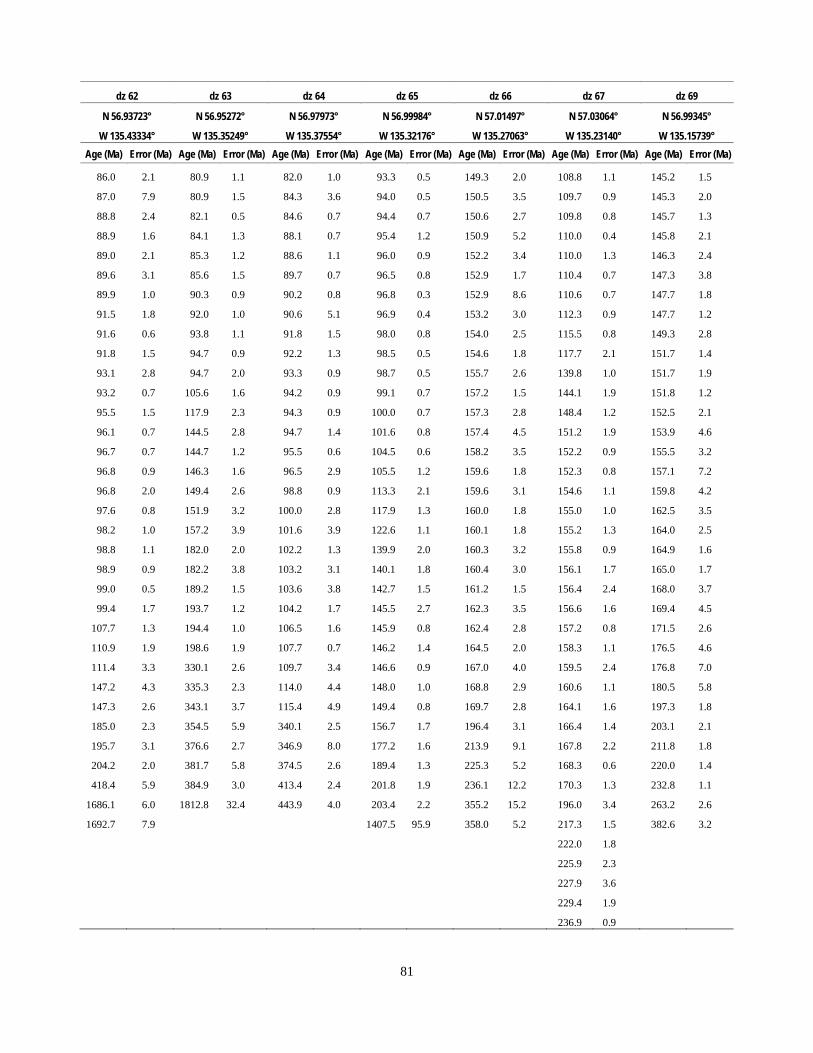
81
dz 62 dz 63 dz 64 dz 65 dz 66 dz 67 dz 69
N 56.93723° N 56.95272° N 56.97973° N 56.99984° N 57.01497° N 57.03064° N 56.99345°
W 135.43334° W 135.35249° W 135.37554° W 135.32176° W 135.27063° W 135.23140° W 135.15739° Age (Ma) Error (Ma) Age (Ma) Error (Ma) Age (Ma) Error (Ma) Age (Ma) Error (Ma) Age (Ma) Error (Ma) Age (Ma) Error (Ma) Age (Ma) Error (Ma)
86.0 2.1 80.9 1.1 82.0 1.0 93.3 0.5 149.3 2.0 108.8 1.1 145.2 1.5
87.0 7.9 80.9 1.5 84.3 3.6 94.0 0.5 150.5 3.5 109.7 0.9 145.3 2.0
88.8 2.4 82.1 0.5 84.6 0.7 94.4 0.7 150.6 2.7 109.8 0.8 145.7 1.3
88.9 1.6 84.1 1.3 88.1 0.7 95.4 1.2 150.9 5.2 110.0 0.4 145.8 2.1
89.0 2.1 85.3 1.2 88.6 1.1 96.0 0.9 152.2 3.4 110.0 1.3 146.3 2.4
89.6 3.1 85.6 1.5 89.7 0.7 96.5 0.8 152.9 1.7 110.4 0.7 147.3 3.8
89.9 1.0 90.3 0.9 90.2 0.8 96.8 0.3 152.9 8.6 110.6 0.7 147.7 1.8
91.5 1.8 92.0 1.0 90.6 5.1 96.9 0.4 153.2 3.0 112.3 0.9 147.7 1.2
91.6 0.6 93.8 1.1 91.8 1.5 98.0 0.8 154.0 2.5 115.5 0.8 149.3 2.8
91.8 1.5 94.7 0.9 92.2 1.3 98.5 0.5 154.6 1.8 117.7 2.1 151.7 1.4
93.1 2.8 94.7 2.0 93.3 0.9 98.7 0.5 155.7 2.6 139.8 1.0 151.7 1.9
93.2 0.7 105.6 1.6 94.2 0.9 99.1 0.7 157.2 1.5 144.1 1.9 151.8 1.2
95.5 1.5 117.9 2.3 94.3 0.9 100.0 0.7 157.3 2.8 148.4 1.2 152.5 2.1
96.1 0.7 144.5 2.8 94.7 1.4 101.6 0.8 157.4 4.5 151.2 1.9 153.9 4.6
96.7 0.7 144.7 1.2 95.5 0.6 104.5 0.6 158.2 3.5 152.2 0.9 155.5 3.2
96.8 0.9 146.3 1.6 96.5 2.9 105.5 1.2 159.6 1.8 152.3 0.8 157.1 7.2
96.8 2.0 149.4 2.6 98.8 0.9 113.3 2.1 159.6 3.1 154.6 1.1 159.8 4.2
97.6 0.8 151.9 3.2 100.0 2.8 117.9 1.3 160.0 1.8 155.0 1.0 162.5 3.5
98.2 1.0 157.2 3.9 101.6 3.9 122.6 1.1 160.1 1.8 155.2 1.3 164.0 2.5
98.8 1.1 182.0 2.0 102.2 1.3 139.9 2.0 160.3 3.2 155.8 0.9 164.9 1.6
98.9 0.9 182.2 3.8 103.2 3.1 140.1 1.8 160.4 3.0 156.1 1.7 165.0 1.7
99.0 0.5 189.2 1.5 103.6 3.8 142.7 1.5 161.2 1.5 156.4 2.4 168.0 3.7
99.4 1.7 193.7 1.2 104.2 1.7 145.5 2.7 162.3 3.5 156.6 1.6 169.4 4.5
107.7 1.3 194.4 1.0 106.5 1.6 145.9 0.8 162.4 2.8 157.2 0.8 171.5 2.6
110.9 1.9 198.6 1.9 107.7 0.7 146.2 1.4 164.5 2.0 158.3 1.1 176.5 4.6
111.4 3.3 330.1 2.6 109.7 3.4 146.6 0.9 167.0 4.0 159.5 2.4 176.8 7.0
147.2 4.3 335.3 2.3 114.0 4.4 148.0 1.0 168.8 2.9 160.6 1.1 180.5 5.8
147.3 2.6 343.1 3.7 115.4 4.9 149.4 0.8 169.7 2.8 164.1 1.6 197.3 1.8
185.0 2.3 354.5 5.9 340.1 2.5 156.7 1.7 196.4 3.1 166.4 1.4 203.1 2.1
195.7 3.1 376.6 2.7 346.9 8.0 177.2 1.6 213.9 9.1 167.8 2.2 211.8 1.8
204.2 2.0 381.7 5.8 374.5 2.6 189.4 1.3 225.3 5.2 168.3 0.6 220.0 1.4
418.4 5.9 384.9 3.0 413.4 2.4 201.8 1.9 236.1 12.2 170.3 1.3 232.8 1.1
1686.1 6.0 1812.8 32.4 443.9 4.0 203.4 2.2 355.2 15.2 196.0 3.4 263.2 2.6
1692.7 7.9 1407.5 95.9 358.0 5.2 217.3 1.5 382.6 3.2
222.0 1.8
225.9 2.3
227.9 3.6
229.4 1.9
236.9 0.9
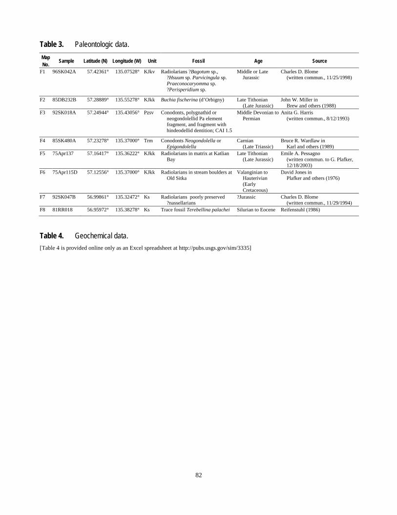
82
Table 3. Paleontologic data. Map No. Sample Latitude (N) Longitude (W) Unit Fossil Age Source
F1 96SK042A 57.42361° 135.07528° KJkv Radiolarians ?Bagotum sp., ?Hsuum sp. Parvicingula sp. Praeconocaryomma sp. ?Perisperidium sp.
Middle or Late Jurassic
Charles D. Blome (written commun., 11/25/1998)
F2 85DB232B 57.28889° 135.55278° KJkk Buchia fischerina (d’Orbigny) Late Tithonian (Late Jurassic)
John W. Miller in Brew and others (1988)
F3 92SK018A 57.24944° 135.43056° Pzsv Conodonts, polygnathid or neogondolellid Pa element fragment, and fragment with hindeodellid dentition; CAI 1.5
Middle Devonian to Permian
Anita G. Harris (written commun., 8/12/1993)
F4 85SK480A 57.23278° 135.37000° Trm Conodonts Neogondolella or Epigondolella
Carnian (Late Triassic)
Bruce R. Wardlaw in Karl and others (1989)
F5 75Apr137 57.16417° 135.36222° KJkk Radiolarians in matrix at Katlian Bay
Late Tithonian (Late Jurassic)
Emile A. Pessagno (written commun. to G. Plafker, 12/18/2003)
F6 75Apr115D 57.12556° 135.37000° KJkk Radiolarians in stream boulders at Old Sitka
Valanginian to Hauterivian (Early Cretaceous)
David Jones in Plafker and others (1976)
F7 92SK047B 56.99861° 135.32472° Ks Radiolarians poorly preserved ?nassellarians
?Jurassic Charles D. Blome (written commun., 11/29/1994)
F8 81RR018 56.95972° 135.38278° Ks Trace fossil Terebellina palachei Silurian to Eocene Reifenstuhl (1986)
Table 4. Geochemical data. [Table 4 is provided online only as an Excel spreadsheet at http://pubs.usgs.gov/sim/3335]