Embed Size (px)
Citation preview
Prepared in cooperation with the California Department of Water Resources
Geologic Logs of Geotechnical Cores From the
Subsurface Sacramento-San Joaquin Delta, California
Open-File Report 2014–1127
U.S. Department of the Interior U.S. Geological Survey

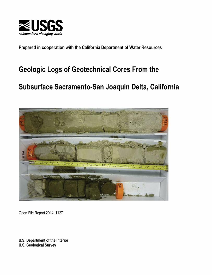
COVER Cores from the California Department of Water Resources geotechnical boreholes drilled in the Sacramento-San Joaquin Delta, California. Photograph by Katherine Maier, 2013.

Prepared in cooperation with the California Department of Water Resources
Geologic Logs of Geotechnical Cores From the
Subsurface Sacramento-San Joaquin Delta, California
By Katherine L. Maier, Daniel J. Ponti, John C. Tinsley, Emma Gatti, and Mark Pagenkopp
Open-File Report 2014–1127
U.S. Department of the Interior U.S. Geological Survey
U.S. Department of the Interior SALLY JEWELL, Secretary
U.S. Geological Survey Suzette M. Kimball, Acting Director
U.S. Geological Survey, Reston, Virginia: 2014
For more information on the USGS—the Federal source for science about the Earth, its natural and living resources, natural hazards, and the environment—visit http://www.usgs.gov or call 1–888–ASK–USGS
For an overview of USGS information products, including maps, imagery, and publications, visit http://www.usgs.gov/pubprod
To order this and other USGS information products, visit http://store.usgs.gov
Suggested citation: Maier, K.L., Ponti, D.J, Tinsley, J.C., Gatti, E., Pagenkopp, M., 2014, Geologic logs of geotechnical cores from the subsurface Sacramento-San Joaquin Delta, California: U.S. Geological Survey Open-File Report 2014-1127, XXp., http://dx.doi.org/10.3133/ofr20141127.
Any use of trade, firm, or product names is for descriptive purposes only and does not imply endorsement by the U.S. Government.
Although this information product, for the most part, is in the public domain, it also may contain copyrighted materials as noted in the text. Permission to reproduce copyrighted items must be secured from the copyright owner.
ISSN 2331-1258 (online)

iii
Contents
Abstract .......................................................................................................................................................................... 1
Introduction .................................................................................................................................................................... 1
Methodology................................................................................................................................................................... 3
Geotechnical Drilling and Retained Samples.............................................................................................................. 3
Geologic Core Descriptions ........................................................................................................................................ 5
Sampling .................................................................................................................................................................... 8
Graphic Logs .............................................................................................................................................................. 8
Discussion ...................................................................................................................................................................... 9
Acknowledgements ........................................................................................................................................................ 9
References Cited ......................................................................................................................................................... 10
Figures ......................................................................................................................................................................... 13
Tables .......................................................................................................................................................................... 15
Appendix ................................................................................................................................................. Available online
Figures
1. Map of borehole locations ......................................................................................................................... 13
2. Explanation for graphic core logs. ............................................................................................................. 14
Tables
1. Geotechnical borehole and core data in this report. ................................................................................... 15
2. Sample abbreviations in core logs. ............................................................................................................. 16

iv
Conversion Factors
Inch/Pound to SI Multiply By To obtain
Length inch (in.) 2.54 centimeter (cm)
inch (in.) 25.4 millimeter (mm)
foot (ft) 0.3048 meter (m)
mile (mi) 1.609 kilometer (km)
Area square mile (mi2) 2.590 square kilometer (km2) SI to Inch/Pound
Multiply By To obtain Length
centimeter (cm) 0.3937 inch (in.)
millimeter (mm) 0.03937 inch (in.)
meter (m) 3.281 foot (ft)
kilometer (km) 0.6214 mile (mi)
Area square kilometer (km2) 0.3861 square mile (mi2)

Geologic Logs of Geotechnical Cores From the
Subsurface Sacramento-San Joaquin Delta, California
By Katherine L. Maier, Daniel J. Ponti, John C. Tinsley, Emma Gatti, and Mark Pagenkopp
Abstract
This report presents and summarizes descriptive geologic logs of geotechnical cores collected
from 2009–12 in the Sacramento–San Joaquin Delta, California, by the California Department of Water
Resources. Graphic logs are presented for 1,785.7 ft of retained cores from 56 borehole sites throughout
the Sacramento-San Joaquin Delta. Most core sections are from a depth of ~100–200 feet. Cores
primarily contain mud, silt, and sand lithologies. Tephra (volcanic ash and pumice), paleosols, and
gravels are also documented in some core sections. Geologic observations contained in the core logs in
this report provide stratigraphic context for subsequent sampling and data for future chronostratigraphic
subsurface correlations.
Introduction
In this report, areas from south of Sacramento to Clifton Court Forebay are considered a part of
the Sacramento–San Joaquin Delta (the delta) (fig. 1). Since 2009, the California Department of Water
Resources (CDWR) has led an ongoing drilling and coring program in the delta, supported by the Delta
Habitat Conservation and Conveyance Program (DHCCP), to inform the design and construction of
planned water-conveyance systems. Cores were obtained during drilling and described onsite by CDWR
geologists and their contractors for engineering purposes. In 2012, the U.S. Geological Survey (USGS)

2
entered into a cooperative agreement with CDWR to examine the newly collected subsurface data as a
way to provide an enhanced Quaternary stratigraphic framework for the subsurface delta.
The Sacramento–San Joaquin Delta includes the lower reaches of the Sacramento and San
Joaquin Rivers and the confluence of these two rivers, upstream from San Francisco Bay. Much of
California relies on the fresh water supply that travels through the delta. The delta also supports diverse
and vulnerable ecosystems; as a result, it has become a site for numerous risk assessment, land
management, water resource, infrastructure, and agriculture studies (for example, Ingebritsen and others,
2000). Agricultural modification in the Sacramento–San Joaquin Delta has led to compaction of peat
soils and subsidence of the land surface below sea level over much of the delta (Deverel and Rojstaczer,
1996; Ingebritsen and others, 2000; Mount and Twiss, 2005; Coons and others, 2008). As a result,
levees and a complex system of waterways have been constructed to keep seawater out of California’s
freshwater supplies and prevent destructive flooding of the islands within the delta (Jackson and
Paterson, 1977; Ingebritsen and others, 2000; Burton and Cutter, 2008). The levees may be vulnerable to
catastrophic failure by way of ground motion and liquefaction related to earthquakes on local faults and
on faults in the adjacent, tectonically active San Francisco Bay area, which has experienced several
large-magnitude (>M6.0) earthquakes in historical times (Unruh and Krug, 2007).
Given the environmental and water resources in the delta, there is increasing need for an
improved understanding of the likelihood and potential impacts of natural hazards in the region.
Geological context for the recently obtained geotechnical data is needed to inform future subsurface
exploration by CDWR, to plan subsurface water-conveyance facilities, and to improve ongoing seismic
and liquefaction hazards assessments in the delta.
A detailed understanding of subsurface Quaternary stratigraphy is essential to evaluating seismic
and liquefaction hazards in the modern Sacramento–San Joaquin Delta. Geologic logs are a crucial first
step toward establishing age, correlation, and potential tectonic deformation of the Quaternary deposits.
Geologic logs are also necessary for interpreting depositional environments and the influence of these

3
settings on liquefaction susceptibility and the engineering parameters that would determine
infrastructure design and performance. Although a geologic context for the Quaternary in the
Sacramento–San Joaquin Delta has been established from surface mapping in the region (for example,
Atwater, 1982; Lettis, 1982; Unruh and others, 2009), detailed geologic data from subsurface
Quaternary deposits older than the Holocene are lacking.
The recent drilling and sampling by CDWR, which extend to depths of >200 ft subsurface,
provide significant new “exposures” of the sediments that underlie the young peat and rivers on the
surface. Utilizing this new information requires a detailed examination and relogging of core samples
that have been retained. The primary purpose of this logging is to identify attributes of the core deposits,
including potential materials for dating, buried soils, and evidence of unconformities. In the future, these
observations could be used for subsurface correlations, depositional environment interpretations, and
insights into delta evolution.
This report details results of the relogging effort and includes descriptions of a total of 1,785.7 ft
of core from 56 boreholes (fig. 1) collected from subsurface depths ranging from 6.5–228.1 ft (table 1).
This initial core logging effort focuses on cores retained from ~100–200 ft drilled depths. Additional
cores have been retained from shallower depths, primarily from boreholes near the Clifton Court
Forebay in the southern delta (fig. 1), but detailed geologic logs for these additional shallow cores are
not presented herein.
Methodology
Geotechnical Drilling and Retained Samples
From 2009–12, CDWR drilled more than 128 boreholes in the Sacramento–San Joaquin Delta,
primarily along a roughly north-south trending line from south of Sacramento to Clifton Court Forebay
(fig. 1). Geotechnical drilling generally involved continuous sampling using a hollow-stem auger in

4
shallow, minimally consolidated sediments (on the order of several feet drilled depth), and mud rotary
drilling in sediment as much as 200 ft below the surface. In the depth range of primary interest to
CDWR (generally 100–200 ft), the sampling procedure involved 3.5-ft-long punch core samples
alternated with 1.5-ft-long Standard Penetration Test (SPT) samples, occasionally interrupted by 2-ft-
long Shelby Tube samples. Punch core samples were collected in unlined barrels, and they were
extruded and described at the drill site. For limited depth ranges (~2–90 ft length within ~200-ft-deep
boreholes; table 1), whole cores were placed in core boxes for storage. Cores that were not retained in
boxes were subsampled over a small interval (~0.5 ft), and the remainder (minus the subsample) of the
core was discarded at the drill site. Small punch core samples and SPT samples were stored in glass jars,
and some of these have been removed by CDWR for laboratory analyses (for example, particle size or
Atterberg limits). Some retained jar samples were examined by the authors and sampled for tephra or
paleontological analyses, but jar samples are not described individually or documented here. Most
Shelby Tube samples remain unextruded and were not used this study.
Retained punch core samples are stored in their original core boxes at room temperature, on open
shelving, in a CDWR warehouse in West Sacramento, Calif. All of the core boxes are 2 ft in length, thus
the longest continuous core segments are 2 ft long.
Geotechnical logging in the field by CDWR and their contractors classified large-scale
(generally ft to tens of ft) sediment packages using the Unified Soil Classification System (American
Society for Testing and Materials, 2007). Within these units, field logs documented plasticity, dilatancy,
toughness, dry strength (Casagrande, 1932; Seed and others, 1966), color, grain-size distribution within
sands, hardness, and moisture. In addition, geologic observations included the presence or absence of
carbonate, mica, peat and organic material, volcanic ash, pumice, and smaller-scale lithologic and
physical property variations.

5
Geologic Core Descriptions
To complement the CDWR core field descriptions, we examined the cores and identified
attributes at a much finer scale (0.1 ft or less) to document subtle differences in geologic parameters that
would assist in interpretations of depositional environment and diagenetic processes. Boxed punch core
samples were stored whole (they were not split longitudinally for field description purposes) and were
often coated in drilling mud. Prior to detailed logging, drilling mud and other disturbed material was
scraped from one side of the core to reveal internal core color and structures. Core descriptions included
color (primary color, and secondary colors if mottled or banded), core disturbance, grain size, lithology
(following the classification scheme defined by Shepard [1954]), bedding thickness, bed contacts,
sorting, roundness, and bioturbation intensity. Additional components, such as lithologic accessories (for
example, laminae, dark minerals), physical structures (for example, sedimentary structures, loading),
fossils, trace fossils, diagenetic features (for example, pedogenic carbonate), and fractures were also
examined.
Geologic core descriptions were recorded using a custom logging software program developed
by the USGS. Initially developed using Filemaker® software, the logging system is currently being
rewritten as a Java-based front end to an open-source SQL database server (PostgreSQL). The custom
Filemaker® software program was used for geologic logging of the cores in the CDWR warehouse.
These data were subsequently imported into the PostgreSQL database at USGS. The software facilitates
consistency in descriptions, quality-assurance checking, and stores all captured information in the
PostgreSQL database for subsequent output and analysis.
Using the software, each core was entered separately into the database with a distinct name
linked to the borehole site. The top of each core was entered as the drilled depth recorded on the CDWR
core boxes, and the core length was measured from core remaining in the box. For measured core
lengths less than the cored interval, the top of the core was “hung” by default at the top of the cored
6
interval, unless samples were removed or other information indicated that the core needed to be
relocated. If a measured core length exceeded the cored interval, the bottom of the core was constrained
to the bottom of the cored interval. Log descriptions were recorded with their depths relative to the top
of the core, and the software automatically handled any adjustments to ensure that computed depths
were located correctly within the cored interval.
The software also allowed independent logging of each attribute for maximum flexibility. For
example, color intervals did not need to match lithology intervals, and accessories attributes could have
independent and overlapping ranges within each core. Quality-assurance checks within the software
ensure that the recorded core data does not contain internal contradictions.
Initial conditions were recorded for each core, including hydrocarbon shows (any visual
evidence for natural petroleum products), core disturbance, and colors. None of the Sacramento–San
Joaquin Delta cores in this report contained hydrocarbon shows, so this attribute is not included on the
graphic logs. Core disturbance was the most prominent disturbance for each interval in a core. Munsell
colors were recorded, but all colors documented in this report represent dry colors that include effects of
alteration during 1–4 years of exposure.
Primary and secondary lithologies were recorded along with estimated median grain size for
each layer within a core. Bedding was generally indicated as massive, laminated (bed thickness <1 mm),
thinly-bedded (bed thickness <1 cm), medium-bedded (bed thickness >1 cm and <10 cm), or thickly
bedded (bed thickness >10 cm). Bedding was recorded as massive if the core was intact and no bedding
was observed. If the core was disturbed such that any bedding that may have been present could no
longer be observed, a note of “bedding not observed” was recorded. The basal contact for each lithologic
unit was indicated as the lithologic transition occurring over <1 cm (sharp), ~1–2 cm (clear), many
centimeters (diffuse), >10 cm (gradational), uncertain, or unknown. Core units that ended at the base of
a core box were recorded as having unknown basal contacts. Breaks in the core that occurred owing to
sample removal during the geotechnical logging were indicated as uncertain basal contacts.

7
Additional characteristics, including sorting, grain roundness, and bioturbation intensity were
recorded. Relative sorting terms were assigned based on the number of grain sizes present. For example,
a bed containing only silt (with visual inspection) was well-sorted, and a bed with a mixture of clay,
very fine sand, and medium sand was moderately sorted. Roundness was only recorded for grain sizes
above very fine sand, and most grains in delta cores were subangular to subrounded. Percent
bioturbation was visually estimated. Units characterized by fine-scale sedimentary structures with no
visible bioturbation were labeled as such; however, lacking evidence of fine-scale sedimentary
structures, units with no bioturbation present in hand sample were labeled as rare bioturbation (<10
percent).
The logging software provided numerous possible accessory inputs defined over intervals of the
core samples, and several types occurred frequently in the delta cores included in this report. Commonly
observed lithologic accessories included dark mineral concentrations, dark mineral banding, the
presence of mica, inferred paleosols, pebbles and (or) granules, coal laminae, and silt, sand, and clay
laminae. Dark mineral concentrations were recorded where dark mineral grains occurred throughout a
layer, typically a sand-rich unit. Dark mineral banding was recorded where laminations were defined by
dark minerals. A layer was reported as micaceous if mica flakes were visible. A unit was interpreted as a
paleosol where pedogenic carbonate or a leached zone above a layer with pedogenic carbonate was
present. Paleosol and pedogenic carbonate were noted as possibilities in the core logs; more definitive
soil interpretations from cores alone were hindered by the segmented retention of core samples. Pebbles
and (or) granules were reported as an accessory if grains larger than very coarse sand were present
within a layer, but not abundant enough to classify the layer as gravel or gravelly in the lithology input.
Coal laminae were recorded where laminations were defined by concentrated organic material. Other
sedimentary structures were recorded as physical structures and include cross-bedding, ripple
laminations, chaotic or deformed bedding, and grading. Fossils included leaves and other
undifferentiated plant material. Trace fossils included rootlets and undifferentiated burrows. Frequently

8
observed diagenetic accessories included clay films recording translocated clays, mottles of texture,
oxidation, and reduction, and pedogenic carbonates of various stages (Birkeland and others, 1990),
including carbonate nodules, carbonate veinlets, and soft carbonate masses. A blue internal core color
revealed after scraping of the core was recorded as mottles, reduced.
All accessories were recorded with an abundance representing the visually estimated percent of
the cored interval that contained the accessory. Abundance categories for accessories included pervasive
(>60 percent), abundant (30–60 percent), common (10–30 percent), few-moderate (5–10 percent), and
rare (<5 percent). For example, a pervasive micaceous accessory was noted where mica occurs in >60
percent of the interval, not where a sand layer was >60 percent mica.
Other descriptive information or comments were documented as remarks, displayed within
intervals related to the comment. These remarks were used to provide a summary of the core layers and
record additional information not covered in the custom program menus.
Sampling
Samples from geotechnical cores were obtained during and after geologic core descriptions.
Sample locations are indicated in the core logs in this report, and sample types are described in table 2.
Sampling included bulk core samples for tephra, smear slides, diatoms, clay chemistry, and organic
material, as well as whole core samples for paleomagnetics.
Graphic Logs
Prior to the generation of core graphic logs, descriptions initially recorded in the Filemaker®
version of the software were transferred to the PostgreSQL database. Customized views of the final core
log information were then exported from the database into Strater® software. Graphic logs were plotted
with Strater® software using a standard template for each borehole, and an explanation of the symbology

9
is provided in figure 2. The depths of each cored interval were cross-checked with geotechnical logs
provided by CDWR.
Discussion
This report is intended to serve as a record of geologic core log descriptions from retained
geotechnical cores collected for the CDWR DHCCP program in the Sacramento–San Joaquin Delta.
This report does not present additional interpretations, sample descriptions, or analytical results.
Retained geotechnical cores are not evenly distributed throughout the Sacramento-San Joaquin Delta.
Most of the available cores are from boreholes drilled along a roughly north-south trending line from
south of Sacramento to Clifton Court Forebay, with many fewer cores available to the east and west (fig.
1). Of the retained cores, few are from ~100–200 ft subsurface depth in the southern delta. Even in the
northern delta where coring was more extensive (fig. 1), cores were retained from only small intervals of
select boreholes (table 1). In fact, none of the boreholes drilled for the DHCCP program have retained-
box cores for the entire drilled interval.
Despite the data gaps, these new core logs are significant because they reveal detailed structures,
composition, and other geologic variability within subsurface geotechnical units. In future studies, the
logs could be used to refine interpretations of intervals that were not cored or where cores were not
retained. Additionally, the logs provide a detailed stratigraphic and depositional context in which
subsamples and future analyses can be located. We advocate the continued retention of geotechnical
core material from drilling in the Sacramento–San Joaquin Delta and the subsequent detailed geologic
description of all core samples.
Acknowledgements
Support for this research and the co-authors has been provided by the U.S. Geological Survey
(USGS), the California Department of Water Resources (CDWR), USGS Mendenhall Postdoctoral

10
Fellowship (K.L. Maier), and Delta Science Fellowship (E. Gatti). Data presented in this report were
collected in collaboration with CDWR. Initial tephra samples were collected and tephra analyses were
conducted in collaboration with Elmira Wan and Holly Olson in the USGS Tephrochronology Project
and Microprobe laboratories in Menlo Park, Calif. Micropaleontological samples were analyzed for
diatoms in collaboration with Scott Starratt (USGS, Menlo Park, Calif.) and David Burtt (Whitman
College, Walla Walla, Wash.). Paleomagnetic samples were collected and analyzed in collaboration with
John Hillhouse (USGS, Menlo Park, Calif.). Sample analyses were possible only with the additional
help of John Barron and Lisamarie Windham-Myers. We thank Brad Aagaard, Rob Barry, Tom Brocher,
Nick Hightower, Tom Holzer, Keith Knudsen, Dave Perry, Scott Sochar, Steven Springhorn, and Paul
Spudich for supporting data collection and development of this report. We thank James Conrad and
Kathryn Watts for scientific reviews and Katherine Burgy and Carolyn Donlin for helpful edits to this
report.
References Cited
American Society for Testing Materials, 2007, Standard practice for classification of soils for
engineering purposes (unified soil classification system) ASTM Standard D2487-11: West
Conshohocken, Penn., American Society for Testing Materials International, 12 p.
Atwater, B.F., 1982, Geologic maps of the Sacramento–San Joaquin Delta, California: U.S. Geological
Survey Miscellaneous Field Studies Map MF–1401, scale 1:24,000.
Birkeland, P.W., Machette, M.N., and Haller, K.M., 1990, Soils as a tool for applied Quaternary
geology—Manual for a short course May 30–June 1, 1990: Utah Geological and Mineral Survey, 68
p.
Burton, C., and Cutter, S.L., 2008, Levee failures and social vulnerability in the Sacramento-San
Joaquin Delta area, California: American Society of Civil Engineers Natural Hazards Review, p. 136–
149.

11
Casagrande, A., 1932, Research on the Atterberg limits of soils: Public Roads, v. 13, no. 8, p. 121–136.
Coons, T., Soulard, C.E., and Knowles, N., 2008, High-resolution digitial terrain models of the
Sacramento/San Joaquin Delta region, California: U.S. Geological Survey Data Series 359.
Deverel, S.J., and Rojstaczer, S., 1996, Subsidence of agricultural lands in the Sacramento–San Joaquin
Delta, California—Role of aqueous and gaseous carbon fluxes: Water Resources Research, v. 32, no.
8, p. 2359–2367.
Ingebritsen, S.E., Ikehara, M.E., Galloway, D.L., and Jones, D.R., 2000, Delta subsidence in
California—The sinking heart of the State: U.S. Geological Survey Fact Sheet 005–00.
Jackson, W.T., and Paterson, A.M., 1977, The Sacramento–San Joaquin Delta—The evolution and
implementation of water policy—An historical perspective, technical completion report: California
Water Resources Center, University of California at Davis, 185 p.
Lettis, W.R., 1982, Late Cenozoic stratigraphy and structure of the western margin of the Central San
Joaquin Valley, California: U.S. Geological Survey Open-File Report 82–526, 203 p.
Mount, J., and Twiss, R., 2005, Subsidence, sea level rise, and seismicity in the Sacramento–San
Joaquin Delta: San Francisco Estuary & Watershed Science, v. 3, no. 1, p. 1–18.
Seed, H.B., Woodward, R.J., and Lundgren, R., 1966, Fundamental aspects of the Atterberg limits:
Journal of Soil Mechanics and Foundations Division, v. 92, p. 63–64.
Shepard, F.P., 1954, Nomenclature based on sand-silt-clay ratios: Journal of Sedimentary Petrology, v.
24, p. 151–158.
Unruh, J.R., and Krug, K., 2007, Assessment and documentation of transpressional structures,
Northeastern Diablo Range, for the Quaternary fault map database—Collaborative Research with
William Lettis & Associates, Inc., and the U.S. Geological Survey: Final Technical Report, 45 p.
Unruh, J.R., Hitchcock, C.S., Hector, S., and Blake, K., 2009, Characterization of potential seismic
sources in the Sacramento-San Joaquin Delta, California, Final Technical Report: Prepared by Fugro

12
William Lettis & Associates, Inc. for U.S. Geological Survey, National Earthquake Hazards
Reduction Program, NEHRP Award No. 08HQGR0055, 45 p.
Yu, E., and Segall, P., 1996, Slip in the 1868 Hayward earthquake from the analysis of historical
triangulation data: Journal of Geophysical Research, v. 101, no. B7, p. 16,101–16,118.

13
Figures
Figure 1. Map of borehole locations. Inset shows location within California.

14
Figure 2. Explanation for graphic core logs. Bedding is categorized as centimeter (cm) to decimeter (dm) scale.

15
Tables
Table 1. Geotechnical borehole and core data in this report.
Borehole Information Retained Cores3 Borehole1 Borehole Name Year
Drilled Elevation2 (ft) Drilled Depth
(ft) Total (ft) Depth Range (ft)
1 DCA-DH-003 2009 -4.4 200.0 51.5 61.5–199.7 2 DCA-DH-004 2009 -7.2 201.5 52.0 61.5–198.1 3 DCA-DH-005 2009 -13.0 202.0 61.2 60.0–197.7 4 DCA-DH-007 2012 -15.0 191.5 22.6 101.5–167.5 5 DCA-DH-008 2012 -17.9 109.5 2.0 104.5–106.5 6 DCA-DH-008A 2012 -17.5 200.5 20.5 105.5–172.2 7 DCA-DH-013 2011 10.6 204.5 31.1 89.5–146.9 8 DCA-DH-014 2011 8.8 199.5 33.3 90.0–146.8 9 DCA-DH-015 2011 8.2 210.0 23.3 81.5–153.5 10 DCA-DH-024 2011 11.2 201.5 31.9 81.5–179.5 11 DCA-DH-030 2011 -8.6 201.5 31.1 91.5–147.7 12 DCA-DH-031 2011 -4.2 199.3 25.5 84.5–156.7 13 DCA-DH-037 2011 2.7 201.5 26.7 91.5–147.3 14 DCA-DH-047 2012 -16.5 200.0 25.2 101.5–175 15 DCA-DH-048 2012 -13.0 217.0 18.5 103.5–181.7 16 DCA-DH-050 2012 -11.0 199.5 23.0 100.2–170 17 DCA-DH-051 2012 -15.6 200.0 27.5 101.5–167.5 18 DCA-DH-053 2012 -15.2 201.5 17.4 101.5–162.2 19 DCA-DH-054 2012 -9.7 199.5 26.8 99.5–170.7 20 DCB-DH-002 2012 -9.9 201.5 23.0 101.5–168.3 21 DCE-DH-003 2009 5.2 202.0 35.8 88.5–170.0 22 DCE-DH-004 2009 4.3 201.0 41.2 91.5–170.8 23 DCE-DH-005 2009 3.9 200.0 32.2 91.5–170.0 24 DCE-DH-010 2009 3.6 201.5 50.6 60.0–201.5 25 DCIF-DH-013 2012 9.0 189.0 72.3 6.5–187.5 26 DCIF-DH-014 2012 9.8 199.5 42.0 79.5–166.4 27 DCIF-DH-015 2012 8.5 200.0 38.3 79.5–170.2 28 DCN4-DH-028 2012 9.6 143.5 3.8 127.2–140.8 29 DCN4-DH-034 2012 11.8 143.0 8.0 133.5–142.0 30 DCN4-DH-036 2012 12.9 148.0 11.0 133.7–145.5 31 DCR-DH-010 2009 4.2 206.5 69.6 52.0–205.0 32 DCR-DH-011 2009 3.8 226.5 34.6 106.5–222.5 33 DCR-DH-015 2009 13.0 216.5 77.0 61.5–215.0 34 DCR-DH-016 2009 4.0 215.0 90.9 71.5–215.0 35 DCR3-DH-013 2012 10.8 180.0 2.1 131.5–133.6 36 DCR4-DH-013 2012 9.4 173.0 4.6 134.5–141.7 37 DCR4-DH-014 2012 9.7 173.0 5.9 135.0–142.1 38 DCR4-DH-015 2012 10.0 174.5 2.0 133.8–135.8 39 DCR5-DH-013 2012 9.2 164.3 7.8 134.5–151.6 40 DCRA-DH-001 2010 8.8 231.5 36.5 121.5–228.1 41 DCRA-DH-002 2010 10.0 221.5 36.9 126.5–217.3 42 DCRA-DH-003 2012 5.1 216.5 38.3 107.0–198.5 43 DCRA-DH-004 2012 5.6 221.5 38.0 103.0–198.8 44 DCRA-DH-005 2012 5.6 221.5 52.2 101.5–199.6 45 DCRA-DH-006 2010 7.8 223.0 36.1 120.8–210.5 46 DCRA-DH-007 2012 4.1 216.5 44.6 101.5–193.2 47 DCRA-DH-009 2012 6.2 225.0 43.8 121.5–225.0 48 DCRA-DH-010 2010 6.0 229.0 13.4 124.0–197.5 49 DCRA-DH-011 2010 5.5 236.5 19.1 124.5–198.0

16
Borehole Information Retained Cores3 Borehole1 Borehole Name Year Elevation2 (ft) Drilled Depth Total (ft) Depth Range (ft)
Drilled (ft) 50 DCRA-DH-012 2010 6.4 212.5 32.7 114.0–190.0 51 DCRA-DH-013 2012 4.6 221.5 41.7 101.5–197.6 52 DCRA-DH-014 2010 4.7 222.9 23.1 123.5–197.0 53 DCRA-DH-015 2012 4.8 236.0 44.5 116.5–215.2 54 DCRA-DH-016 2012 5.7 220.0 33.8 132.0–217.4 55 DCRA-DH-017 2010 6.2 211.0 21.5 101.7–181.5 56 DCRA-DH-022 2010 5.2 212.5 25.7 104.0–169.0 TOTALS 11,277.5 1,785.7 1See Figure 1 for borehole locations.
2Elevation based on ground survey.
3Retained cores presented in this report.
Table 2. Sample abbreviations in core logs.
Sample Type Abbreviation Description Tephra TEP Bulk samples for volcanic ash glass shards geochemical analyses Smear slide SM Bulk samples to evaluate presence of volcanic glass shards Micropaleontology MP Bulk samples for identification of diatoms X-ray analyses XRD Bulk samples for clay chemistry and mineralogy Paleobotany PB Bulk samples of organic material Paleomagnetics PM Whole core samples for paleomagnetic analyses To be determined TBD Bulk samples for potential future analyses