Embed Size (px)
Citation preview
53
Journal of the Royal Society of Western Australia, 90: 53�87, 2007
Geoheritage and geoconservation � history, definition, scope and scale
M Brocx1& V Semeniuk2
1Division of Science & EngineeringMurdoch University
South St., Murdoch, WA, 61502V & C Semeniuk Research Group
21 Glenmere Rd., Warwick, WA, 6024
Manuscript received August 2006; accepted February 2007
AbstractGeoheritage and geoconservation are concerned with the preservation of Earth Science features,
and are important endeavours globally, as reflected in various international and intra-nationalbodies set up for conservation, with agreements, conventions, and inter-governmental initiatives.Historically, the United Kingdom is considered the birthplace of the discipline of Geology, andwith its history and its leadership role in the preservation of geological sites, it is also the birthplaceof geoheritage and geoconservation; both endeavours are integral components of education,tourism, planning and environmental management. In addition, in Pan-Europe, and globally underthe World Heritage Convention, inventory-based geoconservation has been adopted as a whole-of-government approach. Australia presents an internationally contrasting, and a nationally internallydiverse history in the arena of geoconservation. Western Australia, for instance, generally lags theworld trend in practicing geoconservation, while Tasmania is a leader in the arena ofgeoconservation. For this reason, an objective of this paper is to raise the consciousness of WesternAustralian scientists, planners, and land managers, who are outside the field of geology, to theissues of geoheritage and geoconservation.
Geoheritage encompasses global, national, state-wide, and local features of geology, at all scalesthat are intrinsically important sites or culturally important sites offering information or insightsinto the evolution of the Earth; or into the history of science, or that can be used for research,teaching, or reference. As geoheritage focuses on features that are geological, the scope and scale ofwhat constitutes Geology, such as its igneous, metamorphic, sedimentary, stratigraphic, structural,geochemical, palaeontologic, geomorphic, pedologic, and hydrologic attributes, needs to be defined� from there, all that is encompassed by this discipline will be involved in geoheritage, andpotentially, geoconservation. Geoconservation is the preservation of Earth Science features forpurposes of heritage, science, or education.
While globally, and to some extent in Australia, there has been identification of sites ofgeoheritage importance, and development of inventory-based selection of such sites, currentlythere are no definitions and no framework that addresses the full breadth and scope of whatconstitutes geoheritage, nor adequate treatment of the matter of scale, both of which are importantto identifying sites of significance. Geoconservation should encompass all important geologicalfeatures from the regional scale to the individual crystal. The various scales useful for dealing withsites of geoheritage significance include regional, large, medium, small, fine, and very fine scales.While significance is noted in many works dealing with geoconservation, to date the various levelsof significance, from international to local, have not been adequately addressed or defined. Thelevel of importance attributed to a given feature of geoheritage significance is related to howfrequent or common is the feature within a scale of reference, and/or how important is the featureto a given culture. Five levels of significance are recognised in this paper: International, National,State-wide, Regional, and Local.
Keywords: geoheritage, geoconservation, geodiversity, scale, significance
IntroductionGeoheritage and geoconservation are notions concerned
with the preservation of Earth Science features, such aslandforms, natural and artificial exposures of rocks, andsites where geological features can be examined. In thispaper, geoheritage is synonymous to the idea of �EarthHeritage� of Doyle et al. (1994). Geoheritage focuses onthe diversity of minerals, rocks and fossils, andpetrogenetic features that indicate the origin and/or
alteration of minerals, rocks and fossils. It also includeslandforms and other geomorphological features thatillustrate the effects of present and past effects of climateand Earth forces (McBriar 1995). Geoconservation derivesfrom geoheritage, in that it deals with the conservation ofEarth Science features. Globally, it has become importantbecause it has been recognised that Earth systems have astory to tell, and that they are linked to the ongoinghistory of human development, providing the resourcesfor development, and a sense of place, with historical,cultural, aesthetic, and religious values. In addition,Earth systems are the foundation of all ecological© Royal Society of Western Australia 2007

54
Journal of the Royal Society of Western Australia, 90(2), June 2007
processes and part of the heritage of our sciences(Torfason 2001).
Although geoconservation is an arm of conservation,sensu lato, the focus of conservation to date has beenconcerned primarily with preservation of biota,particularly rare and endangered species, and thepreservation of �communities� (Wyatt & Moss 1990;Blandin 1992; Gibson et al. 1994; Withers & Horwitz1996). Conservation, however, should be concerned withmore than preservation of biodiversity (Semeniuk 1997);it should embrace the range of natural history featuressuch as 1. purely biological phenomena of scientific andheritage value, such as rare and endangered species, orrepresentative communities, to �biodiversity� (Soule &Wilcox 1980; McNelly et al. 1990); 2. features combiningbiota and geology, geomorphology, pedology andhydrology � essentially linking biodiversity withgeodiversity (Duff 1994; Hopkins 1994; Semeniuk 1997);and 3. purely physical (i.e., non-biological) aspects ofscientific and heritage value, such as unusual orrepresentative rock and landscape formations (Creaser1994; Markovics 1994). It is in this latter arena ofconservation, or geoconservation, that this paper isoriented.
In a history-of-science context, both geoheritage andgeoconservation, in their current form in terms of scopeand objectives, are relatively newly conceivedendeavours that have gained momentum only in recentyears, i.e., the latter part of the 20th Century in its currentform in terms of scope and objectives (Gray 2004). It hascome to be recognised that embedded in the materialsand the surface of our globe is the story of the Earth, andif destroyed, this archive (or geoarchive) is lost to currentand future generations with a loss of the core data of thealready discovered information and as yet undiscoveredinformation. For this reason, in recent decades, globally,there has been a drive to preserve the heritage of theEarth (what we term in this paper �intrinsicallysignificant sites of geoheritage�), and to preserve thehistory of science as embodied in some classic locations(what we term in this paper �culturally significant sitesof geoheritage�). Although, reserves and protected areas,including some of geoheritage significance, have been inplace for centuries in countries such as the UnitedKingdom, Germany, and America, in Australia definedlegislative frameworks to conserve and manage sites ofgeoheritage significance have only become the focus ofattention during the past 10 years. Also, in Australia,until recently, other than places where landscapes,geological formations or physical features are ofoutstanding scientific importance or �scenic grandeur�(e.g., the Blue Mountains in NSW, the Breadknife in theWarrumbungle Ranges, NSW, Uluru in CentralAustralia, the Twelve Apostles along coastal Victoria,mound springs in South Australia), there has beenlimited Federal legislation (Heritage Amendment Act2003) to conserve and manage sites of geoheritagesignificance. While there are sites of geologicalsignificance in Australia, preserved in National Parks,and World Heritage sites, conservation of Australia�sgeoheritage is still in its development stage, and as such,statutory processes that incorporate the conservation ofsites of geoheritage significance are still in their infancy(Sharples 2002).
Moreover, specifically in Western Australia, whilethere have been a number of initiatives to identify sites ofgeological significance through the endeavours of theNational Trust in Western Australia and the GeologicalSociety of Australia Inc. (e.g., Lemmon et al. 1979; Carter;1987) and others (Halligan 1994; Semeniuk 1998), there isno State legislation, nor any formal systematic processfor the identification, conservation and management ofsites of geoheritage significance at the regional or localplanning level (Anon 2004a). To date, apart from selectedsites such as those identified by Lemmon et al. (1979),Carter (1987), Halligan (1994) and Semeniuk (1998),meteorite impacts (Australian Heritage Commission1978; Bevan & McNamara 1993), or Precambrian fossils(McNamara 1997), the conservation of sites ofgeoheritage significance generally has occurredinadvertently only as a result of processes when the siteis considered to have exceptional aesthetic or tourismvalues, or by default, when significant vegetationassemblages occur as a result of the geology, landform,and soils (Watson 1997). Identification of such places ofheritage significance on an ad hoc basis in WesternAustralia currently is undertaken by the GeologicalSurvey of Western Australia (within the Department ofIndustry, Tourism and Resources), the Department ofEnvironment and Conservation (formerly theDepartment of Conservation and Land Management)who, as at 2006, formally have no geologists on staff, theformer National Trust of Western Australia (prior to theenactment of the Environment Protection BiodiversityConservation Act amendment in 2003 to include heritage)who used consultant geologists, or those of theGeological Survey of Western Australia, the WesternAustralia Heritage Council (under the WesternAustralian Government Heritage Icons: Connecting ACommunity initiative), who use a panel of heritageexperts � who may not be geologists. That is,geoconservation in Western Australia is undertakenmostly by geologists also responsible for resourcedevelopment, or by agencies and organisations withoutformal skills in the Earth Sciences.
There have been some recent initiatives and legislationin the arena of geoheritage and geoconservation (notethat the various Legislation, Acts, State Agreements, andConventions referred to in this paper are listed inAppendix 1); these include: 1. the Memorandum ofUnderstanding between Australia and UNESCO oncooperation concerning World Heritage in the Asia-Pacific region (UNESCO 2002); 2. amendments to theEnvironment Protection and Biodiversity ConservationAct 1999 (Appendix 1) to include �national heritage� as anew matter of National Environmental Significance andto protect listed places to the fullest extent under theConstitution; and 3. the 2002 Memorandum ofUnderstanding between the Commonwealth and theState of Western Australia where Commonwealth andState Heritage Ministers (and relevant EnvironmentMinisters) have agreed to develop a co-operative nationalheritage places strategy which firstly sets out the rolesand responsibilities of the Commonwealth and the States(Memorandum Of Understanding � Appendix 1),secondly, identifies criteria, standards and guidelines forthe protection of heritage by each level of government,and thirdly, provides for the establishment of a list ofplaces of national heritage significance (Department of
55
Environment & Heritage 1997). The process of assessingand assigning an area or feature for conservation, i.e.,why a site should be selected and preserved, involvesscientific assessments, value judgements, andGovernment policies. In the light of there being no suchState legislative mechanism or policy framework toidentify and assess areas of geoheritage significance inWestern Australia it is important to define whatconstitutes geoheritage and geoconservation.
In this paper we explore some of the history behindgeoheritage, define and discuss terms that have evolvedin recent times in relation to the ideas embodied ingeoheritage, geoconservation, geodiversity, describe anddiscuss the issue of scale in dealing with sites ofgeoheritage significance, describe and discuss the levelsof significance that might be applied to sites ofgeoheritage significance, and provides some examples ofsites of significance in Western Australia. We will alsodefine what is encompassed by geoheritage to include allmatters studied in Earth Science, from mountain rangesto crystals, and from solid rocks, including ice masses, tohydrological systems and their hydrochemical productssuch as precipitates and karst. This paper is conceived asthe first of a series dealing with the issues of geoheritageand geoconservation for Western Australia.
Brief history of geoheritage and origins ofgeoconservation
The international literature shows that geoheritage,focused on geology and geomorphology, globally, is nowimportant for local cultural reasons, natural resourcemanagement, land management, research, education,and tourism (Brocx 2007). As a result, there are variousinternational and intra-national bodies set up forgeoconservation, with agreements, conventions, andinter-governmental initiatives. A major outcome of thisinternational collaboration is that there are now variousglobal to local inventory-based classification systems foridentifying and listing sites of geoheritage significance.The international literature characterises geoheritage asprimarily relating to sites of mineral or fossil locations,type sections, classic locations that illustrate Earthhistory, and locations where Earth processes areoperating today, and locally with particular emphasis onclassic sites where some principles of geology were firstcrystallised (e.g., the site of Hutton�s unconformity, orthe site of Lapworth�s mylonite in the Moine Thrust).While pursuit of geoconservation has resulted in thepreservation of sites of geoheritage significance forscience and education, and an apparent exclusion of suchsites from further developments, an additional,unexpected outcome from geoconservation has beensocial and economic benefits � factors that haveimplications for the future application of geoconservationprinciples in Australia.
The United Kingdom is considered to be the birthplaceof the discipline of modern Geology. Reconstruction ofthe Earth�s history through its landform, rocks and fossilsis said to begin with the early work of James Hutton(1726�1797), William Smith (1769�1839), and CharlesLyell (1797�1875). Hutton�s idea that the history of rocksoccurs in cycles, together with Smith�s discovery of thelayering of sediments across their geographic extent, is
taken to mark the start of a period of geologicalenlightenment. Thereafter, many geologists such as Lyell,Smith, Murchison, and Sedgewick, amongst others, set inplace the foundations of stratigraphy and palaeontology,built on an understanding of geology in the field in site-specific locations (Hallam 1989). Consequently, manylocations, particularly in the United Kingdom, assumedsignificance as scientists identified type locations andclassic sites based on an appreciation of the significanceof the Earth�s crust and the landscape as a basis toreconstruct the Earth�s development and its causalprocesses.
The United Kingdom is also considered to be thebirthplace of geoheritage and systematic inventory-basedgeoconservation, which is now an integral component ofits education, tourism, planning and management (Anon1990a). One factor underlying this was the recognitionthat many geological features in the United Kingdomeither are type examples that illustrate geologicalprinciples that are globally relevant (e.g., Hutton�sunconformity), or that are sites where geologicalprinciples were conceived and espoused for the first time.However, also important have been professionalgeoscientists, forming government and non-governmentorganisations, that have been prime movers ingeoconservation in the United Kingdom, and drawing alink between geodiversity and biodiversity (Duff 1994;Semeniuk 1997; Brocx & Semeniuk, unpublished MS).The significance of geoconservation in the UnitedKingdom is demonstrated by the enactment of theCountry Right of Way Act, which effectively placed sitesof international and national importance outside thehands of ownership, and into the realm of nationalheritage, and is recognised as being a major achievementin protection and management of sites of geoheritagesignificance (Prosser & Hughes 2001). Many of theprinciples of geoconservation developed in the UnitedKingdom have been exported and adopted globally,particularly the inventory-based classification system andlisting of sites of geoheritage significance (Wimbledon etal. 1995).
Australia presents an internationally contrasting anda nationally internally diverse history in regards togeoconservation. On one hand, there exist variousframeworks, working recommendations, and strategiesfor geoconservation (for review, see Brocx 2007), withAustralia being a signatory to a number of globalconventions, and having listed a number of globallyimportant sites. On the other hand, nationally, as ageneralisation, Australia�s approach to its geology isresource-exploitative, rather than conservation-oriented,although this aspect is variable from State to State (Brocx2007). Many of the major issues within Australia havearisen as a result of bioconservation and geoconservationconflicting with the mineral and energy industries(O�Connor 1991; Pouliquen-Young 1997). Joyce (1994), forinstance, cites a series of articles and letters published bygeologists in The Australian Geologist wherein support,debate, opposition and controversy followed theGeological Society of Australia�s involvement ingeological heritage matters, and in its nominatinggeological sites for World Heritage listing. In Australia,the major sources of wealth required to sustainpopulation growth, infrastructure and essential servicesare derived from exploitation of minerals and energy
Brocx & Semeniuk: Geoheritage and geoconservation
56
Journal of the Royal Society of Western Australia, 90(2), June 2007
(Horne 1964; Duncan 1977; Alexander 1988; Rich &Young 1988; Collins 1991; Gould 1991; O�Connor 1991;Davis 1992; Tighe 1992; van Acker & Eddy 1992; Walker1992; Lawrence 1994; Brocx 2007), though Willett (2002),while accepting that mineral wealth is �engine ofeconomic growth� in Australia, argues that there hasbeen a shift in the attitude of the mining sector towardssustainable development as a result of negative publicopinion, amongst other issues. However, contrary to thenotion of being able to manage exploitation of Earthresources for sustainable economic development (Willett2002), the extraction of minerals, other Earth resources.,and fossil fuels is not renewable, and if there are sites ofgeological significance in the target zones, politicaldecisions have to be made (or have been made) whetherto exploit the resource or to undertake geoconservation.A corollary of fact that minerals and energy drive theAustralian economy is that Australia, and specificallyWestern Australia, generally lags behind the global trendin the practice of geoconservation.
This is not to say, or imply, that there have not beenany geoconservation initiatives in Australia. Over thedecades work undertaken by various individuals andorganisations towards the goal of recognising sites ofgeoheritage significance and geological monuments andtowards that of geoconservation (McBriar & Hasenohr1994). [Note that in this paper sites of geoheritagesignificance are equivalent to sites of geological heritage,to sites of geological significance and to geologicalmonuments of other authors, though geologicalmonuments tend to be viewed as sites that have somesignificant import to the geological community]. Some ofthese undertakings were through funding by theAustralian Heritage Commission with the support of theGeological Society of Australia Inc. to investigate issuesof geoconservation in all States (e.g., Joyce & King 1980;Mitchell et al. 2000; Davey & White 1984; Cochrane &Joyce 1986; Dixon et al. 1997; Rosengren & White 1997;Joyce 2003). Joyce (1994a) outlines the history ofgeoconservation that has taken place since at least 1960,when the first Divisional Subcommittees of theGeological Society of Australia began identifyinggeological monuments, and Cooper & Branagan (1994)compile the work of several authors who describe thework towards recognition of geological monuments inthe Northern Territory, South Australia, and Tasmania.Some of the work in recognising sites of geoheritagesignificance was undertaken as part of the assessment ofnatural values of regions as part of the Regional ForestAgreements between the Commonwealth and the States(e.g., Osborne et al. 1998; Cook et al. 1998; Semeniuk1998; Anon 1999a).
Thus, progress towards geoconservation in Australiamoved forward: at one extreme, through the dedicatedwork of individuals, e.g., the establishment of theArkaroola-Mt Painter geological province in the northernFlinders Ranges, as a privately conserved and managedgeological area (Sprigg 1984), and at the other, throughthe work of the Geological Society of Australia Inc via itsState Divisions, and through State governments thatacted as instrumentalities in identifying and protectingsites of geological significance. South Australia, Victoria,and Tasmania stand as examples of the latter procedures(McBriar & Mooney 1977; Eastoe 1979; Joyce & King
1980; Sharples 1993; Dixon 1996; Dixon et al. 1997). InSouth Australia, for instance, the South AustralianDepartment of Mines and Energy in conjunction with theNational Parks and Wildlife Service reserved WilpenaPound and its surrounds, established the �Corridorsthrough time Geological Trail� through Brachina Gorge(Selby 1990), and protected Hallett Cove. By 2003, SouthAustralia had recognised 433 geological monuments(Anon 2003). In Victoria, White et al. (2003) provideexamples of sites they recognise as either of international,national, State, or regional significance, sites that hadbeen recognised earlier in the work of Joyce & King(1980), Rosengren & White (1997), amongst others, butalso point out that there are threats to these sites, as theirlisting as significant does not afford them adequateprotection.
As a result, Australia-wide, there are many sitesconsidered to be geological monuments, or sites ofgeological significance, though this does not ensure theirprotection. However, many of the sites of geologicalsignificance in Australia nation-wide reside in NationalParks, World Heritage areas, or are locations specificallydedicated to the conservation of geological values, or havebeen inscribed as National Parks specifically for theirlandscape or geology (Australian Academy of Science1968), or are locations that have had geological features aspart of their criteria for inscription as World Heritage sites,and this is a major factor in the protection of sites ofgeological significance. These include Gosses Bluffmeteorite impact crater in the Northern Territory, theWolfe Creek meteorite impact crater in Western Australia,Purnululu (the Bungle Bungles) in Western Australia, theGogo Fish fossil site in the Kimberleys, Western Australia,Geikie Gorge National Park in Western Australia,Windjana Gorge National Park in Western Australia, theEdiacara Fauna site in the Flinders Ranges, SouthAustralia, Undara Volcanic National Park in Queensland,the Chillagoe Limestone Karst area in Queensland, HallettCove in South Australia, amongst others.
In this context, Western Australia also has contributedto the national inventory of sites of geologicalsignificance and geological monuments (Lemmon et al.1979; Carter 1987; Semeniuk 1998), and currently, theGeological Survey of Western Australia maintains aRegister of sites of geological significance, termed a�State geoheritage site�, based on Lemmon et al. (1979)and Carter (1987). Assessment of the significance of agiven site in Western Australia is based on criteriadeveloped by the Heritage Committee of the GeologicalSociety of Australia Inc. and by the Australian HeritageCommission, which include geological type, age, use,representative or outstanding nature, rarity, and currentcondition (Conservation & Land Management 2005).Recognition of the need to identify and protect such sites(termed geological sites) also was embodied earlier in therecent past in work of the Conservation ThroughReserves Committee (Conservation Through ReservesCommittee 1974, 1977). A brief outline of the objectives,various perceptions, problems and conflicts in the arenaof conservation with regard to the EnvironmentalProtection Authority and the unfolding of the work ofConservation Through Reserves Committee towardsprotection of areas because of their plants, animals,landscape, and geology is provided in Hughes (1991).
57
However, while there has been a recognition of theimportance of features of geological heritage significanceAustralia-wide, there has been no systematic inventory-based geological survey as has been undertaken in theUnited Kingdom, and elsewhere in the world, andaddressing the scale and scope of geoconservation aspresented in this paper. Also, recognition of sites ofsignificance in Australia has not always led to theirprotection. Sanders (2000) commented that theconservation movement is of the view that Australia�slaws in relation to the protection of geological sites areweak and the Geological Society of Australia shouldbecome a proactive advocate toward the strengthening oflaws to protect sites. In Western Australia, for instance,apart from sites that are captured by National Park,National Heritage and World Heritage criteria, andinscribed mainly under Commonwealth powers, themajority of geological sites recommended by Lemmon etal. (1979), Carter (1987) and Semeniuk (1998) remainunsecured.
Similarly, following their systematic description of thevarious landforms of the Quindalup Dunes, at variousscales, along the full climatic extent of this coastal systemfrom Geographe Bay to Dongara, Semeniuk et al. (1989)concluded that there were an inadequate number ofreserves capturing the full variability of dune landformsin this coastal system. While the Leschenault Peninsula(Semeniuk 1985) and part of the Becher Cuspate Foreland(Searle et al. 1988; C A Semeniuk 2006) are now protectedin Reserves, in contrast, to date, since the work ofSemeniuk et al. (1989), little has been achieved insecuring adequate reserves in the Quindalup Dunesbased on geoheritage criteria � in fact, there has beenextensive modification, urbanisation, and development ofthese dunes (as described by Semeniuk & Semeniuk2001).
Some overseas and Australian examples ofsites of geoheritage significance
Prior to dealing with issues of scope, scale andsignificance in geoheritage, five areas that have alreadybeen recognised as sites of geoheritage value aredescribed below to provide an overview of what maycaptured under the umbrella of geoconservation. Theyprovide examples of the range of geological phenomenathat have been recognised as constituting features ofgeoheritage value. The five areas are arranged indecreasing scale, and are drawn from the Grand Canyonin the United States of America, Shark Bay in WesternAustralia, the Precambrian Ediacara fauna of theRawnsley Quartzite in South Australia, the Cambrianfauna in the Burgess Shale in Canada, and Jack Hills inWestern Australia. Two of the locations, viz., The GrandCanyon and Shark Bay, are recognised as globallysignificant sites, being listed as World Heritage areas,and represent features at a large scale frame of reference,but encompass a plethora of smaller scale features. TheEdiacaran in fauna in the Rawnsley Quartzite in SouthAustralia, and the Cambrian fauna in the Burgess Shalein Canada, containing an early record of diverseorganised metazoan life on Earth, also are sites ofinternational significance, albeit at smaller scales ofreference. Jack Hills, a rocky low range with an
uninteresting macroscopic appearance, is an exceptionalsite of global significance (while it is on the InterimListing on the Register of the National Estate, cfDepartment of Environment & Heritage 2004, it has noother formal recognition as such), due to its globalimportance at the crystal scale.
The Grand Canyon, USAThe Grand Canyon is an internationally well known
landform, and a World Heritage site, inscribed in 1979.The Canyon is part of the Colorado River, and portraysseveral important geomorphic and geological features(Holmes 1966; Shelton 1966). Firstly, geomorphically, it isa meandering river that has incised into a tectonicallyuplifted plain, the Colorado Plateau. At the end of theCretaceous, the Plateau was a lowland plain and coastalplain, with an ancient meandering sluggish ColoradoRiver. With uplift, the river incised into the plateau,matching uplift by erosion such that the meanderingform was preserved. In this regard, the Grand Canyonillustrates ancestral landforms (the ancient meanderingriver � now an entrenched antecedent river), tectonism(to produce the Colorado Plateau), riverine erosionkeeping pace with tectonism (to produce the incisedmeanders), and exhumation of the harder rock layers ofthe former Cretaceous Colorado Plain (to form thepresent surface of the Colorado Plateau). Secondly, theGrand Canyon exposes a classic sequence of stratigraphyand stratigraphic relationships. At the base, there arePrecambrian metamorphic and igneous rocks (granitesand schists), with folded, faulted and deformed layeredmetamorphic rocks intruded by granites, overlainunconformably by lower Palaeozoic sedimentarysequences (viz., the Cambrian), and then by upperPalaeozoic sequences (Carboniferous and Permian). Thecliff exposure illustrates an angular unconformitybetween Precambrian and Cambrian rocks, and aconcordant unconformity between lower and upperPalaeozoic rocks. The region thus is a globally importantclassroom for the aspects of megascale geomorphologyand tectonism, local stratigraphy and stratigraphicrelationships, and modern riverine processes.
Shark Bay, Western AustraliaShark Bay also is another internationally well-known
area, and a World Heritage site inscribed in 1991 becauseof its marine and terrestrial environments, and itsgeology, geomorphology, and carbonate sedimentology.It is one of the few places in the world that satisfy allfour natural criteria for listing, i.e., an area showingmajor stages of the world�s evolutionary history, showingongoing geological and biological processes, naturalbeauty, and containing threatened species and importantand significant habitats for in situ conservation ofbiological diversity. From a geologic and geomorphicperspective, the region hosts Quaternary coastal, near-coastal, and marine landforms, and exhibits a wealth ofgeological, geomorphic, sedimentologic, and tectonicfeatures (Logan & Cebulski 1970; Playford 1990). At themegascale, there is the Yaringa Province on the mainlandto the east (a plateau of Mesozoic and Tertiarylimestones), the central Peron Peninsula (of orange andred sand that separates the two main basins of SharkBay), and the western digitate peninsula of Edel Land(composed of mobile parabolic dunes and lithified
Brocx & Semeniuk: Geoheritage and geoconservation
58
Journal of the Royal Society of Western Australia, 90(2), June 2007
Pleistocene aeolianite limestone). The array of theselandforms is due to climatic, eustatic, and tectonic factors(Logan et al. 1970). At smaller frames of reference, thereis an abundance of coastal landforms determined byPleistocene ancestral forms (e.g., digitate inlets along theeastern coast of Edel Land resulting from inundation ofparabolic dunes), or by Holocene coastal processes (e.g.,beachridges, or seagrass bank platforms and sills), andthere are globally significant sedimentary products (suchas the Hamelin Coquina shell beds, oolitic sand banks,stromatolites, gypsum crystal beds, and cemented crusts).The region is a globally important classroom formegascale coastal geomorphology, arid zonesedimentation, the interplay of sedimentation and coastalgeomorphology with Quaternary tectonics, and smallerfeatures such as stromatolites and gypsum crystal beds.
The Ediacara fauna in the Rawnsley Quartzite, SouthAustralia
The Rawnsley Quartzite (formerly the PoundSandstone) occurs in the Ediacara Hills in the FlindersRanges, north of Adelaide in South Australia (Jenkins1975; Drexel et al. 1993). At the site of the exposure of theEdiacara fauna, the Rawnsley Quartzite occurs in a semi-arid landscape that is not remarkably different from thegeomorphology, geological structure and lithologyelsewhere in the region (Drexel et al. 1993), and from aperspective of the style of outcrop, local geomorphology,geological structure, and the lithology itself, the locationmay not be considered to be of national or even regionalsignificance. The importance of the site resides at thebedding scale: while complex metazoan life on Earth,gleaned from the geological record globally has beenaccepted to have evolved at circa 550 Ma, which definesthe Cambrian/Precambrian boundary, the RawnsleyQuartzite contains evidence of metazoan life inPrecambrian rocks (Glaessner 1966). It is the bestpreserved record of the earliest metazoan life on Earth,and as such is of global importance.
The Cambrian fauna in the Burgess Shale, CanadaThe Burgess Shale occurs in the Rocky Mountains of
British Columbia in Canada, in the Yoho National Park.It is Middle Cambrian in age and contains a remarkablydiverse and well preserved metazoan fauna (Whittington1985). So far, about 150 species belonging to 120 generahave been described (Whittington 1980), but many of theanimals are difficult to assign to present phyla.According to Gould (1989), the fauna �contains theremains of some fifteen to twenty organisms so differentone from the other, and so unlike anything now living,that each ought to rank as a separate phylum�, thussuggesting that there were more numerous phyla in theMiddle Cambrian than today, many of which are nowextinct. However, other authors have challenged theconclusions of Gould (1989), and suggest that while thefauna is diverse, a number of the taxa that were thoughtto belong to unique (and now extinct) phyla can beassigned mostly to existing phyla, albeit as distinctfamilies and orders (Morris 1998). Nonetheless, mostauthors agree that the fossil occurrence provides animportant and unique palaeontological window intometazoan life of the Cambrian. At the site of the exposureof the fauna, the Burgess Shale occurs in a borealmountainous landscape that, from a perspective of the
style of outcrop, local geomorphology, geologicalstructure, and the Burgess Shale lithology itself, is notremarkably different from the geomorphology, geologicalstructure and lithology elsewhere in the region. Theimportance of this site resides, as with the Ediacarafauna, at the bedding scale: while elsewhere, globally,Cambrian metazoan faunas are dominated by porifera,archeocyathids, coelenterates, bryozoans, graptolites,trilobites, and brachiopods, amongst others, belonging tophyla that mostly still exist today, the fauna of theBurgess Shale, according to Whittington (1980, 1985) andMorris (1998), records evidence of a plethora of quitedifferent metazoan life in Middle Cambrian times, and anumber of these life forms probably belonging to uniquephyla, though necessarily as many as claimed by Gould(1989). It is an early record of the formerly diversemetazoan life on Earth, best preserved in this location,and of global importance.
Jack Hills, Western AustraliaJack Hills, located in the Narryer Gneiss Terrane of
the northern Yilgarn Craton, Western Australia, is part ofa rocky landscape set in an arid climate. The MountNarryer Quartzite, a metaquartzite, is an importantformation in this Precambrian terrane (Wilde & Pidgeon1990). The terrain/terrane of this area is unremarkable,and relatively uninteresting at the macroscalegeologically, stratigraphically, and geomorphologically.However, within the metaquartzite are polycyclic zonedzircons with a maximum age of circa 4.4 Ga (Wilde et al.2001; Cavosie et al. 2004). They are, effectively, the oldestcrystals in the world, and illustrate that cratonisation andsedimentary reworking of granitic cratons was wellunderway by 4.5 Ga ago, and that the Earth was alreadysolid 50 million years after its formation. The geologicalfeature of global significance in this area is at crystalscale. To emphasise the significance of this occurrence,these crystals date back to the origin of the Solar System,providing unparalleled insights into the early origin ofthe Earth, and essentially providing information on thepetrogenesis on our planet near the age of the inceptionof the Solar System.
The scope of geology as a basis forgeoheritage
Geoheritage and geoconservation are concerned withgeology, so it is worthwhile to explore what constitutesthe science of geology and hence, what may beencompassed by the umbrella of geoheritage andgeoconservation.
The term geology, often used synonymously withEarth Sciences is a diverse discipline. Examined in detail,Geology and its subdisciplines, overlap with otherdisciplines such as Chemistry (e.g., crystal chemistry andgeochemistry are subdisciplines both of Geology and ofChemistry, and the study of crystal deformation andcrystal lattice defects is carried out in Geology, MaterialSciences, and in Engineering). We consider that all thesubdisciplines of Geology to be a part of Geology sensustricto where particular subdisciplines are oriented intheir endeavour to the study of the Earth, even if thesame subdiscipline is shared by another science. This isimportant, because this paper contends that the full scope
59
of what constitutes Geology should be within the scopeof what could be considered to be of heritage value, andwhat is considered to be of geoconservation value.
The scientific discipline of Geology involvessubsidiary disciplines of igneous geology, metamorphicgeology and sedimentary geology, igneous, metamorphicand sedimentary petrology, structural geology,mineralogy, palaeontology, geomorphology, pedology,hydrology and surface processes such sedimentology (seeGlossary of Geology; [Bates & Jackson 1987]). Thistraverses a wide range of scales: at mega-regional scale itincludes global tectonics, mountain building, andlandscape evolution; at smaller scales, it includes Earthsurface processes such as weathering, erosion andsedimentation, involving ice, water, and wind; and atmicroscale, it includes diagenesis, crystal defects anddeformation, amongst others. Chemically they involvestudies of precipitation, cementation, solution, andalteration at all scales (Wilson 1954).
For example, to illustrate the scope of what isconsidered to be geology, and hence geoheritage, in theirdescription of geoheritage features of the Swan CoastalPlain in Western Australia, Semeniuk & Semeniuk (2001)identify a wide range of geological features that theyconsidered fall under the umbrella of geoheritage; theyinclude igneous, metamorphic and sedimentary rocks,and their relationships at all scales (e.g., craton/basinrelationships), mineral locations, fossil locations, pollenlocations, type stratigraphic locations, along with typeigneous, metamorphic or pedogenic locations, sites ofimportance in understanding geological processes, sitesof importance geomorphologically, sites of importancepedologically, sites of importance sedimentologically/stratigraphically, sites of importance hydrologically, andsites of profound aesthetic geological importance, or ofintrinsic geological value.
The science of geology has been split into two distinctstreams or schools � those undertaking investigation ofcausal processes; and those seeking to historicallyreconstruct the Earth�s development. These two schoolswere said to be separated by a �great barrier� (Wilson1954). We term these two schools the geological processesschool and the historical geological school, separatingprocess-oriented endeavours and product-orientedendeavours. Historically each school looked at differentfeatures of the Earth, using different (though at timesoverlapping) techniques. These two schools of geologypersist today, with one continuing to investigate causalprocesses such as weathering, erosion and sedimentation,and at the micro scale, studies of crystal defects anddeformation, while the other, the historical geologists,working at the macro-regional scale to establish thesuccession of the Earth�s development, studying globaltectonics, mountain building and landscape evolution,i.e., the product of Earth processes, and at the small scale,the history and products of diagenesis, weathering,pedogenesis, metamorphism, and crystallisation. The twoapproaches overlap in that information about processesis foundational to understanding and interpretinggeological products.
Clearly, also, the two approaches generate two diverseconceptual categories on which to consider geoheritage.It is our contention that, in geoheritage andgeoconservation, both processes and products need to be
addressed. For instance, citing two examples whereprocesses may be extant: the environment and mediumthat allow dune formation to take place, and theenvironment and medium whereby diagenesis, such acalcite precipitation leading to dune sand cementation,induced by hydrochemical processes takes place, need tobe considered in geoconservation. That is, theenvironment or setting whereby specific physical andchemical processes are operating need to be identifiedand conserved. Coastal dune environments producingrepresentative highly attenuated parabolic dunesoriented in the dominant wind direction, or frettedparabolic dunes (such as in the Jurien area and QuinnsRocks area, respectively, in southwestern Australia; seeSemeniuk et al. 1989) are examples of areas exhibitingdune formation processes. The various Holoceneenvironments of Shark Bay, wherein there is tidal zonecementation, anaerobic marine phreatic diagenesis,stromatolite cementation, gypsum crystal formation, andskeletal grain dissolution (Logan 1974) are examples ofan area illustrating diagenetic processes. Equally,products of these processes (such as the dunesthemselves, or specific crystal formation, cementation, orcolour mottling, amongst other diagenetic products) alsoneed to be considered in geoconservation. Thus,geoconservation can focus either on processes (and these,and their products, will be extant in the modernenvironments), or on products (and these will be extantin modern environments, as well as present instratigraphic sequences, mineral and fossils deposits, andmetamorphic and structural terranes).
Table 1 presents the range of subdisciplines (processand product-oriented) considered to be part of Geology,and which we contend should be considered ininventory-based assessments of geoheritage andgeoconservation.
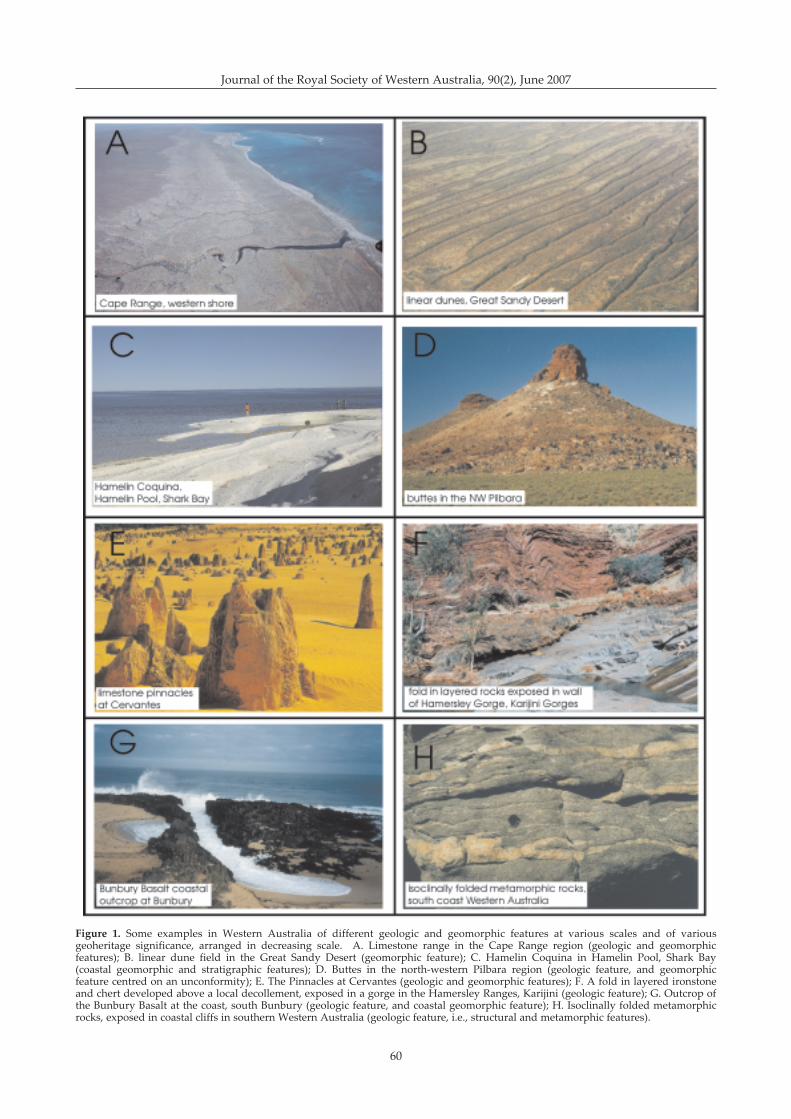
Figure 1 illustrates a selected range of geologicalfeatures in Western Australia that span the scope ofgeological phenomena, as listed in Table 1, that wouldqualify to be assessed as sites of geoheritage significance(in addition to the foregoing discussion, Figure 1 willalso be used in a discussion of levels of significance to bedeveloped later in the paper).
Within Figure 1, the aerial photograph of Cape Range,viewed to the south, illustrates a large scale geologicaland geomorphic feature (Fig. 1A). The Range is atectonically uplifted ridge of Cainozoic limestone(Hocking et al. 1987), on which has developedconsequent streams. The ridge also records a continuoushistory of uplift during the Quaternary, reflected interraces cut into the Quaternary limestones (van deGraaff et al. 1976). Yardie Creek, cut into the limestone,and with a sand bar at its mouth, is in the foreground.Ningaloo Reef is evident in the shallow water to the west.The linear dune field in the Great Sandy Desert (Veevers& Wells 1961) illustrates a desert geomorphic feature ofaeolian landforms (Fig. 1B). The recurved spit ofaccumulated small shells of Fragum hamelini (theHamelin Coquina of Logan et al. 1970) illustrates acoastal geomorphic and stratigraphic feature, whereactive Holocene sedimentation has resulted in thedevelopment of a prograded shell grit beachridge system(Fig. 1C). The buttes in the north-western Pilbara,illustrate geomorphic and geologic features (Fig. 1D),
Brocx & Semeniuk: Geoheritage and geoconservation
60
Journal of the Royal Society of Western Australia, 90(2), June 2007
Figure 1. Some examples in Western Australia of different geologic and geomorphic features at various scales and of variousgeoheritage significance, arranged in decreasing scale. A. Limestone range in the Cape Range region (geologic and geomorphicfeatures); B. linear dune field in the Great Sandy Desert (geomorphic feature); C. Hamelin Coquina in Hamelin Pool, Shark Bay(coastal geomorphic and stratigraphic features); D. Buttes in the north-western Pilbara region (geologic feature, and geomorphicfeature centred on an unconformity); E. The Pinnacles at Cervantes (geologic and geomorphic features); F. A fold in layered ironstoneand chert developed above a local decollement, exposed in a gorge in the Hamersley Ranges, Karijini (geologic feature); G. Outcrop ofthe Bunbury Basalt at the coast, south Bunbury (geologic feature, and coastal geomorphic feature); H. Isoclinally folded metamorphicrocks, exposed in coastal cliffs in southern Western Australia (geologic feature, i.e., structural and metamorphic features).
61
where Mesozoic sedimentary deposits (the resistantcapping) rest with unconformity on Precambrian granite,with the contact representing the stratigraphic interfacebetween deposits of the Canning Basin and the PilbaraCraton. The Pinnacles at Cervantes illustrate a geologicaland geomorphic feature (Fig. 1E): calcrete impregnated/cemented pipes, normally buried beneath a cover ofyellow quartz sand, stand in relief above an aeolian-eroded landscape wherein the yellow sand cover hasbeen removed. The fold in the rocks of the BrockmanIron Formation of Hamersley Group (Macleod 1966),composed of laminated ironstone and chert, illustrates ageological feature; that is of a fold formed in response toa decollement, in a zone of layer-parallel shear (Fig. 1F)).The outcrop of Bunbury Basalt at Bunbury illustrates theexposure of a valley fill of this basalt exhumed by coastalerosion (Fig. 1G). Normally, in this region, the valley fillsof Bunbury Basalt lie buried below the surface (Playfordet al. 1976). The outcrop also shows coastal geomorphicfeatures. The folded metamorphic rock of interlayeredmafic (dark coloured) and felsic (light coloured) layers,occurring in the Irwin Inlet area, southern coast ofWestern Australia, illustrates isoclinally folded granulite,and is a structural and metamorphic feature (Fig. 1H).
The variety of terms now associated withgeoheritage and geoconservation
In the short history of the coining of the termgeoheritage in the 1990s, there has already been aproliferation of related terms, and confusion associatedwith new and existing terms. It is useful therefore to tracethe origin of the terms, and discuss the meaningsascribed to the terms geoheritage, geoconservation, andgeodiversity. Each of the terms are described below as totheir first use, etymological understanding of the terms
(this paper), and our preferred definition of a given term.Appendix 2 provides definitions of the termsgeoheritage, geoconservation, geodiversity, and otherrelated terms, as used in the literature. A review anddiscussion of terms in the arena of geoconservation alsois provided by Prosser (2002a, 2002b).
GeoheritageThe term geoheritage derives from the word heritage,
which means something that has been transmitted fromthe past, or has been handed down by tradition. Theterm is used internationally, and in Australia, and carriesa notion of the heritage of features of a geological nature.It axiomatically conveys the idea that there is something(valuable or otherwise) to inherit from the past and passon to the future. The term geoheritage evolved from�geological heritage� (just as the term biodiversityevolved from the term biological diversity). The term�geological heritage� first makes its appearance in theFirst International Symposium on the Conservation ofour Geological Heritage at Digne, France in 1991 (Anon1991). The term geoheritage first makes its appearance inthe literature in the Malvern International Conference,the 2nd international conference dealing with geologicaland landscape conservation, held in the Malvern Hills(UK) in 1993 (Joyce 1994b; O�Halloran et al 1994).
Between 1991 and 2006, a variety of definitions andconcepts of geoheritage and related terms appeared inthe literature (see Appendix 2). Generally, geoheritage isused as a descriptive term associated with theconservation of Earth features, with theoretical conceptsand definitions of geoheritage still in their developmentalstage (Sharples 2002).
Historically, geoheritage as a concept, (though not as aterm), can be traced back to the time when knowledgewas being gained from the geological discoveries made
Table 1The range of main subdisciplines and specialised subdisciplines within Geology
Main subdiscipline Selected list of associated more specialised subdisciplines
Mineralogy crystallography, mineral chemistry, geochemistryIgneous geology petrology, geochemistry, mineralogy, volcanology, geochronologyMetamorphic geology petrology, geochemistry, mineralogy, geochronologySedimentary geology petrology, geochemistry, mineralogy, stratigraphy, diagenesis, skeletal taphonomy, ichnology,
geochronologyStructural geology mechanical deformation, geomechanics, crystal deformation, geometric analyses, terrane analysesMarine geology marine geomorphology, stratigraphy, sedimentology, igneous geology, geochronologyStratigraphy sedimentary petrology, mineralogy, geochronologyPalaeontology palaeobiology, palaeoecology, evolutionary biology, skeletal petrology, ichnology, taphonomy, mineralogy,
geochronology, biostratigraphySedimentology stratigraphy, sedimentary petrology, geochemistry, mineralogy, diagenesis, ichnology, skeletal taphonomy,
carbonate sedimentology, terrigenous sedimentology, evaporite sedimentology, fluid mechanicsGlaciology ice stratigraphy, ice petrology, crystallography, crystal deformation, geochemistry, sedimentology, glacial
geomorphologyPalaeoclimatology stratigraphy, geochronology, palynology, biostratigraphyPedology stratigraphy, petrology, geochemistry, mineralogyHydrology stratigraphy, hydrogeology, hydrodynamics, hydrochemistry, isotope chemistryGeomorphology fluvial geomorphology, aeolian geomorphology, volcanogenic geomorphology, karst geomorphology,
coastal geomorphology, marine geomorphology, desert geomorphology, alpine geomorphology,geomorphic processes
Surface processes weathering, erosion, transport
Brocx & Semeniuk: Geoheritage and geoconservation
62
Journal of the Royal Society of Western Australia, 90(2), June 2007
during the Industrial Revolution (Busby et al. 2001). Asnoted earlier, when geologists in the United Kingdomsuch as Lyell, Smith, Murchison, and Sedgewick set inplace the foundations for the science of geology,stratigraphy and palaeontology, built on anunderstanding of geology both in the field, and on site-specific locations (Hallam 1989), many locations assumedsignificance as scientists identified type locations andclassic sites. This was based on an appreciation of thesignificance of the Earth�s crust and the landscape as abasis to reconstruct the Earth�s development and thecausal processes. These locations were called sites ofEarth Heritage, and preserved as sites of special scientificsignificance.
The term geoheritage first appeared in the greyliterature in Australia in Bradbury (1993) and Sharples(1993. 1995). Later it was used by Dixon (1996), Semeniuk(1996), the Australian Heritage Commission (1997),Semeniuk & Semeniuk (2001), Conservation & LandManagement (2005), & Anon (2006).
Sharples (1995) expanded the original idea ofgeoheritage to include the protection of dynamicgeological processes and geodiversity, i.e., processes andproducts, for their inherent or intrinsic values, andargued that where geoconservation is based on aesthetic,scientific or cultural reasons it actually involves makinganthropocentric value judgements with the implicationthat the natural environment exists only for human use.Dixon (1996) similarly rejects the notion that the naturalenvironment exists only for human use, and raises thequestion of the ethics and of giving moral considerationto the natural environment for the right to exist withoutjustification. While in principle we agree with thesenotions, as geoheritage leads to (active or passive)geoconservation it involves some degree of assessmentand value judgement.
In this paper, we use the term geoheritage, expandedand modified from Semeniuk (1997) and Semeniuk &Semeniuk (2001), in the following manner:
Globally, nationally, state-wide, to local features ofgeology, such as its igneous, metamorphic,sedimentary, stratigraphic, structural, geochemical,mineralogic, palaeontologic, geomorphic, pedologic, andhydrologic attributes, at all scales, that are intrinsicallyimportant sites, or culturally important sites, that offerinformation or insights into the formation or evolutionof the Earth, or into the history of science, or that canbe used for research, teaching, or reference.
Using this definition, geoheritage covers naturalfeatures that are intrinsically important (such as the JackHills zircons, or the Ediacara fauna), and culturalfeatures (such as the historically important site of thefirst description of an unconformity by Hutton; scenicallyimportant sites such as The Twelve Apostles along thecoast of Victoria; and culturally important sites such asthe Devil�s Marbles in the Northern Territory.Intrinsically important sites may be globally unique,while culturally important sites may be commonglobally, but have a human value, acknowledging thatsome sites have both an historic as well as an intrinsicvalue. This distinction is important, in that the formermay comprise globally unique sites, while the latter maybe important only culturally, e.g., unconformities may be
common globally, and may be better examples than atSiccar Point where Hutton described them for the firsttime, but the location at Siccar Point represents animportant historic as well as (an intrinsically) importantgeologic site.
GeoconservationWhile geoheritage concerns the heritage of features of
a geological nature, geoconservation is the action thatworks towards the preservation of sites of geoheritagesignificance. The term geoconservation was coined andbegan its use in the 1990s (Sharples 1995). Semeniuk(1996), and Semeniuk & Semeniuk (2001), considergeoconservation to be the conservation, or preservationof Earth Science features for purposes of heritage, science,or education. Other authors use the term in a similarmanner. Etymologically, it combines the action ofconservation with �geos� (the Earth), implyingconservation specifically of features that are geological.Geoconservation involves the evaluation of geoheritagefor the purpose of conservation and land management,leading to the protection of important sites by law.
In the international literature, geoconservation has abroader scope than is dealt with here, involving theconservation of sites of geoheritage significance (as inthis paper), but also deals with and is involved withmatters of environmental management, geohazards,sustainability, and natural heritage as it relates tomaintaining habitats, biodiversity, and ecosystems ingeneral. In this paper, while we accept the broaderimplications of the notion of geoconservation as usedoverseas, we focus geoconservation to the objective ofpreserving sites of geoheritage significance. We use theterm geoconservation in the sense of Semeniuk &Semeniuk (2001), i.e., preserving sites of geoheritagesignificance.
GeodiversityFollowing the introduction of the term
geoconservation for the preservation of geologicalfeatures for their intrinsic, ecological and geoheritagevalue (Sharples 1995), the term geodiversity was coinedand at one stage appeared to be replacing the termgeoheritage. Further, some authors made geodiversityanalogous with biodiversity (Kiernan 1990; Eberhard1997). Given the relative success of the term biodiversityin galvanising support for conservation of the biosphere,it was anticipated that the term geodiversity would carrysome of the enthusiasm for bioconservation into therealm of the geological systems (Eberhard 1997).Specifically in Australia during the mid to late 1990s, theterm geodiversity began to replace the term geoheritage.
However, a number of authors have criticised the term(Joyce 1997, Vincent 2004), as it carries with it somedefinition and concept problems. Currently, there are twomain interpretations of the meaning of term geodiversity(Sharples 2002): that developed by Earth scientists in the(Department of) Forestry, Parks and Wildlife in Tasmania(Dixon 1996, Sharples 1995, Kiernan 1995, 1997,Household et al 1997) and accepted by the AustralianHeritage Commission (1997), and that of Joyce (1997) andSemeniuk (1997). The former consider geodiversity to bethe diversity of geological features on the Earth, andessentially use the term to connote the variety of features

63
within Geology. The latter consider geodiversity to be asite-specific or region specific denoting the naturalvariety of geological, geomorphological, pedological,hydrological features of a given area (Semeniuk 1997).This would involve geologic products at one extreme(e.g., cliff faces, shorelines, sandy spits, limestonepinnacles, or river canyons), to the assemblage ofproducts and their formative processes at the other (e.g.,active parabolic dunes forming under a given windregime). As such, the former, i.e., the notion of Dixon(1996), Sharples (1995), Kiernan (1995, 1997), Householdet al (1997), and the Australian Heritage Commission(1997) is equivalent to the term geology, and the latter,i.e., the notion of Joyce (1997) and Semeniuk (1997) is thegeological equivalent of biodiversity.
In this paper we use the term geodiversity in thefollowing manner (after Semeniuk 1997):
the natural variety of geological, geomorphological,pedological, hydrological features of a given area, fromthe purely static features (i.e., products such asshorelines, sandy spits, or limestone pinnacles, or rivercanyons) at one extreme, to the assemblage of products,and at the other, their formative processes (e.g., activeparabolic dunes forming under a given wind regime).
We suggest that use of the term geodiversity, whichetymologically means �the diversity of geologicalfeatures�, should to be applied only to region-specific orsite-specific features. It should not be used to mean�diversity of all things geological�, because the termgeology is broad enough in scope and scale (as discussedabove) to carry that implication.
Furthermore, the term geodiversity should not be usedas a substitute for the term geoheritage (which, as notedabove, means geological features that have been thetransmitted from the past, or have been handed down bytradition): geodiversity connotes diversity, whereasgeoheritage connotes heritage. Geoheritage encapsulatesa specific concept, and the heritage portion of the wordcannot be rationally substituted for by diversity.
In addition, whilst in the field of conservation theterms geoconservation and bioconservation have parallelmeanings, geodiversity with biodiversity do not. That is,substituting geo for bio in the term biodiversity changesthe notional meaning and scale of application of theword. These issues are discussed in more detail in Brocx& Semeniuk (unpublished MS).
We conclude that the use of geodiversity as a termmeaning the diversity of geology worldwide is asurrogate term for Geology itself, and use of the term inthis sense should be abandoned in favour of its meaningas reflecting a site-specific feature of geology, and beinglinked to biodiversity in that local or regionalgeodiversity underpins biodiversity (Semeniuk 1997).
Used in the sense of site-specific or region-specificdiversity, the geodiversity of a site or region lends itselfto measurement, once the scale of the geologicalcomponents and the size of the area being measured aregiven (Brocx & Semeniuk unpublished MS). For example,an intensely fault-splintered terrane in a given regionmay be comprised of a stratigraphically diverse sequenceof rocks, a palaeontologically diverse sequence offormations, and a mineralogically diverse suite of
metamorphic rocks. The term geodiversity can be appliedto this area, at all scales.
However, given that geodiversity (sensu Semeniuk1997) can be measured, it would be erroneous toconclude that it carries with it conservation significancein the same way that biodiversity does. Low geologicaldiversity is not more or less important than highgeological diversity. For instance, a thick monotonoussequence of black limestone, spanning 10 million years,accumulating to hundreds of metres thickness mayexhibit low (geo)diversity, but has a story to tell aboutEarth crust evolution, constancy of basin subsidence, andconsistency of hydrochemistry and environment.Geologically complex situations, for example, where avariety of rock systems from various tectonic regimeshave been juxtaposed together by faulting and thenintruded by a granite batholith, resulting in a widevariety of rock types with a plethora of sedimentary,igneous, metamorphic, and metasomatic minerals canresult in a system of high geodiversity. This type ofsystem will have internally complex stratigraphic andstructural relationships, resulting in complex hydrologyand hydrochemistry, and complex landforms and soils,which in turn result in a complex response in the biota(i.e., species and community biodiversity). But whilesuch a site may be a location where there is aconcentration of features useful for holistic studies in thatmany subdisciplines of geology can be applied to thesite, and there is a wide variety of materials for reachingand research, and while it is a site where complexityitself can be researched, it is not inherently a moreimportant site than one with less complexity.
For site-specific and region-specific assessments, toemphasise geodiversity as a basis for geoconservation, asone would emphasise biodiversity as a basis for(bio)conservation, would be placing undue emphasis onterranes that had been, for instance, tectonically derivedor tectonically and structurally modified. The logicalconclusion would be that the only geological systems orterranes that are worthy of geoconservation are those thathave been complexly altered/modified diagenetically,metamorphically and tectonically, and the more complexthe alteration the greater the geoconservationsignificance. We reject such a notion. Brocx & Semeniuk(unpublished MS) argue that the significance ofgeodiversity is its link to biodiversity.
The matter of scale in geoheritage andgeoconservation
As described above, a coining of new terms andvariable use of meaning of the existing terms ingeoconservation, globally, and to some extent inAustralia, has resulted in the need to define and redefinethe breadth and scope of what constitutes geologicalheritage, in the recognition of sites of geoheritageimportance, and in the development of inventory basedselection of sites. The issue of scale, and its importance togeoheritage, however, has not been dealt with in theliterature, though its principle is implicit in some of thewording in various global Conventions and Acts, and inthe Australian Acts (Australian Heritage Commission1990; Heritage Amendment Act 2003). That is, most ofthe progress in geoheritage and geoconservation has
Brocx & Semeniuk: Geoheritage and geoconservation
64
Journal of the Royal Society of Western Australia, 90(2), June 2007
been scale independent. However, we consider that thismatter is important to developing ideas of what isencompassed by geoheritage, and as such, the matter ofscale in geoheritage needs to be addressed directly.
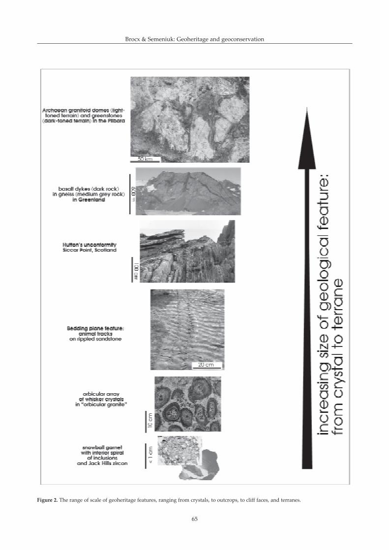
Scale is an important issue to consider in geoheritageand geoconservation, because sites of significance canrange in size from that encompassing landscapes andgeological phenomena at montane-scale, to that at thescale of a crystal. A review of the literature shows that inmany locations of the world, geological sites areimportant because of crystal-sized phenomena, andcrystal fabrics, because it is often at this scale that thestory of the Earth unfolds. For instance, the snowballgarnets of Vatterbotten, Sweden (Barker 1998), theorbicular structures of the Thorr Granodiorite of Donegal,Ireland (Pitcher 1993), or the zoned zircons from JackHills in Western Australia (Wilde et al. 2001) all tellimportant stories about the Earth: the rotation of garnetsand their spiralling incorporation of surrounding layeredmatrix under conditions of shear, or the concentricwhisker crystal growth under delicate conditions ofgrowth, diffusion and cooling, or the zoned zircons thatillustrate that the Earth was already solid 50 millionyears after its formation, respectively. Each of theselocations represents unique and classic examples of Earthhistory, yet the history is embedded at the crystal scale.
At the next scale in increasing size, importantgeological phenomena of geoheritage significance arerepresented by dinosaur footprints (Geological Survey ofWestern Australia 1975), fossil sites such as thePrecambrian Ediacara fauna in South Australia(Glaessner 1966), the Cambrian Burgess Shale fauna inCanada (Gould 1989), Hutton�s classic unconformity site(Hutton 1795, cited in Dean 1992), Lapworth�s mylonitesite (T A Semeniuk 2003), or egg carton folds inlaminated quartzite and marble (Hobbs et al. 1976).
Important geological and geomorphologicalphenomena continue to occur in increasing scale, rightup to the scale of mountain ranges and major drainagebasins.
In Australia, a large range of geological andgeomorphological features of geoheritage significance,and criteria for their selection are described anddiscussed by Joyce (1995), Grimes (1995), and Kiernan(1997), amongst others. In the context of scale discussedabove, these authors illustrate a wide variety ofgeological and geomorphological features of geoheritagesignificance, and from their examples it is clear that thereare sites of geoheritage significance that occur at variousscales.
The Australia Heritage Commission (1990) partlydealt with scale in geological/landform units by assigningthree levels, as follows: large scale (e.g., Central Plateauof Tasmania), medium scale (e.g., Lake George, or theGlasshouse Mountains), and small scale (e.g., HallettCove, Geikie Gorge, or Quincan Crater). Joyce (1995)presented these same scales of reference, but implicitlyadded a further smaller scale, that of an individual site,such as a road cutting.
Scale was more formally addressed in a series ofclassification papers on coastal and wetland landformsby Semeniuk and co-workers (Semeniuk 1986a; C ASemeniuk 1987; Semeniuk et al 1989). The landforms in
these works were described in frames of reference offixed sizes, using terms for frames of reference such asregional, large, medium, small, and fine (Semeniuk1986a; Semeniuk et al. 1989), or megascale, macroscale,mesoscale, microscale, and leptoscale (C A Semeniuk1987). These frames of reference (modified afterSemeniuk 1986a), can be used to describe sites ofgeoheritage significance (Table 2).
A selection of various scales of geological andgeomorphological phenomena is presented in Table 3,graded to illustrate the range of scales, and the variety ofphenomena that occur at these different scales that needto be addressed in assessing sites of geoheritagesignificance. The range of scale encompassed bygeoheritage is conceptually illustrated in Figure 2.
The matter of significanceSignificance in geoheritage and geoconservation is the
assigning of a value to a natural geological orgeomorphological feature. The Oxford Dictionary definesthe word significance as the quality of being worthy ofattention (Simpson & Weiner 1989).
While significance is noted in many works dealingwith geoconservation, the various levels of significance,i.e., international, national, State-wide, regional, to local,has not been adequately addressed or defined.Significance at international and national levelparticularly has not been adequately dealt with globally,in part probably as a result of a historical accidentrelating to what constitutes international and nationalwhere many European countries are national entities andyet fall within the scale of intra-national if viewed at acontinental scale i.e., if they were included within theState of Western Australia (see discussion later). Levelsof significance is a matter that needs to be addressed inclassification and site selection, and be incorporated intoany planning and management strategy so thatgeoconservation can be addressed in local and regional
Table 2Definition of the various scales of reference, with examples
Scale term Frame of reference Examples
Regional scale 100 km x 100 km mountain range scaleor larger or drainage basin
scale: DampierArchipelago complex
Large scale 10 km x 10 km large outcrop scale:limestone barrier atPort Hedland
Medium scale 1 km x 1 km small mesas andadjoining plain
Small scale 10�100 m x outcrop scale: such as10�100 m local cliff face
exposureFine scale 1 m x 1 m bedding scale: such as
fossils in a shelly lensVery fine scale 1 mm x 1 mm, crystal features
or smaller
65
Figure 2. The range of scale of geoheritage features, ranging from crystals, to outcrops, to cliff faces, and terranes.
Brocx & Semeniuk: Geoheritage and geoconservation
66
Journal of the Royal Society of Western Australia, 90(2), June 2007
issues, as well as the axiomatic protection of sites ofinternational and national importance.
The level of importance attributed to a given featureof geoheritage significance is related to one of twofactors: 1. how frequent, or common, is the feature withina scale of reference; and 2. how important is the featureintrinsically or culturally.
In the first instance, if a given geological feature iscommon at the local scale, and is similarly commoneverywhere throughout the region, and everywherethroughout the nation, and occurs generally everywherethroughout the globe, then that feature is not significantlocally, regionally, nationally or globally. Calcite crystalscementing dune sand are an example of such a feature,and their occurrence throughout an area, locally,regionally, nationally, and globally is not significant.Similarly, but on a larger scale, aeolian cross laminationin Pleistocene calcarenite, such as in the coastal zone of
the Swan Coastal Plain and the offshore limestoneislands, southwestern Australia (Fairbridge 1950;Semeniuk & Johnson 1985; Playford 1988) is anotherexample: this feature is common throughout many areas(McKee & Ward 1983), locally, regionally, nationally, andglobally, and hence is not significant. If, on the otherhand, a geological feature occurs once or infrequently atthe local scale, but occurs at that same frequency throughthe regional, and nationally, and globally, then it isfeature significant at the local scale. However, if ageological feature occurs once or a few times within anation (e.g., inland stromatolites occurring at LakeClifton, Lake Richmond, Lake Thetis, and some lakes inthe Eyre Peninsula in South Australia), then it is ofnational significance. And if a geological feature occursonly once, or a few times world-wide (the tidal flatstromatolites of Shark bay, and the zircon crystals of JackHills), then it is a feature of global significance. Thesenotions are summarised diagrammatically in Figure 3.
Table 3Examples of geological phenomena at different scales
Mountain range scale or drainage basin scale
The Grand Canyon (Holmes 1966), geomorphologically illustrating an entrenched river meander cutting down to a new base-level, pacing uplift of a plateau, and geologically illustrating unconformities, and a sequence from Precambrian into thePalaeozoic
Archaean craton structure, folded greenstones, and Proterozoic dykes in the Pilbara Craton (Hickman 1980; Griffin 1990),geologically illustrating a complex array of rounded intrusive granitoids rimmed by greenstones, and cross-cut by a variety ofyounger dykes
Linear dune fields from the Great sandy Desert (Veevers & Wells 1961), geomorphologically illustrating a complex variety ofdune forms in this desert from straight linear, to branched, to tuning fork
Large outcrop scale
Hutton�s unconformity, at Jedburgh (Hutton 1795, cited in Dean 1992), a classic location showing the cycle of deposition,induration, upheaval, planation, and further deposition in the Earth�s crust
Lapworth�s mylonite, along the Moine Thrust (Lapworth 1885; T A Semeniuk 2003), a classic location first used to illustrate themilling of rocks along a major fault
Interlayered black basalt dykes and granitic gneiss, East Greenland (in Myers 1997), the result of the initial rifting betweenNorth America and Europe
Bedding scale
Dinosaur footprints in the Broome Sandstone at Gantheaume Point near Broome (Geological Survey of Western Australia1975), illustrating dinosaurs ambulating across tidal flats in the Mesozoic
Precambrian Ediacara fauna from South Australia (Glaessner 1966), illustrating the oldest invertebrate fauna in the world
Cambrian fauna from the Burgess Shale in Canada (Gould 1989), illustrating a unique, complex and diverse fauna in Cambriantimes
Crystal scale
Snowball garnets of Vatterbotten, Sweden (Barker 1998), illustrating rotation under shear of crystals and their spirallingincorporation of surrounding layered matrix
Orbicular structures of the Thorr Granodiorite of Donegal, Ireland (Pitcher 1993) illustrating concentric whisker crystalformation under delicate conditions of growth, diffusion and cooling
Zircons from Jack Hills in Western Australia (Wilde et al. 2001), so far, the oldest crystals in the world, showing the Earth wasalready solid 50 million years after its formation
67
The examples in Figure 3A illustrate a range ofgeological features both at different levels of significanceand at various scales. The geological features used toillustrate examples of international significance are thelarge scale features of the Grand Canyon, El Capitan inthe Guadalupe Mountains, sinter mounds at Pamukkale,Turkey, an emerged salt dome in the Zagros Mountainsin Iran, and the Shark Bay coastal and marine system inWestern Australia, and a small scale feature, viz., aPrecambrian fossil (from the Ediacara fauna) from theRawnsley Quartzite in South Australia.
The Grand Canyon, a Global Heritage site, illustratesgeomorphic and stratigraphic features, as mentionedearlier in the text (Holmes 1966; Shelton 1966). El Capitanis a well exposed outcrop of Permian limestones that,within the Guadalupe Mountains in Texas, USA,illustrate a shelf margin carbonate complex withtransitions from shelf margin to restricted shallowsubtidal to supratidal shelf interior (King 1948; Matthews1984); it is part of the Guadalupe Mountains NationalPark, and was designated as a World Heritage site in1990 (Anon 1990b) in part on the basis of its geologicalfeatures. The sinter mound, in Turkey, at Pamukkale(Cotton Palace, so named because of the calcite deposits,deriving from hot springs, that form spectacularformations), is large deposit of calcite, with some 200 mrelief, formed from carbonate-enriched spring waters thathave precipitated and constructed an unusual minerallandscape (Dilsiz 2002). It was inscribed as a GlobalHeritage in 1988 (Anon 1988). The salt dome set in afolded belt in the Zagros Mountains, southwestern Iran,is part of a suite of features that occur in the tectonicallyactive region of the Middle East that include folding,faulting, thrusting, and diapirism. While salt domes areoccur sporadically around the world (e.g., the USA,Mexico, the North Sea, Germany, Romania, and theMiddle East), the dome in the Zagros Mountains isunusual in that it is a large scale example set in a regionthat hosts one of the most prolific fold-and-thrust belts inthe world, formed by the collision between the Eurasianand Arabian tectonic plates (Sherkati & Letouzey 2004;Letouzey et al. 1995). Also, elsewhere in the world, saltdomes result in anticlinal doming, but remain in thesubsurface. In the Zagros Mountains, the salt domeillustrated in Figure 3A is emergent amid a system ofanticlines and synclines. Shark Bay, in Western Australia(Logan & Cebulski 1970; Playford 1990), was placed onthe World Heritage list in 1991 because of its globallyunique marine and terrestrial environments, and itsgeology, geomorphology, and carbonate sedimentology.As mentioned earlier, it is one of the places in the worldthat satisfy all four natural criteria for listing. For SharkBay, evident in Figure 3A is the central NW-trendingPeron Peninsula, flanked to the east by a massivesubmarine seagrass-vegetated and constructed barrier(the Faure Sill), and to the southwest, portion of EdelLand, with its cliffed western shore cut into TamalaLimestone, and its digitate eastern shore composed ofmarine inundated limestone terrain of lithified parabolicdunes (Logan et al. 1970). The fossil locations preservingthe Precambrian Ediacara fauna illustrate features ofglobal significance at a bedding scale. The fossilillustrated in Figure 3A is Tribrachidium heraldicum, anunusual disk-shaped organism with triradial symmetry.Uluru, in the Northern Territory is a large inselberg (see
below) which has been inscribed as a World Heritage sitefor its natural history and cultural values. It is globally,and nationally unique, because of its size and shape,combined with its composition. It is considered to be thelargest inselberg in the world, and unlike many that areerosionally developed from cratons, and composed ofgranite and/or gneiss, Uluru is composed of verticallydipping bedded feldspathic sandstone.
Figure 3B illustrates the notion of national significanceby using inselbergs and intra-continental volcaniclandscapes erosionally derived from Cainozoicvolcanoes.
Inselbergs (also termed bornhardts, and by someauthors, monadnocks) are geomorphic features: theyisolated large hills, knobs, ridges, or small mountainsthat rise abruptly from a gently sloping or virtually levelsurrounding plain (Twidale 1968a; Bates & Jackson 1987).Inselbergs are relatively common, occurring in manyparts of the world, and Figure 3B illustrates theoccurrence of some well-documented and notable ones(though this map is only indicative and does not showtheir occurrences exhaustively). Inselbergs are underlainby granite, gneiss, sandstone, conglomerate, and avariety of other rock types, though uniformly weatheringhard rocks, such as granite and gneiss, preferentiallyform domed inselbergs. In this context, arid Australia,Western Australia, and South Australia host quite anumber of inselbergs (e.g., in Western Australia:Boorabbin National Park, Hyden, The Humps, MountAugustus; Twidale 2000, Twidale & Bourne 2004), oftencomposed of granite or gneiss, where softer overlyingsedimentary or saprolitic materials have been weatheredand eroded away to expose unweathered core of bedrock.In a series of papers, Twidale and colleagues havedescribed the morphology, origin, complexities, andsmall scale features of inselbergs, or bornhardts (Twidale1968a, 1968b, 1968c, 1986, 2000, Twidale & Campbell1984; Twidale & Bourne 2003a, 2003b, 2004; Twidale etal. 2002). Their research showed that the topographicforms are complex, with several structural domes, thatthe rock masses may be in compression along one axisand hence with differential water penetration andconsequences in weathering rates, that sheet fractures aretectonic features, and that the rock masses continue to bestressed so that neotectonic forms are still developing(Twidale & Bourne 2003a). Twidale et al. (op cit)explained much of the large scale to small scale featuresof inselbergs: from general overall morphology, toflaring, concavity, fluting, rilling, to A-tents, amongstothers. Their research results are important in a contextof geoconservation because they underscore the need toidentify and preserve, in what superficially appears as asimple landform, the wide range of processes andproducts that are associated with inselbergs in a varietyof lithologic, structural, chronologic, and climaticsettings.
Wave Rock, which is part of Hyden Rock, near Hydenin Western Australia (Twidale 1968c), and Murphy�sHaystacks on the Eyre Peninsula, South Australia(Twidale & Campbell 1984; Twidale 1986) are used toillustrate nationally significant landforms in that theyillustrate site-specific features of erosion of granite domesand development of smaller scale landforms andmorphology. Wave Rock illustrates a well developed
Brocx & Semeniuk: Geoheritage and geoconservation
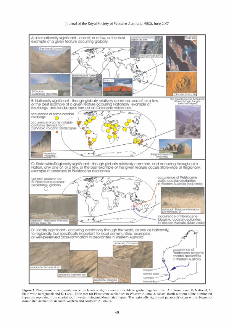
68
Journal of the Royal Society of Western Australia, 90(2), June 2007
Figure 3. Diagrammatic representation of the levels of significance applicable to geoheritage features. A: International; B: National; C:State-wide to regional; and D: Local. Note that for Pleistocene aeolianites in Western Australia, coastal north-western oolite-dominatedtypes are separated from coastal south-western biogenic-dominated types. The regionally significant palaeosols occur within biogenic-dominated aeolianites in south-western and southern Australia.
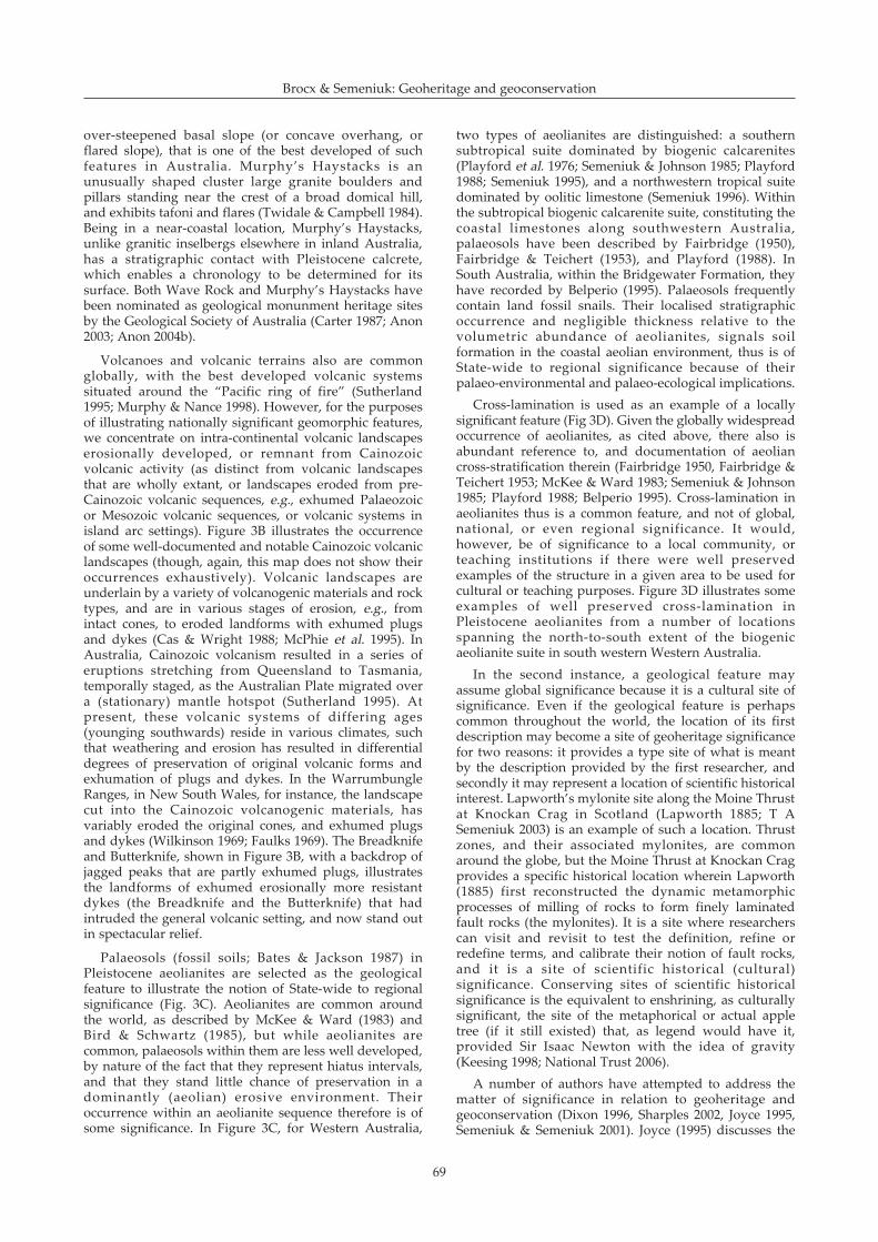
69
over-steepened basal slope (or concave overhang, orflared slope), that is one of the best developed of suchfeatures in Australia. Murphy�s Haystacks is anunusually shaped cluster large granite boulders andpillars standing near the crest of a broad domical hill,and exhibits tafoni and flares (Twidale & Campbell 1984).Being in a near-coastal location, Murphy�s Haystacks,unlike granitic inselbergs elsewhere in inland Australia,has a stratigraphic contact with Pleistocene calcrete,which enables a chronology to be determined for itssurface. Both Wave Rock and Murphy�s Haystacks havebeen nominated as geological monunment heritage sitesby the Geological Society of Australia (Carter 1987; Anon2003; Anon 2004b).
Volcanoes and volcanic terrains also are commonglobally, with the best developed volcanic systemssituated around the �Pacific ring of fire� (Sutherland1995; Murphy & Nance 1998). However, for the purposesof illustrating nationally significant geomorphic features,we concentrate on intra-continental volcanic landscapeserosionally developed, or remnant from Cainozoicvolcanic activity (as distinct from volcanic landscapesthat are wholly extant, or landscapes eroded from pre-Cainozoic volcanic sequences, e.g., exhumed Palaeozoicor Mesozoic volcanic sequences, or volcanic systems inisland arc settings). Figure 3B illustrates the occurrenceof some well-documented and notable Cainozoic volcaniclandscapes (though, again, this map does not show theiroccurrences exhaustively). Volcanic landscapes areunderlain by a variety of volcanogenic materials and rocktypes, and are in various stages of erosion, e.g., fromintact cones, to eroded landforms with exhumed plugsand dykes (Cas & Wright 1988; McPhie et al. 1995). InAustralia, Cainozoic volcanism resulted in a series oferuptions stretching from Queensland to Tasmania,temporally staged, as the Australian Plate migrated overa (stationary) mantle hotspot (Sutherland 1995). Atpresent, these volcanic systems of differing ages(younging southwards) reside in various climates, suchthat weathering and erosion has resulted in differentialdegrees of preservation of original volcanic forms andexhumation of plugs and dykes. In the WarrumbungleRanges, in New South Wales, for instance, the landscapecut into the Cainozoic volcanogenic materials, hasvariably eroded the original cones, and exhumed plugsand dykes (Wilkinson 1969; Faulks 1969). The Breadknifeand Butterknife, shown in Figure 3B, with a backdrop ofjagged peaks that are partly exhumed plugs, illustratesthe landforms of exhumed erosionally more resistantdykes (the Breadknife and the Butterknife) that hadintruded the general volcanic setting, and now stand outin spectacular relief.
Palaeosols (fossil soils; Bates & Jackson 1987) inPleistocene aeolianites are selected as the geologicalfeature to illustrate the notion of State-wide to regionalsignificance (Fig. 3C). Aeolianites are common aroundthe world, as described by McKee & Ward (1983) andBird & Schwartz (1985), but while aeolianites arecommon, palaeosols within them are less well developed,by nature of the fact that they represent hiatus intervals,and that they stand little chance of preservation in adominantly (aeolian) erosive environment. Theiroccurrence within an aeolianite sequence therefore is ofsome significance. In Figure 3C, for Western Australia,
two types of aeolianites are distinguished: a southernsubtropical suite dominated by biogenic calcarenites(Playford et al. 1976; Semeniuk & Johnson 1985; Playford1988; Semeniuk 1995), and a northwestern tropical suitedominated by oolitic limestone (Semeniuk 1996). Withinthe subtropical biogenic calcarenite suite, constituting thecoastal limestones along southwestern Australia,palaeosols have been described by Fairbridge (1950),Fairbridge & Teichert (1953), and Playford (1988). InSouth Australia, within the Bridgewater Formation, theyhave recorded by Belperio (1995). Palaeosols frequentlycontain land fossil snails. Their localised stratigraphicoccurrence and negligible thickness relative to thevolumetric abundance of aeolianites, signals soilformation in the coastal aeolian environment, thus is ofState-wide to regional significance because of theirpalaeo-environmental and palaeo-ecological implications.
Cross-lamination is used as an example of a locallysignificant feature (Fig 3D). Given the globally widespreadoccurrence of aeolianites, as cited above, there also isabundant reference to, and documentation of aeoliancross-stratification therein (Fairbridge 1950, Fairbridge &Teichert 1953; McKee & Ward 1983; Semeniuk & Johnson1985; Playford 1988; Belperio 1995). Cross-lamination inaeolianites thus is a common feature, and not of global,national, or even regional significance. It would,however, be of significance to a local community, orteaching institutions if there were well preservedexamples of the structure in a given area to be used forcultural or teaching purposes. Figure 3D illustrates someexamples of well preserved cross-lamination inPleistocene aeolianites from a number of locationsspanning the north-to-south extent of the biogenicaeolianite suite in south western Western Australia.
In the second instance, a geological feature mayassume global significance because it is a cultural site ofsignificance. Even if the geological feature is perhapscommon throughout the world, the location of its firstdescription may become a site of geoheritage significancefor two reasons: it provides a type site of what is meantby the description provided by the first researcher, andsecondly it may represent a location of scientific historicalinterest. Lapworth�s mylonite site along the Moine Thrustat Knockan Crag in Scotland (Lapworth 1885; T ASemeniuk 2003) is an example of such a location. Thrustzones, and their associated mylonites, are commonaround the globe, but the Moine Thrust at Knockan Cragprovides a specific historical location wherein Lapworth(1885) first reconstructed the dynamic metamorphicprocesses of milling of rocks to form finely laminatedfault rocks (the mylonites). It is a site where researcherscan visit and revisit to test the definition, refine orredefine terms, and calibrate their notion of fault rocks,and it is a site of scientific historical (cultural)significance. Conserving sites of scientific historicalsignificance is the equivalent to enshrining, as culturallysignificant, the site of the metaphorical or actual appletree (if it still existed) that, as legend would have it,provided Sir Isaac Newton with the idea of gravity(Keesing 1998; National Trust 2006).
A number of authors have attempted to address thematter of significance in relation to geoheritage andgeoconservation (Dixon 1996, Sharples 2002, Joyce 1995,Semeniuk & Semeniuk 2001). Joyce (1995) discusses the
Brocx & Semeniuk: Geoheritage and geoconservation
70
Journal of the Royal Society of Western Australia, 90(2), June 2007
use of the term significance in assessing geologicalheritage. Dictionary definitions are provided for theinter-related terms significance, outstanding, andrepresentative, significance for instance being the�meaning or import of something, importance,consequence�. Joyce (1995) suggests that sites ofgeoheritage significance can lie on a scale between highlysignificant to of little or no significance. However, Joyce(1995) does not provide examples of what is consideredas significant in geoconservation, and there is no gradingof significant.
The Australian Heritage Commission (1990), similarly,set out criteria to assess sites that are significant enoughto be placed on the Register of the National Estate, butthere are several deficiencies: for instance, there is noexplanation of what is considered to be significant (i.e.,the criteria are broadly worded, and there is no yardstickor comparative measure with wording such as �thegeological site must be a unique feature in Australia to beconsidered as highly significant� to enable readers topositively identify sites of significance); there are nocomparative examples of significance, nor grading ofsignificance from �highly significant� to moderatelysignificant� to �of low significance�, and no referencebase to review and compare the attributes of sites alreadyin the conservation estate with sites to be added or insome cases replaced with better examples. Later, theAustralian Heritage Commission (Cairnes 1998) dealtwith significance, identifying it as the process ofassessing the importance of a site. The AustralianHeritage Commission (1990) identified types of heritagesignificance (viz., natural, indigenous, and historiccultural), providing criteria of significance (e.g., culturalphases and the evolution of ecosystems; rarity; research,teaching; representativeness; amongst others, as found inthe Australian Heritage Commission Act 1975) which canbe individually graded 1�10, and outlining how�statements of significance� could be prepared.
Kiernan (1990) discussed use of the term significancein relationship to geomorphology, proposing thatsignificance be addressed from a number of perspectives:why is a landform significant? to whom is it significant?at what scale is it significant? and is its significance likelyto be temporary or permanent? Kiernan (1990) suggeststhat two principal approaches can be taken with regardto significance: either landforms are outstandingexamples, or representative examples. However, Kiernan(1990) also emphasises that while it is important toprotect outstanding examples of particular landforms, itis likely to result in neglect of the more common types,which in time also will become rare.
From the literature it is clear that while many authorsidentify significance as a factor in assessment (e.g., Joyce& King 1980; Davey & White 1986; Dixon & Pemberton1991; Joyce 1995; Sharples 2002; and the AustralianHeritage Commission 1990, 1998), and some set upcriteria to assess whether a geological or ageomorphological site is significant, the approach in theearly phases taken by these authors appears to be one ofan of �either/or� situation, i.e., either a given site qualifiesto be significant or it doesn�t. Later, when the termsignificance was more rigorously explored (Kiernan 1990;Australian Heritage Commission 1998; Sharples 2002),criteria for grading and allocation of levels of significance
still were not defined. The assessment of significanceremained a subjective process.
Semeniuk (1986b) and Semeniuk & Semeniuk (1987,2001) directly addressed the issue of significance in theirwork on the conservation of mangrove coasts, inlandwetlands, and sites of geoheritage importance on theSwan Coastal Plain, respectively, by developing apractical tool in providing scales of significance andcriteria for their recognition. Their work, in principle, isapplicable to assessing sites of geoheritage significancein general, and in providing grades of �significance�.Significance can be ranked according to levels or degrees.Amalgamating these works (op cit.,), we recognise 5levels of significance:
International,National,State-wide,Regional, andLocal.
Sharples (2002), summarising work by Rosengren(1984) and others, has presented a similar grading, butadded a category of unknown significance whereinsufficient information is available to make anassessment.
While the levels of significance listed above have beenused globally, nationally in Australia, and withinWestern Australia, there generally is not a definition ofthese terms, except by the Semeniuk and Sharplesreferences cited above. An expansion of the definition ofthese terms, based on Semeniuk (1986b), Semeniuk &Semeniuk (1987, 1991, 2001), Sharples (2002) and Hogan& Thorsell (2005), with examples of natural featuresglobally, nationally and within Western Australia(Geological Survey of Western Australia 1975; AustralianHeritage Commission 2005, UNESCO 2002, according tothese levels of significance are presented in Table 4.
In the context of the levels of significance discussedabove, we return to Figure 1 to provide a measure ofassessment of the geoheritage significance of thesefeatures.
Cape Range is a large scale geological and geomorphicfeature of international significance (Fig. 1A). Itillustrates a coastal landscape developed by Cainozoictectonism (generating a barrier-and-gulf coastal formalong the interface between the Carnarvon Basin and thecoastal plain of the Pilbara Coast; Semeniuk 1993), withsubsequent drainage superimposed on a limestoneterrain. It also illustrates terracing due to progressiveuplift of various Pleistocene marine sediments and coralreefs (van de Graaff et al. 1976). And it contains a karstsystem that is a habitat to stygofauna. Its geologicalcharacteristics have been recognised as contributing to itsvalues as a National Park (Conservation & LandManagement 2005). Recently, it was proposed as part ofa World Heritage listing by the Department ofEnvironment & Conservation (World HeritageConsultative Committee 2004).
The linear dune field in the Great Sandy Desert(Veevers & Wells 1961) is a desert geomorphic feature ofaeolian landforms (Fig. 1B). They are the dominant lineardune field in the State. From a national perspective,linear dunes are present through Australia (King 1956;
71
Jennings 1968), and in terms of continuous extent of areacovered, and clarity of development, the dunes in theGreat Sandy Desert comprise some one third of the bestdeveloped, and beast preserved linear dune fieldsAustralia-wide. The linear dunes in the Great SandyDesert, however, carry an addition significant feature �they reside in a modern basin (the Canning Basin), andtheir seaward extremities interface and stratigraphicallyinteract with sediments of the coastal zone, as describedby Jennings (1975) and Semeniuk (1982). Additionally,the dune field of the Great Sandy Desert fall into thecategory of broad crested linear dunes (Wasson et al.1988), and comprise one of the two major concentrationsof such dunes in Australia, the other being in theNorthern Territory (see figure 5 of Wasson et al. 1988).These aspects render them as geomorphic features ofState-wide significance.
The recurved spit of small shells (the HamelinCoquina; Logan et al. 1970) illustrates a coastalgeomorphic and stratigraphic feature of globalsignificance (Fig. 1C). Shell accumulations peripheral tohypersaline basins are unusual globally, and progradedcoastal plains formed by such shell accumulations shellare equally unusual. As part of the Shark Bay WorldHeritage site, the lithologic, stratigraphic, and diagenetic
history of the Hamelin Coquina (Logan 1974) itself servesas a globally unique and significant classroom insedimentology, stratigraphy and diagenesis.
The buttes in the north-western Pilbara, illustrategeomorphic and geologic features (Fig. 1D). The buttesare developed from the hard capping of Mesozoicsedimentary rock that unconformably rests onPrecambrian granite, effectively highlighting thestratigraphic interface between sedimentary deposits ofthe Canning Basin and the Precambrian rocks of thePilbara Craton. This unconformity is located circa 30 mabove sealevel, and the ensemble of geological andgeomorphic features renders these buttes as of State-widesignificance.
The Pinnacles at Cervantes illustrate a geological andgeomorphic feature of National significance (Fig. 1E).While limestone, calcreted pipes, and yellow sand coverare common along the coastal fringe of south-westernAustralia, the occurrence of exhumed calcreted pipes toform an extensive pinnacle landscape is unique in WesternAustralia. Further, the landscape is not developed alongthe eastern board of Australia, and also not developed inSouth Australia, where age-equivalent and lithologicallyequivalent coastal limestones occur. This makes thepinnacles a feature of national significance.
Table 4Definitions and examples of levels of significance for sites of geoheritage significance1 (note that the size of these features of geoheritagesignificance ranges from the very large scale (e.g. The Everglades) to crystals (Jack Hills zircons)
Significance Definition Examples Rationale
International only one, or a few, or the best 1. Everglades, Florida, USA; Globally uniqueexample of a given feature occurring 2. carbonate deposits, Roebuck Bay, WA systems orglobally, hence it is globally unique, 3. sinter and springs, Pamukkale, Turkey geological featuresrare, or uncommon; or performs a 4. tidal flat columnar stromatolites, Shark Bay; WAfunction in a global network 5. Jack Hills zircons, WA
National while it may be present elsewhere 1. Permian/Precambrian unconformity, Halletts unique systems orglobally, only one, or a few, or the Cove, SA geological features withinbest example of a given feature 2. volcanic landforms, Warrumbungle Ranges, a given Nation, oroccurring nationally; hence it is NSW performs a function in aNationally unique, rare, or 3. Murphy�s Haystacks, Eyre Peninsula, SA National networkuncommon; or performs a function 4. Wave Rock, near Hyden, WAin a National network 5. the Pinnacles at Cervantes, WA
State-wide while it may be present elsewhere 1. karst features in southern Western Australia unique systems orglobally or nationally, only one, or a 2. Leschenault Peninsula barrier dunes, WA geological features withinfew, or the best example of a given 3. the buttes in the NW Pilbara region, WA the Statefeature occurring State-wide; hence in 4. Pleistocene rocky shore stratigraphy exposedthe State it is rare, or uncommon; or in limestone cliffs along the Perth coast, WAperforms a function in a sub-national 5. orbicular granite, Mount Magnet, WAnetwork
Regional while occurring elsewhere globally, 1. Lake Gnangara on the Swan Coastal Plain, WA important systems ornationally, or State-wide, only one, or 2. conglomerate outcrop at Nannup, WA geological features in thea few, or the best example of a given 3. Bunbury Basalt outcrop at Bunbury, WA Region, and for thefeature occurring in the Region; 4. mesa formations, southwestern Pilbara coastal limestone,hence it is uncommon or rare in the region, WA exposure of atypicalRegion; or performs a function in a 5. specular haematite crystals, Koolyanobbing, stratigraphyregional network WA
Local the natural history feature is important limestone cliffs along the Perth coast, important to the localonly to the local community illustrating well-formed cross-lamination in community and schools
the limestone
1 This list is not to imply that the full range of features noted/listed here have been formally recognised as significant. We provide thislist, that derives from application of the criteria developed in this paper, as examples of the level of significance that we considershould be attached to the nominated feature.
Brocx & Semeniuk: Geoheritage and geoconservation
72
Journal of the Royal Society of Western Australia, 90(2), June 2007
The folded laminated ironstone and chert, developedalong a decollement in the rocks of the Brockman IronFormation in Hamersley Gorge, Karijini, in the Pilbararegion is a feature of regional significance (Fig. 1F). It is awell exposed example of such a fold, and is useful tostructural geologists to assist in reconstructing thetectonic history of the Hamersley Group. The exposure inthe gorge also provides access to contacts, whereasoutcrops of such decollements and their associated foldsare not so well exposed throughout the region.
Similarly, the outcrop of Bunbury Basalt at Bunbury(Fig. 1G) provides exposure of a valley fill of thisCretaceous basalt, where normally it remains largelyburied under the Leederville Formation (Playford et al.1976). While there are more extensive and larger outcropsof this basalt along the southern coast of WesternAustralia, the outcrop along the coast at Bunburyillustrates the narrow outcrop of a valley form bodyextending to the northwest. In terms of geomorphology,the outcrop of the basalt at Bunbury is low in elevationrelative to sealevel, and shows coastal geomorphicfeatures of basalt subject to coastal erosion andweathering resulting in shore platforms and specificmicrotopography. The outcrop at Bunbury is also thetype location of the formation, and as such is a site ofgeoheritage significance.
The folded metamorphic rock, in the Owingup area,illustrates isoclinally folded gneissic amphibolite (Fig.1H). As a structural and metamorphic feature it is locallysignificant in that it a well developed example of thistype of folding and rock type exposed along the coast bymarine erosion and marine weathering, and it can assiststructural geologists in reconstruction metamorphic andstructural history along the south coast of WesternAustralia.
The scale at which a given geological feature isassessed as significant should not imply that all featuresat that site at other scales of reference are of equalimportance. For instance, the landforms in the Jack Hillsarea are not of international, national, or State-widesignificance, but the zircon crystals therein areinternationally significant. Conversely, the inselberg atUluru and the fact that this large landform is composedof vertically dipping feldspathic sandstone is ofinternational significance, but the individual feldspargrains comprising the sandstone are not significant, asfeldspathic sandstone is common globally, nationally andState-wide.
Discussion and ConclusionsThe main conclusions of this paper in relation to the
scope of geoheritage, in terms of its conceptualcategories, the scale of geological features that need todiscussed, and the levels of significance of terranes, cliffs,outcrops and crystals that need to be applied aresummarised in Figure 4. The four categories of sites ofgeoheritage significance are very different in their scope.The first involves type examples, or reference sites orlocations, and these were some of the first recorded andpreserved sites of geoheritage significance, andaddressed type stratigraphic and soil locations, typefossil locations, and geomorphic locations as standards
for Earth scientists for research and education. Culturallysignificant sites were those where geological principleswere first explored and explained � Hutton�sunconformity site is a typical and classic example.Geohistorical sites are those where former Earthprocesses and Earth history can be inferred andreconstructed from outcrops such as cliffs � the GrandCanyon serves as an example of this category in that itexhibits a classic stratigraphic sequence andgeomorphology to enable reconstruction of Earth history.The last category relates to modern landscapes whereactives processes are operating � these provideinformation about extant Earth processes per se, and alsoare useful for interpreting ancient sequences.
The scale of a site of geoheritage significanceillustrated in Figure 4 intends to convey the notion thatthe importance of a geological feature may be at theterrane scale (in this diagrammatic example, we use alarge scale igneous intrusion, and its metamorphicaureole as the principle of a large scale feature), but canrange down to the cliff, bedding or rock scale, andultimately to the crystal aggregate and individual crystal.These matters are important because we consider thatthe full gamut of scale in geoconservation, to date, hasnot been systematically addressed, as in many geologicalreconstructions of Earth history the analysis may beginat the crystal scale (cf. Logan 1974; Hobbs et al 1976;Barker 1998), but also can encompass larger frames ofreference (using structural and metamorphic examplesfor the concept of the employment of increasing scale, seeTurner & Weiss 1963, Hobbs et al 1976; Wilson 1982;Nicholas 1987; Davis & Reynolds 1996; and Barker 1998).
Finally, regardless of the size of the geologicalphenomenon being considered, be it terrane-scale,outcrop or bed scale, or crystal scale, the significance ofthe geological feature whether it is international,national, State/regional, or local in importance needsrigorous criteria for assessment. This aspect appliesequally to features of geology such as igneous,metamorphic, sedimentary, or structural terranes andtheir crystals, as well as to geomorphic features such asdistinct mountain ranges, smaller scale mesas and buttes,down to variable microtopographic features on, say, asalt-weathered rocky shores cut into specific rock types.
The remainder of this discussion is broadly framedaround three aspects: 1. why the arena ofgeoconservation should be expanded to include allaspects of Geology, 2. the story of geology that WesternAustralia has to tell, and 3. how the concepts, terms andyardsticks of measurement presented in this paper areapplicable to existing conventions and agreements towhich Australia is a signatory.
In the first instance, given the lack of conservation-oriented geologists in government agencies and non-government bodies, one of the main thrusts of this paperwas to raise the scientific consciousness as to what isformally encompassed by the notion of Geology for thosepractitioners of natural systems conservation who areoutside the field of geology, and also to raise theconsciousness of Western Australian scientists, plannersand land managers to matters dealing with geoheritageand geoconservation.
While the full discipline of what constitutes geology is
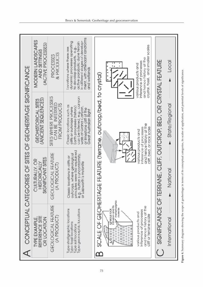
73
Figure4.Su
mmarydiagram
show
ingthescop
eof
geoh
erita
gein
term
sof
itsconcep
tualcatego
ries,itsscales
ofap
plication,
andpo
tentiallevelsof
sign
ificance.
Brocx & Semeniuk: Geoheritage and geoconservation
74
Journal of the Royal Society of Western Australia, 90(2), June 2007
clearly spelt out in texts and dictionaries, the gamut ofthis discipline had not been fully addressed ingeoconservation. Further, geoconservation shouldaddress all scales of geology, from the mountain to thecrystal. This also is a matter that had not been fullyaddressed in current geoconservation.
The United Kingdom and Europe have many globallyunique locations and sites that classically portray thehistory of the Earth, locations where concepts of Earthprocesses and products were first described, and sitesthat are part of our Western Philosophy and ScientificHistory (and as such, essentially are outdoor Museumsof cultural and scientific history). However, WesternAustralia itself has its own geological story to tell (Brocx2007). It offers remarkable, unique, and differentgeological and geomorphological features of globalimportance � the Shark Bay stromatolites, the Jack Hillszircon crystals, the mound springs of the Great SandyDesert, amongst many others. In many locations,Australia has provided global examples of geologicalfeatures (e.g., the Ediacara fauna in South Australia), orglobal type sections illustrating geological phenomena(e.g., the limestone rocky shores of Point Peron atRockingham, is the classic site where Fairbridge 1950developed the standard eustatic sea-level curve for anoscillating post-glacial rising sea). A range of features ofgeoheritage significance in Western Australia are shownin Figure 3. For this reason, Western Australia can offersites of special significance to the global network ofgeoconservation.
In keeping with global objectives for geoconservation,and in order to comply with Australia�s internationalresponsibilities under the World Heritage Convention(Appendix 1), and other international agreementsinvolving the idea of environmentally sustainabledevelopment and the precautionary principle, ainventory-based systematic classification of the State�sgeoheritage is required. Some of this has beenundertaken by Carter (1987) and Lemmon et al (1979),and others, but it has not been a State Governmentendeavour, and the results of Carter (1987) and Lemmonet al (1979) have not been formally adopted by the State�sconservation agencies. In order to meet the objectives ofgeoconservation, clearly defined policies with a whole-of-government approach is required with public policiesthat define the role of each government agency inconserving sites of geoheritage. In addition, clearlydefined public policies are required to define the role ofgovernment in balancing resource development withconservation. In this context, this paper providesdefinitions, terms, approaches of scale, and approachesof significance to more rigorously achieve theseobjectives.
It is important to note that State Agreements with theCommonwealth provide the legislative framework forgeoconservation at the national to local level with intergovernment and interdisciplinary approaches (Beeton etal. 2006; Johnston 2006). It is important also to note thatembedded in them are the principles involvinginventory-based classifications. Overseas, similaragreements have used an inventory based classificationsystem to stock-take sites of geoheritage significance forthe appropriate level of conservation and management.As such there is a basis to apply the same principles and
methods in Western Australia. This approach has beenused successfully for the protection of biodiversity andwetlands, for example, and is the basis forrecommendations and nominations for sites ofgeoheritage significance. However, Australia, andparticularly Western Australia, still lag behind in thesystematic methodology and inventory-based assessmentbeing undertaken as a unified international approach togeoconservation in the United Kingdom and Europe(Brocx 2007).
Geoconservation will only progress forward witheducation, the formation of community interest groups,and a sea change in the misperception thatgeoconservation leads to a loss of employment forgeologists and loss of revenue to the State. From theliterature it is apparent that educational initiatives ingeoconservation are fundamental to raising theconsciousness to the importance of geoheritage. Typicalgeoconservation programs include both public, andprimary, secondary and tertiary education initiatives inschools, museums, and higher education institutions. Inaddition, geoparks are an established alternative toresource exploitation in their use for education, economicand social benefits. This is because geological phenomenaare basic components of the natural environment andtherefore contribute strongly to the development ofsociety. The primary reference-points for geologicaltheory have been, and always will be, the landscape, therocks themselves and their weathering products.Accessible sites in good condition are essential for thetraining of geologists and students that need to accesssome aspects of geology. Such sites represent valued andirreplaceable standards, which should be protectedagainst the pressures of urban, industrial and ruraldevelopment� (Lemmon et al 1979). The importance ofenvironmental education in the global context issummarized in the 1997 UNESCO Statement titled �Educating for a Sustainable Future: A transdisciplinaryvision for concerted action (Anon 1999b).
In Western Australia, the main task of geologicaleducation of the public rests with the Western AustralianMuseum, who have assembled an important andimpressive publicly viewable collection of minerals,rocks, meteorites, and fossils (in a display termed �Fromdiamonds to dinosaurs�), and periodically inform thepublic of interesting features of geological interest (e.g.,stromatolites, the Pinnacles, meteorite craters, amongstothers: Bevan 1992; Bevan & McNamara 1993; Bevan &Downes 2000; McNamara 1997, 2002). In this context, itis also worthy to note the attempt in the 1990s by theNational Trust of Western Australia to introducegeoheritage into the secondary school educationcurriculum failed. Nonetheless, education of students,politicians, decision-makers, and the public on mattersgeological, to bring them to an appreciation of therichness of our geological heritage remains as animportant objective for future geoconservation.
Aside from discussing the evolution and use ofdefinitions used in geoconservation, and outlining thehistorical development of geoheritage andgeoconservation, our main objectives in this paper wereto define geoheritage captured under the umbrella ofgeology (Table 1) as a basis to identifying sites ofgeoheritage, conceptualise the various categories of what
75
constitutes geoheritage (Fig. 4), deal with the issue ofscale in identifying sites of geoheritage significance (Fig.2), and more rigorously define levels of significance thatmight be applied to assessing sites of geoheritagesignificance (Fig. 3). We consider that these outcomes areessential foundations to designing classification andassessment systems to identify sites of geoheritagesignificance in Western Australia, as a prelude tocompiling an inventory of sites of significance as a basisfor more systematic geoconservation.
Acknowledgements: The photographs in Figure 2 of the snowball garnet,the Jack Hills zircon, the cliff face in Greenland, and Hutton�sunconformity at Siccar Point were provided by Simon Wilde; that of theeurypterid tracks in the Tumblagooda Sandstone was provided by KenMcNamara. The photograph in Figure 3 of the El Capitan Reef wasprovided by Phillip Stoffer; that of the Grand Canyon was supplied byLucien van Linden; that of the sinter mound in Pamukkale in Turkey wasprovided by Peter Kaiser; that of Wave Rock was provided by DanielHaller; and the satellite image of the salt dome in the Zagros Mountainsin Iran is courtesy of Image Science & Analysis Laboratory, NASAJohnson Space Centre. The images of Cape Range in Figure 1 and ofShark Bay in Figure 3 are courtesy of the Department of Land, WesternAustralia. All these photographic contributions are gratefullyacknowledged. This paper made use of R&D work undertaken by the V& C Semeniuk Research Group, registered as VCSRG Project #12 withAusIndustry, the Commonwealth R&D agency. Costs towards thispublication, coloured plates and page charges were met by VCSRG P/Land a research grant from Murdoch University. This contribution also isgratefully acknowledged.
ReferencesAlexander I 1988 Western Australia: the resource State.
Australian Geographer. In: D C Rich & Young R W (eds),Environment and development in Australia � SixtiethAnniversary Issue of the Australian Geography, AustralianGeographer 19: 117�130.
Anon 1988 Convention concerning the protection of the Worldcultural and natural heritage � Report of the World HeritageCommittee, Twelfth Session. UNESCO, Gland Switzerland.
Anon 1990a Earth Science Conservation in Great Britain: Astrategy. Nature Conservancy Council, Peterborough, UK.
Anon 1990b World Heritage � Guadalupe Mountains NationalPark. UNESCO World Heritage Centre, Gland Switzerland.
Anon 1991 First International Symposium on the Conservationof our Geological Heritage, Digne, France, 11�16 June 1991:Terra Abstracts Supplement 2 to Terra Nova Volume 3, 1991,17 .
Anon 1999a National Estate identification and assessment in thenorth east region of Victoria. Report by the JointCommonwealth and Victorian Regional Forest AgreementSteering Committee to Environment Australia, Canberra,ACT.
Anon 1999b Today Shapes Tomorrow. Canberra: EnvironmentAustralia Department of the Environment and Heritage.Canberra, ACT.
Anon 2000 Identification, assessment and protection of NationalEstate values. A Report by Environment Australia for theNSW Regional Forest Agreement Steering Committee as partof the NSW Comprehensive Regional Assessments,Canberra, ACT.
Anon 2003 Heritage� State of the Environment report for SouthAustralia 2003. South Australian State Government,Adelaide, SA
Anon 2004a State of the Environment Report 2003�2004.Department of the Environment and Heritage, Canberra,ACT.
Anon 2004b Regional Natural Resource Management Plan 2004�2007. Eyre Peninsula Regional Natural ResourceManagement, Port Lincoln, South Australia.
Anon 2006 Walpole Wilderness Area adjacent Parks andReserves Draft Management Plan. Department ofEnvironment, and Conservation Commission of WesternAustralia. Perth, WA.
Australian Academy of Science 1968 National Parks andReserves in Australia. Report No. 9 Australian Academy ofScience, Canberra, ACT.
Australian Heritage Commission 1975 Australian HeritageCommission Act 1975, Commonwealth of Australia,Canberra, ACT.
Australian Heritage Commission 1978 Wolfe Creek Crater,Koongee Park � Alice Springs Rd, Halls Creek, WA. Registerof the National Estate, Australian Heritage Commission,Canberra, ACT.
Australian Heritage Commission 1990 Future Directions inAssessing National Estate Significance. Australian HeritageCommission, Canberra ACT.
Australian Heritage Commission 1996 Australian NaturalHeritage Charter for conservation of places of naturalheritage significance. Published by the Australian Committeefor the International Union for the Conservation of Nature(ACIUCN), Australian Heritage Commission, Canberra,ACT.
Australian Heritage Commission 1997 Standards and Principlesfor the Conservation of Natural Heritage � The BurraCharters Companion for Natural Heritage. AustralianHeritage Commission, Canberra, ACT.
Australian Heritage Commission 1998 Natural Heritage PlacesHandbook. Applying the Australian Natural HeritageCharter to Conserve places of Natural Heritage Significance:Australian Heritage Commission, Canberra, ACT.
Australian Heritage Commission 2003 Protecting NaturalHeritage: using the Australian Natural Heritage Charter, 2ndEdition, Australian Heritage Commission, Canberra, ACT.
Australian Heritage Commission 2005 Heritage Strategy � Astrategy for managing places owned or controlled by theDepartment to protect and conserve their CommonwealthHeritage values. Department of the Environment andHeritage December, Canberra, ACT.
Barker A J 1998 Introduction to metamorphic textures andmicrostructures. Stanley Thornes, Cheltenham, UnitedKingdom.
Bates L & Jackson J A (eds) 1987 Glossary of Geology. AmericanGeological Institute, Alexandria, Virginia.
Belperio A P 1995 Chapter 11� Quaternary. In: J F Drexel & W VPreiss (eds), The geology of South Australia Volume 2 � thePhanerozoic. South Australia Geological Survey Bulletin 54:219�280.
Beeton R J S, Buckley K I, Jones G J, Morgan D, Reichelt R E,Trewin D 2006 Australian State of the EnvironmentCommittee Independent Report to the AustralianGovernment Minister for the Environment and Heritage.Australian State of the Environment 2006. AustralianGovernment Department of the Environment and WaterResources, Canberra, ACT.
Bevan A 1992 Fashioning the stone minerals: Myths, Magic andScience. Western Australian Museum, Perth.
Bevan A & McNamara K 1993 Australia�s Meteorite Craters.Western Australian Museum, Perth.
Bevan AW R & Downes P J 2000 Mineralogy at the WesternAustralian Museum. Australian Journal of Mineralogy 6: 93�100.
Bird E C & Schwartz M L (eds) 1985 The World�s coastline. VanNostrand Reinhold, New York, USA.
Blandin P 1992 La nature en Europe. Bordas, Paris.Bradbury J 1993 A Preliminary Geoheritage Inventory of the
Eastern Tasmania Terrane. A Report to Parks and WildlifeService, Tasmania.
Brilha H 2002 Geoconservation and protected areas.Environmental Conservation 29(3): 273�276
Brocx & Semeniuk: Geoheritage and geoconservation
76
Journal of the Royal Society of Western Australia, 90(2), June 2007
Brocx M 2007 Geoheritage � from global perspectives to localprinciples for conservation and planning. Western AustralianMuseum, Perth (in press).
Brocx M & Semeniuk V 2007 Geodiversity and biodiversity.(unpublished MS)
Busby III A B, Conrads R, Willis P & Roots D 2001 AnAustralian Geographic Guide to Fossils & Rocks: AustralianGeographic NSW.
Cairnes L 1998 The Natural Heritage Places Handbook:Applying the Australian Natural Heritage Charter toConserve Places of Natural Significance. Canberra ACT:Australian Heritage Commission.
Carter J D 1987 Important geological localities beyond the Perthregion: their significance and value, protection andpreservation. Geological Society of Australia Inc., WesternAustralian Division.
Cas R A F & Wright J V 1988 Volcanic successions � modernand ancient. Chapman & Hall, London.
Cavosie A J, Wilde A S, Liu D, Weiblen P W & Valley J W 2004Internal zoning and U-Th-Pb chemistry of Jack Hills detritalzircons: a mineral record of early Achaean toMesoproterozoic (4348�1576 Ma) magmatism. PrecambrianResearch 135: 251�279.
Cochrane R M & Joyce E B 1986 Geological Features of Nationaland International Significance in Australia. A reportprepared for the Australian Heritage Commission, May,1986. Federal Committee for Geological Monuments,Geological Society of Australia Inc.
Collins P L 1991 Mineral exploration in an environmentallyconscious society: Introduction. In: Mineral exploration in anenvironmentally conscious society. Papers presented at aJoint GSA-AIG Seminar Perth, August 1991. AustralianInstitute of Geoscientists Bulletin 11: 1�2.
Conservation & Land Management 2005 Cape Range NationalPark � Draft Management Plan 2005. Department ofConservation & Land Management, Bentley, WA.
Conservation Through Reserves Committee 1974 ConservationReserves in Western Australia. Report of the ConservationThrough Reserves Committee to the EnvironmentalProtection Authority 1974, Perth, WA.
Conservation Through Reserves Committee 1977 ConservationReserves in Western Australia. Report of the ConservationThrough Reserves Committee on System 7 to theEnvironmental Protection Authority 1977, Perth, WA.
Cook A G, Hocknull S, Trubody B, Jell P, Molnar A & Roberts T1998 Geoheritage sites within the Southeastern QueenslandCRA. A report for the Joint Commonwealth QueenslandCRA/RFA Steering Committee, Queensland Museum,Brisbane.
Cooper B J & Branagan D F (eds) 1994 Rock me hard� Rock mesoft� a history of the Geological Society of Australia Inc.Published by Geological Society of Australia Inc., Sydney,NSW.
Creaser P P 1994 An international earth sciences conventionframework for the future. The Australian Geologist 90: 45�46.
Davey A G & White S 1984 Victorian Caves and Karst:Strategies for Management and Cataloguing. A report to theCaves Classification Committee, Department ofConservation, Forests and Lands, Victoria.
Davey A G & White S 1986 Management of Victorian caves andkarst. Applied Natural Resource Management.
Davis B W 1992 Federal-State tensions in Australianenvironmental management: the World Heritage issue. In: KJ Walker (ed), Australian Environmental Policy � ten casestudies. New South Wales University Press Ltd, Kensington,NSW, p 215�232.
Davis G H & Reynolds S J 1996 Structural geology of rocks andregions (2nd Edition). John Wiley & Sons, New York.
Dean D R 1992 James Hutton and the History of Geology.Cornell University Press, London, UK.
Department of Environment & Heritage 1997 Heads ofAgreement on Commonwealth and State roles andresponsibilities for the Environment. Council of AustralianGovernments November attachment 1. Canberra, ACT
Department of Environment & Heritage 2004. Interim listing ofthe Register of the National Estate. Department ofEnvironment & Heritage, Canberra, ACT
Dingwall P, Weighell T & Badman T 2005 Geological WorldHeritage: A Global Framework. A Contribution to the GlobalTheme Study of World Heritage Natural Sites. IUCN TheWorld Conservation Union, Gland, Switzerland.
Dilsiz C 2002 Environmental issues concerning naturalresources at Pamukkale protected site, southwest Turkey.Environmental Geology 41: 776�784.
Dixon G 1996 Geoconservation: An International Review andStrategy for Tasmania A report to the Parks and WildlifeService, Tasmania and the Australian Heritage Commission.
Dixon G & Pemberton M 1991 Earth science conservation � It�stime. Paper read at 5th Regional Seminar on National Parks& Wildlife Management in Australia, Hobart, Tasmania.
Dixon G, Houshold I & Pemberton M 1997 Geoconservation inTasmania �Wizards of Oz! Earth Heritage 8: 14�15.
Doyle P, Easterbrook G, Reid E, Skipsey E, & Wilson C 1994Earth Heritage Conservation. London, The GeologicalSociety in association with Open University, City Print(Milton Keynes) Ltd, United Kingdom.
Drexel J F, Preiss W V & Parker A J 1993 The geology of SouthAustralia. Volume 1: The Precambrian. Geological Survey ofSouth Australia Bulletin 54.
Duff K 1994 Natural Areas: an holistic approach to conservationbased on geology. In: D O�Halloran, C Green, M Harley, MStanley & J Knil (eds), Geological and landscapeconservation. Geological Society, London.
Duncan C 1977 Mineral resources and mining industries. In: DN Jeans (ed), Australia � a geography. Sydney UniversityPress, Sydney, p 432�465.
Eastoe C J 1979 Geological monuments in Tasmania. GeologicalSociety of Australia Inc Tasmanian Division report to theAustralian Heritage Commission, Canberra, ACT.
Eberhard R (ed) 1997 Pattern & Process: Towards a regionalapproach to National Estate assessment of geodiversity.Environment Australia Technical Series No 2.
Ellis N V (ed), Bowen D Q, Campbell S, Knill J L, McKirdy A P,Prosser C D, Vincent M A, Wilson R C L. 1996 AnIntroduction to the Geological Conservation review.Geological Conservation Review Series 1. Joint NatureConservation Committee, Peterborough, British GeologicalSurvey.
Fairbridge RW 1950 The geology and geomorphology of PointPeron Western Australia. Journal of Royal Society WesternAustralia 34: 35�72.
Fairbridge R W & Teichert C 1953 Soil horizons and marinebands in the coastal limestones of Western Australia betweenCape Naturaliste and cape Leeuwin. Journal andProceedings of Royal Society of New South Wales 86: 68�87.
Faulks I G 1969 Mesozoic and Cainozoic igneous rocks: B.Northeastern New South Wales. The geology of the southernslopes of the Warrumbungle Mountains. In: G H Packham(ed) The Geology of New South Wales. Sydney New SouthWales: Geological Society of Australia Incorporated Sydney,pp530�536.
Geological Society of Australia 2006 Heritage Policy. GeologicalSociety of Australia Inc., Sydney, NSW.
Geological Survey of Western Australia 1975 The Geology ofWestern Australia. Memoir 2. Perth: Geological Survey ofWestern Australia.
Gibson N, Keighery B J, Keighery G J, Burbidge A H & Lyons MN 1994 A floristic survey of the southern Swan Coastal Plain.Unpublished report for the Australian Heritage Commissionprepared by the Department of Conservation and Land
77
Management and the Conservation Council of WesternAustralia (Inc.).
Glaessner M F 1966 Precambrian Paleontology. Earth ScienceReviews 1: 29�50.
Gonggrijp G P 1999 Geodiversity: the key to a holistic approachin renaturation. In: D Barettino, M Vallejo, & E Gallego (eds),Towards the balanced Management and conservation of thegeological heritage in the new millennium. SociedadGeológica de Espana, Madrid, 77�80.
Gould S J 1989 Wonderful Life: The Burgess Shale and thenature of history. W.W Norton & Company, New York.
Gould I 1991 Mineral exploration and Australia�s future. In:Mineral exploration in an environmentally conscious society.Papers presented at a Joint GSA-AIG Seminar Perth, August1991. Australian Institute of Geoscientists Bulletin 11: 15�22.
Gray M 2004 Geodiversity � valuing and conserving abioticnature. John Wiley & Sons, Chichester, UK.
Gray M, Jungerius P D & van den Ancker J A M 2004 EuropeanUnion Soil Thematic Strategy: Geodiversity and Geoheritageas features of Soil Protection. Advice on behalf of theEuropean Federation of Geologists to the Working Groups �Towards a Thematic Strategy for Soil Protection (COM (2002)179 C5-0328/2002 2002/2172(COS). Committee on theEnvironment, Public Health and Consumer Policy, TheEuropean Parliament, Brussels.
Griffin T J 1990 North Pilbara granite-greenstone terrane. In:Geology and Mineral Resources of Western Australia,Memoir 3: 128�158. Geological Survey of Western Australia.,Perth, Western Australia.
Grimes K G 1995 A classification of geological andgeomorphological features: Part of a methodology study forthe Australian Heritage Commission. Australian HeritageCommission, Canberra, ACT.
Hallam A 1989 Great Geological Controversies (2nd Ed). OxfordUniversity Press, Oxford, UK.
Halligan R 1994 Significant geological features (geologicalmonuments) in Western Australia � a Policy Paper for theNational Trust of Australia Inc. Report to National Trust ofAustralia Inc., by Halligan & Associates.
Hickman A H 1980 Crustal evolution of the Pilbara Block. In: JG Glover & D I Groves (eds), Archaean geology, SecondInternational Symposium, Perth 1980. Geological Society ofAustralia Special Publication No 7, pp57�69.
Hobbs B E, Means W D & Williams P F 1976 An outline ofstructural geology. John Wiley & Sons, New York.
Hocking R M, Moors, H T, & van de Graaff W J E 1987 Geologyof the Carnarvon Basin, Western Australia. GeologicalSurvey of Western Australia Bulletin 133.
Hogan R & Thorsell J 2005 Natural World HeritageNominations: guidelines for expert reviewers. IUCN, Gland,Switzerland.
Holmes A 1966 Principles of Physical Geology. Thomas Nelson,London.
Hopkins J 1994 Geology, geomorphology and biodiversity. EarthHeritage 3�6.
Horne D 1964 The Lucky Country. Penguin, Sydney.Household I, Sharples C, Dixon G & Duhig N 1997
Georegionalisation� A more systematic approach to theidentification of places of geoconservation significance: In: REberhard (ed), Pattern & Processes: Towards a RegionalApproach to National Estate assessment of geodiversity.Environment Australia Technical Series No 2,.pp 65�89
Hughes R (ed) 1991 Reflections on 20 years. EnvironmentalProtection Authority, December 1991. State Print, Perth, WA.
Jenkins R J F 1975 An environmental study of the rockscontaining the Ediacara assemblages in the Flinders Ranges.In: Australian Geological Convention, Abstracts, Adelaide,1975. Geological Society of Australia, 21�22.
Jennings J N 1968 A revised map of the desert dunes ofAustralia. Australian Geographer 10: 408�409.
Jennings J N 1975 Desert dunes and estuarine fill in the Fitzroyestuary, north-western Australia. Catena 2: 215�262.
JNCC 1994 Earth Heritage Conservation: Malvern InternationalTask Force for Earth Heritage Conservation, PeterboroughUK.
Johansson C E, Alapasai M, Andersen S, Erikstad L, Geirsson K,Jansson A, Suominen V 2000, Geodiversity in NordicCountries, NORD 8, 1�149.
Johnston C 2006 An integrated approach to environment andheritage issues. Paper prepared for the 2006 Australia Stateof the Environment Committee, Department of Environmentand Heritage, Canberra, ACT
Joyce E B 1994a Geological Heritage Committee. In: B J Cooper& D F Branagan (eds), Rock me hard� Rock me soft� ahistory of the Geological Society of Australia Inc. Publishedby Geological Society of Australia Inc., Sydney, NSW, 30�36.
Joyce E B 1994b Identifying geological features of internationalsignificance the Pacific Way in Geological and LandscapeConservation. In: D O�Halloran, C Green, M Harley, MStanley, & J Knil (eds), Proceedings of the MalvernInternational Conference 1993 Geological Society, London,UK.
Joyce E B 1995 Assessing the significance of geological heritage:A methodology study for the Australian HeritageCommission. A report prepared for the Australian HeritageCommission by the Standing Committee for the GeologicalHeritage of the Geological Society of Australia Inc., Sydney,NSW.
Joyce E B 1997 Assessing Geological Heritage In: R Eberhard(ed), Pattern & Processes: Towards a Regional Approach toNational Estate assessment of geodiversity. EnvironmentAustralia Technical Series No 2.,Canberra, ACT, p 37�39
Joyce E B 2003 Landscape and geological heritage: aBaragwanath seminar sponsored by GSA heritage workers.The Australian Geologist 126: 11�13
Joyce E B & King R L 1980 Geological Features of the NationalEstate in Victoria. An inventory compiled for the AustralianHeritage Commission. Geological Society of Australia Inc,Victoria Division. Melbourne, Vic.
Keesing R G 1998 The history of Newton�s apple tree.Contemporary Physics 39: 377 � 391
Kiernan K 1990 Geomorphology Manual. Forestry CommissionTasmania, Hobart, Tasmania.
Kiernan K 1995 An Atlas of Tasmanian Karst. Tasmanian ForestResearch Council Research Report No 10.
Kiernan K 1997 Landform classification for geoconservation. In:R Eberhard (ed), Pattern & Processes: Towards a RegionalApproach to National Estate assessment of geodiversity.Environment Australia Technical Series No 2.
King D 1956 The Quaternary stratigraphic record of Lake Eyrenorth and the evolution of existing topographic forms.Transactions of the Royal Society of South Australia 79: 93�103.
King P B 1948 Geology of the southern Guadalupe Mountains,Texas. U S Geological Survey Professional Paper 215
Komoo I 2000 Geoheritage Conservation and its Potential forGeopark Development in Asia � Oceania. Geoparks Review.Office of the World Geoparks Network, Beijing, China.
Kozlowski 1999 Programme of geodiversity conservation inPoland. Polish Geological Institute Special Papers 2: 15�18.
Lapworth C 1885 The Highland controversy in British geology:it causes, course and consequences. Nature 32: 558�559.
Lawrence R 1994 Environmental changes on the Bogong HighPlains, 1850s to 1990s. In: S Dovers (ed), AustralianEnvironmental History � essays and cases. Oxford UniversityPress, Oxford, p 167�197.
Legge P & King R 1992 Geological Society of Australia IncPolicy on Geological Heritage in Australia. The AustralianGeologist 85: 18�19.
Lemmon T C, Gee R D, Morgan W R & Elkington C R 1979
Brocx & Semeniuk: Geoheritage and geoconservation
78
Journal of the Royal Society of Western Australia, 90(2), June 2007
Important geological sites in the Perth and southwestern areaof Western Australia. Geological Society of Australia WesternAustralian Division report to the National Trust. Perth, WA.
Letouzey J, Colletta B, Vially R, & Chermette J C 1995 Evolutionof salt related structures in compressional settings. In: M P AJackson, D G Roberts & Snelson S (eds), Salt tectonics � aglobal perspective. American Association of PetroleumGeologists Memoir 65: 41�60.
Logan B W 1974 Inventory of diagenesis in Holocene-Recentcarbonate sediments, Shark Bay, Western Australia. In: B WLogan (ed), Evolution and diagenesis of Quaternarycarbonate sequences, Shark Bay, Western Australia.American Association of Petroleum Geologists Memoir 22:195�249.
Logan B W & Cebulski D E 1970 Sedimentary Environments ofShark Bay Western Australia. In: B W Logan (ed), CarbonateSedimentation and Environments Shark Bay WesternAustralia. American Association of Petroleum GeologistsMemoir 13: 1�37.
Logan B W, Read J F & Davies G R 1970 History of carbonatesedimentation Quaternary Epoch Shark Bay WesternAustralia. In: B W Logan (ed), Carbonate Sedimentation andEnvironments Shark Bay Western Australia. AmericanAssociation of Petroleum Geologists Memoir 13: 38�84.
Macleod W N 1966 The geology and iron deposits of theHamersley Range area, Western Australia. Geological Surveyof Western Australia Bulletin 117.
Markovics G 1994 National Parks and geological heritage �examples from North America and applications to Australia.In: D. O�Halloran, C Green, M Harley, M Stanley & J Knil(eds), Geological and landscape conservation. GeologicalSociety, London.
Matthews R K 1984 Dynamic stratigraphy � an introduction tosedimentation and stratigraphy (2nd edition). Prentice-Hall,New Jersey.
McBriar M 1995 Foreword. In: E B Joyce, A report prepared forthe Australian Heritage Commission by the StandingCommittee for the Geological Heritage of the GeologicalSociety of Australia Inc., Sydney, NSW.
McBriar M & Mooney P A 1977 Geological monuments in SouthAustralia. Geological Monuments Subcommittee of the SouthAustralian Division of the Geological Society of AustraliaInc.
McBriar M & Hasenohr P 1994 Australian initiatives in earthscience conservation. Proceedings of the 1st InternationalSymposium on the Conservation of Our Geological Heritage,Digne les Bains, 11�16 June 1991. Memoires de la Societegeologique de France, n.s.165, pp.75�79.
McKee E D & Ward W C 1983 Eolian environment. In: P AScholle, D G Bebout & C H Moore (eds), Carbonatedepositional environments. American Association ofPetroleum Geologists Memoir 33: 131�170.
McNamara K J 1997 Stromatolites. Western Australian Museum,Perth.
McNamara K J 2002 Pinnacles. Western Australian Museum,Perth.
McNelly J A, Miller K R, Reid W V, Mittermeie R A & Werner TB 1990 Conserving the world�s biological diversity. IUCN,Gland.
McPhie J, Doyle M & Allen R 1993 Volcanic textures: a guide tothe interpretation of textures in volcanic rocks. Centre for oredeposit and exploration studies, University of Tasmania.Tasmanian Government Printing Office, Hobart, Tasmania.
Mitchell M M, Cochrane R M & King R L 2000 Sites ofgeological significance in the Melbourne 1:250 000 mapsheetarea. Geological survey of Victoria Technical Record 2000/1.
Morris S C 1998 The crucible of creation: the Burgess Shale andthe rise of animals. Oxford University Press, Oxford.
Murphy B & Nance D 1998 Earth Science Today. Brooks/Cole,Pacific Grove, California.
Myers J S 1997 Geology of granite. In: S Hopper & P C Withers(eds), Granite outcrops Symposium. Journal of the RoyalSociety of Western Australia 80: 87�100.
National Trust 2006 Isaac Newton�s Apple Tree. Icons � aportrait of England, National Trust, UK.
Nicholas A 1987 Principles of rock deformation. ReidelPublishing Company, Dordrecht, Holland.
O�Connor D 1991 Exploration and the environment: overviewand state-of-play. In: Mineral exploration in anenvironmentally conscious society. Papers presented at aJoint GSA-AIG Seminar Perth, August 1991. AustralianInstitute of Geoscientists Bulletin 11: 3�14.
O�Halloran D, Green C, Harley, M Stanley M, & Knil J (eds)1994 Geological and Landscape Conservation. Proceedingsof the Malvern International Conference 1993. GeologicalSociety, London, UK.
Osborne R A L, Docker B, Salem L 1998 Places of GeoheritageSignificance in New South Wales Comprehensive RegionalAssessment (CRA) Forest Regions. Report to ForestsTaskforce, Department of the Prime Minister and Cabinet,Barton ACT p 12.
Osborne R A L 2000 Geodiversity: �Green� geology in action �Presidential address for 1999�2000. Proceedings of theLinnaean Society of New South Wales 122: 149�173.
Pitcher W S 1993 The Nature and Origin of Granite. BlackieAcademic & Professional, Glasgow, UK.
Playford P E 1988 Guidebook to the geology of Rottnest Island.Geological Society of Australia, Western Australian Division,Excursion Guidebook No. 2.
Playford P E 1990 Geology of the Shark Bay area WesternAustralia. In: P F Berry, S D Bradshaw & B R Wilson (eds),Research in Shark Bay: Report on the France-AustraleBicentenary Expedition Committee. Western AustralianMuseum, Perth.
Playford P E, Cockbain A E & Low G H 1976 Geology of thePerth Basin, Western Australia. Geological Survey ofWestern Australia Bulletin 124.
Pouliquen-Young O 1997 Evolution of the system of protectedareas in Western Australia. Environmental Conservation 24:168�181.
Prosser C 2002a Terms of endearment. Earth Heritage 17: 12�13.Joint Nature Conservation Committee, English Nature,Scottish Natural Heritage and the Countryside Council forWales.
Prosser C 2002b Also speaking the same language. EarthHeritage 18: 24�25. Joint Nature Conservation Committee,English Nature, Scottish Natural Heritage and theCountryside Council for Wales.
Prosser C & Hughes I 2001 Geological conservation in Englandand Wales: New legislation brings increased protection andbetter site management. ProGeo Newsletter 3 2001.
Rich D C & Young A R M 1988 Environment & development.In: D C Rich & Young R W (eds), Environment anddevelopment in Australia � Sixtieth Anniversary Issue of theAustralian Geography, Australian Geographer 19: 7�8.
Rienks I P, Willmott W F, & Stephenson P J 1984 Geologicalsites in central and northern Queensland � geologicalelements of the National Estate in Queensland. Report 3Geological Society of Australia, Inc., Queensland Division.
Rosengren N 1984 Sites of geological and geomorphologicalsignificance in the Shire of Otway. Department ofConservation Forests and Lands, Melbourne, Victoria.
Rosengren N & White S 1997 Sites of Geological andgeomorphological Significance in part of North EasternVictoria A report prepared for the Geological Society ofAustralia Inc., Victorian Division.
Sanders C 2000 Geological Heritage Committee Annual Report1999. West Australian Geologist 394: 7.
Searle D J, Semeniuk V, & Woods PJ 1988 The geomorphology,stratigraphy and Holocene history of the Rockingham �
79
Becher plain. Journal of the Royal Society of WesternAustralia 70: 89�109.
Selby J 1990 Corridors through time: the geology of the FlindersRanges, South Australia. State Publishing Centre, Adelaide.
Semeniuk C A 1987 Wetlands of the Darling System � ageomorphic approach to habitat classification. Journal of theRoyal Society of Western Australia 69: 95�112.
Semeniuk C A 2006 The Becher Wetlands � a Ramsar site: Acase study of the evolution of wetland habitats andvegetation associations on a Holocene coastal plain, south-western Australia. Springer, Amsterdam, The Netherlands.
Semeniuk T A 2003 A new descriptive methodology forpolymineralic rocks from reactivated shear zones of the IvreaZone (North Italy). PhD Department of Earth Sciences ETHZurich.
Semeniuk V 1982 Geomorphology and Holocene history of thetidal flats, King Sound, North Western Australia. Journal ofthe Royal Society of Western Australia 65: 47�68.
Semeniuk V 1985 The age structure of a Holocene barrier dunesystem and its implication for sealevel historyreconstructions in southwestern Australia. Marine Geology67: 197�212.
Semeniuk V 1986a Terminology for geomorphic units andhabitats along the tropical coast of Western Australia. Journalof the Royal Society of Western Australia 68: 53�79.
Semeniuk V 1986b Threats to, and exploitation and destructionof, mangrove systems in Western Australia. In: C D Field &A J Dartnall (eds), Mangrove Ecosystems of Asia and thePacific; status, exploitation and management. Proceedings ofthe Research for Development Seminar, Townsville, 228�240.Australian Institute of Marine Science.
Semeniuk V 1993 The mangrove systems of Western Australia �1993 Presidential Address. Journal of the Royal Society ofWestern Australia 76: 99�122.
Semeniuk V 1995 New Pleistocene and Holocene stratigraphicunits in the Yalgorup Plain area, southern Swan CoastalPlain. Journal of the Royal Society of Western Australia 78:67�79.
Semeniuk V 1996 Coastal forms and Quaternary processes alongthe arid Pilbara coast of northwestern Australia.Palaeogeography Palaeoclimatology Palaeoecology 123: 49�84.
Semeniuk V 1997 The linkage between biodiversity andgeodiversity. In: R Eberhard (ed), Pattern & Processes:Towards a Regional Approach to National Estate assessmentof geodiversity. Technical Series No. 2, Australian HeritageCommission & Environment Forest Taskforce, EnvironmentAustralia, Canberra, p 51 � 58.
Semeniuk V 1998 Identifying sites of geoheritage in the regionof the RFA (Regional Forest Agreement), SouthwesternAustralia � a Discussion. Report to Department ofConservation & Land Management, Manjimup, and toAustralian Nature Conservation Agency (now EnvironmentAustralia), Canberra, ACT.
Semeniuk V & Johnson D P 1985 Modern and Pleistocene rockyshores along carbonate coastlines, Southwestern Australia.Sedimentary Geology, 44: 225�261.
Semeniuk V & Semeniuk C A 1987 Environmental significanceof wetlands in the Perth to Bunbury region. Report toLeprovost Semeniuk & Chalmer and published by theWestern Australian Water Resources Council, Perth, 1987,ISBN 0 7244 6903 6 & 0 7244 6911 7
Semeniuk V & Semeniuk C A 1991 Wetlands of the City ofRockingham: their classification, significance andmanagement. A report by the V & C Semeniuk ResearchGroup to the City of Rockingham & Australian HeritageCouncil, ABN 93-238414.
Semeniuk V & Semeniuk C A 2001 Human impacts on globallyto regionally significant geoheritage features of the SwanCoastal Plain and adjoining coastal zone, southwesternAustralia. In: V Gostin (ed), Gondwana to Greenhouse:
Australian Environmental Geoscience � The AustralianEnvironment. Australian Journal of Earth Sciences SpecialPublication 21: 181�199.
Semeniuk V, Cresswell I D & Wurm P A S 1989 QuindalupDunes: the regional system physical framework andvegetation habitats. Journal of the Royal Society of WesternAustralia 71: 23�47.
Sharples C 1993 A Methodology for the identification ofsignificant landforms and geological sites forgeoconservation purposes. Report to Forestry CommissionTasmania, Hobart, Tasmania.
Sharples C 1995 Geoconservation in forest management �principles and procedures. Tasforests 7: 37�50.
Sharples C 2002 Concepts and principles of geoconservation.Tasmanian Parks & Wildlife Service, Hobart.
Shelton J S 1966 Geology Illustrated. Freeman and Company,San Francisco. USA
Sherkati S & Letouzey J 2004 Variation of structural style andbasin evolution in the central Zagros (Izeh zone and DezfulEmbayment), Iran. Journal of Marine and Petroleum Geology21: 535�554.
Simpson J A & Weiner E S C (eds) 1989 The Oxford EnglishDictionary. Oxford, Clarendon Press.
Soule M E & Wilcox B A 1980. Conservation biology: anevolutionary-ecological perspective. Sinauer Associates Inc.,Sunderland.
Sprigg R C 1984 Arkaroola-Mount Painter in the northernFlinders ranges, S.A..: the last billion years. LutheranPublishing House, Adelaide.
Stace H & Larwood, J G. 2006 Natural foundations: geodiversityfor people, places and nature. English Nature. Peterborough,UK
Stanley M 2000 Geodiversity, Earth Heritage 14: 15�18. JointNature Conservation Committee, English Nature, ScottishNatural Heritage and the Countryside Council for Wales.
Stevens C 1994 Defining geological conservation. KeynoteAddress In: D O�Halloran, C Green, M Harley, M Stanley, JKnil (eds), Geological and Landscape Conservation.Proceedings of the Malvern International Conference 1993.Geological Society, London, UK.
Sullivan S 1997 Foreword. In: R Eberhard (ed) Pattern & Process:Towards a regional approach to National Estate assessmentof geodiversity. Environment Australia Technical Series No2.
Sutherland L 1995 The volcanic Earth. Australian Museum,UNSW Press, Sydney.
Tighe P J 1992 Hydroindustrialisation and conservation policyin Tasmania. In: K J Walker (ed), Australian EnvironmentalPolicy � ten case studies. New South Wales University PressLtd, Kensington, NSW, p 124�155.
Torfason H 2001 Group of experts for the setting up of theEmerald Network of areas of special conservation interest.Report to Istanbul meeting of the Council of Europe.Directorate of Culture and Cultural and Natural heritage,Strasbourg, Bern.
Turner F J & Weiss L E 1963 Structural analysis of metamorphictectonites. McGraw-Hill Book Company, New York.
Twidale C R 1968a Inselberg. In: R W Fairbridge (ed), Theencyclopaedia of geomorphology. Dowden Hutchson & RossInc., Pennsylvannia, USA. 556�559.
Twidale C R 1968b Geomorphology. Nelson Press, Melbourne.Twidale C R 1968c Origin of Wave Rock, Hyden, Western
Australia. Transactions of the Royal Society of SouthAustralia 92: 115�123.
Twidale C R & Campbell E M 1984 Murphy Haystacks, EyrePeninsula, South Australia. Transactions of the Royal Societyof South Australia 108: 175�183.
Twidale C R 1986 Granite platforms and low domes: newlyexposed compartments or degraded remnants? GeografiskaAnnaler. Series A, Physical Geography 68: 399�411.
Brocx & Semeniuk: Geoheritage and geoconservation
80
Journal of the Royal Society of Western Australia, 90(2), June 2007
Twidale C R 2000 Early Mesozoic (?Triassic) Landscapes inAustralia: Evidence, Argument, and Implications. Journal ofGeology 108: 537�552.
Twidale C R & Bourne J A 2003a Active dislocations in graniticterrains of the Gawler and Yilgarn cratons, Australia, andsome implications. South African Journal of Geology 106: 71�84.
Twidale C R & Bourne J A 2003b Origin and inversion of flutingin granitic rocks. Australian Journal of Earth Science 50: 543�552.
Twidale C R & Bourne J A 2004 Notes on the geomorphology ofThe Humps, near Hyden, Western Australia. Journal ofRoyal Society of Western Australia 87: 123�133.
Twidale C R, Bourne J A & Vidal Romani J R 2002 Multistagelandform development in various settings and at variousscales. Cadernos do Laboratorio Xeoloxico de Lax: revista dexeoloxía galega e do hercínico peninsular (ISSN 0213-4497)27: 55�76.
UNESCO 2002. World Heritage List. World HeritageCommittee, Budapest Meeting New World Heritage Sites,June 24th 2002, Hungary. UNESCO, Gland, Switzerland.
van Acker E & Eddy E 1992 The Moreton Island sand miningconflict 1974�1990. In: K J Walker (ed), AustralianEnvironmental Policy � ten case studies. New South WalesUniversity Press Ltd, Kensington, NSW, p 84�102.
van de Graaff W J E, Denman P D, & Hocking R M 1976Emerged Pleistocene marine terraces on cape Range, WesternAustralia. West Australian Geological Survey Annual Report1975, 62�70.
Veer J A 2002 Geovalues in perspective: Research into theopportunities for better preservation of geovalues in theNetherlands in the near future. MSC Land and WaterManagement, The Netherlands Institute of AppliedGeoscience (TNO), Haarlem, Netherlands.
Veevers J J & Wells A T 1961 The geology of the Canning Basin.Bureau of Mineral Resources Geology and Geophysics,Bulletin 60, 323 p. Halstead Press, Sydney, NSW.
Vincent P 2004 What�s in a name? Earth Heritage 22: 7. JointNature Conservation Committee, English Nature, ScottishNatural Heritage and the Countryside Council for Wales.
Walker K J 1992 Introduction. In: K J Walker (ed), AustralianEnvironmental Policy � ten case studies. New South WalesUniversity Press Ltd, Kensington, NSW, p 1�18.
Watson J 1997 Regional planning and protected areas in SouthWestern Australia. Parks 7 (1): 5.
Wasson R J, Fitchett K, Mackey B, & R Hyde 1988 Large-scalepatterns of dune type, spacing and orientation in theAustralian continental dunefield. In: D C Rich & R W Young(eds), Environment and development in Australia � SixtiethAnniversary Issue of the Australian Geography, AustralianGeographer 19: 89�104.
White S, King R L, Mitchell M M, Joyce E B, Cochrane R M,Rosengren N J. & Grimes K G 2003 Chapter 27: Conservationand heritage� registering sites of significance. In: W D Birch(ed) Geology of Victoria. Geological Society of AustraliaSpecial Publication 23: 703�711.
Whittington H B 1980 The significance of the fauna of theBurgess Shale, Middle Cambrian, British Columbia.Proceedings of the Geologist Association 91: 127�148.
Whittington H B 1985 The Burgess Shale. Yale University Press,New Haven, USA.
Wilde S A & Pidgeon R T 1990 Geology of the Jack Hillsmetasedimentary rocks. In: S E Ho, J G Glover, J S Myers, & JR Muhling (eds), Proceedings of the Third InternationalArchaean Symposium Excursion Guidebook. The Universityof Western Australia, Perth, WA, 82�89.
Wilde S A, Valley J W & Graham C M 2001 Evidence fromdetrital zircons of the existence of continental crust andoceans on the Earth 4.4 Gyr ago. Nature 409: 175�178.
Wilkinson J F G 1969 Mesozoic and Cainozoic igneous rocks: B.Northeastern New South Wales. Introduction. In: G HPackham (ed) The Geology of New South Wales. SydneyNew South Wales: Geological Society of AustraliaIncorporated Sydney, pp530�536.
Willett K 2002 Managing Australian mineral wealth forsustainable economic development. Report to InternationalInstitute for Environment and Development (IIED), London ,UK.
Wilson G 1982 Introduction to small-scale geological structures.George Allen & Unwin, London.
Wilson J T 1954 The development and structure of the crust. In:G. Kuiper (ed), The Earth as a planet. Chicago UniversityPress. Chicago.
Wilson C 1994 Earth Heritage Conservation. MiscellaneousPublication The Geological Society of London in associationwith the Open University, Milton Keyes, UK.
Wilson R C L 1994 Earth science conservation: the need foreducation and training. In: D O�Halloran D, C Green, MHarley, M Stanley, & J Knil J (eds), Geological andLandscape Conservation. Proceedings of the MalvernInternational Conference 1993. Geological Society, London
Wimbledon W A, Benton M J, Black R E, Bridgeland D R, ClealC J, Cooper R G & May V J 1995 The development of amethodology for the selection of British geological sites forconservation. Part 1. Modern Geology 20: 159.
Withers P C & Horwitz P (eds) 1996 Symposium on the designof reserves for Nature Conservation in south-westernAustralia. Journal of the Royal Society of Western Australia79: 225�304.
Wong T, Hamilton-Smith E, Chape S, Friederich H (eds) 2001Proceedings of the Asia-Pacific Forum on Karst Ecosystemsand World Heritage. Gunung Mula National Park WorldHeritage Area. Sarawak, Malaysia 26�30 May 2001.UNESCO/IUCN
World Heritage Consultative Committee 2004 Report on aproposal to nominate the North West Cape�Ningaloo Reefarea for inscription on the World Heritage List � Final Report18 October 2004. Conservation and land Management, Perth,Western Australia.
Wyatt B & Moss D 1990 CORINE biotopes: the design,compilation, and use of an inventory of sites of majorimportance for nature conservation in the EuropeanCommunity. The Commission of the European Communities,Luxembourg.
Zagorchev I & Nakov R 1998 Geological Heritage of Europe(Special Issue). Geologica Balcanica 28. 3�4.
81
Appendix 1
Chronological list of Legislation, Acts,State Agreements, and Conventions
referred to in this paper
World Heritage Act (1972; UNESCO)
Australian Heritage Commission Act 1975 (Commonwealth)
The World Heritage and Properties Act 1983 (Commonwealth)
The Environment Protection and Biodiversity Conservation Act 1999 (EPBC Act; Commonwealth)
Bilateral agreement to deliver the Natural Heritage Trust extension between the Commonwealth ofAustralia and the State of Western Australia. Agreement dated 17th December 2002
Memorandum Of Understanding Between The Government Of Australia and The United NationsEducational, Scientific And Cultural Organization On Cooperation Concerning The Protection AndPromotion Of World Cultural And Natural Heritage In The Asia-Pacific Region. Signed atMelbourne, Australia, on the seventh day of May, 2002 (Commonwealth)
Australian Heritage Council Act 2003 (Commonwealth)
Heritage Amendment Act 2003 Environment and Heritage Legislation Amendment Act (No 1)2003.
The Environment and Heritage Legislation Amendment Act (No. 1) 2005, (Heritage Act;Commonwealth)
Brocx & Semeniuk: Geoheritage and geoconservation
82
Journal of the Royal Society of Western Australia, 90(2), June 2007
Appendix 2Definitions and history of the use of geoheritage, geoconservation, geodiversity, and related terms
Term Definition, or usage, and/or history of the term
Geoheritage, and the related terms geological heritage, geoheritage site
geoheritage first use of term �geoheritage� in A preliminary geoheritage inventory of the eastern Tasmanian terrane.(Bradbury 1993) �Geoheritage is here taken to mean those aspects of the Earth which are important to our understanding of
Earth history. The nature of geoheritage sites, which are akin to cultural heritage sites or documents, meansthat they are non-renewable resources.�
geoheritage �those components of natural geodiversity which are of significant value to humans for purposes which do not(Dixon 1996) decrease their intrinsic or ecological values; such purposes may include scientific research, education, aesthetics
and inspiration, cultural development and contribution to the sense of place experienced by humancommunities; this use of the term is synonymous with Earth Heritage as defined by Stevens (1994) and WilsonR C L (1994); this definition of geoheritage used by World Heritage 2005 (Dingwall et al. 2005)
geoheritage �those components of geodiversity that are important to humans for purposes other than resource exploitation;(Sullivan 1997) things we would wish to retain for present and future generations� (proposed by Sullivan as the definition,
deriving from the Australian Heritage Commission workshops, for use by the Australian HeritageCommission)
geoheritage �nationally significant features of geology, including igneous, metamorphic, sedimentary, structural,(Semeniuk 1997) palaeontologic, geomorphic, pedologic or hydrologic attributes that offer important information or insight into
the formation or development of the continent, or that can be used for research, teaching or as a reference site.�
geoheritage �Statewide to Nationally important features of geology, including igneous, metamorphic, sedimentary,(Semeniuk 1998; structural, geochemical, palaeontologic, geomorphic, pedologic or hydrologic attributes that offer importantSemeniuk & information or insight into the formation or evolution of the continent; or that can be used for research,Semeniuk 2001; teaching or reference sites.�Anon 2006)
geoheritage �geoheritage consists of all the significant Earth features and continuing processes that we wish to keep,(Osborne 2000) sustain, conserve, manage and interpret for their natural heritage value�
geoheritage �geoheritage value is strongly linked to scientific value [�] in terms of scientific records for research and(Komoo 2000) education. However, some of them, particularly mineral, fossil and unique landform features, can also be
associated with aesthetic, recreational or cultural values�.geoheritage site ��sites of geoheritage significance identifies areas principally under the following (National Estate) categories:(Cook et al. 1998) A: Its importance to the course or pattern of Australian natural history.
B: Its possession of uncommon, rare or endangered aspects of Australia�s natural history.C: Its potential to yield information that will contribute to an understanding of Australia�s natural history.D: Its importance in demonstrating the principle characteristics of a class of Australia�s natural history, or a
class of Australia�s natural or cultural environments.E: Its important in exhibiting particular aesthetic characteristics values by a community or cultural grouping�
geoheritage �those components of geodiversity that are important to humans for purposes other than destructive(Anon 1999a; exploitation; things we would wish to retain for present and future generations�Anon 2000)
geoheritage anthropocentric or (geo)heritage values, i.e., anthropocentric reasons for valuing particular elements of(Sharples 2002 ) geodiversity; �those elements of natural geodiversity which are of significant value to humans for non
depleting purposes which do not decrease their intrinsic or ecological values�
geoheritage �comprises concrete examples of geodiversity which may be specifically identified as having conservation(Gray et al. 2004) significance�
geoheritage �State-wide to nationally significant features of geology, including igneous, metamorphic, sedimentary,(Conservation & structural, palaeontologic, geomorphic,, pedologic, or hydrologic attributes that offer important information orLand Management insights into the formation or evolution of the continent, or that can be used for research, teaching or as a2005) reference site�
geological heritage used as the title of the first conference for geological conservation: �First International Symposium on the(Anon 1991; Conservation of our Geological Heritage� which took place in Digne, France. �More than 120 specialists fromJNCC 1994) over 30 nations conducted for the first time a world-wide review of the conservation of this heritage. They
unanimously endorsed the declaration of the rights of the Memory of the Earth ��
83
geological heritage(Joyce 1997) �might be defined as:
those geological features of value, whether as representative of a group, or outstanding (unusual or rare)consisting of:� natural landforms and landscapes (including ancient landforms and landscapes);� Earth materials (including rocks, minerals, fossils, soils and regolith, and water, including groundwater),� evidence of geological processes (both internal and external, and past and present),� evidence of geological time (including the definition of specific geological stages or time periods using
such features as rock sequences, unconformities and weathering profiles, fossils and dating techniques),found at or near the Earth�s surface, in natural outcrop or artificial exposures, and available to be observed,appreciated, enjoyed, studied or used for education�.
Joyce (1997) suggested here that �geological heritage� is a more appropriate term to use when discussing theheritage and conservation aspects of Earth science phenomena
geological heritage related to the �importance of the site (locally, regionally, nationally, and internationally), and its use(Zagorchev & (educational, scientific, and recreational), and the need to conserve it�.Nakov 1998;Gonggrijp 1999;Brilha 2002)
geological heritage �encompasses the diversity of minerals, rocks and fossils, and also the features that indicate their origin and(McBriar 1995) alteration through time. It includes landforms and other geomorphological features which illustrate the effects
of present, and past, exposure to climate and Earth forces�
Geoconservation and Geological Conservation
geoconservation �protection of significant geological and landscape features because of their scientific, educational, research,(Legge & King 1992) aesthetic and inspirational value to humans�
Earth Heritage �Earth heritage conservation is concerned with the part of the physical resources of the Earth that representsconservation our cultural heritage, recognizing that that means both the scientific side of it and the inspirational side of it.�(Stevens 1994)
geological �Geological conservation is strongly linked to other cultural conservation areas: it is concerned with conservingconservation the means of intellectual development, as opposed to economic conservation.... Geological conservation is(Stevens 1994) particularly concerned with two aspects of the use of Earth science heritage: our geological understanding
including the means to advance it in the future, and the aesthetic value of the heritage.�
geoconservation �The conservation of geodiversity for its intrinsic, ecological and (geo)heritage values. These values can be(Dixon 1996) defined as follows: Intrinsic value -the concept that a thing is of value in itself, rather than only because of a
purpose for which it might be used by humans or by other living species; Ecological value - the importance ofa thing or process in maintaining natural ecosystems and ecological processes of which it is a part.�
Geodiversity �working out the notion and rules of protecting geodiversity of inanimate nature...; evaluation and assessmentconservation of geodiversity in the fields of geology, pedology and surface and ground waters; presentation of the structure(Kozlowski 1999) of Polish landscapes in relation to geodiversity preservation; development of geoconservation network;
preparation of a draft inventory .....; setting up information system about geodiversity; preparing informationbooklets and cartographic leaflets��.
geoconservation �the identification and conservation of geological, geomorphological and soil features, assemblages, systems(Sullivan 1997) and processes (geodiversity) for their intrinsic, ecological or heritage values�; (proposed by Sullivan as the
definition, deriving from the Australian Heritage Commission workshops, for use by the Australian HeritageCommission)
Geoconservation �Geoconservation is about the employment of land management strategies to safeguard geoscientificKiernan (1997) phenomena�
geoconservation �conservation of Earth science features (geological, geomorphological, pedological, and hydrological) that are(Semeniuk 1997; of sufficient significance to warrant preservation for purposes of heritage, science, or education.�Semeniuk 1998;Semeniuk &Semeniuk 2001)
geoconservation �the conservation of geodiversity for its intrinsic, ecological and (geo)heritage values�(Sharples 2002)
geoconservation �the identification and protective management of geological, geomorphological and soil features, assemblages,(Anon 2000) systems and processes (geodiversity) for their intrinsic, ecological or heritage values�
Term Definition, or usage, and/or history of the term
Brocx & Semeniuk: Geoheritage and geoconservation

84
Journal of the Royal Society of Western Australia, 90(2), June 2007
geoconservation �the conservation of geodiversity for its intrinsic ecological and heritage values�(Dixon 1996;Dingwall et al 2005)
geoconservation �geological and geomorphological conservation�(Prosser 2002a)
geoconservation �a term widely used internationally, and a sensible synonym for geological/geomorphological conservation�(Prosser 2002b)
geoconservation �aims to preserve the natural diversity � or �geodiversity� � of significant geological (bedrock),(Sharples 2002) geomorphological (landform) and soil features and processes, and to maintain natural rates and magnitudes of
change in those features and processes� (emphasis added)
�� geoconservation does not focus solely on the importance of non-living things in conserving biologicalsystems, but is also based on the premise that geodiversity has important conservation values of its own,independent (sic) of any role in sustaining living things�
Sharples notes that Earth features are commonly not robust, and therefore in need of conservation, and givesseveral examples of features that are not robust, such as �delicate fossils or rare mineral sites are easilydestroyed by inappropriate excavations� Ongoing landforming processes � can easily be degraded byinappropriate disturbances in their water catchment areas�
Geoconservation �the endeavour of trying to conserve geodiversity and geoheritage� (after Sharples 2002)(Gray et al. 2004)
Geodiversity
Geodiversity �means the range of Earth features including geological, geomorphological, palaeontological, soil, hydrologicalAustralian Heritage and atmospheric features, systems and earth processes�Commission 1996) 1.8
geodiversity- �A new term recently suggested for use when discussing geological heritage activities.� �the possible use of(Joyce 1997) the term was suggested�and discussed at the 1993 international conference at Malvern UK but failed to
receive significant support�� �the term appears to have been developed in an attempt to draw parallels withthe widely-used term biodiversity.� However, � � the heritage significance of a geological site, landform orregion may in some cases lie not in its diversity but in its uniformity�
geodiversity �diversity of Earth features and systems�(Sharples 1993)
geodiversity �the range (or diversity) of geological (bedrock), geomorphological (landform) and soil features, assemblages,(Sharples 1995; systems and processes�Komoo 2000;Sharples 2002)
geodiversity �the range or diversity of geological (bedrock), geomorphological (landform) and soil features, assemblages,(Dixon 1996) systems and processes�
geodiversity �the range of Earth features including geological, geomorphological, palaeontological, soil, hydrological and(Australian Heritage atmospheric features, systems and Earth processes�Commission 1996)
geodiversity �the natural range (diversity) of geological (bedrock), geomorphological (landform) and soil features,(Sullivan 1997; assemblages, systems and processes; geodiversity includes evidence for the history of the Earth (evidence ofAnon 2000) past life, ecosystems and environments) and a range of processes (biological, hydrological and atmospheric)
currently acting on rocks, landforms and soils.� (proposed by Sullivan as the definition, deriving from theAustralian Heritage Commission workshops, for use by the Australian Heritage Commission)
geodiversity �The relationship between �geodiversity�, �geoheritage� and �geoconservation� can be summarised thus:(Eberhard 1997) geodiversity is an objective quality of the natural environment; geoheritage is made up of examples of aspects
of geodiversity that have been identified as having conservation significance; and geoconservation is theendeavour of trying to conserve geodiversity�
geodiversity �the natural variety of geological, geomorphological, pedological, hydrological features of a given area,(Semeniuk 1997; encompassing the purely static features (i.e., products such as shoreline sandy spits, or limestone pinnacles, orSemeniuk 1998) river canyons) at one extreme, to the assemblage of products and their formative processes at the other (e.g.,
active parabolic dunes forming under a given wind regime).�
Term Definition, or usage, and/or history of the term
85
geodiversity �The range or diversity of geological (bedrock), geomorphological (landform) and soil features, assemblages,(Sharples 1995; systems and processes�Dixon 1996; Kiernan1995, 1997;Household et al1997)
geodiversity �differentiation of the Earth as to geological structure, relief, soils, climate, surface and groundwaters combined(Kozlowski 1999) with demands and impacts of humans�.
geodiversity �the complex variation of bedrock, unconsolidated deposits, landforms and processes that forms the(Johansson et al. landscape�.. Geodiversity can be described as the diversity of geological and geomorphological phenomena2000) in a defined area�
geodiversity �the variety of geological environments, phenomena and active processes that make landscapes, rocks,(Stanley 2000) minerals and other superficial deposits which provide the framework for life on Earth, i.e., the link between
people landscapes and their culture through the interaction of biodiversity, soils, minerals, rocks, fossils, activeprocesses, and the built environment.�
geodiversity �the natural range (diversity) of geological (bedrock), geomorphological (landform) and soil features,(Anon 1999a; Anon assemblages, systems and processes. Geodiversity includes evidence of the past life, ecosystems and2000; Australian environments in the history of the Earth as well as a range of atmospheric, hydrological and biologicalHeritage processes currently acting on rocks, landforms and soils.�Commission 2003,2005; Dingwallet al 2005)
geodiversity �Geodiversity: the natural range (diversity) of geological (rocks, minerals, fossils), geomorphological(Gray 2004) (landform, processes) and soil features. It includes their assemblages, relationships, properties, interpretations
and systems.�
geodiversity �suggests a parallel with biodiversity and that the term geodiversity was possibly adopted for that reason�(Wong et al 2001)
geodiversity �the variety of rocks, fossils, minerals and natural processes�(Prosser 2002a)
geodiversity �the variety of rocks, fossils, minerals and natural processes. However, it is now being used by some in a very(Prosser 2002b) holistic way to emphasise the links between geology, people and wildlife. It is suggested that this may a
synonym for Earth heritage conservation�
geodiversity �the link between rock, landscape, soil, biodiversity and the processes that maintain the natural functions of(Stace & Larwood our environment. It provides many of our resources and defines our surrounding environment�2006)
Geodiversity �the topography, structure and natural form of the land: the natural range of soil, geomorphological and(Gray et al. 2004) geological features. It includes their assemblages, relationships, properties, interpretations and systems (after
Gray, 2004)geodiversity versus �geodiversity is difficult to measure, therefore it is better to �think in terms of geotopes� Geotopes aregeotopes spatially defined terrestrial units with outstanding geological or geomorphological qualities that are worthy of(Vincent 2004) protection for future generations. Their definition specifically requires that they provide evidence of the
geological history of the landscape and its development. Some scientists distinguish between passive andactive geotopes, depending on whether a process that has led to its formation is still active or not�
geodiversity unit �is defined as: land that exhibits particular and related geodiversity characteristics (e.g., geological/geomorphic(Osborne et al 1998) history, rocks, landscape, soil, hydrology etc).
Areas of land forming a single geodiversity unit will often be discontinuous. While geoheritage units maycorrespond to traditional geological and geomorphic units, they may also cross tectonic and stratigraphicboundaries�
Geodiversity �Geodiversity is the whole range of natural Earth features and processes�(Osborne 2000)
Term Definition, or usage, and/or history of the term
Brocx & Semeniuk: Geoheritage and geoconservation
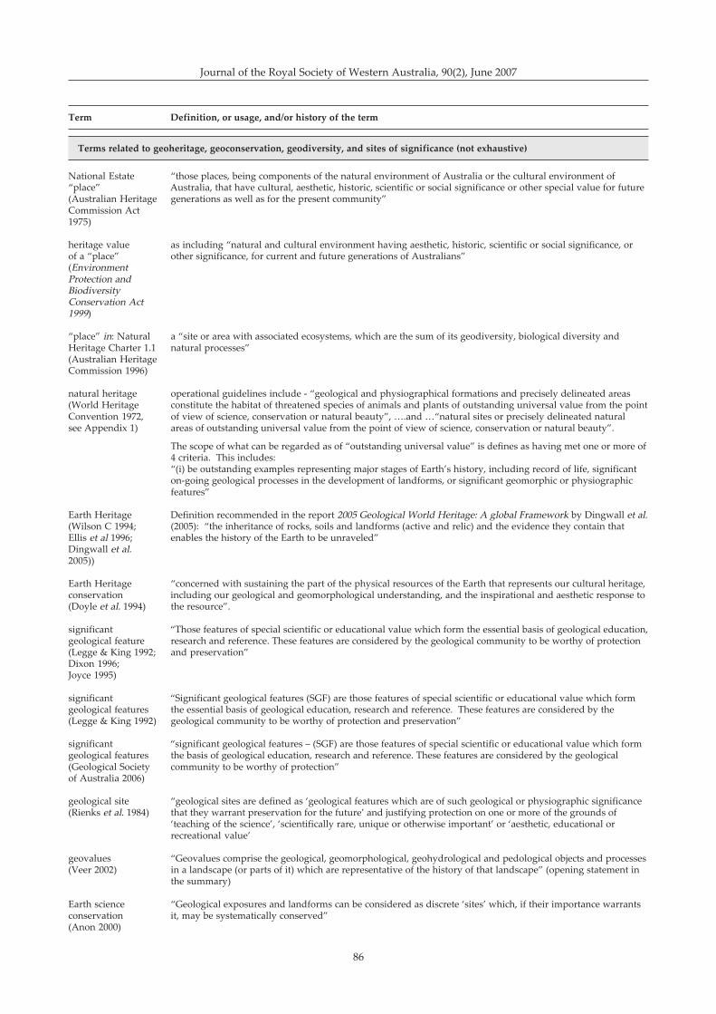
86
Journal of the Royal Society of Western Australia, 90(2), June 2007
Terms related to geoheritage, geoconservation, geodiversity, and sites of significance (not exhaustive)
National Estate �those places, being components of the natural environment of Australia or the cultural environment of�place� Australia, that have cultural, aesthetic, historic, scientific or social significance or other special value for future(Australian Heritage generations as well as for the present community�Commission Act1975)
heritage value as including �natural and cultural environment having aesthetic, historic, scientific or social significance, orof a �place� other significance, for current and future generations of Australians�(EnvironmentProtection andBiodiversityConservation Act1999)
�place� in: Natural a �site or area with associated ecosystems, which are the sum of its geodiversity, biological diversity andHeritage Charter 1.1 natural processes�(Australian HeritageCommission 1996)
natural heritage operational guidelines include - �geological and physiographical formations and precisely delineated areas(World Heritage constitute the habitat of threatened species of animals and plants of outstanding universal value from the pointConvention 1972, of view of science, conservation or natural beauty�, �.and ��natural sites or precisely delineated naturalsee Appendix 1) areas of outstanding universal value from the point of view of science, conservation or natural beauty�.
The scope of what can be regarded as of �outstanding universal value� is defines as having met one or more of4 criteria. This includes:�(i) be outstanding examples representing major stages of Earth�s history, including record of life, significanton-going geological processes in the development of landforms, or significant geomorphic or physiographicfeatures�
Earth Heritage Definition recommended in the report 2005 Geological World Heritage: A global Framework by Dingwall et al.(Wilson C 1994; (2005): �the inheritance of rocks, soils and landforms (active and relic) and the evidence they contain thatEllis et al 1996; enables the history of the Earth to be unraveled�Dingwall et al.2005))
Earth Heritage �concerned with sustaining the part of the physical resources of the Earth that represents our cultural heritage,conservation including our geological and geomorphological understanding, and the inspirational and aesthetic response to(Doyle et al. 1994) the resource�.
significant �Those features of special scientific or educational value which form the essential basis of geological education,geological feature research and reference. These features are considered by the geological community to be worthy of protection(Legge & King 1992; and preservation�Dixon 1996;Joyce 1995)
significant �Significant geological features (SGF) are those features of special scientific or educational value which formgeological features the essential basis of geological education, research and reference. These features are considered by the(Legge & King 1992) geological community to be worthy of protection and preservation�
significant �significant geological features � (SGF) are those features of special scientific or educational value which formgeological features the basis of geological education, research and reference. These features are considered by the geological(Geological Society community to be worthy of protection�of Australia 2006)
geological site �geological sites are defined as �geological features which are of such geological or physiographic significance(Rienks et al. 1984) that they warrant preservation for the future� and justifying protection on one or more of the grounds of
�teaching of the science�, �scientifically rare, unique or otherwise important� or �aesthetic, educational orrecreational value�
geovalues �Geovalues comprise the geological, geomorphological, geohydrological and pedological objects and processes(Veer 2002) in a landscape (or parts of it) which are representative of the history of that landscape� (opening statement in
the summary)
Earth science �Geological exposures and landforms can be considered as discrete �sites� which, if their importance warrantsconservation it, may be systematically conserved�(Anon 2000)
Term Definition, or usage, and/or history of the term
87
Geological/ �This is the favoured terminology in English Nature, meaning the conservation of geology and geomorphologygeomorphological in its natural setting�conservation(Prosser 2002b)
geological �� features considered by the community of Earth scientists to be of such geological or physiographicmonument significance that they are worthy of preservation. When taken together, the geological monuments of the State(McBriar & should adequately represent the geological history of the region �Mooney 1977)
Geological �Geological monuments are those features of a region which form the essential basis of geological education,monument research and reference: the total network of geological monuments incorporates the minimum number of sites(Joyce 1995) to adequately represent the Geology and Geomorphology of the region� (definition adopted at the Second
Geological Convention held at Monash University in 1977).
� �A geological feature may be a single rock outcrop, a rock sequence in a natural or artificial exposure such asa cliff or road cutting, or more rarely a major landscape such as Gosses Bluff, NT. In some cases a monumentmay be lookout where the geomorphology of the surrounding district may be viewed� � as described by theCommittee for the Preservation of Geological Monuments in the ACT
The author notes that the use of the term �geological monument� is now used less commonly than it once was.
Sites of geological �geological features of the Earth that are considered to be unique and of outstanding value within Westernsignificance Australia and to have significant scientific and educational values��(Geological Surveyof Western Australiacited in Conservation& Land Management2005)
Term Definition, or usage, and/or history of the term
Brocx & Semeniuk: Geoheritage and geoconservation