Embed Size (px)
Citation preview

EXPLORING JOGJA GEOHERITAGE:
THE LIFETIME OF AN ANCIENT VOLCANIC ARC IN JAVA
C. Prasetyadi
Geology Department – UPN “Veteran” Yogyakarta
Abstract
In addition to their art and cultural heritages, Jogja and surrounding areas have also an important and interesting
geoheritage. In areas not far from Jogja, within radius around 40 km and only one day visiting, there are
characteristic and important rock exposures that can be reached easily because their locations are nearby the
asphalted roads. These exposures are very special due to geological informations they contain. The
informations include a whole story of the lifetime of an ancient volcanic arc of Java known as the Oligo-Miocene
Arc or called the Old Andesite Formation (AOF), “the backbone of Java Island”, which forms the southern part of
Java Island. The story is a polyhistory consisting of periods with different geological events. These events
consist of pre-OAF, syn-OAF and post-OAF. The pre-OAF period is a non-volcanic period as shown by the
outcrops of Pre-Tertiary basement and Paleogene carbonate and silisiclastic rocks in Bayat areas. The syn-OAF
period comprises three phases, namely early phase (or monogenetic volcanism, indicated by the pillow lava of
Berbah Village), constructing phase (or polygenetic volcanism, marked by the sequence of volcanic breccia and
aglomerate of Nglanggran Formation), and destructing phase (or explosive volcanism, as evidenced by thick
layer of volcanic ash of the Semilir Formation). The post-OAF period is indicated by the widespread exposures
of Miocene-Pliocene carbonate rock which is well-known as the reefal limestone of Wonosari Platform to the
south of Jogja. This paper is aimed to introduce some easily reachable outcrops along with the route or traverse
where we can explore them in order to find out the whole geological history of Java as the main volcanic arc in
western Indonesia region. There is no other route or traverse of this kind in Java so it is appropriate enough to
considered it as Jogja geoheritage.
1. INTRODUCTION
Java island is one of the largest volcanic island, beside Sumatera Island, in western Indonesia region.
As the main island with its highly dense population, Java island has a high potential of geological
hazard due to the presence of active volcanoes and high seismic activity. The years of 2006 and 2010
are years that have been noted and memorized by most people of Jogja and surrounding areas as
years of disaster because of the occurrences of Jogja earthquake and Merapi eruption. Both
geological hazard events are traumatic for most people, especially for ordinary people.
Facing and coping all the consequences of the disasters, most people were shocked and
unprepared mentally. This is due to the lack of basic knowledge and awareness that they live in a
region with highly geological hazard prone. Therefore in the future it is urgent to disseminate among
ordinary people the informations associated with geological hazard and, more basic and important,
informations about how the Java island they occupy are formed. To achieve this purpose, namely to
inform and help ordinary people in Java to get the very basic knowledge of the geological evolution of
their island, we need to find a simple way or method.
Just by exploring the areas surrounding Jogja (Figure-1) we have found the method, and we
called it as “introduction to Jogja geoheritage” and described as follows: In areas surrounding Jogja,
such as Berbah, Candi Ijo Prambanan, Bayat and neigboring areas, we can find field evidences in the

form of rock exposures that contain informations on geological history back to a hundred million years
ago. The geological informations contained by the series of outcrop construct a complete history of the
lifetime of Java as the main volcanic island arc in western Indonesia. The informations include the
lifetime of an ancient volcanic arc of Java known as the Oligo-Miocene Arc or called the Old Andesite
Formation (AOF), “the backbone of Java Island”, which forms the southern part of Java Island
(Figure-2). The story is a polyhistory that consists of periods with different geological events. These
events consist of pre-OAF, syn-OAF and post-OAF. The pre-OAF period is a non-volcanic period as
shown by the outcrops of Pre-Tertiary basement and Paleogene carbonate and silisiclastic rocks. The
syn-OAF period comprises three phases, namely early phase (or monogenetic volcanism),
constructing phase (or polygenetic volcanism), and destructing phase (or explosive volcanism). The
post-OAF period is indicated by the widespread exposures of Miocene-Pliocene carbonate rock which
is well-known as the reefal limestone of Wonosari Platform to the south of Jogja. This paper is aimed
to introduce some easily accessible outcrops along with the route or traverse where we can explore
them in order to find out the whole geological history of Java as the main volcanic arc in western
Indonesia region. There is no other route or traverse of this kind in Java therefore it is appropriate
enough to considered it as Jogja geoheritage.
With the dissemination and socialization of this geoheritage through some ways and method,
espcially through a one-day fieldtrip, it is hope that more people in Jogja, and generally in Java, will
improve their knowledge and awareness to the fact that Java island is a highly geohazard prone
region.
2. BRIEF GEOLOGICAL HISTORY OF JAVA
The following is a brief geological history of the eastern part of Java since Late Cretaceous to Miocene
summarized from Prasetyadi (2007) (Figure-3):
Late Cretaceous – Paleocene (Figure-3 A)
The occurrence of Cretaceous Luk-Ulo Melange Complex in Karangsambung area, north of Kebumen,
Central Java indicate that during Late Cretaceous the area was part of subduction zone of Indo-
Australian Plate northwestward beneath the Sundaland continental plate. This subduction zone
extends to the west to Ciletuh area in West Java and to the NE to Meratus Mountain area in the SE tip
of Kalimantan. In Late Cretaceous in its movement to the west East Java microcontinent collided with
the subduction zone of Karangsambung-Meratus resulted in subduction termination and forming the
suture zone of Meratus Mountain.
Middle Eocene (Figure-3 B)
During 54 to 45 million years ago plate interactions in Indian Ocean region were marked by a
significant decrease of northward movement of India Continent. This sudden drop of India movement
to the north resulted in the slow down of convergent rate of Indo-Australian plate and causing an
extension phase to take place in eastern region of Indian Ocean. This extension regime was a period
of massive basin formations in some areas such as Karangsambung, Nanggulan, and Bayat in Central
Java, and in East Java. In Nanggulan and Bayat areas the sediments were deposited ini a shallow
marine environment and interpreted to be located in the eastern shelf area of East Java
microcontinent and adjacent to the west with deep basin of Karangsambung. Most of Eocene rocks in
Java is free from volcanic material.

Late Eocene – Early Oligocene (Figure-3 C)
Most of upper Eocene sediments have an unconformable contacts with the younger Oligocene rock
units above it. The unconformity was probably associated with a deformation that took place at that
time. The deformation was also related with the northward movement of Australia continent. The
increasing movement of Australia continent caused a higher rate of convergence of Indo-Australian
Plate in Java trench and pushing East Java microcontinent to the northwest. This microcontinent
convergence resulted in the deformation of Paleogen formations ini Karangsambung, Nanggulan, and
Bayat.
Oligocene – Miocene (Figure-3 D)
The increase of movement rate of Australia continent northward might continue until Middle Oligocene
time. This event triggered a volcanic activity associated with the emerging of volcanic zone in the
southern part of Java known as the Old Andesite Formation (OAF) and its area is called as the
Southern Mountain zone. This volcanic activity did not reach regions to the north of Java where
carbonate and silisiclastic sedimentation took place continuously in this area. When Australia
continent was approaching the subduction zone of Java-Banda in Late Miocene, there was a massive
tectonic compression occurring in SE Asia region. This compression regime inversed most of older
sediments. In southern Java because of the arrival of Australia continent in Banda Arc, the volcanic
activity became inactive and the area underwent uplift. The uplift of the area was marked by the
widespread sedimentation of reefal limestone in southern part of Java. The reefal complexes are well-
known as Punung formation in East Java, and as Wonosari, Sentolo, and Kalipucang Formations in
Central Java.
The above geological history in general can be divided into periods as follows (Figure-4):
1. Period of modern volcano
2. Period of post-OAF (Period of inactive Oligo-Miocene Volcanic Arc)
3. Period of OAF (Period of active Oligo-Miocene Volcanic Arc)
4. Period of pre-OAF (Period of non-volcanic arc)
5. Period of Pre-Tertiary Geology or Initial formation of Java Island (Period of microcontinent
amalgamation)
3. THE SITES OF JOGJA GEOHERITAGE EXPOSURES
There are eigth sites or locations where the rock exposures can be observed very closely because
their high accessibilities (Figure-5). This series of outcrop contain complete informations concerning
the geological polyhistory of Java.
Site 1. Pillow Lava – Berbah Village (Figure-5 A)
Based on stratigraphic correlation, the age of Berbah pillow lava is about Oligosen (approximately 30
Million years ago). Its age and basaltic composition indicate that this pillow lava was a product of
monogenetic volcanism, an initial stage of volcanism in a volcanic arc. In the next stage this
monogenetic volcanism will develop into a polygenetic volcanism forming strato volcanoes in which
their composition turn into andesitic. The widespread of Oligo-Miocene andesitic rock along the
southern part of Java indicate that at that time there was a significant volcanic arc occurring in Java
and this volcanic arc has been well known as the Old Andesite Formation (OAF).
Site 2. Thick layer of ancient volcanic ash - Candi Ijo, Prambanan (Figure-5 B)
A thick layer of ancient volcanic ash deposit forming a hilly complex is found in this location. By local
people the hills are being mined resulting in fresh exposures of the rock. The rock unit consists of
white, dull colored layers of volcanic ash containing many pumice fragments. The presence of pumice
fragments convincingly proves that this deposit was produced by an explosive eruption. This kind of
rock is widely distributed and commonly found in area extended from Parangtritis, south coast of
Jogja, to the east to Wonogiri with the thickness ranges 300-600 m. The best outcrop occurs in Semilir
Village, to the south of Jogja. The name of this village is then be used to called the rock unit as Semilir
Formation.
Semilir Formation overlies stratigraphically the Berbah Pillow Lava (Site-1). Widespread
distribution along with its great thickness indicate that Semilir Formation was the product of a serial
event of big volcanic explosion back to Oligo-Miocene time approximately 20-30 Mya (and comparable
to the big explosion of the Toba supervolcano. Smyth et al (2005) called the Semilir Formation as the
product of a super eruption of the Semilir Volcano. From Berbah Pillow Lava lying underneath going
upward to Semilir Formation, it means we see a field evidence concerning the development of a
volcanic arc in which its initial stage was marked by the occurrence of a monogenetic volcanism
(producing only one type of effusive material) in a marine environment and then developed into a
polygenetic volcanism producing strato volcanoes consisting of interbedding lava and pyroclastics,
and as the final stage is the explosive eruption, the Semilir super eruption.
Going further up stratigraphically, Semilir Formation is overlain by the younger Nglanggran
Formation that consists of aglomerate, andesitic volcanic breccia and lava. The presence of
Nglanggran Formation indicates that after the formation of extensive caldera produced by the Semilir
super eruption then it was followed by the growth of a new strato volcanoes, namely the Nglanggran
andesitic strato volcano found in Site-8. In Figure-4, Semilir and Nglanggran Formations represent the
period of OAF.
Site-3. Quartz Conglomerate – West Jiwo, Bayat, Klaten (Figure-5 C)
In this location we can find outcrops of quartz conglomerate. This sedimentary rock is considered as
the oldest sedimentary rock in Java because the components are comprised by materials or fragments
derived from the oldest metamorphic rock. The metamorphic fragments are mostly consist of quartz
material which initially was part of the quartz veins found within the metamorphic rock. The
conglomerate belongs to the Eocene Wungkal-Gamping Formation. Beside conglomerates, there
quartz sandstone, Nummulitic limestone and shale in this formation. The absence of volcanic material
in this formation indicate that during their deposition, the sedimentary environment was not related
with volcanic environment or complex. In other words, when this formation deposited, there was not
yet volcanic arc developed in Java. The deposition of this formation represent the time of Pre-OAF
(see Figure-4).
Stop Site 4a. Bayat Metomorphic rocks, East Jiwo, Klaten (Figure-5 D)
In this rare location we can find an extensive outcrop of metamorphic rocks consisting of slate, phyllite,
schist and few marble. A thick weathering condition make rather difficult to observed the fresh
outcrops of the metamorphic rock. But still we can observe foliation features as the characateristic
structure of the rocks. Metamorphic rocks similar to those we find in this location are very rare in Java.

There are only three places in Java, namely Bayat, Karangsambung and Ciletuh, where we can find
the outcrops of metamorphic rocks. The age of metamorphic rock in Bayat is about 95-100 Mya and
interpreted as part of the East Java micro continent that collided with Karangsambung-Meratus Trench
in Late Cretaceous. The collision terminated the subduction tectonic in the Karangsambung-Meratus
Trench and led to the amalgamation of the East Java micro continent to Sundaland (see Figure-3A).
The erosion product of the many quartz veins found in the phyllitic rocks can be seen as the quartz
fragments in conglomerates found in Site-3. In the Historical Geology Column presented in Figure-4,
this metamorphic rock unit represents the period of initial formation of Java Island.
Site 4b. Index Fossil of Eocene Time, Watuprau, East Jiwo, Klaten (Figure-5 E)
Not far from Site-4a with basement rock outcrops, 200 m to the south, there is a site called by local
people as “Watuprau” (Watu> “rock”, Prau > “boat”, meaning “rock looks like boat”). “Watuprau” is an
outcrop of limestone that contains mostly of fauna fossils of large foraminifera such Nummulites sp,
Discocyclina sp.. This fossiliferous limestone is found along with quartz sandstone and unconformably
overlies the metamorphic rock unit. The occurrence of Nummulites sp. and Discocyclina sp. is very
important because they are index fossils for Eocene Time (50-36 Mya). Based on the presence of the
fossils, it is very convincing to considered that the metamorphic rock underneath is much older in age
and for rock units above it are younger, and the overlying rock is the igneous and volcaniclastic of the
Oligo-Miocene OAF. Along with quartz conglomerate and quartz sandstone, this Nummulitic limestone
is part of The Wungkal-Gamping Formation. Like the conglomerate, the absence of volcanic material
in this formation indicate that during their deposition, their sedimentary environment was not
influenced by volcanic events. In other words, when this formation deposited, there was not yet
volcanic arc developed in Java. The deposition of this formation represent the time of Pre-OAF (see
Figure-4).
Site 5. Enjoying Pre-OAF Landscape – Tancep Village, Klaten (Figure-5 F)
In this location, we are in a high place topographically about 300 m above sea level in Tancep Village.
From here we can enjoy the beautiful landscape sight. The sight is looking to the north where Mt.
Merapi is located. Beside Mt. Merapi, we can see all the landscapes of the site locations we just
observed. This site is part of Baturagung escarpment that extends east-west and consists of rock unit
of OAF with the upper part consists of Semilir and Nglanggran Formations. So in this site we are
occupying the OAF rocks, and to north, there are rock units of the Pre-OAF period while to the south
we will observe the rock unit of the Post-OAF period.
Site 6. Reef Platform of Wonosari – Nglipar Village, Wonosari (Figure-5 G)
Features of karst topography of the Wonosari Formation can be enjoyed nicely in this location. From
this site, we can find the outcrop of marl and bedded limestone of Oyo Formation while to the south
away from this location we can observe the topographic expressions of Wonosari Formations
consisting mainly of reefal limestone. This reefal limestone form a very extensive platform starting
from Wonosari to Pacitan area di East Java and overlies the OAF rock unit. The massive emergence
of this extensive reef platform indicate that at the time this reef complex starting to grow, the volcanic
activity that produce the OAF had been inactive or terminated. Based on its foram content, the
Wonosari reef limestone was start to be deposited in Miosen time (15-5 Mya). The occurrence of Oyo
and Wonosari Formations marked the period of Post-OAF.

Site 7. Sambipitu Bioturbation – Ngalang River, Nglipar (Figure-5 H)
In this site we observe the outcrop as the bedrock of the Ngalang river. The bedrock consists of
interbedding calcareous sandstone and polymict breccia of Sambipitu Formation. This formation
stratigraphically overlies the volcanic Nglanggran Formation and in turn underlies the limestone of Oyo
Formation. On the surface of the sandstone bedding we can see bioturbation features indicating a
coastal to shallow marine sedimentary environment. In between sandstone, there is polymict breccia
layers. Components of the breccia consists of fragments of andesitic lava and reefal limestone. The
andesitic fragments should be derived from the older Nglanggran Formation which is identical to an
andesitic strato volcano. Based on this observations, we can infer that when Sambipitu Formation was
deposited, the Nglanggran Volcano had been inactive and then eroded. The erosion product was
transported and deposited as the fragments of polymict breccia of the Sambipitu Formation which is
marked the Post-OAF period along with Oyo and Wonosari Formations.
Site 8. Situs Gunung Api Purba – Nglanggran Village, Bantul (Figure-5 J)
This location is the most interesting site. This site offer a spectacular landscape indicating the remains
of a volcano complex. The site is dominated by topographic features of eroded volcano. The rocks
found in this area is part of the Nglanggran Formation and dominated by agglomerat and brecciated
lava. Agglomerate is made of coalition of bombs, a kind of pyroclastic materials comprised by lava
ejected not far from the vent of eruption. The Nglanggran formation as shown in this site is very
different compared to the Semilir Formation that consists of volcanic material produced by explosive
eruption, and Nglanggran Formation is younger than the Semilir Formation. The presence of
Nglanggran Formation indicates that after the formation of extensive caldera produced by the Semilir
super eruption then it was followed by the growth of a new strato volcanoes, namely the Nglanggran
andesitic strato volcano found in Site-8. In Figure-4, Semilir and Nglanggran Formations represent the
period of OAF.
4. CONCLUSION
Java island is one of the largest volcanic island in western Indonesia region. As the main island
with its highly dense population, Java island has a high potential of geological hazard due to the
presence of active volcanoes and high seismic activity
From now on it is urgent to disseminate among ordinary people the informations related with
geological hazard and, more importantly, informations about how the Java island they occupy are
formed.
In areas surrounding Jogja, such as Berbah, Candi Ijo Prambanan, Bayat and neigboring areas,
there are rock exposures that contain informations on geological history back to a hundred million
years ago. The geological informations contained by the series of outcrop construct a complete
history of the lifetime of Java as the main volcanic island arc in western Indonesia, and it is called
as “geoheritage of Jogja”.
Jogja Geoheritage includes eigth sites or locations where the rock exposures can be observed
very closely because their high accessibilities. This series of outcrop contain complete
informations concerning the geological polyhistory of Java and can be observed within one day
fieldtrip.

REFERENCES
Asikin, S., 1974, Evolusi Tektonik Daerah Karangsambung Berdasarkan Teori Tectonik Global yg Baru,
Disertasi ITB, tidak dipublikasikan.
Hamilton, W., 1979, Tectonic of Indonesia Region, Special Paper of USGS.
Prasetyadi, C., 2007, Evolusi tektonik Paleogen Jawa bagian timur, Disertati Doktor, ITB Bandung, tidak
diterbitkan, 323 hal.
Sudarno, Ign., 1997, Kendali tektonik terhadap pembentukan struktur pada batuan Paleogen dan
Neogen di Pegunungan Selatan, DIY dan sekitarnya, Tesis Magister, ITB Bandung, tidak diterbitkan
Smyth, H; Hall, R, 2005, Basin development and Basement rocks of East Jawa, IPA Proceeding..
Wartono, R., dkk, 1995, Peta geologi Lembar Yogyakarta, skala 1:100.000, P3G Bandung.
Figure-1: Location map indicating the sites and the route to visit the sites of Jogja Geoheritage.

Figure-2: The two volcanic arcs of Java that form the “backbone of Java”..
Figure-3: Geological evolution of Java (Prasetyadi, 2007).

Figure-4: Geological History column of Java.
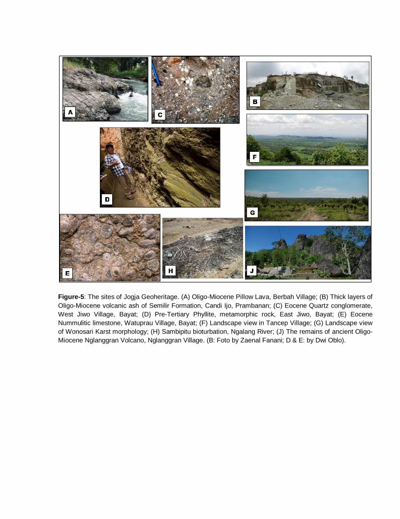
Figure-5: The sites of Jogja Geoheritage. (A) Oligo-Miocene Pillow Lava, Berbah Village; (B) Thick layers of
Oligo-Miocene volcanic ash of Semilir Formation, Candi Ijo, Prambanan; (C) Eocene Quartz conglomerate,
West Jiwo Village, Bayat; (D) Pre-Tertiary Phyllite, metamorphic rock, East Jiwo, Bayat; (E) Eocene
Nummulitic limestone, Watuprau Village, Bayat; (F) Landscape view in Tancep Village; (G) Landscape view
of Wonosari Karst morphology; (H) Sambipitu bioturbation, Ngalang River; (J) The remains of ancient Oligo-
Miocene Nglanggran Volcano, Nglanggran Village. (B: Foto by Zaenal Fanani; D & E: by Dwi Oblo).