Embed Size (px)
Citation preview
GEOGRAPHY GENERAL COURSE Year 11 syllabus

2013/43775v2
IMPORTANT INFORMATION This syllabus is effective from 1 January 2015.
Users of this syllabus are responsible for checking its currency.
Syllabuses are formally reviewed by the School Curriculum and Standards Authority on a cyclical basis, typically every five years.
Copyright
© School Curriculum and Standards Authority, 2013. This document – apart from any third party copyright material contained in it – may be freely copied, or communicated on an intranet, for non-commercial purposes in educational institutions, provided that the School Curriculum and Standards Authority is acknowledged as the copyright owner, and that the Authority’s moral rights are not infringed.
Copying or communication for any other purpose can be done only within the terms of the Copyright Act 1968 or with prior written permission of the School Curriculum and Standards Authority. Copying or communication of any third party copyright material can be done only within the terms of the Copyright Act 1968 or with permission of the copyright owners.
Any content in this document that has been derived from the Australian Curriculum may be used under the terms of the Creative Commons Attribution-NonCommercial 3.0 Australia licence

Content
Rationale ...................................................................................................................................................................... 1
Course outcomes .......................................................................................................................................................... 3
Organisation ................................................................................................................................................................. 4
Structure of the syllabus .................................................................................................................................................. 4
Organisation of content ................................................................................................................................................... 4
Progression from the Year 7–10 curriculum .................................................................................................................... 5
Representation of the general capabilities ...................................................................................................................... 6
Representation of the cross-curriculum priorities ........................................................................................................... 8
Unit 1 – Geography of environments at risk ................................................................................................................. 9
Unit description ................................................................................................................................................................ 9
Unit content ..................................................................................................................................................................... 9
Unit 2 – Geography of people and places .................................................................................................................... 14
Unit description .............................................................................................................................................................. 14
Unit content ................................................................................................................................................................... 14
School-based assessment ............................................................................................................................................ 19
Grading ........................................................................................................................................................................... 20
Appendix 1 – Grade descriptions Year 11 .................................................................................................................... 21
Appendix 2 – Glossary ................................................................................................................................................. 23


1
Geography | General | Year 11 syllabus
Rationale The study of geography draws on students’ curiosity about the diversity of the world’s places and their peoples, cultures and environments. It enables them to appreciate the complexity of our world and the diversity of its environments, economies and cultures and use this knowledge to promote a more sustainable way of life and awareness of social and spatial inequalities.
In the senior secondary years, the Geography General course provides a structured, disciplinary framework to investigate and analyse a range of challenges and associated opportunities facing Australia and the global community. These challenges include rapid change in biophysical environments, the sustainability of places, dealing with environmental risks and the consequences of international integration.
Geography addresses questions about the interaction of natural and human environments within various natural and social systems. It examines the factors that impact upon decisions about sustainability, the conflicting values between individuals and groups over sustainability and the degree of commitment towards sustainable development.
Geography as a discipline values imagination, creativity and speculation as modes of thought. It provides a systematic, integrative way of exploring, analysing and applying the concepts of place, space, environment, interconnection, sustainability, scale and change. These principal geographical concepts are applied and explored in depth through unit topics, to provide a deeper knowledge and understanding of the complex processes shaping our world. Taken together, the ability of students to apply conceptual knowledge, in the context of an inquiry, and the application of skills, constitute ‘thinking geographically’ – a uniquely powerful way of viewing the world.
The course builds students’ knowledge and understanding of the uniqueness of places and an appreciation that place matters in explanations of economic, social and environmental phenomena and processes. It also develops students’ knowledge about the interconnections between places. Nothing exists in isolation. Consequently, the subject considers the significance of location, distance and proximity.
Through the study of geography, students develop the ability to investigate the arrangement of biophysical and human phenomena across space in order to understand the interconnections between people, places and environments. As a subject of the Humanities and Social Sciences, geography studies spatial aspects of human culture using inquiry methods that are analytical, critical and speculative. In doing so, it values imagination and creativity. As a Science, geography develops an appreciation of the role of the biophysical environment in human life and an understanding of the effects human activities can have on environments. As a result, it develops students’ ability to identify, evaluate and justify appropriate and sustainable approaches to the future by thinking holistically and spatially in seeking answers to questions. Students are encouraged to investigate geographical issues and phenomenon from a range of perspectives, including those of Aboriginal and Torres Strait Islander Peoples.
In the Geography General course, students investigate geographical issues and phenomena in a variety of scales and contexts. This may include: comparative studies at the same scale; studying the same issue or phenomenon at a range of scales; or seeking explanations at a different scale to the one being studied. The ability to perform multi-scale and hierarchical analysis is developed further in this syllabus.
2
Geography | General | Year 11 syllabus
Students learn how to collect information from primary and secondary sources, such as field observation and data collection, mapping, monitoring, remote sensing, case studies and reports. Fieldwork, in all its various forms, is central to geographical inquiries as it enables students to develop their understanding of the world through direct experience.
Students develop a range of skills that help them to understand the physical world, interpret the past, scrutinise the present and explore sustainable strategies for the future care of places. They are able to understand recent and future developments, such as urban planning, climate change, environments at risk, sustainable development practices and the unequal distribution of resources throughout the world.
The Geography General course promotes students’ communication abilities by building their skills of spatial and visual representation, and interpretation, through the use of cartographic, diagrammatic, graphical, photographic and multi-modal forms. In addition, students communicate their conclusions by written and oral means.
3
Geography | General | Year 11 syllabus
Course outcomes The Geography General course is designed to facilitate achievement of the following outcomes.
Outcome 1 – Geographical concepts
Students understand and apply key geographical concepts – including place, space, environment, interconnection, sustainability, scale and change.
In achieving this outcome, students:
• understand that geographical features are shaped by natural and social systems over time
• understand that geographical features are influenced by natural processes and human activities
• understand that natural and social systems form patterns of features on the Earth’s surface that change over time
• understand that the degree to which people adopt sustainable practices and solutions influences the nature of their impact on their environments.
Outcome 2 – Geographical inquiry skills
Students investigate the interactions that occur within natural and cultural environments in order to make informed decisions and communicate findings.
In achieving this outcome, students:
• plan ways to gather and organise geographical information
• collect and record information by using geographical inquiry methods
• interpret and analyse information gained from geographical investigations to form conclusions
• apply and communicate findings of geographical investigations to suit a purpose or an audience
• reflect on, and respond to, conclusions.

4
Geography | General | Year 11 syllabus
Organisation This course is organised into a Year 11 syllabus and a Year 12 syllabus. The cognitive complexity of the syllabus content increases from Year 11 to Year 12.
Structure of the syllabus The Year 11 syllabus is divided into two units, each of one semester duration, which are typically delivered as a pair. The notional time for each unit is 55 class contact hours.
Unit 1 – Geography of environments at risk
This unit explores the spatial patterns and processes related to environments at risk, and to the protection of such environments through management at local, regional and global levels.
Unit 2 – Geography of people and places
This unit explores the natural and cultural characteristics of a region and the processes that have enabled it to change over time and the challenges it may face in the future.
Each unit includes:
• a unit description – a short description of the focus of the unit
• unit content – the content to be taught and learned.
The content in each unit is divided into an overview and one or more depth studies. The content descriptions associated with the overview are designed to be taught at a broad level and in a short timeframe. The content descriptions associated with the depth study are designed to be taught in a more focused and detailed way, and therefore take more time to teach.
Organisation of content The course is divided into two interrelated strands: Geographical Knowledge and Understanding, and Geographical Inquiry and Skills.
Geographical Knowledge and Understanding
Geographical knowledge refers to the facts, generalisations, principles, theories and models developed in Geography. This knowledge is dynamic and its interpretation can vary. Opinions and conclusions must be supported by evidence and logical argument.
Geographical understanding is the ability to see the relationships between items of knowledge and construct explanatory frameworks to illustrate these relationships. It is also the ability to apply this knowledge to new situations or to solve new problems.
Geographical Inquiry and Skills
This strand is about the skills required to conduct a geographical inquiry and the geographical skills needed to find and communicate information and data. It contains two sub-strands: Geographical Inquiry Skills and Geographical Skills.
5
Geography | General | Year 11 syllabus
Geographical inquiry is a process undertaken by individual students or groups to investigate geographical questions, information, data, problems or issues to deepen their understanding. This process requires students to apply the following geographical inquiry skills:
• observing, questioning and planning
• collecting, recording, evaluating and representing
• interpreting, analysing and concluding
• communicating
• reflecting and responding.
Inquiries may vary in scale and geographic context.
When using geographical information and data and communicating, students develop the following geographical skills:
• mapping skills (use of maps and atlases)
• remote sensing skills (use of remote sensing products, such as ground level photographs, aerial photographs, radar imagery and satellite imagery)
• geographical and statistical data skills (use of geographical and statistical data in formats, such as tables, graphs, maps and diagrams)
• skills in the use of information and communication technology (ICT) and geographical information systems (GIS) in a geographical context
• fieldwork skills (use of fieldwork observations and measurements).
Relationships between the strands
The two strands are interrelated and the content has been written in a way that enables integration of the strands in the development of a teaching and learning program. The Geographical Knowledge and Understanding strand provides the contexts through which particular inquiries and skills are to be developed. The same set of geographical skills has been included in each of the units to provide a common focus for the teaching and learning of content in the Geographical Knowledge and Understanding strand.
Progression from the Year 7–10 curriculum This syllabus continues to develop student understandings and inquiry skills developed in the Year 7–10 Geography curriculum. It uses the same strands of the Year 7–10 curriculum to further develop students’ ability to explore, analyse and apply the concepts of place, space, environment, interconnection, sustainability, scale and change. It does, however, feature a wider range of geographical contexts and introduces students to a more diverse, and increasingly sophisticated, range of geographical tools and skills.

6
Geography | General | Year 11 syllabus
Representation of the general capabilities The general capabilities encompass the knowledge, skills, behaviours and dispositions that will assist students to live and work successfully in the twenty-first century. Teachers may find opportunities to incorporate the capabilities into the teaching and learning program for the Geography General course. The general capabilities are not assessed unless they are identified within the specified unit content.
Literacy
In the Geography General course, students use literacy skills to explore, interpret and evaluate geographical phenomena and issues and communicate geographically. Students work with oral, print, visual and digital texts to gather, synthesise and analyse information from a range of sources, and present and justify ideas, conclusions and opinions within a broad range of geographical contexts. They understand how language is used and modified for specific purposes, and question attitudes and assumptions embedded in texts.
Geography students also develop visual literacy skills as they make meaning of information communicated through maps, graphs, cartoons and other images.
Numeracy
In the Geography General course, students use numeracy skills to identify and describe a wide range of patterns and relationships, including those that can be visually represented on a graph or map. Geography students also apply numeracy skills to interpret and manipulate data. These skills help students to realise and describe change as it occurs over time. Students demonstrate numeracy capability by making connections between apparently diverse facts and suggesting solutions to problems in a range of circumstances, for example, the relationship between human activity and environmental risk.
Information and communication technology capability
In the Geography General course, students use Information Communication Technology (ICT) to develop geographical understanding, and support the application of geographical skills. They use digital tools, including spatial technologies, to support their inquiries into geographical phenomena and issues. They also use these tools to collect and analyse data, represent it in digital form, access and manipulate databases, and model conceptual constructs. In addition, students critically analyse the quality of digital information and sources of information. They also create multimodal and multi-faceted reports and presentations to represent and communicate the results of geographical inquiry.
Students recognise the relative possibilities, limitations and consequences of using different forms of digital information and methods of distributing this information and apply sophisticated understandings of social and ethical practices in the use of digital information and communications. In particular, they consider how geographical and demographic data may be used and the ethics involved.
Critical and creative thinking
Critical and creative thinking processes and skills are used by students when examining diverse interactions between people, perspectives, interpretations, phenomena and environments. Through multi-faceted problem posing and solving, they explore the interconnections, uncertainty and consequences of these relationships.
7
Geography | General | Year 11 syllabus
Thinking laterally, visualising possibilities, testing options using criteria, and making judgements are essential skills for conducting geographical investigations connected with the environment, space, sustainability, scale and change. When seeking answers to questions, students think holistically and spatially using skills, such as analysis, interpretation, extrapolation from trends, synthesis of relationships and exploration of anomalies evident in patterns.
Through developing dispositions, such as intellectual openness, curiosity and showing initiative, students investigate biophysical and human phenomena. As independent and autonomous thinkers who seek explanations and value discovery, they turn creativity and innovation into action, apply new knowledge to identified gaps, and justify their actions.
Personal and social capability
Personal and social capability involves students taking responsible personal, social and environmental action against, or in support of, decisions by organisations, governments or other bodies. Through the study of the Geography General course, students are provided with learning opportunities to assist them to develop, rehearse and refine their skills in listening to, respecting and acknowledging diverse perspectives and opinions. Students participate in collaborative investigative group-work to make ethical, rational social decisions and solve problems that relate to their social and environmental contexts. Developing these personal and social capabilities positions them to advocate for opportunities and methods for change in a democratic society. Personal and social capability occurs when responsible social and environmental actions and participation are promoted and this should be a logical outcome of many geographical investigations.
Ethical understanding
Ethical understanding plays an important role in geographical inquiry. Students uncover and assess ethical considerations, such as the links between human rights and responsibilities and the ways diverse perspectives, values and cultures impact on geographical issues. Through geographical inquiry, students have the opportunity to analyse, qualify and test their own attitudes, values and beliefs and explore how people’s knowledge, attitudes and values affect judgements, decisions and actions as they apply to their interaction with environment. They become aware of the need for social responsibility when confronted with alternate opinions and when seeking to resolve problems. Students apply ethical standards to guide their use of digital representations of phenomena and statistics associated with biophysical and environmental factors and relationships.
Intercultural understanding
Students deepen their intercultural understanding as they examine geographical issues in a broad range of cultural contexts. This involves students in developing their understanding of the complexity and diversity of the world’s cultures and evaluating alternative responses to the world’s environments and challenges. It enables students to find interconnections and sustainable solutions in an internationally integrated world, and consider the implications of their responses from different cultural responses.

8
Geography | General | Year 11 syllabus
Representation of the cross-curriculum priorities The cross-curriculum priorities address contemporary issues which students face in a globalised world. Teachers may find opportunities to incorporate the priorities into the teaching and learning program for the Geography General course. The cross-curriculum priorities are not assessed unless they are identified within the specified unit content.
Aboriginal and Torres Strait Islander histories and cultures
In the Geography General course, there are a range of opportunities to learn about Aboriginal and Torres Strait Islander histories and cultures. Students can, for example, investigate how Aboriginal and Torres Strait Islander Peoples may be unequally affected by changing environments and environmental interactions in Australia or by economic and cultural developments and challenges faced by places.
More broadly, students develop a range of capabilities that enable them to independently construct informed responses to the range of geographical issues involving Aboriginal and Torres Strait Islander Peoples.
Asia and Australia's engagement with Asia
In the Geography General course, students investigate a wide range of contexts that draw on Asia and Australia’s engagement with Asia. This priority can be addressed through use of examples from the Asia region when explaining how environments and places can be managed to eliminate or minimise harm to people and the environments.
Sustainability
Students explicitly address sustainability in the Geography General course through an investigation of the approaches to sustainability and through an evaluation of alternative responses to geographical issues and phenomena. In doing so, they use economic, social and environmental criteria, to frame investigative questions, and measure the capacity of something to be maintained indefinitely into the future.
9
Geography | General | Year 11 syllabus
Unit 1 – Geography of environments at risk
Unit description This unit explores the spatial patterns and processes related to environments at risk, and to the protection of such environments through management at local, regional and global levels. In the local area, in specific regions and globally, people pose threats to the environment as they attempt to meet their needs. Individuals and/or groups can have conflicting viewpoints about particular environments. This can place environments at risk. Sustainable solutions need to be developed for these environments.
Students develop the knowledge, understandings and skills in this unit that are relevant to the world in which they live and which are also appropriate to careers in the environmental protection/rehabilitation, urban and regional development, and tourism industries.
Unit content This unit includes the knowledge, understandings and skills described below.
Geographical Knowledge and Understanding
Overview of environments at risk
• the concepts of environment, biome and ecosystem
• biotic and abiotic elements of environments, biomes and ecosystems
• the following ecosystem concepts: biodiversity food chains and webs biomass trophic levels pyramid of numbers pyramid of energy flows of matter and energy
• the differences between natural and cultural features of environments
• the concept of sustainability
Students complete a depth study which is taught with the required geographical inquiry skills and additional geographical skills described in this unit.
Depth study
Students investigate at least one of the following environments at risk (this list is not exhaustive).
• catchments, such as, Swan River, Nile River
• coasts, such as, Penguin Island and Point Peron, Californian coast
• coral reefs, such as, Ningaloo, Great Barrier
• world biomes, such as, rainforest, temperate forests, sclerophyllous forest
10
Geography | General | Year 11 syllabus
• wetlands, for example, Lake Monger
• glacial environments, for example, Fox Glacier, Antarctica
• national parks, for example, Purnululu
Students explore the following aspects of the selected environment, biome or ecosystem:
• biotic and abiotic elements of the selected environment, biome or ecosystem
• location and distribution of the environment, biome or ecosystem
• characteristics of the following elements of the environment, biome or ecosystem: climate, including temperature and rainfall soils and landforms, including soil structure and topography flora and fauna, including dominant species and community structures
• the interactions between the flora and fauna of the environment, biome or ecosystem, including the following ecosystem concepts: biodiversity food chains and webs biomass trophic levels pyramid of numbers pyramid of energy flows of matter and energy
• interrelationships between biotic elements and abiotic elements of the environment, biome or ecosystem, such as xerophytic adaptations of plants to drought conditions
• human activity and land use impacts upon patterns and processes within the environment, biome or ecosystem
• cultural landscapes associated with the environment, biome or ecosystem
• economic, political and social factors that impact upon decisions about sustainability of the environment, biome or ecosystem
• the different values and viewpoints (environmental, economic and social) that shape the human use of the environment, biome or ecosystem
• benefits of implementing sustainable practices within the environment, biome or ecosystem
• the extent to which current land use practices are sustainable within the environment, biome or ecosystem
• measures by which humans are caring for the environment, biome or ecosystem; and the extent to which these measures have been successful.
11
Geography | General | Year 11 syllabus
Geographical Inquiry and Skills
All the following skills should be taught during this course. Relevant skills will be emphasised for each depth study.
Geographical inquiry skills
Observing, questioning and planning
• formulate geographical inquiry questions
• plan a geographical inquiry with clearly defined aims and appropriate methodology
Collecting, recording, evaluating and representing
• collect geographical information incorporating ethical protocols from a range of primary (interviews, questionnaires, student’s own experiences, and field observations) and secondary sources (online maps, websites, spatial software applications, print resources and visual media)
• record observations in a range of graphic representations using spatial technologies and information and communication technologies
• evaluate the reliability, validity and usefulness of geographical sources and information
• acknowledge sources of information and use an approved referencing technique
Interpreting, analysing and concluding
• analyse geographical information and data from a range of primary and secondary sources and a variety of perspectives to draw reasoned conclusions and make generalisations
• identify and analyse relationships, spatial patterns and trends and makes predictions and inferences
Communicating
• communicate geographical information, ideas, issues and arguments using appropriate written and/or oral, cartographic, multimodal and graphic forms
• use geographical language in appropriate contexts to demonstrate geographical knowledge and understanding
Reflecting and responding
• apply generalisations to evaluate alternative responses to geographical issues at a variety of scales
• propose individual and collective action, taking into account environmental, social and economic factors and predict the outcomes of the proposed action
Geographical skills
Mapping skills (use of maps and atlases)
• identify and interpret a variety of topographic maps, thematic maps (physical, political, and social maps, overlay maps, synoptic charts and climate maps) and statistical maps (proportional circle and dot distribution maps) at different scales (local, national and global)
• understand and interpret marginal information represented on maps (title, conventional signs contained in the legend, north point, numerical and linear scales)
12
Geography | General | Year 11 syllabus
• establish position on a map using alphanumeric grid coordinates, eastings and northings, four figure area references, six figure grid references, and latitude and longitude expressed in degrees and minutes
• establish direction on a map using general compass directions (8 points) and bearings
• interpret and express scale in written, linear and ratio (representative fraction) formats, and convert scale from one format to another
• apply the map scale to basic calculations to determine distance and area
• interpret relief on a map using contours and spot heights to describe the steepness and shape of a slope (concave, convex and uniform)
• identify different relief features (landforms, including hills, valleys, plains, spurs, ridges, escarpments, saddles, cliffs) and different types of natural vegetation cover and hydrological features
• construct simple annotated sketch maps using map conventions (border, title, legend, north point and approximate scale)
• identify and interpret natural features and cultural features on a map
• describe the site and situation of places
• identify and describe spatial patterns, including land use, settlement and transport
• identify and describe spatial relationships between natural and cultural features
Remote sensing skills (use of remote sensing products, such as ground level photographs, aerial photographs, radar imagery and satellite imagery)
• identify and describe natural and cultural features and their patterns on the Earth’s surface using ground level photographs, aerial photographs (vertical and oblique), radar imagery and satellite imagery (Landsat, weather satellites and Google Earth)
• compare the different types of information available from remote sensing products with the information depicted on a topographic map
• use remote sensing products as an aid to interpreting natural and cultural features shown on topographic maps
• determine direction on remote sensing products
• apply scale to the calculation of distance on remote sensing products
• interpret the difference in scale between a photograph and a topographic map of the same place
Geographical and statistical data skills (use of geographical and statistical data in formats, such as maps, tables, graphs and diagrams)
• calculate and interpret descriptive statistics, including central tendency (arithmetic mean, median, mode) and variation (maximum, minimum and range)
• interpret and apply data from different types of statistical maps (isopleth/isoline, choropleth, proportional circle and dot distribution maps)
• interpret and construct tables and graphs, including: picture graphs; line and bar graphs; scattergrams; climatic graphs; pie graphs; flowcharts and population pyramids
13
Geography | General | Year 11 syllabus
• use simple systems and flow diagrams to organise thinking about relationships
• extrapolate trends over time to forecast future conditions
Skills in the use of information and communications technology and geographical information systems (in a geographic context)
• use the internet as a tool for geographical research
• use simple applications, software and online resources (including Google Earth and Google Maps) to access atlases and remote sensing products (photographs, radar imagery and satellite imagery) for the purpose of identifying and describing spatial patterns and relationships
• access databases, such as the Bureau of Meteorology, for spatial and statistical information
• use geospatial technologies, including global positioning systems (GPS), to collect and map spatial data
• use simple geographical information systems (GIS) products in description and analysis
Fieldwork skills (use of field observations and measurements)
• collect primary data using field techniques, including: surveys and interviews, observing and recording, listening, questioning, sketching and annotating, measuring and counting, photographing and note-taking
• collate field data using techniques, including: listing, tabulating, report writing, graphing, constructing diagrams and mapping
• analyse and interpret primary data
14
Geography | General | Year 11 syllabus
Unit 2 – Geography of people and places Unit description This unit explores the natural and cultural characteristics of a region, the processes that have enabled it to change over time and the challenges it may face in the future. Students develop the knowledge, understanding and skills that will enable them to understand and apply the concept of a region to other regions in different scales.
Unit content This unit includes the knowledge, understandings and skills described below.
Geographical Knowledge and Understanding
Overview of people and places
• the concept of a region
• the natural and cultural features of regions
• the four natural spheres of regions: lithosphere atmosphere hydrosphere biosphere
• the three types of cultural features of regions (land use, settlement, transport)
• how regions can change over time
• the concept of sustainability
• factors that impact upon the implementation of sustainable practices
Students complete a depth study which is taught with the required geographical inquiry skills and additional geographical skills described in this unit.
Depth study
Students investigate at least one of the following regions (this list is not exhaustive):
• a local shire
• a city
• a country town
• a regional area, such as South East Asia
• a mining town
• an agricultural region, such as the wheat belt
• a tourist destination or attraction, such as Ningaloo Reef, Bali.
15
Geography | General | Year 11 syllabus
Students explore the following aspects of the region:
• the location of, and spatial variation within, the region
• characteristics of the natural environment of the region, including: topography and variations in the topography weather and climatic characteristics and factors that characterise the regional weather and climate vegetation and factors affecting the vegetation patterns soil characteristics and patterns of soil distribution
• the associations between the natural attributes of the environment of the region, such as climate, soil type, vegetation, topography
• changing patterns of the natural environments of the region over time, such as changes in soil fertility, climatic variations, changes in topography as a result of fluvial action
• characteristics of the cultural environment of the region, including the: spatial characteristics and patterns of settlement demographic characteristics land use characteristics, including form, function and land use distribution
• characteristics and associations of the cultural environment of the region, including the: variations in the land use variations in settlement patterns and population distribution variations in transport systems and networks and flows of people and services demographic characteristics of the population
• the association between the cultural attributes of the environment of the region, such as topography and settlement, climate and agriculture, soils and agriculture, topography and transport
• changing patterns of the cultural environment of the region over time, such as changes in settlement patterns, changes in agricultural patterns as a result of climate change
• the potential of the region to attract increased numbers of people for tourism and/or employment
• a geographic issue pertinent to the sustainable development of cultural and/or physical resources within the region
• the stakeholders within the region who would be potentially affected by the development issue
• the views and attitudes of these stakeholders towards the development issue
• the extent to which the various responses to the development issue in the region are likely to lead to sustainable management practices
• the impact that increased flows of people for tourism and/or employment may have on sustainable management practices in the region.
16
Geography | General | Year 11 syllabus
Geographical Inquiry and Skills All the following skills should be taught during this course. Relevant skills will be emphasised for each depth study.
Geographical inquiry skills
Observing, questioning and planning
• formulate geographical inquiry questions
• plan a geographical inquiry with clearly defined aims and appropriate methodology
Collecting, recording, evaluating and representing
• collect geographical information incorporating ethical protocols from a range of primary (interviews, questionnaires, student’s own experiences, and field observations) and secondary sources (online maps, websites, spatial software applications, print resources and visual media)
• record observations in a range of graphic representations using spatial technologies and information and communication technologies
• evaluate the reliability, validity and usefulness of geographical sources and information
• acknowledge sources of information and use an approved referencing technique
Interpreting, analysing and concluding
• analyse geographical information and data from a range of primary and secondary sources and a variety of perspectives to draw reasoned conclusions and make generalisations
• identify and analyse relationships, spatial patterns and trends and makes predictions and inferences
Communicating
• communicate geographical information, ideas, issues and arguments using appropriate written and/or oral, cartographic, multimodal and graphic forms
• use geographical language in appropriate contexts to demonstrate geographical knowledge and understanding
Reflecting and responding
• apply generalisations to evaluate alternative responses to geographical issues at a variety of scales
• propose individual and collective action, taking into account environmental, social and economic factors and predict the outcomes of the proposed action
Geographical skills
Mapping skills (use of maps and atlases)
• identify and interpret a variety of topographic maps, thematic maps (physical, political, and social maps, overlay maps, synoptic charts and climate maps) and statistical maps (proportional circle and dot distribution maps) at different scales (local, national and global)
• understand and interpret marginal information represented on maps (title, conventional signs contained in the legend, north point, numerical and linear scales)
17
Geography | General | Year 11 syllabus
• establish position on a map using alphanumeric grid coordinates, eastings and northings, four figure area references, six figure grid references, and latitude and longitude expressed in degrees and minutes
• establish direction on a map using general compass directions (8 points) and bearings
• interpret and express scale in written, linear and ratio (representative fraction) formats, and convert scale from one format to another
• apply the map scale to basic calculations to determine distance and area
• interpret relief on a map using contours and spot heights to describe the steepness and shape of a slope (concave, convex and uniform)
• identify different relief features (landforms, including hills, valleys, plains, spurs, ridges, escarpments, saddles, cliffs) and different types of natural vegetation cover and hydrological features
• construct simple annotated sketch maps using map conventions (border, title, legend, north point and approximate scale)
• identify and interpret natural features and cultural features on a map
• describe the site and situation of places
• identify and describe spatial patterns, including land use, settlements and transport
• identify and describe spatial relationships between natural and cultural features
Remote sensing skills (use of remote sensing products, such as ground level photographs, aerial photographs, radar imagery and satellite imagery)
• identify and describe natural and cultural features and their patterns on the Earth’s surface using ground level photographs, aerial photographs (vertical and oblique), radar imagery and satellite imagery (Landsat, weather satellites and Google Earth)
• compare the different types of information available from remote sensing products with the information depicted on a topographic map
• use remote sensing products as an aid to interpreting natural and cultural features shown on topographic maps
• determine direction on remote sensing products
• apply scale to the calculation of distance on remote sensing products
• interpret the difference in scale between a photograph and a topographic map of the same place
Geographical and statistical data skills (use of geographical and statistical data, such as maps, tables, graphs and diagrams)
• calculate and interpret descriptive statistics, including central tendency (arithmetic mean, median, mode) and variation (maximum, minimum and range)
• interpret and apply data from different types of statistical maps (isopleth/isoline, choropleth, proportional circle and dot distribution maps)
• interpret and construct tables and graphs, including: picture graphs; line and bar graphs; scattergrams; climatic graphs; pie graphs; flowcharts and population pyramids

18
Geography | General | Year 11 syllabus
• use simple systems and flow diagrams to organise thinking about relationships
• extrapolate trends over time to forecast future conditions
Skills in the use of information and communications technology and geographical information systems (in a geographic context)
• use the internet as a tool for geographical research
• use simple applications, software and online resources, including Google Earth and Google Maps, to access atlases and remote sensing products (photographs, radar imagery and satellite imagery) for the purpose of identifying and describing spatial patterns and relationships
• access common databases, such as the Bureau of Meteorology, for spatial and statistical information
• use geospatial technologies, including GPS, to collect and map spatial data
• use simple GIS products in description and analysis relevant to the unit content
Fieldwork skills (use of field observations and measurements)
• collect primary data using field techniques, including: surveys and interviews, observing and recording, listening, questioning, sketching and annotating, measuring and counting, photographing and note-taking
• collate primary data using techniques, including: listing, tabulating, report writing, graphing, constructing diagrams and mapping
• analyse and interpret primary data
19
Geography | General | Year 11 syllabus
School-based assessment The Western Australian Certificate of Education (WACE) Manual contains essential information on principles, policies and procedures for school-based assessment that needs to be read in conjunction with this syllabus.
Teachers design school-based assessment tasks to meet the needs of students. The table below provides details of the assessment types for the Geography General Year 11 syllabus and the weighting for each assessment type.
Assessment table – Year 11
Type of assessment Weighting
Geographical inquiry Students plan and conduct investigations, process and translate information, and communicate findings following ethical protocols and procedures. Both primary and secondary information sources are used. Formats can include: investigation, assignment, report and/or an oral or multimedia presentation.
30%
Fieldwork/practical skills Fieldwork involves students actively engaged in collecting primary data. Practical skills involve the collection and interpretation of data from a number of sources. Formats can include: excursions, map interpretation, and/or data analysis.
30%
Tests Questions can require students to respond to stimulus material. Formats can include: multiple-choice questions, short responses, sectionalised extended responses, and/or a combination of these.
40%
Teachers are required to use the assessment table to develop an assessment outline for the pair of units (or for a single unit where only one is being studied).
The assessment outline must:
• include a set of assessment tasks
• include a general description of each task
• indicate the unit content to be assessed
• indicate a weighting for each task and each assessment type
• include the approximate timing of each task (for example, the week the task is conducted, or the issue and submission dates for an extended task).
In the assessment outline for the pair of units, each assessment type must be included at least twice. In the assessment outline where a single unit is being studied, each assessment type must be included at least once.
The set of assessment tasks must provide a representative sampling of the content for Unit 1 and Unit 2.
Assessment tasks not administered under test/controlled conditions require appropriate validation/authentication processes. This validation process can involve a task (for example, short closed and/or open questions, questions requiring the analysis of data or an extended response) which is complete in class after the final presentation is submitted.
20
Geography | General | Year 11 syllabus
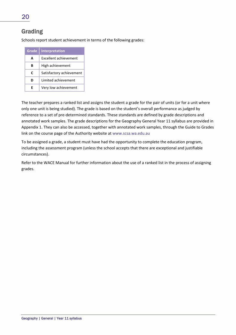
Grading Schools report student achievement in terms of the following grades:
Grade Interpretation
A Excellent achievement
B High achievement
C Satisfactory achievement
D Limited achievement
E Very low achievement
The teacher prepares a ranked list and assigns the student a grade for the pair of units (or for a unit where only one unit is being studied). The grade is based on the student’s overall performance as judged by reference to a set of pre-determined standards. These standards are defined by grade descriptions and annotated work samples. The grade descriptions for the Geography General Year 11 syllabus are provided in Appendix 1. They can also be accessed, together with annotated work samples, through the Guide to Grades link on the course page of the Authority website at www.scsa.wa.edu.au
To be assigned a grade, a student must have had the opportunity to complete the education program, including the assessment program (unless the school accepts that there are exceptional and justifiable circumstances).
Refer to the WACE Manual for further information about the use of a ranked list in the process of assigning grades.

21
Geography | General | Year 11 syllabus
Appendix 1 – Grade descriptions Year 11
A
Geographical knowledge and understandings Presents detailed discussions providing detailed information about features, activities, spatial patterns and associations, processes, relationships and/or factors. Makes relevant references to geographical concepts and/or theories. Geographical terminology and concepts Uses geographical terminology accurately and applies geographical concepts to develop relevant responses. Geographical skills Applies appropriate geographical thinking, skills and processes. Accurately applies mapping and/or diagrammatic skills and processes in a variety of contexts to enhance responses. Presents organised responses, including extended answers with well-developed sentences and paragraphs. Use of supporting evidence Selects and uses a wide range of appropriate supporting evidence, including examples, quotations, sources, statistics, data, maps and/or sketches, when developing responses.
B
Geographical knowledge and understandings Presents generalised brief discussions providing general information about features, activities, spatial patterns, and associations, processes, relationships and/or factors. Makes general reference to geographical concepts and/or theories. Geographical terminology and concepts Uses geographical terminology and concepts to develop relevant responses. Geographical skills Applies geographical thinking, skills and processes that are mainly appropriate. Applies mapping and/or diagrammatic skills and processes to support responses. Presents responses, including extended answers with appropriate sentences and paragraphs. Use of supporting evidence Selects and uses a range of supporting evidence, including examples, quotations, sources, statistics, data, maps and/or sketches, when developing responses.
C
Geographical knowledge and understandings Presents broad discussions providing basic information about features, activities, spatial patterns and associations, processes, relationships and/or factors. Makes occasional accurate references to geographical concepts and/or theories. Geographical terminology and concepts Uses some geographical terminology and/or concepts to develop responses. Geographical skills Applies geographical thinking, skills and processes that are occasionally appropriate. Sometimes uses mapping and/or diagrammatic skills and processes to develop responses. Presents mainly unstructured responses which may include irrelevant information. Use of supporting evidence Uses some supporting evidence which may be relevant, including examples, quotations, sources, statistics, data, maps and/or sketches, when developing responses.

22
Geography | General | Year 11 syllabus
D
Geographical knowledge and understandings Presents basic responses with limited detail. Makes limited reference to geographical concepts and/or theories. Geographical terminology and concepts Makes limited use of geographical terminology and/or concepts. Geographical skills Applies limited geographical thinking, skills and processes that are occasionally correct. Makes limited use of mapping and/or diagrammatic skills and processes. Presents responses showing poor literacy skills making them difficult to understand. Use of supporting evidence Makes limited use of evidence to support statements and generalisations.
E Does not meet the requirements of a D grade and/or has completed insufficient assessment tasks to be assigned a higher grade.

23
Geography | General | Year 11 syllabus
Appendix 2 – Glossary This glossary is provided to enable a common understanding of the key terms in this syllabus.
Anthropogenic biomes Biomes that are the result of sustained direct human interactions with ecosystems.
Biome A naturally occuring community of plants and animals adapted to a particular climate.
Biophysical processes The atmospheric, biological, chemical and physical processes that take place in the lithosphere, hydrosphere, atmosphere and biosphere. They can be further broken down, for example, soil forming processes, mass wasting, cloud forming processes, fluvial processes, marine processes, glacial processes and biogeochemical cycling.
Change The concept of change involves both time and space. Geographical phenomena are constantly changing, and can often be best understood by investigating how they have developed over time periods ranging from a few years to thousands of years. This is important in helping students to understand what is happening around them and to see their world as dynamic.
Ecological hazard A biological or chemical hazard that has the potential to impact adversely on the wellbeing of people or the environment more generally. Ecological hazards involve both biological and chemical agents. Biological factors can lead to infectious diseases. While many of these diseases have proven difficult to eradicate, enough is known about them to use interventions that drastically reduce their incidence. Chemical hazards can cause immediate, dangerous health effects and can also contribute to chronic, or long-term, problems. In contrast to infectious diseases, our understanding of the consequences of chemical exposure for people’s health, especially very low-level exposures typically found in the environment, remains incomplete.
Economic integration An outcome of the reduction or elimination of the barriers to the flow of goods, services and factors of production between nations. The stated aims of economic integration are to reduce costs incurred by consumers and producers, and to increase trade between countries.
Ecosystem A community of plants and animals in a non-living physical environment.
Environment The term ‘environment’, where unqualified, means the living and non-living elements of the Earth’s surface and atmosphere. It includes human changes to the Earth’s surface, for example, croplands, planted forests, buildings and roads.
Fieldwork Fieldwork is an integral part of geographical learning. It provides a planned opportunity for students to engage with the environment – to observe and investigate in the ‘real world’ the geographical phenomena, issues and processes studied in the classroom. It also enables students to explore different perspectives or points of view on important geographical issues. There are multiple approaches to fieldwork ranging from the observational to the fully participatory. Fieldwork can be undertaken in a range of settings, including school grounds. It includes ‘virtual fieldwork’ – the use of the Internet to virtually visit a site and engage in a guided geographical inquiry. A virtual field trip gives students the opportunity to investigate geographical phenomena not normally accessible due to distance or cost.
24
Geography | General | Year 11 syllabus
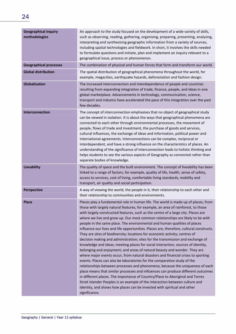
Geographical inquiry methodologies
An approach to the study focused on the development of a wide variety of skills, such as observing, reading, gathering, organising, preparing, presenting, analysing, interpreting and synthesising geographic information from a variety of sources, including spatial technologies and fieldwork. In short, it involves the skills needed to formulate questions and initiate, plan and implement an inquiry relevant to a geographical issue, process or phenomenon.
Geographical processes The combination of physical and human forces that form and transform our world.
Global distribution The spatial distribution of geographical phenomena throughout the world, for example, megacities, earthquake hazards, deforestation and fashion design.
Globalisation The increased interconnection and interdependence of people and countries resulting from expanding integration of trade, finance, people, and ideas in one global marketplace. Advancements in technology, communication, science, transport and industry have accelerated the pace of this integration over the past few decades.
Interconnection The concept of interconnection emphasises that no object of geographical study can be viewed in isolation. It is about the ways that geographical phenomena are connected to each other through environmental processes, the movement of people, flows of trade and investment, the purchase of goods and services, cultural influences, the exchange of ideas and information, political power and international agreements. Interconnections can be complex, reciprocal or interdependent, and have a strong influence on the characteristics of places. An understanding of the significance of interconnection leads to holistic thinking and helps students to see the various aspects of Geography as connected rather than separate bodies of knowledge.
Liveability The quality of space and the built environment. The concept of liveability has been linked to a range of factors, for example, quality of life, health, sense of safety, access to services, cost of living, comfortable living standards, mobility and transport, air quality and social participation.
Perspective A way of viewing the world, the people in it, their relationship to each other and their relationship to communities and environments.
Place Places play a fundamental role in human life. The world is made up of places, from those with largely natural features, for example, an area of rainforest, to those with largely constructed features, such as the centre of a large city. Places are where we live and grow up. Our most common relationships are likely to be with people in the same place. The environmental and human qualities of places influence our lives and life opportunities. Places are, therefore, cultural constructs. They are sites of biodiversity; locations for economic activity; centres of decision making and administration; sites for the transmission and exchange of knowledge and ideas; meeting places for social interaction; sources of identity, belonging and enjoyment; and areas of natural beauty and wonder. They are where major events occur, from natural disasters and financial crises to sporting events. Places can also be laboratories for the comparative study of the relationships between processes and phenomena, because the uniqueness of each place means that similar processes and influences can produce different outcomes in different places. The importance of Country/Place to Aboriginal and Torres Strait Islander Peoples is an example of the interaction between culture and identity, and shows how places can be invested with spiritual and other significance.
25
Geography | General | Year 11 syllabus
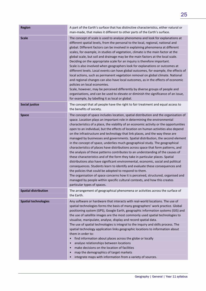
Region A part of the Earth’s surface that has distinctive characteristics, either natural or man-made, that makes it different to other parts of the Earth’s surface.
Scale The concept of scale is used to analyse phenomena and look for explanations at different spatial levels, from the personal to the local, regional, national and global. Different factors can be involved in explaining phenomena at different scales, for example, in studies of vegetation, climate is the main factor at the global scale, but soil and drainage may be the main factors at the local scale. Deciding on the appropriate scale for an inquiry is therefore important. Scale is also involved when geographers look for explanations or outcomes at different levels. Local events can have global outcomes, for example, the effects of local actions, such as permanent vegetation removal on global climate. National and regional changes can also have local outcomes, as in the effects of economic policies on local economies. Scale, however, may be perceived differently by diverse groups of people and organisations, and can be used to elevate or diminish the significance of an issue, for example, by labelling it as local or global.
Social justice The concept that all people have the right to fair treatment and equal access to the benefits of society.
Space The concept of space includes location, spatial distribution and the organisation of space. Location plays an important role in determining the environmental characteristics of a place, the viability of an economic activity or the opportunities open to an individual, but the effects of location on human activities also depend on the infrastructure and technology that link places, and the way these are managed by businesses and governments. Spatial distribution, the second element in the concept of space, underlies much geographical study. The geographical characteristics of places have distributions across space that form patterns, and the analysis of these patterns contributes to an understanding of the causes of these characteristics and of the form they take in particular places. Spatial distributions also have significant environmental, economic, social and political consequences. Students learn to identify and evaluate these consequences and the policies that could be adopted to respond to them. The organisation of space concerns how it is perceived, structured, organised and managed by people within specific cultural contexts, and how this creates particular types of spaces.
Spatial distribution The arrangement of geographical phenomena or activities across the surface of the Earth.
Spatial technologies Any software or hardware that interacts with real-world locations. The use of spatial technologies forms the basis of many geographers’ work practice. Global positioning system (GPS), Google Earth, geographic information systems (GIS) and the use of satellite images are the most commonly used spatial technologies to visualise, manipulate, analyse, display and record spatial data. The use of spatial technologies is integral to the inquiry and skills process. The spatial technology application links geographic locations to information about them in order to: • find information about places across the globe or locally • analyse relationships between locations • make decisions on the location of facilities • map the demographics of target markets • integrate maps with information from a variety of sources.
26
Geography | General | Year 11 syllabus
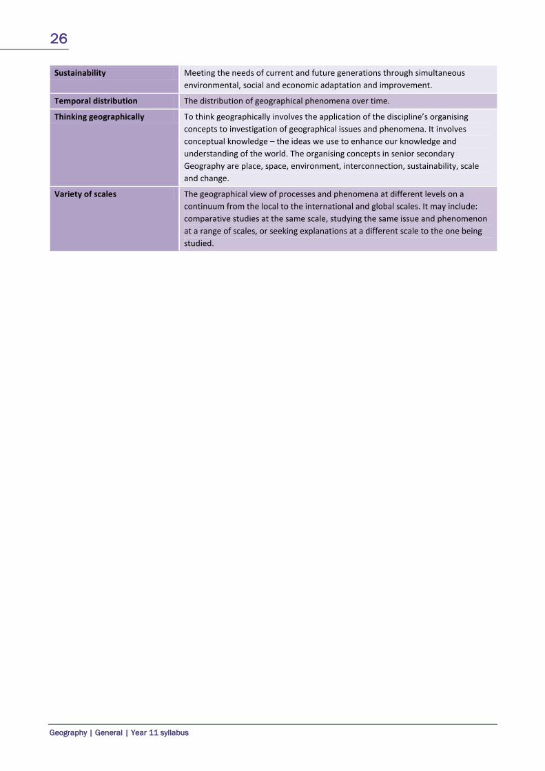
Sustainability Meeting the needs of current and future generations through simultaneous environmental, social and economic adaptation and improvement.
Temporal distribution The distribution of geographical phenomena over time.
Thinking geographically To think geographically involves the application of the discipline’s organising concepts to investigation of geographical issues and phenomena. It involves conceptual knowledge – the ideas we use to enhance our knowledge and understanding of the world. The organising concepts in senior secondary Geography are place, space, environment, interconnection, sustainability, scale and change.
Variety of scales The geographical view of processes and phenomena at different levels on a continuum from the local to the international and global scales. It may include: comparative studies at the same scale, studying the same issue and phenomenon at a range of scales, or seeking explanations at a different scale to the one being studied.