Embed Size (px)
Citation preview

1
GEOGRAPHY(Intermediate 2)
First edition – published April 2004
2
Administrative Information
Publication date: April 2004
Source: Scottish Qualifications Authority
Version: 01
© Scottish Qualifications Authority 2004
This publication may be reproduced in whole or in part for educational purposes provided that no profit is derived fromreproduction and that, if reproduced in part, the source is acknowledged.
Additional copies of this Specification (including Unit Specifications) can be purchased from the Scottish QualificationsAuthority for £7.50. Note: Unit Specifications can be purchased individually for £2.50 (minimum order £5).
2
National Course Specification
Geography (Intermediate 2)
COURSE CODE C208 11
COURSE STRUCTUREThis Course has three mandatory Units:
DF3C 11 Geography: Physical Environments (Intermediate 2) 1 credit (40 hours)DF43 11 Geography: Human Environments (Intermediate 2) 1 credit (40 hours)DF44 11 Geography: Environmental Interactions (Intermediate2) 1 credit (40 hours)
All Courses include 40 hours over and above the 120 hours for the component Units. This may beused for induction, extending the range of learning and teaching approaches, support, consolidation,integration of learning and preparation for external assessment.
RECOMMENDED ENTRYWhile entry is at the discretion of the centre, candidates will normally be expected to have attainedone of the following or equivalent:
♦ Standard Grade in Geography or another social subject at General level♦ Intermediate 1 Geography or its Units♦ Intermediate 1 or 2 Course or Units in another social subject
PROGRESSIONThis Course or its Units may provide progression to:
♦ Units or the Course at Higher Geography ♦ Units or the Course in another social subject at Higher level♦ Higher National programmes in related subjects

Course Arrangements: Intermediate 2 Geography 3
National Course Specification: (cont)
COURSE Geography (Intermediate 2)
CORE SKILLSThis Course gives automatic certification of the following:
Complete Core Skills for the Course None
Core Skills components for the Course Critical Thinking Intermediate 2Using Graphical Information Intermediate 2
CREDIT VALUEThe Intermediate 2 Course in Geography is allocated 24 SCQF points at SCQF level 5.
SCQF points are used to allocate credit to qualifications in the Scottish Credit and QualificationsFramework (SCQF). Each qualification is allocated a number of SCQF credit points at an SCQFlevel. There are 12 SCQF levels, ranging from Access 1 to Doctorates.
Course Arrangements: Intermediate 2 Geography 4
National Course Specification: Course details (cont)
COURSE Geography (Intermediate 2)
RATIONALE
The Intermediate 2 Geography Course can build on the Standard Grade qualification in the subjectand on the Units and Courses studied at Intermediate 1 level in Geography. It is also undertaken by anumber of candidates who may have studied another social subject. The achievement of a Courseaward in Geography at this level is a preparation for those candidates who wish to progress to studythe subject at Higher level. The principal aim of Geography is that candidates develop a detailed understanding of aspects of thecontemporary world, of concern to all citizens, by using the concepts and techniques of geographicalanalysis. In addition, the Course enables candidates to develop progressively: ♦ an understanding of the ways in which people and the environment interact in response to
physical and human processes at local, national and international scales♦ an awareness of spatial relationships and an understanding of the changing world in a balanced,
critical and sympathetic way♦ a life-long interest in, understanding of, and concern for the environment ♦ a geographical perspective on environmental issues and their significance♦ general skills of research, interpretation, analysis, evaluation and presentation, including the use
of IT♦ techniques and terminology to collect, extract, analyse, interpret and explain geographical
phenomena♦ expertise in the use of a range of maps, diagrams, statistical techniques, written accounts and,
where appropriate, new technology, to process and communicate information A contribution is made to general and vocational education and the wider curriculum by: ♦ raising awareness of the links between the subject and other disciplines♦ developing independent and co-operative learning as part of personal and social education♦ developing problem-solving skills♦ emphasising the development and application of learning skills relevant to everyday life Appropriate key geographical concepts should be taught. In constructing a teaching programme,account should be taken of the following underlying concepts:
♦ location♦ spatial patterns♦ change♦ diversity♦ interdependence♦ co-operation♦ conflict♦ sustainability♦ global citizenship ♦ technology These concepts should be introduced where they are appropriate to the topic of study.
Course Arrangements: Intermediate 2 Geography 5
National Course Specification: Course details (cont)
COURSE Geography (Intermediate 2)
During the Course at Intermediate 2 level emphasis is placed on providing geographical experienceswhich lead candidates to an understanding of concepts, key ideas and relevant terminology. Theseexperiences also develop evaluative and investigative skills. At this level candidates are introduced toa number of less familiar concepts and areal contexts. This is achieved through a set of Units withdifferent areal contexts and which focus on the identification of features and the processes involved intheir formation:♦ Geography: Physical Environments Unit — this has a British Isles context and studies a selection
of landscape types. ♦ Geography: Human Environments Unit — this has a wider context and studies detailed examples
from economically more and less developed countries. ♦ Geography: Environmental Interactions Unit — this has a stronger emphasis on global issues and
evaluating of strategies adopted to manage these. The issues studied may have a bias towardeither the physical or human environment but they exemplify the interactions between these twoenvironmental types.
Course Arrangements: Intermediate 2 Geography 6
National Course Specification: Course details (cont)
COURSE Geography (Intermediate 2) COURSE CONTENT
There are three mandatory Units in the Course:♦ Geography: Physical Environments Unit — this has choice embedded within it insofar as centres
can choose which areas they wish to include as case studies. ♦ Geography: Human Environments Unit — this has choice embedded within it insofar as centres
can choose which areas they wish to include as case studies. ♦ Geography: Environmental Interactions Unit — this has a wider range of choice. In this Unit
centres are able to choose any two from a list of five environmental interactions and once thatchoice has been made they can select the areal context and case study examples they wish tocover.
A range of skills is included within all Units. These build on skills developed during previous study ofgeography or other social subjects. The techniques may be taught through actual fieldwork, orsimulated fieldwork in the classroom. The application of selected methods and techniques to present,interpret and analyse information will be part of the Course and Unit assessment. Opportunitiesshould be provided for candidates to make use of a range of maps, including Ordnance Survey (OS)maps at a variety of scales. External assessment will use either 1:25000 or 1:50000 Ordnance Surveymaps. Further details of these skills are contained in Appendix 1 and in the specification for the Unitswhich form part of this Course. Detailed content relating to Knowledge and Understanding is contained in these Unit Specifications.A summary of this content is given in the table below. Each Unit should take up to a maximum of 40 hours for teaching. Additional time is available withinthe 160 hours allocated to the Course for revision, preparation for assessment, remediation andreassessment.
Course Arrangements: Intermediate 2 Geography 7
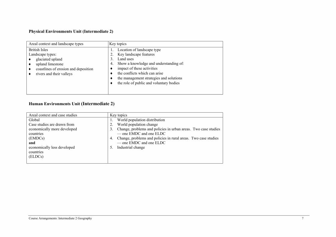
Physical Environments Unit (Intermediate 2) Areal context and landscape types Key topicsBritish IslesLandscape types:♦ glaciated upland♦ upland limestone♦ coastlines of erosion and deposition ♦ rivers and their valleys
1. Location of landscape type 2. Key landscape features3. Land uses 4. Show a knowledge and understanding of:♦ impact of these activities♦ the conflicts which can arise ♦ the management strategies and solutions ♦ the role of public and voluntary bodies
Human Environments Unit (Intermediate 2)
Areal context and case studies Key topicsGlobal Case studies are drawn from economically more developed countries (EMDCs) and economically less developed countries(ELDCs)
1. World population distribution2. World population change3. Change, problems and policies in urban areas. Two case studies
— one EMDC and one ELDC4. Change, problems and policies in rural areas. Two case studies
— one EMDC and one ELDC5. Industrial change
Course Arrangements: Intermediate 2 Geography 8
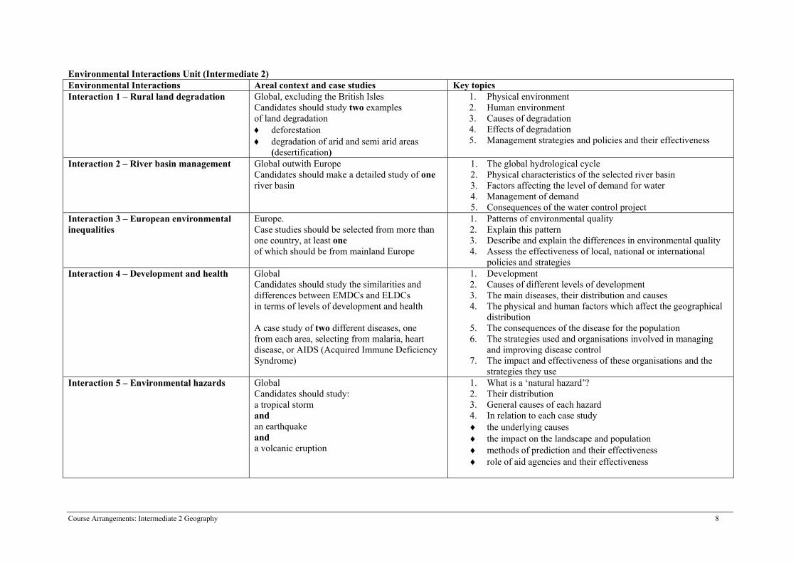
Environmental Interactions Unit (Intermediate 2)Environmental Interactions Areal context and case studies Key topicsInteraction 1 – Rural land degradation Global, excluding the British Isles
Candidates should study two examples of land degradation♦ deforestation ♦ degradation of arid and semi arid areas
(desertification)
1. Physical environment2. Human environment3. Causes of degradation4. Effects of degradation5. Management strategies and policies and their effectiveness
Interaction 2 – River basin management Global outwith EuropeCandidates should make a detailed study of one river basin
1. The global hydrological cycle2. Physical characteristics of the selected river basin3. Factors affecting the level of demand for water4. Management of demand5. Consequences of the water control project
Interaction 3 – European environmentalinequalities
Europe.Case studies should be selected from more than one country, at least one of which should be from mainland Europe
1. Patterns of environmental quality2. Explain this pattern3. Describe and explain the differences in environmental quality4. Assess the effectiveness of local, national or international
policies and strategiesInteraction 4 – Development and health Global
Candidates should study the similarities and differences between EMDCs and ELDCs in terms of levels of development and health
A case study of two different diseases, one from each area, selecting from malaria, heartdisease, or AIDS (Acquired Immune DeficiencySyndrome)
1. Development2. Causes of different levels of development3. The main diseases, their distribution and causes4. The physical and human factors which affect the geographical
distribution5. The consequences of the disease for the population6. The strategies used and organisations involved in managing
and improving disease control7. The impact and effectiveness of these organisations and the
strategies they useInteraction 5 – Environmental hazards Global
Candidates should study:a tropical stormand an earthquake anda volcanic eruption
1. What is a ‘natural hazard’?2. Their distribution3. General causes of each hazard4. In relation to each case study ♦ the underlying causes♦ the impact on the landscape and population♦ methods of prediction and their effectiveness♦ role of aid agencies and their effectiveness
Course Arrangements: Intermediate 2 Geography : 9
National Course Specification: course details (cont)
COURSE Geography (Intermediate 2)
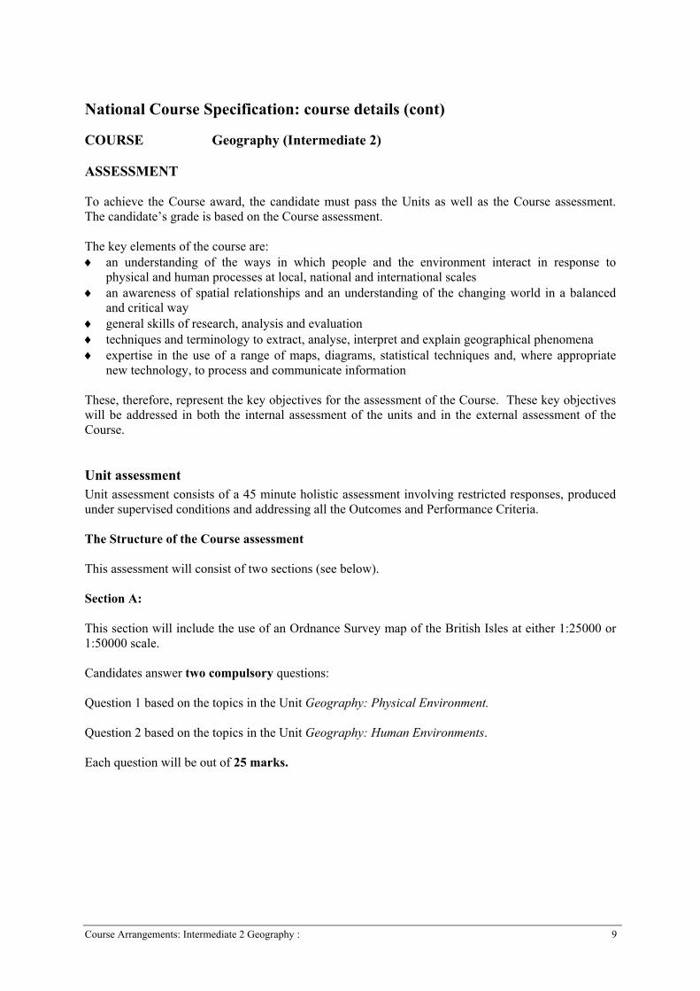
ASSESSMENT
To achieve the Course award, the candidate must pass the Units as well as the Course assessment.The candidate’s grade is based on the Course assessment.
The key elements of the course are:♦ an understanding of the ways in which people and the environment interact in response to
physical and human processes at local, national and international scales♦ an awareness of spatial relationships and an understanding of the changing world in a balanced
and critical way ♦ general skills of research, analysis and evaluation♦ techniques and terminology to extract, analyse, interpret and explain geographical phenomena♦ expertise in the use of a range of maps, diagrams, statistical techniques and, where appropriate
new technology, to process and communicate information
These, therefore, represent the key objectives for the assessment of the Course. These key objectiveswill be addressed in both the internal assessment of the units and in the external assessment of theCourse.
Unit assessment Unit assessment consists of a 45 minute holistic assessment involving restricted responses, producedunder supervised conditions and addressing all the Outcomes and Performance Criteria.
The Structure of the Course assessment
This assessment will consist of two sections (see below).
Section A:
This section will include the use of an Ordnance Survey map of the British Isles at either 1:25000 or1:50000 scale.
Candidates answer two compulsory questions:
Question 1 based on the topics in the Unit Geography: Physical Environment.
Question 2 based on the topics in the Unit Geography: Human Environments.
Each question will be out of 25 marks.
Course Arrangements: Intermediate 2 Geography : 10
National Course Specification: course details (cont)
COURSE Geography (Intermediate 2)
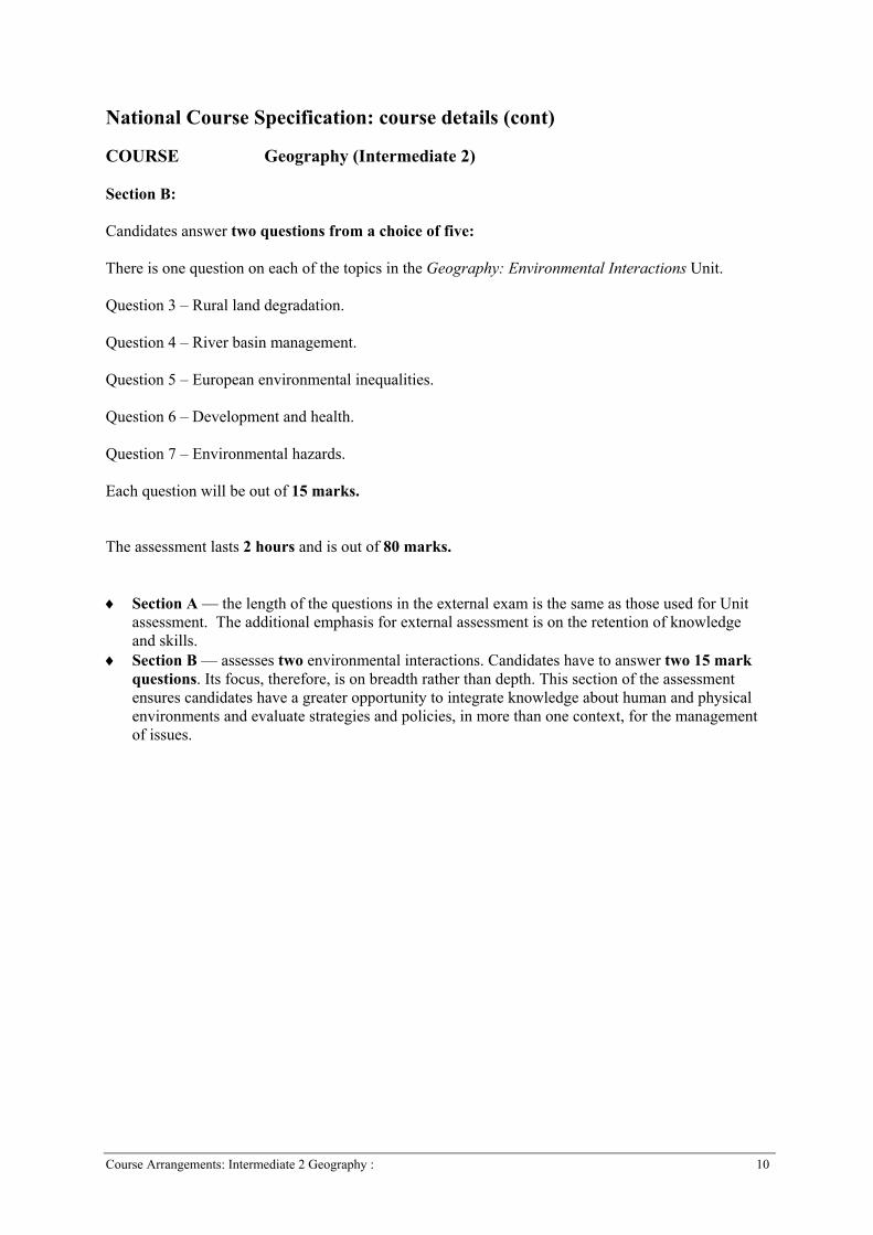
Section B:
Candidates answer two questions from a choice of five:
There is one question on each of the topics in the Geography: Environmental Interactions Unit.
Question 3 – Rural land degradation.
Question 4 – River basin management.
Question 5 – European environmental inequalities.
Question 6 – Development and health. Question 7 – Environmental hazards.
Each question will be out of 15 marks.
The assessment lasts 2 hours and is out of 80 marks. ♦ Section A — the length of the questions in the external exam is the same as those used for Unit
assessment. The additional emphasis for external assessment is on the retention of knowledgeand skills.
♦ Section B — assesses two environmental interactions. Candidates have to answer two 15 markquestions. Its focus, therefore, is on breadth rather than depth. This section of the assessmentensures candidates have a greater opportunity to integrate knowledge about human and physicalenvironments and evaluate strategies and policies, in more than one context, for the managementof issues.
Course Arrangements: Intermediate 2 Geography : 11
National Course Specification: Course details (cont)
COURSE Geography (Intermediate 2) Links between Unit and Course assessment and the added value of the Course Completion of the Course at this level demands more of candidates than is required to complete thethree Units. The external assessment also requires candidates to answer questions based aroundOrdnance survey maps. Although internal assessment items are likely to contain questions based onOrdnance survey maps there is no requirement to include them. Candidates who complete the Coursewill also have studied at least two environmental interactions through work undertaken in Unit 3.This additional interaction (only one is required for Unit assessment) allows candidates to furtherdemonstrate their depth and retention of knowledge but, more importantly, it provides furtheropportunities to write more extended and evaluative responses to questions. One of the key aims ofthe Environmental Interactions Unit is to show the degree of integration there is within and betweendifferent elements of the environment. By studying a second interaction for the Course award,candidates will have to show a greater knowledge and understanding of this integration than they dofor the Unit assessment. In addition to this, the Performance Criteria stress the relevance in this Unitof evaluating management strategies to deal with environmental issues. This higher level skill is,therefore, given greater prominence in the Course assessment. A further, and significant, example ofadded value of the Course relates to the need for candidates to retain knowledge over a longer periodof time and to be able to recall and use this to demonstrate their knowledge and understanding of thesubject. Candidates who have completed the Course, therefore, have widened their knowledge of theenvironment as a whole and will also have been able to use this knowledge to come to a greaterunderstanding of how the different elements of environment relate to each other. As these knowledgeand skill areas develop candidates will increasingly apply them to situations in which they have tomake sound and reasoned judgements about local, national and global environmental issues.
Further details about assessment for this Course can be found in NAB materials, the CourseAssessment Specification and the Specimen Question Paper, which are available for NAB materials atwww.sqa.org.uk/sqasecure and for the Course Assessment Specification and Specimen Paper atwww.sqa.org.uk.
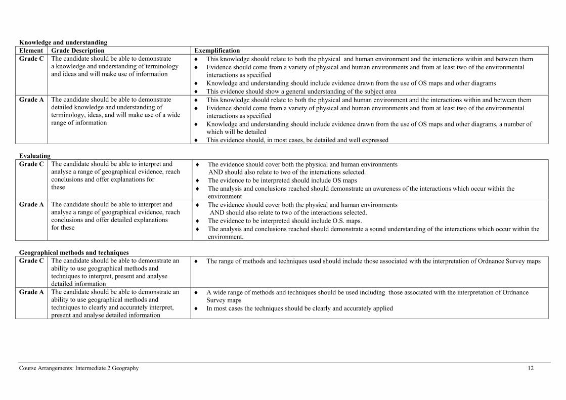
GRADE DESCRIPTIONS
The Intermediate 2 Geography Course should enable candidates to demonstrate a knowledge andunderstanding of key concepts, an ability to evaluate and analyse information and use a variety ofgeographical methods and techniques to interpret and explain geographical phenomena. The candidate’s grade will be based on the total score obtained from the Course assessment. Thedescriptions below indicate the nature of achievement required for the award at grade C and A in theCourse.
Course Arrangements: Intermediate 2 Geography 12
Knowledge and understandingElement Grade Description ExemplificationGrade C The candidate should be able to demonstrate
a knowledge and understanding of terminologyand ideas and will make use of information
♦ This knowledge should relate to both the physical and human environment and the interactions within and between them♦ Evidence should come from a variety of physical and human environments and from at least two of the environmental
interactions as specified♦ Knowledge and understanding should include evidence drawn from the use of OS maps and other diagrams♦ This evidence should show a general understanding of the subject area
Grade A The candidate should be able to demonstratedetailed knowledge and understanding ofterminology, ideas, and will make use of a widerange of information
♦ This knowledge should relate to both the physical and human environment and the interactions within and between them♦ Evidence should come from a variety of physical and human environments and from at least two of the environmental
interactions as specified♦ Knowledge and understanding should include evidence drawn from the use of OS maps and other diagrams, a number of
which will be detailed♦ This evidence should, in most cases, be detailed and well expressed
EvaluatingGrade C The candidate should be able to interpret and
analyse a range of geographical evidence, reach conclusions and offer explanations for these
♦ The evidence should cover both the physical and human environments AND should also relate to two of the interactions selected.
♦ The evidence to be interpreted should include OS maps♦ The analysis and conclusions reached should demonstrate an awareness of the interactions which occur within the
environmentGrade A The candidate should be able to interpret and
analyse a range of geographical evidence, reach conclusions and offer detailed explanations for these
♦ The evidence should cover both the physical and human environments AND should also relate to two of the interactions selected.
♦ The evidence to be interpreted should include O.S. maps. ♦ The analysis and conclusions reached should demonstrate a sound understanding of the interactions which occur within the
environment.
Geographical methods and techniques Grade C The candidate should be able to demonstrate an
ability to use geographical methods andtechniques to interpret, present and analysedetailed information
♦ The range of methods and techniques used should include those associated with the interpretation of Ordnance Survey maps
Grade A The candidate should be able to demonstrate anability to use geographical methods andtechniques to clearly and accurately interpret,present and analyse detailed information
♦ A wide range of methods and techniques should be used including those associated with the interpretation of OrdnanceSurvey maps
♦ In most cases the techniques should be clearly and accurately applied
Course Arrangements: Intermediate 2 Geography 13
National Course Specification: Course details (cont)
COURSE Geography (Intermediate 2)
Evidence used for estimates and appeals
To determine the suitability of the evidence for estimates and appeals, centres should measure itagainst the Grade Descriptions and exemplification illustrated in the table above. Where evidencemeets these criteria and demonstrates the retention of knowledge and skills over a period of time itcan contribute to judgements made for the purposes of estimates.
Centres should base their appeals on the following criteria:
♦ there should be evidence of retained and integrated knowledge♦ there should be evidence from a range of topics from within the physical and human
environments♦ there should be evidence from two environmental interactions♦ the evidence should include the use of Ordnance Survey maps
Where the centre has gathered evidence in such a way that the candidates are able to demonstrateevidence for all these criteria, eg by means of a prelim exam, this can form the basis of an appeal.Ideally, if a prelim is used, it should replicate the style, timing, difficulty and overall mark of theexternal examination.
If using a prelim, some centres may set this early on in the Course when it would not be possible toassess all topics. In this case additional evidence covering the later topics (which could be frominternal assessment/NABs) should be submitted. Evidence generated later in the Course may be morerepresentative of candidates’ final level of attainment.
Centres gathering evidence for estimates and appeals sometimes draw heavily on past SQA papers fortheir questions. For reliability, it is important that the assessment being used for evidence is an unseenassessment conducted under controlled and supervised conditions. Centres should note that a pastpaper or SQA specimen paper, in its entirety, will not be accepted as evidence to support an appeal.However, it is acceptable for centres to use a selection of individual questions drawn from a range ofpast papers, suitably adapted, to make up a prelim paper. This gives a degree of uniqueness to theassessment.
Centres may use evidence generated from NAB items/Unit assessments to contribute toward appeals.However, the achievement of a pass in each of the units does not demonstrate all the elements of theperformance required to achieve a minimum ‘C’ award. Achievement of at least 60% in each NABcan be helpful but evidence matching all of the bullet points listed above must be provided.
Course Arrangements: Intermediate 2 Geography 14
National Course Specification: Course details (cont)
COURSE Geography (Intermediate 2)
QUALITY ASSURANCE
All National Courses are subject to external marking and/or moderation. External markers, visitingexaminers and moderators are trained by SQA to apply national standards. SQA is currently seekingto assist centres by preparing exemplification of standards materials in a number of subject areas.This will be rolled out to all subjects in due course.
The Units of all Courses are subject to internal moderation and may also be chosen for externalmoderation. This is to ensure that national standards are being applied across all subjects.
Courses may be assessed by a variety of methods. Where marking is undertaken by a trained markerin their own time, markers meetings are held to ensure that a consistent standard is applied. The workof all markers is subject to scrutiny by the Principal Assessor and a PA report is published for allsubjects.
APPROACHES TO LEARNING AND TEACHING
This Course consists of three 40 hour mandatory Units.
D (?) : Geography: Physical Environments (Intermediate 2) 40 hoursD (?) : Geography: Human Environments (Intermediate 2) 40 hoursD (?) : Geography: Environmental Interactions (Intermediate 2) 40 hours
All of the Intermediate 2 Geography Course can be taught solely in the classroom but there are manyopportunities for centres to engage their candidates in fieldwork related to the Course. Both theGeography: Physical Environment Unit and the Geography: Human Environment Unit can be mademore relevant to candidates by providing opportunities for fieldwork and educational visits during theCourse. In the Geography: Environmental Interactions Unit, the rural land resources, Europeanenvironmental inequalities and urban change and its management topics can also incorporate elements offieldwork. A number of centres encourage their candidates to take part in residential visits to field studiescentres or to participate in field visits organised around day visits to places of interest.
This Course will be taught in a variety of different situations and the candidates in the teaching groupmay be working at different levels. Although many different combinations are possible, most teachinggroups will fall in to one of the following categories:
♦ The whole group studying Geography at Intermediate 2 level.♦ The whole group studying Geography at Intermediate 1 or 2.♦ Different members of the group studying Geography at Higher (and Intermediate 1) as well as
Intermediate 2.
The background of candidates will vary as well. Some may:
♦ plan to study Geography at Higher level the following year♦ have studied Geography at Intermediate 1 level the previous year♦ not have studied Geography at any level for a number of years♦ have started at another level and changed to this level during the session
Course Arrangements: Intermediate 2 Geography 15
National Course Specification: Course details (cont)
COURSE Geography (Intermediate 2)
Centres will also have different priorities. Some will value the chance to teach different levels:
♦ the same content♦ related, but similar content ♦ different content
The wide variety of teaching groups, candidate backgrounds and centre policies require the Course atIntermediate 2 to be flexible. This flexibility is constrained by the need to be able to resource, manageand reliably assess candidates. The variety of topics which centres can choose to study for the UnitGeography: Environmental Interactions is, in particular, aimed at creating the flexibility needed for theCourse at this level.
The Units which make up this Course are designed to allow each of the above combinations of candidatesto be taught. Centres will require to identify priorities for teaching the Course at this level and then selectcontexts to fit the circumstances most appropriate to their needs. This might mean that what is taught mayvary from year to year. The Units have flexibility within them to select different case studies so that nocandidate need repeat them in a second year of study. The Geography: Environmental Interactions Unitalso contains a choice: two from five environmental interactions. This again provides the opportunity toavoid repetitiveness from year to year but it also ensures that there is progression of ideas, skills andconcepts. In some centres a high value might be placed on minimising the differences in content betweenthe levels. The Course can also be planned to achieve this, but only if the environmental interactionsstudied are the same for Intermediate 1 and 2. Not all environmental interaction topics provide the sameprogression route to Higher. In cases where centres want very close alignment between Higher andIntermediate 2 this will need to be considered when choices are made. These selection decisions may alsoimpact on Intermediate 1 and Higher level as well.
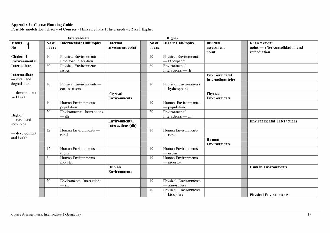
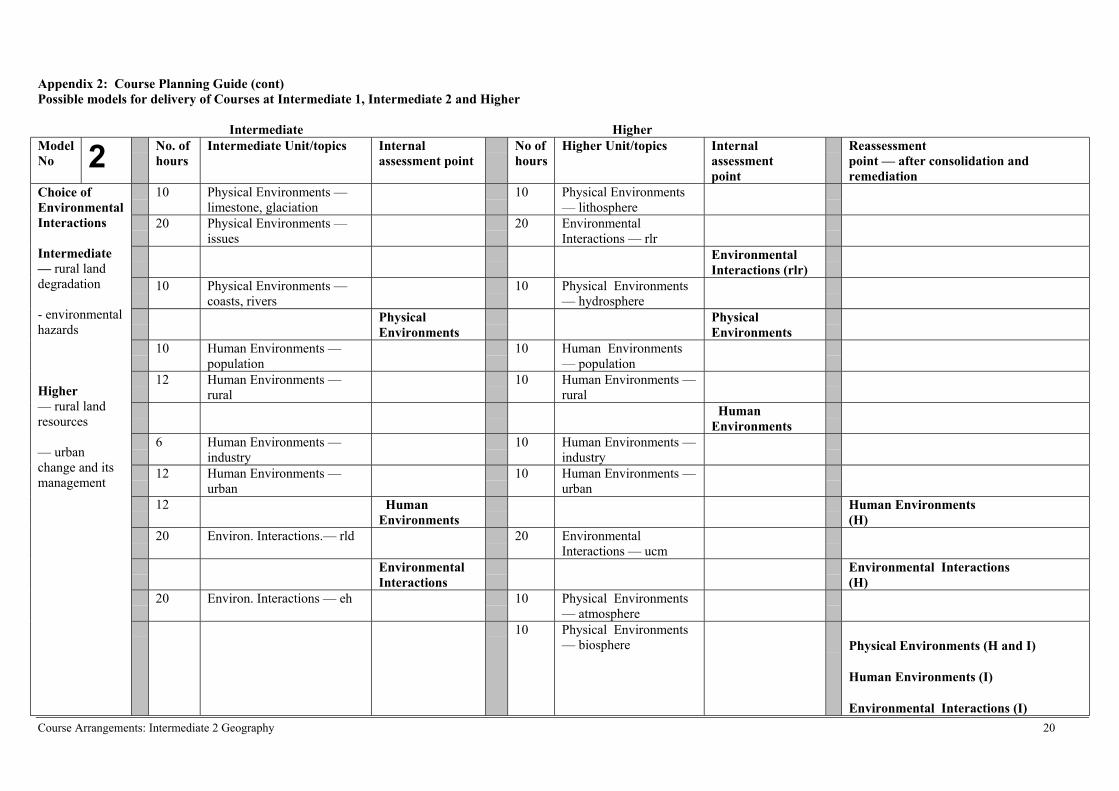
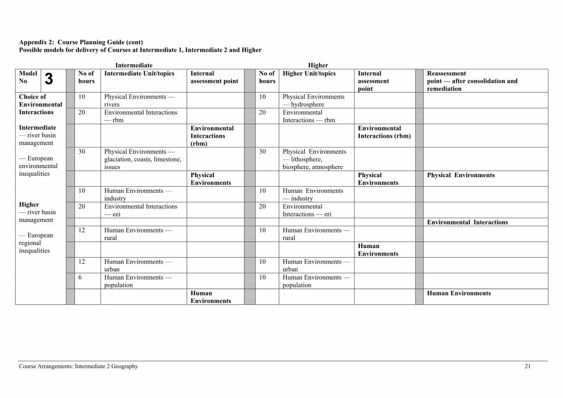
An example of models which might be used to teach this Course in association with the Higher Course inGeography is provided in Appendix 2.
For centres teaching only Intermediate 1 and 2 in the same group it is likely that they will be taught acommon Course. There is, however, no reason why the two Courses cannot be made quite different byselecting different case studies in Geography: Physical Environment Unit and the Geography: HumanEnvironment Unit and completely different topics in the Geography: Environmental Interactions Unit.Where this happens it should be possible to carry out internal assessment at the same time.
The Units at Intermediate 2 do not require to be taught sequentially. Where centres decide to select topicsin the Geography: Environmental Interactions Unit which link closely with aspects of Geography:Physical Environment Unit and the Geography: Human Environment Unit, e.g. river basin management,development and health, they are advised to teach the relevant content in these two Units at an earliertime. It is, however, up to the centre to devise a Course plan which best meets its needs.
The timing of internal assessment may be critical in some centres where there is a priority to align theassessment at this level with, say, Higher level. The information in Appendix 2 provides examples ofhow this might be done. Other models of delivery may achieve this Outcome as well.
In situations where candidates transfer between levels during a session, for example, from Higher toIntermediate 2, they will receive credit for any passes they have achieved at Higher. They will, however,only be able to achieve certification for a Course award at the lower level. However, where a candidate ismoved from Intermediate 2 to Higher during a session they would have to sit all the assessments at thelevel above to be able to achieve certification for a Course award at the higher level.
Course Arrangements: Intermediate 2 Geography 16
National Course Specification: Course details (cont)
COURSE Geography (Intermediate 2)
SPECIAL NEEDS
This Course Specification is intended to ensure that there are no artificial barriers to learning orassessment. Special needs of individual candidates should be taken into account when planninglearning experiences, selecting assessment instruments or considering alternative Outcomes for Units.For information on these, please refer to the SQA document Guidance on Special AssessmentArrangements (SQA, September, 2003).
GEOGRAPHY IN A BROADER CONTEXT A number of national initiatives and programmes have been designed to promote themes that areimportant to contemporary society such as citizenship and enterprise. These themes contribute toindividual subjects and Courses by making connections beyond the subject boundaries and enrich thelearning experience. Similarly, the specialist knowledge and skills developed through study of aparticular subject contributes to the understanding of these themes.
Cross curricular themes and issues in Geography
The nature of Geography, crossing as it does many of the inter-disciplinary divides, means thatgeographical education has traditionally been imbued with cross-curricular themes. At all levels, theUnit Specifications allow teachers and students to continue to exploit opportunities for learningexperiences which go beyond the bounds of the subject. Many of the themes encompassed withincurrent initiatives such as education for citizenship, enterprise in education, health education and thenational priorities for education, can be found within the Specifications for the National Courses inGeography.
Education for citizenship equips young people with the knowledge and skills which develop theirability to become active and responsible citizens. Within the Units of Intermediate 1, Intermediate 2and Higher Courses, students have the opportunity to explore connections between human culturesand the physical world in which they live.
Specifically, in the Intermediate 1 and Intermediate 2 Courses, the impact of human activities on theenvironment is explored in a variety of contexts within the British Isles in Unit 1. In Unit 2, with amore global context, differences in economic development and population change underline the needfor global citizenship. Unit 3 focuses on the relationships between the physical and humanenvironment, and extends the themes of sustainable development. Respect for cultural and communitydiversity may be explored through studies of the management of urban change, population change (atall levels), and European Regional Inequalities (Higher).
Health education is explored in both the Intermediate and Higher Courses, with the Specifications atboth levels highlighting differences in health across the globe and specifically including reference toAIDS. Implicit is a study of healthy lifestyles.
Enterprise in Education highlights the need to equip young people with the skills to prosper in achanging society. At all levels students have the opportunity to increase knowledge relevant to theworld of work through studies of technological change and change in manufacturing methods.Awareness of the changing nature of the world of business, of working life and economic activity areimplicit in the Specifications for Intermediate 1, Intermediate 2 and Higher. At Advanced Higherlevel, self-motivation and independence are encouraged in the undertaking of practical activities.
Course Arrangements: Intermediate 2 Geography 17
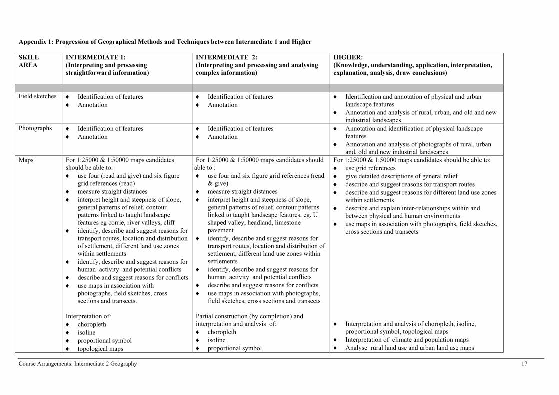
Appendix 1: Progression of Geographical Methods and Techniques between Intermediate 1 and Higher
SKILLAREA
INTERMEDIATE 1: (Interpreting and processingstraightforward information)
INTERMEDIATE 2:(Interpreting and processing and analysingcomplex information)
HIGHER:(Knowledge, understanding, application, interpretation,explanation, analysis, draw conclusions)
Field sketches ♦ Identification of features♦ Annotation
♦ Identification of features♦ Annotation
♦ Identification and annotation of physical and urbanlandscape features
♦ Annotation and analysis of rural, urban, and old and newindustrial landscapes
Photographs ♦ Identification of features♦ Annotation
♦ Identification of features♦ Annotation
♦ Annotation and identification of physical landscapefeatures
♦ Annotation and analysis of photographs of rural, urbanand, old and new industrial landscapes
Maps For 1:25000 & 1:50000 maps candidatesshould be able to: ♦ use four (read and give) and six figure
grid references (read)♦ measure straight distances♦ interpret height and steepness of slope,
general patterns of relief, contourpatterns linked to taught landscapefeatures eg corrie, river valleys, cliff
♦ identify, describe and suggest reasons fortransport routes, location and distributionof settlement, different land use zoneswithin settlements
♦ identify, describe and suggest reasons forhuman activity and potential conflicts
♦ describe and suggest reasons for conflicts♦ use maps in association with
photographs, field sketches, crosssections and transects.
Interpretation of:♦ choropleth♦ isoline♦ proportional symbol♦ topological maps
For 1:25000 & 1:50000 maps candidates should able to : ♦ use four and six figure grid references (read
& give)♦ measure straight distances ♦ interpret height and steepness of slope,
general patterns of relief, contour patternslinked to taught landscape features, eg. Ushaped valley, headland, limestonepavement
♦ identify, describe and suggest reasons fortransport routes, location and distribution ofsettlement, different land use zones withinsettlements
♦ identify, describe and suggest reasons forhuman activity and potential conflicts
♦ describe and suggest reasons for conflicts♦ use maps in association with photographs,
field sketches, cross sections and transects
Partial construction (by completion) andinterpretation and analysis of:♦ choropleth♦ isoline♦ proportional symbol
For 1:25000 & 1:50000 maps candidates should be able to:♦ use grid references♦ give detailed descriptions of general relief♦ describe and suggest reasons for transport routes♦ describe and suggest reasons for different land use zones
within settlements ♦ describe and explain inter-relationships within and
between physical and human environments♦ use maps in association with photographs, field sketches,
cross sections and transects
♦ Interpretation and analysis of choropleth, isoline,proportional symbol, topological maps
♦ Interpretation of climate and population maps♦ Analyse rural land use and urban land use maps
Course Arrangements: Intermediate 2 Geography 18
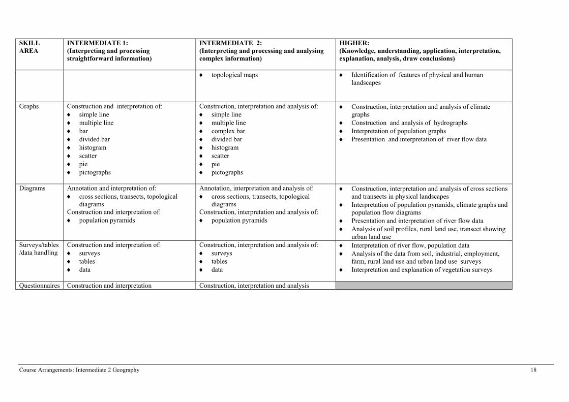
SKILLAREA
INTERMEDIATE 1: (Interpreting and processingstraightforward information)
INTERMEDIATE 2:(Interpreting and processing and analysingcomplex information)
HIGHER:(Knowledge, understanding, application, interpretation,explanation, analysis, draw conclusions)
♦ topological maps ♦ Identification of features of physical and humanlandscapes
Graphs Construction and interpretation of:♦ simple line♦ multiple line♦ bar♦ divided bar♦ histogram♦ scatter♦ pie♦ pictographs
Construction, interpretation and analysis of:♦ simple line♦ multiple line♦ complex bar♦ divided bar♦ histogram♦ scatter♦ pie♦ pictographs
♦ Construction, interpretation and analysis of climategraphs
♦ Construction and analysis of hydrographs♦ Interpretation of population graphs♦ Presentation and interpretation of river flow data
Diagrams Annotation and interpretation of:♦ cross sections, transects, topological
diagramsConstruction and interpretation of: ♦ population pyramids
Annotation, interpretation and analysis of:♦ cross sections, transects, topological
diagramsConstruction, interpretation and analysis of: ♦ population pyramids
♦ Construction, interpretation and analysis of cross sectionsand transects in physical landscapes
♦ Interpretation of population pyramids, climate graphs andpopulation flow diagrams
♦ Presentation and interpretation of river flow data♦ Analysis of soil profiles, rural land use, transect showing
urban land useSurveys/tables/data handling
Construction and interpretation of:♦ surveys♦ tables♦ data
Construction, interpretation and analysis of:♦ surveys♦ tables♦ data
♦ Interpretation of river flow, population data♦ Analysis of the data from soil, industrial, employment,
farm, rural land use and urban land use surveys♦ Interpretation and explanation of vegetation surveys
Questionnaires Construction and interpretation Construction, interpretation and analysis
Course Arrangements: Intermediate 2 Geography 19
Appendix 2: Course Planning GuidePossible models for delivery of Courses at Intermediate 1, Intermediate 2 and Higher
Intermediate HigherModelNo 1 No of
hoursIntermediate Unit/topics Internal
assessment pointNo ofhours
Higher Unit/topics Internalassessment point
Reassessmentpoint — after consolidation andremediation
10 Physical Environments —limestone, glaciation
10 Physical Environments— lithosphere
20 Physical Environments—–issues
20 EnvironmentalInteractions — rlr
EnvironmentalInteractions (rlr)
10 Physical Environments —coasts, rivers
10 Physical Environments— hydrosphere
PhysicalEnvironments
PhysicalEnvironments
10 Human Environments —population
10 Human Environments— population
20 Environmental Interactions— dh
20 EnvironmentalInteractions — dh
EnvironmentalInteractions (dh)
Environmental Interactions
12 Human Environments —rural
10 Human Environments— rural
HumanEnvironments
12 Human Environments —urban
10 Human Environments— urban
6 Human Environments —industry
10 Human Environments— industry
HumanEnvironments
Human Environments
20 Enviromental Interactions— rld
10 Physical Environments— atmosphere
Choice ofEnvironmentalInteractions
Intermediate— rural landdegradation
— developmentand health
Higher— rural landresources
— developmentand health
10 Physical Environments— biosphere Physical Environments
Course Arrangements: Intermediate 2 Geography 20
Appendix 2: Course Planning Guide (cont)Possible models for delivery of Courses at Intermediate 1, Intermediate 2 and Higher
Intermediate HigherModelNo 2 No. of
hoursIntermediate Unit/topics Internal
assessment pointNo ofhours
Higher Unit/topics Internalassessment point
Reassessmentpoint — after consolidation andremediation
10 Physical Environments —limestone, glaciation
10 Physical Environments— lithosphere
20 Physical Environments —issues
20 EnvironmentalInteractions — rlr
EnvironmentalInteractions (rlr)
10 Physical Environments —coasts, rivers
10 Physical Environments— hydrosphere
PhysicalEnvironments
PhysicalEnvironments
10 Human Environments —population
10 Human Environments— population
12 Human Environments —rural
10 Human Environments —rural
HumanEnvironments
6 Human Environments —industry
10 Human Environments —industry
12 Human Environments —urban
10 Human Environments —urban
12 HumanEnvironments
Human Environments(H)
20 Environ. Interactions.— rld 20 EnvironmentalInteractions — ucm
EnvironmentalInteractions
Environmental Interactions(H)
20 Environ. Interactions — eh 10 Physical Environments— atmosphere
Choice ofEnvironmentalInteractions
Intermediate— rural landdegradation
- environmentalhazards
Higher— rural landresources
— urbanchange and itsmanagement
10 Physical Environments— biosphere Physical Environments (H and I)
Human Environments (I)
Environmental Interactions (I)
Course Arrangements: Intermediate 2 Geography 21
Appendix 2: Course Planning Guide (cont)Possible models for delivery of Courses at Intermediate 1, Intermediate 2 and Higher
Intermediate HigherModelNo 3 No of
hoursIntermediate Unit/topics Internal
assessment pointNo ofhours
Higher Unit/topics Internalassessment point
Reassessmentpoint — after consolidation andremediation
10 Physical Environments —rivers
10 Physical Environments— hydrosphere
20 Environmental Interactions— rbm
20 EnvironmentalInteractions — rbm
EnvironmentalInteractions(rbm)
EnvironmentalInteractions (rbm)
30 Physical Environments —glaciation, coasts, limestone,issues
30 Physical Environments— lithosphere,biosphere, atmosphere
PhysicalEnvironments
PhysicalEnvironments
Physical Environments
10 Human Environments —industry
10 Human Environments— industry
20 Environmental Interactions— eei
20 EnvironmentalInteractions — eri
Environmental Interactions12 Human Environments —
rural10 Human Environments —
rural Human
Environments12 Human Environments —
urban10 Human Environments —
urban
6 Human Environments —population
10 Human Environments —population
Choice ofEnvironmentalInteractions
Intermediate— river basinmanagement
— Europeanenvironmentalinequalities
Higher— river basinmanagement
— Europeanregionalinequalities
HumanEnvironments
Human Environments
Administrative InformationSuperclass: RF
Publication date: April 2004
Source: Scottish Qualifications Authority
Version: 01
© Scottish Qualifications Authority
This publication may be reproduced in whole or in part for educational purposes provided that no profit is derived fromreproduction and that, if reproduced in part, the source is acknowledged.
Additional copies of this unit specification can be purchased from the Scottish Qualifications Authority. The cost for eachunit specification is £2.50. (A handling charge of £1.95 will apply to all orders for priced items.) 22
National Unit Specification: general information
UNIT Geography: Physical Environments (Intermediate 2)
CODE DF3C 11
COURSE Geography (Intermediate 2)
SUMMARY
This Unit builds on the key ideas developed through the study theme ‘the physical environment’ inStandard Grade Geography and the 5-14 guidelines on ‘Environmental Studies – People and Place’and also the Geography: Physical Environments Unit at Intermediate 1. It could also be used as anintroductory Unit for those with a broad interest in the subject area.
In this Unit emphasis is placed on providing candidates with opportunities to develop their knowledgeand understanding of aspects of the physical environment. This is done through the study of selectedphysical environments which provide the focus for change.
The specific aims of the Unit are to develop:
♦ knowledge and understanding of different and changing physical environments ♦ understanding of the opportunities and limitations of the physical environment for human
activities ♦ knowledge and understanding of how human activities can lead to various forms of environmental
change, both beneficial and detrimental♦ knowledge, understanding and evaluation of the strategies employed to manage the environment ♦ skills of processing and interpreting Ordnance Survey maps, statistical data and other types of
graphical information.
Appendix 1 contains the skills and content which will be covered in this Unit and will be sampled toprovide the evidence required for the Unit.
Unit Specification – Geography: Physical Environments (Intermediate 2) 23
National Unit Specification: general information (cont)
UNIT Geography: Physical Environments (Intermediate 2)
OUTCOMES
a) Demonstrate knowledge and understanding of a wide range of features of the physicalenvironment.
b) Demonstrate the ability to use detailed geographical information presented in a variety offorms.
c) Demonstrate knowledge and understanding of an interaction within the physical environment.
RECOMMENDED ENTRY
While entry is at the discretion of the centre, candidates would normally be expected to have attainedone of the following or equivalent:♦ Standard Grade Geography at General level♦ Standard Grade at General or Credit level in another social subject ♦ Intermediate 1 Geography or its Units♦ Intermediate 1 or 2 Course or Unit(s) in another social subject
CREDIT VALUE
1 credit at Intermediate 2 (6 SCQF credit points at SCQF level 5*)
*SCQF credit points are used to allocate credit to qualifications in the Scottish Credit and QualificationsFramework (SCQF). Each qualification in the Framework is allocated a number of SCQF credit pointsat an SCQF level. There are 12 SCQF levels, ranging from Access 1 to Doctorates.
CORE SKILLSThis Unit gives automatic certification of the following:
Complete Core Skills for the Unit None
Core Skills components for the Unit Critical Thinking Intermediate 2Using Graphical Information Intermediate 2
Unit Specification – Geography: Physical Environments (Intermediate 2) 24
National Unit Specification: statement of standards
UNIT Geography: Physical Environments (Intermediate 2)
Acceptable performance in this Unit will be the satisfactory achievement of the standards set out inthis part of the Unit Specification. All sections of the statement of standards are mandatory and cannotbe altered without reference to the Scottish Qualifications Authority.
OUTCOME 1
Demonstrate knowledge and understanding of a wide range of features of the physical environment.
Performance Criteria
a) Clearly and accurately identify a wide range of features on maps, sketches and photographs ofthe physical environment.
b) Clearly and accurately describe a wide range of features of the physical environment.c) Clearly and accurately explain the formation of a wide range of features of the physical
environment.
OUTCOME 2
Demonstrate the ability to use detailed geographical information presented in a variety of forms.
Performance Criteria
a) Clearly and accurately interpret detailed information on maps and diagrams, and in statistics andtext.
b) Clearly and accurately present detailed information on maps, diagrams and in written summaries.c) Clearly and accurately analyse detailed information on maps, diagrams, in statistics and text.
OUTCOME 3
Demonstrate knowledge and understanding of an interaction within the physical environment.
Performance Criteria
a) Clearly and accurately describe the interaction to show the linkages between the main featuresof the environment.
b) Clearly and accurately explain the interaction to show the linkages between the main features ofthe environment.
c) Clearly and accurately describe the consequences or issues arising from the interaction.d) Clearly and accurately explain the consequences or issues arising from the interaction.e) Clearly and accurately describe the strategies for the management of, or solutions to, the issues.
f) Clearly and accurately describe the effectiveness of the strategies.

Unit Specification – Geography: Physical Environments (Intermediate 2) 25
National Unit Specification: statement of standards (cont)
UNIT Geography: Physical Environments (Intermediate 2)
EVIDENCE REQUIREMENTS FOR THE UNIT
Evidence for this Unit will involve restricted responses which can be written, oral or diagrammaticsupplemented by written or oral responses. This evidence should be produced under supervisedconditions without the assistance of additional resources. The assessment must be capable of beingcompleted within 45 minutes and will be holistic, covering all Outcomes and PCs.
The assessment will sample the content and skills defined in Appendix 1 by including questionswhich reflect the breadth of content and skills as shown in the numbered sections in that Appendix. Ifa re-assessment is required, it should contain a different sample from the range of content and skills.
Achievement can be decided by the use of a cut-off score. The standard to be applied and the breadthof coverage are illustrated in the National Assessment Bank items available for this Unit. If a centrewishes to design its own assessments for this Unit, they should be of a comparable standard.
Unit Specification – Geography: Physical Environments (Intermediate 2) 26
National Unit Specification: support notes
UNIT Geography: Physical Environments (Intermediate 2)
This part of the Unit Specification is offered as guidance. The support notes are not mandatory.
While the exact time allocated to this Unit is at the discretion of the centre, the notional design lengthis 40 hours.
GUIDANCE ON THE CONTENT AND CONTEXT FOR THIS UNIT
This Unit is one of three mandatory Units which make up the Course at Intermediate 2 Geography.The other two Units are Geography: Human Environments and Geography: EnvironmentalInteractions. It is designed to meet the needs of the broad variety of candidates who may choose tostudy the Unit.
The skills and content for this Unit are provided in Appendix 1.
The knowledge component of this Unit is important but so also is the use of the geographical skillswhich can be used to interpret, present and analyse information. There should be a particular emphasison the use of Ordnance Survey maps in this Unit and it is advised that candidates use these types ofmaps in the study of each of the different landscape types. Although Ordnance Survey maps may beused in the other Units, this one provides many opportunities to develop the skills associated withreading, interpreting and analysing information presented in this form.
In the study of this Unit it is expected that candidates will develop their knowledge and understandingof the features of, and processes which create, the physical environment in the British Isles. Theyshould also have opportunities to increase their understanding of the complex issues which surroundthe use and management of these areas.
GUIDANCE ON LEARNING AND TEACHING APPROACHES FOR THIS UNIT
Teaching orderIn centres where one or both of the other Units at this level is being taught, teachers or lecturers canchoose to teach the Units in any order. It is also possible to integrate the content of these Units intoone continuous programme or to teach the Units separately or in parallel with each other. While thecontent is different, the general skills and concepts are broadly the same, and centres may considerthat these will be reinforced if they are used and developed in different contexts at the same time.
Articulation with Intermediate 1 and HigherThe articulation between this Unit and the lithosphere and rural land resource topics at Higher level issuch that centres should, at the same time, be able to teach these topics in the two levels to the onecandidate group. There are, however, some differences in the Units between the levels, and candidateswho switch levels during the session should be aware of these. For those who move from Higher toIntermediate 2 there is one key difference between this Unit and the rural land resource topic atHigher level, and this requires additional study at Intermediate 2. This requires a case study of threelandscape types (upland glaciation, upland limestone and coastal erosion and deposition) whereas atHigher an in-depth knowledge of only a coastal area and either an area of upland glaciation or anarea of upland limestone is necessary.
Unit Specification – Geography: Physical Environments (Intermediate 2) 27
National Unit Specification: support notes (cont)
UNIT Geography: Physical Environments (Intermediate 2)
In centres where it is decided not to teach the rural land resources topic in the Geography:Environmental Interactions Unit at Higher level, case studies of each landscape type will require to becovered before candidates attempt assessments for Intermediate 2. This might be done while theatmosphere and biosphere topics from the Geography: Physical Environments Unit are being studiedat Higher level.
This Unit articulates very closely with Geography: Physical Environments Unit at Intermediate 1 andalthough it is best taught to a group of candidates who are all studying at Intermediate 2 level, it hasbeen designed to facilitate the teaching of two levels in the same teaching group. The nature of thisarticulation is such that in many centres the decision to present candidates for certification at aparticular level may not need to be taken when the Course commences. Where centres teachIntermediate 1 and Intermediate 2 in the same sequence and use the same case studies there should notbe any curricular barriers to candidates who move between levels during the session.
Case studiesThe Outcomes and Performance Criteria describe the key aspects for study in this Unit. It issuggested that these are taught in an integrated way. Within the case studies chosen there is a greatdeal of flexibility for centres to customise their delivery to the needs of the candidate group. As longas an overview of the physical environments of the British Isles has been established it would bepossible to teach this Unit by in depth studies of specific locations. On the other hand, centres maychoose to focus their teaching around the landscape types and introduce case studies of specificlocations to exemplify issues surrounding these. The selected case studies can, if centres wish, be thesame as those used in the Geography: Physical Environments Unit Intermediate 1 and in the ruralland resources topic of Geography: Environmental Interactions Unit at Higher level.
MethodologyApproaches to the delivery of the Unit will vary but there is scope to use informal/formal group workand independent research using various paper based and IT resources. Candidates might also beencouraged to present findings based on any independent research to others in the teaching group.Centres may also wish to make use of field work in the teaching of this Unit.
Skills and learning experiencesThe Outcomes and Performance Criteria together with the skills information provided in Appendix 1,indicate the skills and learning experiences which are important to this Unit. During the Unitcandidates should also:
♦ make use of relevant terminology and concepts♦ interpret, evaluate and analyse geographical evidence♦ record systematically information derived from a variety of sources such as maps, books, notes,
graphs, audio visual materials♦ develop the skills of communicating information in written (or equivalent), map and graphical
form for a variety of purposes
GUIDANCE ON APPROACHES TO ASSESSMENT FOR THIS UNIT
Opportunities for extension (if the Unit is being delivered as part of the Course), remediation andconsolidation should be built into this Unit; how this is organised will depend on the teachingapproach.
Unit Specification – Geography: Physical Environments (Intermediate 2) 28
National Unit Specification: support notes (cont)
UNIT Geography: Physical Environments (Intermediate 2)
The assessment would normally be given at the end of the Unit. In the case of centres delivering thisUnit as part of a Course, it could be delayed and be incorporated into a prelim exam. In the latter casethe Unit assessment must be treated as a stand alone item within the prelim and only if the cut offscore as illustrated in the NAB is achieved in that section can the candidate be considered to havepassed the Unit.
As reassessment should only follow after further work or remediation centres might consider itappropriate to delay this until further teaching in other Units has been undertaken. An alternativewould be to use part of a prelim exam to provide the opportunity for this reassessment.
SPECIAL NEEDSThis Unit Specification is intended to ensure that there are no artificial barriers to learning orassessment. Special needs of individual candidates should be taken into account when planninglearning experiences, selecting assessment instruments or considering special alternative Outcomesfor Units. For information on these, please refer to the SQA document Guidance on SpecialAssessment Arrangements (SQA, September, 2003).
Unit Specification – Geography: Physical Environments (Intermediate 2) 29
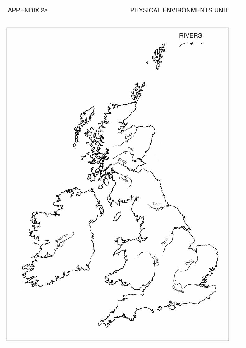
APPENDIX 1
The skills and content which will be sampled to provide the evidence required for the Unit are asfollows.
The skills sampled to show candidates have achieved Outcome 2 are identified below:
♦ interpreting and annotating field sketches and photographs♦ using a variety of maps — candidates should be able to:
- use four (read and give) and six (read and give) figure grid references - measure straight distances- annotate cross sections- interpret height and steepness of slope- describe, interpret and analyse general patterns of relief together with contour patterns linked
to taught landscape features- identify, describe and suggest reasons for transport routes- interpret and analyse the location and distribution of different land use zones within
settlements- describe and suggest reasons for land use- identify and explain potential conflicts - use maps in association with photographs/field sketches, cross sections/transects
NB Ordnance Survey (OS) maps at 1:25000 and 1:50000 may be used for assessment.
♦ construction (by completion in assessment), interpretation and analysis of choropleth, isoline,proportional symbol and topological maps
♦ using graphs — construction (by completion in assessment) of line, bar, scatter and pie diagrams;interpretation and analysis of these types of graphs, including those located in maps andtopological diagrams
♦ constructing and using surveys, questionnaires and using other primary data
The content sampled to show candidates have achieved Outcomes 1 and 3 is identified below:
Areal context: British Isles
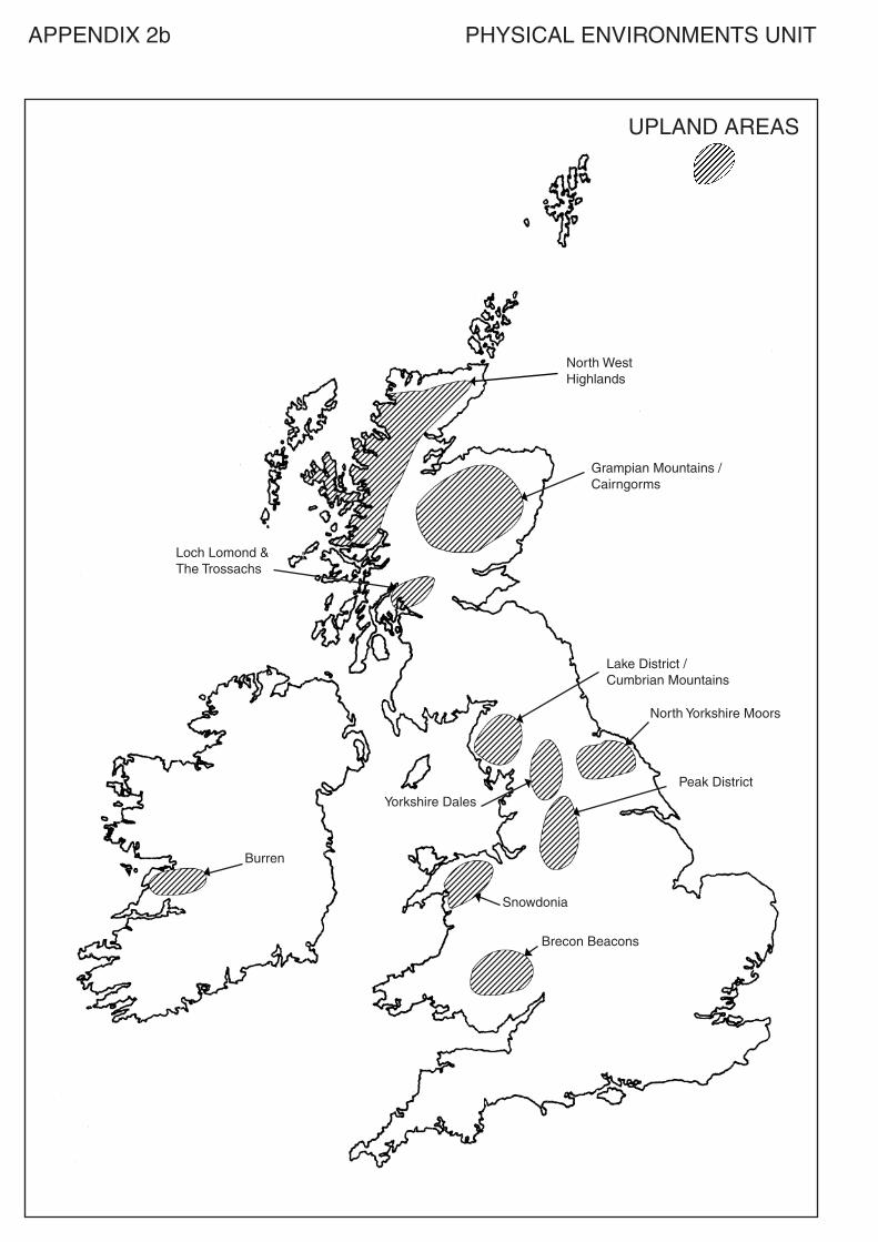
The following topics should be studied within the context of four landscape types, namely: ♦ glaciated upland♦ upland limestone♦ coastlines of erosion and deposition ♦ rivers and their valleys
Candidates should be able to:
1. Locate each of these landscape types. The locations which may be used in assessments areshown on the maps at the end of this Specification (Appendix 2).
2. Recognise, describe and explain the formation of the following landscape features:
♦ glaciated upland — corrie, tarn/corrie loch, pyramidal peak, arête, U-shaped valley,misfit stream, truncated spur, hanging valley, ribbon lake
♦ upland limestone — limestone pavements, clint, gryke, scree slopes, potholes/swallowholes, caverns, stalactites, stalagmites, intermittent drainage
♦ landscapes of coastal erosion and deposition — cliffs, caves, arches, stacks, headlandsand bays, beaches, spits, bars, tombolos
Unit Specification – Geography: Physical Environments (Intermediate 2) 30
APPENDIX 1 (cont)
♦ river valleys – features at different stagesa) upper stage — v-shaped valleys, waterfallsb) middle stage — meander, braidingc) lower stage — ox bow lake, levee, flood plain
Candidates should be able to recognise these features from photographs, sketches and OS maps.
3. Show, through the study of one of each of the selected areas of upland glaciation, uplandlimestone and coastal erosion and deposition, a knowledge and understanding of land usesappropriate to the areas studied. The land uses should be chosen from:
♦ farming♦ forestry♦ industry♦ military♦ recreation and leisure♦ tourism ♦ water storage and supply
In relation to each of the three areas studied candidates should be able to show knowledge andunderstanding of:
a) the social, economic and environmental impact (both positive and negative) of these activities
b) the conflicts which can arise between these and other land uses within these landscapes
c) the management strategies and solutions adopted to deal with the identified land use issues
d) the role of public and voluntary bodies in the management of these strategies and solutions
The table below provides some guidance on the length of time which might be spent on each of thekey topics within the Unit.
Topic Suggested teachingtime (hours)
Location of landscapes 1Recognition, description and explanation of features 20Knowledge of land uses 8Impact, conflicts, management strategies 11
Spey
Tay
Tees
Tren
t
Shannon
Forth
Clyde
Severn O
use
Thames
RIVERS
APPENDIX 2a PHYSICAL ENVIRONMENTS UNIT
APPENDIX 2b PHYSICAL ENVIRONMENTS UNIT
UPLAND AREAS
North West�Highlands
Loch Lomond &The Trossachs
Burren
Lake District /Cumbrian Mountains
North Yorkshire Moors
Yorkshire Dales
Snowdonia
Brecon Beacons
Peak District
Grampian Mountains /Cairngorms
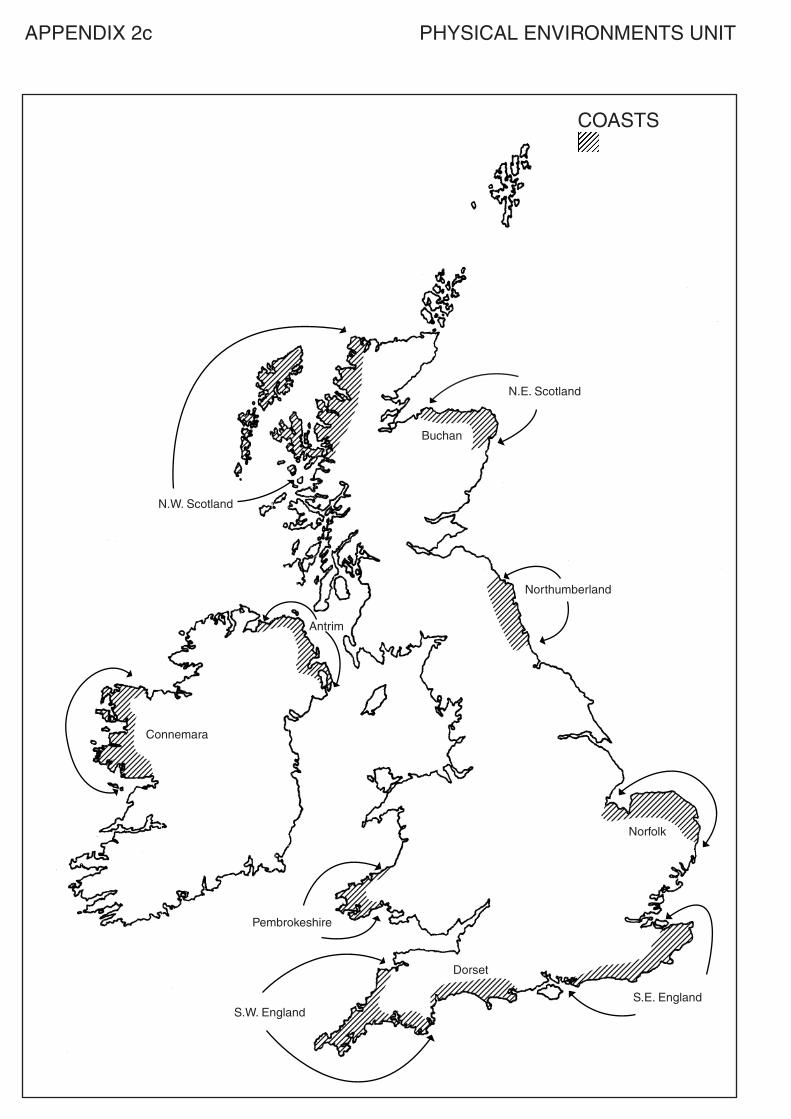
COASTS
N.E. Scotland
N.W. Scotland
Connemara
Antrim
Pembrokeshire
S.W. EnglandS.E. England
Dorset
Norfolk
Northumberland
Buchan
APPENDIX 2c PHYSICAL ENVIRONMENTS UNIT
Administrative InformationSuperclass: RF
Publication date: April 2004
Source: Scottish Qualifications Authority
Version: 01
© Scottish Qualifications Authority
This publication may be reproduced in whole or in part for educational purposes provided that no profit is derived fromreproduction and that, if reproduced in part, the source is acknowledged.
Additional copies of this unit specification can be purchased from the Scottish Qualifications Authority. The cost for eachunit specification is £2.50. (A handling charge of £1.95 will apply to all orders for priced items.) 34
National Unit Specification: general information
UNIT Geography: Human Environments (Intermediate 2)
CODE DF43 11
COURSE Geography (Intermediate 2)
SUMMARY
This Unit builds on the key ideas developed through the study theme ‘the human environment’ inStandard Grade Geography and the 5-14 guidelines on “Environmental Studies – People and Place”and also the Geography: Human Environments Unit at Intermediate 1. It could also be used as an introductory Unit for those with a broad interest in the subject area.
In this Unit emphasis is placed on providing candidates with opportunities to develop their knowledgeand understanding of aspects of the human environment. This is done through the study of selectedhuman environments which provide the focus for change.
The specific aims of the Unit are to develop:
♦ knowledge and understanding of different and changing human environments ♦ understanding of the opportunities and limitations of the human environment for human activities♦ knowledge and understanding of how human activities can lead to various forms of environmental
change, both beneficial and detrimental♦ knowledge, understanding and evaluation of the strategies employed to manage the environment ♦ skills of processing and interpreting Ordnance Survey maps, statistical data and other types of
graphical information
Appendix 1 contains the skills and content which will be covered in this Unit and will be sampled toprovide the evidence required for the Unit.
Unit Specification – Geography: Human Environments (Intermediate 2) 35
National Unit Specification: general information (cont)
UNIT Geography: Human Environments (Intermediate 2)
OUTCOMES
a) Demonstrate knowledge and understanding of a wide range of features and activities within thehuman environment.
b) Demonstrate the ability to use detailed geographical information presented in a variety offorms.
c) Demonstrate knowledge and understanding of an interaction within the human environment.
RECOMMENDED ENTRY
While entry is at the discretion of the centre, candidates would normally be expected to have attainedone of the following or equivalent:♦ Standard Grade Geography at General level♦ Standard Grade at General or Credit level in another social subject ♦ Intermediate 1 Geography or its Units♦ Intermediate 1 or 2 Course or Unit(s) in another social subject
CREDIT VALUE
1 credit at Intermediate 2 (6 SCQF credit points at SCQF level 5*)
*SCQF credit points are used to allocate credit to qualifications in the Scottish Credit and QualificationsFramework (SCQF). Each qualification in the Framework is allocated a number of SCQF credit points at an SCQFlevel. There are 12 SCQF levels, ranging from Access 1 to Doctorates.
CORE SKILLSThis Unit gives automatic certification of the following:
Complete Core Skills for the Unit None
Core Skills components for the Unit Critical Thinking Intermediate 2Using Graphical Information Intermediate 2
Unit Specification – Geography: Human Environments (Intermediate 2) 36
National Unit Specification: statement of standards
UNIT Geography: Human Environments (Intermediate 2)
Acceptable performance in this Unit will be the satisfactory achievement of the standards set out inthis part of the Unit Specification. All sections of the statement of standards are mandatory and cannotbe altered without reference to the Scottish Qualifications Authority.
OUTCOME 1
Demonstrate knowledge and understanding of a wide range of features and activities within thehuman environment.
Performance Criteria
a) Clearly and accurately identify a wide range of features and activities on maps, sketches andphotographs within the human environment.
b) Clearly and accurately describe a wide range of features and activities within the humanenvironment.
c) Clearly and accurately explain a wide range of features and activities within the humanenvironment.
OUTCOME 2
Demonstrate the ability to use detailed geographical information presented in a variety of forms.
Performance Criteria
a) Clearly and accurately interpret detailed information on maps and diagrams, and in statistics andtext.
b) Clearly and accurately present detailed information on maps, diagrams and in written summaries.c) Clearly and accurately analyse detailed information on maps and diagrams, and in statistics and
text.
OUTCOME 3
Demonstrate knowledge and understanding of an interaction within the human environment.
Performance Criteria
a) Clearly and accurately describe the interaction to show the linkages between the main features of the environment.
b) Clearly and accurately explain the interaction to show the linkages between the main features ofthe environment.
c) Clearly and accurately describe the consequences or issues arising from the interaction.d) Clearly and accurately explain the consequences or issues arising from the interaction.e) Clearly and accurately describe the strategies for the management of, or solutions to, the issues.
f) Clearly and accurately describe the effectiveness of the strategies or solutions.
Unit Specification – Geography: Human Environments (Intermediate 2) 37
National Unit Specification: statement of standards (cont)
UNIT Geography: Human Environments (Intermediate 2)
EVIDENCE REQUIREMENTS FOR THE UNIT
Evidence for this Unit will involve restricted responses which can be written, oral or diagrammaticsupplemented by written or oral responses. This evidence should be produced under supervisedconditions without the assistance of additional resources. The assessment must be capable of beingcompleted within 45 minutes and will be holistic, covering all Outcomes and PCs.
The assessment will sample the content and skills defined in Appendix 1 by including questionswhich reflect the breadth of content and skills as shown in the numbered sections in that Appendix. Ifa re-assessment is required, it should contain a different sample from the range of content and skills.
Achievement can be decided by the use of a cut-off score. The standard to be applied and the breadthof coverage are illustrated in the National Assessment Bank items available for this Unit. If a centrewishes to design its own assessments for this Unit, they should be of a comparable standard.
Unit Specification – Geography: Human Environments (Intermediate 2) 38
National Unit Specification: support notes
UNIT Geography: Human Environments (Intermediate 2)
This part of the Unit Specification is offered as guidance. The support notes are not mandatory.
While the exact time allocated to this Unit is at the discretion of the centre, the notional design lengthis 40 hours.
GUIDANCE ON THE CONTENT AND CONTEXT FOR THIS UNIT
This Unit is one of three mandatory Units which make up the Course at Intermediate 2 Geography.The other two Units are Geography: Physical Environments and Geography: EnvironmentalInteractions. It is designed to meet the needs of the broad variety of candidates who may choose tostudy the Unit.
The skills and content for this Unit are provided in Appendix 1.
The knowledge component of this Unit is important but so also is the use of the geographical skillswhich can be used to interpret, present and analyse information. During the study of urban, rural andindustrial areas the opportunity should be taken to use Ordnance Survey maps to illustrate some of thelandscapes and issues being considered. Depending on the case studies chosen the extent to whichthese maps can be used will vary. Their use in this way would help reinforce some of the skillsacquired in the Geography: Physical Environments Unit.
In the study of this Unit it is expected that candidates will develop their knowledge and understandingof world population and the varying environments in which this population lives. They should alsohave opportunities to increase their understanding of the complex issues which surround change andits management in these environments.
GUIDANCE ON LEARNING AND TEACHING APPROACHES FOR THIS UNIT
Teaching orderIn centres where one or both of the other Units at this level is being taught, teachers or lecturers canchoose to teach the Units in any order. It is also possible to integrate the content of these Units intoone continuous programme or to teach the Units separately or in parallel with each other. While thecontent is different, the general skills and concepts are broadly the same, and centres may considerthat these will be reinforced if they are used and developed in different contexts at the same time.
Articulation with Intermediate 1 and HigherThis Unit articulates very closely with Geography: Human Environments Unit at Intermediate 1 andalthough it is best taught to a group of candidates who are all studying at Intermediate 2 level, it hasbeen designed to facilitate the teaching of two levels in the same teaching group. The nature of thisarticulation is such that in many centres the decision to present candidates for certification at aparticular level may not need to be taken when the Course commences. Where centres teachIntermediate 1 and Intermediate 2 in the same sequence and use the same case studies there should notbe any curricular barriers to candidates who move between levels during the session.
Unit Specification – Geography: Human Environments (Intermediate 2) 39
National Unit Specification: support notes (cont)
UNIT Geography: Human Environments (Intermediate 2)
This articulation between these Units is such that centres should, at the same time, be able to teachthese topics in the two levels to the one candidate group. There are, however, some differences in theUnits between the Intermediate 2 and Higher levels. For those candidates who move from Higher toIntermediate 2 there is one key difference. Unless the candidate has completed the urban change andits management topic in the Geography : Environmental Interactions Unit at Higher level centres willhave to ensure that both urban case studies have been covered before the candidate attempts theassessment for Intermediate 2.
Case studiesThe Outcomes and Performance Criteria describe the key aspects for study in this Unit. It issuggested that these are taught in an integrated way. Within the case studies chosen there is a greatdeal of flexibility for centres to customise their delivery to the needs of the candidate group. Theconcentration on case studies to deliver the topics on urban and rural issues, and also, if thoughtappropriate, industrial change, provides the possibility of matching the content of these case studies tothat used in the Geography: Human Environments Unit at both Intermediate 1 and Higher levels andin the topic on urban change and its management in the Geography: Environmental Interactions Unitat Higher level.
MethodologyApproaches to the delivery of the Unit will vary but there is scope to use informal/formal group workand independent research using various paper based and IT resources. Candidates might also beencouraged to present findings based on any independent research to others in the teaching group.Centres may also wish to make use of field work in the teaching of this Unit.
Skills and learning experiencesThe Outcomes and Performance Criteria, together with the skills information provided in Appendix 1,indicate the skills and learning experiences which are important to this Unit. During the Unitcandidates should also:
♦ make use of relevant terminology and concepts♦ interpret, evaluate and analyse geographical evidence♦ record systematically information derived from a variety of sources such as maps, books, notes,
graphs, audio visual materials♦ develop the skills of communicating information in written (or equivalent), map and graphical
form for a variety of purposes
GUIDANCE ON APPROACHES TO ASSESSMENT FOR THIS UNIT
Opportunities for extension (if the Unit is being delivered as part of the Course), remediation andconsolidation should be built into this Unit; how this is organised will depend on the teachingapproach.
The assessment would normally be given at the end of the Unit. In the case of centres delivering thisUnit as part of a Course, it could be delayed and be incorporated into a prelim exam. In the latter casethe Unit assessment must be treated as a stand alone item within the prelim and only if the cut offscore as illustrated in the NAB, is achieved in that section, can the candidate be considered to havepassed the Unit.
Unit Specification – Geography: Human Environments (Intermediate 2) 40
National Unit Specification: support notes (cont)
UNIT Geography: Human Environments (Intermediate 2)
As reassessment should only follow after further work or remediation centres might consider itappropriate to delay this until further teaching in other Units has been undertaken. An alternativewould be to use part of a prelim exam to provide the opportunity for this reassessment.
SPECIAL NEEDSThis Unit Specification is intended to ensure that there are no artificial barriers to learning orassessment. Special needs of individual candidates should be taken into account when planninglearning experiences, selecting assessment instruments or considering special alternative Outcomesfor Units. For information on these, please refer to the SQA document Guidance on SpecialAssessment Arrangements (SQA, September, 2003).
Unit Specification – Geography: Human Environments (Intermediate 2) 41
APPENDIX 1
The skills and content which will be sampled to provide the evidence required for the Unit are asfollows.
The skills sampled to show candidates have achieved Outcome 2 are identified below:
♦ interpreting and annotating field sketches and photographs♦ using a variety of maps — candidates should be able to:
- use four (read and give) and six (read and give) figure grid references- measure straight distances- annotate cross sections- interpret height and steepness of slope- describe, interpret and analyse general patterns of relief together with contour patterns
linked to taught landscape features- identify, describe and suggest reasons for transport routes- interpret and analyse the location and distribution of different land use zones within
settlements- describe and suggest reasons for land use- identify and explain potential conflicts- use maps in association with photographs/field sketches, cross sections/transects
NB Ordnance Survey (OS) maps at 1:25000 and 1:50000 may be used for assessment.
♦ construction (by completion in assessment), interpretation and analysis of choropleth, isoline,proportional symbol and topological maps
♦ using graphs — construction (by completion in assessment) of line, bar, scatter and pie diagrams;interpretation and analysis of these types of graphs, including those located in maps andtopological diagrams
♦ constructing and using surveys, questionnaires and using other primary data
The content sampled to show candidates have achieved Outcomes 1 and 3 is identified below:
Areal context: Global with examples drawn from economically more developed countries (EMDCs)and economically less developed countries (ELDCs).
Candidates should be able to describe and explain:
1. World population distribution:
♦ factors influencing distribution and density — relief, climate, resources, employmentopportunities
♦ population patterns including urban/rural structures
2. World population change:
♦ growth rates over time♦ changing structure over time♦ variations in growth rates♦ factors affecting change — influences on birth rates, death rates, infant mortality rates♦ implications of change
Unit Specification – Geography: Human Environments (Intermediate 2) 42
APPENDIX 1 (Cont)
3. Change, problems and policies (where applicable) in urban areas. One example of an urban areashould be chosen from an EMDC and one example should be chosen from an ELDC:
♦ housing — inner city renewal, gentrification, ghettoisation, fringe developments, ‘highsecurity’ residential areas, squatter areas, shanty towns
♦ transport — quality of public transport, commuting, ring road developments, roadpricing, congestion
♦ retail services — changes in the CBD, shopping malls, business parks/trading estates,street markets
♦ environmental quality — dereliction, pollution, sanitation, waste disposal
4. Change, problems and policies (where applicable) in rural areas. One example of a rural areashould be chosen from an EMDC and one example should be chosen from an ELDC:
♦ agricultural change (post 1950) — farming systems, impact of new technology, impact ofpolitical policies eg Green Revolution, EU policies, diversification
♦ landscape — population density, employment structure, settlement patterns,infrastructure, migration patterns, urban sprawl, impact of tourism
5. Industrial change:
♦ factors affecting the changing location of industry — labour, market, transport, rawmaterials, technology, government policies
♦ changing landscapes — infrastructure, appearance, impact of change on the environment,use of maps to describe and evaluate changing industrial location and landscapes
The table below provides some guidance on the length of time which might be spent on each of thekey topics within the Unit.
Topic Suggested teachingtime (hours)
World population distribution 5World population change 5Urban areas 12Rural areas 12Industrial change 6
Administrative InformationSuperclass: RF
Publication date: April 2004
Source: Scottish Qualifications Authority
Version: 01
© Scottish Qualifications Authority 2004
This publication may be reproduced in whole or in part for educational purposes provided that no profit is derived fromreproduction and that, if reproduced in part, the source is acknowledged.
Additional copies of this unit specification can be purchased from the Scottish Qualifications Authority. The cost for eachunit specification is £2.50. (A handling charge of £1.95 will apply to all orders for priced items.) 43
National Unit Specification: general information
UNIT Geography: Environmental Interactions (Intermediate 2)
CODE DF44 11
COURSE Geography (Intermediate 2)
SUMMARY
This Unit builds on the key ideas developed through the study themes in Standard Grade Geographyand the 5-14 guidelines on ‘Environmental Studies – People and Place’ and also the Geography:Environmental Interactions Unit at Intermediate 1. It could also be used as an introductory Unit forthose with a broad interest in the subject area.
The specific aims of the Unit are to develop:
♦ knowledge and understanding of the changing inter-relationships within and between the physicaland human environment
♦ understanding of the opportunities and limitations of the environment in terms of human activities♦ knowledge and understanding of how physical processes and/or human activities can lead to
various forms of environmental change, both beneficial and detrimental♦ knowledge, understanding and evaluation of the strategies employed to manage the environment
to encourage sustainable development♦ skills of processing and interpreting map, statistical and other types of graphical information
In this Unit, emphasis is placed on providing candidates with the opportunity to develop further theirknowledge and understanding of aspects of the physical and human environment. This is done bystudying specific interactions (see below). This Unit emphasises the holistic nature of geography.
Candidates will be required to study two environmental interactions chosen from the list below. Eachshould take up 20 hours of study time.
Unit Specification – Geography: Environmental Interactions (Intermediate 2) 44
National Unit Specification: general information (cont)
UNIT Geography: Environmental Interactions (Intermediate 2)
Interaction 1 – Rural land degradationInteraction 2 – River basin managementInteraction 3 – European environmental inequalitiesInteraction 4 – Development and healthInteraction 5 – Environmental hazards
Each topic provides an opportunity to examine issues which are relevant to the contemporary world.Each considers the general background to the environmental interaction being studied and developsthese ideas through a case study approach. These five topics articulate closely with the Geography:Environmental Interactions Unit at Intermediate 1 level. Three of them (rural land degradation, riverbasin management and development and health) articulate with the same topics in the Geography:Environmental Interactions Unit at Higher level. While each topic has a different focus, all five offercandidates the opportunity to study the inter-relationships between elements of the physical andhuman environment.
Appendix 1 contains the skills and content which will be covered in this Unit and will be sampled toprovide the evidence required for the Unit.
OUTCOMES
a) Demonstrate knowledge and understanding of the main features of interactions within andbetween physical and human environments.
b) Demonstrate the ability to use detailed geographical information presented in a variety of forms.c) Evaluate possible strategies for environmental management of the consequences of an interaction.
RECOMMENDED ENTRY
While entry is at the discretion of the centre, candidates would normally be expected to have attainedone of the following or equivalent:♦ Standard Grade Geography at General Level♦ Standard Grade at General or Credit level in another social subject ♦ Intermediate 1 or its Units♦ Intermediate 2 Course Unit(s) in another social subject
CREDIT VALUE
1 credit at Intermediate 2 (6 SCQF credit points at SCQF level 5*)
*SCQF credit points are used to allocate credit to qualifications in the Scottish Credit and QualificationsFramework (SCQF). Each qualification in the Framework is allocated a number of SCQF credit points at an SCQFlevel. There are 12 SCQF levels, ranging from Access 1 to Doctorates.
Unit Specification – Geography: Environmental Interactions (Intermediate 2) 45
National Unit Specification: general information (cont)
UNIT Geography: Environmental Interactions (Intermediate 2)
CORE SKILLSThis Unit gives automatic certification of the following:
Complete Core Skills for the Unit None
Core Skills components for the Unit Critical Thinking Intermediate 2Using Graphical Information Intermediate 2
Unit Specification – Geography: Environmental Interactions (Intermediate 2) 46
National Unit Specification: statement of standards
UNIT Geography: Environmental Interactions (Intermediate 2)
Acceptable performance in this Unit will be the satisfactory achievement of the standards set out inthis part of the Unit Specification. All sections of the statement of standards are mandatory and cannotbe altered without reference to the Scottish Qualifications Authority.
OUTCOME 1
Demonstrate knowledge and understanding of the main features of interactions within and betweenphysical and human environments.
Performance Criteria
a) Clearly and accurately describe an interaction.b) Clearly and accurately explain the interaction.c) Clearly and accurately describe the environmental consequences of an interaction.d) Clearly and accurately explain the environmental consequences of an interaction.
OUTCOME 2
Demonstrate the ability to use detailed geographical information presented in a variety of forms.
Performance criteria
a) Clearly and accurately interpret detailed information on maps and diagrams, and in statisticsand text.
b) Clearly and accurately present detailed information on maps, diagrams and in written summaries.
c) Clearly and accurately analyse detailed information on maps, diagrams, in statistics and text.
OUTCOME 3
Evaluate possible strategies for environmental management of the consequences of an interaction.
Performance Criteria
a) Clearly and accurately describe the strategies for environmental management of the interaction.b) Clearly and accurately evaluate the strategies by commenting on their effectiveness.
Unit Specification – Geography: Environmental Interactions (Intermediate 2) 47
National Unit Specification: statement of standards (cont)
UNIT Geography: Environmental Interactions (Intermediate 2)
EVIDENCE REQUIREMENTS FOR THE UNIT
For the purposes of this Unit the term ‘interaction’ is any one of the topics listed in the summary.
Evidence for this Unit will involve restricted responses which can be written, oral or diagrammaticsupplemented by written or oral responses. This evidence should be produced under supervisedconditions without the assistance of additional resources. The assessment must be capable of beingcompleted within 45 minutes and will be holistic, covering all Outcomes and PCs.
The assessment will focus on one of the topics listed in Appendix 1, and will sample the content andskills defined in that Appendix. If a re-assessment is required, it should contain a different samplefrom the range of content and skills.
Achievement can be decided by the use of a cut-off score. The standard to be applied and the breadthof coverage are illustrated in the National Assessment Bank items available for this Unit. If a centrewishes to design its own assessments for this Unit, they should be of a comparable standard.
Unit Specification – Geography: Environmental Interactions (Intermediate 2) 48
National Unit Specification: support notes
UNIT Geography: Environmental Interactions (Intermediate 2)
This part of the Unit Specification is offered as guidance. The support notes are not mandatory.
While the exact time allocated to this Unit is at the discretion of the centre, the notional design lengthis 40 hours.
GUIDANCE ON THE CONTENT AND CONTEXT FOR THIS UNIT
This Unit is one of three mandatory Units which make up the Course at Intermediate 2 Geography.The other two Units are Geography: Physical Environments and Geography: Human Environments.It is designed to meet the needs of the broad variety of candidates who may choose to study the Unit.
The skills and content for this Unit are provided in Appendix 1.
The knowledge component of this Unit is important but so also is the use of the geographical skillswhich can be used to interpret, analyse and present information.
In this Unit candidates will cover two topics from the following list:♦ rural land degradation(*)♦ river basin management(*)♦ European environmental inequalities♦ development and health(*)♦ environmental hazards
It is expected that these topics will receive an equal time allocation within the 40 hours provided forthis Unit. Some topics are designed to articulate more closely with Higher level than others. These areidentified by the use of an asterisk (*). In choosing the topics which are to be covered candidates andcentres will have to consider the key role of the Unit in their specific circumstances. Where closearticulation with Higher is a key feature of the selection the choice may be different from a centrewhich does not consider this to be a priority. Within centres it is also possible that the topics coveredmay vary from session to session.
GUIDANCE ON LEARNING AND TEACHING APPROACHES FOR THIS UNIT
Teaching orderIn centres where one or both of the other Units at this level is being taught, teachers or lecturers canchoose to teach the Units in any order. It is also possible to integrate the content of these Units intoone continuous programme or to teach the Units separately or in parallel with each other. While thecontent is different, the general skills and concepts are broadly the same, and centres may considerthat these will be reinforced if they are used and developed in different contexts at the same time.
Articulation with Intermediate 1 and HigherThis Unit articulates very closely with the Geography: Environmental Interactions Unit atIntermediate 1 and although it is best taught to a group of candidates who are all studying atIntermediate 2 level, it has been designed to facilitate the teaching of two levels in the same teachinggroup. The nature of this articulation is such that in many centres the decision to present candidatesfor certification at a particular level may not need to be taken when the Course commences. Wherecentres teach Intermediate 1 and Intermediate 2 in the same sequence and use the same topics thereshould not be any curricular barriers to candidates who move between levels during the session.
Unit Specification – Geography: Environmental Interactions (Intermediate 2) 49
National Unit Specification: support notes (cont)
UNIT Geography: Environmental Interactions (Intermediate 2)
Case studiesThe Outcomes and Performance Criteria describe the key aspects for study in this Unit. It issuggested that these are taught in an integrated way. Within the topics chosen there is a great deal offlexibility for centres to customise their delivery to the needs of the candidate group. The use of casestudies to cover parts of the topics provides the possibility of matching the content of these casestudies to that used in the Geography: Environmental Interactions Unit at both Intermediate 1 andHigher levels.
MethodologyApproaches to the delivery of the Unit will vary but there is scope to use informal/formal group workand independent research using various paper based and IT resources. Candidates might also beencouraged to present findings based on any independent research to others in the teaching group.Centres may also wish to make use of field work in the teaching of this Unit.
Skills and learning experiencesThe Outcomes and Performance Criteria, together with the skills information provided in Appendix 1,indicate the skills and learning experiences which are important to this Unit. During the Unitcandidates should also:
♦ make use of relevant terminology and concepts♦ interpret and evaluate geographical evidence♦ record systematically information derived from a variety of sources such as maps, books, notes,
graphs, audio visual materials♦ develop the skills of communicating information in written (or equivalent), map and graphical
form for a variety of purposes
GUIDANCE ON APPROACHES TO ASSESSMENT FOR THIS UNIT
Opportunities for extension (if the Unit is being delivered as part of the Course), remediation andconsolidation should be built into this Unit. How this is organised will depend on the teachingapproach.
The assessment would normally be given on the completion of the study of the topic selected for thispurpose. This could also be given immediately after the Unit has been completed or in the case ofcentres delivering this Unit as part of a Course, it could be delayed and be incorporated into a prelimexam. In the latter case the Unit assessment must be treated as a stand alone item where it wouldrequire a 25 mark question on a single topic, as illustrated in the NAB, within the prelim and only ifthe cut off score is achieved in that section can the candidate be considered to have passed the Unit.
As reassessment should only follow after further work or remediation centres might consider itappropriate to delay this until further teaching in other Units has been undertaken. An alternativewould be to use part of a prelim exam to provide the opportunity for this reassessment.

Unit Specification – Geography: Environmental Interactions (Intermediate 2) 50
National Unit Specification: support notes (cont)
UNIT Geography: Environmental Interactions (Intermediate 2)
SPECIAL NEEDSThis Unit Specification is intended to ensure that there are no artificial barriers to learning orassessment. Special needs of individual candidates should be taken into account when planninglearning experiences, selecting assessment instruments or considering special alternative Outcomesfor units. For information on these, please refer to the SQA document Guidance on SpecialAssessment Arrangements (SQA, September, 2003).
Unit Specification – Geography: Environmental Interactions (Intermediate 2) 51
APPENDIX 1
The skills and content which will be sampled to provide the evidence required for the Unit are asfollows.
The skills sampled to show candidates have achieved Outcome 2 are identified below:
♦ interpreting and annotating field sketches and photographs♦ using a variety of maps ♦ construction (by completion in assessment), interpretation and analysis of choropleth, isoline,
proportional symbol and topological maps ♦ using graphs — construction (by completion in assessment) of line, bar, scatter and pie diagrams;
interpretation and analysis of these types of graphs, including those located in maps andtopological diagrams
♦ constructing and using surveys, questionnaires and using other primary data
The content sampled to show candidates have achieved Outcomes 1 and 3 is identified below:
Candidates will cover two topics from the following list:
1. Rural land degradation
Rural land resources are subject to degradation, which may be the result of natural processes, humanactivity or a combination of both. The decline in land productivity and other consequences of landdegradation have direct social and economic consequences and have led to the development of soiland land management strategies.
Areal context: Global, excluding the British Isles
Candidates should study two examples of land degradation:♦ one of these should focus on the issues surrounding deforestation ♦ the other should focus on issues related to the degradation of arid and semi arid areas
(desertification)
The following topics should be studied for each of the chosen areas:
1 physical environment — climate, vegetation, soils and relief
2 human environment — population density, farming systems
3 causes of degradation
4 effects of degradation
5 management strategies and policies and their effectiveness
2. River basin management
Within river basins, water control projects are undertaken for a variety of reasons and on a range ofscales. These projects are examples of human interference with systems, especially hydrologicalsystems. The changes often have both beneficial and adverse consequences.
Areal context: Global out with Europe
Unit Specification – Geography: Environmental Interactions (Intermediate 2) 52
APPENDIX 1 (cont)
Candidates should study one river basin in detail.
The following topics should be studied:
1 The components of the global hydrological cycle.
2 The physical characteristics of the selected river basin and their impact on water storage andmovement:♦ size and shape of catchment area♦ rainfall distribution and reliability♦ surface features♦ rock type
3 Factors affecting the level of demand for water in the river basin with reference to domestic,agricultural, leisure, industrial and energy use.
4 Management of demand by means of a water control project.
5 The social, economic, political and environmental benefits and adverse consequences of thewater control project.
3. European environmental inequalities
Within the contemporary world, environmental quality varies on a regional and national basis. Thereis a variety of physical, social and economic reasons for these spatial patterns. Within the EuropeanUnion and other European countries, policies are developed at local, national and international levelto improve environmental quality.
Areal context: Europe (as identified on map in Appendix 2)
Case studies should be selected from more than one country, at least one of which should be frommainland Europe.
The following topics should be studied:
1 Description of patterns of environmental quality with reference to♦ air ♦ rivers♦ seas and coastal areas
2 Explanation for this pattern with reference to physical, economic, social and political factors:♦ population density♦ transport links♦ physical and climatic environment♦ economic activity eg agricultural, industrial, tourist♦ living standards♦ attitudes toward environmental protection
3 Describe and explain the differences in environmental quality between any♦ two rivers, and
Unit Specification – Geography: Environmental Interactions (Intermediate 2) 53
APPENDIX 1 (cont)
♦ either two sea and coastal areas or two mountain areas
4 For the areas selected from ‘3’ above describe and assess the effectiveness of local, national orinternational policies and strategies used to manage, improve or maintain their environmentalquality.
4. Development and health
Inequality of social and economic development is a major feature of the contemporary world. It existson various scales and is measurable in several ways. Levels of health and the incidence of disease areone of the ways in which levels of development can be measured. The indicators of levels ofdevelopment may be explained geographically by reference to a variety of interacting processes.
Areal context: Global
Candidates should study the similarities and differences between economically more developedcountries (EMDCs) and economically less developed countries (ELDCs) in terms of levels ofdevelopment and health.
The following topics should be studied:
1 What is meant by ‘development’? ♦ definition of development♦ a selection of development indicators — social, economic and combined♦ use of development indicators to classify countries as economically more or economically
less developed
2 Causes of different levels of development:♦ physical factors — climate, relief, resources, environment, natural disasters♦ human factors — demographic changes, urbanisation, industrialisation, trade, technology
3 Identification of the main diseases of EMDCs and ELDCs, their distribution and causes. Theseinclude heart disease, cancer, asthma, AIDS (Acquired Immune Deficiency Syndrome),malaria, cholera and kwashiorkor.
4 Two case studies are required, one from each of the lists below: List A List B
(Diseases common in EMDCs) (Diseases common in ELDCs)
Heart disease MalariaAIDS AIDS
NB AIDS cannot be selected from both lists.
♦ the physical and human factors (eg climate, water supply, wealth, nutrition, remoteness,lifestyle) which affect the geographical distribution of each disease
♦ the consequences of the disease studied for the population in an area affected by it♦ the strategies used and organisations involved in managing and improving disease control
in relation to the diseases studied♦ the impact and effectiveness of these organisations and the strategies they use in connection
with the diseases studied
Unit Specification – Geography: Environmental Interactions (Intermediate 2) 54
APPENDIX 1 (cont)
5. Environmental hazards
Natural hazards are geographical phenomena which reflect global systems, particularly in relation tothe physical environment. The impact of these hazards varies at a local level depending on a varietyof aspects of the human environment.
Areal contexts: Global
Candidates should have detailed knowledge of:♦ a tropical stormand♦ an earthquake and♦ a volcanic eruption
Examples can be taken from any suitable context.
The following topics should be studied:
1 What is meant by a ‘natural hazard’?Definition of ‘natural’ and ‘hazard’.
2 For tropical storms, earthquakes and volcanoes a knowledge and understanding of theirdistribution.
3 General causes of each hazard:
♦ tropical storms — movement of global pressure systems, formation of low pressuresystems, significance of sea temperatures
♦ earthquakes and volcanoes — plate tectonics, activities at plate boundaries
4 In relation to a case study for each type of natural hazard a description and explanation of:
♦ the underlying causes♦ the impact on the landscape and population♦ methods of prediction and their effectiveness♦ role of aid agencies and their effectiveness (both short and long term)
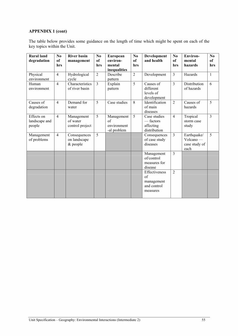
Unit Specification – Geography: Environmental Interactions (Intermediate 2) 55
APPENDIX 1 (cont)
The table below provides some guidance on the length of time which might be spent on each of thekey topics within the Unit.
Rural landdegradation
Noofhrs
River basinmanagement
Noofhrs
Europeanenviron-mentalinequalities
Noofhrs
Developmentand health
Noofhrs
Environ-mentalhazards
Noofhrs
Physicalenvironment
4 Hydrologicalcycle
2 Describepattern
2 Development 3 Hazards 1
Humanenvironment
4 Characteristicsof river basin
3 Explainpattern
5 Causes ofdifferentlevels ofdevelopment
3 Distributionof hazards
6
Causes ofdegradation
4 Demand forwater
5 Case studies 8 Identificationof maindiseases
2 Causes ofhazards
5
Effects onlandscape andpeople
4 Managementof watercontrol project
5 Managementofenvironment-al problem
5 Case studies— factorsaffectingdistribution
4 Tropicalstorm casestudy
3
Managementof problems
4 Consequenceson landscape& people
5 Consequencesof case studydiseases
3 Earthquake/Volcano —case study ofeach
5
Managementof/controlmeasures fordisease
3
Effectivenessofmanagementand controlmeasures
2
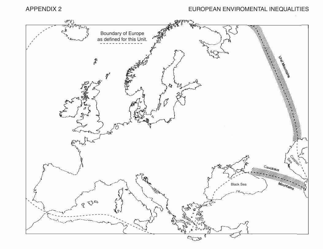


![Using Information [INTERMEDIATE 2; HIGHER] webzite/Powerpoint using... · • Intermediate 2 Information Systems • Intermediate 2 Computing ... meaningful to you as the icons representative](https://img.pdfslide.us/doc/110x75/5b0456bb7f8b9aba168d2310/using-information-intermediate-2-higher-webzitepowerpoint-using-intermediate.jpg)