Embed Size (px)
Citation preview
Geography guideFirst examinations 2019


Geography guideFirst examinations 2019
Published February 2017
Published byInternational Baccalaureate Organization
15 Route des Morillons1218 Le Grand-Saconnex
Geneva, Switzerland
Represented byIB Publishing Ltd, Churchillplein 6, The Hague, 2517JW The Netherlands
© International Baccalaureate Organization 2017
The International Baccalaureate Organization (known as the IB) offers four high-quality and challenging educational programmes for a worldwide community of schools, aiming to create a better, more peaceful world. This publication is one of a range of materials produced to support these programmes.
The IB may use a variety of sources in its work and checks information to verify accuracy and authenticity, particularly when using community-based knowledge sources such as Wikipedia. The IB respects the principles of intellectual property and makes strenuous efforts to identify and obtain permission before publication from rights holders of all copyright material used. The IB is grateful for permissions received for material used in this publication and will be pleased to correct any errors or omissions at the earliest opportunity.
All rights reserved. No part of this publication may be reproduced, stored in a retrieval system, or transmitted, in any form or by any means, without the prior written permission of the IB, or as expressly permitted by law or by the IB’s own rules and policy. See www.ibo.org/copyright.
IB merchandise and publications can be purchased through the IB store at store.ibo.org.
Email: [email protected]
Diploma ProgrammeGeography guide
International Baccalaureate, Baccalauréat International and Bachillerato Internacional are registered trademarks of the International Baccalaureate Organization.

IB mission statementThe International Baccalaureate aims to develop inquiring, knowledgeable and caring young people who help to create a better and more peaceful world through intercultural understanding and respect.
To this end the organization works with schools, governments and international organizations to develop challenging programmes of international education and rigorous assessment.
These programmes encourage students across the world to become active, compassionate and lifelong learners who understand that other people, with their differences, can also be right.


Geography guide 1
Introduction
Purpose of this document
This publication is intended to guide the planning, teaching and assessment of the subject in schools. Subject teachers are the primary audience, although it is expected that teachers will use the guide to inform students and parents about the subject.
This guide can be found on the subject page of the online curriculum centre (OCC) at occ.ibo.org, a password-protected IB website designed to support IB teachers. It can also be purchased from the IB store at store.ibo.org.
Additional resources Additional publications such as specimen papers, teacher support materials, subject reports and grade descriptors can also be found on the OCC. Past examination papers as well as markschemes can be purchased from the IB store.
Teachers are encouraged to check the OCC for additional resources created or used by other teachers. Teachers can provide details of useful resources, for example: websites, books, videos, journals or teaching ideas.
Acknowledgment The IB wishes to thank the educators and associated schools for generously contributing time and resources to the production of this guide.
First assessment 2019

Geography guide 2
The Diploma Programme
The Diploma Programme is a rigorous pre-university course of study designed for students in the 16 to 19 age range. It is a broad-based two-year course that aims to encourage students to be knowledgeable and inquiring, but also caring and compassionate. There is a strong emphasis on encouraging students to develop intercultural understanding, open-mindedness, and the attitudes necessary for them to respect and evaluate a range of points of view.
The Diploma Programme model The course is presented as six academic areas enclosing a central core (see figure 1). It encourages the concurrent study of a broad range of academic areas. Students study: two modern languages (or a modern language and a classical language); a humanities or social science subject; an experimental science; mathematics; and one of the creative arts. It is this comprehensive range of subjects that makes the Diploma Programme a demanding course of study designed to prepare students effectively for university entrance. In each of the academic areas students have flexibility in making their choices, which means they can choose subjects that particularly interest them and that they may wish to study further at university.
Figure 1 The Diploma Programme model
Geography guide 3
Choosing the right combination Students are required to choose one subject from each of the six academic areas, although they can, instead of an arts subject, choose two subjects from another area. Normally, three subjects (and not more than four) are taken at higher level (HL), and the others are taken at standard level (SL). The IB recommends 240 teaching hours for HL subjects and 150 hours for SL. Subjects at HL are studied in greater depth and breadth than at SL.
At both levels, many skills are developed, especially those of critical thinking and analysis. At the end of the course, students’ abilities are measured by means of external assessment. Many subjects contain some element of coursework assessed by teachers.
The core of the Diploma Programme model All Diploma Programme students participate in the three course elements that make up the core of the model.
Theory of knowledge (TOK) is a course that is fundamentally about critical thinking and inquiry into the process of knowing rather than about learning a specific body of knowledge. The TOK course examines the nature of knowledge and how we know what we claim to know. It does this by encouraging students to analyse knowledge claims and explore questions about the construction of knowledge. The task of TOK is to emphasize connections between areas of shared knowledge and link them to personal knowledge in such a way that an individual becomes more aware of his or her own perspectives and how they might differ from others.
Creativity, activity, service (CAS) is at the heart of the Diploma Programme. The emphasis in CAS is on helping students to develop their own identities, in accordance with the ethical principles embodied in the IB mission statement and the IB learner profile. It involves students in a range of activities alongside their academic studies throughout the Diploma Programme. The three strands of CAS are creativity (arts, and other experiences that involve creative thinking), activity (physical exertion contributing to a healthy lifestyle) and service (an unpaid and voluntary exchange that has a learning benefit for the student). Possibly, more than any other component in the Diploma Programme, CAS contributes to the IB’s mission to create a better and more peaceful world through intercultural understanding and respect.
The extended essay, including the world studies extended essay, offers the opportunity for IB students to investigate a topic of special interest, in the form of a 4,000-word piece of independent research. The area of research undertaken is chosen from one of the students’ six Diploma Programme subjects, or in the case of the interdisciplinary world studies essay, two subjects, and acquaints them with the independent research and writing skills expected at university. This leads to a major piece of formally presented, structured writing, in which ideas and findings are communicated in a reasoned and coherent manner, appropriate to the subject or subjects chosen. It is intended to promote high-level research and writing skills, intellectual discovery and creativity. An authentic learning experience, it provides students with an opportunity to engage in personal research on a topic of choice, under the guidance of a supervisor.
Approaches to teaching and approaches to learning Approaches to teaching and learning across the Diploma Programme refers to deliberate strategies, skills and attitudes that permeate the teaching and learning environment. These approaches and tools, intrinsically linked with the learner profile attributes, enhance student learning and assist student preparation for the Diploma Programme assessment and beyond. The aims of approaches to teaching and learning in the Diploma Programme are to:
• empower teachers as teachers of learners as well as teachers of content
• empower teachers to create clearer strategies for facilitating learning experiences in which students are more meaningfully engaged in structured inquiry and greater critical and creative thinking
Geography guide 4
• promote both the aims of individual subjects (making them more than course aspirations) and linkingpreviously isolated knowledge (concurrency of learning)
• encourage students to develop an explicit variety of skills that will equip them to continue to be activelyengaged in learning after they leave school, and to help them not only obtain university admissionthrough better grades but also prepare for success during tertiary education and beyond
• enhance further the coherence and relevance of the students’ Diploma Programme experience
• allow schools to identify the distinctive nature of an IB Diploma Programme education, with its blend ofidealism and practicality.
The five approaches to learning (developing thinking skills, social skills, communication skills, self-management skills and research skills) along with the six approaches to teaching (teaching that is inquiry-based, conceptually focused, contextualized, collaborative, differentiated and informed by assessment) encompass the key values and principles that underpin IB pedagogy.
The IB mission statement and the IB learner profile The Diploma Programme aims to develop in students the knowledge, skills and attitudes they will need to fulfill the aims of the IB, as expressed in the organization’s mission statement and the learner profile. Teaching and learning in the Diploma Programme represent the reality in daily practice of the organization’s educational philosophy.
Academic honesty Academic honesty in the Diploma Programme is a set of values and behaviours informed by the attributes of the learner profile. In teaching, learning and assessment, academic honesty serves to promote personal integrity, engender respect for the integrity of others and their work, and ensure that all students have an equal opportunity to demonstrate the knowledge and skills they acquire during their studies.
All coursework—including work submitted for assessment—is to be authentic, based on the student’s individual and original ideas with the ideas and work of others fully acknowledged. Assessment tasks that require teachers to provide guidance to students or that require students to work collaboratively must be completed in full compliance with the detailed guidelines provided by the IB for the relevant subjects.
For further information on academic honesty in the IB and the Diploma Programme, please consult the IB publications Academic honesty in the IB educational context, The Diploma Programme: From principles into practice and General regulations: Diploma Programme. Specific information regarding academic honesty as it pertains to external and internal assessment components of this Diploma Programme subject can be found in this guide.
Acknowledging the ideas or work of another person Coordinators and teachers are reminded that candidates must acknowledge all sources used in work submitted for assessment. The following is intended as a clarification of this requirement.
Diploma Programme candidates submit work for assessment in a variety of media that may include audio-visual material, text, graphs, images and/or data published in print or electronic sources. If a candidate uses the work or ideas of another person, the candidate must acknowledge the source using a standard style of referencing in a consistent manner. A candidate’s failure to acknowledge a source will be investigated by the IB as a potential breach of regulations that may result in a penalty imposed by the IB final award committee.

Geography guide 5
The IB does not prescribe which style(s) of referencing or in-text citation should be used by candidates; this is left to the discretion of appropriate faculty/staff in the candidate’s school. The wide range of subjects, different response languages and the diversity of referencing styles make it impractical and restrictive to insist on particular styles. In practice, certain styles may prove most commonly used, but schools are free to choose a style that is appropriate for the subject concerned and the language in which candidates’ work is written. Regardless of the reference style adopted by the school for a given subject, it is expected that the minimum information given includes: name of author, date of publication, title of source, and page numbers as applicable.
Candidates are expected to use a standard style and use it consistently so that credit is given to all sources used, including sources that have been paraphrased or summarized. When writing text candidates must clearly distinguish between their words and those of others by the use of quotation marks (or other method, such as indentation) followed by an appropriate citation that denotes an entry in the bibliography. If an electronic source is cited, the date of access must be indicated. Candidates are not expected to show faultless expertise in referencing, but are expected to demonstrate that all sources have been acknowledged. Candidates must be advised that audio-visual material, text, graphs, images and/or data published in print or in electronic sources that is not their own must also attribute the source. Again, an appropriate style of referencing/citation must be used.
Learning diversity and learning support requirements Schools must ensure that equal access arrangements and reasonable adjustments are provided to candidates with learning support requirements that are in line with the IB documents Candidates with assessment access requirements and Learning diversity and inclusion in IB programmes.

Geography guide 6
Nature of the subject
Geography “Geography is the only subject that has given me the skills to interpret and understand reality in a way I could not imagine before and that will remain for life.”
A student at the British School of Rio de Janeiro (2013)
Geography is a dynamic subject that is firmly grounded in the real world and focuses on the interactions between individuals, societies and physical processes in both time and space. It seeks to identify trends and patterns in these interactions. It also investigates the way in which people adapt and respond to change, and evaluates actual and possible management strategies associated with such change. Geography describes and helps to explain the similarities and differences between different places. These may be defined on a variety of scales and from the perspectives of a different range of actors, with varying powers over decision-making processes.
Within individuals and societies subjects, geography is distinctive in its spatial dimension and occupies a middle ground between social or human sciences and natural sciences. The Diploma Programme geography course integrates physical, environmental and human geography, and ensures that students acquire elements of both socio-economic and scientific methodologies. Geography takes advantage of its position to examine relevant concepts and ideas from a wide variety of disciplines. This helps students develop life skills and have an appreciation of, and a respect for, alternative approaches, viewpoints and ideas.
Distinction between SL and HL Students at SL and HL in geography are presented with a syllabus that has optional geographic themes and a common SL and HL core. HL students also study the HL core extension. The syllabus requires the development of certain skills, attributes and knowledge as described in the assessment objectives, which are externally assessed. Although the skills and activity of studying geography are common to both SL and HL students, HL students are required to acquire a further body of knowledge, to demonstrate critical evaluation and to further synthesize the concepts in the HL extension.
In summary:
• SL students study two optional themes; HL students study three optional themes, providing further breadth.
• Both SL and HL students study the core geographic perspectives—global change.
• HL students study the HL extension geographic perspectives—global interactions, and further examine, evaluate and synthesize the prescribed concepts, which by their nature are complex, contestable, interlinked and require holistic treatment. This provides further depth at HL.
• Both SL and HL students complete a fieldwork study for the internal assessment.
Geography and the core
Geography and theory of knowledge The relationship between each subject and theory of knowledge (TOK) is important and fundamental to the Diploma Programme. Having followed a course of study in individuals and societies, students should be able to reflect critically on the various processes of knowing and methods used in human sciences, helping them to become “inquiring, knowledgeable and caring young people” (IB mission statement).

Geography guide 7
Many of the subjects that fall within the individuals and societies subject group in the Diploma Programme are often known collectively as the “human sciences” or “social sciences”. The human sciences are one of the eight areas of knowledge at the centre of the TOK course, with the others being mathematics, the natural sciences, the human sciences, the arts, history, ethics, religious knowledge systems, and indigenous knowledge systems. In TOK, students also explore the question of how we know what we claim to know by examining different ways of knowing, which are specified in the TOK course as language, sense perception, emotion, reason, imagination, faith, intuition, and memory.
As with other disciplines in the human sciences, there are a variety of ways of gaining knowledge in geography—for example, archival evidence, data collection, experimentation, observation, and inductive and deductive reasoning. Geography students also explore and think critically about the interactions between people and their environment in time and place. All of these elements can be used to help explain patterns of behaviour and contribute to an examination of how we know what we claim to know.
During the Diploma Programme geography course, a number of opportunities will arise that can be used to highlight the relationship and common goals between TOK and geography. Some of the knowledge questions and claims that might be considered during the geography course are identified below.
• Who decides how we classify knowledge? Why might it be useful to classify knowledge?
• To what extent are the methods of the human sciences scientific?
• How is statistical data used differently in different areas of knowledge?
• How reliable are the methods available for gathering demographic data on hundreds of millions of people?
• How has ready access to vast amounts of information, and the way in which the internet has contributed to our shrinking world, changed our understanding of knowledge?
• Does language simply describe knowledge, or is it part of the knowledge itself?
• To what extent do maps reflect reality? What are the hidden messages in maps and the stories behind the way maps are presented?
• Some geographical topics, such as climate change, are controversial. How does the scientific method attempt to address them? Are such topics always within the scope of the scientific method?
• What scientific or social factors might influence the study of a complex phenomenon such as global warming?
• On what basis might we decide between the judgments of experts if they disagree with each other?
• Arguably, while some aspects of geography can be measured, others cannot. To what extent does knowledge need to be quantifiable?
• Many geographers and others value diversity in human affairs. Does globalization increase opportunities to share knowledge or does it diminish diversity?
• What roles do emotion and reason play in individuals’ lifestyle choices?
• To what extent might possession of knowledge carry with it moral obligations?
More information for teachers on TOK can be found in the Theory of knowledge guide.
Geography and creativity, activity, service Creativity, activity, service (CAS) experiences can be associated with each of the subject groups of the Diploma Programme. CAS and geography can complement each other in a number of ways; identifying trends and patterns between individuals, societies and processes and how these may manifest in local, regional or global issues may give students ideas for CAS experiences.
Geography guide 8
An important characteristic of the geography course is that students examine spatial interactions, possibilities and change in a contextual way. Due to the interconnectedness of our contemporary world, many global challenges may present themselves in students’ local or otherwise significant communities as inspiring springboards for CAS experiences. As a result of the knowledge and understanding students develop about issues through a geographic lens, they might be able to investigate, plan, act, reflect on and demonstrate CAS experiences in a more informed and meaningful way. Similarly, CAS experiences can ignite students’ passions for addressing a particular global matter.
The challenge and enjoyment of CAS experiences can often have a profound effect on geography students, who might choose, for example, to engage with CAS in the following ways.
• Plan, participate and implement an activity to help educate selected members of a community about the United Nations’ (UN) Sustainable Development Goals regarding habitation and inequality, with virtual reality screenings that increase awareness of the reality of refugee migration.
• Take lessons in surfing, or another physical pursuit, while completing internal assessment fieldwork. This could be accomplished as a single experience or through a series of sessions, or by encouraging others to participate in—or perhaps extend—the experience by creating a community environmental group.
• Explore perspectives on regional access to employment, demonstrating an ongoing interest through the mediums of storytelling and craftivism that advocate awareness of a particular gender’s position.
A CAS experience can be a single event or may be an extended series of events. However, CAS experiences must be distinct from and may not be included or used in the student’s Diploma course requirements.
Additional suggestions on the links between Diploma Programme subjects and CAS can be found in the Creativity, activity, service teacher support material.
Geography and the extended essay or world studies extended essay An extended essay in geography is not an extension of the internal assessment task for the subject. Students must ensure that they understand the clear distinction between the internal assessment and the extended essay. While there is inevitably an overlap in the skills being developed, there are clear distinctions between the tasks and a different emphasis in terms of the sources and types of data used.
An extended essay in geography provides the student with an opportunity to apply a range of geographic skills to complete an independent and in-depth research investigation using geographic concepts, methodologies, theories, and sources with a clear spatial emphasis.
It is important that the topic of the essay is geographic and gives a clear indication of the nature of the research. The essay topic may relate to an area of the Diploma Programme geography course, but this is not a requirement and other areas of the wider subject may be explored.
The scope of the essay should not be too broad, as such essays are rarely successful. The research question should be single and focused, clearly stated and must be framed in question form. It is the task of the supervisor to ensure that the research question is relevant to the subject, leads the student along a path that utilizes appropriate geographic sources, and encourages the application of relevant subject concepts, theories or ideas.
It is important that the geographic and theoretical context is well established early in the essay. Investigations carried out at a local scale usually meet the expectations of the higher bands of the markscheme. This narrow focus discourages an over-reliance on published materials and encourages original research. It is rare for an essay that is based entirely on published texts to score highly. Investigations conducted in a location that is familiar and accessible to the student have a much greater chance of achieving success through more personal involvement, which in turn encourages greater in-depth research.
The geographic context in which the research is being conducted should be clearly outlined, usually with the aid of one or more annotated maps and, where relevant, photographs and/or satellite images.
Geography guide 9
The extended essay should focus on individual research and avoid approaches involving group fieldwork data collection. Although there may be some similarities in approach to the geography internal assessment, the extended essay should not place so strong an emphasis on primary field data collection and processing. Many successful research topics are based on published data such as census or weather records. The emphasis should therefore be more on written analysis, interpretation, discussion, critical evaluation and the development of a coherent, reasoned argument than on the techniques of data collection and processing.
A descriptive or narrative approach should be avoided. Information on the methodology of the investigation is essential, as is the collection of high-quality data and information. It is vital that the investigation is tailored closely to the research question and shows evidence of careful planning.
Appropriate resources for an extended essay in geography could include both primary and secondary data and/or quantitative and qualitative information, obtained from books, newspapers and magazines; interviews; questionnaires; the internet; maps; aerial photographs and satellite images; digital landscape simulations; videos; geographic information systems (GIS); diagrams and models. Geographical data should be analysed using appropriate quantitative, statistical, graphical or qualitative techniques, and the findings should be critically evaluated.
Indication of the possible range of topics, research questions and approaches that can be considered can be found in the Extended essay guide in the section “Geography: Subject-specific guidance”.
Geography and international-mindedness The geography course conceptually and contextually embodies international and global awareness in several distinctive approaches. It examines key world issues, such as the nexus of sustainable environmental, societal and economic development, and climate change. It considers examples and case studies at a variety of scales, from local to regional, national, international and global. Throughout the course, teachers have considerable flexibility in their choice of examples and case studies as content in order to ensure that Diploma Programme geography is a highly appropriate way to meet the needs of all students, regardless of their geographical location. Inherent to the syllabus is a consideration of different perspectives, economic circumstances and social and cultural diversity.
Geography seeks to develop international understanding and foster a concern for global issues as well as to raise students’ awareness of their own responsibility at a local level. Geography also aims to develop values and attitudes that will help students reach a degree of personal commitment in trying to resolve these issues, appreciating our shared responsibility as citizens of an increasingly interconnected and ever shrinking world.
Engaging with sensitive topics The optional themes, the core SL and HL themes, and the HL extension cover areas of knowledge that are often affected by personal bias and value judgments. It is important that teachers are aware of this and ensure that students are not only presented with the facts but are taught the analytical skills to allow accurate interpretation and evaluation of these contemporary themes.
Prior learning The geography course requires no specific prior learning. No particular background in terms of specific subjects studied for national or international qualifications is expected or required. The skills needed for the geography course are developed within the context of the course itself.
Links to the Middle Years Programme Geography is often offered explicitly as one of the disciplines within the individuals and societies subject group of the IB Middle Years Programme (MYP). Regardless of whether the learner takes geography or another discipline within MYP individuals and societies, the course provides a strong foundation for students who go on to study Diploma Programme geography.
Geography guide 10
Like the Diploma Programme geography course, MYP individuals and societies is a concept-driven curriculum aimed at helping the learner to develop broader and deeper levels of understanding and critical and creative thinking. MYP individuals and societies courses are framed by four prescribed key concepts:
• change
• global interactions
• time, place and space
• systems.
These broad, enduring and powerful ideas are used as lenses to give breadth to learning in each unit of study, and to enable students to transfer knowledge across disciplines. The related concepts in any MYP individuals and societies course add depth to learning in terms of facilitating more subject-specific understanding. Diploma Programme geography adopts a similar concept-based approach, using the four key concepts of place, process, power and possibility to underpin the entire course, alongside other organizing and topic-specific specialist concepts that provide depth to the understanding of the different geographic inquiries (see Figure 3).
Inquiry-based learning is central to individuals and societies courses in both the MYP and the Diploma Programme, providing students with opportunities to independently and collaboratively investigate and analyse relevant issues. As inquiry develops curiosity and promotes active critical and creative thinking, it is important to emphasize that pedagogically, a Diploma Programme geography learning environment should be very similar in nature to the MYP experience.
MYP individuals and societies students are required to practise and develop their investigation skills, one of the MYP four assessment objectives, giving an important foundation for the internal assessment component of the Diploma Programme geography course. The MYP assessment objective of thinking critically also corresponds to the higher order assessment objectives of evaluation and synthesis that are expected from a Diploma Programme geography student.
Across the MYP, there are 16 key concepts with the four highlighted below as the focus for MYP individuals and societies.
The key concepts across the MYP subjects
Aesthetics Form Systems Communities
Connections Creativity Culture Development
Change Relationships Identity Time, place and space
Perspective Global interactions Communication Logic
Links to the Career-related Programme In the IB Career-related Programme (CP), students study at least two Diploma Programme subjects, a core consisting of four components and a career-related study, which is determined by the local context and aligned with student needs. The CP has been designed to add value to the student’s career-related studies. This provides the context for the choice of Diploma Programme courses. Courses can be chosen from any group of the Diploma Programme. It is also possible to study more than one course from the same group (for example, visual arts and film).
Geography may be a beneficial choice for CP students considering careers in, for example, the environmental and resource sphere, health care, tourism industries, the technology industry, social informatics, urban planning or international engagement. Geography helps students to understand the interconnectedness of environments, economies and societies in the contemporary world, and to engage with similarity and diversity in human development. Students explore different places at different scales, from local to global, leading to a greater understanding of the physical and human world around them.

Geography guide 11
Geography encourages the development of strong written, verbal, and visual or graphical communication skills; critical and complex thinking; and ethical considerations that will assist students in preparing for the future global workplace. This in turn fosters the IB learner profile attributes that are transferable to the entire CP, providing relevance and support for the student’s learning.
For the CP students, Diploma Programme courses can be studied at SL or HL. Schools can explore opportunities to integrate CP students with Diploma Programme students.

Geography guide 12
Aims
Individuals and societies aims The aims of all subjects in the individuals and societies subject group are to:
1. encourage the systematic and critical study of: human experience and behaviour; physical, economic and social environments; the history and development of social and cultural institutions
2. develop in the student the capacity to identify, to analyse critically and to evaluate theories, concepts and arguments about the nature and activities of the individual and society
3. enable the student to collect, describe and analyse data used in studies of society, to test hypotheses and interpret complex data and source material
4. promote the appreciation of the way in which learning is relevant to both the culture in which the student lives, and the culture of other societies
5. develop an awareness in the student that human attitudes and opinions are widely diverse and that a study of society requires an appreciation of such diversity
6. enable the student to recognize that the content and methodologies of the subjects in the individuals and societies group are contestable and that their study requires the toleration of uncertainty.
Geography aims The aims of the geography course at SL and HL are to enable students to:
1. develop an understanding of the dynamic interrelationships between people, places, spaces and the environment at different scales
2. develop a critical awareness and consider complexity thinking in the context of the nexus of geographic issues, including:
– acquiring an in-depth understanding of how geographic issues, or wicked problems, have been shaped by powerful human and physical processes
– synthesizing diverse geographic knowledge in order to form viewpoints about how these issues could be resolved
3. understand and evaluate the need for planning and sustainable development through the management of resources at varying scales.
Geography guide 13
Assessment objectives
There are four assessment objectives (AOs) for the SL and HL Diploma Programme geography course.
Having followed the course at SL or HL, students will be expected to do the following.
1. Demonstrate knowledge and understanding of specified content
– Demonstrate knowledge and understanding of the core theme—global change
– Demonstrate knowledge and understanding of two optional themes at SL and three optional themes at HL
– At HL only, demonstrate knowledge and understanding of the HL extension—global interactions
– In internal assessment, demonstrate knowledge and understanding of a specific geographic research topic
2. Demonstrate application and analysis of knowledge and understanding
– Apply and analyse geographic concepts and theories
– Identify and interpret geographic patterns and processes in unfamiliar information, data and cartographic material
– Demonstrate the extent to which theories and concepts are recognized and understood in particular contexts
3. Demonstrate synthesis and evaluation
– Examine and evaluate geographic concepts, theories and perceptions
– Use geographic concepts and examples to formulate and present an argument
– Evaluate materials using methodology appropriate for geographic fieldwork
– At HL only, demonstrate synthesis and evaluation of the HL extension—global interactions
4. Select, use and apply a variety of appropriate skills and techniques
– Select, use and apply the prescribed geographic skills in appropriate contexts
– Produce well-structured written material, using appropriate terminology
– Select, use and apply techniques and skills appropriate to a geographic research question

Geography guide 14
Assessment objectives in practice
Command terms are classified according to the assessment objectives of:
• AO1 Knowledge and understanding of specified content
• AO2 Application and analysis of knowledge and understanding
• AO3 Synthesis and evaluation
• AO4 Selection, use and application of a variety of appropriate skills and techniques.
Although command terms are not used explicitly in the syllabus, students must be familiar with them to understand the depth of treatment required in examination questions. The allocation of marks in examination question markbands also reflects this classification of the assessment objectives.
There is a progression in demand from AO1 to AO3, while AO4 terms are specific to particular skills and examination questions. Definitions of these command terms are listed in the appendix. The command terms within each classification are listed in alphabetical order in the following table
Objective Key command term Depth
AO1 Knowledge and understanding of specified content
Classify
Define
Describe
Determine
Estimate
Identify
Outline
State
These terms require students to demonstrate knowledge and understanding.
AO2 Application and analysis of knowledge and understanding
Analyse
Distinguish
Explain
Suggest
These terms require students to use and analyse knowledge and understanding.
AO3 Synthesis and evaluation
Compare
Compare and contrast
Contrast
Discuss
Evaluate
Examine
Justify
To what extent?
These terms require students to make a judgment based on evidence and when relevant construct an argument.

Geography guide 15
Objective Key command term Depth
AO4 Selection, use and application of a variety of appropriate skills and techniques
Annotate
Construct
Draw
Label
These terms require students to demonstrate the selection and application of skills.

Geography guide 16
A conceptual and contextual approach to the geography course
The opportunity to have concepts in the foreground of the curriculum topics and the focus for geographic inquiry allow for more discussion, application of thinking skills, and transparent assessments. Students are required to discuss or evaluate in a way that shows conceptual insight into the context of the expected knowledge and understanding. The application of geographic skills allow for the synthesis of knowledge and ideas, and bring understanding of concepts and contexts together through the study of specified or appropriate content.
Figure 2 A conceptual and contextual approach to Diploma Programme geography
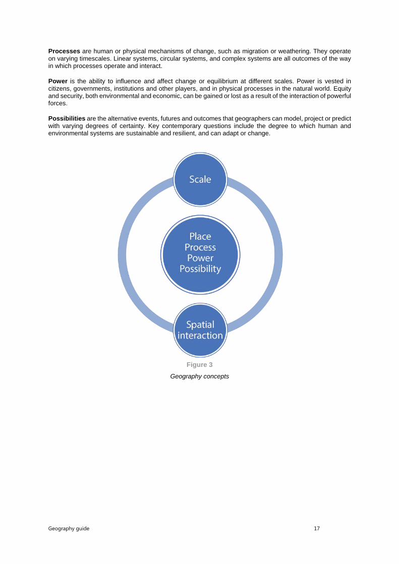
Geography concepts The “Geography concepts” model (Figure 3) shows the six main concepts of the course, with the four key concepts of place, process, power, and possibility at the centre and the organizing concepts of scale and spatial interactions connecting them. Scale has both temporal and spatial perspectives.
Places can be identified at a variety of scales, from local territories or locations to the national or state level. Places can be compared according to their cultural or physical diversity, or disparities in wealth or resource endowment. The characteristics of a place may be real or perceived, and spatial interactions between places can be considered.
Geography guide 17
Processes are human or physical mechanisms of change, such as migration or weathering. They operate on varying timescales. Linear systems, circular systems, and complex systems are all outcomes of the way in which processes operate and interact.
Power is the ability to influence and affect change or equilibrium at different scales. Power is vested in citizens, governments, institutions and other players, and in physical processes in the natural world. Equity and security, both environmental and economic, can be gained or lost as a result of the interaction of powerful forces.
Possibilities are the alternative events, futures and outcomes that geographers can model, project or predict with varying degrees of certainty. Key contemporary questions include the degree to which human and environmental systems are sustainable and resilient, and can adapt or change.
Figure 3 Geography concepts
Geography guide 18
The IB learner profile
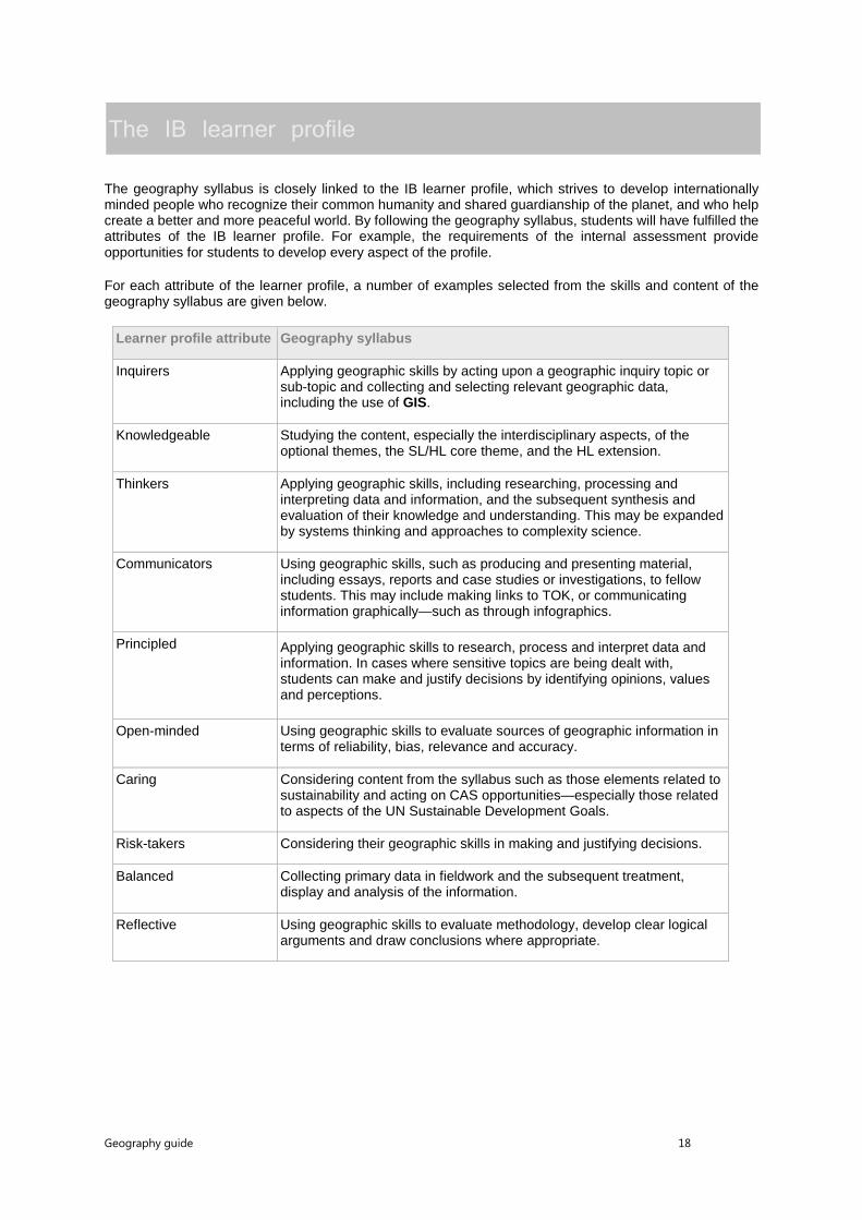
The geography syllabus is closely linked to the IB learner profile, which strives to develop internationally minded people who recognize their common humanity and shared guardianship of the planet, and who help create a better and more peaceful world. By following the geography syllabus, students will have fulfilled the attributes of the IB learner profile. For example, the requirements of the internal assessment provide opportunities for students to develop every aspect of the profile.
For each attribute of the learner profile, a number of examples selected from the skills and content of the geography syllabus are given below.
Learner profile attribute Geography syllabus
Inquirers Applying geographic skills by acting upon a geographic inquiry topic or sub-topic and collecting and selecting relevant geographic data, including the use of GIS.
Knowledgeable Studying the content, especially the interdisciplinary aspects, of the optional themes, the SL/HL core theme, and the HL extension.
Thinkers Applying geographic skills, including researching, processing and interpreting data and information, and the subsequent synthesis and evaluation of their knowledge and understanding. This may be expanded by systems thinking and approaches to complexity science.
Communicators Using geographic skills, such as producing and presenting material, including essays, reports and case studies or investigations, to fellow students. This may include making links to TOK, or communicating information graphically—such as through infographics.
Principled Applying geographic skills to research, process and interpret data and information. In cases where sensitive topics are being dealt with, students can make and justify decisions by identifying opinions, values and perceptions.
Open-minded Using geographic skills to evaluate sources of geographic information in terms of reliability, bias, relevance and accuracy.
Caring Considering content from the syllabus such as those elements related to sustainability and acting on CAS opportunities—especially those related to aspects of the UN Sustainable Development Goals.
Risk-takers Considering their geographic skills in making and justifying decisions.
Balanced Collecting primary data in fieldwork and the subsequent treatment, display and analysis of the information.
Reflective Using geographic skills to evaluate methodology, develop clear logical arguments and draw conclusions where appropriate.

Geography guide 19
Geographic skills
Geographic skills are essential to the study of geography and reflect the subject’s distinctive methodology and approach. Teaching and learning these skills enriches the students’ understanding of geography and enables them to apply and use appropriate techniques and terminology. It is essential that the skills should be covered throughout the whole syllabus and that they are introduced and integrated where appropriate, depending on the context, in the different themes and the SL/HL core and HL extension. It is essential that the skills should be all taught at some stage of the course and are not treated in isolation.
Students are expected to demonstrate competence in the use of geographic skills in examination papers and internal assessment as appropriate. Those skills indicated below in italics are not assessed in the externally assessed examination papers.
It is recognized that the ability to use GIS as a tool is a valuable geographic skill that goes beyond many of those listed below. Where GIS is accessible and practical, its use is encouraged.
Skill Examples
Locate and differentiate elements of the Earth’s surface
Using:
• direction
• latitude
• longitude
• grid references and area references
• scale
• political units.
Interpret, analyse and, when appropriate, construct tables, graphs, diagrams, cartographic material and images
All kinds of maps, including:
o isoline and isopleth maps
o choropleth maps
o topological maps
o dot maps
o flow maps
o thematic maps (including mental maps)
o topographic maps
• proportional symbols
• aerial photographs
• ground-level photographs
• satellite images
• graphs, including scatter, line, bar, compound, triangular, logarithmic, bipolar graphs
• pie charts
• flow diagrams/charts
• population pyramids

Geography guide 20
Skill Examples
• Lorenz curves
• cross-profiles (sections)
• rose diagrams
• development diamonds.
Undertake statistical calculations to show patterns and summarize information
Such as:
• totals
• averages (means, medians, modes)
• frequencies
• ranges of data (differences between maximum and minimum)
• densities
• percentages
• ratios.
Research, process and interpret data and information
Types of data and information:
• measures of correlation (including Spearman rank and chi-squared)
• measures of concentration and dispersion (including nearest neighbour and location quotients)
• measures of spatial interactions
• measures of diversity
• indices and ratios (including Gini coefficient, ecological footprint, Human Development Index (HDI), dependency ratio)
• textual information
• observations
• opinions, values and perceptions.
Processing and interpreting:
• classify data and information
• analyse data and information
• describe patterns, trends and relationships
• make generalizations and identify anomalies
• make inferences and predictions
• make and justify decisions
• draw conclusions
• evaluate methodology.

Geography guide 21
Skill Examples
Collect and select relevant geographic information
Making:
• observations, including field sketches and sketch maps
• images.
Conducting:
• interviews.
Taking:
• measurements.
Evaluate sources of geographic information
In terms of:
• accuracy
• relevance
• bias.
Produce written material (including essays, reports and investigations)
Presenting:
• material in a clear and well-structured way.
Responding:
• appropriately to command terms.

Geography guide 22
Further guidance
Use of case studies and examples The recommended teaching approach throughout the course is to focus on the concepts and to use case studies and examples, or detailed examples, to illustrate content and to contextualize these concepts (see Figure 2).
A case study is located, detailed and used for discussion or a discursive approach. Ideally, case studies selected should be recent; that is, they should have occurred within the student’s lifetime and should not be historical. For example, using the destruction of Pompeii as an example of volcanic destruction is not recommended. If the case studies used are very old, it is likely that they will not offer as much scope for answers as more recent ones. This is because current research and reporting generally produce far more data than previous records.
If case studies are required in a response, this will be stated in the question and students are advised, above all, to match the case study to the demands of the question. However, wherever possible, students are encouraged to develop their extended responses using case studies or detailed examples.
When examples are used, students should not just provide one-word responses but should offer some development. An example is a sentence or two that enriches an answer; it may include a specific location, an amount, or a date, all showing a greater depth of knowledge and understanding. An examination answer may include reference to many different examples to illustrate or support the response.
Advice on the number of case studies or detailed examples to be studied is given, where appropriate, in the sections of the guide devoted to the optional themes, the SL/HL core theme, and the HL extension.
Geographic models and theories Students can study models to illustrate concepts relevant to particular topics, but examination questions will not require students to have prior knowledge of any specific model or theory.
Primary and secondary information Primary information is material and data collected in the field through measurement and observation. It can include both qualitative and quantitative information. Secondary information is information that has already been compiled in written, statistical or mapped forms. It can include, for example, material from sources such as United Nations (UN) agencies, non-governmental organizations (NGOs), government publications, statistical yearbooks, telephone directories, censuses or the internet.
Topics for extended essays in geography Almost all areas of the syllabus lend themselves to deeper analysis and investigation in an extended essay. Many topics offer a wide range of opportunities for extended essays, although care may be needed to ensure that the research question is not too broad to be satisfactorily answered within the word limit. Also, it is important to note that there is a requirement to focus on a narrow area of research in depth, and that an extended essay must have a spatial component.
The global nature of the topics in the core themes means that they are not always suitable for extended essays. However, it should be possible to investigate the underlying concepts in extended essays, provided the area of research is at a local scale. As data collection in the field is not required for extended essays, the research questions can be more broadly based than those used for fieldwork and can rely on information derived from sources other than direct fieldwork.

Geography guide 23
The online curriculum centre All teachers of the geography course are strongly encouraged to access the OCC at regular intervals. The OCC is a website on which all teachers can post inquiries, present examples of good practice, ask for advice and access exemplar materials. The content of the geography forum on the OCC is provided by geography teachers for geography teachers. The website also includes updates on resources and frequently asked questions, as well as the subject report following each examination or assessment session.

Geography guide 24
Syllabus
Syllabus outline
Diploma Programme geography—SL and HL curriculum (first teaching September 2017)
SL teaching hours
SL assessment (first assessment May 2019)
HL teaching hours
HL assessment (first assessment May 2019)
Part one Geographic themes—seven options
Two options are studied at SL, and three at HL
• Freshwater—drainage basins
• Oceans and coastal margins
• Extreme environments
• Geophysical hazards
• Leisure, tourism and sport
• Food and health
• Urban environments
60 hours Paper 1
SL weight 35%
45 minutes per option question
Total 1 hour 30 minutes
Each option has a structured question and one extended answer question from a choice of two.
20 (10 + 10) marks per option
Total 40 marks
90 hours Paper 1
HL weight 35%
45 minutes per option question
Total 2 hours 15 minutes
Each option has a structured question and one extended answer question from a choice of two.
20 (10 + 10) marks per option
Total 60 marks
Geography guide 25
Diploma Programme geography—SL and HL curriculum (first teaching September 2017)
SL teaching hours
SL assessment (first assessment May 2019)
HL teaching hours
HL assessment (first assessment May 2019)
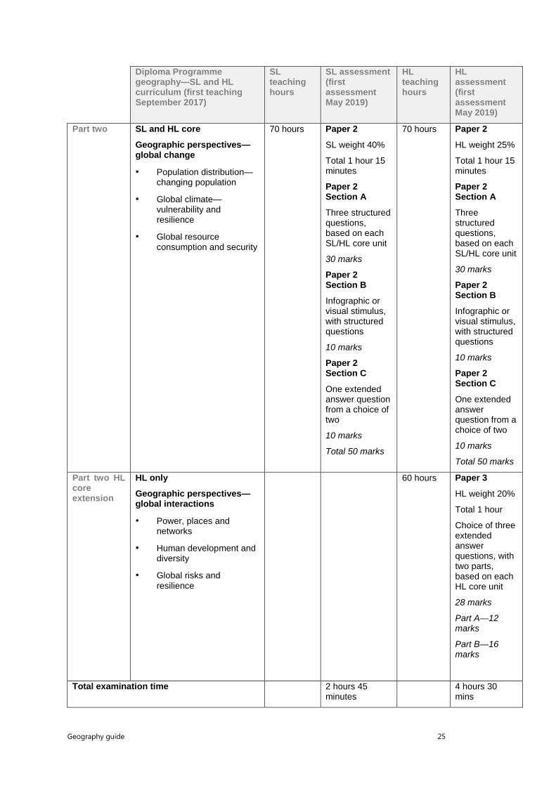
Part two SL and HL core
Geographic perspectives—global change
• Population distribution—changing population
• Global climate—vulnerability and resilience
• Global resource consumption and security
70 hours Paper 2
SL weight 40%
Total 1 hour 15 minutes
Paper 2 Section A
Three structured questions, based on each SL/HL core unit
30 marks
Paper 2 Section B
Infographic or visual stimulus, with structured questions
10 marks
Paper 2 Section C
One extended answer question from a choice of two
10 marks
Total 50 marks
70 hours Paper 2
HL weight 25%
Total 1 hour 15 minutes
Paper 2 Section A
Three structured questions, based on each SL/HL core unit
30 marks
Paper 2 Section B
Infographic or visual stimulus, with structured questions
10 marks
Paper 2 Section C
One extended answer question from a choice of two
10 marks
Total 50 marks
Part two HL core extension
HL only
Geographic perspectives—global interactions
• Power, places and networks
• Human development and diversity
• Global risks and resilience
60 hours Paper 3
HL weight 20%
Total 1 hour
Choice of three extended answer questions, with two parts, based on each HL core unit
28 marks
Part A—12 marks
Part B—16 marks
Total examination time 2 hours 45 minutes
4 hours 30 mins

Geography guide 26
Diploma Programme geography—SL and HL curriculum (first teaching September 2017)
SL teaching hours
SL assessment (first assessment May 2019)
HL teaching hours
HL assessment (first assessment May 2019)
Internal assessment
SL and HL
Fieldwork
Fieldwork, leading to one written report based on a fieldwork question, information collection and analysis with evaluation
20 hours Internal assessment
SL weight 25%
Fieldwork question to be based on any suitable topic from the syllabus
Total 25 marks
20 hours Internal assessment
HL weight 20%
Fieldwork question to be based on any suitable topic from the syllabus
Total 25 marks
Total teaching hours 150 hours 240 hours

Geography guide 27
Approaches to the teaching and learning of geography
The recommended teaching time is 150 hours at SL, and 240 hours at HL. The syllabus is designed to allow sufficient time for in-depth analysis, evaluation and consolidation of learning.
Teachers are encouraged to find ways of delivering the course that are most relevant to their students’ interests and to the school’s resources. The overall aim of the course is to give students a deeper understanding of the nature and scope of geography. The different parts of the course should complement each other and the geographic skills must be integrated throughout the course.
While specific physical or human oriented options are not mandatory, it is strongly advised that teachers in different international settings consider any national education system requirements, and progress to higher education, in the choices made.
Structure of the syllabus Each option or unit topic is structured to emphasise the conceptual focus of the geographic inquiry, with details relating to the prescribed geographic knowledge and understanding.
The order of the content is not an indication of how the optional themes, the SL/HL core theme, and the HL extension are to be delivered. Since many topics and sub-topics are interrelated, teachers are encouraged to adopt a holistic approach to teaching. For example, a single case study may serve to cover several topics or sub-topics.
Only topics and details in the syllabus will be selected for assessment in the examination papers, although references from the introductory sections of the optional themes, the SL/HL core theme, and the HL extension may occasionally be used to set the context for examination questions. Definitions and a classification of the command terms are published in this guide.
The “Geographic skills” section lists the skills required in the course that enable students to apply the techniques of geography and use appropriate terminology. It is essential that the skills be covered throughout the whole syllabus (at both SL and HL), that they are delivered through the content and context of the optional themes (the SL/HL core theme and HL extension, as appropriate), and that they are fully integrated into teaching as opposed to being treated individually. Students are expected to demonstrate competence in the use of these skills in both external assessment examination papers and internal assessment, as and when appropriate.
Reference may be made to topographic maps in any examination question and all students must be familiar with them. They are especially relevant to such themes as, for example, “Freshwater”, “Oceans and coastal margins” and “Urban environments”.
Geography guide 28
Syllabus content—Part one: Geographic themes
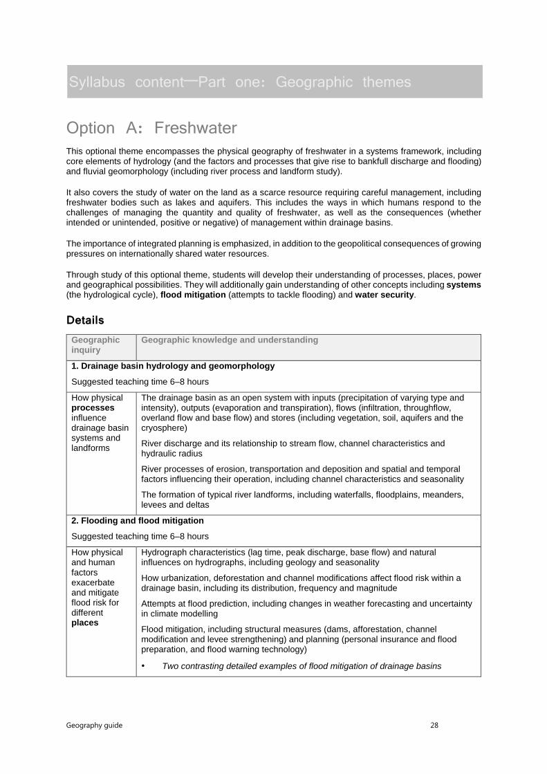
Option A: Freshwater This optional theme encompasses the physical geography of freshwater in a systems framework, including core elements of hydrology (and the factors and processes that give rise to bankfull discharge and flooding) and fluvial geomorphology (including river process and landform study).
It also covers the study of water on the land as a scarce resource requiring careful management, including freshwater bodies such as lakes and aquifers. This includes the ways in which humans respond to the challenges of managing the quantity and quality of freshwater, as well as the consequences (whether intended or unintended, positive or negative) of management within drainage basins.
The importance of integrated planning is emphasized, in addition to the geopolitical consequences of growing pressures on internationally shared water resources.
Through study of this optional theme, students will develop their understanding of processes, places, power and geographical possibilities. They will additionally gain understanding of other concepts including systems (the hydrological cycle), flood mitigation (attempts to tackle flooding) and water security.
Details Geographic inquiry
Geographic knowledge and understanding
1. Drainage basin hydrology and geomorphology
Suggested teaching time 6–8 hours
How physical processes influence drainage basin systems and landforms
The drainage basin as an open system with inputs (precipitation of varying type and intensity), outputs (evaporation and transpiration), flows (infiltration, throughflow, overland flow and base flow) and stores (including vegetation, soil, aquifers and the cryosphere)
River discharge and its relationship to stream flow, channel characteristics and hydraulic radius
River processes of erosion, transportation and deposition and spatial and temporal factors influencing their operation, including channel characteristics and seasonality
The formation of typical river landforms, including waterfalls, floodplains, meanders, levees and deltas
2. Flooding and flood mitigation
Suggested teaching time 6–8 hours
How physical and human factors exacerbate and mitigate flood risk for different places
Hydrograph characteristics (lag time, peak discharge, base flow) and natural influences on hydrographs, including geology and seasonality
How urbanization, deforestation and channel modifications affect flood risk within a drainage basin, including its distribution, frequency and magnitude
Attempts at flood prediction, including changes in weather forecasting and uncertainty in climate modelling
Flood mitigation, including structural measures (dams, afforestation, channel modification and levee strengthening) and planning (personal insurance and flood preparation, and flood warning technology)
• Two contrasting detailed examples of flood mitigation of drainage basins

Geography guide 29
Geographic inquiry
Geographic knowledge and understanding
3. Water scarcity and water quality
Suggested teaching time 6–8 hours
The varying power of different actors in relation to water management issues
Physical and economic water scarcity, and the factors that control these including the causes and impacts of droughts; the distinction between water quantity and water quality
Environmental consequences of agricultural activities on water quality, to include pollution (eutrophication) and irrigation (salinization)
• Detailed examples to illustrate the role of different stakeholders
Growing human pressures on lakes and aquifers, including economic growth and population migration
Internationally shared water resources as a source of conflict
• Case study of one internationally shared water resource and the role of different stakeholders in attempting to find a resolution
4. Water management futures
Suggested teaching time 6–8 hours
Future possibilities for management intervention in drainage basins
The importance of strengthening participation of local communities to improve water management in different economic development contexts, including sustainable water use and efficiency, and ensuring access to clean, safe and affordable water
Increased dam building for multipurpose water schemes, and their costs and benefits
• Case study of contemporary dam building expansion in one major drainage basin
The growing importance of integrated drainage basin management (IDBM) plans, and the costs and benefits they bring
• Case study of one recent IDBM plan
Growing pressures on major wetlands and efforts to protect them, such as the Ramsar Convention
• Case study of the future possibilities for one wetland area
Synthesis (Sy), Evaluation (Ev) and Skills (Sk) opportunities
These suggestions aim to synthesize the learning throughout the unit.
How natural processes or human interference in one part of a drainage basin may bring spatial interactions with other parts/places [Sy]
How water management actions take place at personal to global scales [Sy/Ev]
Different perspectives on the costs and benefits of water management strategies [Ev]
How water cycling and water system flows can be represented graphically [Sk]
Geography guide 30
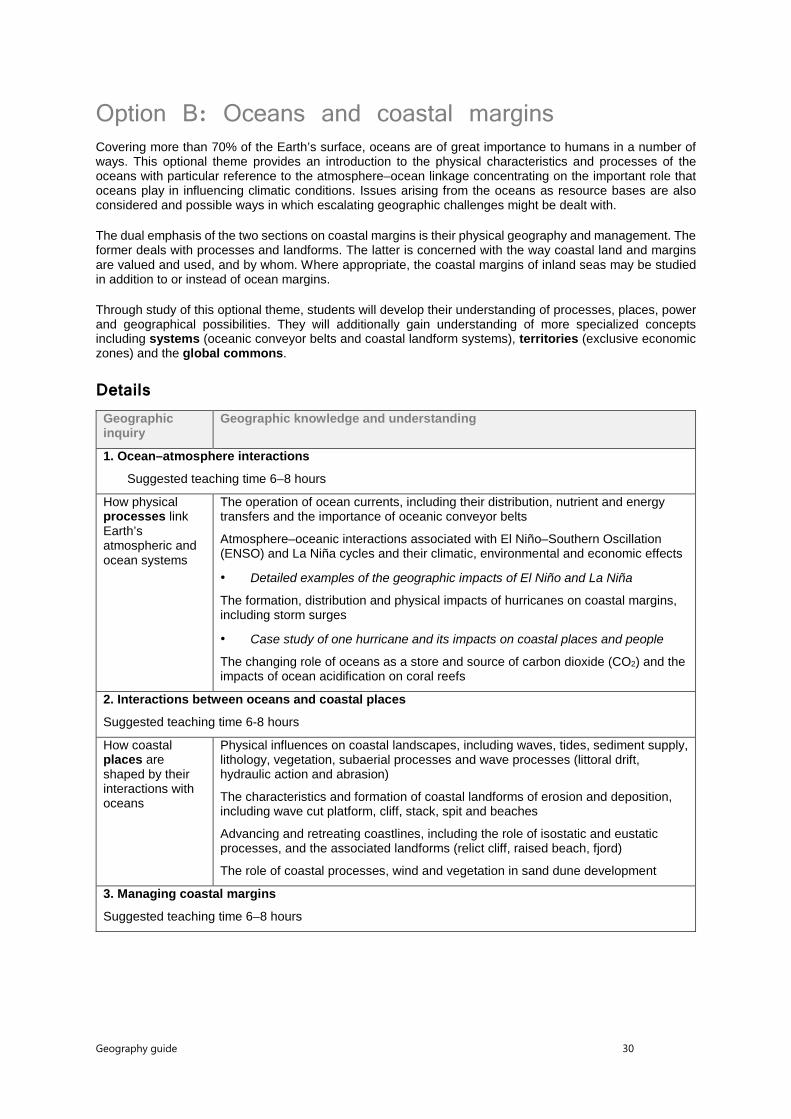
Option B: Oceans and coastal margins Covering more than 70% of the Earth’s surface, oceans are of great importance to humans in a number of ways. This optional theme provides an introduction to the physical characteristics and processes of the oceans with particular reference to the atmosphere–ocean linkage concentrating on the important role that oceans play in influencing climatic conditions. Issues arising from the oceans as resource bases are also considered and possible ways in which escalating geographic challenges might be dealt with.
The dual emphasis of the two sections on coastal margins is their physical geography and management. The former deals with processes and landforms. The latter is concerned with the way coastal land and margins are valued and used, and by whom. Where appropriate, the coastal margins of inland seas may be studied in addition to or instead of ocean margins.
Through study of this optional theme, students will develop their understanding of processes, places, power and geographical possibilities. They will additionally gain understanding of more specialized concepts including systems (oceanic conveyor belts and coastal landform systems), territories (exclusive economic zones) and the global commons.
Details Geographic inquiry
Geographic knowledge and understanding
1. Ocean–atmosphere interactions
Suggested teaching time 6–8 hours
How physical processes link Earth’s atmospheric and ocean systems
The operation of ocean currents, including their distribution, nutrient and energy transfers and the importance of oceanic conveyor belts
Atmosphere–oceanic interactions associated with El Niño–Southern Oscillation (ENSO) and La Niña cycles and their climatic, environmental and economic effects
• Detailed examples of the geographic impacts of El Niño and La Niña
The formation, distribution and physical impacts of hurricanes on coastal margins, including storm surges
• Case study of one hurricane and its impacts on coastal places and people
The changing role of oceans as a store and source of carbon dioxide (CO2) and the impacts of ocean acidification on coral reefs
2. Interactions between oceans and coastal places
Suggested teaching time 6-8 hours
How coastal places are shaped by their interactions with oceans
Physical influences on coastal landscapes, including waves, tides, sediment supply, lithology, vegetation, subaerial processes and wave processes (littoral drift, hydraulic action and abrasion)
The characteristics and formation of coastal landforms of erosion and deposition, including wave cut platform, cliff, stack, spit and beaches
Advancing and retreating coastlines, including the role of isostatic and eustatic processes, and the associated landforms (relict cliff, raised beach, fjord)
The role of coastal processes, wind and vegetation in sand dune development
3. Managing coastal margins
Suggested teaching time 6–8 hours

Geography guide 31
Geographic inquiry
Geographic knowledge and understanding
The varying power of different stakeholders in relation to coastal margin management
Coastal erosion and flooding management strategies, including cliff line stabilization and managed retreat
• One coastal management case study focused on the decision-making process and perspectives of different actors
Conflicting land-use pressures on coastlines, including commercial land uses (tourism, industry and housing) and conservation measures
• One case study to illustrate the roles of, and outcomes for, coastal stakeholders
Management of coral reefs and mangrove swamps, including different stakeholder perspectives on their use and value
• Detailed examples of both ecosystems and their issues
Sovereignty rights of nations in relation to territorial limits along coastal margins and exclusive economic zones (EEZs)
4. Ocean management futures
Suggested teaching time 6–8 hours
Future possibilities for managing the oceans as a global commons
Causes and consequences of increasing demand for the abiotic resources of oceans, including minerals, oil and gas
Trends in biotic resource use (fish and mammals) and the viability of alternatives to overfishing, including aquaculture, conservation areas and quotas
Strengths and weaknesses of initiatives to manage ocean pollution, including local and global strategies for radioactive materials, oil and plastic waste
The strategic value of oceans and sources of international conflict/insecurity, including the contested ownership and control of island, canals and transit choke points
• One contemporary geopolitical case study focusing on a contested ocean area
Synthesis (Sy), Evaluation (Ev) and Skills (Sk) opportunities
These suggestions can be integrated into the study of the above. No additional teaching time is required.
How changes in one part of an ocean or coastal margin may bring spatial interactions with other parts/places [Sy]
How ocean exploitation and management take place at varying scales [Sy/Ev]
Varying perspectives on the costs, benefits and effectiveness of management [Ev]
How ocean and atmospheric systems, and their interactions, can be represented graphically [Sk]
Geography guide 32
Option C: Extreme environments This optional theme considers two different kinds of extreme, terrestrial environments:
• cold and high-altitude environments (polar, glacial areas, periglacial areas, high mountains in non-polar latitudes)
• hot, arid environments (hot deserts and semi-arid areas).
These environments are relatively inaccessible and tend to be viewed as inhospitable to human habitation. Despite this, they provide numerous opportunities for settlement and economic activity. This theme examines the essential landscape characteristics of the two kinds of extreme environments, together with the natural processes operating in them; the way in which people have responded to the opportunities they offer, how they have adapted to extremes of weather and climate, and the challenges these environments pose for management and sustainability.
Through study of this optional theme, students will develop their understanding of processes, places, power and geographical possibilities. They will additionally gain understanding of more specialized concepts including glacial systems, risk and adaptation (in relation to climate change) and resource nationalism (in relation to land ownership).
Details Geographic inquiry Geographic knowledge and understanding
1. The characteristics of extreme environments
Suggested teaching time 6–8 hours
Why some places are considered to be extreme environments
Global-scale distribution of cold and high altitude environments (polar, glacial areas, periglacial areas, high mountains in non-polar places) and hot arid environments (hot deserts and semi-arid areas)
Relief and climatic characteristics that make environments extreme, including unreliability and intensity of rainfall in arid environments and the risk of flash floods
How relief, climate, human discomfort, inaccessibility, and remoteness present challenges for human habitation and resource development
• Detailed examples for illustrative purposes
The changing distribution of extreme environments over time, including the advance and retreat of glaciers and natural desertification
2. Physical processes and landscapes
Suggested teaching time 6–8 hours
How physical processes create unique landscapes in extreme environments
Glacial processes of erosion, transport and deposition, and landscape features in glaciated areas, including cirques/corries, lakes, pyramidal peaks/horns, arêtes, glacial troughs; lateral, medial and terminal moraine and erratics
Periglacial processes of freeze-thaw, solifluction and frost heave, and periglacial landscape features, including permafrost, thermokarst, patterned ground and pingos
Physical and chemical weathering in hot arid environments, and erosion, transportation and deposition by wind and water
Hot, arid landscape features, including dunes, wadis, rock pedestals, mesas and buttes
3. Managing extreme environments
Suggested teaching time 6–8 hours

Geography guide 33
Geographic inquiry Geographic knowledge and understanding
The varying power of different stakeholders to extract economic value from extreme environments
Agricultural opportunities and challenges in arid areas, including the distinction between aridity and infertility, irrigation access, salinization risk and land ownership
Human and physical opportunities and challenges for mineral extraction in cold environments, including inaccessibility, permafrost and resource nationalism
• Case study of one cold environment to illustrate the issues
Human and physical opportunities and challenges for mineral extraction in arid environments, including inaccessibility and climatic and political factors
• Case study of one arid environment to illustrate the issues
Opportunities and challenges for tourism in extreme environments
• Detailed examples illustrating the involvement of local and global stakeholders
4. Extreme environments futures
Suggested teaching time 6–8 hours
Future possibilities for managing extreme environments and their communities
The causes, acceleration, consequences and management of desertification, including land use, conflict and climate change
• One case study illustrating the human and physical dimensions of desertification
Increasing competition for access to resources in extreme environments, including the role of indigenous groups, civil society organizations, transnational corporations (TNCs) and militia groups
• One case study to highlight the issues
New technology and sustainable development in extreme environments, including greater use of solar power and desalination
The impacts and management of global climate change in extreme environments, including adaptation by local populations
Synthesis (Sy), Evaluation (Ev) and Skills (Sk) opportunities
These suggestions can be integrated into the study of the above. No additional teaching time is required.
How places and people in extreme environments are affected by spatial interactions with other places and people [Sy]
The varying spatial scale of the processes and challenges associated with different kinds of extreme environment [Sy/Ev]
Varying perspectives on how and why extreme environments are managed [Ev]
How glacial systems and climatic data are best represented graphically [Sk]

Geography guide 34
Option D: Geophysical hazards This optional theme focuses on geophysical hazard events. This includes internal earth processes, such as earthquakes and volcanic activity. It also encompasses mass movements such as landslides, rockslides, debris or mud flows. The theme also includes human impacts and responses. Case studies of contrasting geophysical hazard events need to be undertaken (“contrasting” can be interpreted as severity of impacts and/or locations with different socio-economic realities):
• two earthquake hazard events of similar magnitudes but with contrasting human impacts
• two volcanic hazard events in contrasting plate boundary locations
• two mass movement hazard events with contrasting physical characteristics (fast/slow; solid/loose).
Through study of this optional theme, students will develop their understanding of processes, places, power and geographic possibilities. They will additionally gain understanding of more specialized concepts including risk and vulnerability (both of which vary according to the local context) and also resilience and adaptation (in relation to pre-event and post-event disaster management).
Details Geographic inquiry Geographic knowledge and understanding
1. Geophysical systems
Suggested teaching time 6–8 hours
How geological processes give rise to geophysical events of differing type and magnitude
Mechanisms of plate movement including internal heating, convection currents, plumes, subduction and rifting at plate margins
Characteristics of volcanoes (shield, composite and cinder) formed by varying types of volcanic eruption; and associated secondary hazards (pyroclastic flows, lahars, landslides)
Characteristics of earthquakes (depth of focus, epicentre and wave types) caused by varying types of plate margin movement and human triggers (dam building, resource extraction); and associated secondary hazards (tsunami, landslides, liquefaction, transverse faults)
Classification of mass movement types according to cause (physical and human), liquidity, speed of onset, duration, extent and frequency
2. Geophysical hazard risks
Suggested teaching time 6–8 hours
How geophysical systems generate hazard risks for different places
The distribution of geophysical hazards (earthquakes, volcanoes, mass movements)
The relevance of hazard magnitude and frequency/recurrence for risk management
Geophysical hazard risk as a product of economic factors (levels of development and technology), social factors (education, gender), demographic factors (population density and structure) and political factors (governance)
Geographic factors affecting geophysical hazard event impacts, including rural/urban location, time of day and degree of isolation
3. Hazard risk and vulnerability
Suggested teaching time 6–8 hours
Geography guide 35
Geographic inquiry Geographic knowledge and understanding
The varying power of geophysical hazards to affect people in different local contexts
• Two contemporary contrasting case studies each for volcanic hazards, earthquake hazards and mass movement hazards (see guidance above)
• For each geophysical hazard type, the case studies should develop knowledge and understanding of:
– geophysical hazard event profiles, including any secondary hazards
– varied impacts of these hazards on different aspects of human well-being
– why levels of vulnerability varied both between and within communities, including spatial variations in hazard perception, personal knowledge and preparedness
4. Future resilience and adaptation
Suggested teaching time 6–8 hours
Future possibilities for lessening human vulnerability to geophysical hazards
Global geophysical hazard and disaster trends and future projections, including event frequency and population growth estimates
Geophysical hazard adaptation through increased government planning (land use zoning) and personal resilience (increased preparedness, use of insurance and adoption of new technology)
Pre-event management strategies for mass movement (to include slope stabilization), earthquakes and tsunami (to include building design, tsunami defences), volcanoes (to include GPS crater monitoring and lava diversions)
Post-event management strategies (rescue, rehabilitation, reconstruction), to include the enhanced use of communications technologies to map hazards/disasters, locate survivors and promote continuing human development
Synthesis (Sy), Evaluation (Ev) and Skills (Sk) opportunities
These suggestions can be integrated into the study of the above. No additional teaching time is required.
How hazard risk is a function of spatial interactions between different human and physical processes [Sy]
The varying spatial scale of the processes and challenges associated with different kinds of geophysical event and their aftermaths [Sy/Ev]
Different perspectives on how geophysical hazard risks should be managed [Ev]
How spatial patterns of risk and vulnerability can be represented graphically [Sk]

Geography guide 36
Option E: Leisure, tourism and sport This optional theme focuses on ways in which people in a growing number of global contexts make use of their leisure time. As more people join the “global middle class”, they have disposable incomes allowing participation in tourism, including international travel and different types of sport. Sport can also be an important use of leisure time for people on low incomes who cannot afford to participate in tourism.
While tourism often has an urban focus, rural areas provide another important geographical setting for touristic activities, including walking, enjoying wilderness, doing extreme sports or visiting heritage sites. The uses made of places vary greatly, depending on physical geography, history and level of economic development.
Through study of this optional theme, students will develop their understanding of processes, places, power and geographical possibilities. They will additionally gain understanding of more specialized concepts including consumption (of landscapes), carrying capacity and threshold (in relation to environmental stress) and sustainability (in relation to long-term management of touristic resources).
Details Geographic inquiry Geographic knowledge and understanding
1. Changing leisure patterns
Suggested teaching time 6–8 hours
How human development processes give rise to leisure activities
The growth and changing purpose of leisure time for societies in different geographic and developmental contexts
The categorization of touristic activities (cost, duration, destination) and sporting activities (cost, popularity, site)
The link between economic development and participation in leisure activities
• Detailed examples to illustrate recent changes in participation for two or more societies at contrasting stages of development
Factors affecting personal participation in sports and tourism, including affluence, gender, stage in lifecycle, personality, place of residence
2. Tourism and sport at the local and national scale
Suggested teaching time 6–8 hours
How physical and human factors shape places into sites of leisure
Human and physical factors explaining the growth of rural and urban tourism hotspots including the role of primary and secondary touristic resources
Variations in sphere of influence for different kinds of sporting and touristic facility, including neighbourhood parks and gyms, city stadiums and national parks
Factors affecting the geography of a national sports league, including the location of its hierarchy of teams and the distribution of supporters
• Case study of one national sports league
Large-scale sporting, musical, cultural or religious festivals as temporary sites of leisure and their associated costs and benefits
• Case study of one festival in a rural location, its site factors and geographic impacts
3. Tourism and sport at the international scale
Suggested teaching time 6–8 hours

Geography guide 37
Geographic inquiry Geographic knowledge and understanding
The varying power of different countries to participate in global tourism and sport
Niche national tourism strategies with a global sphere of influence, including adventure tourism, movie location tourism and heritage tourism
The role of TNCs in expanding international tourism destinations, including the costs and benefits of TNC involvement for different stakeholders
Costs and benefits of tourism as a national development strategy, including economic and social/cultural effects
Political, economic and cultural factors affecting the hosting of international sporting events, including Olympics and football World Cup events
• Case study of costs and benefits for one country hosting an international event
4. Managing tourism and sport for the future
Suggested teaching time 6–8 hours
Future possibilities for management of, and participation in, tourism and sport at varying scales
The consequences of unsustainable touristic growth in rural and urban tourism hotspots, including the concept of carrying capacity and possible management options to increase site resilience
The concept of sustainable tourism, including the growth of ecotourism
• One case study of sustainable tourism in one low-income country
Factors influencing future international tourism, including greater use of social media, international security and diaspora growth
The growing importance of political and cultural influences on international sport participation, including international agreements, inclusion via changing gender roles and the growing importance of the Paralympics
Synthesis (Sy), Evaluation (Ev) and Skills (Sk) opportunities
These suggestions can be integrated into the study of the above. No additional teaching time is required.
How leisure use of a place is influenced by spatial interactions with other places [Sy]
People’s freedom and ability to participate in leisure activities is subject to multiple influences from personal/local to global scales [Sy/Ev]
Different perspectives on the costs and benefits of how places are used for leisure activities and who is allowed to participate [Ev]
How trends and changes in visitor and impact data can be shown graphically [Sk]
Geography guide 38
Option F: Food and health This optional theme looks at the geography of food and health. Economic development is often accompanied by dietary change and an epidemiological transition in which diseases of poverty become less common and diseases of affluence more common; however, this transition does not apply equally to all sectors of society.
Neither food nor health is easy to “measure”, so alternative indicators of food and health are considered. There are many interactions between, and shared influences on, food and health. The role of gender, TNCs and national governments in both food and health provision is considered. This topic considers alternative ways of assessing agricultural sustainability alongside possibilities for improving food supplies and global health over the long term.
Through study of this optional theme, students will develop their understanding of processes, places, power and geographical possibilities. They will additionally gain understanding of more specialized concepts including some, such as diffusion and barriers, which are applicable to both food production systems and the spread of diseases. Sustainability is considered in relation to long-term food production.
Details Geographic inquiry Geographic knowledge and understanding
1. Measuring food and health
Suggested teaching time 6–8 hours
Ways of measuring disparities in food and health between places
Global patterns in food/nutrition indicators, including the food security index, the hunger index, calories per person/capita, indicators of malnutrition
The nutrition transition, and associated regional variations of food consumption and nutrition choices
Global patterns in health indicators, including health-adjusted life expectancy (HALE), infant mortality, maternal mortality, access to sanitation and the ratio between doctors/physicians and people
The epidemiological transition, the diseases continuum (diseases of poverty to diseases of affluence), and the implications of a global ageing population for disease burden
2. Food systems and spread of diseases
Suggested teaching time 6–8 hours
How physical and human processes lead to changes in food production and consumption, and incidence and spread of disease
The merits of a systems approach (inputs, stores, transfers, outputs) to compare energy efficiency and water footprints in food production, and relative sustainability in different places
The physical and human processes that can lead to variations in food consumption
The importance of diffusion (including adoption/acquisition, expansion, relocation) in the spread of agricultural innovations, and also in the spread of diseases, and the role of geographic factors (including physical, economic and political barriers) in the rate of diffusion
Geographic factors contributing to the incidence, diffusion and impacts (demographic and socio-economic) of vector-borne and water-borne diseases
• One detailed example of a vector-borne disease and one detailed example of a water-borne disease
3. Stakeholders in food and health
Suggested teaching time 6–8 hours
Geography guide 39
Geographic inquiry Geographic knowledge and understanding
The power of different stakeholders in relation to influence over diets and health
The roles of international organizations (such as the World Food Programme, Food and Agriculture Organization of the United Nations, and World Health Organization), governments and NGOs in combating food insecurity and disease
The influence of TNCs (agribusinesses and the media) in shaping food consumption habits
Gender roles related to food and health, including food production/acquisition and disparities in health
Factors affecting the severity of famine, including governance, the power of the media and access to international aid
• One case study of the issues affecting a famine-stricken country or area
4. Future health and food security and sustainability
Suggested teaching time 6–8 hours
Future possibilities for sustainable agriculture and improved health
Possible solutions to food insecurity, including waste reduction
• One case study of attempts to tackle food insecurity
Advantages and disadvantages of contemporary approaches to food production, including genetically modified organisms (GMOs), vertical farming and in vitro meat
The merits of prevention and treatment in managing disease, including social marginalization issues, government priorities, means of infection and scientific intervention
Managing pandemics, including the epidemiology of the disease, prior local and global awareness, international action and the role of media
• One case study of a contemporary pandemic and the lessons learned for pandemic management in the future
Synthesis (Sy), Evaluation (Ev) and Skills (Sk) opportunities
These suggestions can be integrated into the study of the above. No additional teaching time is required.
The spatial interaction between geographies of health and food/nutrition [Sy]
Contrasts in the scale of causes and solutions to food and health challenges [Sy/Ev]
Perspectives of stakeholders on the priorities for health care and food security [Ev]
How patterns in health and the diffusion of disease can be represented graphically [Sk]

Geography guide 40
Option G: Urban environments More than 50% of the world’s population now lives in urban environments, with many living in megacities. This optional theme considers the hierarchy of cities and other urban places as sites of intense social interaction and as focal points of production, wealth generation and consumption. They exhibit diversity in patterns of wealth and deprivation, which can result in conflict. They may share common characteristics and processes irrespective of the national level of economic development.
Transport improvements have led to rapid growth and shifts in population and economic activities, producing stresses and challenges for urban planners. The theme also considers issues of sustainability, wherein cities need to be managed to minimize harmful social and environmental impacts.
Through study of this optional theme, students will develop their understanding of processes, places, power and geographical possibilities. They will additionally gain understanding of more specialized concepts including hierarchies (of settlements), systems (in relation to movements of people and the management of transport and waste flows) and sustainability.
Details Geographic inquiry Geographic knowledge and understanding
1. The variety of urban environments
Suggested teaching time 6–8 hours
The characteristics and distribution of urban places, populations and economic activities
Characteristics of urban places, including site, function, land use, hierarchy of settlement (including megacities) and growth process (planned or spontaneous)
Factors affecting the pattern of urban economic activities (retail, commercial, industrial), including physical factors, land values, proximity to a central business district (CBD) and planning
Factors affecting the pattern of residential areas within urban areas, including physical factors, land values, ethnicity and planning
The incidence of poverty, deprivation and informal activity (housing and industry) in urban areas at varying stages of development
2. Changing urban systems
Suggested teaching time 6–8 hours
How economic and demographic processes bring change over time to urban systems
Urbanization, natural increase and centripetal population movements, including rural–urban migration in industrializing cities, and inner city gentrification in post-industrial cities
Centrifugal population movements, including suburbanization and counter-urbanization
Urban system growth including infrastructure improvements over time, such as transport, sanitation, water, waste disposal and telecommunications
• Case study of infrastructure growth over time in one city
The causes of urban deindustrialization and its economic, social and demographic consequences
3. Urban environmental and social stresses
Suggested teaching time 6–8 hours
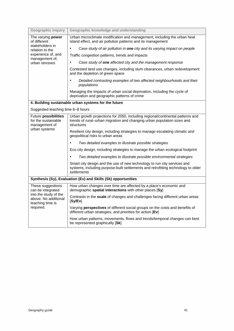
Geography guide 41
Geographic inquiry Geographic knowledge and understanding
The varying power of different stakeholders in relation to the experience of, and management of, urban stresses
Urban microclimate modification and management, including the urban heat island effect, and air pollution patterns and its management
• Case study of air pollution in one city and its varying impact on people
Traffic congestion patterns, trends and impacts
• Case study of one affected city and the management response
Contested land use changes, including slum clearances, urban redevelopment and the depletion of green space
• Detailed contrasting examples of two affected neighbourhoods and their populations
Managing the impacts of urban social deprivation, including the cycle of deprivation and geographic patterns of crime
4. Building sustainable urban systems for the future
Suggested teaching time 6–8 hours
Future possibilities for the sustainable management of urban systems
Urban growth projections for 2050, including regional/continental patterns and trends of rural–urban migration and changing urban population sizes and structures
Resilient city design, including strategies to manage escalating climatic and geopolitical risks to urban areas
• Two detailed examples to illustrate possible strategies
Eco city design, including strategies to manage the urban ecological footprint
• Two detailed examples to illustrate possible environmental strategies
Smart city design and the use of new technology to run city services and systems, including purpose-built settlements and retrofitting technology to older settlements
Synthesis (Sy), Evaluation (Ev) and Skills (Sk) opportunities
These suggestions can be integrated into the study of the above. No additional teaching time is required.
How urban changes over time are affected by a place’s economic and demographic spatial interactions with other places [Sy]
Contrasts in the scale of changes and challenges facing different urban areas [Sy/Ev]
Varying perspectives of different social groups on the costs and benefits of different urban strategies, and priorities for action [Ev]
How urban patterns, movements, flows and trends/temporal changes can best be represented graphically [Sk]
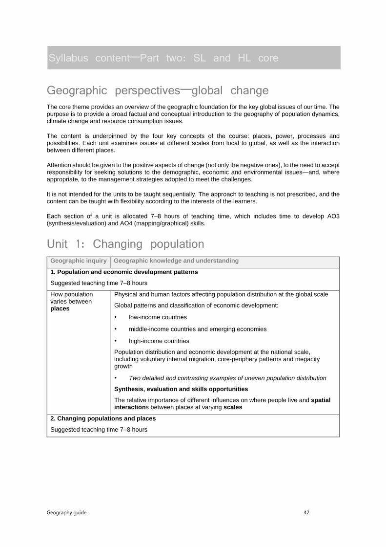
Geography guide 42
Syllabus content—Part two: SL and HL core
Geographic perspectives—global change The core theme provides an overview of the geographic foundation for the key global issues of our time. The purpose is to provide a broad factual and conceptual introduction to the geography of population dynamics, climate change and resource consumption issues.
The content is underpinned by the four key concepts of the course: places, power, processes and possibilities. Each unit examines issues at different scales from local to global, as well as the interaction between different places.
Attention should be given to the positive aspects of change (not only the negative ones), to the need to accept responsibility for seeking solutions to the demographic, economic and environmental issues—and, where appropriate, to the management strategies adopted to meet the challenges.
It is not intended for the units to be taught sequentially. The approach to teaching is not prescribed, and the content can be taught with flexibility according to the interests of the learners.
Each section of a unit is allocated 7–8 hours of teaching time, which includes time to develop AO3 (synthesis/evaluation) and AO4 (mapping/graphical) skills.
Unit 1: Changing population Geographic inquiry Geographic knowledge and understanding
1. Population and economic development patterns
Suggested teaching time 7–8 hours
How population varies between places
Physical and human factors affecting population distribution at the global scale
Global patterns and classification of economic development:
• low-income countries
• middle-income countries and emerging economies
• high-income countries
Population distribution and economic development at the national scale, including voluntary internal migration, core-periphery patterns and megacity growth
• Two detailed and contrasting examples of uneven population distribution
Synthesis, evaluation and skills opportunities
The relative importance of different influences on where people live and spatial interactions between places at varying scales
2. Changing populations and places
Suggested teaching time 7–8 hours
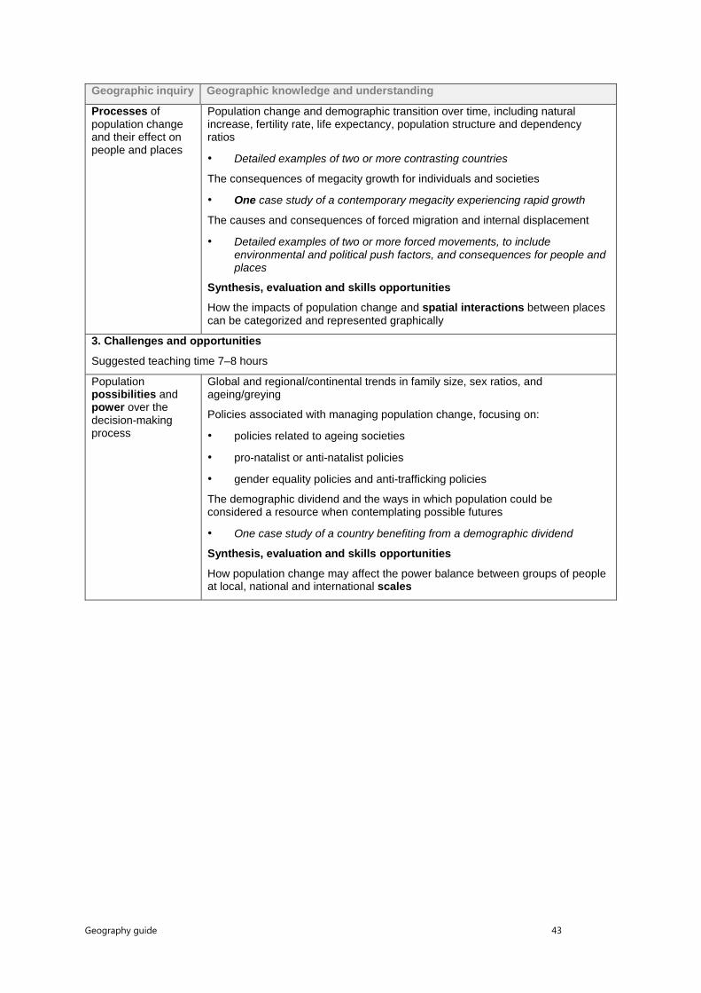
Geography guide 43
Geographic inquiry Geographic knowledge and understanding
Processes of population change and their effect on people and places
Population change and demographic transition over time, including natural increase, fertility rate, life expectancy, population structure and dependency ratios
• Detailed examples of two or more contrasting countries
The consequences of megacity growth for individuals and societies
• One case study of a contemporary megacity experiencing rapid growth
The causes and consequences of forced migration and internal displacement
• Detailed examples of two or more forced movements, to include environmental and political push factors, and consequences for people and places
Synthesis, evaluation and skills opportunities
How the impacts of population change and spatial interactions between places can be categorized and represented graphically
3. Challenges and opportunities
Suggested teaching time 7–8 hours
Population possibilities and power over the decision-making process
Global and regional/continental trends in family size, sex ratios, and ageing/greying
Policies associated with managing population change, focusing on:
• policies related to ageing societies
• pro-natalist or anti-natalist policies
• gender equality policies and anti-trafficking policies
The demographic dividend and the ways in which population could be considered a resource when contemplating possible futures
• One case study of a country benefiting from a demographic dividend
Synthesis, evaluation and skills opportunities
How population change may affect the power balance between groups of people at local, national and international scales

Geography guide 44
Unit 2: Global climate—vulnerability and resilience Geographic inquiry Geographic knowledge and understanding
1. Causes of global climate change
Suggested teaching time 7–8 hours
How natural and human processes affect the global energy balance
The atmospheric system, including the natural greenhouse effect and energy balance (incoming shortwave radiation and outgoing longwave radiation)
Changes in the global energy balance, and the role of feedback loops, resulting from:
• solar radiation variations, including global dimming due to volcanic eruptions
• terrestrial albedo changes and feedback loops
• methane gas release and feedback loops
The enhanced greenhouse effect and international variations in greenhouse gas sources and emissions, in relation to economic development, globalization and trade
Synthesis, evaluation and skills opportunities
The complexity of the dynamic climate system and the spatial interactions of different processes and feedback mechanisms
2. Consequences of global climate change
Suggested teaching time 7–8 hours
The effects of global climate change on places, societies and environmental systems
Climate change and the hydrosphere, atmosphere and biosphere, including:
• water stored in ice and oceans, and changing sea levels
• carbon stored in ice, oceans and the biosphere
• incidence and severity of extreme weather events, including drought
• spatial changes in biomes, habitats and animal migration patterns
• changes to agriculture, including crop yields, limits of cultivation, soil erosion
Impacts of climate change on people and places, including health hazards, migration and ocean transport routes
Synthesis, evaluation and skills opportunities
The uneven spatial distribution of effects and uncertainty about their timing, scale and impacts for individuals and societies
3. Responding to global climate change
Suggested teaching time 7–8 hours

Geography guide 45
Geographic inquiry Geographic knowledge and understanding
Possibilities for responding to climate change and power over the decision-making process
Disparities in exposure to climate change risk and vulnerability, including variations in people’s location, wealth, social differences (age, gender, education), risk perception
• Detailed examples of two or more societies with contrasting vulnerability
Government-led adaptation and mitigation strategies for global climate change:
• global geopolitical efforts, recognizing that the source/s of greenhouse gas emissions may be spatially distant from the countries most impacted
• carbon emissions offsetting and trading
• technology, including geo-engineering
Civil society and corporate strategies to address global climate change
• Case study of the response to climate change in one country focusing on the actions of non-governmental stakeholders
Synthesis, evaluation and skills opportunities
Why perspectives and viewpoints may be different about the need for, practicality and urgency of action on global climate change
Unit 3: Global resource consumption and security Geographic inquiry Geographic knowledge and understanding
1. Global trends in consumption
Suggested teaching time 7–8 hours
How global development processes affect resource availability and consumption
Global and regional/continental progress towards poverty reduction, including the growth of the “new global middle class”
Measuring trends in resource consumption, including individual, national and global ecological footprints
An overview of global patterns and trends in the availability and consumption of:
• water, including embedded water in food and manufactured goods
• land/food, including changing diets in middle-income countries
• energy, including the relative and changing importance of hydrocarbons, nuclear power, renewables, new sources of modern energy
Synthesis, evaluation and skills opportunities
How different patterns and trends are interrelated and involve spatial interactions between different places
2. Impacts of changing trends in resource consumption
Suggested teaching time 7–8 hours
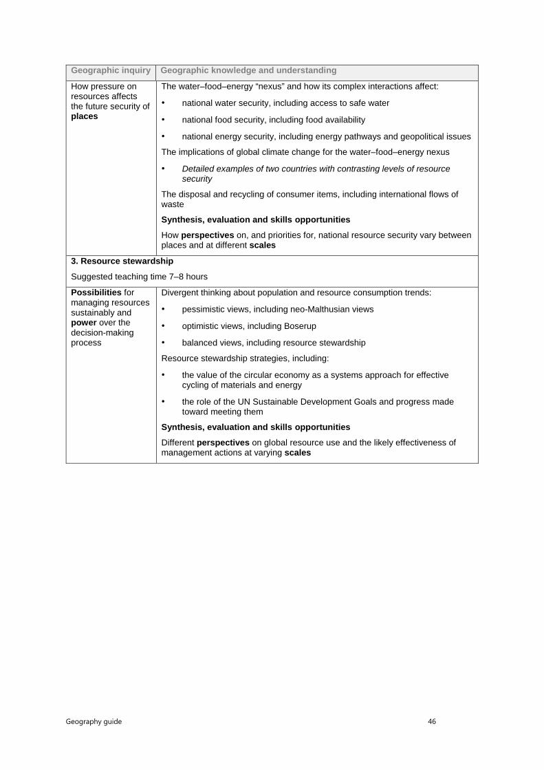
Geography guide 46
Geographic inquiry Geographic knowledge and understanding
How pressure on resources affects the future security of places
The water–food–energy “nexus” and how its complex interactions affect:
• national water security, including access to safe water
• national food security, including food availability
• national energy security, including energy pathways and geopolitical issues
The implications of global climate change for the water–food–energy nexus
• Detailed examples of two countries with contrasting levels of resource security
The disposal and recycling of consumer items, including international flows of waste
Synthesis, evaluation and skills opportunities
How perspectives on, and priorities for, national resource security vary between places and at different scales
3. Resource stewardship
Suggested teaching time 7–8 hours
Possibilities for managing resources sustainably and power over the decision-making process
Divergent thinking about population and resource consumption trends:
• pessimistic views, including neo-Malthusian views
• optimistic views, including Boserup
• balanced views, including resource stewardship
Resource stewardship strategies, including:
• the value of the circular economy as a systems approach for effective cycling of materials and energy
• the role of the UN Sustainable Development Goals and progress made toward meeting them
Synthesis, evaluation and skills opportunities
Different perspectives on global resource use and the likely effectiveness of management actions at varying scales

Geography guide 47
Syllabus content—Part two: HL core extension
Geographic perspectives—global interactions
Rationale and conceptual framework This study of global interactions has a broader perspective than a more conventional study of globalization that emphasizes a linear process involving the domination and the imposition of Western culture on the world. In the context of this syllabus, global interaction suggests a two-way and complex process whereby cultural traits and commodities may be adopted, adapted or resisted by societies. The process is neither inevitable nor universal.
The HL extension theme focuses on the global interactions, flows and exchanges arising from the disparities that exist between places. It presents important and contestable geographic issues of change in space and time for the HL student to question. This part of the syllabus is divided into three units relating to global interactions and global development.
Teaching and learning guidance This sequence of units in the HL core extension is not fixed and may be modified, although it is recommended that unit 4.1 be taught as an introduction.
The time allocation provides a rough guide to the depth of study and emphasis required for each. It should also be recognized that there is overlap between concepts, content and contexts, and that these links should be emphasized to give a holistic view of the course. This course allows for student-centred activities including research, presentations and group work. All units must be covered and be illustrated through the use of case studies and local examples where relevant.
Unit 4: Power, places and networks Geographic inquiry
Geographic knowledge and understanding
1. Global interactions and global power
Suggested teaching time 6–7 hours
How global power and influence varies spatially
Globalization indices showing how countries participate in global interactions
Global superpowers and their economic, geopolitical and cultural influence
• Detailed examples of at least two actual or potential global superpowers
Powerful organizations and global groups:
• G7/8, G20 and Organization for Economic Cooperation and Development (OECD) groups
• Organization of the Petroleum Exporting Countries’ (OPEC) influence over energy policies
• global lending institutions, including the International Monetary Fund (IMF) and New Development Bank (NDB)
Synthesis, evaluation and skills opportunities
How wealthy and powerful places exist at varying scales, and how the global map is complex and subject to change

Geography guide 48
Geographic inquiry
Geographic knowledge and understanding
2. Global networks and flows
Suggested teaching time 6–7 hours
How different places become interconnected by global interactions
An overview of contemporary global networks and flows:
• global trade in materials, manufactured goods and services
• an overview of international aid, loans and debt relief
• international remittances from economic migrants
• illegal flows, such as trafficked people, counterfeit goods and narcotics
Foreign Direct Investment (FDI) and outsourcing by transnational corporations (TNCs), and ways in which this networks places and markets
• Two contrasting detailed examples of TNCs and their global strategies and supply chains
Synthesis, evaluation and skills opportunities
The relative importance of different flows, and the suitability of different methods for graphically representing flows and interactions
3. Human and physical influences on global interactions
Suggested teaching time 6–7 hours
How political, technological and physical processes influence global interactions
Political factors that affect global interactions:
• multi-governmental organizations (MGOs) and free trade zones
• economic migration controls and rules
Our “shrinking world” and the forces driving technological innovation:
• changing global data flow patterns and trends
• transport developments over time
• patterns and trends in communication infrastructure and use
The influence of the physical environment on global interactions:
• natural resource availability
• the potentially limiting effect of geographic isolation, at varying scales
Synthesis, evaluation and skills opportunities
How processes that influence spatial interactions are interlinked in complex ways that accelerate globalization

Geography guide 49
Unit 5: Human development and diversity Geographic inquiry
Geographic knowledge and understanding
1. Development opportunities
Suggested teaching time 6–7 hours
Ways of supporting the processes of human development
The multidimensional process of human development and ways to measure it:
• UN Sustainable Development Goals criteria
• validity and reliability of development indicators and indices, including the human development index (HDI) and gender inequality index (GII)
• empowering women and indigenous or minority groups
• Detailed illustrative examples of affirmative action to close the development gap
The importance of social entrepreneurship approaches for human development:
• the work of microfinance organizations and their networks
• alternative trading networks such as “Fairtrade”
• TNC corporate social responsibility frameworks and global agreements
Synthesis, evaluation and skills opportunities
How actions to support human development involve spatial interactions from local to global scales
2. Changing identities and cultures
Suggested teaching time 6–7 hours
How global interactions bring cultural influences and changes to places
The global spectrum of cultural traits, ethnicities and identities, and ways in which the spectrum of diversity is widening or narrowing at different scales
The effects of global interactions on cultural diversity in different places:
• the diffusion of cultural traits, and cultural imperialism
• glocalization of branded commodities, and cultural hybridity
• cultural landscape changes in the built environment
How diasporas influence cultural diversity and identity at both global and local scales
• Case study of a global diaspora population and its cultures(s)
Synthesis, evaluation and skills opportunities
Differing evidence and perspectives on how diversity is changing at local, national and global scales
3. Local responses to global interactions
Suggested teaching time 6–7 hours

Geography guide 50
Geographic inquiry
Geographic knowledge and understanding
The varying power of local places and actors to resist or accept change
Local and civil society resistance to global interactions:
• rejection of globalized production, including campaigns against TNCs and in favour of local sourcing of food and goods by citizens
• rise of anti-immigration movements
Geopolitical constraints on global interactions:
• government and militia controls on personal freedoms to participate in global interactions
• national trade restrictions, including protectionism and resource nationalism
The role of civil society in promoting international-mindedness and participating in global interactions, including social media use and campaigning for internet freedom
• Two detailed examples of places where restricted freedoms have been challenged
Synthesis, evaluation and skills opportunities
How acceptance of, or resistance to, global interactions takes different forms and occurs at different scales
Unit 6: Global risks and resilience Geographic inquiry Geographic knowledge and understanding
1. Geopolitical and economic risks
Suggested teaching time 6–7 hours
How technological and globalizing processes create new geopolitical and economic risks for individuals and societies
Threats to individuals and businesses:
• hacking, identity theft and the implications of surveillance for personal freedoms
• political, economic and physical risks to global supply chain flows
New and emerging threats to the political and economic sovereignty of states:
• profit repatriation and tax avoidance by TNCs and wealthy individuals
• disruptive technological innovations, such as drones and 3D printing
The correlation between increased globalization and renewed nationalism/tribalization
• Two detailed examples to illustrate geopolitical tension/conflict
Synthesis, evaluation and skills opportunities
How the advantages of globalization must be weighed against heightened possibilities of new geopolitical and economic risks
2. Environmental risks
Suggested teaching time 6–7 hours
Geography guide 51
Geographic inquiry Geographic knowledge and understanding
How global interactions create environmental risks for particular places and people
Transboundary pollution (TBP) affecting a large area/more than one country
• One TBP case study including the consequences and possible responses
Environmental impacts of global flows at varying scales:
• localized pollution, including impacts along shipping lanes
• carbon footprints for global flows of food, goods and people
Environmental issues linked with the global shift of industry:
• polluting manufacturing industries
• food production systems for global agribusiness
Synthesis, evaluation and skills opportunities
How global interactions affect the physical environment by varying degrees at different scales
3. Local and global resilience
Suggested teaching time 6–7 hours
New and emerging possibilities for managing global risks
The success of international civil society organizations in attempting to raise awareness about, and find solutions for, environmental and social risks associated with global interactions
• Detailed examples of one environmental and one social civil society organization action
Strategies to build resilience:
• re-shoring of economic activity by TNCs
• use of crowd-sourcing technologies to build resilience by government and civil society
• new technologies for the management of global flows of data and people, including cybersecurity and e-passports
Synthesis, evaluation and skills opportunities
How perspectives vary on the severity of different risks and priorities for action

Geography guide 52
Assessment
Assessment in the Diploma Programme
General Assessment is an integral part of teaching and learning. The most important aims of assessment in the Diploma Programme are that it should support curricular goals and encourage appropriate student learning. Both external and internal assessments are used in the Diploma Programme. IB examiners mark work produced for external assessment, while work produced for internal assessment is marked by teachers and externally moderated by the IB.
There are two types of assessment identified by the IB:
• Formative assessment informs both teaching and learning. It is concerned with providing accurate and helpful feedback to students and teachers on the kind of learning taking place and the nature of students’ strengths and weaknesses in order to help develop students’ understanding and capabilities. Formative assessment can also help to improve teaching quality, as it can provide information to monitor progress towards meeting the course aims and objectives.
• Summative assessment gives an overview of previous learning and is concerned with measuring student achievement.
The Diploma Programme primarily focuses on summative assessment designed to record student achievement at, or towards the end of, the course of study. However, many of the assessment instruments can also be used formatively during the course of teaching and learning, and teachers are encouraged to do this. A comprehensive assessment plan is viewed as being integral with teaching, learning and course organization. For further information, see the IB Programme standards and practices document.
The approach to assessment used by the IB is criterion-related, not norm-referenced. This approach to assessment judges students’ work by their performance in relation to identified levels of attainment, and not in relation to the work of other students. For further information on assessment within the Diploma Programme please refer to the publication Diploma Programme assessment: principles and practice.
To support teachers in the planning, delivery and assessment of the Diploma Programme courses, a variety of resources can be found on the OCC or purchased from the IB store (store.ibo.org). Additional publications such as specimen papers and markschemes, teacher support materials, subject reports and grade descriptors can also be found on the OCC. Past examination papers as well as markschemes can be purchased from the IB store.
Methods of assessment The IB uses several methods to assess work produced by students.
Assessment criteria Assessment criteria are used when the assessment task is open-ended. Each criterion concentrates on a particular skill that students are expected to demonstrate. An assessment objective describes what students should be able to do, and assessment criteria describe how well they should be able to do it. Using assessment criteria allows discrimination between different answers and encourages a variety of responses. Each criterion comprises a set of hierarchically ordered level descriptors. Each level descriptor is worth one or more marks. Each criterion is applied independently using a best-fit model. The maximum marks for each criterion may differ according to the criterion’s importance. The marks awarded for each criterion are added together to give the total mark for the piece of work.
Geography guide 53
Markbands Markbands are a comprehensive statement of expected performance against which responses are judged. They represent a single holistic criterion divided into level descriptors. Each level descriptor corresponds to a range of marks to differentiate student performance. A best-fit approach is used to ascertain which particular mark to use from the possible range for each level descriptor.
Analytic markschemes Analytic markschemes are prepared for those examination questions that expect a particular kind of response and/or a given final answer from students. They give detailed instructions to examiners on how to break down the total mark for each question for different parts of the response.
Marking notes For some assessment components marked using assessment criteria, marking notes are provided. Marking notes give guidance on how to apply assessment criteria to the particular requirements of a question.
Inclusive assessment arrangements Inclusive assessment arrangements are available for candidates with assessment access requirements. These arrangements enable candidates with diverse needs to access the examinations and demonstrate their knowledge and understanding of the constructs being assessed.
The IB document Candidates with assessment access requirements provides details on all the inclusive assessment arrangements available to candidates with learning support requirements. The IB document Learning diversity and inclusion in IB programmes (January 2016) outlines the position of the IB with regard to candidates with diverse learning needs in the IB programmes. For candidates affected by adverse circumstances, the IB documents General regulations: Diploma Programme and the Handbook of procedures for the Diploma Programme provide details on access consideration.
Responsibilities of the school The school is required to ensure that equal access arrangements and reasonable adjustments are provided to candidates with learning support requirements that are in line with the IB documents Candidates with assessment access requirements and Learning diversity and inclusion in IB programmes.

Geography guide 54
Assessment outline—SL
First assessment 2019
Assessment component Weighting
External assessment (2 hours 45 minutes)
Paper 1 (1 hour 30 minutes) Geographic themes—two options (40 marks)
75%
35%
Paper 2 (1 hour 15 minutes) Geographic perspectives—global change (50 marks)
40%
Internal assessment (20 hours)
This component is internally assessed by the teacher and externally moderated by the IB at the end of the course.
Fieldwork (20 hours) Written report (25 marks)
25%

Geography guide 55
Assessment outline—HL
First assessment 2019
Assessment component Weighting
External assessment (4 hours 30 minutes)
Paper 1 (2 hours 15 minutes) Geographic themes—three options (60 marks)
80%
35%
Paper 2 (1 hour 15 minutes) Geographic perspectives—global change (50 marks)
25%
Paper 3 (1 hour) Geographic perspectives—global interactions (28 marks)
20%
Internal assessment (20 hours)
This component is internally assessed by the teacher and externally moderated by the IB at the end of the course.
Fieldwork (20 hours) Written report (25 marks)
20%
Geography guide 56
External assessment
External assessment markbands—SL and HL
Paper 1 SL and HL part b) (optional themes) and paper 2 SL and HL part b Maximum mark 10 (2 marks per band)
The level descriptors per markband below describe characteristics of a typical response appropriate to a specific mark range. Verbs in bold in the criteria refer to the command terms. For the full definition, please refer to the “Glossary of command terms” section.
Marks Level descriptor
AO1: Knowledge and understanding of specified content
AO2: Application and analysis of knowledge and understanding
AO3: Synthesis and evaluation
AO4: Selection, use and application of a variety of appropriate skills and techniques
0 The work does not reach a standard described by the descriptors below.
1–2 The response is too brief, lists unconnected information, is not focused on the question and lacks structure.
• The response is very brief or descriptive, listing a series of unconnected comments or largely irrelevant information. The knowledge and understanding presented is very general with large gaps or errors in interpretation. Examples or case studies are not included or only listed.
• There is no evidence of analysis.
• Terminology is missing, not defined, irrelevant or used incorrectly.
• No evidence of evaluation or conclusion is expected at this level.
• Information presented is not grouped logically (in paragraphs or sections).
• Maps, graphs or diagrams are not included, are irrelevant or difficult to decipher (only if appropriate to the question).
3–4 The response is too general, lacks detail, is not focused on the question and is largely unstructured.

Geography guide 57
Marks Level descriptor
AO1: Knowledge and understanding of specified content
AO2: Application and analysis of knowledge and understanding
AO3: Synthesis and evaluation
AO4: Selection, use and application of a variety of appropriate skills and techniques
• The response is very general. The knowledge and understanding presented outlines examples, statistics, and facts that are both relevant and irrelevant. Links to the question are listed.
• The argument or analysis presented is not relevant to the question.
• Basic terminology is defined and used but with errors in understanding or used inconsistently.
• If appropriate to the question, the conclusion is irrelevant.
• There is no evidence of critical evaluation of evidence (examples, statistics and case studies).
• Most of the information is not grouped logically (in paragraphs or sections).
• Maps, graphs or diagrams included lack detail, are incorrectly or only partially interpreted without explicit connections to the question (only if appropriate to the question).
5–6 The response partially addresses the question, but with a narrow argument, an unsubstantiated conclusion, and limited evaluation.
• The response describes relevant supporting evidence (information, examples, case studies et cetera), outlining appropriate link(s) to the question.
• The argument or analysis partially addresses the question or elaborates one point repeatedly.
• Relevant terminology is defined and used with only minor errors in understanding or is used inconsistently.
• If appropriate to the question, the conclusions are general, not aligned with the evidence presented and/or based on an incorrect interpretation of the evidence.
• Other perspectives on evidence (examples, statistics and case studies) and/or strengths and weaknesses of evidence are listed.
• Logically related information is grouped together (in sections or paragraphs) but not consistently.
• Maps, graphs or diagrams included do not follow conventions, and include relevant and irrelevant interpretations in the text (only if appropriate to the question).
7–8 The response addresses the whole question, the analysis is evaluated and the conclusion is relevant but lacks balance.

Geography guide 58
Marks Level descriptor
AO1: Knowledge and understanding of specified content
AO2: Application and analysis of knowledge and understanding
AO3: Synthesis and evaluation
AO4: Selection, use and application of a variety of appropriate skills and techniques
• The response describes relevant supporting evidence correctly (information, examples and case studies) that covers all the main points of the question, describing appropriate links to the question.
• The argument or analysis is clear and relevant to the question but one-sided or unbalanced.
• Complex terminology is defined and used correctly but not consistently.
• If appropriate to the question, the conclusion is relevant to the question, aligned with the evidence but unbalanced.
• Other perspectives on evidence (examples, statistics and case studies) and/or strengths and weaknesses of evidence are described.
• Logically related information is grouped together (in sections) consistently.
• Maps, graphs or diagrams included contribute to/support the argument or analysis (only if appropriate to the question).
9–10 The response is in-depth and question-specific (topic and command term); analysis and conclusion are justified through well-developed evaluation of evidence and perspectives.
• The response explains correct and relevant examples, statistics and details that are integrated in the response, explaining the appropriate link to the question.
• The argument or analysis is balanced, presenting evidence that is discussed, explaining complexity, exceptions and comparisons.
• Complex and relevant terminology is used correctly throughout the response.
• If appropriate to the question, the conclusion is relevant to the question, balanced and aligned with the evidence.
• Evaluation includes a systematic and detailed presentation of ideas, cause and effect relations, other perspectives; strengths and weaknesses of evidence are discussed; (if appropriate) includes justification of the argument and conclusion.
• Response is logically structured with discussion (and if appropriate to the question, a conclusion) focusing on the argument or points made, making it easy to follow.
• Maps, graphs or diagrams are annotated following conventions and their relevance is explained and support the argument or analysis (only if appropriate to the question).

Geography guide 59
External assessment markbands—HL Please see the “External assessment markbands—SL and HL” section for the markbands for papers 1 and 2.
Paper 3 HL part a Maximum mark 12 (3 marks per band)
The level descriptors per markband below describe characteristics of a typical response appropriate to a specific mark range. Verbs in bold in the criteria refer to the command terms. For the full definition, please refer to the “Glossary of command terms” section.
Marks Level descriptor
AO1: Knowledge and understanding of specified content
AO2: Application and analysis of knowledge and understanding
AO3: Synthesis and evaluation
AO4: Selection, use and application of a variety of appropriate skills and techniques
0 The work does not reach a standard described by the descriptors below.
1–3 The response is general, not focused on the question, and lacks detail and structure.
• The response is very brief or general, listing a series of unconnected comments or largely irrelevant information. Evidence is general or relevant to the topic, but not to the question.
• Evidence (that is, facts, statistics, examples or theories) is listed, lacks detail, and the relevance to the question is unclear.
• Evidence is not used to formulate an argument or an analysis.
• Everyday language is used; there is little use of geographical terminology or it is used with errors in understanding.
• No evidence of synthesis or evaluation is expected.
• Information is listed but is not grouped together in paragraphs, or paragraphing is erratic.
• If present, the conclusion is brief, does not summarize the argument and/or does not address the question.
4–6 The response only partially addresses the question; evidence is both relevant and irrelevant and is largely unstructured.

Geography guide 60
Marks Level descriptor
• The response partially addresses the question and/or does not meet the requirements of the command term. Key evidence is not included.
• A mix of relevant and irrelevant evidence is outlined (that is, facts, statistics, examples or theories) and any links to the question are only listed.
• The evidence presented supports only one element or interpretation of the question.
• Key geographical terms are defined briefly. The terminology used is both relevant and irrelevant to the question.
• No evidence of synthesis or evaluation is expected.
• Paragraphs do not reflect grouping of information that addresses a specific element of the question.
• If present, the conclusion is one-sided, addressing only part of the question.
7–9 The response addresses most parts of the question and outlines an analysis supported by relevant evidence but may lack clear links between paragraphs.
• The question is broken down into parts and most parts of the question are addressed in the response, with supporting evidence for each aspect of the question. The response meets the requirements of the command term.
• Relevant evidence (that is, facts, statistics, examples or theories) is described, focused on the question and mostly correct. Links with the question are described.
• The analysis outlines a two-sided argument briefly (if appropriate) and is mostly descriptive, using examples as explanation.
• Correct definitions are given, and relevant and irrelevant specialist geographical terms are used with occasional errors; or everyday language is used.
• No evidence of synthesis or evaluation is expected.
• A series of standalone paragraphs each addressing a specific element of the question but lacking clear links connecting them all into a coherent whole.
• The conclusion repeats and summarizes the analysis or argument, but may contain new information as well.
10–12 The response addresses all aspects of the question; the analysis is explained using evidence integrated in the paragraphs, and it is well structured.

Geography guide 61
Marks Level descriptor
• All aspects of the question are addressed and the response meets the requirements of the command term.
• Detailed evidence (that is, facts, statistics, examples or theories) are integrated in sentences and paragraphs, and links made between evidence and the question are explained and relevant.
• The response explains how the two sides of the argument (if appropriate) are supported by detailed evidence that is integrated in sentences.
• Clear, correct definitions and use of geographical language is integrated in the sentences and throughout the response.
• No evidence of synthesis or evaluation is expected.
• Paragraphs focus on a relevant point of the argument and integrate the supporting evidence. Paragraphs are linked and support the logical flow of the argument and response.
• The conclusion summarizes the evidence and argument, and links all back to the question.

Geography guide 62
Paper 3 HL part b) Maximum mark 16 (4 marks per band)
The level descriptors per markband below describe characteristics of a typical response appropriate to a specific mark range. Verbs in bold in the criteria refer to the command terms. For the full definition, please refer to the “Glossary of command terms” section.
Marks Level descriptor
AO1: Knowledge and understanding of specified content
AO2: Application and analysis of knowledge and understanding
AO3: Synthesis and evaluation AO4: Selection, use and application of a variety of appropriate skills and techniques
0 The work does not reach a standard described by the descriptors below.
1–4 The response is general, not focused on the question, and lacks detail and structure.
• The response is very brief or general, listing a series of unconnected comments or largely irrelevant information. Evidence is general or relevant to the topic, but not the question.
• Evidence (that is, facts, statistics, examples or theories) is listed, lacks detail, and the relevance to the question is unclear.
• Evidence is not used to formulate an argument or an analysis.
• Everyday language is used; there is little use of geographical terminology or it is used with errors in understanding.
• No synthesis or evaluation is expected at this level.
• No links are presented between the response and (sub)topics in the guide.
• No valid opinion or perspective on the issue is formulated.
• Information is listed but is not grouped together in paragraphs, or paragraphing is erratic.
• If present, the conclusion is brief, does not summarize the argument and/or does not address the question.
5–8 The response only partially addresses the question with limited links to the guide; evidence is both relevant and irrelevant and is largely unstructured.

Geography guide 63
Marks Level descriptor
• The response partially addresses the question and/or does not meet the requirements of the command term. Key evidence is not included.
• A mix of relevant and irrelevant evidence is outlined (that is, facts, statistics, examples or theories) and any links to the question are only listed.
• The evidence presented supports only one element or interpretation of the question.
• Key geographical terms are defined briefly. Terminology used is both relevant and irrelevant to the question.
• No synthesis or evaluation is expected at this level.
• The link(s) between the response and the guide focus on one topic; other potential links are listed.
• A valid but limited opinion or perspective on the issue is formulated.
• Paragraphs do not reflect grouping of information that addresses a specific element of the question.
• If present, the conclusion is one-sided, addressing only part of the question.
9–12 The response addresses most parts of the question with developed links to the guide and outlines an analysis supported by relevant evidence but may lack clear links between paragraphs.
• The question is broken down into parts and most parts of the question are addressed in the response, with supporting evidence for each aspect of the question. The response meets the requirements of the command term.
• Relevant evidence (that is, facts, statistics, examples or theories) is described, focused on the question and mostly correct. Links with the question are described.
• The analysis outlines a two-sided argument briefly (if appropriate) and is mostly descriptive, using examples as explanation.
• Correct definitions are given, and relevant and irrelevant specialist geographical terms are used with occasional errors; or everyday language is used.
• Synthesis or evaluation is required at this level.
• Links between the response and the guide refer to multiple topics and are described.
• Opinion or perspective presented is aligned with the response but the links are not made explicit or the link is a general statement. Other perspectives or interpretations are listed without details.
• A series of standalone paragraphs each addressing a specific element of the question but lacking clear links connecting them all into a coherent whole.
• The conclusion repeats and summarizes the analysis or argument, but may contain new information as well.
13–16 The response addresses all aspects of the question; the analysis is explained and evaluated using evidence integrated in the paragraphs, and it is well structured.

Geography guide 64
Marks Level descriptor
• All aspects of the question are addressed and the response meets the requirements of the command term.
• Detailed evidence (that is, facts, statistics, examples or theories) are integrated in sentences and paragraphs, and links made between evidence and the question are explained and relevant.
• The response explains how the two sides of the argument (if appropriate) are supported by detailed evidence that is integrated in sentences.
• Clear, correct definitions and use of geographical language is integrated in the sentences and throughout the response.
• Synthesis and evaluation is required at this level.
• Links between the response and (sub)topics from the guide are explained and supported by the evidence in the response.
• The opinion or perspective presented is explicitly linked to the range of evidence included in the response, including critical analysis of the relative certainty of evidence used, describing other perspectives or interpretations of evidence.
• Paragraphs focus on a relevant point of the argument and integrate the supporting evidence. Paragraphs are linked and support the logical flow of the argument and response.
• The conclusion summarizes the evidence and argument, and links all back to the question.

Geography guide 65
Internal assessment
Purpose of internal assessment Internal assessment is an integral part of the course and is a compulsory component for both SL and HL students. It enables students to demonstrate the application of their skills and knowledge, and to pursue their personal interests, without the time limitations and other constraints that are associated with examination papers. The internal assessment should, as far as possible, be woven into normal practice and classroom teaching, and not be a separate activity conducted after a course has been taught.
The internal assessment requirements at SL and at HL are the same. The time allowed is 20 hours, and the weightings are 25% at SL and 20% at HL. Students are required to undertake fieldwork collecting primary information and produce one written report that is based on a fieldwork question.
Guidance and authenticity The SL and HL written reports submitted for internal assessment must be the student’s individual work. However, it is not the intention that students should decide upon a title or topic and be left to work on the internally assessed component without any further support from the teacher. The teacher should play an important role during both the planning stage and the period when the student is working on the internally assessed work. It is the responsibility of the teacher to ensure that students are familiar with:
• the requirements of the type of work to be internally assessed, including the methods of information collection, regulations on group work and the format of the written report
• the ethical guidelines and risk assessment advice given under the internal assessment requirements in this syllabus
• the assessment criteria—students must understand that the work submitted for assessment must address these criteria effectively.
Teachers and students must discuss the internally assessed work. Students should be encouraged to initiate discussions with the teacher to obtain advice and information, and students must not be penalized for seeking guidance. As part of the learning process, teachers can give advice to students on a first draft of the internally assessed work. This advice should be in terms of the way the work could be improved, but this first draft must not be heavily annotated or edited by the teacher. The next version handed to the teacher after the first draft must be the final one. However, if a student could not have completed the work without substantial support from the teacher, this should be recorded.
It is the responsibility of teachers to ensure that all students understand the basic meaning and significance of concepts that relate to academic honesty, especially authenticity and intellectual property. Teachers must ensure that all student work for assessment is prepared according to the requirements and must explain clearly to students that the internally assessed work must be entirely their own. Where collaboration between students is permitted, it must be clear to all students what the difference is between collaboration and collusion.
All work submitted to the IB for moderation or assessment must be authenticated by a teacher, and must not include any known instances of suspected academic misconduct. Authenticity may be checked by discussion with the student on the content of the work, and scrutiny of one or more of the following.
• The student’s initial proposal
• The first draft of the written work
• The references cited
Geography guide 66
• The style of writing compared with work known to be that of the student
• The analysis of the work by a web-based plagiarism detection service such as www.turnitin.com.
For further details refer to the IB publication Academic honesty in the IB educational context,, The Diploma Programme: From principles into practice and the relevant articles in General regulations: Diploma Programme.
The same piece of work cannot be submitted to meet the requirements of both the internal assessment and the extended essay.
Group work Group work may be undertaken by students as described below but the written report must be the students’ individual work.
The fieldwork topic, fieldwork question and methods of information collection may be chosen by the teacher, the whole class, small groups or individuals. In the early stages of the investigation, students may collect fieldwork information in groups and collaborate on these findings and suitable methods of presentation.
Once the research is completed and the necessary fieldwork information and possible methods of presentation exchanged, the emphasis must be on individual work. The writing of the report, the justification of methods, the analysis and the conclusion must be entirely the work of the individual student.
Time allocation Internal assessment is an integral part of the geography course, contributing 25% to the final assessment in the SL course and 20% in the HL course. This weighting should be reflected in the time that is allocated to teaching the knowledge, skills and understanding required to undertake the work, as well as the total time allocated to carry out the work.
It is recommended that a total of approximately 20 hours of teaching time for both SL and HL should be allocated to the work. This should include:
• time for the teacher to explain to students the requirements of the internal assessment
• time to review the geography course ethical guidelines and risk assessment advice
• time at the survey or fieldwork site
• class time for students to work on the internal assessment component
• time for consultation between the teacher and each student
• time to review and monitor progress, and to check authenticity.
Requirements and recommendations
Rationale The purpose of the internally assessed fieldwork is to amplify, reinforce and extend principal geographic concepts and skills taught in class. Fieldwork is intended to enrich the study of particular themes within the course. It adds to the student’s knowledge, understanding and awareness and helps to make learning more engaging and relevant. It provides opportunities for learning through practical work and fosters the skills of cooperation, organization, investigation and presentation. It also presents opportunities for leadership.
Fieldwork involves the collection of primary data in the field and the subsequent treatment, display and analysis of this information using appropriate skills. The material is presented in a written report.

Geography guide 67
Fieldwork activities allow students to practise many of the skills listed for internal assessment in the “Geographic skills” section of the guide and to develop specific skills appropriate to the chosen fieldwork question.
Choice of fieldwork investigation
Scale and site Many types of investigation are possible, and the choice depends on the opportunities offered by the local environment. The investigation must be manageable and the site accessible. The topic chosen for investigation must be on a local scale but it does not need to be undertaken near the school. If necessary, when there are logistical or security concerns, for example, the school site may be used and can provide several fieldwork possibilities.
Maps It is strongly recommended that maps are student-generated, either by being hand drawn or computer-derived, and they must be made relevant to the study. Maps that are downloaded or photocopied should be adapted to the student’s own information. Normal map conventions must be followed.
Risk assessment Schools are advised to follow health and safety guidelines (risk assessment) in fieldwork, observing standard regulations as appropriate. Each school is ultimately responsible for the health and safety of its students.
Ethical guidelines Students should consider whether there are any ethical implications involved in collecting fieldwork information, such as respect for the views of individuals expressed during interviews, respect for the environment and the integrity of the information. Further details are given in the Ethical practice in the Diploma Programme poster, available on the OCC.
Using assessment criteria for internal assessment For internal assessment, a number of assessment criteria have been identified. Each assessment criterion has level descriptors describing specific levels of achievement together with an appropriate range of marks. The level descriptors concentrate on positive achievement, although for the lower levels failure to achieve may be included in the description.
Teachers must judge the internally assessed work at SL and at HL against the criteria using the level descriptors.
• The same assessment criteria are provided for both SL and HL.
• The aim is to find, for each criterion, the descriptor that conveys most accurately the level attained by the student, using the best-fit model. A best-fit approach means that compensation should be made when a piece of work matches different aspects of a criterion at different levels. The mark awarded should be one that most fairly reflects the balance of achievement against the criterion. It is not necessary for every single aspect of a level descriptor to be met for that mark to be awarded.
• When assessing a student’s work, teachers should read the level descriptors for each criterion until they reach a descriptor that most appropriately describes the level of the work being assessed. If a piece of work seems to fall between two descriptors, both descriptors should be read again and the one that more appropriately describes the student’s work should be chosen.
• Where there are two or more marks available within a level, teachers should award the upper marks if the student’s work demonstrates the qualities described to a great extent. Teachers should award the lower marks if the student’s work demonstrates the qualities described to a lesser extent.

Geography guide 68
• Only whole numbers should be recorded; partial marks (fractions and decimals) are not acceptable.
• Teachers should not think in terms of a pass or fail boundary, but should concentrate on identifying the appropriate descriptor for each assessment criterion.
• The highest level descriptors do not imply faultless performance but should be achievable by a student. Teachers should not hesitate to use the extremes if they are appropriate descriptions of the work being assessed.
• A student who attains a high level of achievement in relation to one criterion will not necessarily attain high levels of achievement in relation to other criteria. Similarly, a student who attains a low level of achievement for one criterion will not necessarily attain low achievement levels for the other criteria. Teachers should not assume that the overall assessment of the students will produce any particular distribution of marks.
• It is recommended that the assessment criteria be available to students.
Internal assessment details—SL/HL Duration: 20 hours
Weighting: SL 25%, HL 20%
Relationship to the syllabus The fieldwork study for both HL and SL students must be related to material in a geographic inquiry topic or sub-topic and its development in the syllabus, whether it is from the optional themes, the core theme, or the HL extension. It can combine two or more topics or themes.
The fieldwork must be on a local scale and involve the collection of primary information. The chosen topic may be environmental, physical or human, or may integrate approaches.
Global issues are unsuitable for study unless they can be adapted to the local scale. For example, the SL/HL core theme unit 3 “Global resource consumption and security”, sub-topic 3 on the development of resource stewardship strategies could be applied at the local scale.
The following topics within the core theme, the optional themes B, C, D, E and F, and the HL extension are unlikely to be suitable for fieldwork investigation.
Part of course Topics and sub-topics
Part one: Geographic themes Option B: Oceans and coastal margins
Topic 1: Ocean–atmosphere interactions
Option C: Extreme environments
Topic 1: The characteristics of extreme environments
Option D: Geophysical hazards
Topic 1: Geophysical systems
Option E: Leisure, tourism and sport
Topic 3: Tourism and sport at the international level
Option F: Food and health
Topic 1: Measuring food and health (global patterns)
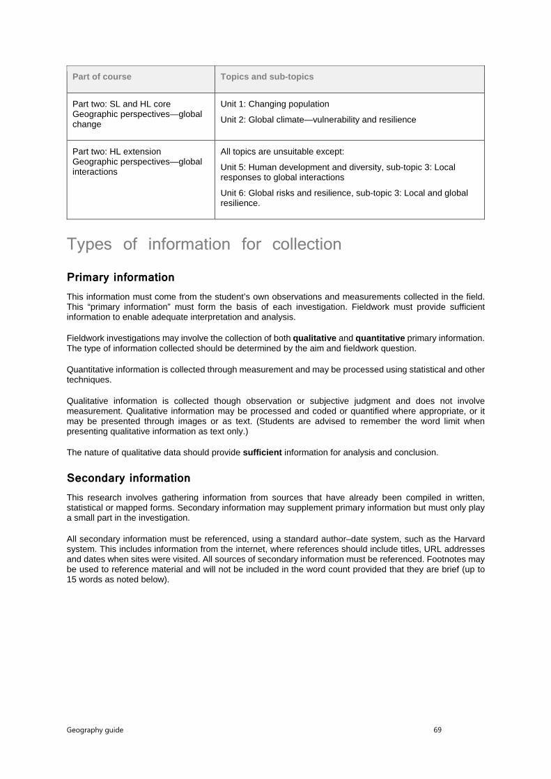
Geography guide 69
Part of course Topics and sub-topics
Part two: SL and HL core Geographic perspectives—global change
Unit 1: Changing population
Unit 2: Global climate—vulnerability and resilience
Part two: HL extension Geographic perspectives—global interactions
All topics are unsuitable except:
Unit 5: Human development and diversity, sub-topic 3: Local responses to global interactions
Unit 6: Global risks and resilience, sub-topic 3: Local and global resilience.
Types of information for collection
Primary information This information must come from the student’s own observations and measurements collected in the field. This “primary information” must form the basis of each investigation. Fieldwork must provide sufficient information to enable adequate interpretation and analysis.
Fieldwork investigations may involve the collection of both qualitative and quantitative primary information. The type of information collected should be determined by the aim and fieldwork question.
Quantitative information is collected through measurement and may be processed using statistical and other techniques.
Qualitative information is collected though observation or subjective judgment and does not involve measurement. Qualitative information may be processed and coded or quantified where appropriate, or it may be presented through images or as text. (Students are advised to remember the word limit when presenting qualitative information as text only.)
The nature of qualitative data should provide sufficient information for analysis and conclusion.
Secondary information This research involves gathering information from sources that have already been compiled in written, statistical or mapped forms. Secondary information may supplement primary information but must only play a small part in the investigation.
All secondary information must be referenced, using a standard author–date system, such as the Harvard system. This includes information from the internet, where references should include titles, URL addresses and dates when sites were visited. All sources of secondary information must be referenced. Footnotes may be used to reference material and will not be included in the word count provided that they are brief (up to 15 words as noted below).

Geography guide 70
Written reports Students should produce one report of their investigation. The report must not exceed 2,500 words.
Word limit The following are not included in the word count.
• Title page
• Acknowledgments
• Contents page
• Titles and subtitles
• References
• Footnotes—up to a maximum of 15 words each
• Map legends and/or keys
• Labels—of 10 words or less
• Tables—of statistical or numerical data, or categories, classes or group names
• Calculations
• Appendices—containing only raw data and/or calculations
All the main text is included in the word count, including the research question, analysis, conclusion and evaluation, as well as all annotations over 10 words and any footnotes over 15 words.
A very limited use of appendices is acceptable and, if appendices are used, these should contain only examples of materials that have been used or are representative of the material used, such as a data sheet or a translation of a questionnaire. It should not include all materials used, for example, every survey or questionnaire completed. Further, it should not include secondary information.
Where work is over the limit, teachers and moderators are advised to stop reading and students are likely to not gain as many marks under criteria such as E and F.
Emphasis The emphasis of the written report must be analytical and include focus on the method(s) and technologies (if any) employed for information collection, its treatment and analysis. A purely descriptive report and/or a long theoretical introduction must be avoided.
Format Students are advised to use the following guidelines to format their reports, which will ensure that the reports fulfill the requirements of the criteria.
The fieldwork written report must meet the following requirements of organization and presentation.
• The work is concise and within the 2,500-word limit.
• Overall presentation is well structured, with pages numbered.
• All illustrative material is fully integrated into the body of the report and is not relegated to an appendix.
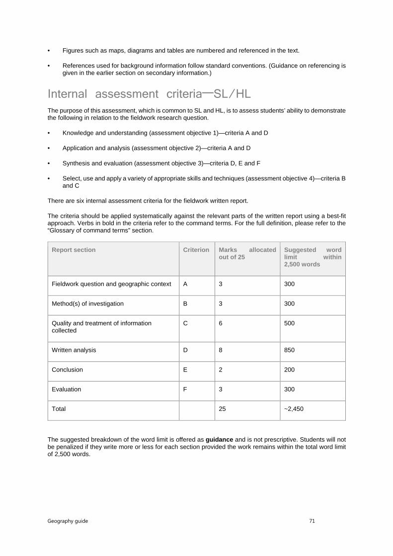
Geography guide 71
• Figures such as maps, diagrams and tables are numbered and referenced in the text.
• References used for background information follow standard conventions. (Guidance on referencing is given in the earlier section on secondary information.)
Internal assessment criteria—SL/HL
The purpose of this assessment, which is common to SL and HL, is to assess students’ ability to demonstrate the following in relation to the fieldwork research question.
• Knowledge and understanding (assessment objective 1)—criteria A and D
• Application and analysis (assessment objective 2)—criteria A and D
• Synthesis and evaluation (assessment objective 3)—criteria D, E and F
• Select, use and apply a variety of appropriate skills and techniques (assessment objective 4)—criteria B and C
There are six internal assessment criteria for the fieldwork written report.
The criteria should be applied systematically against the relevant parts of the written report using a best-fit approach. Verbs in bold in the criteria refer to the command terms. For the full definition, please refer to the “Glossary of command terms” section.
Report section Criterion Marks allocated out of 25
Suggested word limit within 2,500 words
Fieldwork question and geographic context A 3 300
Method(s) of investigation B 3 300
Quality and treatment of information collected
C 6 500
Written analysis D 8 850
Conclusion E 2 200
Evaluation F 3 300
Total
25 ~2,450
The suggested breakdown of the word limit is offered as guidance and is not prescriptive. Students will not be penalized if they write more or less for each section provided the work remains within the total word limit of 2,500 words.

Geography guide 72
Internal assessment criteria for the fieldwork The details below explain the requirements for each section, how each must be related to the assessment criteria and how the marks are allocated for each.
The level descriptions within each criterion below describe characteristics of a typical response appropriate to a specific mark. Verbs in bold in the criteria refer to the command terms. For the full definition, please refer to the “Glossary of command terms” section.
Criterion A: Fieldwork question and geographic context The fieldwork question (the precise inquiry) guides the fieldwork investigation. It must be focused, appropriate and stated as a question that can be answered through the collection of primary information in the field. Where appropriate, students can make a brief preliminary judgment or prediction answering the fieldwork question. This prediction may be formulated as a hypothesis.
Students must also comment briefly on the geographic context, explaining why and where the fieldwork investigation is to be carried out. This can include relevant spatial, physical, socio-economic conditions and other background information, concepts or characteristics. A map of the research area and/or the locations used in the fieldwork investigation is essential to provide the necessary spatial element.
Students must also state the area(s) of the syllabus to which the study relates, which geographic inquiry topic or sub-topic in the syllabus, whether it is from the optional themes, the core theme, or the HL extension. It can be drawn from a combination of two or more topics or themes.
This criterion assesses the focus and geographic context of the fieldwork and to what extent the link between the fieldwork question and the geographic context (that is, material in the syllabus, a relevant syllabus topic or geographical theory) is made clear. The fieldwork question should be specifically geographical.
Marks Level descriptor
0 The work does not reach the standard described by the descriptors below.
1 The fieldwork question is not formulated as a question or is not appropriately linked to the relevant syllabus topic or geographical theory.
The fieldwork question does not allow for the collection of primary data, does not include a location or is too broad to address within the limits of the internal assessment.
No locational map is included or the map is inappropriate for the fieldwork question.
2 The fieldwork question is geographical, identifying an appropriate link to the relevant syllabus topic, the syllabus or geographical theory.
The fieldwork question identifies a specific location allowing for the collection of primary data and a question that can be addressed within the limits of an internal assessment.
The locational map is a copy of an existing map (for example, internet or satellite map) with too many unnecessary details or lacking mapping conventions.
3 The link between the fieldwork question and the relevant syllabus topic, the syllabus or geographical theory is described. The link made to geographical theory allows for the possible formulation of hypotheses and predictions.
The fieldwork question is geographical and focused, clearly identifying a precise location allowing for primary data collection within the limits of the internal assessment.
One or more locational maps are presented and follow mapping conventions, providing clear information and details of the fieldwork location.

Geography guide 73
Criterion B: Method(s) of investigation Students must describe the method(s) used to collect information. The description may include technologies employed, sampling techniques, time, location and circumstances of information collection where relevant.
The method(s) used must be justified and must enable a sufficient quality and quantity of primary data to be produced to allow the fieldwork question to be investigated.
This criterion assesses the description, justification and appropriateness of the method or methods including sampling and surveying techniques, primary or secondary data collection as appropriate used to investigate the question formulated.
Marks Level descriptor
0 The work does not reach the standard described by the descriptors below.
1 The method(s) used for information and data collection are listed or outlined, but are too general or vague or do not allow for the collection of enough information and data that are relevant to address the question formulated or the hypotheses.
Data collection technologies/instruments and sampling/surveying techniques are listed or outlined but are not correctly used.
2 The method(s) used for information and data collection are described, outlining how the data collected is relevant to the question formulated and hypotheses.
The method(s), data collection instruments/technologies and sampling/surveying techniques are used correctly and allow for sufficient data for quantitative and/or qualitative analysis, but it may be minimal or only one or two variables are collected.
3 The method(s) used for information and data collection are described, explaining clearly and accurately how the combination of data collected is relevant to the theory, question formulated or the hypotheses for the internal assessment. They may describe statistical tests if appropriate.
The method(s), data collection instruments/technologies and sampling/surveying techniques are used correctly, resulting in reliable and good quality primary data supporting a relevant quantitative and/or qualitative analysis.
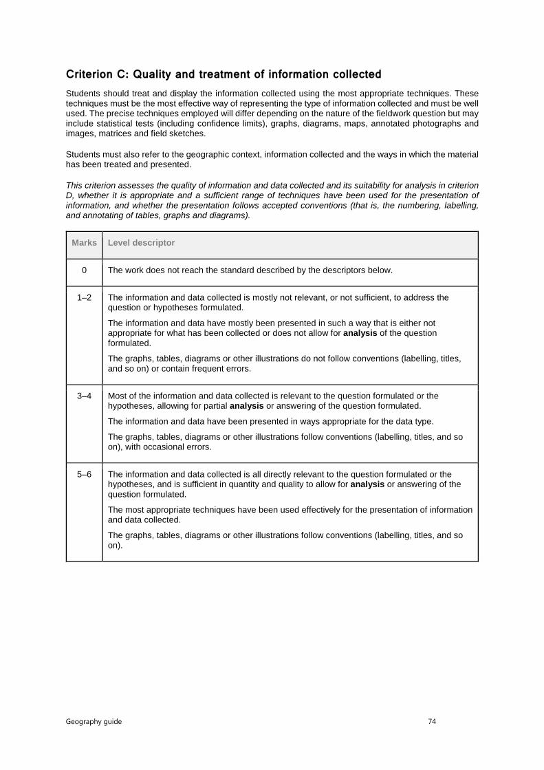
Geography guide 74
Criterion C: Quality and treatment of information collected Students should treat and display the information collected using the most appropriate techniques. These techniques must be the most effective way of representing the type of information collected and must be well used. The precise techniques employed will differ depending on the nature of the fieldwork question but may include statistical tests (including confidence limits), graphs, diagrams, maps, annotated photographs and images, matrices and field sketches.
Students must also refer to the geographic context, information collected and the ways in which the material has been treated and presented.
This criterion assesses the quality of information and data collected and its suitability for analysis in criterion D, whether it is appropriate and a sufficient range of techniques have been used for the presentation of information, and whether the presentation follows accepted conventions (that is, the numbering, labelling, and annotating of tables, graphs and diagrams).
Marks Level descriptor
0 The work does not reach the standard described by the descriptors below.
1–2 The information and data collected is mostly not relevant, or not sufficient, to address the question or hypotheses formulated.
The information and data have mostly been presented in such a way that is either not appropriate for what has been collected or does not allow for analysis of the question formulated.
The graphs, tables, diagrams or other illustrations do not follow conventions (labelling, titles, and so on) or contain frequent errors.
3–4 Most of the information and data collected is relevant to the question formulated or the hypotheses, allowing for partial analysis or answering of the question formulated.
The information and data have been presented in ways appropriate for the data type.
The graphs, tables, diagrams or other illustrations follow conventions (labelling, titles, and so on), with occasional errors.
5–6 The information and data collected is all directly relevant to the question formulated or the hypotheses, and is sufficient in quantity and quality to allow for analysis or answering of the question formulated.
The most appropriate techniques have been used effectively for the presentation of information and data collected.
The graphs, tables, diagrams or other illustrations follow conventions (labelling, titles, and so on).

Geography guide 75
Criterion D: Written analysis In the written analysis, students must demonstrate their knowledge and understanding of the fieldwork investigation by interpreting and explaining the information they have collected in relation to the fieldwork question. This includes recognizing any trends and spatial patterns found in the information collected. Where appropriate, an attempt should be made to identify and explain any anomalies.
The treatment and display of material and the written analysis must be integrated within this section.
This criterion assesses the quality of the analysis of the results, referring to:
• links to the question and hypotheses formulated
• geographic context (that is, geographical theory, the syllabus, or the relevant syllabus topic)
• information collected
• statistics used (descriptive techniques—that is, graphs, charts, histograms and so on; as well as statistical techniques—that is, correlations, regression and so on)
• illustrative material.
Marks Level descriptor
0 The work does not reach the standard described by the descriptors below.
1–2 The written analysis includes descriptive techniques that are not all appropriate to the data and the question formulated.
The data or information presented is outlined without explicit link to the question or hypotheses formulated. Obvious trends and patterns are listed.
3–4 The written analysis includes descriptive techniques that are appropriate to the data and the question formulated. Any statistical techniques used either are not relevant to the question formulated or contain errors.
The data and information, trends and patterns presented are described and linked explicitly to the question or hypotheses formulated.
The written analysis allows for answering the question formulated in a descriptive way.
5–6 The written analysis includes descriptive and statistical techniques (if appropriate to the question formulated) that are appropriate to the data and the question formulated.
The data and information, trends, patterns and statistics are described and linked explicitly to the question or hypotheses formulated. Outliers and anomalies in the data, if present, are listed.
The written analysis allows for answering the question formulated, although there are gaps in the supporting evidence.
7–8 The written analysis includes descriptive and statistical techniques (with confidence levels if appropriate) that are appropriate to the data and the question formulated.
The trends, patterns and statistics found, including outliers and anomalies if present, are explained and linked to the question formulated, hypotheses, geographical theory, the fieldwork location and methods used.
The written analysis allows for answering the question formulated, with no or only minor gaps in the supporting evidence.

Geography guide 76
Criterion E: Conclusion Students should summarize the findings of the fieldwork investigation. There should be a clear, concise statement answering the fieldwork question. It is acceptable for the conclusion to state that the findings do not match the student’s preliminary judgment or prediction.
This criterion assesses the ability of the student to summarize the findings of the fieldwork investigation and draw a supported conclusion.
Marks Level descriptor
0 The work does not reach the standard described by the descriptors below.
1 A conclusion to the fieldwork question is formulated, which is partially supported by the analysis.
2 There is a clear conclusion to the fieldwork question, which is supported by the analysis.
Criterion F: Evaluation Students should review their investigative methodology, including methods of collecting primary information. Within this, they should consider any factors that may have affected the validity of the data, including personal bias and unpredicted external circumstances such as the weather.
Students should suggest specific and plausible ways in which the study might have been improved and could be extended in the future.
This criterion assesses the student’s ability to review the investigative methodology, by weighing up the strengths and/or weaknesses of the chosen method, and suggest improvements.
Marks Level descriptor
0 The work does not reach the standard described by the descriptors below.
1 Strengths and/or weaknesses of the data collection methods and suggestions for improvement are listed, but these are mostly superficial, not appropriate, or not relevant to the study.
2 Strengths and/or weaknesses of the data collection methods and suggestions for improvement are outlined, and these are mostly appropriate and relevant to the study.
3 The most appropriate and relevant strengths and/or weaknesses are explained regarding the data collection methods, the formulation of the fieldwork research question, the presentation of data/information and the choice of location. Suggestions for improvement are outlined and the potential impact of these improvements is explained.
Moderation of internal assessment reports Details on how to present the reports for moderation are available in the Handbook of procedures for the Diploma Programme.

Geography guide 77
Appendix
Glossary of command terms
Command terms with definitions Students should be familiar with the following key terms and phrases used in examination questions, which are to be understood as described below. Although these terms will be used frequently in examination questions, other terms may be used to direct students to present an argument in a specific way.
Analyse AO2 Break down in order to bring out the essential elements or structure.
Annotate AO4 Add brief notes to a diagram or graph.
Classify AO1 Arrange or order by class or category.
Compare AO3 Give an account of the similarities between two (or more) items or situations, referring to both (all) of them throughout.
Compare and contrast AO3 Give an account of similarities and differences between two (or more) items or situations, referring to both (all) of them throughout.
Construct AO4 Display information in a diagrammatic or logical form.
Contrast AO3 Give an account of the differences between two (or more) items or situations, referring to both (all) of them throughout.
Define AO1 Give the precise meaning of a word, phrase, concept or physical quantity.
Describe AO1 Give a detailed account.
Determine AO1 Obtain the only possible answer.
Discuss AO3 Offer a considered and balanced review that includes a range of arguments, factors or hypotheses. Opinions or conclusions should be presented clearly and supported by appropriate evidence.
Distinguish AO2 Make clear the differences between two or more concepts or items.

Geography guide 78
Draw AO4 Represent by means of a labelled, accurate diagram or graph, using a pencil. A ruler (straight edge) should be used for straight lines. Diagrams should be drawn to scale. Graphs should have points correctly plotted (if appropriate) and joined in a straight line or smooth curve.
Estimate AO1 Obtain an approximate value.
Evaluate AO3 Make an appraisal by weighing up the strengths and limitations.
Examine AO3 Consider an argument or concept in a way that uncovers the assumptions and interrelationships of the issue.
Explain AO2 Give a detailed account including reasons or causes.
Identify AO1 Provide an answer from a number of possibilities.
Justify AO3 Give valid reasons or evidence to support an answer or conclusion.
Label AO4 Add labels to a diagram.
Outline AO1 Give a brief account or summary.
State AO1 Give a specific name, value or other brief answer without explanation or calculation.
Suggest AO2 Propose a solution, hypothesis or other possible answer.
To what extent AO3 Consider the merits or otherwise of an argument or concept. Opinions and conclusions should be presented clearly and supported with empirical evidence and sound argument.