Embed Size (px)
Citation preview
Bethel
Lincoln
Caribou
Ashland
Ellsworth
Newry
Milo
Rumford Unity
Anson
Eustis
Patten
Rangeley
Medway
Kingfield
Jackman
Houlton
Guilford
Oakfield
Wilton
Presque Isle
Fort Kent
Calais
Waterford
Lubec
Old Town
Farmington
Madawaska
Dover-Foxcroft
Greenville
Princeton
Carrabassett ValleyBingham
Gouldsboro
Island Falls
Sullivan
Van Buren
The Forks Plt
Orono
Saint Agatha
Jonesport
Machias
Millinocket
Milbridge
Eastport
Rockwood Strip T1 R1 NBKP
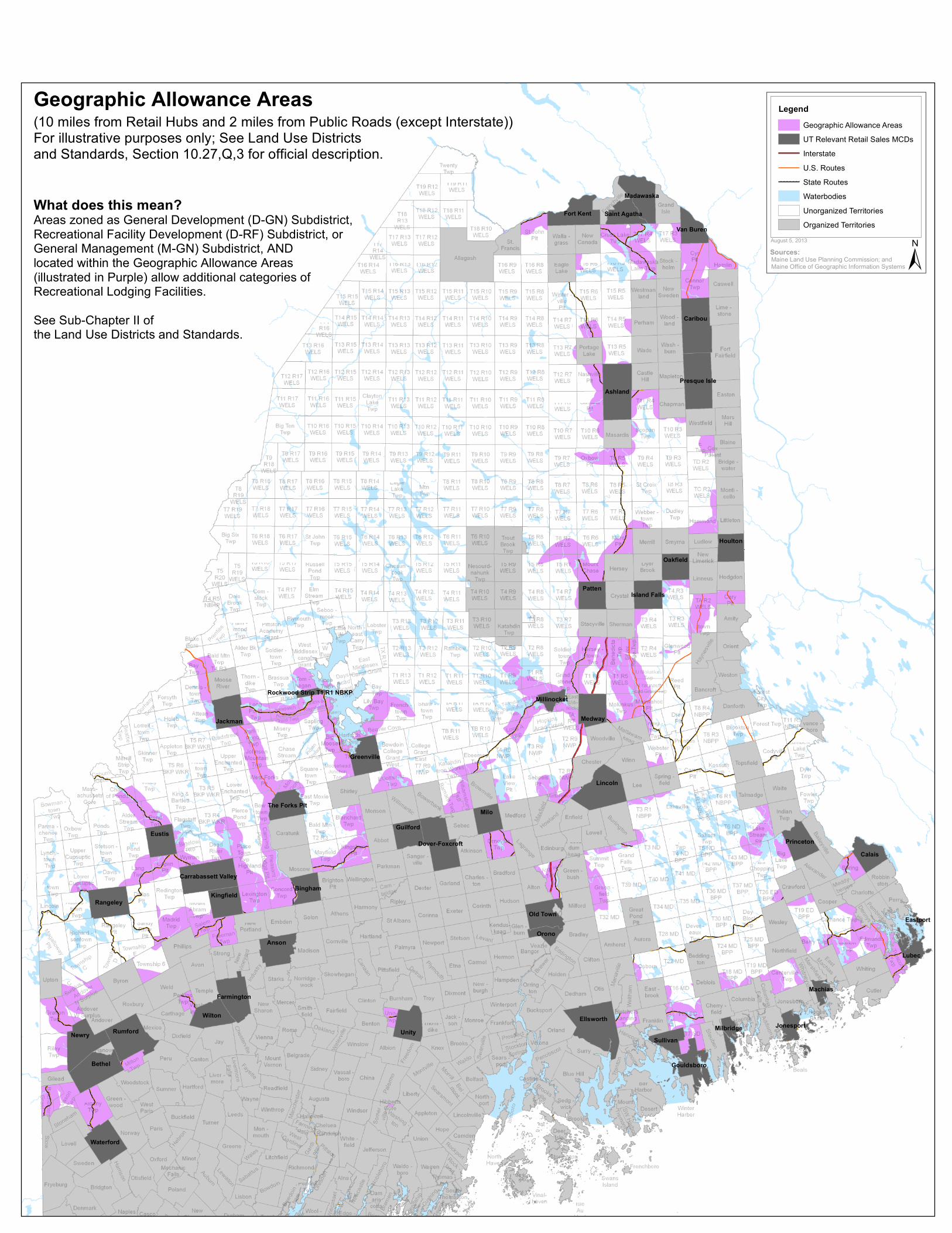
August 5, 2013
±Sources:
LegendGeographic Allowance AreasUT Relevant Retail Sales MCDsInterstateU.S. Routes
XY XY XY XY XY XY XY State RoutesWaterbodiesUnorganized TerritoriesOrganized Territories
Maine Land Use Planning Commission; andMaine Office of Geographic Information Systems
What does this mean?
Geographic Allowance Areas
Areas zoned as General Development (D-GN) Subdistrict,Recreational Facility Development (D-RF) Subdistrict, orGeneral Management (M-GN) Subdistrict, ANDlocated within the Geographic Allowance Areas(illustrated in Purple) allow additional categories ofRecreational Lodging Facilities.See Sub-Chapter II ofthe Land Use Districts and Standards.
(10 miles from Retail Hubs and 2 miles from Public Roads (except Interstate))For illustrative purposes only; See Land Use Districts and Standards, Section 10.27,Q,3 for official description.


![Fiive-Year R«viic w Report S|Hni]i]ij»;fiield, Vermont ...Construction of OIJ I completed. Construction of OIJ II completed. Prel i tin inary Close Ou t Report (PCOR) a n d I in](https://img.pdfslide.us/doc/110x75/5ed82f4c0fa3e705ec0dfe57/fiive-year-rviic-w-report-shniiijfiield-vermont-construction-of-oij.jpg)